2012 city of fort collins lower cache la poudre river
TRANSCRIPT

2012 City of Fort Collins
Lower Cache la Poudre River
& Urban Creek
Water Quality Report
At mouth of the Poudre Canyon May 2, 2013, Keith Elmund
Report Prepared by
Keith Elmund, Ph.D., Environmental Services Manager, Utilities Susan Strong, Environmental Regulatory Specialist, Utilities Basil Hamdan, P.E., Stormwater Quality Engineer, Utilities
July 15, 2013

Page 2 of 44
2012 Lower Poudre River & Urban Creek Water Quality Report Table of Contents Page Introduction 3 Purpose of the Report 3 Executive summary 3 History of the City’s River, Creek and Stormwater Quality Monitoring Programs 5 Agencies with Monitoring Activities on the Poudre & Urban Creeks 6 Water Quality Impacts of the High Park Fire on the Lower Poudre 7 Lower Poudre Water Quality Programs & Municipal Separate Storm Sewer System (MS4) Monitoring Programs and Costs
11
Municipal Separate Storm Sewer System (MS4) Report & Highlights 12 Is the Cache la Poudre River through Fort Collins Meeting All Stream Standards? 22 303(d) Listing of Impaired Waters on the Cache la Poudre River 23 Colorado Nutrient Criteria for Lakes, Reservoirs, Rivers & Streams 25 Nutrient Control Regulations and the Lower Poudre Monitoring Alliance 28 Urban Creek Water Quality Monitoring Program Highlights 33 Parkwood Lake Water Quality 35 E. coli contamination in Fossil Creek and Spring Creek 36 Stormwater Division – 2012 Stormwater Quality Summary Report 37 Analysis and Evaluation of Stormwater Quality and Quantity Performance for Three Permeable Pavement Systems in Fort Collins, Colorado
38
Roadway Deicing Operations in the City of Fort Collins and Impacts to Urban Stream Water Quality
39
2012 Stormwater Quality Monitoring Program Costs 40 Appendix A. Fish and Macro-invertebrate Surveys with CSU on the Poudre 41 Appendix B. Site Location Details for the Lower Cache la Poudre River Reg85 Monitoring Plan
44

Page 3 of 44
2012 Lower Poudre River & Urban Creek Water Quality Report
Introduction: This 2012 Lower Poudre and Urban Creek Water Quality Report provides a water quality-focused summary of the scope, status and trends of the City’s monitoring efforts on the Cache la Poudre River through Fort Collins and three urban creeks in our community. The presentation includes discussion of current and future regulatory changes and initiatives that affect the Poudre. In addition, key stormwater quality enforcement and improvement efforts, regulatory requirements, activities and associated compliance and non-compliance issues are also highlighted. Details on river and creek monitoring site locations, test parameters, key results and trends are presented. It must be noted, however, that aspects of this report are limited in scope: flow and water quality are just two of many key factors that influence and reflect the health of a river or creek. Other factors include man-made changes and activities as well as stream geomorphology and the abundance and diversity of its biological community. The ability of the biological community in a stream to survive and thrive is dependent, in part, on the quantity, quality and physical characteristics of the water flow as well as stream habitat. Future monitoring reporting efforts and programs will strive to identify, assess and explain the interdependencies that tie together the many factors affecting the health of the Poudre and urban creeks in our community. Purpose of the Report: In order to fulfill City Council's goal of protecting and enhancing the Poudre River as outlined in Council Resolution 92-14 "Framework for Environmental Action" and Resolution 95-14 “Approving the Watershed Approach to Stormwater Quality Management”, City staff has prepared the following status report on water quality conditions in key urban creeks and the Cache la Poudre River through Fort Collins. This report also includes summaries on the 2012 status of several stormwater quality monitoring and improvement programs in the City. Executive Summary: In 2012 several significant regulatory changes occurred that reveal both positive and negative trends in current water quality conditions in the Poudre through Fort Collins as well as our urban creeks.
1. High Park Fire. Beginning in early June and burning for nearly a month, the High Park Fire
burned over 87 thousand acres of the Poudre watershed at a cost of over 39 million dollars. Details on the fire are available at the InciWeb Incident Information Website: http://www.inciweb.org/incident/2904/ The Poudre watershed provides approximately half of the City’s drinking water and is a critical asset to our community. Impacts in the aftermath of the fire to the watershed including potential drinking water issues as well as impacts on the plains portion of the river through the City will be felt for many years into the future. Additional details regarding water quality are presented starting on page 7.

Page 4 of 44
2. Municipal Separate Storm Sewer System (MS4) Permit Program Activities: In 2003, the City received its first MS4 Permit and began implementation of the required program. This federally mandated program is administered by the Colorado Department of Public Health and Environment, Water Quality Control Division. Fort Collins is currently in its second permit term, 2008-2013. The goal of the program is to reduce the amount of pollutants entering streams, creeks, lakes and rivers as a result of rain water and snowmelt from residential, commercial and industrial areas. The following six minimum control measures must be met: public education and outreach, public participation/involvement, illicit detection and elimination, construction site stormwater runoff control, post-construction site stormwater management, pollution prevention/good housekeeping for municipal operations. Details on 2012 MS4 program activities begin on page 11.
3. Nutrient Control Regulations: There was one new water quality control program adopted by the Colorado Water Quality Control Commission in 2012 that will have significant cost impacts on the design, capital improvements and long-term operation of the City’s two water reclamation facilities. This regulatory program is called “Nutrient Criteria” or Regulation 85 (Reg85). The regulation focuses on limiting the discharge of the nutrients nitrogen and phosphorus into state waterways. These nutrients can promote the growth of nuisance algae that can adversely affect water quality and disrupt the food web in lakes, reservoirs, rivers, and streams. In addition, algae blooms can create aesthetic problems (visual, taste and odor) for drinking water supplies and adversely impact recreational activities like swimming and fishing. Additional details this regulatory change and its impacts are presented on page 28.
4. Selenium levels in the Poudre: Water quality conditions in the Cache la Poudre River from
Shields Street downstream to just above Boxelder Creek are currently better than all WQCD-defined aquatic life stream standards except for the levels of selenium. Selenium is associated with shale and is naturally present in the soils, river- and creek-banks in our area. Over the years, higher selenium levels in the Poudre have not been observed. However, the WQCD-defined stream standard is now more restrictive. Therefore selenium levels reported in the past now exceed that new stricter standard. The exceedences were sufficient for the WQCD to list the stretch of the Poudre through the City as 303(d)-impaired for chronic exposure aquatic life selenium standards. The WQCD gave this listing a low 303(d) priority for corrective action. Further details regarding this issue are presented on page 23.
5. Both Fossil Creek and Boxelder Creek are listed as “303(d)-impaired” (low priority) for
high selenium levels. Like the Poudre, exceedences of regulated selenium levels in Fossil and Boxelder Creeks were the result of stricter selenium standards and not reduced water quality in the creeks. City data show that high selenium levels in our urban creeks are observed during and after major storm events. In addition, any activities that erode creek banks or otherwise contribute to soil erosion can contribute to higher selenium levels in the water. Further details on this issue are presented on page 33 .
6. Both Fossil Creek and Spring Creek 303(d) listed as impaired, high priority, for
seasonal E. coli contamination: E. coli is an indicator of fecal contamination. Although these bacteria can be pathogens, their presence in water also indicates that other water-borne disease-causing enteric bacteria (Salmonella, Shigella) may also be present. In our urban

Page 5 of 44
creeks, high E. coli levels show strong seasonal trends with the highest levels appearing during the late spring and summer months and the lowest levels during the late fall and winter. These urban creeks are listed as a “high priority” because of the corresponding high probability of human and animal contact during recreational activities in nearby parks. The State is expecting proactive corrective control measures to be taken on this issue. In response, additional creek water quality monitoring and field survey efforts are underway to ensure that possible illicit discharges, leakage from sewer pipes or septic systems are not contributing to the problem. Additional details on this issue begin on page 36.
7. Stormwater Quality Monitoring Programs Underway: The City in cooperation with
Colorado State University (CSU) is conducting a wet-weather monitoring program to assess the effectiveness of existing structural stormwater Best Management Practices (BMPs) and new Low Impact Development (LID) BMPs. Additional work has been completed on the stormwater quality impacts of winter de-icing activities in the City. A summary of findings for these programs begins on page 37.
Natural disasters, regulatory changes and corresponding impacts at the local level point to the continued need for long-term, proactive monitoring and testing programs for the Poudre and our urban creeks. Successful water quality monitoring programs will help keep our community at the forefront of environmental protection efforts and provide the data necessary for careful stewardship of our limited resources.
History of the City’s River, Creek and Stormwater Quality Monitoring Programs:
In the mid-1970s, the Colorado Water Quality Control Commission held its first stream classification hearings for the Cache la Poudre River. At that time, both Federal and State Clean Water Act mandates were being implemented across the state and the nation. Unfortunately, little or no water quality data were available for the Poudre as it flowed past the City’s two wastewater treatment plants. At the Commission’s hearings it quickly became apparent that because of this lack of data, the City was at both a tactical and strategic disadvantage: proof was needed that treated discharges from its wastewater treatment plants were not harming the river. As a result, the City initiated several long-term monitoring efforts to gather flow and water quality data to protect both the Poudre and the City’s interests. Since the late 1970s and in cooperation with the US Geological Survey (USGS), the City has been monitoring both flow and water quality in the Cache la Poudre River above and through Fort Collins. Beginning in the early 1980s, and in cooperation with Colorado State University and Kodak Colorado Division (KCD), the USGS program was expanded to include assessments of the fish and benthic macro-invertebrate communities in the Poudre. At that same time, City staff from the Pollution Control Lab began weekly water quality monitoring both up- and down-stream of the City’s two wastewater treatment plants. The City-CSU-KCD cooperative program expanded in 2007 to form the Poudre Monitoring Alliance.

Page 6 of 44
The Poudre Monitoring Alliance is part of EPA’s award winning Performance Track program. It brings together under one roof the monitoring efforts of the City, Boxelder and South Fort Collins Sanitation Districts, the Town of Windsor, KCD and the City of Greeley. The alliance monitors over 42 miles of the Poudre at ten separate sites from Lincoln Street to its confluence with the Platte. In May 2007, the Utility received a letter of appreciation from Dave Akers, manager of the Clean Water Facilities program of the Colorado Water Quality Control Division commending the City’s thirty year commitment to on-going water quality monitoring on the Cache la Poudre River. In the late fall of 2007, the City received a letter of recognition from then Senator Ken Salazar lauding the example of the Poudre Monitoring Alliance for spearheading on-going regional cooperation for environmental protection. In the fall of 2012, the cooperative monitoring program was expanded to meet the requirements of the new Colorado Nutrient Control Regulations. Net effects of the regulations include reduced costs and heightened cooperation among the affected agencies and communities. Since 1984, the City has monitored water quality in Parkwood Lake. The lake receives stormwater inputs from the area bounded by Drake and Lemay Avenues. Beginning in 2000, the program was expanded to include routine testing at three urban creeks: Boxelder Creek, Spring Creek and Fossil Creek. Two sites on each creek are monitored each calendar quarter for a variety of water quality parameters including potential E. coli and Selenium contamination that have been issues in the past.
Agencies with Monitoring Activities on the Poudre & Urban Creeks in Fort Collins:
Natural water bodies in the Fort Collins area are actively monitored at numerous locations to evaluate the impacts of human and natural activities on water quality. Water quality datasets for some sites in the City begin in the mid-1970s. The Cache la Poudre River, as it flows through town from Shields Street to Boxelder Creek (Segment 11), is currently sampled and tested by several agencies, including: the City of Fort Collins, Colorado State University (CSU), the Colorado Water Quality Control Division (WQCD), the Colorado Department of Health & Environment (CDPHE), the U.S. Geological Survey (USGS), In-Situ, Inc., Boxelder Sanitation District, and RiverWatch.

Page 7 of 44
2012 spring runoff flows in the Poudre were substantially below the levels observed in several previous years. It is of interest to note that the numbers and biomass of brown trout observed during the November 2012 CSU fish survey upstream of Lincoln Street exceeded levels observed in 2011. Speculation as to the cause of this result raises several interesting questions regarding habitat, species dominance, diversity, etc. The relationship of this observation to potential adverse short and long-term impacts of stormwater runoff from the High Park Fire is under continued study. One long-term key indicator will be whether brown trout are able to reproduce on ash-laden streambeds in the lower Poudre. Understanding the relationship of this finding to projected loss of macro-invertebrate habitat due to summer stormwater runoff from the 2012 High Park Fire is also under continued study. Water Quality Impacts of the High Park Fire on the Lower Poudre: The High Park Fire began June 9th and was declared fully contained on July 1st, 2013. The fire consumed over 87 thousand acres of land in the Poudre watershed. The estimated cost of the fire at that time was over 38 million dollars (source: KUSA Web team; http://www.timetoast.com/timelines/high-park-fire) . Significant rainstorm events in the watershed were captured both with grab samples and real-time telemetry. Two significant storm events occurred on the 7th of July and again during the period 26 through 30 July. Real time data for both of these events were collected at the Lincoln Street Gage using equipment from the Fort Collins-based In-Situ, Inc. The field measurements
-
20,000
40,000
60,000
80,000
100,000
120,000
140,000
Flo
w, c
fsMonthly River Flows at the Lincoln St Gage
2007 2008
2009 2010
2011 2012

Page 8 of 44
were relayed to an on-line database, were updated every fifteen minutes and made available for download.
Stage Height, Turbidity and Conductivity Levels in the Cache la Poudre River at the Lincoln St Gage during the July 7th, 2012 storm event in the High Park burn area of the Poudre watershed. The data depict the rapid changes in levels of turbidity (fire ash and debris) and conductivity (salinity) with corresponding dynamic changes in river flow reflected in the stage height or depth of water at the site. The results depicted in this graph show that the increase in water depth (stage height) slightly preceded the subsequent spikes in turbidity and conductivity and gradual recovery over a period of two days. One significant concern was the potential impacts of the ash and debris from the High Park Fire on the quality of drinking water in our community. To avoid ash-laden water, the Poudre supply was turned-off in June and not restarted until mid-September 2012. The graph below compares City tap water quality with the regulated standards and then also with the levels of Iron and Manganese observed in a grab sample of water collected during a major storm event on July 7th. Both Iron and Manganese fall under “secondary” or aesthetic standards. Secondary standards reflect on the clarity, taste and odor of drinking water but at the levels normally seen in treated water, they do not represent a health risk. Note that the Y-axis scale of the graph is log10-based.

Page 9 of 44
Iron and manganese can be difficult to remove at the water treatment facility (WTF). However, the City’s plant has no difficulty treating the levels normally found in the Horsetooth and Poudre supplies. In the fall season and depending on the level and water temperatures in Horsetooth Reservoir, spikes in Manganese (Mn) concentrations are possible. Data from the 1990s showed levels of Mn exceeding 500 parts per million (ppm) or micrograms per liter (µg/L). Using special oxidizers, the WTF plant can convert the Mn into a form readily removed during filtration. The WTF will also take advantage of its ability to dodge ash-laden water when significant storm events occur upstream in the Poudre watershed.
Ash and stormwater debris near Lincoln Street July 11, 2012

Page 10 of 44
A second series of storm events occurred in the Poudre watershed during late July of 2012. The water quality changes were captured at the Lincoln Street Gage using In-Situ equipment. With this event, spikes in turbidity mirrored the jumps in water depth (stage height) at the gage. However, the spike in salinity (conductivity) of the water was delayed over the same time period. This observation may reflect a delay or inertia in the downstream movement of ash with a different buoyant density or mass as the storm surge proceeded downstream.

Page 11 of 44
Lower Poudre Water Quality Programs & Municipal Separate Stormwater Sewer System (MS4) Monitoring Programs and Costs:
2012 Monitoring Program Description Cost Comment
USGS: October 2011 – September 2012 U.S. Geologic Survey cooperative
monitoring program for six flow and two water quality sites on the Cache la Poudre
from the Michigan River near Cameron Pass to the gage station upstream of Boxelder Cr.
$133,700 City’s share: $91,920. Federal funds
cover the remaining portion of the cooperative program.
Poudre River: City’s Pollution Control and Water Quality Lab monitoring on Cache la Poudre River at both up- and down-stream sites from water reclamation facilities with both a weekly schedule and 8 special data
collections for the Poudre Monitoring Alliance including the CSU fish and benthic
macro invertebrate surveys.
$92,152
Cost value of field sampling, field measurements and lab work; includes
City’s portion of Lower Poudre Monitoring Alliance Program.
Urban Creeks: City’s Pollution Control and
Water Quality Lab quarterly monitoring at two sites on three urban creeks plus Parkwood Lake
at three locations twice each year.
$6,939 Cost value of field sampling, field
measurements and lab work.
2012 CSU Fish and Macro-invertebrate
Biosurveys on the Poudre through the City as part of the Lower Poudre Monitoring
Alliance Program
$24,973 Fort Collins share of this portion of Lower Poudre Monitoring Alliance
Program
Municipal Separate Storm Sewer System
(MS4) Permit Compliance Program
$270,000 Managed by the Division of
Government and Regulatory Affairs
In 2012, the City committed over $527,000 to collect flow and water quality data on the lower Cache la Poudre River as well as water quality data on key urban creeks, Parkwood Lake, stormwater and for MS4 permit compliance. USGS flow and water quality data are used to help manage operations at the City’s two water reclamation facilities as well as the City’s and to manage its extensive water rights portfolio. The data is also used to assess regulatory compliance and stormwater impacts on key urban creeks in the City as well as the river.

Page 12 of 44
Municipal Separate Storm Sewer System (MS4) Report & Highlights:
Art in Public Places sculpture for the Low Impact Development permeable pavers on the Mitchell Block
The City of Fort Collins is required by the Colorado Water Quality Control Division (WQCD) to have a Municipal Separate Storm Sewer System (MS4) permit in order to discharge stormwater from its MS4 into State waters. The City must implement a Colorado Discharge Permit System (CDPS) Stormwater Management Program in accordance with the MS4 permit. The City’s Stormwater Management Program is a comprehensive program comprised of six minimum control measures designed to minimize the discharge of pollutants from its MS4. Each measure requires several detailed elements that must be implemented annually or on an ongoing basis.
In addition to maintaining permit compliance, the elements facilitate protection of water quality and habitat of the Cache la Poudre River and our urban streams. City staff take pride in implementation of these pollution prevention measures and the resulting urban watershed quality. Listed below are the minimum control measures, abbreviated requirements, and 2012 accomplishments.
1. Public Education and Outreach - The permittee must implement a public education program
in an effort to promote behavior change by the public to reduce water quality impacts associated with pollutants in stormwater runoff and illicit discharges.
Highlights of the 2012 stormwater education program:
The City’s WaterSHED (Stormwater Habitat Education Development) program
educated 7,180 students and 872 adults, for a total of 9,568 student and 1,284 adult contact hours.

Page 13 of 44
Working with the WaterSHED program, Blevins Middle School became a Watershed School. Students study soil, wetlands, water quality and more in Red Fox Meadows.
Staff educated students and adults on the land-water connection at the Birding Fair. Attendees at the Sustainable Living Fair and the Earth Day celebration participated in
a storm drain activity to educate them on proper disposal of different materials. Twenty adults were trained though the Master Naturalist program. The Children’s Water Festival had 1782 student participants. Interpretive signage is displayed at select outdoor classrooms in Fort Collins,
including the watershed display at the Spring Creek Bicycle Trail. Storm drain markers were installed on 200 storm drain inlets. The storm drain marker contest received over 190 entries by citizens living in our
urban watershed. Citizens learned about aquatic insects and water quality through our outreach then designed markers to be permanently installed on our local storm drains.
The Stormwater Business Outreach Program distributed stormwater education packets to 139 landscaping businesses that services Fort Collins. Packets included the following information:
o Landscaping Best Management Practices brochure o “Keep the Poudre Clean” bumper sticker o Coupon for a free tarp to be used to prevent stormwater from carrying
landscaping-related pollutants to the storm drainage system

Page 14 of 44

Page 15 of 44
o 2. Public Participation and Involvement - The permittee must provide a mechanism and process to allow the public to review and provide input on the CDPS Stormwater Management Program.
An annual update of the permit Stormwater Management Program is presented to the
Natural Resources Advisory Board and the Water Board. The 2012 MS4 Permit update included a summary of the 2011 MS4 Permit annual report, minimum control measure internal assessment and tracking, program challenges and successes, along with a regulatory update.
The City’s MS4 Permit Stormwater Management Program description and 2008-2012 annual reports are posted on the City’s website at:

Page 16 of 44
http://www.fcgov.com/utilities/what-we-do/stormwater/stormwater-quality/management-program
3. Illicit Discharge Detection and Elimination - The permittee must develop, implement and enforce a program to detect and eliminate illicit discharges into the permittee’s MS4. During 2012, MS4 staff:
Responded to 36 spill complaint calls in 2012. Responses included site visits, incident
investigations, on-site and phone education, delivery of educational door hangers and follow-up letters. Staff reported 8 verbal and 5 written notices of violation and two charges to recover City clean-up costs.
Reviewed Regulation 61 proposed legislative amendment to exempt discharges from firefighting activities from the Illicit Discharge program.
Participated on the Poudre Fire Authority Hazmat Team.
Staff and Poudre Fire Authority collaborated to ensure containment and cleanup of chemical spill.

Page 17 of 44
Staff members attended HAZWOPER Technician training
4. Construction Site Runoff Control – The permittee must develop and implement a program to assure adequate design, implementation, and maintenance of BMPs at construction sites within the MS4 to reduce pollutant discharges and protect water quality. During 2012, staff
Performed 1,737 inspections on 89 construction sites for sediment and erosion control
in 2012. Enforcement measures for inadequate sediment and erosion control included: 224 verbal warnings, three written notices of violation, 13 building permits held, and holds issued on 575 initial building permits to ensure erosion control measures were installed on individual lots.
Signed-off on 324 Soil Amendment Certifications. Responded to over 500 phone calls addressing customer questions regarding soil
erosion control, stormwater pond inspections and permit compliance. Attended nine development construction permit meetings. Inspected 547 building sites and 59 development sites. Assisted City engineering staff with the development of erosion control plans for
three City projects. Advised City departments and contractors on construction stormwater permit and
stormwater management plan requirements for three City projects. Advised private developers and their contractors on-site with erosion control
requirements and plan implementation.

Page 18 of 44
Improperly installed Best Management Practices on a small construction site caused discharge of sediment.
Straw wattles and staked portable toilet on construction site.

Page 19 of 44
5. Post-Construction Stormwater Management in New Development/Redevelopment - The permittee must develop, implement, and enforce a program to address stormwater runoff from new development and redevelopment projects that disturb greater than or equal to one acre, including projects less than one acre that are part of a larger common plan of development or sale, that discharge into the MS4. The program must ensure that controls are in place that would prevent or minimize water quality impacts. During 2012, MS4 staff
Inspected 245 permanent water quality control features, or best management
practices. Enforcement actions included 59 written notices of violation and 21 verbal notice of violation.
Added 2,671 photos of stormwater basins/best management practices to the Post-Construction inventory.
Added 20 stormwater basins to the Stormwater Information Management System (SWIMS) database.
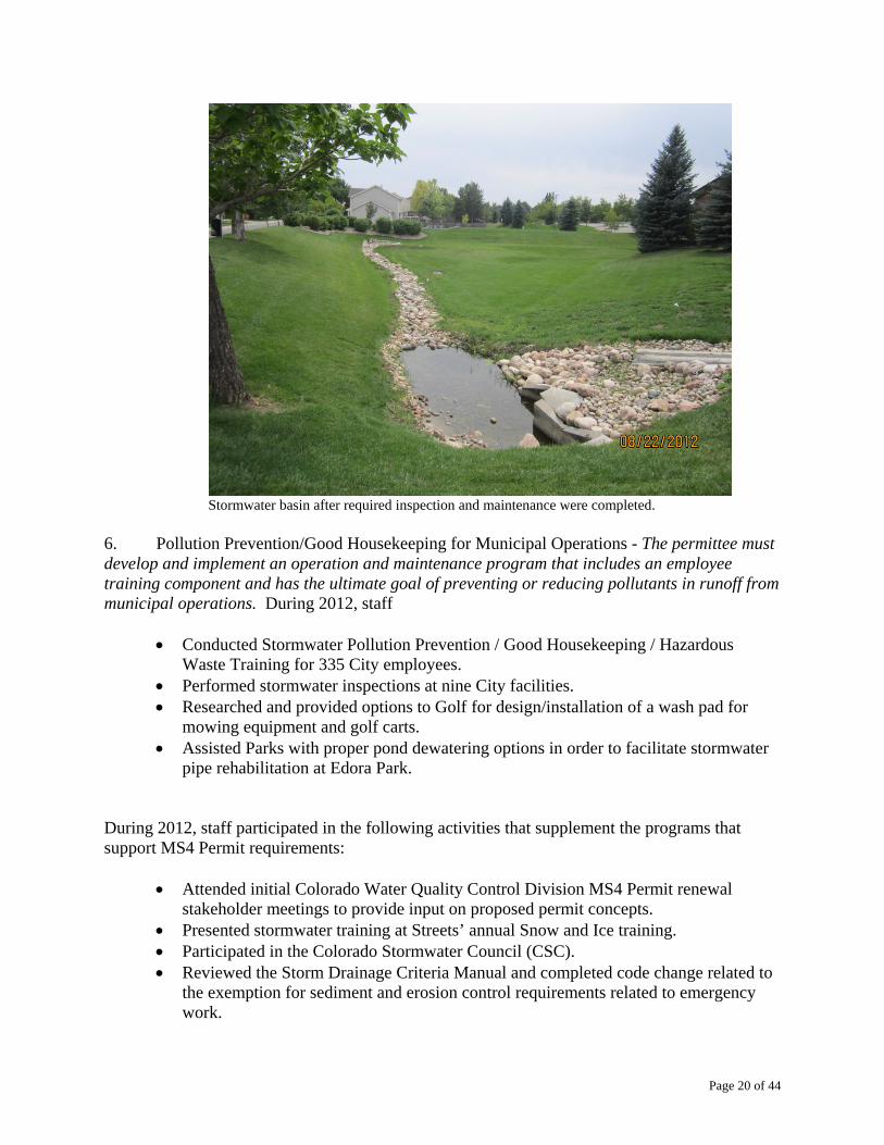
Stormwater basin before inspection and required maintenance were completed.
Page 20 of 44
Stormwater basin after required inspection and maintenance were completed.
6. Pollution Prevention/Good Housekeeping for Municipal Operations - The permittee must develop and implement an operation and maintenance program that includes an employee training component and has the ultimate goal of preventing or reducing pollutants in runoff from municipal operations. During 2012, staff
Conducted Stormwater Pollution Prevention / Good Housekeeping / Hazardous
Waste Training for 335 City employees. Performed stormwater inspections at nine City facilities. Researched and provided options to Golf for design/installation of a wash pad for
mowing equipment and golf carts. Assisted Parks with proper pond dewatering options in order to facilitate stormwater
pipe rehabilitation at Edora Park. During 2012, staff participated in the following activities that supplement the programs that support MS4 Permit requirements:
Attended initial Colorado Water Quality Control Division MS4 Permit renewal stakeholder meetings to provide input on proposed permit concepts.
Presented stormwater training at Streets’ annual Snow and Ice training. Participated in the Colorado Stormwater Council (CSC). Reviewed the Storm Drainage Criteria Manual and completed code change related to
the exemption for sediment and erosion control requirements related to emergency work.

Page 21 of 44
Submitted the required MS4 Targeted Permit Questionnaire to the Water Quality Control Division.
Completed Project Manager Training on stormwater permits and related requirements.
Collaborated with the City of Loveland on the renewal the Fort Collins Loveland Airport Industrial Stormwater Permit and related Stormwater Management Plan.
Collaborated with the Colorado Stormwater Council and the Urban Drainage and Flood Control District to provide data related to the Nutrient Regulations Data and Gap Analysis Report.
Advised Transfort on the renewal their Industrial Stormwater Permit and related Stormwater Management Plan.
Assisted a City contractor with CDPHE spill report for the accidental discharge of super-chlorinated water.
Participated on the Multi-Criteria Decision Analysis Team for assessment and prioritization of stream rehabilitation projects.
Coordinated and held two successful one-day Household Hazardous Waste Collection events, collecting over 114,000 pounds of waste from approximately 1,500 residents.
Staff helped residents properly dispose of waste during the Household Hazardous Waste Collection Event

Page 22 of 44
Is the Cache la Poudre River through Fort Collins Meeting All Stream Standards? No, Selenium levels exceed the aquatic life stream standards. Water quality conditions for the Cache la Poudre are reviewed approximately every five years by the Water Quality Control Division (WQCD) of the Colorado Department of Public Health and Environment (CDPHE). This review is used to develop new stream classifications and standards, to identify exceedences in water quality standards and then to subsequently develop discharge permit limits for industries, communities and sanitation districts. Permitted discharge limits are designed to protect public health as well as aquatic life in the receiving stream. The WQCD’s most recent review of water quality conditions in the Poudre through Fort Collins was completed in 2012. A summary of their findings is presented in the following table: Poudre Water Quality: Standards vs. Actual Test Results. The most recent report from the Colorado Water Quality Control Division for Segment 11 of the Cache la Poudre from Shields Street to Boxelder Creek just upstream of I-25. Parameter TVS† Results‡ # of Tests Meeting Std? pH, std units 6.5 – 9.0 7.6 – 8.51 438 Yes Dissolved Oxygen, mg/L 5 8.4 384 Yes Hardness, mg/L as CaCO3 NA 284 448 Yes E. coli # / 100ml 126 24 185 Yes Arsenic, dissolved, µg/L 7.6 0 112 Yes Cadmium, dissolved, µg/L 0.93 0 148 Yes Copper, dissolved, µg/L 21.81 2.77 330 Yes Iron, dissolved, µg/L NA 69 286 Yes Iron, total recoverable 1000 180 264 Yes Lead, dissolved, µg/L 7.67 0 145 Yes Manganese, dissolved, µg/L 2335 53.4 119 Yes Selenium, dissolved, µg/L 4.60 5.4 205 No Silver, dissolved, µg/L 1.93 0 208 Yes Zinc, dissolved, µg/L 302.5 23.2 147 Yes Uranium, dissolved, µg/L 4738 9.4 5 Yes Ammonia-N, mg/L TVS 0.3 381 Yes Nitrate-N, mg/L 100 1.18 252 Yes Sulfate, mg/L NA 282.4 75 Yes Derived from “Colorado Department of Public Health & Environment. Water Quality Control Commission, Regulation No. 38, WQCD Exhibit 38-11, June 2009..
† = TVS: Table Value Standard µg/L = part per billion mg/L = part per millions ‡ Results from the Water Quality Control Division, US Geological Survey, RiverWatch, Boxelder Sanitation District and the City of Fort Collins. Selenium exceedences on the Cache la Poudre were reported by RiverWatch. TVS stream standard for Selenium was reduced by the EPA to a lower level in 2001. Selenium exceedences were the result of stricter standards plus more reported data and not a change resulting in deterioration of water quality. The chronic dissolved selenium standard was exceeded in the Cache La Poudre River at the USGS gage above Boxelder Creek (BSD #Station 4), at Lee Martinez Park (Riverwatch, RW #599), at Prospect Rd.

Page 23 of 44
(RW #602), and above Boxelder Creek (USGS #6752280). The acute dissolved copper standard was exceeded in the Cache La Poudre River at Lee Martinez Park (RW #599).
303(d) Listing of Impaired Waters on the Cache la Poudre River
In accordance with Section 303 of the Clean Water Act (PL 92-500), the Colorado Water Quality Control Division (WQCD) evaluates waters every two years to determine if they are impaired from meeting their water quality criteria. Waters that are determined to be impaired are added to the State’s 303(d) list and become eligible for grant funds to determine the cause of impairment. Based on data collected in part by the City, the Cache la Poudre River, below the confluence with Boxelder Creek and then east to the South Platte River was put on the State’s 303(d) list for high E. coli levels in 2004. The presence of E. coli is an indicator of fecal contamination in the water. This has been a long-term issue on the lower reaches of the Cache La Poudre and is attributed primarily non-point source, stormwater runoff and irrigation return waters from agricultural operations. Table 3 presents a summary of the 303(d) listing status for the Cache la Poudre River from the Monroe diversion through the various classification segments to its confluence with the Platte River east of Greeley. However, both Fossil and Boxelder Creeks as well as Segments 11 and 12 of the Poudre below Shields Street are listed as 303(d) impaired for selenium values that exceed the aquatic life chronic table value stream standard of 4.6 µg/L (part per billion). The following paragraph provides details on the toxicity, nature and fate of selenium in waters and the environment:
“Selenium is an essential nutrient for humans and animals. There is a narrow margin between too little and too much selenium. Selenium can be harmful to humans at 5 to 10 times recommended daily dose (55 micrograms per day for adults). Selenium is more toxic to vertebrates than to invertebrates and plants. Selenium is more toxic to fish and wildlife than to humans. Selenium “bioaccumulates” in the food chain, when selenium is ingested in amounts greater than the body needs, the excess selenium is not excreted, but instead is retained within the body. As organisms are preyed upon by other animals higher on the food chain, the predator takes on the entire body burden of selenium carried by the prey. High concentrations of selenium can result in adverse impacts to birds and fish, including selenium poisoning and reproductive toxicity. Extremely high concentrations of selenium can result in adverse impacts to livestock.” (Source: Fountain Creek Watershed Group, Pikes Peak and Pueblo Areas Council of Governments)
It should be noted that the selenium-impaired listings given in the following table are a result of a lower EPA and CDPHE aquatic life stream standard and not changing water quality. For comparison, the safe drinking water standard for selenium is 50 µg/L (microgram per liter or part per billion, ppb) and Fort Collins drinking water contains less than 1 µg/L or less than 1 ppb.

Page 24 of 44
2012 Colorado 303(d) Listing of Impaired Waters on the Cache la Poudre River: River Segment COSPCP ID#
Segment Description Designation Use Classifications Portion Impairment State’s Priority
Easy Fix?
10 Cache la Poudre River,
Monroe Canal to Shields Street
Anti-Degradation
Review (ADR) in 2009†
Aquatic Life Cold 2 Recreation E Water Supply Agriculture
Below confluence with North
Fork
Copper / Temperature Medium No
11 Cache la Poudre River,
Shields St to Boxelder CrADR in 2009†
Aquatic Life Warm 2 Recreation E Agriculture
All Selenium Low No
12 Cache la Poudre River, Boxelder Cr to S. Platte
River ADR in 2009†
Aquatic Life Warm 2 Recreation E Agriculture
All Selenium /
E. coli Low / High No
13a
All tributaries to the Cache la Poudre River,
including all lakes reservoirs and wetlands, from the North Fork of
the Cache la Poudre River to the confluence with the
South Platte River; Spring and Fossil
Creeks
--
Aquatic Life Warm 2 Recreation E Water Supply Agriculture
Spring Cr
&
Fossil Cr
Selenium for Fossil Cr / Seasonal
E. coli both Fossil and
Spring Creeks
Low / High No
13b Boxelder Creek from source to the Cache la
Poudre River --
Aquatic Life Warm 2 5/15-9/15
Recreation P 9/16-5/14
Recreation N Agriculture
All Selenium / Seasonal
E. coli Low / High No
22 Fossil Cr Reservoir
Use Protected Status
Renewed in 2009
Aquatic Life Warm 2 Recreation E Water Supply Agriculture
Fossil Creek Reservoir
No longer listed for Selenium
Removed from List
No
Derived from: Colorado Department of Public Health and Environment; Water Quality Control Commission; 5 CCR 1002-93 30-March-2012; Regulation #93; Section 303(d) list water-quality-limited segments requiring TMDLs. † Moved to “Reviewable” Anti-Degradation Status by the Water Quality Control Commission on 09 June of 2009. Table current in Regulation 93 as of 30-March-2013.

Page 25 of 44
Colorado Nutrient Criteria for Lakes, Reservoirs, Rivers & Streams
Background: Nutrient criteria were adopted in the March 2012 Regulation 31 Basic Standards Hearing. In preparation for that hearing, the Colorado Department of Health and Environment (CDPHE) - Water Quality Control Division (WQCD) developed preliminary criteria for total phosphorus and total nitrogen. The nutrient criteria will consist of both a “Control Regulation 85” for permitted dischargers and “Stream Standards” defined in the Water Quality Control Division’s Regulation 31: The Control Regulation will define technology-based requirements for dischargers to “control” the release of nutrients and will be based on best available technology (BAT):
Control Parameter Annual Median Effluent
Concentration 95 Percentile Effluent Concentration
Total Phosphorus 1.0 mg/L 2.5 mg/L Total Inorganic Nitrogen (TIN) 15 mg/L 20 mg/L
TIN: The sum of Ammonia-Nitrogen, Nitrate-Nitrogen and Nitrite-Nitrogen in milligrams per liter. Other requirements of the Control Regulation 85 include: o Municipal Separate Stormwater System (MS4) to implement control measures:
o Public education and outreach targeting potential nutrient sources and o Identification and control of nutrient sources from municipal operations
o Monitoring requirements for Publicly Owned Treatment Works (POTWs):
o Monthly effluent monitoring for total inorganic nitrogen (TIN), total phosphorus (TP) and total daily flow and
o Monthly in-stream monitoring above and below the POTW discharge for Total Nitrogen (TN) and total phosphorus (TP) as well as total daily stream flow from an established gaging station
o Reporting nutrient testing results to the Colorado Water Quality Control Division each year starting in March of 2014.
o Monitoring Requirements for the City’s MS4s program:
o Both wet and dry weather monitoring at representative stormwater outfalls throughout the MS4 (urban growth) area.
Cost Implications for the City to Implement Required Wastewater Treatment Nutrient Controls:
o Biological Nutrient Removal (BNR) upgrades were completed at Mulberry Water Reclamation Facility (MWRF) in the summer of 2011. If future Colorado regulations require Enhanced Nutrient Removal (ENR) of phosphorus and nitrogen to achieve tougher limits, an additional eight million dollars in capital improvements will be needed at the MWRF.

Page 26 of 44
o Both capital improvements and operational changes are underway that will bring the Drake Water Reclamation Facility (DWR)F into compliance with the proposed tighter BNR limits on discharges of phosphorus and total inorganic nitrogen (TIN).
Comparison of Proposed Colorado Nutrient Criteria to Various Wastewater Treatment Technologies. Note: the Poudre downstream of Shields Street is classified as “warm water”:
Treated Effluent Test
Parameter
Typical Municipal
Raw Sewage, mg/L
Treated Effluent (No
Nutrient Removal),
mg/L
Typical Biological Nutrient Removal
(BNR), mg/L
Enhanced Nutrient Removal (ENR), mg/L
Limits of Current
Treatment Technology,
mg/L
Colorado In-Stream Nutrient Criteria Limits,
mg/L Cold Water
(Warm Water) Total Phosphorous
4 - 8 4 - 6 1 – 3 0.3 or less 0.05 - 0.07 0.11
(0.17) Total Nitrogen
25 – 35 20 - 30 8 - 10 3 - 6 3 -4 1.25
(2.01) Sources: Municipal Wastewater Treatment Considerations: Dave Clark (HDR) – presentation to Colorado Nutrient Workgroup, April 13, 2010: http://projects.ch2m.com/cwqf/Workgroups/Content/nutrient_criteria/Meetings/04%202010%20April/Colorado%20Nutrient%20LOT%20and%20Permitting.pdf and http://www.waterworld.com/index/display/article-display/286210/articles/waterworld/volume-23/issue-3/editorial-feature/wastewater-industry-moving-toward-enhanced-nutrient-removal-standards.html
Fort Collins Water Reclamation Facility Biological Nutrient Removal (BNR) Construction Timeline and Costs: The Mulberry WRF re-started with BNR operations on July 5th, 2011. Treatment processes are being fine-tuned to achieve effluent levels of nutrients below the newly Reg85 established control limits. Design and construction improvements to the Drake WRF for BNR are underway as described in the following table:
Reclamation Facility Current Status Cost Mulberry WRF Upgrades Complete $25.2 Million
Drake WRF: North Treatment Trains
Construction completed in October 2012
$7.5 Million
Drake WRF: South Treatment Train
Design: 2014 Construction: 2015
$3.2 Million
Note: Should Enhanced Nutrient Removal (ENR) be required in the future, an additional $50 to $60 million dollars in capital improvements will be required at the DWRF. Implementation Timeline for Nutrient Control Regulation “Reg85” for the Mulberry and Drake Water Reclamation Facilities:
Water Quality Control Commission Nutrient
Control Rulemaking Hearing March 12 & 13, 2012
Final Action on Rulemaking June 11, 2012 Control Limits Effective Date September 30, 2012
City must comply with nutrient control effluent limitations (or receive a compliance schedule)
After November 30, 2013 or upon discharge permit renewal anticipated in 2015

Page 27 of 44
How are we doing in meeting the nutrient control regulatory requirements?
Since January 2012, after capital improvement and process upgrades, the Mulberry WRF is in full compliance with Reg85 for both the annual median and the 95th percentile effluent limits for Total Phosphorus (TP) and Total Nitrogen (TN) removal. Nutrient Control River and Stream Standards (Regulation 31): This regulation will set water quality standards based on the need to protect designated uses (water supply, agriculture, etc.). The WQCD has developed the following stream standards for total phosphorus (TP) and total inorganic nitrogen (TIN) levels for rivers and streams: Proposed Nutrient Criteria Regulated Standards for Rivers and Streams (From Shields Street to the Platte, the Poudre is classified as “warm water”)
Designation Total Phosphorus† Total Nitrogen
(TN) ‡ Chlorophyll-aª
Cold Water 0.11 mg/L 1.25 mg/L 150 mg/m2 Warm Water 0.17 mg/L 2.01 mg/L 150 mg/m2
† Running annual median of Total Phosphorus (µg/L), allowable exceedence frequency of 1-in-5 years. ‡ Running Annual median Total Nitrogen (TN). TN is the sum of the levels of Total Kjeldahl Nitrogen, Nitrate-Nitrogen and Nitrite-Nitrogen. ª Summer (July 1 – September 30) maximum attached algae, not to exceed.

Page 28 of 44
Nutrient Control Regulations and the Lower Poudre Monitoring Alliance:
Starting in the Fall of 2012, the Lower Poudre Monitoring Alliance joined in their efforts to meet the new monitoring requirements established by the passage of the Colorado Nutrient Control Regulations (Reg85). The alliance includes the Cities of Fort Collins and Greeley, the Town of Windsor, Carestream Health, the Boxelder Sanitation District and Leprino Foods, Inc. As required by regulation, all of these entities collect river water samples once each month both up and downstream of their respective discharge points. River samples along with treated effluent samples are delivered to and tested at the City’s Pollution Control Lab. Lab results along with river and treated discharge flows will be reported once each year to the participants, CDPHE and uploaded to EPA’s national Water Quality Exchange (WQX) internet database. The data will be used to assess compliance with the requirements of Reg85 and the program will continue indefinitely.
Aerial map of showing locations of key gaging stations, effluent discharger points and water quality sample site locations on the lower Poudre that are part of the cooperative Lower Poudre Monitoring Alliance Reg85 and Reg31 sampling and analysis plan completed and submitted to the WQCD in February 2013. Full implementation of the cooperative monitoring program began in March 2013. Site location and other details of the cooperative monitoring plan are presented in Appendix A. USGS and Colorado Department of Water Resources (DWR) gaging stations are located on the Poudre at:
o Lincoln Street (432 PLNC) in Fort Collins, o above the confluence with Boxelder Creek (370 PBOX), o below Fossil Creek Reservoir at the New Cache Ditch (DWR CLARIVCO gage), o the Staff Gage (225 SGage) above the Town of Windsor and Carestream Health outfalls, o the DWR CLAWASCO gage above Greeley’s and Leprino Foods discharge points and

Page 29 of 44
o the DWR CLAGRECO gage below the City of Greeley near Fern Avenue. Note: the numeric descriptive before the site abbreviation, 432 PLNC for example, is code for the approximate river mile location (43.2 miles) upstream of the confluence of the Poudre with the Platte River How to Read a Boxplot or a Box & Whisker Plot?
1. First note the location of the median (white line) in the box. If the median is in the middle the box, the data is not skewed to a predominance of high or low values. The overall height of the box indicates the overall range or distribution of the data. A tall box indicates a wide range in values.
2. The top and bottom of the box define the upper and lower quartiles at 25% and 75%.
3. The maximum and minimum values (excluding outliers) are represented by the horizontal lines at the end of the whiskers.
4. Outlier data points are represented by dots.

Page 30 of 44
Nitrate-Nitrogen (NO3-N) levels in the lower Poudre are a key indicator of potential compliance issues with Reg85. The City monitors four key sites on the Poudre for nitrate levels through Fort Collins. Proceeding from the mouth of the canyon (546PCAN), to Lincoln Street (432PLNC), to the Nature Center (380PNAT) and then to the USGS Gage above Boxelder Cr (380PBOX), the running annual median Nitrate-N levels do not exceed the stream standard of 2.01 mg/L.
Total Phosphorus (TP) levels are another key indicator of the “nutrient” status of the Poudre and compliance with Reg31. High levels of Phosphorus can promote algal growth, lower dissolved oxygen levels in the water, create nuisance odor and adversely affect the aesthetics of an out-of-doors experience. Under extreme conditions, algae can produce toxins that can affect both the aquatic community and animals including humans, pets and livestock. With near weekly monitoring completed since June of 2012 and even with the spikes in levels nutrients observed in High Park Fire stormwater samples, the Poudre through Fort Collins is in compliance with the Reg85 running annual median TP limit of 0.17 mg/L. Although several total phosphorus values in samples collected near the mouth of the canyon exceeded the median limit, these results were associated with sampling events showing impacts of stormwater runoff from the High Park fire.

Page 31 of 44
Poudre Site Legend: 365PARCH = Ft Collins Archery Range at river mile 36.5; 325PFOS = Downstream of Fossil Cr Reservoir at river mile 32.5; 145FSPUR = Farmer’s Spur at river mile 14.5; 022FERN = Poudre at Fern Avenue in Greeley at river mile 2.2 above confluence with the Platte. Results since June of 2012, indicate that the Poudre downstream of the Archery Range to the confluence with the Platte will not be in compliance with the Reg31 limits. These high levels of phosphorus are due, in part, to return waters from irrigated fields stormwater runoff from confined animal feeding operations (CAFOs) entering the Poudre. Other sources include municipal stormwater as well as industrial and community wastewater treatment plant effluents. Fossil Creek Reservoir and the Nutrient Criteria Regulated Standards (Reg31) for Lakes and Reservoirs: Fossil Creek Reservoir is a strategic agricultural supply reservoir for Larimer and Weld Counties. It is classified as a “warm” water reservoir. The reservoir serves several key functions for the City:
o Fossil Creek Ditch leading to the reservoir is a discharge point for the treated effluent from the Drake WRF.
o Effluent flows from the Drake, containing re-usable Western-slope water, play a vital role in the management of the City’s extensive water resources portfolio.
o Fossil Creek Ditch and Reservoir receive stormwater inflows from the City’s urban growth area, and
o The Reservoir received treated effluent from the South Fort Collins Sanitation District. The District provides water reclamation services for much of our urban growth area below Harmony Road.
o The Reservoir provides extensive habitat for wildlife and corresponding recreational activities for the community.

Page 32 of 44
Regulation 31 Nutrient Standards for Lakes and Reservoirs: Compared to the nutrient standards for rivers and streams, these stricter standards are designed to protect water bodies that may also serve as drinking water supplies.
Designation Total Phosphorus† Total Nitrogen
(TN) ‡ Chlorophyll-aª
Cold Water 0.025 mg/L 0.426 mg/L 8 µg/L Warm Water 0.083 mg/L 0.91 mg/L 20 µg/L
1. Summer (July 1 – September 30) average Total Phosphorus (µg/L) in the mixed layer of lakes (median of multiple depths), allowable exceedence frequency of 1-in-5 years. † Total Nitrogen (TN) is the sum of the levels of Total Kjeldahl Nitrogen, Nitrate-Nitrogen and Nitrite-Nitrogen. Summer (July 1 – September 30) average Total Nitrogen (µg/L) in the mixed layer of lakes (median of multiple depths), allowable exceedence frequency of 1-in-5 years. ª Summer (July 1 – September 30) average Chlorophyll-a (µg/L) in the mixed layer of lakes (median of multiple depths), allowable exceedence frequency of 1-in-5 years. For lakes and reservoirs greater than 25 acres.
Nutrient Control Stream Standards (Regulation 31) Timeline:
Water Quality Control Commission Nutrient Control Rulemaking Hearing
March 12 & 13, 2012
Final Action on Rulemaking June 11, 2012 Initiate monitoring on wastewater discharges March 1, 2013
Municipal Separate Stormwater Systems (MS4s) prepare and submit discharge
assessment data reports to the Colorado Water Quality Control Division (WQCD)
October 31, 2014
Interim values for Total Nitrogen can be adopted as standards
After May 31, 2017 and prior to May 31, 2022
Interim values for total phosphorus, total nitrogen and chlorophyll-a can be adopted as water quality standards in all segments during
regularly scheduled basin hearings
After May 31, 2022.

Page 33 of 44
Urban Creek Water Quality Monitoring Program Highlights: The Colorado Department of Health and Environment (CDPHE) has established public use classifications and water quality standards for Spring Creek and Fossil Creek designed to protect aquatic life and support public uses, recreation and agriculture. Available water quality data from November 2000 through August 2007 show that Fossil Creek and Spring Creek consistently meet water quality standards for pH, dissolved oxygen, and nitrite designed to support aquatic life. The water quality standard for the indicator bacteria, E. coli, is designed to protect recreational use. Spring Creek and Fossil Creek are both designated as “Recreation Class 1a” waterbodies. This classification indicates waters where primary contact occurs including swimming and frequent water play by children. Water quality data for E .coli show strong seasonal trends with individual values above the water quality standard primarily during summer months. Sources of E. coli contamination include human and animal waste. Controlling or minimizing contamination from improper connections to the City’s river and creeks is the focus of the Utility’s Illicit Discharge Program, a component of the City’s stormwater quality program. In 2006, Fossil Creek was included on CDPHE’s list of impaired waterbodies for non-attainment of the selenium water quality standard. Available monitoring data shows selenium values consistently above the water quality standard. High concentrations of selenium are found in local shale deposits. The EPA has published more stringent Selenium standard of 4.6 ppb in a revision of water quality criteria. Consequently in 2006, Colorado adopted this as a water quality standard and is now placing numerous river and stream segments on the 303(d) list for Selenium. The following local stream segments were put on the 303(d) list in 2006 due to exceeding the new selenium standard:
o the Poudre River from Boxelder Creek to where it meets the South Platte River, o all of Fossil Creek, and o Boxelder Creek, from its origin in northern Colorado to where it meets the Poudre River.
Selenium is naturally occurring in the underlying shale. The listings given above were a result of a new lower standard and not changing water quality. Selenium can be mobilized by precipitation runoff and infiltration to surface water and groundwater, resulting in elevated stream concentrations. As directed in City Council Resolution 2000-128, “Recognizing the Need to Protect Water Quality”, the City monitors Boxelder Creek, Spring Creek, and Fossil Creek at two sites every calendar quarter for inorganic chemicals, dissolved oxygen and bacteria. Parkwood Lake is sampled twice per year for bacteriological, physical, and chemical parameters.

Page 34 of 44
2006 – 2012 Maximum, Average and Aquatic Life Table Value Standard for Selenium Levels in Fort Collins Urban Creeks.
Legend: BoxCr56 = Boxelder Creek at County Road 56 BoxCrSG = Boxelder Creek at Staff Gage located south of Prospect St. FosCr287 = Fossil Creek at Hwy 287 FosCr34 = Fossil Creek at County Road 34 SprCr287 = Spring Creek at Hwy 287 SprCrEP = Spring Creek at Edora Park
The Colorado Water Quality Control Division (WQCD) has listed both Boxelder Creek and Fossil Creek as 303(d)-impaired for the naturally elevated levels of selenium. The Table Value Standard (TVS) for selenium in these creeks is set at 4.6 micrograms per liter (parts per billion, ppb). Selenium is associated with the shale common to soils in our geographic region. The City’s Pollution Control Lab monitors the selenium levels in waters from each of these three urban creeks at two locations every calendar quarter. Additional testing is done at these sites each calendar quarter for the presence of nutrients, temperature, pH, dissolved oxygen, E. coli, etc.

Page 35 of 44
o These boxplots
show substantially higher and a broader range of selenium concentrations in waters from Fossil Creek than in either Boxelder or Spring Creeks. Selenium levels in both Boxelder Creek and Fossil Creek exceed the table value standard for aquatic life. Hence, they have been listed as 303(d)-impaired for selenium.
Parkwood Lake Water Quality: Since 1983, the City has shared in an agreement with the Parkwood Property Owner’s Association (POA) for water quality monitoring on Parkwood Lake. The lake receives water from Arthur Ditch and stormwater from City streets. In return for giving permission for the City to use the lake as a receiving waterbody for stormwater, the City committed to an ongoing water quality monitoring program. Twice each year, field measurements are taken and water samples are collected for testing at three defined locations near the shoreline of the lake. A summary of the data since 2006 is presented in the table below. Water quality is currently meeting applicable standards. However, should the Colorado Water Quality Control Division (WQCD) adopt strict “nutrient criteria” standards there may be issues with total phosphorus levels in the lake. Phosphorus is a common constituent of lawn and garden fertilizers as well as animal and bird feces.
2006 - 2012 Boxplots of Selenium Levels in Fort Collins Urban Creeks
BXCR56 BXCSG FOSC287 FOSCEP SPRCR287 SPRCREP
1 2 3 4 5 6
Se
len
ium
, µg
/L
0
10
20
30
40
Table Value Standard =4.6 µg/L or ppb
Median > Standard

Page 36 of 44
2006 - 2012 Parkwood Lake Water Quality Summary
Parameter Average Maximum Minimum Standard Good?
Ammonia-N (Nitrogen), mg/L <0.1 0.1 <0.1 TVS † Yes Biochemical Oxygen Demand-5 Day,
mg/L 5.21 8 <2 none Yes Conductivity, µmhos/cm 380 712 234 none Yes Dissolved Oxygen, mg/L 8.4 13 6 5 Yes
E. coli per 100 ml 13.4 (geomean) 143 <1 126 ‡ Yes Hardness, mg/L as CaCO3 152 263 111 none Yes
Lead, µg/L <5.0 <5.0 <5.0 10.55 Yes Nitrate-N, mg/L <0.05 0.09 <0.05 10 Yes Nitrite-N, mg/L <0.05 <0.05 <0.05 0.5 Yes
pH 8.4 8.7 7.7 6.5 - 9.0 Yes Silver, µg/L <0.2 <0.2 <0.2 3.27 Yes
Temperature, °C 16.9 24.6 10.0 I.D. Yes
Total Phosphate, mg/L 0.09 0.13 <0.1 0.083 a Yes Zinc, µg/L <5.0 <5.0 <5.0 393.2 Yes
Legend: † TVS: Table Value Standard based on pH and temperature calculation ‡ Standard is based on geometric mean calculation of available stream or lake data I.D. = Insufficient Data a: Possible problem with very strict future "Nutrient Criteria" Standards for Lakes and Reservoirs. Exceedence of the standard only allowed once every five years.
E. coli contamination in Fossil Creek and Spring Creek: Using several years of City and USGS data and focusing on the months of April through October, the Colorado WQCD has determined that both Fossil Creek and Spring Creek are now 303(d)-listed as “impaired” for E. coli contamination. Both creeks were also given a “high priority” designation for developing corrective actions. Potential sources of E. coli contamination include failing septic systems, leaking sewer lines, domestic animals (pets, cattle, horses, etc.) and wildlife. Additional monitoring to identify potential point sources of contamination within the creeks will need to be completed. The diagram presented below depicts the overall and seasonal geometric mean values of E. coli levels found in key Fort Collins urban creeks for the 2006 – 2012 timeframe compared to the stream standard of 126 E. coli per 100 ml. E. coli levels were monitored once each calendar quarter for this time period and the overall and seasonal (April through October) geometric means were calculated per Colorado Water Quality Control Division (WQCD) procedures. The overall geometric mean values (n=20) for each site were all below the 126 E. coli / 100 ml limit set by the WQCD. However, data for the April through October showed the creeks to be in violation of the water quality standard.

Page 37 of 44
2006 – 2012 Overall and April through October E. coli levels in Fort Collins key urban creeks versus the stream standard of 126 E. coli per 100 milliliters (ml). All three sites are listed as 303(d) – seasonally impaired for high E. coli levels during the spring and summer months.
Stormwater Division – 2012 Stormwater Quality Summary Report Beginning in October of 2009, the City of Fort Collins (City) has partnered with Colorado State University (CSU) to conduct a sampling program of numerous stormwater Best Management Practices (BMPs) as well as to monitor the effects of roadway deicing operations on Spring Creek. One of the major initiatives undertaken by Council in the last year was requiring of the use of Low Impact Development (LID) practices for all new development and redevelopment sites. The LID ordinance adopted by City Council calls for a minimum of 25 % of the proposed pavement area in new development or redeveloping sites to be permeable. In addition a minimum of 50% of any development area should be treated by a BMP considered as an LID-type technology. These “LID-type” treatment measures may include, but are not be limited to:
Grass Buffers
Grass Swales
Bioretention (alternatively referred to as Rain Garden or Porous Landscape Detention)
Extended Detention Basins (EDB)
Sand Filters
Retention Ponds
Constructed Wetland Ponds
Constructed Wetland Channels and
Permeable Pavements

Page 38 of 44
In support of the LID Council ordinance, the City commissioned CSU to evaluate the performance of existing LID Pilot Project installations of permeable pavement in the City. These are located at the Mitchell Block on the corner of Walnut and Mountain and at the CTL Thompson development site located at 351 Linden Street. The City also continued to fund CSU study of the effect of deicing operations on City streams. The City has decided to use Spring Creek as a representative stream for Fort Collins urban streams. The following two reports summarize the findings from these studies to date. Analysis and Evaluation of Stormwater Quality and Quantity Performance for Three Permeable Pavement Systems in Fort Collins, Colorado Urbanization and the subsequent increase of effective impervious area result in an increase in storm runoff volumes, peak flow rates and pollutant concentrations. Stormwater management has recently shifted towards a focus on site level low impact development (LID) techniques that aim to reduce the total stormwater runoff volumes in addition to attenuating peak flows and removing pollutants at or near the source of runoff. Permeable pavement systems (PPS) are a subset of LID stormwater best management practices (BMPs) of particular interest in dense urban areas because they can be installed in parking areas and low traffic roadways where the availability of land space for more traditional BMPs is not available. From 2009 through 2011, the City of Fort Collins Stormwater Division, in cooperation and conjunction with Colorado State University Civil and Environmental Engineering Department monitored and studied three permeable pavement systems (PPS) in Fort Collins, Colorado to improve the functionality of existing PPS in Fort Collins and provide guidance for the implementation of future PPS. Two of the sites, referred to collectively as Mitchell Block, were constructed using permeable interlocking concrete pavers (PICP) and have a “no-infiltration” sub-base design. The third site, referred to as CTL, was constructed with porous concrete (PC) and utilizes a “full-infiltration” sub-base design. The three main objectives were to evaluate current surface infiltration rates and determine maintenance needs, evaluate water quality of the effluent PPS, and determine runoff volume reduction at the two “no-infiltration” PPS. This study found that all three PPS are experiencing surface clogging causing reduced surface infiltration rates. To restore infiltration rates, maintenance is recommended at CTL using a wet vacuum sweeper and at Mitchell Block using a dry vacuum sweeper, per Urban Drainage and Flood Control District (UDFCD) recommendations. The water quantity results showed that PPS with “no-infiltration” sub-base designs are capable of reducing storm runoff volume. Both Mitchell Block sites reduced runoff in over 70% of the monitored storms. Higher per storm runoff volume reduction was observed at Mountain, likely due to a combination of more uniformly graded sub-base aggregate material and site exposure to sunlight. Future applications of “no-infiltration” PPS should consider these two factors in the design process. Flooding of the Mountain paver surface was observed due to a sidewalk culvert clogging. This should be remedied by increasing the hydraulic capacity of the culvert. Water quality results for all three PPS showed lower effluent concentrations than typical Fort Collins runoff for; total suspended solids, total phosphorous, total nitrogen, total recoverable zinc and E. coli.

Page 39 of 44
Total recoverable copper, total dissolved solids, and nitrate concentrations in the PPS effluent were elevated at all three sites compared to typical Fort Collins runoff. CTL effluent total recoverable chromium concentrations were significantly elevated, indicating that chromium is being leached out of the Portland cement within the PC material. The significant elevation in nitrate at the Mitchell Block sites is likely occurring due to the conversion of ammonia to nitrate (nitrification), which is more biologically available and is therefore not a favorable result. Further evaluation of leachates from CTL is recommended before using PC systems for future applications. PICP sites are recommended for future applications with the consideration that elevated nitrate is likely in the effluent and downstream implications should be considered. Roadway Deicing Operations in the City of Fort Collins and Impacts to Urban Stream Water Quality As part of its ongoing efforts to evaluate and reduce the impacts of various operations on the local waterways, and under the direction of City Council, the City of Fort Collins Stormwater Utility and Streets Department commissioned this study to evaluate the impacts of roadway deicing operations (RDO) on the water quality of Spring Creek. The study was conducted in collaboration with the Colorado State University Urban Water Center from January-March 2011 and January-March 2012. The primary objectives of the study were to:
Evaluate the effects of deicing materials on urban stream quality in terms of chloride concentrations and its potential impacts on aquatic life
Determine if RDO is a significant source of chloride in the Spring Creek watershed
Although deicing materials contain many different constituents that may have negative impacts on water quality, the scope of this study was limited to evaluating the effects of chloride. Chloride exists in high concentrations in most deicing materials and is known to be lethal to certain aquatic species in high concentrations. Instream chloride concentrations were estimated throughout the monitoring period at four different sites located in Spring Creek. Those concentrations were compared against several non-regulatory water quality criteria established for the protection of aquatic life. Results show that chloride concentrations throughout Spring Creek are below levels detrimental to aquatic life in all but a few instances. The EPA’s acute (1-hr average) criteria maximum concentration (CMC) was exceeded once in 2011 and twice in 2012. Four other aquatic life criteria were never exceeded. A mass balance approach (i.e. quantification of chloride inputs and outputs to the Spring Creek watershed) was used to estimate the portion of chloride inputs that can be attributed to RDO. Besides RDO, deicing materials are also applied by private property owners, however the relative contributions of those two sources is currently unknown. By understanding the primary source(s) of chloride (either RDO or other), the City may develop appropriate strategies for reducing the impacts on water quality of deicing material application. The results show that RDO is the most significant source of chloride in the lower reaches of Spring Creek (below Drake Rd.). In the upper reaches (above Drake Rd), non-RDO chloride sources were estimated to contribute approximately 40% of the chloride load.

Page 40 of 44
2012 Stormwater Quality Monitoring Program Costs:
Monitoring Program Description Cost Comment
City-CSU event-based Best Management Practices (BMP)
Stormwater Quality Monitoring Program
$ 44,000
Limited lab analysis costs due to lack of rainfall.
Main costs consisted of funding salaries for CSU
analysis and site evaluation
Project funded through the City-CSU stormwater
contract. Low Impact Development (LID) Pilot Project Monitoring Equipment Costs (new Equipment, Replacement and
Repair)
LID Pilot Project sites design repair and retrofitting
$ 5,000
$ 8,000
Funded through the LID Monitoring Pilot Program
Winter Runoff Monitoring Study $10,000
$3,000 Salary costs funded by
Regulatory and Government Affairs with the remaining
funded by City-CSU contract
Sherwood Lake Water Quality Monitoring
$2,500 Probes Used for Sampling
Operations

Page 41 of 44
Appendix A. Fish and Macro-invertebrate Surveys with CSU on the Poudre: To evaluate the potential impacts of the City’s two wastewater treatment plants on the Cache la Poudre River, the Utilities sponsors a biosurvey program of fish and bottom-dwelling macro-invertebrates in the river both upstream and downstream of the City’s water reclamation facilities. CSU provides the field experience and technical expertise for these studies. The City, Carestream Health, Inc (formerly Kodak Colorado Division) and CSU have participated for over 30 years, and Boxelder Sanitation District joined the program eight years ago. The biosurvey program expanded in 2007 and became an integral part of the Poudre Monitoring Alliance. For the City of Fort Collins and as part of the regional Poudre Monitoring Alliance, this biosurvey program includes: 1) testing four sites eight times each year for bacteriological, physical, and chemical parameters, 2) testing three sites four times each year for benthic macro-invertebrate population abundance and diversity, and 3) testing two sites once each year for fish abundance and diversity. Overall the data show strong seasonal trends with generally the highest species diversity and population numbers in early summer months. Similarly, the data show that the Poudre below Shields Street to the confluence with the Platte is primarily flow and habitat-limited rather than water quality-limited. 2012 Fall Season Fish Survey Results on the Cache la Poudre from Dr Kevin Bestgen, CSU Percent abundance and biomass results by species are presented for four sites on the Poudre starting upstream of Lincoln Street in Old Town to the Strauss Cabin located upstream of I-25. The complete 2012 Poudre water quality, fish and macroinvertebrate survey report from CSU is available from the Utility’s Environmental Services Division.

Page 42 of 44

Page 43 of 44
Site Legend: P-1: Approximately 75 m upstream of the Lincoln Street Bridge in Fort Collins P-2: Approximately 200 m upstream of the Prospect Street Bridge in Fort Collins P-3: Poudre River adjacent Boxelder treatment plant, east edge Environmental Learning Center P-4: Poudre River near the Strauss Cabin upstream of I-25 P-5: Poudre River, 1/4 mile upstream of CR 32E below Fossil Creek Reservoir discharge P-6: Poudre River, Staff gage site just above Windsor sewage effluent P-7: Poudre River at Sharks tooth, old bridge crossing below Carestream Health discharge P-8: Poudre River, about 1/3 mile upstream of 59th Avenue above Greeley P-9: Poudre River, just upstream of Hwy 85 upstream of the Greeley WWTP discharge P-10: Poudre River, above confluence of South Platte River

Page 44 of 44
AppendixB.SiteLocationDetailsfortheLowerCachelaPoudreRiverReg85MonitoringPlan
Site Name
Cooperators for Stream
Panel Monitoring
Flow Gage Operator
Nutrient Control Monitoring
Relative Gage Position Latitude Longitude
432PLNC Ft Collins USGS
6752260 Upstream of Mulberry WRF
40.588956 ‐105.0697665
380PNAT Ft Collins No Gage Downstream of Mulberry WRF & Upstream of Drake
40.559843 ‐105.0215947
370PBOX Ft Collins & Boxelder SD
USGS 6752280
Downstream of MWRF & DWRF; Upstream of
Boxelder SD 40.551955 ‐105.0105633
BXCG Boxelder SD Boxelder
Creek Gage
Boxelder Creek Gage is upstream of Boxelder Sanitation District Discharge into the Creek
40.552267 ‐105.0045650
365PARCH Boxelder SD Downstream Flow by math
Downstream of Boxelder SD discharge
40.547024 ‐105.0006872
325PFOS Ft Collins & So Ft Collins
SD
DWR CLARIVCO
Downstream of Ft Collins, Boxelder SD & South Ft Collins SD
40.486331 ‐104.9616821
225SGage Carestream Health & Windsor
Carestream Health Staff Gage Site
Upstream of Windsor & Carestream Health
40.440740 ‐104.8789800
220WND Windsor Windsor
downstream flow by math
Downstream of Windsor Discharge &
Upstream of Carestream Discharge
40.43820 ‐104.87300
145FSPUR Carestream
Health Downstream Flow by math
Downstream for Windsor &
Carestream Health
40.445722 ‐104.7732342
055WPCF Greeley DWR
CLAWASCO Upstream of Greeley 40.422640 ‐104.6756700
054PLEP Leprino Foods Flow by math Upstream of Leprino
Foods 40.422004 ‐104.676071
022FERN Greeley &
Leprino Foods
DWR CLAGRECO
Downstream of Greeley & Leprino Foods Mixing Zones
40.417638 ‐104.6399220