2013 – 2018 unavco community proposal geodesy advancing geosciences and earthscope ... ·...
TRANSCRIPT
1
2013 – 2018 UNAVCO Community Proposal
Geodesy Advancing Geosciences and EarthScope:
GAGE Quarterly Project Report
Y1-Q3: 01 April 2014 - 30 June 2014
EAR – 1261833
Submitted: 11 August 2014
Submitted by Principal Investigators: M. Meghan Miller, President
Glen Mattioli, Geodetic Infrastructure Program Director Charles M. Meertens, Geodetic Data Services Program Director
Donna Charlevoix, Education & Community Engagement Program Director
Report coordination: David A. Phillips, Data Products Project Manager

2
Geodesy Advancing Geosciences and EarthScope:
GAGE Quarterly Project Report Y1Q3: 01 April 2014 - 30 June 2014 0. Introduction In this report, we present the program activities and impact of the third quarter of the first fiscal year (Y1Q3) for the Geodesy Advancing Geosciences and EarthScope: the GAGE Facility award to UNAVCO, under the NSF Award EAR-1261833. The report includes four sections: (1) UNAVCO Community, Governance and Management (this section also rolls up quarterly broader impacts), (2) Geodetic Infrastructure Program, (3) Geodetic Data Services Program, and (4) Education and Community Engagement Program. Each section is accompanied by performance metrics that chart the contributions and progress of the GAGE Facility. Since 1984, UNAVCO university participants have operated facilities to support geodesy research with core sponsorship from NSF and NASA, and additional support from NOAA, USGS, and others, under various organizational structures. In 2001, the academic consortium established UNAVCO, Inc. In 2003, the newly formed independent non-profit organization undertook the construction and operation of Plate Boundary Observatory (PBO - the geodetic component of EarthScope) and transitioned support of investigator science by the UNAVCO Facility to the new management structure. Building on the preceding two decades of facility contributions, in its current form, UNAVCO has supported the scientific community for nearly a decade, with the development, installation, and maintenance of geodetic networks, hardware, software, a free and open data archive, data products, cyberinfrastructure, and the necessary technical expertise to further cutting edge scientific research in this transformational field. At the same time, UNAVCO has established itself as a resource to the NSF Large Facilities Office for responsive facility management. Throughout this report, we differentiate the work of the UNAVCO GAGE Facility and its activities from those of the UNAVCO university consortium, which is a community of scientists with associated university membership, governance, and oversight of the non-profit corporation UNAVCO, Inc. and its management. 1. Community, Governance & Management 1.1 THE UNAVCO CONSORTIUM AND COMMUNITY By its mission, UNAVCO, a non-profit, university-governed consortium, facilitates geoscience research and education using geodesy. The consortium includes 106 US academic Members, nearly all of which are degree-granting institutions that participate in UNAVCO governance and science community. Another 93 Associate Members include organizations that share UNAVCO’s purpose at home and abroad, giving UNAVCO global reach in advancing geodesy. During the reporting quarter, UNAVCO gained one new Associate Members and no new Members.
● The Chinese University of Hong Kong Lin Liu More than 600 individuals from around the world formally interact with UNAVCO on an ongoing basis through its scientific collaborations, governance, science planning and engineering services, information

3
services, and its Education and Community Engagement program. This includes 623 subscribers to the [email protected] list service, and as well as 639 subscribers to [email protected]. Community reach is also furthered by the UNAVCO web site; a major upgrade to the underlying information architecture and web content was completed during the current quarter (see 1.2.4). During GAGE Y1Q3, UNAVCO featured 4 new Geodetic Science Snapshots of community science on its home page:
● Paleoseismic Evidence for Several Historic Earthquakes Before the 1906 San Francisco Event ● Unrecognized Rapid Ice Loss in Northeast Greenland Due to Warming ● Plate Boundary Observatory Evaluates California’s Water Resources ● Seasonal GPS Vertical Motions Related to Groundwater Extraction May Enhance Seismicity on
San Andreas Fault System Highlight: PBO Featured at EarthScope Symposium and Reception Scientists, sponsors, and policy makers celebrated the successes of EarthScope's first ten years on 14-15 May 2014, in Washington, D.C. The Plate Boundary Observatory (PBO) was featured as one of EarthScope's three major observatories, along with USArray and the San Andreas Fault Observatory at Depth (SAFOD). Events included Congressional briefings, a half-day science symposium, and an evening reception. The celebration recognized the contributions of the National Science Foundation, its partners, and the numerous organizations and agencies throughout the government that have made the past ten years of EarthScope a resounding success. Congressional Briefings. EarthScope scientists conducted Congressional briefings about the innovations, science advances and broader societal impacts of the past ten years of EarthScope and the compelling potential of the next five years of authorized Federal funding. There were two briefings for the House of Representatives and one briefing for the Senate. The briefings were organized in cooperation with the House Research and Development Caucus, led by Representatives Frank Wolf (Virginia, 10th) and Rush Holt (New Jersey, 12th); with the House Natural Resources Committee; Senator Martin Heinrich (New Mexico); and the Bicameral Congressional Hazards Caucus led by Representative Zoe Lofgren (California, 19th), Senator Lisa Murkowski (Alaska) and Senator Mary Landrieu (Louisiana). The speakers included Jeffrey Freymueller, University of Alaska, J Ramon Arrowsmith, EarthScope National Office and Arizona State University, Mark Simons, California Institute of Technology, Rowena Lohman, Cornell, Meghan S. Miller, University of Southern California, and Hersh Gilbert, Purdue. William Leith, U.S. Geological Survey, Senior Advisor on Earthquake and Geological Hazards served as a moderator for some of the briefings. The presentation for the Research & Development Caucus briefing is available for download on the event page. Science Symposium. Scientists working with EarthScope data presented their work in a science symposium attended by over 100 scientists, federal agency staff, and policymakers. Science presentations highlighted groundbreaking results from all three EarthScope observatories. The many educational opportunities providing both during the observatories installation processes and ongoing activities leveraging the scientific data were also showcased. The symposium concluded with a multi-agency panel discussion highlighting the broader impacts of the EarthScope project including policy, societal, and education and outreach implications, and urged the community to continue to think innovatively about EarthScope and the future of EarthScope-related science. Reception. The celebration finished with a reception that included displays of state-of-the-art equipment, keynote remarks by Cora Marrett, Deputy Director of the National Science Foundation, and an opportunity to interact with a broad range of scientists and engineers connected to the EarthScope observatories.
4
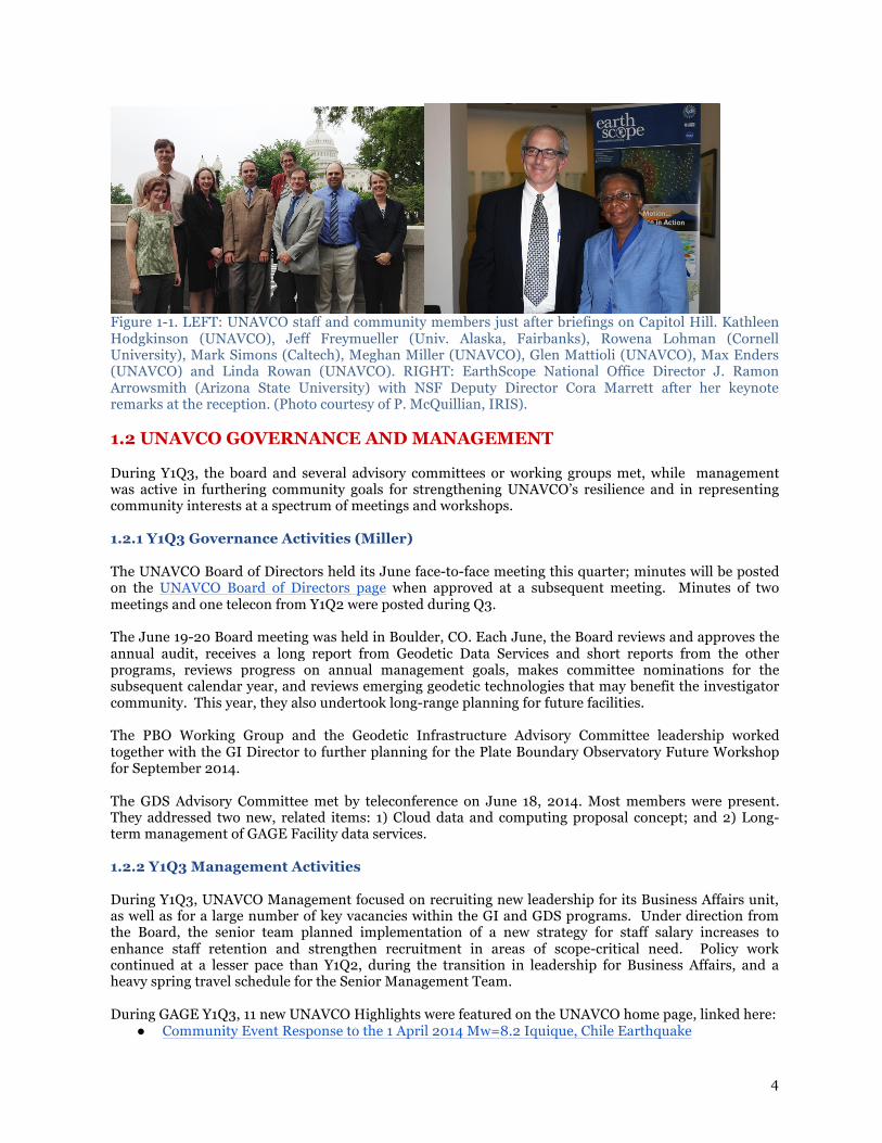
Figure 1-1. LEFT: UNAVCO staff and community members just after briefings on Capitol Hill. Kathleen Hodgkinson (UNAVCO), Jeff Freymueller (Univ. Alaska, Fairbanks), Rowena Lohman (Cornell University), Mark Simons (Caltech), Meghan Miller (UNAVCO), Glen Mattioli (UNAVCO), Max Enders (UNAVCO) and Linda Rowan (UNAVCO). RIGHT: EarthScope National Office Director J. Ramon Arrowsmith (Arizona State University) with NSF Deputy Director Cora Marrett after her keynote remarks at the reception. (Photo courtesy of P. McQuillian, IRIS).
1.2 UNAVCO GOVERNANCE AND MANAGEMENT During Y1Q3, the board and several advisory committees or working groups met, while management was active in furthering community goals for strengthening UNAVCO’s resilience and in representing community interests at a spectrum of meetings and workshops. 1.2.1 Y1Q3 Governance Activities (Miller) The UNAVCO Board of Directors held its June face-to-face meeting this quarter; minutes will be posted on the UNAVCO Board of Directors page when approved at a subsequent meeting. Minutes of two meetings and one telecon from Y1Q2 were posted during Q3. The June 19-20 Board meeting was held in Boulder, CO. Each June, the Board reviews and approves the annual audit, receives a long report from Geodetic Data Services and short reports from the other programs, reviews progress on annual management goals, makes committee nominations for the subsequent calendar year, and reviews emerging geodetic technologies that may benefit the investigator community. This year, they also undertook long-range planning for future facilities. The PBO Working Group and the Geodetic Infrastructure Advisory Committee leadership worked together with the GI Director to further planning for the Plate Boundary Observatory Future Workshop for September 2014. The GDS Advisory Committee met by teleconference on June 18, 2014. Most members were present. They addressed two new, related items: 1) Cloud data and computing proposal concept; and 2) Long-term management of GAGE Facility data services. 1.2.2 Y1Q3 Management Activities During Y1Q3, UNAVCO Management focused on recruiting new leadership for its Business Affairs unit, as well as for a large number of key vacancies within the GI and GDS programs. Under direction from the Board, the senior team planned implementation of a new strategy for staff salary increases to enhance staff retention and strengthen recruitment in areas of scope-critical need. Policy work continued at a lesser pace than Y1Q2, during the transition in leadership for Business Affairs, and a heavy spring travel schedule for the Senior Management Team. During GAGE Y1Q3, 11 new UNAVCO Highlights were featured on the UNAVCO home page, linked here:
● Community Event Response to the 1 April 2014 Mw=8.2 Iquique, Chile Earthquake
5
● Data Event Response to the 10 March 2014 Mw 6.8 Earthquake 77 km WNW of Ferndale, California
● Data Event Response to the 28 March 2014 Mw 5.1 Earthquake 2 km East of La Habra, California
● Connecting museum visitors to geohazard science and GPS technology ● Earthquake and tsunami science and preparedness for coastal Cascadia educators ● UNAVCO installs COCONet cGPS site CN46 in Carriacou, Grenada ● 2014 UNAVCO Science Workshop ● PBO Featured at EarthScope Symposium and Reception ● Data Event Response to the 23 June 2014 Mw 7.9 Earthquake 24km SE of Little Sitkin Island, Alaska ● UNAVCO installs COCONet cGPS site CN21 in Honduras ● Reaching educators in Alaska
While there were no changes to Key Personnel during Y1Q3, Gail Strobel, Business Affairs Director, retired and a search to replace her yielded a very strong pool of finalists. 1.2.3 UNAVCO Staff Representation at Meetings and Workshops UNAVCO Staff represented community interests and facility contributions in a broad cross-section of meetings and workshops. UNAVCO governance and some informational meetings are also included here.
● California Land Surveyors Association Meeting, Riverside, CA, April 3, 2014. Attended by: GI
staff G. Mattioli and C. Walls. ● NSTA National Conference, Boston, MA, April 4-6, 2014. Attended by: S. Olds (ECE). There were
four UNAVCO events: (1) Yellowstone Jigsaw Workshop, (2) Geology Share-a-Thon, (3) Earth System Science Share-a-Thon, (4) EarthScope session.
● Meetings at USGS-Menlo Park, USGS-Pasadena, and JPL, April 4 and April 7, 2014. Attended by GI staff A. Basset, D. Mann, G. Mattioli, and C. Walls.
● Polar Technology Conference (PTC), Bloomington, IN, April 15-17, 2014. Attended by: GI staff N. Bayou and J. Pettit.
● US Science and Engineering Festival, Washington D.C., April 23-28, 2014. Attended by B. Bartel (ECE).
● EarthScope Interpreters Workshop, Anchorage, AK April 27-May 1. Attended by S. Olds (ECE). ● European Geophysical Union General Assembly, Vienna, Austria, April 28-May 2, 2014.
Attended by: F. Boler (GDS), G. Mattioli (GI), and M. Miller (EO). F. Boler attended splinter meetings for the IGS Governing Board meeting, FUTUREVOLC Supersites, and COOPEUS.
● Seismological Society of America Annual Meeting, Anchorage, AK, April 30-May 2, 2014. Attended by: R. Bierma (GI), E. Boyce (GI), M. Enders (GI), K. Feaux (GI), K. Hodgkinson (GDS), D. Phillips (GDS), C. Puskas (GDS).
● California Spatial Reference Center Spring Meeting, San Francisco, CA, May 1, 2014. Attended by: D. Mann (GI).
● SSA/UNAVCO/IRIS Teacher Workshop, Anchorage, AK, May 3-4, 2014. Attended by S. Olds (ECE).
● YVO Consortium Meeting, Mammoth Hot Springs, WY, May 7-8, 2014. Attended by: GI staff G. Mattioli and D. Mencin.
● Board on Earth Sciences and Resources, Division on Earth & Life Sciences, National Research Council Meeting on “Our Changing Globe: The Challenges and Value of Monitoring Earth Processes,” Washington, DC, May 12. Attended by: G. Mattioli (GI, invited speaker) and M. Miller (EO, member of BESR).
● Community Workshop: Next Generation of LiDAR Analysis for Critical Zone Research, University of Colorado, Boulder, May 12-14, 2014. Attended by C. Crosby (GI/GDS).
● EarthScope Decadal Celebration and Reception, Washington D.C., May 15, 2014. Attended by: G.

6
Bartel (ECE), D. Charlevoix (ECE), M. Enders (GI), K. Hodgkinson (GDS), G. Mattioli (GI), M. Miller (EO), and L. Rowan (EO).
● EarthScope Steering Committee, Washington D.C., May 16, 2014. Attended by G. Mattioli (GI) and M. Miller (EO).
● Polar Networks Science Committee meeting, UNAVCO, Boulder CO, May 20-21, 2014. Attended by: G. Mattioli (GI), M. Miller (EO), and J. Pettit (GI).
● Field camp support for Volcanos of the eastern world field course, Nevada, May 21-24, 2014. Attended by B.Bartel (ECE).
● EarthScope Education & Outreach Subcommittee meeting, Tempe, AZ, June 3-5, 2014. Attended by D. Charlevoix (ECE).
● Oregon GPS User Group Meeting, Bend, OR, June 6, 2014. Attended by: GI staff G. Mattioli and K. Austin.
● 2014 IRIS Annual Meeting and Workshop, Sunriver, OR, June 8-11, 2014. Attended by: K. Austin (GI), K. Karl Feaux (GI), K. Hodgkinson (GDS), M. Miller (EO), D. Phillips (GDS) and C. Puskas (GDS). Structural geology & tectonics forum: Strain SC, Golden, CO, June 16-18, 2014. Attended by S. Olds (ECE) and K. Alexander (ECE Intern).
● UNAVCO GDS Advisory Committee meeting, UNAVCO, Boulder, CO, June 18, 2014, Boulder, CO. Attended by GDS staff F. Boler, C. Crosby, D. Ertz, C. Meertens and L. Snett.
● UNAVCO Board of Directors, UNAVCO, Boulder, CO, June 19 - 20, 2014. Attended by: all Senior Management Team members and all available Project Management Team members.
● Structural Geology and Tectonics Forum TLS Short Course, UNAVCO, Boulder, CO, June 20, 2014. Attended and taught by GDS staff C. Crosby and M. Okal.
● Natural Hazards Research and Applications Workshop, Broomfield, CO, June 22-25, 2014. Attended by S. Olds (ECE).
● IGS Workshop 2014: Celebrating 20 Years of Service, Pasadena, CA, June 23-27, 2014. Attended by: F. Blume (GI), H. Berglund (GI), F. Boler (GDS), S. Doelger (GI), D. Maggert (GDS), C. Meertens (GDS) and M. Miller (EO). IGS Governing Board meetings attended by C. Meertens, F. Boler, and D. Maggert.
● EarthCube All Hands Meeting, Washington, DC, June 24-26, 2014. Attended by: C. Crosby (GDS).
This list includes two international trips by GAGE PIs: Mattioli’s April travel to Trimble (Munich) and EGU (Vienna), and Miller’s trip to EGU (Vienna). The benefits of Mattioli’s trip are reported in section 2.1. GI Overview. Highlights and new developments resulting from Miller’s trip: ● Hosting of the Associate Member’s reception at this meeting continues to provide a venue for
advancing international collaborations in support of UNAVCO’s mission and the U.S. geoscience community. Associate Membership is our most rapidly growing class of membership, and this meeting provides an important presence for UNAVCO community science.
● Miller also participates in the Wegener splinter meeting, GGOS and GEO Supersites partners, and a number of more informal interactions with international partners.
● The size of this meeting is much more tractable than AGU for meeting and interacting with key U.S. partners.
● EGU is also an important meeting for Miller’s professional development. The European focus on core geodesy (vs. geophysical applications of geodesy) supports the currency of her expertise. EGU is a much more practical venue to keep current on both global and international aspects of the science, and applications across the atmosphere, cryosphere, oceans and lithosphere.
1.2.4 Publications, Abstracts, and Other Products Created by UNAVCO Staff
Articles: None this quarter.

7
Abstracts and Presentations:
● Bayou, N., 2014, UNAVCO - Powering Science at High Latitudes: Polar Technology Conference (PTC), Bloomington, IN, April 15-17, 2014.
● Berglund, H., F. Blume, I. Romero, and E. D’Anastastio (2014), Effects of the April 1st, 2014 GLONASS Outage on GNSS Receivers: IGS Workshop 2014: Celebrating 20 Years of Service, Pasadena, CA, June 25, 2014.
● Blume, F., H. Berglund, T. Herring, K. Feaux, K. Austin, T. Dittmann, C. Walls, and G. Mattioli (2014), Stability of GNSS Monumentation: Analysis of Co-Located Monuments in the Plate Boundary Observatory: IGS Workshop 2014: Celebrating 20 Years of Service, Pasadena, CA, June 24, 2014.
● Boler, F., S. Wier, N. D’Agostino, R.R.M. Fernandes, A. Ganas, C. Bruyninx, and B. Ofeigsson, 2014, New Collaboration Among Geodesy Data Centers in Europe and the US Facilitates Data Discovery and Access: European Geosciences Union Meeting, Vienna Austria, April 28-May 2, 2014.
● Boyce, E., M. Enders, R. Bierma, K. Feaux, G. Mattioli, 2014, Ongoing Developments in the Plate Boundary Observatory Alaska Network: Testing New Telemetry and Power Options for Improving Station Robustness: Seismological Society of America Annual Meeting, Anchorage, AK, April 30-May 2, 2014.
● Doelger, S., F. Blume, D. Stowers, and G, Mattioli (2014), Status and Plans for the NASA Global GNSS Network (GGN): IGS Workshop 2014: Celebrating 20 Years of Service, Pasadena, CA, June 25, 2014.
● Hodgkinson, K., D. Mencin, D. Phillips, B. Henderson, M. Gottlieb, W. Gallaher, W. Johnson, C. Pyatt, E. Van Boskirk, O. Fox, G. Mattioli, and C. Meertens, 2014, Measuring Transient Signals in Plate Boundary Faults Zones with Strainmeters: European Geosciences Union Meeting, Vienna Austria, April 28-May 2, 2014.
● Hodgkinson, K. D. Phillips, D. Mencin, D., B. Henderson, M. Gottlieb, W. Gallaher, W. Johnson, C. Pyatt, E. Van Boskirk, O. Fox, , C. Puskas, G. Mattioli and C. Meertens, 2014, PBO Strainmeter Measurements of Cascadia Episodic Tremor and Slip Events: Seismological Society of America Annual Meeting, Anchorage, AK, April 30-May 2, 2014.
● Hodgkinson, K., D. Phillips, D. Mencin, B. Henderson, W. Gallaher, W. Johnson, C. Pyatt, L. Van Boskirk, O. Fox, C. Meertens, G. Mattioli and M. Gottlieb, 2014, Data Products from the PBO Borehole Network: 2014 IRIS Workshop, Sunriver, OR, June 8-11, 2014.
● Mattioli, G.S., J. Miller, C. DeMets, and P. Jansma, 2014, Rigidity and definition of Caribbean plate motion from COCONet and campaign GPS observations: European Geosciences Union Meeting, Vienna Austria, April 28-May 2, 2014.
● Phillips, D., D. Mencin, C. Sievers, K. Austin, H. Berglund, F. Blume, C. Meertens, and G. Mattioli, 2014, Large Scale Real-Time GPS Networks, Data Processing Systems and Community Datasets: Seismological Society of America Annual Meeting, Anchorage, AK, April 30-May 2, 2014.
● Phillips, D., C. Crosby, C. Meertens, F. Boler and S. Baker, 2014, EarthScope Geodetic Imaging Data: An Historical Overview of Satellite InSAR and Airborne LiDAR Data Acquired During the EarthScope Facility Construction and Examples of Resulting Science: 2014 IRIS Workshop, Sunriver, OR, June 8-11, 2014.
● Puskas, C. D. Phillips, K. Hodgkinson, H. Berglund, C. Sievers, C. Meertens, G. Mattioli, and D. Mencin, 2014, Nonlinear Deformation Examples Recorded by the Plate Boundary Observatory: Seismological Society of America Annual Meeting, Anchorage, AK, April 30-May 2, 2014.
● Puskas, C., D. Phillips, H. Berglund, D. Mencin, C. Meertens and G. Mattioli, 2014, Bridging the time scales between seismic and geodetic data: High rate and daily data from the EarthScope Plate Boundary Observatory (PBO) network: 2014 IRIS Workshop, Sunriver, OR, June 8-11, 2014.
● B. Bartel and M. Enders manned the UNAVCO display and answered questions from attendees

8
at the EarthScope Decadal Celebration and Reception, Washington D.C., May 15, 2014. ● C. Crosby gave several presentations on TLS technology and data acquisition workflow, lidar
data processing, emerging technologies at the Next Generation of LiDAR Analysis for Critical Zone Research community workshop, University of Colorado, Boulder, May 12-14, 2014.
● C. Crosby gave a presentation on UNAVCO GeoWS web services and project status at the EarthCube All Hands Meeting, Washington, DC, June 24-26, 2014.
● D. Mann presented a talk outlining the status of PBO at the California Spatial Reference Center Spring Meeting, San Francisco, CA, May 1, 2014.
● G. Mattioli presented a talk on the status of PBO and future activities at the California Land Surveyors Association Meeting, Riverside, CA, April 3, 2014.
● G. Mattioli presented a talk on the current status of PBO under GAGE and discussions were conducted about the future of PBO at meetings at USGS -Menlo Park, USGS-Pasadena, and JPL, April 4 and April 7, 2014.
● G. Mattioli presented a talk on “Our Changing Globe: The Challenges and Value of Monitoring Earth Processes” at the Board on Earth Sciences and Resources, Division on Earth & Life Sciences, National Research Council Meeting Washington, DC, May 12.
● G. Mattioli presented a talk on the status and future of PBO at the Oregon GPS User Group Meeting, Bend, OR, June 6, 2014.
● D. Mencin presented a talk on UNAVCO assets in the Yellowstone region and their status with a focus was on possibilities for real-time applications at the YVO Consortium Meeting, Mammoth Hot Springs, WY, May 7-8, 2014.
● UNAVCO Senior Management Team and Project Management Team members gave talks at Board of Directors meeting UNAVCO, Boulder, CO, June 19 - 20, 2014.
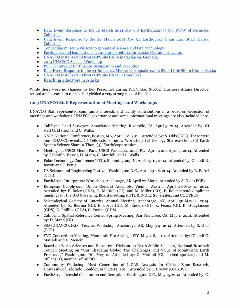
1.2.5 DOI Minting of Community Datasets This quarter, 525 datasets were minted by DOI largely due to the efforts of two GDS summer interns. A number of other products were developed (Table 1-1). Table 1-1. GAGE Facility products. GAGE FACILITY PRODUCTS GAGE Y1Q3
Datasets Published by DOI 525 Knowledge Base Documents Created 3 Knowledge Base Documents Updated 7 Highlights Published 11 Science Snapshots Published 4 1.2.3 Broader Impacts for Community, Governance and Management UNAVCO Websites. The UNAVCO websites are managed by the Web Team (Web Editor in Chief and Web Administrators), Section Editors, and subject matter experts who contribute web content. Content for the seven main sections of the primary UNAVCO website (Community, Projects, Instrumentation, Data, Software, Science, and Education) are the responsibility of seven Section Editors. The focus of the Web Team for the past nine months has been on the UNAVCO Web Integration Project, an effort to combine three disparate UNAVCO web presences, i.e., www.unavco.org, pbo.unavco.org, and facility.unavco.org, into one cohesive website under www.unavco.org, to better reflect the GAGE Facility and its activities. This was a major effort that necessitated the redesign of the main UNAVCO website’s information architecture (IA) to create a more user-friendly and logically consistent experience for our site visitors. On May 13 our newly integrated web presence went live. However, much dynamic content and web applications remain to be integrated and represent a major ongoing development effort. Our goal is to retire pbo.unavco.org and facility.unavco.org once all dynamic content and applications

9
have been migrated to www.unavco.org. In the interim, we use URL redirects to both pbo.unavco.org and facility.unavco.org in order to bring these applications into the www.unavco.org namespace in a virtual manner. We are currently monitoring user activity of the new integrated site to measure the usage and understanding of our new information architecture and to track broken links from outside parties. These insights enable us to provide iterative improvements to promote better site accessibility for all users. The UNAVCO websites are a key resource for both the UNAVCO community and as a tool to reach beyond to educators and the general public (Table 1-2A). The GAGE Facility also provides infrastructure and maintenance support to websites for the Research Experiences in Solid Earth Science for Students (RESESS) and Continuously Operating Caribbean GPS Observational Network (COCONet) programs. A new TLALOCNet site is also under development. TABLE 1-2B shows the activity for individual domains UNAVCO is responsible for maintaining. UNAVCO provides web support to EarthScope through maintenance of the primary EarthScope website (www.earthscope.org). The EarthScope website received routine updates and several new site projects were supported including the 2014 Speaker Series and the new Earthscope Institute: Geochronology and the Earth Sciences Short Course. Table 1-2A. Quarterly activity for the primary UNAVCO websites. The number of users metric quantifies the number of different site visitors. Total number of sessions quantifies the number of visits to the website separated by > 0.5 hr. Number of “page views” quantifies the number of individual pages viewed. WEBSITE IMPACTS GAGE Y1Q3 Number of Users 57,195 Number of Sessions 89,970 Page Views 211,684 Table 1-2B. Breakdown of Table 1-2A by third order domain. Note that these metrics will change in future reports with the continued reconfiguration of the web site.
WEBSITE NUMBER OF USERS
NUMBER OF SESSIONS PAGE VIEWS
Y1Q3 www.unavco.org 43,513 70,148 166,749 Y1Q3 facility.unavco.org 7,013 8,993 18,836 Y1Q3 pbo.unavco.org 4,595 7,462 15,967 Y1Q3 resess.unavco.org 1,381 2,164 6,971 Y1Q3 coconet.unavco.org 693 1,203 3,161 UNAVCO Outreach and Impacts. Many outreach activities are conducted by UNAVCO staff across all three programs. While ECE has traditionally conducted the largest number of activities and supports those that are most visible activities to the community, a significant number of GI and GDS staff regularly interact with the public, stakeholders, National Park Service staff, schools, and other similar groups. In order to better represent the true impact UNAVCO has, starting with this Y1Q3 report, summaries of events conducted (Table 1-3) and individuals reached (Table 1-4) will be reported across all three programs and presented in this Broader Impacts section. (Previously it was reported within the ECE program section.) For example, in Y1Q3, GI staff K. Austin, D. Mann, and A. Basset gave presentations to the non-geodetic community in their regions, reaching community college students, and surveyors, and polar engineer N. Bayou visited Lyons Elementary School, north of Boulder, to talk with 2nd and 4th graders about working in Antarctica. Table 1-3. Metrics for activities led and products produced by all UNAVCO Programs (GI, GDS, ECE) for Y1Q3.
10
OUTREACH: ACTIVITIES (QTY) GAGE Y1Q3
Short Courses 2 Workshops and Outreach Events 23 Internship Programs 2 Table 1-4. Number of people reached through the activities identified in Table 1-3, organized by audience. Researchers and research faculty include non-teaching faculty and researchers; college and university faculty include tenure and non-tenure track faculty. Other Professionals include anyone participating in activities for professional growth and development, who do not fall into one of the other professional categories. Examples of Other Professionals include Emergency Managers, Park Interpreters, Federal Agency staff, and Sponsors, among others. Large event visitors are individuals visiting museum displays and conference exhibit booths.
OUTREACH: INDIVIDUALS REACHED (QTY) GAGE Y1Q3
Researchers + Research Faculty 8
University + College Faculty 22
Post-docs 2
Graduate Students 14
Undergraduate Students 88
Public / K-12 Students 45
K-12 Faculty 111
Other Professionals 230
Large Event visitors 38,137 2. Geodetic Infrastructure Program 2.1 OVERVIEW This UNAVCO program integrates all geodetic infrastructure and data acquisition capabilities for continuously operating observational networks and shorter-term deployments. Supported activities include development and testing, advanced systems engineering, the construction, operation, and maintenance of permanent geodetic instrument networks around the globe, and engineering services tailored to PI project requirements. The GI program coordinates closely with Geodetic Data Services program (Section 3) to assure the highest standards of data quality control, integrity of metadata, ease and transparency of data access for the UNAVCO user community, and to provide appropriate and timely metrics on data usage for sponsors. Major projects currently supported by the GI program include the 1,112 station Plate Boundary Observatory (PBO), Polar networks in Greenland and Antarctica (GNET and ANET, together known as POLENET), COCONet spanning the Caribbean plate boundary, the multi-disciplinary AfricaArray, and several other smaller continuously observing geodetic networks. A major new GI project was initiated in September 2013 with the recent award (EAR-1338091) of NSF Instrument Development Major Research Instrumentation (MRI) program entitled “MRI: TLALOCNet - Development of a continuous GPS-MET array in Mexico for atmospheric, climatic, and seismotectonic research in the Americas" ($1,500,000; 9/1/13 – 8/31/17). Core support from GAGE also will be used to leverage funds provided by the MRI award. A new Project Manager, Mr. John Galetzka, was hired to spearhead the TLALOCNet project. He joined the UNAVCO team in late February, 2014 and immediately

11
hit the ground running by going to Mexico to complete a reconnaissance field trip and series of initial in country stakeholder meetings, which will be critical to the success of the project over the long-term. Since the last report (GAGE Facility Y1Q2), significant progress has been made in the construction phase of TLALOCNet, including the installation of 2 new sites (Hermosillo, Cuauhtomoc) and rehabilitation of 1 site (Moctezuma). We anticipate another 2-3 sites will be completed in the next several months. A more comprehensive report on the progress to date will be provided to NSF as part of the TLALOCNet Annual report. The GI program also provides engineering services to individual PIs for shorter-term GPS and TLS projects, and other investigator-led data acquisition that had been previously managed by the UNAVCO Facility. While a large share of GI resources in GAGE is tied to ongoing O&M of the PBO, GGN, and POLENET continuous GPS (cGPS) networks and ongoing support to PI projects, two key areas for enhancement were identified through community input and delineated in the GAGE proposal: ● The continued upgrade of PBO to high-rate (>1 Hz), low-latency (<1 s), well-hardened sites in
order to support research activities related to dynamic fault rupture and volcanic eruption processes and mitigation of earthquake and volcano hazards;
● Continued evaluation and upgrade of all GPS receiver pools for implementation of full GNSS
capability. Both of these tasks build on the specific recommendations of the Committee on National Requirements for Precision Geodetic Infrastructure [NRC, 2010]. Given the reduction in budget to the GAGE Facility in year one to levels ~9% below FY2012, both of these strategic initiatives were significantly curtailed during GAGE Y1Q1 and Y1Q2. The impact to tasks (1) and (2) above have been mitigated in part through acquisition of new instruments with non-GAGE funds. 300 additional Trimble RT-GPS node licenses for the PIVOT platform (225 for PBO and 75 for PI projects) along with 50 new Trimble GNSS-capable NetR9 receivers and choke ring antennas (10) and GNSS LNA kits (40) to upgrade PBO stations were purchased in late 2013. In addition, an 33 new Trimble GNSS-capable NetR9 instruments were purchased to upgrade the EAR PI-support instrument pool. These actions have helped to mitigate the GAGE YR1 budget reductions to the GI program. Since the Y1Q2 GAGE Facility report, 20 additional NetR9 instruments have been purchased to support the EAR PI community pool with 12 additional for PBO. Eight of the new PBO instruments have been configured with GLONASS tracking and on board RTX (Trimble’s real-time, in-band, precise point positioning solution). Over the next quarter, deployment of these GNSS/RTX instruments will be conditioned based on consultation with the PBO working group and PBO Ops staff. The Polar Services group has not ordered or received any new GNSS instruments as yet, but plans to acquire additional instruments to support PLR PIs in Y1Q4 of the GAGE Facility. During Y1Q2, UNAVCO staff developed a Collaborative Research MRI request with PI David Holland of New York University ($689K NYU; $232K UNAVCO) for enhanced terrestrial radar observations of calving processes at the Helheim Glacier, an outlet glacier in a fjord in southeast Greenland. The GI Polar Support team together with the GI TLS and D&T groups will work closely and cooperatively with the PI and the instrument manufacturer to assemble two ground-based interferometric radar (GBIR) systems capable of long-term polar deployment. The development of these GBIR systems will subsequently allow the wider-community to deploy clones of the newly designed instrument system at a number of outlet glaciers around the world, and to thereby build an encompassing, physically-based calving rheology for outlet glaciers. UNAVCO was informed during Y1Q3 that the MRI proposal would not be funded at this time. We are now working to formulate a revised proposal for submission to the next MRI or EAR-IF program deadline. Also during Y1Q2, GI Borehole Geophysics Ops staff worked closely with PI Lawrence Murdoch of Clemson University to develop a proposal to the DOE to install a PBO GTSM/Seismic borehole instrument string proximal to a producing hydrocarbon field. Injecting CO2 or other fluids into a well deforms the enveloping rocks in a complex pattern that increases in magnitude and expands outward with time. This evolving strain field holds important information that can be interpreted to improve

12
understanding of geomechanical processes such as fault slip, which could hinder the injection process, or to sharpen estimates of formation properties and pressures, which will reduce risks and costs associated with injection. The objective of the proposed project is to evaluate the feasibility of measuring and interpreting the in-situ strain tensor to characterize CO2 injection processes. UNAVCO will provide (from the PBO MREFC instrument cache) and install a GTSM borehole instrument package as a subaward from Clemson. This proposal has now undergone both scientific and budget review, which required that UNAVCO provide additional documentation and justification for its costs and planned scope of work to PI Murdoch. The DOE has recently approved this project, and we anticipate that installation of the initial GTSM instrument will occur during GAGE Y2Q1 (late 2014) or possibly Y2Q2 (early 2015). The GI Director took a single international trip during Y1Q3 that was partly supported by GAGE, to Trimble in Munich and EGU in Vienna. The benefits to UNAVCO and the US science community included: 1) technical discussions about the future of PPP technology and epoch-by-epoch integrity software for implementation on >900 extant Trimble NetRS receivers. 2) briefing by Trimble staff on future products likely to be of interest to US community including efforts to stand an Earthquake Early Warning system in the western US, based in part on NSF-funded PBO assets. 3) two technical presentations at EGU: a) poster on transient slip or creep events with PBO BSM array proximal to Parkfield; and b) talk on Caribbean plate kinematics based in part on new cGPS observations from COCONet. 4) hosted annual EGU reception for UNAVCO Associate Members with M. Miller and F. Boler. Lastly, during Y1Q2, the GI Director worked closely with the GI Advisory Committee, the PBO Working Group, and the UNAVCO Board of Directors liaison to the GI AC, to develop a workshop proposal to address the future of the PBO in the GAGE Facility and beyond the end of the EarthScope plan in September 2018. We proposed a 3-day workshop to be held in Breckenridge, Colorado, now planned for the early fall of 2014, to bring together various stakeholders, core and potential additional federal and state sponsors, scientific and technical leaders from a wide variety of interests and communities, and representatives from the commercial sector. The proposal was successful, and was awarded on July 1, 2014, the start of Y1Q4 (EAR-1441122). The GI Director and the organizing committee have spent considerable time and effort refining the goals, revising the agenda, and extending invitations to the workshop since the last GAGE Facility report. Expected deliverables from the workshop include a report and web resources encapsulating community-vetted recommendations. UNAVCO would incorporate these recommendations into future budget requests as part of the GAGE Facility CA (EAR-1261833). A summary of the important support GI metrics is shown below in Table 2-1. Table 2-1. Geodetic infrastructure metrics for GAGE.
GEODETIC INFRASTRUCTURE METRICS: SUMMARY OF KEY METRICS GAGE Y1Q3
PI Projects & Proposals Supported: NSF-EAR, NSF-Other (Qty) 19 PI Projects & Proposals Supported: NSF-PLR (Qty) 4 PI Projects & Proposals Supported: Other Community (Qty) 9 Permanent Stations Supported: NSF-EAR and Community, PBO and Related (Qty) 2,105 Permanent Stations Supported: NSF-PLR (Qty) 156 Permanent Stations Supported: NASA GGN (Qty) 62
PI PROJECTS SUPPORTED (QTY) GAGE Y1Q3
GPS NSF-EAR 7 GPS NSF-Other 5 GPS Other Community 4

13
GPS NSF-PLR Arctic 1 GPS NSF-PLR Antarctic 1 TLS NSF-EAR 3 TLS NSF-Other 0 TLS Other Community 2 TLS NSF-PLR Arctic 2 TLS NSF-PLR Antarctic 0 PI PROPOSALS SUPPORTED (QTY) GAGE Y1Q3
GPS NSF-EAR 3 GPS NSF-Other 0 GPS Other Community 2 GPS NSF-PLR Arctic 0 GPS NSF-PLR Antarctic 0 TLS NSF-EAR 1 TLS NSF-Other 0 TLS Other Community 1 TLS NSF-PLR Arctic 0 TLS NSF-PLR Antarctic 0 UNIQUE PI's SUPPORTED (QTY) GAGE Y1Q3
GPS NSF-EAR: Projects and Proposals 34 GPS NSF-Other: Projects and Proposals 9 GPS Other Community: Projects and Proposals 11 GPS NSF-PLR Arctic: Projects and Proposals 1 GPS NSF-PLR Antarctic: Projects and Proposals 1 TLS NSF-EAR: Projects and Proposals 3 TLS NSF-Other: Projects and Proposals 0 TLS Other Community: Projects and Proposals 4 TLS NSF-PLR Arctic: Projects and Proposals 2 TLS NSF-PLR Antarctic: Projects and Proposals 0 GPS NSF-EAR, NSF-Other, Other Community: Permanent Station Networks 42 PERMANENT STATIONS O&M (QTY) GAGE Y1Q3
GPS NSF-EAR and Community 770 GPS NSF-PLR Arctic 76 GPS NSF-PLR Antarctic 80 GPS NASA GGN 62 PBO GPS 1,127 PBO Borehole Seismometers 79 PBO Borehole Strainmeters 75 PBO Shallow Borehole Tiltmeters 25 PBO Pore Pressure Sensors 23 PBO Long Baseline Laser Strainmeters 6

14
POOL EQUIPMENT (QTY & UTILIZATION) GAGE Y1Q3
GPS NSF-EAR (# Receivers in Pool) 653 GPS NSF-EAR (Average % Utilization) 74% GPS NSF-EAR (Peak % Utilization) 81% GPS NSF-PLR Arctic (# Receivers in Pool) 125 GPS NSF-PLR Arctic (Average % Utilization) 73% GPS NSF-PLR Arctic (Peak % Utilization) 75% GPS NSF-PLR Antarctic (# Receivers in Pool) 208 GPS NSF-PLR Antarctic (Average % Utilization) 60% GPS NSF-PLR Antarctic (Peak % Utilization) 62% GPS Systems Repaired (UNAVCO & Community) 41 TLS (# Scanners in Pool) 6
DEVELOPMENT & TESTING (QTY) GAGE Y1Q3
D&T Projects Worked 14 D&T Projects Completed 3 2.2 COMMUNITY AND CONTINUOUSLY OBSERVING NETRKS 2.2.1 Plate Boundary Observatory and Related Projects UNAVCO operated and maintained the following instruments this period as part of the PBO network:
● 1127 permanent GPS stations (1100 PBO core, 27 other) ● 75 borehole strainmeters (74 PBO core, 1 NSF Continental Dynamics) ● 79 borehole seismometers (78 PBO core, 1 NSF Continental Dynamics) ● 23 borehole pore pressure sensors ● 25 shallow borehole tiltmeters (out of 26 possible holes) ● 6 long baseline laser strainmeters ● 145 meteorological stations (118 core, 27 NOAA) ● 430 real-time GPS stations (391 PBO core, including 282 stations upgraded as part of the NSF-
funded ARRA Cascadia initiative)

15
2.2.1.1 cGPS Network
Figure 2-1. GPS uptime time series for PBO network from April 2009 through June 2014.
● The 1100-station core PBO GPS network uptime percentage for the month of June was 95.4%. For Y1Q3, the network uptime percentage was 94.7% and for the project since inception is 94.8%.
● In GAGE Facility Y1Q3, there were 112 PBO GPS site visits, resolving 232 GPS issues during 277 engineer-days in the field. An additional 61 days of engineer travel involved required meetings and training. Other PBO GPS Ops staff travel included activities related to permitting (11 days), TLS support (8 days), PI support (8 days), TLALOCNet (14 days) and COCONet (23 days).
● PBO regional managers and engineers completed a comprehensive assessment of GPS network attributes to assess performance and cost for each station. Characteristics such as transfer rates, accessibility, communications capabilities, and permit fees were included in the compilation.
● PBO AK staff initiated and largely completed summer helicopter-based operations, conducting 39 maintenance visits or aerial inspections via helicopter access. This year’s extended helicopter contract began in Alaska on May 26th and is scheduled to conclude on July 15th. An additional 20 site visits were completed via other types of transportation.
● PBO AK staff supported a high-rate data download response to the 2014-06-23 M7.9 earthquake near Amchitka Island in the Aleutian Arc. As part of this response, 1-Hz data were downloaded from all stations within 800 km of the epicenter. PBO worked with partner organizations to obtain downloads of certain stations behind firewalls, and arranged for remote receiver downloads at other offline sites.
● PBO AK staff coordinated with colleagues at Alaska Volcano Observatory, Alaska Earthquake Center, West Coast/Alaska Tsunami Warning Center, IRIS/Transportable Array, and U. of Alaska Fairbanks, to plan joint field activities for summer 2014, co-locate new equipment, and implement communications-sharing at several locations. Partner agency efforts have resulted in 2 PBO stations being brought back online during this quarter. These collaborations reduce

16
overall operating costs and continue to be mutually beneficial. ● Ellie Boyce (AK) traveled to Guatemala in April to install metpacks and train in-country
technicians for additional metpack installations. Data from 6 cGPS sites in Guatemala are now being archived as part of COCONet.
● Max Enders (PBO Alaska Project Manager) departed UNAVCO for a new position with IRIS/Transportable Array. Ellie Boyce was appointed as Interim AK region PM for the 2014 summer field season.
● PBO engineering staff from all regions helped facilitate numerous custom data requests from community members and stakeholders. Many of these requests are for airborne LiDAR surveys and local surveying operations.
● PBO SW engineers completed collaborative work with Scripps, testing equipment, implementing repairs and hardening communications for sites with the MEMS accelerometer geodetic module. Part of the project included an upgrade of the Borrego Springs VPN (7 sites) to high bandwidth 5.8GHz radios with transfer rates improved 8x.
● PBO SW engineers Doerte Mann, Shawn Lawrence and Chris Walls completed a tower climbing and fall arrest course in April.
● The PBO SW group finalized engineer screening and interviews for the open position in San Clemente. The new engineer will start in July.
● In the PBO SW region P781 (Modesto, CA) was removed due to freeway overpass construction. This was a short notice request that did not allow for a replacement station to be constructed. Prior to decommissioning data was collected simultaneously at a nearby NGS benchmark (PID HS0229) for a geodetic tie should a station be constructed in the future.
● The PBO SW region continued the decommissioning of cellular modems by combining and expanding radio networks in order to increase bandwidth and reduce recurring communication costs.
● Intermountain Region engineers completed a joint Borehole Strainmeter/GPS operations trip in Yellowstone National Park during May. Highlights included upgrading telemetry at the Lake GPS station and data quality issues with several borehole strainmeter stations.
● Intermountain Region engineers upgraded the radio link in the Baker Relay on the Nevada/Utah border to newer 2.4 GHz Ubiquiti IP radios.
● Intermountain engineers continued supporting data downloads and maintenance of the Rio Grande Rift sub award, as well as an engineer who provided 2 weeks of field time in Nicaragua supporting the COCONet project.
● TLALOCNet project manager John Galetzka, with assistance from Adam Woolace and Luis Salazar, reconnoitered 22 of 25 sites (one site in Oaxaca was rejected out of security concerns). The remaining three island sites will be built without prior visits to save time and money. The first four stations (three in Sonora, one in Chihuahua) will be operational in early Q4 and an additional three stations (Puebla, Oaxaca and Chiapas) are planned to be operational by the end of Q4.
● The TLALOCNet "Donation-to-UNAM" and US State Department “Diplomatic Pouch” equipment shipping processes is progressing and will be used as a template for future shipments. Meanwhile, coordination continues with the TLALOCNet Mexican contractor (Luis Salazar) to help with installations, operations and maintenance.
● PBO engineers Ken Austin, Adam Woolace, Tim Dittman, David Kasmer and Doerte Mann attended Predatory Mammal Safety Training in Alaska and supported AK operations.
● Adam Woolace, Dave Kasmer and Chad Pyatt completed a week of Borehole Geophysics cross training/field work in April in Northern California.
● Ken Austin and Liz Van Boskirk completed GPS/BG cross training in May 2014 on the Olympic Peninsula.
This quarter, with high-elevation GPS stations melting out of the snow and the weather becoming milder, the PBO Alaska region began annual helicopter-based maintenance operations. This year’s primary helicopter contract lasts 7 weeks and the work plan includes stations with locations scattered across from Southeast Alaska out west to the Aleutian Arc and up north to Denali National Park and Fairbanks. During the first 35 days of work in Y1Q3, the helicopter-based field crew made 31 maintenance visits and conducted 8 aerial inspections, bringing 19 stations back online by repairing a
17
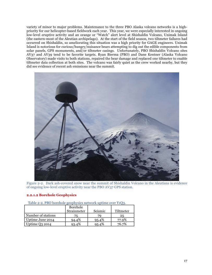
variety of minor to major problems. Maintenance to the three PBO Alaska volcano networks is a high-priority for our helicopter-based fieldwork each year. This year, we were especially interested in ongoing low-level eruptive activity and an orange or “Watch” alert level at Shishaldin Volcano, Unimak Island (the eastern-most of the Aleutian archipelago). At the start of the field season, two tiltmeter failures had occurred on Shishaldin, so ameliorating this situation was a high priority for GAGE engineers. Unimak Island is notorious for curious/hungry/nuisance bears attempting to dig out the edible components from solar panels, GPS monuments, and/or tiltmeter casings. Unfortunately, PBO Shishaldin Volcano sites AV37 and AV39 tend to be favorite targets. Ryan Bierma (PBO) and Dane Kentner (Alaska Volcano Observatory) made visits to both stations, repaired the bear damage and replaced one tiltmeter to enable tiltmeter data collection at both sites. The volcano was fairly quiet as the crew worked nearby, but they did see evidence of recent ash emissions near the summit.
Figure 2-2. Dark ash-covered snow near the summit of Shishaldin Volcano in the Aleutians is evidence of ongoing low-level eruptive activity near the PBO AV37 GPS station. 2.2.1.2 Borehole Geophysics Table 2-2. PBO borehole geophysics network uptime over Y1Q3.
Borehole
Strainmeter Seismic Tiltmeter Number of stations 75 79 25 Uptime June 2014 94.4% 95.4% 77.9% Uptime Q3 2014 93.4% 95.4% 76.7%

18
Figure 2-3. PBO seismic network uptime time series from April 2009 through June 2014.

19
Figure 2-4. PBO Borehole strainmeter network uptime time series from April 2009 through June 2014.

20
Figure 2-5. PBO tiltmeter network uptime time series from April through June 2014. Tiltmeter network
status is tracked on a quarterly basis. Note the recent improvement in late June 2014.
● Borehole Geophysics (BG) field engineers resolved 57 BG maintenance issues with 60 field days in Y1Q3.
● BG Ops staff completed the final installation details and replacement strainmeter at Norris (B950) in Yellowstone. The borehole strainmeter/seismometer were brought online in February and the tiltmeter in June. The old tiltmeter at B205 is still installed for continuous record. This station continues to operate well and has passed initial metrics.
● BG Ops staff successfully brought A/C power to B020, removing a problematic thermoelectric generator and significantly improving reliability/reducing station visits as part of on-going hardening efforts.
● BG Ops staff spent a week in April cross-training 2 GPS engineers on the GTSM and other BG components.
● BG team presented and internally released an iPhone app for field engineers to manage metadata and SOH information.
● BG team created a budget scenario calculator to help plan for possible future funding scenarios and in preparation for PBO workshop in September of 2014.
● UNAVCO received notice of intent to fund a DOE proposal with Larry Murdoch at Clemson, which includes UNAVCO engineering effort to install a BG in Oklahoma and to develop new ways of to remove hydrologic signals toward improved monitoring of CO2 sequestration reservoirs.
Planned Activities
● Installation of at least one borehole strainmeter in on Buyukada (an island offshore Istanbul in the Sea of Marmara) Turkey in July as part of GeoGONAF. (Will also support geophysical logging of the co-located 300m seismic borehole.)
● Annual maintenance trips to seasonally available stations in Yellowstone and Mt St Helens. ● Continued efforts to improve data quality at poorly performing borehole strainmeters. Currently

21
working through a list of stations with potentially resolvable (electronic) issues. 2.2.1.3 Long Baseline Laser Strainmeter Subaward: UC San Diego The long baseline laser strainmeter (LSM) recordings for this period were exceptionally good, requiring a minimum of time in the field. The benign weather played a major role (as reflected by the record drought conditions). This situation was helpful in two ways: for dealing with laser-stability issues and in completing the conversion and switchover of our data-processing system. The lasers used for the primary strain measurement are special purpose high-stability instruments. Starting some time last year, the company that produces these instruments lost control of their production process. SIO staff have been working with them since the start of the year to obtain four replacement lasers, and to maintain the quality required. Current tests are encouraging, but this effort has absorbed considerable amounts of time. Table 2-3. LSM instrument performance metrics (percentage of data recorded at each site) this period.
CHL1 CHL2 DHL2 GVS1 SCS1 SCS2 Network Average
2014-04 100% 99% 95% 100% 99% 100% 98%
2014-05 100% 100% 100% 94% 99% 96% 98%
2014-06 99% 100% 100% 99% 100% 100% 99%
2.2.1.4 PBO Network Data Return and Data Quality The PBO network data return target is 85% for all data types except for tiltmeter; tiltmeter data return is on a best effort basis. The summary for all PBO sensor types is shown in Table 2-4. The time series for data return percentage since the beginning of the initial 5-year PBO/SAFOD O&M award (EAR-0732947) is shown in Figure 2-5. This period, all PBO data types exceeded the data return target. Table 2-4. PBO network cumulative data return percentage for quarter and since beginning of PBO O&M.
Period Target GPS Seismic Borehole
Strainmeter Laser
Strainmeter Tiltmeter Pore
Pressure GAGE Y1Q3 85% 96% 99% 98% 100% 87% 98% Cumulative since
2008-10 85% 99% 96% 98% 100% 86% 92%

22
Figure 2-6. PBO network data return percentage from 01 October 2008 through 30 June 2014.
PBO network data return notes this period:
● Strainmeters. The longest outage this quarter was at B202 on Mt St Helens. An engineer hiked to the site from Johnston Ridge Observatory to restart the instrument May 29 2014. The strainmeter restarted as normal and passed data quality metrics. The new Yellowstone strainmeter, B950, installed in October 2013 is passing all data quality metrics expected of a strainmeter at this stage post-install. It is recording the M2 earth tide at a string signal to noise ratio, there are minimal unexplained steps in the data and it records teleseismic shears.
● Pore Pressure: B082 failed the pore pressure metric this quarter due to extensive hydrological pumping a few 100 meters from the site. This induced large strain transients that reduced the coherence between pore pressure and barometric pressure change.
● Tiltmeters. Data flow for several tiltmeters that had been offline during the previous quarter resumed as normal following spring and early summer field work. These included sites in Alaska, Yellowstone and Mt St Helens. A new tiltmeters was installed in borehole B950 in Yellowstone on June 18, 2014. This is the replacement tiltmeter for the B205 strain/tiltmeter/seismic installation that was destroyed by lightning. The B205 tiltmeter, the only instrument that still functions in the B205 borehole will be run simultaneously with B950 to enable comparison of instrument responses. Because the new B950 tiltmeter was installed in the last few weeks of this quarter it does not pass the data quality metric, which requires comparison of the observed and predicted earth tides. Initial indication of data quality is that it is good; a tidal signal is visible in the time domain. Tiltmeter sites that failed the data quality metric were: ○ AV29, WestdahlSEAK2008, Alaska: Data flow resumed from this site June 2 2014. The y-
gauge had recorded a flat line through the time it was offline. ○ AV39, ShishaldinAK2008, Alaska: Off line through this quarter. ○ B204, marble204bwa2007, Mt St Helens: Data were too noisy to resolve the tides in the X-
gauge. ○ B945, panthr945swy2008, Yellowstone: The instrument failed in October 2013. The failed
instrument was removed in June 2014 with the replacement planned for July 2014. ○ P693, MSH_NWDomeWA2004, Mt St Helens: Off line through this quarter.
The number and type of data quality metrics vary by data type. The summary for all PBO sensor types is shown in Table 2-5. In this reporting period, all PBO data types exceeded data quality metric targets.

23
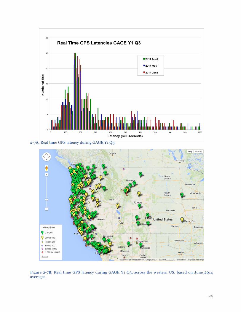
Table 2-5. Network performance metrics for PBO: data quality. PBO NETWORK PERFORMANCE: DATA QUALITY (Pass/Fail) GAGE Y1Q3 PBO GPS PASS PBO Borehole Strainmeters PASS PBO Shallow Borehole Tiltmeters PASS PBO Pore Pressure Sensors PASS PBO Long Baseline Laser Strainmeters PASS 2.2.1.5 Real Time GPS Network Operations The average completeness across the UNAVCO RT-GPS network was 83.6% for each month of the quarter. The median latency across the network throughout the quarter ranged from 221 to 231 milliseconds milliseconds with 25% of the network typically having latency less than 166 ms and 75% of the network having latencies around 565 milliseconds (Table 2-6). The spread in latencies does not vary much over the quarter or network (Figures 2-7A and 2-7B ). Table 2-6. Real time GPS network completeness and latency for GAGE Y1Q3.
Month Number of Sites
Network Completeness
(%)
Average Latency*
(ms)
Median Latency
(ms)
25% (ms)
75% (ms)
2014-04 440 83 913 231 159 564
2014-05 445 83 798 223 158 565
2014-06 455 85 809 221 161 554
* Latencies are based on sites online during the quarter.
24
2-7A. Real time GPS latency during GAGE Y1 Q3.
Figure 2-7B. Real time GPS latency during GAGE Y1 Q3, across the western US, based on June 2014 averages.

25
2.2.2 Field Support for the NASA GGN UNAVCO, in collaboration with JPL, is responsible for the operations and maintenance of the 62 permanent GNSS stations that comprise the NASA Global GNSS Network (GGN) (fig. 1). UNAVCO staff monitor station network connections, ship new equipment to site operators as necessary, and construct new permanent sites as directed by JPL. UNAVCO staff work closely with local collaborators at each station for the purposes of routine maintenance as well as troubleshooting when data flow is interrupted, and perform field maintenance and upgrades. 75 receivers are monitored in the GGN as 13 stations have two receivers on the same antenna. Currently, 57 GGN stations are fully operational and provide daily files to the geodetic user community. Two are in the process of being repaired due to data communications failures, but are otherwise healthy and data will be recovered when communications have been restored. Three stations have suffered computer failures. New computer equipment has been shipped to these sites and will be installed in the coming month. During the past three months, UNAVCO engineers worked with local station collaborators to get four new receivers installed at stations DGAV on Diego Garcia Island, FAIR in Fairbanks, Alaska, BSHM in Haifa, Israel, and AREV at the Arequipa Laser Station in Peru. These receivers are capable of tracking GPS, GLONASS, Galileo, Beidou, and QZSS satellites, and were installed as replacements for, not additions to, existing receivers at the aforementioned stations. Four additional receivers were sent to, and are awaiting installation at MOIU in Eldoret, Kenya, CGGN in Toro, Nigeria, PALM, at Palmer Station, Antarctica, and POLJ, in Bishkek, Kyrgyzstan
Figure 2-8. Operational state of the NASA GGN on April 1, 2014. Green indicates an operational station grey indicates a 3-week or longer interruption in data flow. UNAVCO is also in the process of upgrading the entire GGN with new remote computers that have dual hard drives for failover purposes and modern operating systems. Six of these new computers were

26
installed during the reporting period. Five additional computers were shipped to other stations and are awaiting installation, after which, eight stations will remain that need computer upgrades. The UNAVCO GGN staff has also selected three new rugged PC models that will be tested in-house for deployment at the GGN’s most remote stations, including those in Antarctica, and Greenland. Four additional stations that have no personnel on site and require collaborators multiple hours to reach have been selected for the installation of networked power strips. These will allow UNAVCO staff to remotely power cycle any of the station equipment immediately as the first means of troubleshooting, should any equipment go offline. 2.2.3 Polar Projects: POLENET POLENET support is a year-round effort of the UNAVCO Polar team. With telemetered cGPS networks in Greenland and Antarctica, the cycle of monitoring, planning, preparation and field work is continuous. For the Antarctic aspect of the project, ANET, support this quarter has been directed at the ongoing monitoring and data flow management of Antarctic sites. The five new sites that were installed this field season as part of a renewal of the ANET award and expansion of the original network, are operating as expected. The new sites brought the total number of core ANET sites to 42. LARISSA (LARson Ice Shelf System), a sister network operating on the Antarctic Peninsula, added one more sight during this period for a total of ten full time, telemetered stations. Planning and preparation is underway for the next ANET field season, wherein most sites will be visited, with priority given to those most requiring maintenance or upgrades. The average culmulative ANET data recovery, measured by data that reaches the UNAVCO archive, is currently at 88.5%. For monthly averages, see 2-9 below.
Figure 2-9. POLENET/ANET and LARISSA network status since inception. Solid red area shows the number of stations operating through time (52 at close of Y1Q3). Orange line shows monthly data return percentage.

27
Figure 2-10. Locations of ANET and LARISSA continuously operating GPS stations in Antarctica.

28
Figure 2-11. ANET cGPS station MINO, located a t Minna Bluff in Antarctica. Photo: Nicolas Bayou 2014 GAGE Y1Q3 activities for the Polar Services team were focused on preparations for the 2014 GNET field season. Engineering efforts have been directed towards preparation of field O&M kits to enable rapid repair and upgrade of Greenland sites to be visited this year. Ongoing monitoring and data management of GNET sites has uncovered a recent issue in which several of the data cards aboard the NetRS receivers are failing. This causes data collection at affected sites to cease. UNAVCO is working with Ohio State University and the card manufacturer to pin down the exact issue. It appears at this time that the failure lies in the card itself, but further testing is needed to confirm this absolutely. Currently, 15 of the 42 GNET sites are not operational. Of these, at least a dozen are suspected to have the flash card issue. There is a likelihood that more that will be involved. Since the sites at risk are scattered throughout the network, this season the O&M crew will visit all sites in Greenland. Of these, 20 sites are scheduled for regular maintenance visits, which will include both repairs and upgrades. A number of replacement kits are undergoing fabrication and test in preparation for this aggressive 2014 summer maintenance plan. In addition to critical preventive maintenance and repair, battery state of health analysis will occur at all sites on the visit plan. This will give us key data on long term battery capacity trends over the network. Overall GNET data recovery, measured by data that reaches the UNAVCO archive, is currently 88.4%. For monthly averages, see Figure 2-12 below. The recent drop in recovery rates in Greenland is attributable in part to the failure of sites with bad data cards. We expect the rate to recover after the field maintenance is complete.

29
Figure 2-12. POLENET/GNET network status since inception. Solid red area shows the number of stations operating through time (42 at close of Y1Q3). Orange line shows monthly data return percentage.
Figure 2-13. GNET continuously operating GPS stations in Greenland.

30
GNET Stations receiving maintenance field visits this quarter: Nothing to report.
ANET Stations receiving maintenance field visits this quarter: Nothing to report. 2.2.4 Support for Other Community Networks
GPS PI Network Engineering UNAVCO provides operations and management (O&M) support at various levels to 770 continuously operating GPS stations in 49 different networks, which were installed in support of a NSF-supported PI project. Many of these stations continue to operate beyond the funding period of the original project. The O&M support includes data downloading, state of health monitoring and reporting, resolving communications and equipment issues, shipping replacement equipment, and working with PIs and local contacts to resolve problems. UNAVCO, working closely with PI’s and their collaborators, provides this O&M support at three broad levels (the number of projects supported in parentheses below):
● High– UNAVCO provides centralized O&M support that may include retrieving the data, monitoring station data flow, and proactively responding to problems with data flow or station hardware. Problems are fixed remotely working with collaborators if necessary. If maintenance trips or materials are required for O&M, these are funded by the PI’s project.
● Medium– PI or collaborators download the data from the stations, monitor station data flow, and handle most problems themselves. UNAVCO provides engineering and technical support on a request basis. Any UNAVCO Engineering maintenance trips and materials required for O&M are covered by the PI’s project.
● Low– UNAVCO provides only archiving support and a low-level of technical support. UNAVCO does not monitor or download data from the stations. UNAVCO provides engineering and technical support on a request basis.
The performance of each network varies greatly and most has to do with the method of data downloading and deliver. Networks with stations that are online and the data is downloaded and archived by UNAVCO show a higher percentage of expected data returned when looked at for the past quarter. COCONet (91% data return; 89 of 98 stations this quarter), HoustonNet (100% data return from 22 stations this quarter) are examples of these types of networks. Networks that are in remote areas,and therefore not online and only downloaded periodically, typically indicate lower percentage of data returned for a particular period; however, the overall yearly data return can be similar to networked site, if the network’s receivers are periodically downloaded. The UNAVCO PI network group is continuing to work on a network monitoring tool call Nagios. This web based monitoring tool will allow easy access to a stations state of health (SOH). The SOH can be determined by either directly connecting the receiver if it is online or by examining the data that is in the UNAVCO archive (e.g. data that has been ftp’d to UNAVCO). In GAGE Y1Q3, UNAVCO engineers completed an overhaul of the Nicoya cGPS network. Upgrades includ:; receiver upgrades, new cellular modems, batteries, enclosures and domes. The funds to accomplish this work were provided as Supplemental Funding to the GAGE CA to support PI Tim Dixon’s recently funded EAR Geophysics award (EAR-1345100) entitled “Geodetic observations at the early stage of subduction zone seismic cycle: towards complete seismic cycle coverage.” All stations are now online via the cellular modems. One last configuration issue that remains to be resolved is access to the OVISCORI intranet, via a VPN tunnel, which will enable automated downloading and archiving. 2.3 PI PROJECT SUPPORT 2.3.1 EAR PI GPS Project Engineering and Equipment Support
GPS PI Project Engineering & Equipment Support: NSF-EAR & Community UNAVCO provides state-of-the-art GNSS equipment and engineering services to PI projects. This includes project management, planning, installation, operations and maintenance of continuous, permanent GPS/GNSS station networks around the globe. Engineers and technicians also undertake
31
technology development, testing, and systems integration to support new project demands.
GPS PI Project Support In this reporting period, 16 PI individual projects (7 NSF-EAR, 5 NSF-Other, and 4 Community) were supported by UNAVCO. UNAVCO staff was involved in proposal development, project planning, network design, monument design, equipment preparation and installation, and establishing real-time data flow. During this reporting period the engineering staff assisted the COCONet project with 5 new cGPS installations. Additionally, UNAVCO supported 5 new PI proposals (3 NSF-EAR, 0 NSF-Other, and 2 Community).
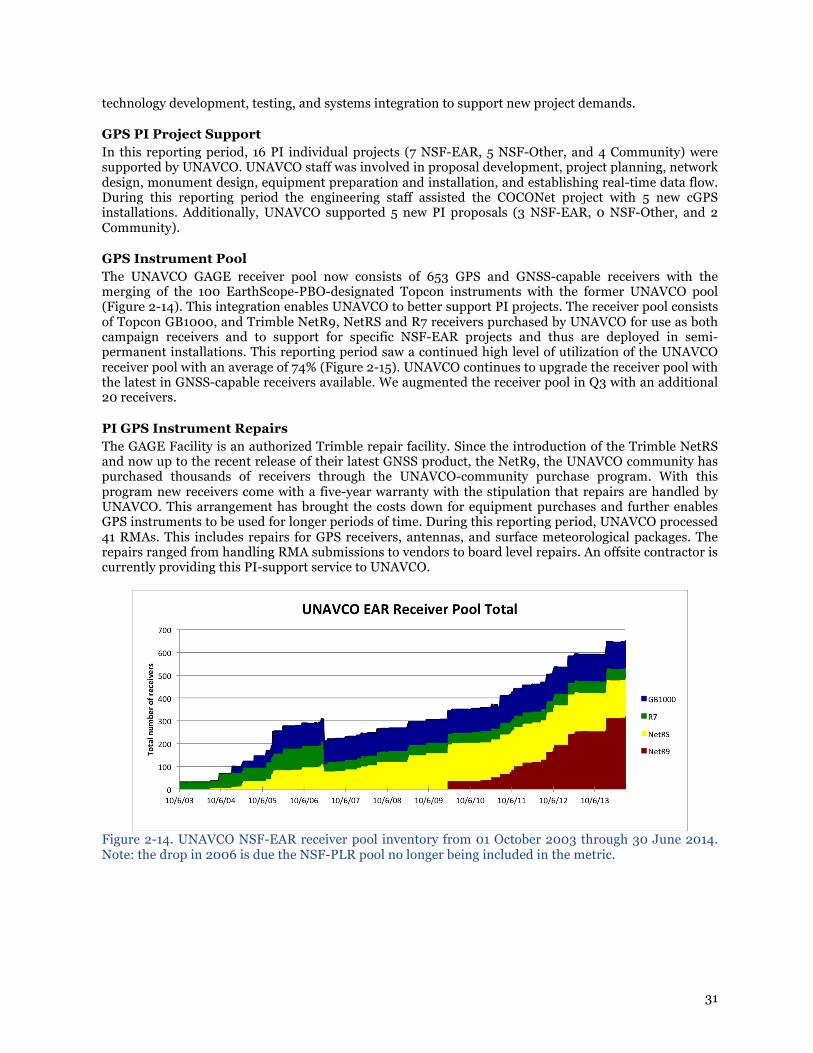
GPS Instrument Pool The UNAVCO GAGE receiver pool now consists of 653 GPS and GNSS-capable receivers with the merging of the 100 EarthScope-PBO-designated Topcon instruments with the former UNAVCO pool (Figure 2-14). This integration enables UNAVCO to better support PI projects. The receiver pool consists of Topcon GB1000, and Trimble NetR9, NetRS and R7 receivers purchased by UNAVCO for use as both campaign receivers and to support for specific NSF-EAR projects and thus are deployed in semi-permanent installations. This reporting period saw a continued high level of utilization of the UNAVCO receiver pool with an average of 74% (Figure 2-15). UNAVCO continues to upgrade the receiver pool with the latest in GNSS-capable receivers available. We augmented the receiver pool in Q3 with an additional 20 receivers.
PI GPS Instrument Repairs The GAGE Facility is an authorized Trimble repair facility. Since the introduction of the Trimble NetRS and now up to the recent release of their latest GNSS product, the NetR9, the UNAVCO community has purchased thousands of receivers through the UNAVCO-community purchase program. With this program new receivers come with a five-year warranty with the stipulation that repairs are handled by UNAVCO. This arrangement has brought the costs down for equipment purchases and further enables GPS instruments to be used for longer periods of time. During this reporting period, UNAVCO processed 41 RMAs. This includes repairs for GPS receivers, antennas, and surface meteorological packages. The repairs ranged from handling RMA submissions to vendors to board level repairs. An offsite contractor is currently providing this PI-support service to UNAVCO.
Figure 2-14. UNAVCO NSF-EAR receiver pool inventory from 01 October 2003 through 30 June 2014. Note: the drop in 2006 is due the NSF-PLR pool no longer being included in the metric.

32
Figure 2-15. UNAVCO NSF-EAR receiver pool utilization from 01 October 2003 through 30 June 2014. The metric reflects the proportion of receiver pool instruments that are sourced out of the UNAVCO GeoLogistics Center and assigned to any project during any given week. 2.3.2 Polar Services The UNAVCO Polar engineering team transitioned out of the Antarctic and into full support of the Arctic field season during this quarter. Fortunately, late season issues with shipping cargo from Antarctica to the USA didn’t impact Arctic support significantly. Antarctic support during this quarter centered around early planning for the 2014-15 field season and ongoing monitoring of PI cGPS networks operating on the continent. These sites include ANET and LARISSA. At the other end of the globe, Arctic support continued as the Polar team finished preparing and shipping gear for an early airlift to Greenland. This necessitated a focused effort in the first quarter to make sure we met the shipping date, regardless of the actual project start date. UNAVCO has provided support for 16 projects in the Arctic thus far in 2014 , including locations in Alaska and Greenland. Several short term GPS networks were fielded during this quarter, designed to operate into the early winter before going into hibernation. These installations are not equipped with telemetry and rely on manual data pickup. UNAVCO provided field Terrestrial Laser Scanning (TLS) support to one project on Mount Hunter, Alaska this quarter. Despite significant storm delays, a successful dataset was obtained. Other Arctic TLS projects are on the schedule for later in the summer. Demand is steady, and the spectrum of scanning applications is growing. Most TLS projects have a GPS component, which results in the higher demand for GPS instruments. UNAVCO field engineers typically employ a longer range Riegl VZ-1000 scanner as well as a shorter-range model, the VZ-400 in polar field applications. This suite of scanners enables the application of the technology to a broad range of uses, including small scale volumetric estimates as well as change detection. During this period, UNAVCO also provided TLS training for PI Craig Tweedie to augment his work on the Barrow ITEX project.
UNAVCO monitors and maintains several non-POLENET GPS networks in the Arctic and the Antarctic described in the accompanying GI spreadsheet tab “PI Projects Supported.” Additionally, UNAVCO maintains GPS reference stations and forward deployed equipment at multiple locations. In the Arctic, these can be found at Barrow, Atqasuk, Toolik camps in Alaska and Summit Station in Greenland. Similar installations are supported at the three continuously operated US research stations in Antarctica: McMurdo Station, Palmer Station and the Amundsen-Scott South Pole Station. In GAGE Y1Q3, UNAVCO Polar staff visited the site in Barrow, Alaska to begin an effort to relocate the Barrow reference station from the BASC lab to the newer Barrow Alaska Research Center (BARC). This move will ultimately help to consolidate the science support while reducing overall costs. While in Barrow, the engineer also spent time going through the dGPS survey gear that is staged for multiple group use,

33
assuring that everything was in top operating condition for the upcoming season.
Figure 2-16. TLS work performed on Mount Hunter, in Alsaska. Photo: Brendan Hodge 2014
Currently there are 125 GPS receivers in the Arctic pool and 208 receivers in the Antarctic pool. Many of these are deployed year round in support of continuous stations in Greenland and Antarctica.
2.3.3 Geodetic Imaging (TLS) Geodetic Imaging activities during the GAGE Y1Q3 period included engineering support for PI projects, planning support for PI proposals, education and outreach, and resource development. In GAGE Y1Q3, a total of 7 TLS field projects (3 EAR, 2 PLR, 2 other community funded) and 2 proposals (1 NSF EAR, 1 other community funded) were supported by the Geodetic Imaging project (Figure 2-17).

34
Figure 2-17. Number of TLS projects and proposals supported by UNAVCO through June 30, 2014.
During the reporting period, an RFQ for the procurement of a new TLS system under UNAVCO’s active award, “Acquisition of Next Generation Terrestrial Laser Scanning Systems for Community Earth and Polar Science Research” (EAR-1261653) was posted (early April 2014). UNAVCO received three responses to the RFQ, and undertook a comprehensive review of candidate instrumentation. The review included onsite demonstrations of the TLS systems by all three vendors. A team of UNAVCO staff consisting of the Geodetic Imaging Project Manager, Polar and EAR Field Engineers, and TLS support Technician formed the evaluation committee for the instrumentation. Documentation and final evaluation of the RFQ responses is ongoing and we anticipate acquiring a new scanner in Y1Q4, based on feedback from UNAVCO leadership and the TIGWiG. A Supplemental Funding request was submitted this quarter to provide additional resources to support TLS PIs, specifically data archiving and distribution, TLS instrument pool management and maintenance, and enhanced TLS and education activities. This supplement addresses the gap between proposed GAGE funding levels of GI and GDS TLS support and the actual GAGE budget put forth by NSF. The supplement will ensure ongoing support at the level demanded by the UNAVCO community and protects critical TLS activities that would be in jeopardy otherwise.
To meet the needs of UNAVCO’s growing and diversifying TLS user community, UNAVCO is actively developing training resources and documentation to support Earth science TLS users. Several new documents and entries were added to the TLS Knowledgebase during the current reporting period (http://facility.unavco.org/kb/categories/Geodetic+Imaging/Terrestrial+Laser+Scanning+(TLS)/).
In addition to the typical TLS PI support activities, Geodetic Imaging staff supported two training courses this quarter. The first course was a comprehensive week-long session focused on cross-training UNAVCO field engineering staff in UNAVCO TLS best practices. Two UNAVCO FEs were trained, as well as a Polar community member who will be deploying UNAVCO TLS equipment in Y1Q4. A one-day introduction to TLS short course was also run in Y1Q3. This short course was part of the 2014 Structural Geology and Tectonics Forum, held at the Colorado School of Mines in Golden.

35
During this quarter, a dedicated TLS Technician I was hired. This position was filled by a former Agency temp, hired as a UNAVCO employee to work full time through and part-time x to x; the longevity of this role beyond 1/30/2015 is contingent upon funding. 2.4 DEVELOPMENT AND TESTING
The GAGE Facility Development and Testing effort is staffed by 2.75 FTE at the Project Manager III, Engineer III and Engineer II levels, and now also incorporates the PBO strainmeter and GPS testing efforts. Ad hoc contributions to individual D&T projects from other UNAVCO groups have been critical to the effort, with individuals participating in projects of direct interest to their operational efforts. The ongoing development of teqc software and the implementation of server-based real-time GPS positioning capabilities in close collaboration with GDS are important ongoing projects undertaken by the D&T staff. Two technical presentations, detailing the results of GAGE D&T projects, were given by UNAVCO staff at the IGS 2014 Workshop in Pasadena in late June 2014. Henry Berglund presented a poster detailing the variety of behaviors exhibited by GNSS receivers during a GLONASS malfunction that coincided with the Mw = 8.2 Pisagua earthquake, resulting in the loss of data at key stations in Argentina. On April 1st the entire GLONASS constellation was disrupted as illegal ephemeris uploaded to each satellite took effect simultaneously. The outage continued for more than 10 hours as affected satellites broadcast navigation messages with incorrect application times. The use of multi-constellation GNSS receivers has been assumed to be a way to increase system integrity, both by increased coverage during normal operations and failover redundancy in the event of a constellation failure. But in this case the opposite was true: not only was the ability of many GNSS receivers to track GLONASS interrupted, but many also lost the ability to track GPS satellites during the outage, and many failed altogether. In collaboration with our colleagues at GNS New Zealand, we investigated the response to all GLONASS-enabled receivers whose data were available in the UNAVCO archive and GNS New Zealand – approximately 350 receivers. Figure 2-18 shows how the population of receivers from different manufacturers were affected, and Figure 2-19 shows the effects of the bad GLONASS messages on real-time streams from a Trimble Net-R9 receiver.
Figures 2-18 (left) and 2-19 (right). Figure 2-18 shows the number of global GNSS receivers that had missing observations during the April 1 GLONASS outage. Figure 2-19 shows the effect of the GLONASS outage on real-time positions derived from a Trimble Net-R9 receiver in the GNS network of New Zealand.

36
Freddy Blume gave a plenary talk that presented new analysis of the PBO Monumentation Stability experiment data and results. Now that a full year has passed since the installation of the first of the multi-monument stations, the relative instability of concrete pillars with respect to drilled- or driven-
braced monuments in sedimentary environments is becoming apparent. At two stations in southern California, Figures 2-20 (left) and 2-21 (right). Figure 2-20 shows northward motion of a concrete pillar with respect to the nearby deep drilled-braced monument (red) correlated with precipitation (blue). Figure 2-21 shows that the collocated shallow driven-braced monument shows submillimeter stability during these rainfall events. Time series for these 10 meter baselines were computed using combined single-frequency analyses in GAMIT. motions of pillars with 5-meter deep foundations can be directly attributed to precipitation events, while shallow (1.5 m) driven-braced monuments show no-such effects (figures 2-20 and 2-21). It appears that the horizontal footprint of these monuments is of great importance to stability than their vertical depth. A variety of other effects were observed in both bedrock and sedimentary installations that are the subject of further analysis. Performance Metric 4/2014 – 6/2014: 14 Development and Testing Projects, 3 Completed.
2.5 GI PROGRAM SUMMARY This has been another busy quarter for the GI program with the planning and logistical efforts related to the challenging borehole strainmeter installations in Turkey, the new cGPS/Met station installations in Mexico for TLALOCNet, the continued efforts to complete construction of COCONet and HoustonNET. Additional efforts to obtain contracts for new cGPS network construction are underway and likely to be completed in in GAGE Y1Q3. Marianne Okal, a Polar Services field engineer, has now completed her move to the GDS program full time. In addition, Polar Services group has completed the search for her replacement as well as another field engineer to support POLENET and PI project support in the polar regions. The two new PLR engineers will start with UNAVCO in GAGE Y1Q4. PBO GPS and BG staff are now in full swing during the busy summer field season. The installation of 4 GTSM/Seismic instrument packages along the Sea of Marmara segment of the North Anatolian fault system was initiated, but drilling progress was extremely slow because the drilling contractor did not provide the appropriate drill rig or drilling tools to allow rapid depth penetration through Paleozoic quartzite at the first borehole. PBO GPS Ops also has completed its search for a replacement field engineer to support the PBO SW region. The new Engineer II for PBO SW will start with UNAVCO in GAGE Y1Q4. Lastly, two positions remain vacant in the GI Program: PBO AK Regional Manager and the Permitting Manager. The need and role for a replacement Regional Manager position will be reviewed in GAGE Y1Q4. Initial screening of the vacant Permit Manager position began in late GAGE Y1Q3 and the position should be filled in the next month or so (GAGE Y1Q4).

37
3. Geodetic Data Services Program 3.1 OVERVIEW The Geodetic Data Services (GDS) program manages a complex set of metadata and data flow operations providing a wide range of geodetic/geophysical observations to scientific and educational communities. Sensors currently include GPS (downloaded files and streaming real time (RT-GPS)), borehole geophysics instrumentation (strainmeters, tiltmeters, seismometers, pore pressure and meteorological sensors), long baseline laser strainmeters, and terrestrial laser scanners. Field data are acquired either from continuously operating sites or episodic “campaign” surveys conducted the community. UNAVCO also acquires and distributes satellite synthetic aperture radar (SAR) data from foreign space agencies. GDS services include data operations (managing metadata; data downloading, ingesting and preprocessing); data products and services (generating processed results and QA/QC and state-of-health monitoring); data management and archiving (distribution and curation); cyberinfrastructure; and information technology (systems and web administration). In order to perform this mission, GDS maintains a technical staff, onsite and offsite computer facilities with networking, servers and disc storage, and manages a number of subawards to university groups who provide additional products, software and training. Some key GDS activities of this quarter include: 1) Upgrade of the PBO Operational Database. This long-needed upgrade was seamless and resulted in a noticeable increase in performance. 2) The download of high rate data from over 1000 stations in response to the 1 April 2014 M8.2 Iquique earthquake, with more than 700 of the stations providing both 5 Hz and 1 Hz data. It was significant in that it was the first ever full-network download of 5 Hz GPS data by UNAVCO, and the first full-network download of 1 Hz GPS data performed since March 2011 Tohoku earthquake. 3) With the hiring of the TLS Data Engineer a significant backlog of new and prior TLS campaigns was realized with 17 archived via the RAMADDA system. 4) The routine processing of permanent stations by GAGE subawardee GPS Analysis Centers (AC’s) and Analysis Center Coordinator (ACC) grew to 1,863 GPS stations in the PBO, COCONet, GAMA and SCIGN networks and the NGS CORS and other regional stations in middle and eastern North America. Routine data processing and product operations were stable during this period. The reprocessing effort restarted after initial combination revealed the cause of processing issues. The generation of the final product is expected to be completed by the end of August. 5) In addition to GPS, UNAVCO produced fully processed borehole strainmeter data sets for the April Chile and June Alaska earthquakes. 6) UNAVCO’s collocation data facilities at FRII in Fort Collins, CO, continued to be exercised and with new offsite ftp server there transitioned to primary mode. This is part of an ongoing effort to increase the robustness of UNAVCO’s data operations. 7) Two summer student intern data technicians helped to place additional focus on the data set Digital Object Identifier (DOI) project by contacting PIs to provide and correct information needed for DOI publication. 8) RT-GPS operations continued smoothly and cross-training was initiated with the anticipated departure of the primary RT-GPS data engineer. 9) SAR activities continued to support and improve operations through the WInSAR, SSARA and Supersites projects. 10) Cyberinfrastructure developments focused on web services through EarthCube, SSARA, COOPEUS and core GAGE projects. 11) A new time-series plotter “U-Plotter” was released for beta testing. GDS data metrics are summarized below in Tables 3-1 and 3-2. Table 3-1. Geodetic data metrics for GAGE facility.
GEODETIC DATA METRICS: SUMMARY OF KEY METRICS GAGE Y1Q3
Campaigns Archived - All Sensors (Qty) 27 Permanent Stations Archived - All Sensors (Qty) 2,826 Data Volume Archived - All Products (GB) 5,911 Data Volume Delivered - All Products (GB) 11,413

38
PBO Data Volume Archived - All Products (GB) 4,970 PBO Data Volume Delivered - All Products (GB) 7,525
CAMPAIGNS ARCHIVED (QTY) GAGE Y1Q3
GPS 10 TLS 17
PERMANENT STATIONS ARCHIVED (QTY) GAGE Y1Q3
GPS - All sample rates and delivery methods 2,607 GPS High Rate (1-Hz and Higher) 1,899 Delivered via Stream 412 Delivered via Download, Continuous 171 Delivered via Download, Intermittent 1,497 Seismic 83 Borehole Strainmeter 81 Tiltmeter 26 Pore Pressure 23 Laser Strainmeter 6
TOTAL MONUMENTS W/ DATA MAINTAINED IN ARCHIVE (QTY) GAGE Y1Q3
GPS - All Monuments with Data 12,526 GPS - All Campaigns with Data 946 GPS - All Permanent Stations with Data 3,020 Seismic 84 Borehole Strainmeter 82 Tiltmeter 26 Pore Pressure 23 Laser Strainmeter 6
DATA VOLUME ARCHIVED (GB) GAGE Y1Q3
GPS - All sample rates and delivery methods 5,259 GPS Standard Rate 1,012 GPS High Rate 2,154 GPS Data Products (Level 2 and higher) 2,093 Seismic 305 Borehole Strainmeter Raw Data 89 Borehole Strainmeter Data Products 1 Tiltmeter 1 Pore Pressure 2 Laser Strainmeter Raw Data 3 Laser Strainmeter Data Products 0.003 SAR 151 TLS 100

39
DATA VOLUME DELIVERED (GB) GAGE Y1Q3
GPS - All sample rates and delivery methods 8,091 GPS Standard Rate 4,714 GPS High Rate 471 GPS Data Products (Level 2 and higher) 428 GPS Real Time Streams 2,478 Seismic 2,058 Borehole Strainmeter Raw Data 149 Borehole Strainmeter Data Products 29 Tiltmeter 29 Pore Pressure 27 Laser Strainmeter Raw Data 0.1 Laser Strainmeter Data Products 0.1 SAR 902 TLS 128
DATA USERS (MONTHLY AVERAGE, QTY) GAGE Y1Q3
GPS Standard Rate (unique IP's) 1,924 GPS High Rate (unique IP's) 285 GPS Data Products (unique IP's) 128 GPS Real Time Streams (active registered users) 64 Seismic (2nd level domains) 65 Borehole Strainmeter Raw Data (2nd level domains) 49 Borehole Strainmeter Data Products (2nd level domains) 13 Tiltmeter (2nd level domains) 8 Pore Pressure (2nd level domains) 4 Laser Strainmeter Raw Data (2nd level domains) 5 Laser Strainmeter Data Products (2nd level domains) 14 ALS (unique users reported by OpenTopography) 111 SAR (active registered users) 14 TLS (unique IP's) 9
CUSTOM HIGH RATE GPS DATA REQUESTS THIS PERIOD (QTY) GAGE Y1Q3
Event response 5 Total 12
NSF & NASA COMMUNITY SOFTWARE (QTY) GAGE Y1Q3
TEQC downloads 2,461 TEQC information requests 199 ISCE downloads 8
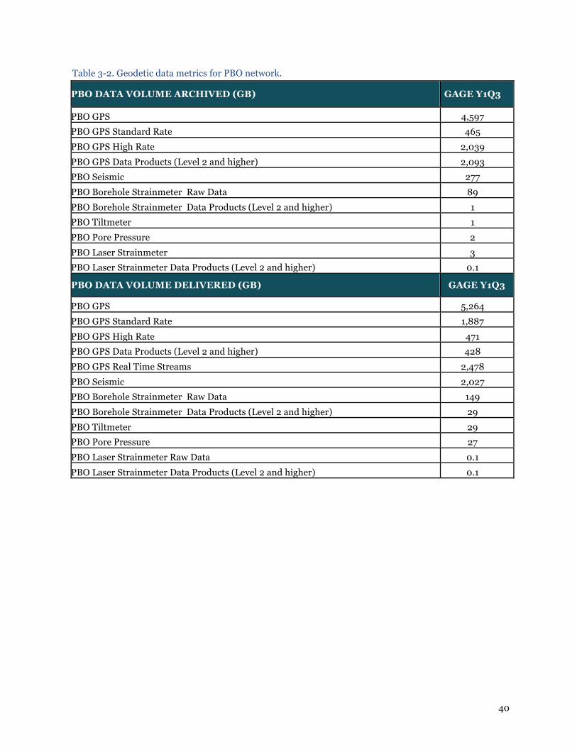
40
Table 3-2. Geodetic data metrics for PBO network.
PBO DATA VOLUME ARCHIVED (GB) GAGE Y1Q3
PBO GPS 4,597 PBO GPS Standard Rate 465 PBO GPS High Rate 2,039 PBO GPS Data Products (Level 2 and higher) 2,093 PBO Seismic 277 PBO Borehole Strainmeter Raw Data 89 PBO Borehole Strainmeter Data Products (Level 2 and higher) 1 PBO Tiltmeter 1 PBO Pore Pressure 2 PBO Laser Strainmeter 3 PBO Laser Strainmeter Data Products (Level 2 and higher) 0.1
PBO DATA VOLUME DELIVERED (GB) GAGE Y1Q3
PBO GPS 5,264 PBO GPS Standard Rate 1,887 PBO GPS High Rate 471 PBO GPS Data Products (Level 2 and higher) 428 PBO GPS Real Time Streams 2,478 PBO Seismic 2,027 PBO Borehole Strainmeter Raw Data 149 PBO Borehole Strainmeter Data Products (Level 2 and higher) 29 PBO Tiltmeter 29 PBO Pore Pressure 27 PBO Laser Strainmeter Raw Data 0.1 PBO Laser Strainmeter Data Products (Level 2 and higher) 0.1

41
Figure 3-1. Cumulative total UNAVCO data archived from 01 January 2004 through 30 June 2014.
Figure 3-2. Cumulative PBO data delivered from 01 October 2004 through 30 June 2014.

42
Figure 3-3. Number of UNAVCO data users by quarter from 01 January 2009 through 30 June 2014. The method of counting users varies by data product, for example by unique IP address, second level domain or active registered user. Values in this figure are consistent with the user count method given in the Data Users section of Table 3-1.
3.2 DATA OPERATIONS AND MANAGEMENT 3.2.1 Network Data Flow Network data flow covers data and metadata management from the field to the Boulder operations center, a critical activity in support of data archiving and distribution (for related performance metrics, see Table 3-1). Staff with responsibilities for data and metadata flow focus on timely handling of operational flow and any issues as they arise. Operational capabilities are addressed on a best-effort basis.
The PBO Operational Database was upgraded from Postgresql 9.0 to 9.3 and relocated to a Linux virtual machine. Along with modifications to the database configuration this has resulted in a noticeable improvement in query performance.
Due to the upgrade to the PBO Operational Database software release and server hardware, an outage for PBO dataflow lasting about 36 hours took place during this quarter. The timing was known and announced well in advance using the unav-data mail list. All of the data arriving during the outage was archived and available within a few hours after the upgrade was complete.
The download of high rate data from over 1000 stations in response to the 1 April 2014 M8.2 Iquique earthquake, with over 700 of the stations providing both 5 Hz and 1 Hz data, was handled by the data operations and archiving teams during this quarter. This event response exercised the new data download software that was developed last quarter.
3.2.2 Campaign Data Flow Data flow for GPS campaigns increased this quarter to an average of three campaigns per month, still a relatively minor activity (Table 3-1). There were no maintenance or improvements to campaign data flow for the quarter. Seventeen TLS campaigns were archived this period via the RAMADDA system.

43
3.3 DATA PRODUCTS In addition to normal data product operations, UNAVCO provided custom data products associated with the following geophysical events this period:
● M8.2 - 95km NW of Iquique, Chile 2014-04-01 23:46:46 UTC main shock and M7.7 - 49km SW of Iquique, Chile 2014-04-03 02:43:14 UTC aftershock.
● M5.6 - 20km NE of Noatak, Alaska 2014-04-18 18:44:18 UTC. ● M5.5 - 33km NE of Noatak, Alaska on 2014-05-03 08:57:12 UTC. ● M5.8 - 38km SE of Boca de Yuma, Dominican Republic 2014-05-28 21:15:04 UTC. ● M8.0 - 24km SE of Little Sitkin Island, Alaska 2014-06-23.
The data response to the M8.2 Iquique was significant in that it was the first ever full-network download of 5 Hz GPS data by UNAVCO, and the first full-network download of 1 Hz GPS data performed since March 2011 (in response to the Tohoku earthquake). Interesting statistics related to this full-network download are as follows:
● Total GDS staff time: 160+ hours (data engineers/techs: 124 hours; software engineers: 36 hours).
● Time to complete all download and data staging: 6 weeks. ● Total number of stations with 1 Hz data attempted: 1199, downloaded: 1102. ● Total number of stations with 5 Hz data attempted: 918, downloaded: 785. ● Data volume archived: ~1.6 Terabytes (T00/T02 files: 80 GB, DAT/TGD files: 744 GB, RINEX
files on FTP: 759 GB). Full-network downloads of high rate GPS data are clearly resource intensive activities. For future events, UNAVCO will encourage PI’s to request a predetermined budget amount in their RAPID proposals to cover the costs associated with FTE, disk space and communications costs for full-network downloads. 3.3.1 GPS/GNSS Data Processing and Products The GAGE GPS Analysis Centers (AC’s) and Analysis Center Coordinator (ACC) processed data and provided products this quarter from 1,863 GPS stations in the PBO, COCONet, GAMA and SCIGN networks as well as NGS CORS and other regional stations in middle and eastern North America. Routine data processing and product operations were stable this period. High rate (1-Hz and 5-Hz) GPS data were provided in response to the earthquakes described above. There were several significant developments related to the major reprocessing effort by the AC’s and ACC. We reported last quarter that this activity was complete. However, part of this task is having to be redone since major issues were discovered, rendering this activity once again incomplete in Y1Q3. The Y1Q2 report indicated that some “height anomalies” had been discovered in some of the NMT reprocessed results, which resulted in failed PBO data quality metrics and had negative impacts on data users. This problem was initially thought to only affect a small number stations in space and time and was originally attributed to bad JPL data products that were used by CWU in their processing routines. However, subsequent work this quarter and feedback from collaborators at JPL indicated that the problem was not in fact related to any problematic JPL products, but instead resulted from CWU’s analysis methods during parts of the reprocessing effort. Moreover, it was determined that all stations for all periods in CWU’s reprocessing products were affected. After it was recognized that the issue was not caused by bad JPL files, CWU ultimately discovered a bug in a nested Python program used in the 2013 reprocessing that incorrectly passed a fiducial WLPB file instead of the non-fiducial WLPB file to GIPSY (the difference in filenames being "_nf"). The error manifested itself not as gross position deviation in any or all stations, which would have allowed its detection by CWU, but as a subtle (~20%) increase in the scatter of multi-year time series after merging and, during windows of poor data, as an intermittent ~1 cm height anomaly, which became apparent only after CWU solutions were merged with NMT’s by the ACC. In order to meet the reprocessing timeline, CWU chose to utilize a faster but previously unused (by
44
CWU) ambiguity-resolved PPP approach using JPL’s wide lane phase bias estimates. CWU switched methods in September 2013. The new approach required that CWU modify their core processing scripts, and although they tested several months of data with their traditional, full-ambiguity resolution approach, a new script incorrectly called the fiducial instead of non-fiducial WLPB file. This seemingly minor adversely affected all 1800 stations in the reprocessing but was not obvious in any of their daily position estimates, covariances or χ²s, as would have been the case with incorrect orbit or clock files. Again in retrospect, this is expected: the wide-lane phase bias estimate is theoretically independent of fiducial vs non-fiducial orbit determination. In practice, its difference between the fiducial and non-fiducial for a given station-arc on a typical day is sub-mm. Detecting the error internally would have required generating time series, which is typically handled by the ACC.
When the time series were generated and the height anomaly noticed and pointed out to CWU, because it appeared greatest in the Central Valley of California, CWU ran a series of tests and found that eliminating station GOLD (Goldstone, CA) from the WLPB file made the anomaly disappear. Because CWU did not understand the problem, they switched back to their standard full-ambiguity resolution approach, reprocessed the flawed periods (which removed the anomaly) and concluded the WLPB estimates for GOLD were flawed and dropped the WLPB method for the times in question. JPL personnel investigated this potential issue but concluded that the WLPB files were fine, which prompted CWU to reexamine their methodology, at which point they found both the bug and that it affected the entire reprocessing. For this reason the CWU AC is re-processing the entire PBO dataset from 1996-2013. Enhancements to CWU’s processing capabilities should allow them to complete all re-processing (again) by 31 July 2014. The CWU AC PI also confirmed that he will more carefully vet any future changes in procedures that CWU implements and monitor the status of products shipped. Reprocessing results from the NMT AC were not affected by this problem, and users were advised to use GPS data products from NMT instead of CWU or the combined PBO solutions (which were affected by the CWU problems). UNAVCO/ACC/AC operations telecons were held on 11 April, 13 May and 30 June 2014. Participants included the subaward directors and supported personnel as well as key UNAVCO GDS staff. Updates and enhancements to GPS time series plots and plotting tools continued this quarter. Ongoing updates to GPS data product documentation and content for the new UNAVCO website also continued this period.
3.3.1.1 GPS Analysis Center Subaward: Central Washington University ● Routine generation of rapid and final products, including and 12- and 26-week supplemental
solutions, was stable. CWU continues to use standard PPP for rapids and traditional bias-fixed solutions with final data products. CWU is considering switching the final processing to utilize the more computationally-efficient WLPB products from JPL but are waiting to see the final results of the merged reprocessing before making the switch.
● CWU added 14 new compute nodes to their cluster, each of which has 16 cores, and each core is double-threaded (in the new lexicon of Intel). Practically, this manifests itself as the cluster can handle ~520 independent point-position jobs simultaneously without any apparent slowdowns due to I/O bottlenecks or other obvious delays. This has become important for the re-reprocessing of the PBO data set, in which CWU is using the WLPB approach and products of JPL, which are essentially ambiguity-resolved PPP. Currently, CWU’s final product solutions can process all 1800+ stations in the PBO in roughly a half hour.
● The addition of the 500 CORS stations to the PBO processing has increased CWU’s workload of resolving metadata issues by a factor of 10, even though CORS comprise less than a third of the total stations in the PBO processing. CWU has thus spent an extensive amount of time tracking down and correcting CORS metadata mistakes, and editing CORS metadata has become a disproportionately large amount of time. Additionally, some CORS stations have RINEX with non-standard header files not supported by TEQC, and other issues. CWU has therefore generated a file to indicate how many changes to the CORS file have had to be made by hand and will share this with the other analysis centers and UNAVCO data products manager for reflection on the feasibility of adding in additional 3rd party CORS stations without sufficient metadata

45
vetting. ● In addition to the ongoing processing activities, CWU added 224 cores to their hardware base,
restarted a comprehensive re-reprocessing of the entire PBO data set 1996-2013 because of the discovery of an error in the previous CWU reprocessing (as described above), and undertook a comprehensive review of metadata used by CWU to better agree with that being utilized by MIT and NMT. CWU’s processing cluster now includes ~250 CPU cores.
● CWU began reprocessing the entire PBO data set from 1996 through 2013 as described above. CWU also submitted to UNAVCO a corrective action plan and description of the cause and solution of the height anomaly issue.
3.3.1.2 GPS Analysis Center Subaward: New Mexico Tech ● Activities focused on the generation of routine rapid and final products, and developing new
procedures to take advantage of increased computational and storage capabilities. Routine generation of rapid and final orbit products, and 3- and 6-month supplemental solutions (i.e., stations missing in the initial final orbit products) continued without significant issues, except for server problems noted below.
● NMT performed incremental upgrades to GAMIT/GLOBK analysis package version 10.5 that implements new IGS standard model changes, including the Kouba yaw model and general relativity in orbit generation. According to the ACC, these changes, necessary for the reprocessing currently underway by IGS, should have no impact on GAGE processing. 12 new stations, mostly associated with the COCONet project or located in southern California, were added to the processing.
● Maintenance of up-to-date station metadata continues to be a major focus of effort. One unresolved issue that NMT raised is how to best document changes of radomes at stations, in particular swaps of the same type of radome. Radome serial numbers, if they even exist, are not included in either the GAMIT/GLOBK metadata files or in the SINEX format. Such changes, which generally occur after a radome is damaged, can potentially introduce apparent offsets in the time series, and are currently undocumented in the GAGE products. NMT is currently investigating the impact of this issue.
● Purchase of new computer hardware prior to the beginning of GAGE significantly increased NMT’s computational and storage capabilities. NMT is continuing to develop new procedures to better take advantage of these enhanced resources, in particular to facilitate major reanalysis efforts. NMT is improving their processing scripts to allow better flexibility when adding in new networks, and are testing newly developed time-series analysis procedures provided in the GAMIT/GLOBK distribution package to better visualize and quality check products.
● The newly purchased hardware, plus hardware added by other researchers at NMT, are now beginning to tax the air-conditioning load in NMT’s departmental server room. In June, generally the hottest month in New Mexico, the air-conditioning overloaded and froze up twice, causing significant overheating and shutdown of the servers. In response to this emergency situation, NMT AC servers temporarily have been moved to the campus server center, which has greater air-conditioning capacity. This move caused several days delay in the rapid products as the networking was reconfigured. NMT’s department, and the computer and research campus administration are currently working to resolve this situation.
3.3.1.3 GPS Analysis Center Coordinator Subaward: Massachusetts Institute of Technology ● Routine combination of final and rapid level 2a products, including and 12- and 26-week
supplemental solutions, was stable. ● In this quarter 1,863 sites were processed compared to 1,837 for the previous quarter. ● For the three months of the final position time series generated by NMT, CWU and combination
of the two (PBO), MIT fit linear trends and annual signals and compute the RMS scatters of the position residuals in north, east and up for each site in the analysis. The median horizontal RMS scatters are less than 1.2 mm for all centers and as low as 0.8 mm for NMT and PBO north component. The up RMS scatters are less than 4.8 mm and as low as 3.9 mm. These statistics are improved over the previous quarter especially for CWU. It is encouraging to see that in heights, the combined solution has smaller WRMS than either of the two input series. In the NAM08 frame realization, scale changes are not estimated.

46
● Generated monthly and quarterly “snapshot” velocity fields in the NAM08 reference frame based on the time series analysis of all data processed to that time. This quarter there were 2054 sites, 2 more than last quarter, in these analyses. In this analysis, offsets are estimated for antenna changes and earthquakes. Annual signals are estimated and for some earthquakes, logarithmic post-seismic signals are also estimated. A direct comparison of the NMT and CWU solutions shows the weighted root-mean- square (WRMS) difference between the two velocity fields is 0.18 mm/yr horizontal and 1.11 mm/yr vertical in direct difference of all sites in both solutions (2039 sites). The χ2/f of the difference is (1.98)2 for the horizontal components and (1.80)2 for height. Since the RMS is weighted, sites with small standard deviations with tend to dominate the WRMS. Establishing a lower bound on the standard deviation of the velocity estimates 0.19 mm/yr (summed squared into the horizontal velocity standard deviations) and 0.85 mm/yr in heights generates and RMS difference of 0.33 mm/yr with a χ2/f of unity horizontal only and 1.43 mm/yr for height. We have modified the method used to compute these values and the height results show a larger scatter than previous reports. When we use only sites with small uncertainties so that about only half the sites are used (minimum NE sigma 0.25 mm/yr and U sigma 1.06 mm/yr such that all sigma components must satisfy these limits in both solutions), 1054 sites are compared the WRMS differences are 0.21 and 1.06 mm/yr in NE and Up. The NRMS values (sqrt(χ2/f) are 0.73 and 0.77 indicating the re-weighting factors could be too large and a simple additive baseline variance for the velocity estimates is not complete enough. Most likely there could also be a scale to be applied to the sigmas as well.
● Earthquake Analyses. The NEIC catalog was used to search for earthquakes that could cause coseismic offsets at the sites analyzed by the GAGE analysis centers. The following earthquake did generate co-seismic offsets: M4.1 2km SE of Rowland Heights on 2014-03-29. Maximum co-seismic offset was <3 mm. Some of the co-seismic could be from aftershocks as well.
● Investigated and reported seven antenna change offsets. Details are provided in the detailed MIT quarterly report.
● Confirmed that new processing by CWU is significantly better than the original reprocessing. Comparisons are presented in the detailed MIT quarterly report.
● Abandoned trying to use LDM to transfer reprocessed SINEX files to UNAVCO. There was too much unexplained loss of data presumably due to overflows of the 12 Gbyte queue at MIT and slow transfer of the results from the UNAVCO queue to the ftp area. A special scp area has been set up and transfer with scp has been much successful. The standard products will continue to be delivered with LDM and provided only a few Gbytes of results are queued at one time, this procedure should be adequate. MIT will run scripts that verify the ftp products area is consistent with the MIT products.
● Updated scripts that require lists of stations from specific networks (e.g., PBO, COCO Net, GAMA etc.) because the java routine used to return metadata and obtain lists of sites was timing out for the PBO network. The other network lists still work fine. As a work around, MIT now uses static lists of stations with the original static list for PBO generated by testing each station in the processing that did not appear in the other network lists to see if the station is PBO or not. This change effected both MIT’s quarterly and monthly report generation.
● Prepared and submitted 27-page comprehensive report on Y1Q3 activities and analytics.
3.3.1.4 GAMIT/GLOBK Community Support Subaward: Massachusetts Institute of Technology During this period MIT carried out routine development of the GAMIT/GLOBK software: minor enhancement of 10 features, including the script that combines field surveys with PBO solution files; table updates for a new GPS satellite launch; and support for two new receivers and two new antennas. There were no workshops, but MIT spent 5-10 hours per week in email support for users. During this period, MIT issued royalty-free licenses to 22 new users from universities and government laboratories.
3.3.1.5 Custom Data Product Requests UNAVCO supported a total of twelve custom data requests for high rate (1-Hz and 5-Hz) GPS data downloads. Five of these requests were earthquake responses (described above). Non-event data requests were for high rate GPS data to support regional airborne LiDAR missions including NCALM projects, NOAA ocean surveys, Caltrans surveys and commercial surveys.

47
3.3.2 Strain, Seismic and Tiltmeter Data Processing and Products UNAVCO processes data and provides products for borehole strainmeters, seismometers and tiltmeters in the PBO network. Routine data processing and product operations were stable this period. Fully processed 1-sps borehole strainmeter data sets were generated for the April 1st M8.2 Chile and June 23 M7.9 Alaska earthquakes. Data from the tiltmeter installed June 18th 2014 in the new B950 Yellowstone borehole are now available from the UNAVCO web site. The few weeks of data available from this installation indicate the data are of good quality; there are minimal steps in the time series and a strong signal in the M2 tidal frequency. Level 2 processed data are now available for the B950 strainmeter, installed in October 2013. A tidal model, barometric response coefficients and estimate of the borehole trends are now available. The barometric response coefficients are typical of GTSM21 strainmeters and very similar to those determined for B205. The instrument does record shear strains from teleseisms events and also displays energy in the microseism frequencies. UCSD, through a subaward managed by UNAVCO, processes data and provides products from the long baseline laser strainmeter network described in section 2.2.1.3. This May/June UCSD transitioned to a new computer system. In the new system, data-serving operations have been pared from the processing and archiving machine, for greatly improved security. UCSD began this effort almost a year ago, with a focus on rewriting the code for the new operating system and improving upon a number of processing schemes. This work was completed in April, and the switchover made in May, with additional refinements ongoing. UNAVCO GDS staff contributed to this activity. For laser strainmeter data editing and Processing, like last quarter, some of the key data-series required considerable detailed editing. This sort of editing, being in the 'fine structure' of the data (near instantaneous jumps on the 1-s time scale) leads to cleaned data with little evidence (credit for the effort) of the editing that has been done: performance factors near 1.00. This notwithstanding, factors near unity are a proper measure of how accurately the final processed 5-min data reflects the earth's deformation within the footprint of the strainmeters. The recordings for this quarter were quite good. 3.3.3 Meteorological and Hydrologic Data Products Meteorological data are collected along with GPS/GNSS and other forms of geophysical data to enhance the datasets, contribute to network monitoring information, and provide additional information for interpretation of deformation signals. Temperature, humidity and barometric pressure data collected at GPS stations are available directly from the GPS RINEX files. Routine product operations were stable. Documentation and metrics related to new hydrologic loading data products continue to be developed. 3.3.4 LiDAR – Terrestrial and Airborne Laser Scanning UNAVCO provides TLS data services and products including basic data processing, data management and data archiving. The standard UNAVCO TLS deliverable is a merged, aligned, georeferenced point cloud, which is accompanied by pertinent metadata products such as site photos, meteorological information, field notes and other ancillary project information. TLS data support is further described in section 3.4.4, LiDAR data management and archiving.
EarthScope ALS data products are supported by OpenTopography with metrics reported by them to UNAVCO. No new ALS related data product activities have been performed to date under the GAGE CA. 3.4 DATA MANAGEMENT AND ARCHIVING 3.4.1 GPS/GNSS The Data Center provides a secure long-term archive for data, data products, and metadata from GNSS instrumentation, and makes data available to the scientific community and the public. User interfaces, APIs, and software tools that facilitate data search and access, data handling, and visualization are

48
provided to support full utilization of the data assets. Data archiving and distribution is an operational activity that continues to grow, with stations added for archiving from Antarctica (ANET), COCONet, HoustonNet, Malawi Rifting, and Telica Volcano networks. Everyday operational activities of the data management and archiving staff were impacted by the requirement to handle the extra volume of high rate data acquired in association with the Iquique earthquake. This required more than three weeks of Data Engineer and Data Technician time. Delay of non-critical tasks allowed for accommodating additional labor for event-based data archiving. Our new offsite ftp server, installed at FRII, Inc., a Colorado collocation services provider during last quarter, was transitioned to the role of primary ftp server. The older hardware in house at Boulder headquarters is now the failover ftp system. With this transition we have instituted more detailed monitoring of traffic that will be helpful for cost control. The upgrade to the archive database server will take place early in the next quarter. Additional preparation occurred during this quarter including engaging the services of expert Oracle consultants. This quarter marked the initiation of heightened focus on the data set Digital Object Identifier project. Two student intern data technicians were hired for the June-July time frame to handle the mechanics of contacting PIs who have contributed data to the Archive, verifying necessary information, and minting DOIs. The e-mails to PIs provide document their contributions, provide background on DOIs including links to information on the UNAVCO website with examples of data sets that have DOIs. PIs are requested to verify or correct our records and to provide additional information such as release notes and their own publications based on the data set. In June approximately 300 of the 435 contributing PIs were contacted by the interns; the remainder will be contacted in July. This effort has resulted in over 500 additional DOIs minted this quarter (Table 1-1). The metrics in Table 3-1 document the data volumes archived and delivered. Metrics notes for the quarter: ● The archiving of the reprocessed GPS analysis products continues to impact the associated
metrics, as was the case in the previous quarter. ● A substantial increase in the volume of high-rate data archived resulted from earthquake related
data activities. Similarly, the count of stations that provided high-rate data for archiving increased.
● Prior to this quarter, the archiving of PBO and other data that was delivered via stream was limited primarily to those stations that were originally upgraded with ARRA funding. During this quarter, most of the remaining ~200 stations with streaming were setup for full time archiving.
● The total volume archived this quarter exceeds each of the previous two quarters of GAGE due to both high rate data and to elevated volume of products archived.
● The volume delivered for standard rate, high rate, and products dropped steeply this quarter; this was partly a return to more normal volumes from a period of particularly high volume of deliveries; in addition, infrastructure shifts including the new web site and a change of ftp server location may have impacted deliveries.
● Following a period including last quarter during which the number of unique IPs accessing data climbed to new highs, this metric returned to more typical levels during this quarter.
● Standard rate data deliveries continue to be the highest volume category for archived GNSS deliveries (other categories tracked are high rate and products).
3.4.2 Real Time GPS Data Flow and Management UNAVCO provides high-rate (1 Hz), low-latency (<1 s) GPS data streams (RT-GPS) from approximately 430 stations, 391 of which are PBO stations, including 282 stations upgraded as part of the NSF-funded ARRA Cascadia initiative. GDS support for RT-GPS continues to operate at high levels. The RT-GPS group has been combined with the borehole data group, Kathleen Hodgkinson, Otina Fox and Brent Henderson, to streamline data collection and operations gaining efficiency.

49
RT-GPS data users are classified into three groups: academic, commercial and government. Commercial users were the largest group to access RT-GPS in each month of the quarter but government agencies and nonprofit consortia collectively downloaded the largest volume of data (Figure 3-4). As in previous quarters, commercial users formed the largest group of users both in terms of being registered and being active but the government agency and nonprofit consortia downloaded more data in each month of the quarter.
Figure 3-4. Real-time GPS data users. Registered data users are all of the users who have been given access to RT-GPS data streams since inception. Active data users are those who actually accessed data streams this quarter. Commercial users were the largest group of registered and active users this quarter. The five sites with the greatest volumes of data downloaded were P059 Point Arena, California, P365 in Coos Bay, Oregon, P041 Boulder, Colorado, P387 Sisters, Oregon and P780 in Puerto Rico (Figure 3-5). Across the network, 386 sites were accessed by the academic community, 196 by the commercial entities and 272 by government and non-profit consortia. 138 sites were accessed by all three user groups; academic, commercial and government plus non-profit consortia (Figure 3-6).

50
Figure 3-5 Total volume downloaded from sites in the western US through GAGE Y1 Q3.
Figure 3-6 GPS sites in the western US from which data were accessed by all users types. 3.4.3 Borehole Geophysics Data: Strain, Seismic, Tiltmeter, Pore Pressure

51
Metrics for data archiving and delivery volumes this period, as well as unique users, are summarized in Table 3-1. Trends and notes this period include:
● Most strain, seismic, tiltmeter, and pore pressure data metrics were typical this quarter. ● There was a moderate spike in borehole strainmeter raw data and product downloads in April,
mostly attributable to a single user. ● Data delivery and user count metrics for April, 2014 are artificially low due to missing records
(lost FTP logs).
3.4.4 LiDAR – Terrestrial and Airborne Laser Scanning Data A new Data Engineer III was hired and began work on TLS data archive, products, and community support in Y1Q3. Data from TLS PI projects continue to be added to the archive as projects are completed, with approximately a 100 GB of TLS data added this quarter. The new Data Engineer is working to standardize, document, and ingest legacy TLS datasets. A concerted effort is also ongoing to create a standard TLS metadata template and to streamline generation of this metadata content going forward. UNAVCO continues to improve access to software required by community members to process and analyze TLS data. The Data Engineer has been working to update and install new software on our license server and to improve documentation on accessing and using these software packages. OpenTopography is the official archive and access point for EarthScope ALS data. Metrics provided by OpenTopography this quarter:
● 111 unique users accessed point cloud and raster terrain products during Y1Q3, dowloading 289 GB of data.
3.4.5 SAR Data UNAVCO has managed the SAR Archive since 2005, with significant recent enhancements under a supporting NASA award. Under GAGE, UNAVCO orders ESA and TerraSAR-X scenes in response to WInSAR user requests. In addition, the WInSAR Executive Committee and UNAVCO arranged for a tasking quota with DLR for use by WInSAR. WInSAR user requested tasking orders for the TerraSAR-X mission have been placed on a regular basis. UNAVCO has also begun archiving of WInSAR community TSX data in the UNAVCO SAR Archive. UNAVCO also manages access to the ISCE SAR data processing software package for all members of the WInSAR Consortium.
SAR data metrics are shown in Table 3-1. WInSAR scenes from the European Space Agency (ESA) are available without cost under their open data policy. TSX data access is restricted to Co-PIs associated with a specific science proposal approved by DLR. UNAVCO continues to maintain the core SAR archive infrastructure, including hardware, database, software, and web presence. Data ingest capabilities have been developed to allow UNAVCO to host data from newer satellite platforms such as CosmoSkyMed (CSK), and RADARSAT-2 which WInSAR community users are beginning to utilize. Integration of CSK and RADARSAT-2 data into the WInSAR data portal (https://winsar.unavco.org/portal/) is ongoing.
UNAVCO’s SAR data holdings are backed up to cloud-based systems. ESA is the primary archive for ERS-1, ERS-2, and Envisat, while the Alaska Satellite Facility (ASF) is primary archive for RADARSAT-1. For all data not archived in ESA’s Archive4 system or at ASF, UNAVCO is now backing data up to Amazon Glacier, a commercial cloud storage system. This approach ensures both a complete offsite backup of the full UNAVCO SAR archive while minimizing redundancy of data backups. (see previous comment) Supersites support For the GEO Supersites and Natural Laboratories initiative, UNAVCO provides data ordering (from the European Space Agency), together with data management (download and repackaging) of the orders

52
received, and upload of the orders to the ESA supported cloud storage (Level 4 archive). In addition to this operational data management activity, UNAVCO provides web site content management and hosting for the Supersites main page and for Supersite Event pages. In this quarter UNAVCO has expanded our support for TSX, CSK, and RADARSAT-2 data collected under the Supersites initiative. For these datasets, the lists of PIs with access to the data include international collaborators as well as WInSAR community members. To address this expanded community of users and associated access constraints, we’ve made several modifications to the WInSAR Portal system to allow registration by international partners.
Building on the successes of UNAVCO’s ongoing NASA ROSES ACCESS funded work to develop a Seamless SAR Archive (SSARA), UNAVCO staff members have been engaged in discussions with the European SAR community (DLR, ESA, CEOS, etc.) regarding federated access to data, data processing environments, and metadata and product formats. The goal is to leverage the SSARA work to build federated access to data hosted by the space agencies that participate in Supersites. 3.5 CYBERINFRASTRUCTURE Several projects are in progress to expand the cyberinfrastructure capabilities of UNAVCO’s geodetic data systems. Our efforts in a related collaboration with the IRIS-led EarthCube Building Blocks award “Deploying Web Services Across Multiple Geoscience Domains” this quarter include participation in technical and management level meetings as well as modifications and enhancements by our software team to web services that are being leveraged by the award. Enhancements included the new REST web service documentation system that includes a URL builder. UNAVCO’s Geodesy Seamless Archive Centers (GSAC) software has been adopted by the European Plate Observing System (EPOS). During both the GSAC WG4 EPOS workshop that took place last quarter, and the IGS Workshop that took place this quarter, discussions on the metadata content and exchange standards for GPS/GNSS were topics of great interest. Plans to initiate further standards collaborations were outcomes of both meetings that UNAVCO will play a role in going forward. Chad Pyatt (GI) has been building an iPhone app for field engineers that utilizes GSAC metadata web services. Stuart Wier (GDS) has provided software development for additional output formats from GSAC useful for the app. In support of the COCONet project software staff are involved in the COCONet Regional Data Center development and deployment. The software and systems configurations developed for this project are being designed as a GPS/GNSS data and metadata management package, called Dataworks for GNSS. The package consists of a set of modules that will ultimately be made available for general download and access for GPS/GNSS data centers. GSAC is one module of the system. The COCONet Regional Data Centers will be the first deployment of the Dataworks for GNSS system. UNAVCO’s support to NASA under GAGE includes progress in development of the IGS Site Log Manager tool. Regular team teleconferences and work by a contract Software Engineer have completed this phase of development. The Site Log Manager was demonstrated at the IGS Workshop 2014 in Pasadena, and is now released to the IGS community. The primary UNAVCO web site available at www.unavco.org has undergone significant structural reorganization both in terms of content and architecture. Content has been rationalized and what were multiple web sites have been integrated together under the www.unavco.org domain and infrastructure. These upgrades present a more consistent and uniform interface to the user, facilitate content updates by UNAVCO staff, and ease updates to the software code base. This project is discussed in some detail with other broader impacts in section 1. A new REST web service documentation system that includes a URL builder was implemented and is now available to the user from the Data section of the UNAVCO web site.

53
A new, highly flexible time-series plotter called U-Plotter is available on the web site (http://www.unavco.org/software/visualization/u-plotter/u-plotter.html) that provides the ability to plot GPS position, borehole strain and pore, and meteorological time series. Plots can also be overlaid with event markers for station maintenance and earthquakes. 3.6 GDS PROGRAM SUMMARY The Geodetic Data Services program collects and monitors 89 detailed and six key summary metrics (Tables 3-1 and 3-2). These metrics include numbers of stations, data and derived data product volumes archived and delivered, user metrics, and software downloads for data from all of the data different sensor types managed by UNAVCO. The 6 key summary metrics for Y1Q3 campaigns and permanent stations archived, data volumes archived and delivered are generally similar to prior quarters. The total data volume delivered is 11,413 GB with the volume of data archived this quarter at 5,911 GB. The total volume of data in the archive (all sensors) is now approaching 120 TB. The number of permanent stations (all sensors) increased slightly from 2,791 in Y1Q2, to 2,826 in Y1Q3 primarily due to addition of stations from new and ongoing projects. The estimate of the number of users dropped back to a more typical ~3,000 per quarter from an anomalous ~4,000 in Y1Q2. The number of campaigns archived jumped from a typical 7-8 per quarter to 27 with the catching up of TLS campaign archiving by the new TLS data engineer. In addition to the hiring of the new Data Engineer, a new Project Engineer for Software Engineering and IT was brought on board to replace the retiring incumbent. This was a critical step to ensure continuity of GDS operations and implementation of a new Agile-based software development process. Focus continues to be placed upon filling vacancies in software engineer staffing to meeting replacement and new project needs.
4. Education and Community Engagement 4.1 OVERVIEW The Education and Community Engagement (ECE) program supports professional development activities for community scientists and teachers, develops and disseminates geodesy-focused education materials, conducts geo-workforce development, and provides communications and other support to the UNAVCO community. The ECE team actively participates in UNAVCO website upgrades, leads the organization-wide social media effort, works with UNAVCO staff to develop Program Highlights, and collaborates with external partners to develop interactive displays for exploring Earth science content. Whenever possible, ECE efforts are closely coordinate with those of partner organizations including the EarthScope National Office, Geological Society of America, the American Geophysical Union, UCAR, and IRIS, among others. 4.2 PROFESSIONAL DEVELOPMENT Through professional development activities, UNAVCO supports the community that uses UNAVCO-supported tools, data, and instrumentation and broadens our reach through technical training, educational workshops, and online resources. During GAGE Y1Q3 S. Olds supported community member Vince Cronin of Baylor University, in the short course Using Real Geodesy Data in Undergraduate Structural Geology and Geophysics Courses. The short course was taught in conjunction with the 3rd Structural Geology and Tectonics Forum, an On the Cutting Edge - Professional Development for Geoscience Faculty event. The goals of the short course were to (1) teach faculty how to use velocity data from three non-colinear GPS station velocities to compute average crustal strain, (2) present the associated curricular resources developed by UNAVCO, and (3) discuss how these resources might be adapted for use in structural geology, geophysics, or tectonics courses.
UNAVCO provided Plate Boundary Observatory-focused professional development in Alaska through two workshops. The Earthscope Alaska-Yukon Regional Workshop for Interpretive Professionals at the USGS Alaska Science Center in Anchorage hosted Alaskan museum and park interpretive professionals,

54
naturalist guides, and instructional specialists. K-12 teachers participated in a second workshop hosted by the Seismological Society of America. Both workshops leveraged the 50th anniversary of the 1964 Alaska earthquake with Plate Boundary Observatory data highlighting the ongoing deformation from the event. The workshops (Figures 4-1 and 4-2) use a teach-the-teacher model where the participants conduct their own workshops in local areas. This methodology allows for a single UNAVCO workshop to ultimately reach thousands of people. Providing these educators with skills and knowledge about EarthScope, available resources, and the geology of their region enables them to incorporate this information into park programs, museum exhibits, and courses, passing what they have learned on to the public and students. By using this training approach, awareness of EarthScope, UNAVCO, and PBO is efficiently reaching broad audiences.
Figures 4-1 (left) and 4-2 (right). Figure 4-1: Workshop participants practice earthquake safety: drop, cover, and hold on, during a simulated Shakeout earthquake safety drill. Figure 4-2: Emily Roland, USGS, describes the tectonics of the subducting Pacific Plate and the resulting 1964 Great Earthquake. 4.3 EDUCATION RESOURCES UNAVCO facilitates the development and dissemination of geodesy-focused educational materials. A summer intern working with ECE staff updated multiple lessons including writing additional scaffolding for early career and out-of-discipline K-12 teachers, articulation of details on the Next Generation Science Standards 3D alignment, and development of differentiated instructional guidance. In preparation for summer teacher workshops, multiple tutorials and handouts available online were updated. Lessons updated include:
● For Undergraduates: InSAR investigations to better understand earthquake faulting ● Pure and simple graphing of GPS data ● Measuring plate motion with GPS ● Exploring plate motion and deformation in California with GPS ● Visualizing Relationships with Data: Exploring plate boundaries with Earthquakes, Volcanoes, and
GPS Data in the Western U.S. Using EarthScope Jr. Tutorials and online resources updated:
● The Geoid and Receiver Measurements ● Selective Availability and the GPS Receiver ● Websites to Explore ● Sources of Earth Science Data to explore and download
4.4 COMMUNITY COMMUNICATIONS ECE leads efforts related to communication, collaboration, access, and dissemination of UNAVCO science and education to both the UNAVCO and broader communities. Highlights of Y1Q3 include the

55
EarthScope Decadal Celebration Event, EarthScope InSights publication, UNAVCO Project Highlights featured on the UNAVCO website, community outreach support including field education support, social media feeds, and informal educational opportunities. Notable accomplishments this quarter include:
● UNAVCO Highlights posted within 24 hours of the event. ECE, in collaboration with GDS, created an event response highlight for the 23 June 2014 magnitude 7.9 earthquake off Little Sitka Island, Alaska. It describes UNAVCO’s success in providing relevant, high-rate data from the Plate Boundary Observatory GPS and borehole strainmenter sites.
● Increased community engagement through Facebook. The UNAVCO Facebook fan base increased by more than 13% with 1,052 “Likes” and gained 126 new “Likes” over Q2. Most notably this quarter, posts about UNAVCO’s response to the Mw 8.2 earthquake near Iquique, Chile, on 1 April 2014 garnered more than 6,000 views and more than 40 shares.
● Incorporation of RESESS intern work into community communications. Two of this quarter’s Facebook banners were designed by RESESS interns as part of their seminar on communicating science to the public.
● Hundreds reached through national outreach: Over 525 attendees of the USA Science & Engineering Festival visited the UNAVCO/EarthScope exhibit over three days in Washington, D.C. This is the largest such festival in the United States. Visitors engaged in hands-on activities demonstrating GPS helps us better understand Earth Processes.
● EarthScope Spring 2014 Insights. Stability of PBO GPS Monument Types. 4.5 GEO-WORKFORCE DEVELOPMENT The UNAVCO facility is committed to growing the geodesy community and geo-workforce. UNAVCO efforts in this area traditionally were manifested through the Research Experiences in Solid Earth Science for Students (RESESS) program (NSF-OEDG-0914704). Y1Q3 includes a new summer internship program at UNAVCO. RESESS: 2014 is the 10th year of the RESESS program. The UNAVCO GAGE Facility provides management and infrastructure support to the program. 2014 had 10 summer interns; five new and five returning. Eight RESESS interns worked with 20 mentors in the Colorado Foothills area (USGS (1), Colorado School of Mines (1), NEON (1), UCAR (1), UNAVCO (1), University of Colorado-Boulder (15)). Two interns conducted research at UNAVCO member institutions (University of Nevada-Reno and Cornell University). UNAVCO collaborated with UCAR and NEON throughout the summer including a facility tour during the first week by GDS Director C. Meertens and a live TLS demonstration by M. Okal (of GDS). The spring issue of the RESESS Newsletter was published in May. UNAVCO Summer Internship Program (USIP): UNAVCO has developed a summer internship program where students spend eight weeks working on projects with UNAVCO staff. ECE coordinated this effort. Four graduate students and one undergraduate student participated this summer. Three of the interns worked with ECE ( C. Crosby and B. Pratt-Situala, S. Olds, and B. Bartel) and two with F. Boler of GDS (development of DOI). USIP interns collaborated with RESESS interns through professional and informal interactions.

56
Figures 4-3 (left) and 4-4 (right). Figure 4-3: RESESS and USIP interns learn about the history of the area at the Morrison Natural History Museum, Morrison, CO. Figure 4-4: Interns and UNAVCO Staff at Dinosaur Ridge in Morrison, CO.
4.6 ECE PROGRAM SUMMARY This quarter was a very busy one with ECE playing an instrumental role in summer internship programs, workshops, and the EarthScope decadal event. All of these efforts allowed ECE staff to collaborate with other UNAVCO staff throughout UNAVCO (GI, GDS and Business Affairs) helping to better integrate ECE support throughout the organization. Significant effort was put forth by several ECE staff in developing online guidance for UNAVCO PIs related to inclusion of broader impacts in NSF proposals. A suite of resources are now available on the UNAVCO website under the Education section. Comprehensive review of the broader impacts of UNAVCO was undertaken by the ECE Director. The goal was to develop a method to better identify the full suite of broader impacts of UNAVCO on both our stakeholders and the general public. In March, an internal colloquium engaged UNAVCO staff in the development of a process by which to capture and document outreach activities conducted by non-ECE staff. The result of this two month process is a more comprehensive summary of both broader impacts activities and events conducted by UNAVCO and a summary of the audience types reached. Beginning with this report, this broader impact information is presented in Section 1 above, as it is truly a representation of the broader impact of UNAVCO as a whole. We continue to report specific community PI support related to education and outreach as well as ECE-specific products created in this section. Co-PI travel funded by GAGE includes an outreach visit to Hobart and William Smith Colleges, participation in the EarthScope Decadal Celebration in Washington D.C., and attendance at the EarthScope Education & Outreach Subcommittee meeting, Tempe, AZ.
5. Summary GAGE Y1Q3 has been productive quarter, advancing GAGE scope across all programs and working towards annual goals. Successes in recruiting and rebuilding staffing, the engagement and enthusiasm of staff as the summer field season launched, and a mix of national and international meetings and workshops where UNAVCO contributions to science stakeholders were featured have made this a good quarter for UNAVCO. Collectively these activities continue to advance the hardening of operations, strengthening of management culture, and employee engagement in service of the community and sponsor science goals.