cascadia earthscope earthquake and tsunami education
TRANSCRIPT

Otter Crest State Scenic Viewpoint,Oregon
Robe
rt J.
Lill
ie
Cascadia EarthScopeEarthquake and Tsunami
Education Program (CEETEP)
Bob ButlerUniversity of Portland
Nancee Hunter & Bob LillieOregon State UniversityBeth Pratt-Sitaula
Central Washington University
Workshop for K-12 Teachers,Park/Museum Interpreters, and
Emergency Management Educators
OSU Hatfield Marine Science CenterAugust 12-15, 2013

Robe
rt J.
Lill
ie
Cascadia EarthScopeEarthquake and Tsunami
Education Program (CEETEP)
Introductions:CEETEP,
EarthScope, Participants,Instructors
Newport, Oregon GPS Station

Robe
rt J.
Lill
ie
Beverly Beach State Park, Oregon
Goal and ObjectivesCEETEP Training Workshop
Objectives. Participants will be able to:1. Explain how the landscape of western Oregon formed.2. Discuss geological hazards of the Oregon Coast.
Goal: To provide coastal educators with background knowledge,strategies, and materials to engage students and visitors on thescience of, and preparedness for, earthquakes and tsunamis.
3. Incorporate the region’sgeological landscape andgeophysical monitoringinto lesson plans andinterpretive programs thattell the story of the Coast’sformation and potential forearthquakes and tsunamis.

Robe
rt J.
Lill
ie
Beverly Beach State Park, Oregon
CEETEP Training Workshop
Why is Beverly Beach so Important to our discussions?

http://www.oregoncoasttoday.com/bigstumpbeach.html
GovernorPattersonMemorial
StateRecreation
Site
“The same geological processes that threaten our liveswith earthquakes and tsunamis also nourish our spiritsby creating the spectacular headlands and beaches ofthe Pacific Northwest.”
Beauty and the BeastRo
bert
J. L
illie
Otter Crest State Scenic Viewpoint

Cascadia Earthquake and Tsunami EarthScope Education Program(CETEEP)
Teachers on the Leading Edge (TOTLE)Workshops for Earth Science Teachers in Oregon
and Washington(2005 - 2011)
EarthScope Education and OutreachWorkshops for Interpretive Professionals in
Parks and Museums(2008 - Present)

Science (EarthScope, Cascadia)
Meanings (Geoscience, Hazards, Preparedness)
Interpreters
Scientists
Students The Public
Form
al Lea
rnin
gFree-Choice Learning
K-12
Colleg
es &
Unive
rsiti
esTraining
Parks & M
useums
Teachers
CEETEPCascadia EarthScope Earthquake and Tsunami Education Program
Educators
EmergencyManagement
Educators

Scientists
Students The Public
Form
al Lea
rnin
gFree-Choice Learning
Not: “Dumbing It Down”
CEETEPCascadia EarthScope Earthquake and Tsunami Education Program
Science (EarthScope, Cascadia)
Meanings (Geoscience, Hazards, Preparedness)

Scientists
Students The Public
Formal LearningFr
ee-C
hoice
Lea
rnin
g
Rather: “Storying It Up”
CEETEPCascadia EarthScope Earthquake and Tsunami Education Program
Science (EarthScope, Cascadia)
Meanings (Geoscience, Hazards, Preparedness)

Scientists
Students The Public
Formal LearningFr
ee-C
hoice
Lea
rnin
gK-12
Colleges &
Universities Train
ing
Park
s & M
useu
ms
EducatorsK-12
TeachersPark
Interpreters
EmergencyManagement
Educators
Cascadia Earthquake and Tsunami EarthScope Education Program(CETEEP)
Trained Together inCoastal Communities
“Storying it Up!”
Science (EarthScope, Cascadia)
Meanings (Geoscience, Hazards, Preparedness)

Parks and Plates ©2005 Robert J. Lillie
Newport, OregonAugust 12-15, 2013
Astoria, OregonOctober 11-14, 2013
Cascadia EarthScopeEarthquake and Tsunami
Education Program (CEETEP)
Workshops on Cascadia Scienceand Preparedness:
Other parts ofCascadia Coast in
2014 and 2015

CEETEP Principle Investigators and Instructors1. Bob Butler, University of Portland, Portland2. Nancee Hunter, OSU Hatfield Marine Science
Center, Newport3. Bob Lillie, Oregon State University, Corvallis4. Beth Pratt-Sitaula, Central Washington
University, Ellensburg, and UNAVCO,Boulder, CO
Master Teachers and Co-Instructors5. Brian Atwater, U. S. Geological Survey,
Seattle, WA6. Bonnie Magura, Portland Public Schools
(retired), Portland7. Roger Groom, Mt. Tabor Middle School,
Portland8. Sue Graves, Lincoln County Schools, Newport
Parks and Plates ©2005 Robert J. Lillie
CEETEP WorkshopOSU Hatfield Marine Science Center
Newport, OregonAugust 12-15, 2013
2 3
1
45
78
4
6

CEETEP Partner Organizations9. Shelley Olds, UNAVCO, Boulder, CO10. Bob de Groot, Southern California
Earthquake Center, Los Angeles, CA11. Sarah Robinson, EarthScope National Office,
Arizona State University, Tempe, AZ
External Evaluators12. Kip Ault, Lewis and Clark College, Portland13. Michael Coe, Cedar Lake Research, Portland
Animator/Videographer14. Jenda Johnson, Portland
CEETEP Office Administrator15. Kathryn Hawes, OSU Hatfield Marine Science
Center, Newport
Student Assistant16. Rachel Hausmann, Oregon State University,
Corvallis
CEETEP WorkshopOSU Hatfield Marine Science Center
Newport, OregonAugust 12-15, 2013
11
9
10
2 3
1
4
6 78
4
211314
1516
5

CEETEP Earthquake and Tsunami Education WorkshopHatfield Marine Science Center
August 12-15, 2013
20-Second Introductions:1. Who are you?2. Your school?If you wish:3. One aspect of earthquake and tsunami education you would
like to incorporate into your work as a teacher?
K-12 Teachers:
1
2 345
6
7
8
9 10
11 1. Kama Almasi Waldport Waldport High School2. Josh Beaudry Newport Lincoln County School District3. Sean Bedell Eddyville Eddyville Charter School4. Judith Clark Upton Toledo Toledo Jr/Sr High School5. Annette Delehanty Depoe Bay Lincoln County School District6. Charlotte Kelly Long Beach, WA Ilwaco Middle/High School7. Avery Marvin Depoe Bay Taft High School8. Kate Parker Neskowin Neskowin Valley School9. Rachel Sievers Newport Taft Elementary School10. Dana Spink Toledo Toledo Elementary School11. Kelly Stroh Lincoln City Oceanlake Elementary School

CEETEP Earthquake and Tsunami Education WorkshopHatfield Marine Science Center
August 12-15, 2013
20-Second Introductions:1. Who are you?2. Your park/museum?If you wish:3. One aspect of earthquake and tsunami education you would
like to incorporate into your work as an interpreter?
Park/Museum Interpreters:1. Christian Burns Newport Yaquina Head Outstanding Natural Area (BLM)2. Dawn Grafe Newport U. S. Fish and Wildlife Service (USFWS)3. Rebecca Harver Newport Hatfield Marine Science Center (OSU)4. Brian Hoeh Yachats Cape Perpetua Scenic Area (USFS)5. Carl Krigbaum Bandon Bullards Beach State Park (OPRD)6. Robert Ivey Eugene Museum of Natural and Cultural History (UO)7. Sarah Lobner Florence Jessie M. Honeyman Memorial State Park (OPRD)8. Stephanie Miller Coos Bay Sunset Bay State Park (OPRD)9. Megan Miller-Morgan Newport Hatfield Marine Science Center (OSU)10. Doug Purcell Newport Yaquina Head Outstanding Natural Area (BLM)
123
5
67
910
8
4

CEETEP Earthquake and Tsunami Education WorkshopHatfield Marine Science Center
August 12-15, 2013
20-Second Introductions:1. Who are you?2. Your organization?If you wish:3. One aspect of earthquake and tsunami education you
would like to incorporate into your work as anemergency management educator?
Emergency Management Educators:
1. Beth Bunce Frame Yachats It's A New Day Preschool and Kindergarten2. Nathan Keffer Lane/Douglas County Red Cross3. Jim Kusz Lincoln City North Lincoln Fire and Rescue District #14. Anne Schatz Gleneden Beach DBFD CERT Leadership5. Karen Shafer Gleneden Beach CERT and other Community Outreach6. Jim Upton Newport Toledo Jr/Sr High School
1
45
6
2
3

CEETEP Earthquake and Tsunami Education WorkshopHatfield Marine Science Center
August 12-15, 2013K-12 TeachersPark/Museum InterpretersEmergency Management Educators
1
2 345
6
7
8
9 10
11
123
5
67
910
8
4
1
45
6
2
3

A National Science Foundation (NSF) effort to …..• Explore the structure and evolution of North American continent• Study processes that cause earthquakes and volcanic eruptions
EarthScope
Drillhole across San Andreas Fault875 GPS Instruments175 Borehole Strainmeters5 Long-Baseline Laser Strainmeters400 Seismometers at 2,000 sites100 Permanent Seismometers
EarthScope
EarthScope has three main “observatories” …..

USArray
SAFODPBO
EarthScope Observatories
Plate Boundary Observatory
Seismometers
GeodeticInstruments
San Andreas Fault Observatoryat Depth
DeepDrillhole

Drillhole across San Andreas Fault875 GPS Instruments175 Borehole Strainmeters5 Long-Baseline Laser Strainmeters400 Seismometers at 2,000 sites100 Permanent Seismometers
Like a “Hubble Telescope”aimed into the Earth
EarthScope

IRIS(Incorporated Research
Institutions for Seismology) Washington, DC
• Includes 400 Transportable Seismometers• Each station occupies a site for 1½ to 2 years• 10 years to leap-frog across the country
Observatories1. USArray
http://anf.ucsd.edu/stations/deployment_history.php

Status: June, 20131. USArray
Observatories

Visualization of SeismicWaves Moving Across
USArray
Wells, Nevada, 2008
Bob Woodward - IRISChuck Ammon - Penn State
Visualizations


Visualization ofSeismic WavesMoving Across
USArray
China, 2008
Bob Woodward - IRIS
Visualizations

Visualization of SeismicWaves Moving Across
USArray - 3D
China, 2008
Bob Woodward - IRISChuck Ammon - Penn State
Visualizations

• GPS Instruments• Strainmeters
UNAVCO Boulder, CO
GSP StationCalifornia State University
at San Bernardino
Observatories2. PBO
Plate Boundary Observatory

EarthScope GPS StationsBackbone Network
Subduction Cluster Volcanic ClusterTransform Cluster Extension Cluster
2. PBOPlate Boundary ObservatoryObservatories

Wegener's Dream"This [direct measurement of continental drift] must beleft to the geodesists. I have no doubt that in the not toodistant future we will be successful in making a precisemeasurement of the drift of North America relative toEurope."-- Alfred Wegener, 1929
From UNAVCOTeacher Workshop

Supercontinent ofPangea
Parks and Plates©2005 Robert J. Lillie
Geologic Observationsgive rates averaged over
Millions of Years

Atlantic Ocean Ocean Continues to Open
Parks and Plates©2005 Robert J. Lillie
Geologic Observationsgive rates averaged over
Millions of Years

Mid-
Atlan
ticRi
dge

20 - 30 kilometers/million years
= 20 - 30 millimeters/year~ 1 inch/year
Mid
-Atla
ntic
Ridg
eGeologic Observations
give rates averaged overMillions of Years

GPS Measurements:Motion of North America relative to Europe.
Wegener’s Dream come true!

Illinois EarthScope Teacher Workshop
Illinois EarthScope 2010

Robe
rt J.
Lill
ie
Newport, Oregon GPS Station

http://www.earthscope.org/current_status
EarthScope Station StatusJuly 1, 2013

http://www.earthscope.org/current_status/showstatus.php?map=NW&Facility=All&Instrument=All&StartDate=2000-01-01&Display=Instruments
Pacific Northwest StatusJuly 1, 2013

New seismometers being deployed offshore and onshore to complementexisting onshore seismometers and GPS instruments
Four year project: 2011 - 2014Onshore: 232 GPS stations 27 seismometersOffshore: 60 ocean-bottom seismometers60 ocean-bottom seismometers
Cascadia Initiative

Education and Outreach Goals
1. Create high profile EarthScope identity2. Promote science literacy through informal education3. Advance formal education in the classroom4. Foster use of data, discoveries, technology5. Establish sense of community ownership
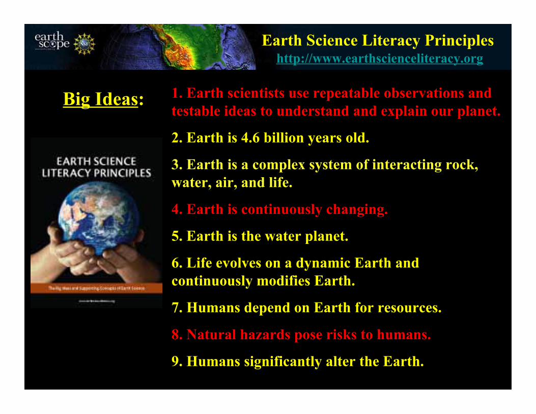
Earth Science Literacy Principles
1. Earth scientists use repeatable observations andtestable ideas to understand and explain our planet.
2. Earth is 4.6 billion years old.
3. Earth is a complex system of interacting rock,water, air, and life.
4. Earth is continuously changing.
5. Earth is the water planet.
6. Life evolves on a dynamic Earth andcontinuously modifies Earth.
7. Humans depend on Earth for resources.
8. Natural hazards pose risks to humans.
9. Humans significantly alter the Earth.
Big Ideas:
http://www.earthscienceliteracy.org

Sense of Place …..• Our hometowns and other special places are part of exciting new
exploration and discovery.• Our communities are not standing still--they are moving!
EarthScope
Drillhole across San Andreas Fault875 GPS Instruments175 Borehole Strainmeters5 Long-Baseline Laser Strainmeters400 Seismometers at 2,000 sites100 Permanent Seismometers
EarthScope