20140825 dam breach rpt rev0 - canada.ca
TRANSCRIPT

AJAX PROJECT
Environmental Assessment Certificate Application / Environmental Impact Statement
for a Comprehensive Study
Appendix 17.6-B
Ajax Mine: Tailings Dam Failure Modes Assessment and Dam
Breach Inundation Evaluation

ORIGINAL SIGNED

KGHMAjax M
EXECU
1 I
2 T
2
2
2
2
3 S
3
3
3
4 P
4
4
5 D
5
5
6 C
7 C
8 R
M Ajax Mining IMine: Tailings D
UTIVE SUMM
NTRODUCTIO
TAILINGS STO
TSF Des2.1
Genera2.2
TSF Em2.3
Planned2.4
2.4.1
2.4.2
SCREENING ST
North E3.1
East Em3.2
South E3.3
POTENTIAL FA
Method4.1
Potenti4.2
4.2.1
4.2.2
4.2.3
4.2.4
DAM BREACH
Excessi5.1
5.1.1
5.1.2
5.1.3
Tailings5.2
5.2.1
5.2.2
5.2.3
CONCLUSION
CLOSURE ......
REFERENCES .
nc. 809‐6 Dam Failure Mo
MARY ............
ON ...............
ORAGE FACILI
sign Objective
al ...................
bankment La
d Embankme
Pre‐Produc
Production
TUDY ...........
Embankment
mbankment: .
Embankment
AILURE MOD
dology ..........
ial Failure Mo
Consequen
Consequen
Consequen
Consequen
H INUNDATIO
ve Seepage ‐
Case #1 Me
Case #1 Un
Case #1 Im
s Runout ‐ Ca
Case #5 Me
Case #5 Inu
Case #5 Im
S .................
....................
....................
odes Assessme
Ta
....................
....................
TY DESCRIPT
es .................
.....................
ayouts ...........
nt Constructi
ction .............
n ....................
....................
: ....................
.....................
: ....................
ES ANALYSIS
.....................
odes Assessm
nce Category
nce Category
nce Category
nce Category
ON EVALUATIO
Case #1 and
ethodology ...
ncontrolled Se
mpacts and Mi
ses #5 ...........
ethodology ...
undation Resu
mpacts and Mi
....................
....................
....................
ent and Dam B
able of Con
....................
....................
TION .............
......................
......................
......................
ion Sequence
.....................
.....................
....................
......................
......................
......................
...................
......................
ment Results...
I ....................
II ...................
III ..................
IV ..................
ON ..............
Case #2 ........
.....................
eepage Flow R
itigation .......
......................
.....................
ults ...............
itigation .......
....................
....................
....................
Breach Inundat
ntents
....................
....................
....................
.....................
.....................
.....................
e ....................
.....................
.....................
....................
.....................
.....................
.....................
....................
.....................
.....................
.....................
.....................
.....................
.....................
....................
.....................
.....................
Results .........
.....................
.....................
.....................
.....................
.....................
....................
....................
....................
tion Evaluation
....................
....................
....................
.....................
.....................
.....................
.....................
.....................
.....................
....................
.....................
.....................
.....................
....................
.....................
.....................
.....................
.....................
.....................
.....................
....................
.....................
.....................
.....................
.....................
.....................
.....................
.....................
.....................
....................
....................
....................
n
....................
....................
....................
......................
......................
......................
......................
.....................
.....................
....................
......................
......................
......................
....................
......................
......................
.....................
.....................
.....................
.....................
....................
......................
.....................
.....................
.....................
......................
.....................
.....................
.....................
....................
....................
....................
TOC‐1
............ 1
......... 1‐1
......... 2‐1
.......... 2‐1
.......... 2‐1
.......... 2‐2
.......... 2‐2
.......... 2‐2
.......... 2‐3
......... 3‐1
.......... 3‐1
.......... 3‐2
.......... 3‐2
......... 4‐1
.......... 4‐1
.......... 4‐2
.......... 4‐2
.......... 4‐3
.......... 4‐6
.......... 4‐9
......... 5‐1
.......... 5‐2
.......... 5‐2
.......... 5‐4
.......... 5‐6
.......... 5‐7
.......... 5‐7
.......... 5‐8
.......... 5‐8
......... 6‐1
......... 7‐1
......... 8‐1

KGHM Ajax Mining Inc. 809‐6 Ajax Mine: Tailings Dam Failure Modes Assessment and Dam Breach Inundation Evaluation TOC‐2
List of Appendices
APPENDIX A POTENTIAL FAILURE MODES ASSESSMENT .................................................................... A‐1
List of Tables
Table 3‐1 Screening Study for Potential Dam Failure Scenarios ............................................................... 3‐3
Table 4‐1 Highlighted Dam Breach Cases for Failure Modes Assessment ................................................ 4‐2
Table 5‐1 Highlighted Cases for Dam Breach Study .................................................................................. 5‐1
Table 5‐2 Model Hydraulic Conductivity Parameters ................................................................................ 5‐3
Table 5‐3 SEEP/W Uncontrolled Seepage Flow Estimates ........................................................................ 5‐5
List of Figures
Figure 2‐1 TSF Depth Area Capacity Curve ................................................................................................ 2‐4
Figure 2‐2 TSF Filling Schedule .................................................................................................................. 2‐4
Figure 5‐1 Estimated TSF Starter Pond Drawdown ................................................................................... 5‐6
List of Drawings
C180‐KA39‐5100‐00‐011 General Arrangement Plan ‐ End of Mine Life (Ultimate)
C180‐KA39‐5110‐00‐001 Starter (North) Embankment Sections ‐ End of Year ‐1 ‐ Case #1
C180‐KA39‐5110‐00‐002 North Embankment Sections ‐ End of Year 1 ‐ Case #2
C180‐KA39‐5110‐00‐003 North Embankment Sections ‐ End of Mine Life (Ultimate) ‐ Case #3
C180‐KA39‐5120‐00‐001 East Embankment Sections ‐ End of Mine Life (Ultimate) ‐ Case #4
C180‐KA39‐5130‐00‐001 South Embankment Sections ‐ End of Mine Life (Ultimate) ‐ Case #5
C180‐KA39‐5100‐00‐002 South Embankment Inundation Extent End of Mine Life (Ultimate) ‐ Case #5
KGHM Ajax Mining Inc. 809‐6 Ajax Mine: Tailings Dam Failure Modes Assessment and Dam Breach Inundation Evaluation ES‐1
EXECUTIVE SUMMARY
KGHM Ajax Mining Inc. (KAM) proposes to develop the Ajax Project, an open pit copper‐gold mine at the
historic Afton Mining Camp, British Columbia (BC). The Ajax Project is required to obtain an
Environmental Assessment Certificate in accordance with BC’s Environmental Assessment Act (BCEAA).
This report is prepared to accompany an Application for an Environmental Assessment Certificate by
KAM. According to the Application Information Requirements/Environmental Impact Statement
Guidelines (AIR/EIS‐G), the AIR/EIS‐G will identify the likelihood of potential accidents, malfunctions and
unplanned events, including a failure of the TSF that could occur in any phase of the Project, and
describe how each potential accident, malfunction or unplanned event would be managed or mitigated.
The dam breach inundation study accomplished these objectives by carrying out the work in three
stages as follows:
Stage 1: Screening Level Study: Collect available information related to the TSF design and
staging of the dams and highlight failure scenarios that could lead to a dam breach during
pre‐production, production and closure. Screen these scenarios to obtain a set of critical
scenarios that highlight appropriate “sunny” and “rainy” day failure modes for further
failure mode assessment. The Canadian Dam Safety Association (CDA, 2007) provides
guidelines that define these terms as:
“Sunny‐day” failure – A sudden dam failure that occurs during normal
operations. It may be caused by internal erosion, piping, earthquakes, mis‐
operation leading to overtopping, or another event.
“Rainy‐day” “failure (or flood‐induced”) – A dam failure resulting from a
natural flood of a magnitude that is greater than what the dam can safely
pass.
Stage 2: Potential Failure Modes Analysis: Complete a Potential Failure Modes Analysis
(PFMA) of the highlighted cases identified in the Screening Level study (Stage 1) to identify
potential mechanisms that could lead to a dam breach, generally assess the likelihood of the
failure occurring and the effects (consequences) of such failure, and identify potential risk
reduction measures that could reduce breach potential. A generalized consequence
category was applied to each Potential Failure Mode (PFM) as follows:
Category I – PFM with potential for a breach and subsequent inundation
with potential for significant impact beyond the property boundary. These
mechanisms typically involve water only or tailings and water as the mobile
fluid. This is the highest consequence category.

KGHM Ajax Mining Inc. 809‐6 Ajax Mine: Tailings Dam Failure Modes Assessment and Dam Breach Inundation Evaluation ES‐2
Category II – PFM with potential for a breach with inundation zone likely to
be maintained within the property or results in limited impacts beyond the
property boundary.
Category III – PFMs leading to a structural failure that is unlikely to cause a
breach and loss of contents.
Category IV – PFMs that may be ruled out because the physical possibility
does not exist or the PFM is so remote a possibility as to be non‐credible or
not reasonable to postulate.
Stage 3: Dam Breach and Inundation Evaluation: Complete a dam breach/inundation
analyses on the credible cases that could lead to a potential dam breach scenario resulting
from the PFMA in Stage 2. Assessment of the breach flows was completed for evaluating the
possible inundation and potential consequences of dam failure.
The results of the PFMA identified Category II failure modes involving potential for breach
and partial/complete loss of mobile contents (water and/or liquefied tailings) behind the
dam structures. These are the “critical” cases that form the basis for bounding the
inundation risks based on the TSF design. Three of these cases are for the North
Embankment, involving excessive seepage and one case for the South Embankment
involving dam breach. The PFMA indicates that there is no Category I failure modes
identified. The TSF design includes several design features that significantly improve
embankment stability and protects against downstream slope failures that could lead to a
breach and loss of contents:
1. A mine rock buttress and/or Mine Rock Storage Facility are included on the
downstream of the embankment to increase the Factor of Safety (FOS) against a
breach several times higher than the minimum design requirement.
2. Additional freeboard allowance for PMF and wave‐run up for all stages of dam
development.
3. 2014 site investigation has not identified continuous clay layers with high plasticity
(weak) that could adversely impact global stability. Field investigations identified
only localized clay soil units at shallow depth (<5m) and it is planned to remove
these materials as part of foundation preparation.
4. Except for the start‐up condition, the design calls for the supernatant pond to be
maintained at several hundred meters from the dam crest.

KGHM Ajax Mining Inc. 809‐6 Ajax Mine: Tailings Dam Failure Modes Assessment and Dam Breach Inundation Evaluation ES‐3
There are three failure modes that could lead to an uncontrolled seepage event; of these
Case #1 ‐ North Embankment at the End of Year ‐1 has the largest potential for high flows.
This case has a potential for releasing uncontrolled seepage flows through the North
Embankment, and drawing down the start‐up water pond. The critical flow path is through
the section where the pond has a 12m water head and in contact with the starter
embankment over approximately a 115m length at the maximum elevation. Flow through
this section will collect at the North Embankment Seepage Collection Pond #2. An
estimated average daily flow of 38,000m3 will discharge during the first week. The discharge
rate will gradually reduce, and the estimated total time for the stored 2.4 Mm3 to
completely empty is about 4.5 months, if no interim interventions are made.
Based on the estimated initial discharge rates, the excessive seepage could fill the North
Embankment Seepage Collection Pond #2 after about 3 days following the onset of
excessive seepage. There are pumps planned for emptying the ponds. Additional
emergency pumping will be required to transfer the excessive seepage flows, and prevent
the pond from overtopping. Over the filling duration of more than 3 days, it is considered
that the mine can adequately deploy additional emergency pumping to draw down the
collection pond, and transfer the seepage water elsewhere within the site (i.e. collection
ponds, open pit, etc.) to allow work for repair of this impermeable till layer within the
embankment to impede flow. Existing pits at site include the Ajax East, West East and West
West Pits. The West East Pit occupies an area of approximately 10 ha, measuring about 300
m long by 300 m wide and has a depth of about 60 m to the existing water level (~ 845 masl
to 850 masl) (BGC, 2015). The storage volume in this open pit location is expected to provide
sufficient temporary storage for managing the estimated seepage volume. If emergency
pumping can be deployed and storage is appropriately utilized, excessive seepage flow from
the TSF can be contained within the mine property.
Exposure to a risk of a significant release of water occurs just prior to production and shortly
thereafter. Once tailings deposition occurs, the slope of the tailings surface will push the
pond back from the crest of the dam so that there is significant tailings beach above water
developed. Most of the North Embankment will include a massive mine rock buttress placed
on the downstream side, constructed as the mine is developed. These conditions cause the
potential for a water release to be very remote and beyond current consideration, shortly
after production begins (within 1 to 2 years).
There is one failure mode that could lead to a breach and loss of contents; Case #5 – South
Embankment at End of Mine Life. At the end of the mine life, tailings deposition will be at
full capacity so that these conditions represent the “worst cases” for a tailings breach;
assuming that the pond will be managed at a “safe” distance from the dam crest. Clearly

KGHM Ajax Mining Inc. 809‐6 Ajax Mine: Tailings Dam Failure Modes Assessment and Dam Breach Inundation Evaluation ES‐4
careful pond management will be a critical issue with strict operational criteria provided
during detailed design. Results for the above dam breach cases showed that the tailings
inundation area from a breach will extend over the Ajax property boundary (Case #5) but
with no significant impacts downstream. The impacts and inundation results from these
cases are summarized as follows:
The estimated areas for Case #5 are contained by topography such that the tailings would
not be carried to other catchments through surface runoff. Therefore, downstream surface
water environmental impacts are likely to be limited. There is a potential risk to life for
those mine personnel present immediately downstream of the embankments where some
of the mine infrastructure will be present. Mine infrastructure that includes seepage
collection ponds and water management ditches will likely be buried. KAM is planning a
thickened tailings strategy using 60% solids content tailings material, based on results from
a recent trade off study to identify the Best Available Technology (BAT) for the Ajax Project
(Norwest, 2015). Thickened tailings technology has higher solids content to improve physical
stability of the tailings deposit and minimizes water requirements within the facility as
compared to the unthickened tailings containment.
Based on the estimates for the uncontrolled seepage flows that could occur in the event of a
failure of the upstream till blanket, flow discharged from the TSF can be contained within the
mine property. This will involve emergency pumping and use of existing storage areas to allow
the necessary work for repair of the impermeable till layer within the embankment to impede
flow. Surveillance procedures to assist in detecting the onset of excessive seepage, as well as
planning and preparedness for deploying emergency pumping and risk management will be
evaluated and specified as part of the detailed design, Operation, Maintenance and Surveillance
(OMS) manual and Quantitative Risk Assessment (QRA). Pond management will be crucial in
limiting the risk of a breach, while design mitigation will include improving stability through
shallower slopes and/or revised alignments that allow for a buttress.

KGHM Ajax Mining Inc. 809‐6 Ajax Mine: Tailings Dam Failure Modes Assessment and Dam Breach Inundation Evaluation 1‐1
1 INTRODUCTION
KGHM Ajax Mining Inc. (KAM) proposes to develop the Ajax Project, an open pit copper‐gold
mine at the historic Afton Mining Camp, British Columbia (BC). The Ajax Project is required to
obtain an Environmental Assessment Certificate in accordance with BC’s Environmental
Assessment Act (BCEAA). This report is prepared to accompany an Application for an
Environmental Assessment Certificate by KAM. According to the Application Information
Requirements/Environmental Impact Statement Guidelines (AIR/EIS‐G), the AIR/EIS‐G will
identify the likelihood of potential accidents, malfunctions and unplanned events, including a
failure of the TSF that could occur in any phase of the Project, and describe how each potential
accident, malfunction or unplanned event would be managed or mitigated. This study is a
federal requirement under the Canadian Environmental Assessment Act as part of the Accidents
and Malfunctions evaluation. Proposed federal studies, such as this report are outlined in an
Environmental Impact Statement Guidelines (EIS Guidelines) document; information needed to
complete the federal EA process is submitted to the CEA Agency for approval in an
Environmental Impact Statement (EIS), which was completed by KAM in a separate document
(KAM, July 2015).
Norwest Corporation (Norwest) has been appointed as the engineering design consultant for the
tailings facility at the Ajax project near Kamloops, BC. The mine plan will process ore during
approximately 20 years of operation. A basic engineering design of the TSF facility that will store
thickened tailings has been completed (Norwest, 2015) and this design forms the basis for this
study. The TSF design comprises of four zoned earth‐rockfill dams (referred to as the North
Embankment, East Embankment, South Embankment, and Southeast Embankment) constructed
using the downstream method of construction. During the course of the work, Norwest
completed a failure modes assessment and identified opportunities for modifying the design to
improve its risk profile and reduce potential consequences accordingly as noted herein.
Potential Failure Modes Analysis (PFMA) is a systematic, proactive method for evaluating a
structure or system to identify where and how it might fail (potential failure modes) and
generally assess the likelihood of the failure occurring and the effects (consequences) of such
failure. The purpose of a dam breach study is to evaluate potential consequences of dam failure
in order to classify the dam and to map out potential inundation zones for emergency
preparedness measures. The PFMA precedes the dam breach study in order to identify credible
failure mechanisms including those that could lead to breach and inundation. The study
accomplished its objectives by carrying out the work in three stages as follows:
Stage 1: Screening Level Study: Collect available information related to the TSF
design and staging of the dams and highlight failure scenarios that could lead to a

KGHM Ajax Mining Inc. 809‐6 Ajax Mine: Tailings Dam Failure Modes Assessment and Dam Breach Inundation Evaluation 1‐2
dam breach during pre‐production, production and closure. Screen these scenarios
to obtain a set of critical scenarios that highlight appropriate “sunny” and “rainy”
day failure modes for further failure mode assessment. The Canadian Dam Safety
Association (CDA, 2007) provides guidelines that define these terms as:
“Sunny‐day” failure – A sudden dam failure that occurs during normal
operations. It may be caused by internal erosion, piping, earthquakes, mis‐
operation leading to overtopping, or another event.
“Rainy‐Day” failure (or “flood‐induced”) – A dam failure resulting from a
natural flood of a magnitude that is greater than what the dam can safely
pass.
Stage 2: Potential Failure Modes Analysis: Complete a Potential Failure Modes
Analysis (PFMA) of the highlighted critical cases identified in the Screening Level
study (Stage 1) to identify potential mechanisms that could lead to a dam breach,
generally assess the likelihood of the failure occurring and the effects
(consequences) of such failure, and identify potential risk reduction measures that
could reduce breach potential.
Stage 3: Dam Breach and Inundation Evaluation: Complete a dam
breach/inundation analyses on the critical failure modes that could lead to a
potential dam breach scenario resulting from the PFMA in Stage 2.
Norwest (2015) has recently carried out a tailings technology trade‐off study to identify the Best
Available Technology (BAT) for the Ajax Project and Thickened Tailings (60% solids slurry)
emerged as the most appropriate choice. Thickened tailings technology has higher solids
content to improve physical stability of the tailings deposit and minimizes water requirements
within the facility as compared to the unthickened tailings containment.

KGHMAjax M
2
2.1
2.2
M Ajax Mining IMine: Tailings D
TAILINGS
TSF Desig
The princ
supernata
effective r
criteria:
General
The Projec
of the Tra
Nicola Reg
The TSF w
Drawing C
End of Min
Tailings w
designed t
comprise
Embankme
the downs
Integral to
the TSF, w
The West
South Min
structures
nc. 809‐6 Dam Failure Mo
S STORAGE
gn Objective
ipal design
nt water du
reclamation a
Provide pe
engineered
Control see
for recyclin
Application
tailings con
No surface
ct is located in
ns‐Canada H
gional District
will be located
C180‐KA39‐51
ne Life.
ill be deposit
to permanent
of four zon
ent, South Em
stream metho
o the embank
hich are inco
Mine Rock S
ne Rock Sto
contribute to
odes Assessme
E FACILITY D
es
objectives fo
ring operatio
at mine closu
rmanent, sec
d disposal faci
epage throug
ng as process
n of Best Avai
ntainment.
water discha
n the South‐C
ighway No. 1
.
d approximat
100‐00‐011 is
ted and man
tly store tailin
ed earth‐roc
mbankment,
od of constru
ment design
rporated in t
Storage Facilit
rage Facility
o the overall s
ent and Dam B
DESCRIPTIO
or the TSF
ons and in t
re. The TSF d
cure and tota
ility.
gh the basin a
water to the
lable Techno
arge to the en
Central Interio
1 and the Coq
tely 1km sou
general arra
aged in a TS
ngs generated
ckfill dams (
and Southea
ction.
will be the us
he tailings em
ty (WMRSF)
(SMRF) will
stability and p
Breach Inundat
ON
are to prov
the long ter
design requir
al confinemen
and embankm
maximum pr
logy (BAT) an
nvironment ov
or of British C
quihalla High
uth of the op
angement of t
SF located so
d during the
referred to
ast Embankm
se of mine ro
mbankment d
will buttress
buttress th
performance
tion Evaluation
vide containm
rm (post‐clos
rements shou
nt of all tailin
ments of the
ractical exten
nd Best Availa
ver the life of
Columbia, sou
hway (No. 5),
pen pit, east
the TSF and a
uth of the o
operation of
as the Nort
ment) and wil
ock storage fa
designs to but
the North E
he East Emba
e of the TSF.
n
ment for tai
sure), and to
uld meet the
ngs materials
TSF during o
t.
able Practices
f the project.
utheast of the
within the T
of Lac Le Jeu
associated fa
pen pit. The
the mine. Th
th Embankm
l be construc
acilities down
ttress these s
mbankment
ankment. T
2‐1
lings and
o achieve
following
within an
operations
s (BAP) for
e junction
Thompson
une Road.
acilities, at
e TSF was
he TSF will
ment, East
cted using
nstream of
tructures.
while the
The MRSF

KGHMAjax M
2.3
2.4
M Ajax Mining IMine: Tailings D
TSF Emba
The TSF w
5100‐00‐0
Planned E
There are
Pre‐Produ
deposited
during mil
2.4.1 Pr
TS
co
Th
an
em
es
vo
nc. 809‐6 Dam Failure Mo
ankment Lay
will provide ta
11):
North Emb
where the
approximat
embankme
East Emba
27ha, and
valley with
Lake. It is e
in Year 2.
South Emb
20ha, and a
the TSF bas
Southeast
southern e
foundation
Embankmen
two primary
ction is cons
in the TSF (
l operations.
e‐Production
SF starter‐ No
onstruction ap
his embankme
nd will retain
mergency sto
timate is bas
olume from th
odes Assessme
youts
ailings conta
bankment wil
existing gro
tely 3,700m
ent height of 1
nkment is a
a maximum
steep side s
estimated tha
bankment is
a maximum e
sin to constra
Embankment
extent. The
footprint of
nt Construct
construction
idered the pe
Year ‐2, ‐1)
Construction
n
orth Embankm
pproximately
ent will prov
the start‐up
orage for pro
ed on a thick
he previously
ent and Dam B
inment using
ll be located
ound elevatio
long with a f
122m.
pproximately
embankmen
lopes on the
at the TSF sup
approximate
embankment
in the TSF wi
t will constra
South Emba
2ha, and a m
tion Sequenc
phases throu
eriod before
and Producti
n tasks for eac
ment (Year ‐2
y 1 to 2 years
ide capacity
water pond,
cess water s
kened tailings
proposed co
Breach Inundat
g four emban
d at the nort
on is the lo
foundation fo
y 1,450m lon
t height of 1
east side of
pernatant po
ly 1,550m lo
height of 42m
thin the KGH
in the TSF w
ankment is a
maximum emb
ce
ugh life of mi
mill operatio
ion (Year 1 t
ch of these tw
2, ‐1): The sta
s prior to the
for approxim
which is estim
supply to the
s storage faci
nventional ta
tion Evaluation
nkments (See
th and weste
owest. The N
ootprint of 15
ng with a fo
108m. It is s
the TSF basi
ond footprint
ong with a fo
m. It is situat
M property b
ithin the pro
approximatel
bankment hei
ne: Pre‐Produ
ons, when th
to approxima
wo phases are
arter North E
e operation o
mately two ye
mated at app
e mill. This s
lity, which sig
ailings facility
n
e Drawing C1
ern extent of
North Emban
54ha, and a
oundation foo
situated acros
n, just north
will reach Go
oundation foo
ted at the sou
boundary.
perty bounda
ly 550m lon
ight of 13.5m
uction and Pr
here will be n
ately 20) is t
e as follows:
mbankment
of the proces
ears of tailing
proximately 2
start‐up wate
gnificantly re
(Norwest 20
2‐2
180‐KA39‐
f the TSF,
nkment is
maximum
otprint of
ss a small
of Goose
oose Lake
otprint of
uth end of
ary at the
ng with a
m.
roduction.
no tailings
he period
will begin
ss facility.
gs storage
2.4Mm3 of
er volume
duces the
015).

KGHM Ajax Mining Inc. 809‐6 Ajax Mine: Tailings Dam Failure Modes Assessment and Dam Breach Inundation Evaluation 2‐3
2.4.2 Production
Embankment raises of TSF Embankments to full height (Year 1 to 20): The thickened
tailings will be deposited and managed in a TSF located south of the open pit. Four
zoned earth‐rockfill dams will be constructed to provide tailings and water storage
containment. Tailings will be discharged from the embankments that will result in a
supernatant pond toward the southeast corner of the facility. The method of tailings
deposition (spigotting from perimeter) is expected to result in beaches with
approximately 1 to 2% slopes. Initial tailings deposition into the TSF will be by spigotting
from the face of the North Embankment. The East Embankment will not be required to
retain tailings and water until Year 3. However, to limit access constraints, construction
of the East Embankment will start in Year 1. The South Embankment will be required to
retain tailings and water from Year 7 until the end of the mine life. The Southeast
Embankment will not be required to be in place until towards end of mine life.
All the embankments will have a crest elevation of 1,056m. Prior to closure of the TSF,
the supernatant water will be pumped into the pit to expedite the establishment of a pit
lake and eliminate long‐term ponded water on the TSF. The tailings will be reclaimed to
a terrestrial landscape, as close as practical to pre‐mining conditions with a cover system
designed to limit infiltration to the TSF. Following reclamation, any runoff and/or flood
events will be directed away from the facility to an engineered channel to Humphrey
Creek, which is located in the neighboring catchment to the east of the TSF.
A depth area capacity curve that reflects the planned TSF storage volume is shown in
Figure 2‐1. The volumes and areas are based on topographic information provided by
KGHM using 3D MineSight modelling software.
Figure 2‐2 shows the TSF filling schedule that shows the cumulative tailings volumes,
freeboard for PMF and wave run‐up and respective dam crest elevations to contain the
water and tailings volumes on an annual basis. The TSF has storage capacity of
approximately 321.5Mm3, which is comprised of 275Mm3 of tailings (at a dry density of
1.6 tonnes/m3), 2.4Mm3 of supernatant water and approximately 4.1Mm3 allowance for
the design flood (Probable Maximum Flood (PMF)) storage.

KGHM Ajax Mining Inc. 809‐6 Ajax Mine: Tailings Dam Failure Modes Assessment and Dam Breach Inundation Evaluation 2‐4
Figure 2‐1
TSF Depth Area Capacity Curve
Figure 2‐2
TSF Filling Schedule
1).Startup pond volume is estimated at approximately 2.4 Mm3. 2). Minimum crest elevation includes sufficient storage for tailings, pond and allowance for PMF and wave run‐up. 3).Tailings volume is assumed to be 65,000 tpd at a mill availability of approximately 92%.

KGHMAjax M
3
3.1
M Ajax Mining IMine: Tailings D
SCREENI
The Ajax ta
are differe
stages of o
series of s
considered
Analysis in
The South
Therefore
Rationale f
follows:
North Em
nc. 809‐6 Dam Failure Mo
NG STUDY
ailings facility
ent failure mo
operation an
scenarios we
d to be critic
n Section 4. T
east Embank
it is not inclu
for defining t
mbankment:
Case #1: Th
facility at st
after the s
water dam
Case #2: At
water with
downstream
Storage Fac
minimum d
included in
embankme
risk of un
blanket. On
blanket fail
Case #3: T
production
approximat
approximat
and water
therefore t
The North
located do
odes Assessme
y will be deve
odes and rela
nd constructio
re developed
al are highlig
Table 3.1 sum
kment will no
ded in the ev
the critical sce
he North Emb
tart‐up (end
start of prod
. This is the m
t the end of y
hin 500m o
m constructi
cility to incre
design requir
n the dam
ent stability a
controlled se
nce there are
ure is low.
he largest ta
. The TSF w
tely 2.4Mm3
tely 1,200m
stored in th
he ultimate c
Embankmen
wnstream ap
ent and Dam B
eloped over a
ated potentia
on, and in or
d to provide
ghted for furt
mmarizes the
t have water
valuation.
enarios at ea
bankment is r
of Year ‐1) so
uction, the N
most critical p
year 1, the N
of the dam.
on compose
ease the FOS
ement. This d
design thro
gainst this po
eepage from
e tailings agai
ilings volume
ill store app
of supernat
away from t
he facility fo
case is more c
t will be con
pproximately
Breach Inundat
a period of up
al dam breac
rder to evalu
a basis for
ther consider
five cases ch
r or tailings re
ch embankm
required to c
o that during
North Emban
period from a
North Embank
. The dam
d of a mine
against a bre
downstream
oughout the
otential failur
m cracking o
inst the upstr
e contained
roximately 4
tant water at
he North Em
r prior years
critical in com
nstructed to e
y 39m higher
tion Evaluation
p to approxim
ch scenarios t
uate these dif
a screening
ration in a Po
hosen for fai
esting against
ment over the
contain 2.4Mm
the period fr
nkment will n
a dam breach
kment will co
configuratio
e rock buttre
each several
buttress is a
life of the
re mode. How
of the imper
ream embank
within the fa
440 million to
t the southe
mbankment. T
s are less th
mparison.
elevation 1,0
r than the em
n
mately 20 yea
that occur at
fferent time
evaluation.
otential Failu
lure mode ev
t it at end of
life of the fa
m3 of water w
rom start‐up
need to func
and risk pers
ontain tailings
on includes
ess and/or M
times higher
a contingency
e facility to
wever, there
rmeable upst
kment face, t
acility is at th
onnes of tail
ern end of th
The volume o
an the final
56m with the
mbankment.
3‐1
ars. There
t different
periods a
Scenarios
re Modes
valuation.
mine life.
acility is as
within the
to shortly
ction as a
spective.
s and free
sufficient
Mine Rock
r than the
y measure
improve
may be a
tream till
the risk of
he end of
lings with
he facility
of tailings
year and
e WMRSF
Although

KGHMAjax M
3.2
3.3
M Ajax Mining IMine: Tailings D
East Emb
South Em
nc. 809‐6 Dam Failure Mo
the emba
composed
higher than
seepage fro
ankment:
Case #4: Th
end of year
end of yea
embankme
five years o
face of the
production
east emban
located do
275Mm3 o
southern e
embankme
tailings and
mbankment:
Case #5: Th
facility. The
end of prod
The South
approximat
at the sou
embankme
odes Assessme
nkment con
of a robust
n the minimu
om cracking o
he first stage
r 1 to provide
r 3, the SMR
ent. About 64
of operation.
e embankmen
, when the l
nkment will b
ownstream a
of tailings w
end of the f
ent. During pr
d water stored
here is no wat
erefore, the m
duction when
Embankment
tely 275Mm3
uthern end o
ent at the end
ent and Dam B
nfiguration i
MRSF to inc
um design req
of the imperm
e of construc
e tailings con
RSF rapidly ex
4m of its 108
. There will
nt and the c
largest tailing
be constructe
bove the em
with approxim
facility that i
rior years, the
d in the facilit
ter impounde
most critical s
n the largest
t will be cons
of tailings wi
of the facilit
d of productio
Breach Inundat
ncludes suff
crease the FO
quirement, th
meable upstre
ction for the
tainment for
xpands to pro
8m total heigh
not be any w
ritical phase
gs volume is
d to elevation
mbankment.
mately 2.4M
is approxima
e freeboard is
ty are less tha
ed against th
scenario for th
tailings volu
structed to el
ith approxim
ty approxima
on.
tion Evaluation
ficient down
OS against a
here may be
eam till blank
East Embank
r the third yea
ovide additio
ht will be com
water stored
is considere
contained w
n 1,056m wit
The TSF wil
m3 of super
ately 1,000m
s relatively la
an the final y
e south dam
he Southeast
me is contain
levation 1,05
ately 2.4Mm3
ately 700m a
n
nstream con
breach seve
a risk of unc
ket.
kment will st
ar of product
onal buttressi
mpleted withi
against the
d to be at th
within the fac
th a mine roc
l store appr
rnatant wate
away from
rge, and the v
ear.
through the
t Embankmen
ned within th
56m. The TSF 3 of supernat
away from t
3‐2
nstruction
eral times
controlled
art at the
tion. After
ing to the
n the first
upstream
he end of
cility. The
k buttress
roximately
er at the
the east
volume of
life of the
nt is at the
he facility.
will store
ant water
the south

KGHM Ajax Mining Inc. 809‐6 Ajax Mine: Tailings Dam Failure Modes Assessment and Dam Breach Inundation Evaluation 3‐3
Table 3‐1
Screening Study for Potential Dam Failure Scenarios
End of Year Crest
Elevation (m)
Impounded Contents
TSF Embankments
North East South
‐2 Water Only
Not Critical Not Built
Not Built
‐1 971 Case #1
1 984
Tailings and Water
Case #2 Not Critical
2 992 Not Critical Not Critical
5 1,012 Not Critical Not Critical
10 1,031 Not Critical Not Critical Not Critical
20 (End of Mine
Life) 1,056 Case #3 Case #4 Case #5
Closure 1,056 DRY CLOSURE – No impounded water. Consolidated Thickened Tailings deposit

KGHMAjax M
4
4.1
M Ajax Mining IMine: Tailings D
POTENTI
Potential
structure
generally a
failure.
Norwest h
modes we
Methodo
The PFMA
(Table 4‐1)
1. Ide
(ov
of
co
2. Fo
an
3. As
nc. 809‐6 Dam Failure Mo
IAL FAILURE
Failure Mode
or system to
assess the lik
has complete
re assessed f
ology
A presented h
):
entify and de
vertopping, s
events that
ontents.
or each PFM,
nd conceivabl
ssign PFMs to
a. Catego
potenti
mechan
fluid. T
b. Catego
tailings
propert
c. Catego
and los
d. Catego
not exi
reason
odes Assessme
E MODES A
es Analysis (
o identify w
kelihood of th
d a PFMA us
or each of the
here was car
efine Potentia
structural fail
could subse
list the factor
e (adverse fa
generalized
ry I – PFM w
ial for signi
nisms typical
This is the hig
ry II – PFM w
s and water.
ty.
ry III – PFMs
ss of contents
ry IV – PFMs
ist or the PF
able to postu
ent and Dam B
ANALYSIS
PFMA) is a s
here and ho
he failure occ
sing the Preli
e five cases fr
ried out as f
al Failure Mod
ure, and pipi
equently lead
rs that were c
ctors) or less
consequence
with potentia
ificant impa
lly involve w
hest consequ
with potential
Inundation
s leading to a
s.
that may be
FM is so rem
ulate.
Breach Inundat
systematic, p
ow it might
curring and t
minary TSF D
rom the scree
follows for ea
des (PFMs) in
ng), the initia
d to a breac
considered to
likely and re
e categories d
l for a breac
ct beyond
water only or
uence catego
for a breach
zone presu
a structural f
e ruled out be
mote a possib
tion Evaluation
proactive me
fail (potentia
the effects (c
Design as a b
ening study.
ach of the se
n terms of th
ating mechan
h and partia
o make the fa
mote (positiv
defined as fol
h and subseq
the propert
r tailings and
ry.
and/or unco
med to be m
failure that w
ecause the ph
bility as to b
n
ethod for eva
al failure mo
consequences
basis. Differe
even highligh
e broad type
nism and the
al or complet
ilure mode m
ve factors).
lows:
quent inunda
ty boundary.
d water as th
ontrolled relea
maintained w
will not cause
hysical possib
e non‐credib
4‐1
aluating a
odes) and
s) of such
ent failure
hted cases
of failure
sequence
te loss of
more likely
ation with
. These
he mobile
ase of the
within the
e a breach
bility does
ble or not

KGHMAjax M
End oYear
‐1
1
20
Note. 1
4.2
M Ajax Mining IMine: Tailings D
4. Pr
pr
me
su
of
of r
Crest El. (m)
971
984
1,056
1. See Appendix
Potential
Details of
terms as t
constructio
evaluated.
Key findin
category in
PFM, posit
are provid
4.2.1 Co
Co
inu
me
th
Th
an
nc. 809‐6 Dam Failure Mo
ovide a list o
obability of f
easures are
bsequent dow
detail, some
Highligh
Estimated Tailings and/Water El. (m
Tailings Wa
94
968 954
1,053 10
A for Potential F
Failure Mod
the PFMA re
the designs a
on methods,
.
gs for each o
n turn. A deta
tive and adve
ed in tabular
onsequence C
onsequence C
undation wit
echanisms ty
e highest con
he PFMA (App
ny of the five
odes Assessme
of risk reduc
ailure and/or
especially im
wnstream inu
of these mea
hted Dam Brea
/or m)
ImpoundConte
ater
46 Water O
4.8
Tailinand Wa
043
Failure Mode (P
des Assessm
sults are disc
re still at a b
suitability o
of the five ca
ailed summar
erse factors, m
form as Appe
Category I
Category I co
h potential fo
pically involv
nsequence cat
pendix A) ind
cases. The T
ent and Dam B
ction measure
r reducing or
mportant for
undation pot
asures may be
Table 4‐1
ach Cases for F
dment ents
North
Only Case #
ngs ater
Case #
Case #
FM) description
ment Results
cussed in this
basic enginee
of fill materia
ases are disc
ry of these PF
mitigation opp
endix A.
onsider PFMs
or significant
e water only
tegory.
icates that th
TSF design in
Breach Inundat
es that mitig
eliminating t
r managing
ential. As th
e subsequent
Failure Modes
TSF Embankme
h East
#1
#2
#3 Case #4
s and analysis b
s
s section. The
ering level an
als, and tailin
ussed below
FM for these c
portunities a
s with poten
t impact beyo
or tailings an
here is no Cat
ncludes sever
tion Evaluation
gate the failu
the conseque
the risk of
e design adva
tly adopted.
Assessment
ents
South
Case #5
C
C
reakdown.
e PFMs are d
d details of f
ngs depositio
by consider
cases, includi
nd resulting C
ntial for a br
ond the prop
nd water as th
tegory I failur
al design fea
n
ure mode by
ence altogeth
a breach ev
ances to the
Drawing
#
C180‐KA39‐5110
C180‐KA39‐5110
C180‐KA39‐5110
C180‐KA39‐5120
C180‐KA39‐5130
defined in ver
foundation co
on plan are s
ing each con
ng a descript
Consequence
reach and su
perty boundar
he mobile flu
re modes iden
tures that sig
4‐2
y lowering
er. These
vent with
next level
g
0‐00‐001
0‐00‐002
0‐00‐003,
0‐00‐001,
0‐00‐001
ry general
onditions,
still being
nsequence
tion of the
e Category
ubsequent
ry. These
id. This is
ntified for
gnificantly

KGHM Ajax Mining Inc. 809‐6 Ajax Mine: Tailings Dam Failure Modes Assessment and Dam Breach Inundation Evaluation 4‐3
improve embankment stability and protect against downstream slope failures that could
lead to a breach:
A mine rock buttress and/or MRSF have been included on the downstream
slope of the embankment to increase the Factor of Safety (FOS) against a breach
to several times higher than the minimum design requirement.
Additional freeboard allowance for PMF and wave‐run up for all stages of dam
development.
The 2014 site investigation has not identified continuous clay layers with high
plasticity (weak) that could adversely impact global stability. Field investigations
identified only localized clay soil units at shallow depth (<5m) and it is planned
to remove these materials as part of foundation preparation.
Except for the start‐up condition, the design calls for the supernatant pond to
be maintained at several hundred meters from the dam crest.
4.2.2 Consequence Category II
Consequence Category II considers PFMs with potential for a breach and/or
uncontrolled release of the tailings and water. Inundation zone presumed to be
maintained within the property.
4.2.2.1 PFM #3 ‐ Case #1: North Embankment at End of Year ‐1
Potential Failure Mode: Upstream failure of the till blanket that is triggered by a
seismic event, rapid drawdown, differential settlement and cracking, poor
construction and/or high pore pressures leading to uncontrolled seepage.
Positive Factors:
Stability analyses completed as part of the preliminary TSF design show
that the FOS for this failure mode exceeds design criteria.
This embankment configuration, which includes the mine rock buttress,
results in a very long seepage path that minimizes flow velocities and
reduces the potential for internal erosion and piping.
The rock fill material that provides the structural component of the
embankment is not generally susceptible to erosion and piping.
KGHM Ajax Mining Inc. 809‐6 Ajax Mine: Tailings Dam Failure Modes Assessment and Dam Breach Inundation Evaluation 4‐4
At the end of year ‐1, the starter pond will be in contact with the dam
over two relatively small areas for a limited time before the start of
tailings deposition against the upstream face. The wetted face exposed
to the highest water level (12m) is located along the northern upstream
section of the starter embankment. The design includes significant
freeboard (25m) above this water level to prevent overtopping, safe
containment of the PMF and for wave run up.
Geotextile filter to protect against internal erosion.
Adverse Factors:
Rapid construction of the till blanket may lead to increased pore
pressures and differential settlement.
Construction of this low permeability till blanket is limited by seasonal
construction period and it is expected to have tight construction
specifications.
Potential for settlement and cracking.
Mitigation Opportunities:
Use geotechnical instruments and construction monitoring to monitor
performance, prior to filling of the TSF.
Develop Quality Assurance/Quality Control of material construction
specifications of processed engineered fill.
Include additional seepage controls: thicker upstream blanket, internal
core zone, and/or basin underdrains could be added as a design
contingency.
4.2.2.2 PFM #4 ‐ Case #1: North Embankment at End of Year ‐1
Potential Failure Mode: Excessive and/or preferential seepage flows through
foundation that leads to progressive internal erosion or piping.
Positive Factors
A seepage cut‐off is included in the design to minimize seepage losses
from the TSF.

KGHM Ajax Mining Inc. 809‐6 Ajax Mine: Tailings Dam Failure Modes Assessment and Dam Breach Inundation Evaluation 4‐5
Downstream drains.
Adverse Factors:
There may be loose granular material in the foundation that could
provide a potential seepage pathway that could result in piping failure if
not defined and mitigated.
Mitigation Opportunities
A deeper cut‐off wall could be used to minimize seepage.
Use geotechnical instruments and construction monitoring to monitor
performance, prior to filling of the TSF.
4.2.2.3 PMF # 8 ‐ Case #2: North Embankment at End of Year 1
Potential Failure Mode: Excessive and/or preferential seepage flows,
inadequately designed filter material or internally unstable soils, seepage
through embankment or foundation leading to progressive internal erosion of
fill or foundation material starting from the downstream side of the dam.
Positive Factors:
There is a very long seepage path that minimizes flow velocities that
reduces internal erosion and potential for piping. The mine rock
buttress is over 500m long at places and the sloped tailings beach
pushes the supernatant pond over 200m away from the embankments.
The till blanket on the upstream face will significantly reduce seepage.
The filter zones will manage and control internal seepage through the
embankment. The majority of seepage will be collected within two
downstream seepage collection ponds or report to the open pit.
Adverse Factors:
There may be loose granular material in the foundation that can provide
a potential seepage pathway that could result to piping failure.
A very large flood or PMF could occur, which would be sufficiently
contained within the facility, but a substantial length of beach may be
inundated that may result in a pond closer to the embankment.

KGHM Ajax Mining Inc. 809‐6 Ajax Mine: Tailings Dam Failure Modes Assessment and Dam Breach Inundation Evaluation 4‐6
Mitigation Opportunities
A deeper cut‐off wall could be used to minimize seepage.
Use geotechnical instruments and construction monitoring to monitor
performance, prior to filling of the TSF.
Underdrain in the upper beach to de‐saturate the tailings.
4.2.2.4 PMF # 18 ‐ Case #5: South Embankment at End of Year 20
Potential Failure Mode: Large failure triggered by a seismic event and/or high
pore pressures leading to deep seated foundation failure and subsequent
breach and a release of tailings and water that is contained by topography.
Positive Factors:
Stability analyses completed as part of the preliminary TSF design show
that the FOS for this failure mode exceeds design criteria.
The potential for structural failure is negligible due to very dense glacial
deposits overlying competent bedrock geology beneath the south
ultimate embankment.
Long term baseline data will be collected from geotechnical instruments
to monitor performance.
Adverse Factors:
No rock buttress is incorporated into the design due to property
boundary constraints. Any released tailings would be contained within
the topography immediately behind the embankment, if a structural
failure were to occur.
4.2.3 Consequence Category III
Consequence Category III considers PFMs leading to a structural failure that will not
cause a breach and loss of contents.
4.2.3.1 PFM #2 ‐ Case #1: North Embankment at End of Year ‐1
Potential Failure Mode: Downstream sliding or slumping failure of the mine
rock buttress triggered by seismic event, high pore pressures, rapid
construction, oversteepened angle‐of‐repose slopes or weak foundation leading

KGHM Ajax Mining Inc. 809‐6 Ajax Mine: Tailings Dam Failure Modes Assessment and Dam Breach Inundation Evaluation 4‐7
to failure that causes a disruption of access roads, toe drainage and other mine
site infrastructure.
Positive Factors:
The FOS exceeds design criteria and the downstream slopes are
relatively shallow (3H:1V).
Foundation geology consists mostly of compact to very dense glacial
deposits overlying competent bedrock. Most weak layers were
identified at shallow depth (<5m), which will be sub excavated.
Continuous weak layers at depth were not identified in the site
investigations to date.
The mine rock buttress will comprise of rock fill material and the toe of
the mine rock buttress will be more than 100m from startup water
pond.
Adverse Factors:
Localized clay layers have been identified.
Increased pore pressures in the foundation may occur due to rapid
construction of the mine rock buttress.
4.2.3.2 PFM #7 ‐ Case #2: North Embankment at End of Year 1
Potential Failure Mode: Downstream sliding or slumping failure of the mine
rock buttress triggered by seismic event and/or high pore pressures leading to
failure that leads to disruption of access roads and toe drainage.
Positive Factors:
The FOS exceeds design criteria and the downstream slopes are
relatively shallow (3H:1V).
Foundation geology consists mostly of compact to very dense glacial
deposits overlying competent bedrock and weak layers that were
identified at shallow depth (<5m) will be sub‐excavated. Continuous
weak layers at depth were not identified in the site investigations to
date.

KGHM Ajax Mining Inc. 809‐6 Ajax Mine: Tailings Dam Failure Modes Assessment and Dam Breach Inundation Evaluation 4‐8
The mine rock buttress will comprise of well‐draining rock fill material
and the toe of the mine rock buttress will be a considerable distance
away from the start‐up water pond.
Adverse Factors:
Localized clay layers have been identified.
Increased pore pressures in the foundation may occur due to rapid
construction of the mine rock buttress.
Mitigation Opportunities
Use geotechnical instruments to monitor performance during
construction and filling of the TSF.
4.2.3.3 PFM # 11 ‐ Case #3: North Embankment at End of Year 20
Potential Failure Mode: Downstream sliding or slumping failure of the Mine
Rock Storage Facility triggered by seismic event, high pore pressures, rapid
construction, oversteepened angle‐of‐repose slopes or weak foundation leading
to failure that impacts the downstream North sediment collection ponds and/or
Kinder Morgan pipeline.
Positive Factors:
The FOS for the end of mine life configuration exceeds design criteria
and the downstream slopes are relatively shallow (3H:1V).
Foundation geology consists mostly of compact to very dense glacial
deposits overlying competent bedrock. Most weak layers were
identified at shallow depth (<5m), which will be sub excavated.
Continuous weak layers at depth were not identified in the site
investigations to date.
The mine rock buttress will comprise of well‐draining rock fill material.
Adverse Factors:
Localized clay layers have been identified.
Rapid construction of mine rock buttress that may lead to increased
pore pressures in the foundation.

KGHM Ajax Mining Inc. 809‐6 Ajax Mine: Tailings Dam Failure Modes Assessment and Dam Breach Inundation Evaluation 4‐9
4.2.4 Consequence Category IV
Consequence Category IV considers PFMs that may be ruled out because the physical
possibility does not exist or the PFM is so remote a possibility as to be non‐credible or
not reasonable to postulate.
4.2.4.1 PFM #5, PFM #9, PFM #13, PFM # 17, PFM #19 ‐ Overtopping PFM for all Four Embankments
Case #1 to #6 have a Category IV assignment for the overtopping PFMs, and this
mechanism is not considered for further inundation evaluation. The tailings
facility has capacity for the Probable Maximum Flood (PMF) event which is the
highest theoretical inflow so that this “rainy day” scenario is very unlikely to
lead to a failure due to overtopping.
4.2.4.2 PFM # 1 ‐ Case #1: North Embankment at End of Year ‐1
Potential Failure Mode: Large catastrophic failure triggered by a seismic event
and/or high pore pressures leading to deep seated foundation failure and
subsequent breach and a release of water into Peterson Creek and off site.
Positive Factors:
The FOS for the Year ‐1 starter embankment configuration is several
times higher than design criteria.
There will be over 25m of freeboard above the pond water.
2014 site investigation has not identified continuous clay layers with
high plasticity (weak) that could adversely impact global stability. Field
investigations identified only localized clay soil units at shallow depth
(<5m) and it is planned to remove these materials as part of foundation
preparation.
Mine rock buttress on downstream side is >500m at places.
Short period of time that water is against upstream face prior to tailings
deposition.
Adverse Factors:
There will be approximately 12m (north side) and 3m (west side) of
water head against the North starter embankment.

KGHM Ajax Mining Inc. 809‐6 Ajax Mine: Tailings Dam Failure Modes Assessment and Dam Breach Inundation Evaluation 4‐10
The mine rock buttress was included as part of the starter dam configuration.
This buttress has a base width up to 400m, which is approximately 2/3 the
height of the starter embankment, and a downstream slope of 3:1. Due to the
very large buttress that is built adjacent to the engineered fill embankment, very
high safety factors are obtained for the breached condition under static and
seismic conditions. This means that a breach or a large catastrophic failure that
leads to deep seated foundation failure and subsequent breach and a release of
water into Peterson Creek and off site is considered very unlikely based on the
assumed conditions. For this reason, this PFM may be ruled out for Stage 3
evaluation.
4.2.4.3 PFM #6 ‐ Case #2: North Embankment at End of Year 1
Potential Failure Mode: Large catastrophic failure triggered by a seismic event
and/or high pore pressures leading to deep seated foundation failure and
subsequent breach and a release of tailings and water into Peterson Creek and
off site.
Positive Factors:
The FOS for the End of Year 1 configuration is several times higher than
design criteria.
There will be over 22m of freeboard above the supernatant pond water,
which is expected to be over 200m away from the embankment.
2014 site investigation has not identified continuous clay layers with
high plasticity (weak) that could adversely impact global stability. Field
investigations identified only localized clay soil units at shallow depth
(<5m) and it is planned to remove these materials as part of foundation
preparation.
Mine rock buttress on downstream side is >500m at places.
Adverse Factors:
Localized clay layers have been identified that require further definition.
With the high Factor of Safety for the Year 1 embankment configuration a
large catastrophic failure that leads to deep seated foundation failure and
subsequent breach and a release of water into Peterson Creek and off site is

KGHM Ajax Mining Inc. 809‐6 Ajax Mine: Tailings Dam Failure Modes Assessment and Dam Breach Inundation Evaluation 4‐11
considered remote. For this reason, this PFM may be ruled out for Stage 3
evaluation.
4.2.4.4 PFM # 10 ‐ Case #3: North Embankment at End of Year 20
Potential Failure Mode: Large catastrophic failure triggered by a seismic event
and/or high pore pressures leading to deep seated foundation failure and
subsequent breach and a release of tailings and water into Peterson Creek and
off site.
Positive Factors:
The FOS of the embankments at the end of production is several times
higher than design criteria.
There will be over 13m of freeboard above the supernatant pond, which
will be over 1,200m away from the embankment.
2014 site investigation has not identified continuous clay layers with
high plasticity (weak) that could adversely impact global stability. Field
investigations identified only localized clay soil units at shallow depth
(<5m) and it is planned to remove these materials as part of foundation
preparation.
Mine rock buttress on downstream side is >500m at places.
Adverse Factors:
Localized clay layers have been identified that require further definition.
Rapid construction of mine rock buttress that may lead to increased
pore pressures in the foundation.
Stability analyses were completed in a separate study (Norwest, August 2015) to
demonstrate adequate stability of the dams for static and pseudo‐static
conditions. With the high FOS for the embankments at the end of production, a
large catastrophic failure that leads to deep seated foundation failure and
subsequent breach and a release of water into Peterson Creek and off site is
considered remote. Due to the large WMRSF downstream of the embankment
(that is approximately 39m higher than the dam itself), the large consolidated
tailings beach adjacent to the upstream embankment (that is approximately
KGHM Ajax Mining Inc. 809‐6 Ajax Mine: Tailings Dam Failure Modes Assessment and Dam Breach Inundation Evaluation 4‐12
1,200m wide) that pushes the supernatant pond from the dam crest, this PFM
may be ruled out for Stage 3 evaluation.
4.2.4.5 PFM # 12 ‐ Case #3: North Embankment at End of Year 20
Potential Failure Mode: Piping due to excessive and/or preferential seepage
flows, inadequately designed filter material or internally unstable soils, seepage
through embankment or foundation that leads to progressive internal erosion of
fill or foundation material starting from the downstream side of the dam or
foundation.
Positive Factors:
The mine rock buttress is over 500m long at places and the tailings
beach length will be over 1,200m, which results in a very long seepage
path that minimizes flow velocities that reduces internal erosion and
potential for piping.
The till blanket on the upstream face of the embankment will
significantly reduce seepage. The filter zones will manage and control
internal seepage through the embankment.
Adverse Factors:
Localized clay layers have been identified that require further definition.
Rapid construction of mine rock buttress that may lead to increased
pore pressures in the foundation.
With these factors and the height of tailings deposited through the mine life,
piping through embankment or foundation that leads to progressive internal
erosion of fill or foundation starting from the downstream side of the dam or
foundation was considered remote and may be ruled out for Stage 3 evaluation.
4.2.4.6 PFM # 14 ‐ Case #4: East Embankment at End of Year 20
Potential Failure Mode: Large catastrophic failure triggered by a seismic event
and/or high pore pressures leading to deep seated foundation failure and
subsequent breach and a release of tailings and water into Peterson Creek and
off site.

KGHM Ajax Mining Inc. 809‐6 Ajax Mine: Tailings Dam Failure Modes Assessment and Dam Breach Inundation Evaluation 4‐13
Positive Factors:
The FOS at the end of construction is several times higher than design
criteria. There will be over 13m of pond water freeboard, and the pond
will be about 1,000m away from the embankment.
Foundation geology consists mostly of compact to very dense glacial
deposits overlying competent bedrock. Continuous weak layers at
depth were not identified in the site investigations to date.
With the high FOS for end of production, a large catastrophic failure
that leads to deep seated foundation failure and subsequent breach and
a release of water into Peterson Creek and off site is considered remote
and this PFM may be ruled out for Stage 3 evaluation.
4.2.4.7 PFM # 16 ‐ Case #4: East Embankment at End of Year 20
Potential Failure Mode: Piping due to excessive and/or preferential seepage
flows, inadequately designed filter material or internally unstable soils, seepage
through embankment or foundation that leads to progressive internal erosion of
fill or foundation material starting from the downstream side of the dam or
foundation.
Positive Factors:
The mine rock buttress is over 500m long at places and there is a very
long seepage path that minimizes flow velocities that reduces internal
erosion and potential for piping.
At the End of Mine Life, the beach length will be over 1,000m. The till
blanket on the upstream face of will significantly reduce seepage.
The filter zones will manage and control internal seepage through the
embankment.
Adverse Factors:
There may be loose granular material in the foundation that can provide
a potential seepage pathway that could lead to piping failure.
With these factors and the height of tailings deposited through the mine life,
piping through embankment or foundation that leads to progressive internal

KGHM Ajax Mining Inc. 809‐6 Ajax Mine: Tailings Dam Failure Modes Assessment and Dam Breach Inundation Evaluation 4‐14
erosion of fill or foundation material starting from the downstream side of the
dam or foundation site is considered remote and this PFM may be ruled out for
Stage 3 evaluation.
4.2.4.8 Closure Case for all Four Embankments
KAM plans to implement a dry closure strategy that will minimize infiltration
and divert surface drainage over an engineered spillway to natural drainages
(i.e. Humphrey Creek). The terrestrial landscape closure and reclamation cover
will reduce embankment stability risks during the post‐closure period as no
water is impounded. PFM will likely result in a structural failure that is unlikely
to cause a breach and loss of contents. For this reason, the PFM at closure were
not considered for further inundation evaluation.

KGHM Ajax Mining Inc. 809‐6 Ajax Mine: Tailings Dam Failure Modes Assessment and Dam Breach Inundation Evaluation 5‐1
5 DAM BREACH INUNDATION EVALUATION
The Potential Failure Modes Analysis (PMFA) has identified four cases involving potential for
breach and partial/complete loss of mobile contents (water and/or liquefied tailings) behind the
dam structures, as summarized in Table 5‐1. These are the “critical” cases that form the basis
for bounding the inundation risks based on the preliminary design. There are no Category I
PFMs identified and 4 PFMs are assigned as Category II as shown in Table 5‐1. Category II means
that there is potential for a breach and loss of TSF contents which should not result in any
significant impact beyond the property boundary.
Table 5‐1
Highlighted Cases for Dam Breach Study
End of
Year
Crest El. (m)
Estimated Tailings and/or
Water El. (m)
Mobile Contents
Potential Failure Mode1
Consequence Category
North South Drawing #
‐1 971 946 Water Only
Till blanket failure leading to
excessive seepage
(PFM #3)
II
Case #1
C180‐KA39‐5110‐00‐001
Piping/seepage through foundation
(PFM #4) II
1 984 968 Water and
Tailings
Till blanket cracking leading to
excessive seepage
(PFM #8)
II Case #2
C180‐KA39‐5110‐00‐002
20 1,056 1,053 Tailings Only
Structural (Foundation)
Failure
(PFM #18)
II
Case #5 C180‐KA39‐5130‐00‐001
Note. 1. See Appendix A for Potential Failure Mode (PFM) descriptions and analysis breakdown.
The four cases summarized in Table 5‐1 were taken forward for additional evaluation of breach
flows and potential for inundation. The recently issued CDA Technical Bulletin titled
“Application of Dam Safety Guidelines to Mining Dams” does not prescribe procedures for
conducting dam breach analyses, but is rather limited to identifying “some specific issues that
should be considered during the design and safety evaluation of mining dams” (CDA, 2014).
Accordingly, the choice of which methodology is selected for tailings dam breach analyses,

KGHMAjax M
5.1
M Ajax Mining IMine: Tailings D
including
characteris
Excessive
Case #1 an
TSF but ca
in detail in
The piping
potential f
For this re
case) comp
5.1.1 Ca
Du
up
em
In
of
Th
C1
co
nc. 809‐6 Dam Failure Mo
the simplify
stics is largely
e Seepage ‐ C
nd Case #2 in
n be manage
n Section 4.2.2
PFM #4 an
through fo
material sta
PFM #3 con
embankme
g failure thro
failure of the
the low in‐s
the low pe
infiltration
the rock d
seepage c
embankme
eason, the till
pared to the
ase #1 Metho
uring Case #1
pstream. A f
mbankment.
the estimate
the starter e
he seepage an
180‐KA39‐511
ontact with th
odes Assessme
ying assumpt
y reliant on th
Case #1 and
clude three C
ed and mainta
2 and are sum
d #8 piping f
undation tha
arting from th
nsiders the ti
ent.
ugh the foun
till blanket du
situ permeab
ermeability se
through the i
rains that w
ollection po
ent and down
l blanket failu
other two PF
odology
, the start‐up
failure of the
Norwest has
es, it is conser
embankment
nalysis was co
10‐00‐001. T
he starter emb
ent and Dam B
tions made
he judgment
Case #2
Category II PF
ained within t
mmarized as f
failures due t
at leads to pr
he downstrea
ill blanket fai
ndation is con
ue to:
bility of the fo
eepage cut‐of
in‐situ soils, a
will convey an
onds, and re
stream mine
ure (PFM #3
Ms and there
p pond is reta
e till blanket
s estimated s
rvatively assu
that is in con
ompleted for
hrough Sectio
bankment ov
Breach Inundat
about the m
and experien
FMs that coul
the property.
follows:
to excessive
rogressive int
am side of the
ilure resulting
nsidered less
oundation ma
ff that will ti
and
ny seepage f
elieve any h
rock buttres
for Case#1) i
efore assesse
ined by the N
would lead
seepage flow
umed that the
ntact with the
r Section A an
on A, the pon
ver an approx
tion Evaluation
mode of fai
nce of the eng
ld result in se
. These failure
and/or prefe
ternal erosio
e dam or foun
g in excessive
s likely failure
terial,
ie into the fo
flow from th
hydrostatic
s.
is the domina
ed further.
North Embank
to excessive
rates that co
e till blanket a
e pond fails a
nd Section B s
nd has a 12m
ximate 115m w
n
lure and its
gineer.
eepage losses
e modes are
erential seep
on of fill or fo
ndation.
e seepage th
e mechanism
oundation to
e downstrea
pressures w
ant mechanis
kment, with n
seepage thr
ould potentia
along the ent
almost simult
shown on Dra
m water head
width at the
5‐2
s defining
s from the
described
age flows
oundation
rough the
m than the
minimize
am toe to
within the
sm (worst
no tailings
rough the
ally occur.
tire length
taneously.
awing No.
d that is in
maximum

KGHM Ajax Mining Inc. 809‐6 Ajax Mine: Tailings Dam Failure Modes Assessment and Dam Breach Inundation Evaluation 5‐3
elevation. Through Section B, the pond has a 3m water head that is in contact with the
starter embankment over an approximate 270m width at the maximum elevation.
As identified in the PFMA (Appendix A), the length of the rock buttress, which is over
500m at the critical failure section assessed, is such that the excessive seepage is very
unlikely to lead to piping failure that washes away the embankment and releases flow
through an open channel or enlarged pipe. Rather, it is assumed that a relatively large,
uncontrolled seepage flux through the face of the mine rock embankment in contact
with the pond will occur.
To estimate the excessive seepage conditions, Norwest has utilized a SEEP/W model for
the seepage flow rates, followed by a Hydraulic Engineering Center‐ Hydrologic
Modeling System (HEC‐HMS) model to estimate the rate at which the 2.4Mm3 empties
from the pond.
5.1.1.1 SEEP/W Seepage Flow Rate Estimates
A seepage analysis was run to estimate the seepage flow rates from the starter
pond in the event of a failure of the till blanket. The finite element software
SEEP/W 2012 (Version 8.14) was used for the seepage analysis. The analysis was
based on steady state conditions.
The seepage boundaries were defined as follows:
Constant total head boundary which was based on the pond level
elevation at the upstream slope and upstream toe.
Zero pressure boundary at downstream toe.
Seepage boundary along downstream slope face.
The parameters used for hydraulic conductivity are listed in Table 5‐2.
Table 5‐2
Model Hydraulic Conductivity Parameters
Material Hydraulic Conductivity, Ksat (m/s)
Kv/Kh
Mine Rock 0.01 1
Undifferentiated Foundation 1.0E‐07 0.1

KGHM Ajax Mining Inc. 809‐6 Ajax Mine: Tailings Dam Failure Modes Assessment and Dam Breach Inundation Evaluation 5‐4
A hydraulic conductivity (Ksat) of 0.01m/s was selected as the base case
parameter. To test sensitivity, Ksat values of 0.0005m/s and 0.015m/s were also
used.
Initial analysis showed due to the low water head and volume for Section B, the
flow rate through that section is much lower than through Section A.
Therefore, only Section A analysis results are presented here. The analyses were
done for the following pond elevations; EL946m, 944m, 942m and 938m, which
correspond to the 12m, 10m, 8m and 4m water head, respectively.
5.1.1.2 HEC‐HMS Starter Pond Drawdown Estimates
The HEC‐HMS software package includes a routine procedure that can be used
to estimate the outflow curve based on the relationship between storage and
discharge. The purpose of this calculation is to estimate water quantities
released from the starter pond through the time it takes to empty it, so that
potential impacts and measures for dealing with the released flow can be
evaluated.
The HEC‐HMS model was created using the Elevation‐Storage‐Discharge option,
which utilizes both a storage‐discharge curve, and an elevation‐storage
relationship. The storage‐discharge relationship used is as estimated by the
SEEP/W analysis, and presented on Table 5‐3, and the elevation‐storage
relationship is as shown on Figure 2‐1. The HEC‐HMS model was run for the
assumptions that the excessive seepage starts when the pond has been filled to
the targeted 2.4Mm3, and that the entire 2.4Mm3 is discharged.
5.1.2 Case #1 Uncontrolled Seepage Flow Results
Table 5‐3 summarizes the results of the SEEP/W seepage flow estimates for the range of
water elevations within the TSF. The results are presented for the base case with
Ksat=0.01m/s, as well as high and low Ksat values of 0.015m/s and 0.005m/s that were
used to check sensitivity. Measures to manage the seepage flow are discussed further
under Section 5.1.3.

KGHM Ajax Mining Inc. 809‐6 Ajax Mine: Tailings Dam Failure Modes Assessment and Dam Breach Inundation Evaluation 5‐5
Table 5‐3
SEEP/W Uncontrolled Seepage Flow Estimates
Section Mine Rock Permeability
(m/s)
Pond Level (m)
Pond Depth (m)
Unit Flux (m3/s/m)
Length of Dam in Contact with
Pond (m)
Total Flux (m3/day)
Section A
(see Drawing No. C180‐KA39‐
5110‐00‐001)
0.005
946 12 2E‐03 115 19,900
944 10 2E‐03 96 13,500
942 8 1E‐03 77 8,500
938 4 6E‐04 38 2,000
0.01
946 12 4E‐03 115 39,700
944 10 3E‐03 96 27,000
942 8 3E‐03 77 16,900
938 4 1E‐03 38 3,900
0.015
946 12 6E‐03 115 59,500
944 10 5E‐03 96 40,400
942 8 4E‐03 77 25,300
938 4 2E‐03 38 5,800
Figure 5‐1 shows the drawdown of the starter pond volume with time, as a result of
seepage discharge through Section A. Assuming a Ksat of 0.01m/s, an estimated
average daily flow of 38,000m3 will discharge during the first week. The discharge rate
will gradually reduce, and the estimated total time for the stored 2.4Mm3 to completely
empty is about 4.5months.
From the sensitivity assessment, if the mine rock permeability (Ksat) is as low as
0.005m/s, initial daily discharge would be approximately 20,000m3, and the drawdown
period will be considerably longer, at about 16 months. If the mine rock permeability
(Ksat) is as high as 0.015m/s, initial daily discharge would be approximately 60,000m3,
and the drawdown about 3 months.

KGHMAjax M
M Ajax Mining IMine: Tailings D
5.1.3 Ca
Se
at
No
No
No
ap
ev
dis
se
Pu
Ho
se
Ov
pu
nc. 809‐6 Dam Failure Mo
ase #1 Impact
eepage discha
the toe of t
orth Embank
orth Embankm
orth Embank
pproximately
valuation assu
scharge”. The
epage could
umping with t
owever, addi
epage flows,
ver the filling
umping to dra
odes Assessme
Estimated
ts and Mitiga
arged through
the final WM
ment Collect
ment Collecti
kment Collec
130,000m3.
umes that th
erefore, base
fill the pond
the pumps pla
tional emerg
and prevent
duration of m
aw down the
ent and Dam B
Figure 5‐1
TSF Starter Po
tion
h the embank
MRSF footprin
tion Pond #2
on Pond #1.
tion Pond #
There are pu
hey will be la
ed on the e
after about 3
anned as part
gency pumpi
the pond fro
more than 3 d
collection po
Breach Inundat
1
ond Drawdown
kment will co
nt, with flows
2 and flows
#2 will be d
umps planne
argely empty
stimated init
3 days follow
t of the pond
ing will be r
m overtoppin
days, the min
ond.
tion Evaluation
n
llect in the co
s through Se
through Sec
esigned for
ed for emptyi
y at the onse
tial discharge
ing the onset
d infrastructu
required to t
ng.
ne can deploy
n
ollection pond
ction A disch
ction B disch
a storage v
ing the pond
et of an “unc
e rates, the
t of excessive
re will delay t
transfer the
y additional e
5‐6
ds located
harging to
harging to
volume of
s and the
controlled
excessive
e seepage.
the filling.
excessive
mergency

KGHMAjax M
5.2
M Ajax Mining IMine: Tailings D
Th
tra
are
60
ex
flo
Op
ex
pu
pu
40
If
ex
Th
en
it i
Th
5.3
be
Tailings R
5.2.1 Ca
Ca
da
Em
ma
mi
co
fo
wi
br
loc
do
nc. 809‐6 Dam Failure Mo
he seepage w
ansferred else
e made. For
00m northeas
xisting open p
ow pumped fr
perational su
xcessive seep
umping. Base
umping shou
0,000m3/d (0.
emergency p
xcessive seepa
his PFM is bas
ntire length of
is deemed ve
he pumping r
3 (average =
e feasible thro
Runout ‐ Cas
ase #5 Metho
ase #5 applie
am is a small
mbankment w
anage the su
ine boundary
onsolidated ta
undation bei
th mine rock
each of the S
cated a safe
ownstream o
odes Assessme
water collect
ewhere withi
example, at
st of the colle
pit has volum
rom the colle
rveillance pro
page, as well
ed on the see
ld have cap
5m3/s).
pumping can
age flow from
sed on the as
f embankmen
ery unlikely th
requirements
950m3/hr, ta
ough an emer
es #5
odology
s to the end
l structure co
will be constr
upernatant p
y limits. The
ailings mass u
ng relatively
k and was th
South Embank
distance aw
f the emban
ent and Dam B
ed at the N
in the site, w
Year ‐1, the
ection pond (s
me in excess o
ction ponds u
ocedures wil
l as planning
epage flow es
pacity in exc
n be deploye
m the TSF can
sumption tha
nt that is in co
hat the entire
for the rang
aking into acc
rgency pump
of tailings d
ompared to t
ructed at the
ond at the T
potential for
upstream that
compact to v
herefore cons
kment would
way from the
nkments was
Breach Inundat
orth Embank
where the vol
existing ope
see Drawing
of 2.4Mm3, a
under emerge
l be in place
g and prepa
timates, it is
cess of the
ed and stora
be contained
at the till blan
ontact with t
till blanket lo
ge of estimat
count the sen
ing system.
deposition wh
the North an
e end of yea
TSF and cont
r structural f
t provides str
very dense H
sidered for t
release tailin
e dam crest.
s estimated t
tion Evaluation
kment Collec
lume can be
n pit will be
No. C180‐KA
and therefore
ency conditio
to assist in d
redness for
recommende
initial flow
age such as
d within the m
nket fails sim
he pond. If a
oses function
ted seepage
nsitivity cons
hen the TSF
nd East Emba
ar 10 to prov
ain the tailin
failure is unl
ructural suppo
However, the
he dam brea
ngs only, as th
The maxim
to be the sa
n
ction Pond #
managed un
located appr
A39‐5110‐00‐0
e could conta
ons.
detecting the
deploying e
ed that the e
rates into t
the open pit
mine property
ultaneously a
a failure were
simultaneou
flows shown
sidered) is ex
is at full cap
ankments. T
vide tailings c
ngs deposit w
ikely due to
ort and also d
dam is not b
ach evaluatio
he supernata
um inundatio
ame tailings
5‐7
#2 can be
til repairs
oximately
001). The
ain all the
e onset of
mergency
mergency
the pond,
t utilized,
y.
across the
e to occur,
usly.
on Table
pected to
acity. The
The South
control to
within the
the large
due to the
buttressed
on. A dam
nt pond is
on extent
elevation

KGHM Ajax Mining Inc. 809‐6 Ajax Mine: Tailings Dam Failure Modes Assessment and Dam Breach Inundation Evaluation 5‐8
stored within the TSF, as the topography will contain any tailings and water that are
released in the event of a dam breach.
5.2.2 Case #5 Inundation Results
Drawing No. C180‐KA39‐5130‐00‐002 shows the estimated maximum inundation
extents in the case of a breach of the South Embankment. It is assumed that the tailings
will liquefy and flow as a fluid with very low strength. Immediately south of the
embankment, the terrain steepens uphill; therefore the runout distance will be limited.
Inundation could extend as far as 300m from the toe of the South Embankment.
5.2.3 Case #5 Impacts and Mitigation
The inundation area from a breach of the South Embankment will extend over the Ajax
southern property boundary. The estimated area is contained by topography such that
the tailings would not be carried to other catchments through surface runoff.
Therefore, downstream surface water environmental impacts are likely to be limited.
There is a potential risk to life for those mine personnel present immediately
downstream of the embankments where the South Embankment Collection Pond and
associated infrastructure will be present. The seepage collection ponds and water
management ditches will likely be buried.

KGHM Ajax Mining Inc. 809‐6 Ajax Mine: Tailings Dam Failure Modes Assessment and Dam Breach Inundation Evaluation 6‐1
6 CONCLUSIONS
The Potential Failure Modes Analysis (PMFA) has identified four failure modes that have
potential for breach and partial/complete loss of mobile contents (water and/or liquefied
tailings) behind the dam structures. Three of the four failure modes identified could cause
excessive seepage and one structural (foundation) failure mode was identified that could cause
a breach with inundation potential.
The PFM for Case #1 resulting in excessive seepage through the North Embankment is worse
than the other two critical North Embankment cases identified, which are for seepage and
piping through the foundation. Therefore the worst case was assessed further.
Thus there are two conditions that are considered for dam breach inundation evaluations:
Case #1 ‐ North Embankment at the End of Year ‐1: This case has a potential for
releasing uncontrolled seepage flows through the North Embankment, and drawing
down the starter pond. The critical flow path is through the section where the pond
has a 12m water head and is in contact with the starter embankment over an
approximate 115m length at the maximum elevation. Flow through this section will
collect at the North Embankment Seepage Collection Pond #2. An estimated average
daily flow of 38,000m3 will discharge during the first week. The discharge rate will
gradually reduce, and the estimated total time for the stored 2.4Mm3 to completely
empty is about 4.5 months, if no interim interventions are made.
Based on the estimated initial discharge rates, the excessive seepage could fill the North
Embankment Seepage Collection Pond #2 after about 3 days following the onset of
excessive seepage, if there was no concurrent pumping from the collection pond. The
duration to fill the collection pond is considered reasonably adequate for the mine to
deploy additional emergency pumping to draw down the collection pond and transfer
the seepage water elsewhere within the site, such as to the open pit. Existing pits at site
include the Ajax East, West East and West West Pits. The West East Pit occupies an area
of approximately 10 ha, measuring about 300 m long by 300 m wide and has a depth of
about 60 m to the existing water level (~ 845 masl to 850 masl) (BGC, 2015). The storage
volume in this open pit location is expected to provide sufficient temporary storage for
managing the estimated seepage volume. If emergency pumping can be deployed and
storage such as the open pit utilized, excessive seepage flow from the TSF can be
contained within the mine property.
Exposure to a risk of a significant release of water occurs just prior to production and
shortly thereafter. Once tailings deposition occurs, the slope of the tailings surface will

KGHM Ajax Mining Inc. 809‐6 Ajax Mine: Tailings Dam Failure Modes Assessment and Dam Breach Inundation Evaluation 6‐2
push the pond back from the crest of the dam so that there is significant tailings beach
above water developed. Most of the North Embankment will include a massive mine
rock buttress placed on the downstream side, constructed as the mine is developed.
These conditions cause the potential for a water release to be very remote and beyond
current consideration, shortly after production begins (within 1 to 2 years).
Case #5, –South Embankment at End of Year 20: At the end of the mine life, tailings
deposition will be at full capacity so that these conditions represent the “worst cases”
for a tailings breach; assuming that the pond will be managed at a “safe” distance from
the dam crest. Clearly, careful pond management will be a critical issue with strict
operational criteria provided during detailed design. Results for the above dam breach
cases showed that the tailings inundation area from a breach will extend over the Ajax
property boundary (Case #5) but with no significant impacts downstream.
The impacts and inundation results from these cases are summarized as follows:
The estimated inundation area for Case #5 is contained by topography such that
the tailings would not be carried to other catchments through surface runoff.
Therefore, downstream surface water environmental impacts are likely to be
limited. There is a potential risk to life for those mine personnel present
immediately downstream of the embankments where some of the mine
infrastructure will be present. Mine infrastructure that includes seepage
collection ponds and water management ditches will likely be buried.

KGHM Ajax Mining Inc. 809‐6 Ajax Mine: Tailings Dam Failure Modes Assessment and Dam Breach Inundation Evaluation 7‐1
7 CLOSURE
This report has been prepared for KGHM Ajax Mining Inc. to provide a dam breach assessment
for the proposed tailings storage facility at the Ajax Project, located near Kamloops, British
Columbia. As mutual protection to KGHM Ajax Mining Inc., the public, and Norwest
Corporation, this report and its figures are submitted for exclusive use by KGHM Ajax Mining Inc.
We specifically disclaim any responsibility for losses or damages incurred though the use of our
work for a purpose other than described in the report. Our report and recommendations should
not be reproduced in whole or in part without our express written permission.
August 26, 2015
“original signed and sealed by author”
Eugene Ngwenya, P.Eng
Senior Water Resource Engineer
Chris Klassen, P.Eng.
Manager, Geotechnical Engineering
Reviewed /Approved by:
Richard Dawson, P.Eng
Senior Vice President

KGHM Ajax Mining Inc. 809‐6 Ajax Mine: Tailings Dam Failure Modes Assessment and Dam Breach Inundation Evaluation 8‐1
8 REFERENCES
Canadian Dam Association (CDA), 2007. Dam Safety Guidelines.
Knight Piésold Limited, 2015. Report on Laboratory Geotechnical Testing of Tailings Materials
and Tailings Consolidation Modelling. VA101‐246/26‐13 Rev A.
Morgenstern, N.R., Vick, S. G., van Zyl, D., 2015. Independent Expert Engineering and Review
Panel, Report on Mount Polley Tailings Storage Facility Breach. Available at:
https://www.mountpolleyreviewpanel.ca/sites/default/files/report/ReportonMountPolleyTailin
gs StorageFacilityBreach.pdf
Hungr, O., 2010. DAN‐W Release 10, Dynamic Analysis of Landslides, User’s Manual. O. Hungr
Geotechnical Research Inc.
Norwest, 2015. Preliminary Tailings Storage Facility Design Report – DRAFT. C180‐KA39‐RPT‐00‐
002 Rev A.
US Army Corps of Engineers Hydrologic Engineering Center, 2013. Hydrologic Modeling System
HEC‐HMS, User’s Manual. Version 4.0.
KGHM Ajax Mining Inc. 809‐6 Ajax Mine: Tailings Dam Failure Modes Assessment and Dam Breach Inundation Evaluation A‐1
Appendix A Potential Failure Modes Assessment

KGHM Ajax Mining Inc. 809‐6 Ajax Mine: Tailings Dam Failure Modes Assessment and Dam Breach Inundation Evaluation A‐1
Table A.1
Potential Failure Modes Assessment Case #1 – North Embankment – End of Year ‐1 (Start‐up)
Potential Failure Mode #
Potential Failure Mode Positive Factors Adverse Factors Mitigation Opportunity Consequence Category (I and IV)
PFM # 1
Large catastrophic failure triggered by a seismic event and/or high pore pressures leading to deep seated foundation failure and subsequent breach and a release of water into Peterson Creek and off site.
• Factor of Safety is several time higher than design criteria.
• 25m of pond water freeboard
• Foundation geology consists mostly of compact to very dense glacial deposits overlying competent bedrock.
• Most weak layers were identified at shallow depth (<5m), which will be sub excavated out.
• Continuous weak layers at depth were not identified.
• Localized clay layer was identified but not fully defined.
• Approximately 14m (north side) and 4m (west side) of water North embankment.
• PMF or large flood volume during
construction that exceeds minimum
freeboard.
•Use geotechnical instruments to
monitor performance, prior to
filling of the TSF. • Use internal cofferdam(s) to
minimize water against the starter
embankment. • Sub excavate weak layers
identified at shallow depth (<5m).
Category IV
PFM # 2
Downstream sliding or slumping failure of the mine rock buttress triggered by seismic event and/or high pore pressures leading to disruption of access roads and toe drainage.
• Factor of Safety exceeds design criteria.
• Downstream slopes are relatively shallow
(3H:1V).
• Foundation geology consists mostly of compact to very dense glacial deposits overlying competent bedrock.
• Most weak layers were identified at shallow depth (<5m), which will be sub excavated out.
• Continuous weak layers at depth were not identified.
• Mine rock buttress comprised of well‐draining
rock fill material. • The toe of the Mine Rock Buttress is >100m
from startup water pond.
• Localized clay layer was identified but not fully defined.
• Rapid construction of mine rock
buttress that may lead to increased
pore pressures in the foundation.
•Use geotechnical instruments to
monitor performance, prior to
filling of the TSF. • Sub excavate weak layers
identified at shallow depth (<5m).
Category III

KGHM Ajax Mining Inc. 809‐6 Ajax Mine: Tailings Dam Failure Modes Assessment and Dam Breach Inundation Evaluation A‐2
PFM # 3
Upstream failure of the till blanket that is triggered by a seismic event, rapid drawdown, poor construction and/or high pore pressures leading to uncontrolled seepage.
• Factor of Safety exceeds design criteria.
• Very long seepage path that minimizes flow velocities that reduces internal erosion and potential for piping.
• Rock fill material is not susceptible to erosion
and piping. • Spatial and limited time of contact over a
relatively small area. Startup pond has limited
contact with the upstream face of the starter
embankment.
•Limited by seasonal construction period.
• Borrow areas are not well
defined. • Rapid construction of till blanket
that may lead to increased pore
pressures and differential
settlement.
•Use geotechnical instruments and
construction monitoring to monitor
performance, prior to filling of the
TSF.
• QA/QC of material construction
specifications of processed
engineered fill.
• Use additional seepage control,
thicker upstream blanket, and
internal core zone as a design
contingency.
Category II
PFM # 4
Piping due to excessive and/or preferential seepage flows through foundation that leads to progressive internal erosion of fill or foundation material starting from the downstream side of the dam or foundation.
• Very long seepage path that minimizes flow velocities that reduces internal erosion and potential for piping.
• Till blanket on upstream face of dam, any seepage through fills is limited to liner defects until deposition of tailings, which will line the TSF and will significantly reduce seepage.
• Seepage cutoff used to minimize seepage
losses from basin.
• Filter zones will manage and control internal seepage through the embankment.
• Majority of seepage will be collected within two downstream seepage collection ponds or report to the open pit.
• Loose granular material in the foundation.
• Use deeper cutoff wall to minimize seepage.
• Use geotechnical instruments and construction monitoring to monitor performance during construction, prior to filling the TSF.
Category II
PFM # 5
Overtopping due to major precipitation event, and/or inadequate water balance, inadequate freeboard that leads to a rise in impoundment water level which eventually overtops and erodes confining embankments.
•Freeboard = 25m, which significantly exceeds minimum requirements to accommodate PMF and wave run‐up above water elevation.
• None. • Water management and maintenance of freeboard availability.
Category IV
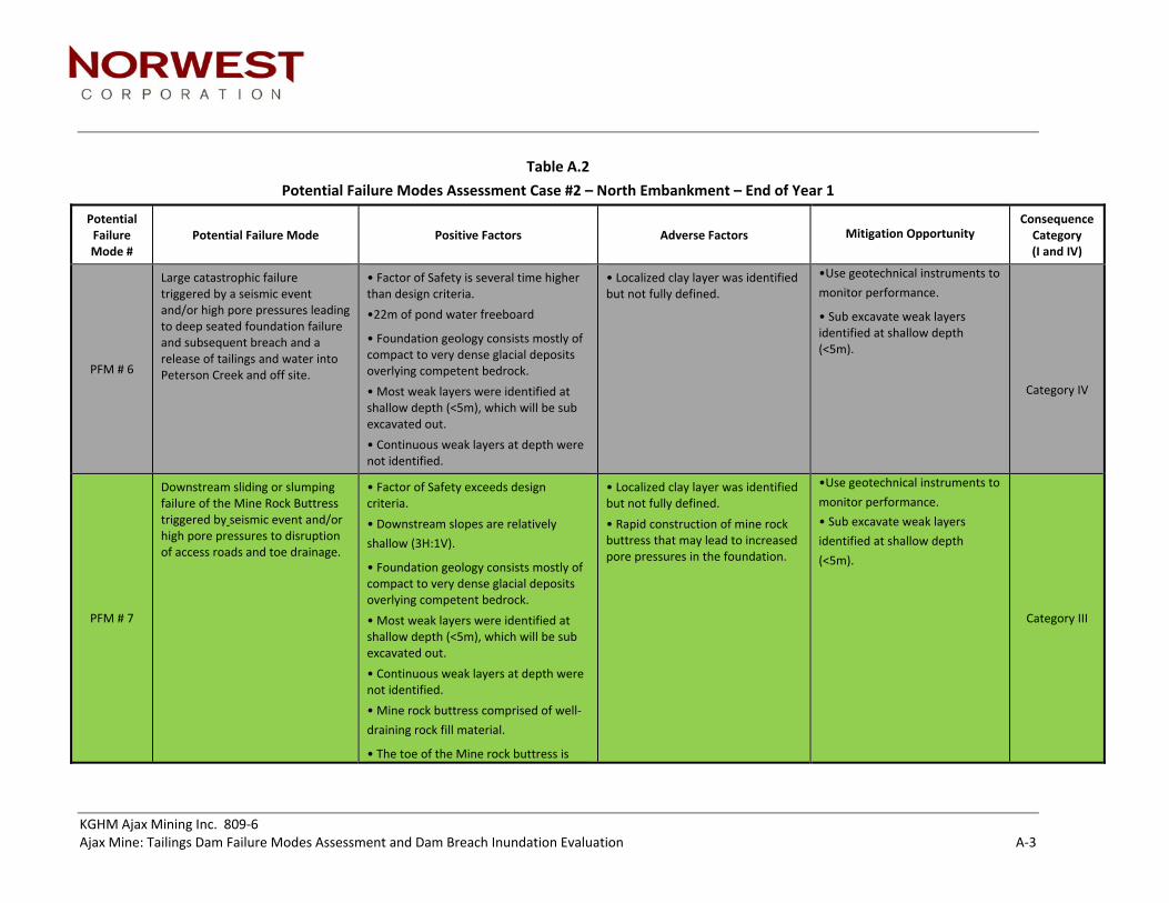
KGHM Ajax Mining Inc. 809‐6 Ajax Mine: Tailings Dam Failure Modes Assessment and Dam Breach Inundation Evaluation A‐3
Table A.2
Potential Failure Modes Assessment Case #2 – North Embankment – End of Year 1
Potential Failure Mode #
Potential Failure Mode Positive Factors Adverse Factors Mitigation Opportunity Consequence Category (I and IV)
PFM # 6
Large catastrophic failure triggered by a seismic event and/or high pore pressures leading to deep seated foundation failure and subsequent breach and a release of tailings and water into Peterson Creek and off site.
• Factor of Safety is several time higher than design criteria.
•22m of pond water freeboard
• Foundation geology consists mostly of compact to very dense glacial deposits overlying competent bedrock.
• Most weak layers were identified at shallow depth (<5m), which will be sub excavated out.
• Continuous weak layers at depth were not identified.
• Localized clay layer was identified but not fully defined.
•Use geotechnical instruments to
monitor performance.
• Sub excavate weak layers identified at shallow depth (<5m).
Category IV
PFM # 7
Downstream sliding or slumping failure of the Mine Rock Buttress triggered by seismic event and/or high pore pressures to disruption of access roads and toe drainage.
• Factor of Safety exceeds design criteria.
• Downstream slopes are relatively
shallow (3H:1V).
• Foundation geology consists mostly of compact to very dense glacial deposits overlying competent bedrock.
• Most weak layers were identified at shallow depth (<5m), which will be sub excavated out.
• Continuous weak layers at depth were not identified.
• Mine rock buttress comprised of well‐
draining rock fill material.
• The toe of the Mine rock buttress is
• Localized clay layer was identified but not fully defined.
• Rapid construction of mine rock buttress that may lead to increased pore pressures in the foundation.
•Use geotechnical instruments to
monitor performance.
• Sub excavate weak layers
identified at shallow depth
(<5m).
Category III

KGHM Ajax Mining Inc. 809‐6 Ajax Mine: Tailings Dam Failure Modes Assessment and Dam Breach Inundation Evaluation A‐4
>100m from startup water pond.
PFM # 8
Piping due to excessive and/or preferential seepage flows through foundation that leads to progressive internal erosion of fill or foundation material starting from the downstream side of the dam or foundation.
• Very long seepage path that minimizes flow velocities that reduces internal erosion and potential for piping. There is a >200m beach length.
• Till blanket and tailings on upstream face of dam and significantly reduces seepage.
• Filter zones will manage and control internal seepage through the embankment.
• Majority of seepage will be collected within two downstream seepage collection ponds or report to the open pit.
• Loose granular material in the foundation.
• Very large flood or PMF leading to loss of tailings beach length.
• Use deeper cutoff wall to minimize seepage.
• Use geotechnical instruments and construction monitoring to monitor performance during construction.
Category II
PFM # 9
Overtopping due to major precipitation event, and/or inadequate water balance, inadequate freeboard that leads to a rise in impoundment water level which eventually overtops and erodes confining embankments.
•Freeboard = 22m, which significantly exceeds minimum requirements to accommodate PMF and wave run‐up above water elevation.
•Sloped tailings beaches push supernatant pond over >400m away from north embankment.
• Water management and maintenance of freeboard availability.
• None.
Category IV
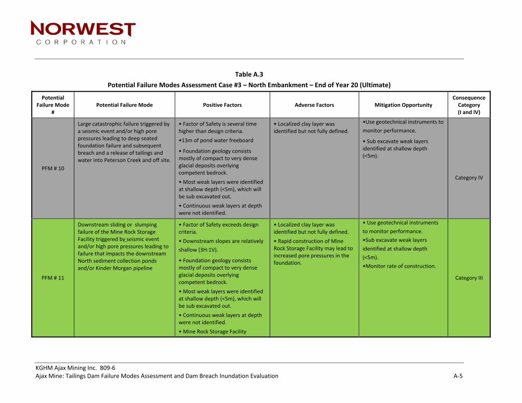
KGHM Ajax Mining Inc. 809‐6 Ajax Mine: Tailings Dam Failure Modes Assessment and Dam Breach Inundation Evaluation A‐5
Table A.3
Potential Failure Modes Assessment Case #3 – North Embankment – End of Year 20 (Ultimate)
Potential Failure Mode
# Potential Failure Mode Positive Factors Adverse Factors Mitigation Opportunity
Consequence Category (I and IV)
PFM # 10
Large catastrophic failure triggered by a seismic event and/or high pore pressures leading to deep seated foundation failure and subsequent breach and a release of tailings and water into Peterson Creek and off site.
• Factor of Safety is several time higher than design criteria.
•13m of pond water freeboard
• Foundation geology consists mostly of compact to very dense glacial deposits overlying competent bedrock.
• Most weak layers were identified at shallow depth (<5m), which will be sub excavated out.
• Continuous weak layers at depth were not identified.
• Localized clay layer was identified but not fully defined.
•Use geotechnical instruments to
monitor performance.
• Sub excavate weak layers identified at shallow depth (<5m).
Category IV
PFM # 11
Downstream sliding or slumping failure of the Mine Rock Storage Facility triggered by seismic event and/or high pore pressures leading to failure that impacts the downstream North sediment collection ponds and/or Kinder Morgan pipeline
• Factor of Safety exceeds design criteria.
• Downstream slopes are relatively
shallow (3H:1V).
• Foundation geology consists mostly of compact to very dense glacial deposits overlying competent bedrock.
• Most weak layers were identified at shallow depth (<5m), which will be sub excavated out.
• Continuous weak layers at depth were not identified.
• Mine Rock Storage Facility
• Localized clay layer was identified but not fully defined.
• Rapid construction of Mine Rock Storage Facility may lead to increased pore pressures in the foundation.
• Use geotechnical instruments
to monitor performance.
•Sub excavate weak layers
identified at shallow depth
(<5m).
•Monitor rate of construction.
Category III

KGHM Ajax Mining Inc. 809‐6 Ajax Mine: Tailings Dam Failure Modes Assessment and Dam Breach Inundation Evaluation A‐6
comprised of well‐draining rock fill
material.
PFM # 12
Piping due to excessive and/or preferential seepage flows through foundation that leads to progressive internal erosion of fill or foundation material starting from the downstream side of the dam or foundation.
• Very long seepage path that minimizes flow velocities that reduces internal erosion and potential for piping. There is a >1000m beach length.
• Till blanket and tailings on upstream face of dam and significantly reduces seepage.
• Filter zones will manage and control internal seepage through the embankment.
• Majority of seepage will be collected within two downstream seepage collection ponds or report to the open pit.
• Loose granular material in the foundation.
• Use deeper cutoff wall to minimize seepage.
• Use geotechnical instruments and construction monitoring to monitor performance during construction, prior to filling the TSF.
Category IV
PFM # 13
Overtopping due to major precipitation event, and/or inadequate water balance, inadequate freeboard that leads to a rise in impoundment water level which eventually overtops and erodes confining embankments.
•Freeboard = 13m, which significantly exceeds minimum requirements to accommodate PMF and wave run‐up above water elevation.
•Sloped tailings beaches push supernatant pond over >1000m away from north embankment.
• None. • Water management and maintenance of freeboard availability.
Category IV

KGHM Ajax Mining Inc. 809‐6 Ajax Mine: Tailings Dam Failure Modes Assessment and Dam Breach Inundation Evaluation A‐7
Table A.4
Potential Failure Modes Assessment Case #4 – East Embankment – End of Year 20 (Ultimate)
Potential Failure Mode
# Potential Failure Mode Positive Factors Adverse Factors Mitigation Opportunity
Consequence Category (I and IV)
PFM # 14
Large catastrophic failure triggered by a seismic event and/or high pore pressures leading to deep seated foundation failure and subsequent breach and a release of tailings and water into Peterson Creek and off site.
• Factor of Safety is several time higher than design criteria.
•13m of pond water freeboard
• Foundation geology consists mostly of compact to very dense glacial deposits overlying competent bedrock.
• Most weak layers were identified at shallow depth (<5m), which will be sub excavated out.
• Continuous weak layers at depth were not identified.
• Localized clay layer was identified but not fully defined.
•Use geotechnical instruments to
monitor performance, prior to
filling of the TSF.
• Sub excavate weak layers identified at shallow depth (<5m).
Category IV
PFM # 15
Downstream sliding or slumping failure of the South Mine Rock Storage Facility triggered by seismic event and/or high pore pressures leading to failure that impacts the downstream plant site and infrastructure in close proximity.
• Factor of Safety meets design criteria.
• Downstream slopes are
relatively shallow (2.5H:1V).
• Foundation geology consists mostly of compact to very dense glacial deposits overlying competent bedrock.
• Most weak layers were identified at shallow depth (<5m), which will be sub excavated out.
• Continuous weak layers at depth were not identified.
• Rapid construction of Mine Rock Storage Facility may lead to increased pore pressures in the foundation.
• Use geotechnical instruments to
monitor performance, prior to
filling of the TSF.
•Sub excavate weak layers
identified at shallow depth (<5m).
•Monitor rate of construction.
Category III

KGHM Ajax Mining Inc. 809‐6 Ajax Mine: Tailings Dam Failure Modes Assessment and Dam Breach Inundation Evaluation A‐8
• Mine Rock Storage Facility
comprised of well‐draining rock
fill material.
PFM # 16
Piping due to excessive and/or preferential seepage flows through foundation that leads to progressive internal erosion of fill or foundation material starting from the downstream side of the dam or foundation.
• Very long seepage path that minimizes flow velocities that reduces internal erosion and potential for piping. There is a >700m beach length.
• Till blanket and tailings on upstream face of dam and significantly reduces seepage.
• Filter zones will manage and control internal seepage through the embankment.
• Majority of seepage will be collected within two downstream seepage collection ponds or report to the open pit.
• Loose granular material in the foundation.
• Use deeper cutoff wall to minimize seepage.
• Use geotechnical instruments and construction monitoring to monitor performance during construction, prior to filling the TSF.
Category IV
PFM # 17
Overtopping due to major precipitation event, and/or inadequate water balance, inadequate freeboard that leads to a rise in impoundment water level which eventually overtops and erodes confining embankments.
•Freeboard = 13m, which significantly exceeds minimum requirements to accommodate PMF and wave run‐up above water elevation.
•Sloped tailings beaches push supernatant pond over >700m away from east embankment.
• None. • Water management and maintenance of freeboard availability.
Category IV

KGHM Ajax Mining Inc. 809‐6 Ajax Mine: Tailings Dam Failure Modes Assessment and Dam Breach Inundation Evaluation A‐9
Table A.5
Potential Failure Modes Assessment Case #5 – South Embankment – End of Year 20 (Ultimate)
Potential Failure Mode
# Potential Failure Mode Positive Factors Adverse Factors Mitigation Opportunity
Consequence Category (I and IV)
PFM # 18
Large catastrophic failure triggered by a seismic event and/or high pore pressures leading to deep seated foundation failure and subsequent breach and a release of tailings downstream.
• Factor of Safety is several times higher than design criteria.
•13m of pond water freeboard
• Foundation geology consists mostly of compact to very dense glacial deposits overlying competent bedrock.
• Most weak layers were identified at shallow depth (<5m), which will be sub excavated out.
• Continuous weak layers at depth were not identified.
• Shallow weak unit identified beneath foundation approximately 5m deep.
• Add rock buttress or reduce overall downstream slopes to improve stability.
• Provide performance monitoring program to monitor to confirm that no movements within the foundation.
Category II
PFM # 19
Overtopping due to major precipitation event, and/or inadequate water balance, inadequate freeboard that leads to a rise in impoundment water level which eventually overtops and erodes confining embankments.
•Freeboard = 13m, which significantly exceeds minimum requirements to accommodate PMF and wave run‐up above water elevation.
•Sloped tailings beaches push supernatant pond over >700m away from south embankment.
• None. • Water management and maintenance of freeboard availability.
Category IV