20150203 birdlife dry creek 2
TRANSCRIPT

3 February 2015 Referrals Gateway Environment Assessment Branch Department of the Environment GPO Box 787 Canberra ACT 2601 [email protected] Dear Sir/Madam EPBC referral 2015/7418: Ridley Land Corporation Ltd (the Proponent)/ Commercial development/ Dry Creek/ SA / Dry Creek Salt Field Closure (the Proposal) BirdLife Australia is a national non-government organisation with more than 10,000 members and 65,000 supporters throughout Australia. Our primary objective is to conserve and protect Australia's native birds and their habitat. We have an extensive ongoing program of bird conservation research, including our Shorebirds 2020 program, developed to address the ongoing decline of Australia’s resident and migratory shorebirds. Our Special Interest Group, the Australasian Wader Studies Group (AWSG) conducts and promotes shorebird research and conservation throughout Australasia. Through our Shorebirds 2020 program and the work of the AWSG, BirdLife Australia is recognised as a leading authority on the ecology and conservation of Australia’s shorebirds. Thank you for the opportunity to comment on the Proposal. Summary BirdLife Australia believes that recent changes to the pumping regimes within the Dry Creek Saltfield have drastically altered the hydrology and habitat values of the site. The area has been subjected to variable water regimes and should be considered to be in a state of transition. It is not appropriate for further decisions about changes in the management of the saltfields to be made at this time. If implemented in full (i.e. if the maximum proposed area of habitat is lost), the Proposal is likely to have a significant impact on Matters of National Environmental Significance (MNES). Specifically, that the Proposal will result in the degradation of internationally significant shorebird habitat at the Dry Creek saltfields, leading to a long term decline in the migratory shorebird population of Gulf St Vincent. These concerns arise from recent and ongoing hydrological changes at Dry Creek Saltfields initiated in early2013 (including the implementation of the “holding pattern”) and further changes proposed within the current referral.

Our conclusions are based on the fact that: • Dry Creek saltfields are in a state of transition. It is too early to assess the long-
term impacts of recent and continuing hydrological changes (the “holding pattern”) on migratory shorebird populations and other MNES given:
a. the high site fidelity of migratory shorebirds to terminal non-breeding areas (such as Dry Creek);
b. the temporary increase in accessible shorebird habitat (shallow water) coincidentally produced during draining of ponds (evidenced by shifts in shorebird distribution within the saltfields); and
c. different survey methodologies between the BirdLife Shorebirds 2020 data and EBS data referenced in the referral make it difficult to determine population trends.
A single season of population monitoring (summer 2013/14) is not a sufficient foundation for determining the future of the site. BirdLife recommends at least one more summer of population investigations before further alterations to hydrological regimes are sanctioned.
• Over 11% of mapped shorebird habitat (Purnell 2010, 2011) in Section 3 & 4 has already been drained and a further 7% abandoned by shorebirds due to hydrological fluctuations. If 1,470ha is lost subject to closure (maximum area proposed in the referral) a further 46% of mapped shorebird habitat will be impacted.
• Without sufficient information regarding future management of the saltfield and the consequences of this management for MNES it is highly unlikely that 1,061 - 2,148 ha of habitat could be lost from the system without having a significant impact on MNES. In particular, it is unlikely that the remaining ponds will provide adequate variety and abundance of habitat to continue to support 95% of the migratory shorebird population recorded in recent years.
Evidence suggests that the goals set in the agreed maintenance of hydrological regimes (the ‘holding pattern’) have not been achieved in several of the Section 3 ponds (Fig. 4 pg 27, Attachments 5-7). It is therefore likely that the ‘holding pattern’ is contributing to the ongoing decline of shorebird habitat within the saltfields. Any further alteration to pond hydrology (including draining) is likely to drastically reduce the site’s capacity to support the current shorebird population and will increase pressure on populations on a larger scale. Any increase in competition and loss of regional resilience associated with the Proposal is likely to accelerate the rate of population decline in migratory and resident species occurring in the newly proclaimed Adelaide International Bird Sanctuary, beyond that of national trends.

Recommendations: 1. BirdLife Australia strongly believes that at least one more season of
investigations is required to determine whether the initiation of the “holding pattern” has had an impact on MNES. No decisions on future changes to hydrological regimes within the ponds should be made until these investigations are completed. This includes decisions relating to the current referral.
2. BirdLife Australia recommends a minimum conservation area of 1804 hectares.
The term conservation area must be more clearly defined within the context of a comprehensive environmental management plan to maintain the environmental values of the site (at pre-2013 values) before approval is given to allow any further changes to the hydrology of the Dry Creek saltfields.
If you have any questions relating to this submission, please contact our Research and Conservation Officer, Chris Purnell 03 9347 0757 ext 233 or [email protected] Sincerely,
Samantha Vine Head of Conservation

Background Since 2008, funding provided by the Adelaide Mount Lofty Ranges NRM Board has allowed BirdLife Australia to study the shorebird population of Gulf St. Vincent (GSV). This work has included: • ongoing population monitoring (in collaboration with Birds South Australia); • collation of historic literature and data sets from local and international experts; • detailed mapping of shorebird habitat; • identification of priority sites; • and recommendations on threat mitigation. The project identified that the saltfields are the single most significant shorebird site in GSV, regularly supporting 48% of the total population including internationally significant populations (>1% of the East Asian–Australasian Flyway population) of Red-necked Stint and Sharp-tailed Sandpiper. It is also clear that the actively managed saltfields increased the region’s capacity to sustain shorebirds and waterbirds because they provided a reliable, tidally independent water source with a mosaic of accessible habitat types within a relatively small area. It is well documented that saltfields increase the resilience of shorebird and waterbird populations in the face of increasing human and climate induced pressures and privations (Masero et al 2001, Warnock et al 2002, Masero 2003, Béchet et al. 2009; Dias 2009, Sripanomyom et al. 2011). It is also well documented that mismanagement of decommissioned saltfields can lead to regional population declines (Masero et al 2001, Masero 2006, Paracuellos et al ).

Figure 1. Areas of proposed Actions detailed in the Referral. Section 2, Table 2 pp 13-14.
Section 2
Section 4
Section 3

Impacts of altered hydrological regimes on shorebirds. Since the cessation of the salt production pumping regime in April 2013, ponds have been subject to a number of changes in hydrological regimes, resulting in drastic and continued variation in salinity levels in many of the ponds (Referral Fig. 4 pg 27, Referral Attachments 5-7 and Figs. 4 & 5). Despite the implementation of a ‘holding pattern’, changes continue to disrupt the long-term patterns of shorebird distribution and behaviour in the area. There has been visible change in habitat values and concomitant shorebird distributions (evident in data discussed below) with the alteration of hydrology and drying of ponds historically important to shorebirds. This includes: • Drying of ponds which contained 11% of the total mapped shorebird habitat
(Purnell 2011). Notably XC2 and XC2-south in section 3 (red in Figure 1); a previously high value area for small migratory shorebirds and colloquially known as “wader alley”. This resulted in the displacement of several hundred Sharp-tailed Sandpiper, Curlew Sandpiper and breeding Red-capped Plovers.
• Extreme fluctuations in salinity at PA 4 and PA 5 (Fig. 1), which regularly supported more than 1,000 birds including flocks of over 600 Red-necked Stint and hundreds of Red-capped plovers.
The Holding Pattern BirdLife Australia believes the use of the term ‘holding pattern’ is misleading as this suggests the ‘holding pattern’ has maintained a condition of no change. In fact the ‘holding pattern’ has not achieved the objective of maintaining the long-term ecological values of the site; rather several areas have deteriorated to the point where they are incapable of sustaining the previous diversity of invertebrate communities and the migratory shorebirds that rely on them (Referral Attachment 5-7 & Fig. 4). The narrowing of the salinity gradient and rapid change of pond conditions has had a deleterious effect on several habitats and reduced overall variety and reliability of pond biota in Section 3 (Black outlined ponds, Figs. 4 & 5). Actions in drained ponds In 2013/14, shorebird populations were able to persist at the saltfields, despite draining of ponds, because an unseasonal and exceptional rain event in February 2013 inundated several dried ponds and topped up those undergoing drying. This provided substitute feeding habitat for the remainder of the season. Ponds in the process of drying (XF1) and dry ponds receiving surface water through stochastic rain events continue to provide preferred feeding and roosting habitat for a proportion of the migratory shorebird population (Table 1). Drained ponds receiving rainwater will continue to provide habitat for shorebirds and any activities in these ponds should be included as part of the proposed Action and subject to referral.

Table 1. Adapted from Table 8, Section 6 of the referral. Migratory shorebirds – ponds supporting at least 95% of average total counts (Jan – May 2014 – 2,143. tabled with current state of ponds and proposed state from Table 2 Section 2 of the referral form.
Pond ranked Avg. shorebird count
Migratory shorebirds as % Avg. shorebird count
current state proposed future use
XA-2 850 50% WET CONS RES XA-4 239 WET DRAINED OR CONS RES XA3 230 75% WET DRAIN XE-5 205 WET DRAINED OR CONS RES XC2 204 DRY DRY XE1-3 144.2 95% WET DRAINED OR CONS RES XF-1 47.6 DRY (2015) DRY XD-1 47.4 WET DRAINED OR CONS RES XB-3 47 WET CONS RES XF-2 43.2 DRY DRY Proposed variations and aims to protect at least 95% of migratory shorebirds Salinity gradients within saltfields create a range of habitats that support a diversity of shorebirds. Importantly, these habitats are largely protected from tide and stochastic climatic variations, making them reliable shorebird sites. The maintenance of relatively consistent salinities within each pond allows the colonisation and development of distinct in-pond biota and sediment type (Masero 2003). This in turn predetermines what shorebird foraging guilds utilise which ponds. Studies in decommissioned salt works in San Francisco (Takekawa 2000) illustrate that maintaining ponds of a wide salinity range is critical to conserving diversity. As indicated in the referral, higher foraging densities of shorebirds are observed in low and medium hypersaline ponds compared with marine salinities. However in order to sustain ponds at a consistently higher salinity water must first travel through a predefined area of lower salinity pondage (Referral Figure 2). The referral makes no reference to the proposed ongoing maintenance of such a gradient and sets no target for a maximum sustained salinity (Referral Section 2.1). If a salinity gradient is to be retained and salinities within ponds are to remain constant enough to sustain biota, a large area of deep water will be necessary

(given shallow waters are susceptible to variations in temperature/evaporation and dilution by rainwater). It is therefore unlikely that the minimum pond area proposed for conservation, 946 ha (Figure 1), will provide a large enough area of sufficiently shallow water (0-0.15m) to sustain the abundance and diversity of shorebirds recorded in recent years. It is also unlikely to provide a large enough area of water of medium to high salinity to support the large eruptive flocks of Banded Stilt (22,000 in 2014) which rely on prey sources found in water with a specific gravity (sp) <1.080. Given a 946 ha of salinity gradient scenario, only around 17 ha of the ponds would have a specific gravity <1.080 sp. Funding for the ongoing management of the saltfields A managed pond system will require ongoing maintenance including infrastructure (banks, weirs, watergates, pumps), pond chemistry and any adaptive management necessary to maintain MNES. Although the referral proposes a system of managed ponds, it does not suggest a funding stream to maintain them, only that the conservation reserve, including all its infrastructure, would be operated, maintained and managed by or under the auspices of the SA State Government” (Referral Section 2.4.) BirdLife suggests the establishment of a trust/endowment fund by Ridley Corporation before the site is returned to the state for management. Ongoing management concerns
BirdLife is seriously concerned that given the position of the minimum area of conservation pondage (Blue area, Figure 1), the majority of ponds will, through lack of management or further works, be sacrificed by levee breach and tidal inundation.
It has been shown that tidally inundated ponds only support shorebird populations in the early stages following a breach but ultimately reduce shorebird habitat (Hickey et al. 2007, Demers et al. 2010, Athearn et al 2012, Takekawa et al 2013).
As an approach that will require minimum ongoing management, tidal inundation of ponds should be considered on some scale, but will not provide equal shorebird value and should only be considered alongside managed ponds. Further options for closure are explored in a NRM board funded Risks and Opportunities paper (Coleman 2013) which is not referenced in the referral.
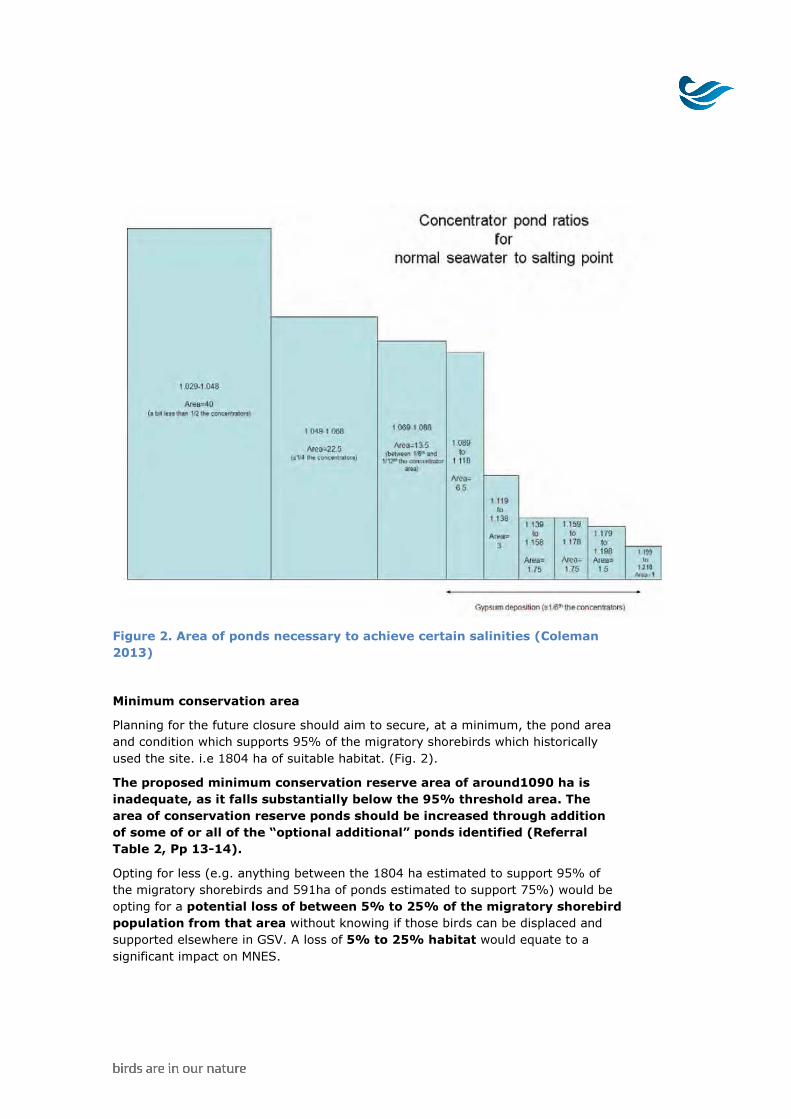
Figure 2. Area of ponds necessary to achieve certain salinities (Coleman 2013) Minimum conservation area Planning for the future closure should aim to secure, at a minimum, the pond area and condition which supports 95% of the migratory shorebirds which historically used the site. i.e 1804 ha of suitable habitat. (Fig. 2). The proposed minimum conservation reserve area of around1090 ha is inadequate, as it falls substantially below the 95% threshold area. The area of conservation reserve ponds should be increased through addition of some of or all of the “optional additional” ponds identified (Referral Table 2, Pp 13-14). Opting for less (e.g. anything between the 1804 ha estimated to support 95% of the migratory shorebirds and 591ha of ponds estimated to support 75%) would be opting for a potential loss of between 5% to 25% of the migratory shorebird population from that area without knowing if those birds can be displaced and supported elsewhere in GSV. A loss of 5% to 25% habitat would equate to a significant impact on MNES.
Data interpretation BirdLife Australia has concerns about the interpretation of some of the data in the referral. 1. Ridley Corporation funded studies of biota in individual ponds (including
vertebrate and invertebrates) can only be considered as a census of an altered state because these studies were initiated in December 2013 after hydrological regimes had been altered. Therefore, this data does not give an accurate picture of the resources that have supported shorebird populations at the site over many years and should not be used to provide a benchmark for maintenance of ecological values in any long term management plans for the site.
2. Within the referral, comparisons made between BirdLife’s Shorebirds 2020 and EBS Ecology data fail to account for differences in survey methodology (in particular, the survey area) between these two data sets. BirdLife’s Shorebird 2020 surveys (2008 – present, ongoing) are only conducted in Section 3 and part of Section 2 (3 ponds). A total of 410 ha. This area, from St Kilda Rd to Pt Gawler Rd, was prioritized for counting because it was known to be the most significant area for shorebirds. However, in their pond scale surveys conducted in the summer of 2013/14 (post implementation of the “holding pattern”), EBS Ecology collected data on species abundance across the entire pondage north of St Kilda Rd (Section 4, 3 and 2) - an area of 609 ha. This is a much larger area than that surveyed under the Shorebirds 2020 program. This difference in survey methodology/area is not accounted for in Attachment 4 Section 7 of the referral, where the species and population averages from the Shorebirds 2020 surveys are directly compared with the averages of the data collected by EBS Ecology. In doing so, the referral creates a false impression that alterations in pond hydrology have not resulted in deterioration in habitat values or shorebird usage of the area. Once the analysis is restricted to the comparable data from the Shorebirds 2020 and EBS datasets (that collected from Section 2 and 3), declines in shorebird usage of the ponds between St Kilda Rd and Port Gawler become apparent. For example, the referral quotes counts of 1000-2500 Red-necked Stints pre “holding pattern” (Shorebird 2020 data) and an average count of 1,979 Red-necked Stints post “holding pattern” (EBS data). However if ponds north of Pt Gawler Rd are excluded from the analysis 1, the average count drops to 1,292. Even then, this average count value of 1,292 is heavily influenced by a single
1 Data from Report 13061 (2.0), May 2014 Dry Creek Salt Fields Self Assessment prepared for Ridley Corporation.

count of 6,415 in February 2014. If this one count is excluded from the analysis, the average of the remaining 5 counts is just 267 individuals (Figure 3).
Figure 3 . Count data for Red-necked Stint in ponds between St Kilda Rd and Port Gawler Rd exclusively - 2012-2014.Shorebird 2020 data and Ridley data (EBS). 3. Due to the high site fidelity of many shorebird species, (Peter 2007, Coleman et
al 2012) changes in regional populations in response to gradual habitat changes often take several years to become evident in survey data. Dry Creek saltfields have provided stable, suitable conditions for over half a century. Migratory shorebirds returning to Australia that have come to rely on the saltfields are likely to return to Gulf St Vincent expecting consistent conditions at the saltfields. Although the trade-off between abandoning the site in search of a supplementary habitat may not pay off within the summer season, if migrants leave on northward migration (March-April) in poor condition they are less likely to return to the site or the region the following year. The apparent, within-season declines in usage of Section 3 ponds mentioned above and increases in foraging in dried or drying ponds and/or neighboring habitats in GSV since 2013 would thus suggest that that foraging conditions in Section 3 have deteriorated. BirdLife recommends a longer period of investigation of the impacts of recent changes in the hydrology of the saltfields on migratory shorebirds before any further alterations can be made to the “holding pattern”.
First alteration of flow (April 13)

4. BirdLife’s Shorebird 2020 counts do not include complete counts of waterbirds and BirdLife’s Atlas of Australian Bird counts conducted at the saltfields have not been not standardised by area. For these reasons waterbird data collected prior to Ridley study period can not be used to determine population averages or definitive site wide maxima.
5. Given the transitory nature of shorebirds on spatial and temporal scales it is inappropriate to set baseline population estimate on rolling averages. At a site scale a more conservative approach using seasonal maximums is more appropriate.
Listed threatened species Australian Fairy Tern (Vulnerable) - Fairy Terns have been recorded 66 times in the saltfields since 1999 including a report of breeding in 2004 (Atlas of Australian Birds). Although spatial coordinates may vary due to projection submitted by observers, all records are attributed to the saltfields. As noted in Ridley Corporations biodiversity risk assessment for the draining of Pond XF1, maximum counts for the species (80 feeding, 72 roosting) were recorded on XF1, which is now undergoing a drying process. Furthermore Cooper (1966) and Day (2005) both report regular breeding at the saltfields. Price Saltfields in the north west GSV regularly hosts numerous breeding pairs which nest on access tracks and pond levees each summer. With a drastic increase in the Silver Gull breeding colony on Section Banks and a lack of other breeding sites on the eastern gulf, planning for closure of the saltfields should take into account breeding requirements for Fairy Terns. Australian Painted Snipe (Endangered)- Although this species is not mentioned in the referral, the Atlas of Australian Birds, Day (2005) and Rix (1977) report 2 birds in the saltfields (1969 and 1999) and 5 birds at or between Buckland Park Lake and the XE pond system (1976 and 2001). Although predominantly a freshwater species, Australian Painted Snipe have been known to occupy brackish water and saltmarsh. Historically the Adelaide Plains are likely to have been a seasonal stronghold for the species and the storm water wetlands directly to the south and adjacent to the saltfields produce some of the most consistent records of the species in the last decade (unpublished data from BirdLife Australia Australian Painted Snipe Database). Future actions should consider the species. Listed migratory species Great Egret- the Atlas of Australian Birds database contains 176 records attributed to the saltfields since 1998. Pond scale surveys conducted by EBS Ecology on behalf of Ridley in 20142 reported the species on every count (average 39). EBS also recorded a maximum of 80 birds (0.32% of the minimum estimated global population) and 45 in one pond (XF1 which has since been drained). Great Egret feed on the adjacent intertidal areas at low-mid tide and rely on the saltfields and 2 Data from Dry Creek EPBC Self-Assessment May 2014

associated saltmarsh for feeding during the high tides. Future actions should consider impacts to the species.

References: � Béchet A., Germain, C., Graham, A.S., Hirons, J.M., Green, R.E., Walmsley, J.G.,
and Johnson A.R. (2009). Assessment of the impacts of hydrological fluctuations and salt pans abandonment on Greater flamingos in the Camargue, south of France. Biodiversity Conservation 18: 1575–1588
� Coleman 2013, Risk and opportunities: A briefing paper on coastal habitat and shorebird conservation in the light of potential closure of the Ridley Dry Creek salt Fields Prepared for: AMLR NRM Board
� Coleman, JT and Milton, David A. Feeding and roost site fidelity of two migratory shorebirds in Moreton Bay, South-Eastern Queensland, Australia [online]. Sunbird: Journal of the Queensland Ornithological Society, The, Vol. 42, No. 2, Dec 2012: 41-51.
� Day, F. (2005). Birding on the Penrice Saltfields- an account of the birdlife on the saltfields and surrounding St Kilda.
� Cooper, R.P. (1966). Birds of a Salt-Field. ICI, Melbourne. � Demers, S.A., Takekawa, J.Y., Ackerman, J.T., Warnock, N., and Athearn, N.D.
(2010). Space use and habitat selection of migrant and resident American Avocets in San Francisco Bay. Condor 112:511–520
� Masero, J.A., Pérez-Hurtado, A., Castro, M. and Arroyo, G.M. (2000) Complementary use of intertidal mudflats and adjacent salinas by foraging waders. Ardea 88, 177–191.
� Masero, J.A., and Pérez-Hurtado, A. (2001). Importance of the supratidal habitats for maintaining overwintering shorebird populations: how Redshanks use tidal mudflats and adjacent saltworks in southern Europe. Condor 103: 21–30.
� Masero, J.A. (2003). Assessing alternative anthropogenic habitats for conserving waterbirds:salinas as buffer areas against the impact of natural habitat loss for shorebirds.Biodiversity and Conservation 12: 1157–1173
� Mariano Paracuellos, Hermelindo Castro, Juan Carlos Nevado, José Antonio Oña, José Javier Matamala, Lorenzo García and Gabriel Salas (2002) Repercussions of the Abandonment of Mediterranean Saltpans on Waterbird Communities Waterbirds: The International Journal of Waterbird Biology Vol. 25, No. 4 pp. 492-498
� Purnell, C., Clemens, R. and Peter, J. (2011) Shorebird Population Monitoring within the Gulf of St Vincent: July 2010 to June 2011 Annual Report. Birds Australia report for the Adelaide and Mount Lofty Range Natural Resources Management Board and the Department of the Environment, Water, Heritage and the Arts.
� Purnell, C., Clemens, R. and Peter, J. (2012) Shorebird Population Monitoring within the Gulf of St Vincent: July 2011 to June 2012 Annual Report. Birds Australia report for the Adelaide and Mount Lofty Range Natural Resources Management Board and the Department of the Environment, Water, Heritage and the Arts.
� Sripanomyom, S., Round, P.D., Savini, T., Trisurat, Y., and Gale, G.A. (2011). Traditional saltpans hold major concentrations of overwintering shorebirds in Southeast Asia. Biological Conservation 144: 526–537.
� Warnock, N, Page, G, Ruhlen, T, Nur,N, Takekawa, J and Hanson, J (2002). Management and Conservation of San Francisco Bay Salt Ponds: Effects of Pond Salinity, Area, Tide, and Season on Pacific Flyway Waterbirds Waterbirds: The International Journal of Waterbird Biology. Vol. 25, Special Publication 2: Managing Wetlands for Waterbirds: Integrated Approaches pp. 79-92
�
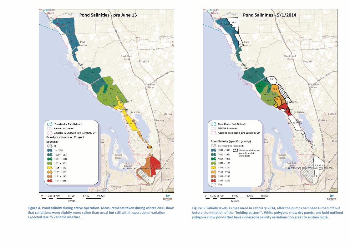
Figure 5. Salinity levels as measured in February 2014, after the pumps had been turned off but before the initiation of the "holding pattern". White polygons show dry ponds, and bold outlined polygons show ponds that have undergone salinity variations too great to sustain biota.
Figure 4. Pond salinity during active operation. Measurements taken during winter 2005 show that conditions were slightly more saline than usual but still within operational variation expected due to variable weather.