2120environmentalw.pdf
TRANSCRIPT

YOUR PARTNER IN REAL ESTATE LIFECYCLE PLANNING & MANAGEMENT www.emgcorp.com
ENVIRONMENTALA S S E S S M E N T
FFDDIICC AASS RREECCEEIIVVEERR FFOORR SSEECCOONNDD FFEEDDEERRAALL SSAAVVIINNGGSS && LLOOAANN AASSSSOOCCIIAATTIIOONN OOFF CCHHIICCAAGGOO
PPHHAASSEE II EENNVVIIRROONNMMEENNTTAALL SSIITTEE AASSSSEESSSSMMEENNTT ooff
44334433 SSOOUUTTHH HHEERRMMIITTAAGGEE AAVVEENNUUEE Chicago, Illinois 60609
Asset No.: 88831000063
PPRREEPPAARREEDD BBYY::
EMG 222 Schilling Circle, Suite 275 Hunt Valley, Maryland 21031 800.733.0660 www.emgcorp.com
EEMMGG CCOONNTTAACCTT::
Justin J. Arias Senior Environmental Consultant 800.733.0660, Ext. 6579 [email protected]
EMG Project #: 102803.12R-021.051 Date of Report: November 15, 2012
On site Date: October 5, 2012

110022880033 ..1122RR-- 002211 .. 005511
YO U R PA R T N E R I N RE A L ES T A T E LI F E C Y C L E PL A N N I N G & MA N A G E M E N T 800.733.0660 • www.emgcorp.com
A S S E S S M E N T
E N V I R O N M E N T A L
PP RR OO JJ EE CC TT SS UU MM MM AA RR YY
4343 South Hermitage Avenue Chicago, Illinois 60609
Assessment Component Acceptable Routine Solution Phase II Estimated Cost §
Reference Section Page
Adjacent Properties �� 3.2 5 Historical Review �� 4 7 Regulatory Review �� 5.2 11 Operational Activities �� 6.2 15 Hazardous Materials �� 6.3 15 Wastes �� 6.4 15 Polychlorinated Biphenyls
�� 6.5 16
Asbestos-Containing Materials
�� 6.6 16
Radon Gas �� 6.7 16 Drinking Water �� 6.8 16 Lead-Based Paint �� 6.9 16 On site Storage Tanks �� 6.11 17 Special Resources (1) N/A 7 20
Conditions noted in the Project Summary Table are representative of the overall conditions of the property. There may be more detail on specific assessment components in the report text, therefore the Project Summary Table should not be used as a standalone document. § Costs depicted are for investigation/program development activities. Remediation costs, if required, will be identified as a result of the activities.
(1) Information concerning archaeological resources/historic sites and structures was not available for inclusion in this report. When received they will be forwarded in the form of an addendum.

110022880033 ..1122RR-- 002211 .. 005511
YO U R PA R T N E R I N RE A L ES T A T E LI F E C Y C L E PL A N N I N G & MA N A G E M E N T 800.733.0660 • www.emgcorp.com
A S S E S S M E N T
E N V I R O N M E N T A L
TT AA BB LL EE OO FF CC OO NN TT EE NN TT SS
1.� Background ............................................................................................................ 1�1.1. Survey Approach/Purpose ............................................................................................... 1�1.2. User Provided Information ............................................................................................. 2�1.2.1. User Engaged Environmental Cleanup Liens and Activity And Use
Limitation (AUL) Review ............................................................................................. 3�1.2.2. User Questionnaire ....................................................................................................... 3�1.2.3. Reason for Assessment ................................................................................................. 3�
2.� Asset Information ................................................................................................... 4�3.� Site Background ..................................................................................................... 5�
3.1. Property Location and Description .............................................................................. 5�3.2. Adjoining Properties and Surrounding Area ............................................................. 5�3.3. Properties Adjacent to or Contiguous with the Project ......................................... 6�
4.� Property History..................................................................................................... 7�4.1. Chain of Title ....................................................................................................................... 7�4.2. Prior Use Interviews .......................................................................................................... 7�4.3. Historical Maps .................................................................................................................. 7�4.4. Historical City Directories .............................................................................................. 9�4.5. Aerial Photography ............................................................................................................ 9�4.6. Previous Investigations/Assessments ........................................................................... 9�4.7. Plans and Specifications ................................................................................................ 10�4.8. Historical Summary ......................................................................................................... 10�
5.� Regulatory Review ................................................................................................ 11�5.1. Local/State Agency Contacts ........................................................................................ 11�5.2. Regulatory Database Review ....................................................................................... 11�
6.� Site Investigation and Review of Environmental Conditions .............................. 14�6.1. Environmental Setting .................................................................................................... 14�6.1.1. Topography .................................................................................................................... 14�6.1.2. Soils/Geology ................................................................................................................ 14�6.1.3. Groundwater Hydrology ........................................................................................... 14�6.2. Operational Activities ..................................................................................................... 15�6.3. Chemicals and Raw Materials ..................................................................................... 15�6.4. Waste Generation, Treatment, Storage, and Disposal ......................................... 15�6.5. Polychlorinated Biphenyls (PCBs) .............................................................................. 16�6.6. Asbestos-Containing Materials (ACM) ...................................................................... 16�6.7. Radon Gas .......................................................................................................................... 16�6.8. Drinking Water ................................................................................................................. 16�6.9. Lead-Based Paint (LBP)................................................................................................... 16�6.10. Landfills ............................................................................................................................ 17�6.11. Pits, Sumps, Drywells, and Catch Basins .............................................................. 17�6.12. On site Storage Tanks and Pipelines (above or below ground) ..................... 17�

110022880033 ..1122RR-- 002211 .. 005511
YO U R PA R T N E R I N RE A L ES T A T E LI F E C Y C L E PL A N N I N G & MA N A G E M E N T 800.733.0660 • www.emgcorp.com
A S S E S S M E N T
E N V I R O N M E N T A L
6.13. Off site Underground Storage Tanks ....................................................................... 17�6.14. Storm Water Drainage/Waste Water Discharge .................................................. 18�6.15. Surface Areas .................................................................................................................. 18�6.16. Other Observations ...................................................................................................... 19�
7.� List of Special Resources ..................................................................................... 20�7.1. Endangered Species ........................................................................................................ 20�7.2. Wetlands ............................................................................................................................. 20�7.3. Covered Property ............................................................................................................. 20�7.4. Undeveloped Flood Plains/Wild and Scenic Rivers ............................................. 20�7.5. Areas of Scientific Significance ................................................................................... 21�7.6. Wilderness Areas ............................................................................................................. 21�7.7. National Natural Landmarks ........................................................................................ 21�7.8. Undeveloped Sole Source Aquifers ........................................................................... 21�7.9. Archaeological Resources/Historic Sites and Structures ..................................... 21�7.10. Recreational Areas ........................................................................................................ 21�7.11. Undeveloped Coastal Zones/Coastal Barrier Units ............................................ 21�
8.� Interviews ............................................................................................................. 23�8.1. Key Site Manager ............................................................................................................. 23�8.2. Owner ................................................................................................................................. 23�8.3. User ...................................................................................................................................... 23�8.4. Occupants .......................................................................................................................... 23�8.5. Past Owners, Operators, and Occupants ................................................................. 23�8.6. Owners Or Occupants of Adjacent or Nearby Property .................................... 23�8.7. Interviews with Others ................................................................................................... 24�
9.� Summary ............................................................................................................... 25�9.1. Recommendations ........................................................................................................... 28�9.2. Data Gaps ........................................................................................................................... 28�
10.�Persons Performing the Phase I ESA ................................................................... 29�11.�Appendices ........................................................................................................... 30�

110022880033 ..1122RR-- 002211 .. 005511
YO U R PA R T N E R I N RE A L ES T A T E LI F E C Y C L E PL A N N I N G & MA N A G E M E N T 800.733.0660 • www.emgcorp.com 1
A S S E S S M E N T
E N V I R O N M E N T A L
11 .. BB AA CC KK GG RR OO UU NN DD
11 .. 11 .. SS UU RR VV EE YY AA PP PP RR OO AA CC HH //PP UU RR PP OO SS EE
EMG was not accompanied by a representative of the Project during the assessment. On site activities and/or interviews were conducted by Mr. Nicholas Brandt, EMG Project Manager. Since there was no on site Point of Contact or person knowledgeable about the Project, the Pre-Survey Questionnaire was not completed. Areas accessed included all tenant units; all common areas; all exterior areas (except the roof); and the Project boundaries. Visual observation of pipe chases and behind walls was not performed as a part of this assessment. Specific areas to which access was limited include the following: � Roof (No Ladder) � While in the process of scheduling a visit to sample ACM and LBP, the FDIC issued an interior access
waiver Weather conditions at the time of the Project assessment were partly cloudy, with temperatures in the low 50s (�F) and moderate winds. EMG reviewed available federal, state, and local records in an effort to identify sites of known or suspected hazardous waste activity located at or near the Project which could have an adverse impact on the Project. In an attempt to determine whether historical uses of the Project and surrounding area have had an environmental impact on the Project, EMG interviewed individuals knowledgeable about the Project and reviewed available pertinent records and documents. This assessment is based on the evaluation of the information gathered, laboratory analysis of samples collected (when required), and accessibility at the time of the assessment. The purpose of this report is to provide the Client an assessment concerning environmental conditions (limited to those issues identified in the report) as they existed at the Project. The assessment was conducted utilizing generally accepted Phase I industry standards using the American Society for Testing and Materials (ASTM) Standard Practice E 1527-05. The scope of work included an evaluation of: � The Project history in an attempt to identify any possible ownership(s) and/or uses that would suggest an
impact to the environmental integrity of the Project as identified through review of reasonably ascertainable standard historical sources.
� Physical characteristics of the Project as identified through review of reasonably ascertainable topographic maps.
� Current Project conditions (as applicable), including compliance with appropriate regulations as they pertain to the presence or absence of: � Facility storage tanks, drums, containers (above or below ground), etc. � Transformers and other electrical equipment which utilize fluid which may potentially contain PCBs � The use of hazardous materials/chemicals and petroleum products, and/or the generation, treatment,
storage, or disposal of hazardous, regulated, or medical wastes

110022880033 ..1122RR-- 002211 .. 005511
YO U R PA R T N E R I N RE A L ES T A T E LI F E C Y C L E PL A N N I N G & MA N A G E M E N T 800.733.0660 • www.emgcorp.com 2
A S S E S S M E N T
E N V I R O N M E N T A L
� An evaluation of information contained in programs such as the NPL, CERCLIS, SHWS, RCRIS, SWF, LUST, and other governmental information systems within specific search distances of the Project. This evaluation was performed to identify any sites that would have the potential to impact the environmental integrity of the Project. The regulatory agency report provided is based on an evaluation of the data collected and compiled by a contracted data research company. The report is based on a radius search which focuses on both the Project and neighboring sites that may impact the Project. Neighboring sites listed in governmental environmental records are identified within a specific search distance. The search distance varies depending upon the particular government record being checked. The search is designed to meet the requirements of ASTM Standard E 1527-05. The information provided is assumed to be correct and complete.
� Visual observation of the adjacent properties to identify high-risk neighbors and the potential for known or suspected contamination to migrate onto the Project.
� A review of the physical characteristics of the Project as identified through review of reasonably ascertainable wetlands, flood plain, soils, geology, and groundwater data.
� A screening approach for the potential existence of: � Asbestos, including the identification of all suspect materials in accessible areas (interior and exterior)
and the collection and analysis of three bulk samples from each homogeneous area of suspect ACM. The remaining materials are considered suspect until tested and proven otherwise. This screening approach is not a comprehensive (i.e., AHERA-Style) asbestos survey, nor is it intended to fulfill the NESHAP requirements for demolition/renovation purposes, but is intended to identify the potential for an asbestos hazard in accessible areas. This screening is not intended to be used for demolition, abatement, renovation, or repair work. The basis for “suspect” determination is taken from the materials listed in Appendix G of the United States Environmental Protection Agency (USEPA) publication Managing Asbestos in Place (the “Green Book”). Therefore, all materials listed in the Green Book which were installed prior to 1981 are considered suspect. The laboratory reports list the samples taken from the Project and their subsequent analytical results using polarized light microscopy with dispersion staining (Interim Method for Determination of Asbestos in Bulk Insulation Sample — USEPA 600/M4-82-020) for asbestos. Analysis was performed using the “positive-stop” method, whereby analysis is stopped on a group of samples once the first positive sample is analyzed, and the entire homogeneous material is considered asbestos-containing.
� Radon gas propensity, through the review of the USEPA’s Map of Radon Zones. � Lead-based paint for all residential properties constructed prior to 1978. The basis for this
determination is taken from the Lead Paint Poisoning Act passed by the Congress of the United States that banned the use of lead paint starting January 1, 1978. Therefore, all paint applied prior to 1978 is considered suspect.
� Lead in water, based on information provided by the municipal water provider.
11 .. 22 .. UU SS EE RR PP RR OO VV II DD EE DD II NN FF OO RR MM AA TT II OO NN
This Section documents whether the user reported to EMG information pursuant to the responsibilities described in Section 6 of the ASTM Standard E 1527-05.

110022880033 ..1122RR-- 002211 .. 005511
YO U R PA R T N E R I N RE A L ES T A T E LI F E C Y C L E PL A N N I N G & MA N A G E M E N T 800.733.0660 • www.emgcorp.com 3
A S S E S S M E N T
E N V I R O N M E N T A L
11..22..11.. UUsseerr EEnnggaaggeedd EEnnvviirroonnmmeennttaall CClleeaannuupp LLiieennss aanndd AAccttiivviittyy AAnndd UUssee LLiimmiittaattiioonn ((AAUULL)) RReevviieeww
The user engaged EMG to review title and judicial records for environmental liens or Activity and Use Limitations (AULs) recorded against the Project. To do this, EMG contracted Banks Environmental Data to complete this research.
According to the information provided, there are no environmental liens or AULs filed against the Project.
11..22..22.. UUsseerr QQuueessttiioonnnnaaiirree
A User Questionnaire was provided to the user (Client) to assist the user and EMG in gathering information from the user that may be material to identifying RECs. EMG did not receive a response to the User Questionnaire that was provided to the user. Furthermore, the user did not provide any of the information requested in the questionnaire and required by Section 6 of the ASTM Standard E 1527-05. The lack of or inability to obtain this information represents a data gap. However, based on the findings of this report, the absence of this information is not considered a significant data gap.
11..22..33.. RReeaassoonn ffoorr AAsssseessssmmeenntt
The user informed EMG that the reason for the assessment is for sale of the property.

110022880033 ..1122RR-- 002211 .. 005511
YO U R PA R T N E R I N RE A L ES T A T E LI F E C Y C L E PL A N N I N G & MA N A G E M E N T 800.733.0660 • www.emgcorp.com 4
A S S E S S M E N T
E N V I R O N M E N T A L
22 .. AA SS SS EE TT II NN FF OO RR MM AA TT II OO NN
Asset Information
Asset name and address: 4343 South Hermitage Avenue Chicago, Illinois 60609
Asset number: 88831000063 Name of financial institution: FDIC as Receiver for Second Federal Savings & Loan
Association of Chicago FDIC four digit identifier of financial institution: 10453 City and state of financial institution: Chicago, Illinois Whether asset is a real estate, secured collateral, or other: Real Estate Name and address of FDIC Service Center responsible for the property:
Dallas FDIC DRR 1601 Bryan Street, Room 16138 Dallas, Texas 75201
Name and address of the Account Officer (or Asset Manager, if applicable) for the property
Donna Lemoine, Quantum Partners

110022880033 ..1122RR-- 002211 .. 005511
YO U R PA R T N E R I N RE A L ES T A T E LI F E C Y C L E PL A N N I N G & MA N A G E M E N T 800.733.0660 • www.emgcorp.com 5
A S S E S S M E N T
E N V I R O N M E N T A L
33 .. SS II TT EE BB AA CC KK GG RR OO UU NN DD
33 .. 11 .. PP RR OO PP EE RR TT YY LL OO CC AA TT II OO NN AA NN DD DD EE SS CC RR II PP TT II OO NN
Review of information available from the Cook County Assessor’s Office indicated that the Project is shown as Parcel 20-06-404-022-0000. A copy of the tax map is appended (Section 11). The Project is located at 4343 South Hermitage Avenue in Chicago, Cook County, Illinois 60609. The Project lands consist of approximately 0.07 acre. The Project is currently a multi-family apartment building and contains four units. The Project was constructed in 1895. Project improvements consist of a three-story structure (approximately 3,400 square feet), landscaping, and surface-level asphalt paved parking/drive areas. Prior uses of the Project include a vacant lot. Vehicular access to the Project is available from west and east. The Project is serviced by public water and sanitary sewer systems. The Project is supplied with water from the City of Chicago Water Department. Review of the latest water quality report published by the City of Chicago Water Management Division identified that the drinking water supplied to the Project is within federal, state, and local drinking water quality standards. Hot water is generated by a natural gas-fired water heater. The associated piping was observed to be uninsulated. The exhaust flues associated with the natural gas-fired water heaters were observed to be uninsulated. HVAC systems observed consisted of the following: � Heat is supplied to the Project from a natural gas-fired furnace unit. Hot air is distributed via
thermostatically controlled, ducted supply and return plenum systems. Where observed, duct work associated with the HVAC systems was uninsulated. The exhaust flues associated with the furnace were observed to be uninsulated.
� Air-conditioning is supplied to the Project via individual wall-mounted, electrically operated units. No information regarding historic HVAC systems was available during the course of this assessment. Review of information recorded at the Cook County Recorder’s Office indicates that the Project is currently owned by REO, LLC. The Project is currently a residence. In addition, no Key Site Manager was identified.
33 .. 22 .. AA DD JJ OO II NN II NN GG PP RR OO PP EE RR TT II EE SS AA NN DD SS UU RR RR OO UU NN DD II NN GG AA RR EE AA
The general vicinity of the Project consists of residential land uses. The following surrounding/adjacent properties were observed: North — The Project is bordered to the north by a multi-family apartment building (4339 South
Hermitage Avenue). The adjacent property to the north is located topographically crossgradient from the Project.
East — The Project is bordered to the east by an alleyway. Farther east are single-family homes (4338-4342 South Pauline Avenue). The adjacent property to the east is located topographically crossgradient from the Project.

110022880033 ..1122RR-- 002211 .. 005511
YO U R PA R T N E R I N RE A L ES T A T E LI F E C Y C L E PL A N N I N G & MA N A G E M E N T 800.733.0660 • www.emgcorp.com 6
A S S E S S M E N T
E N V I R O N M E N T A L
South — The Project is bordered to the south by a single-family home (4345 South Hermitage Avenue). The adjacent property to the south is located topographically crossgradient from the Project.
West — The Project is bordered to the west by Hermitage Avenue. Farther west are single-family homes (4338-4342 South Hermitage Avenue). The adjacent property to the west is located topographically crossgradient from the Project.
Based on observations and available regulatory information, the adjacent property uses are not anticipated to adversely impact the environmental integrity of the Project. Based upon a review of chain of title information, historical maps, city directories, and aerial photographs; the following historical surrounding/adjacent property uses were identified: North — The Project was bordered to the north by a residential building (4339 South Hermitage
Avenue). East — The Project was bordered to the east by an alleyway. Farther east are residential buildings
(4338-4344 South Hermitage Avenue). South — The Project was bordered to the south by a residential building (4345 South Hermitage
Avenue). Farther south is an alleyway. West — The Project was bordered to the west by Hermitage Avenue. Farther west are residential
buildings (4338-4344 South Hermitage Avenue). The historic property uses are not anticipated to adversely impact the environmental integrity of the Project.
33 .. 33 .. PP RR OO PP EE RR TT II EE SS AA DD JJ AA CC EE NN TT TT OO OO RR CC OO NN TT II GG UU OO UU SS WW II TT HH TT HH EE PP RR OO JJ EE CC TT
The Project is not greater than 50 acres in size and is not vacant; therefore, no further action is warranted.

110022880033 ..1122RR-- 002211 .. 005511
YO U R PA R T N E R I N RE A L ES T A T E LI F E C Y C L E PL A N N I N G & MA N A G E M E N T 800.733.0660 • www.emgcorp.com 7
A S S E S S M E N T
E N V I R O N M E N T A L
44 .. PP RR OO PP EE RR TT YY HH II SS TT OO RR YY
44 .. 11 .. CC HH AA II NN OO FF TT II TT LL EE
Review of the available deed records at the Cook County Recorder of Deeds, as provided by Banks Environmental Data, indicates that the Project has been owned by REO, LLC since 2012. Deed records were researched back to 1942. A copy of the chain of title as provided by Banks Environmental Data is appended (Section 11). According to the information provided by Banks Environmental Data, Alexander Rutkowski, et al held the title prior to 1940. Review of available deed records did not identify any previous environmentally suspect ownership, easements, right of ways, or other environmental entries/restrictions associated with the Project. Deeds and titles identified are listed in the table below.
Owner Year Purchased
REO, LLC 2010 Emiliano Soriano 2004 Juan Jimenez 2002 Mario Hernandez 1991 Mary Hernandez 1986 Mario Hernandez 1972 Alexander Rutkowski Prior to 1940
44 .. 22 .. PP RR II OO RR UU SS EE II NN TT EE RR VV II EE WW SS
During the course of this assessment, not individuals knowledgeable of the Project were available for interview.
44 .. 33 .. HH II SS TT OO RR II CC AA LL MM AA PP SS
Sanborn Maps
EMG reviewed available Sanborn maps as provided by EDR. Historical maps are detailed scale drawings that show the location and use of buildings and structures that occupied a given area. EMG’s map search revealed the following: Review of the 1895 historical map, indicated the following: � Project: The Project is shown as a vacant lot. Vehicular access is available from the west. � Off site: The areas north, east and south of the Project are shown as vacant lots. The area west of the
Project is shown as Hermitage Avenue, beyond which is a vacant lot. The 1915 historical map does not show the Project or surrounding area.

110022880033 ..1122RR-- 002211 .. 005511
YO U R PA R T N E R I N RE A L ES T A T E LI F E C Y C L E PL A N N I N G & MA N A G E M E N T 800.733.0660 • www.emgcorp.com 8
A S S E S S M E N T
E N V I R O N M E N T A L
The 1925 historical map differs from the previous historical map in that: � Project: The Project is improved with one structure and surface-level parking. Notations on the map
indicate that the Project is used as a store as well as a residence. Vehicular access is available from the west and east.
� Off site: The area north of the Project is shown as a residential flat. The area east of the Project is shown as an alleyway, beyond which are residential buildings. The area south of the Project is shown as a store as well as a residence. The area west of the Project is shown as Hermitage Avenue, beyond which are residential buildings.
The 1950 historical map differs from the previous historical map in that: � Project: The Project is improved with one structure and surface-level parking. Notations on the map
indicate that the Project is used as a residence. Vehicular access is available from the west and the east. � Off site: The area south of the Project is shown as a residence. The 1975, 1988, 1991, 1993, 2002, and 2004 historical maps do not differ significantly from the previous historical map. Topographic Maps
EMG reviewed available Topographic maps as provided by EDR. Historical maps are detailed scale drawings that show the location and use of buildings and structures that occupied a given area. EMG’s map search revealed the following: The scale of the 1901 historical map prevents any distinct features from being identified. The 1929 historical map differs from the previous historical map in that: � Project: The Project is improved with one outlined structures believed to be the current site
improvements. Vehicular access is available from the west and east. � Off site: The area north of the Project is shown as apparent single-family home. The area east of the
Project is shown as an apparent single-family home. The area south of the Project is shown as an apparent single-family home. The area west of the Project is shown as a road, beyond which is an apparent single-family home.
The 1953 historical map differs from the previous historical map in that: � Project: The Project is shown as shaded as to represent a high-density urban area. Vehicular access is
available from the west. � Off site: The areas north, east, south, and west of the Project are shown as shaded as to represent a high-
density urban area. The 1963, 1972, 1980, and 1993 historical maps do not differ significantly from the previous historical map. No other historical maps were identified. Copies of the historical maps are appended (Section 11). To note, no additional historical topographic maps were on-file with EDR. In addition, no older historical topographic maps were available through the USGS, or any other federal, state, or local agency contacted as part of this assessment. Therefore, it appears that the historical topographic map dated 1901 is the oldest historical topographic map available for the Project area.

110022880033 ..1122RR-- 002211 .. 005511
YO U R PA R T N E R I N RE A L ES T A T E LI F E C Y C L E PL A N N I N G & MA N A G E M E N T 800.733.0660 • www.emgcorp.com 9
A S S E S S M E N T
E N V I R O N M E N T A L
44 .. 44 .. HH II SS TT OO RR II CC AA LL CC II TT YY DD II RR EE CC TT OO RR II EE SS
Historical city directories were reviewed for the Project as provided by EDR. City directories have tenant listings by address. This review revealed the following information: � 1923 — The Project address is listed as LINK Jos lab, Thamula Adolph lab, Zileswioz Jos lab. � 1928 — The Project address is listed as Blozevicus Sylvester mech h, Gutierrez Jose h, Karminski Stanley
janitor h, Luderwich Powell lab r, Rutkowski Alex h, Barias Henry h. � 1947 — The Project address is listed as Tumble Inn. � 1951 — The Project address is listed as Rutkowski Casey. � 1957 — The Project address is listed as Brown Thos H, Jerzak Edwin S, Sobczak Walter, Szymankowsky
Helen, Young Frank M Jr. � 1961 — The Project address is listed as Brand Jas R, Helen, Young Frank M Jr. � 1966 — The Project address is listed as Cegielski Robt E, Rutkowski Edw, Zemanek John. � 1971 — The Project address is listed as Cegielski Robt E, Rutkowski Edw. � 1976 — The Project address is listed as Bonilla Cepriano, Cegielski Robt E. � 1986 — The Project address is listed as Almaraz Elizabeth W. � 1999 — The Project address is listed as Hernandez Mary. � 2005 — The Project address is listed as Galvan Salvador A, Munoz No, Soriano Emiiano. No other historical city directories were identified.
44 .. 55 .. AA EE RR II AA LL PP HH OO TT OO GG RR AA PP HH YY
Review of the 1938 aerial photograph, available from EDR, indicated the following: � Project: The Project is improved with one structure believed to be the current site improvements,
surface-level parking and minimal vegetation. The building is situated in the central portion of the Project. Vehicular access is available from west and east.
� Off site: The area north of the Project is shown as an apparent residential building. The area east of the Project is shown as an alleyway, beyond which are apparent residential buildings. The area south of the Project is shown as an apparent residential building. The area west of the Project is shown as a road, beyond which are apparent residential buildings.
The 1952, 1962, 1972, 1978, 1984, 1988, 1994, 1999, 2005, and 2007 aerial photographs, available from EDR, do not differ significantly from the 1938 aerial photograph. Copies of the aerial photographs are appended (Section 11). To note, no additional historical aerial photographs were on-file with EDR. In addition, no older historical aerial photographs were available through the USGS, or any other federal, state, or local agency contacted as part of this assessment. Therefore, it appears that the historical aerial photograph dated 1938 is the oldest historical aerial photograph available for the Project area.
44 .. 66 .. PP RR EE VV II OO UU SS II NN VV EE SS TT II GG AA TT II OO NN SS //AA SS SS EE SS SS MM EE NN TT SS
EMG was not provided with any previously conducted environmental assessment reports for the Project.

110022880033 ..1122RR-- 002211 .. 005511
YO U R PA R T N E R I N RE A L ES T A T E LI F E C Y C L E PL A N N I N G & MA N A G E M E N T 800.733.0660 • www.emgcorp.com 10
A S S E S S M E N T
E N V I R O N M E N T A L
44 .. 77 .. PP LL AA NN SS AA NN DD SS PP EE CC II FF II CC AA TT II OO NN SS
As-built/renovation site plans, drawings, or specifications were not available for review at the Project or local agency offices visited for this assessment.
44 .. 88 .. HH II SS TT OO RR II CC AA LL SS UU MM MM AA RR YY
Based upon a review of chain of title information, historical maps, city directories, and aerial photographs; the Project was undeveloped prior to the development of the current Project improvements in 1895. EMG was not able to obtain the Project history in five year intervals. This data failure represents a data gap; however, this data gap is not considered a significant data gap and therefore is not addressed in Section 3.1.

110022880033 ..1122RR-- 002211 .. 005511
YO U R PA R T N E R I N RE A L ES T A T E LI F E C Y C L E PL A N N I N G & MA N A G E M E N T 800.733.0660 • www.emgcorp.com 11
A S S E S S M E N T
E N V I R O N M E N T A L
55 .. RR EE GG UU LL AA TT OO RR YY RR EE VV II EE WW
55 .. 11 .. LL OO CC AA LL //SS TT AA TT EE AA GG EE NN CC YY CC OO NN TT AA CC TT SS
EMG reviewed file information online for the Project from the Illinois State Fire Marshal’s Office. Records dating back to the 1940’s are maintained by this department. Based on review of this database, there are no USTs or LUST Incidents associated with the Project address. EMG contacted City of Chicago Building Department. At the time this report was issued, the information was pending. Any environmentally significant information not identified through other sources will be forwarded upon receipt and review; however, based upon the results of the assessment to date, it is not anticipated that the conclusions drawn will change when this information is received. EMG contacted the City of Chicago Department of Community Development in order to review current and historic zoning designations for the Project. At the time this report was issued, the information was pending. Any environmentally significant information not identified through other sources will be forwarded upon receipt and review; however, based upon the results of the assessment to date, it is not anticipated that the conclusions drawn will change when this information is received. EMG reviewed available file information maintained by the United States Department of Labor Occupational Safety and Health Administration’s (OSHA) Internet site. This department maintains records dating back to 1972 for non-residential properties. As such, no information was identified for the Project address.
55 .. 22 .. RR EE GG UU LL AA TT OO RR YY DD AA TT AA BB AA SS EE RR EE VV II EE WW
Based on review of the regulatory database report, and by cross-referencing name, address, and zip code, EMG concludes that the Project is not a listed site. Furthermore, the area search of the Project for sites listed in these databases identified various sites outlined in the regulatory database report included in the Appendices, Section 11. Information about the listed sites is included below. EMG also reviewed the unmappable sites in the database report, cross-referencing addresses and site names. Unmappable sites are environmental risk sites that cannot be plotted with confidence, but can be located by zip code or city name. In general, a site cannot be geocoded because of inaccurate or missing location information in the record provided by the agency. Any identified unmappable site within the specified search radii is included below. The following are some of the databases which were reviewed for this assessment. See the appended regulatory database report for a complete listing of databases reviewed for this assessment: � NPL Listing: The National Priorities (Superfund) List (NPL) is United States Environmental Protection
Agency (USEPA’s) database of uncontrolled or abandoned hazardous waste sites identified for priority remedial actions under the Superfund Program.
� Delisted NPL Listing: The Delisted NPL database is a listing of sites which have been deleted from the NPL list by the USEPA.
� RCRA-TSD Facilities Listing: The USEPA’s Resource Conservation and Recovery Act (RCRA) Program identifies and tracks hazardous waste from the point of generation to the point of disposal. The RCRA-TSD database is a compilation by the USEPA of reporting facilities that transport, treat, store or dispose of hazardous waste.

110022880033 ..1122RR-- 002211 .. 005511
YO U R PA R T N E R I N RE A L ES T A T E LI F E C Y C L E PL A N N I N G & MA N A G E M E N T 800.733.0660 • www.emgcorp.com 12
A S S E S S M E N T
E N V I R O N M E N T A L
� RCRA-Corracts Facilities Listing: The USEPA’s Resource Conservation and Recovery Act (RCRA) Corrective Action Sites Listing contains information pertaining to hazardous waste treatment, storage, and disposal facilities (RCRA TSD) which have conducted, or are currently conducting, a corrective action(s) as regulated under RCRA.
� CERCLIS Listing: This database is a compilation of sites which the USEPA has investigated or is currently investigating for a release or threatened release of hazardous substances.
� NFRAP Listing: This database contains information regarding sites which have been removed from the USEPA CERCLIS database.
� RCRIS-Generator Listing: The USEPA identifies and tracks hazardous waste from the point of generation to the point of disposal through the Resource Conservation and Recovery Information System (RCRIS). The RCRIS-Generators database is a compilation by the USEPA of facilities that report hazardous waste generation.
� Emergency Response Notification System (ERNS): The ERNS is a national database used to collect information on reported releases of oil or hazardous substances.
� Federal institutional control registry: This database contains information on sites with federal institutional controls.
� Federal engineering control registry: This database contains information on sites with federal engineering controls.
� SHWS Listing: This database is a comprehensive listing of sites which are considered to be a threat to the public health and welfare by the Illinois Environmental Protection Agency. Further, this is the ASTM equivalent of a State Hazardous Waste Sites List.
� SWF Listing: This database is a comprehensive listing of all State Permitted Solid Waste Landfills. � Leaking Underground Storage Tanks: This database contains a summary of information pertaining to
leaking underground storage tank (LUST) sites identified by the state. � Underground Storage Tanks: This database contains a summary of information pertaining to
registered underground storage tanks (USTs) identified by the state. � The following is a discussion of listed sites: OORROOWWIICCHH TTEEDDLLEEYY 4359 South Wood Distance: 275 Feet Direction: Southwest Database listed on: EDR Historical Auto Station
Based on review of the USGS Topographic Map, this site is located topographically cross-gradient from the Project and estimated groundwater flow in the area of the site is to the north, parallel to the Project. The EDR Historical Auto Stations database is a listing of facilities identified through review of historical telephone books and does not necessarily confirm that environmentally significant activities occurred at the facility. Information in the EDR Historical Auto Station database indicates the historic site was used as an automobile repair shop in 1928. Furthermore, this site was not identified on any database which reports releases or spills such as the NPL, SHWS, or CERCLIS Listings. Based on distance from the Project, topographic relations, and estimated groundwater flow, this site is not anticipated to have adversely impacted the environmental integrity of the Project.

110022880033 ..1122RR-- 002211 .. 005511
YO U R PA R T N E R I N RE A L ES T A T E LI F E C Y C L E PL A N N I N G & MA N A G E M E N T 800.733.0660 • www.emgcorp.com 13
A S S E S S M E N T
E N V I R O N M E N T A L
OORROOWWIICCHH TTEEDDLLEEYY 4359 South Wood Distance: 275 Feet Direction: Southwest Database listed on: EDR Historical Auto Station
Based on review of the USGS Topographic Map, this site is located topographically cross-gradient from the Project and estimated groundwater flow in the area of the site is to the north, parallel to the Project. The EDR Historical Auto Stations database is a listing of facilities identified through review of historical telephone books and does not necessarily confirm that environmentally significant activities occurred at the facility. Information in the EDR Historical Auto Station database indicates the historic site was used as an automobile repair shop in 1928. Furthermore, this site was not identified on any database which reports releases or spills such as the NPL, SHWS, or CERCLIS Listings. Based on distance from the Project, topographic relations, and estimated groundwater flow, this site is not anticipated to have adversely impacted the environmental integrity of the Project. VVAACCAANNTT PPAARRCCEELL,, BBAACCKK OOFF YYAARRDDSS NNEEIIGGHHBBOORRHHOOOODD CCOOUUNNCCIILL 4316 S Paulina, 4314-4318 S Paulina Distance: 310 Feet Direction: Northeast Database listed on: UST, LUST, SRP
Based on review of the USGS Topographic Map, this site is located topographically down-gradient from the Project and estimated groundwater flow in the area of the site is to the north, away from the Project. The UST database is a listing of facilities that are required to register their USTs for tracking purposes and are not necessarily sites with reported contamination incidents. However, the site is identified on the LUST database. According to the database, the initial IEMA date was recorded as of August 25, 2000. The UST had stored fuel oil, and does not indicated if the Non LUST determination letter or no further action/remedial action letters were received. Furthermore, the site is listed on the SRP database, which indicates a Site Remediation Program at the site. The database identifies the status of all voluntary remediation projects administered through the cleanup program (1989 to 1995) and the site remediation program (1996 to the present). The listing indicates that the site became enrolled in the program as of June 3, 2002 and is currently no longer active. No further pertinent information is provided concerning the SRP database listing. Based on distance from the Project, topographic relations, and estimated groundwater flow, this site is not anticipated to have adversely impacted the environmental integrity of the Project. The remaining properties are located over 500 feet from the Project. Based on various factors such as distance, topographic relations, estimated groundwater flow direction, and/or regulatory status, the remaining off site listed properties are not anticipated to have adversely impacted the environmental integrity of the Project.

110022880033 ..1122RR-- 002211 .. 005511
YO U R PA R T N E R I N RE A L ES T A T E LI F E C Y C L E PL A N N I N G & MA N A G E M E N T 800.733.0660 • www.emgcorp.com 14
A S S E S S M E N T
E N V I R O N M E N T A L
66 .. SS II TT EE II NN VV EE SS TT II GG AA TT II OO NN AA NN DD RR EE VV II EE WW OO FF EE NN VV II RR OO NN MM EE NN TT AA LL CC OO NN DD II TT II OO NN SS
66 .. 11 .. EE NN VV II RR OO NN MM EE NN TT AA LL SS EE TT TT II NN GG
66..11..11.. TTooppooggrraapphhyy
Review of the Englewood, Illinois Topographic Quadrangle, published by the United States Geological Survey (USGS) and dated 1997 (photorevised in 1972), indicated the following: � The Project has an average elevation of approximately 600 feet above mean sea level. Elevations do not
vary significantly across the Project lands. Slope in the general area of the Project is to the north. � The Project area is shaded to represent a high-density developed area and the exact site improvements are
not shown. � The slope of the Project is estimated between approximately zero and two percent in a northerly
direction. The nearest surface water feature, South Fork of the Chicago River, is located approximately 4,810 feet north of the Project.
A copy of the topographic map is appended (Section 11).
66..11..22.. SSooiillss//GGeeoollooggyy
Review of the United States Department of Agriculture Soil Conservation Service Soil Survey Geographic Database (SSURGO) data, indicated the following: � The urban land complex indicates that 100 percent of the predominant soil type has been disturbed and
covered with an impervious layer consisting of buildings, sidewalks, streets, and other structures. Review of the Geologic Map of Physiographic Provinces, published by the USGS and dated 1967, indicated the following: � The Project is located within the Central Lowland physiographic province, which consists of dolostone
and limestone materials. The Project is further located over a Silurian-aged formation with an estimated thickness of approximately 150 to 400 feet.
Review of the Seismic Zone Map of the United States presented in 1994 by the Uniform Building Code International Council of Building Officials indicated that the Project is located in: � Zone 0 – Area of low probability of damaging ground motion.
66..11..33.. GGrroouunnddwwaatteerr HHyyddrroollooggyy
Review of the Water Resources Data Report for Illinois, published by the USGS and dated 1995, indicated the following: � The Project is located within the Central Lowland aquifer formation with estimated groundwater levels
between 20 and 50 feet below ground surface (bgs).

110022880033 ..1122RR-- 002211 .. 005511
YO U R PA R T N E R I N RE A L ES T A T E LI F E C Y C L E PL A N N I N G & MA N A G E M E N T 800.733.0660 • www.emgcorp.com 15
A S S E S S M E N T
E N V I R O N M E N T A L
Shallow groundwater flow is expected to follow the ground level slope of surface elevations towards the nearest open body of water or intermittent stream. The direction of this flow at the Project is anticipated to be toward the north. Estimated groundwater levels may vary due to seasonal fluctuations in precipitation, local usage demands, geology, underground structures, or dewatering operations. According to the Illinois Environmental Protection Agency, the Project is not located within an aquifer protection district.
66 .. 22 .. OO PP EE RR AA TT II OO NN AA LL AA CC TT II VV II TT II EE SS
The Project is a residential apartment building. No noteworthy tenants occupy the Project and no environmentally significant operations are conducted at the Project. Considering the operations assessed at the Project, no environmental permits, registrations, or notifications appear to be required.
66 .. 33 .. CC HH EE MM II CC AA LL SS AA NN DD RR AA WW MM AA TT EE RR II AA LL SS
Visual observation for the use and/or storage of hazardous materials and petroleum products was performed. The following products listed in the Observed Materials Table below were identified.
Observed Materials
Type of Material Quantity Storage Location Use
Routine janitorial and maintenance supplies
Small quantities Storage closets Project maintenance and upkeep
The identified chemicals, materials, and products were observed in their sealed, original containers and in designated storage areas. Materials appeared to be properly stored. No evidence of spills or staining was observed in the area of product storage/usage. In addition, the concrete floors and asphalt surfaces appeared intact and no cracks were observed in the areas of product storage/usage.
66 .. 44 .. WW AA SS TT EE GG EE NN EE RR AA TT II OO NN ,, TT RR EE AA TT MM EE NN TT ,, SS TT OO RR AA GG EE ,, AA NN DD DD II SS PP OO SS AA LL
Visual observation for the generation, treatment, storage, and disposal of wastes was performed. The Project is not involved in the generation, treatment, storage, or disposal of hazardous, regulated, or medical wastes. EMG identified the following waste generation listed in the Waste Generation Table below.
Waste Generation
Type of Waste Generation Process Pre-Disposal Storage Disposal Method
Non-Hazardous Solid
Municipal trash N/A Dumpsters Contracted waste hauler Non-Hazardous Liquid
Sewage N/A N/A Municipal sanitary system

110022880033 ..1122RR-- 002211 .. 005511
YO U R PA R T N E R I N RE A L ES T A T E LI F E C Y C L E PL A N N I N G & MA N A G E M E N T 800.733.0660 • www.emgcorp.com 16
A S S E S S M E N T
E N V I R O N M E N T A L
No evidence of spills or staining was observed in the area of waste generation or pre-disposal storage. In addition, the concrete floors and asphalt surfaces appeared intact and no cracks were observed in the areas of waste generation or pre-disposal storage. No excessive odors or overflowing/excessive ground trash were noted in the vicinity of the dumpsters. No hazardous, regulated, or medical wastes were noted in the dumpsters. The dumpsters are labeled as not receiving hazardous or regulated wastes.
66 .. 55 .. PP OO LL YY CC HH LL OO RR II NN AA TT EE DD BB II PP HH EE NN YY LL SS (( PPCCBB SS ))
The Project is supplied with overhead secondary electrical service from off site transformers. No additional equipment with the potential to utilize dielectric or hydraulic fluid was observed during the site assessment.
66 .. 66 .. AA SS BB EE SS TT OO SS -- CC OO NN TT AA II NN II NN GG MM AA TT EE RR II AA LL SS (( AACCMM))
As-built/renovation site plans, drawings, or specifications were not available for review at the Project or local agency offices visited for this assessment. Suspect ACM in the form of floor tile, wallboard/joint compound, various mastics, and roofing materials were identified during the on site assessment; however, prior to the sampling visit an interior access waiver was issued by the FDIC.
66 .. 77 .. RR AA DD OO NN GG AA SS
Review of the USEPA’s Radon Map for Cook County, Illinois indicated that the Project is located in Zone 2, areas with a predicted average indoor radon screening level between 2 and 4 pCi/L (picoCuries per liter of air). Based on the moderate propensity, no further action or investigation is recommended with regard to radon gas levels at the Project.
66 .. 88 .. DD RR II NN KK II NN GG WW AA TT EE RR
The on site buildings were constructed prior to the 1986 ban on lead drinking water piping and lead solder and flux on copper drinking water piping. Therefore, the potential exists that the drinking water supplied to the Project may contain concentrations of contaminants, including lead, above applicable drinking water quality standards. Based on visual observations during the on site assessment, there are no water fountains (coolers) located at the Project.
66 .. 99 .. LL EE AA DD -- BB AA SS EE DD PP AA II NN TT (( LLBBPP))
The building at the Project was originally constructed in 1895. In addition, the buildings at the Project were completely renovated, stripping of all painted surfaces, although the exact year is not able to be determined. The painted surfaces were observed to be in good condition, with no chipping, peeling, or cracking paint observed.

110022880033 ..1122RR-- 002211 .. 005511
YO U R PA R T N E R I N RE A L ES T A T E LI F E C Y C L E PL A N N I N G & MA N A G E M E N T 800.733.0660 • www.emgcorp.com 17
A S S E S S M E N T
E N V I R O N M E N T A L
Based on the date of construction, there is a potential that the paint at the Project is lead-based.
66 .. 1100 .. LL AA NN DD FF II LL LL SS
Based on a review of the Regulatory Database Report (Section 11), and local and state records, no active or inactive landfills were identified within one-half mile of the Project.
66 .. 11 11 .. PP II TT SS ,, SS UU MM PP SS ,, DD RR YY WW EE LL LL SS ,, AA NN DD CC AA TT CC HH BB AA SS II NN SS
Visual observations did not identify any evidence of pits, sumps, drywells or catch basins at the Project. Storm water from the roof areas is directed to the surface via downspouts. Storm water from drive and parking surfaces is directed to surface drains via grading. Storm water from vegetated surface areas naturally infiltrates into the subsurface or is directed to surface drains via grading.
66 .. 1122 .. OO NN SS II TT EE SS TT OO RR AA GG EE TT AA NN KK SS AA NN DD PP II PP EE LL II NN EE SS (( AA BB OO VV EE OO RR BB EE LL OO WW GG RR OO UU NN DD ))
Visual observations for manways, vent pipes, fill connections, concrete pads, and saw cuts in paved areas did not identify any surface connections or disturbances that would indicate the potential for an underground storage tank (UST) installation at the Project. No aboveground storage tanks (ASTs) were observed at the Project. Visual observations did not identify any identified surface markings indicating the existence of subsurface product pipelines at the Project.
66 .. 1133 .. OO FF FF SS II TT EE UU NN DD EE RR GG RR OO UU NN DD SS TT OO RR AA GG EE TT AA NN KK SS
There were no USTs identified on the abutting or adjacent properties; however, there were eight LUST listings identified within 0.5 mile of the Project. These listings are discussed in the following Off site UST Table.
Off site UST Table
Site/Location Of Tanks (distance from Project)
Number
Of Tanks
Size
(gallons)
Contents Construction Status
Registered (Yes/No)
LUST
(Y/N)
Year Installed
4316 South Paulina (0.05 miles)
One Unknown Fuel oil Unknown Inactive Yes Yes Unknown
4200 South Hermitage Avenue (0.15 miles)
One Unknown Fuel oil Unknown Inactive Yes Yes Unknown
4400 South Ashland (0.17 miles)
One Unknown Gasoline Unknown Inactive Yes Yes Unknown
4401 South Ashland (0.17 miles)
One Unknown Diesel Unknown Inactive Yes Yes Unknown
4443 South Ashland (0.26 miles)
Unknown Unknown Gasoline, Diesel
Unknown Inactive Yes Yes Unknown
1800 West 43rd Street (0.20 miles)
One Unknown Other petro
Unknown Inactive Yes Yes Unknown
1555 West 44th Street (0.27 miles)
One Unknown Gasoline Unknown Inactive Yes Yes Unknown

110022880033 ..1122RR-- 002211 .. 005511
YO U R PA R T N E R I N RE A L ES T A T E LI F E C Y C L E PL A N N I N G & MA N A G E M E N T 800.733.0660 • www.emgcorp.com 18
A S S E S S M E N T
E N V I R O N M E N T A L
Site/Location Of Tanks (distance from Project)
Number
Of Tanks
Size
(gallons)
Contents Construction Status
Registered (Yes/No)
LUST
(Y/N)
Year Installed
4215-4229 South Marshfield (0.20 miles)
One Unknown Gasoline Unknown Inactive Yes Yes Unknown
4200 South Ashland (0.25 miles)
One Unknown Other Petro
Unknown Inactive Yes Yes Unknown
4132 South Ashland (0.28 miles)
Unknown Unknown Gasoline, diesel
Unknown Inactive Yes Yes Unknown
2005 West 43rd Street (0.35 miles)
Unknown Unknown Gasoline, Diesel
Unknown Inactive Yes Yes Unknown
1415 West 44th Street (0.39 miles)
One Unknown Fuel Oil Unknown Inactive Yes Yes Unknown
1928 West 46th Street (0.36 miles)
One Unknown Fuel Oil Unknown Inactive Yes Yes Unknown
1751 West 47th Street (0.45 miles)
One Unknown Fuel Oil Unknown Inactive Yes Yes Unknown
4717 South Ashland (0.50 miles)
One Unknown Fuel Oil Unknown Inactive Yes Yes Unknown
LUST = Leaking Underground Storage Tank † I (R) = Permanently removed from the ground I (A) = Permanently abandoned in place
66 .. 1144 .. SS TT OO RR MM WW AA TT EE RR DD RR AA II NN AA GG EE //WW AA SS TT EE WW AA TT EE RR DD II SS CC HH AA RR GG EE
Based on visual observations, there are no storm water discharges associated with the operational activities at the Project for which permits, registration, or notifications are required. Based on visual observations, there are no waste water discharges associated with the operational activities at the Project for which permits, registration, or notifications are required.
66 .. 1155 .. SS UU RR FF AA CC EE AA RR EE AA SS
The land surface of the Project is relatively flat, with no significant changes in elevation. Visual observation of the Project and adjacent properties did not identify any evidence of distressed vegetation, staining, or surface migration of petroleum releases or hazardous materials onto or off the Project. Visual observations did not identify any evidence of on site surface impoundment facilities, pits, dry wells, or dumping of apparent hazardous substances at the Project. Visual observations did not identify any surface water features including lagoons, ponds or other bodies of water at the Project. Parking facilities consist of surface level asphalt pavement and concrete areas. Minor oil discharges were observed on the parking areas; however, the discharges are incidental in nature and corrective action is neither practical nor warranted. Storm water from the roof areas is directed to the surface via downspouts. Storm water from drive and parking surfaces is directed to surface drains via grading. Storm water from vegetated surface areas naturally infiltrates into the subsurface or is directed to surface drains via grading.

110022880033 ..1122RR-- 002211 .. 005511
YO U R PA R T N E R I N RE A L ES T A T E LI F E C Y C L E PL A N N I N G & MA N A G E M E N T 800.733.0660 • www.emgcorp.com 19
A S S E S S M E N T
E N V I R O N M E N T A L
66 .. 1166 .. OO TT HH EE RR OO BB SS EE RR VV AA TT II OO NN SS
The inspection process included a walk-over of the entire perimeter boundary of the Project, around and throughout the residential structure, and a grid pattern of all remaining areas not included in above process, including wooded or overgrown areas. Visual observations did not identify: � Surface water discharge � Stressed vegetation (from a cause other than insufficient water) � Stained soil or pavement � Indications of liquid or solid waste dumping or disposal � Discolored flowing or ponded waters � Abnormal odors (especially strong, pungent, or noxious odors) � Unnatural fill material or soil grading suggesting solid waste disposal (including mounds or depressions) � Evidence of farm wastes, such as feed lot spoils or manure stockpiles � Evidence of prolonged use or misapplication of pesticides or fertilizers � Floor drains or sumps � Stains or corrosion of floors, walls, or ceilings � Existence of heavy equipment, tankers, or spray rigs Visual observations identified natural gas and electricity as the fuel sources associated with the heating and cooling systems at the Project. Visual observations identified Project sewage disposal systems. The Project is connected to the municipal sewage disposal system.

110022880033 ..1122RR-- 002211 .. 005511
YO U R PA R T N E R I N RE A L ES T A T E LI F E C Y C L E PL A N N I N G & MA N A G E M E N T 800.733.0660 • www.emgcorp.com 20
A S S E S S M E N T
E N V I R O N M E N T A L
77 .. LL II SS TT OO FF SS PP EE CC II AA LL RR EE SS OO UU RR CC EE SS
A review was conducted to determine if the following special resources are located on the Project: endangered species, wetlands, covered property, undeveloped flood plains/wild and scenic rivers, areas of scientific significance, wilderness areas, national natural landmarks, undeveloped sole source aquifers, archaeological resources/historic sites and structures, recreational areas, and undeveloped coastal zones/coastal barrier units.
77 .. 11 .. EE NN DD AA NN GG EE RR EE DD SS PP EE CC II EE SS
Based upon maps, aerial photographs, site reconnaissance, and other information on the Project, there are no Natural Areas on the Project one (1) acre or more in size, therefore, no further action is warranted.
77 .. 22 .. WW EE TT LL AA NN DD SS
Review of the National Wetlands Inventory (NWI) data provided online by the United States Fish and Wildlife Service, indicated the following: � No wetland areas are indicated at the Project or adjacent properties. A copy of the wetland map is appended (Section 11). Review of the Soil Survey for Cook County did not identify hydric soils at the Project.
77 .. 33 .. CC OO VV EE RR EE DD PP RR OO PP EE RR TT YY
The Project is not greater than 50 acres in size, nor is it located within a unit of the Coastal Barrier Resources System (i.e., Coastal Barrier Unit); therefore, no further action is warranted.
77 .. 44 .. UU NN DD EE VV EE LL OO PP EE DD FF LL OO OO DD PP LL AA II NN SS //WW II LL DD AA NN DD SS CC EE NN II CC RR II VV EE RR SS
Review of the Flood Insurance Rate Map, published by the Federal Emergency Management Agency (FEMA) and dated August 19, 2008, indicated the following: � The Project is located in Zone X, areas outside the 1-percent annual chance floodplain, areas of 1%
annual chance sheet flow flooding where average depths are less than 1 foot, areas of 1% annual chance stream flooding where the contributing drainage area is less than 1 square mile, or areas protected from the 1% annual chance flood by levees. No Base Flood Elevations or depths are shown within this zone. Insurance purchase is not required in these zones.
A copy of the flood plain map is appended (Section 11). No rivers or streams were observed at the Project during the site reconnaissance. In addition, the National Parks: Index 1991, does not list the Project area as containing any Wild and Scenic Rivers.

110022880033 ..1122RR-- 002211 .. 005511
YO U R PA R T N E R I N RE A L ES T A T E LI F E C Y C L E PL A N N I N G & MA N A G E M E N T 800.733.0660 • www.emgcorp.com 21
A S S E S S M E N T
E N V I R O N M E N T A L
77 .. 55 .. AA RR EE AA SS OO FF SS CC II EE NN TT II FF II CC SS II GG NN II FF II CC AA NN CC EE
The Project is not greater than 50 areas in size. Therefore, no further research is warranted concerning areas of scientific significance.
77 .. 66 .. WW II LL DD EE RR NN EE SS SS AA RR EE AA SS
No natural areas were identified at the Project. In addition, based upon available lists of Wilderness Areas, maps, aerial photographs and the site reconnaissance, the Project is not located in, contiguous with, or adjacent to Federally owned lands, or lands legally designated for acquisition by a Federal agency, that are designated or proposed for designation as part of the National Wilderness Preservation System.
77 .. 77 .. NN AA TT II OO NN AA LL NN AA TT UU RR AA LL LL AA NN DD MM AA RR KK SS
No natural areas were identified at the Project. Therefore, no further research is warranted concerning national natural landmarks at the Project.
77 .. 88 .. UU NN DD EE VV EE LL OO PP EE DD SS OO LL EE SS OO UU RR CC EE AA QQ UU II FF EE RR SS
The Project does not have natural areas. In addition, review of the USEPA list of sole source aquifers indicates that the Project is not located in an area of a proposed or designated sole source aquifer.
77 .. 99 .. AA RR CC HH AA EE OO LL OO GG II CC AA LL RR EE SS OO UU RR CC EE SS //HH II SS TT OO RR II CC SS II TT EE SS AA NN DD SS TT RR UU CC TT UU RR EE SS
Based on review of aerial photographs and records reviewed as a part of this assessment (i.e., aerial photographs), as well as observations during the on site assessment, there are:
� Buildings fifty years old or older EMG has contacted the State Historic Preservation Office (SHPO) for Illinois to determine if there are archaeological resources or historic sites and structures on the Project that are either listed or are eligible for listing in the National Register of Historic Places. Information from the SHPO pertaining to archaeological resources/historic sites and structures is pending.
77 .. 1100 .. RR EE CC RR EE AA TT II OO NN AA LL AA RR EE AA SS
Based on review of aerial photographs and records reviewed as a part of this assessment (i.e., aerial photographs), as well as observations during the on site assessment, no natural areas are located at the Project. Therefore, no further research is warranted regarding Recreational Areas.
77 .. 11 11 .. UU NN DD EE VV EE LL OO PP EE DD CC OO AA SS TT AA LL ZZ OO NN EE SS //CC OO AA SS TT AA LL BB AA RR RR II EE RR UU NN II TT SS
Based on visual observations made during the on site assessment, as well as, review of maps and aerial photographs, there are no coastal zone areas on the Project.

110022880033 ..1122RR-- 002211 .. 005511
YO U R PA R T N E R I N RE A L ES T A T E LI F E C Y C L E PL A N N I N G & MA N A G E M E N T 800.733.0660 • www.emgcorp.com 22
A S S E S S M E N T
E N V I R O N M E N T A L
Based on review of the listed of Counties of the United States that contain a Unit of the Coastal Barrier Resources System as designated under the Coastal Barrier Improvement Act of 1990, the Project is not located in a county listed as containing a Unit of the Coastal Barrier Resources System.

110022880033 ..1122RR-- 002211 .. 005511
YO U R PA R T N E R I N RE A L ES T A T E LI F E C Y C L E PL A N N I N G & MA N A G E M E N T 800.733.0660 • www.emgcorp.com 23
A S S E S S M E N T
E N V I R O N M E N T A L
88 .. II NN TT EE RR VV II EE WW SS
88 .. 11 .. KK EE YY SS II TT EE MM AA NN AA GG EE RR
Since there was no Key Site Manager or person knowledgeable about the Project identified by the user, a Pre-Survey Questionnaire was not completed. Attempts to identify a Key Site Manager during EMG’s site visit were unsuccessful. Therefore, a Key Site Manager was not interviewed as part of this assessment. The lack of or inability to obtain this information represents a data gap. However, based on the findings of this report, the absence of this information is not considered a significant data gap.
88 .. 22 .. OO WW NN EE RR
EMG submitted an Owner Questionnaire to the user in an effort to identify the owner of the Project that could be interviewed to provide information regarding proceedings involving the Project. A completed Owner Questionnaire was not returned to EMG. The lack of or inability to obtain this information represents a data gap. However, based on the findings of this report, the absence of this information is not considered a significant data gap.
88 .. 33 .. UU SS EE RR
EMG submitted a User Questionnaire to the user in an effort to identify the owner of the Project that could be interviewed to provide information regarding proceedings involving the Project. A completed User Questionnaire was not returned to EMG. The lack of or inability to obtain this information represents a data gap. However, based on the findings of this report, the absence of this information is not considered a significant data gap.
88 .. 44 .. OO CC CC UU PP AA NN TT SS
The Project is a multi-family residential property and contains no non-residential tenants. Therefore, based on the ASTM Standard guidance, residential occupants were not interviewed.
88 .. 55 .. PP AA SS TT OO WW NN EE RR SS ,, OO PP EE RR AA TT OO RR SS ,, AA NN DD OO CC CC UU PP AA NN TT SS
No past owners, operators, or occupants of the Project who would likely have material information regarding the potential for contamination at the Project were identified.
88 .. 66 .. OO WW NN EE RR SS OO RR OO CC CC UU PP AA NN TT SS OO FF AA DD JJ AA CC EE NN TT OO RR NN EE AA RR BB YY PP RR OO PP EE RR TT YY
The Project was not an abandoned property with evidence of unauthorized uses or uncontrolled access; therefore, interviews were not conducted with adjacent or nearby property owners or occupants.

110022880033 ..1122RR-- 002211 .. 005511
YO U R PA R T N E R I N RE A L ES T A T E LI F E C Y C L E PL A N N I N G & MA N A G E M E N T 800.733.0660 • www.emgcorp.com 24
A S S E S S M E N T
E N V I R O N M E N T A L
88 .. 77 .. II NN TT EE RR VV II EE WW SS WW II TT HH OO TT HH EE RR SS
No other individuals were interviewed as part of this assessment.

110022880033 ..1122RR-- 002211 .. 005511
YO U R PA R T N E R I N RE A L ES T A T E LI F E C Y C L E PL A N N I N G & MA N A G E M E N T 800.733.0660 • www.emgcorp.com 25
A S S E S S M E N T
E N V I R O N M E N T A L
99 .. SS UU MM MM AA RR YY
EMG performed a Phase I Environmental Site Assessment, that included on site observations of the accessible areas of the property located at 4343 South Hermitage Avenue (the “Project”), on October 5, 2012. The Project is located in Chicago, Illinois 60609, and consists of approximately 0.07 acre. All investigation requirements were satisfied. The Project is currently a multi-family apartment building. The Project was originally constructed in 1895. Current facility operations include residential use. Prior to construction of the current improvements, the Project was undeveloped land. Properties in the general vicinity of the Project include residential and industrial land uses. The following summarizes the independent conclusions representing EMG’s best professional judgment based on information and data available to us during the course of this assignment. Factual information regarding operations, conditions, and test data provided by the Client, owner, or their representative has been assumed to be correct and complete. Additionally, the conclusions presented are based on the conditions that existed at the time of the assessment. We have performed a Phase I Environmental Site Assessment in conformance with the scope and limitations of ASTM Practice E 1527 of 4343 South Hermitage Avenue, Chicago, Illinois 60609. Any exceptions to, or deletions from, this practice are described in Section 1.1 of this report. This assessment has revealed no evidence of Recognized Environmental Conditions (RECs) or Historic RECs (HRECs) in connection with the Project. A summary of the findings for this assessment are described below.
Adjoining Properties and Surrounding Area (Section 3.2)
� EMG identified no adjacent properties that are anticipated to have a negative impact on the environmental integrity of the Project. No further action or investigation is recommended regarding the adjacent properties.
Property History (Section 4)
� The review of the historical data available for the Project and surrounding area revealed no evidence that may have led to an environmental impact to the Project. No further action or investigation is recommended regarding historical uses.
Regulatory Review (Section 5)
� Based on review of the regulatory database report, the Project is not located on any of the databases evaluated, and none of the off site listed facilities are anticipated to have negatively impacted the environmental integrity of the Project. In addition, the review does not suggest that the Project is involved in the generation, treatment, storage, or disposal of hazardous waste. No further action or investigation is recommended regarding the regulatory review.

110022880033 ..1122RR-- 002211 .. 005511
YO U R PA R T N E R I N RE A L ES T A T E LI F E C Y C L E PL A N N I N G & MA N A G E M E N T 800.733.0660 • www.emgcorp.com 26
A S S E S S M E N T
E N V I R O N M E N T A L
Operational Activities (Section 6.2)
� EMG observed no circumstances of environmental concern associated with the operational activities at the Project. No further action or investigation is recommended regarding operational activities at the Project.
Chemicals and Raw Materials (Section 6.3)
� The Project is involved in the use of hazardous materials and petroleum products in the form of routine janitorial/maintenance supplies. The identified materials appear to be properly stored. The materials observed do not appear to pose a hazard to the Project, provided they continue to be used as designed, are properly handled, and all regulations regarding their use are followed. No further action or investigation is recommended regarding the use of hazardous materials or petroleum products at the Project.
Wastes (Section 6.4)
� The Project does not generate, treat, store, or dispose of hazardous, medical, or regulated wastes. Furthermore, the non-hazardous solid and liquid wastes generated at the Project appear to be stored and disposed of properly. No further action or investigation is recommended regarding wastes at the Project.
Polychlorinated Biphenyls (PCBs) (Section 6.5)
� EMG identified a utility-owned transformer which is not classified regarding PCB content. This equipment appeared to be in good condition with no evidence of leaks. The utility is the financially responsible party for maintenance of the transformer. No further action or investigation is recommended regarding the transformer at the Project.
Asbestos-Containing Materials (ACM) (Section 6.6)
� The laboratory analysis results for samples collected at the Project have not yet been received. The results will be included in the final report when they are available.
� Suspect ACM in the form of floor tile, wallboard/joint compound, various mastics, and roofing materials were identified during the on site assessment; however, prior to the sampling visit an interior access waiver was issued by the FDIC. These non-friable materials are in fair condition and should be sampled prior to repair, renovation, or demolition activities.
Radon Gas (Section 6.7)
� Review of the USEPA’s Radon Map for Cook County, Illinois indicated that the Project is located in Zone 2, areas with a predicted average indoor radon screening level between 2 and 4 pCi/L (picoCuries per liter of air). However, based on the propensity, radon sampling was not performed as a part of this assessment. No further action or investigation is recommended with regard to radon gas levels at the Project.
Drinking Water (Section 6.8)
� Based on review of the most recent Water Quality Report, the water at the Project is not expected to contain elevated levels of lead. However, the building was constructed prior to the 1986 ban on lead drinking water piping and lead solder and flux on copper drinking water piping. If exact lead in water levels are needed, testing should be performed.

110022880033 ..1122RR-- 002211 .. 005511
YO U R PA R T N E R I N RE A L ES T A T E LI F E C Y C L E PL A N N I N G & MA N A G E M E N T 800.733.0660 • www.emgcorp.com 27
A S S E S S M E N T
E N V I R O N M E N T A L
Lead-Based Paint (Section 6.9)
� Considering the date of construction (1895), the potential exists for LBP to have been used at the Project. Sampling should be sampled prior to repair, renovation, or demolition activities.
Landfills (Section 6.10)
� Based on a review of the Regulatory Database Report (Section 11), and local and state records, no active or inactive landfills were identified within one-half mile of the Project. No further action or investigation is recommended regarding landfills at or in the area of the Project.
Pits, Sumps, Drywells, and Catch Basins (Section 6.11)
� The Project consists of undeveloped land and does not contain pits, sumps, drywells or catch basins. No further action or investigation is recommended regarding pits, sumps, drywells or catch basins at the Project.
Storage Tanks/Pipelines (Section 6.12)
� No evidence of storage tanks or pipelines (above or below ground) was identified. No further action or investigation is recommended regarding storage tanks or pipelines at the Project.
Off site Underground Storage Tanks (Section 6.13)
� There were no abutting or adjacent properties identified as containing USTs. However, there were no LUST listings identified within 0.5 mile of the Project. The identified USTs are discussed in the following Off site UST Table. No further action or investigation is recommended regarding off site underground storage tanks.
Storm Water Drainage/Waste Water Discharge (Section 6.14)
� Based on visual observations, there are no storm water/waste water discharges associated with the operational activities at the Project for which permits, registration, or notifications are required. No further action or investigation is recommended regarding surface areas at the Project.
Surface Areas (Section 6.15)
� No issues associated with surface areas were identified. No further action or investigation is recommended regarding surface areas at the Project.
� Visual observation of the storm water system did not identify any abnormal accumulation of petroleum run-off or foreign material. No unusual blockages of the storm water control system were observed. No unusual ponding of storm waters was observed. No further action or investigation is recommended regarding storm water systems at the Project.
Other Observations (Section 6.16)
� EMG identified no other observations that are anticipated to have a negative impact on the environmental integrity of the Project. No further action or investigation is recommended regarding other observations.

110022880033 ..1122RR-- 002211 .. 005511
YO U R PA R T N E R I N RE A L ES T A T E LI F E C Y C L E PL A N N I N G & MA N A G E M E N T 800.733.0660 • www.emgcorp.com 28
A S S E S S M E N T
E N V I R O N M E N T A L
Special Resources (Section 7)
� Information concerning the following special resource was not available for inclusion in this report. When received they will be forwarded in the form of an addendum: � Archeological Resources/Historic Sites and Structures
99 .. 11 .. RR EE CC OO MM MM EE NN DD AA TT II OO NN SS
No further action or investigation is recommended at this time.
99 .. 22 .. DD AA TT AA GG AA PP SS
Data gaps in information exist. However, because the data gaps were not determined to be material in identifying a Recognized Environmental Conditions (RECs) they are not considered by ASTM standards to be significant and therefore, are not individually addressed in this report.

110022880033 ..1122RR-- 002211 .. 005511
YO U R PA R T N E R I N RE A L ES T A T E LI F E C Y C L E PL A N N I N G & MA N A G E M E N T 800.733.0660 • www.emgcorp.com 29
A S S E S S M E N T
E N V I R O N M E N T A L
11 00 .. PP EE RR SS OO NN SS PP EE RR FF OO RR MM II NN GG TT HH EE PP HH AA SS EE II EE SS AA
EMG has completed a Phase I Environmental Site Assessment of the property located at 4343 South Hermitage Avenue (the “Project”) in Chicago, Illinois 60609. The assessment was performed at the Client’s request using the methods and procedures consistent with good commercial and customary practice designed to conform with acceptable industry standards. This report is exclusively for the use and benefit of the FDIC as Receiver for Second Federal Savings & Loan Association of Chicago - 10453. This report is not for the use or benefit of, nor may it be relied upon by any other person or entity, for any purpose. In expressing the opinions stated in this report, EMG has exercised the degree of skill and care ordinarily exercised by a reasonable prudent environmental professional in the same community and in the same time frame given the same or similar facts and circumstances. Documentation and data provided by the Client, designated representatives of the Client or other interested third parties, or from the public domain, and referred to in the preparation of this assessment, have been used and referenced with the understanding that EMG assumes no responsibility or liability for their accuracy. The independent conclusions represent our professional judgment based on information and data available to us during the course of this assignment. Factual information regarding operations, conditions, and test data provided by the Client or their representative has been assumed to be correct and complete. The conclusions presented are based on the data provided, observations, and conditions that existed on the date of the on site visit. If you have any questions regarding this report, please contact the Senior Environmental Consultant listed on the cover page of this report.
Researched by: Nicholas Brandt, Field Observer
Surveyed by: Nicholas Brandt, Field Observer
Written by: Nicholas Brandt, Field Observer
Reviewed by:
Justin J. Arias, Senior Environmental Consultant
[email protected] I declare that, to the best of my professional knowledge and belief, I meet the definition of Environmental Professional as defined in §312.10 of 40 CFR 312. I have the specific qualifications based on education, training, and experience to assess a property of the nature, history, and setting of the Project. I have developed and performed the all appropriate inquiries in conformance with the standard and practices set forth in 40 CFR Part 312.
Justin J. Arias, Senior Environmental Consultant [email protected]

110022880033 ..1122RR-- 002211 .. 005511
YO U R PA R T N E R I N RE A L ES T A T E LI F E C Y C L E PL A N N I N G & MA N A G E M E N T 800.733.0660 • www.emgcorp.com 30
A S S E S S M E N T
E N V I R O N M E N T A L
11 11 .. AA PP PP EE NN DD II CC EE SS
APPENDIX A:� Photographic Documentation�
APPENDIX B:� Field Sketch�
APPENDIX C:� Maps and Aerial Photographs�
APPENDIX D:� Records of Communication�
APPENDIX E:� Questionnaires�
APPENDIX F:� Regulatory Database Report�
APPENDIX G:� Asbestos Survey Documentation�
APPENDIX H:� Special Resources Documentation�
APPENDIX I:� Supporting Documentation�
APPENDIX J:� FDIC Statement of Work�
APPENDIX K:� Resumes and Certifications�

110022880033 ..1122RR-- 002211 .. 005511
YO U R PA R T N E R I N RE A L ES T A T E LI F E C Y C L E PL A N N I N G & MA N A G E M E N T 800.733.0660 • www.emgcorp.com
A S S E S S M E N T
E N V I R O N M E N T A L
AA PP PP EE NN DD II XX AA :: PP HH OO TT OO GG RR AA PP HH II CC DD OO CC UU MM EE NN TT AA TT II OO NN

EMG PHOTOGRAPHIC RECORD
Project No.: 102803.12R-021.051 Project Name: 4343 South Hermitage Avenue
CORPORATE HEADQUARTERS 222 SCHILLING CIRCLE, SUITE 275 HUNT VALLEY, MARYLAND 21031 800 733 0660 FAX 410 785 6220 www.emgcorp.com
Photo #1:
Front (west) elevation – facing northeast Photo #2:
north elevation – facing east
Photo #3:
East elevation – facing west Photo #4:
North elevation – facing southwest
Photo #5:
First floor living space Photo #6:
First floor kitchen

EMG PHOTOGRAPHIC RECORD
Project No.: 102803.12R-021.051 Project Name: 4343 South Hermitage Avenue
CORPORATE HEADQUARTERS 222 SCHILLING CIRCLE, SUITE 275 HUNT VALLEY, MARYLAND 21031 800 733 0660 FAX 410 785 6220 www.emgcorp.com
Photo #7:
First floor bedroom Photo #8:
First floor bathroom
Photo #9:
Second floor living space Photo #10:
Second floor bedroom
Photo #11:
Second floor bathroom Photo #12:
Second floor bedroom

EMG PHOTOGRAPHIC RECORD
Project No.: 102803.12R-021.051 Project Name: 4343 South Hermitage Avenue
CORPORATE HEADQUARTERS 222 SCHILLING CIRCLE, SUITE 275 HUNT VALLEY, MARYLAND 21031 800 733 0660 FAX 410 785 6220 www.emgcorp.com
Photo #13:
Third floor living space Photo #14:
Third floor bedroom
Photo #15:
Third floor bedroom Photo #16:
Third floor living space
Photo #17:
Crawl space Photo #18:
Water heater

EMG PHOTOGRAPHIC RECORD
Project No.: 102803.12R-021.051 Project Name: 4343 South Hermitage Avenue
CORPORATE HEADQUARTERS 222 SCHILLING CIRCLE, SUITE 275 HUNT VALLEY, MARYLAND 21031 800 733 0660 FAX 410 785 6220 www.emgcorp.com
Photo #19:
Second floor bathroom – floor tile sampled
Photo #20:
Dumpsters
Photo #21:
North adjacent – multi-family apartment building
Photo #22:
East adjacent – single-family homes
Photo #23:
South adjacent – single-family home Photo #24:
West adjacent – single-family homes

110022880033 ..1122RR-- 002211 .. 005511
YO U R PA R T N E R I N RE A L ES T A T E LI F E C Y C L E PL A N N I N G & MA N A G E M E N T 800.733.0660 • www.emgcorp.com
A S S E S S M E N T
E N V I R O N M E N T A L
AA PP PP EE NN DD II XX BB :: FF II EE LL DD SS KK EE TT CC HH

Field Sketch
Key: Project Boundary D – Dumpster S – Sampling location
Project Number:102803.12R-021.051
Project Name:4343 South Hermitage Avenue
Not drawn to scale. The north arrow indicator is an approximation of 0° North.
On-Site Date:October 5, 2012
Multi�family�apartment�building(4339�South�Hermitage�Avenue)
�
�
�
�
Parking�
�
Single�family�home���
Herm
itage�Avenu
e
D�
Single�family�homes��� Single�family�
homes���
The�Project(4343�South�Hermitage�Avenue)�
Alleyw
ay�
�
�
�
�
S

110022880033 ..1122RR-- 002211 .. 005511
YO U R PA R T N E R I N RE A L ES T A T E LI F E C Y C L E PL A N N I N G & MA N A G E M E N T 800.733.0660 • www.emgcorp.com
A S S E S S M E N T
E N V I R O N M E N T A L
AA PP PP EE NN DD II XX CC :: MM AA PP SS AA NN DD AA EE RR II AA LL PP HH OO TT OO GG RR AA PP HH SS

Topographic Map
Source:USGS Topographic Quadrangle: Englewood, Illinois
Date: 1997 Photorevised: 1972
The north arrow indicator is an approximation of 0° North.
Project Number:102803.12R-021.051
Project Name:4343 South Hermitage Road
On-Site Date:October 5, 2012

Wetlands Map
Source:U.S. Fish and Wildlife Service
Date: 2012
The north arrow indicator is an approximation of 0° North.
Project Number:102803.12R-021.051
Project Name:4343 South Hermitage Avenue
On-Site Date:October 5, 2012

Floodplain Map
Source:FEMA
Date: 2008
The north arrow indicator is an approximation of 0° North.
Project Number:102803.12R-021.051
Project Name:4343 South Hermitage Avenue
On-Site Date:October 5, 2012

Tax Map
Source:Cook County Assessor
The north arrow indicator is an approximation of 0° North.
Project Number:102803.12R-021.051
Project Name:4343 South Hermitage Avenue
On-Site Date:October 5, 2012

Sanborn Map
Source:Environmental Data Resources (EDR) Date: 1895
The north arrow indicator is an approximation of 0° North.
Project Number:102803.12R-021.051
Project Name:4343 South Hermitage Avenue
On-Site Date:October 5, 2012

Sanborn Map
Source:Environmental Data Resources (EDR) Date: 1915
The north arrow indicator is an approximation of 0° North.
Project Number:102803.12R-021.051
Project Name:4343 South Hermitage Avenue
On-Site Date:October 5, 2012

Sanborn Map
Source:Environmental Data Resources (EDR) Date: 1925
The north arrow indicator is an approximation of 0° North.
Project Number:102803.12R-021.051
Project Name:4343 South Hermitage Avenue
On-Site Date:October 5, 2012
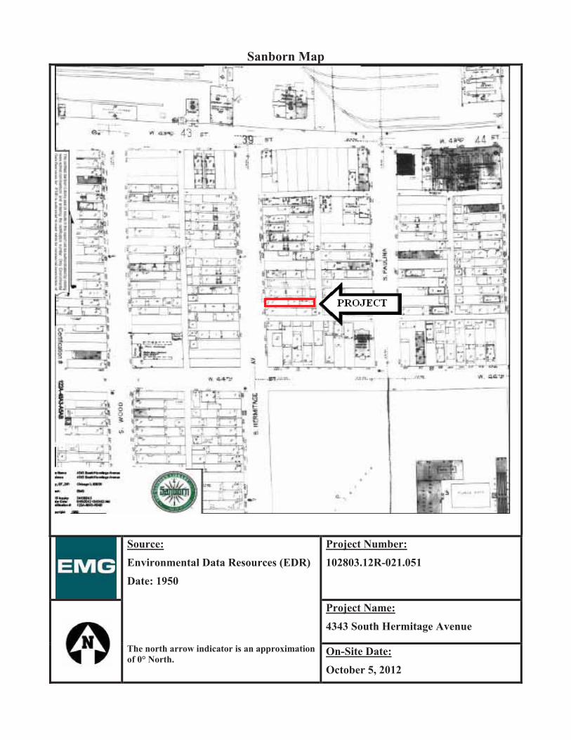
Sanborn Map
Source:Environmental Data Resources (EDR) Date: 1950
The north arrow indicator is an approximation of 0° North.
Project Number:102803.12R-021.051
Project Name:4343 South Hermitage Avenue
On-Site Date:October 5, 2012

Sanborn Map
Source:Environmental Data Resources (EDR) Date: 1975
The north arrow indicator is an approximation of 0° North.
Project Number:102803.12R-021.051
Project Name:4343 South Hermitage Avenue
On-Site Date:October 5, 2012

Sanborn Map
Source:Environmental Data Resources (EDR) Date: 1988
The north arrow indicator is an approximation of 0° North.
Project Number:102803.12R-021.051
Project Name:4343 South Hermitage Avenue
On-Site Date:October 5, 2012

Sanborn Map
Source:Environmental Data Resources (EDR) Date: 1991
The north arrow indicator is an approximation of 0° North.
Project Number:102803.12R-021.051
Project Name:4343 South Hermitage Avenue
On-Site Date:October 5, 2012

Sanborn Map
Source:Environmental Data Resources (EDR) Date: 1993
The north arrow indicator is an approximation of 0° North.
Project Number:102803.12R-021.051
Project Name:4343 South Hermitage Avenue
On-Site Date:October 5, 2012

Sanborn Map
Source:Environmental Data Resources (EDR) Date: 2002
The north arrow indicator is an approximation of 0° North.
Project Number:102803.12R-021.051
Project Name:4343 South Hermitage Avenue
On-Site Date:October 5, 2012

Sanborn Map
Source:Environmental Data Resources (EDR) Date: 2004
The north arrow indicator is an approximation of 0° North.
Project Number:102803.12R-021.051
Project Name:4343 South Hermitage Avenue
On-Site Date:October 5, 2012

Historic Topographic Map
Source:EDRDate: 1901
The north arrow indicator is an approximation of 0° North.
Project Number:102803.12R-021.051
Project Name:4343 South Hermitage Avenue
On-Site Date:October 5, 2012

Historic Topographic Map
Source:EDRDate: 1929
The north arrow indicator is an approximation of 0° North.
Project Number:102803.12R-021.051
Project Name:4343 South Hermitage Avenue
On-Site Date:October 5, 2012

Historic Topographic Map
Source:EDRDate: 1953
The north arrow indicator is an approximation of 0° North.
Project Number:102803.12R-021.051
Project Name:4343 South Hermitage Avenue
On-Site Date:October 5, 2012

Historic Topographic Map
Source:EDRDate: 1963
The north arrow indicator is an approximation of 0° North.
Project Number:102803.12R-021.051
Project Name:4343 South Hermitage Avenue
On-Site Date:October 5, 2012

Historic Topographic Map
Source:EDRDate: 1972
The north arrow indicator is an approximation of 0° North.
Project Number:102803.12R-021.051
Project Name:4343 South Hermitage Avenue
On-Site Date:October 5, 2012

Historic Topographic Map
Source:EDRDate: 1980
The north arrow indicator is an approximation of 0° North.
Project Number:102803.12R-021.051
Project Name:4343 South Hermitage Avenue
On-Site Date:October 5, 2012
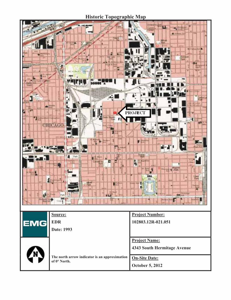
Historic Topographic Map
Source:EDRDate: 1993
The north arrow indicator is an approximation of 0° North.
Project Number:102803.12R-021.051
Project Name:4343 South Hermitage Avenue
On-Site Date:October 5, 2012

Aerial Photograph
Source:EDRDate: 1938
The north arrow indicator is an approximation of 0° North.
Project Number:102803.12R-021.051
Project Name:4343 South Hermitage Avenue
On-Site Date:October 5, 2012

Aerial Photograph
Source:EDRDate: 1952
The north arrow indicator is an approximation of 0° North.
Project Number:102803.12R-021.051
Project Name:4343 South Hermitage Avenue
On-Site Date:October 5, 2012

Aerial Photograph
Source:EDRDate: 1962
The north arrow indicator is an approximation of 0° North.
Project Number:102803.12R-021.051
Project Name:4343 South Hermitage Avenue
On-Site Date:October 5, 2012

Aerial Photograph
Source:EDRDate: 1972
The north arrow indicator is an approximation of 0° North.
Project Number:102803.12R-021.051
Project Name:4343 South Hermitage Avenue
On-Site Date:October 5, 2012

Aerial Photograph
Source:EDRDate: 1978
The north arrow indicator is an approximation of 0° North.
Project Number:102803.12R-021.051
Project Name:4343 South Hermitage Avenue
On-Site Date:October 5, 2012

Aerial Photograph
Source:EDRDate: 1984
The north arrow indicator is an approximation of 0° North.
Project Number:102803.12R-021.051
Project Name:4343 South Hermitage Avenue
On-Site Date:October 5, 2012

Aerial Photograph
Source:EDRDate: 1988
The north arrow indicator is an approximation of 0° North.
Project Number:102803.12R-021.051
Project Name:4343 South Hermitage Avenue
On-Site Date:October 5, 2012

Aerial Photograph
Source:EDRDate: 1994
The north arrow indicator is an approximation of 0° North.
Project Number:102803.12R-021.051
Project Name:4343 South Hermitage Avenue
On-Site Date:October 5, 2012

Aerial Photograph
Source:EDRDate: 1999
The north arrow indicator is an approximation of 0° North.
Project Number:102803.12R-021.051
Project Name:4343 South Hermitage Avenue
On-Site Date:October 5, 2012

Aerial Photograph
Source:EDRDate: 2005
The north arrow indicator is an approximation of 0° North.
Project Number:102803.12R-021.051
Project Name:4343 South Hermitage Avenue
On-Site Date:October 5, 2012

Aerial Photograph
Source:EDRDate: 2007
The north arrow indicator is an approximation of 0° North.
Project Number:102803.12R-021.051
Project Name:4343 South Hermitage Avenue
On-Site Date:October 5, 2012

110022880033 ..1122RR-- 002211 .. 005511
YO U R PA R T N E R I N RE A L ES T A T E LI F E C Y C L E PL A N N I N G & MA N A G E M E N T 800.733.0660 • www.emgcorp.com
A S S E S S M E N T
E N V I R O N M E N T A L
AA PP PP EE NN DD II XX DD :: RR EE CC OO RR DD SS OO FF CC OO MM MM UU NN II CC AA TT II OO NN

110022880033 ..1122RR-- 002211 .. 005511
YO U R PA R T N E R I N RE A L ES T A T E LI F E C Y C L E PL A N N I N G & MA N A G E M E N T 800.733.0660 • www.emgcorp.com
A S S E S S M E N T
E N V I R O N M E N T A L
RR EE CC OO RR DD OO FF CC OO MM MM UU NN II CC AA TT II OO NN
Date: 10-10-2012 Time: 5:00 PM Project Number: 102803.12R-021.051 Recorded by: Nick Brandt Project Name: 4343 South Hermitage Avenue
Communication with: FOIA Request System of: City of Chicago Building Department
Phone: 312-743-3600 Communication via:
Telephone Conversation Discussions During Site Assessment Office Visitation/Meeting at:
X Other: Email Re: Submittal of FOIA Request Summary of Communication: Request has been received and is being processed.

110022880033 ..1122RR-- 002211 .. 005511
YO U R PA R T N E R I N RE A L ES T A T E LI F E C Y C L E PL A N N I N G & MA N A G E M E N T 800.733.0660 • www.emgcorp.com
A S S E S S M E N T
E N V I R O N M E N T A L
RR EE CC OO RR DD OO FF CC OO MM MM UU NN II CC AA TT II OO NN
Date: 10-10-2012 Time: 5:00 PM Project Number: 102803.12R-021.051 Recorded by: Nick Brandt Project Name: 4343 South Hermitage Avenue
Communication with: Antonio Binns of: City of Chicago Housing and Economic Development (Planning)
Phone: 312-744-2271 Communication via:
Telephone Conversation Discussions During Site Assessment Office Visitation/Meeting at:
X Other: Email Re: Submittal of FOIA Request Summary of Communication: Request has been received and is being processed.

110022880033 ..1122RR-- 002211 .. 005511
YO U R PA R T N E R I N RE A L ES T A T E LI F E C Y C L E PL A N N I N G & MA N A G E M E N T 800.733.0660 • www.emgcorp.com
A S S E S S M E N T
E N V I R O N M E N T A L
AA PP PP EE NN DD II XX EE :: QQ UU EE SS TT II OO NN NN AA II RR EE SS

110022880033 ..1122RR-- 002211 .. 005511
YO U R PA R T N E R I N RE A L ES T A T E LI F E C Y C L E PL A N N I N G & MA N A G E M E N T 800.733.0660 • www.emgcorp.com
A S S E S S M E N T
E N V I R O N M E N T A L
KK EE YY SS II TT EE MM AA NN AA GG EE RR PP RR EE -- SS UU RR VV EE YY QQ UU EE SS TT II OO NN NN AA II RR EE
Name of person completing questionnaire: No Key Site Manager identified
Association with property:
Length of association with property:
Date:
Phone Number:
Property Name: 4343 South Hermitage Avenue
EMG Project Number: 102803.12R-021.051
Directions: Please answer all questions to the best of your knowledge and in good faith. Mark the column corresponding to the appropriate response. Additional details necessary to explain any yes or unknown responses should be provided in the “Comments” column. Note: U/NR indicates “Unknown” or “No Response”.
QUESTION RESPONSE COMMENTS
Y N U/NR
1A. Is the Project used for an industrial use?
1B. Are any adjoining properties used for an industrial use?
2A. To the best of your knowledge, has the Project been used for an industrial use in the past?
2B. To the best of your knowledge, has any adjoining properties been used for an industrial use in the past?
3A. Is the Project used as a gasoline station, motor repair facility, commercial printing facility, dry cleaners, photo developing laboratory, junkyard or landfill, or as a waste treatment, storage, disposal, processing, or recycling facility?
3B. Is any adjoining property used as a gasoline station, motor repair facility, commercial printing facility, dry cleaners, photo developing laboratory, junkyard or landfill, or as a waste treatment, storage, disposal, processing, or recycling facility?
4A. To the best of your knowledge, has the Project been used as a gasoline station, motor repair facility, commercial printing facility, dry cleaners, photo developing laboratory, junkyard or landfill, or as a waste treatment, storage, disposal, processing, or recycling facility?
4B. To the best of your knowledge, has any adjoining property been used as a gasoline station, motor repair facility, commercial printing facility, dry cleaners, photo developing laboratory, junkyard or landfill, or as a waste treatment, storage, disposal, processing, or recycling facility?
5A. Are there currently any automotive or industrial batteries, pesticides, paints, or other chemicals in individual containers of greater than five gallons in volume or fifty gallons in the aggregate, stored on or used at the Project?

110022880033 ..1122RR-- 002211 .. 005511
YO U R PA R T N E R I N RE A L ES T A T E LI F E C Y C L E PL A N N I N G & MA N A G E M E N T 800.733.0660 • www.emgcorp.com
A S S E S S M E N T
E N V I R O N M E N T A L
QUESTION RESPONSE COMMENTS
Y N U/NR
5B. To the best of your knowledge, have there been previously any automotive or industrial batteries, pesticides, paints, or other chemicals in individual containers of greater than five gallons in volume or fifty gallons in the aggregate, stored on or used at the Project?
6A. Are there currently any industrial drums (typically 55-gallon) or sacks of chemicals located on the Project?
6B. To the best of your knowledge, have there been previously any industrial drums (typically 55-gallon) or sacks of chemicals located on the Project?
7A. Are there currently any groundwater monitoring wells or other groundwater wells (i.e., potable drinking water wells) located on the Project?
7B. To the best of your knowledge, have there been previously any groundwater monitoring wells or other groundwater wells (i.e., potable drinking water wells) located on the Project?
8A. Has fill dirt been brought onto the Project which originated from a contaminated site?
8B. Has fill dirt been brought onto the Project which is of an unknown origin?
9A. Are there currently any pits, ponds or lagoons located on the Project in connection with waste treatment or waste disposal?
9B. To the best of your knowledge, have there been previously any pits, ponds or lagoons located on the Project in connection with waste treatment or waste disposal?
10A. Is there currently, any stained soil on the Project?
10B. To the best of your knowledge, has there been previously any stained soil on the Project?
11A. Are there currently any registered or unregistered storage tanks (above or underground) located on the Project?
11B. To the best of your knowledge, have there been previously any registered or unregistered storage tanks (above or underground) located on the Project?
12A. Are there currently any vent pipes, fill pipes or access ways indicating a fill pipe protruding from the ground on the Project or adjacent to any structure located on the Project?
12B. To the best of your knowledge, have there been previously any vent pipes, fill pipes or access ways indicating a fill pipe protruding from the ground on the Project or adjacent to any structure located on the Project?
13A. Are there currently any flooring, drains, or walls located at the Project that are stained by substances other than water or are emitting foul odors?

110022880033 ..1122RR-- 002211 .. 005511
YO U R PA R T N E R I N RE A L ES T A T E LI F E C Y C L E PL A N N I N G & MA N A G E M E N T 800.733.0660 • www.emgcorp.com
A S S E S S M E N T
E N V I R O N M E N T A L
QUESTION RESPONSE COMMENTS
Y N U/NR
13B. To the best of your knowledge, have there been previously any flooring, drains, or walls located at the Project that are stained by substances other than water or are emitting foul odors?
14A. If the Project is served by a private well or non-public water system, have contaminants been identified in the well or system that exceed guidelines applicable to the water system?
14B. If the Project is served by a private well or non-public water system, has the well been designated as contaminated by any government environmental/health agency?
15A. Have you been informed of the past existence of hazardous substances or petroleum products with respect to the Project or any facility located on the Project?
15B. Have you been informed of the current existence of hazardous substances or petroleum products with respect to the Project or any facility located on the Project?
16A. Are there any environmental liens or governmental notification relating to past or current violations of environmental laws with respect to the Project or any facility located on the Project?
16B. Have you been informed of the past existence of environmental violations with respect to the Project or any facility located on the Project?
16C. Are you aware of any pending, threatened, or past litigation relevant to hazardous substances of petroleum products in, on or from the property?
16D. Are you aware of any pending, threatened, or past administrative proceedings relevant to hazardous substances or petroleum products in, on or from the property?
16E. Are you aware of any notices from any governmental entity regarding any possible violation or environmental laws or possible liability relating to hazardous substances or petroleum products?
17. Have there been any environmental site assessments of the Project that indicated the presence of hazardous substances or petroleum products on, or contamination of, the Project or recommended further assessment of the Project?
18. Does the Project discharge waste water on or adjacent to the project, other than storm water, into a storm water sewer system?
19. Does the Project discharge waste water on or adjacent to the project, other than storm water, or into a sanitary system?
20. Have any hazardous substances or petroleum products, unidentified waste materials, tires, automotive or industrial batteries or any other waste materials been dumped above grade, buried and/or burned on the Project?
21. Is there a transformer, capacitor or any hydraulic equipment for which there are any records indicating the presence of PCBs?

110022880033 ..1122RR-- 002211 .. 005511
YO U R PA R T N E R I N RE A L ES T A T E LI F E C Y C L E PL A N N I N G & MA N A G E M E N T 800.733.0660 • www.emgcorp.com
A S S E S S M E N T
E N V I R O N M E N T A L
QUESTION RESPONSE COMMENTS
Y N U/NR
22. Is there now or has there ever been any asbestos-containing materials (ACM), in any application, on the Project?
23. Has there ever been any ACM testing conducted on the Project?
24. Is there an asbestos Operations and Maintenance (O&M) program in place at the Project?
25. Is there now or has there ever been any lead-based paint (LBP) applications on the Project?
26. Has there ever been LBP testing conducted on the Project?
27. Is there a Lead Paint Operations and Maintenance (O&M) Program in place at the Project?
28. Has the water at the Project ever been tested for lead?
29. Has Radon testing ever been conducted at the Project?
30. Are there any other Operations and Maintenance (O&M) programs in place that we should be made aware of?
31. Is the Project or any portion of the Project located or involved in any environmentally sensitive areas (i.e., wetlands, coastal barrier resource areas, coastal barrier improvement act areas, flood plains, endangered species, etc.)?
32. Is the HVAC system inspected at least annually?
33. Have identified HVAC problems been corrected in a timely manner?
34. Is there now, or has there ever been any water damage in the building(s), whether from flooding, plumbing, roof leaks, or other sources?
If so, when?
Summarize historical Project use (when was the Project developed with the current improvements, what modifications have taken place, what was the Project used for prior to its current use)

110022880033 ..1122RR-- 002211 .. 005511
YO U R PA R T N E R I N RE A L ES T A T E LI F E C Y C L E PL A N N I N G & MA N A G E M E N T 800.733.0660 • www.emgcorp.com
A S S E S S M E N T
E N V I R O N M E N T A L
UU SS EE RR QQ UU EE SS TT II OO NN NN AA II RR EEEMG has been retained to conduct a Phase I Environmental Site Assessment (ESA) of the following property. The Phase I ESA will involve site observations, interviews, and a review of available documentation. To ensure the success of the assessment, and in accordance with the ASTM 05 Scope of Work for this assessment, which documents certain User responsibilities, we are submitting this questionnaire to help you meet those responsibilities. Please complete this questionnaire and return via email or by fax to 410-785-6220 (within one business day of receipt).
Date:
Name of person completing questionnaire: Not returned to EMG Company:
Length of association with property: Phone Number:
Property Name/Address: 4343 South Hermitage Avenue/Chicago, Illinois 60609
EMG Project Number: 102803.12R-021.051
Directions: Please answer all questions to the best of your knowledge and in good faith. Mark the column corresponding to the appropriate response. Additional details necessary to explain any yes or unknown responses should be provided in the “Comments” column. Note: U/NR indicates “Unknown” or “No Response”, and “N/A” indicates not applicable.
QUESTION RESPONSE COMMENTS
Y N U/NR
1 Are you aware of any pending, threatened, or past litigation relevant to hazardous substances or petroleum products in, on, or from the property?
2 Are you aware of any pending, threatened, or past administrative proceedings relevant to hazardous substances or petroleum products in, on or from the property?
3 Are you aware of any notices from any governmental entity regarding any possible violation of environmental laws or possible liability relating to hazardous substances or petroleum products?
4 Are you aware of any environmental cleanup liens against the property that are filed or recorded under federal, tribal, state or local law?
5 Are you aware of any Activity and Use Limitations, such as engineering controls, land use restrictions or institutional controls that are in place at the site and/or have been filed or recorded in a registry under federal, tribal, state or local law?
6 As the user of this ESA do you have any specialized knowledge or experience related to the property or nearby properties? For example, are you involved in the same line of business as the current or former occupants of the property or an adjoining property so that you would have specialized knowledge of the chemicals and processes used by this type of business?
7 Does the purchase price being paid for this property reasonably reflect the fair market value of the property? If you conclude that there is a difference, have you considered whether the lower purchase price is because contamination is known or believed to be present at the property?
8 Are you aware of commonly known or reasonably ascertainable information about the property that would help the environmental professional to identify conditions indicative of releases or threatened releases? For example, as user
8 (a) Do you know the past uses of the property?

110022880033 ..1122RR-- 002211 .. 005511
YO U R PA R T N E R I N RE A L ES T A T E LI F E C Y C L E PL A N N I N G & MA N A G E M E N T 800.733.0660 • www.emgcorp.com
A S S E S S M E N T
E N V I R O N M E N T A L
QUESTION RESPONSE COMMENTS
Y N U/NR
8 (b) Do you know of specific chemicals that are present or once were present at the property?
8 (c) Do you know of spills or other chemical releases that have taken place at the property?
8 (d) Do you know of any environmental cleanups that have taken place at the property?
9 As the user of this ESA, based on your knowledge and experience related to the property are there any obvious indicators that point to the presence or likely presence of contamination at the property?
In addition, are you aware of any of the following documents, and if so, please forward copies of the document(s) to EMG at 222 Schilling Circle, Suite 275, Hunt Valley, Maryland 21031 (along with a copy of this form):
Helpful Documents to be forwarded EMG:
Environmental site assessment reports (i.e., Phase I, Phase II, tank testing results, radon, lead paint, or asbestos testing, etc.)
Environmental compliance audit reports; risk assessments; and recorded Activity and Use Limitations (AULs)
Environmental permits (i.e., solid waste disposal, hazardous waste disposal, wastewater, NPDES, underground injection, etc.)
Registrations for underground storage tanks (USTs) and aboveground storage tanks (ASTs) Registrations for underground injection systems Material safety data sheets Community right-to-know plan Safety plans; preparedness and prevention plans; spill prevention, countermeasure, and control plans, etc Reports regarding hydrogeological or geotechnical conditions on the property and surrounding area
Notices/correspondence from any agency relating to past/current violations of environmental laws, or liens encumbering the property
Hazardous waste generator notices or reports Other:
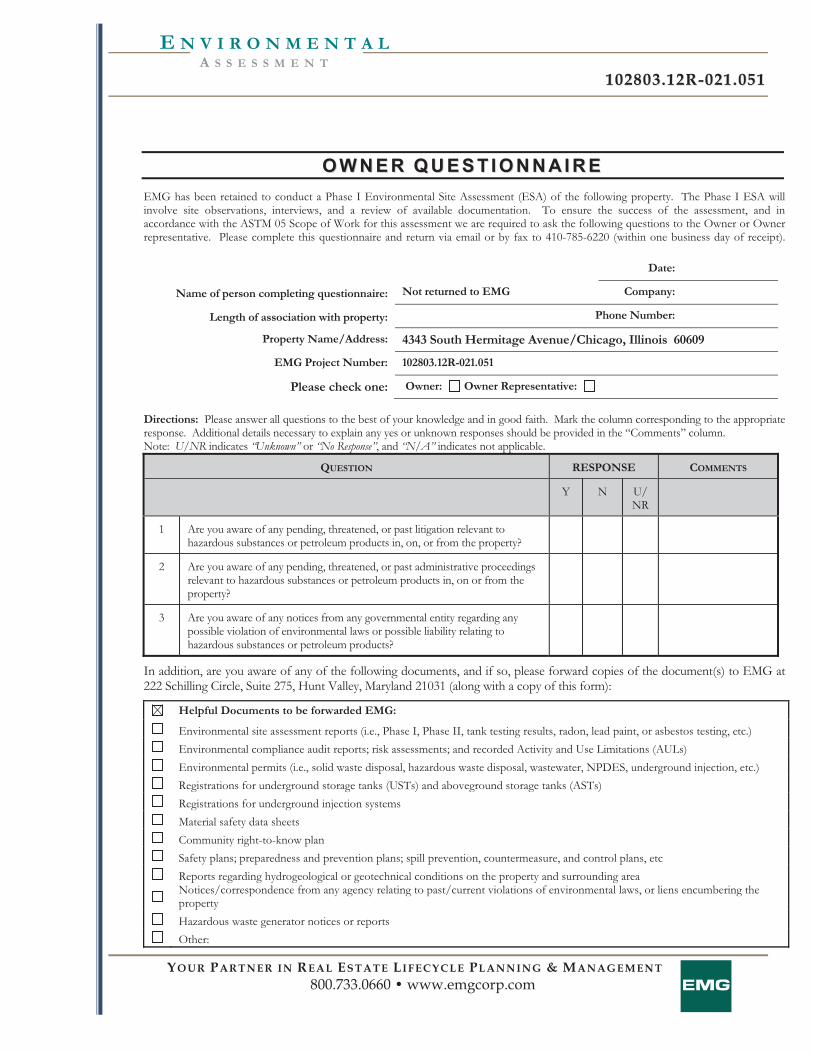
110022880033 ..1122RR-- 002211 .. 005511
YO U R PA R T N E R I N RE A L ES T A T E LI F E C Y C L E PL A N N I N G & MA N A G E M E N T 800.733.0660 • www.emgcorp.com
A S S E S S M E N T
E N V I R O N M E N T A L
OO WW NN EE RR QQ UU EE SS TT II OO NN NN AA II RR EEEMG has been retained to conduct a Phase I Environmental Site Assessment (ESA) of the following property. The Phase I ESA will involve site observations, interviews, and a review of available documentation. To ensure the success of the assessment, and in accordance with the ASTM 05 Scope of Work for this assessment we are required to ask the following questions to the Owner or Owner representative. Please complete this questionnaire and return via email or by fax to 410-785-6220 (within one business day of receipt).
Date:
Name of person completing questionnaire: Not returned to EMG Company:
Length of association with property: Phone Number:
Property Name/Address: 4343 South Hermitage Avenue/Chicago, Illinois 60609
EMG Project Number: 102803.12R-021.051
Please check one: Owner: Owner Representative:
Directions: Please answer all questions to the best of your knowledge and in good faith. Mark the column corresponding to the appropriate response. Additional details necessary to explain any yes or unknown responses should be provided in the “Comments” column. Note: U/NR indicates “Unknown” or “No Response”, and “N/A” indicates not applicable.
QUESTION RESPONSE COMMENTS
Y N U/NR
1 Are you aware of any pending, threatened, or past litigation relevant to hazardous substances or petroleum products in, on, or from the property?
2 Are you aware of any pending, threatened, or past administrative proceedings relevant to hazardous substances or petroleum products in, on or from the property?
3 Are you aware of any notices from any governmental entity regarding any possible violation of environmental laws or possible liability relating to hazardous substances or petroleum products?
In addition, are you aware of any of the following documents, and if so, please forward copies of the document(s) to EMG at 222 Schilling Circle, Suite 275, Hunt Valley, Maryland 21031 (along with a copy of this form):
Helpful Documents to be forwarded EMG:
Environmental site assessment reports (i.e., Phase I, Phase II, tank testing results, radon, lead paint, or asbestos testing, etc.) Environmental compliance audit reports; risk assessments; and recorded Activity and Use Limitations (AULs) Environmental permits (i.e., solid waste disposal, hazardous waste disposal, wastewater, NPDES, underground injection, etc.) Registrations for underground storage tanks (USTs) and aboveground storage tanks (ASTs) Registrations for underground injection systems Material safety data sheets Community right-to-know plan Safety plans; preparedness and prevention plans; spill prevention, countermeasure, and control plans, etc Reports regarding hydrogeological or geotechnical conditions on the property and surrounding area
Notices/correspondence from any agency relating to past/current violations of environmental laws, or liens encumbering the property
Hazardous waste generator notices or reports Other:

110022880033 ..1122RR-- 002211 .. 005511
YO U R PA R T N E R I N RE A L ES T A T E LI F E C Y C L E PL A N N I N G & MA N A G E M E N T 800.733.0660 • www.emgcorp.com
A S S E S S M E N T
E N V I R O N M E N T A L
AA PP PP EE NN DD II XX FF :: RR EE GG UU LL AA TT OO RR YY DD AA TT AA BB AA SS EE RR EE PP OO RR TT

FORM-STP-KXG
®kcehCoeGhtiwtropeR™paMsuidaRRDEehTGMErofderaperP
440 Wheelers Farms RoadMilford, CT 06461Toll Free: 800.352.0050www.edrnet.com
Project #: 102803.021.0514343 South Hermitage Avenue4343 South Hermitage AvenueChicago, IL 60609
Inquiry Number: 3413564.2sSeptember 19, 2012

SECTION PAGE
Executive Summary ES1
Overview Map 2
Detail Map 3
Map Summary 4
Map Findings 7
Orphan Summary 78
Government Records Searched/Data Currency Tracking GR-1
GEOCHECK ADDENDUM
Physical Setting Source Addendum A-1
Physical Setting Source Summary A-2
Physical Setting Source Map A-9
Physical Setting Source Map Findings A-10
Physical Setting Source Records Searched A-50
TC3413564.2s Page 1
Thank you for your business.Please contact EDR at 1-800-352-0050
with any questions or comments.
Disclaimer - Copyright and Trademark NoticeThis Report contains certain information obtained from a variety of public and other sources reasonably available to Environmental DataResources, Inc. It cannot be concluded from this Report that coverage information for the target and surrounding properties does not exist fromother sources. NO WARRANTY EXPRESSED OR IMPLIED, IS MADE WHATSOEVER IN CONNECTION WITH THIS REPORT. ENVIRONMENTALDATA RESOURCES, INC. SPECIFICALLY DISCLAIMS THE MAKING OF ANY SUCH WARRANTIES, INCLUDING WITHOUT LIMITATION,MERCHANTABILITY OR FITNESS FOR A PARTICULAR USE OR PURPOSE. ALL RISK IS ASSUMED BY THE USER. IN NO EVENT SHALLENVIRONMENTAL DATA RESOURCES, INC. BE LIABLE TO ANYONE, WHETHER ARISING OUT OF ERRORS OR OMISSIONS, NEGLIGENCE,ACCIDENT OR ANY OTHER CAUSE, FOR ANY LOSS OF DAMAGE, INCLUDING, WITHOUT LIMITATION, SPECIAL, INCIDENTAL,CONSEQUENTIAL, OR EXEMPLARY DAMAGES. ANY LIABILITY ON THE PART OF ENVIRONMENTAL DATA RESOURCES, INC. IS STRICTLYLIMITED TO A REFUND OF THE AMOUNT PAID FOR THIS REPORT. Purchaser accepts this Report "AS IS". Any analyses, estimates, ratings,environmental risk levels or risk codes provided in this Report are provided for illustrative purposes only, and are not intended to provide, norshould they be interpreted as providing any facts regarding, or prediction or forecast of, any environmental risk for any property. Only a Phase IEnvironmental Site Assessment performed by an environmental professional can provide information regarding the environmental risk for anyproperty. Additionally, the information provided in this Report is not to be construed as legal advice.
Copyright 2012 by Environmental Data Resources, Inc. All rights reserved. Reproduction in any media or format, in wholeor in part, of any report or map of Environmental Data Resources, Inc., or its affiliates, is prohibited without prior written permission.EDR and its logos (including Sanborn and Sanborn Map) are trademarks of Environmental Data Resources, Inc. or its affiliates. All othertrademarks used herein are the property of their respective owners.
TABLE OF CONTENTS

EXECUTIVE SUMMARY
TC3413564.2s EXECUTIVE SUMMARY 1
A search of available environmental records was conducted by Environmental Data Resources, Inc (EDR).The report was designed to assist parties seeking to meet the search requirements of EPA’s Standardsand Practices for All Appropriate Inquiries (40 CFR Part 312), the ASTM Standard Practice forEnvironmental Site Assessments (E 1527-05) or custom requirements developed for the evaluation ofenvironmental risk associated with a parcel of real estate.
TARGET PROPERTY INFORMATION
ADDRESS
4343 SOUTH HERMITAGE AVENUECHICAGO, IL 60609
COORDINATES
41.8146000 - 41˚ 48’ 52.56’’Latitude (North): 87.6684000 - 87˚ 40’ 6.24’’Longitude (West): Zone 16Universal Tranverse Mercator: 444482.7UTM X (Meters): 4629194.5UTM Y (Meters):
USGS TOPOGRAPHIC MAP ASSOCIATED WITH TARGET PROPERTY
41087-G6 ENGLEWOOD, ILTarget Property Map:1997Most Recent Revision:
AERIAL PHOTOGRAPHY IN THIS REPORT
2009, 2010Portions of Photo from:USDASource:
TARGET PROPERTY SEARCH RESULTS
The target property was not listed in any of the databases searched by EDR.
DATABASES WITH NO MAPPED SITES
No mapped sites were found in EDR’s search of available ("reasonably ascertainable ") governmentrecords either on the target property or within the search radius around the target property for thefollowing databases:
STANDARD ENVIRONMENTAL RECORDS
Federal NPL site listNPL National Priority List

EXECUTIVE SUMMARY
TC3413564.2s EXECUTIVE SUMMARY 2
Proposed NPL Proposed National Priority List SitesNPL LIENS Federal Superfund Liens
Federal Delisted NPL site listDelisted NPL National Priority List Deletions
Federal CERCLIS listCERCLIS Comprehensive Environmental Response, Compensation, and Liability Information SystemFEDERAL FACILITY Federal Facility Site Information listing
Federal RCRA generators listRCRA-LQG RCRA - Large Quantity GeneratorsRCRA-SQG RCRA - Small Quantity Generators
Federal institutional controls / engineering controls registriesUS ENG CONTROLS Engineering Controls Sites ListUS INST CONTROL Sites with Institutional Controls
Federal ERNS listERNS Emergency Response Notification System
State- and tribal - equivalent CERCLISSSU State Sites Unit Listing
State and tribal landfill and/or solid waste disposal site listsSWF/LF Available Disposal for Solid Waste in Illinois - Solid Waste Landfills Subject to State SurchargeLF SPECIAL WASTE Special Waste Site ListCCDD Clean Construction or Demolition Debris
State and tribal leaking storage tank listsLUST TRUST Underground Storage Tank Fund Payment Priority ListINDIAN LUST Leaking Underground Storage Tanks on Indian Land
State and tribal registered storage tank listsINDIAN UST Underground Storage Tanks on Indian LandFEMA UST Underground Storage Tank Listing
State and tribal institutional control / engineering control registriesINST CONTROL Institutional Controls
State and tribal voluntary cleanup sitesINDIAN VCP Voluntary Cleanup Priority Listing
State and tribal Brownfields sitesBROWNFIELDS Municipal Brownfields Redevelopment Grant Program Project Descriptions

EXECUTIVE SUMMARY
TC3413564.2s EXECUTIVE SUMMARY 3
ADDITIONAL ENVIRONMENTAL RECORDS
Local Brownfield listsUS BROWNFIELDS A Listing of Brownfields Sites
Local Lists of Landfill / Solid Waste Disposal SitesDEBRIS REGION 9 Torres Martinez Reservation Illegal Dump Site LocationsODI Open Dump InventoryINDIAN ODI Report on the Status of Open Dumps on Indian Lands
Local Lists of Hazardous waste / Contaminated SitesUS CDL Clandestine Drug LabsCDL Meth Drug Lab Site ListingUS HIST CDL National Clandestine Laboratory Register
Local Land RecordsLIENS 2 CERCLA Lien InformationLUCIS Land Use Control Information System
Records of Emergency Release ReportsHMIRS Hazardous Materials Information Reporting SystemSPILLS State spills
Other Ascertainable RecordsRCRA-NonGen RCRA - Non GeneratorsDOT OPS Incident and Accident DataDOD Department of Defense SitesFUDS Formerly Used Defense SitesCONSENT Superfund (CERCLA) Consent DecreesROD Records Of DecisionUMTRA Uranium Mill Tailings SitesMINES Mines Master Index FileTSCA Toxic Substances Control ActFTTS FIFRA/ TSCA Tracking System - FIFRA (Federal Insecticide, Fungicide, & Rodenticide Act)/TSCA (Toxic Substances Control Act)HIST FTTS FIFRA/TSCA Tracking System Administrative Case ListingSSTS Section 7 Tracking SystemsICIS Integrated Compliance Information SystemPADS PCB Activity Database SystemMLTS Material Licensing Tracking SystemRADINFO Radiation Information DatabaseFINDS Facility Index System/Facility Registry SystemRAATS RCRA Administrative Action Tracking SystemNPDES A Listing of Active PermitsUIC Underground Injection WellsHWAR Hazard Waste Annual ReportDRYCLEANERS Illinois Licensed Drycleaners

EXECUTIVE SUMMARY
TC3413564.2s EXECUTIVE SUMMARY 4
IMPDMENT Surface Impoundment InventoryAIRS AIRSTIER 2 Tier 2 Information ListingINDIAN RESERV Indian ReservationsSCRD DRYCLEANERS State Coalition for Remediation of Drycleaners ListingCOAL ASH Coal Ash Site ListingPRP Potentially Responsible Parties2020 COR ACTION 2020 Corrective Action Program ListCOAL ASH EPA Coal Combustion Residues Surface Impoundments ListPIMW Potentially Infectious Medical WasteEPA WATCH LIST EPA WATCH LISTUS FIN ASSUR Financial Assurance InformationPCB TRANSFORMER PCB Transformer Registration DatabaseCOAL ASH DOE Steam-Electric Plant Operation DataFINANCIAL ASSURANCE Financial Assurance Information Listing
EDR PROPRIETARY RECORDS
EDR Proprietary RecordsManufactured Gas Plants EDR Proprietary Manufactured Gas Plants
SURROUNDING SITES: SEARCH RESULTS
Surrounding sites were identified in the following databases.
Page numbers and map identification numbers refer to the EDR Radius Map report where detailed data onindividual sites can be reviewed.
Sites listed in bold italics are in multiple databases.
Unmappable (orphan) sites are not considered in the foregoing analysis.
STANDARD ENVIRONMENTAL RECORDS
Federal CERCLIS NFRAP site ListCERC-NFRAP: Archived sites are sites that have been removed and archived from the inventory of CERCLISsites. Archived status indicates that, to the best of EPA’s knowledge, assessment at a site has been completedand that EPA has determined no further steps will be taken to list this site on the National Priorities List(NPL), unless information indicates this decision was not appropriate or other considerations require arecommendation for listing at a later time. This decision does not necessarily mean that there is no hazardassociated with a given site; it only means that, based upon available information, the location is not judgedto be a potential NPL site.
A review of the CERC-NFRAP list, as provided by EDR, and dated 12/28/2011 has revealed that there is 1 CERC-NFRAP site within approximately 0.5 miles of the target property.
PageMap IDDist / Dir Address Site ________ ________ __________ _____ _____
CUSTOM ORGANICS INC 1445 W 42ND ST 1/4 - 1/2 (0.341 mi.) ENE H28 25

EXECUTIVE SUMMARY
TC3413564.2s EXECUTIVE SUMMARY 5
Federal RCRA CORRACTS facilities listCORRACTS: CORRACTS is a list of handlers with RCRA Corrective Action Activity. This report showswhich nationally-defined corrective action core events have occurred for every handler that has had correctiveaction activity.
A review of the CORRACTS list, as provided by EDR, and dated 08/19/2011 has revealed that there are 2 CORRACTS sites within approximately 1 mile of the target property.
PageMap IDDist / Dir Address Site ________ ________ __________ _____ _____
CUSTOM ORGANICS INC 1445 W 42ND ST 1/4 - 1/2 (0.341 mi.) ENE H28 25 BRACO PLATING CO / BAIRD & WAR 4831 S MAY 1/2 - 1 (0.928 mi.) SE 62 74
Federal RCRA non-CORRACTS TSD facilities listRCRA-TSDF: RCRAInfo is EPA’s comprehensive information system, providing access to data supportingthe Resource Conservation and Recovery Act (RCRA) of 1976 and the Hazardous and Solid Waste Amendments (HSWA)of 1984. The database includes selective information on sites which generate, transport, store, treat and/ordispose of hazardous waste as defined by the Resource Conservation and Recovery Act (RCRA). Transporters areindividuals or entities that move hazardous waste from the generator offsite to a facility that can recycle,treat, store, or dispose of the waste. TSDFs treat, store, or dispose of the waste.
A review of the RCRA-TSDF list, as provided by EDR, and dated 03/15/2012 has revealed that there is 1 RCRA-TSDF site within approximately 1 mile of the target property.
PageMap IDDist / Dir Address Site ________ ________ __________ _____ _____
CUSTOM ORGANICS INC 1445 W 42ND ST 1/4 - 1/2 (0.341 mi.) ENE H28 25
Federal RCRA generators listRCRA-CESQG: RCRAInfo is EPA’s comprehensive information system, providing access to data supportingthe Resource Conservation and Recovery Act (RCRA) of 1976 and the Hazardous and Solid Waste Amendments (HSWA)of 1984. The database includes selective information on sites which generate, transport, store, treat and/ordispose of hazardous waste as defined by the Resource Conservation and Recovery Act (RCRA). Conditionallyexempt small quantity generators (CESQGs) generate less than 100 kg of hazardous waste, or less than 1 kg ofacutely hazardous waste per month.
A review of the RCRA-CESQG list, as provided by EDR, and dated 03/15/2012 has revealed that there is 1 RCRA-CESQG site within approximately 0.125 miles of the target property.
PageMap IDDist / Dir Address Site ________ ________ __________ _____ _____
DAVIS SQUARE PARK 4430 S MARSHFIELD AVE 0 - 1/8 (0.121 mi.) SE C8 11

EXECUTIVE SUMMARY
TC3413564.2s EXECUTIVE SUMMARY 6
State and tribal landfill and/or solid waste disposal site listsIL NIPC: NIPC is an inventory of active and inactive solid waste disposal sites, based on state,local government and historical archive data. Included are numerous sites that previously had never beenidentified largely because, prior to 1971, there was no obligation to register such sites. The data come fromthe Northeastern Illinois Planning Commission’s Solid Waste Landfill Inventory.
A review of the IL NIPC list, as provided by EDR, and dated 08/01/1988 has revealed that there are 2 IL NIPC sites within approximately 0.5 miles of the target property.
PageMap IDDist / Dir Address Site ________ ________ __________ _____ _____
46TH/DAMEN AVE 1/4 - 1/2 (0.453 mi.) SW 35 56 J P RUBBISH COMPANY 1/4 - 1/2 (0.480 mi.) NNE 38 59
State and tribal leaking storage tank listsLUST: The Leaking Underground Storage Tank Incident Reports contain an inventory of reportedleaking underground storage tank incidents. The data come from the Illinois Environmental Protection Agency’sLUST Incident Report.
A review of the LUST list, as provided by EDR, and dated 07/20/2012 has revealed that there are 17 LUST sites within approximately 0.5 miles of the target property.
PageMap IDDist / Dir Address Site ________ ________ __________ _____ _____
BACK OF YARDS NEIGHBORHOOD COU 4316 SOUTH PAULINA ST. 0 - 1/8 (0.072 mi.) NNE A3 7 INOLEX CHEMICAL COMPANY 4200 SOUTH HERMITAGE AV 0 - 1/8 (0.083 mi.) NNW B6 9
NFA/NFR Letter: 09/26/1991
NEW CENTURY CONSTRUCTION 4400 SOUTH ASHLAND AVE. 1/8 - 1/4 (0.160 mi.) ESE D10 14NFA/NFR Letter: 04/18/2006
CHICAGO, CITY OF 4401 SOUTH ASHLAND AVE. 1/8 - 1/4 (0.170 mi.) ESE D11 14NFA/NFR Letter: 08/19/1998
KLEAN CAR WASH 4443 SOUTH ASHLAND AVEN 1/8 - 1/4 (0.188 mi.) ESE E12 15 S&L CARTAGE 1800 W 43RD ST 1/8 - 1/4 (0.194 mi.) WNW 14 16
NFA/NFR Letter: 05/27/2004
GES EXPOSITION SVCS 1555 W 44TH ST 1/8 - 1/4 (0.200 mi.) E D17 21 TREMBACKI, DAVID 4215-4229 SOUTH MARSHFI 1/8 - 1/4 (0.216 mi.) NNE F19 22
NFA/NFR Letter: 10/22/2008
42 ASHLAND VENTURE LLC 4200 SOUTH ASHLAND AVEN 1/4 - 1/2 (0.264 mi.) NE 25 23NFA/NFR Letter: 05/17/2004
CONCESSIONS SERVICES INC. 4132 SOUTH ASHLAND AVE. 1/4 - 1/2 (0.317 mi.) NNE 26 24NFA/NFR Letter: 05/30/2000
DRY STORAGE CORP. 2005 WEST 43RD ST. 1/4 - 1/2 (0.334 mi.) WNW 27 24 ROCKTENN CP LLC 1415 W 44TH ST 1/4 - 1/2 (0.378 mi.) E 30 53
NFA/NFR Letter: 02/11/1997
EPC PROPERTIES 1928 WEST 46TH 1/4 - 1/2 (0.380 mi.) SW 31 54 CITIBANK 1751 WEST 47TH ST. 1/4 - 1/2 (0.412 mi.) S 34 56 BALABAN FURNITURE 4717 SOUTH ASHLAND AVEN 1/4 - 1/2 (0.469 mi.) SSE 36 57 COLE TAYLOR BANK 1542 WEST 47TH STREET 1/4 - 1/2 (0.471 mi.) SSE 37 57
NFA/NFR Letter: 11/20/2008

EXECUTIVE SUMMARY
TC3413564.2s EXECUTIVE SUMMARY 7
PageMap IDDist / Dir Address Site ________ ________ __________ _____ _____
STIGLITZ, ALVIN 1500 WEST 47TH ST. 1/4 - 1/2 (0.499 mi.) SE 39 59
NFA/NFR Letter: 02/11/1999
State and tribal registered storage tank listsUST: The Underground Storage Tank database contains registered USTs. USTs are regulated underSubtitle I of the Resource Conservation and Recovery Act (RCRA). The data come from the Illinois State FireMarshal’s STC Facility List.
A review of the UST list, as provided by EDR, and dated 05/01/2012 has revealed that there are 3 UST sites within approximately 0.125 miles of the target property.
PageMap IDDist / Dir Address Site ________ ________ __________ _____ _____
VACANT PARCEL 4316 S PAULINA 0 - 1/8 (0.072 mi.) NNE A2 7 INOLEX CHEMICAL CO 4200 S HERMITAGE AVE 0 - 1/8 (0.083 mi.) NNW B5 9 DAVIS SQUARE PARK FIELD HOUSE 4430 S MARSHFIELD 0 - 1/8 (0.121 mi.) SE C7 10
State and tribal institutional control / engineering control registriesENG CONTROLS: Sites with Engineering Controls.
A review of the ENG CONTROLS list, as provided by EDR, and dated 07/20/2012 has revealed that there are 3 ENG CONTROLS sites within approximately 0.5 miles of the target property.
PageMap IDDist / Dir Address Site ________ ________ __________ _____ _____
BACK OF THE YARDS DAYCARE 1633 WEST 43RD STREET 1/8 - 1/4 (0.128 mi.) NE 9 13 S&L CARTAGE 1800 W 43RD ST 1/8 - 1/4 (0.194 mi.) WNW 14 16 COLE TAYLOR BANK 1542 WEST 47TH STREET 1/4 - 1/2 (0.471 mi.) SSE 37 57
State and tribal voluntary cleanup sitesSRP: Illinois Environmental Protection Agency, Site Remediation Program Database
A review of the SRP list, as provided by EDR, and dated 07/20/2012 has revealed that there are 25 SRP sites within approximately 1 mile of the target property.
PageMap IDDist / Dir Address Site ________ ________ __________ _____ _____
EMPTY LOT 4314-4318 SOUTH PAULINA 0 - 1/8 (0.074 mi.) NNE A4 8 BACK OF THE YARDS DAYCARE 1633 WEST 43RD STREET 1/8 - 1/4 (0.128 mi.) NE 9 13 S&L CARTAGE 1800 W 43RD ST 1/8 - 1/4 (0.194 mi.) WNW 14 16 Not reported 4024 ASHLAND AVE 1/4 - 1/2 (0.396 mi.) NNE I32 54 CHICAGO, CITY OF 4008 SOUTH ASHLAND AVEN 1/4 - 1/2 (0.401 mi.) NNE I33 55 COLE TAYLOR BANK 1542 WEST 47TH STREET 1/4 - 1/2 (0.471 mi.) SSE 37 57 1300 WEST EXCHANGE, LLC 1300 WEST EXCHANGE AVEN 1/2 - 1 (0.568 mi.) ENE 41 59

EXECUTIVE SUMMARY
TC3413564.2s EXECUTIVE SUMMARY 8
PageMap IDDist / Dir Address Site ________ ________ __________ _____ _____
CHICAGO INDOOR SOCCER, LLC 3900 SOUTH ASHLAND AVEN 1/2 - 1 (0.571 mi.) NNE 42 60 BISHOP PLAZA 1400-1422 WEST 47TH STR 1/2 - 1 (0.580 mi.) SE 43 61 CHICAGO UNION STOCKYARDS 4100 SOUTH PACKERS AVEN 1/2 - 1 (0.598 mi.) NE 44 62 JAMES MCNAUGHTON BUILDERS 1700 WEST PERSHING 1/2 - 1 (0.599 mi.) N 45 63 FERNANDEZ AUTO PARTS 2101 WEST 47TH STREET 1/2 - 1 (0.607 mi.) SW 46 64 ILLINOIS TOOL WORKS SHAKEPROOF 4300 SOUTH RACINE AVENU 1/2 - 1 (0.671 mi.) E 48 65 CORRUGATED METALS 4800 SOUTH HOYNE AVENUE 1/2 - 1 (0.699 mi.) SW 49 66 HAMMOND WAREHOUSE (TESTA PARCE 4555 SOUTH RACINE AVENU 1/2 - 1 (0.712 mi.) ESE 50 67 NORTH SHORE GROUP 1420 WEST 38TH STREET 1/2 - 1 (0.793 mi.) NNE 52 68 TEX’S TRUCK & PARTS, INC. 2300 WEST 47TH STREET 1/2 - 1 (0.807 mi.) WSW 55 69 LITTON SYSTEMS INC PRECISION G 4545 S WESTERN AVE 1/2 - 1 (0.845 mi.) WSW 56 70 TURTLE WAX 4130 SOUTH WESTERN AVEN 1/2 - 1 (0.877 mi.) WNW 57 71 PUBLIC STORAGE 3659 SOUTH ASHLAND AVEN 1/2 - 1 (0.915 mi.) N 59 72 WEST 48TH PLACE AND OAKLEY 4835 SOUTH OAKLEY AVENU 1/2 - 1 (0.916 mi.) SW 60 73 WELD RITE SERVICE, INC. 1150 WEST 40TH STREET 1/2 - 1 (0.918 mi.) ENE J61 74 HYDROAIRE, INC. 1126 WEST 40TH STREET 1/2 - 1 (0.931 mi.) ENE J63 75 WALGREENS 4724 SOUTH WESTERN AVEN 1/2 - 1 (0.943 mi.) WSW 64 76 PIN PARTNERS, LTD. 4801 SOUTH WESTERN BOUL 1/2 - 1 (0.955 mi.) SW 65 76
ADDITIONAL ENVIRONMENTAL RECORDS
Other Ascertainable RecordsTRIS: The Toxic Chemical Release Inventory System identifies facilities that release toxicchemicals to the air, water, and land in reportable quantities under SARA Title III, Section 313. The sourceof this database is the U.S. EPA.
A review of the TRIS list, as provided by EDR, and dated 12/31/2009 has revealed that there are 8 TRIS sites within approximately 1 mile of the target property.
PageMap IDDist / Dir Address Site ________ ________ __________ _____ _____
ALCOLAC INC 4342 S WOLCOTT AVE 1/8 - 1/4 (0.199 mi.) W 16 21 CLEAN HARBORS RECYCLING SERVIC 1445 W 42ND 1/4 - 1/2 (0.341 mi.) ENE H29 53 EDSAL MANUFACTURING CO INC 4400 S PACKER 1/4 - 1/2 (0.500 mi.) E 40 59 VANTAGE OLEOCHEMICALS 4650 S RACINE AVE 1/2 - 1 (0.615 mi.) ESE 47 64 REXAM BEVERAGE CAN CO RE : CH 1101 WEST 43RD STREET 1/2 - 1 (0.747 mi.) E 51 68 AMES METAL PRODUCTS CO 4323 S WESTERN BLVD 1/2 - 1 (0.796 mi.) W 53 69 WHEATLAND TUBE CO - CHICAGO DI 4435 S WESTERN BLVD 1/2 - 1 (0.797 mi.) W 54 69 FAIRMONT CORP 2245 W PERSHING RD 1/2 - 1 (0.880 mi.) NW 58 72
EDR PROPRIETARY RECORDS
EDR Proprietary RecordsEDR Historical Auto Stations: EDR has searched selected national collections of business directories and has collected

EXECUTIVE SUMMARY
TC3413564.2s EXECUTIVE SUMMARY 9
listings of potential gas station/filling station/service station sites that were available to EDRresearchers. EDR’s review was limited to those categories of sources that might, in EDR’s opinion, includegas station/filling station/service station establishments. The categories reviewed included, but were notlimited to gas, gas station, gasoline station, filling station, auto, automobile repair, auto service station,service station, etc.
A review of the EDR Historical Auto Stations list, as provided by EDR, has revealed that there are 6 EDR Historical Auto Stations sites within approximately 0.25 miles of the target property.
PageMap IDDist / Dir Address Site ________ ________ __________ _____ _____
OROWICH TEDLEY 4359 S WOOD 0 - 1/8 (0.064 mi.) W 1 7 KING OIL COMPANY INC 4453 S ASHLAND AVE 1/8 - 1/4 (0.194 mi.) ESE E15 20 WILSON CO 4225 S MARSHFIELD AV 1/8 - 1/4 (0.205 mi.) NNE F18 21 JAKUBOROSKI ALBERT 4546 S MARSHFIELD AV 1/8 - 1/4 (0.239 mi.) SSE G22 23 KOZAL JOHN 4527 S HONORE 1/8 - 1/4 (0.240 mi.) SSW 23 23 TOWN OF LAKE GARAGE 4555 S MARSHFIELD AVE 1/8 - 1/4 (0.248 mi.) SSE G24 23
EDR Historical Cleaners: EDR has searched selected national collections of business directories and has collectedlistings of potential dry cleaner sites that were available to EDR researchers. EDR’s review was limited tothose categories of sources that might, in EDR’s opinion, include dry cleaning establishments. The categoriesreviewed included, but were not limited to dry cleaners, cleaners, laundry, laundromat, cleaning/laundry, wash& dry etc.
A review of the EDR Historical Cleaners list, as provided by EDR, has revealed that there are 3 EDR Historical Cleaners sites within approximately 0.25 miles of the target property.
PageMap IDDist / Dir Address Site ________ ________ __________ _____ _____
HING CHARLIE 4509 S WOOD 1/8 - 1/4 (0.191 mi.) SSW 13 16 KEE TOM 1611 W 45TH 1/8 - 1/4 (0.224 mi.) SE 20 22 SWISS CLEANERS DYERS 1542 44 W 51ST 1/8 - 1/4 (0.239 mi.) E 21 22

EXECUTIVE SUMMARY
TC3413564.2s EXECUTIVE SUMMARY 10
Due to poor or inadequate address information, the following sites were not mapped. Count: 20 records.
Site Name Database(s)____________ ____________
DAN RYAN & 47TH STREET CERCLIS-NFRAP,PRPALL CITY ENVIRONMENTAL SERVICES CERCLISJ P REFUSE DISPOSAL CERCLIS-NFRAP
ERNS ERNS ERNS ERNS ERNS ERNS ERNS ERNS ERNS ERNS ERNS ERNS ERNS ERNS ERNS
SOUTH SCHOOL FINDS,AIRSI-55/CICERO AVENUE FINDS

EDR Inc.EDR Inc.EDR Inc.EDR Inc.EDR Inc.EDR Inc.EDR Inc.EDR Inc.EDR Inc.EDR Inc.EDR Inc.EDR Inc.EDR Inc.EDR Inc.EDR Inc.EDR Inc.EDR Inc.EDR Inc.EDR Inc.EDR Inc.EDR Inc.EDR Inc.EDR Inc.EDR Inc.EDR Inc.EDR Inc.EDR Inc.EDR Inc.EDR Inc.EDR Inc.EDR Inc.EDR Inc.EDR Inc.EDR Inc.EDR Inc.EDR Inc.EDR Inc.EDR Inc.EDR Inc.EDR Inc.
345 kV
345 kV
345 kV
345 kV

EDR Inc.EDR Inc.EDR Inc.EDR Inc.EDR Inc.EDR Inc.EDR Inc.EDR Inc.EDR Inc.EDR Inc.EDR Inc.EDR Inc.EDR Inc.EDR Inc.EDR Inc.EDR Inc.EDR Inc.EDR Inc.EDR Inc.EDR Inc.EDR Inc.EDR Inc.EDR Inc.EDR Inc.EDR Inc.EDR Inc.EDR Inc.EDR Inc.EDR Inc.EDR Inc.EDR Inc.EDR Inc.EDR Inc.EDR Inc.EDR Inc.EDR Inc.EDR Inc.EDR Inc.EDR Inc.EDR Inc.

MAP FINDINGS SUMMARY
SearchTargetDistance Total
Database Property(Miles) < 1/8 1/8 - 1/4 1/4 - 1/2 1/2 - 1 > 1 Plotted
STANDARD ENVIRONMENTAL RECORDS
Federal NPL site list 0 NR 0 0 0 0 1.000NPL 0 NR 0 0 0 0 1.000Proposed NPL 0 NR NR NR NR NR TPNPL LIENS
Federal Delisted NPL site list 0 NR 0 0 0 0 1.000Delisted NPL
Federal CERCLIS list 0 NR NR 0 0 0 0.500CERCLIS 0 NR 0 0 0 0 1.000FEDERAL FACILITY
Federal CERCLIS NFRAP site List 1 NR NR 1 0 0 0.500CERC-NFRAP
Federal RCRA CORRACTS facilities list 2 NR 1 1 0 0 1.000CORRACTS
Federal RCRA non-CORRACTS TSD facilities list 1 NR 0 1 0 0 1.000RCRA-TSDF
Federal RCRA generators list 0 NR NR NR NR 0 0.125RCRA-LQG 0 NR NR NR NR 0 0.125RCRA-SQG 1 NR NR NR NR 1 0.125RCRA-CESQG
Federal institutional controls /engineering controls registries
0 NR NR 0 0 0 0.500US ENG CONTROLS 0 NR NR 0 0 0 0.500US INST CONTROL
Federal ERNS list 0 NR NR NR NR NR TPERNS
State- and tribal - equivalent CERCLIS 0 NR 0 0 0 0 1.000SSU
State and tribal landfill and/orsolid waste disposal site lists
0 NR NR 0 0 0 0.500SWF/LF 0 NR NR 0 0 0 0.500LF SPECIAL WASTE 2 NR NR 2 0 0 0.500IL NIPC 0 NR NR 0 0 0 0.500CCDD
State and tribal leaking storage tank lists 17 NR NR 9 6 2 0.500LUST 0 NR NR 0 0 0 0.500LUST TRUST
TC3413564.2s Page 4

MAP FINDINGS SUMMARY
SearchTargetDistance Total
Database Property(Miles) < 1/8 1/8 - 1/4 1/4 - 1/2 1/2 - 1 > 1 Plotted
0 NR NR 0 0 0 0.500INDIAN LUST
State and tribal registered storage tank lists 3 NR NR NR NR 3 0.125UST 0 NR NR NR 0 0 0.250INDIAN UST 0 NR NR NR 0 0 0.250FEMA UST
State and tribal institutionalcontrol / engineering control registries
3 NR NR 1 2 0 0.500ENG CONTROLS 0 NR NR NR NR NR TPINST CONTROL
State and tribal voluntary cleanup sites 25 NR 19 3 2 1 1.000SRP 0 NR NR 0 0 0 0.500INDIAN VCP
State and tribal Brownfields sites 0 NR NR 0 0 0 0.500BROWNFIELDS
ADDITIONAL ENVIRONMENTAL RECORDS
Local Brownfield lists 0 NR NR NR NR NR TPUS BROWNFIELDS
Local Lists of Landfill / SolidWaste Disposal Sites
0 NR NR 0 0 0 0.500DEBRIS REGION 9 0 NR NR 0 0 0 0.500ODI 0 NR NR 0 0 0 0.500INDIAN ODI
Local Lists of Hazardous waste /Contaminated Sites
0 NR NR NR NR NR TPUS CDL 0 NR NR NR NR NR TPCDL 0 NR NR NR NR NR TPUS HIST CDL
Local Land Records 0 NR NR NR NR NR TPLIENS 2 0 NR NR 0 0 0 0.500LUCIS
Records of Emergency Release Reports 0 NR NR NR NR NR TPHMIRS 0 NR NR NR NR NR TPSPILLS
Other Ascertainable Records 0 NR NR NR NR NR TPRCRA-NonGen 0 NR NR NR NR NR TPDOT OPS 0 NR NR NR NR NR TPDOD 0 NR 0 0 0 0 1.000FUDS 0 NR 0 0 0 0 1.000CONSENT
TC3413564.2s Page 5

MAP FINDINGS SUMMARY
SearchTargetDistance Total
Database Property(Miles) < 1/8 1/8 - 1/4 1/4 - 1/2 1/2 - 1 > 1 Plotted
0 NR 0 0 0 0 1.000ROD 0 NR NR 0 0 0 0.500UMTRA 0 NR NR NR NR 0 0.125MINES 8 NR 5 2 1 0 1.000TRIS 0 NR NR NR NR NR TPTSCA 0 NR NR NR NR NR TPFTTS 0 NR NR NR NR NR TPHIST FTTS 0 NR NR NR NR NR TPSSTS 0 NR NR NR NR NR TPICIS 0 NR NR NR NR NR TPPADS 0 NR NR NR NR NR TPMLTS 0 NR NR NR NR NR TPRADINFO 0 NR NR NR NR NR TPFINDS 0 NR NR NR NR NR TPRAATS 0 NR NR NR NR NR TPNPDES 0 NR NR NR NR NR TPUIC 0 NR NR NR NR NR TPHWAR 0 NR NR NR NR 0 0.125DRYCLEANERS 0 NR NR NR NR NR TPIMPDMENT 0 NR NR NR NR NR TPAIRS 0 NR NR NR NR NR TPTIER 2 0 NR 0 0 0 0 1.000INDIAN RESERV 0 NR NR 0 0 0 0.500SCRD DRYCLEANERS 0 NR NR 0 0 0 0.500COAL ASH 0 NR NR NR NR NR TPPRP 0 NR NR NR 0 0 0.2502020 COR ACTION 0 NR NR 0 0 0 0.500COAL ASH EPA 0 NR NR NR 0 0 0.250PIMW 0 NR NR NR NR NR TPEPA WATCH LIST 0 NR NR NR NR NR TPUS FIN ASSUR 0 NR NR NR NR NR TPPCB TRANSFORMER 0 NR NR NR NR NR TPCOAL ASH DOE 0 NR NR NR NR NR TPFINANCIAL ASSURANCE
EDR PROPRIETARY RECORDS
EDR Proprietary Records 0 NR NR NR NR 0 0.125Manufactured Gas Plants 6 NR NR NR 5 1 0.250EDR Historical Auto Stations 3 NR NR NR 3 0 0.250EDR Historical Cleaners
NOTES:
TP = Target Property
NR = Not Requested at this Search Distance
Sites may be listed in more than one database
TC3413564.2s Page 6

MAP FINDINGSMap ID
EDR ID NumberDirectionDistance
EPA ID NumberDatabase(s)SiteDistance (ft.)
AUTOMOBILE REPAIRINGType: 1928Year: OROWICH TEDLEYName:
EDR Historical Auto Stations:
339 ft.0.064 mi.< 1/8 CHICAGO, IL West 4359 S WOOD N/A1 EDR Historical Auto StationsOROWICH TEDLEY 1009103746
Not reportedFee Due: Not reportedSelf Service Permit Expire Date: Not reportedSelf Service Permit Inspection Date: Not reportedGreen Tag Expire Date: Not reportedGreen Tag Issue Date: Not reportedGreen Tag Decal: Not reportedInstall Date: Not reportedRed Tag Issue Date: Exempt from registrationTank Status: 11/6/2000OSFM First Notify Date: 12/31/1973Last Used Date: SolventTank Substance: 285Tank Capacity: 1Tank Number:
Chicago, IL 60609388Owner City,St,Zip: 1751 W 47th StOwner Address: U0029729Owner Id: Back of the Yards CouncilOwner Name: NONEFacility Type: EXEMPTFacility Status: 2040055Facility ID:
UST:
378 ft. Site 1 of 3 in cluster A0.072 mi.< 1/8 CHICAGO, IL 60609NNE 4316 S PAULINA N/AA2 USTVACANT PARCEL U003762875
1751 West 47th St.PRP Address: Mark RoschenPRP Contact: Back of Yards Neighborhood CouncilPRP Name: Not reportedEmail: Not reportedProject Manager Phone: NOT ASSIGNEDProject Manager: 08/25/2000IEMA Date: Fuel Oil, Uset OilProduct: 0316615339IL EPA Id: 20001629Incident Num:
LUST:
378 ft. Site 2 of 3 in cluster A0.072 mi.< 1/8 CHICAGO, IL 60609NNE 4316 SOUTH PAULINA ST. N/AA3 LUSTBACK OF YARDS NEIGHBORHOOD COUNCIL S104792757
TC3413564.2s Page 7

MAP FINDINGSMap ID
EDR ID NumberDirectionDistance
EPA ID NumberDatabase(s)SiteDistance (ft.)
Not reportedNFR Date Recorded: Not reportedNFA/NFR Letter: 10/13/200045 Report Received: 10/02/200020 Report Received: Not reportedNon LUST Determination Letter: Not reportedDate Section 57.5(g) Letter: 732Section 57.5(g) Letter: Not reportedSite Classification: 7735234416PRP Phone: Chicago, IL 60609PRP City,St,Zip:
BACK OF YARDS NEIGHBORHOOD COUNCIL (Continued) S104792757
Not reportedAcres: Not reportedWorker Caution: Not reportedBarrier: Not reportedInstitutional Controls: Not reportedComprehensive/Focused: Not reportedSite Type: Not reportedNFR Letter Date Recorded: Not reportedNFR Letter: Not reportedSite Name: Not reportedIllinois EPA: Not reportedRemediation Applicant City,St,Zip: Not reportedRemediation Applicant Address 2: Not reportedRemediation Applicant Address: Not reportedRemediation Applicant Company: Not reportedRemediation Applicant Name: Mr.Remediation Applicant Title: City of Chicago Department of EnvironmentRemediation Applicant Co: Not reportedNo Further Remediation Letter Dt: 0.22Total Acres: FalseActive: Not reportedNFR Recorded: Not reportedSec. 4 Letter Date: IrwinProj Mgr Assigned: (630) 762-1400Consultant Phone: St. Charles, IL 60174-1231Consultant City,St,Zip: Suite CConsultant Address2: 1150 North Fifth AvenueConsultant Address: Envirogen, Inc.Consultant Company: Ryan M. LaDieu, P.E.Point Of Contact: 06/03/2002Date Enrolled: (312) 742-0756Contact Phone: Chicago, IL 60602-2575Contact City,St,Zip: Not reportedContact Address2: 30 North LaSalle StreetContact Address: David ReynoldsContact Name: 41.81528Latitude: -87.66795Longitude: ILR000078725US EPA Id: 0316615339IL EPA Id:
SRP:
390 ft. Site 3 of 3 in cluster A0.074 mi.< 1/8 CHICAGO, IL 60609NNE 4314-4318 SOUTH PAULINA STREET N/AA4 SRPEMPTY LOT S105521058
TC3413564.2s Page 8

MAP FINDINGSMap ID
EDR ID NumberDirectionDistance
EPA ID NumberDatabase(s)SiteDistance (ft.)
Not reportedFee Due: Not reportedSelf Service Permit Expire Date: Not reportedSelf Service Permit Inspection Date: Not reportedGreen Tag Expire Date: Not reportedGreen Tag Issue Date: Not reportedGreen Tag Decal: 9/1/1971Install Date: Not reportedRed Tag Issue Date: RemovedTank Status: 9/24/1992OSFM First Notify Date: 8/1/1976Last Used Date: Not reportedTank Substance: 550Tank Capacity: 2Tank Number:
Not reportedFee Due: Not reportedSelf Service Permit Expire Date: Not reportedSelf Service Permit Inspection Date: Not reportedGreen Tag Expire Date: Not reportedGreen Tag Issue Date: Not reportedGreen Tag Decal: 9/1/1971Install Date: Not reportedRed Tag Issue Date: RemovedTank Status: 9/24/1992OSFM First Notify Date: 10/1/1976Last Used Date: GasolineTank Substance: 10000Tank Capacity: 1Tank Number:
Chicago, IL 60609Owner City,St,Zip: 4200 S Hermitage AveOwner Address: U0020676Owner Id: Inolex Chemical CoOwner Name: INDUSTRIAL / MANUFACTURINGFacility Type: CLOSEDFacility Status: 2031370Facility ID:
UST:
438 ft. Site 1 of 2 in cluster B0.083 mi.< 1/8 CHICAGO, IL 60609NNW 4200 S HERMITAGE AVE N/AB5 USTINOLEX CHEMICAL CO U001142631
Not reportedEmail: Not reportedProject Manager Phone: IrwinProject Manager: 10/24/1990IEMA Date: Fuel OilProduct: 0316615019IL EPA Id: 903137Incident Num:
LUST:
438 ft. Site 2 of 2 in cluster B0.083 mi.< 1/8 CHICAGO, IL 60609NNW 4200 SOUTH HERMITAGE AVENUE N/AB6 LUSTINOLEX CHEMICAL COMPANY 1001958797
TC3413564.2s Page 9

MAP FINDINGSMap ID
EDR ID NumberDirectionDistance
EPA ID NumberDatabase(s)SiteDistance (ft.)
Not reportedNFR Date Recorded: 09/26/1991NFA/NFR Letter: 02/29/199245 Report Received: 02/29/199220 Report Received: Not reportedNon LUST Determination Letter: Not reportedDate Section 57.5(g) Letter: 731Section 57.5(g) Letter: Not reportedSite Classification: Not reportedPRP Phone: Chicago, IL 60609PRP City,St,Zip: 4200 South HermitagePRP Address: John AlexanderPRP Contact: Inolex Chemical Co.PRP Name:
INOLEX CHEMICAL COMPANY (Continued) 1001958797
Not reportedSelf Service Permit Expire Date: Not reportedSelf Service Permit Inspection Date: Not reportedGreen Tag Expire Date: Not reportedGreen Tag Issue Date: Not reportedGreen Tag Decal: 1/1/1950Install Date: Not reportedRed Tag Issue Date: Abandoned in placeTank Status: 10/27/1997OSFM First Notify Date: 12/1/1973Last Used Date: Heating OilTank Substance: 8000Tank Capacity: 2Tank Number:
Not reportedFee Due: Not reportedSelf Service Permit Expire Date: Not reportedSelf Service Permit Inspection Date: Not reportedGreen Tag Expire Date: Not reportedGreen Tag Issue Date: Not reportedGreen Tag Decal: 1/1/1953Install Date: Not reportedRed Tag Issue Date: Abandoned in placeTank Status: 7/1/1992OSFM First Notify Date: 1/1/1976Last Used Date: Heating OilTank Substance: 12000Tank Capacity: 1Tank Number:
Chicago, IL 60611Owner City,St,Zip: 541 North Fairbanks CourtOwner Address: U0002888Owner Id: Chicago Park DistrictOwner Name: OTHER SPECIAL SERVICE DISTRICTFacility Type: CLOSEDFacility Status: 2030934Facility ID:
UST:
639 ft. Site 1 of 2 in cluster C0.121 mi.< 1/8 CHICAGO, IL 60609SE 4430 S MARSHFIELD N/AC7 USTDAVIS SQUARE PARK FIELD HOUSE U000791175
TC3413564.2s Page 10

MAP FINDINGSMap ID
EDR ID NumberDirectionDistance
EPA ID NumberDatabase(s)SiteDistance (ft.)
Not reportedFee Due:
DAVIS SQUARE PARK FIELD HOUSE (Continued) U000791175
StateLegal status: (312) 742-4287Owner/operator telephone: USOwner/operator country: CHICAGO, IL 60611 541 N FAIRBANKSOwner/operator address: CHICAGO PARK DISTOwner/operator name:
Not reportedOwner/Op end date: 11/20/2003Owner/Op start date: OperatorOwner/Operator Type: StateLegal status: (312) 742-4287Owner/operator telephone: USOwner/operator country: CHICAGO, IL 60611 541 N FAIRBANKSOwner/operator address: CHICAGO PARK DISTRICTOwner/operator name:
Owner/Operator Summary:
hazardous waste the cleanup of a spill, into or on any land or water, of acutely any residue or contaminated soil, waste or other debris resulting from time: 1 kg or less of acutely hazardous waste; or 100 kg or less of hazardous waste during any calendar month, and accumulates at any from the cleanup of a spill, into or on any land or water, of acutely of any residue or contaminated soil, waste or other debris resulting land or water, of acutely hazardous waste; or generates 100 kg or less other debris resulting from the cleanup of a spill, into or on any waste; or 100 kg or less of any residue or contaminated soil, waste or month, and accumulates at any time: 1 kg or less of acutely hazardous or generates 1 kg or less of acutely hazardous waste per calendar month, and accumulates 1000 kg or less of hazardous waste at any time; Handler: generates 100 kg or less of hazardous waste per calendarDescription: Conditionally Exempt Small Quantity GeneratorClassification: StateLand type: 05EPA Region: Not reportedContact email: (708) 932-0202Contact telephone: Not reportedContact country: Not reported Not reportedContact address: THOMAS CONNELLYContact: CHICAGO, IL 60611 541 N FAIRBANKSMailing address: ILR000124818EPA ID: CHICAGO, IL 60609 4430 S MARSHFIELD AVEFacility address: DAVIS SQUARE PARKFacility name: 11/20/2003Date form received by agency:
RCRA-CESQG:
639 ft. Site 2 of 2 in cluster C0.121 mi.< 1/8 CHICAGO, IL 60609SE 4430 S MARSHFIELD AVE ILR000124818C8 RCRA-CESQGDAVIS SQUARE PARK 1007092908
TC3413564.2s Page 11

MAP FINDINGSMap ID
EDR ID NumberDirectionDistance
EPA ID NumberDatabase(s)SiteDistance (ft.)
StateEvaluation lead agency: 09/28/2005Date achieved compliance: Generators - Records/ReportingArea of violation: NON-FINANCIAL RECORD REVIEWEvaluation: 05/13/2005Evaluation date:
Evaluation Action Summary:
Not reported Paid penalty amount: Not reported Final penalty amount: Not reported Proposed penalty amount: State Enforcement lead agency: Not reported Enf. disp. status date: Not reported Enf. disposition status: 06/08/2005 Enforcement action date: VIOLATION NOTICE (VN) Enforcement action: StateViolation lead agency: 09/28/2005Date achieved compliance: 05/13/2005Date violation determined: Generators - Records/ReportingArea of violation: SR - 722.141(a)Regulation violated:
Facility Has Received Notices of Violations:
MERCURYWaste name: D009Waste code:
LEADWaste name: D008Waste code:
Hazardous Waste Summary:
NoUsed oil transporter: NoUsed oil transfer facility: NoUsed oil Specification marketer: NoUsed oil fuel marketer to burner: NoUser oil refiner: NoUsed oil processor: NoUsed oil fuel burner: NoFurnace exemption: NoOn-site burner exemption: NoUnderground injection activity: NoTreater, storer or disposer of HW: NoTransporter of hazardous waste: NoRecycler of hazardous waste: NoMixed waste (haz. and radioactive): NoU.S. importer of hazardous waste:
Handler Activities Summary:
Not reportedOwner/Op end date: 11/20/2003Owner/Op start date: OwnerOwner/Operator Type:
DAVIS SQUARE PARK (Continued) 1007092908
TC3413564.2s Page 12

MAP FINDINGSMap ID
EDR ID NumberDirectionDistance
EPA ID NumberDatabase(s)SiteDistance (ft.)
ComprehensiveComprehensive/Focused: ResidentialSite Type: 2001-07-26NFR Letter Date Recorded: 2001-07-09NFR Letter: Back of the Yards DaycareSite Name: 0316615346Illinois EPA: Chicago, IL 60602-Remediation Applicant City,St,Zip: Suite 200Remediation Applicant Address 2: 30 North LaSalle StreetRemediation Applicant Address: City of Chicago, Department of EnvironmentRemediation Applicant Company: Mr. David ReynoldsRemediation Applicant Name: Mr.Remediation Applicant Title: City of Chicago Department of EnvironmentRemediation Applicant Co: 07/09/2001No Further Remediation Letter Dt: 0.660Total Acres: FalseActive: 07/26/2001NFR Recorded: Not reportedSec. 4 Letter Date: GrossProj Mgr Assigned: (312) 938-0300Consultant Phone: Chicago, IL 60601-5276Consultant City,St,Zip: Suite 600Consultant Address2: 303 East Wacker DriveConsultant Address: Consoer Townsend Envirodyne EngineersConsultant Company: David Russian, P.E.Point Of Contact: 10/02/2000Date Enrolled: (312) 744-9139Contact Phone: Chicago, IL 60602-Contact City,St,Zip: Suite 2500Contact Address2: 30 North LaSalle StreetContact Address: David ReynoldsContact Name: 41.81566Latitude: -87.66705Longitude: Not reportedUS EPA Id: 0316615346IL EPA Id:
SRP:
0.660Acres: FalseWorker Caution: Asphalt barrier/Clean soil barrier/Building foundationEngineered Barriers: Groundwater use restrictionInstitutional Controls: Chicago, IL 60602-RA City,St,Zip: Suite 200RA Secondary Address: 30 North LaSalle StreetRA Address: City of Chicago, Department of EnvironmentRA Company: David ReynoldsRemediation Applicant Name: Mr.Remediation Applicant Title: ComprehensiveComprehensive / Focused: ResidentialType Of Site: 07/26/2001Date NFR Recorded: 07/09/2001NFR Letter: 0316615346Illinois Epa Id:
ENGINEERING CONTROLS:
675 ft.0.128 mi.1/8-1/4 CHICAGO, IL 60609NE SRP1633 WEST 43RD STREET N/A9 ENG CONTROLSBACK OF THE YARDS DAYCARE S104780112
TC3413564.2s Page 13

MAP FINDINGSMap ID
EDR ID NumberDirectionDistance
EPA ID NumberDatabase(s)SiteDistance (ft.)
0.660Acres: FalseWorker Caution: Asphalt barrier/Clean soil barrier/Building foundationBarrier: Groundwater use restrictionInstitutional Controls:
BACK OF THE YARDS DAYCARE (Continued) S104780112
02/08/2012NFR Date Recorded: 04/18/2006NFA/NFR Letter: 06/28/200145 Report Received: 06/28/200120 Report Received: Not reportedNon LUST Determination Letter: Not reportedDate Section 57.5(g) Letter: 732Section 57.5(g) Letter: Not reportedSite Classification: 7082673160PRP Phone: Oak Lawn, IL 60453PRP City,St,Zip: 6060 West 95th St.PRP Address: Khaled Al-ShakhPRP Contact: New Century ConstructionPRP Name: [email protected]: (217) 785-3943Project Manager Phone: CovertProject Manager: 10/20/2000IEMA Date: GasolineProduct: 0316035153IL EPA Id: 20002008Incident Num:
LUST:
844 ft. Site 1 of 3 in cluster D0.160 mi.1/8-1/4 CHICAGO, IL 60609ESE 4400 SOUTH ASHLAND AVE. N/AD10 LUSTNEW CENTURY CONSTRUCTION S104792861
Not reportedDate Section 57.5(g) Letter: 731Section 57.5(g) Letter: Not reportedSite Classification: Not reportedPRP Phone: Chicago, IL 60622PRP City,St,Zip: 1685 North Throop St.PRP Address: Richard BolgerPRP Contact: City of ChicagoPRP Name: [email protected]: (217) 524-7650Project Manager Phone: HarlowProject Manager: 04/07/1992IEMA Date: DeiselProduct: 0316615122IL EPA Id: 920903Incident Num:
LUST:
897 ft. Site 2 of 3 in cluster D0.170 mi.1/8-1/4 CHICAGO, IL 60609ESE 4401 SOUTH ASHLAND AVE. N/AD11 LUSTCHICAGO, CITY OF S105225805
TC3413564.2s Page 14

MAP FINDINGSMap ID
EDR ID NumberDirectionDistance
EPA ID NumberDatabase(s)SiteDistance (ft.)
02/05/1999NFR Date Recorded: 08/19/1998NFA/NFR Letter: 10/07/199745 Report Received: 10/29/199220 Report Received: Not reportedNon LUST Determination Letter:
CHICAGO, CITY OF (Continued) S105225805
Not reportedNFR Date Recorded: Not reportedNFA/NFR Letter: Not reported45 Report Received: Not reported20 Report Received: Not reportedNon LUST Determination Letter: Not reportedDate Section 57.5(g) Letter: 731Section 57.5(g) Letter: Not reportedSite Classification: Not reportedPRP Phone: Chicago, IL 60609PRP City,St,Zip: 4443 South Ashland Ave.PRP Address: Bob PecoraPRP Contact: Minuteman Mini MartPRP Name: [email protected]: (217) 782-1803Project Manager Phone: HaleProject Manager: 07/07/1993IEMA Date: GasolineProduct: 0316610030IL EPA Id: 931824Incident Num:
Not reportedNFR Date Recorded: Not reportedNFA/NFR Letter: Not reported45 Report Received: 03/11/200220 Report Received: Not reportedNon LUST Determination Letter: Not reportedDate Section 57.5(g) Letter: 732Section 57.5(g) Letter: HighSite Classification: 7086921897PRP Phone: Chicago, IL 60609PRP City,St,Zip: 4524 South Ashland Ave.PRP Address: Jaime LinaresPRP Contact: Klean Car Wash, Inc.PRP Name: [email protected]: (217) 782-1803Project Manager Phone: HaleProject Manager: 02/20/2002IEMA Date: Gasoline, DeiselProduct: 0316610030IL EPA Id: 20020238Incident Num:
LUST:
991 ft. Site 1 of 2 in cluster E0.188 mi.1/8-1/4 CHICAGO, IL 60609ESE 4443 SOUTH ASHLAND AVENUE N/AE12 LUSTKLEAN CAR WASH U002222632
TC3413564.2s Page 15
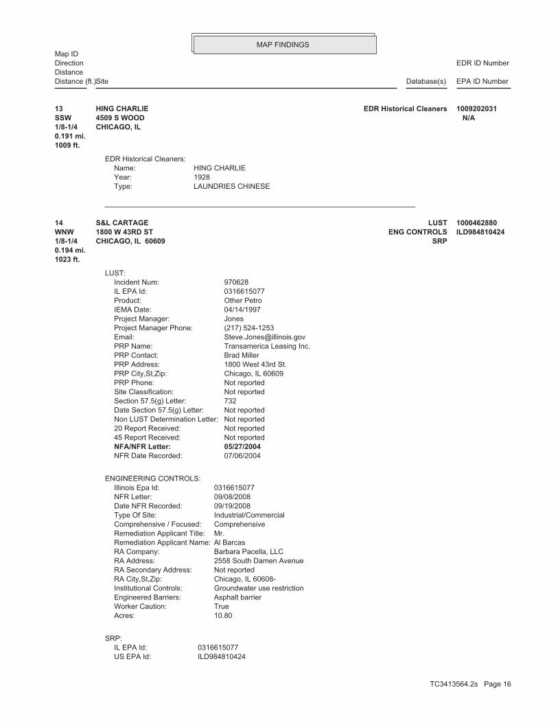
MAP FINDINGSMap ID
EDR ID NumberDirectionDistance
EPA ID NumberDatabase(s)SiteDistance (ft.)
LAUNDRIES CHINESEType: 1928Year: HING CHARLIEName:
EDR Historical Cleaners:
1009 ft.0.191 mi.1/8-1/4 CHICAGO, IL SSW 4509 S WOOD N/A13 EDR Historical CleanersHING CHARLIE 1009202031
ILD984810424US EPA Id: 0316615077IL EPA Id:
SRP:
10.80Acres: TrueWorker Caution: Asphalt barrierEngineered Barriers: Groundwater use restrictionInstitutional Controls: Chicago, IL 60608-RA City,St,Zip: Not reportedRA Secondary Address: 2558 South Damen AvenueRA Address: Barbara Pacella, LLCRA Company: Al BarcasRemediation Applicant Name: Mr.Remediation Applicant Title: ComprehensiveComprehensive / Focused: Industrial/CommercialType Of Site: 09/19/2008Date NFR Recorded: 09/08/2008NFR Letter: 0316615077Illinois Epa Id:
ENGINEERING CONTROLS:
07/06/2004NFR Date Recorded: 05/27/2004NFA/NFR Letter: Not reported45 Report Received: Not reported20 Report Received: Not reportedNon LUST Determination Letter: Not reportedDate Section 57.5(g) Letter: 732Section 57.5(g) Letter: Not reportedSite Classification: Not reportedPRP Phone: Chicago, IL 60609PRP City,St,Zip: 1800 West 43rd St.PRP Address: Brad MillerPRP Contact: Transamerica Leasing Inc.PRP Name: [email protected]: (217) 524-1253Project Manager Phone: JonesProject Manager: 04/14/1997IEMA Date: Other PetroProduct: 0316615077IL EPA Id: 970628Incident Num:
LUST:
1023 ft.0.194 mi.1/8-1/4 SRPCHICAGO, IL 60609WNW ENG CONTROLS1800 W 43RD ST ILD98481042414 LUSTS&L CARTAGE 1000462880
TC3413564.2s Page 16

MAP FINDINGSMap ID
EDR ID NumberDirectionDistance
EPA ID NumberDatabase(s)SiteDistance (ft.)
2558 South Damen AvenueRemediation Applicant Address: Barbara Pacella, LLCRemediation Applicant Company: Mr. Al BarcasRemediation Applicant Name:
10.80Acres: TrueWorker Caution: Not reportedBarrier: Groundwater use restrictionInstitutional Controls: FocusedComprehensive/Focused: Industrial/CommercialSite Type: 2004-07-06NFR Letter Date Recorded: 2004-05-27NFR Letter: Transamerica Leasing, Inc.Site Name: 0316615077Illinois EPA: Chicago, IL 60609-Remediation Applicant City,St,Zip: Not reportedRemediation Applicant Address 2: 1800 est 43rd StreetRemediation Applicant Address: MGM Acquisitions Company, Inc.Remediation Applicant Company: Vice President Charles GenoarRemediation Applicant Name:
10Acres: FalseWorker Caution: Not reportedBarrier: Groundwater use restrictionInstitutional Controls: FocusedComprehensive/Focused: Industrial/CommercialSite Type: 2000-11-02NFR Letter Date Recorded: 2000-09-22NFR Letter: TransAmerica Leasing FacilitySite Name: 0316615077Illinois EPA: Purchase, NY 10577-2135Remediation Applicant City,St,Zip: Not reportedRemediation Applicant Address 2: 100 Manhattanville RoadRemediation Applicant Address: TransAmerica Leasing, Inc.Remediation Applicant Company: Mr. Marc PearlinRemediation Applicant Name: Mr.Remediation Applicant Title: Barbara Pacella, LLCRemediation Applicant Co: 09/08/2008No Further Remediation Letter Dt: 10.80Total Acres: FalseActive: 09/19/2008NFR Recorded: Not reportedSec. 4 Letter Date: HallProj Mgr Assigned: (312) 922-1030Consultant Phone: Chicago, IL 60602-Consultant City,St,Zip: Suite 4250Consultant Address2: 70 West Madison StreetConsultant Address: Weaver Boos ConsultantsConsultant Company: Carolyn M. Feltz, P.E.Point Of Contact: 06/04/2001Date Enrolled: (773) 927-1300Contact Phone: Chicago, IL 60608-Contact City,St,Zip: Not reportedContact Address2: 2558 South Damen AvenueContact Address: Al BarcasContact Name: 41.81682Latitude: -87.67033Longitude:
S&L CARTAGE (Continued) 1000462880
TC3413564.2s Page 17

MAP FINDINGSMap ID
EDR ID NumberDirectionDistance
EPA ID NumberDatabase(s)SiteDistance (ft.)
1800 est 43rd StreetRemediation Applicant Address: MGM Acquisitions Company, Inc.Remediation Applicant Company: Vice President Charles GenoarRemediation Applicant Name:
10Acres: FalseWorker Caution: Not reportedBarrier: Groundwater use restrictionInstitutional Controls: FocusedComprehensive/Focused: Industrial/CommercialSite Type: 2000-11-02NFR Letter Date Recorded: 2000-09-22NFR Letter: TransAmerica Leasing FacilitySite Name: 0316615077Illinois EPA: Purchase, NY 10577-2135Remediation Applicant City,St,Zip: Not reportedRemediation Applicant Address 2: 100 Manhattanville RoadRemediation Applicant Address: TransAmerica Leasing, Inc.Remediation Applicant Company: Mr. Marc PearlinRemediation Applicant Name: Mr.Remediation Applicant Title: Barbara Pacella, LLCRemediation Applicant Co: 09/22/2000No Further Remediation Letter Dt: 10.80Total Acres: FalseActive: 11/02/2000NFR Recorded: Not reportedSec. 4 Letter Date: HallProj Mgr Assigned: (312) 922-1030Consultant Phone: Chicago, IL 60602-Consultant City,St,Zip: Suite 4250Consultant Address2: 70 West Madison StreetConsultant Address: Weaver Boos ConsultantsConsultant Company: Carolyn M. Feltz, P.E.Point Of Contact: 06/04/2001Date Enrolled: (773) 927-1300Contact Phone: Chicago, IL 60608-Contact City,St,Zip: Not reportedContact Address2: 2558 South Damen AvenueContact Address: Al BarcasContact Name: 41.81682Latitude: -87.67033Longitude: ILD984810424US EPA Id: 0316615077IL EPA Id:
10.80Acres: TrueWorker Caution: Asphalt barrierBarrier: Groundwater use restrictionInstitutional Controls: ComprehensiveComprehensive/Focused: Industrial/CommercialSite Type: 2008-09-19NFR Letter Date Recorded: 2008-09-08NFR Letter: Transamerica Leasing, IncSite Name: 0316615077Illinois EPA: Chicago, IL 60608-Remediation Applicant City,St,Zip: Not reportedRemediation Applicant Address 2:
S&L CARTAGE (Continued) 1000462880
TC3413564.2s Page 18

MAP FINDINGSMap ID
EDR ID NumberDirectionDistance
EPA ID NumberDatabase(s)SiteDistance (ft.)
100 Manhattanville RoadRemediation Applicant Address: TransAmerica Leasing, Inc.Remediation Applicant Company: Mr. Marc PearlinRemediation Applicant Name: Mr.Remediation Applicant Title: Barbara Pacella, LLCRemediation Applicant Co: 05/27/2004No Further Remediation Letter Dt: 10.80Total Acres: FalseActive: 07/06/2004NFR Recorded: Not reportedSec. 4 Letter Date: HallProj Mgr Assigned: (312) 922-1030Consultant Phone: Chicago, IL 60602-Consultant City,St,Zip: Suite 4250Consultant Address2: 70 West Madison StreetConsultant Address: Weaver Boos ConsultantsConsultant Company: Carolyn M. Feltz, P.E.Point Of Contact: 06/04/2001Date Enrolled: (773) 927-1300Contact Phone: Chicago, IL 60608-Contact City,St,Zip: Not reportedContact Address2: 2558 South Damen AvenueContact Address: Al BarcasContact Name: 41.81682Latitude: -87.67033Longitude: ILD984810424US EPA Id: 0316615077IL EPA Id:
10.80Acres: TrueWorker Caution: Asphalt barrierBarrier: Groundwater use restrictionInstitutional Controls: ComprehensiveComprehensive/Focused: Industrial/CommercialSite Type: 2008-09-19NFR Letter Date Recorded: 2008-09-08NFR Letter: Transamerica Leasing, IncSite Name: 0316615077Illinois EPA: Chicago, IL 60608-Remediation Applicant City,St,Zip: Not reportedRemediation Applicant Address 2: 2558 South Damen AvenueRemediation Applicant Address: Barbara Pacella, LLCRemediation Applicant Company: Mr. Al BarcasRemediation Applicant Name:
10.80Acres: TrueWorker Caution: Not reportedBarrier: Groundwater use restrictionInstitutional Controls: FocusedComprehensive/Focused: Industrial/CommercialSite Type: 2004-07-06NFR Letter Date Recorded: 2004-05-27NFR Letter: Transamerica Leasing, Inc.Site Name: 0316615077Illinois EPA: Chicago, IL 60609-Remediation Applicant City,St,Zip: Not reportedRemediation Applicant Address 2:
S&L CARTAGE (Continued) 1000462880
TC3413564.2s Page 19

MAP FINDINGSMap ID
EDR ID NumberDirectionDistance
EPA ID NumberDatabase(s)SiteDistance (ft.)
10.80Acres: TrueWorker Caution: Asphalt barrierBarrier: Groundwater use restrictionInstitutional Controls: ComprehensiveComprehensive/Focused: Industrial/CommercialSite Type: 2008-09-19NFR Letter Date Recorded: 2008-09-08NFR Letter: Transamerica Leasing, IncSite Name: 0316615077Illinois EPA: Chicago, IL 60608-Remediation Applicant City,St,Zip: Not reportedRemediation Applicant Address 2: 2558 South Damen AvenueRemediation Applicant Address: Barbara Pacella, LLCRemediation Applicant Company: Mr. Al BarcasRemediation Applicant Name:
10.80Acres: TrueWorker Caution: Not reportedBarrier: Groundwater use restrictionInstitutional Controls: FocusedComprehensive/Focused: Industrial/CommercialSite Type: 2004-07-06NFR Letter Date Recorded: 2004-05-27NFR Letter: Transamerica Leasing, Inc.Site Name: 0316615077Illinois EPA: Chicago, IL 60609-Remediation Applicant City,St,Zip: Not reportedRemediation Applicant Address 2: 1800 est 43rd StreetRemediation Applicant Address: MGM Acquisitions Company, Inc.Remediation Applicant Company: Vice President Charles GenoarRemediation Applicant Name:
10Acres: FalseWorker Caution: Not reportedBarrier: Groundwater use restrictionInstitutional Controls: FocusedComprehensive/Focused: Industrial/CommercialSite Type: 2000-11-02NFR Letter Date Recorded: 2000-09-22NFR Letter: TransAmerica Leasing FacilitySite Name: 0316615077Illinois EPA: Purchase, NY 10577-2135Remediation Applicant City,St,Zip: Not reportedRemediation Applicant Address 2:
S&L CARTAGE (Continued) 1000462880
SERVICE STATIONS GASOLINE AND OILType: 1981Year: KING OIL COMPANY INCName:
EDR Historical Auto Stations:
1023 ft. Site 2 of 2 in cluster E0.194 mi.1/8-1/4 CHICAGO, IL ESE 4453 S ASHLAND AVE N/AE15 EDR Historical Auto StationsKING OIL COMPANY INC 1009075862
TC3413564.2s Page 20

MAP FINDINGSMap ID
EDR ID NumberDirectionDistance
EPA ID NumberDatabase(s)SiteDistance (ft.)
4 additional US_TRIS: record(s) in the EDR Site Report.Click this hyperlink while viewing on your computer to access
TRIS:
1051 ft.0.199 mi.1/8-1/4 CHICAGO, IL 60609West 4342 S WOLCOTT AVE 60609LCLCN4316 TRISALCOLAC INC 1000333432
Not reportedNFR Date Recorded: Not reportedNFA/NFR Letter: 11/22/199345 Report Received: 04/29/199320 Report Received: Not reportedNon LUST Determination Letter: Not reportedDate Section 57.5(g) Letter: 731Section 57.5(g) Letter: Not reportedSite Classification: Not reportedPRP Phone: Phoenix, AZ 85077PRP City,St,Zip: 1850 North Central Ave.PRP Address: Kenneth RiesPRP Contact: VIAD Corp.PRP Name: [email protected]: (217) 524-4649Project Manager Phone: BenantiProject Manager: 01/15/1993IEMA Date: GasolineProduct: 0316615143IL EPA Id: 930157Incident Num:
LUST:
1057 ft. Site 3 of 3 in cluster D0.200 mi.1/8-1/4 CHICAGO, IL 60609East 1555 W 44TH ST IL0000036269D17 LUSTGES EXPOSITION SVCS 1000861076
AUTOMOBILE GARAGESType: 1928Year: WILSON COName:
EDR Historical Auto Stations:
1083 ft. Site 1 of 2 in cluster F0.205 mi.1/8-1/4 CHICAGO, IL NNE 4225 S MARSHFIELD AV N/AF18 EDR Historical Auto StationsWILSON CO 1009105968
TC3413564.2s Page 21

MAP FINDINGSMap ID
EDR ID NumberDirectionDistance
EPA ID NumberDatabase(s)SiteDistance (ft.)
11/17/2008NFR Date Recorded: 10/22/2008NFA/NFR Letter: 03/12/200845 Report Received: 12/20/200620 Report Received: Not reportedNon LUST Determination Letter: Not reportedDate Section 57.5(g) Letter: 734Section 57.5(g) Letter: Not reportedSite Classification: Not reportedPRP Phone: Not reportedPRP City,St,Zip: Not reportedPRP Address: Not reportedPRP Contact: Not reportedPRP Name: [email protected]: (217) 557-8763Project Manager Phone: SchwartzkopfProject Manager: 12/05/2006IEMA Date: GasolineProduct: 0316616454IL EPA Id: 20061524Incident Num:
LUST:
1139 ft. Site 2 of 2 in cluster F0.216 mi.1/8-1/4 CHICAGO, IL 60609NNE 4215-4229 SOUTH MARSHFIELD N/AF19 LUSTTREMBACKI, DAVID S108255704
LAUNDRIES CHINESEType: 1928Year: KEE TOMName:
EDR Historical Cleaners:
1181 ft.0.224 mi.1/8-1/4 CHICAGO, IL SE 1611 W 45TH N/A20 EDR Historical CleanersKEE TOM 1009198758
CLEANERS AND DYERS CONTDType: 1923Year: SWISS CLEANERS DYERSName:
EDR Historical Cleaners:
1261 ft.0.239 mi.1/8-1/4 CHICAGO, IL East 1542 44 W 51ST N/A21 EDR Historical CleanersSWISS CLEANERS DYERS 1009212255
TC3413564.2s Page 22

MAP FINDINGSMap ID
EDR ID NumberDirectionDistance
EPA ID NumberDatabase(s)SiteDistance (ft.)
AUTOMOBILE GARAGESType: 1928Year: JAKUBOROSKI ALBERTName:
EDR Historical Auto Stations:
1261 ft. Site 1 of 2 in cluster G0.239 mi.1/8-1/4 CHICAGO, IL SSE 4546 S MARSHFIELD AV N/AG22 EDR Historical Auto StationsJAKUBOROSKI ALBERT 1009103496
AUTOMOBILE GARAGESType: 1928Year: KOZAL JOHNName:
EDR Historical Auto Stations:
1266 ft.0.240 mi.1/8-1/4 CHICAGO, IL SSW 4527 S HONORE N/A23 EDR Historical Auto StationsKOZAL JOHN 1009105579
AUTOMOBILE REPAIR AND SERVICEType: 2003Year: TOWN OF LAKE GARAGEName:
EDR Historical Auto Stations:
1312 ft. Site 2 of 2 in cluster G0.248 mi.1/8-1/4 CHICAGO, IL SSE 4555 S MARSHFIELD AVE N/AG24 EDR Historical Auto StationsTOWN OF LAKE GARAGE 1009072977
01/21/200420 Report Received: Not reportedNon LUST Determination Letter: Not reportedDate Section 57.5(g) Letter: P.A.Section 57.5(g) Letter: Not reportedSite Classification: Not reportedPRP Phone: Not reportedPRP City,St,Zip: Not reportedPRP Address: Not reportedPRP Contact: Not reportedPRP Name: [email protected]: (217) 524-4649Project Manager Phone: BenantiProject Manager: 01/09/2004IEMA Date: Other PetroProduct: 0316616400IL EPA Id: 20040029Incident Num:
LUST:
1395 ft.0.264 mi.1/4-1/2 CHICAGO, IL 60609NE 4200 SOUTH ASHLAND AVENUE N/A25 LUST42 ASHLAND VENTURE LLC S106132068
TC3413564.2s Page 23

MAP FINDINGSMap ID
EDR ID NumberDirectionDistance
EPA ID NumberDatabase(s)SiteDistance (ft.)
10/04/2004NFR Date Recorded: 05/17/2004NFA/NFR Letter: 02/09/200445 Report Received:
42 ASHLAND VENTURE LLC (Continued) S106132068
08/18/2000NFR Date Recorded: 05/30/2000NFA/NFR Letter: 09/24/199245 Report Received: 06/15/199220 Report Received: Not reportedNon LUST Determination Letter: Not reportedDate Section 57.5(g) Letter: 731Section 57.5(g) Letter: Not reportedSite Classification: Not reportedPRP Phone: Chicago, IL 60616PRP City,St,Zip: 1723 South Michigan Ave.PRP Address: Edith LeonianPRP Contact: Concessions Services Inc.PRP Name: [email protected]: (217) 524-3312Project Manager Phone: HeatonProject Manager: 03/16/1992IEMA Date: Gasoline, DeiselProduct: 0316155092IL EPA Id: 920698Incident Num:
LUST:
1676 ft.0.317 mi.1/4-1/2 CHICAGO, IL 60641NNE 4132 SOUTH ASHLAND AVE. N/A26 LUSTCONCESSIONS SERVICES INC. S104564091
04/15/199420 Report Received: 1995-02-24Non LUST Determination Letter: Not reportedDate Section 57.5(g) Letter: 732Section 57.5(g) Letter: Not reportedSite Classification: Not reportedPRP Phone: Des Plaines, IL 60018PRP City,St,Zip: 1750 South Wolf Rd.PRP Address: Marilee TataliasPRP Contact: Dry Storage Corp.PRP Name: [email protected]: (217) 524-7650Project Manager Phone: HarlowProject Manager: 03/28/1994IEMA Date: Gasoline, DeiselProduct: 0316615168IL EPA Id: 940652Incident Num:
LUST:
1766 ft.0.334 mi.1/4-1/2 CHICAGO, IL 60609WNW 2005 WEST 43RD ST. N/A27 LUSTDRY STORAGE CORP. 1001919704
TC3413564.2s Page 24

MAP FINDINGSMap ID
EDR ID NumberDirectionDistance
EPA ID NumberDatabase(s)SiteDistance (ft.)
Not reportedNFR Date Recorded: Not reportedNFA/NFR Letter: 01/09/199545 Report Received:
DRY STORAGE CORP. (Continued) 1001919704
Not reportedOwner/operator telephone: USOwner/operator country: CHICAGO, IL 60609 1445 W 42ND STOwner/operator address: CLEAN HARBORS RECYCLING SVCSOwner/operator name:
Not reportedOwner/Op end date: 03/21/2008Owner/Op start date: OperatorOwner/Operator Type: PrivateLegal status: Not reportedOwner/operator telephone: USOwner/operator country: CHICAGO, IL 60609 1445 W 42ND STOwner/operator address: CLEAN HARBORS RSC LLCOwner/operator name:
Owner/Operator Summary:
100 kg of that material at any time hazardous waste during any calendar month, and accumulates more than from the cleanup of a spill, into or on any land or water, of acutely of any residue or contaminated soil, waste or other debris resulting kg of acutely hazardous waste at any time; or generates 100 kg or less hazardous waste during any calendar month, and accumulates more than 1 waste during any calendar month; or generates 1 kg or less of acutely cleanup of a spill, into or on any land or water, of acutely hazardous residue or contaminated soil, waste or other debris resulting from the during any calendar month; or generates more than 100 kg of any calendar month; or generates more than 1 kg of acutely hazardous waste Handler: generates 1,000 kg or more of hazardous waste during anyDescription: Large Quantity GeneratorClassification: waste Handler is engaged in the treatment, storage or disposal of hazardousDescription: TSDFClassification: PrivateLand type: 05EPA Region: Not reportedContact email: (773) 247-2828Contact telephone: Not reportedContact country: Not reported Not reportedContact address: GARY MALINOWSKIContact: ILD005450697EPA ID: CHICAGO, IL 60609 1445 W 42ND STFacility address: CLEAN HARBORS RSC LLCFacility name: 03/01/2010Date form received by agency:
RCRA-TSDF:
1799 ft. Site 1 of 2 in cluster H0.341 mi.1/4-1/2 CORRACTSCHICAGO, IL 60609ENE CERC-NFRAP1445 W 42ND ST ILD005450697H28 RCRA-TSDFCUSTOM ORGANICS INC 1000415786
TC3413564.2s Page 25

MAP FINDINGSMap ID
EDR ID NumberDirectionDistance
EPA ID NumberDatabase(s)SiteDistance (ft.)
NoUser oil refiner: NoUsed oil processor: NoUsed oil fuel burner: NoFurnace exemption: NoOn-site burner exemption: NoUnderground injection activity: YesTreater, storer or disposer of HW: NoTransporter of hazardous waste: YesRecycler of hazardous waste: NoMixed waste (haz. and radioactive): NoU.S. importer of hazardous waste:
Handler Activities Summary:
Not reportedOwner/Op end date: Not reportedOwner/Op start date: OwnerOwner/Operator Type: PrivateLegal status: (312) 247-2828Owner/operator telephone: Not reportedOwner/operator country: CHICAGO, IL 60609 1445 W 42ND STOwner/operator address: SAFETY KLEEN CORPOwner/operator name:
Not reportedOwner/Op end date: 04/03/2008Owner/Op start date: OwnerOwner/Operator Type: PrivateLegal status: Not reportedOwner/operator telephone: USOwner/operator country: NORWELL, PA 02061 42 LONGWATER DROwner/operator address: CLEAN HARBORS RECYCLING SVCSOwner/operator name:
Not reportedOwner/Op end date: Not reportedOwner/Op start date: OperatorOwner/Operator Type: PrivateLegal status: (312) 247-2828Owner/operator telephone: Not reportedOwner/operator country: CITY NOT REPORTED, IL 99998 1445 W 42ND STOwner/operator address: CUSTOM ORGANICS INCOwner/operator name:
Not reportedOwner/Op end date: 03/21/2008Owner/Op start date: OwnerOwner/Operator Type: PrivateLegal status: Not reportedOwner/operator telephone: USOwner/operator country: NORWELL, MA 02061 42 LONGWATER DR P O BOX 9149Owner/operator address: CLEAN HARBORS RSC LLCOwner/operator name:
Not reportedOwner/Op end date: 04/03/2008Owner/Op start date: OperatorOwner/Operator Type: PrivateLegal status:
CUSTOM ORGANICS INC (Continued) 1000415786
TC3413564.2s Page 26

MAP FINDINGSMap ID
EDR ID NumberDirectionDistance
EPA ID NumberDatabase(s)SiteDistance (ft.)
CLEAN HARBORS RSC LLCFacility name: 02/28/1990Date form received by agency:
Large Quantity GeneratorClassification: SAFETY-KLEEN CORPSite name: CLEAN HARBORS RSC LLCFacility name: 03/01/1992Date form received by agency:
Large Quantity GeneratorClassification: SAFETY-KLEEN CORPSite name: CLEAN HARBORS RSC LLCFacility name: 03/01/1994Date form received by agency:
Large Quantity GeneratorClassification: SAFETY-KLEEN CORPSite name: CLEAN HARBORS RSC LLCFacility name: 03/01/1996Date form received by agency:
Large Quantity GeneratorClassification: SAFETY-KLEEN CORPSite name: CLEAN HARBORS RSC LLCFacility name: 03/01/1998Date form received by agency:
Large Quantity GeneratorClassification: SAFETY-KLEEN CORPSite name: CLEAN HARBORS RSC LLCFacility name: 03/01/2000Date form received by agency:
Large Quantity GeneratorClassification: SAFETY-KLEEN CORPSite name: CLEAN HARBORS RSC LLCFacility name: 03/01/2002Date form received by agency:
Large Quantity GeneratorClassification: SAFETY-KLEEN CORPSite name: CLEAN HARBORS RSC LLCFacility name: 03/01/2004Date form received by agency:
Large Quantity GeneratorClassification: SAFETY-KLEEN CORPSite name: CLEAN HARBORS RSC LLCFacility name: 03/01/2006Date form received by agency:
Large Quantity GeneratorClassification: CLEAN HARBORS RSC LLCFacility name: 03/01/2008Date form received by agency:
Large Quantity GeneratorClassification: CLEAN HARBORS RECYCLING SVCSSite name: CLEAN HARBORS RSC LLCFacility name: 04/03/2008Date form received by agency:
Historical Generators:
NoUsed oil transporter: NoUsed oil transfer facility: NoUsed oil Specification marketer: NoUsed oil fuel marketer to burner:
CUSTOM ORGANICS INC (Continued) 1000415786
TC3413564.2s Page 27

MAP FINDINGSMap ID
EDR ID NumberDirectionDistance
EPA ID NumberDatabase(s)SiteDistance (ft.)
F004Waste code:
MIXTURES. BOTTOMS FROM THE RECOVERY OF THESE SPENT SOLVENTS AND SPENT SOLVENT MORE OF THOSE SOLVENTS LISTED IN F001, F002, F004, AND F005, AND STILL SOLVENTS, AND, A TOTAL OF TEN PERCENT OR MORE (BY VOLUME) OF ONE OR CONTAINING, BEFORE USE, ONE OR MORE OF THE ABOVE NON-HALOGENATED NON-HALOGENATED SOLVENTS; AND ALL SPENT SOLVENT MIXTURES/BLENDS MIXTURES/BLENDS CONTAINING, BEFORE USE, ONLY THE ABOVE SPENT ALCOHOL, CYCLOHEXANONE, AND METHANOL; ALL SPENT SOLVENT ACETATE, ETHYL BENZENE, ETHYL ETHER, METHYL ISOBUTYL KETONE, N-BUTYL THE FOLLOWING SPENT NON-HALOGENATED SOLVENTS: XYLENE, ACETONE, ETHYLWaste name: F003Waste code:
SPENT SOLVENT MIXTURES. F005, AND STILL BOTTOMS FROM THE RECOVERY OF THESE SPENT SOLVENTS AND OF THE ABOVE HALOGENATED SOLVENTS OR THOSE LISTED IN F001, F004, OR BEFORE USE, A TOTAL OF TEN PERCENT OR MORE (BY VOLUME) OF ONE OR MORE 1,1,2-TRICHLOROETHANE; ALL SPENT SOLVENT MIXTURES/BLENDS CONTAINING, ORTHO-DICHLOROBENZENE, TRICHLOROFLUOROMETHANE, AND CHLOROBENZENE, 1,1,2-TRICHLORO-1,2,2-TRIFLUOROETHANE, METHYLENE CHLORIDE, TRICHLOROETHYLENE, 1,1,1-TRICHLOROETHANE, THE FOLLOWING SPENT HALOGENATED SOLVENTS: TETRACHLOROETHYLENE,Waste name: F002Waste code:
SPENT SOLVENTS AND SPENT SOLVENT MIXTURES. IN F002, F004, AND F005, AND STILL BOTTOMS FROM THE RECOVERY OF THESE ONE OR MORE OF THE ABOVE HALOGENATED SOLVENTS OR THOSE SOLVENTS LISTED CONTAINING, BEFORE USE, A TOTAL OF TEN PERCENT OR MORE (BY VOLUME) OF FLUOROCARBONS; ALL SPENT SOLVENT MIXTURES/BLENDS USED IN DEGREASING 1,1,1-TRICHLOROETHANE, CARBON TETRACHLORIDE, AND CHLORINATED TETRACHLOROETHYLENE, TRICHLOROETHYLENE, METHYLENE CHLORIDE, THE FOLLOWING SPENT HALOGENATED SOLVENTS USED IN DEGREASING:Waste name: F001Waste code:
WHICH WOULD BE CONSIDERED AS IGNITABLE HAZARDOUS WASTE. MATERIAL. LACQUER THINNER IS AN EXAMPLE OF A COMMONLY USED SOLVENT WHICH CAN BE OBTAINED FROM THE MANUFACTURER OR DISTRIBUTOR OF THE FLASH POINT OF A WASTE IS TO REVIEW THE MATERIAL SAFETY DATA SHEET, CLOSED CUP FLASH POINT TESTER. ANOTHER METHOD OF DETERMINING THE LESS THAN 140 DEGREES FAHRENHEIT AS DETERMINED BY A PENSKY-MARTENS IGNITABLE HAZARDOUS WASTES ARE THOSE WASTES WHICH HAVE A FLASHPOINT OFWaste name: D001Waste code:
Hazardous Waste Summary:
Large Quantity GeneratorClassification: SAFETY KLEEN CORP CHGO RCSite name: CLEAN HARBORS RSC LLCFacility name: 08/05/1980Date form received by agency:
Not a generator, verifiedClassification: SAFETY KLEEN CORP CHGO RCSite name: CLEAN HARBORS RSC LLCFacility name: 11/19/1980Date form received by agency:
Large Quantity GeneratorClassification: SAFETY-KLEEN CORPSite name:
CUSTOM ORGANICS INC (Continued) 1000415786
TC3413564.2s Page 28

MAP FINDINGSMap ID
EDR ID NumberDirectionDistance
EPA ID NumberDatabase(s)SiteDistance (ft.)
ETHANE, 1,1,1-TRICHLORO-Waste name: U226Waste code:
BENZENE, METHYL-Waste name: U220Waste code:
FURAN, TETRAHYDRO-(I)Waste name: U213Waste code:
ETHENE, TETRACHLORO-Waste name: U210Waste code:
PHENOLWaste name: U188Waste code:
NAPHTHALENEWaste name: U165Waste code:
METHYL METHACRYLATE (I,T)Waste name: U162Waste code:
METHYL ISOBUTYL KETONE (I)Waste name: U161Waste code:
2-BUTANONE (I,T)Waste name: U159Waste code:
METHANOL (I)Waste name: U154Waste code:
ISOBUTYL ALCOHOL (I,T)Waste name: U140Waste code:
2-FURANCARBOXALDEHYDE (I)Waste name: U125Waste code:
FURAN (I)Waste name: U124Waste code:
METHANE, TRICHLOROFLUORO-Waste name: U121Waste code:
THESE SPENT SOLVENTS AND SPENT SOLVENT MIXTURES. LISTED IN F001, F002, OR F004; AND STILL BOTTOMS FROM THE RECOVERY OF ONE OR MORE OF THE ABOVE NON-HALOGENATED SOLVENTS OR THOSE SOLVENTS CONTAINING, BEFORE USE, A TOTAL OF TEN PERCENT OR MORE (BY VOLUME) OF 2-ETHOXYETHANOL, AND 2-NITROPROPANE; ALL SPENT SOLVENT MIXTURES/BLENDS KETONE, CARBON DISULFIDE, ISOBUTANOL, PYRIDINE, BENZENE, THE FOLLOWING SPENT NON-HALOGENATED SOLVENTS: TOLUENE, METHYL ETHYLWaste name: F005Waste code:
SPENT SOLVENTS AND SPENT SOLVENT MIXTURES. F001, F002, AND F005; AND STILL BOTTOMS FROM THE RECOVERY OF THESE OF THE ABOVE NON-HALOGENATED SOLVENTS OR THOSE SOLVENTS LISTED IN BEFORE USE, A TOTAL OF TEN PERCENT OR MORE (BY VOLUME) OF ONE OR MORE ACID, AND NITROBENZENE; ALL SPENT SOLVENT MIXTURES/BLENDS CONTAINING, THE FOLLOWING SPENT NON-HALOGENATED SOLVENTS: CRESOLS AND CRESYLICWaste name:
CUSTOM ORGANICS INC (Continued) 1000415786
TC3413564.2s Page 29

MAP FINDINGSMap ID
EDR ID NumberDirectionDistance
EPA ID NumberDatabase(s)SiteDistance (ft.)
LISTED IN F001, F002, OR F004; AND STILL BOTTOMS FROM THE RECOVERY OF ONE OR MORE OF THE ABOVE NON-HALOGENATED SOLVENTS OR THOSE SOLVENTS CONTAINING, BEFORE USE, A TOTAL OF TEN PERCENT OR MORE (BY VOLUME) OF 2-ETHOXYETHANOL, AND 2-NITROPROPANE; ALL SPENT SOLVENT MIXTURES/BLENDS KETONE, CARBON DISULFIDE, ISOBUTANOL, PYRIDINE, BENZENE, THE FOLLOWING SPENT NON-HALOGENATED SOLVENTS: TOLUENE, METHYL ETHYLWaste name: F005Waste code:
MIXTURES. BOTTOMS FROM THE RECOVERY OF THESE SPENT SOLVENTS AND SPENT SOLVENT MORE OF THOSE SOLVENTS LISTED IN F001, F002, F004, AND F005, AND STILL SOLVENTS, AND, A TOTAL OF TEN PERCENT OR MORE (BY VOLUME) OF ONE OR CONTAINING, BEFORE USE, ONE OR MORE OF THE ABOVE NON-HALOGENATED NON-HALOGENATED SOLVENTS; AND ALL SPENT SOLVENT MIXTURES/BLENDS MIXTURES/BLENDS CONTAINING, BEFORE USE, ONLY THE ABOVE SPENT ALCOHOL, CYCLOHEXANONE, AND METHANOL; ALL SPENT SOLVENT ACETATE, ETHYL BENZENE, ETHYL ETHER, METHYL ISOBUTYL KETONE, N-BUTYL THE FOLLOWING SPENT NON-HALOGENATED SOLVENTS: XYLENE, ACETONE, ETHYLWaste name: F003Waste code:
SPENT SOLVENT MIXTURES. F005, AND STILL BOTTOMS FROM THE RECOVERY OF THESE SPENT SOLVENTS AND OF THE ABOVE HALOGENATED SOLVENTS OR THOSE LISTED IN F001, F004, OR BEFORE USE, A TOTAL OF TEN PERCENT OR MORE (BY VOLUME) OF ONE OR MORE 1,1,2-TRICHLOROETHANE; ALL SPENT SOLVENT MIXTURES/BLENDS CONTAINING, ORTHO-DICHLOROBENZENE, TRICHLOROFLUOROMETHANE, AND CHLOROBENZENE, 1,1,2-TRICHLORO-1,2,2-TRIFLUOROETHANE, METHYLENE CHLORIDE, TRICHLOROETHYLENE, 1,1,1-TRICHLOROETHANE, THE FOLLOWING SPENT HALOGENATED SOLVENTS: TETRACHLOROETHYLENE,Waste name: F002Waste code:
METHYL ETHYL KETONEWaste name: D035Waste code:
DISPOSED, THE WASTE WOULD BE A CORROSIVE HAZARDOUS WASTE. THESE CAUSTIC OR ACID SOLUTIONS BECOME CONTAMINATED AND MUST BE USED BY MANY INDUSTRIES TO CLEAN METAL PARTS PRIOR TO PAINTING. WHEN OR DEGREASE PARTS. HYDROCHLORIC ACID, A SOLUTION WITH A LOW PH, IS CAUSTIC SOLUTION WITH A HIGH PH, IS OFTEN USED BY INDUSTRIES TO CLEAN CONSIDERED TO BE A CORROSIVE HAZARDOUS WASTE. SODIUM HYDROXIDE, A A WASTE WHICH HAS A PH OF LESS THAN 2 OR GREATER THAN 12.5 ISWaste name: D002Waste code:
WHICH WOULD BE CONSIDERED AS IGNITABLE HAZARDOUS WASTE. MATERIAL. LACQUER THINNER IS AN EXAMPLE OF A COMMONLY USED SOLVENT WHICH CAN BE OBTAINED FROM THE MANUFACTURER OR DISTRIBUTOR OF THE FLASH POINT OF A WASTE IS TO REVIEW THE MATERIAL SAFETY DATA SHEET, CLOSED CUP FLASH POINT TESTER. ANOTHER METHOD OF DETERMINING THE LESS THAN 140 DEGREES FAHRENHEIT AS DETERMINED BY A PENSKY-MARTENS IGNITABLE HAZARDOUS WASTES ARE THOSE WASTES WHICH HAVE A FLASHPOINT OFWaste name: D001Waste code:
BENZENE, DIMETHYL- (I,T)Waste name: U239Waste code:
ETHENE, TRICHLORO-Waste name: U228Waste code:
CUSTOM ORGANICS INC (Continued) 1000415786
TC3413564.2s Page 30

MAP FINDINGSMap ID
EDR ID NumberDirectionDistance
EPA ID NumberDatabase(s)SiteDistance (ft.)
D034Waste code:
HEXACHLOROBUTADIENEWaste name: D033Waste code:
HEXACHLOROBENZENEWaste name: D032Waste code:
2,4-DINITROTOLUENEWaste name: D030Waste code:
1,1-DICHLOROETHYLENEWaste name: D029Waste code:
1,2-DICHLOROETHANEWaste name: D028Waste code:
1,4-DICHLOROBENZENEWaste name: D027Waste code:
CRESOLWaste name: D026Waste code:
P-CRESOLWaste name: D025Waste code:
M-CRESOLWaste name: D024Waste code:
O-CRESOLWaste name: D023Waste code:
CHLOROFORMWaste name: D022Waste code:
CHLOROBENZENEWaste name: D021Waste code:
CHLORDANEWaste name: D020Waste code:
CARBON TETRACHLORIDEWaste name: D019Waste code:
BENZENEWaste name: D018Waste code:
WHICH WOULD BE CONSIDERED AS IGNITABLE HAZARDOUS WASTE. MATERIAL. LACQUER THINNER IS AN EXAMPLE OF A COMMONLY USED SOLVENT WHICH CAN BE OBTAINED FROM THE MANUFACTURER OR DISTRIBUTOR OF THE FLASH POINT OF A WASTE IS TO REVIEW THE MATERIAL SAFETY DATA SHEET, CLOSED CUP FLASH POINT TESTER. ANOTHER METHOD OF DETERMINING THE LESS THAN 140 DEGREES FAHRENHEIT AS DETERMINED BY A PENSKY-MARTENS IGNITABLE HAZARDOUS WASTES ARE THOSE WASTES WHICH HAVE A FLASHPOINT OFWaste name: D001Waste code:
THESE SPENT SOLVENTS AND SPENT SOLVENT MIXTURES.
CUSTOM ORGANICS INC (Continued) 1000415786
TC3413564.2s Page 31

MAP FINDINGSMap ID
EDR ID NumberDirectionDistance
EPA ID NumberDatabase(s)SiteDistance (ft.)
BOTTOMS FROM THE RECOVERY OF THESE SPENT SOLVENTS AND SPENT SOLVENT MORE OF THOSE SOLVENTS LISTED IN F001, F002, F004, AND F005, AND STILL SOLVENTS, AND, A TOTAL OF TEN PERCENT OR MORE (BY VOLUME) OF ONE OR CONTAINING, BEFORE USE, ONE OR MORE OF THE ABOVE NON-HALOGENATED NON-HALOGENATED SOLVENTS; AND ALL SPENT SOLVENT MIXTURES/BLENDS MIXTURES/BLENDS CONTAINING, BEFORE USE, ONLY THE ABOVE SPENT ALCOHOL, CYCLOHEXANONE, AND METHANOL; ALL SPENT SOLVENT ACETATE, ETHYL BENZENE, ETHYL ETHER, METHYL ISOBUTYL KETONE, N-BUTYL THE FOLLOWING SPENT NON-HALOGENATED SOLVENTS: XYLENE, ACETONE, ETHYLWaste name: F003Waste code:
SPENT SOLVENT MIXTURES. F005, AND STILL BOTTOMS FROM THE RECOVERY OF THESE SPENT SOLVENTS AND OF THE ABOVE HALOGENATED SOLVENTS OR THOSE LISTED IN F001, F004, OR BEFORE USE, A TOTAL OF TEN PERCENT OR MORE (BY VOLUME) OF ONE OR MORE 1,1,2-TRICHLOROETHANE; ALL SPENT SOLVENT MIXTURES/BLENDS CONTAINING, ORTHO-DICHLOROBENZENE, TRICHLOROFLUOROMETHANE, AND CHLOROBENZENE, 1,1,2-TRICHLORO-1,2,2-TRIFLUOROETHANE, METHYLENE CHLORIDE, TRICHLOROETHYLENE, 1,1,1-TRICHLOROETHANE, THE FOLLOWING SPENT HALOGENATED SOLVENTS: TETRACHLOROETHYLENE,Waste name: F002Waste code:
SPENT SOLVENTS AND SPENT SOLVENT MIXTURES. IN F002, F004, AND F005, AND STILL BOTTOMS FROM THE RECOVERY OF THESE ONE OR MORE OF THE ABOVE HALOGENATED SOLVENTS OR THOSE SOLVENTS LISTED CONTAINING, BEFORE USE, A TOTAL OF TEN PERCENT OR MORE (BY VOLUME) OF FLUOROCARBONS; ALL SPENT SOLVENT MIXTURES/BLENDS USED IN DEGREASING 1,1,1-TRICHLOROETHANE, CARBON TETRACHLORIDE, AND CHLORINATED TETRACHLOROETHYLENE, TRICHLOROETHYLENE, METHYLENE CHLORIDE, THE FOLLOWING SPENT HALOGENATED SOLVENTS USED IN DEGREASING:Waste name: F001Waste code:
2,4,6-TRICHLOROPHENOLWaste name: D042Waste code:
2,4,5-TRICHLOROPHENOLWaste name: D041Waste code:
TRICHLOROETHYLENEWaste name: D040Waste code:
TETRACHLOROETHYLENEWaste name: D039Waste code:
PYRIDINEWaste name: D038Waste code:
PENTRACHLOROPHENOLWaste name: D037Waste code:
NITROBENZENEWaste name: D036Waste code:
METHYL ETHYL KETONEWaste name: D035Waste code:
HEXACHLOROETHANEWaste name:
CUSTOM ORGANICS INC (Continued) 1000415786
TC3413564.2s Page 32

MAP FINDINGSMap ID
EDR ID NumberDirectionDistance
EPA ID NumberDatabase(s)SiteDistance (ft.)
PHENOLWaste name: U188Waste code:
NAPHTHALENEWaste name: U165Waste code:
METHYL METHACRYLATE (I,T)Waste name: U162Waste code:
METHYL ISOBUTYL KETONE (I)Waste name: U161Waste code:
2-BUTANONE (I,T)Waste name: U159Waste code:
METHANOL (I)Waste name: U154Waste code:
ISOBUTYL ALCOHOL (I,T)Waste name: U140Waste code:
2-FURANCARBOXALDEHYDE (I)Waste name: U125Waste code:
FURAN (I)Waste name: U124Waste code:
METHANE, TRICHLOROFLUORO-Waste name: U121Waste code:
F028). HAZARDOUS WASTES NUMBER(S): F020, F021, F022, F026, F027, AND/OR HAZARDOUS WASTES AND NO OTHER HAZARDOUS WASTES RETAINS ITS EPA RESULTING FROM THE DISPOSAL OF ONE OR MORE OF THE FOLLOWING EPA CLASSIFIED AS HAZARDOUS UNDER SUBPART D OF THIS PART. (LEACHATE RESULTING FROM THE DISPOSAL OF MORE THAN ONE RESTRICTED WASTE LEACHATE (LIQUIDS THAT HAVE PERCOLATED THROUGH LAND DISPOSED WASTES)Waste name: F039Waste code:
THESE SPENT SOLVENTS AND SPENT SOLVENT MIXTURES. LISTED IN F001, F002, OR F004; AND STILL BOTTOMS FROM THE RECOVERY OF ONE OR MORE OF THE ABOVE NON-HALOGENATED SOLVENTS OR THOSE SOLVENTS CONTAINING, BEFORE USE, A TOTAL OF TEN PERCENT OR MORE (BY VOLUME) OF 2-ETHOXYETHANOL, AND 2-NITROPROPANE; ALL SPENT SOLVENT MIXTURES/BLENDS KETONE, CARBON DISULFIDE, ISOBUTANOL, PYRIDINE, BENZENE, THE FOLLOWING SPENT NON-HALOGENATED SOLVENTS: TOLUENE, METHYL ETHYLWaste name: F005Waste code:
SPENT SOLVENTS AND SPENT SOLVENT MIXTURES. F001, F002, AND F005; AND STILL BOTTOMS FROM THE RECOVERY OF THESE OF THE ABOVE NON-HALOGENATED SOLVENTS OR THOSE SOLVENTS LISTED IN BEFORE USE, A TOTAL OF TEN PERCENT OR MORE (BY VOLUME) OF ONE OR MORE ACID, AND NITROBENZENE; ALL SPENT SOLVENT MIXTURES/BLENDS CONTAINING, THE FOLLOWING SPENT NON-HALOGENATED SOLVENTS: CRESOLS AND CRESYLICWaste name: F004Waste code:
MIXTURES.
CUSTOM ORGANICS INC (Continued) 1000415786
TC3413564.2s Page 33

MAP FINDINGSMap ID
EDR ID NumberDirectionDistance
EPA ID NumberDatabase(s)SiteDistance (ft.)
1,4-DICHLOROBENZENEWaste name: D027Waste code:
CRESOLWaste name: D026Waste code:
P-CRESOLWaste name: D025Waste code:
M-CRESOLWaste name: D024Waste code:
O-CRESOLWaste name: D023Waste code:
CHLOROFORMWaste name: D022Waste code:
CHLOROBENZENEWaste name: D021Waste code:
CHLORDANEWaste name: D020Waste code:
CARBON TETRACHLORIDEWaste name: D019Waste code:
BENZENEWaste name: D018Waste code:
WHICH WOULD BE CONSIDERED AS IGNITABLE HAZARDOUS WASTE. MATERIAL. LACQUER THINNER IS AN EXAMPLE OF A COMMONLY USED SOLVENT WHICH CAN BE OBTAINED FROM THE MANUFACTURER OR DISTRIBUTOR OF THE FLASH POINT OF A WASTE IS TO REVIEW THE MATERIAL SAFETY DATA SHEET, CLOSED CUP FLASH POINT TESTER. ANOTHER METHOD OF DETERMINING THE LESS THAN 140 DEGREES FAHRENHEIT AS DETERMINED BY A PENSKY-MARTENS IGNITABLE HAZARDOUS WASTES ARE THOSE WASTES WHICH HAVE A FLASHPOINT OFWaste name: D001Waste code:
BENZENE, DIMETHYL- (I,T)Waste name: U239Waste code:
ETHENE, TRICHLORO-Waste name: U228Waste code:
ETHANE, 1,1,1-TRICHLORO-Waste name: U226Waste code:
BENZENE, METHYL-Waste name: U220Waste code:
FURAN, TETRAHYDRO-(I)Waste name: U213Waste code:
ETHENE, TETRACHLORO-Waste name: U210Waste code:
CUSTOM ORGANICS INC (Continued) 1000415786
TC3413564.2s Page 34

MAP FINDINGSMap ID
EDR ID NumberDirectionDistance
EPA ID NumberDatabase(s)SiteDistance (ft.)
ORTHO-DICHLOROBENZENE, TRICHLOROFLUOROMETHANE, AND CHLOROBENZENE, 1,1,2-TRICHLORO-1,2,2-TRIFLUOROETHANE, METHYLENE CHLORIDE, TRICHLOROETHYLENE, 1,1,1-TRICHLOROETHANE, THE FOLLOWING SPENT HALOGENATED SOLVENTS: TETRACHLOROETHYLENE,Waste name: F002Waste code:
SPENT SOLVENTS AND SPENT SOLVENT MIXTURES. IN F002, F004, AND F005, AND STILL BOTTOMS FROM THE RECOVERY OF THESE ONE OR MORE OF THE ABOVE HALOGENATED SOLVENTS OR THOSE SOLVENTS LISTED CONTAINING, BEFORE USE, A TOTAL OF TEN PERCENT OR MORE (BY VOLUME) OF FLUOROCARBONS; ALL SPENT SOLVENT MIXTURES/BLENDS USED IN DEGREASING 1,1,1-TRICHLOROETHANE, CARBON TETRACHLORIDE, AND CHLORINATED TETRACHLOROETHYLENE, TRICHLOROETHYLENE, METHYLENE CHLORIDE, THE FOLLOWING SPENT HALOGENATED SOLVENTS USED IN DEGREASING:Waste name: F001Waste code:
2,4,6-TRICHLOROPHENOLWaste name: D042Waste code:
2,4,5-TRICHLOROPHENOLWaste name: D041Waste code:
TRICHLOROETHYLENEWaste name: D040Waste code:
TETRACHLOROETHYLENEWaste name: D039Waste code:
PYRIDINEWaste name: D038Waste code:
PENTRACHLOROPHENOLWaste name: D037Waste code:
NITROBENZENEWaste name: D036Waste code:
METHYL ETHYL KETONEWaste name: D035Waste code:
HEXACHLOROETHANEWaste name: D034Waste code:
HEXACHLOROBUTADIENEWaste name: D033Waste code:
HEXACHLOROBENZENEWaste name: D032Waste code:
2,4-DINITROTOLUENEWaste name: D030Waste code:
1,1-DICHLOROETHYLENEWaste name: D029Waste code:
1,2-DICHLOROETHANEWaste name: D028Waste code:
CUSTOM ORGANICS INC (Continued) 1000415786
TC3413564.2s Page 35

MAP FINDINGSMap ID
EDR ID NumberDirectionDistance
EPA ID NumberDatabase(s)SiteDistance (ft.)
U154Waste code:
ISOBUTYL ALCOHOL (I,T)Waste name: U140Waste code:
2-FURANCARBOXALDEHYDE (I)Waste name: U125Waste code:
FURAN (I)Waste name: U124Waste code:
METHANE, TRICHLOROFLUORO-Waste name: U121Waste code:
F028). HAZARDOUS WASTES NUMBER(S): F020, F021, F022, F026, F027, AND/OR HAZARDOUS WASTES AND NO OTHER HAZARDOUS WASTES RETAINS ITS EPA RESULTING FROM THE DISPOSAL OF ONE OR MORE OF THE FOLLOWING EPA CLASSIFIED AS HAZARDOUS UNDER SUBPART D OF THIS PART. (LEACHATE RESULTING FROM THE DISPOSAL OF MORE THAN ONE RESTRICTED WASTE LEACHATE (LIQUIDS THAT HAVE PERCOLATED THROUGH LAND DISPOSED WASTES)Waste name: F039Waste code:
THESE SPENT SOLVENTS AND SPENT SOLVENT MIXTURES. LISTED IN F001, F002, OR F004; AND STILL BOTTOMS FROM THE RECOVERY OF ONE OR MORE OF THE ABOVE NON-HALOGENATED SOLVENTS OR THOSE SOLVENTS CONTAINING, BEFORE USE, A TOTAL OF TEN PERCENT OR MORE (BY VOLUME) OF 2-ETHOXYETHANOL, AND 2-NITROPROPANE; ALL SPENT SOLVENT MIXTURES/BLENDS KETONE, CARBON DISULFIDE, ISOBUTANOL, PYRIDINE, BENZENE, THE FOLLOWING SPENT NON-HALOGENATED SOLVENTS: TOLUENE, METHYL ETHYLWaste name: F005Waste code:
SPENT SOLVENTS AND SPENT SOLVENT MIXTURES. F001, F002, AND F005; AND STILL BOTTOMS FROM THE RECOVERY OF THESE OF THE ABOVE NON-HALOGENATED SOLVENTS OR THOSE SOLVENTS LISTED IN BEFORE USE, A TOTAL OF TEN PERCENT OR MORE (BY VOLUME) OF ONE OR MORE ACID, AND NITROBENZENE; ALL SPENT SOLVENT MIXTURES/BLENDS CONTAINING, THE FOLLOWING SPENT NON-HALOGENATED SOLVENTS: CRESOLS AND CRESYLICWaste name: F004Waste code:
MIXTURES. BOTTOMS FROM THE RECOVERY OF THESE SPENT SOLVENTS AND SPENT SOLVENT MORE OF THOSE SOLVENTS LISTED IN F001, F002, F004, AND F005, AND STILL SOLVENTS, AND, A TOTAL OF TEN PERCENT OR MORE (BY VOLUME) OF ONE OR CONTAINING, BEFORE USE, ONE OR MORE OF THE ABOVE NON-HALOGENATED NON-HALOGENATED SOLVENTS; AND ALL SPENT SOLVENT MIXTURES/BLENDS MIXTURES/BLENDS CONTAINING, BEFORE USE, ONLY THE ABOVE SPENT ALCOHOL, CYCLOHEXANONE, AND METHANOL; ALL SPENT SOLVENT ACETATE, ETHYL BENZENE, ETHYL ETHER, METHYL ISOBUTYL KETONE, N-BUTYL THE FOLLOWING SPENT NON-HALOGENATED SOLVENTS: XYLENE, ACETONE, ETHYLWaste name: F003Waste code:
SPENT SOLVENT MIXTURES. F005, AND STILL BOTTOMS FROM THE RECOVERY OF THESE SPENT SOLVENTS AND OF THE ABOVE HALOGENATED SOLVENTS OR THOSE LISTED IN F001, F004, OR BEFORE USE, A TOTAL OF TEN PERCENT OR MORE (BY VOLUME) OF ONE OR MORE 1,1,2-TRICHLOROETHANE; ALL SPENT SOLVENT MIXTURES/BLENDS CONTAINING,
CUSTOM ORGANICS INC (Continued) 1000415786
TC3413564.2s Page 36
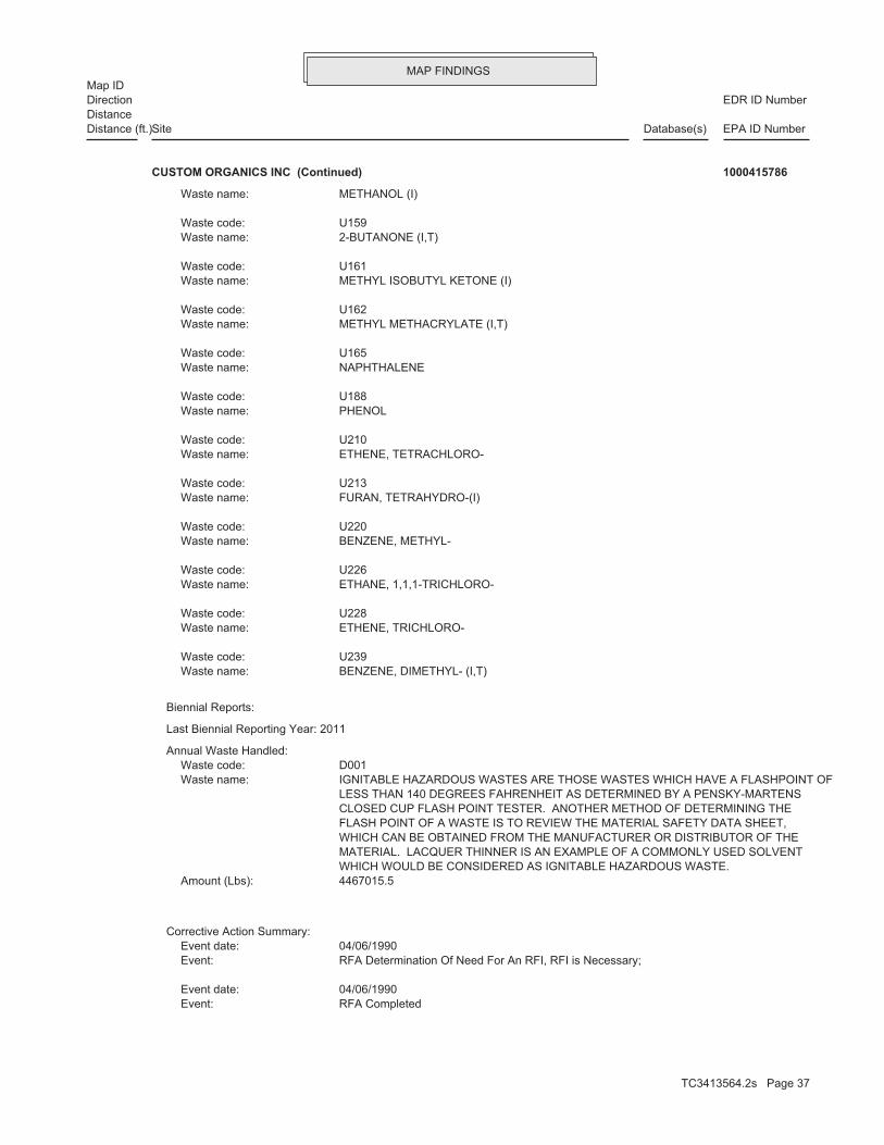
MAP FINDINGSMap ID
EDR ID NumberDirectionDistance
EPA ID NumberDatabase(s)SiteDistance (ft.)
RFA CompletedEvent: 04/06/1990Event date:
RFA Determination Of Need For An RFI, RFI is Necessary;Event: 04/06/1990Event date:
Corrective Action Summary:
4467015.5Amount (Lbs): WHICH WOULD BE CONSIDERED AS IGNITABLE HAZARDOUS WASTE. MATERIAL. LACQUER THINNER IS AN EXAMPLE OF A COMMONLY USED SOLVENT WHICH CAN BE OBTAINED FROM THE MANUFACTURER OR DISTRIBUTOR OF THE FLASH POINT OF A WASTE IS TO REVIEW THE MATERIAL SAFETY DATA SHEET, CLOSED CUP FLASH POINT TESTER. ANOTHER METHOD OF DETERMINING THE LESS THAN 140 DEGREES FAHRENHEIT AS DETERMINED BY A PENSKY-MARTENS IGNITABLE HAZARDOUS WASTES ARE THOSE WASTES WHICH HAVE A FLASHPOINT OFWaste name: D001Waste code:
Annual Waste Handled:
Last Biennial Reporting Year: 2011
Biennial Reports:
BENZENE, DIMETHYL- (I,T)Waste name: U239Waste code:
ETHENE, TRICHLORO-Waste name: U228Waste code:
ETHANE, 1,1,1-TRICHLORO-Waste name: U226Waste code:
BENZENE, METHYL-Waste name: U220Waste code:
FURAN, TETRAHYDRO-(I)Waste name: U213Waste code:
ETHENE, TETRACHLORO-Waste name: U210Waste code:
PHENOLWaste name: U188Waste code:
NAPHTHALENEWaste name: U165Waste code:
METHYL METHACRYLATE (I,T)Waste name: U162Waste code:
METHYL ISOBUTYL KETONE (I)Waste name: U161Waste code:
2-BUTANONE (I,T)Waste name: U159Waste code:
METHANOL (I)Waste name:
CUSTOM ORGANICS INC (Continued) 1000415786
TC3413564.2s Page 37

MAP FINDINGSMap ID
EDR ID NumberDirectionDistance
EPA ID NumberDatabase(s)SiteDistance (ft.)
Date For Remedy Selection (CM Imposed)Event: 06/30/2009Event date:
CA550RCEvent: 06/30/2009Event date:
changes at the facility. re-evaluated when the Agency/State becomes aware of significant reasonably expected conditions. This determination will be expected to be under control at the facility under current and contained in the EI determination, current human exposures are Under Control has been verified. Based on a review of information Current Human Exposures under Control, Yes, Current Human ExposuresEvent: 06/30/2009Event date:
significant changes at the facility. determination will be re-evaluated when the Agency becomes aware of remains within the existing area of contaminated groundwater. This monitoring will be conducted to confirm that contaminated groundwater migration of contaminated groundwater is under control, and that at the facility. Specifically, this determination indicates that the determined that migration of contaminated groundwater is under control review of information contained in the EI determination, it has been Contaminated Groundwater Under Control has been verified. Based on a Igration of Contaminated Groundwater under Control, Yes, Migration ofEvent: 05/28/2009Event date:
RFI Supplemental Information Deemed SatisfactoryEvent: 07/07/1995Event date:
RFI Supplemental Information Deemed SatisfactoryEvent: 09/30/1994Event date:
RFI Supplemental Information ReceivedEvent: 07/01/1994Event date:
action priority. CA Prioritization, Facility or area was assigned a low correctiveEvent: 09/30/1993Event date:
RFI Workplan ApprovedEvent: 09/23/1993Event date:
the facility, or other administrative considerations. risk, timing considerations, the status of corrective action work at conclusion may be the status of closure at the facility, the degree of there is a lack of technical information (IN). Reasons for this it appears to be technically infeasible or inappropriate (NF) or 2- stabilization activity at the present time for reasons other than 1- Stabilization Measures Evaluation,This facility is not amenable toEvent: 09/23/1993Event date:
RFI ImpositionEvent: 09/30/1992Event date:
RFA Determination Of Need For An RFI, RFI is Necessary;Event: 09/30/1992Event date:
CUSTOM ORGANICS INC (Continued) 1000415786
TC3413564.2s Page 38

MAP FINDINGSMap ID
EDR ID NumberDirectionDistance
EPA ID NumberDatabase(s)SiteDistance (ft.)
Not reported Enf. disposition status: 08/10/1994 Enforcement action date: WRITTEN INFORMAL Enforcement action: StateViolation lead agency: 10/07/1994Date achieved compliance: 06/07/1994Date violation determined: TSD - Financial RequirementsArea of violation: SR - 725.244(b)Regulation violated:
Not reported Paid penalty amount: Not reported Final penalty amount: Not reported Proposed penalty amount: State Enforcement lead agency: Not reported Enf. disp. status date: Not reported Enf. disposition status: 08/10/1994 Enforcement action date: WRITTEN INFORMAL Enforcement action: StateViolation lead agency: 10/07/1994Date achieved compliance: 06/07/1994Date violation determined: TSD - Financial RequirementsArea of violation: SR - 725.242(b)Regulation violated:
Not reported Paid penalty amount: Not reported Final penalty amount: Not reported Proposed penalty amount: State Enforcement lead agency: Not reported Enf. disp. status date: Not reported Enf. disposition status: 12/04/1995 Enforcement action date: WRITTEN INFORMAL Enforcement action: StateViolation lead agency: 08/23/1996Date achieved compliance: 11/08/1995Date violation determined: TSD - Financial RequirementsArea of violation: SR - 724.251Regulation violated:
Not reported Paid penalty amount: Not reported Final penalty amount: Not reported Proposed penalty amount: EPA Enforcement lead agency: Not reported Enf. disp. status date: Not reported Enf. disposition status: 02/28/2001 Enforcement action date: WRITTEN INFORMAL Enforcement action: EPAViolation lead agency: 08/02/2001Date achieved compliance: 09/20/1999Date violation determined: TSD IS-Air Emission Standards - Equipment LeaksArea of violation: Not reportedRegulation violated:
Facility Has Received Notices of Violations:
RFI Workplan ReceivedEvent: Not reportedEvent date:
CA800YEEvent: 09/30/2010Event date:
CUSTOM ORGANICS INC (Continued) 1000415786
TC3413564.2s Page 39

MAP FINDINGSMap ID
EDR ID NumberDirectionDistance
EPA ID NumberDatabase(s)SiteDistance (ft.)
Not reported Enf. disp. status date: Not reported Enf. disposition status: 12/04/1992 Enforcement action date: VIOLATION NOTICE (VN) Enforcement action: StateViolation lead agency: 12/21/1992Date achieved compliance: 09/30/1992Date violation determined: TSD - Financial RequirementsArea of violation: SR - 725.247(f)(3)Regulation violated:
Not reported Paid penalty amount: Not reported Final penalty amount: Not reported Proposed penalty amount: State Enforcement lead agency: Not reported Enf. disp. status date: Not reported Enf. disposition status: 10/19/1992 Enforcement action date: WRITTEN INFORMAL Enforcement action: StateViolation lead agency: 12/21/1992Date achieved compliance: 09/30/1992Date violation determined: TSD - Financial RequirementsArea of violation: SR - 725.247(f)(3)Regulation violated:
Not reported Paid penalty amount: Not reported Final penalty amount: Not reported Proposed penalty amount: State Enforcement lead agency: Not reported Enf. disp. status date: Not reported Enf. disposition status: 12/04/1992 Enforcement action date: VIOLATION NOTICE (VN) Enforcement action: StateViolation lead agency: 12/21/1992Date achieved compliance: 09/30/1992Date violation determined: TSD - Financial RequirementsArea of violation: SR - 725.247(a)Regulation violated:
Not reported Paid penalty amount: Not reported Final penalty amount: Not reported Proposed penalty amount: State Enforcement lead agency: Not reported Enf. disp. status date: Not reported Enf. disposition status: 08/03/1993 Enforcement action date: WRITTEN INFORMAL Enforcement action: StateViolation lead agency: 10/27/1993Date achieved compliance: 07/26/1993Date violation determined: TSD - Financial RequirementsArea of violation: SR - 724.251Regulation violated:
Not reported Paid penalty amount: Not reported Final penalty amount: Not reported Proposed penalty amount: State Enforcement lead agency: Not reported Enf. disp. status date:
CUSTOM ORGANICS INC (Continued) 1000415786
TC3413564.2s Page 40

MAP FINDINGSMap ID
EDR ID NumberDirectionDistance
EPA ID NumberDatabase(s)SiteDistance (ft.)
State Enforcement lead agency: Not reported Enf. disp. status date: Not reported Enf. disposition status: 04/22/1991 Enforcement action date: WRITTEN INFORMAL Enforcement action: StateViolation lead agency: 07/10/1991Date achieved compliance: 04/04/1991Date violation determined: TSD - Financial RequirementsArea of violation: SR - 724.251Regulation violated:
Not reported Paid penalty amount: Not reported Final penalty amount: Not reported Proposed penalty amount: State Enforcement lead agency: Not reported Enf. disp. status date: Not reported Enf. disposition status: 04/22/1991 Enforcement action date: WRITTEN INFORMAL Enforcement action: StateViolation lead agency: 07/10/1991Date achieved compliance: 04/04/1991Date violation determined: TSD - Financial RequirementsArea of violation: SR - 725.242(b)Regulation violated:
Not reported Paid penalty amount: Not reported Final penalty amount: Not reported Proposed penalty amount: State Enforcement lead agency: Not reported Enf. disp. status date: Not reported Enf. disposition status: 08/30/1991 Enforcement action date: WRITTEN INFORMAL Enforcement action: StateViolation lead agency: 10/10/1991Date achieved compliance: 07/24/1991Date violation determined: Generators - Records/ReportingArea of violation: SR - 722.141(a)Regulation violated:
Not reported Paid penalty amount: Not reported Final penalty amount: Not reported Proposed penalty amount: State Enforcement lead agency: Not reported Enf. disp. status date: Not reported Enf. disposition status: 10/19/1992 Enforcement action date: WRITTEN INFORMAL Enforcement action: StateViolation lead agency: 12/21/1992Date achieved compliance: 09/30/1992Date violation determined: TSD - Financial RequirementsArea of violation: SR - 725.247(a)Regulation violated:
Not reported Paid penalty amount: Not reported Final penalty amount: Not reported Proposed penalty amount: State Enforcement lead agency:
CUSTOM ORGANICS INC (Continued) 1000415786
TC3413564.2s Page 41

MAP FINDINGSMap ID
EDR ID NumberDirectionDistance
EPA ID NumberDatabase(s)SiteDistance (ft.)
Not reported Proposed penalty amount: State Enforcement lead agency: Not reported Enf. disp. status date: Not reported Enf. disposition status: 02/22/1990 Enforcement action date: WRITTEN INFORMAL Enforcement action: StateViolation lead agency: 06/04/1990Date achieved compliance: 02/20/1990Date violation determined: TSD - Financial RequirementsArea of violation: SR - 725.243(c)(4)Regulation violated:
Not reported Paid penalty amount: Not reported Final penalty amount: Not reported Proposed penalty amount: State Enforcement lead agency: Not reported Enf. disp. status date: Not reported Enf. disposition status: 02/22/1990 Enforcement action date: WRITTEN INFORMAL Enforcement action: StateViolation lead agency: 06/04/1990Date achieved compliance: 02/20/1990Date violation determined: TSD - Financial RequirementsArea of violation: SR - 725.247(a)Regulation violated:
Not reported Paid penalty amount: Not reported Final penalty amount: Not reported Proposed penalty amount: State Enforcement lead agency: Not reported Enf. disp. status date: Not reported Enf. disposition status: 02/22/1990 Enforcement action date: WRITTEN INFORMAL Enforcement action: StateViolation lead agency: 06/04/1990Date achieved compliance: 02/20/1990Date violation determined: TSD - Financial RequirementsArea of violation: SR - 725.242(b)Regulation violated:
Not reported Paid penalty amount: Not reported Final penalty amount: Not reported Proposed penalty amount: State Enforcement lead agency: Not reported Enf. disp. status date: Not reported Enf. disposition status: 04/22/1991 Enforcement action date: WRITTEN INFORMAL Enforcement action: StateViolation lead agency: 07/10/1991Date achieved compliance: 04/04/1991Date violation determined: TSD - Financial RequirementsArea of violation: SR - 725.243(c)(4)Regulation violated:
Not reported Paid penalty amount: Not reported Final penalty amount: Not reported Proposed penalty amount:
CUSTOM ORGANICS INC (Continued) 1000415786
TC3413564.2s Page 42

MAP FINDINGSMap ID
EDR ID NumberDirectionDistance
EPA ID NumberDatabase(s)SiteDistance (ft.)
03/04/2010Evaluation date:
StateEvaluation lead agency: Not reportedDate achieved compliance: Not reportedArea of violation: COMPLIANCE EVALUATION INSPECTION ON-SITEEvaluation: 12/16/2010Evaluation date:
StateEvaluation lead agency: Not reportedDate achieved compliance: Not reportedArea of violation: FINANCIAL RECORD REVIEWEvaluation: 11/17/2011Evaluation date:
StateEvaluation lead agency: Not reportedDate achieved compliance: Not reportedArea of violation: COMPLIANCE EVALUATION INSPECTION ON-SITEEvaluation: 12/07/2011Evaluation date:
StateEvaluation lead agency: Not reportedDate achieved compliance: Not reportedArea of violation: FINANCIAL RECORD REVIEWEvaluation: 02/09/2012Evaluation date:
Evaluation Action Summary:
Not reported Paid penalty amount: Not reported Final penalty amount: Not reported Proposed penalty amount: State Enforcement lead agency: Not reported Enf. disp. status date: Not reported Enf. disposition status: 08/28/1987 Enforcement action date: WRITTEN INFORMAL Enforcement action: StateViolation lead agency: 11/04/1987Date achieved compliance: 06/19/1987Date violation determined: TSD - GeneralArea of violation: SR - 703.155(c)Regulation violated:
Not reported Paid penalty amount: Not reported Final penalty amount: Not reported Proposed penalty amount: State Enforcement lead agency: Not reported Enf. disp. status date: Not reported Enf. disposition status: 03/23/1989 Enforcement action date: VIOLATION NOTICE (VN) Enforcement action: StateViolation lead agency: 12/04/1989Date achieved compliance: 01/31/1989Date violation determined: TSD - Tank System StandardsArea of violation: SR - 725.293(a)Regulation violated:
Not reported Paid penalty amount: Not reported Final penalty amount:
CUSTOM ORGANICS INC (Continued) 1000415786
TC3413564.2s Page 43

MAP FINDINGSMap ID
EDR ID NumberDirectionDistance
EPA ID NumberDatabase(s)SiteDistance (ft.)
Not reportedDate achieved compliance: Not reportedArea of violation: COMPLIANCE EVALUATION INSPECTION ON-SITEEvaluation: 12/10/2003Evaluation date:
StateEvaluation lead agency: Not reportedDate achieved compliance: Not reportedArea of violation: COMPLIANCE EVALUATION INSPECTION ON-SITEEvaluation: 12/08/2004Evaluation date:
StateEvaluation lead agency: Not reportedDate achieved compliance: Not reportedArea of violation: COMPLIANCE EVALUATION INSPECTION ON-SITEEvaluation: 12/05/2005Evaluation date:
StateEvaluation lead agency: Not reportedDate achieved compliance: Not reportedArea of violation: FINANCIAL RECORD REVIEWEvaluation: 07/27/2006Evaluation date:
EPAEvaluation lead agency: Not reportedDate achieved compliance: Not reportedArea of violation: COMPLIANCE EVALUATION INSPECTION ON-SITEEvaluation: 03/29/2007Evaluation date:
StateEvaluation lead agency: Not reportedDate achieved compliance: Not reportedArea of violation: FINANCIAL RECORD REVIEWEvaluation: 05/08/2008Evaluation date:
StateEvaluation lead agency: Not reportedDate achieved compliance: Not reportedArea of violation: COMPLIANCE EVALUATION INSPECTION ON-SITEEvaluation: 12/09/2008Evaluation date:
StateEvaluation lead agency: Not reportedDate achieved compliance: Not reportedArea of violation: FINANCIAL RECORD REVIEWEvaluation: 05/08/2009Evaluation date:
StateEvaluation lead agency: Not reportedDate achieved compliance: Not reportedArea of violation: COMPLIANCE EVALUATION INSPECTION ON-SITEEvaluation: 12/03/2009Evaluation date:
StateEvaluation lead agency: Not reportedDate achieved compliance: Not reportedArea of violation: FINANCIAL RECORD REVIEWEvaluation:
CUSTOM ORGANICS INC (Continued) 1000415786
TC3413564.2s Page 44

MAP FINDINGSMap ID
EDR ID NumberDirectionDistance
EPA ID NumberDatabase(s)SiteDistance (ft.)
01/21/1999Evaluation date:
StateEvaluation lead agency: Not reportedDate achieved compliance: Not reportedArea of violation: FINANCIAL RECORD REVIEWEvaluation: 08/06/1999Evaluation date:
EPAEvaluation lead agency: 08/02/2001Date achieved compliance: TSD IS-Air Emission Standards - Equipment LeaksArea of violation: COMPLIANCE EVALUATION INSPECTION ON-SITEEvaluation: 09/20/1999Evaluation date:
StateEvaluation lead agency: Not reportedDate achieved compliance: Not reportedArea of violation: COMPLIANCE EVALUATION INSPECTION ON-SITEEvaluation: 01/18/2000Evaluation date:
StateEvaluation lead agency: Not reportedDate achieved compliance: Not reportedArea of violation: FINANCIAL RECORD REVIEWEvaluation: 01/31/2000Evaluation date:
StateEvaluation lead agency: Not reportedDate achieved compliance: Not reportedArea of violation: FINANCIAL RECORD REVIEWEvaluation: 07/10/2000Evaluation date:
StateEvaluation lead agency: Not reportedDate achieved compliance: Not reportedArea of violation: COMPLIANCE EVALUATION INSPECTION ON-SITEEvaluation: 10/18/2000Evaluation date:
StateEvaluation lead agency: Not reportedDate achieved compliance: Not reportedArea of violation: FINANCIAL RECORD REVIEWEvaluation: 04/26/2001Evaluation date:
StateEvaluation lead agency: Not reportedDate achieved compliance: Not reportedArea of violation: COMPLIANCE EVALUATION INSPECTION ON-SITEEvaluation: 10/24/2001Evaluation date:
StateEvaluation lead agency: Not reportedDate achieved compliance: Not reportedArea of violation: COMPLIANCE EVALUATION INSPECTION ON-SITEEvaluation: 10/17/2002Evaluation date:
StateEvaluation lead agency:
CUSTOM ORGANICS INC (Continued) 1000415786
TC3413564.2s Page 45

MAP FINDINGSMap ID
EDR ID NumberDirectionDistance
EPA ID NumberDatabase(s)SiteDistance (ft.)
Not reportedDate achieved compliance: Not reportedArea of violation: COMPLIANCE EVALUATION INSPECTION ON-SITEEvaluation: 01/20/1995Evaluation date:
StateEvaluation lead agency: Not reportedDate achieved compliance: Not reportedArea of violation: COMPLIANCE EVALUATION INSPECTION ON-SITEEvaluation: 07/11/1995Evaluation date:
StateEvaluation lead agency: 08/23/1996Date achieved compliance: TSD - Financial RequirementsArea of violation: FINANCIAL RECORD REVIEWEvaluation: 11/08/1995Evaluation date:
StateEvaluation lead agency: Not reportedDate achieved compliance: Not reportedArea of violation: COMPLIANCE EVALUATION INSPECTION ON-SITEEvaluation: 01/24/1996Evaluation date:
StateEvaluation lead agency: Not reportedDate achieved compliance: Not reportedArea of violation: COMPLIANCE EVALUATION INSPECTION ON-SITEEvaluation: 07/30/1996Evaluation date:
StateEvaluation lead agency: Not reportedDate achieved compliance: Not reportedArea of violation: COMPLIANCE EVALUATION INSPECTION ON-SITEEvaluation: 01/23/1997Evaluation date:
StateEvaluation lead agency: Not reportedDate achieved compliance: Not reportedArea of violation: FINANCIAL RECORD REVIEWEvaluation: 04/28/1997Evaluation date:
StateEvaluation lead agency: Not reportedDate achieved compliance: Not reportedArea of violation: COMPLIANCE EVALUATION INSPECTION ON-SITEEvaluation: 01/27/1998Evaluation date:
StateEvaluation lead agency: Not reportedDate achieved compliance: Not reportedArea of violation: FINANCIAL RECORD REVIEWEvaluation: 06/15/1998Evaluation date:
StateEvaluation lead agency: Not reportedDate achieved compliance: Not reportedArea of violation: COMPLIANCE EVALUATION INSPECTION ON-SITEEvaluation:
CUSTOM ORGANICS INC (Continued) 1000415786
TC3413564.2s Page 46

MAP FINDINGSMap ID
EDR ID NumberDirectionDistance
EPA ID NumberDatabase(s)SiteDistance (ft.)
01/17/1992Evaluation date:
StateEvaluation lead agency: Not reportedDate achieved compliance: Not reportedArea of violation: COMPLIANCE EVALUATION INSPECTION ON-SITEEvaluation: 07/21/1992Evaluation date:
StateEvaluation lead agency: 12/21/1992Date achieved compliance: TSD - Financial RequirementsArea of violation: FINANCIAL RECORD REVIEWEvaluation: 09/30/1992Evaluation date:
StateEvaluation lead agency: Not reportedDate achieved compliance: Not reportedArea of violation: COMPLIANCE EVALUATION INSPECTION ON-SITEEvaluation: 01/26/1993Evaluation date:
StateEvaluation lead agency: 10/27/1993Date achieved compliance: TSD - Financial RequirementsArea of violation: FINANCIAL RECORD REVIEWEvaluation: 07/26/1993Evaluation date:
StateEvaluation lead agency: Not reportedDate achieved compliance: Not reportedArea of violation: COMPLIANCE EVALUATION INSPECTION ON-SITEEvaluation: 07/29/1993Evaluation date:
EPA-Initiated Oversight/Observation/Training ActionsEvaluation lead agency: Not reportedDate achieved compliance: Not reportedArea of violation: COMPLIANCE EVALUATION INSPECTION ON-SITEEvaluation: 07/29/1993Evaluation date:
StateEvaluation lead agency: Not reportedDate achieved compliance: Not reportedArea of violation: COMPLIANCE EVALUATION INSPECTION ON-SITEEvaluation: 01/26/1994Evaluation date:
StateEvaluation lead agency: 10/07/1994Date achieved compliance: TSD - Financial RequirementsArea of violation: FINANCIAL RECORD REVIEWEvaluation: 06/07/1994Evaluation date:
StateEvaluation lead agency: Not reportedDate achieved compliance: Not reportedArea of violation: COMPLIANCE EVALUATION INSPECTION ON-SITEEvaluation: 07/27/1994Evaluation date:
StateEvaluation lead agency:
CUSTOM ORGANICS INC (Continued) 1000415786
TC3413564.2s Page 47

MAP FINDINGSMap ID
EDR ID NumberDirectionDistance
EPA ID NumberDatabase(s)SiteDistance (ft.)
12/04/1989Date achieved compliance: TSD - Tank System StandardsArea of violation: COMPLIANCE EVALUATION INSPECTION ON-SITEEvaluation: 01/31/1989Evaluation date:
StateEvaluation lead agency: 12/04/1989Date achieved compliance: TSD - Tank System StandardsArea of violation: COMPLIANCE EVALUATION INSPECTION ON-SITEEvaluation: 07/25/1989Evaluation date:
StateEvaluation lead agency: Not reportedDate achieved compliance: Not reportedArea of violation: COMPLIANCE SCHEDULE EVALUATIONEvaluation: 10/10/1989Evaluation date:
StateEvaluation lead agency: Not reportedDate achieved compliance: Not reportedArea of violation: COMPLIANCE EVALUATION INSPECTION ON-SITEEvaluation: 01/19/1990Evaluation date:
StateEvaluation lead agency: 06/04/1990Date achieved compliance: TSD - Financial RequirementsArea of violation: FINANCIAL RECORD REVIEWEvaluation: 02/20/1990Evaluation date:
StateEvaluation lead agency: Not reportedDate achieved compliance: Not reportedArea of violation: COMPLIANCE EVALUATION INSPECTION ON-SITEEvaluation: 07/19/1990Evaluation date:
StateEvaluation lead agency: Not reportedDate achieved compliance: Not reportedArea of violation: COMPLIANCE EVALUATION INSPECTION ON-SITEEvaluation: 01/30/1991Evaluation date:
StateEvaluation lead agency: 07/10/1991Date achieved compliance: TSD - Financial RequirementsArea of violation: FINANCIAL RECORD REVIEWEvaluation: 04/04/1991Evaluation date:
StateEvaluation lead agency: 10/10/1991Date achieved compliance: Generators - Records/ReportingArea of violation: COMPLIANCE EVALUATION INSPECTION ON-SITEEvaluation: 07/24/1991Evaluation date:
StateEvaluation lead agency: Not reportedDate achieved compliance: Not reportedArea of violation: COMPLIANCE EVALUATION INSPECTION ON-SITEEvaluation:
CUSTOM ORGANICS INC (Continued) 1000415786
TC3413564.2s Page 48

MAP FINDINGSMap ID
EDR ID NumberDirectionDistance
EPA ID NumberDatabase(s)SiteDistance (ft.)
Not reportedDate Started: SITE INSPECTIONAction:
Low priority for further assessmentPriority Level: 02/01/1983Date Completed: Not reportedDate Started: PRELIMINARY ASSESSMENTAction:
Not reportedPriority Level: 04/01/1979Date Completed: Not reportedDate Started: DISCOVERYAction:
CERCLIS-NFRAP Assessment History:
NFRAP-Site does not qualify for the NPL based on existing informationNon NPL Status: Not on the NPLNPL Status: Not a Federal FacilityFederal Facility: 0500198Site ID:
CERC-NFRAP:
StateEvaluation lead agency: 11/04/1987Date achieved compliance: TSD - GeneralArea of violation: COMPLIANCE EVALUATION INSPECTION ON-SITEEvaluation: 06/19/1987Evaluation date:
StateEvaluation lead agency: Not reportedDate achieved compliance: Not reportedArea of violation: COMPLIANCE EVALUATION INSPECTION ON-SITEEvaluation: 01/14/1988Evaluation date:
StateEvaluation lead agency: Not reportedDate achieved compliance: Not reportedArea of violation: COMPLIANCE EVALUATION INSPECTION ON-SITEEvaluation: 03/07/1988Evaluation date:
StateEvaluation lead agency: Not reportedDate achieved compliance: Not reportedArea of violation: COMPLIANCE EVALUATION INSPECTION ON-SITEEvaluation: 07/14/1988Evaluation date:
EPAEvaluation lead agency: Not reportedDate achieved compliance: Not reportedArea of violation: FOCUSED COMPLIANCE INSPECTIONEvaluation: 07/14/1988Evaluation date:
StateEvaluation lead agency: Not reportedDate achieved compliance: Not reportedArea of violation: FINANCIAL RECORD REVIEWEvaluation: 08/12/1988Evaluation date:
StateEvaluation lead agency:
CUSTOM ORGANICS INC (Continued) 1000415786
TC3413564.2s Page 49

MAP FINDINGSMap ID
EDR ID NumberDirectionDistance
EPA ID NumberDatabase(s)SiteDistance (ft.)
ILD005450697EPA ID:
Not reportedSchedule end date: Not reportedOriginal schedule date: Materials Recovery Facilities Waste Collection 56211 56292NAICS Code(s): CA400 - Date For Remedy Selection (CM Imposed)Action: 06/30/2009Actual Date: ENTIRE FACILITYArea Name: 05EPA Region: ILD005450697EPA ID:
Not reportedSchedule end date: Not reportedOriginal schedule date: Materials Recovery Facilities Waste Collection 56211 56292NAICS Code(s): Migration of Contaminated Groundwater Under Control has been verified CA750YE - Migration of Contaminated Groundwater under Control, Yes,Action: 05/28/2009Actual Date: ENTIRE FACILITYArea Name: 05EPA Region: ILD005450697EPA ID:
Not reportedSchedule end date: Not reportedOriginal schedule date: Materials Recovery Facilities Waste Collection 56211 56292NAICS Code(s): CA070YE - RFA Determination Of Need For An RFI, RFI is NecessaryAction: 04/06/1990Actual Date: ENTIRE FACILITYArea Name: 05EPA Region: ILD005450697EPA ID:
Not reportedSchedule end date: Not reportedOriginal schedule date: Materials Recovery Facilities Waste Collection 56211 56292NAICS Code(s): CA050 - RFA CompletedAction: 04/06/1990Actual Date: ENTIRE FACILITYArea Name: 05EPA Region: ILD005450697EPA ID:
CORRACTS:
Not reportedPriority Level: 09/01/1984Date Completed: Not reportedDate Started: ARCHIVE SITEAction:
NFRAP-Site does not qualify for the NPL based on existing informationPriority Level: 09/01/1984Date Completed:
CUSTOM ORGANICS INC (Continued) 1000415786
TC3413564.2s Page 50

MAP FINDINGSMap ID
EDR ID NumberDirectionDistance
EPA ID NumberDatabase(s)SiteDistance (ft.)
56211 56292NAICS Code(s): considerations corrective action work at the facility, or other, administrative facility, the degree of risk, timing considerations, the status of (IN). Reasons for this conclusion may be the status of, closure at the inappropriate (NF) or (2) there is a lack of technical, information other than (1) it appears to be technically, infeasible or amenable to stabilization activity at the, present time for reasons CA225NR - Stabilization Measures Evaluation, This facility is, notAction: 09/23/1993Actual Date: ENTIRE FACILITYArea Name: 05EPA Region: ILD005450697EPA ID:
Not reportedSchedule end date: Not reportedOriginal schedule date: Materials Recovery Facilities Waste Collection 56211 56292NAICS Code(s): CA170 - RFI Supplemental Information Deemed SatisfactoryAction: 07/07/1995Actual Date: ENTIRE FACILITYArea Name: 05EPA Region: ILD005450697EPA ID:
Not reportedSchedule end date: Not reportedOriginal schedule date: Materials Recovery Facilities Waste Collection 56211 56292NAICS Code(s): CA160 - RFI Supplemental Information ReceivedAction: 07/01/1994Actual Date: ENTIRE AREAArea Name: 05EPA Region: ILD005450697EPA ID:
Not reportedSchedule end date: Not reportedOriginal schedule date: Materials Recovery Facilities Waste Collection 56211 56292NAICS Code(s): Exposures Under Control has been verified CA725YE - Current Human Exposures Under Control, Yes, Current HumanAction: 06/30/2009Actual Date: ENTIRE FACILITYArea Name: 05EPA Region: ILD005450697EPA ID:
Not reportedSchedule end date: Not reportedOriginal schedule date: Materials Recovery Facilities Waste Collection 56211 56292NAICS Code(s): CA550RCAction: 06/30/2009Actual Date: ENTIRE FACILITYArea Name: 05EPA Region:
CUSTOM ORGANICS INC (Continued) 1000415786
TC3413564.2s Page 51

MAP FINDINGSMap ID
EDR ID NumberDirectionDistance
EPA ID NumberDatabase(s)SiteDistance (ft.)
Waste Collection 56211 56292NAICS Code(s): CA170 - RFI Supplemental Information Deemed SatisfactoryAction: 09/30/1994Actual Date: ENTIRE AREAArea Name: 05EPA Region: ILD005450697EPA ID:
Not reportedSchedule end date: Not reportedOriginal schedule date: Materials Recovery Facilities Waste Collection 56211 56292NAICS Code(s): corrective action priority CA075LO - CA Prioritization, Facility or area was assigned a lowAction: 09/30/1993Actual Date: ENTIRE FACILITYArea Name: 05EPA Region: ILD005450697EPA ID:
Not reportedSchedule end date: Not reportedOriginal schedule date: Materials Recovery Facilities Waste Collection 56211 56292NAICS Code(s): CA070YE - RFA Determination Of Need For An RFI, RFI is NecessaryAction: 09/30/1992Actual Date: ENTIRE FACILITYArea Name: 05EPA Region: ILD005450697EPA ID:
Not reportedSchedule end date: Not reportedOriginal schedule date: Materials Recovery Facilities Waste Collection 56211 56292NAICS Code(s): CA100 - RFI ImpositionAction: 09/30/1992Actual Date: ENTIRE AREAArea Name: 05EPA Region: ILD005450697EPA ID:
Not reportedSchedule end date: Not reportedOriginal schedule date: Materials Recovery Facilities Waste Collection 56211 56292NAICS Code(s): CA150 - RFI Workplan ApprovedAction: 09/23/1993Actual Date: ENTIRE AREAArea Name: 05EPA Region: ILD005450697EPA ID:
Not reportedSchedule end date: Not reportedOriginal schedule date: Materials Recovery Facilities Waste Collection
CUSTOM ORGANICS INC (Continued) 1000415786
TC3413564.2s Page 52

MAP FINDINGSMap ID
EDR ID NumberDirectionDistance
EPA ID NumberDatabase(s)SiteDistance (ft.)
Not reportedSchedule end date: 05/04/1993Original schedule date: Materials Recovery Facilities Waste Collection 56211 56292NAICS Code(s): CA110 - RFI Workplan ReceivedAction: Not reportedActual Date: ENTIRE AREAArea Name: 05EPA Region: ILD005450697EPA ID:
Not reportedSchedule end date: Not reportedOriginal schedule date: Materials Recovery Facilities Waste Collection 56211 56292NAICS Code(s): CA800YEAction: 09/30/2010Actual Date: ENTIRE FACILITYArea Name: 05EPA Region: ILD005450697EPA ID:
Not reportedSchedule end date: Not reportedOriginal schedule date: Materials Recovery Facilities
CUSTOM ORGANICS INC (Continued) 1000415786
5 additional US_TRIS: record(s) in the EDR Site Report.Click this hyperlink while viewing on your computer to access
TRIS:
1799 ft. Site 2 of 2 in cluster H0.341 mi.1/4-1/2 CHICAGO, IL 60609ENE 1445 W 42ND 60609SFTYK14H29 TRISCLEAN HARBORS RECYCLING SERVICES OF CHICAGO LLC 1005454148
NFASite Classification: Not reportedPRP Phone: Chicago, IL 60609PRP City,St,Zip: 1415 West 44th StreetPRP Address: Wayne GreenePRP Contact: Cameo Container Corp.PRP Name: Not reportedEmail: Not reportedProject Manager Phone: DavisonProject Manager: 01/27/1994IEMA Date: Fuel OilProduct: 0316005178IL EPA Id: 940200Incident Num:
LUST:
1994 ft.0.378 mi.1/4-1/2 CHICAGO, IL 60609East 1415 W 44TH ST ILD00509882730 LUSTROCKTENN CP LLC 1000209124
TC3413564.2s Page 53

MAP FINDINGSMap ID
EDR ID NumberDirectionDistance
EPA ID NumberDatabase(s)SiteDistance (ft.)
04/23/1998NFR Date Recorded: 02/11/1997NFA/NFR Letter: 08/11/199445 Report Received: 02/16/199420 Report Received: Not reportedNon LUST Determination Letter: Not reportedDate Section 57.5(g) Letter: 732Section 57.5(g) Letter:
ROCKTENN CP LLC (Continued) 1000209124
Not reportedNFR Date Recorded: Not reportedNFA/NFR Letter: Not reported45 Report Received: Not reported20 Report Received: Not reportedNon LUST Determination Letter: Not reportedDate Section 57.5(g) Letter: 731Section 57.5(g) Letter: Not reportedSite Classification: Not reportedPRP Phone: Hallendale, FL 33009PRP City,St,Zip: 1920 East HallendalePRP Address: Not reportedPRP Contact: EPC PropertiesPRP Name: Not reportedEmail: Not reportedProject Manager Phone: NOT ASSIGNEDProject Manager: 09/02/1988IEMA Date: Fuel OilProduct: 0316610022IL EPA Id: 881273Incident Num:
LUST:
2005 ft.0.380 mi.1/4-1/2 CHICAGO, IL 60609SW 1928 WEST 46TH N/A31 LUSTEPC PROPERTIES S104528023
27755 Diehl RoadConsultant Address: ENSR CorporationConsultant Company: Miguel A. ArriagaPoint Of Contact: 07/09/2007Date Enrolled: (540) 981-5184Contact Phone: Roanoke, VA 24042-0013Contact City,St,Zip: Not reportedContact Address2: 110 Franklin Road SoutheastContact Address: Kevin HauschildtContact Name: 41.81994Latitude: -87.66732Longitude: ILD984920017US EPA Id: 0316615032IL EPA Id:
SRP:
2089 ft. Site 1 of 2 in cluster I0.396 mi.1/4-1/2 CHICAGO, IL NNE 4024 ASHLAND AVE N/AI32 SRP S108046244
TC3413564.2s Page 54

MAP FINDINGSMap ID
EDR ID NumberDirectionDistance
EPA ID NumberDatabase(s)SiteDistance (ft.)
Not reportedAcres: Not reportedWorker Caution: Not reportedBarrier: Not reportedInstitutional Controls: Not reportedComprehensive/Focused: Not reportedSite Type: Not reportedNFR Letter Date Recorded: Not reportedNFR Letter: Not reportedSite Name: Not reportedIllinois EPA: Not reportedRemediation Applicant City,St,Zip: Not reportedRemediation Applicant Address 2: Not reportedRemediation Applicant Address: Not reportedRemediation Applicant Company: Not reportedRemediation Applicant Name: Mr.Remediation Applicant Title: Norfolk Southern Railway CompanyRemediation Applicant Co: Not reportedNo Further Remediation Letter Dt: 10Total Acres: FalseActive: Not reportedNFR Recorded: Not reportedSec. 4 Letter Date: LandersProj Mgr Assigned: (630) 836-1700Consultant Phone: Warrenville, IL 60555-3998Consultant City,St,Zip: Suite 100Consultant Address2:
(Continued) S108046244
T & B Limited PartnershipRemediation Applicant Co: Not reportedNo Further Remediation Letter Dt: 30Total Acres: TrueActive: Not reportedNFR Recorded: Not reportedSec. 4 Letter Date: MurphyProj Mgr Assigned: (708) 225-1115Consultant Phone: South Holland, IL 60473-Consultant City,St,Zip: Not reportedConsultant Address2: 16650 South Canal StreetConsultant Address: Environmental Protection IndustriesConsultant Company: Austin ListPoint Of Contact: 03/30/2009Date Enrolled: (773) 254-3644Contact Phone: Chicago, IL 60609-Contact City,St,Zip: Not reportedContact Address2: 4450 South Morgan StreetContact Address: Michael TadinContact Name: 41.82142Latitude: -87.66894Longitude: ILR000110932US EPA Id: 0316616367IL EPA Id:
SRP:
2115 ft. Site 2 of 2 in cluster I0.401 mi.1/4-1/2 CHICAGO, IL 60609NNE 4008 SOUTH ASHLAND AVENUE N/AI33 SRPCHICAGO, CITY OF S109528251
TC3413564.2s Page 55

MAP FINDINGSMap ID
EDR ID NumberDirectionDistance
EPA ID NumberDatabase(s)SiteDistance (ft.)
Not reportedAcres: Not reportedWorker Caution: Not reportedBarrier: Not reportedInstitutional Controls: Not reportedComprehensive/Focused: Not reportedSite Type: Not reportedNFR Letter Date Recorded: Not reportedNFR Letter: Not reportedSite Name: Not reportedIllinois EPA: Not reportedRemediation Applicant City,St,Zip: Not reportedRemediation Applicant Address 2: Not reportedRemediation Applicant Address: Not reportedRemediation Applicant Company: Not reportedRemediation Applicant Name: PresidentRemediation Applicant Title:
CHICAGO, CITY OF (Continued) S109528251
Not reportedNFR Date Recorded: Not reportedNFA/NFR Letter: Not reported45 Report Received: 03/08/199420 Report Received: 1994-06-03Non LUST Determination Letter: Not reportedDate Section 57.5(g) Letter: 732Section 57.5(g) Letter: Not reportedSite Classification: Not reportedPRP Phone: Chicago, IL 60661PRP City,St,Zip: 500 West Madison St., 6th FloorPRP Address: John HenryPRP Contact: CitibankPRP Name: [email protected]: (217) 785-5734Project Manager Phone: LowderProject Manager: 02/17/1994IEMA Date: Fuel OilProduct: 0316615165IL EPA Id: 940351Incident Num:
LUST:
2175 ft.0.412 mi.1/4-1/2 CHICAGO, IL 60609South 1751 WEST 47TH ST. N/A34 LUSTCITIBANK S104523344
2393 ft.0.453 mi.1/4-1/2 CHICAGO, IL SW N/A35 IL NIPC46TH/DAMEN AVE S100790176
TC3413564.2s Page 56

MAP FINDINGSMap ID
EDR ID NumberDirectionDistance
EPA ID NumberDatabase(s)SiteDistance (ft.)
Not reportedNFR Date Recorded: Not reportedNFA/NFR Letter: Not reported45 Report Received: Not reported20 Report Received: Not reportedNon LUST Determination Letter: Not reportedDate Section 57.5(g) Letter: 734Section 57.5(g) Letter: Not reportedSite Classification: Not reportedPRP Phone: Not reportedPRP City,St,Zip: Not reportedPRP Address: Not reportedPRP Contact: Not reportedPRP Name: Not reportedEmail: Not reportedProject Manager Phone: Not reportedProject Manager: 12/09/2011IEMA Date: Fuel OilProduct: 0316616504IL EPA Id: 20111322Incident Num:
LUST:
2478 ft.0.469 mi.1/4-1/2 CHICAGO, IL 60609SSE 4717 SOUTH ASHLAND AVENUE N/A36 LUSTBALABAN FURNITURE S111419209
05/25/2006NFR Letter: 0316616399Illinois Epa Id:
ENGINEERING CONTROLS:
12/08/2008NFR Date Recorded: 11/20/2008NFA/NFR Letter: 07/24/200845 Report Received: Not reported20 Report Received: Not reportedNon LUST Determination Letter: Not reportedDate Section 57.5(g) Letter: 734Section 57.5(g) Letter: Not reportedSite Classification: Not reportedPRP Phone: Not reportedPRP City,St,Zip: Not reportedPRP Address: Not reportedPRP Contact: Not reportedPRP Name: [email protected]: (217) 785-0231Project Manager Phone: GaydoshProject Manager: 07/26/2007IEMA Date: Other PetroProduct: 0316616399IL EPA Id: 20071022Incident Num:
LUST:
2486 ft.0.471 mi.1/4-1/2 SRPCHICAGO, IL 60609SSE ENG CONTROLS1542 WEST 47TH STREET N/A37 LUSTCOLE TAYLOR BANK S106121978
TC3413564.2s Page 57
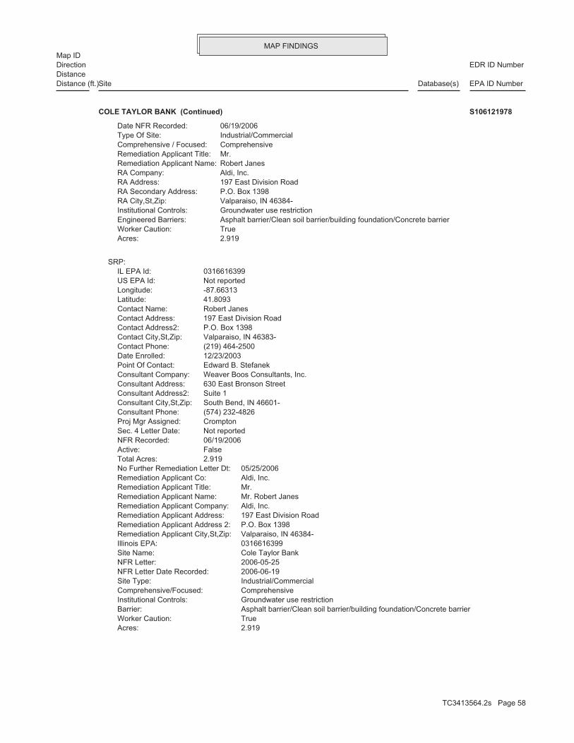
MAP FINDINGSMap ID
EDR ID NumberDirectionDistance
EPA ID NumberDatabase(s)SiteDistance (ft.)
2.919Acres: TrueWorker Caution: Asphalt barrier/Clean soil barrier/building foundation/Concrete barrierBarrier: Groundwater use restrictionInstitutional Controls: ComprehensiveComprehensive/Focused: Industrial/CommercialSite Type: 2006-06-19NFR Letter Date Recorded: 2006-05-25NFR Letter: Cole Taylor BankSite Name: 0316616399Illinois EPA: Valparaiso, IN 46384-Remediation Applicant City,St,Zip: P.O. Box 1398Remediation Applicant Address 2: 197 East Division RoadRemediation Applicant Address: Aldi, Inc.Remediation Applicant Company: Mr. Robert JanesRemediation Applicant Name: Mr.Remediation Applicant Title: Aldi, Inc.Remediation Applicant Co: 05/25/2006No Further Remediation Letter Dt: 2.919Total Acres: FalseActive: 06/19/2006NFR Recorded: Not reportedSec. 4 Letter Date: CromptonProj Mgr Assigned: (574) 232-4826Consultant Phone: South Bend, IN 46601-Consultant City,St,Zip: Suite 1Consultant Address2: 630 East Bronson StreetConsultant Address: Weaver Boos Consultants, Inc.Consultant Company: Edward B. StefanekPoint Of Contact: 12/23/2003Date Enrolled: (219) 464-2500Contact Phone: Valparaiso, IN 46383-Contact City,St,Zip: P.O. Box 1398Contact Address2: 197 East Division RoadContact Address: Robert JanesContact Name: 41.8093Latitude: -87.66313Longitude: Not reportedUS EPA Id: 0316616399IL EPA Id:
SRP:
2.919Acres: TrueWorker Caution: Asphalt barrier/Clean soil barrier/building foundation/Concrete barrierEngineered Barriers: Groundwater use restrictionInstitutional Controls: Valparaiso, IN 46384-RA City,St,Zip: P.O. Box 1398RA Secondary Address: 197 East Division RoadRA Address: Aldi, Inc.RA Company: Robert JanesRemediation Applicant Name: Mr.Remediation Applicant Title: ComprehensiveComprehensive / Focused: Industrial/CommercialType Of Site: 06/19/2006Date NFR Recorded:
COLE TAYLOR BANK (Continued) S106121978
TC3413564.2s Page 58

MAP FINDINGSMap ID
EDR ID NumberDirectionDistance
EPA ID NumberDatabase(s)SiteDistance (ft.)
2535 ft.0.480 mi.1/4-1/2 CHICAGO, IL NNE N/A38 IL NIPCJ P RUBBISH COMPANY S100790025
Not reportedNFR Date Recorded: Not reportedNFA/NFR Letter: 02/18/199945 Report Received: 02/18/199920 Report Received: Not reportedNon LUST Determination Letter: Not reportedDate Section 57.5(g) Letter: 732Section 57.5(g) Letter: HIGHSite Classification: 7732522900PRP Phone: Chicago, IL 60651PRP City,St,Zip: 4340 West Division St.PRP Address: Alvin StiglitzPRP Contact: Wholesale OilPRP Name: [email protected]: (217) 524-1253Project Manager Phone: JonesProject Manager: 12/29/1998IEMA Date: GasolineProduct: 0316615323IL EPA Id: 983177Incident Num:
LUST:
2635 ft.0.499 mi.1/4-1/2 CHICAGO, IL 60609SE 1500 WEST 47TH ST. N/A39 LUSTSTIGLITZ, ALVIN S104529328
3 additional US_TRIS: record(s) in the EDR Site Report.Click this hyperlink while viewing on your computer to access
TRIS:
2639 ft.0.500 mi.1/4-1/2 CHICAGO, IL 60609East 4400 S PACKER 60609DSLMF4440 TRISEDSAL MANUFACTURING CO INC 1005454146
-87.65788Longitude: Not reportedUS EPA Id: 0316616500IL EPA Id:
SRP:
2999 ft.0.568 mi.1/2-1 CHICAGO, IL 60609ENE 1300 WEST EXCHANGE AVENUE N/A41 SRP1300 WEST EXCHANGE, LLC S111069745
TC3413564.2s Page 59

MAP FINDINGSMap ID
EDR ID NumberDirectionDistance
EPA ID NumberDatabase(s)SiteDistance (ft.)
Not reportedAcres: Not reportedWorker Caution: Not reportedBarrier: Not reportedInstitutional Controls: Not reportedComprehensive/Focused: Not reportedSite Type: Not reportedNFR Letter Date Recorded: Not reportedNFR Letter: Not reportedSite Name: Not reportedIllinois EPA: Not reportedRemediation Applicant City,St,Zip: Not reportedRemediation Applicant Address 2: Not reportedRemediation Applicant Address: Not reportedRemediation Applicant Company: Not reportedRemediation Applicant Name: Mr.Remediation Applicant Title: 1300 West Exchange, LLCRemediation Applicant Co: Not reportedNo Further Remediation Letter Dt: 4.570Total Acres: TrueActive: Not reportedNFR Recorded: Not reportedSec. 4 Letter Date: ConnerProj Mgr Assigned: (815) 524-4007Consultant Phone: Plainfield, IL 60544-Consultant City,St,Zip: Not reportedConsultant Address2: 14106 South Naperville RoadConsultant Address: Schrack Environmental Consulting, Inc.Consultant Company: Ronald W. Schrack, P.E.Point Of Contact: 06/21/2011Date Enrolled: (773) 254-8300Contact Phone: Chicago, IL 60609-Contact City,St,Zip: Not reportedContact Address2: 1300 West Exchange AvenueContact Address: Michael PassarelliContact Name: 41.81920Latitude:
1300 WEST EXCHANGE, LLC (Continued) S111069745
16650 South Canal StreetConsultant Address: Environmental Protection IndustriesConsultant Company: Jinan Yan, P.E.Point Of Contact: 05/19/2004Date Enrolled: (773) 983-5811Contact Phone: Chicago, IL 60609-Contact City,St,Zip: Not reportedContact Address2: 3900 South Ashland AvenueContact Address: Michael WidellContact Name: 41.82262Latitude: -87.66638Longitude: Not reportedUS EPA Id: 0316616405IL EPA Id:
SRP:
3015 ft.0.571 mi.1/2-1 CHICAGO, IL 60609NNE 3900 SOUTH ASHLAND AVENUE N/A42 SRPCHICAGO INDOOR SOCCER, LLC S110363576
TC3413564.2s Page 60

MAP FINDINGSMap ID
EDR ID NumberDirectionDistance
EPA ID NumberDatabase(s)SiteDistance (ft.)
7.089Acres: TrueWorker Caution: Asphalt barrier/Concrete barrierBarrier: Groundwater use restrictionInstitutional Controls: ComprehensiveComprehensive/Focused: Industrial/CommercialSite Type: 2010-07-30NFR Letter Date Recorded: 2010-07-22NFR Letter: Chicago Indoor Soccer, LLCSite Name: 0316616405Illinois EPA: Chicago, IL 60609-Remediation Applicant City,St,Zip: Not reportedRemediation Applicant Address 2: 3900 South Ashland AvenueRemediation Applicant Address: Chicago Indoor Soccer, LLCRemediation Applicant Company: Mr. Michael WidellRemediation Applicant Name: Mr.Remediation Applicant Title: Chicago Indoor Soccer, LLCRemediation Applicant Co: 07/22/2010No Further Remediation Letter Dt: 7.089Total Acres: FalseActive: 07/30/2010NFR Recorded: Not reportedSec. 4 Letter Date: IrwinProj Mgr Assigned: (708) 225-1115Consultant Phone: South Holland, IL 60473-Consultant City,St,Zip: Not reportedConsultant Address2:
CHICAGO INDOOR SOCCER, LLC (Continued) S110363576
Bishop Plaza, LLCRemediation Applicant Co: Not reportedNo Further Remediation Letter Dt: 4Total Acres: FalseActive: Not reportedNFR Recorded: Not reportedSec. 4 Letter Date: MehraProj Mgr Assigned: (847) 464-1123Consultant Phone: Elgin, IL 60124-Consultant City,St,Zip: Not reportedConsultant Address2: 40W840 Bowes Bend DriveConsultant Address: Advanced Earth Technologies, Inc.Consultant Company: William J. Smith, P.E.Point Of Contact: 07/13/2006Date Enrolled: (312) 337-1001Contact Phone: Chicago, IL 60601-Contact City,St,Zip: Suite 2350Contact Address2: 200 North LaSalle StreetContact Address: James MatankyContact Name: 41.80879Latitude: -87.66111Longitude: Not reportedUS EPA Id: 0316616450IL EPA Id:
SRP:
3063 ft.0.580 mi.1/2-1 CHICAGO, IL 60609SE 1400-1422 WEST 47TH STREET N/A43 SRPBISHOP PLAZA S108048348
TC3413564.2s Page 61

MAP FINDINGSMap ID
EDR ID NumberDirectionDistance
EPA ID NumberDatabase(s)SiteDistance (ft.)
Not reportedAcres: Not reportedWorker Caution: Not reportedBarrier: Not reportedInstitutional Controls: Not reportedComprehensive/Focused: Not reportedSite Type: Not reportedNFR Letter Date Recorded: Not reportedNFR Letter: Not reportedSite Name: Not reportedIllinois EPA: Not reportedRemediation Applicant City,St,Zip: Not reportedRemediation Applicant Address 2: Not reportedRemediation Applicant Address: Not reportedRemediation Applicant Company: Not reportedRemediation Applicant Name: Mr.Remediation Applicant Title:
BISHOP PLAZA (Continued) S108048348
2000-02-29NFR Letter Date Recorded: 2000-02-15NFR Letter: Chicago Union StockyardsSite Name: 0316615267Illinois EPA: Chicago, IL 60602-Remediation Applicant City,St,Zip: 25th FloorRemediation Applicant Address 2: 30 North LaSalle StreetRemediation Applicant Address: City of Chicago, Department of EnvironmentRemediation Applicant Company: Mr. David ReynoldsRemediation Applicant Name: Mr.Remediation Applicant Title: City of Chicago, Dept. of Environ.Remediation Applicant Co: 02/15/2000No Further Remediation Letter Dt: 5.5Total Acres: FalseActive: 02/29/2000NFR Recorded: Not reportedSec. 4 Letter Date: FrierdichProj Mgr Assigned: (312) 762-2908Consultant Phone: Chicago, IL 60607-Consultant City,St,Zip: Suite 500Consultant Address2: 600 West Van Buren StreetConsultant Address: Carnow, Conibear & Associates, Ltd.Consultant Company: Ala E. Sassila, P.E.Point Of Contact: 08/01/1997Date Enrolled: (312) 744-3639Contact Phone: Chicago, IL 60602-Contact City,St,Zip: 25th FloorContact Address2: 30 North LaSalle StreetContact Address: Richard SchleyerContact Name: 41.81906Latitude: -87.66019Longitude: Not reportedUS EPA Id: 0316615267IL EPA Id:
SRP:
3159 ft.0.598 mi.1/2-1 CHICAGO, IL 60609NE 4100 SOUTH PACKERS AVENUE N/A44 SRPCHICAGO UNION STOCKYARDS S104491720
TC3413564.2s Page 62

MAP FINDINGSMap ID
EDR ID NumberDirectionDistance
EPA ID NumberDatabase(s)SiteDistance (ft.)
5.5Acres: TrueWorker Caution: Clean soil barrierBarrier: Groundwater use restrictionInstitutional Controls: ComprehensiveComprehensive/Focused: Industrial/CommercialSite Type:
CHICAGO UNION STOCKYARDS (Continued) S104491720
2.299Acres: FalseWorker Caution: Not reportedBarrier: Not reportedInstitutional Controls: FocusedComprehensive/Focused: ResidentialSite Type: 2005-02-24NFR Letter Date Recorded: 2005-01-18NFR Letter: Chicago, City ofSite Name: 0316005455Illinois EPA: Hinsdale, IL 60521-Remediation Applicant City,St,Zip: Not reportedRemediation Applicant Address 2: 123 East Ogden AvenueRemediation Applicant Address: James McNaughton-Pershing Road, LLCRemediation Applicant Company: Mr. Stephen GregoryRemediation Applicant Name: Mr.Remediation Applicant Title: James McNaughton-Pershing Road, LLCRemediation Applicant Co: 01/18/2005No Further Remediation Letter Dt: 2.299Total Acres: FalseActive: 02/24/2005NFR Recorded: Not reportedSec. 4 Letter Date: GrossProj Mgr Assigned: Not reportedConsultant Phone: Addison, IL 60101-Consultant City,St,Zip: Not reportedConsultant Address2: 1752 West Armitage CourtConsultant Address: Environment, Inc.Consultant Company: Not reportedPoint Of Contact: 11/03/2003Date Enrolled: (630) 655-0559Contact Phone: Hinsdale, IL 60521-Contact City,St,Zip: Not reportedContact Address2: 123 East Ogden AvenueContact Address: Steven GregoryContact Name: 41.82388Latitude: -87.66867Longitude: ILR000079657US EPA Id: 0316005455IL EPA Id:
SRP:
3163 ft.0.599 mi.1/2-1 CHICAGO, IL 60609North 1700 WEST PERSHING N/A45 SRPJAMES MCNAUGHTON BUILDERS S106121929
TC3413564.2s Page 63

MAP FINDINGSMap ID
EDR ID NumberDirectionDistance
EPA ID NumberDatabase(s)SiteDistance (ft.)
Not reportedAcres: Not reportedWorker Caution: Not reportedBarrier: Not reportedInstitutional Controls: Not reportedComprehensive/Focused: Not reportedSite Type: Not reportedNFR Letter Date Recorded: Not reportedNFR Letter: Not reportedSite Name: Not reportedIllinois EPA: Not reportedRemediation Applicant City,St,Zip: Not reportedRemediation Applicant Address 2: Not reportedRemediation Applicant Address: Not reportedRemediation Applicant Company: Not reportedRemediation Applicant Name: Ms.Remediation Applicant Title: Public Building Commission of ChicagoRemediation Applicant Co: Not reportedNo Further Remediation Letter Dt: 8.820Total Acres: TrueActive: Not reportedNFR Recorded: Not reportedSec. 4 Letter Date: BaldwinProj Mgr Assigned: (312) 733-6262Consultant Phone: Chicago, IL 60607-Consultant City,St,Zip: Suite 200Consultant Address2: 855 West Adams StreetConsultant Address: GSG Consultants, Inc.Consultant Company: Ala E. Sassila, P.E.Point Of Contact: 06/04/2010Date Enrolled: (312) 744-9281Contact Phone: Chicago, IL 60602-Contact City,St,Zip: Suite 200Contact Address2: 50 West Washington StreetContact Address: LeeAnn Tomas-FosterContact Name: 41.80818Latitude: -87.67768Longitude: Not reportedUS EPA Id: 0316135016IL EPA Id:
SRP:
3207 ft.0.607 mi.1/2-1 CHICAGO, IL 60609SW 2101 WEST 47TH STREET N/A46 SRPFERNANDEZ AUTO PARTS S104527250
1 additional US_TRIS: record(s) in the EDR Site Report.Click this hyperlink while viewing on your computer to access
TRIS:
3247 ft.0.615 mi.1/2-1 CHICAGO, IL 60609ESE 4650 S RACINE AVE 60609NCHMC4647 TRISVANTAGE OLEOCHEMICALS 1005450261
TC3413564.2s Page 64

MAP FINDINGSMap ID
EDR ID NumberDirectionDistance
EPA ID NumberDatabase(s)SiteDistance (ft.)
Mark V. CastroPoint Of Contact: 02/11/2003Date Enrolled: (847) 657-4949Contact Phone: Glenview, IL 60025-5800Contact City,St,Zip: Not reportedContact Address2: 3600 West Lake AvenueContact Address: Robert HankContact Name: 41.81501Latitude: -87.65617Longitude: ILD005126842US EPA Id: 0316615024IL EPA Id:
5.570Acres: TrueWorker Caution: Asphalt barrier/Clean soil/Building foundationBarrier: Groundwater use restrictionInstitutional Controls: ComprehensiveComprehensive/Focused: Industrial/CommercialSite Type: 2008-06-26NFR Letter Date Recorded: 2008-05-28NFR Letter: Illinois Tool Works Shakeproof Mfg PlantSite Name: 0316615024Illinois EPA: Glenview, IL 60025-Remediation Applicant City,St,Zip: Not reportedRemediation Applicant Address 2: 3600 West Lake AvenueRemediation Applicant Address: ITW CompanyRemediation Applicant Company: Mr. Robert HankRemediation Applicant Name: Mr.Remediation Applicant Title: ITW CompanyRemediation Applicant Co: 05/28/2008No Further Remediation Letter Dt: 5.570Total Acres: FalseActive: 06/26/2008NFR Recorded: Not reportedSec. 4 Letter Date: DunnProj Mgr Assigned: (312) 899-0634Consultant Phone: Chicago, IL 60601-Consultant City,St,Zip: Suite 1500Consultant Address2: 65 East Wacker PlaceConsultant Address: Carlson Environmental, Inc.Consultant Company: Mark V. CastroPoint Of Contact: 02/11/2003Date Enrolled: (847) 657-4949Contact Phone: Glenview, IL 60025-5800Contact City,St,Zip: Not reportedContact Address2: 3600 West Lake AvenueContact Address: Robert HankContact Name: 41.81501Latitude: -87.65617Longitude: ILD005126842US EPA Id: 0316615024IL EPA Id:
SRP:
3544 ft.0.671 mi.1/2-1 CHICAGO, IL 60609East 4300 SOUTH RACINE AVENUE N/A48 SRPILLINOIS TOOL WORKS SHAKEPROOF MFG PLANT S106029718
TC3413564.2s Page 65

MAP FINDINGSMap ID
EDR ID NumberDirectionDistance
EPA ID NumberDatabase(s)SiteDistance (ft.)
5.570Acres: TrueWorker Caution: Asphalt barrier/Clean soil/Building foundationBarrier: Groundwater use restrictionInstitutional Controls: ComprehensiveComprehensive/Focused: Industrial/CommercialSite Type: 2008-06-26NFR Letter Date Recorded: 2008-05-28NFR Letter: Illinois Tool Works Shakeproof Mfg PlantSite Name: 0316615024Illinois EPA: Glenview, IL 60025-Remediation Applicant City,St,Zip: Not reportedRemediation Applicant Address 2: 3600 West Lake AvenueRemediation Applicant Address: ITW CompanyRemediation Applicant Company: Mr. Robert HankRemediation Applicant Name: Mr.Remediation Applicant Title: ITW CompanyRemediation Applicant Co: 04/23/2008No Further Remediation Letter Dt: 5.570Total Acres: FalseActive: Not reportedNFR Recorded: Not reportedSec. 4 Letter Date: DunnProj Mgr Assigned: (312) 899-0634Consultant Phone: Chicago, IL 60601-Consultant City,St,Zip: Suite 1500Consultant Address2: 65 East Wacker PlaceConsultant Address: Carlson Environmental, Inc.Consultant Company:
ILLINOIS TOOL WORKS SHAKEPROOF MFG PLANT (Continued) S106029718
Not reportedTotal Acres: FalseActive: Not reportedNFR Recorded: 03/24/1994Sec. 4 Letter Date: MurphyProj Mgr Assigned: (312) 486-2123Consultant Phone: Chicago, IL 60622Consultant City,St,Zip: Not reportedConsultant Address2: 1421 North Elston AvenueConsultant Address: Gabriel Environmental ServicesConsultant Company: Not reportedPoint Of Contact: 10/18/1993Date Enrolled: (312) 254-1611Contact Phone: Chicago, IL 60609Contact City,St,Zip: P.O. Box 388009Contact Address2: 6520 South Cicero AvenueContact Address: Kenneth CarltonContact Name: 41.8065Latitude: -87.67737Longitude: Not reportedUS EPA Id: 0316610047IL EPA Id:
SRP:
3689 ft.0.699 mi.1/2-1 CHICAGO, IL 60609SW 4800 SOUTH HOYNE AVENUE N/A49 SRPCORRUGATED METALS S104491713
TC3413564.2s Page 66

MAP FINDINGSMap ID
EDR ID NumberDirectionDistance
EPA ID NumberDatabase(s)SiteDistance (ft.)
Not reportedAcres: Not reportedWorker Caution: Not reportedBarrier: Not reportedInstitutional Controls: Not reportedComprehensive/Focused: Not reportedSite Type: Not reportedNFR Letter Date Recorded: Not reportedNFR Letter: Not reportedSite Name: Not reportedIllinois EPA: Not reportedRemediation Applicant City,St,Zip: Not reportedRemediation Applicant Address 2: Not reportedRemediation Applicant Address: Not reportedRemediation Applicant Company: Not reportedRemediation Applicant Name: Vice PresidentRemediation Applicant Title: Corrugated Metals, Inc.Remediation Applicant Co: Not reportedNo Further Remediation Letter Dt:
CORRUGATED METALS (Continued) S104491713
Hammond Warehouse (Testa Parcel 1)Site Name: 0316615295Illinois EPA: Chicago, IL 60608-Remediation Applicant City,St,Zip: Not reportedRemediation Applicant Address 2: 1501 South Blue Island AvenueRemediation Applicant Address: Testa Properties, LLCRemediation Applicant Company: Mr. Peter TestaRemediation Applicant Name: PresidentRemediation Applicant Title: Testa Properties, LLCRemediation Applicant Co: 10/13/2011No Further Remediation Letter Dt: 10.4Total Acres: FalseActive: 12/14/2011NFR Recorded: Not reportedSec. 4 Letter Date: MergenProj Mgr Assigned: (312) 447-1200Consultant Phone: Chicago, IL 60607-Consultant City,St,Zip: Suite 201Consultant Address2: 557 West Polk StreetConsultant Address: Environmental Group Services, LTD.Consultant Company: William LennonPoint Of Contact: 05/03/1999Date Enrolled: (312) 226-3237Contact Phone: Chicago, IL 60608-572Contact City,St,Zip: Not reportedContact Address2: 1501 South Blue Island AvenueContact Address: Peter TestaContact Name: 41.81127Latitude: -87.65366Longitude: Not reportedUS EPA Id: 0316615295IL EPA Id:
SRP:
3759 ft.0.712 mi.1/2-1 CHICAGO, IL 60609ESE 4555 SOUTH RACINE AVENUE N/A50 SRPHAMMOND WAREHOUSE (TESTA PARCEL 1) S110480745
TC3413564.2s Page 67
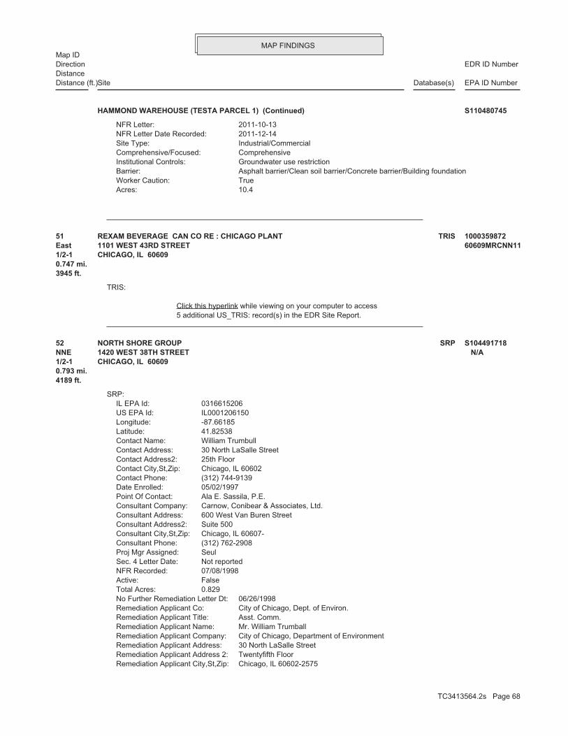
MAP FINDINGSMap ID
EDR ID NumberDirectionDistance
EPA ID NumberDatabase(s)SiteDistance (ft.)
10.4Acres: TrueWorker Caution: Asphalt barrier/Clean soil barrier/Concrete barrier/Building foundationBarrier: Groundwater use restrictionInstitutional Controls: ComprehensiveComprehensive/Focused: Industrial/CommercialSite Type: 2011-12-14NFR Letter Date Recorded: 2011-10-13NFR Letter:
HAMMOND WAREHOUSE (TESTA PARCEL 1) (Continued) S110480745
5 additional US_TRIS: record(s) in the EDR Site Report.Click this hyperlink while viewing on your computer to access
TRIS:
3945 ft.0.747 mi.1/2-1 CHICAGO, IL 60609East 1101 WEST 43RD STREET 60609MRCNN1151 TRISREXAM BEVERAGE CAN CO RE : CHICAGO PLANT 1000359872
Chicago, IL 60602-2575Remediation Applicant City,St,Zip: Twentyfifth FloorRemediation Applicant Address 2: 30 North LaSalle StreetRemediation Applicant Address: City of Chicago, Department of EnvironmentRemediation Applicant Company: Mr. William TrumballRemediation Applicant Name: Asst. Comm.Remediation Applicant Title: City of Chicago, Dept. of Environ.Remediation Applicant Co: 06/26/1998No Further Remediation Letter Dt: 0.829Total Acres: FalseActive: 07/08/1998NFR Recorded: Not reportedSec. 4 Letter Date: SeulProj Mgr Assigned: (312) 762-2908Consultant Phone: Chicago, IL 60607-Consultant City,St,Zip: Suite 500Consultant Address2: 600 West Van Buren StreetConsultant Address: Carnow, Conibear & Associates, Ltd.Consultant Company: Ala E. Sassila, P.E.Point Of Contact: 05/02/1997Date Enrolled: (312) 744-9139Contact Phone: Chicago, IL 60602Contact City,St,Zip: 25th FloorContact Address2: 30 North LaSalle StreetContact Address: William TrumbullContact Name: 41.82538Latitude: -87.66185Longitude: IL0001206150US EPA Id: 0316615206IL EPA Id:
SRP:
4189 ft.0.793 mi.1/2-1 CHICAGO, IL 60609NNE 1420 WEST 38TH STREET N/A52 SRPNORTH SHORE GROUP S104491718
TC3413564.2s Page 68

MAP FINDINGSMap ID
EDR ID NumberDirectionDistance
EPA ID NumberDatabase(s)SiteDistance (ft.)
0.829Acres: FalseWorker Caution: Not reportedBarrier: Groundwater use restrictionInstitutional Controls: ComprehensiveComprehensive/Focused: Industrial/CommercialSite Type: 1998-07-08NFR Letter Date Recorded: 1998-06-26NFR Letter: North Shore GroupSite Name: 0316615206Illinois EPA:
NORTH SHORE GROUP (Continued) S104491718
1 additional US_TRIS: record(s) in the EDR Site Report.Click this hyperlink while viewing on your computer to access
TRIS:
4202 ft.0.796 mi.1/2-1 CHICAGO, IL 60609West 4323 S WESTERN BLVD 60609MSMTL4353 TRISAMES METAL PRODUCTS CO 1005450260
4 additional US_TRIS: record(s) in the EDR Site Report.Click this hyperlink while viewing on your computer to access
TRIS:
4207 ft.0.797 mi.1/2-1 CHICAGO, IL 60609West 4435 S WESTERN BLVD 60609MNLYL4454 TRISWHEATLAND TUBE CO - CHICAGO DIV 1010560642
(630) 268-9090Consultant Phone: Oakbrook Terrace, IL 60181Consultant City,St,Zip: Suite 300Consultant Address2: 1 South 660 Midwest RoadConsultant Address: O’Shea, Parsons & Associates, Inc.Consultant Company: Robert W. ParsonsPoint Of Contact: 08/22/1996Date Enrolled: (609) 854-5400Contact Phone: Collingswood, NJ 08108-Contact City,St,Zip: Suite 500Contact Address2: 900 Haddon AvenueContact Address: F. Timothy BoylanContact Name: 41.81020Latitude: -87.68125Longitude: ILD984778241US EPA Id: 0316615049IL EPA Id:
SRP:
4259 ft.0.807 mi.1/2-1 CHICAGO, IL 60609WSW 2300 WEST 47TH STREET N/A55 SRPTEX’S TRUCK & PARTS, INC. S104521796
TC3413564.2s Page 69

MAP FINDINGSMap ID
EDR ID NumberDirectionDistance
EPA ID NumberDatabase(s)SiteDistance (ft.)
15.86Acres: TrueWorker Caution: Asphalt barrierBarrier: Not reportedInstitutional Controls: ComprehensiveComprehensive/Focused: Industrial/CommercialSite Type: 1999-05-17NFR Letter Date Recorded: 1999-04-02NFR Letter: John Maneely CompanySite Name: 0316615049Illinois EPA: Chicago, IL 60609-Remediation Applicant City,St,Zip: Not reportedRemediation Applicant Address 2: 4435 South Western BoulevardRemediation Applicant Address: Wheatland Tube CompanyRemediation Applicant Company: Mr. Arthur HallRemediation Applicant Name: Vice PresidentRemediation Applicant Title: John Maneely and Related CompaniesRemediation Applicant Co: 04/02/1999No Further Remediation Letter Dt: 15.86Total Acres: FalseActive: 05/17/1999NFR Recorded: Not reportedSec. 4 Letter Date: HackeProj Mgr Assigned:
TEX’S TRUCK & PARTS, INC. (Continued) S104521796
Litton Systems, Inc.Remediation Applicant Company: Ms. Carol WiesnerRemediation Applicant Name: Vice PresidentRemediation Applicant Title: Litton Systems, Inc.Remediation Applicant Co: 03/22/2000No Further Remediation Letter Dt: 3.129Total Acres: FalseActive: 09/19/2000NFR Recorded: Not reportedSec. 4 Letter Date: FrierdichProj Mgr Assigned: (312) 263-6703Consultant Phone: Chicago, IL 60606-Consultant City,St,Zip: Suite 1900Consultant Address2: 10 South Riverside PlazaConsultant Address: ARCADIS Geraghty & Miller, Inc.Consultant Company: Robert J. SmithPoint Of Contact: 10/09/1997Date Enrolled: (818) 598-5000Contact Phone: Woodland Hills, CA 91367-6675Contact City,St,Zip: Not reportedContact Address2: 21240 Burbank BoulevardContact Address: Carol WiesnerContact Name: 41.81045Latitude: -87.68254Longitude: ILD069994218US EPA Id: 0316580002IL EPA Id:
SRP:
4462 ft.0.845 mi.1/2-1 CHICAGO, IL 60609WSW 4545 S WESTERN AVE ILD06999421856 SRPLITTON SYSTEMS INC PRECISION GEAR DIV 1000417021
TC3413564.2s Page 70

MAP FINDINGSMap ID
EDR ID NumberDirectionDistance
EPA ID NumberDatabase(s)SiteDistance (ft.)
3.129Acres: TrueWorker Caution: Concrete barrierBarrier: Groundwater use restrictionInstitutional Controls: FocusedComprehensive/Focused: Industrial/CommercialSite Type: 2000-09-19NFR Letter Date Recorded: 2000-03-22NFR Letter: Litton Precision GearSite Name: 0316580002Illinois EPA: Woodland Hills, CA 91367-Remediation Applicant City,St,Zip: Not reportedRemediation Applicant Address 2: 21240 Burbank BoulevardRemediation Applicant Address:
LITTON SYSTEMS INC PRECISION GEAR DIV (Continued) 1000417021
Groundwater use restrictionInstitutional Controls: FocusedComprehensive/Focused: Industrial/CommercialSite Type: 2007-08-30NFR Letter Date Recorded: 2007-08-27NFR Letter: Turtle WaxSite Name: 0316615046Illinois EPA: Willowbrook, IL 60527-Remediation Applicant City,St,Zip: Not reportedRemediation Applicant Address 2: 625 Willowbrook Centre ParkwayRemediation Applicant Address: Turtle Wax Appearance Centers II, LLCRemediation Applicant Company: Mr. W.N. BoylesRemediation Applicant Name: PresidentRemediation Applicant Title: Turtle Wax Auto Appearance Centers II, LLCRemediation Applicant Co: 08/27/2007No Further Remediation Letter Dt: 0.280Total Acres: FalseActive: 08/30/2007NFR Recorded: Not reportedSec. 4 Letter Date: MurphyProj Mgr Assigned: (847) 464-1123Consultant Phone: Elgin, IL 60123-Consultant City,St,Zip: Not reportedConsultant Address2: 40W840 Bowes Bend DriveConsultant Address: Advanced Earth Technologies, Inc.Consultant Company: William J. Smith, P.E.Point Of Contact: 12/21/2006Date Enrolled: (630) 455-3740Contact Phone: Willowbrook, IL 60527-Contact City,St,Zip: Not reportedContact Address2: 625 Willowbrook Centre ParkwayContact Address: W.N. BoylesContact Name: 41.81868Latitude: -87.68507Longitude: Not reportedUS EPA Id: 0316615046IL EPA Id:
SRP:
4632 ft.0.877 mi.1/2-1 CHICAGO, IL 60609WNW 4130 SOUTH WESTERN AVENUE N/A57 SRPTURTLE WAX S104527974
TC3413564.2s Page 71

MAP FINDINGSMap ID
EDR ID NumberDirectionDistance
EPA ID NumberDatabase(s)SiteDistance (ft.)
0.280Acres: FalseWorker Caution: Not reportedBarrier:
TURTLE WAX (Continued) S104527974
1 additional US_TRIS: record(s) in the EDR Site Report.Click this hyperlink while viewing on your computer to access
TRIS:
4644 ft.0.880 mi.1/2-1 CHICAGO, IL 60609NW 2245 W PERSHING RD 60609FRMNT2258 TRISFAIRMONT CORP 1000900874
Not reportedSite Type: Not reportedNFR Letter Date Recorded: Not reportedNFR Letter: Not reportedSite Name: Not reportedIllinois EPA: Not reportedRemediation Applicant City,St,Zip: Not reportedRemediation Applicant Address 2: Not reportedRemediation Applicant Address: Not reportedRemediation Applicant Company: Not reportedRemediation Applicant Name: Mr.Remediation Applicant Title: AEW Capital Management, L.P.Remediation Applicant Co: Not reportedNo Further Remediation Letter Dt: 1.55Total Acres: FalseActive: Not reportedNFR Recorded: Not reportedSec. 4 Letter Date: McCaslinProj Mgr Assigned: (630) 916-7272Consultant Phone: Downers Grove, IL 60515-Consultant City,St,Zip: Unit 4Consultant Address2: 2777 Finley RoadConsultant Address: ATC Associates, Inc.Consultant Company: Ann M.C. ReppePoint Of Contact: 07/17/2000Date Enrolled: (617) 261-9328Contact Phone: Boston, MA 02110-2803Contact City,St,Zip: Not reportedContact Address2: 225 Franklin StreetContact Address: Edward CassidyContact Name: 41.82717Latitude: -87.66487Longitude: ILT180014532US EPA Id: 0316330003IL EPA Id:
SRP:
4831 ft.0.915 mi.1/2-1 CHICAGO, IL 60609North 3659 SOUTH ASHLAND AVENUE N/A59 SRPPUBLIC STORAGE S104562059
TC3413564.2s Page 72

MAP FINDINGSMap ID
EDR ID NumberDirectionDistance
EPA ID NumberDatabase(s)SiteDistance (ft.)
Not reportedAcres: Not reportedWorker Caution: Not reportedBarrier: Not reportedInstitutional Controls: Not reportedComprehensive/Focused:
PUBLIC STORAGE (Continued) S104562059
Not reportedAcres: Not reportedWorker Caution: Not reportedBarrier: Not reportedInstitutional Controls: Not reportedComprehensive/Focused: Not reportedSite Type: Not reportedNFR Letter Date Recorded: Not reportedNFR Letter: Not reportedSite Name: Not reportedIllinois EPA: Not reportedRemediation Applicant City,St,Zip: Not reportedRemediation Applicant Address 2: Not reportedRemediation Applicant Address: Not reportedRemediation Applicant Company: Not reportedRemediation Applicant Name: Mr.Remediation Applicant Title: Burns Philp (Fleischmann’s Vinegar)Remediation Applicant Co: Not reportedNo Further Remediation Letter Dt: 1.350Total Acres: FalseActive: Not reportedNFR Recorded: Not reportedSec. 4 Letter Date: FrierdichProj Mgr Assigned: (608) 273-2886Consultant Phone: Madison, WI 53711-6227Consultant City,St,Zip: Suite 201Consultant Address2: 25 Kessel CourtConsultant Address: URSConsultant Company: Mark S. McCollochPoint Of Contact: 12/02/1997Date Enrolled: (773) 523-2817Contact Phone: Chicago, IL 60609-Contact City,St,Zip: Not reportedContact Address2: 4801 South Oakley AvenueContact Address: Kirk AveryContact Name: 41.80556Latitude: -87.68141Longitude: Not reportedUS EPA Id: 0316615213IL EPA Id:
SRP:
4837 ft.0.916 mi.1/2-1 CHICAGO, IL 60609SW 4835 SOUTH OAKLEY AVENUE N/A60 SRPWEST 48TH PLACE AND OAKLEY S104491719
TC3413564.2s Page 73

MAP FINDINGSMap ID
EDR ID NumberDirectionDistance
EPA ID NumberDatabase(s)SiteDistance (ft.)
0.899Acres: TrueWorker Caution: Asphalt barrier/Concrete barrier/Building foundationBarrier: Groundwater use restrictionInstitutional Controls: FocusedComprehensive/Focused: Industrial/CommercialSite Type: 2010-04-09NFR Letter Date Recorded: 2010-03-31NFR Letter: Weld Rite ServicesSite Name: 0316006040Illinois EPA: Chicago, IL 60603-Remediation Applicant City,St,Zip: Not reportedRemediation Applicant Address 2: 120 South LaSalle StreetRemediation Applicant Address: Stone 1126 West 40th, LLCRemediation Applicant Company: Mr. William ChannonRemediation Applicant Name: Mr.Remediation Applicant Title: Stone 1126 W 40th, LLCRemediation Applicant Co: 03/31/2010No Further Remediation Letter Dt: 0.900Total Acres: FalseActive: 04/09/2010NFR Recorded: Not reportedSec. 4 Letter Date: ZookProj Mgr Assigned: (630) 577-0800Consultant Phone: Naperville, IL 60563-Consultant City,St,Zip: Suite 100Consultant Address2: 1245 East Diehl RoadConsultant Address: Atwell-HicksConsultant Company: C. Michael PerkinsPoint Of Contact: 04/21/2009Date Enrolled: (630) 589-3226Contact Phone: Chicago, IL 60603-Contact City,St,Zip: Not reportedContact Address2: 120 South LaSalle StreetContact Address: William ChannonContact Name: 41.82132Latitude: -87.65491Longitude: ILD984808337US EPA Id: 0316006040IL EPA Id:
SRP:
4849 ft. Site 1 of 2 in cluster J0.918 mi.1/2-1 CHICAGO, IL 60647ENE 1150 WEST 40TH STREET N/AJ61 SRPWELD RITE SERVICE, INC. S109528239
ENTIRE FACILITYArea Name: 05EPA Region: ILD087547618EPA ID:
CORRACTS:
4898 ft.0.928 mi.1/2-1 CHICAGO, IL 60609SE 4831 S MAY ILD08754761862 CORRACTSBRACO PLATING CO / BAIRD & WARNER 1000177454
TC3413564.2s Page 74

MAP FINDINGSMap ID
EDR ID NumberDirectionDistance
EPA ID NumberDatabase(s)SiteDistance (ft.)
Not reportedSchedule end date: Not reportedOriginal schedule date: Not reportedNAICS Code(s): CA070NO - RFA Determination Of Need For An RFI, RFI is Not NecessaryAction: 05/01/2009Actual Date:
BRACO PLATING CO / BAIRD & WARNER (Continued) 1000177454
Not reportedAcres: Not reportedWorker Caution: Not reportedBarrier: Not reportedInstitutional Controls: Not reportedComprehensive/Focused: Not reportedSite Type: Not reportedNFR Letter Date Recorded: Not reportedNFR Letter: Not reportedSite Name: Not reportedIllinois EPA: Not reportedRemediation Applicant City,St,Zip: Not reportedRemediation Applicant Address 2: Not reportedRemediation Applicant Address: Not reportedRemediation Applicant Company: Not reportedRemediation Applicant Name: Mr.Remediation Applicant Title: HydroAire, Inc.Remediation Applicant Co: Not reportedNo Further Remediation Letter Dt: 1.26Total Acres: TrueActive: Not reportedNFR Recorded: Not reportedSec. 4 Letter Date: ConnerProj Mgr Assigned: (773) 722-9200Consultant Phone: Chicago, IL 60612-Consultant City,St,Zip: Suite 101Consultant Address2: 700 North Sacramento BoulevardConsultant Address: Pioneer Environmental Services, LLCConsultant Company: Thomas D. CuligPoint Of Contact: 02/23/2011Date Enrolled: (312) 738-3000Contact Phone: Chicago, IL 60607-Contact City,St,Zip: Not reportedContact Address2: 834 West Madison StreetContact Address: Kenneth NovakContact Name: 41.82159Latitude: -87.65416Longitude: Not reportedUS EPA Id: 0316616497IL EPA Id:
SRP:
4918 ft. Site 2 of 2 in cluster J0.931 mi.1/2-1 CHICAGO, IL 60609ENE 1126 WEST 40TH STREET N/AJ63 SRPHYDROAIRE, INC. S110764145
TC3413564.2s Page 75

MAP FINDINGSMap ID
EDR ID NumberDirectionDistance
EPA ID NumberDatabase(s)SiteDistance (ft.)
0.119Acres: TrueWorker Caution: Asphalt barrier/Flowable slurry barrier/Concrete barrier/Building foundationBarrier: Groundwater use restrictionInstitutional Controls: FocusedComprehensive/Focused: Industrial/CommercialSite Type: 2003-03-18NFR Letter Date Recorded: 2003-03-11NFR Letter: WalgreensSite Name: 0316615332Illinois EPA: Chicago, IL 60610-Remediation Applicant City,St,Zip: 4th FloorRemediation Applicant Address 2: 225 West Hubbard StreetRemediation Applicant Address: 47th-Western L.L.C.Remediation Applicant Company: Mr. John McLindenRemediation Applicant Name: Mr.Remediation Applicant Title: 47th-Western, L.L.C.Remediation Applicant Co: 03/11/2003No Further Remediation Letter Dt: 0.12Total Acres: FalseActive: 03/18/2003NFR Recorded: Not reportedSec. 4 Letter Date: L-GaydoshProj Mgr Assigned: (708) 206-0007Consultant Phone: Flossmoor, IL 60422-Consultant City,St,Zip: P.O. Box 333Consultant Address2: 2612 Flossmoor RoadConsultant Address: Challenge Contractors, Inc.Consultant Company: Richard C. ThomasPoint Of Contact: 11/01/1999Date Enrolled: (312) 832-2500Contact Phone: Chicago, IL 60610-Contact City,St,Zip: 4th FloorContact Address2: 225 West Hubbard StreetContact Address: John McLindenContact Name: 41.80778Latitude: -87.68479Longitude: Not reportedUS EPA Id: 0316615332IL EPA Id:
SRP:
4980 ft.0.943 mi.1/2-1 CHICAGO, IL 60609WSW 4724 SOUTH WESTERN AVENUE N/A64 SRPWALGREENS S104491723
Arthur SalkContact Name: 41.80619Latitude: -87.68289Longitude: IL0000077735US EPA Id: 0316615159IL EPA Id:
SRP:
5044 ft.0.955 mi.1/2-1 CHICAGO, IL 60609SW 4801 SOUTH WESTERN BOULEVARD N/A65 SRPPIN PARTNERS, LTD. S104529017
TC3413564.2s Page 76

MAP FINDINGSMap ID
EDR ID NumberDirectionDistance
EPA ID NumberDatabase(s)SiteDistance (ft.)
0.5Acres: TrueWorker Caution: Asphalt barrier/Building foundationBarrier: Groundwater use restrictionInstitutional Controls: FocusedComprehensive/Focused: ResidentialSite Type: 1999-04-08NFR Letter Date Recorded: 1999-03-23NFR Letter: Pin Partners, Ltd.Site Name: 0316615159Illinois EPA: Northbrook, IL 60062-Remediation Applicant City,St,Zip: Suite 110Remediation Applicant Address 2: 630 Dundee RoadRemediation Applicant Address: Hilander, L.L.C.Remediation Applicant Company: Mr. Arthur SalkRemediation Applicant Name: Mr.Remediation Applicant Title: Highlander Care Center, LLCRemediation Applicant Co: 03/23/1999No Further Remediation Letter Dt: 0.5Total Acres: FalseActive: 04/08/1999NFR Recorded: Not reportedSec. 4 Letter Date: L-BloomeProj Mgr Assigned: (847) 564-8333Consultant Phone: Chicago, IL 60062Consultant City,St,Zip: Not reportedConsultant Address2: 643 North Orleans StreetConsultant Address: Pepper Environmental Technologies, Inc.Consultant Company: James F. DavisPoint Of Contact: 11/15/1996Date Enrolled: (847) 564-8333Contact Phone: Northbrook, IL 60062Contact City,St,Zip: Suite 110Contact Address2: 630 Dundee RoadContact Address:
PIN PARTNERS, LTD. (Continued) S104529017
TC3413564.2s Page 77

OR
PH
AN
SU
MM
AR
Y
City
ED
R ID
Site
Nam
eS
ite A
ddre
ssZi
pD
atab
ase(
s)
Cou
nt: 2
0 re
cord
s.
CH
ICA
GO
1003
8700
56J
P R
EFU
SE
DIS
PO
SA
L40
TH &
SO
UTH
AS
HLA
ND
6060
9C
ER
CLI
S-N
FRA
PC
HIC
AG
O10
0812
5406
SO
UTH
SC
HO
OL
79TH
AN
D H
ON
OR
E S
TFI
ND
S,A
IRS
CIC
ER
O10
1220
9927
ALL
CIT
Y E
NV
IRO
NM
EN
TAL
SE
RV
ICE
S50
01 W
40T
H S
T60
632
CE
RC
LIS
CH
ICA
GO
1012
2421
45I-5
5/C
ICE
RO
AV
EN
UE
CIC
ER
O A
VE
NU
E A
ND
43R
D S
T.60
632
FIN
DS
CH
ICA
GO
1014
4095
52D
AN
RY
AN
& 4
7TH
STR
EE
T47
TH S
TRE
ET
6060
9C
ER
CLI
S-N
FRA
P,P
RP
CH
ICA
GO
2000
5180
2713
5 S
OU
TH K
AD
ZIE
0E
RN
SC
HIC
AG
O20
0053
0517
5142
SO
UTH
LA
CR
OS
SE
STR
EE
T0
ER
NS
CH
ICA
GO
2000
5307
3345
41 S
OU
TH F
OR
ES
TVIL
LE0
ER
NS
CH
ICA
GO
2001
5578
2437
50 S
OU
TH S
AN
GA
NO
NE
RN
SC
HIC
AG
O20
0259
1202
103
36TH
SO
UTH
AV
E O
.0
ER
NS
CH
ICA
GO
2002
5930
4514
00 S
OU
TH W
ES
TER
N B
LVD
0E
RN
SC
HIC
AG
O20
0259
3093
1400
SO
UTH
WE
STE
RN
BLV
D0
ER
NS
CH
ICA
GO
2002
6007
3726
00 S
OU
TH D
AM
ON
0E
RN
SC
HIC
AG
O20
0363
7212
5701
SO
UTH
CO
RN
ELL
L D
RIV
EE
RN
SC
HIC
AG
O20
0364
8226
1130
SO
UTH
HA
LSTA
DE
RN
SC
HIC
AG
O20
0370
8369
SO
UTH
EN
DE
RN
SC
HIC
AG
O20
0471
2427
AR
CH
ER
AV
EN
UE
& K
OS
TER
AV
EN
UE
ER
NS
CH
ICA
GO
2004
7140
3512
931
SO
UTH
NO
RM
AE
RN
SC
HIC
AG
O20
0473
1395
6300
SO
UTH
LA
TOR
BE
AV
EE
RN
SC
HIC
AG
O20
0473
3058
AS
HLA
ND
AV
EN
UE
ER
NS
TC34
1356
4.2s
P
age
78

To maintain currency of the following federal and state databases, EDR contacts the appropriate governmental agencyon a monthly or quarterly basis, as required.
Number of Days to Update: Provides confirmation that EDR is reporting records that have been updated within 90 daysfrom the date the government agency made the information available to the public.
STANDARD ENVIRONMENTAL RECORDS
Federal NPL site list
NPL: National Priority ListNational Priorities List (Superfund). The NPL is a subset of CERCLIS and identifies over 1,200 sites for prioritycleanup under the Superfund Program. NPL sites may encompass relatively large areas. As such, EDR provides polygoncoverage for over 1,000 NPL site boundaries produced by EPA’s Environmental Photographic Interpretation Center(EPIC) and regional EPA offices.
Date of Government Version: 06/07/2012Date Data Arrived at EDR: 07/05/2012Date Made Active in Reports: 09/18/2012Number of Days to Update: 75
Source: EPATelephone: N/ALast EDR Contact: 07/05/2012Next Scheduled EDR Contact: 10/22/2012Data Release Frequency: Quarterly
NPL Site Boundaries
Sources:
EPA’s Environmental Photographic Interpretation Center (EPIC)Telephone: 202-564-7333
EPA Region 1 EPA Region 6Telephone 617-918-1143 Telephone: 214-655-6659
EPA Region 3 EPA Region 7Telephone 215-814-5418 Telephone: 913-551-7247
EPA Region 4 EPA Region 8Telephone 404-562-8033 Telephone: 303-312-6774
EPA Region 5 EPA Region 9Telephone 312-886-6686 Telephone: 415-947-4246
EPA Region 10Telephone 206-553-8665
Proposed NPL: Proposed National Priority List SitesA site that has been proposed for listing on the National Priorities List through the issuance of a proposed rulein the Federal Register. EPA then accepts public comments on the site, responds to the comments, and places onthe NPL those sites that continue to meet the requirements for listing.
Date of Government Version: 06/07/2012Date Data Arrived at EDR: 07/05/2012Date Made Active in Reports: 09/18/2012Number of Days to Update: 75
Source: EPATelephone: N/ALast EDR Contact: 07/05/2012Next Scheduled EDR Contact: 10/22/2012Data Release Frequency: Quarterly
NPL LIENS: Federal Superfund LiensFederal Superfund Liens. Under the authority granted the USEPA by CERCLA of 1980, the USEPA has the authorityto file liens against real property in order to recover remedial action expenditures or when the property ownerreceived notification of potential liability. USEPA compiles a listing of filed notices of Superfund Liens.
Date of Government Version: 10/15/1991Date Data Arrived at EDR: 02/02/1994Date Made Active in Reports: 03/30/1994Number of Days to Update: 56
Source: EPATelephone: 202-564-4267Last EDR Contact: 08/15/2011Next Scheduled EDR Contact: 11/28/2011Data Release Frequency: No Update Planned
TC3413564.2s Page GR-1
GOVERNMENT RECORDS SEARCHED / DATA CURRENCY TRACKING

Federal Delisted NPL site list
DELISTED NPL: National Priority List DeletionsThe National Oil and Hazardous Substances Pollution Contingency Plan (NCP) establishes the criteria that theEPA uses to delete sites from the NPL. In accordance with 40 CFR 300.425.(e), sites may be deleted from theNPL where no further response is appropriate.
Date of Government Version: 06/07/2012Date Data Arrived at EDR: 07/05/2012Date Made Active in Reports: 09/18/2012Number of Days to Update: 75
Source: EPATelephone: N/ALast EDR Contact: 07/05/2012Next Scheduled EDR Contact: 10/22/2012Data Release Frequency: Quarterly
Federal CERCLIS list
CERCLIS: Comprehensive Environmental Response, Compensation, and Liability Information SystemCERCLIS contains data on potentially hazardous waste sites that have been reported to the USEPA by states, municipalities,private companies and private persons, pursuant to Section 103 of the Comprehensive Environmental Response, Compensation,and Liability Act (CERCLA). CERCLIS contains sites which are either proposed to or on the National PrioritiesList (NPL) and sites which are in the screening and assessment phase for possible inclusion on the NPL.
Date of Government Version: 12/27/2011Date Data Arrived at EDR: 02/27/2012Date Made Active in Reports: 03/12/2012Number of Days to Update: 14
Source: EPATelephone: 703-412-9810Last EDR Contact: 08/28/2012Next Scheduled EDR Contact: 12/10/2012Data Release Frequency: Quarterly
FEDERAL FACILITY: Federal Facility Site Information listingA listing of National Priority List (NPL) and Base Realignment and Closure (BRAC) sites found in the ComprehensiveEnvironmental Response, Compensation and Liability Information System (CERCLIS) Database where EPA Federal FacilitiesRestoration and Reuse Office is involved in cleanup activities.
Date of Government Version: 12/10/2010Date Data Arrived at EDR: 01/11/2011Date Made Active in Reports: 02/16/2011Number of Days to Update: 36
Source: Environmental Protection AgencyTelephone: 703-603-8704Last EDR Contact: 07/13/2012Next Scheduled EDR Contact: 10/22/2012Data Release Frequency: Varies
Federal CERCLIS NFRAP site List
CERCLIS-NFRAP: CERCLIS No Further Remedial Action PlannedArchived sites are sites that have been removed and archived from the inventory of CERCLIS sites. Archived statusindicates that, to the best of EPA’s knowledge, assessment at a site has been completed and that EPA has determinedno further steps will be taken to list this site on the National Priorities List (NPL), unless information indicatesthis decision was not appropriate or other considerations require a recommendation for listing at a later time.This decision does not necessarily mean that there is no hazard associated with a given site; it only means that,based upon available information, the location is not judged to be a potential NPL site.
Date of Government Version: 12/28/2011Date Data Arrived at EDR: 02/27/2012Date Made Active in Reports: 03/12/2012Number of Days to Update: 14
Source: EPATelephone: 703-412-9810Last EDR Contact: 08/28/2012Next Scheduled EDR Contact: 12/10/2012Data Release Frequency: Quarterly
Federal RCRA CORRACTS facilities list
CORRACTS: Corrective Action ReportCORRACTS identifies hazardous waste handlers with RCRA corrective action activity.
TC3413564.2s Page GR-2
GOVERNMENT RECORDS SEARCHED / DATA CURRENCY TRACKING

Date of Government Version: 08/19/2011Date Data Arrived at EDR: 08/31/2011Date Made Active in Reports: 01/10/2012Number of Days to Update: 132
Source: EPATelephone: 800-424-9346Last EDR Contact: 08/07/2012Next Scheduled EDR Contact: 11/26/2012Data Release Frequency: Quarterly
Federal RCRA non-CORRACTS TSD facilities list
RCRA-TSDF: RCRA - Treatment, Storage and DisposalRCRAInfo is EPA’s comprehensive information system, providing access to data supporting the Resource Conservationand Recovery Act (RCRA) of 1976 and the Hazardous and Solid Waste Amendments (HSWA) of 1984. The databaseincludes selective information on sites which generate, transport, store, treat and/or dispose of hazardous wasteas defined by the Resource Conservation and Recovery Act (RCRA). Transporters are individuals or entities thatmove hazardous waste from the generator offsite to a facility that can recycle, treat, store, or dispose of thewaste. TSDFs treat, store, or dispose of the waste.
Date of Government Version: 03/15/2012Date Data Arrived at EDR: 04/04/2012Date Made Active in Reports: 05/15/2012Number of Days to Update: 41
Source: Environmental Protection AgencyTelephone: 312-886-6186Last EDR Contact: 08/16/2012Next Scheduled EDR Contact: 10/15/2012Data Release Frequency: Quarterly
Federal RCRA generators list
RCRA-LQG: RCRA - Large Quantity GeneratorsRCRAInfo is EPA’s comprehensive information system, providing access to data supporting the Resource Conservationand Recovery Act (RCRA) of 1976 and the Hazardous and Solid Waste Amendments (HSWA) of 1984. The databaseincludes selective information on sites which generate, transport, store, treat and/or dispose of hazardous wasteas defined by the Resource Conservation and Recovery Act (RCRA). Large quantity generators (LQGs) generateover 1,000 kilograms (kg) of hazardous waste, or over 1 kg of acutely hazardous waste per month.
Date of Government Version: 03/15/2012Date Data Arrived at EDR: 04/04/2012Date Made Active in Reports: 05/15/2012Number of Days to Update: 41
Source: Environmental Protection AgencyTelephone: 312-886-6186Last EDR Contact: 08/16/2012Next Scheduled EDR Contact: 10/15/2012Data Release Frequency: Quarterly
RCRA-SQG: RCRA - Small Quantity GeneratorsRCRAInfo is EPA’s comprehensive information system, providing access to data supporting the Resource Conservationand Recovery Act (RCRA) of 1976 and the Hazardous and Solid Waste Amendments (HSWA) of 1984. The databaseincludes selective information on sites which generate, transport, store, treat and/or dispose of hazardous wasteas defined by the Resource Conservation and Recovery Act (RCRA). Small quantity generators (SQGs) generatebetween 100 kg and 1,000 kg of hazardous waste per month.
Date of Government Version: 03/15/2012Date Data Arrived at EDR: 04/04/2012Date Made Active in Reports: 05/15/2012Number of Days to Update: 41
Source: Environmental Protection AgencyTelephone: 312-886-6186Last EDR Contact: 08/16/2012Next Scheduled EDR Contact: 10/15/2012Data Release Frequency: Quarterly
RCRA-CESQG: RCRA - Conditionally Exempt Small Quantity GeneratorsRCRAInfo is EPA’s comprehensive information system, providing access to data supporting the Resource Conservationand Recovery Act (RCRA) of 1976 and the Hazardous and Solid Waste Amendments (HSWA) of 1984. The databaseincludes selective information on sites which generate, transport, store, treat and/or dispose of hazardous wasteas defined by the Resource Conservation and Recovery Act (RCRA). Conditionally exempt small quantity generators(CESQGs) generate less than 100 kg of hazardous waste, or less than 1 kg of acutely hazardous waste per month.
Date of Government Version: 03/15/2012Date Data Arrived at EDR: 04/04/2012Date Made Active in Reports: 05/15/2012Number of Days to Update: 41
Source: Environmental Protection AgencyTelephone: 312-886-6186Last EDR Contact: 08/16/2012Next Scheduled EDR Contact: 10/15/2012Data Release Frequency: Varies
TC3413564.2s Page GR-3
GOVERNMENT RECORDS SEARCHED / DATA CURRENCY TRACKING

Federal institutional controls / engineering controls registries
US ENG CONTROLS: Engineering Controls Sites ListA listing of sites with engineering controls in place. Engineering controls include various forms of caps, buildingfoundations, liners, and treatment methods to create pathway elimination for regulated substances to enter environmentalmedia or effect human health.
Date of Government Version: 12/30/2011Date Data Arrived at EDR: 12/30/2011Date Made Active in Reports: 01/10/2012Number of Days to Update: 11
Source: Environmental Protection AgencyTelephone: 703-603-0695Last EDR Contact: 09/05/2012Next Scheduled EDR Contact: 12/24/2012Data Release Frequency: Varies
US INST CONTROL: Sites with Institutional ControlsA listing of sites with institutional controls in place. Institutional controls include administrative measures,such as groundwater use restrictions, construction restrictions, property use restrictions, and post remediationcare requirements intended to prevent exposure to contaminants remaining on site. Deed restrictions are generallyrequired as part of the institutional controls.
Date of Government Version: 12/30/2011Date Data Arrived at EDR: 12/30/2011Date Made Active in Reports: 01/10/2012Number of Days to Update: 11
Source: Environmental Protection AgencyTelephone: 703-603-0695Last EDR Contact: 09/05/2012Next Scheduled EDR Contact: 12/24/2012Data Release Frequency: Varies
Federal ERNS list
ERNS: Emergency Response Notification SystemEmergency Response Notification System. ERNS records and stores information on reported releases of oil and hazardoussubstances.
Date of Government Version: 04/02/2012Date Data Arrived at EDR: 04/03/2012Date Made Active in Reports: 06/14/2012Number of Days to Update: 72
Source: National Response Center, United States Coast GuardTelephone: 202-267-2180Last EDR Contact: 07/02/2012Next Scheduled EDR Contact: 10/15/2012Data Release Frequency: Annually
State- and tribal - equivalent CERCLIS
SSU: State Sites Unit ListingThe State Response Action Program database identifies the status of all sites under the responsibility of theIllinois EPA’s State Sites Unit.
Date of Government Version: 07/10/2012Date Data Arrived at EDR: 07/12/2012Date Made Active in Reports: 08/02/2012Number of Days to Update: 21
Source: Illinois Environmental Protection AgencyTelephone: 217-524-4826Last EDR Contact: 07/12/2012Next Scheduled EDR Contact: 11/12/2012Data Release Frequency: Semi-Annually
State and tribal landfill and/or solid waste disposal site lists
SWF/LF: Available Disposal for Solid Waste in Illinois - Solid Waste Landfills Subject to State SurchargeSolid Waste Facilities/Landfill Sites. SWF/LF type records typically contain an inventory of solid waste disposalfacilities or landfills in a particular state. Depending on the state, these may be active or inactive facilitiesor open dumps that failed to meet RCRA Subtitle D Section 4004 criteria for solid waste landfills or disposalsites.
Date of Government Version: 12/31/2010Date Data Arrived at EDR: 12/21/2011Date Made Active in Reports: 12/23/2011Number of Days to Update: 2
Source: Illinois Environmental Protection AgencyTelephone: 217-785-8604Last EDR Contact: 08/03/2012Next Scheduled EDR Contact: 11/12/2012Data Release Frequency: Annually
TC3413564.2s Page GR-4
GOVERNMENT RECORDS SEARCHED / DATA CURRENCY TRACKING

LF WMRC: Waste Management & Research Center Landfill DatabaseThe Waste Management & Research Center Landfill Database includes records from the Department of Public Health,Department of Mines & Minerals, Illinois Environmental Protection Agency, State Geological Survey, NortheasternIllinois Planning Commission and Pollution Control Board.
Date of Government Version: 12/31/2001Date Data Arrived at EDR: 10/06/2006Date Made Active in Reports: 11/06/2006Number of Days to Update: 31
Source: Department of Natural ResourcesTelephone: 217-333-8940Last EDR Contact: 09/18/2009Next Scheduled EDR Contact: 12/28/2009Data Release Frequency: No Update Planned
LF SPECIAL WASTE: Special Waste Site ListThese landfills, as of January 1, 1990, accept non-hazardous special waste pursuant to the Illinois EPA Non-HazardousSpecial Waste Definition. List A includes landfills that may receive any non-hazardous waste, Non-Regional PollutionControl Facilities are so noted. List B includes landfills designed to receive specific non-hazardous wastes.List B landfills are designated as a Regional Pollution Control Facility by RPCF, or Non-Regional Pollution ControlFacility by Non-RPCF.
Date of Government Version: 01/01/1990Date Data Arrived at EDR: 06/17/2009Date Made Active in Reports: 07/15/2009Number of Days to Update: 28
Source: Illinois EPATelephone: 217-782-9288Last EDR Contact: 06/10/2009Next Scheduled EDR Contact: N/AData Release Frequency: No Update Planned
IL NIPC: Solid Waste Landfill InventorySolid Waste Landfill Inventory. NIPC is an inventory of active and inactive solid waste disposal sites, basedon state, local government and historical archive data. Included are numerous sites which previously had neverbeen identified largely because there was no obligation to register such sites prior to 1971.
Date of Government Version: 08/01/1988Date Data Arrived at EDR: 08/01/1994Date Made Active in Reports: 08/12/1994Number of Days to Update: 11
Source: Northeastern Illinois Planning CommissionTelephone: 312-454-0400Last EDR Contact: 05/23/2006Next Scheduled EDR Contact: N/AData Release Frequency: No Update Planned
CCDD: Clean Construction or Demolition DebrisConstruction and demolition (C and D) debris is nonhazardous, uncontaminated material resulting from construction,remodeling, repair, or demolition of utilities, structures, and roads.
Date of Government Version: 07/30/2012Date Data Arrived at EDR: 07/31/2012Date Made Active in Reports: 08/31/2012Number of Days to Update: 31
Source: Illinois EPATelephone: 217-524-3300Last EDR Contact: 07/31/2012Next Scheduled EDR Contact: 11/12/2012Data Release Frequency: Varies
State and tribal leaking storage tank lists
LUST: Leaking Underground Storage Tank SitesLeaking Underground Storage Tank Incident Reports. LUST records contain an inventory of reported leaking undergroundstorage tank incidents. Not all states maintain these records, and the information stored varies by state.
Date of Government Version: 07/20/2012Date Data Arrived at EDR: 07/31/2012Date Made Active in Reports: 08/31/2012Number of Days to Update: 31
Source: Illinois Environmental Protection AgencyTelephone: 217-782-6762Last EDR Contact: 07/31/2012Next Scheduled EDR Contact: 11/12/2012Data Release Frequency: Semi-Annually
LUST TRUST: Underground Storage Tank Fund Payment Prioirty ListIn case sufficient funds are not available in the Underground Storage Tank Fund, requests for payment are enteredon the Payment Priority List by "queue date" order. As required by the Environmental Protection Act, the queuedate is the date that a complete request for partial or final payment was received by the Agency. The queue dateis "officially" confirmed at the end of the payment review process when a Final Decision Letter is sent to thesite owner.
TC3413564.2s Page GR-5
GOVERNMENT RECORDS SEARCHED / DATA CURRENCY TRACKING

Date of Government Version: 07/19/2012Date Data Arrived at EDR: 07/31/2012Date Made Active in Reports: 08/31/2012Number of Days to Update: 31
Source: Illinois EPATelephone: 217-782-6762Last EDR Contact: 07/31/2012Next Scheduled EDR Contact: 11/12/2012Data Release Frequency: Varies
INDIAN LUST R1: Leaking Underground Storage Tanks on Indian LandA listing of leaking underground storage tank locations on Indian Land.
Date of Government Version: 04/12/2012Date Data Arrived at EDR: 05/09/2012Date Made Active in Reports: 07/10/2012Number of Days to Update: 62
Source: EPA Region 1Telephone: 617-918-1313Last EDR Contact: 08/03/2012Next Scheduled EDR Contact: 11/12/2012Data Release Frequency: Varies
INDIAN LUST R7: Leaking Underground Storage Tanks on Indian LandLUSTs on Indian land in Iowa, Kansas, and Nebraska
Date of Government Version: 02/07/2012Date Data Arrived at EDR: 02/17/2012Date Made Active in Reports: 05/15/2012Number of Days to Update: 88
Source: EPA Region 7Telephone: 913-551-7003Last EDR Contact: 07/26/2012Next Scheduled EDR Contact: 11/12/2012Data Release Frequency: Varies
INDIAN LUST R4: Leaking Underground Storage Tanks on Indian LandLUSTs on Indian land in Florida, Mississippi and North Carolina.
Date of Government Version: 12/14/2011Date Data Arrived at EDR: 12/15/2011Date Made Active in Reports: 01/10/2012Number of Days to Update: 26
Source: EPA Region 4Telephone: 404-562-8677Last EDR Contact: 07/26/2012Next Scheduled EDR Contact: 11/12/2012Data Release Frequency: Semi-Annually
INDIAN LUST R6: Leaking Underground Storage Tanks on Indian LandLUSTs on Indian land in New Mexico and Oklahoma.
Date of Government Version: 09/12/2011Date Data Arrived at EDR: 09/13/2011Date Made Active in Reports: 11/11/2011Number of Days to Update: 59
Source: EPA Region 6Telephone: 214-665-6597Last EDR Contact: 07/26/2012Next Scheduled EDR Contact: 11/12/2012Data Release Frequency: Varies
INDIAN LUST R10: Leaking Underground Storage Tanks on Indian LandLUSTs on Indian land in Alaska, Idaho, Oregon and Washington.
Date of Government Version: 05/07/2012Date Data Arrived at EDR: 05/08/2012Date Made Active in Reports: 07/10/2012Number of Days to Update: 63
Source: EPA Region 10Telephone: 206-553-2857Last EDR Contact: 07/26/2012Next Scheduled EDR Contact: 11/12/2012Data Release Frequency: Quarterly
INDIAN LUST R9: Leaking Underground Storage Tanks on Indian LandLUSTs on Indian land in Arizona, California, New Mexico and Nevada
Date of Government Version: 05/25/2012Date Data Arrived at EDR: 05/25/2012Date Made Active in Reports: 07/16/2012Number of Days to Update: 52
Source: Environmental Protection AgencyTelephone: 415-972-3372Last EDR Contact: 07/26/2012Next Scheduled EDR Contact: 11/12/2012Data Release Frequency: Quarterly
TC3413564.2s Page GR-6
GOVERNMENT RECORDS SEARCHED / DATA CURRENCY TRACKING

INDIAN LUST R8: Leaking Underground Storage Tanks on Indian LandLUSTs on Indian land in Colorado, Montana, North Dakota, South Dakota, Utah and Wyoming.
Date of Government Version: 08/18/2011Date Data Arrived at EDR: 08/19/2011Date Made Active in Reports: 09/13/2011Number of Days to Update: 25
Source: EPA Region 8Telephone: 303-312-6271Last EDR Contact: 07/26/2012Next Scheduled EDR Contact: 11/26/2012Data Release Frequency: Quarterly
State and tribal registered storage tank lists
UST: Underground Storage Tank Facility ListRegistered Underground Storage Tanks. UST’s are regulated under Subtitle I of the Resource Conservation and RecoveryAct (RCRA) and must be registered with the state department responsible for administering the UST program. Availableinformation varies by state program.
Date of Government Version: 05/01/2012Date Data Arrived at EDR: 05/01/2012Date Made Active in Reports: 06/01/2012Number of Days to Update: 31
Source: Illinois State Fire MarshalTelephone: 217-785-0969Last EDR Contact: 07/31/2012Next Scheduled EDR Contact: 11/12/2012Data Release Frequency: Quarterly
INDIAN UST R10: Underground Storage Tanks on Indian LandThe Indian Underground Storage Tank (UST) database provides information about underground storage tanks on Indianland in EPA Region 10 (Alaska, Idaho, Oregon, Washington, and Tribal Nations).
Date of Government Version: 05/07/2012Date Data Arrived at EDR: 05/08/2012Date Made Active in Reports: 07/16/2012Number of Days to Update: 69
Source: EPA Region 10Telephone: 206-553-2857Last EDR Contact: 07/26/2012Next Scheduled EDR Contact: 11/12/2012Data Release Frequency: Quarterly
INDIAN UST R9: Underground Storage Tanks on Indian LandThe Indian Underground Storage Tank (UST) database provides information about underground storage tanks on Indianland in EPA Region 9 (Arizona, California, Hawaii, Nevada, the Pacific Islands, and Tribal Nations).
Date of Government Version: 11/28/2011Date Data Arrived at EDR: 11/29/2011Date Made Active in Reports: 01/10/2012Number of Days to Update: 42
Source: EPA Region 9Telephone: 415-972-3368Last EDR Contact: 07/26/2012Next Scheduled EDR Contact: 11/12/2012Data Release Frequency: Quarterly
INDIAN UST R8: Underground Storage Tanks on Indian LandThe Indian Underground Storage Tank (UST) database provides information about underground storage tanks on Indianland in EPA Region 8 (Colorado, Montana, North Dakota, South Dakota, Utah, Wyoming and 27 Tribal Nations).
Date of Government Version: 08/18/2011Date Data Arrived at EDR: 08/19/2011Date Made Active in Reports: 09/13/2011Number of Days to Update: 25
Source: EPA Region 8Telephone: 303-312-6137Last EDR Contact: 07/26/2012Next Scheduled EDR Contact: 11/12/2012Data Release Frequency: Quarterly
INDIAN UST R7: Underground Storage Tanks on Indian LandThe Indian Underground Storage Tank (UST) database provides information about underground storage tanks on Indianland in EPA Region 7 (Iowa, Kansas, Missouri, Nebraska, and 9 Tribal Nations).
Date of Government Version: 02/07/2012Date Data Arrived at EDR: 02/17/2012Date Made Active in Reports: 05/15/2012Number of Days to Update: 88
Source: EPA Region 7Telephone: 913-551-7003Last EDR Contact: 07/26/2012Next Scheduled EDR Contact: 11/12/2012Data Release Frequency: Varies
TC3413564.2s Page GR-7
GOVERNMENT RECORDS SEARCHED / DATA CURRENCY TRACKING

INDIAN UST R6: Underground Storage Tanks on Indian LandThe Indian Underground Storage Tank (UST) database provides information about underground storage tanks on Indianland in EPA Region 6 (Louisiana, Arkansas, Oklahoma, New Mexico, Texas and 65 Tribes).
Date of Government Version: 05/10/2011Date Data Arrived at EDR: 05/11/2011Date Made Active in Reports: 06/14/2011Number of Days to Update: 34
Source: EPA Region 6Telephone: 214-665-7591Last EDR Contact: 07/26/2012Next Scheduled EDR Contact: 11/12/2012Data Release Frequency: Semi-Annually
INDIAN UST R4: Underground Storage Tanks on Indian LandThe Indian Underground Storage Tank (UST) database provides information about underground storage tanks on Indianland in EPA Region 4 (Alabama, Florida, Georgia, Kentucky, Mississippi, North Carolina, South Carolina, Tennesseeand Tribal Nations)
Date of Government Version: 12/14/2011Date Data Arrived at EDR: 12/15/2011Date Made Active in Reports: 01/10/2012Number of Days to Update: 26
Source: EPA Region 4Telephone: 404-562-9424Last EDR Contact: 07/26/2012Next Scheduled EDR Contact: 11/12/2012Data Release Frequency: Semi-Annually
INDIAN UST R1: Underground Storage Tanks on Indian LandThe Indian Underground Storage Tank (UST) database provides information about underground storage tanks on Indianland in EPA Region 1 (Connecticut, Maine, Massachusetts, New Hampshire, Rhode Island, Vermont and ten TribalNations).
Date of Government Version: 04/12/2012Date Data Arrived at EDR: 05/02/2012Date Made Active in Reports: 07/16/2012Number of Days to Update: 75
Source: EPA, Region 1Telephone: 617-918-1313Last EDR Contact: 08/03/2012Next Scheduled EDR Contact: 11/12/2012Data Release Frequency: Varies
INDIAN UST R5: Underground Storage Tanks on Indian LandThe Indian Underground Storage Tank (UST) database provides information about underground storage tanks on Indianland in EPA Region 5 (Michigan, Minnesota and Wisconsin and Tribal Nations).
Date of Government Version: 02/28/2012Date Data Arrived at EDR: 02/29/2012Date Made Active in Reports: 05/15/2012Number of Days to Update: 76
Source: EPA Region 5Telephone: 312-886-6136Last EDR Contact: 07/26/2012Next Scheduled EDR Contact: 11/12/2012Data Release Frequency: Varies
FEMA UST: Underground Storage Tank ListingA listing of all FEMA owned underground storage tanks.
Date of Government Version: 01/01/2010Date Data Arrived at EDR: 02/16/2010Date Made Active in Reports: 04/12/2010Number of Days to Update: 55
Source: FEMATelephone: 202-646-5797Last EDR Contact: 07/12/2012Next Scheduled EDR Contact: 10/29/2012Data Release Frequency: Varies
State and tribal institutional control / engineering control registries
ENG CONTROLS: Sites with Engineering ControlsSites using of engineered barriers (e.g., asphalt or concrete paving).
Date of Government Version: 07/20/2012Date Data Arrived at EDR: 07/24/2012Date Made Active in Reports: 07/30/2012Number of Days to Update: 6
Source: Illinois Environmental Protection AgencyTelephone: 217-782-6761Last EDR Contact: 08/30/2012Next Scheduled EDR Contact: 11/05/2012Data Release Frequency: Quarterly
TC3413564.2s Page GR-8
GOVERNMENT RECORDS SEARCHED / DATA CURRENCY TRACKING

Inst Control: Institutional ControlsLegal or administrative restrictions on land use and/or other activities (e.g., groundwater use restrictions)which effectively limit exposure to contamination may be employed as alternatives to removal or treatment of contamination.
Date of Government Version: 07/20/2012Date Data Arrived at EDR: 07/24/2012Date Made Active in Reports: 07/30/2012Number of Days to Update: 6
Source: Illinois Environmental Protection AgencyTelephone: 217-782-6761Last EDR Contact: 08/30/2012Next Scheduled EDR Contact: 11/05/2012Data Release Frequency: Quarterly
State and tribal voluntary cleanup sites
INDIAN VCP R7: Voluntary Cleanup Priority LisitngA listing of voluntary cleanup priority sites located on Indian Land located in Region 7.
Date of Government Version: 03/20/2008Date Data Arrived at EDR: 04/22/2008Date Made Active in Reports: 05/19/2008Number of Days to Update: 27
Source: EPA, Region 7Telephone: 913-551-7365Last EDR Contact: 04/20/2009Next Scheduled EDR Contact: 07/20/2009Data Release Frequency: Varies
INDIAN VCP R1: Voluntary Cleanup Priority ListingA listing of voluntary cleanup priority sites located on Indian Land located in Region 1.
Date of Government Version: 02/17/2012Date Data Arrived at EDR: 04/03/2012Date Made Active in Reports: 05/15/2012Number of Days to Update: 42
Source: EPA, Region 1Telephone: 617-918-1102Last EDR Contact: 07/02/2012Next Scheduled EDR Contact: 10/15/2012Data Release Frequency: Varies
SRP: Site Remediation Program DatabaseThe database identifies the status of all voluntary remediation projects administered through the pre-notice sitecleanup program (1989 to 1995) and the site remediation program (1996 to the present).
Date of Government Version: 07/20/2012Date Data Arrived at EDR: 07/24/2012Date Made Active in Reports: 07/30/2012Number of Days to Update: 6
Source: Illinois Environmental Protection AgencyTelephone: 217-785-9407Last EDR Contact: 08/30/2012Next Scheduled EDR Contact: 11/05/2012Data Release Frequency: Semi-Annually
State and tribal Brownfields sites
BROWNFIELDS: Municipal Brownfields Redevelopment Grant Program Project DescriptionsThe Illinois Municipal Brownfields Redevelopment Grant Program (MBRGP) offers grants worth a maximum of $240,000each to municipalities to assist in site investigation activities, development of cleanup objectives, and performanceof cleanup activities. Brownfields are abandoned or underused industrial and/or commercial properties that arecontaminated (or thought to be contaminated) and have an active potential for redevelopment.
Date of Government Version: 06/28/2012Date Data Arrived at EDR: 06/29/2012Date Made Active in Reports: 07/27/2012Number of Days to Update: 28
Source: Illinois Environmental Protection AgencyTelephone: 217-785-3486Last EDR Contact: 08/15/2012Next Scheduled EDR Contact: 11/12/2012Data Release Frequency: Varies
BROWNFIELDS: Redevelopment Assessment DatabaseThe Office of Site Evaluations Redevelopment Assessment database identifies the status of all properties withinthe State in which the Illinois EPA’s Office of Site Evaluation has conducted a municipal Brownfield RedevelopmentAssessment.
TC3413564.2s Page GR-9
GOVERNMENT RECORDS SEARCHED / DATA CURRENCY TRACKING

Date of Government Version: 07/30/2012Date Data Arrived at EDR: 07/31/2012Date Made Active in Reports: 08/31/2012Number of Days to Update: 31
Source: Illinois Environmental Protection AgencyTelephone: 217-524-1658Last EDR Contact: 07/31/2012Next Scheduled EDR Contact: 11/12/2012Data Release Frequency: Varies
ADDITIONAL ENVIRONMENTAL RECORDS
Local Brownfield lists
US BROWNFIELDS: A Listing of Brownfields SitesBrownfields are real property, the expansion, redevelopment, or reuse of which may be complicated by the presenceor potential presence of a hazardous substance, pollutant, or contaminant. Cleaning up and reinvesting in theseproperties takes development pressures off of undeveloped, open land, and both improves and protects the environment.Assessment, Cleanup and Redevelopment Exchange System (ACRES) stores information reported by EPA Brownfieldsgrant recipients on brownfields properties assessed or cleaned up with grant funding as well as information onTargeted Brownfields Assessments performed by EPA Regions. A listing of ACRES Brownfield sites is obtained fromCleanups in My Community. Cleanups in My Community provides information on Brownfields properties for which informationis reported back to EPA, as well as areas served by Brownfields grant programs.
Date of Government Version: 06/25/2012Date Data Arrived at EDR: 06/25/2012Date Made Active in Reports: 09/18/2012Number of Days to Update: 85
Source: Environmental Protection AgencyTelephone: 202-566-2777Last EDR Contact: 06/25/2012Next Scheduled EDR Contact: 10/08/2012Data Release Frequency: Semi-Annually
Local Lists of Landfill / Solid Waste Disposal Sites
DEBRIS REGION 9: Torres Martinez Reservation Illegal Dump Site LocationsA listing of illegal dump sites location on the Torres Martinez Indian Reservation located in eastern RiversideCounty and northern Imperial County, California.
Date of Government Version: 01/12/2009Date Data Arrived at EDR: 05/07/2009Date Made Active in Reports: 09/21/2009Number of Days to Update: 137
Source: EPA, Region 9Telephone: 415-947-4219Last EDR Contact: 07/03/2012Next Scheduled EDR Contact: 10/08/2012Data Release Frequency: No Update Planned
ODI: Open Dump InventoryAn open dump is defined as a disposal facility that does not comply with one or more of the Part 257 or Part 258Subtitle D Criteria.
Date of Government Version: 06/30/1985Date Data Arrived at EDR: 08/09/2004Date Made Active in Reports: 09/17/2004Number of Days to Update: 39
Source: Environmental Protection AgencyTelephone: 800-424-9346Last EDR Contact: 06/09/2004Next Scheduled EDR Contact: N/AData Release Frequency: No Update Planned
INDIAN ODI: Report on the Status of Open Dumps on Indian LandsLocation of open dumps on Indian land.
Date of Government Version: 12/31/1998Date Data Arrived at EDR: 12/03/2007Date Made Active in Reports: 01/24/2008Number of Days to Update: 52
Source: Environmental Protection AgencyTelephone: 703-308-8245Last EDR Contact: 08/03/2012Next Scheduled EDR Contact: 11/19/2012Data Release Frequency: Varies
Local Lists of Hazardous waste / Contaminated Sites
TC3413564.2s Page GR-10
GOVERNMENT RECORDS SEARCHED / DATA CURRENCY TRACKING

US CDL: Clandestine Drug LabsA listing of clandestine drug lab locations. The U.S. Department of Justice ("the Department") provides thisweb site as a public service. It contains addresses of some locations where law enforcement agencies reportedthey found chemicals or other items that indicated the presence of either clandestine drug laboratories or dumpsites.In most cases, the source of the entries is not the Department, and the Department has not verified the entryand does not guarantee its accuracy. Members of the public must verify the accuracy of all entries by, for example,contacting local law enforcement and local health departments.
Date of Government Version: 03/16/2012Date Data Arrived at EDR: 06/12/2012Date Made Active in Reports: 07/16/2012Number of Days to Update: 34
Source: Drug Enforcement AdministrationTelephone: 202-307-1000Last EDR Contact: 09/05/2012Next Scheduled EDR Contact: 12/17/2012Data Release Frequency: Quarterly
CDL: Meth Drug Lab Site ListingA listing of clandestine/meth drug lab locations.
Date of Government Version: 07/16/2012Date Data Arrived at EDR: 07/17/2012Date Made Active in Reports: 07/27/2012Number of Days to Update: 10
Source: Department of Public HealthTelephone: 217-782-5750Last EDR Contact: 07/12/2012Next Scheduled EDR Contact: 10/29/2012Data Release Frequency: Varies
US HIST CDL: National Clandestine Laboratory RegisterA listing of clandestine drug lab locations. The U.S. Department of Justice ("the Department") provides thisweb site as a public service. It contains addresses of some locations where law enforcement agencies reportedthey found chemicals or other items that indicated the presence of either clandestine drug laboratories or dumpsites.In most cases, the source of the entries is not the Department, and the Department has not verified the entryand does not guarantee its accuracy. Members of the public must verify the accuracy of all entries by, for example,contacting local law enforcement and local health departments.
Date of Government Version: 09/01/2007Date Data Arrived at EDR: 11/19/2008Date Made Active in Reports: 03/30/2009Number of Days to Update: 131
Source: Drug Enforcement AdministrationTelephone: 202-307-1000Last EDR Contact: 03/23/2009Next Scheduled EDR Contact: 06/22/2009Data Release Frequency: No Update Planned
Local Land Records
LIENS 2: CERCLA Lien InformationA Federal CERCLA (’Superfund’) lien can exist by operation of law at any site or property at which EPA has spentSuperfund monies. These monies are spent to investigate and address releases and threatened releases of contamination.CERCLIS provides information as to the identity of these sites and properties.
Date of Government Version: 02/16/2012Date Data Arrived at EDR: 03/26/2012Date Made Active in Reports: 06/14/2012Number of Days to Update: 80
Source: Environmental Protection AgencyTelephone: 202-564-6023Last EDR Contact: 07/27/2012Next Scheduled EDR Contact: 11/12/2012Data Release Frequency: Varies
LUCIS: Land Use Control Information SystemLUCIS contains records of land use control information pertaining to the former Navy Base Realignment and Closureproperties.
Date of Government Version: 12/09/2005Date Data Arrived at EDR: 12/11/2006Date Made Active in Reports: 01/11/2007Number of Days to Update: 31
Source: Department of the NavyTelephone: 843-820-7326Last EDR Contact: 05/21/2012Next Scheduled EDR Contact: 09/03/2012Data Release Frequency: Varies
Records of Emergency Release Reports
TC3413564.2s Page GR-11
GOVERNMENT RECORDS SEARCHED / DATA CURRENCY TRACKING

HMIRS: Hazardous Materials Information Reporting SystemHazardous Materials Incident Report System. HMIRS contains hazardous material spill incidents reported to DOT.
Date of Government Version: 04/01/2012Date Data Arrived at EDR: 04/03/2012Date Made Active in Reports: 06/14/2012Number of Days to Update: 72
Source: U.S. Department of TransportationTelephone: 202-366-4555Last EDR Contact: 07/02/2012Next Scheduled EDR Contact: 10/15/2012Data Release Frequency: Annually
SPILLS: State spillsA listing of incidents reported to the Office of Emergency Response.
Date of Government Version: 07/18/2012Date Data Arrived at EDR: 07/23/2012Date Made Active in Reports: 07/30/2012Number of Days to Update: 7
Source: Illinois EPATelephone: 217-558-1677Last EDR Contact: 07/12/2012Next Scheduled EDR Contact: 10/29/2012Data Release Frequency: Varies
Other Ascertainable Records
RCRA-NonGen: RCRA - Non GeneratorsRCRAInfo is EPA’s comprehensive information system, providing access to data supporting the Resource Conservationand Recovery Act (RCRA) of 1976 and the Hazardous and Solid Waste Amendments (HSWA) of 1984. The databaseincludes selective information on sites which generate, transport, store, treat and/or dispose of hazardous wasteas defined by the Resource Conservation and Recovery Act (RCRA). Non-Generators do not presently generate hazardouswaste.
Date of Government Version: 03/15/2012Date Data Arrived at EDR: 04/04/2012Date Made Active in Reports: 05/15/2012Number of Days to Update: 41
Source: Environmental Protection AgencyTelephone: 312-886-6186Last EDR Contact: 08/16/2012Next Scheduled EDR Contact: 10/15/2012Data Release Frequency: Varies
DOT OPS: Incident and Accident DataDepartment of Transporation, Office of Pipeline Safety Incident and Accident data.
Date of Government Version: 07/31/2012Date Data Arrived at EDR: 08/07/2012Date Made Active in Reports: 09/18/2012Number of Days to Update: 42
Source: Department of Transporation, Office of Pipeline SafetyTelephone: 202-366-4595Last EDR Contact: 08/07/2012Next Scheduled EDR Contact: 11/19/2012Data Release Frequency: Varies
DOD: Department of Defense SitesThis data set consists of federally owned or administered lands, administered by the Department of Defense, thathave any area equal to or greater than 640 acres of the United States, Puerto Rico, and the U.S. Virgin Islands.
Date of Government Version: 12/31/2005Date Data Arrived at EDR: 11/10/2006Date Made Active in Reports: 01/11/2007Number of Days to Update: 62
Source: USGSTelephone: 888-275-8747Last EDR Contact: 07/19/2012Next Scheduled EDR Contact: 10/29/2012Data Release Frequency: Semi-Annually
FUDS: Formerly Used Defense SitesThe listing includes locations of Formerly Used Defense Sites properties where the US Army Corps of Engineersis actively working or will take necessary cleanup actions.
Date of Government Version: 12/31/2009Date Data Arrived at EDR: 08/12/2010Date Made Active in Reports: 12/02/2010Number of Days to Update: 112
Source: U.S. Army Corps of EngineersTelephone: 202-528-4285Last EDR Contact: 09/10/2012Next Scheduled EDR Contact: 12/24/2012Data Release Frequency: Varies
TC3413564.2s Page GR-12
GOVERNMENT RECORDS SEARCHED / DATA CURRENCY TRACKING

CONSENT: Superfund (CERCLA) Consent DecreesMajor legal settlements that establish responsibility and standards for cleanup at NPL (Superfund) sites. Releasedperiodically by United States District Courts after settlement by parties to litigation matters.
Date of Government Version: 06/01/2012Date Data Arrived at EDR: 07/24/2012Date Made Active in Reports: 09/18/2012Number of Days to Update: 56
Source: Department of Justice, Consent Decree LibraryTelephone: VariesLast EDR Contact: 06/27/2012Next Scheduled EDR Contact: 10/15/2012Data Release Frequency: Varies
ROD: Records Of DecisionRecord of Decision. ROD documents mandate a permanent remedy at an NPL (Superfund) site containing technicaland health information to aid in the cleanup.
Date of Government Version: 02/27/2012Date Data Arrived at EDR: 03/14/2012Date Made Active in Reports: 06/14/2012Number of Days to Update: 92
Source: EPATelephone: 703-416-0223Last EDR Contact: 09/12/2012Next Scheduled EDR Contact: 12/24/2012Data Release Frequency: Annually
UMTRA: Uranium Mill Tailings SitesUranium ore was mined by private companies for federal government use in national defense programs. When the millsshut down, large piles of the sand-like material (mill tailings) remain after uranium has been extracted fromthe ore. Levels of human exposure to radioactive materials from the piles are low; however, in some cases tailingswere used as construction materials before the potential health hazards of the tailings were recognized.
Date of Government Version: 09/14/2010Date Data Arrived at EDR: 10/07/2011Date Made Active in Reports: 03/01/2012Number of Days to Update: 146
Source: Department of EnergyTelephone: 505-845-0011Last EDR Contact: 08/28/2012Next Scheduled EDR Contact: 12/10/2012Data Release Frequency: Varies
MINES: Mines Master Index FileContains all mine identification numbers issued for mines active or opened since 1971. The data also includesviolation information.
Date of Government Version: 08/18/2011Date Data Arrived at EDR: 09/08/2011Date Made Active in Reports: 09/29/2011Number of Days to Update: 21
Source: Department of Labor, Mine Safety and Health AdministrationTelephone: 303-231-5959Last EDR Contact: 09/04/2012Next Scheduled EDR Contact: 12/17/2012Data Release Frequency: Semi-Annually
TRIS: Toxic Chemical Release Inventory SystemToxic Release Inventory System. TRIS identifies facilities which release toxic chemicals to the air, water andland in reportable quantities under SARA Title III Section 313.
Date of Government Version: 12/31/2009Date Data Arrived at EDR: 09/01/2011Date Made Active in Reports: 01/10/2012Number of Days to Update: 131
Source: EPATelephone: 202-566-0250Last EDR Contact: 08/31/2012Next Scheduled EDR Contact: 12/10/2012Data Release Frequency: Annually
TSCA: Toxic Substances Control ActToxic Substances Control Act. TSCA identifies manufacturers and importers of chemical substances included on theTSCA Chemical Substance Inventory list. It includes data on the production volume of these substances by plantsite.
Date of Government Version: 12/31/2006Date Data Arrived at EDR: 09/29/2010Date Made Active in Reports: 12/02/2010Number of Days to Update: 64
Source: EPATelephone: 202-260-5521Last EDR Contact: 06/29/2012Next Scheduled EDR Contact: 10/08/2012Data Release Frequency: Every 4 Years
TC3413564.2s Page GR-13
GOVERNMENT RECORDS SEARCHED / DATA CURRENCY TRACKING

FTTS: FIFRA/ TSCA Tracking System - FIFRA (Federal Insecticide, Fungicide, & Rodenticide Act)/TSCA (Toxic Substances Control Act)FTTS tracks administrative cases and pesticide enforcement actions and compliance activities related to FIFRA,TSCA and EPCRA (Emergency Planning and Community Right-to-Know Act). To maintain currency, EDR contacts theAgency on a quarterly basis.
Date of Government Version: 04/09/2009Date Data Arrived at EDR: 04/16/2009Date Made Active in Reports: 05/11/2009Number of Days to Update: 25
Source: EPA/Office of Prevention, Pesticides and Toxic SubstancesTelephone: 202-566-1667Last EDR Contact: 08/22/2012Next Scheduled EDR Contact: 12/10/2012Data Release Frequency: Quarterly
FTTS INSP: FIFRA/ TSCA Tracking System - FIFRA (Federal Insecticide, Fungicide, & Rodenticide Act)/TSCA (Toxic Substances Control Act)A listing of FIFRA/TSCA Tracking System (FTTS) inspections and enforcements.
Date of Government Version: 04/09/2009Date Data Arrived at EDR: 04/16/2009Date Made Active in Reports: 05/11/2009Number of Days to Update: 25
Source: EPATelephone: 202-566-1667Last EDR Contact: 08/22/2012Next Scheduled EDR Contact: 12/10/2012Data Release Frequency: Quarterly
HIST FTTS: FIFRA/TSCA Tracking System Administrative Case ListingA complete administrative case listing from the FIFRA/TSCA Tracking System (FTTS) for all ten EPA regions. Theinformation was obtained from the National Compliance Database (NCDB). NCDB supports the implementation of FIFRA(Federal Insecticide, Fungicide, and Rodenticide Act) and TSCA (Toxic Substances Control Act). Some EPA regionsare now closing out records. Because of that, and the fact that some EPA regions are not providing EPA Headquarterswith updated records, it was decided to create a HIST FTTS database. It included records that may not be includedin the newer FTTS database updates. This database is no longer updated.
Date of Government Version: 10/19/2006Date Data Arrived at EDR: 03/01/2007Date Made Active in Reports: 04/10/2007Number of Days to Update: 40
Source: Environmental Protection AgencyTelephone: 202-564-2501Last EDR Contact: 12/17/2007Next Scheduled EDR Contact: 03/17/2008Data Release Frequency: No Update Planned
HIST FTTS INSP: FIFRA/TSCA Tracking System Inspection & Enforcement Case ListingA complete inspection and enforcement case listing from the FIFRA/TSCA Tracking System (FTTS) for all ten EPAregions. The information was obtained from the National Compliance Database (NCDB). NCDB supports the implementationof FIFRA (Federal Insecticide, Fungicide, and Rodenticide Act) and TSCA (Toxic Substances Control Act). SomeEPA regions are now closing out records. Because of that, and the fact that some EPA regions are not providingEPA Headquarters with updated records, it was decided to create a HIST FTTS database. It included records thatmay not be included in the newer FTTS database updates. This database is no longer updated.
Date of Government Version: 10/19/2006Date Data Arrived at EDR: 03/01/2007Date Made Active in Reports: 04/10/2007Number of Days to Update: 40
Source: Environmental Protection AgencyTelephone: 202-564-2501Last EDR Contact: 12/17/2008Next Scheduled EDR Contact: 03/17/2008Data Release Frequency: No Update Planned
SSTS: Section 7 Tracking SystemsSection 7 of the Federal Insecticide, Fungicide and Rodenticide Act, as amended (92 Stat. 829) requires allregistered pesticide-producing establishments to submit a report to the Environmental Protection Agency by March1st each year. Each establishment must report the types and amounts of pesticides, active ingredients and devicesbeing produced, and those having been produced and sold or distributed in the past year.
Date of Government Version: 12/31/2009Date Data Arrived at EDR: 12/10/2010Date Made Active in Reports: 02/25/2011Number of Days to Update: 77
Source: EPATelephone: 202-564-4203Last EDR Contact: 07/27/2012Next Scheduled EDR Contact: 11/12/2012Data Release Frequency: Annually
TC3413564.2s Page GR-14
GOVERNMENT RECORDS SEARCHED / DATA CURRENCY TRACKING

ICIS: Integrated Compliance Information SystemThe Integrated Compliance Information System (ICIS) supports the information needs of the national enforcementand compliance program as well as the unique needs of the National Pollutant Discharge Elimination System (NPDES)program.
Date of Government Version: 07/20/2011Date Data Arrived at EDR: 11/10/2011Date Made Active in Reports: 01/10/2012Number of Days to Update: 61
Source: Environmental Protection AgencyTelephone: 202-564-5088Last EDR Contact: 06/21/2012Next Scheduled EDR Contact: 10/08/2012Data Release Frequency: Quarterly
PADS: PCB Activity Database SystemPCB Activity Database. PADS Identifies generators, transporters, commercial storers and/or brokers and disposersof PCB’s who are required to notify the EPA of such activities.
Date of Government Version: 11/01/2010Date Data Arrived at EDR: 11/10/2010Date Made Active in Reports: 02/16/2011Number of Days to Update: 98
Source: EPATelephone: 202-566-0500Last EDR Contact: 07/19/2012Next Scheduled EDR Contact: 10/29/2012Data Release Frequency: Annually
MLTS: Material Licensing Tracking SystemMLTS is maintained by the Nuclear Regulatory Commission and contains a list of approximately 8,100 sites whichpossess or use radioactive materials and which are subject to NRC licensing requirements. To maintain currency,EDR contacts the Agency on a quarterly basis.
Date of Government Version: 06/21/2011Date Data Arrived at EDR: 07/15/2011Date Made Active in Reports: 09/13/2011Number of Days to Update: 60
Source: Nuclear Regulatory CommissionTelephone: 301-415-7169Last EDR Contact: 09/05/2012Next Scheduled EDR Contact: 12/24/2012Data Release Frequency: Quarterly
RADINFO: Radiation Information DatabaseThe Radiation Information Database (RADINFO) contains information about facilities that are regulated by U.S.Environmental Protection Agency (EPA) regulations for radiation and radioactivity.
Date of Government Version: 01/10/2012Date Data Arrived at EDR: 01/12/2012Date Made Active in Reports: 03/01/2012Number of Days to Update: 49
Source: Environmental Protection AgencyTelephone: 202-343-9775Last EDR Contact: 07/11/2012Next Scheduled EDR Contact: 10/22/2012Data Release Frequency: Quarterly
FINDS: Facility Index System/Facility Registry SystemFacility Index System. FINDS contains both facility information and ’pointers’ to other sources that contain moredetail. EDR includes the following FINDS databases in this report: PCS (Permit Compliance System), AIRS (AerometricInformation Retrieval System), DOCKET (Enforcement Docket used to manage and track information on civil judicialenforcement cases for all environmental statutes), FURS (Federal Underground Injection Control), C-DOCKET (CriminalDocket System used to track criminal enforcement actions for all environmental statutes), FFIS (Federal FacilitiesInformation System), STATE (State Environmental Laws and Statutes), and PADS (PCB Activity Data System).
Date of Government Version: 10/23/2011Date Data Arrived at EDR: 12/13/2011Date Made Active in Reports: 03/01/2012Number of Days to Update: 79
Source: EPATelephone: (312) 353-2000Last EDR Contact: 09/11/2012Next Scheduled EDR Contact: 12/24/2012Data Release Frequency: Quarterly
RAATS: RCRA Administrative Action Tracking SystemRCRA Administration Action Tracking System. RAATS contains records based on enforcement actions issued under RCRApertaining to major violators and includes administrative and civil actions brought by the EPA. For administrationactions after September 30, 1995, data entry in the RAATS database was discontinued. EPA will retain a copy ofthe database for historical records. It was necessary to terminate RAATS because a decrease in agency resourcesmade it impossible to continue to update the information contained in the database.
TC3413564.2s Page GR-15
GOVERNMENT RECORDS SEARCHED / DATA CURRENCY TRACKING

Date of Government Version: 04/17/1995Date Data Arrived at EDR: 07/03/1995Date Made Active in Reports: 08/07/1995Number of Days to Update: 35
Source: EPATelephone: 202-564-4104Last EDR Contact: 06/02/2008Next Scheduled EDR Contact: 09/01/2008Data Release Frequency: No Update Planned
BRS: Biennial Reporting SystemThe Biennial Reporting System is a national system administered by the EPA that collects data on the generationand management of hazardous waste. BRS captures detailed data from two groups: Large Quantity Generators (LQG)and Treatment, Storage, and Disposal Facilities.
Date of Government Version: 12/31/2009Date Data Arrived at EDR: 03/01/2011Date Made Active in Reports: 05/02/2011Number of Days to Update: 62
Source: EPA/NTISTelephone: 800-424-9346Last EDR Contact: 08/31/2012Next Scheduled EDR Contact: 12/10/2012Data Release Frequency: Biennially
NPDES: A Listing of Active PermitsA listing of facilities currently active in the state. The types of permits are public, private, federal and state.
Date of Government Version: 07/09/2012Date Data Arrived at EDR: 08/03/2012Date Made Active in Reports: 08/09/2012Number of Days to Update: 6
Source: Illinois EPATelephone: 217-782-0610Last EDR Contact: 06/29/2012Next Scheduled EDR Contact: 07/23/2012Data Release Frequency: Varies
UIC: Underground Injection WellsInjection wells are used for disposal of fluids by "injection" into the subsurface. The construction of injectionwells range from very technical designs with twenty-four hour monitoring to simply a hole dug in the ground tocontrol runoff. As a result of this diversity, the UIC Program divides injection wells into five different classes.
Date of Government Version: 06/13/2012Date Data Arrived at EDR: 06/22/2012Date Made Active in Reports: 07/27/2012Number of Days to Update: 35
Source: Illinois EPATelephone: 217-782-9878Last EDR Contact: 08/23/2012Next Scheduled EDR Contact: 12/10/2012Data Release Frequency: Varies
HWAR: Hazard Waste Annual ReportEach year, Illinois hazardous-waste generators tell the Illinois EPA the amounts and kinds of hazardous wastethey produced during the previous year. Generators indicate by code the types of wastes produced and the stepsthey took to manage these wastes. If some or all of these wastes were sent to commercial treatment, storage, anddisposal facilities (TSDFs), that information and the identity of each receiving facility also are submitted.Illinois TSDFs likewise report the types and quantities of wastes received from in-state and out-of-state generators;they also report the procedures they used to manage these wastes.
Date of Government Version: 12/31/2010Date Data Arrived at EDR: 04/24/2012Date Made Active in Reports: 05/16/2012Number of Days to Update: 22
Source: Illinois EPATelephone: 217-524-3300Last EDR Contact: 08/07/2012Next Scheduled EDR Contact: 11/26/2012Data Release Frequency: Annually
DRYCLEANERS: Illinois Licensed DrycleanersAny retail drycleaning facility in Illinois must apply for a license through the Illinois Drycleaner EnvironmentalResponse Trust Fund. Drycleaner Environmental Response Trust Fund of Illinois.
Date of Government Version: 05/28/2012Date Data Arrived at EDR: 05/31/2012Date Made Active in Reports: 06/18/2012Number of Days to Update: 18
Source: Drycleaner Environmental Response Trust Fund of IllinoisTelephone: 800-765-4041Last EDR Contact: 08/28/2012Next Scheduled EDR Contact: 12/10/2012Data Release Frequency: Varies
TC3413564.2s Page GR-16
GOVERNMENT RECORDS SEARCHED / DATA CURRENCY TRACKING

IMPDMENT: Surface Impoundment InventoryStatewide inventory of industrial, municipal, mining, oil & gas , and large agricultural impoundment. This studywas conducted by the Illinois EPA to assess potentail for contamination of shallow aquifers. This was a one-timestudy. Although many of the impoundments may no longer be present, the sites may be contaminated.
Date of Government Version: 12/31/1980Date Data Arrived at EDR: 03/08/2002Date Made Active in Reports: 06/03/2002Number of Days to Update: 87
Source: Illinois Waste Management & Research CenterTelephone: 217-333-8940Last EDR Contact: 02/20/2002Next Scheduled EDR Contact: N/AData Release Frequency: No Update Planned
AIRS: AIRSA listing of air permits and emissions information.
Date of Government Version: 12/31/2011Date Data Arrived at EDR: 04/16/2012Date Made Active in Reports: 05/15/2012Number of Days to Update: 29
Source: Illinois EPATelephone: 217-557-0314Last EDR Contact: 07/05/2012Next Scheduled EDR Contact: 10/22/2012Data Release Frequency: Varies
TIER 2: Tier 2 Information ListingA listing of facilities which store or manufacture hazardous materials and submit a chemical inventory report.
Date of Government Version: 12/31/2011Date Data Arrived at EDR: 05/23/2012Date Made Active in Reports: 06/28/2012Number of Days to Update: 36
Source: Illinois Emergency Management AgencyTelephone: 217-785-9860Last EDR Contact: 08/15/2012Next Scheduled EDR Contact: 12/03/2012Data Release Frequency: Annually
INDIAN RESERV: Indian ReservationsThis map layer portrays Indian administered lands of the United States that have any area equal to or greaterthan 640 acres.
Date of Government Version: 12/31/2005Date Data Arrived at EDR: 12/08/2006Date Made Active in Reports: 01/11/2007Number of Days to Update: 34
Source: USGSTelephone: 202-208-3710Last EDR Contact: 07/19/2012Next Scheduled EDR Contact: 10/29/2012Data Release Frequency: Semi-Annually
SCRD DRYCLEANERS: State Coalition for Remediation of Drycleaners ListingThe State Coalition for Remediation of Drycleaners was established in 1998, with support from the U.S. EPA Officeof Superfund Remediation and Technology Innovation. It is comprised of representatives of states with establisheddrycleaner remediation programs. Currently the member states are Alabama, Connecticut, Florida, Illinois, Kansas,Minnesota, Missouri, North Carolina, Oregon, South Carolina, Tennessee, Texas, and Wisconsin.
Date of Government Version: 03/07/2011Date Data Arrived at EDR: 03/09/2011Date Made Active in Reports: 05/02/2011Number of Days to Update: 54
Source: Environmental Protection AgencyTelephone: 615-532-8599Last EDR Contact: 07/19/2012Next Scheduled EDR Contact: 11/05/2012Data Release Frequency: Varies
FEDLAND: Federal and Indian LandsFederally and Indian administrated lands of the United States. Lands included are administrated by: Army Corpsof Engineers, Bureau of Reclamation, National Wild and Scenic River, National Wildlife Refuge, Public Domain Land,Wilderness, Wilderness Study Area, Wildlife Management Area, Bureau of Indian Affairs, Bureau of Land Management,Department of Justice, Forest Service, Fish and Wildlife Service, National Park Service.
Date of Government Version: 12/31/2005Date Data Arrived at EDR: 02/06/2006Date Made Active in Reports: 01/11/2007Number of Days to Update: 339
Source: U.S. Geological SurveyTelephone: 888-275-8747Last EDR Contact: 07/19/2012Next Scheduled EDR Contact: 10/29/2012Data Release Frequency: N/A
TC3413564.2s Page GR-17
GOVERNMENT RECORDS SEARCHED / DATA CURRENCY TRACKING

COAL ASH: Coal Ash Site ListingA listing of coal ash site lcoations.
Date of Government Version: 10/01/2011Date Data Arrived at EDR: 03/09/2012Date Made Active in Reports: 04/10/2012Number of Days to Update: 32
Source: Illinois EPATelephone: 217-782-1654Last EDR Contact: 09/07/2012Next Scheduled EDR Contact: 12/17/2012Data Release Frequency: Annually
PRP: Potentially Responsible PartiesA listing of verified Potentially Responsible Parties
Date of Government Version: 02/27/2012Date Data Arrived at EDR: 04/04/2012Date Made Active in Reports: 05/15/2012Number of Days to Update: 41
Source: EPATelephone: 202-564-6023Last EDR Contact: 07/02/2012Next Scheduled EDR Contact: 10/15/2012Data Release Frequency: Quarterly
2020 COR ACTION: 2020 Corrective Action Program ListThe EPA has set ambitious goals for the RCRA Corrective Action program by creating the 2020 Corrective ActionUniverse. This RCRA cleanup baseline includes facilities expected to need corrective action. The 2020 universecontains a wide variety of sites. Some properties are heavily contaminated while others were contaminated buthave since been cleaned up. Still others have not been fully investigated yet, and may require little or no remediation.Inclusion in the 2020 Universe does not necessarily imply failure on the part of a facility to meet its RCRA obligations.
Date of Government Version: 11/11/2011Date Data Arrived at EDR: 05/18/2012Date Made Active in Reports: 05/25/2012Number of Days to Update: 7
Source: Environmental Protection AgencyTelephone: 703-308-4044Last EDR Contact: 08/16/2012Next Scheduled EDR Contact: 11/26/2012Data Release Frequency: Varies
COAL ASH EPA: Coal Combustion Residues Surface Impoundments ListA listing of coal combustion residues surface impoundments with high hazard potential ratings.
Date of Government Version: 08/17/2010Date Data Arrived at EDR: 01/03/2011Date Made Active in Reports: 03/21/2011Number of Days to Update: 77
Source: Environmental Protection AgencyTelephone: N/ALast EDR Contact: 09/14/2012Next Scheduled EDR Contact: 12/24/2012Data Release Frequency: Varies
PIMW: Potentially Infectious Medical WastePotentially Infectious Medical Waste (PIMW) is waste generated in connection with the diagnosis, treatment (i.e.,provision of medical services), or immunization of human beings or animals; research pertaining to the provisionof medical services; or the provision or testing of biologicals.
Date of Government Version: 06/21/2012Date Data Arrived at EDR: 06/25/2012Date Made Active in Reports: 07/27/2012Number of Days to Update: 32
Source: Illinois EPATelephone: 217-524-3289Last EDR Contact: 06/21/2012Next Scheduled EDR Contact: 10/08/2012Data Release Frequency: Varies
EPA WATCH LIST: EPA WATCH LISTEPA maintains a "Watch List" to facilitate dialogue between EPA, state and local environmental agencies on enforcementmatters relating to facilities with alleged violations identified as either significant or high priority. Beingon the Watch List does not mean that the facility has actually violated the law only that an investigation byEPA or a state or local environmental agency has led those organizations to allege that an unproven violationhas in fact occurred. Being on the Watch List does not represent a higher level of concern regarding the allegedviolations that were detected, but instead indicates cases requiring additional dialogue between EPA, state andlocal agencies - primarily because of the length of time the alleged violation has gone unaddressed or unresolved.
TC3413564.2s Page GR-18
GOVERNMENT RECORDS SEARCHED / DATA CURRENCY TRACKING

Date of Government Version: 07/31/2012Date Data Arrived at EDR: 08/13/2012Date Made Active in Reports: 09/18/2012Number of Days to Update: 36
Source: Environmental Protection AgencyTelephone: 617-520-3000Last EDR Contact: 08/07/2012Next Scheduled EDR Contact: 11/26/2012Data Release Frequency: Quarterly
US FIN ASSUR: Financial Assurance InformationAll owners and operators of facilities that treat, store, or dispose of hazardous waste are required to provideproof that they will have sufficient funds to pay for the clean up, closure, and post-closure care of their facilities.
Date of Government Version: 05/24/2012Date Data Arrived at EDR: 06/05/2012Date Made Active in Reports: 06/14/2012Number of Days to Update: 9
Source: Environmental Protection AgencyTelephone: 202-566-1917Last EDR Contact: 08/14/2012Next Scheduled EDR Contact: 12/03/2012Data Release Frequency: Quarterly
PCB TRANSFORMER: PCB Transformer Registration DatabaseThe database of PCB transformer registrations that includes all PCB registration submittals.
Date of Government Version: 02/01/2011Date Data Arrived at EDR: 10/19/2011Date Made Active in Reports: 01/10/2012Number of Days to Update: 83
Source: Environmental Protection AgencyTelephone: 202-566-0517Last EDR Contact: 08/03/2012Next Scheduled EDR Contact: 11/12/2012Data Release Frequency: Varies
COAL ASH DOE: Sleam-Electric Plan Operation DataA listing of power plants that store ash in surface ponds.
Date of Government Version: 12/31/2005Date Data Arrived at EDR: 08/07/2009Date Made Active in Reports: 10/22/2009Number of Days to Update: 76
Source: Department of EnergyTelephone: 202-586-8719Last EDR Contact: 07/16/2012Next Scheduled EDR Contact: 10/29/2012Data Release Frequency: Varies
FINANCIAL ASSURANCE: Financial Assurance Information ListingInformation for hazardous waste facilities. Financial assurance is intended to ensure that resources are availableto pay for the cost of closure, post-closure care, and corrective measures if the owner or operator of a regulatedfacility is unable or unwilling to pay.
Date of Government Version: 06/01/2010Date Data Arrived at EDR: 06/03/2010Date Made Active in Reports: 07/14/2010Number of Days to Update: 41
Source: Illinois Environmental Protection AgencyTelephone: 217-782-9887Last EDR Contact: 06/02/2010Next Scheduled EDR Contact: 09/13/2010Data Release Frequency: Varies
EDR PROPRIETARY RECORDS
EDR Proprietary Records
Manufactured Gas Plants: EDR Proprietary Manufactured Gas PlantsThe EDR Proprietary Manufactured Gas Plant Database includes records of coal gas plants (manufactured gas plants)compiled by EDR’s researchers. Manufactured gas sites were used in the United States from the 1800’s to 1950’sto produce a gas that could be distributed and used as fuel. These plants used whale oil, rosin, coal, or a mixtureof coal, oil, and water that also produced a significant amount of waste. Many of the byproducts of the gas production,such as coal tar (oily waste containing volatile and non-volatile chemicals), sludges, oils and other compoundsare potentially hazardous to human health and the environment. The byproduct from this process was frequentlydisposed of directly at the plant site and can remain or spread slowly, serving as a continuous source of soiland groundwater contamination.
Date of Government Version: N/ADate Data Arrived at EDR: N/ADate Made Active in Reports: N/ANumber of Days to Update: N/A
Source: EDR, Inc.Telephone: N/ALast EDR Contact: N/ANext Scheduled EDR Contact: N/AData Release Frequency: No Update Planned
TC3413564.2s Page GR-19
GOVERNMENT RECORDS SEARCHED / DATA CURRENCY TRACKING

EDR Historical Auto Stations: EDR Proprietary Historic Gas StationsEDR has searched selected national collections of business directories and has collected listings of potentialgas station/filling station/service station sites that were available to EDR researchers. EDR’s review was limitedto those categories of sources that might, in EDR’s opinion, include gas station/filling station/service stationestablishments. The categories reviewed included, but were not limited to gas, gas station, gasoline station,filling station, auto, automobile repair, auto service station, service station, etc.
Date of Government Version: N/ADate Data Arrived at EDR: N/ADate Made Active in Reports: N/ANumber of Days to Update: N/A
Source: EDR, Inc.Telephone: N/ALast EDR Contact: N/ANext Scheduled EDR Contact: N/AData Release Frequency: Varies
EDR Historical Cleaners: EDR Proprietary Historic Dry CleanersEDR has searched selected national collections of business directories and has collected listings of potentialdry cleaner sites that were available to EDR researchers. EDR’s review was limited to those categories of sourcesthat might, in EDR’s opinion, include dry cleaning establishments. The categories reviewed included, but werenot limited to dry cleaners, cleaners, laundry, laundromat, cleaning/laundry, wash & dry etc.
Date of Government Version: N/ADate Data Arrived at EDR: N/ADate Made Active in Reports: N/ANumber of Days to Update: N/A
Source: EDR, Inc.Telephone: N/ALast EDR Contact: N/ANext Scheduled EDR Contact: N/AData Release Frequency: Varies
OTHER DATABASE(S)
Depending on the geographic area covered by this report, the data provided in these specialty databases may or may not becomplete. For example, the existence of wetlands information data in a specific report does not mean that all wetlands in thearea covered by the report are included. Moreover, the absence of any reported wetlands information does not necessarilymean that wetlands do not exist in the area covered by the report.
CT MANIFEST: Hazardous Waste Manifest DataFacility and manifest data. Manifest is a document that lists and tracks hazardous waste from the generator throughtransporters to a tsd facility.
Date of Government Version: 05/21/2012Date Data Arrived at EDR: 05/22/2012Date Made Active in Reports: 05/31/2012Number of Days to Update: 9
Source: Department of Energy & Environmental ProtectionTelephone: 860-424-3375Last EDR Contact: 08/20/2012Next Scheduled EDR Contact: 12/03/2012Data Release Frequency: Annually
NJ MANIFEST: Manifest InformationHazardous waste manifest information.
Date of Government Version: 12/31/2011Date Data Arrived at EDR: 07/19/2012Date Made Active in Reports: 08/28/2012Number of Days to Update: 40
Source: Department of Environmental ProtectionTelephone: N/ALast EDR Contact: 07/19/2012Next Scheduled EDR Contact: 10/29/2012Data Release Frequency: Annually
NY MANIFEST: Facility and Manifest DataManifest is a document that lists and tracks hazardous waste from the generator through transporters to a TSDfacility.
Date of Government Version: 05/01/2012Date Data Arrived at EDR: 05/09/2012Date Made Active in Reports: 06/14/2012Number of Days to Update: 36
Source: Department of Environmental ConservationTelephone: 518-402-8651Last EDR Contact: 08/09/2012Next Scheduled EDR Contact: 11/19/2012Data Release Frequency: Annually
TC3413564.2s Page GR-20
GOVERNMENT RECORDS SEARCHED / DATA CURRENCY TRACKING

PA MANIFEST: Manifest InformationHazardous waste manifest information.
Date of Government Version: 12/31/2011Date Data Arrived at EDR: 07/23/2012Date Made Active in Reports: 09/18/2012Number of Days to Update: 57
Source: Department of Environmental ProtectionTelephone: 717-783-8990Last EDR Contact: 07/19/2012Next Scheduled EDR Contact: 11/05/2012Data Release Frequency: Annually
RI MANIFEST: Manifest informationHazardous waste manifest information
Date of Government Version: 12/31/2011Date Data Arrived at EDR: 06/22/2012Date Made Active in Reports: 07/31/2012Number of Days to Update: 39
Source: Department of Environmental ManagementTelephone: 401-222-2797Last EDR Contact: 08/23/2012Next Scheduled EDR Contact: 12/10/2012Data Release Frequency: Annually
WI MANIFEST: Manifest InformationHazardous waste manifest information.
Date of Government Version: 12/31/2010Date Data Arrived at EDR: 08/19/2011Date Made Active in Reports: 09/15/2011Number of Days to Update: 27
Source: Department of Natural ResourcesTelephone: N/ALast EDR Contact: 09/18/2012Next Scheduled EDR Contact: 12/31/2012Data Release Frequency: Annually
Oil/Gas Pipelines: This data was obtained by EDR from the USGS in 1994. It is referred to by USGS as GeoData Digital Line Graphsfrom 1:100,000-Scale Maps. It was extracted from the transportation category including some oil, but primarilygas pipelines.
Electric Power Transmission Line DataSource: Rextag Strategies Corp.Telephone: (281) 769-2247U.S. Electric Transmission and Power Plants Systems Digital GIS Data
Sensitive Receptors: There are individuals deemed sensitive receptors due to their fragile immune systems and special sensitivityto environmental discharges. These sensitive receptors typically include the elderly, the sick, and children. While the location of allsensitive receptors cannot be determined, EDR indicates those buildings and facilities - schools, daycares, hospitals, medical centers,and nursing homes - where individuals who are sensitive receptors are likely to be located.
AHA Hospitals:Source: American Hospital Association, Inc.Telephone: 312-280-5991The database includes a listing of hospitals based on the American Hospital Association’s annual survey of hospitals.
Medical Centers: Provider of Services ListingSource: Centers for Medicare & Medicaid ServicesTelephone: 410-786-3000A listing of hospitals with Medicare provider number, produced by Centers of Medicare & Medicaid Services,a federal agency within the U.S. Department of Health and Human Services.
Nursing HomesSource: National Institutes of HealthTelephone: 301-594-6248Information on Medicare and Medicaid certified nursing homes in the United States.
Public SchoolsSource: National Center for Education StatisticsTelephone: 202-502-7300The National Center for Education Statistics’ primary database on elementaryand secondary public education in the United States. It is a comprehensive, annual, national statisticaldatabase of all public elementary and secondary schools and school districts, which contains data that arecomparable across all states.
Private SchoolsSource: National Center for Education StatisticsTelephone: 202-502-7300The National Center for Education Statistics’ primary database on private school locations in the United States.
TC3413564.2s Page GR-21
GOVERNMENT RECORDS SEARCHED / DATA CURRENCY TRACKING

Daycare Centers: Homes & Centers ListingSource: Department of Children & Family ServicesTelephone: 312-814-4150
Flood Zone Data: This data, available in select counties across the country, was obtained by EDR in 2003 & 2011 from the FederalEmergency Management Agency (FEMA). Data depicts 100-year and 500-year flood zones as defined by FEMA.
NWI: National Wetlands Inventory. This data, available in select counties across the country, was obtained by EDRin 2002 and 2005 from the U.S. Fish and Wildlife Service.
Scanned Digital USGS 7.5’ Topographic Map (DRG)Source: United States Geologic SurveyA digital raster graphic (DRG) is a scanned image of a U.S. Geological Survey topographic map. The map imagesare made by scanning published paper maps on high-resolution scanners. The raster imageis georeferenced and fit to the Universal Transverse Mercator (UTM) projection.
STREET AND ADDRESS INFORMATION
© 2010 Tele Atlas North America, Inc. All rights reserved. This material is proprietary and the subject of copyright protectionand other intellectual property rights owned by or licensed to Tele Atlas North America, Inc. The use of this material is subjectto the terms of a license agreement. You will be held liable for any unauthorized copying or disclosure of this material.
TC3413564.2s Page GR-22
GOVERNMENT RECORDS SEARCHED / DATA CURRENCY TRACKING

TC3413564.2s Page A-1
geologic strata.of the soil, and nearby wells. Groundwater flow velocity is generally impacted by the nature of theGroundwater flow direction may be impacted by surface topography, hydrology, hydrogeology, characteristics
2. Groundwater flow velocity. 1. Groundwater flow direction, and
Assessment of the impact of contaminant migration generally has two principal investigative components:
forming an opinion about the impact of potential contaminant migration.EDR’s GeoCheck Physical Setting Source Addendum is provided to assist the environmental professional in
1997Most Recent Revision:41087-G6 ENGLEWOOD, ILTarget Property Map:
USGS TOPOGRAPHIC MAP
4629194.5UTM Y (Meters): 444482.7UTM X (Meters): Zone 16Universal Tranverse Mercator: 87.6684 - 87˚ 40’ 6.24’’Longitude (West): 41.8146 - 41˚ 48’ 52.56’’Latitude (North):
TARGET PROPERTY COORDINATES
CHICAGO, IL 606094343 SOUTH HERMITAGE AVENUE4343 SOUTH HERMITAGE AVENUE
TARGET PROPERTY ADDRESS
®GEOCHECK - PHYSICAL SETTING SOURCE ADDENDUM®

TC3413564.2s Page A-2
should be field verified.on a relative (not an absolute) basis. Relative elevation information between sites of close proximitySource: Topography has been determined from the USGS 7.5’ Digital Elevation Model and should be evaluated
General NNWGeneral Topographic Gradient:TARGET PROPERTY TOPOGRAPHY
should contamination exist on the target property, what downgradient sites might be impacted.assist the environmental professional in forming an opinion about the impact of nearby contaminated properties or,Surface topography may be indicative of the direction of surficial groundwater flow. This information can be used toTOPOGRAPHIC INFORMATION
collected on nearby properties, and regional groundwater flow information (from deep aquifers).sources of information, such as surface topographic information, hydrologic information, hydrogeologic datausing site-specific well data. If such data is not reasonably ascertainable, it may be necessary to rely on otherGroundwater flow direction for a particular site is best determined by a qualified environmental professionalGROUNDWATER FLOW DIRECTION INFORMATION
®GEOCHECK - PHYSICAL SETTING SOURCE SUMMARY®

TC3413564.2s Page A-3
For additional site information, refer to Physical Setting Source Map Findings.
W - E1/2 - 1 Mile WNW99S1/2 - 1 Mile NNEM77S1/2 - 1 Mile NNEM76Not Reported1/4 - 1/2 Mile SW27Not Reported1/8 - 1/4 Mile East4
GENERAL DIRECTIONLOCATIONGROUNDWATER FLOWFROM TPMAP ID
hydrogeologically, and the depth to water table.authorities at select sites and has extracted the date of the report, groundwater flow direction as determinedflow at specific points. EDR has reviewed reports submitted by environmental professionals to regulatoryEDR has developed the AQUIFLOW Information System to provide data on the general direction of groundwater
AQUIFLOW®
Search Radius: 1.000 Mile.
Not found Status:1.25 miles Search Radius:
Site-Specific Hydrogeological Data*:
* ©1996 Site−specific hydrogeological data gathered by CERCLIS Alerts, Inc., Bainbridge Island, WA. All rights reserved. All of the information and opinions presented are those of the cited EPA report(s), which were completed undera Comprehensive Environmental Response Compensation and Liability Information System (CERCLIS) investigation.
contamination exist on the target property, what downgradient sites might be impacted.environmental professional in forming an opinion about the impact of nearby contaminated properties or, shouldof groundwater flow direction in the immediate area. Such hydrogeologic information can be used to assist theHydrogeologic information obtained by installation of wells on a specific site can often be an indicatorHYDROGEOLOGIC INFORMATION
YES - refer to the Overview Map and Detail MapENGLEWOOD
NATIONAL WETLAND INVENTORYNWI ElectronicData CoverageNWI Quad at Target Property
Not ReportedAdditional Panels in search area:
17031C - FEMA DFIRM Flood dataFlood Plain Panel at Target Property:
YES - refer to the Overview Map and Detail MapCOOK, IL
FEMA FLOOD ZONEFEMA FloodElectronic DataTarget Property County
and bodies of water).Refer to the Physical Setting Source Map following this summary for hydrologic information (major waterways
contamination exist on the target property, what downgradient sites might be impacted.the environmental professional in forming an opinion about the impact of nearby contaminated properties or, shouldSurface water can act as a hydrologic barrier to groundwater flow. Such hydrologic information can be used to assistHYDROLOGIC INFORMATION
®GEOCHECK - PHYSICAL SETTING SOURCE SUMMARY®

TC3413564.2s Page A-4
> 0 inchesDepth to Bedrock Max:
> 0 inchesDepth to Bedrock Min:
Not ReportedCorrosion Potential - Uncoated Steel:
Hydric Status: Soil does not meet the requirements for a hydric soil.
Not reportedSoil Drainage Class:
Not reportedHydrologic Group:
variableSoil Surface Texture:
URBANLANDSoil Component Name:
The following information is based on Soil Conservation Service STATSGO data.in a landscape. Soil maps for STATSGO are compiled by generalizing more detailed (SSURGO) soil survey maps.for privately owned lands in the United States. A soil map in a soil survey is a representation of soil patternsSurvey (NCSS) and is responsible for collecting, storing, maintaining and distributing soil survey informationThe U.S. Department of Agriculture’s (USDA) Soil Conservation Service (SCS) leads the National Cooperative Soil
DOMINANT SOIL COMPOSITION IN GENERAL AREA OF TARGET PROPERTY
Map, USGS Digital Data Series DDS - 11 (1994).of the Conterminous U.S. at 1:2,500,000 Scale - a digital representation of the 1974 P.B. King and H.M. BeikmanGeologic Age and Rock Stratigraphic Unit Source: P.G. Schruben, R.E. Arndt and W.J. Bawiec, Geology
ROCK STRATIGRAPHIC UNIT GEOLOGIC AGE IDENTIFICATION
Stratifed SequenceCategory:PaleozoicEra:SilurianSystem:Middle Silurian (Niagoaran)Series:S2Code: (decoded above as Era, System & Series)
at which contaminant migration may be occurring.Geologic information can be used by the environmental professional in forming an opinion about the relative speedGEOLOGIC INFORMATION IN GENERAL AREA OF TARGET PROPERTY
move more quickly through sandy-gravelly types of soils than silty-clayey types of soils.characteristics data collected on nearby properties and regional soil information. In general, contaminant plumesto rely on other sources of information, including geologic age identification, rock stratigraphic unit and soilusing site specific geologic and soil strata data. If such data are not reasonably ascertainable, it may be necessaryGroundwater flow velocity information for a particular site is best determined by a qualified environmental professionalGROUNDWATER FLOW VELOCITY INFORMATION
®GEOCHECK - PHYSICAL SETTING SOURCE SUMMARY®

TC3413564.2s Page A-5
FEDERAL USGS WELL INFORMATION
LOCATIONFROM TPWELL IDMAP ID
1.000State DatabaseNearest PWS within 1 mileFederal FRDS PWS1.000Federal USGS
WELL SEARCH DISTANCE INFORMATION
SEARCH DISTANCE (miles)DATABASE
opinion about the impact of contaminant migration on nearby drinking water wells.professional in assessing sources that may impact ground water flow direction, and in forming anEDR Local/Regional Water Agency records provide water well information to assist the environmental
LOCAL / REGIONAL WATER AGENCY RECORDS
loamloamy sandsandsilt loamDeeper Soil Types:
sandy loamShallow Soil Types:
fine sandloamfine sandy loamsilt loamSurficial Soil Types:
fine sandloamfine sandy loamsilt loamSoil Surface Textures:
appear within the general area of target property.Based on Soil Conservation Service STATSGO data, the following additional subordinant soil types may
OTHER SOIL TYPES IN AREA
Min: 0.00Max: 0.00
Min: 0.00Max: 0.00Not reportedNot reportedvariable60 inches 0 inches 1
Soil Layer Information
Boundary ClassificationPermeabilityRate (in/hr)
Layer Upper Lower Soil Texture Class AASHTO Group Unified Soil Soil Reaction(pH)
®GEOCHECK - PHYSICAL SETTING SOURCE SUMMARY®

TC3413564.2s Page A-6
1/4 - 1/2 Mile SEP6620 H321/4 - 1/2 Mile SEP6621 H311/4 - 1/2 Mile WSWILSG10000200770 301/4 - 1/2 Mile EastILSG10000201206 G291/4 - 1/2 Mile NNEP6622 281/4 - 1/2 Mile NEILSG10000201470 F261/4 - 1/2 Mile WNWP6635 E241/4 - 1/2 Mile WNWP6626 E231/4 - 1/2 Mile WNWP6631 E221/4 - 1/2 Mile WNWP6629 E211/4 - 1/2 Mile WNWP6627 E201/4 - 1/2 Mile WNWP6632 E191/4 - 1/2 Mile WNWP6634 E181/4 - 1/2 Mile WNWP6625 E171/4 - 1/2 Mile WNWP6636 E161/4 - 1/2 Mile WNWP6630 E151/4 - 1/2 Mile WNWP6628 E141/4 - 1/2 Mile WNWP6633 E131/4 - 1/2 Mile NEILSG10000201445 D121/4 - 1/2 Mile ENEILSG10000201371 B111/4 - 1/2 Mile NorthILSG10000201581 C101/4 - 1/2 Mile NEILSG10000201466 D91/4 - 1/2 Mile NorthP6639 C81/4 - 1/2 Mile NorthP6638 C71/4 - 1/2 Mile NorthP6637 C61/8 - 1/4 Mile NorthILSG10000201464 31/8 - 1/4 Mile NNEP6623 A21/8 - 1/4 Mile NNEP6624 A1
STATE DATABASE WELL INFORMATION
LOCATIONFROM TPWELL IDMAP ID
Note: PWS System location is not always the same as well location.
No PWS System Found
FEDERAL FRDS PUBLIC WATER SUPPLY SYSTEM INFORMATION
LOCATIONFROM TPWELL IDMAP ID
1/2 - 1 Mile SWUSGS2351811 P971/2 - 1 Mile SWUSGS2351810 861/2 - 1 Mile WestUSGS2351658 811/2 - 1 Mile ENEUSGS2351671 801/2 - 1 Mile ENEUSGS2351662 741/2 - 1 Mile NNEUSGS2351674 421/4 - 1/2 Mile ENEUSGS2351663 351/4 - 1/2 Mile ENEUSGS2351664 F251/8 - 1/4 Mile ENEUSGS2351660 B5
FEDERAL USGS WELL INFORMATION
LOCATIONFROM TPWELL IDMAP ID
®GEOCHECK - PHYSICAL SETTING SOURCE SUMMARY®

TC3413564.2s Page A-7
1/2 - 1 Mile WSWILSG10000200612 O921/2 - 1 Mile WSWILSG10000200609 O911/2 - 1 Mile WSWILSG10000200610 O901/2 - 1 Mile ESEP6614 891/2 - 1 Mile ENEILSG10000201794 881/2 - 1 Mile NEILSG10000201983 871/2 - 1 Mile NNEILSG10000202233 851/2 - 1 Mile EastILSG10000201263 N841/2 - 1 Mile EastILSG10000201262 N831/2 - 1 Mile EastILSG10000201261 N821/2 - 1 Mile NorthILSG10000202217 791/2 - 1 Mile ESEILSG10000200704 781/2 - 1 Mile EastILSG10000201163 L751/2 - 1 Mile EastP6590 L731/2 - 1 Mile EastP6600 L721/2 - 1 Mile EastP6595 L711/2 - 1 Mile EastP6588 L701/2 - 1 Mile EastP6591 L691/2 - 1 Mile EastP6584 L681/2 - 1 Mile EastP6593 L671/2 - 1 Mile EastP6594 L661/2 - 1 Mile EastP6583 L651/2 - 1 Mile EastP6597 L641/2 - 1 Mile EastP6592 L631/2 - 1 Mile EastP6601 L621/2 - 1 Mile EastP6605 L611/2 - 1 Mile EastP6607 L601/2 - 1 Mile EastP6586 L591/2 - 1 Mile EastP6606 L581/2 - 1 Mile EastP6604 L571/2 - 1 Mile EastP6598 L561/2 - 1 Mile EastP6599 L551/2 - 1 Mile EastP6587 L541/2 - 1 Mile EastP6603 L531/2 - 1 Mile EastP6589 L521/2 - 1 Mile EastP6609 L511/2 - 1 Mile EastP6602 L501/2 - 1 Mile EastP6596 L491/2 - 1 Mile EastP6585 L481/2 - 1 Mile EastP6610 L471/2 - 1 Mile EastP6608 L461/2 - 1 Mile ENEILSG10000201489 K451/2 - 1 Mile ENEILSG10000201488 K441/2 - 1 Mile ENEILSG10000201487 K431/2 - 1 Mile EastILSG10000201026 411/2 - 1 Mile SSWILSG10000200447 401/2 - 1 Mile SEP6618 J391/2 - 1 Mile SEP6617 J381/4 - 1/2 Mile ENEP6615 I371/4 - 1/2 Mile ENEP6616 I361/4 - 1/2 Mile EastILSG10000201129 G341/4 - 1/2 Mile SEP6619 H33
STATE DATABASE WELL INFORMATION
LOCATIONFROM TPWELL IDMAP ID
®GEOCHECK - PHYSICAL SETTING SOURCE SUMMARY®
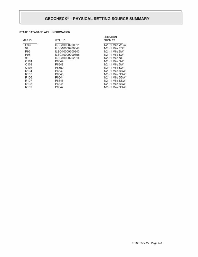
TC3413564.2s Page A-8
1/2 - 1 Mile SSWP6642 R1091/2 - 1 Mile SSWP6641 R1081/2 - 1 Mile SSWP6645 R1071/2 - 1 Mile SSWP6644 R1061/2 - 1 Mile SSWP6643 R1051/2 - 1 Mile SSWP6640 R1041/2 - 1 Mile SWP6650 Q1031/2 - 1 Mile SWP6648 Q1021/2 - 1 Mile SWP6649 Q1011/2 - 1 Mile NEILSG10000202314 981/2 - 1 Mile SWILSG10000200356 P961/2 - 1 Mile SWILSG10000200340 P951/2 - 1 Mile ESEILSG10000200840 941/2 - 1 Mile WSWILSG10000200611 O93
STATE DATABASE WELL INFORMATION
LOCATIONFROM TPWELL IDMAP ID
®GEOCHECK - PHYSICAL SETTING SOURCE SUMMARY®

EDR Inc.EDR Inc.EDR Inc.EDR Inc.EDR Inc.EDR Inc.EDR Inc.EDR Inc.EDR Inc.EDR Inc.EDR Inc.EDR Inc.EDR Inc.EDR Inc.EDR Inc.EDR Inc.EDR Inc.EDR Inc.EDR Inc.EDR Inc.EDR Inc.EDR Inc.EDR Inc.EDR Inc.EDR Inc.EDR Inc.EDR Inc.EDR Inc.EDR Inc.EDR Inc.EDR Inc.EDR Inc.EDR Inc.EDR Inc.EDR Inc.EDR Inc.EDR Inc.EDR Inc.EDR Inc.EDR Inc.
06 0 0
6 006 0 0
6 0 0 6 0060
0
60
0
60
0
0 600
600
6 0 0
6 0 0
6 0 0
6 00
6 0 06 0 0
60 0
600
6 00 600
600
60
0
6 0 0
60
0
IL
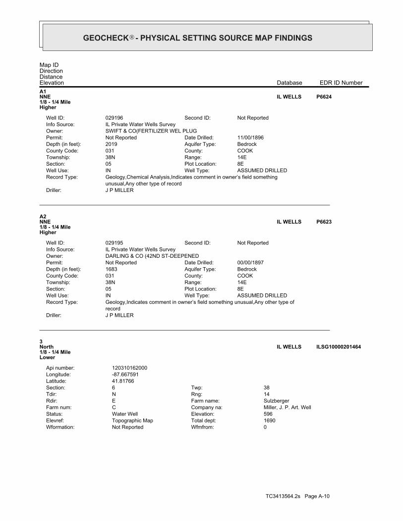
TC3413564.2s Page A-10
0Wfmfrom:Not ReportedWformation:1690Total dept:Topographic MapElevref:596Elevation:Water WellStatus:Miller, J. P. Art. WellCompany na:CFarm num:SulzbergerFarm name:ERdir:14Rng:NTdir:38Twp:6Section:
41.81766Latitude:-87.667591Longitude:120310162000Api number:
3North1/8 - 1/4 MileLower
ILSG10000201464IL WELLS
J P MILLERDriller:recordGeology,Indicates comment in owner’s field something unusual,Any other type ofRecord Type:
ASSUMED DRILLEDWell Type:INWell Use:8EPlot Location:05Section:14ERange:38NTownship:COOKCounty:031County Code:BedrockAquifer Type:1683Depth (in feet):00/00/1897Date Drilled:Not ReportedPermit:
DARLING & CO (42ND ST-DEEPENEDOwner:IL Private Water Wells SurveyInfo Source:
Not ReportedSecond ID:029195Well ID:
A2NNE1/8 - 1/4 MileHigher
P6623IL WELLS
J P MILLERDriller:unusual,Any other type of recordGeology,Chemical Analysis,Indicates comment in owner’s field somethingRecord Type:
ASSUMED DRILLEDWell Type:INWell Use:8EPlot Location:05Section:14ERange:38NTownship:COOKCounty:031County Code:BedrockAquifer Type:2019Depth (in feet):11/00/1896Date Drilled:Not ReportedPermit:
SWIFT & CO(FERTILIZER WEL PLUGOwner:IL Private Water Wells SurveyInfo Source:
Not ReportedSecond ID:029196Well ID:
A1NNE1/8 - 1/4 MileHigher
P6624IL WELLS
Map IDDirectionDistanceElevation EDR ID NumberDatabase
®GEOCHECK - PHYSICAL SETTING SOURCE MAP FINDINGS®

TC3413564.2s Page A-11
C6North1/4 - 1/2 MileLower
P6637IL WELLS
Ground-water levels, Number of Measurements: 0
0Ground water data count:0000-00-00Ground water data end date:Ground water data begin date: 0000-00-001Water quality data count:1914-01-01Water quality data end date:1914-01-01Water quality data begin date:0Peak flow data count:0000-00-00Peak flow data end date:0000-00-00Peak flow data begin date:0Daily flow data count:0000-00-00Daily flow data end date:0000-00-00Daily flow data begin date:0Real time data flag:
034Project number:Not ReportedSource of depth data:
Not ReportedHole depth:2019Well depth:Not ReportedAquifer:Not ReportedAquifer Type:Single well, other than collector or Ranney typeType of ground water site:NLocal standard time flag:
CSTMean greenwich time offset:Not ReportedDate inventoried:19000101Date construction:Ground-water other than SpringSite type:
Not ReportedTopographic:Chicago. Illinois, Indiana. Area = 622 sq.mi.Hydrologic:National Geodetic Vertical Datum of 1929Altitude datum:Not ReportedAltitude accuracy:UnknownAltitude method:592.00Altitude:
24000Map scale:ENGLEWOODLocation map:SWSWNWS 5 T 38N R 14E 3Land net:USCountry:031County:17State:17District:NAD83Dec latlong datum:NAD27Latlong datum:SCoor accr:MCoor meth:-87.66394078Dec lon:41.81586653Dec lat:873950Longitude:USGS2351660EDR Site id:414857Latitude:
38N14E- 5.8e2Site name:414857087395001Site no:USGSAgency cd:
B5ENE1/8 - 1/4 MileHigher
USGS2351660FED USGS
Date: 08/28/1997Current Shallow Depth: 8.34Current Average Depth: Not ReportedCurrent Deep Depth: 9.47Shallow Water Depth: 2.91Average Water Depth: Not ReportedDeep Water Depth: 4.30Groundwater Flow: Not ReportedSite ID: S1029445664
East1/8 - 1/4 MileHigher
62740AQUIFLOW
ILSG10000201464Site id:0Pumpgpm:0Wfmto:
®GEOCHECK - PHYSICAL SETTING SOURCE MAP FINDINGS®

TC3413564.2s Page A-12
D9NE1/4 - 1/2 MileHigher
ILSG10000201466IL WELLS
Not ReportedDriller:Chemical AnalysisRecord Type:
ASSUMED DRILLEDWell Type:INWell Use:2FPlot Location:06Section:14ERange:38NTownship:COOKCounty:031County Code:BedrockAquifer Type:1677Depth (in feet):00/00/1936Date Drilled:Not ReportedPermit:
WILSON & CO #6Owner:IL Private Water Wells SurveyInfo Source:
Not ReportedSecond ID:029204Well ID:
C8North1/4 - 1/2 MileLower
P6639IL WELLS
GRAYDriller:Geology,Chemical Analysis,Inventory,Any other type of recordRecord Type:
ASSUMED DRILLEDWell Type:INWell Use:2FPlot Location:06Section:14ERange:38NTownship:COOKCounty:031County Code:BedrockAquifer Type:1701Depth (in feet):09/00/1929Date Drilled:Not ReportedPermit:
WILSON & CO #4Owner:IL Private Water Wells SurveyInfo Source:
Not ReportedSecond ID:029203Well ID:
C7North1/4 - 1/2 MileLower
P6638IL WELLS
Not ReportedDriller:Chemical Analysis,Any other type of recordRecord Type:
ASSUMED DRILLEDWell Type:INWell Use:2FPlot Location:06Section:14ERange:38NTownship:COOKCounty:031County Code:BedrockAquifer Type:1620Depth (in feet):00/00/1914Date Drilled:Not ReportedPermit:
SULZBERGER & SONSOwner:IL Private Water Wells SurveyInfo Source:
Not ReportedSecond ID:029202Well ID:
®GEOCHECK - PHYSICAL SETTING SOURCE MAP FINDINGS®

TC3413564.2s Page A-13
D12NE1/4 - 1/2 MileHigher
ILSG10000201445IL WELLS
ILSG10000201371Site id:0Pumpgpm:0Wfmto:0Wfmfrom:Not ReportedWformation:2019Total dept:Ground levelElevref:593Elevation:Water WellStatus:Miller, J. P. Art. WellCompany na:3Farm num:Swift & CoFarm name:ERdir:14Rng:NTdir:38Twp:5Section:
41.816797Latitude:-87.663933Longitude:120310160900Api number:
B11ENE1/4 - 1/2 MileHigher
ILSG10000201371IL WELLS
ILSG10000201581Site id:0Pumpgpm:0Wfmto:0Wfmfrom:Not ReportedWformation:1700Total dept:Ground levelElevref:593Elevation:Water WellStatus:Gray, F. M., Jr., Inc.Company na:Not ReportedFarm num:Wilson Packing CoFarm name:ERdir:14Rng:NTdir:38Twp:6Section:
41.818552Latitude:-87.668817Longitude:120310272100Api number:
C10North1/4 - 1/2 MileLower
ILSG10000201581IL WELLS
ILSG10000201466Site id:0Pumpgpm:0Wfmto:0Wfmfrom:Not ReportedWformation:1600Total dept:Not ReportedElevref:0Elevation:Water WellStatus:Geiger, S. B. Co.Company na:Not ReportedFarm num:Swift & CoFarm name:ERdir:14Rng:NTdir:38Twp:6Section:
41.817687Latitude:-87.665177Longitude:120310272000Api number:
®GEOCHECK - PHYSICAL SETTING SOURCE MAP FINDINGS®

TC3413564.2s Page A-14
E15WNW1/4 - 1/2 MileLower
P6630IL WELLS
GEIGERDriller:Any other type of recordRecord Type:
ASSUMED DRILLEDWell Type:INWell Use:Not ReportedPlot Location:06Section:14ERange:38NTownship:COOKCounty:031County Code:BedrockAquifer Type:1600Depth (in feet):06/16/1920Date Drilled:Not ReportedPermit:
WILSON & CO (WELL B)Owner:IL Private Water Wells SurveyInfo Source:
Not ReportedSecond ID:029200Well ID:
E14WNW1/4 - 1/2 MileLower
P6628IL WELLS
ENVR. CONSTURCTIONDriller:Construction Report,GeologyRecord Type:
--Well Type:MonitoringWell Use:Not ReportedPlot Location:06Section:14ERange:38NTownship:COOKCounty:031County Code:UnconsolidatedAquifer Type:25Depth (in feet):11/18/1993Date Drilled:Not ReportedPermit:
AMOCO OIL #1Owner:IL Private Water Wells SurveyInfo Source:
Not ReportedSecond ID:246480Well ID:
E13WNW1/4 - 1/2 MileLower
P6633IL WELLS
ILSG10000201445Site id:0Pumpgpm:0Wfmto:0Wfmfrom:Not ReportedWformation:1683Total dept:Topographic MapElevref:596Elevation:Water WellStatus:Geiger, S. B. Co.Company na:Not ReportedFarm num:Darling & CoFarm name:ERdir:14Rng:NTdir:38Twp:5Section:
41.81757Latitude:-87.664034Longitude:120310165400Api number:
®GEOCHECK - PHYSICAL SETTING SOURCE MAP FINDINGS®

TC3413564.2s Page A-15
E18WNW1/4 - 1/2 MileLower
P6634IL WELLS
GEIGERDriller:Any other type of recordRecord Type:
ASSUMED DRILLEDWell Type:INWell Use:Not ReportedPlot Location:06Section:14ERange:38NTownship:COOKCounty:031County Code:BedrockAquifer Type:880Depth (in feet):00/00/0000Date Drilled:Not ReportedPermit:
WILSON & COOwner:IL Private Water Wells SurveyInfo Source:
Not ReportedSecond ID:029197Well ID:
E17WNW1/4 - 1/2 MileLower
P6625IL WELLS
ENVR. CONSTRUCTIONDriller:Construction Report,GeologyRecord Type:
--Well Type:MonitoringWell Use:Not ReportedPlot Location:06Section:14ERange:38NTownship:COOKCounty:031County Code:UnconsolidatedAquifer Type:17Depth (in feet):11/19/1993Date Drilled:Not ReportedPermit:
AMOCO OIL #4Owner:IL Private Water Wells SurveyInfo Source:
Not ReportedSecond ID:246483Well ID:
E16WNW1/4 - 1/2 MileLower
P6636IL WELLS
Not ReportedDriller:Construction Report,GeologyRecord Type:
||Well Type:INWell Use:Not ReportedPlot Location:06Section:14ERange:38NTownship:COOKCounty:031County Code:BedrockAquifer Type:1596Depth (in feet):07/01/1924Date Drilled:Not ReportedPermit:
WILSON & CO #3 (BLDG 17)Owner:IL Private Water Wells SurveyInfo Source:
Not ReportedSecond ID:033518Well ID:
®GEOCHECK - PHYSICAL SETTING SOURCE MAP FINDINGS®

TC3413564.2s Page A-16
E21WNW1/4 - 1/2 MileLower
P6629IL WELLS
Not ReportedDriller:Construction Report,GeologyRecord Type:
ASSUMED DRILLEDWell Type:INWell Use:Not ReportedPlot Location:06Section:14ERange:38NTownship:COOKCounty:031County Code:BedrockAquifer Type:1596Depth (in feet):07/01/1924Date Drilled:Not ReportedPermit:
WILSON & CO #3 (BLDG 17)Owner:IL Private Water Wells SurveyInfo Source:
Not ReportedSecond ID:029199Well ID:
E20WNW1/4 - 1/2 MileLower
P6627IL WELLS
MILLERDriller:Geology,Any other type of recordRecord Type:
--Well Type:INWell Use:Not ReportedPlot Location:06Section:14ERange:38NTownship:COOKCounty:031County Code:BedrockAquifer Type:1690Depth (in feet):00/00/1914Date Drilled:Not ReportedPermit:
WILSON & CO #1Owner:IL Private Water Wells SurveyInfo Source:
Not ReportedSecond ID:189581Well ID:
E19WNW1/4 - 1/2 MileLower
P6632IL WELLS
ENVR. CONSTRUCTIONDriller:Construction Report,GeologyRecord Type:
--Well Type:MonitoringWell Use:Not ReportedPlot Location:06Section:14ERange:38NTownship:COOKCounty:031County Code:UnconsolidatedAquifer Type:17Depth (in feet):12/18/1993Date Drilled:Not ReportedPermit:
AMOCO OIL #2Owner:IL Private Water Wells SurveyInfo Source:
Not ReportedSecond ID:246481Well ID:
®GEOCHECK - PHYSICAL SETTING SOURCE MAP FINDINGS®

TC3413564.2s Page A-17
E24WNW1/4 - 1/2 MileLower
P6635IL WELLS
J P MILLERDriller:Construction Report,GeologyRecord Type:
ASSUMED DRILLEDWell Type:INWell Use:Not ReportedPlot Location:06Section:14ERange:38NTownship:COOKCounty:031County Code:BedrockAquifer Type:1691Depth (in feet):03/00/1913Date Drilled:Not ReportedPermit:
WILSON & CO #2Owner:IL Private Water Wells SurveyInfo Source:
Not ReportedSecond ID:029198Well ID:
E23WNW1/4 - 1/2 MileLower
P6626IL WELLS
J P MILLERDriller:Construction Report,GeologyRecord Type:
||Well Type:INWell Use:Not ReportedPlot Location:06Section:14ERange:38NTownship:COOKCounty:031County Code:BedrockAquifer Type:1691Depth (in feet):03/00/1913Date Drilled:Not ReportedPermit:
WILSON & CO #2Owner:IL Private Water Wells SurveyInfo Source:
Not ReportedSecond ID:033519Well ID:
E22WNW1/4 - 1/2 MileLower
P6631IL WELLS
J P MILLERDriller:Geology,Any other type of recordRecord Type:
ASSUMED DRILLEDWell Type:INWell Use:Not ReportedPlot Location:06Section:14ERange:38NTownship:COOKCounty:031County Code:BedrockAquifer Type:1620Depth (in feet):00/00/1914Date Drilled:Not ReportedPermit:
WILSON & CO/SULZBERGER & SONSOwner:IL Private Water Wells SurveyInfo Source:
Not ReportedSecond ID:029201Well ID:
®GEOCHECK - PHYSICAL SETTING SOURCE MAP FINDINGS®

TC3413564.2s Page A-18
F26NE1/4 - 1/2 MileHigher
ILSG10000201470IL WELLS
Ground-water levels, Number of Measurements: 0
0Ground water data count:0000-00-00Ground water data end date:Ground water data begin date: 0000-00-001Water quality data count:1914-01-01Water quality data end date:1914-01-01Water quality data begin date:0Peak flow data count:0000-00-00Peak flow data end date:0000-00-00Peak flow data begin date:0Daily flow data count:0000-00-00Daily flow data end date:0000-00-00Daily flow data begin date:0Real time data flag:
034Project number:Not ReportedSource of depth data:
Not ReportedHole depth:1979Well depth:Not ReportedAquifer:Not ReportedAquifer Type:Single well, other than collector or Ranney typeType of ground water site:NLocal standard time flag:
CSTMean greenwich time offset:Not ReportedDate inventoried:Not ReportedDate construction:Ground-water other than SpringSite type:
Not ReportedTopographic:Chicago. Illinois, Indiana. Area = 622 sq.mi.Hydrologic:National Geodetic Vertical Datum of 1929Altitude datum:Not ReportedAltitude accuracy:UnknownAltitude method:592.00Altitude:
24000Map scale:ENGLEWOODLocation map:SWSWNWS 5 T 38N R 14E 3Land net:USCountry:031County:17State:17District:NAD83Dec latlong datum:NAD27Latlong datum:SCoor accr:MCoor meth:-87.66310745Dec lon:41.81697764Dec lat:873947Longitude:USGS2351664EDR Site id:414901Latitude:
38N14E- 5.8e1Site name:414901087394701Site no:USGSAgency cd:
F25ENE1/4 - 1/2 MileHigher
USGS2351664FED USGS
ENVR. CONSTRUCTIONDriller:Construction Report,GeologyRecord Type:
--Well Type:MonitoringWell Use:Not ReportedPlot Location:06Section:14ERange:38NTownship:COOKCounty:031County Code:UnconsolidatedAquifer Type:17Depth (in feet):11/19/1993Date Drilled:Not ReportedPermit:
AMOCO OIL #3Owner:IL Private Water Wells SurveyInfo Source:
Not ReportedSecond ID:246482Well ID:
®GEOCHECK - PHYSICAL SETTING SOURCE MAP FINDINGS®

TC3413564.2s Page A-19
0Wfmfrom:Not ReportedWformation:1581Total dept:Topographic MapElevref:597Elevation:Water WellStatus:No CompanyCompany na:Not ReportedFarm num:Armour & CoFarm name:ERdir:14Rng:NTdir:38Twp:5Section:
41.815463Latitude:-87.659753Longitude:120310159700Api number:
G29East1/4 - 1/2 MileHigher
ILSG10000201206IL WELLS
GRAYDriller:Geology,Chemical Analysis,Any other type of recordRecord Type:
ASSUMED DRILLEDWell Type:INWell Use:7GPlot Location:05Section:14ERange:38NTownship:COOKCounty:031County Code:BedrockAquifer Type:1619Depth (in feet):00/00/1918Date Drilled:Not ReportedPermit:
SWIFT & CO (NORTH BOILER RM WEOwner:IL Private Water Wells SurveyInfo Source:
Not ReportedSecond ID:029194Well ID:
28NNE1/4 - 1/2 MileLower
P6622IL WELLS
Date: 9/23/1988Current Shallow Depth: 3Current Average Depth: Not ReportedCurrent Deep Depth: 6Shallow Water Depth: Not ReportedAverage Water Depth: 5Deep Water Depth: Not ReportedGroundwater Flow: Not ReportedSite ID: S10053038627
SW1/4 - 1/2 MileLower
25663AQUIFLOW
ILSG10000201470Site id:0Pumpgpm:0Wfmto:0Wfmfrom:Not ReportedWformation:1614Total dept:Topographic MapElevref:596Elevation:Water WellStatus:Miller, J. P. Art. WellCompany na:Not ReportedFarm num:Darling & CoFarm name:ERdir:14Rng:NTdir:38Twp:5Section:
41.817721Latitude:-87.662733Longitude:120310165300Api number:
®GEOCHECK - PHYSICAL SETTING SOURCE MAP FINDINGS®

TC3413564.2s Page A-20
WHITNEYDriller:Any other type of recordRecord Type:
ASSUMED DRILLEDWell Type:INWell Use:6BPlot Location:05Section:14ERange:38NTownship:COOKCounty:031County Code:BedrockAquifer Type:1650Depth (in feet):00/00/1916Date Drilled:Not ReportedPermit:
HOWARD GOLZ & CO #2/MILLER-HAROwner:IL Private Water Wells SurveyInfo Source:
Not ReportedSecond ID:029193Well ID:
H32SE1/4 - 1/2 MileHigher
P6620IL WELLS
Not ReportedDriller:InventoryRecord Type:
||Well Type:INWell Use:6BPlot Location:05Section:14ERange:38NTownship:COOKCounty:031County Code:Not ReportedAquifer Type:Not ReportedDepth (in feet):00/00/0000Date Drilled:Not ReportedPermit:
HOWARD GOLZ & CO #1/MILLER-HAROwner:IL Private Water Wells SurveyInfo Source:
Not ReportedSecond ID:033464Well ID:
H31SE1/4 - 1/2 MileHigher
P6621IL WELLS
ILSG10000200770Site id:0Pumpgpm:0Wfmto:0Wfmfrom:Not ReportedWformation:54Total dept:Ground levelElevref:595Elevation:Engineering TestStatus:Chicago Pub. Works Dept.Company na:B-3Farm num:Storage GarageFarm name:ERdir:14Rng:NTdir:38Twp:6Section:
41.811199Latitude:-87.67589Longitude:120312656700Api number:
30WSW1/4 - 1/2 MileLower
ILSG10000200770IL WELLS
ILSG10000201206Site id:0Pumpgpm:0Wfmto:
®GEOCHECK - PHYSICAL SETTING SOURCE MAP FINDINGS®

TC3413564.2s Page A-21
CSTMean greenwich time offset:Not ReportedDate inventoried:19140101Date construction:Ground-water other than SpringSite type:
Not ReportedTopographic:Chicago. Illinois, Indiana. Area = 622 sq.mi.Hydrologic:National Geodetic Vertical Datum of 1929Altitude datum:5Altitude accuracy:Interpolated from topographic mapAltitude method:592.00Altitude:
24000Map scale:ENGLEWOODLocation map:SWSENWS 5 T 38N R 14E 3Land net:USCountry:031County:17State:17District:NAD83Dec latlong datum:NAD27Latlong datum:SCoor accr:MCoor meth:-87.65949621Dec lon:41.81697767Dec lat:873934Longitude:USGS2351663EDR Site id:414901Latitude:
38N14E- 5.6e1Site name:414901087393401Site no:USGSAgency cd:
35ENE1/4 - 1/2 MileHigher
USGS2351663FED USGS
ILSG10000201129Site id:0Pumpgpm:0Wfmto:0Wfmfrom:Not ReportedWformation:1600Total dept:Ground levelElevref:592Elevation:Water WellStatus:No CompanyCompany na:Not ReportedFarm num:Armour & CoFarm name:ERdir:14Rng:NTdir:38Twp:5Section:
41.814688Latitude:-87.659037Longitude:120310159800Api number:
G34East1/4 - 1/2 MileHigher
ILSG10000201129IL WELLS
Not ReportedDriller:InventoryRecord Type:
ASSUMED DRILLEDWell Type:INWell Use:6BPlot Location:05Section:14ERange:38NTownship:COOKCounty:031County Code:Not ReportedAquifer Type:Not ReportedDepth (in feet):00/00/0000Date Drilled:Not ReportedPermit:
HOWARD GOLZ & CO #1/MILLER-HAROwner:IL Private Water Wells SurveyInfo Source:
Not ReportedSecond ID:029192Well ID:
H33SE1/4 - 1/2 MileHigher
P6619IL WELLS
Map IDDirectionDistanceElevation EDR ID NumberDatabase
®GEOCHECK - PHYSICAL SETTING SOURCE MAP FINDINGS®

TC3413564.2s Page A-22
J38SE1/2 - 1 MileHigher
P6617IL WELLS
Not ReportedDriller:Inventory,Indicates comment in owner’s field something unusualRecord Type:
ASSUMED DRILLEDWell Type:INWell Use:5FPlot Location:05Section:14ERange:38NTownship:COOKCounty:031County Code:BedrockAquifer Type:1608Depth (in feet):00/00/1909Date Drilled:Not ReportedPermit:
SWIFT & CO (CENTRAL WELL)(DEEPOwner:IL Private Water Wells SurveyInfo Source:
Not ReportedSecond ID:029190Well ID:
I37ENE1/4 - 1/2 MileHigher
P6615IL WELLS
Not ReportedDriller:Inventory,Indicates comment in owner’s field something unusualRecord Type:
||Well Type:INWell Use:5FPlot Location:05Section:14ERange:38NTownship:COOKCounty:031County Code:BedrockAquifer Type:1608Depth (in feet):00/00/1909Date Drilled:Not ReportedPermit:
SWIFT & CO (CENTRAL WELL)(DEEPOwner:IL Private Water Wells SurveyInfo Source:
Not ReportedSecond ID:033501Well ID:
I36ENE1/4 - 1/2 MileHigher
P6616IL WELLS
Ground-water levels, Number of Measurements: 0
0Ground water data count:0000-00-00Ground water data end date:Ground water data begin date: 0000-00-001Water quality data count:1914-01-01Water quality data end date:1914-01-01Water quality data begin date:0Peak flow data count:0000-00-00Peak flow data end date:0000-00-00Peak flow data begin date:0Daily flow data count:0000-00-00Daily flow data end date:0000-00-00Daily flow data begin date:0Real time data flag:
034Project number:Not ReportedSource of depth data:
Not ReportedHole depth:1643Well depth:Not ReportedAquifer:Not ReportedAquifer Type:Single well, other than collector or Ranney typeType of ground water site:NLocal standard time flag:
®GEOCHECK - PHYSICAL SETTING SOURCE MAP FINDINGS®

TC3413564.2s Page A-23
41East1/2 - 1 MileHigher
ILSG10000201026IL WELLS
ILSG10000200447Site id:0Pumpgpm:125Wfmto:40Wfmfrom:limestoneWformation:125Total dept:Ground levelElevref:598Elevation:Water WellStatus:Fykes, Charles N.Company na:Not ReportedFarm num:Rowell Chemical Corp.Farm name:ERdir:14Rng:NTdir:38Twp:7Section:
41.807583Latitude:-87.673397Longitude:120313205500Api number:
40SSW1/2 - 1 MileHigher
ILSG10000200447IL WELLS
Not ReportedDriller:InventoryRecord Type:
||Well Type:INWell Use:6APlot Location:05Section:14ERange:38NTownship:COOKCounty:031County Code:BedrockAquifer Type:1600Depth (in feet):00/00/0000Date Drilled:Not ReportedPermit:
DARLING & CO (46TH ST PLANT)Owner:IL Private Water Wells SurveyInfo Source:
Not ReportedSecond ID:033450Well ID:
J39SE1/2 - 1 MileHigher
P6618IL WELLS
Not ReportedDriller:InventoryRecord Type:
ASSUMED DRILLEDWell Type:INWell Use:6APlot Location:05Section:14ERange:38NTownship:COOKCounty:031County Code:BedrockAquifer Type:1600Depth (in feet):00/00/0000Date Drilled:Not ReportedPermit:
DARLING & CO (46TH ST PLANT)Owner:IL Private Water Wells SurveyInfo Source:
Not ReportedSecond ID:029191Well ID:
®GEOCHECK - PHYSICAL SETTING SOURCE MAP FINDINGS®

TC3413564.2s Page A-24
K43ENE1/2 - 1 MileLower
ILSG10000201487IL WELLS
Ground-water levels, Number of Measurements: 0
0Ground water data count:0000-00-00Ground water data end date:Ground water data begin date: 0000-00-001Water quality data count:1914-08-31Water quality data end date:1914-08-31Water quality data begin date:0Peak flow data count:0000-00-00Peak flow data end date:0000-00-00Peak flow data begin date:0Daily flow data count:0000-00-00Daily flow data end date:0000-00-00Daily flow data begin date:0Real time data flag:
034Project number:Not ReportedSource of depth data:
Not ReportedHole depth:2300Well depth:Not ReportedAquifer:Not ReportedAquifer Type:Single well, other than collector or Ranney typeType of ground water site:NLocal standard time flag:
CSTMean greenwich time offset:Not ReportedDate inventoried:Not ReportedDate construction:Ground-water other than SpringSite type:
Not ReportedTopographic:Chicago. Illinois, Indiana. Area = 622 sq.mi.Hydrologic:National Geodetic Vertical Datum of 1929Altitude datum:Not ReportedAltitude accuracy:UnknownAltitude method:593.00Altitude:
24000Map scale:ENGLEWOODLocation map:NWNWNWS 5 T 38N R 14E 3Land net:USCountry:031County:17State:17District:NAD83Dec latlong datum:NAD27Latlong datum:MCoor accr:MCoor meth:-87.66421874Dec lon:41.82225536Dec lat:873951Longitude:USGS2351674EDR Site id:414920Latitude:
38N14E- 5.8h1Site name:414920087395101Site no:USGSAgency cd:
42NNE1/2 - 1 MileLower
USGS2351674FED USGS
ILSG10000201026Site id:0Pumpgpm:0Wfmto:0Wfmfrom:Not ReportedWformation:1575Total dept:Topographic MapElevref:596Elevation:Water WellStatus:No CompanyCompany na:Not ReportedFarm num:Armour & CoFarm name:ERdir:14Rng:NTdir:38Twp:5Section:
41.8138Latitude:-87.65758Longitude:120310159600Api number:
®GEOCHECK - PHYSICAL SETTING SOURCE MAP FINDINGS®

TC3413564.2s Page A-25
L46East1/2 - 1 MileHigher
P6608IL WELLS
ILSG10000201489Site id:0Pumpgpm:0Wfmto:0Wfmfrom:Not ReportedWformation:1626Total dept:Not ReportedElevref:0Elevation:Water WellStatus:Miller, J. P. Art. WellCompany na:Not ReportedFarm num:Nelson Morris CoFarm name:ERdir:14Rng:NTdir:38Twp:5Section:
41.817785Latitude:-87.657844Longitude:120310160600Api number:
K45ENE1/2 - 1 MileLower
ILSG10000201489IL WELLS
ILSG10000201488Site id:0Pumpgpm:0Wfmto:0Wfmfrom:Not ReportedWformation:1622Total dept:Ground levelElevref:592Elevation:Water WellStatus:Miller, J. P. Art. WellCompany na:Not ReportedFarm num:Nelson Morris CoFarm name:ERdir:14Rng:NTdir:38Twp:5Section:
41.817785Latitude:-87.657844Longitude:120310160700Api number:
K44ENE1/2 - 1 MileLower
ILSG10000201488IL WELLS
ILSG10000201487Site id:0Pumpgpm:0Wfmto:0Wfmfrom:Not ReportedWformation:1607Total dept:Topographic MapElevref:597Elevation:Water WellStatus:Miller, J. P. Art. WellCompany na:Not ReportedFarm num:Nelson Morris CoFarm name:ERdir:14Rng:NTdir:38Twp:5Section:
41.817785Latitude:-87.657844Longitude:120310160500Api number:
®GEOCHECK - PHYSICAL SETTING SOURCE MAP FINDINGS®

TC3413564.2s Page A-26
L49East1/2 - 1 MileHigher
P6596IL WELLS
J P MILLERDriller:Geology,Any other type of recordRecord Type:
ASSUMED DRILLEDWell Type:INWell Use:Not ReportedPlot Location:05Section:14ERange:38NTownship:COOKCounty:031County Code:BedrockAquifer Type:1626Depth (in feet):00/00/1901Date Drilled:Not ReportedPermit:
ARMOUR & CO/NELSON MORRIS COOwner:IL Private Water Wells SurveyInfo Source:
Not ReportedSecond ID:023844Well ID:
L48East1/2 - 1 MileHigher
P6585IL WELLS
Not ReportedDriller:InventoryRecord Type:
||Well Type:INWell Use:Not ReportedPlot Location:05Section:14ERange:38NTownship:COOKCounty:031County Code:BedrockAquifer Type:2000Depth (in feet):10/00/1901Date Drilled:Not ReportedPermit:
SWIFT & CO (REF. PLANT #3)Owner:IL Private Water Wells SurveyInfo Source:
Not ReportedSecond ID:033510Well ID:
L47East1/2 - 1 MileHigher
P6610IL WELLS
Not ReportedDriller:InventoryRecord Type:
||Well Type:INWell Use:Not ReportedPlot Location:05Section:14ERange:38NTownship:COOKCounty:031County Code:BedrockAquifer Type:1200Depth (in feet):00/00/1935Date Drilled:Not ReportedPermit:
SIEGEL & WELLEROwner:IL Private Water Wells SurveyInfo Source:
Not ReportedSecond ID:033481Well ID:
®GEOCHECK - PHYSICAL SETTING SOURCE MAP FINDINGS®

TC3413564.2s Page A-27
L52East1/2 - 1 MileHigher
P6589IL WELLS
Not ReportedDriller:InventoryRecord Type:
||Well Type:INWell Use:Not ReportedPlot Location:05Section:14ERange:38NTownship:COOKCounty:031County Code:BedrockAquifer Type:1614Depth (in feet):01/11/1908Date Drilled:Not ReportedPermit:
SWIFT & CO (#5 HOUSE)Owner:IL Private Water Wells SurveyInfo Source:
Not ReportedSecond ID:033509Well ID:
L51East1/2 - 1 MileHigher
P6609IL WELLS
Not ReportedDriller:Geology,Any other type of recordRecord Type:
ASSUMED DRILLEDWell Type:INWell Use:Not ReportedPlot Location:05Section:14ERange:38NTownship:COOKCounty:031County Code:BedrockAquifer Type:1900Depth (in feet):00/00/1915Date Drilled:Not ReportedPermit:
SWIFT & CO (WELL B)Owner:IL Private Water Wells SurveyInfo Source:
Not ReportedSecond ID:029182Well ID:
L50East1/2 - 1 MileHigher
P6602IL WELLS
Not ReportedDriller:Inventory,Indicates comment in owner’s field something unusualRecord Type:
ASSUMED DRILLEDWell Type:INWell Use:Not ReportedPlot Location:05Section:14ERange:38NTownship:COOKCounty:031County Code:BedrockAquifer Type:1200Depth (in feet):00/00/1935Date Drilled:Not ReportedPermit:
SIEGEL & WELLER (DEEPEROwner:IL Private Water Wells SurveyInfo Source:
Not ReportedSecond ID:029176Well ID:
®GEOCHECK - PHYSICAL SETTING SOURCE MAP FINDINGS®

TC3413564.2s Page A-28
L55East1/2 - 1 MileHigher
P6599IL WELLS
J P MILLERDriller:Any other type of recordRecord Type:
ASSUMED DRILLEDWell Type:INWell Use:Not ReportedPlot Location:05Section:14ERange:38NTownship:COOKCounty:031County Code:BedrockAquifer Type:1607Depth (in feet):05/00/1898Date Drilled:Not ReportedPermit:
ARMOUR & CO/NELSON MORRIS COOwner:IL Private Water Wells SurveyInfo Source:
Not ReportedSecond ID:023846Well ID:
L54East1/2 - 1 MileHigher
P6587IL WELLS
Not ReportedDriller:Any other type of recordRecord Type:
ASSUMED DRILLEDWell Type:INWell Use:Not ReportedPlot Location:05Section:14ERange:38NTownship:COOKCounty:031County Code:BedrockAquifer Type:1900Depth (in feet):00/00/1915Date Drilled:Not ReportedPermit:
SWIFT & CO (WELL C)Owner:IL Private Water Wells SurveyInfo Source:
Not ReportedSecond ID:029183Well ID:
L53East1/2 - 1 MileHigher
P6603IL WELLS
J P MILLERDriller:Indicates comment in owner’s field something unusual,Any other type of recordRecord Type:
ASSUMED DRILLEDWell Type:INWell Use:Not ReportedPlot Location:05Section:14ERange:38NTownship:COOKCounty:031County Code:BedrockAquifer Type:1595Depth (in feet):00/00/1897Date Drilled:Not ReportedPermit:
ANGLO AMERICAN CO(DEEPEND IN 1Owner:IL Private Water Wells SurveyInfo Source:
Not ReportedSecond ID:024195Well ID:
®GEOCHECK - PHYSICAL SETTING SOURCE MAP FINDINGS®

TC3413564.2s Page A-29
L58East1/2 - 1 MileHigher
P6606IL WELLS
J P MILLERDriller:Indicates comment in owner’s field something unusual,Any other type of recordRecord Type:
ASSUMED DRILLEDWell Type:INWell Use:Not ReportedPlot Location:05Section:14ERange:38NTownship:COOKCounty:031County Code:BedrockAquifer Type:1614Depth (in feet):00/00/1907Date Drilled:Not ReportedPermit:
SWIFT & CO (WEST SLAUGHTER HSEOwner:IL Private Water Wells SurveyInfo Source:
Not ReportedSecond ID:029184Well ID:
L57East1/2 - 1 MileHigher
P6604IL WELLS
J P MILLERDriller:Geology,Any other type of recordRecord Type:
ASSUMED DRILLEDWell Type:INWell Use:Not ReportedPlot Location:05Section:14ERange:38NTownship:COOKCounty:031County Code:BedrockAquifer Type:2008Depth (in feet):02/00/1901Date Drilled:Not ReportedPermit:
SWIFT & CO (HOG HOUSE)Owner:IL Private Water Wells SurveyInfo Source:
Not ReportedSecond ID:029178Well ID:
L56East1/2 - 1 MileHigher
P6598IL WELLS
J P MILLERDriller:Construction Report,GeologyRecord Type:
ASSUMED DRILLEDWell Type:INWell Use:Not ReportedPlot Location:05Section:14ERange:38NTownship:COOKCounty:031County Code:BedrockAquifer Type:1027Depth (in feet):07/00/1946Date Drilled:Not ReportedPermit:
SWIFT & CO (POULTRY DIV)Owner:IL Private Water Wells SurveyInfo Source:
Not ReportedSecond ID:029179Well ID:
®GEOCHECK - PHYSICAL SETTING SOURCE MAP FINDINGS®

TC3413564.2s Page A-30
L61East1/2 - 1 MileHigher
P6605IL WELLS
J P MILLERDriller:Geology,Any other type of recordRecord Type:
ASSUMED DRILLEDWell Type:INWell Use:Not ReportedPlot Location:05Section:14ERange:38NTownship:COOKCounty:031County Code:BedrockAquifer Type:1605Depth (in feet):02/00/1912Date Drilled:Not ReportedPermit:
SWIFT & CO/INDEPENDENT PACKINGOwner:IL Private Water Wells SurveyInfo Source:
Not ReportedSecond ID:029187Well ID:
L60East1/2 - 1 MileHigher
P6607IL WELLS
J P MILLERDriller:Geology,Any other type of recordRecord Type:
ASSUMED DRILLEDWell Type:INWell Use:Not ReportedPlot Location:05Section:14ERange:38NTownship:COOKCounty:031County Code:BedrockAquifer Type:1622Depth (in feet):00/00/1903Date Drilled:Not ReportedPermit:
ARMOUR & CO/NELSON MORRIS COOwner:IL Private Water Wells SurveyInfo Source:
Not ReportedSecond ID:023845Well ID:
L59East1/2 - 1 MileHigher
P6586IL WELLS
Not ReportedDriller:Any other type of recordRecord Type:
ASSUMED DRILLEDWell Type:INWell Use:Not ReportedPlot Location:05Section:14ERange:38NTownship:COOKCounty:031County Code:BedrockAquifer Type:1300Depth (in feet):00/00/0000Date Drilled:Not ReportedPermit:
SWIFT & CO/BOYD LUNHAM COOwner:IL Private Water Wells SurveyInfo Source:
Not ReportedSecond ID:029186Well ID:
®GEOCHECK - PHYSICAL SETTING SOURCE MAP FINDINGS®

TC3413564.2s Page A-31
L64East1/2 - 1 MileHigher
P6597IL WELLS
J P MILLERDriller:Geology,Any other type of recordRecord Type:
ASSUMED DRILLEDWell Type:INWell Use:Not ReportedPlot Location:05Section:14ERange:38NTownship:COOKCounty:031County Code:BedrockAquifer Type:1593Depth (in feet):12/00/1904Date Drilled:Not ReportedPermit:
G H HAMMOND COOwner:IL Private Water Wells SurveyInfo Source:
Not ReportedSecond ID:029172Well ID:
L63East1/2 - 1 MileHigher
P6592IL WELLS
Not ReportedDriller:Geology,Any other type of recordRecord Type:
ASSUMED DRILLEDWell Type:INWell Use:Not ReportedPlot Location:05Section:14ERange:38NTownship:COOKCounty:031County Code:BedrockAquifer Type:1900Depth (in feet):00/00/1915Date Drilled:Not ReportedPermit:
SWIFT & CO (WELL A)Owner:IL Private Water Wells SurveyInfo Source:
Not ReportedSecond ID:029181Well ID:
L62East1/2 - 1 MileHigher
P6601IL WELLS
J P MILLERDriller:recordGeology,Indicates comment in owner’s field something unusual,Any other type ofRecord Type:
ASSUMED DRILLEDWell Type:INWell Use:Not ReportedPlot Location:05Section:14ERange:38NTownship:COOKCounty:031County Code:BedrockAquifer Type:1981Depth (in feet):00/00/1900Date Drilled:Not ReportedPermit:
SWIFT & CO(BONE HOUSE DEEPED FOwner:IL Private Water Wells SurveyInfo Source:
Not ReportedSecond ID:029185Well ID:
®GEOCHECK - PHYSICAL SETTING SOURCE MAP FINDINGS®

TC3413564.2s Page A-32
L67East1/2 - 1 MileHigher
P6593IL WELLS
J P MILLERDriller:Geology,Any other type of recordRecord Type:
ASSUMED DRILLEDWell Type:INWell Use:Not ReportedPlot Location:05Section:14ERange:38NTownship:COOKCounty:031County Code:BedrockAquifer Type:1593Depth (in feet):10/00/1902Date Drilled:Not ReportedPermit:
HAMMOND PACKING COOwner:IL Private Water Wells SurveyInfo Source:
Not ReportedSecond ID:029174Well ID:
L66East1/2 - 1 MileHigher
P6594IL WELLS
C.W.WHITNEYDriller:Geology,Chemical Analysis,Any other type of recordRecord Type:
ASSUMED DRILLEDWell Type:INWell Use:Not ReportedPlot Location:05Section:14ERange:38NTownship:COOKCounty:031County Code:BedrockAquifer Type:1600Depth (in feet):04/00/1914Date Drilled:Not ReportedPermit:
ARMOUR & COOwner:IL Private Water Wells SurveyInfo Source:
Not ReportedSecond ID:023842Well ID:
L65East1/2 - 1 MileHigher
P6583IL WELLS
Not ReportedDriller:InventoryRecord Type:
ASSUMED DRILLEDWell Type:INWell Use:Not ReportedPlot Location:05Section:14ERange:38NTownship:COOKCounty:031County Code:BedrockAquifer Type:1614Depth (in feet):01/11/1908Date Drilled:Not ReportedPermit:
SWIFT & CO (#5 HOUSE)Owner:IL Private Water Wells SurveyInfo Source:
Not ReportedSecond ID:029177Well ID:
®GEOCHECK - PHYSICAL SETTING SOURCE MAP FINDINGS®

TC3413564.2s Page A-33
L70East1/2 - 1 MileHigher
P6588IL WELLS
J P MILLERDriller:recordGeology,Indicates comment in owner’s field something unusual,Any other type ofRecord Type:
ASSUMED DRILLEDWell Type:INWell Use:Not ReportedPlot Location:05Section:14ERange:38NTownship:COOKCounty:031County Code:BedrockAquifer Type:2012Depth (in feet):00/00/1892Date Drilled:Not ReportedPermit:
CONTINENTAL PACKING CO (DEEPENOwner:IL Private Water Wells SurveyInfo Source:
Not ReportedSecond ID:024197Well ID:
L69East1/2 - 1 MileHigher
P6591IL WELLS
ARMOURDriller:Geology,Any other type of recordRecord Type:
ASSUMED DRILLEDWell Type:INWell Use:Not ReportedPlot Location:05Section:14ERange:38NTownship:COOKCounty:031County Code:BedrockAquifer Type:1575Depth (in feet):00/00/1910Date Drilled:Not ReportedPermit:
ARMOUR & COOwner:IL Private Water Wells SurveyInfo Source:
Not ReportedSecond ID:023843Well ID:
L68East1/2 - 1 MileHigher
P6584IL WELLS
J P MILLERDriller:Geology,Any other type of recordRecord Type:
ASSUMED DRILLEDWell Type:INWell Use:Not ReportedPlot Location:05Section:14ERange:38NTownship:COOKCounty:031County Code:BedrockAquifer Type:1595Depth (in feet):01/00/1903Date Drilled:Not ReportedPermit:
HAMMOND PACKING COOwner:IL Private Water Wells SurveyInfo Source:
Not ReportedSecond ID:029173Well ID:
®GEOCHECK - PHYSICAL SETTING SOURCE MAP FINDINGS®

TC3413564.2s Page A-34
L73East1/2 - 1 MileHigher
P6590IL WELLS
Not ReportedDriller:InventoryRecord Type:
ASSUMED DRILLEDWell Type:INWell Use:Not ReportedPlot Location:05Section:14ERange:38NTownship:COOKCounty:031County Code:BedrockAquifer Type:2000Depth (in feet):10/00/1901Date Drilled:Not ReportedPermit:
SWIFT & CO (REF. PLANT #3)Owner:IL Private Water Wells SurveyInfo Source:
Not ReportedSecond ID:029180Well ID:
L72East1/2 - 1 MileHigher
P6600IL WELLS
GRAYDriller:Any other type of recordRecord Type:
ASSUMED DRILLEDWell Type:INWell Use:Not ReportedPlot Location:05Section:14ERange:38NTownship:COOKCounty:031County Code:BedrockAquifer Type:1600Depth (in feet):00/00/1918Date Drilled:Not ReportedPermit:
HAMMOND PACKING CO/G H HAMMONDOwner:IL Private Water Wells SurveyInfo Source:
Not ReportedSecond ID:029175Well ID:
L71East1/2 - 1 MileHigher
P6595IL WELLS
WHITNEYDriller:Any other type of recordRecord Type:
ASSUMED DRILLEDWell Type:INWell Use:Not ReportedPlot Location:05Section:14ERange:38NTownship:COOKCounty:031County Code:BedrockAquifer Type:1615Depth (in feet):00/00/1913Date Drilled:Not ReportedPermit:
CHICAGO PACKAGE COOwner:IL Private Water Wells SurveyInfo Source:
Not ReportedSecond ID:023847Well ID:
®GEOCHECK - PHYSICAL SETTING SOURCE MAP FINDINGS®

TC3413564.2s Page A-35
L75East1/2 - 1 MileHigher
ILSG10000201163IL WELLS
Ground-water levels, Number of Measurements: 0
0Ground water data count:0000-00-00Ground water data end date:Ground water data begin date: 0000-00-001Water quality data count:1914-01-01Water quality data end date:1914-01-01Water quality data begin date:0Peak flow data count:0000-00-00Peak flow data end date:0000-00-00Peak flow data begin date:0Daily flow data count:0000-00-00Daily flow data end date:0000-00-00Daily flow data begin date:0Real time data flag:
034Project number:Not ReportedSource of depth data:
Not ReportedHole depth:2008Well depth:Not ReportedAquifer:Not ReportedAquifer Type:Single well, other than collector or Ranney typeType of ground water site:NLocal standard time flag:
CSTMean greenwich time offset:Not ReportedDate inventoried:19000101Date construction:Ground-water other than SpringSite type:
Not ReportedTopographic:Chicago. Illinois, Indiana. Area = 622 sq.mi.Hydrologic:National Geodetic Vertical Datum of 1929Altitude datum:Not ReportedAltitude accuracy:UnknownAltitude method:592.00Altitude:
24000Map scale:ENGLEWOODLocation map:SESENWS 5 T 38N R 14E 3Land net:USCountry:031County:17State:17District:NAD83Dec latlong datum:NAD27Latlong datum:SCoor accr:MCoor meth:-87.65699612Dec lon:41.81697769Dec lat:873925Longitude:USGS2351662EDR Site id:414901Latitude:
38N14E- 5.5e1Site name:414901087392501Site no:USGSAgency cd:
74ENE1/2 - 1 MileLower
USGS2351662FED USGS
J P MILLERDriller:unusual,Any other type of recordGeology,Chemical Analysis,Indicates comment in owner’s field somethingRecord Type:
ASSUMED DRILLEDWell Type:INWell Use:Not ReportedPlot Location:05Section:14ERange:38NTownship:COOKCounty:031County Code:BedrockAquifer Type:1604Depth (in feet):00/00/1889Date Drilled:Not ReportedPermit:
ARMOUR & CO(DEEPEND IN 1907 FROwner:IL Private Water Wells SurveyInfo Source:
Not ReportedSecond ID:024196Well ID:
®GEOCHECK - PHYSICAL SETTING SOURCE MAP FINDINGS®

TC3413564.2s Page A-36
79North1/2 - 1 MileLower
ILSG10000202217IL WELLS
ILSG10000200704Site id:0Pumpgpm:0Wfmto:0Wfmfrom:Not ReportedWformation:1600Total dept:Not ReportedElevref:0Elevation:Water WellStatus:Geiger, S. B. Co.Company na:Not ReportedFarm num:Darling & CoFarm name:ERdir:14Rng:NTdir:38Twp:5Section:
41.810296Latitude:-87.657929Longitude:120310165500Api number:
78ESE1/2 - 1 MileHigher
ILSG10000200704IL WELLS
Date: 07/02/1993Current Shallow Depth: Not ReportedCurrent Average Depth: 5.16Current Deep Depth: Not ReportedShallow Water Depth: Not ReportedAverage Water Depth: 5.66Deep Water Depth: Not ReportedGroundwater Flow: SSite ID: S102944119M77
NNE1/2 - 1 MileLower
62301AQUIFLOW
Date: 2/13/1995Current Shallow Depth: Not ReportedCurrent Average Depth: 5.16Current Deep Depth: Not ReportedShallow Water Depth: Not ReportedAverage Water Depth: 5.16Deep Water Depth: Not ReportedGroundwater Flow: SSite ID: S102944612M76
NNE1/2 - 1 MileLower
25710AQUIFLOW
ILSG10000201163Site id:0Pumpgpm:0Wfmto:0Wfmfrom:Not ReportedWformation:57Total dept:Ground levelElevref:594Elevation:Engineering TestStatus:Chicago Pub. Works Dept.Company na:Sy6Farm num:Stockyd RedevFarm name:ERdir:14Rng:NTdir:38Twp:5Section:
41.815078Latitude:-87.656562Longitude:120312656500Api number:
®GEOCHECK - PHYSICAL SETTING SOURCE MAP FINDINGS®

TC3413564.2s Page A-37
81West1/2 - 1 MileHigher
USGS2351658FED USGS
Ground-water levels, Number of Measurements: 0
0Ground water data count:0000-00-00Ground water data end date:Ground water data begin date: 0000-00-001Water quality data count:1914-07-16Water quality data end date:1914-07-16Water quality data begin date:0Peak flow data count:0000-00-00Peak flow data end date:0000-00-00Peak flow data begin date:0Daily flow data count:0000-00-00Daily flow data end date:0000-00-00Daily flow data begin date:0Real time data flag:
034Project number:Not ReportedSource of depth data:
Not ReportedHole depth:1600Well depth:Not ReportedAquifer:Not ReportedAquifer Type:Single well, other than collector or Ranney typeType of ground water site:NLocal standard time flag:
CSTMean greenwich time offset:Not ReportedDate inventoried:Not ReportedDate construction:Ground-water other than SpringSite type:
Not ReportedTopographic:Chicago. Illinois, Indiana. Area = 622 sq.mi.Hydrologic:National Geodetic Vertical Datum of 1929Altitude datum:Not ReportedAltitude accuracy:UnknownAltitude method:592.00Altitude:
24000Map scale:ENGLEWOODLocation map:SENENWS 5 T 38N R 14E 3Land net:USCountry:031County:17State:17District:NAD83Dec latlong datum:NAD27Latlong datum:MCoor accr:MCoor meth:-87.65755177Dec lon:41.81975544Dec lat:873927Longitude:USGS2351671EDR Site id:414911Latitude:
38N14E- 5.5g1Site name:414911087392701Site no:USGSAgency cd:
80ENE1/2 - 1 MileLower
USGS2351671FED USGS
ILSG10000202217Site id:0Pumpgpm:0Wfmto:0Wfmfrom:Not ReportedWformation:51Total dept:Ground levelElevref:593Elevation:Engineering TestStatus:Chicago Pub. Works Dept.Company na:Ap2Farm num:39Th & Ashlnd OpassFarm name:ERdir:14Rng:NTdir:39Twp:31Section:
41.824039Latitude:-87.666528Longitude:120312666500Api number:
®GEOCHECK - PHYSICAL SETTING SOURCE MAP FINDINGS®

TC3413564.2s Page A-38
N83East1/2 - 1 MileHigher
ILSG10000201262IL WELLS
ILSG10000201261Site id:0Pumpgpm:0Wfmto:0Wfmfrom:Not ReportedWformation:2051Total dept:Not ReportedElevref:0Elevation:Water WellStatus:Miller, J. P. Art. WellCompany na:Not ReportedFarm num:Armour & CoFarm name:ERdir:14Rng:NTdir:38Twp:5Section:
41.816015Latitude:-87.655305Longitude:120310271200Api number:
N82East1/2 - 1 MileHigher
ILSG10000201261IL WELLS
Ground-water levels, Number of Measurements: 0
0Ground water data count:0000-00-00Ground water data end date:Ground water data begin date: 0000-00-001Water quality data count:1942-01-01Water quality data end date:1942-01-01Water quality data begin date:0Peak flow data count:0000-00-00Peak flow data end date:0000-00-00Peak flow data begin date:0Daily flow data count:0000-00-00Daily flow data end date:0000-00-00Daily flow data begin date:0Real time data flag:
034Project number:Not ReportedSource of depth data:
Not ReportedHole depth:1701Well depth:Not ReportedAquifer:Not ReportedAquifer Type:Single well, other than collector or Ranney typeType of ground water site:NLocal standard time flag:
CSTMean greenwich time offset:Not ReportedDate inventoried:19290101Date construction:Ground-water other than SpringSite type:
Not ReportedTopographic:Chicago. Illinois, Indiana. Area = 622 sq.mi.Hydrologic:National Geodetic Vertical Datum of 1929Altitude datum:Not ReportedAltitude accuracy:UnknownAltitude method:591.00Altitude:
24000Map scale:ENGLEWOODLocation map:NENWSWS 6 T 38N R 14E 3Land net:USCountry:031County:17State:17District:NAD83Dec latlong datum:NAD27Latlong datum:MCoor accr:MCoor meth:-87.68144134Dec lon:41.81364416Dec lat:874053Longitude:USGS2351658EDR Site id:414849Latitude:
38N14E- 6.7d1Site name:414849087405301Site no:USGSAgency cd:
®GEOCHECK - PHYSICAL SETTING SOURCE MAP FINDINGS®

TC3413564.2s Page A-39
86SW1/2 - 1 MileHigher
USGS2351810FED USGS
ILSG10000202233Site id:0Pumpgpm:0Wfmto:0Wfmfrom:Not ReportedWformation:40Total dept:Ground levelElevref:593Elevation:Engineering TestStatus:Chicago Dept. of SubwaysCompany na:R-4Farm num:Subway BoringFarm name:ERdir:14Rng:NTdir:39Twp:32Section:
41.824077Latitude:-87.66409Longitude:120310323000Api number:
85NNE1/2 - 1 MileLower
ILSG10000202233IL WELLS
ILSG10000201263Site id:0Pumpgpm:0Wfmto:0Wfmfrom:Not ReportedWformation:1027Total dept:Not ReportedElevref:0Elevation:Water WellStatus:Miller, J. P. Art. WellCompany na:Not ReportedFarm num:Swift & CoFarm name:ERdir:14Rng:NTdir:38Twp:5Section:
41.816015Latitude:-87.655305Longitude:120310271900Api number:
N84East1/2 - 1 MileHigher
ILSG10000201263IL WELLS
ILSG10000201262Site id:0Pumpgpm:0Wfmto:0Wfmfrom:Not ReportedWformation:2013Total dept:Not ReportedElevref:0Elevation:Water WellStatus:Miller, J. P. Art. WellCompany na:Not ReportedFarm num:Continental PackFarm name:ERdir:14Rng:NTdir:38Twp:5Section:
41.816015Latitude:-87.655305Longitude:120310271300Api number:
®GEOCHECK - PHYSICAL SETTING SOURCE MAP FINDINGS®

TC3413564.2s Page A-40
88ENE1/2 - 1 MileLower
ILSG10000201794IL WELLS
ILSG10000201983Site id:0Pumpgpm:0Wfmto:0Wfmfrom:Not ReportedWformation:55Total dept:Ground levelElevref:591Elevation:Engineering TestStatus:Chicago Pub. Works Dept.Company na:Sy12Farm num:Stockyd RedevFarm name:ERdir:14Rng:NTdir:38Twp:5Section:
41.822344Latitude:-87.656726Longitude:120312656600Api number:
87NE1/2 - 1 MileLower
ILSG10000201983IL WELLS
Ground-water levels, Number of Measurements: 0
0Ground water data count:0000-00-00Ground water data end date:Ground water data begin date: 0000-00-001Water quality data count:1915-01-01Water quality data end date:1915-01-01Water quality data begin date:0Peak flow data count:0000-00-00Peak flow data end date:0000-00-00Peak flow data begin date:0Daily flow data count:0000-00-00Daily flow data end date:0000-00-00Daily flow data begin date:0Real time data flag:
034Project number:Not ReportedSource of depth data:
Not ReportedHole depth:1942Well depth:Not ReportedAquifer:Not ReportedAquifer Type:Single well, other than collector or Ranney typeType of ground water site:NLocal standard time flag:
CSTMean greenwich time offset:Not ReportedDate inventoried:1915Date construction:Ground-water other than SpringSite type:
Not ReportedTopographic:Chicago. Illinois, Indiana. Area = 622 sq.mi.Hydrologic:National Geodetic Vertical Datum of 1929Altitude datum:5Altitude accuracy:Interpolated from topographic mapAltitude method:594.00Altitude:
24000Map scale:ENGLEWOODLocation map:SWNENWS 7 T 38N R 14E 3Land net:USCountry:031County:17State:17District:NAD83Dec latlong datum:NAD27Latlong datum:FCoor accr:MCoor meth:-87.67782988Dec lon:41.80558869Dec lat:874040Longitude:USGS2351810EDR Site id:414820Latitude:
38N14E- 7.6g1Site name:414820087404001Site no:USGSAgency cd:
®GEOCHECK - PHYSICAL SETTING SOURCE MAP FINDINGS®

TC3413564.2s Page A-41
O91WSW1/2 - 1 MileHigher
ILSG10000200609IL WELLS
ILSG10000200610Site id:0Pumpgpm:17Wfmto:10Wfmfrom:clayWformation:17Total dept:Ground levelElevref:591Elevation:Water Well Monitoring WellStatus:Environmental Constr. Co.Company na:MW-4Farm num:Amoco OilFarm name:ERdir:14Rng:NTdir:38Twp:6Section:
41.809302Latitude:-87.683086Longitude:120313133600Api number:
O90WSW1/2 - 1 MileHigher
ILSG10000200610IL WELLS
Not ReportedDriller:Construction Report,GeologyRecord Type:
ASSUMED DRILLEDWell Type:INWell Use:3BPlot Location:05Section:14ERange:38NTownship:COOKCounty:031County Code:BedrockAquifer Type:1625Depth (in feet):01/00/1956Date Drilled:Not ReportedPermit:
PRODUCE TERMINAL CORP #2Owner:IL Private Water Wells SurveyInfo Source:
00018Second ID:029189Well ID:
89ESE1/2 - 1 MileHigher
P6614IL WELLS
ILSG10000201794Site id:0Pumpgpm:0Wfmto:0Wfmfrom:Not ReportedWformation:1604Total dept:Topographic MapElevref:598Elevation:Water WellStatus:Miller, J. P. Art. WellCompany na:Not ReportedFarm num:Armour & CoFarm name:ERdir:14Rng:NTdir:38Twp:5Section:
41.820559Latitude:-87.654239Longitude:120310271100Api number:
®GEOCHECK - PHYSICAL SETTING SOURCE MAP FINDINGS®

TC3413564.2s Page A-42
94ESE1/2 - 1 MileHigher
ILSG10000200840IL WELLS
ILSG10000200611Site id:0Pumpgpm:16Wfmto:10Wfmfrom:clayWformation:25Total dept:Ground levelElevref:591Elevation:Water Well Monitoring WellStatus:Environmental Constr. Co.Company na:MW-1Farm num:Amoco OilFarm name:ERdir:14Rng:NTdir:38Twp:6Section:
41.809302Latitude:-87.683086Longitude:120313133300Api number:
O93WSW1/2 - 1 MileHigher
ILSG10000200611IL WELLS
ILSG10000200612Site id:0Pumpgpm:17Wfmto:13Wfmfrom:clayWformation:17Total dept:Ground levelElevref:591Elevation:Water Well Monitoring WellStatus:Environmental Constr. Co.Company na:MW-3Farm num:Amoco OilFarm name:ERdir:14Rng:NTdir:38Twp:6Section:
41.809302Latitude:-87.683086Longitude:120313133500Api number:
O92WSW1/2 - 1 MileHigher
ILSG10000200612IL WELLS
ILSG10000200609Site id:0Pumpgpm:17Wfmto:12Wfmfrom:clayWformation:17Total dept:Ground levelElevref:591Elevation:Water Well Monitoring WellStatus:Environmental Constr. Co.Company na:MW-2Farm num:Amoco OilFarm name:ERdir:14Rng:NTdir:38Twp:6Section:
41.809302Latitude:-87.683086Longitude:120313133400Api number:
®GEOCHECK - PHYSICAL SETTING SOURCE MAP FINDINGS®

TC3413564.2s Page A-43
P97SW1/2 - 1 MileHigher
USGS2351811FED USGS
ILSG10000200356Site id:0Pumpgpm:0Wfmto:0Wfmfrom:Not ReportedWformation:1962Total dept:Topographic MapElevref:595Elevation:Water WellStatus:Geiger, S. B. Co.Company na:Not ReportedFarm num:Fleischmann YeastFarm name:ERdir:14Rng:NTdir:38Twp:7Section:
41.806584Latitude:-87.681821Longitude:120310163800Api number:
P96SW1/2 - 1 MileHigher
ILSG10000200356IL WELLS
ILSG10000200340Site id:0Pumpgpm:0Wfmto:0Wfmfrom:Not ReportedWformation:1942Total dept:Topographic MapElevref:592Elevation:Water WellStatus:Geiger, S. B. Co.Company na:Not ReportedFarm num:Standard BrandsFarm name:ERdir:14Rng:NTdir:38Twp:7Section:
41.806345Latitude:-87.681466Longitude:120310272300Api number:
P95SW1/2 - 1 MileHigher
ILSG10000200340IL WELLS
ILSG10000200840Site id:0Pumpgpm:0Wfmto:0Wfmfrom:Not ReportedWformation:1605Total dept:Ground levelElevref:594Elevation:Water WellStatus:Milaeger Well Drlg.Company na:Not ReportedFarm num:Stock YardsFarm name:ERdir:14Rng:NTdir:38Twp:5Section:
41.812088Latitude:-87.652294Longitude:120310271700Api number:
®GEOCHECK - PHYSICAL SETTING SOURCE MAP FINDINGS®

TC3413564.2s Page A-44
Date: Not ReportedCurrent Shallow Depth: Not ReportedCurrent Average Depth: Not ReportedCurrent Deep Depth: Not ReportedShallow Water Depth: Not ReportedAverage Water Depth: Not ReportedDeep Water Depth: Not ReportedGroundwater Flow: W - ESite ID: S10005505899
WNW1/2 - 1 MileHigher
25620AQUIFLOW
ILSG10000202314Site id:0Pumpgpm:0Wfmto:0Wfmfrom:Not ReportedWformation:905Total dept:Topographic MapElevref:586Elevation:Engineering TestStatus:Metro Sanitary DistCompany na:Not ReportedFarm num:Dh-71-13Farm name:ERdir:14Rng:NTdir:39Twp:32Section:
41.825068Latitude:-87.658005Longitude:120310167600Api number:
98NE1/2 - 1 MileLower
ILSG10000202314IL WELLS
Ground-water levels, Number of Measurements: 0
0Ground water data count:0000-00-00Ground water data end date:Ground water data begin date: 0000-00-001Water quality data count:1915-06-26Water quality data end date:1915-06-26Water quality data begin date:0Peak flow data count:0000-00-00Peak flow data end date:0000-00-00Peak flow data begin date:0Daily flow data count:0000-00-00Daily flow data end date:0000-00-00Daily flow data begin date:0Real time data flag:
034Project number:Not ReportedSource of depth data:
Not ReportedHole depth:1942Well depth:Not ReportedAquifer:Not ReportedAquifer Type:Single well, other than collector or Ranney typeType of ground water site:NLocal standard time flag:
CSTMean greenwich time offset:Not ReportedDate inventoried:Not ReportedDate construction:Ground-water other than SpringSite type:
Not ReportedTopographic:Chicago. Illinois, Indiana. Area = 622 sq.mi.Hydrologic:National Geodetic Vertical Datum of 1929Altitude datum:Not ReportedAltitude accuracy:UnknownAltitude method:592.00Altitude:
24000Map scale:ENGLEWOODLocation map:NENWNWS 7 T 38N R 14E 3Land net:USCountry:031County:17State:17District:NAD83Dec latlong datum:NAD27Latlong datum:SCoor accr:MCoor meth:-87.68171893Dec lon:41.80642198Dec lat:874054Longitude:USGS2351811EDR Site id:414823Latitude:
38N14E- 7.7h1Site name:414823087405401Site no:USGSAgency cd:
®GEOCHECK - PHYSICAL SETTING SOURCE MAP FINDINGS®

TC3413564.2s Page A-45
Q103SW1/2 - 1 MileHigher
P6650IL WELLS
SMYTHDriller:Geology,Chemical Analysis,Any other type of recordRecord Type:
ASSUMED DRILLEDWell Type:INWell Use:7GPlot Location:07Section:14ERange:38NTownship:COOKCounty:031County Code:BedrockAquifer Type:1830Depth (in feet):00/00/1914Date Drilled:Not ReportedPermit:
STANDARD BRANDS #3 (REHAB TO 1Owner:IL Private Water Wells SurveyInfo Source:
Not ReportedSecond ID:029209Well ID:
Q102SW1/2 - 1 MileHigher
P6648IL WELLS
GEIGERDriller:unusual,Any other type of recordAffidavit,Chemical Analysis,Indicates comment in owner’s field somethingRecord Type:
ASSUMED DRILLEDWell Type:INWell Use:7GPlot Location:07Section:14ERange:38NTownship:COOKCounty:031County Code:BedrockAquifer Type:1938Depth (in feet):00/00/1919Date Drilled:Not ReportedPermit:
STANDARD BRANDS(BLDG 19)(REHABOwner:IL Private Water Wells SurveyInfo Source:
Not ReportedSecond ID:029210Well ID:
Q101SW1/2 - 1 MileHigher
P6649IL WELLS
Date: 02/05/1997Current Shallow Depth: 7.5Current Average Depth: Not ReportedCurrent Deep Depth: 10.5Shallow Water Depth: Not ReportedAverage Water Depth: Not ReportedDeep Water Depth: Not ReportedGroundwater Flow: Not ReportedSite ID: S100530145100
WSW1/2 - 1 MileHigher
62808AQUIFLOW
Map IDDirectionDistanceElevation EDR ID NumberDatabase
®GEOCHECK - PHYSICAL SETTING SOURCE MAP FINDINGS®

TC3413564.2s Page A-46
R106SSW1/2 - 1 MileHigher
P6644IL WELLS
GRAYDriller:Chemical Analysis,Any other type of recordRecord Type:
ASSUMED DRILLEDWell Type:INWell Use:Not ReportedPlot Location:07Section:14ERange:38NTownship:COOKCounty:031County Code:BedrockAquifer Type:1689Depth (in feet):00/00/1913Date Drilled:Not ReportedPermit:
STANDARD BRANDS/ILL VINEGAR WOOwner:IL Private Water Wells SurveyInfo Source:
Not ReportedSecond ID:029205Well ID:
R105SSW1/2 - 1 MileHigher
P6643IL WELLS
ROSS HARTLMANDriller:Any other type of recordRecord Type:
ASSUMED DRILLEDWell Type:DomesticWell Use:Not ReportedPlot Location:07Section:14ERange:38NTownship:COOKCounty:031County Code:Not ReportedAquifer Type:270Depth (in feet):00/00/1928Date Drilled:Not ReportedPermit:
C F CLAUSSENOwner:IL Private Water Wells SurveyInfo Source:
Not ReportedSecond ID:023848Well ID:
R104SSW1/2 - 1 MileHigher
P6640IL WELLS
Not ReportedDriller:unusual,Any other type of recordAffidavit,Chemical Analysis,Indicates comment in owner’s field somethingRecord Type:
ASSUMED DRILLEDWell Type:INWell Use:7GPlot Location:07Section:14ERange:38NTownship:COOKCounty:031County Code:BedrockAquifer Type:1962Depth (in feet):00/00/1919Date Drilled:Not ReportedPermit:
STANDARD BRANDS(BLDG 20)(REHABOwner:IL Private Water Wells SurveyInfo Source:
Not ReportedSecond ID:029211Well ID:
®GEOCHECK - PHYSICAL SETTING SOURCE MAP FINDINGS®

TC3413564.2s Page A-47
R109SSW1/2 - 1 MileHigher
P6642IL WELLS
Not ReportedDriller:Any other type of recordRecord Type:
ASSUMED DRILLEDWell Type:INWell Use:Not ReportedPlot Location:07Section:14ERange:38NTownship:COOKCounty:031County Code:Not ReportedAquifer Type:Not ReportedDepth (in feet):00/00/1934Date Drilled:Not ReportedPermit:
CERTAINTEED PRODUCTS/BEAVER PROwner:IL Private Water Wells SurveyInfo Source:
Not ReportedSecond ID:023849Well ID:
R108SSW1/2 - 1 MileHigher
P6641IL WELLS
GEIGERDriller:Geology,Any other type of recordRecord Type:
--Well Type:INWell Use:Not ReportedPlot Location:07Section:14ERange:38NTownship:COOKCounty:031County Code:BedrockAquifer Type:1948Depth (in feet):00/00/1914Date Drilled:Not ReportedPermit:
STANDARD BRANDS #1Owner:IL Private Water Wells SurveyInfo Source:
Not ReportedSecond ID:189579Well ID:
R107SSW1/2 - 1 MileHigher
P6645IL WELLS
WHITNEYDriller:Indicates comment in owner’s field something unusual,Any other type of recordRecord Type:
ASSUMED DRILLEDWell Type:INWell Use:Not ReportedPlot Location:07Section:14ERange:38NTownship:COOKCounty:031County Code:BedrockAquifer Type:750Depth (in feet):00/00/0000Date Drilled:Not ReportedPermit:
STND BRANDS/FLEISCHMAN MALT(DEOwner:IL Private Water Wells SurveyInfo Source:
Not ReportedSecond ID:029206Well ID:
®GEOCHECK - PHYSICAL SETTING SOURCE MAP FINDINGS®

TC3413564.2s Page A-48
Not ReportedDriller:Chemical AnalysisRecord Type:
ASSUMED DRILLEDWell Type:Not ReportedWell Use:Not ReportedPlot Location:07Section:14ERange:38NTownship:COOKCounty:031County Code:BedrockAquifer Type:1942Depth (in feet):00/00/1915Date Drilled:Not ReportedPermit:
Not ReportedOwner:IL Private Water Wells SurveyInfo Source:
Not ReportedSecond ID:027199Well ID:
®GEOCHECK - PHYSICAL SETTING SOURCE MAP FINDINGS®

TC3413564.2s Page A-49
0%7%93%1.740 pCi/LBasement0%0%100%0.900 pCi/LLiving Area - 2nd Floor0%4%96%1.273 pCi/LLiving Area - 1st Floor
% >20 pCi/L% 4-20 pCi/L% <4 pCi/LAverage ActivityArea
Number of sites tested: 82
Federal Area Radon Information for COOK COUNTY, IL
: Zone 3 indoor average level < 2 pCi/L. : Zone 2 indoor average level >= 2 pCi/L and <= 4 pCi/L. Note: Zone 1 indoor average level > 4 pCi/L.
Federal EPA Radon Zone for COOK County: 2
AREA RADON INFORMATION
®GEOCHECK - PHYSICAL SETTING SOURCE MAP FINDINGSRADON
®

TOPOGRAPHIC INFORMATION
USGS 7.5’ Digital Elevation Model (DEM)Source: United States Geologic SurveyEDR acquired the USGS 7.5’ Digital Elevation Model in 2002 and updated it in 2006. The 7.5 minute DEM correspondsto the USGS 1:24,000- and 1:25,000-scale topographic quadrangle maps. The DEM provides elevation datawith consistent elevation units and projection.
Scanned Digital USGS 7.5’ Topographic Map (DRG)Source: United States Geologic SurveyA digital raster graphic (DRG) is a scanned image of a U.S. Geological Survey topographic map. The map imagesare made by scanning published paper maps on high-resolution scanners. The raster imageis georeferenced and fit to the Universal Transverse Mercator (UTM) projection.
HYDROLOGIC INFORMATION
Flood Zone Data: This data, available in select counties across the country, was obtained by EDR in 2003 & 2011 from the FederalEmergency Management Agency (FEMA). Data depicts 100-year and 500-year flood zones as defined by FEMA.
NWI: National Wetlands Inventory. This data, available in select counties across the country, was obtained by EDRin 2002 and 2005 from the U.S. Fish and Wildlife Service.
HYDROGEOLOGIC INFORMATION
AQUIFLOW Information SystemRSource: EDR proprietary database of groundwater flow informationEDR has developed the AQUIFLOW Information System (AIS) to provide data on the general direction of groundwater
flow at specific points. EDR has reviewed reports submitted to regulatory authorities at select sites and hasextracted the date of the report, hydrogeologically determined groundwater flow direction and depth to water tableinformation.
GEOLOGIC INFORMATION
Geologic Age and Rock Stratigraphic UnitSource: P.G. Schruben, R.E. Arndt and W.J. Bawiec, Geology of the Conterminous U.S. at 1:2,500,000 Scale - A digitalrepresentation of the 1974 P.B. King and H.M. Beikman Map, USGS Digital Data Series DDS - 11 (1994).
STATSGO: State Soil Geographic DatabaseSource: Department of Agriculture, Natural Resources Conservation ServicesThe U.S. Department of Agriculture’s (USDA) Natural Resources Conservation Service (NRCS) leads the nationalConservation Soil Survey (NCSS) and is responsible for collecting, storing, maintaining and distributing soilsurvey information for privately owned lands in the United States. A soil map in a soil survey is a representationof soil patterns in a landscape. Soil maps for STATSGO are compiled by generalizing more detailed (SSURGO)soil survey maps.
SSURGO: Soil Survey Geographic DatabaseSource: Department of Agriculture, Natural Resources Conservation Services (NRCS)Telephone: 800-672-5559SSURGO is the most detailed level of mapping done by the Natural Resources Conservation Services, mappingscales generally range from 1:12,000 to 1:63,360. Field mapping methods using national standards are used toconstruct the soil maps in the Soil Survey Geographic (SSURGO) database. SSURGO digitizing duplicates theoriginal soil survey maps. This level of mapping is designed for use by landowners, townships and countynatural resource planning and management.
TC3413564.2s Page A-50
PHYSICAL SETTING SOURCE RECORDS SEARCHED

LOCAL / REGIONAL WATER AGENCY RECORDS
FEDERAL WATER WELLS
PWS: Public Water SystemsSource: EPA/Office of Drinking WaterTelephone: 202-564-3750Public Water System data from the Federal Reporting Data System. A PWS is any water system which provides water to at
least 25 people for at least 60 days annually. PWSs provide water from wells, rivers and other sources.
PWS ENF: Public Water Systems Violation and Enforcement DataSource: EPA/Office of Drinking WaterTelephone: 202-564-3750Violation and Enforcement data for Public Water Systems from the Safe Drinking Water Information System (SDWIS) after
August 1995. Prior to August 1995, the data came from the Federal Reporting Data System (FRDS).
USGS Water Wells: USGS National Water Inventory System (NWIS)This database contains descriptive information on sites where the USGS collects or has collected data on surfacewater and/or groundwater. The groundwater data includes information on wells, springs, and other sources of groundwater.
STATE RECORDS
Water Well RecordsSource: Illinois Geological SurveyTelephone: 217-333-4747
Illinois Private Well Database and PICS (Public, Industrial, Commercial Survey)Source: Illinois State Water SurveyTelephone: 217-333-9043
Water Well Location InformationSource: Illinois Environmental Protection AgencyTelephone: 217-782-0810
OTHER STATE DATABASE INFORMATION
RADON
State Database: IL RadonSource: Department of Nuclear SafetyTelephone: 217-785-9958County Radon Results
Area Radon InformationSource: USGSTelephone: 703-356-4020The National Radon Database has been developed by the U.S. Environmental Protection Agency(USEPA) and is a compilation of the EPA/State Residential Radon Survey and the National Residential Radon Survey.The study covers the years 1986 - 1992. Where necessary data has been supplemented by information collected atprivate sources such as universities and research institutions.
EPA Radon ZonesSource: EPATelephone: 703-356-4020Sections 307 & 309 of IRAA directed EPA to list and identify areas of U.S. with the potential for elevated indoorradon levels.
OTHER
Airport Landing Facilities: Private and public use landing facilitiesSource: Federal Aviation Administration, 800-457-6656
Epicenters: World earthquake epicenters, Richter 5 or greaterSource: Department of Commerce, National Oceanic and Atmospheric Administration
TC3413564.2s Page A-51
PHYSICAL SETTING SOURCE RECORDS SEARCHED

STREET AND ADDRESS INFORMATION
© 2010 Tele Atlas North America, Inc. All rights reserved. This material is proprietary and the subject of copyright protectionand other intellectual property rights owned by or licensed to Tele Atlas North America, Inc. The use of this material is subjectto the terms of a license agreement. You will be held liable for any unauthorized copying or disclosure of this material.
TC3413564.2s Page A-52
PHYSICAL SETTING SOURCE RECORDS SEARCHED

110022880033 ..1122RR-- 002211 .. 005511
YO U R PA R T N E R I N RE A L ES T A T E LI F E C Y C L E PL A N N I N G & MA N A G E M E N T 800.733.0660 • www.emgcorp.com
A S S E S S M E N T
E N V I R O N M E N T A L
AA PP PP EE NN DD II XX GG :: AA SS BB EE SS TT OO SS SS UU RR VV EE YY DD OO CC UU MM EE NN TT AA TT II OO NN

�������������������������������
TT HH II SS AA PP PP EE NN DD II XX II SS II NN TT EE NN TT II OO NN AA LL LL YY LL EE FF TT BB LL AA NN KK ..
����������������������������
YO U R P A R T N E R I N R E AL E S T A T E L I F E C Y C L E P L A N N I N G & MA N A G E M E N T 800.733.0660 • www.emgcorp.com

110022880033 ..1122RR-- 002211 .. 005511
YO U R PA R T N E R I N RE A L ES T A T E LI F E C Y C L E PL A N N I N G & MA N A G E M E N T 800.733.0660 • www.emgcorp.com
A S S E S S M E N T
E N V I R O N M E N T A L
AA PP PP EE NN DD II XX HH :: SS PP EE CC II AA LL RR EE SS OO UU RR CC EE SS DD OO CC UU MM EE NN TT AA TT II OO NN

An Environment For Success
HEADQUARTERS: EMG CORPORATE CENTER 222 SCHILLING CIRCLE,, SUITE 275 HUNT VALLEY,, MARYLAND 21031 800 733 0660 FAX 410 785 6220
ATLANTA � BALTIMORE � BOSTON � CHICAGO � DALLAS � DENVER � DETROIT � HARTFORD � KANSAS CITY � LAS VEGAS
LOS ANGELES � MILWAUKEE � NEW YORK � PHOENIX � PORTLAND � SAN FRANCISCO � SEATTLE � SPOKANE � TRENTON
EMG
November 15, 2012
Illinois Historic Preservation Services #1 Old State Capitol Plaza Springfield, Illinois 62701 Attn: Anne E. Haaker 4343 South Hermitage Avenue Chicago, Illinois 60609 EMG Project No. 102803.12R-021.051 Dear Ms. Haaker, EMG is an environmental consulting firm acting pursuant to the request of the owners of the subject facility to conduct an investigation of current or historical conditions which could potentially impact the property. We are requesting review of this property to satisfy the NEPA requirements as part of a FDIC insured transaction. Specifically, please provide access to information concerning existing or historical conditions and violations relating to: � Whether the project is known or suspected to contain archaeological resources, is in or adjacent to an
established or proposed historic/conservation district. Furthermore, whether the project is listed on the National Register of Historic Places, or any local cultural resources inventories.
I have included a copy of a USGS topographical map of this property, as well as maps of adjacent properties. This Phase I assessment is being done for FDIC. The property is located at tax parcel 20-06-404-022-0000, and is currently a multi-family apartment building.

An Environment For Success
Page 2
HEADQUARTERS: EMG CORPORATE CENTER 222 SCHILLING CIRCLE,, SUITE 275 HUNT VALLEY,, MARYLAND 21031 800 733 0660 FAX 410 785 6220
ATLANTA � BALTIMORE � BOSTON � CHICAGO � DALLAS � DENVER � DETROIT � HARTFORD � KANSAS CITY � LAS VEGAS
LOS ANGELES � MILWAUKEE � NEW YORK � PHOENIX � PORTLAND � SAN FRANCISCO � SEATTLE � SPOKANE � TRENTON
EMG
Please include EMG Project Number 102803.12R-021.051 on all correspondence or responses forwarded to our offices in reference to this request. Any written responses should be sent to the following address: EMG, Inc. 222 Schilling Circle, Suite 275 Hunt Valley, Maryland 21031 Attn: Justin Arias EMG appreciates your continued efforts and patience in responding to this request. Should you have any questions please contact our office at (800) 733-0660 ext 6519 or via email [email protected] . Sincerely, Nicholas Brandt Attachments

110022880033 ..1122RR-- 002211 .. 005511
YO U R PA R T N E R I N RE A L ES T A T E LI F E C Y C L E PL A N N I N G & MA N A G E M E N T 800.733.0660 • www.emgcorp.com
A S S E S S M E N T
E N V I R O N M E N T A L
AA PP PP EE NN DD II XX II :: SS UU PP PP OO RR TT II NN GG DD OO CC UU MM EE NN TT AA TT II OO NN

Freedom of Information Act (FOIA) Request (revised by DGS 10/8/02)
October 10, 2012 To: City of Chicago
Department of Building Permits 121 N. LaSalle, Room 900 Chicago, IL 60602
Phone #: (312) 743-3600
Re: 4343 South Hermitage Avenue Chicago, IL 60609
Project No: 102803.12R-021.051 Project Manager: Mr. Nicholas Brandt
To whom it may concern:
EMG is an environmental consulting firm acting pursuant to the request of the owners of the above-referenced property to conduct an investigation of current and historical conditions which could potentially impact the environmental condition of the property. Through the Freedom of Information Act (FOIA), we request any available information on file which is related to potential environmental issues concerning the above-referenced property. Specifically, we request your assistance by providing us with information concerning existing or historical conditions for the above-referenced property, including:
� How far back are records maintained by this Department?
� Are there any required Department environmental permits, registrations, or notifications, and if any, the compliance status and any reported violations (including violation status)?
� Are there any petroleum product/hazardous material storage tanks, both aboveground and underground?
� Are there any releases of petroleum products and/or hazardous materials?
� Are there any building construction, renovation and/or building demolition permits?
Responses may be faxed directly to our office at (410) 785-6220, or mailed to our offices:
EMG Attn: Mr. Justin Arias Senior Environmental Consultant
222 Schilling Circle, Suite 275 Hunt Valley, Maryland 21031
Please note the EMG Project Number and the Senior Environmental Consultant's name on all correspondence. If you need additional information to complete this request, please contact me at (800) 733-0660 ext. 6519. Thank you for your prompt attention to this matter. Sincerely, Malinda S. Ross

Freedom of Information Act (FOIA) Request (revised by DGS 10/8/02)
October 11, 2012 To: City of Chicago
Department of Planning/Zoning 121 N. LaSalle Street, Room 905 Chicago, IL 60602
Phone #: (312) 744-5777
Re: 4343 South Hermitage Avenue Chicago, IL 60609
Project No: 102803.12R-021.051 Project Manager: Mr. Nicholas Brandt
To whom it may concern:
EMG is an environmental consulting firm acting pursuant to the request of the owners of the above-referenced property to conduct an investigation of current and historical conditions which could potentially impact the environmental condition of the property. Through the Freedom of Information Act (FOIA), we request any available information on file which is related to potential environmental issues concerning the above-referenced property. Specifically, we request your assistance by providing us with information concerning existing or historical conditions for the above-referenced property, including:
� How far back are records maintained by this Department?
� What is the current zoning designation (i.e. “R – residential”) for the property?
� What historical designations were assigned to the property?
Responses may be faxed directly to our office at (410) 785-6220, or mailed to our offices:
EMG Attn: Mr. Justin Arias Senior Environmental Consultant
222 Schilling Circle, Suite 275 Hunt Valley, Maryland 21031
Please note the EMG Project Number and the Senior Environmental Consultant's name on all correspondence. If you need additional information to complete this request, please contact me at (800) 733-0660 ext. 6519. Thank you for your prompt attention to this matter. Sincerely, Malinda S. Ross
������������ ������������������������ ����������������������������
���������� ��� ���!�"��#���$�� ����!���%�!%
������������������������������
������������� ����������������������������������������� �!� ����������� ��� ������� �������������� ��� ������� �������������� ��� ������� �������������� ��� ������� ���

������ !�� "��"��
����# "
�$���������� ���
!��%����
���������������# ����
�������������� ��������&'��(����������)*+�����!,-��,�"%,��"��
.����������(����(������ ���(#
����&�� �������'��������%����%� ��(�"�����/�(�+�$�����������(�����������0�� �������������1�0�� ������������0�$��'�����1������(�����(����(����'������'��'�����)������ ����'�*����+�(�����(�����#������������������'�1�1�0�� ���(�+�$�������������������0�� ������0���������������1�(������1����$��$�����(�1��(������2�(��0�� ������(�����(#�" �)����"�*��+,������� ��#-,�#��.�#��-����)��� �/���#"�� ""���# "�)#���#����, ��0��"/#� "-�"������������ 1����.�#"�0��,��#!#����*��#����#-�����-�2#"3� !��"*��1��)����"�#��.�#"��1�#"3�)#� 1���#-#���# ".�-����"���#�#�*� ��!#�"����! ����,���#�1����1��� ��,1�, ��0������#�2�#�����1-����*����1���0�#"�" ��/�"��������"/#� "-�"������������ 1����.�#"�0�����#������ ��"* "�.�)�������#�#"3� 1�� !���� ��� �� -#��# "�.�"�3�#3�"��.����#��"�� ���"*� ������1��.�! ���"*�� ��� ����-�3�.�#"��1�#"3.�)#� 1���#-#���# ".��,��#��.�#"�#��"���.�� "��41�"�#��.� ���+�-,���*���-�3��0��"*��#��#�#�*� "����,���� !��"/#� "-�"������������ 1����.�#"�0�#�����#���*��#-#����� �����!1"�� !�����- 1"��,�#��! ���#����, ��0�&����(�������$�(���(�+�$����3�����3#��������'�(�(���(�� ���(��������(��������� ����'���(4�'���'(������(4���1�(�$����1�1������(�+�$��������$����1�1�0����''�(��������$��$�(�(���'�����1��������������1�1����$����1�������(��'1�������������$����1��(�$����1��������0���(������1��������$��1���������0�����(���0������������� ����'���(4�0�������$��$����#�5�'����&�(����)������ ����'�������((�(( ����$��0�� �1�������������� ����'�$��0�((����'�����$����1����0�� �����������1�������������� ����'���(4�0�������$��$����#��11������''��������0�� ������$����1�1������(�+�$�����(��������������(����1��(�'���'��1����#
��$������%�!%����)������ ����'�*����+�(�����(�����#���''�����(���(����1#��+�$��1�������������� �1������0�� �������.�'������� �$������0�������$������� �$��0�)������ ����'�*����+�(�����(�����#������(��00�'����(��(�$�������1�.������$�����.�������$�� �((���# ��
)*+���1���(�'���(�6���'�1��������������1���������7�$8��������1� ��4(��0�)������ ����'�*����+�(�����(�����#������(��00�'����(#��''���������1� ��4(��(�1��������������$��$������0��������($��������.���(#
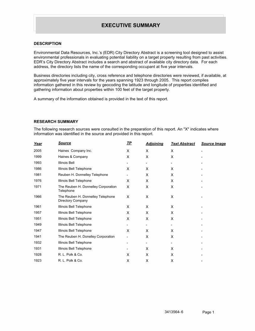
�+��1�#/���1--��*
�����#,�# "
)������ ����'�*����+�(�����(�����#9(�6)*+8������*�����������(�������(���(������������'�1�(����1�����((�(��������� ����'�$��0�((����'(�������'�������$�������'�'����'����������������$��$�������(�'�����0�� �$�(�����������(#��)*+9(������*�����������(���������'�1�(���(�������1���(�������0�����'��'�������1���������1���#��:��������11��((�����1���������'�(�(������ ���0���������($��1��������$�������0����������������'(#
;�(���((�1���������(����'�1�������������((���0���������1���'�$����1���������(�.���������.�1���0�����'��'�������$$��2� ���'��0����������������'(�0����������(�($�������!�%��������%��"#��/�(���$������ $�'�(���0�� ������������1������(������.���������1�������'�����1����1�'������1���0�$��$�����(��1����0��1���1������������0�� ������������$��$�����(�.�����!���0�����0�����������$��$����#
��(� �����0������0�� �������������1��(�$����1�1���������2���0���(���$���#
���������1--��*
/��0�''�.������(�����(�����(�.�������(�'��1�������$��$���������0���(���$���#����3<3���1�����(�.������0�� ������.�(��1����0��1�������(��������1�$����1�1������(���$���#
���� ������ �������� ������ ������ ����������
%��" ����(���� $�������# < < < ,!��� ����(�=��� $��� < < < ,!��� �''����(�;�'' , , , ,!�-� �''����(�;�''�/�'�$��� < < < ,!�-! +������#�*����''���/�'�$��� , < < ,!�>� �''����(�;�''�/�'�$��� < < < ,!�>! /��+������#�*����''������$��������
/�'�$���< < < ,
!��� /��+������#�*����''���/�'�$����*����������� $���
< < < ,
!��! �''����(�;�''�/�'�$��� < < < ,!�"> �''����(�;�''�/�'�$��� < < < ,!�"! �''����(�;�''�/�'�$��� < < < ,!��� �''����(�;�''�/�'�$��� , , , ,!��> �''����(�;�''�/�'�$��� < < < ,!��! /��+������#�*���''������$������� , < < ,!��% �''����(�;�''�/�'�$��� , , , ,!��! �''����(�;�''�/�'�$��� , < < ,!�%- +#��#�&�'4�=���# < < < ,!�%� +#��#�&�'4�=���# < < < ,
��!�"��, � &����!

!#"�#"3�
���3���,� ,���*�#"! �-��# "
������������������� ������������������������������
!#"�#"3������#�/������&��$�������(�����1����'#
����-#��3�
����������-#��3�
���� ���� ����
!�"> ;+5?��/5�� �''����(�;�''�/�'�$���
@)+A�B�)*?���� �''����(�;�''�/�'�$���
�5;�A�B�?��/)+ �''����(�;�''�/�'�$���
�AC7��B5?�BC�)�)� �''����(�;�''�/�'�$���
C5D�E�:+��B�7�@+ �''����(�;�''�/�'�$���
!�"! +D/B5?�B�����)C �''����(�;�''�/�'�$���
!��> /D7;�)���� �''����(�;�''�/�'�$���
����-#��3���/�
����������-#��3���/�
���� ���� ����
%��" E��F�����'��1���� ����(���� $�������#
7D�5A��� ����(���� $�������#
�5+���5�) ����� ����(���� $�������#
!��� )+���*)A�7��� ����(�=��� $���
!�-� �' ���G�)'�G�����? �''����(�;�''�/�'�$���
!�%- ;'�G�����(���'��(���� ��� +#��#�&�'4�=���#
E�������G�@�(�� +#��#�&�'4�=���#
B�� ��(4������'���H������� +#��#�&�'4�=���#
��1��.���&�.�''�'���� +#��#�&�'4�=���#
+��4�.(4���'�2� +#��#�&�'4�=���#
!�%� ���B�@�(�'�� +#��#�&�'4�=���#
/� �'���1�'$�'�� +#��#�&�'4�=���#
A�'�(.��G�@�(�'�� +#��#�&�'4�=���#
��!�"��, � &����%

���� ���� ����
!#"�#"3�
����-#��3����
����������-#��3����
���� ���� ����
!�>� ;5�������)&+���5 �''����(�;�''�/�'�$���
�)E�)��B��+5;/�) �''����(�;�''�/�'�$���
!�>! �)E�)��B��+5;/�) /��+������#�*����''������$��������/�'�$���
+D/B5?�B��)*? /��+������#�*����''������$��������/�'�$���
!��� �)E�)��B��+5;/�) /��+������#�*����''���/�'�$����*����������� $���
+D/B5?�B��)*? /��+������#�*����''���/�'�$����*����������� $���
A)7��)B�@5� /��+������#�*����''���/�'�$����*����������� $���
!��! ;+��*�@���+ �''����(�;�''�/�'�$���
)�)� �''����(�;�''�/�'�$���
C5D�E�:+��B�7�@+ �''����(�;�''�/�'�$���
!�%- ;����(������ +#��#�&�'4�=���#
��!�"��, � &�����

!#"�#"3�
��5 #"#"3�,� ,���*�����#�
/��0�''�.�����1H�������&��$������11��((�(�.������(�����1�0�����(���$���#��*����'�1�0��1���(�����$����1�1�0��������11��((#
����-#��3�
��67������-#��3�
���� ���� ����
!�"> &�?��B5?�B��@5� �''����(�;�''�/�'�$���
!�"! �D+��@5� �''����(�;�''�/�'�$���
B��7��A�)�+C �''����(�;�''�/�'�$���
!��> �D+��@5� �''����(�;�''�/�'�$���
E+��A�:+��B �''����(�;�''�/�'�$���
��68������-#��3�
���� ���� ����
!�"> B?������/5��@ �''����(�;�''�/�'�$���
?�E�)+�@5��&�@+ �''����(�;�''�/�'�$���
!�"! B?��������� �''����(�;�''�/�'�$���
B?������/5��@ �''����(�;�''�/�'�$���
!��> B?����)��A�; �''����(�;�''�/�'�$���
B?��������� �''����(�;�''�/�'�$���
B?������/5��@ �''����(�;�''�/�'�$���
��69������-#��3�
���� ���� ����
!�"> �A�AD;�)?�B��;)+���) �''����(�;�''�/�'�$���
5;�A�+�C�7���)� �''����(�;�''�/�'�$���
!�"! 5;�A�+�C�7���)� �''����(�;�''�/�'�$���
�A�AD;�)?�B��;)+���) �''����(�;�''�/�'�$���
!��> �A�AD;�)?�B��;)+���) �''����(�;�''�/�'�$���
��6:������-#��3�
���� ���� ����
!�"> ;���B����� �''����(�;�''�/�'�$���
!�"! ;���B����� �''����(�;�''�/�'�$���
��;<������-#��3�
���� ���� ����
!�"> @D*E)��5+7�� �''����(�;�''�/�'�$���
��!�"��, � &�����

���� ���� ����
!#"�#"3�
���� ���� ����
!�"! /D7���?��/)+ �''����(�;�''�/�'�$���
�C��B��:)��< �''����(�;�''�/�'�$���
@D*E)��5+7�� �''����(�;�''�/�'�$���
��;6������-#��3�
���� ���� ����
!�"> BD/���/���)C�:�@+ �''����(�;�''�/�'�$���
5��F�+)��@5��) �''����(�;�''�/�'�$���
!�"! E��E)+��5//�)�7��� �''����(�;�''�/�'�$���
5��F�+)��@5��) �''����(�;�''�/�'�$���
��;;������-#��3�
���� ���� ����
!�"> �7�)�A�C�+5;/�* �''����(�;�''�/�'�$���
75�B5���)<�� �''����(�;�''�/�'�$���
!�"! �775�*���5�)7�� �''����(�;�''�/�'�$���
��;�������-#��3�
���� ���� ����
!�"! B�D��;+D�5 �''����(�;�''�/�'�$���
��;=������-#��3�
���� ���� ����
!�"> /�+5����?��/)+ �''����(�;�''�/�'�$���
+�����@5� �''����(�;�''�/�'�$���
��;8������-#��3�
���� ���� ����
!�"> F�/5�BC�@5��? �''����(�;�''�/�'�$���
+5D;��@5� �''����(�;�''�/�'�$���
!�"! ��/A�)+�E)5�B �''����(�;�''�/�'�$���
+5D;��@5� �''����(�;�''�/�'�$���
�5@���?��/)+�@�@+ �''����(�;�''�/�'�$���
!��> ��/A�)+�E)5�B �''����(�;�''�/�'�$���
+5D;��@5� �''����(�;�''�/�'�$���
�5@���?��/)+�@�@+ �''����(�;�''�/�'�$���
��;:������-#��3�
���� ���� ����
!�"> *D��B���@5�)&��)�7 �''����(�;�''�/�'�$���
��!�"��, � &����"

���� ���� ����
!#"�#"3�
���� ���� ����
!�"! *D��B���@5�)&��)�7 �''����(�;�''�/�'�$���
!��> *D��B���@5�)&��)�7 �''����(�;�''�/�'�$���
���<������-#��3�
���� ���� ����
!�>! 5*5�@5��� /��+������#�*����''������$��������/�'�$���
����:+��B /��+������#�*����''������$��������/�'�$���
!�"> B�7+�*/�@5��E �''����(�;�''�/�'�$���
!�"! 5�C�)*?�: �''����(�;�''�/�'�$���
!��> 5�C�)*?�: �''����(�;�''�/�'�$���
���;������-#��3�
���� ���� ����
!�"> ;�+���B��@5� �''����(�;�''�/�'�$���
!�"! ���5D&B��:+)* �''����(�;�''�/�'�$���
+57��5?�B�����+� �''����(�;�''�/�'�$���
5�5/���BC�B�/)+��) �''����(�;�''�/�'�$���
��;����D/)+� �''����(�;�''�/�'�$���
!��> ���5D&B��:+)* �''����(�;�''�/�'�$���
���=������-#��3�
���� ���� ����
!�"> A)E�*�5�B��7)+) �''����(�;�''�/�'�$���
7�/�D�/)5 �''����(�;�''�/�'�$���
D7�C�@5� �''����(�;�''�/�'�$���
!�"! 7��)B�:+��B�7+� �''����(�;�''�/�'�$���
D7�C�@5� �''����(�;�''�/�'�$���
;���)*��@5�)&��)�7 �''����(�;�''�/�'�$���
7�/�D�/)5 �''����(�;�''�/�'�$���
!��> 7��)B�:+��B�7+� �''����(�;�''�/�'�$���
D7�C�@5� �''����(�;�''�/�'�$���
;���)*��@5�)&��)�7 �''����(�;�''�/�'�$���
���7������-#��3�
���� ���� ����
!�"> ?+5;)���5D���: �''����(�;�''�/�'�$���
5�/+5?�B���/���)C �''����(�;�''�/�'�$���
;�+E��B�7���)� �''����(�;�''�/�'�$���
!�"! ?+5;)����/)+��) �''����(�;�''�/�'�$���
��!�"��, � &�����

���� ���� ����
!#"�#"3�
���� ���� ����
!�"! ;�+E��B�7���)� �''����(�;�''�/�'�$���
!��> ;�+E��B�7���)� �''����(�;�''�/�'�$���
?+5;)����/)+��) �''����(�;�''�/�'�$���
���8������-#��3�
���� ���� ����
!�"> A�B)+�@���: �''����(�;�''�/�'�$���
!�"! ?5*�+�ACB�F����? �''����(�;�''�/�'�$���
E5�*)��E)5�� �''����(�;�''�/�'�$���
!��> ?5*�+�ACB�F����? �''����(�;�''�/�'�$���
BD�B��@5� �''����(�;�''�/�'�$���
���9������-#��3�
���� ���� ����
!�"> �5�E�7)+�) �''����(�;�''�/�'�$���
;D+���?7�@ �''����(�;�''�/�'�$���
!�"! &��)��B�@5� �''����(�;�''�/�'�$���
���B�D�B���F��/5+�� �''����(�;�''�/�'�$���
�/�+5���/���)C �''����(�;�''�/�'�$���
!��> ���B�D�B���F��/5+�� �''����(�;�''�/�'�$���
&��)��B�@5� �''����(�;�''�/�'�$���
���:������-#��3�
���� ���� ����
!�>� ���*5F����+/D+5�+ �''����(�;�''�/�'�$���
!�"> ;D+B)�@5��B �''����(�;�''�/�'�$���
*D7��/����/��C��� �''����(�;�''�/�'�$���
;+�������)< �''����(�;�''�/�'�$���
!�"! ;+�������)< �''����(�;�''�/�'�$���
A�;DB����*�7 �''����(�;�''�/�'�$���
!��> *5F)�B��)�/)����) �''����(�;�''�/�'�$���
�)5F��B��D����) �''����(�;�''�/�'�$���
���;������-#��3�
���� ���� ����
!�"> ;+�������)< �''����(�;�''�/�'�$���
��@*�B�;)+��+* �''����(�;�''�/�'�$���
&�+5E�@5� �''����(�;�''�/�'�$���
!�"! B+AC���B�:+��B��:/�*+�B� �''����(�;�''�/�'�$���
!��> @�ED����;)+/ �''����(�;�''�/�'�$���
��!�"��, � &����>

���� ���� ����
!#"�#"3�
����������-#��3�
���� ���� ����
!�"> �5?5;�)��B��:+��B �''����(�;�''�/�'�$���
!�"! B�D::7����:+)*�+5;/ �''����(�;�''�/�'�$���
!��> B�D::7����:+)*�+5;/ �''����(�;�''�/�'�$���
���=������-#��3�
���� ���� ����
!�"> �)E�)��B��@5� �''����(�;�''�/�'�$���
F���DB5����B�AC� �''����(�;�''�/�'�$���
+�&�BC�@5��: �''����(�;�''�/�'�$���
B5+��*��@���@ �''����(�;�''�/�'�$���
!�"! �)E�)��B��@5��� �''����(�;�''�/�'�$���
+�&�BC����& �''����(�;�''�/�'�$���
!��> C5D�E��/)��� �''����(�;�''�/�'�$���
�)E�)��B��@5��� �''����(�;�''�/�'�$���
���:������-#��3�
���� ���� ����
!�"> B+�D�)C��/)��� �''����(�;�''�/�'�$���
!�"! B+�D�)C��/)��� �''����(�;�''�/�'�$���
B+�D��*���&�D� �''����(�;�''�/�'�$���
��=<������-#��3�
���� ���� ����
!�"> A�@����/)F) �''����(�;�''�/�'�$���
ED//�/)*�? �''����(�;�''�/�'�$���
!�"! A�@����/)F) �''����(�;�''�/�'�$���
@��7��B�:+��B�� �''����(�;�''�/�'�$���
!��> @��7��B�:+��B�� �''����(�;�''�/�'�$���
����-#��3���/�
��67������-#��3���/�
���� ���� ����
%��" +5*+�ED)A�+��� ����(���� $�������#
F�����D)F����'��� ����(���� $�������#
!��� +5*+�ED)A+��� ����(�=��� $���
F�����D)F����7�� ����(�=��� $���
!�-� ;�1�''��)�(�1�� �''����(�;�''�/�'�$���
!�%- ;�4����1� � +#��#�&�'4�=���#
��!�"��, � &����-

���� ���� ����
!#"�#"3�
���� ���� ����
!�%- �������� �:'�������7�(� +#��#�&�'4�=���#
*����'����(� ��� +#��#�&�'4�=���#
�''($��4�)�������� +#��#�&�'4�=���#
���'���@�������7�(� +#��#�&�'4�=���#
�.���4�;���0����'���� +#��#�&�'4�=���#
!�%� *����4��@���'�� +#��#�&�'4�=���#
B����4��@���'�� +#��#�&�'4�=���#
B����4��@�(�'�� +#��#�&�'4�=���#
B�G����.(4��E���'�� +#��#�&�'4�=���#
����.��G����$� �� +#��#�&�'4�=���#
��4�(G�����G�F������'�� +#��#�&�'4�=���#
&(G�G�'4��@���'�� +#��#�&�'4�=���#
&(G�G�'4��@�(�$4� +#��#�&�'4�=���#
F���'�(�/����'�� +#��#�&�'4�=���#
��68������-#��3���/�
���� ���� ����
%��" &�/��5�+� ��� ����(���� $�������#
!��� ;D�/5��;���'� ����(�=��� $���
!�-� ���1���(������� �''����(�;�''�/�'�$���
!�-! ?������@�(�&�@� +������#�*����''���/�'�$���
B� ��1��@�(�E +������#�*����''���/�'�$���
!�%- E'��(4��/�(� +#��#�&�'4�=���#
B�����(4����������1�� 4��� +#��#�&�'4�=���#
B�����(4��?�'����(��1����� +#��#�&�'4�=���#
��4���4(4��:���4� +#��#�&�'4�=���#
7��4�.��G���(� +#��#�&�'4�=���#
7���G�@����'4�� +#��#�&�'4�=���#
!�%� ;�(�(�E�(�'�� +#��#�&�'4�=���#
B�����(4�������.�1�����( +#��#�&�'4�=���#
7���G�@���'�� +#��#�&�'4�=���#
7���.(4���������'�� +#��#�&�'4�=���#
��4�(��� ��� +#��#�&�'4�=���#
��69������-#��3���/�
���� ���� ����
%��" D++�/���+����'1� ����(���� $�������#
;�D/��/�������� ����(���� $�������#
�5���5�&��'� ����(���� $�������#
��!�"��, � &�����

���� ���� ����
!#"�#"3�
���� ���� ����
!��� +D�A/���(��@ ����(�=��� $���
+D�A@�(��+ ����(�=��� $���
���/5��E������ ����(�=��� $���
F)�������'� ����(�=��� $���
��6:������-#��3���/�
���� ���� ����
%��" <<<< ����(���� $�������#
!��� :�5+)������� ����(�=��� $���
!�-! �����1�G����� +������#�*����''���/�'�$���
+� ���G�����0��� +������#�*����''���/�'�$���
!��! ;���4�@�(�@�� �''����(�;�''�/�'�$���
!�%- ;���4�E��� +#��#�&�'4�=���#
;���4��'���� +#��#�&�'4�=���#
;���4�@�(� +#��#�&�'4�=���#
;���4�����'���1������� +#��#�&�'4�=���#
;���4��'����'4�@�?�;��'���&�$������� +#��#�&�'4�=���#
�G�H4��@���'��� +#��#�&�'4�=���#
E���'�G�4�����(����� +#��#�&�'4�=���#
7�G���4�:���4� +#��#�&�'4�=���#
7�����B�&�����'���� +#��#�&�'4�=���#
!�%� F�'�4�7��'�'�� +#��#�&�'4�=���#
/��'������������($� +#��#�&�'4�=���#
&�����4�E���'�� +#��#�&�'4�=���#
7��(G�'�@���'�� +#��#�&�'4�=���#
7�'�G(��(�&����� �� � +#��#�&�'4�=���#
7��(G�4�@�(�'�� +#��#�&�'4�=���#
B��((��0������.�(�� +#��#�&�'4�=���#
E��H��@�(�'�� +#��#�&�'4�=���#
��;<������-#��3���/�
���� ���� ����
%��" /+D@���5@�(� ����(���� $�������#
&)+)A�7����� ����(���� $�������#
!��� <<<< ����(�=��� $���
!�-� +� ���G�7����( �''����(�;�''�/�'�$���
�'�����7���� �''����(�;�''�/�'�$���
!�-! 7����(�7����' +������#�*����''���/�'�$���
!��! ��H1�4�E�� /��+������#�*���''������$�������
��!�"��, � &����!�

���� ���� ����
!#"�#"3�
���� ���� ����
!�%- ;�1�������$��'����$��� +#��#�&�'4�=���#
�G�H4��E���� +#��#�&�'4�=���#
�G�H4��E���H� +#��#�&�'4�=���#
*G��1����@�(� +#��#�&�'4�=���#
:�'����1� �����4���� +#��#�&�'4�=���#
E���'�@�(��(4� ����� ����=���� +#��#�&�'4�=���#
B��'�@��� +#��#�&�'4�=���#
����'���B����4��� +#��#�&�'4�=���#
���1�����'��(��� +#��#�&�'4�=���#
����G���B�����'4�� +#��#�&�'4�=���#
����G���F�������� +#��#�&�'4�=���#
/���''��;��H�'���� +#��#�&�'4�=���#
!�%� *G������'�.(4���'�2������� +#��#�&�'4�=���#
�������4�����(�'�� +#��#�&�'4�=���#
*G������'�.(4��+� ���'�� +#��#�&�'4�=���#
��;6������-#��3���/�
���� ���� ����
%��" +�7�+)A�)�(���� ����(���� $�������#
+�7�+)A�7����( ����(���� $�������#
F�+�75�/)����'��1�� ����(���� $�������#
!��� E57)A@�(�( ����(�=��� $���
+�7�+)A)�(���� ����(�=��� $���
+�7�+)A7����( ����(�=��� $���
!�-� �'���(�����( �''����(�;�''�/�'�$���
B��������'���:�@� �''����(�;�''�/�'�$���
7��G���@����� �''����(�;�''�/�'�$���
!�-! B��������'���:�@� +������#�*����''���/�'�$���
A���.(4���'�� +������#�*����''���/�'�$���
!��! E�������������7�(( /��+������#�*���''������$�������
!�%- *G������'�.(4��@��������1�� +#��#�&�'4�=���#
*G������'�.(4���������� +#��#�&�'4�=���#
*G������'�.(4��+� ���'��� +#��#�&�'4�=���#
:'�������@�((���'��� +#��#�&�'4�=���#
E�'��4��@�(� +#��#�&�'4�=���#
��+�5��/�(�� +#��#�&�'4�=���#
A��������G��� �'���� +#��#�&�'4�=���#
!�%� �4�1���@���'�� +#��#�&�'4�=���#
B���4��������'�� +#��#�&�'4�=���#
��!�"��, � &����!!

���� ���� ����
!#"�#"3�
��;;������-#��3���/�
���� ���� ����
%��" ;)���7���� ����(���� $�������#
!��� <<<< ����(�=��� $���
!�-� 7���(��'������ �''����(�;�''�/�'�$���
!��! 5+��B�7�4��� �''����(�;�''�/�'�$���
!�%- ��� �4�7����� +#��#�&�'4�=���#
!�%� ?�H��4��������'�� +#��#�&�'4�=���#
:�'�$�G�4�����'���'�� +#��#�&�'4�=���#
;�4�.(4��D�����'�� +#��#�&�'4�=���#
��;�������-#��3���/�
���� ���� ����
%��" 75+)�5��������� ����(���� $�������#
75+)�5���'����� ����(���� $�������#
!��� <<<< ����(�=��� $���
!��! ?����'�:���4 /��+������#�*���''������$�������
!��! ?+5;)��:���4�� �''����(�;�''�/�'�$���
!�%- B�'��4�@�(�� +#��#�&�'4�=���#
B�'��4������7�(� +#��#�&�'4�=���#
E�����(4������0��� ��� +#��#�&�'4�=���#
!�%� ;������*��'�'�� +#��#�&�'4�=���#
��� �4�:���4���� +#��#�&�'4�=���#
��;=������-#��3���/�
���� ���� ����
%��" +�7�+)A�&������� ����(���� $�������#
�5����@�''� ����(���� $�������#
!��� <<<< ����(�=��� $���
!�-� ��0�����(�@�(�( �''����(�;�''�/�'�$���
!�-! ;�(��@�(��E��1�'�$� +������#�*����''���/�'�$���
!�%- *��1G���@�(� +#��#�&�'4�=���#
/� �(4��7��'� +#��#�&�'4�=���#
�+F)C�/�(�H������� +#��#�&�'4�=���#
E��1G����@�(� +#��#�&�'4�=���#
*����7����� +#��#�&�'4�=���#
!�%� 7��1�'��7������( (��( +#��#�&�'4�=���#
��4�(G�G�4�@����(�'�� +#��#�&�'4�=���#
����4�:���4�'�� +#��#�&�'4�=���#
*� �'�4�E���'�� +#��#�&�'4�=���#
��!�"��, � &����!%

���� ���� ����
!#"�#"3�
���� ���� ����
!�%� ;�'��1��@���'�� +#��#�&�'4�=���#
7�������������$�� +#��#�&�'4�=���#
��'�(G���'��(�������'�� 4� +#��#�&�'4�=���#
?�4�(�����'�� +#��#�&�'4�=���#
��;8������-#��3���/�
���� ���� ����
%��" +)C)������� ����(���� $�������#
!��� +5*+�ED)A7����� ����(�=��� $���
+5*+�ED)A*����' ����(�=��� $���
!�-� +�����@�( �''����(�;�''�/�'�$���
!�-! +�����@�( +������#�*����''���/�'�$���
!�%- ;� ���@���� +#��#�&�'4�=���#
���1����+�(��1�� +#��#�&�'4�=���#
7�'1�(���(�� +#��#�&�'4�=���#
+�����������'���� +#��#�&�'4�=���#
+�����:���4�'��� +#��#�&�'4�=���#
+�����@�(�'���� +#��#�&�'4�=���#
D+;�������'���'���� +#��#�&�'4�=���#
;�1����;��H�� +#��#�&�'4�=���#
�����G��(4�������� +#��#�&�'4�=���#
!�%� +�����:���4�'�� +#��#�&�'4�=���#
��;:������-#��3���/�
���� ���� ����
%��" <<<< ����(���� $�������#
!��� ED���)�@�(��E ����(�=��� $���
!�-! B���(�* +������#�*����''���/�'�$���
?������+����1� +������#�*����''���/�'�$���
!�%- +�1�����G�;������� +#��#�&�'4�=���#
��1�����1��.� +#��#�&�'4�=���#
!�%� ��1�����1��.������� +#��#�&�'4�=���#
�G�.�G�4�E���'�� +#��#�&�'4�=���#
�1���.��G���1��.�'�� +#��#�&�'4�=���#
���<������-#��3���/�
���� ���� ����
%��" &)+)A�7����''� ����(���� $�������#
7D�5A�7���� ����(���� $�������#
��!�"��, � &����!�

���� ���� ����
!#"�#"3�
���� ���� ����
%��" EDA7����'����� ����(���� $�������#
!��� �+����/5�F�1����� ����(�=��� $���
!�-� +����@������ �''����(�;�''�/�'�$���
!��! ��75�)��@�(����� �''����(�;�''�/�'�$���
!�%- ������G4���'�2� +#��#�&�'4�=���#
��G���(4��/�(� +#��#�&�'4�=���#
���'��4���'�2�('( ��7�1�'�*��������� +#��#�&�'4�=���#
!�%� ��.4��&��'�'�� +#��#�&�'4�=���#
�� ���(�@�(�������0� +#��#�&�'4�=���#
�'��G��@�(�(�'�� +#��#�&�'4�=���#
���;������-#��3���/�
���� ���� ����
%��" 5+�)����E�(���� ����(���� $�������#
!��� <<<< ����(�=��� $���
!�-� �.�1���*����( �''����(�;�''�/�'�$���
!�-! E� �G�����( +������#�*����''���/�'�$���
!�%- ;������*��'� +#��#�&�'4�=���#
*� ��'�(���(�'���� +#��#�&�'4�=���#
B+�D�������� +#��#�&�'4�=���#
B+�D���������'4�� +#��#�&�'4�=���#
����4��@���'��� +#��#�&�'4�=���#
�G�G��4��@���'���� +#��#�&�'4�=���#
!�%� &��0�����G�@�����'�� +#��#�&�'4�=���#
&��0�����G��� �'�� +#��#�&�'4�=���#
�G���4��@���'�� +#��#�&�'4�=���#
�������(�'�� +#��#�&�'4�=���#
����4��@���'�� +#��#�&�'4�=���#
&��0�����G�����'���'�� +#��#�&�'4�=���#
;�'����(�7��'����0� +#��#�&�'4�=���#
�1���������'�� +#��#�&�'4�=���#
E��(4���'�����'�� +#��#�&�'4�=���#
*��'4�@���'�� +#��#�&�'4�=���#
����������-#��3���/�
���� ���� ����
!�%- @��1���'��(�?�'����'���� +#��#�&�'4�=���#
��!�"��, � &����!�

���� ���� ����
!#"�#"3�
���=������-#��3���/�
���� ���� ����
%��" E�+�����1�� ����(���� $�������#
�D@��5�7����� ����(���� $�������#
F)��A�5�@���� ����(���� $�������#
!��� A�75+��5�E���1�'�$� ����(�=��� $���
A�75+��5E��1�'�$� ����(�=��� $���
!�-� � ���@�( �''����(�;�''�/�'�$���
7� ��1�+�H�� �''����(�;�''�/�'�$���
7�����/�� �''����(�;�''�/�'�$���
5'�(�.(4��7���� �''����(�;�''�/�'�$���
?�'�(�+�(� ���� �''����(�;�''�/�'�$���
!�-! � ���@�( +������#�*����''���/�'�$���
B�'�'���1�'�+ +������#�*����''���/�'�$���
7�����/�� +������#�*����''���/�'�$���
?�'�(�+�(� ���� +������#�*����''���/�'�$���
!�%- ;����G���1� � +#��#�&�'4�=���#
@�($�'4���@�(�'���� +#��#�&�'4�=���#
@�($�'4�@�(� +#��#�&�'4�=���#
B�'$(����(� +#��#�&�'4�=���#
��������/����$� ��� +#��#�&�'4�=���#
5��4�(�@�(� +#��#�&�'4�=���#
!�%� 7�������@���'�� +#��#�&�'4�=���#
D ��1�@�(�'�� +#��#�&�'4�=���#
B�(� �����(�@�'��(�'�� +#��#�&�'4�=���#
���7������-#��3���/�
���� ���� ����
%��" ?+5;)������(��7 ����(���� $�������#
!��� ?+5;)�@�(�$��� ����(�=��� $���
!�-� ?����'�����(�: �''����(�;�''�/�'�$���
!�-! ;���'�4�7����' +������#�*����''���/�'�$���
?����'�����(�: +������#�*����''���/�'�$���
!�%- C��� ���7����'���� +#��#�&�'4�=���#
+���'�@������$��� +#��#�&�'4�=���#
��(4��:���4������� 4�� +#��#�&�'4�=���#
�����G�4�/����'4( ���� +#��#�&�'4�=���#
� �������E���'��� +#��#�&�'4�=���#
C��� ���@���$����� +#��#�&�'4�=���#
!�%� 7��4�.(4��;�������7�$4� +#��#�&�'4�=���#
��!�"��, � &����!"

���� ���� ����
!#"�#"3�
���� ���� ����
!�%� 7��4�.(4��;�����(��'4 +#��#�&�'4�=���#
7����������.�1�:���4 +#��#�&�'4�=���#
���8������-#��3���/�
���� ���� ����
%��" ����)A����' ����(���� $�������#
!��� <<<< ����(�=��� $���
!�-� ����(�B����� �''����(�;�''�/�'�$���
!�-! ����(�B����� +������#�*����''���/�'�$���
!��! +5@���@����� �''����(�;�''�/�'�$���
!�%- ��'���4���1��.�� +#��#�&�'4�=���#
*�G(�4�@���� +#��#�&�'4�=���#
1�������G������ +#��#�&�'4�=���#
1�������G�)��� +#��#�&�'4�=���#
1�������G������� +#��#�&�'4�=���#
����������������1�� +#��#�&�'4�=���#
+� ���G�@�((��'���� +#��#�&�'4�=���#
/� ���G����4�� +#��#�&�'4�=���#
/� ���G�D�'1�� +#��#�&�'4�=���#
F�G������F��������.�1�&����� +#��#�&�'4�=���#
!�%� ;�'���7������'�� +#��#�&�'4�=���#
�+��/5&�@������$�� +#��#�&�'4�=���#
�?)�/A)+�7��'��$�' +#��#�&�'4�=���#
�G�1�4�(�;���'�� +#��#�&�'4�=���#
C����G�:���4�'�� +#��#�&�'4�=���#
?�G�����F��������.�1�&���� +#��#�&�'4�=���#
F����G�4�@�(�'�� +#��#�&�'4�=���#
���9������-#��3���/�
���� ���� ����
%��" �&�+/7)�/� ����(���� $�������#
;+�F5�+�'�� ����(���� $�������#
+�7�+)A�@��� ����(���� $�������#
+)C)��@�(� ����(���� $�������#
+)C�5�5E ����(���� $�������#
+5E+�ED)A�E����� ����(���� $�������#
!�-� &����''��� �''����(�;�''�/�'�$���
!�-! @�����;���� +������#�*����''���/�'�$���
!�%- /��4(�'�(�B��(�������'��� +#��#�&�'4�=���#
��!�"��, � &����!�

���� ���� ����
!#"�#"3�
���� ���� ����
!�%- /����''�(����(�������� +#��#�&�'4�=���#
/����''�(�����������0�� +#��#�&�'4�=���#
�4���4�@���'���� +#��#�&�'4�=���#
+� ����4�@�(� +#��#�&�'4�=���#
&��(����4�:���4�� +#��#�&�'4�=���#
7���4������'���H��'���� +#��#�&�'4�=���#
7���4������'���'��� +#��#�&�'4�=���#
7���4��;������������� +#��#�&�'4�=���#
;�����:���4����$�� +#��#�&�'4�=���#
B�.�'��4�7���'�������� +#��#�&�'4�=���#
B�.�'�G�4�@�������� +#��#�&�'4�=���#
B+�D��:���4� +#��#�&�'4�=���#
B��� �'�/������$���� +#��#�&�'4�=���#
��$��4���$���.�1�����(� +#��#�&�'4�=���#
!�%� B�.�'�G�4�7��'�'�� +#��#�&�'4�=���#
7��4�.(4��:���4�'�� +#��#�&�'4�=���#
*���4�7��'�'�� +#��#�&�'4�=���#
�G��G��������'���'�� +#��#�&�'4�=���#
;���'�@�(�������$� +#��#�&�'4�=���#
���:������-#��3���/�
���� ���� ����
%��" �)+F��/)��+�� ����(���� $�������#
)+���*)A���(����� ����(���� $�������#
7�+���7����� ����(���� $�������#
5�5:+)���� � ����(���� $�������#
!�-� :'���(�����'�� �''����(�;�''�/�'�$���
��������)��'�� �''����(�;�''�/�'�$���
&�'� ���@�(�( �''����(�;�''�/�'�$���
&'�(�������7���� �''����(�;�''�/�'�$���
����'����7����' �''����(�;�''�/�'�$���
!�-! ��(��''���(�;��� +������#�*����''���/�'�$���
7������G�+������ +������#�*����''���/�'�$���
&�'� ���@�(�( +������#�*����''���/�'�$���
!��! *����4��)(��''��) /��+������#�*���''������$�������
!�%- ����.��G�@�(� +#��#�&�'4�=���#
����'�@�'�'�� ������4���� +#��#�&�'4�=���#
����'�G�E��''�� �� +#��#�&�'4�=���#
����'�G�@�'����� +#��#�&�'4�=���#
��!�"��, � &����!>

���� ���� ����
!#"�#"3�
���� ���� ����
!�%- ;�1��� �? � +#��#�&�'4�=���#
F���''��@�(��� +#��#�&�'4�=���#
F�������:�'�$��� +#��#�&�'4�=���#
F�+E���51�'���� +#��#�&�'4�=���#
F������:��(������ +#��#�&�'4�=���#
��.���������.�1�����'��� +#��#�&�'4�=���#
� +#��#�&�'4�=���#
B��$��B��(��'� +#��#�&�'4�=���#
B��(��(4��? �'���� +#��#�&�'4�=���#
:����(�+� ���� +#��#�&�'4�=���#
:����(�@�(��� +#��#�&�'4�=���#
!�%� ?�'(4��@���'�� +#��#�&�'4�=���#
D1����.��G�7���'�� +#��#�&�'4�=���#
����'�����'���'�� +#��#�&�'4�=���#
&�(4��(����'(��&�(�4� +#��#�&�'4�=���#
&�(��(4��7��'�'�� +#��#�&�'4�=���#
;���.��G�@�(�'�� +#��#�&�'4�=���#
���������G�B�( ���'�� +#��#�&�'4�=���#
?�(4��.��G��������'�� +#��#�&�'4�=���#
���;������-#��3���/�
���� ���� ����
%��" +)��5�5�+� ��� ����(���� $�������#
+57���+��� ����(���� $�������#
��F�+)A�@�(��� ����(���� $�������#
!��� �5���:�1����� ����(�=��� $���
7�+/��)A���'�� ����(�=��� $���
+)��5�5�+� �� ����(�=��� $���
+)C)��+���� ����(�=��� $���
!�-� ;����(�/�( �''����(�;�''�/�'�$���
!�-! ��$�G�@ +������#�*����''���/�'�$���
!��! B�G�(��4�:���4��0��1��4( /��+������#�*���''������$�������
!��! B�G�(��4�:���4�� �''����(�;�''�/�'�$���
!�%- &����(�4�7�����'4�@���7����(����� +#��#�&�'4�=���#
&����(��4�@��� +#��#�&�'4�=���#
B����0�'�E��� +#��#�&�'4�=���#
�'��)1.�$�������� +#��#�&�'4�=���#
!�%� @���(�@��������$�� +#��#�&�'4�=���#
@���(�@�(�'�� +#��#�&�'4�=���#
��!�"��, � &����!-

���� ���� ����
!#"�#"3�
���� ���� ����
!�%� B�G�(��4�:���4�(�0��1���4( +#��#�&�'4�=���#
B�G�(��4�������1��'4 +#��#�&�'4�=���#
B����+�������$ +#��#�&�'4�=���#
����������-#��3���/�
���� ���� ����
!��� <<<< ����(�=��� $���
!��! /�7D����:���4�@�� �''����(�;�''�/�'�$���
!�%- ;'�G����'��(����'���� +#��#�&�'4�=���#
5��C���$���'���� +#��#�&�'4�=���#
�'�������G� +#��#�&�'4�=���#
�'��7����''��'4�� +#��#�&�'4�=���#
�'����$���� +#��#�&�'4�=���#
�'������'���������� +#��#�&�'4�=���#
�����(4�(�����('( �� +#��#�&�'4�=���#
!�%� &�����&��'����1�( 4� +#��#�&�'4�=���#
/� �'�(�:���4�@��'4��� ����=��� +#��#�&�'4�=���#
���=������-#��3���/�
���� ���� ����
%��" )�&�+A��@�(� ����(���� $�������#
+57)+5�&��'� ����(���� $�������#
F�����D)F��7�2� �'���� ����(���� $�������#
!��� �5/5�������� ����(�=��� $���
��@)+��+���� ����(�=��� $���
!�-� 7�����G�)' � �''����(�;�''�/�'�$���
�����E��''�� ��� �''����(�;�''�/�'�$���
!�-! 5'����������( +������#�*����''���/�'�$���
������������� +������#�*����''���/�'�$���
�������'��1�� +������#�*����''���/�'�$���
!�%- E�''��1�����'�(� +#��#�&�'4�=���#
@�4�.���@�'��(� +#��#�&�'4�=���#
&�(��(��������$����� +#��#�&�'4�=���#
��������7���'�'$��� +#��#�&�'4�=���#
!�%� &��������(�/�'�� +#��#�&�'4�=���#
E������(���( +#��#�&�'4�=���#
;�(G�����(�'�� +#��#�&�'4�=���#
��!�"��, � &����!�

���� ���� ����
!#"�#"3�
���9������-#��3���/�
���� ���� ����
%��" ����)A@�(� ����(���� $�������#
���:������-#��3���/�
���� ���� ����
%��" <<<< ����(���� $�������#
!��� B+�D�)C�& ����(�=��� $���
!�-� B���'���& �''����(�;�''�/�'�$���
!�-! B���'���& +������#�*����''���/�'�$���
!��! B���'�1�(�&��' /��+������#�*���''������$�������
!��! B���'��1�(�&��'�� �''����(�;�''�/�'�$���
!�%- ���(G���1� � +#��#�&�'4�=���#
B���'��1�(�&�����(��1����� +#��#�&�'4�=���#
�� �'��4�@���� +#��#�&�'4�=���#
B���'��1�(�&��'� +#��#�&�'4�=���#
��=<������-#��3���/�
���� ���� ����
%��" *)��*��+������ ����(���� $�������#
F)E��@�(�'��� ����(���� $�������#
7�/����'�� ����(���� $�������#
!��� ��+�F)5�� �'1� ����(�=��� $���
!�-� A�H�����/ �''����(�;�''�/�'�$���
E����/�1�? �''����(�;�''�/�'�$���
!�-! A�H����/ +������#�*����''���/�'�$���
E����/�1�? +������#�*����''���/�'�$���
!��! A�H�������� /��+������#�*���''������$�������
!��! @�;�5��BC���(�� �''����(�;�''�/�'�$���
E5�B)��1�'0�� �''����(�;�''�/�'�$���
!�%- /���G��4�?�'����&�������� +#��#�&�'4�=���#
/���G��4�:���4�$�������� +#��#�&�'4�=���#
/���G��4������.�1���1��.� +#��#�&�'4�=���#
��'4��?�'����@� ���1�� +#��#�&�'4�=���#
E'����4�@�(�1������� +#��#�&�'4�=���#
E'����4�@�(�H��� +#��#�&�'4�=���#
E'����4�@�(� +#��#�&�'4�=���#
F�H��4���(�H�������1�� +#��#�&�'4�=���#
!�%� B'�$�G�4�@���'�� +#��#�&�'4�=���#
B�&D�/B������'���'�� +#��#�&�'4�=���#
��!�"��, � &����%�

���� ���� ����
!#"�#"3�
���� ���� ����
!�%� B�&D�/B��7������'4 +#��#�&�'4�=���#
B�&D�/B��B���7�(���� +#��#�&�'4�=���#
;�(4�$�@�(�'�� +#��#�&�'4�=���#
B�&D�/B��@���(��1��� +#��#�&�'4�=���#
��=�������-#��3���/�
���� ���� ����
!�%- B���4��(�@�(� +#��#�&�'4�=���#
��=�������-#��3���/�
���� ���� ����
%��" ��F)A����( ����(���� $�������#
!��� ��F)A��� ����(�=��� $���
��=9������-#��3���/�
���� ���� ����
!��� *)��*��+������ ����(�=��� $���
2���/�? ����(�=��� $���
!�-! *���1��+������ +������#�*����''���/�'�$���
����-#��3����
��67������-#��3����
���� ���� ����
!�>! &�?��B5?�B���� /��+������#�*����''������$��������/�'�$���
!��� &�?��B5?�B��@5� /��+������#�*����''���/�'�$����*����������� $���
�����/5�+5;/ /��+������#�*����''���/�'�$����*����������� $���
!��! &�?��B5?�B��@5� �''����(�;�''�/�'�$���
��68������-#��3����
���� ���� ����
!�>� ?�E�)+�@5��&�@+ �''����(�;�''�/�'�$���
B?������/5��@ �''����(�;�''�/�'�$���
B��&)+�)*? �''����(�;�''�/�'�$���
B�7+�*/�@5��E �''����(�;�''�/�'�$���
!�>! B?������/5��@ /��+������#�*����''������$��������/�'�$���
B�7+�*/�@5��E /��+������#�*����''������$��������/�'�$���
��!�"��, � &����%!

���� ���� ����
!#"�#"3�
���� ���� ����
!��� B�7+�*/�@5��E /��+������#�*����''���/�'�$����*����������� $���
B��&)+�)*? /��+������#�*����''���/�'�$����*����������� $���
B?������/5��@ /��+������#�*����''���/�'�$����*����������� $���
?�E�)+�@5��&�@+ /��+������#�*����''���/�'�$����*����������� $���
!��! ?�E�)+�@5��&�@+ �''����(�;�''�/�'�$���
B?������/5��@ �''����(�;�''�/�'�$���
!�%- B�����(4�������.�1�����(� +#��#�&�'4�=���#
��69������-#��3����
���� ���� ����
!�>! 5//)��/+5)+�*5���*�E /��+������#�*����''������$��������/�'�$���
5�E�?��*5�? /��+������#�*����''������$��������/�'�$���
!��� 5;�A�+�C�7���)� /��+������#�*����''���/�'�$����*����������� $���
B)��)+�@5� /��+������#�*����''���/�'�$����*����������� $���
��������)�)� /��+������#�*����''���/�'�$����*����������� $���
!��! ��������)�)� �''����(�;�''�/�'�$���
��6:������-#��3����
���� ���� ����
!�>� /+D5�E��EDC)��C)� �''����(�;�''�/�'�$���
!�>! ;���B�:+��B�) /��+������#�*����''������$��������/�'�$���
;���B����� /��+������#�*����''������$��������/�'�$���
!��� ;���B�:+��B�) /��+������#�*����''���/�'�$����*����������� $���
;���B����� /��+������#�*����''���/�'�$����*����������� $���
!��! ;���B����� �''����(�;�''�/�'�$���
��;<������-#��3����
���� ���� ����
!�>! EAC+��:+��B /��+������#�*����''������$��������/�'�$���
!��� A?�@��A���*+)? /��+������#�*����''���/�'�$����*����������� $���
��!�"��, � &����%%

���� ���� ����
!#"�#"3�
���� ���� ����
!��� EAC+��:+��B /��+������#�*����''���/�'�$����*����������� $���
!��! 75�B5���)<�� �''����(�;�''�/�'�$���
EAC+��:+��B �''����(�;�''�/�'�$���
��;6������-#��3����
���� ���� ����
!�>� BD/���/���)C�:�@+ �''����(�;�''�/�'�$���
!�>! BD/���/���)C�:�@+ /��+������#�*����''������$��������/�'�$���
;���*��)*?�: /��+������#�*����''������$��������/�'�$���
!��� ;���*��)*?�: /��+������#�*����''���/�'�$����*����������� $���
BD/���/���)C�:�@+ /��+������#�*����''���/�'�$����*����������� $���
5��F�+)��@5��) /��+������#�*����''���/�'�$����*����������� $���
!��! B5+?���E)5�� �''����(�;�''�/�'�$���
:�@+ �''����(�;�''�/�'�$���
5��F�+)��@5��) �''����(�;�''�/�'�$���
��;;������-#��3����
���� ���� ����
!�>� *�C�) �''����(�;�''�/�'�$���
!��� ;5+A)�B��@5� /��+������#�*����''���/�'�$����*����������� $���
��;�������-#��3����
���� ���� ����
!�>� B�D��;+D�5 �''����(�;�''�/�'�$���
5*5�@5��� �''����(�;�''�/�'�$���
!�>! B�D��;+D�5�)�@+ /��+������#�*����''������$��������/�'�$���
B�D��;+D�5 /��+������#�*����''������$��������/�'�$���
!��� B�D��;+D�5 /��+������#�*����''���/�'�$����*����������� $���
!��! ;+D�5 �''����(�;�''�/�'�$���
��;=������-#��3����
���� ���� ����
!�>� ?)�F)+��)�/)+�@ �''����(�;�''�/�'�$���
�)E5F���5�+5@)��5 �''����(�;�''�/�'�$���
��!�"��, � &����%�

���� ���� ����
!#"�#"3�
���� ���� ����
!�>! ?)�F)+��)�/)+�@ /��+������#�*����''������$��������/�'�$���
!��� E+��ACB�+5���* /��+������#�*����''���/�'�$����*����������� $���
/D�B)+�&�D�)//) /��+������#�*����''���/�'�$����*����������� $���
*D*B5?�B���/���)C /��+������#�*����''���/�'�$����*����������� $���
!��! E+D*A�)��@5� �''����(�;�''�/�'�$���
/�+5����?��/)+ �''����(�;�''�/�'�$���
!�%- �����'��4�C�(�0�'���� +#��#�&�'4�=���#
���.���E���(���4 ��� +#��#�&�'4�=���#
��;8������-#��3����
���� ���� ����
!�>� 5;�A�+�C�7���)� �''����(�;�''�/�'�$���
+5D;��@5� �''����(�;�''�/�'�$���
�&�+B����5C*� �''����(�;�''�/�'�$���
!�>! +5D;��@5� /��+������#�*����''������$��������/�'�$���
5�A�+�C�7���)� /��+������#�*����''������$��������/�'�$���
!��� E�+����@5� /��+������#�*����''���/�'�$����*����������� $���
+5D;��@5� /��+������#�*����''���/�'�$����*����������� $���
�&�+B����5C*� /��+������#�*����''���/�'�$����*����������� $���
!��! +5D;��@5� �''����(�;�''�/�'�$���
��;9������-#��3����
���� ���� ����
!�%- 7���''������(�'����� ����=����� +#��#�&�'4�=���#
��;:������-#��3����
���� ���� ����
!�>� �D���F���@ �''����(�;�''�/�'�$���
!�>! F)E��F��/5+ /��+������#�*����''������$��������/�'�$���
!��� *D��B���@5�)&��)�7 /��+������#�*����''���/�'�$����*����������� $���
��!�"��, � &����%�

���� ���� ����
!#"�#"3�
���<������-#��3����
���� ���� ����
!�>� B?�B�7�+��� �''����(�;�''�/�'�$���
!��� &�+���5&�) /��+������#�*����''���/�'�$����*����������� $���
!��! �5?���)��@5��@ �''����(�;�''�/�'�$���
���;������-#��3����
���� ���� ����
!�>� E57)A��5D��) �''����(�;�''�/�'�$���
!��! A�)���B��@5� �''����(�;�''�/�'�$���
���=������-#��3����
���� ���� ����
!�>� ?��)��+5�)7�+�) �''����(�;�''�/�'�$���
7�/�D�/)5 �''����(�;�''�/�'�$���
D7�C�@5� �''����(�;�''�/�'�$���
E5+���B��:+��B �''����(�;�''�/�'�$���
!�>! ?��D��+5�)7�+�) /��+������#�*����''������$��������/�'�$���
7�/�D�/)5 /��+������#�*����''������$��������/�'�$���
D7�C�@5� /��+������#�*����''������$��������/�'�$���
;5;)B�;)+���) /��+������#�*����''������$��������/�'�$���
�)BD���:+��B /��+������#�*����''������$��������/�'�$���
!��� 7�/�D�/)5 /��+������#�*����''���/�'�$����*����������� $���
*D�����@��)/�7 /��+������#�*����''���/�'�$����*����������� $���
D7�C�@5� /��+������#�*����''���/�'�$����*����������� $���
7�/D����@5� /��+������#�*����''���/�'�$����*����������� $���
!��! ;��*C�B�@)+57) �''����(�;�''�/�'�$���
��/5��)*?�@5� �''����(�;�''�/�'�$���
D7�C�@5� �''����(�;�''�/�'�$���
7�/�D�/)5 �''����(�;�''�/�'�$���
5���B�)*? �''����(�;�''�/�'�$���
A)E�*�5�B��7)+) �''����(�;�''�/�'�$���
!��! B)��7)+���(�+�� �''����(�;�''�/�'�$���
��!�"��, � &����%"

���� ���� ����
!#"�#"3�
���7������-#��3����
���� ���� ����
!�>� ;�+E��B�7���)� �''����(�;�''�/�'�$���
?+5;)���5D���: �''����(�;�''�/�'�$���
!�>! ;�+E��B�7���)� /��+������#�*����''������$��������/�'�$���
!��� ;�+E��B�7���)� /��+������#�*����''���/�'�$����*����������� $���
?+5;)���5D���: /��+������#�*����''���/�'�$����*����������� $���
!��! ;�+E��B�7���)� �''����(�;�''�/�'�$���
5�/+5?�B���/���)C �''����(�;�''�/�'�$���
?+5;)���5D���: �''����(�;�''�/�'�$���
!��! ;�H����+� �� /��+������#�*���''������$�������
���8������-#��3����
���� ���� ����
!�>� �++���B)��)/ �''����(�;�''�/�'�$���
A�B)+�E)5�: �''����(�;�''�/�'�$���
!�>! A�B)+�E)5�: /��+������#�*����''������$��������/�'�$���
!��� A�B)+�E)5�: /��+������#�*����''���/�'�$����*����������� $���
A�B)+�@���: /��+������#�*����''���/�'�$����*����������� $���
!��! A�B)+�@���: �''����(�;�''�/�'�$���
!�%- @����4�@���'���� +#��#�&�'4�=���#
���9������-#��3����
���� ���� ����
!�>! ;)�B)+��+5�*�) /��+������#�*����''������$��������/�'�$���
!��� ;)�B)+��+5�*�) /��+������#�*����''���/�'�$����*����������� $���
E+5��B5?�B���/���)C /��+������#�*����''���/�'�$����*����������� $���
�5�E�7)+�) /��+������#�*����''���/�'�$����*����������� $���
�5+)*5�+���+*�F /��+������#�*����''���/�'�$����*����������� $���
!��! �AD;)+��/�?7�@ �''����(�;�''�/�'�$���
���:������-#��3����
���� ���� ����
!�>� &��57�+�@)�D� �''����(�;�''�/�'�$���
��!�"��, � &����%�

���� ���� ����
!#"�#"3�
���� ���� ����
!�>� F����;5��@)�D� �''����(�;�''�/�'�$���
!�>! �++���B)��)/ /��+������#�*����''������$��������/�'�$���
!��� ?�����7��+5C�* /��+������#�*����''���/�'�$����*����������� $���
;55A)+�:+)* /��+������#�*����''���/�'�$����*����������� $���
�)�)C�+5;/� /��+������#�*����''���/�'�$����*����������� $���
�++���B)��)/ /��+������#�*����''���/�'�$����*����������� $���
!��! ;+�������)5 �''����(�;�''�/�'�$���
7�/DA�:+��B�� �''����(�;�''�/�'�$���
!�%- ?�(4��.��G�/����'���� +#��#�&�'4�=���#
���<������-#��3����
���� ���� ����
!�>� +C��&)/)+ �''����(�;�''�/�'�$���
���;������-#��3����
���� ���� ����
!�>� �/):���+5;/�� �''����(�;�''�/�'�$���
!�>! @��B5?�B��+5�) /��+������#�*����''������$��������/�'�$���
!��� @��B5?�B��+5�) /��+������#�*����''���/�'�$����*����������� $���
����������-#��3����
���� ���� ����
!�>� /�&������F�*DB) �''����(�;�''�/�'�$���
!��� &+D�A)?�B��?7�; /��+������#�*����''���/�'�$����*����������� $���
!��! B�D::7����:+)*�+5;/ �''����(�;�''�/�'�$���
!��! B��00 ����:��1�+��� /��+������#�*���''������$�������
!�%- ����.(4������'���� +#��#�&�'4�=���#
���=������-#��3����
���� ���� ����
!�>� F)��+*)�&5+:)+�5 �''����(�;�''�/�'�$���
&)���+���+*5 �''����(�;�''�/�'�$���
)�ID�F)����+��5 �''����(�;�''�/�'�$���
!�>! :)++)C+���)/���� /��+������#�*����''������$��������/�'�$���
��!�"��, � &����%>

���� ���� ����
!#"�#"3�
���� ���� ����
!�>! �55&)+�/)+)���� /��+������#�*����''������$��������/�'�$���
!��� ;55A)+�;)��@ /��+������#�*����''���/�'�$����*����������� $���
!��! A�7D�)F���&)/+5�)��� �''����(�;�''�/�'�$���
B5+��*��@���@ �''����(�;�''�/�'�$���
A)���)B�@5� �''����(�;�''�/�'�$���
!�%- �7�/�@���� +#��#�&�'4�=���#
���9������-#��3����
���� ���� ����
!��� B�D::7����:+)*�+5;/ /��+������#�*����''���/�'�$����*����������� $���
���:������-#��3����
���� ���� ����
!�>� B+�D�)C�& �''����(�;�''�/�'�$���
!��� ?�5�AB5�)��+CB� /��+������#�*����''���/�'�$����*����������� $���
B+�D��*���&�D��) /��+������#�*����''���/�'�$����*����������� $���
��=<������-#��3����
���� ���� ����
!�>� A�@����/)F) �''����(�;�''�/�'�$���
�7�)/����)*? �''����(�;�''�/�'�$���
ED//�/)*�? �''����(�;�''�/�'�$���
!�>! A�@����/)F) /��+������#�*����''������$��������/�'�$���
�7�)/����)*? /��+������#�*����''������$��������/�'�$���
ED//�/)*�? /��+������#�*����''������$��������/�'�$���
!��� �7�)/����)*? /��+������#�*����''���/�'�$����*����������� $���
B5?���ACB�+5A���� /��+������#�*����''���/�'�$����*����������� $���
ED//�/)*�? /��+������#�*����''���/�'�$����*����������� $���
A������/)F) /��+������#�*����''���/�'�$����*����������� $���
!��! A�@����/)F) �''����(�;�''�/�'�$���
�7�)/����)*? �''����(�;�''�/�'�$���
ED//�/)*�? �''����(�;�''�/�'�$���
��!�"��, � &����%-

���� ���� ����
!#"�#"3�
��=�������-#��3����
���� ���� ����
!�>� 5�/+5?�B���/���)C �''����(�;�''�/�'�$���
!�>! 5�/+5?�B���/���)C /��+������#�*����''������$��������/�'�$���
!��� 5�/+5?�B���/���)C /��+������#�*����''���/�'�$����*����������� $���
��=9������-#��3����
���� ���� ����
!�>� *)��*��+5E)+�5 �''����(�;�''�/�'�$���
!�>! ��*��+5E)+�5 /��+������#�*����''������$��������/�'�$���
��!�"��, � &����%�

!#"�#"3�
���3���,� ,���*>���������" ��#��"�#!#���#"���������� 1���
/��0�''�.����/������&��$������11��((�(�.������(�����1�0�����(���$�������1�����11��((�(�.���������1����0��1���������(�����(�����#
�%%�������������% �%%�����"���#%����?��%������������������������������ ������������ !�����!�-!��!�����!��!��!��%��!��!
��5 #"#"3�,� ,���*>�����������" ��#��"�#!#���#"���������� 1���
/��0�''�.�����1H�������&��$������11��((�(�.������(�����1�0�����(���$�������1�����11��((�(�.���������1����0��1������(�����(�����#
�%%�������������% �%%�����"���#%����?��%��������������������!����)+7�/�E) %��"��!�����!�����!�-���!�-!��!�>���!�>!��!�����!��!��!�����!��!��!��%��!��!� �
!�%-��!�%���!����)+7�/�E)��F) !�����!�-!��!�>���!�>!��!�����!��!��!�">��!�"!��!�����!��>��!��!��!��%��!��!
��!����)+7�/�E)��/ %��"��!�����!�����!�-���!�-!��!�>���!�">��!�"!��!�����!��>��!��!��!��%��!��!� �!�%-��!�%�
��!>���)+7�/�E) %��"��!�����!�����!�-���!�-!��!�>���!�>!��!�����!��!��!�����!��!��!��%��!��!� �!�%-��!�%�
��!>���)+7�/�E)��F) !�����!�>���!�>!��!�����!��!��!�">��!�"!��!�����!��>��!��!��!��%��!��!
��!>���)+7�/�E)��/ %��"��!�����!�����!�-���!�-!��!�>���!�>!��!�����!��!��!�">��!�"!��!�����!��>� �!��!��!��%��!��!��!�%�
��!>���)+7�/�E)��/ %��"��!�����!�����!�-���!�-!��!�">��!�"!��!�����!��>��!��!��!��%��!��!��!�%-� �!�%�
��!-���)+7�/�E) %��"��!�����!�����!�-���!�-!��!�>���!�>!��!�����!��!��!�����!��!��!��%��!��!� �!�%-��!�%�
��!-���)+7�/�E)��F) !�����!�-���!�-!��!�>���!�>!��!�����!��!��!�">��!�"!��!�����!��>��!��!��!��%� �!��!��!�%-��!�%�
��!-���)+7�/�E)��/ %��"��!�����!�����!�-���!�-!��!�>���!�">��!�"!��!�����!��>��!��!��!��%��!��!� �!�%-��!�%�
��!����)+7�/�E) %��"��!�����!�����!�-���!�-!��!�>���!�>!��!�����!��!��!�����!��>��!��!��!��%� �!��!��!�%-��!�%�
��!����)+7�/�E)��F) !�����!�-���!�>���!�>!��!�����!��!��!�">��!�"!��!�����!��>��!��!��!��%
��!����)+7�/�E)��/ %��"��!�����!�����!�-���!�-!��!�">��!�"!��!�����!��>��!��!��!��%��!��!��!�%-� �!�%�
��%����)+7�/�E) %��"��!�����!�����!�-���!�-!��!�>���!�>!��!�����!��!��!�����!��>��!��!��!��%� �!��!��!�%-��!�%�
��%����)+7�/�E)��F) !�����!�>���!�>!��!�����!��!��!�">��!�"!��!�����!��>��!��%��!��!
��%����)+7�/�E)��/ %��"��!�����!�����!�-���!�-!��!�>���!�">��!�"!��!�����!��>��!��!��!��%��!��!� �!�%-��!�%�
��%!���)+7�/�E) %��"��!�����!�����!�-���!�-!��!�>���!�>!��!�����!��!��!�����!��>��!��!��!��%� �!��!��!�%-��!�%�
��%!���)+7�/�E)��F) !�����!�>���!�>!��!�����!��!��!�">��!�"!��!�����!��>��!��%��!��!

!#"�#"3�
�%%�������������% �%%�����"���#%����?��%��������������������%!���)+7�/�E)��/ %��"��!�����!�����!�-���!�-!��!�">��!�"!��!�����!��>��!��!��!��%��!��!��!�%-� �
!�%���%%���)+7�/�E) %��"��!�����!�����!�-���!�-!��!�>���!�>!��!�����!��!��!�����!��>��!��!��!��%� �
!��!��!�%-��!�%���%%���)+7�/�E)��F) !�����!�-!��!�>���!�>!��!�����!��!��!�">��!�"!��!�����!��>��!��!��!��%
��%%���)+7�/�E)��/ %��"��!�����!�����!�-���!�-!��!�>!��!��!��!�">��!�"!��!�����!��>��!��!��!��%� �!��!��!�%-��!�%�
��%����)+7�/�E) %��"��!�����!�����!�-���!�-!��!�>���!�>!��!�����!��!��!�">��!�����!��>��!��!� �!��%��!��!��!�%-��!�%�
��%����)+7�/�E)��F) !�����!�-���!�-!��!�>���!�>!��!�����!��!��!�">��!�"!��!�����!��>��!��%
��%����)+7�/�E)��/ %��"��!�����!�����!�-���!�-!��!�">��!�"!��!�����!��>��!��!��!��%��!��!��!�%-� �!�%�
��%"���)+7�/�E) %��"��!�����!�����!�-���!�-!��!�>���!�>!��!�����!��!��!�"!��!�����!��>��!��!� �!��%��!��!��!�%-��!�%�
��%"���)+7�/�E)��F) !�����!�>���!�>!��!�����!��!��!�">��!�"!��!�����!��>��!��!��!��%��!��!
��%"���)+7�/�E)��/ %��"��!�����!�����!�-���!�-!��!�>���!�>!��!�����!��!��!�">��!�"!��!�����!��>� �!��!��!��%��!��!��!�%�
��%"���)+7�/�E)��/ %��"��!�����!�����!�-���!�-!��!�">��!�"!��!�����!��>��!��!��!��%��!��!��!�%-� �!�%�
��%>���)+7�/�E) %��"��!�����!�����!�-���!�-!��!�>���!�>!��!�����!��!��!�����!��!��!��%��!��!� �!�%-��!�%�
��%>���)+7�/�E)��F) !�����!�>���!�>!��!�����!��!��!�">��!�"!��!�����!��>��!��!��!��%��!��!
��%>���)+7�/�E)��/ %��"��!�����!�����!�-���!�-!��!�">��!�"!��!�����!��>��!��!��!��%��!��!��!�%-� �!�%�
��%-���)+7�/�E)��/ %��"��!�����!�����!�-���!�-!��!�>���!�>!��!�����!��!��!�">��!�"!��!�����!��>� �!��!��!��%��!��!��!�%�
��%����)+7�/�E) %��"��!�����!�����!�-���!�-!��!�>���!�>!��!�����!��!��!�����!��!��!��%��!��!� �!�%-��!�%�
��%����)+7�/�E)��F) !�����!�-���!�>���!�>!��!�����!��!��!�">��!�"!��!�����!��>��!��!��!��%��!��!
��%����)+7�/�E)��/ %��"��!�����!�����!�-���!�-!��!��!��!�">��!�"!��!�����!��>��!��!��!��%��!��!� �!�%-��!�%�
�������)+7�/�E) %��"��!�����!�����!�-���!�-!��!�>���!�����!��!��!�����!��!��!��%��!��!��!�%-� �!�%�
�������)+7�/�E)��F) !�����!�-!��!�>���!�>!��!�����!��!��!�">��!�"!��!�����!��>��!��!��!��%
�������)+7�/�E)��/ %��"��!�����!�����!�-���!�-!��!�>!��!�">��!�"!��!�����!��>��!��!��!��%��!��!� �!�%-��!�%�
���%���)+7�/�E) %��"��!�����!�����!�-���!�-!��!�>���!�>!��!�����!��!��!�����!��!��!��%��!��!� �!�%-��!�%�
���%���)+7�/�E)��F) !�����!�>���!�>!��!�����!��!��!�">��!�"!��!�����!��>��!��!��!��%��!��!
���%���)+7�/�E)��/ %��"��!�����!�����!�-���!�-!��!�>!��!�����!�">��!�"!��!�����!��>��!��!��!��%� �!��!��!�%-��!�%�
�������)+7�/�E)��F) %��"��!�����!�����!�-���!�-!��!�>���!�>!��!�����!��!��!�">��!�"!��!�����!��>� �!��!��!��%��!��!��!�%�
���"���)+7�/�E) %��"��!�����!�����!�-���!�-!��!�>���!�>!��!�����!��!��!�����!��!��!��%��!��!� �!�%-��!�%�

!#"�#"3�
�%%�������������% �%%�����"���#%����?��%���������������������"���)+7�/�E)��F) !�����!�>���!�>!��!�����!��!��!�">��!�"!��!�����!��>��!��!��!��%��!��!
���"���)+7�/�E)��/ %��"��!�����!�����!�-���!�-!��!�>���!�>!��!�����!��!��!�">��!�"!��!�����!��>� �!��!��!��%��!�%-��!�%�
���"���)+7�/�E)��/ %��"��!�����!�����!�-���!�-!��!�">��!�"!��!�����!��>��!��!��!��%��!��!��!�%-� �!�%�
�������)+7�/�E) %��"��!�����!�����!�-���!�-!��!�>���!�>!��!�����!��!��!�����!��!��!��%��!��!� �!�%-��!�%�
�������)+7�/�E)��F) !�����!�>���!�>!��!�����!��!��!�">��!�"!��!�����!��>��!��!��!��%��!��!
�������)+7�/�E)��/ %��"��!�����!�����!�-���!�-!��!�>���!�>!��!�����!��!��!�">��!�"!��!�����!��>� �!��%��!��!��!�%-��!�%�
�������)+7�/�E)��/ %��"��!�����!�����!�-���!�-!��!�">��!�"!��!�����!��>��!��!��!��%��!��!��!�%-� �!�%�
���>���)+7�/�E) %��"��!�����!�����!�-���!�-!��!�>���!�>!��!�����!��!��!�����!��!��!��%��!��!� �!�%-��!�%�
���>���)+7�/�E)��F) !�����!�>���!�>!��!�����!��!��!�">��!�"!��!�����!��>��!��!��!��%
���>���)+7�/�E)��/ %��"��!�����!�����!�-���!�-!��!�>���!�>!��!�����!��!��!�">��!�"!��!�����!��>� �!��!��!��%��!��!��!�%�
���>���)+7�/�E)��/ %��"��!�����!�����!�-���!�-!��!�">��!�"!��!�����!��>��!��!��!��%��!��!��!�%-� �!�%�
���-���)+7�/�E) %��"��!�����!�����!�-���!�-!��!�>���!�>!��!�����!��!��!�����!��!��!��%��!��!� �!�%-��!�%�
���-���)+7�/�E)��F) !�����!�����!�>���!�>!��!�����!��!��!�">��!�"!��!�����!��>��!��!��!��%��!��!
���-���)+7�/�E)��/ %��"��!�����!�����!�-���!�-!��!�>���!�">��!�"!��!�����!��>��!��!��!��%��!��!� �!�%-��!�%�
�������)+7�/�E) %��"��!�����!�����!�-���!�-!��!�>!��!�����!��!��!�����!��!��!��%��!��!��!�%-� �!�%�
�������)+7�/�E)��F) !�����!�����!�>���!�>!��!�����!��!��!�">��!�"!��!�����!��>��!��%��!��!
�������)+7�/�E)��/ %��"��!�����!�����!�-���!�-!��!�>���!�>!��!�����!��!��!�">��!�"!��!�����!��>� �!��!��!��%��!��!��!�%�
�������)+7�/�E)��/ %��"��!�����!�����!�-���!�-!��!�">��!�"!��!�����!��>��!��!��!��%��!��!��!�%-� �!�%�
�������)+7�/�E)��/ %��"��!�����!�����!�-���!�-!��!�>!��!�����!��!��!�">��!�"!��!�����!��>��!��!� �!��%��!��!��!�%-��!�%�
���%���)+7�/�E) %��"��!�����!�����!�-���!�-!��!�>���!�>!��!�����!��!��!�����!��!��!��%��!��!� �!�%-��!�%�
���%���)+7�/�E)��F) !�����!�>���!�>!��!�����!��!��!�">��!�"!��!�����!��>��!��%
���%���)+7�/�E)��/ %��"��!�����!�����!�-���!�-!��!��!��!�">��!�"!��!�����!��>��!��!��!��%��!��!� �!�%-��!�%�
�������)+7�/�E) %��"��!�����!�����!�-���!�-!��!�>���!�>!��!�����!��!��!�����!��!��!��%��!��!� �!�%-��!�%�
�������)+7�/�E)��F) %��"��!�����!�-���!�-!��!�>���!�>!��!�����!��!��!�">��!�"!��!�����!��>��!��!� �!��%
�������)+7�/�E)��/ %��"��!�����!�����!�-���!�-!��!�>���!�>!��!�����!��!��!�">��!�"!��!�����!��>� �!��%��!��!��!�%�
�������)+7�/�E)��/ %��"��!�����!�����!�-���!�-!��!�>!��!�">��!�"!��!�����!��>��!��!��!��%��!��!� �!�%-��!�%�

!#"�#"3�
�%%�������������% �%%�����"���#%����?��%���������������������"���)+7�/�E) %��"��!�����!�����!�-���!�-!��!�>���!�>!��!�����!��!��!�����!��!��!��%��!��!� �
!�%-��!�%����"���)+7�/�E)��F) !�����!�>���!�>!��!�����!��!��!�">��!�"!��!�����!��>��!��!��!��%��!��!
���"���)+7�/�E)��/ %��"��!�����!�����!�-���!�-!��!�>���!�>!��!�����!��!��!�">��!�"!��!�����!��>� �!��!��!��%��!��!��!�%�
���"���)+7�/�E)��/ %��"��!�����!�����!�-���!�-!��!�">��!�"!��!�����!��>��!��!��!��%��!��!��!�%-� �!�%�
���-���)+7�/�E)��F) !�����!�����!�-���!�-!��!�>���!�>!��!�����!��!��!�">��!�"!��!�����!��>��!��!� �!��%��!��!��!�%-��!�%�
���-���)+7�/�E)��/ %��"��!�����!�����!�-���!�-!��!�>���!�>!��!��!��!�">��!�"!��!�����!��>��!��!� �!��%��!��!��!�%-��!�%�
�������)+7�/�E) %��"��!�����!�����!�-���!�-!��!�>���!�>!��!�����!��!��!�����!��>��!��!��!��%� �!��!��!�%-��!�%�
�������)+7�/�E)��F) !�����!�>���!�>!��!�����!��!��!�">��!�"!��!�����!��>��!��%��!�%�
�������)+7�/�E)��/ %��"��!�����!�����!�-���!�-!��!�>!��!��!��!�">��!�"!��!�����!��>��!��!��!��%� �!��!��!�%-��!�%�
��"����)+7�/�E) %��"��!�����!�����!�-���!�-!��!�>���!�>!��!�����!��!��!�����!��!��!��%��!��!� �!�%-��!�%�
��"����)+7�/�E)��F) !�����!�>���!�>!��!�����!��!��!�">��!�"!��!�����!��>��!��%
��"����)+7�/�E)��/ %��"��!�����!�����!�-���!�-!��!�">��!�"!��!�����!��>��!��!��!��%��!��!��!�%-� �!�%�
��"����)+7�/�E)��F) %��"��!�����!�����!�-���!�-!��!�>���!�>!��!�����!��!��!�">��!�"!��!�����!��>� �!��!��!��%��!��!��!�%�
��"����)+7�/�E)��F) !�����!�-���!�-!��!�>���!�>!��!�����!��!��!�">��!�"!��!�����!��>��!��!��!��%� �!��!��!�%-��!�%�
��"����)+7�/�E)��/ %��"��!�����!�����!�-���!�-!��!��!��!�">��!�"!��!�����!��>��!��!��!��%��!��!� �!�%-��!�%�
��"-���)+7�/�E)��F) %��"��!�����!�-���!�>���!�>!��!�����!��!��!�">��!�"!��!�����!��>��!��!��!��%� �!��!��!�%-��!�%�
��"-���)+7�/�E)��/ %��"��!�����!�����!�-���!�-!��!�����!��!��!�">��!�"!��!�����!��>��!��!��!��%� �!��!��!�%-��!�%�

Banks Environmental Data, Inc. | 1601 Rio Grande, Ste. 500 | Austin, TX 78701 | 800.531.5255 P | 512.478.1433 F www.banksinfo.com
�
Prepared for:
EMG222 Schilling Circle, STE 275 Hunt Valley, MD 21031�
CHAIN OF TITLE REPORT
4343�South�Hermitage�Avenue�Chicago,�IL�60609�
Cook�County�PO#:�102803.12R�021.250�
Banks�ID:�ES�102153�September�26,�2012�

CHAIN OF TITLE REPORT ES-102153 September 26, 2012
��
Banks Environmental Data, Inc. | 1601 Rio Grande, Ste. 500 | Austin, TX 78701 | 800.531.5255 P | 512.478.1433 F www.banksinfo.com
�
�
�
Legal�Description:� See�Attached��Subject�Parcel�Number:� 20�06�404�022�0000�
Date� Document�Type� Grantor� Grantee� Parcel/�
Legal� Book/�Page�
11/20/2010� Judicial�Deed� Intercounty�Judicial�Sales�Corporation�
REO,�LLC� Subject�Parcel�
2010�30634099�
06/30/2004� Warranty�Deed�
Martin�Jimenez� Emiliano�Soriano� Subject�Parcel�
2004�18201147�
07/01/2002� Warranty�Deed�
Mario�Hernandez� Juan�Jimenez� Subject�Parcel�
2002�0728215�
04/24/1991� Trustee’s�Deed�
Chicago�Title�&�Trust�Company�–�Trust�#61865�
Mario�Hernandez� Subject�Parcel�
1991�189260�
04/04/1986� Deed�in�Trust� Mary�Hernandez� Chicago�Title�&�Trust�Company�–�Trust�#61865�
Subject�Parcel�
1986�130013�
04/04/1986� Trustee’s�Deed�
Chicago�Title�&�Trust�Company�–�Trust�#61865�
Mary�Hernandez� Subject�Parcel�
1986�130012�
04/16/1973� Deed�in�Trust� Mario�Hernandez� Chicago�Title�&�Trust�Company�–�Trust�#61865�
Subject�Parcel�
1973�22290118�
08/01/1972� Warranty�Deed�
Alexander�Rutkowski,�et�al�
Mario�Hernandez� Subject�Parcel�
1972/21997510�
Alexander�Rutkowski,�et�al�held�the�title�prior�to�1940.�
HISTORICAL OWNERSHIP

CHAIN OF TITLE REPORT ES-102153 September 26, 2012
��
Banks Environmental Data, Inc. | 1601 Rio Grande, Ste. 500 | Austin, TX 78701 | 800.531.5255 P | 512.478.1433 F www.banksinfo.com
�
�
�
TITLE�RESEARCH�NOTES��
Notes:� �
� �
ASTM�Notes:� ASTM�E�1527�05,�on�Historical�Use�Information�requires�a�review�of�“Reasonably�Ascertainable�standard�historical�sources.”�
“Reasonably�Ascertainable�means�information�that�is�publicly�available,�obtainable�from�a�source�with�reasonable�time�and�cost�constraints,�and�practically�reviewable.”�
This�task�requires�reviewing�only�as�many�of�the�standard�historical�sources�as�are�necessary,�and�that�are�reasonably�ascertainable�and�likely�to�be�useful.�
Banks�Environmental�Data,�Inc.�has�determined�that�the�ASTM�E�1527�05,�Section�8.3.4.4�requirements�(as�it�pertains�to�methods�and�locations�of�research)�have�been�met�for�the�subject�property�searched�in�this�report.��
�
Environmental�Liens:�
No�environmental�liens�or�activity/use�limitations�(AULs)�were�identified.�Illinois�does�not�appear�to�be�a�Superlien�state.�
�
�
�
�
�
HISTORICAL OWNERSHIP

CHAIN OF TITLE REPORT ES-102153 September 26, 2012
��
Banks Environmental Data, Inc. | 1601 Rio Grande, Ste. 500 | Austin, TX 78701 | 800.531.5255 P | 512.478.1433 F www.banksinfo.com
�
�
�
�
�
�
Banks�Environmental�Data,�Inc.�(Banks)�has�completed�your�request�for�an�Environmental�Chain�of�Title�search�for�the�above�site.��The�information�in�this�report�has�been�produced�from�a�limited�search�of�the�public�land�records�and/or�real�property�deed�records�of�the�county�and�state�for�a�70�year�period�up�through�the�indicated�date�as�shown�on�this�report.��This�limited�search�includes�only�the�recorded�deeds�and�most�easements�and�surface�leases�affecting�the�ownership�history�of�the�subject�property.��This�report�is�being�provided�for�use�only�as�a�limited�part�of�an�overall�Phase�I�Environmental�Site�Assessment�as�performed�by�a�qualified�Environmental�Engineer/Consultant�as�specified�in�the�ASTM�Standard�E�1527�05�and�as�specified�in�the�Comprehensive�Environmental�Response,�Compensation�and�Liabilities�Act�of�1980,�as�amended,�and�may�not�be�relied�upon�for�any�other�purpose.���
�
This�report�is�not�to�be�considered�an�Abstract,�a�Title�Commitment,�Title�Opinion,�Title�Guaranty,�or�a�representation�of�the�legal�status�of�the�property.��The�information�presented�is�simply�a�report�of�instruments�filed�of�record�pertaining�to�the�above�property�and�was�obtained�from�the�county�public�records.��No�guaranty�as�to�the�integrity�or�correctness�of�said�records�is�implied.�
�
�
�
�
�
RESOURCES & LIMITATIONS

CHAIN OF TITLE REPORT ES-102153 September 26, 2012
��
Banks Environmental Data, Inc. | 1601 Rio Grande, Ste. 500 | Austin, TX 78701 | 800.531.5255 P | 512.478.1433 F www.banksinfo.com
�
�
�
GLOSSARY�
There�are�certain�terms�used�in�Chain�of�Title�searches,�which�may�require�clarification.��This�glossary�is�designed�to�provide�definitions�for�some�of�the�most�common�terms.�
1.��Environmental�Lien:� The�Environmental�Lien�is�a�record�of�a�document/instrument�filed�by�the�City,�County,�State�or�Federal�Government�that�prevents�the�conveyance�of�a�property�because�of�severe�environmental�problems�existing�on�the�premises.�
2.��Break�in�Chain:�
There�may�appear�to�be�a�break�in�the�chain�of�title�as�indicated�when�the�sequential�tracing�of�ownership�fails.��An�example�of�a�break�would�be:��Smith�to�Jones.�.�.Jones�to�Wilson.�.�.White�to�Black.��The�missing�link�is�from�Wilson�to�White.��There�are�several�possible�reasons�for�this�occurrence.�� Due�to�the�size�or�other�physical�characteristics�of�the�property,�there�could�be�
multiple�owners�at�any�time�when�tracing�the�history�of�the�ownership�of�the�property.�
� There�could�be�an�“easement�title”�over�some�portion�of�the�property,�allowing�for�use�of�that�portion�for�a�specific�purpose.�
� There�could�be�a�“multi�percentage�interest”�in�the�property,�with�concurrent�multiple�owners�making�up�100%�of�the�fee�title.��Then,�a�percentage�owner�deeds�out�his�particular�interest�or�a�percentage�of�this�interest�to�one�or�more�parties.��This�causes�a�perceived�break�in�the�chain.�
3.��Easement:�An�easement�is�the�right�to�enter�and�use�another�person’s�property:��a�non�possessor�right�to�use�another�person’s�real�property.��Traditionally�easements�are�granted�to�utility�companies�and�other�service�organizations�or�as�a�right�of�access�to�another�property.�
4.��Multiple�Owners:�
When�“others”�or�“et�al”�appears�on�the�report�in�the�owner�category,�it�indicates�multiple�ownership�of�a�single�parcel,�with�too�many�names�to�record�in�summary.��It�is�frequently�used�to�denote�more�than�a�single�owner.��If�the�owners�are�a�married�couple,�both�names�may�appear�on�the�report�or�may�be�denoted�by�“et�ux”.��The�term�“owners’�is�usually�used�to�indicate�owners�of�multiple�parcels,�all�recorded�under�a�document�that�covers�the�multiple�parcels.�
5.��Multiple�Parcels:�Some�properties�are�created�by�combining�several�adjoining�parcels�into�one�large�parcel.��When�this�occurs;�there�might�be�several�different�owners�until�the�time�of�unification�of�the�property.��Sometimes�the�ownership�appears�to�be�cloudy�until�each�owner�conveys�his/her�interest�to�the�single�owner�of�the�new�larger�parcel.�
HISTORICAL OWNERSHIP

CHAIN OF TITLE REPORT ES-102153 September 26, 2012
��
Banks Environmental Data, Inc. | 1601 Rio Grande, Ste. 500 | Austin, TX 78701 | 800.531.5255 P | 512.478.1433 F www.banksinfo.com
�
�
�
�
�
�
�
�
This�report�is�solely�for�the�limited�use�of�the�client�and�its�customers.��Banks�Environmental�Data,�Inc.�makes�no�warranties�as�to�accuracy,�validity,�completeness,�merchantability,�quality,�condition,�suitability�or�fitness�for�a�particular�use�or�purpose�in�respect�to�this�report�and�any�information�contained�herein.��All�risk�is�assumed�by�the�user.��Banks�Environmental�Data,�Inc.�assumes�no�liability�to�any�party�for�loss�or�damage�whether�rising�out�of�errors�or�omissions,�negligence,�accident,�or�any�other�cause.��In�no�event�shall�Banks�Environmental�Data,�Inc.,�its�affiliates�or�agents,�be�liable�to�anyone�for�special�incidental,�consequential�or�exemplary�damages.�
COPYRIGHT POLICY & DISCLAIMER


110022880033 ..1122RR-- 002211 .. 005511
YO U R PA R T N E R I N RE A L ES T A T E LI F E C Y C L E PL A N N I N G & MA N A G E M E N T 800.733.0660 • www.emgcorp.com
A S S E S S M E N T
E N V I R O N M E N T A L
AA PP PP EE NN DD II XX JJ :: FF DD II CC SS TT AA TT EE MM EE NN TT OO FF WW OO RR KK

1
SSttaatteemmeenntt ooff WWoorrkk:: FFDDIICC PPhhaassee II EESSAA
FEDERAL DEPOSIT INSURANCE CORPORATION SOW
PHASE I ESA
FOR THE IDENTIFICATION OF
ENVIRONMENTAL HAZARDS AND SPECIAL RESOURCES
FEBRUARY 2006

2
SSttaatteemmeenntt ooff WWoorrkk:: FFDDIICC PPhhaassee II EESSAA,, ccoonnttiinnuueedd
TABLE OF CONTENTS
SOW
FDIC PHASE I ESA
I. SCOPE II. BACKGROUND III. APPLICABLE DOCUMENTS IV. TASKS V. CONTRACT DELIVERABLES (DISCUSSION OF
REPORT FORMAT) VI. DELIVERY VII. INSPECTION AND ACCEPTANCE CRITERIA/TASK COMPLETION DATES VIII. ADDITIONAL REQUIREMENTS IX. DEFINITIONS X. ATTACHMENTS A. FDIC Bid Proposal Form B. FDIC Qualifications Requirements for Environmental
ProfessionalC. FDIC Insurance Requirements for Environmental
ProfessionalD. Map Ordering Form E. List of the Network of State Natural Heritage Programs F. List of the State Historic Preservation Officers G. List of States and Counties Containing Units of the
Coastal Barrier Resources SystemCREDITS:
Portions of this document are reprinted by permission of ASTM, from standard E1527-05 Practice for ESAs: Phase I ESA Process prepared by ASTM Committee E 50 on ESA. The standard may be obtained from ASTM, 100 Barr Harbor Drive, West Conshohocken, PA 19428-2959, 610-832-9585.

3
SSttaatteemmeenntt ooff WWoorrkk:: FFDDIICC PPhhaassee II EESSAA,, ccoonnttiinnuueedd
I. Scope
To conduct a Phase I ESA which identifies an existing or potential Environmental Condition(s) in connection with the Property as well as an existing or potential Special Resource(s) in connection with the Property.
II. Background
The Phase I ESA will address both Environmental Conditions and resources with natural, cultural, recreational, or scientific value of special significance (i.e., Special Resources).
The FDIC will use the information on Environmental Conditions which is presented in the Environmental Professional’s Phase I ESA Report (hereinafter, the “Phase I Report”) to evaluate its potential legal and financial liabilities associated with the Property, and how these affect foreclosure, purchase, sale, loan workout, or seller financing. The information presented on Special Resources will assist the FDIC in identifying applicable laws that affect the Property’s development potential. The information for both Environmental Conditions and Special Resources will assist the FDIC in determining the Property’s appraised value, as well as the marketing strategy that yields the highest potential return.
Specifically, the Phase I Report will
1. identify the presence or likely presence of any Environmental Condition or Special Resource that may trigger an environmental liability on, restrict the use of, or affect the marketability or value of the Property.
2. identify any immediate risk to the public health or safety of the environment.
3. identify the need for additional investigation, studies or surveys to confirm and evaluate the location, extent, magnitude, and source of any Environmental Condition or Special Resource and/or for required follow-up actions (e.g., the development of operations and maintenance plans or response actions for asbestos containing materials).

4
SSttaatteemmeenntt ooff WWoorrkk:: FFDDIICC PPhhaassee II EESSAA,, ccoonnttiinnuueedd
III. Applicable documents
The FDIC will make its best efforts to provide copies of the following documents, if in the possession of the FDIC, to the Environmental Professional:
1. any completed prior environmental studies, including Environmental Checklists or Transaction Screen Questionnaires that may have been conducted under a different Phase I ESA protocol, ESAs, Environmental Audits, or Environmental Database Search Reports;
2. any existing or recommended asbestos or lead-based paint operations and maintenance plan(s) (O&M) and/or response actions recommended or implemented as a result of such plans;
3. copies of notices provided to tenants regarding the existence or possible existence of an Environmental Condition, such as asbestos or lead-based paint on the Property;
4. notices of code or regulatory violations, notices of environmental liens or any specialized knowledge relating to an Environmental Condition or Special Resource on the Property;
5. information identifying the Property, including the legal description (lot, block, subdivision, or other legal description), asset number, street address, municipality, county, state, and zip code;
6. information indicating the type of property (commercial office building, multifamily, industrial facility, undeveloped land), property size (acres), number of building structures on Property, building size (square feet), number of stories in building, building age, and occupancy status;
7. leases;
8. land contracts;
9. chain of title documents;
10. the result of any appraisal reports with respect to property actual value versus fair market value;

5
11. any information on past or existing renovations or rehabilitations to the Property, including existing building construction or renovation plans/actions taken and specifications and drawings;
12. any commonly known or reasonably ascertainable information about the property regarding specific chemical usage, spills or chemical releases that are present or were once present at the property; and
13. any obvious indicator that point to the presence or likely presence of contamination at the property.

6
SSttaatteemmeenntt ooff WWoorrkk:: FFDDIICC PPhhaassee II EESSAA,, ccoonnttiinnuueedd
IV. Tasks
A. Overview
Notwithstanding any previous Phase I ESA SOW in any FDIC Basic Ordering Agreement (BOA) or Basic Purchasing Agreement (BPA), or in any RTC Task Order Agreement (TOA), the following requirements are to be used in conducting a Phase I ESA. These requirements are intended to provide consistency in all ESAs prepared for the FDIC and its representative contractors.
The Environmental Professional must employ, at a minimum, the following assessment procedures and methods, and, where professional environmental standards and practice in a given locality dictate the use of the additional procedures and methods, Environmental Professional shall employ such additional procedures and methods.
When an investigation requirement has not been met, the Environmental Professional shall indicate this, and the reason the requirement was not met in the Summary and Recommendations section of the Phase I Report.
B. Method of Inquiry
Methods of inquiry shall include, but are not limited to, the following: (1) records review—site background; (2) records review—governmental agencies; (3) interviews with owner/occupants or other persons knowledgeable about the Property and its uses; (4) interviews with persons knowledgeable about the Adjoining Properties and surrounding area, as well as properties adjacent to or contiguous with the Property, and their uses; and (5) site reconnaissance and investigation.
All attempts should be made, if possible, to conduct the records review of site background and governmental agencies prior to the site visit. Although the Phase I ESA may allow for some sampling, such as in the case of asbestos, invasive procedures or sampling are generally not part of the Phase I ESA SOW. If the Environmental Professional finds that certain investigations or samplings are needed, beyond any authorized at the time of contract award, the FDIC Contracting Officer shall be notified in writing before beginning work. The Environmental Professional shall not proceed with any additional work until written approval from the FDIC Contracting Officer is received.

7
SSttaatteemmeenntt ooff WWoorrkk:: FFDDIICC PPhhaassee II EESSAA,, ccoonnttiinnuueedd
IV. Tasks, continued
1. Review of Site Background (Step One)
Prior to conducting any analysis of the Property, the Environmental Professional shall review all applicable environmental documents, including any completed prior environmental studies, such as Environmental Checklists or Transaction Screen Questionnaires, ESAs, Environmental Audits and Environmental Database Search Reports.1 The inability to obtain information in this section shall be identified as a data gap if failure to obtain such information affects the ability of the Environmental Professional to adequately assess the conditions of the site.
a. Site Location and Description
i. Identify Property by legal description (including lot, block, and subdivision or other legal description), asset number, street address, municipality, county, state, and zip code. (FDIC will have already provided this information.)
ii. Identify type of property (commercial office building, multifamily, industrial facility, undeveloped land, etc.), property size (acres), number of building structures on property, building size (square feet), number of stories in building, building age, and occupancy status. (FDIC will have already provided some of this information.)
iii. Identify current use of the Property, and whether there are any relevant items, such as oil wells or underground storage tanks (“USTs”) on the Property. Indicate names of owner(s), operator(s), key on-site manager(s), major occupant(s) on the property and any occupants that are using or are likely using, storing, treating, handling or disposing of hazardous substances on the property.
1 If (as a result of the Phase I Environmental Site Assessment or the actual knowledge of the Environmental Professional) the information from a prior environmental study is inaccurate, the Environmental Professional should not use that information, and should describe, in the contents of the Phase I Report, how the Environmental Professional’s information differs from previously-obtained information.

8
SSttaatteemmeenntt ooff WWoorrkk:: FFDDIICC PPhhaassee II EESSAA,, ccoonnttiinnuueedd
IV. Tasks, continued
iv. Identify prior uses of the Property, including the nature of businesses or operations which were on the Property since 1940 or back until the time that the property was not yet developed (development including agricultural uses and the placement of fill upon the property) at intervals determined by the Environmental Professional, based on sources that are reasonably ascertainable and that are useful. Such sources include easements, liens, and other encumbrances on the Property.
b. Adjoining Properties and Surrounding Area
For Environmental Conditions, describe land uses (including present or most recent use[s] and prior use[s]), in the area surrounding the Property. Determine how these uses may adversely impact the Property (e.g., whether there are any activities that may generate, use, store, or dispose of Hazardous Substances or Petroleum Products; whether such activities are on properties topographically up gradient or down gradient to the Property [if reasonably ascertainable]; and whether there is potential for groundwater contamination).
The area surrounding the Property that will be researched will be at a search distance determined by the Environmental Professional.2
2 Factors to consider in making this determination include but are not limited to: the extent to which information is reasonably ascertainable; the time and cost involved in reviewing surrounding uses (for example, analyzing aerial photographs is relatively quick, but reviewing property tax files for adjacent properties or reviewing local street directories for more than the few streets that surround the site is typically too time-consuming); the extent to which information is useful, accurate, and complete in light of the purpose of the records review; the likelihood of the information being significant to environmental conditions in connection with the property; the extent to which potential concerns are obvious; known hydrogeologic/geologic conditions that may indicate a high probability of hazardous substances or petroleum products migration to the property; how recently local development has taken place; information obtained from interviews and other sources; and local good commercial or customary practice. (Source: ASTM Standard Practice for Environmental Site Assessments: Phase I Environmental Site Assessment Process, 2005.)

9
SSttaatteemmeenntt ooff WWoorrkk:: FFDDIICC PPhhaassee II EESSAA,, ccoonnttiinnuueedd
IV. Tasks, continued
c. Properties Adjacent to or Contiguous with the Property
For a review of possible Special Resources on any Property having undeveloped land greater than fifty (50) acres, identify any properties adjacent to or contiguous with the Property, properties that are managed by a governmental agency (federal, state, or local) for wildlife refuge, sanctuary, open space, recreational, historical, cultural, or natural resource conservation purposes. A review of the local land ownership records to determine if any properties adjacent to or contiguous with the Property are tax exempt will assist in identifying areas managed by a governmental agency for the various enumerated conservation purposes.
d. Site History
i. Standard Historical Sources
(a) Title search/title review
If the FDIC has not provided a chain of title, the Environmental Professional shall conduct a chain of title search dating back to at least 1940 (or until such time that Property is undeveloped, whichever is the earliest date) and also obtain a title abstract. As an alternative, the Environmental Professional shall have the title company provide a certificate of title abstract which shows the chain of title.
(b) Environmental Clean Up Liens
If the FDIC has not provided documentation regarding environmental clean up liens, the Environmental Professional shall conduct an environmental clean up lien search for the Property.
(c) Engineering and Institutional Controls
The Environmental Professional shall perform a review of government records and available lists for institutional and engineering controls at the subject property. This may include a search of “restrictions of record on title” documents.

10
SSttaatteemmeenntt ooff WWoorrkk:: FFDDIICC PPhhaassee II EESSAA,, ccoonnttiinnuueedd
IV. Tasks, continued
(d) Aerial photographs
Secure, review, and interpret aerial photographs of the Property and the surrounding area. The Environmental Professional should obtain the oldest available photographs, dating back to at least 1940, (or to a time when the Property was undeveloped, whichever is the earliest date), and at an intervals of five (5) years, unless the use of a Property remains unchanged for more than five years.
(e) Maps and other data
Secure, review, interpret, and summarize documents and maps regarding geologic, hydrologic, and topographic conditions at the Property and in the surrounding area. These shall be obtained for intervals of five (5) years, unless the use of a Property remains unchanged longer than five years.
Maps include archival, fire insurance, topographic, soil survey, surficial geology, bedrock geology, groundwater, floodplain, coastal zone, wetland, and land use. Some of these maps may be obtained from the National Wetlands Inventory through the U.S. Geological Service, Natural Resources Conservation Service, the Federal Emergency Management Agency, State agency responsible for administering the Coastal Zone Management Program, if applicable, and State Geological Bureaus.
Other data including building blueprints, building permits or construction documents, and those records indicated under Section IV.B.2.a., “General Public Records.”

11
SSttaatteemmeenntt ooff WWoorrkk:: FFDDIICC PPhhaassee II EESSAA,, ccoonnttiinnuueedd
IV. Tasks, continued
ii. Lists of Special Resources
Based upon the information provided to the Environmental Professional and the Environmental Professional’s knowledge of the Property, the Environmental Professional shall obtain, review, and interpret the most recent lists of Special Resources that may be applicable to the Property, such as the following:
The National Park Service (NPS) list of Wild, Scenic and Recreational rivers, including study rivers; available lists of Wilderness Areas; a map of the National Wilderness Preservation System; the NPS National Registry of Natural Landmarks; the EPA list of designated sole source aquifers, including those proposed for designation; a list of archaeological and historic properties listed or eligible for listing within the applicable state; the United States Fish and Wildlife Service Endangered Species list, including those proposed for listing; the NPS list of National Trails; and areas included in the applicable State Comprehensive Outdoor Recreation Plan.

12
SSttaatteemmeenntt ooff WWoorrkk:: FFDDIICC PPhhaassee II EESSAA,, ccoonnttiinnuueedd
IV. Tasks, continued
2. Review of Governmental Agency Records (Step Two)
Review and interpret federal, state, tribal and local public records to assess the Property, as well as the properties Adjoining the Property and the surrounding area and, as applicable, properties adjacent to or contiguous with the Property. The inability to obtain information in this section shall be identified as a data gap if failure to obtain such information affects the ability of the Environmental Professional to adequately assess the conditions of the Property.
a. General Public Records
The Environmental Professional’s review shall include, but not be limited to, the following:
i. City engineering plans which indicate gas, water, sewer;
ii. Public utilities for information on product pipelines and ancillary structures (e.g., railroad spurs, electrical tower transmission lines);
iii. Property tax records, ownership, appraisal or assessment records;
iv. Local street directories;
v. Local planning/zoning/land use records, including those pertaining to historic sites or historic districts;
vi. Building permits and demolition permits; and
vii. Local and state trial court records for liens affecting the Property.

13
SSttaatteemmeenntt ooff WWoorrkk:: FFDDIICC PPhhaassee II EESSAA,, ccoonnttiinnuueedd
IV. Tasks, continued
b. Review Governmental Agency Records
i. Obtain Regulatory Compliance Records
(a) Environmental Professional shall obtain and review a current Environmental Database Search Report, which reflects searches of federal, state, tribal and local databases and lists that identify Environmental Conditions for real estate properties. If tribal databases are not available and the property is located on or near tribal lands, the Environmental Professional must attempt to review tribal records or obtain required information through other sources. The database search will cover a number of regulatory databases and lists including, but not limited to, the following federal lists: National Priorities List (NPL), the Comprehensive Environmental Response, Compensation and Liability Information System (CERCLIS) List, the Resource Conservation and Recovery Act (RCRA) TSD Facilities List, Federal Resource Conservation and Recovery Act Generators List and the Emergency Response Notification System (ERNS) List. State and tribal lists to be searched include, but are not limited to, the following: state and tribal lists of hazardous waste sites identified for investigation or remediation (NPL and CERCLIS equivalents); state and tribal institutional control/engineering control registries, state and tribal voluntary cleanup sites, state and tribal Brownfield sites, state and tribal landfill and/or solid waste disposal site lists; state and tribal leaking storage tank lists; and state and tribal registered storage tank lists.
The Environmental Database Search Report shall cover governmental agency records pertaining not just to the Property, but also pertaining to properties within the “Approximate Minimum Search Distance” (as described in Section IX, “Definitions”) in order to help assess the likelihood of problems from migrating Hazardous Substances.

14
SSttaatteemmeenntt ooff WWoorrkk:: FFDDIICC PPhhaassee II EESSAA,, ccoonnttiinnuueedd
IV. Tasks, continued
(b) All regulatory databases shall be the most current ones that are available from the source agency. Government information obtained from nongovernmental sources shall be considered current if the source updates the information at least every ninety (90) days or, for information that is updated less frequently than quarterly by the government agency, within ninety (90) days of the date the government agency makes the information available to the public. The Environmental Database Search Report shall include the date the last update was made to each database by the source agency.
ii. Contact Regulatory Authorities
Environmental Profession shall identify all federal, state, tribal and local agencies with probable jurisdiction over the Property, and shall contact each appropriate regulatory authority, verbally (through telephone or visits) in an effort to determine information on existing and/or suspected Environmental Conditions which was not available from the environmental database search, and on Special Resources. All verbal inquiries will be documented in written record of conversation. Both records of verbal inquiries and written requests and responses will be attached to the Phase I Report as part of the Appendix.

15
SSttaatteemmeenntt ooff WWoorrkk:: FFDDIICC PPhhaassee II EESSAA,, ccoonnttiinnuueedd
IV. Tasks, continued
(a) For Environmental Conditions:
Contact applicable federal, state, tribal and local regulatory agencies to obtain and review information regarding environmental violations or incidents, compliance with the Emergency Planning and Community Right-to-Know Act (EPCRA), and other reporting requirements and/or status of enforcement actions, (e.g., consent decrees) at the Property and at properties within a one-mile radius that may pose an environmental threat to the Property. Contacts include, but are not limited to, the local fire department; local building permit/inspection departments; local and state health authorities; local water and sewer authorities; emergency response agency(ies); water quality control departments or district; local pollution control agency; local, state, and local environmental agencies; and EPA and OSHA federal and regional offices.

16
SSttaatteemmeenntt ooff WWoorrkk:: FFDDIICC PPhhaassee II EESSAA,, ccoonnttiinnuueedd
IV. Tasks, continued
(b) For Special Resources:
Contact applicable federal, state, and local regulatory agencies for information on the presence of Special Resources. Contacts include, but are not limited to, the appropriate U.S. Army Corps of Engineers District Office and the Natural Resources Conservation Service County Office for Wetlands; the U.S. Fish and Wildlife Service if federally-listed Endangered Species (including their habitat) is present, or if the Property is within a Unit of the Coastal Barrier Resources System; the appropriate state Coastal Zone Management Agency if the Property is within a coastal zone; the local municipality if the Property is situated in a 100-year floodplain; the agency responsible for administering the Wild and Scenic River, the nearby Wilderness Area, and adjacent public land, as well as the local governmental authorities; The National Park Service Regional Office for Natural Landmarks; the appropriate Office of Groundwater for the Environmental Protection Agency if the Property is within the boundaries of a sole source aquifer and local governmental authorities; the state Historic Preservation Officer and local governmental authorities if the Property has any archaeological or historic significance; and the applicable state Parks and Recreation Department for Recreational Areas. Indicate in the Summary and Recommendations section of the report what federal, state, and local requirements may be applicable for each Special Resource identified on the Property to include a description of the specific property condition that may cause the Property to fall within the referenced requirement(s).
(c) Information to be obtained through these inquiries will include, but not be limited to, the following:
i. Status of federal, state, or local environmental permits or orders;

17
SSttaatteemmeenntt ooff WWoorrkk:: FFDDIICC PPhhaassee II EESSAA,, ccoonnttiinnuueedd
IV. Tasks, continued
ii. cease and desist order, memorandum of understanding, injunction or the like issued with respect to the Property;
iii. Whether the Property is presently under investigation for violation of any environmental laws, regulations, or standards;
iv. Whether the Property is listed on any regulatory databases (e.g., inventory of open dumps, PCB notification records, UST notification records);
v. Corrective action, restoration, or remediation planned, currently taking place, or completed. Obtain documents describing these plans or actions;
vi. Hazardous and chemical substances discovered and reported. (Obtain copies of Material Safety Data Sheets [MSDS]);
vii. Copies of any existing emergency response plans under SARA Title III, or any other safety plans, spill prevention, countermeasure, and control plans; and
viii. Any other pertinent information relating to the Property or area surrounding the Property in the files of relevant regulatory authorities.

18
SSttaatteemmeenntt ooff WWoorrkk:: FFDDIICC PPhhaassee II EESSAA,, ccoonnttiinnuueedd
IV. Tasks, continued
3. Interviews (Step Three)
The Environmental Professional shall interview the current owner, operator or occupant(s) of the Property to obtain information which may indicate a recognized environmental condition at the site. The inability to obtain information in this section shall be identified as a data gap if failure to obtain such information affects the ability of the Environmental Professional to adequately assess the conditions of the Property.
a. Immediate Site
b. Interview the current owner, operator or occupant(s) of the Property to determine historical land use activities, and whether possible Hazardous Substances or Petroleum Products were generated, used, treated, released, disposed of, or transported. Additional individuals should be interviewed as necessary to provide sufficient information with regard to previous land use and property condition. These additional individuals may include, but are not limited to, former property owners, operators or occupants, employees, key on-site managers, chief physical plant supervisors, or head maintenance persons. If the current owner, operator or occupant(s) cannot be interviewed, at least one owner or occupant of a neighboring property should be interviewed to obtain information regarding past owners or uses of the subject property. Maintain names, addresses, and telephone numbers of all persons interviewed, and dates interviewed.

19
SSttaatteemmeenntt ooff WWoorrkk:: FFDDIICC PPhhaassee II EESSAA,, ccoonnttiinnuueedd
IV. Tasks, continued
c. Adjoining Properties and Surrounding Area
i. Interview persons at the immediate Property to determine the historical land use activities at the adjoining property(ies) and the area surrounding the Property. Maintain names, addresses, and telephone numbers of all persons interviewed, and dates interviewed.
ii. Interview adjoining or hydrologically up gradient property owners (or other persons, such as occupants or key property managers having knowledge of the Property in question) within a surrounding area that may affect the Property to obtain information about historic land use activities and conditions and to determine whether any environmental incidents including, but not limited to, leaking tanks, chemical spills, or authorized and unauthorized disposal of waste or hazardous releases, are known to have affected such Property in the past. Maintain names, addresses, and telephone numbers of all persons interviewed.
iii. Interview knowledgeable persons (real estate salespersons and appraisers, county assessor, county land office personnel, and zoning commissioners) to identify historical land use activities and conditions on the properties in the surrounding area to determine whether any environmental incidents including, but not limited to, leaking tanks, chemical spills, authorized or unauthorized disposal, or Hazardous Substance or Petroleum Product releases, are known to have affected such properties. Maintain names, addresses, and telephone numbers of all persons interviewed, and dates interviewed.

20
SSttaatteemmeenntt ooff WWoorrkk:: FFDDIICC PPhhaassee II EESSAA,, ccoonnttiinnuueedd
IV. Tasks, continued
4. Site Reconnaissance and Investigation (Step Four)
A visual and/or physical inspection of the Property shall be performed by the Environmental Professional to the extent not obstructed by bodies of water, adjacent buildings or other obstacles. Any limitations to the inspection (ie. snow, flooding or other obstructions) should be noted in the report.
a. Visual Inspection
i. Immediate Site
(a) Perform a visual inspection and walk-through of the Property, and visually inspect the exteriors of all structures on the Property. At a minimum, Environmental Professional shall walk the perimeter boundary of the Property, each side of all drainage pathways, the boundaries of all on-site bodies of water and a grid pattern for the remaining exterior areas, including overgrown or wooded areas.
For the interior of structures on the Property, Environmental Professional shall, at a minimum, visually inspect accessible common areas expected to be used by occupants or the public (e.g., lobbies and hallways), maintenance and repair areas (e.g., boiler rooms), and a representative sample of occupant spaces.
(b) Note current and past use of the Property as indicated by physical observation of the site. Any current or past uses which likely involve(d) the use, treatment, storage, disposal or generation of Hazardous Substances or Petroleum Products must be identified in the report.
(c) Note distinct boundaries of the Property and improvements on it through representative photographs of the structure, and map directional on representative maps and/or schematics to scale. All photographs should be original or photocopy 35-millimeter color prints or digital prints of business quality or better.

21
SSttaatteemmeenntt ooff WWoorrkk:: FFDDIICC PPhhaassee II EESSAA,, ccoonnttiinnuueedd
IV. Tasks, continued
(d) Note the topographic conditions of the Property and surrounding area such as observable from the periphery of the site. Any information that indicates that hazardous substances or petroleum products on the Property are likely to migrate into the soil or groundwater shall be analyzed and discussed in connection with geologic, hydrogeologic, hydrologic and topographic conditions.
(e) A general description of structures or other improvements should be described in the report, such as number of buildings approximate age, etc.
(f) Public thoroughfares adjoining the Property and any roads, streets or parking facilities located on the Property should be described in the report.
(g) Note the source and location of potable water for the Property and any groundwater monitoring wells. Identify whether there are any active or inactive wells on the Property (including oil or gas wells, injection wells, irrigation wells, groundwater monitoring wells, dry wells, abandoned wells, or other wells).
(h) Note additional observations including, but not limited to, the presence of natural waterways (natural bodies of water—including springs—and possible Wetlands); the presence and condition of surface water discharges; areas of stressed vegetation (from a cause other than insufficient water); stained soil or pavement; indications of liquid or solid waste dumping or disposal; discolored flowing or ponded waters; groundwater wells; abnormal odors (especially strong, pungent, or noxious odors—describe and attempt to identify sources) associated with the Property; the presence of unnatural fill material or soil grading (or mounds and depressions) suggesting solid waste disposal; evidence of farm wastes, such as feed lot spoils or manure stockpiles; evidence of prolonged use or misapplication of pesticides or fertilizers; the existence of drums, whether they are leaking, if they are properly labeled and the suspected content of those drums; construction and trash debris; floor drains and sumps; stains or corrosion on floors, walls or ceilings;

22
SSttaatteemmeenntt ooff WWoorrkk:: FFDDIICC PPhhaassee II EESSAA,, ccoonnttiinnuueedd
IV. Tasks, continued
current and historical fuel source(s) for heating and cooling; and current and historical sewage disposal systems (e.g., on-site septic systems, cisterns, or cesspools); and the existence of heavy equipment, tankers, or spray rigs.

23
Statement of Work: FDIC Phase I ESA, continued
IV. Tasks, continued
ii. Adjoining Properties and Surrounding Area
Conduct visual inspections of the area surrounding the Property. Report in detail whether there are any activities that generate, use, store, transport, or dispose of Hazardous Substances or hazardous wastes at the Property and/or the area surrounding the Property. Note whether these activities are on properties up gradient or down gradient to the Property and discuss the potential for groundwater contamination.
iii. Properties adjacent to or contiguous with the Property
For a Property having Undeveloped land greater than fifty (50) acres, determine whether the Property is adjacent to or contiguous with any lands managed by a governmental agency (federal, state, local) primarily for wildlife refuge, sanctuary, open space, recreational, historical, or natural resource conservation purposes.Contact the agency responsible for administering any adjacent public lands to determine if such lands are managed for conservation purposes and document and present the results in the Summary and Recommendations section of the Phase I Report.
b. Investigation for Environmental Hazards
i. Topography
Report on the range of site elevations, overall site topography or slope, and significant physiographic features, such as ridges, streams, and valleys. In the event that site specific hydrogeologic data are not available, regional topographic data should be used to infer the direction of groundwater flows (and, therefore, the direction of flow of contaminated waters) in near-surface aquifers. The U.S. Geological Survey’s (USGS) 7.5-minute Topographic Maps can be used for most areas of the United States.

24
SSttaatteemmeenntt ooff WWoorrkk:: FFDDIICC PPhhaassee II EESSAA,, ccoonnttiinnuueedd
IV. Tasks, continued
ii. Geology
Examine geologic data, to the extent that they are available. If possible, the physiographic province within which the Property is located and the characteristics (e.g., rock types, impermeable layers, bedrock characteristics of local geologic formations) should be described, including seismological changes. These characteristics help determine the susceptibility of groundwater to contamination. For example, aquifers or water-bearing zones located beneath impermeable layers of rock or soil are less susceptible to near-surface contaminant sources, such as leaking USTs. Potential data sources include the USGS and state and local environmental agencies.
iii. Soils
Identify soil types and general characteristics, such as drainage, permeability, soil mantle depth, and depth-to-rock. Soil data assists in determining the ease with which contaminants may migrate laterally and downward, depth to groundwater, and suitability for underground storage tanks (some soils are highly corrosive to metals, and may contribute to the failure of steel tank). The soil data can be obtained from county soil surveys. The surveys are published by the U.S. Department of Agriculture (USDA) Soil Conservation Service and are available for most counties.

25
SSttaatteemmeenntt ooff WWoorrkk:: FFDDIICC PPhhaassee II EESSAA,, ccoonnttiinnuueedd
IV. Tasks, continued
iv. Hydrology
Examine hydrologic data to the extent that it is available. Regarding groundwater, determine approximate depth to groundwater, water quality, direction of flow, aquifer productivity, and its suitability for domestic consumption and current source of drinking water. The nearest producing wells should be identified as to location pumping rate, and type of use. For surface water, describe site drainage both onto, and off of the Property, as well as water quality. Hydrologic data are important in assessing the significance of water contamination. For example, contaminated groundwater within a naturally-poorquality aquifer with no withdrawal for human use or consumption would generally not be considered significant. Potential sources of hydrologic data include the USGS, and state and local environmental or water resource agencies.
v. Chemicals and Raw Materials
Identify and report hazardous or potentially hazardous chemicals or raw materials generated, used, stored, released, transported, or disposed of in connection with the Property or facility(ies). Estimate quantity and type of hazardous chemical substances to the extent such information is reasonably ascertainable and provide Material Safety Data Sheets.

26
SSttaatteemmeenntt ooff WWoorrkk:: FFDDIICC PPhhaassee II EESSAA,, ccoonnttiinnuueedd
IV. Tasks, continued
vi. Polychlorinated Biphenyl (PCB)
(a) Determine whether electrical or other suspected PCB-containing equipment has been brought onto the Property and, if so, provide the following information:
i. PCB content of oils or other fluids present in the equipment (as evidenced by the presence of labels indicating non-PCB contents);
ii. Name of utility company that owns the electrical or other equipment (if applicable), unit manufacturer, serial numbers and other descriptive markings on the equipment;
iii. The date the equipment was manufactured; and
iv. The location of equipment. Also identify the location on a real property survey and on facility building plans (on maps or schematics).
(b) For all equipment on the Property identify
i. Evidence of any spills and releases associated with such equipment;
ii. Any conditions associated with the equipment or its contents that may result in, or contribute to, future harm or damages; and
iii. The disposal location of such equipment or its contents if such location is on the Property.
vii. Asbestos-Containing Material (ACM)
The potential for Asbestos-Containing Materials (ACM) shall be evaluated for all buildings constructed prior to 1981 that have any remaining useful life, excluding single-family one-to-four units (unless there is a state or local law requiring an asbestos inspection), and also excluding properties which have been renovated, and in which the asbestos has been removed and/or a current Operations and Maintenance (O&M) Program is in place.

27
SSttaatteemmeenntt ooff WWoorrkk:: FFDDIICC PPhhaassee II EESSAA,, ccoonnttiinnuueedd
IV. Tasks, continued
The Environmental Professional shall perform a Comprehensive Asbestos Inspection to inspect, sample, and analyze all suspected ACMs, including Presumed ACM (PACM). The purpose of this inspection will be to identify the location, quantities, and conditions of the ACM, and to determine if the ACM is damaged and friable.
The tasks required under the Comprehensive Asbestos Inspection shall be conducted in accordance with all applicable or relevant federal, state, and local laws, rules, and regulations relating to asbestos, including the Asbestos Hazard Emergency Response Act (AHERA, as implemented by regulations published at 40 C.F.R., part 763, subparts E and F), the Clean Air Act, and the Occupational Safety and Health Act. These tasks are as follows:
(a) Environmental Professional shall obtain reasonably available building documents, if not provided by the FDIC, and shall review the documents. Environmental Professional shall conduct interviews with individuals (such as building inspectors, contractors, subcontractors, architects, engineers, and building staff) who have direct knowledge of the building, construction techniques, and materials used on the property.
(b) Environmental Professional shall conduct a thorough visual inspection of all interior building areas (including, but not limited to, crawl spaces, basement, shafts, mechanical areas, ceiling plenums, and roofs) to identify the location of all suspected ACM. If the FDIC informs Environmental Professional that demolition or renovation is planned, then Environmental Professional shall conduct a thorough visual inspection of all exterior building areas, including exterior roofs. If the FDIC Oversight Manager approves sampling of exterior roofs, the Environmental Professional shall conduct such sampling.

28
SSttaatteemmeenntt ooff WWoorrkk:: FFDDIICC PPhhaassee II EESSAA,, ccoonnttiinnuueedd
IV. Tasks, continued
(c) Environmental Professional shall assess the condition (friability, as determined by hand pressure) and damage or potential for disturbance of ACM.
(d) Environmental Professional shall identify all homogeneous areas (as defined in 40 C.F.R. 763.83) of friable suspected ACM and all homogeneous areas of non-friable suspected ACM.
(e) Environmental Professional shall collect and submit for analysis bulk samples of all suspected ACM, in accordance with all applicable or relevant federal, state, and local laws, rules, and regulations and professional standards relating to sampling protocols (including AHERA), for each homogeneous area where suspected ACM have been observed during the visual inspection. In order to minimize duplication of bulk sample locations, the selection of sampling locations should incorporate the results of any previous sampling. Sample locations shall be randomly distributed throughout a given homogeneous sampling area. Samples shall not be composite. Environmental Professional shall take color photographs of each sampling location, then label and include those photographs in the survey report.
(f) Environmental Professional shall comply with quality assurance/quality control (QA/QC) procedures established by AHERA and other applicable or relevant federal, state, and local laws, rules and regulations, and professional standards. Samples shall be transported under chain of custody procedures for analysis by a laboratory accredited by the National Voluntary Laboratory Accreditation Program (NVLAP) administered by the National Institute of Standards and Technology, and, if applicable, by the jurisdiction in which the services are being performed.

29
SSttaatteemmeenntt ooff WWoorrkk:: FFDDIICC PPhhaassee II EESSAA,, ccoonnttiinnuueedd
IV. Tasks, continued
(g) Samples shall be collected utilizing appropriate health and safety protective measures. Sampled locations shall be repaired so as to prevent potential fiber release to the sampling point. Environmental Professional shall comply with all applicable statutory and regulatory provisions relating to worker protection and hazard communication.
(h) Laboratory testing and analysis shall be done by employing accredited AHERA, NESHAP, and NVLAP methods, including the EPA’s “Test Method for the Determination of Asbestos in Bulk Sampling Materials (EPA/600/R-93-116)” or the most recent version thereof. Samples shall be held for possible recertification of the asbestos content. Costs for performing the Comprehensive Asbestos Inspection to be provided on the FDIC Bid Proposal Form in Attachment A. All Environmental Professionals and their subcontractors must state in their bid proposal that they are properly licensed and EPA-certified in the state in which the inspection and sampling is performed, and provide evidence of such licenses and certificates, including all recertification. (See Attachment B, “FDIC Qualifications Requirements for Environmental Professionals.”)

30
SSttaatteemmeenntt ooff WWoorrkk:: FFDDIICC PPhhaassee II EESSAA,, ccoonnttiinnuueedd
IV. Tasks, continued
Upon completion of the Comprehensive Asbestos Inspection, the Environmental Professional must prepare and present a written compilation of data to classify and identify ACM, its condition and potential for disturbance, and hazard ranking. The Environmental Professional should also clearly document on a building blueprint diagram or sketch the locations of confirmed ACM. The total quantity of ACMs shall be included, calculated on a square footage basis for surfacing and miscellaneous materials, and calculated on a linear footage basis for pipe lagging, duct tape, and so on. The Environmental Professional must also present a table which, at a minimum, describes the condition of the ACM, the numerical hazard ranking code and key for the numerical codes, the condition of the material as defined by guidelines under AHERA, and the location and amount of the material. Cost estimate tables for each recommendation should also be presented with the quantities of ACM, as should charts regarding applicable response action options. See Section V, “Contract Deliverables” for guidance on the recommendations.
viii. Radon
If the Property is a residential structure (including mixed-use residential), determine
(a) Whether the Property is currently included in an area of EPA-determined concentration of radon or
(b) Whether state or local testing requirements exist for the Property.

31
SSttaatteemmeenntt ooff WWoorrkk:: FFDDIICC PPhhaassee II EESSAA,, ccoonnttiinnuueedd
IV. Tasks, continued
If testing requirements exist, have a test performed which meets the specified protocol associated with the requirement or, if no such protocol exists, meet the EPA requirements for reliability in testing (Radon Measurement Proficiency Program [RMMP]), and/or is state-certified. The Environmental Professional will already have included a cost estimate for such services in the FDIC Bid Proposal Form (see Attachment A: FDIC Bid Proposal Form). All Environmental Professionals and their subcontractors must also state in their bid proposal that they are properly licensed and/or certified to conduct radon tests and provide evidence of such license and/or certifications. The Environmental Professional will provide appropriate recommendations for radon in the Summary and Recommendations section of the Phase I Report and include a copy of the testing requirement in the Appendix to the Report.
ix. Drinking Water
Indicate if the Property is served by a publicly regulated municipal water service or a private on-site system, such as a residential drinking water distribution system, and determine whether there is any indication of contamination that exceeds EPA minimum drinking water standards. Provide references to any documented reports regarding lead in water that are known to the area impacting the Property. Also determine whether there are lead pipes and lead solder, or lead-lined coolers on the Property, which could affect the Property’s drinking water distribution system. Provide support for assumptions pertaining to any recommendation to sample drinking water in the Summary and Recommendations section of the Phase I Report.

32
SSttaatteemmeenntt ooff WWoorrkk:: FFDDIICC PPhhaassee II EESSAA,, ccoonnttiinnuueedd
IV. Tasks, continued
x. Lead-Based Paint
If the Property is a residential property constructed prior to 1978 or contains any buildings constructed prior to 1978 that serve as daycare centers, determine whether there are applicable state or local laws, regulations, or ordinances regarding lead-based paint inspection or abatement requirements.
If there is such a state or local requirement, the Environmental Professional will perform all required inspection and testing services in accordance with such requirement(s). (The Environmental Professional will already have included a cost estimate for such services in the FDIC Bid Proposal Form, which is Attachment A.) All Environmental Professionals and subcontractors must certify in their bid proposal that they are properly licensed and/or certified to conduct inspections and testing for lead-based paint. (See Attachment B, “FDIC Qualifications Requirements for Environmental Professionals.”)
The Environmental Professional will also identify whether tenant notification forms may be required by state or local law or regulation.
The Environmental Professional will provide appropriate recommendations for lead-based paint in the Summary and Recommendations section of the Phase I Report and include in the Appendix to the Report a copy of the inspection and/or abatement requirements. If required inspections were not performed, the Environmental Professional will address this in the Summary and Recommendations section of the Phase I Report.

33
SSttaatteemmeenntt ooff WWoorrkk:: FFDDIICC PPhhaassee II EESSAA,, ccoonnttiinnuueedd
IV. Tasks, continued
xi. Hazardous Substances
Identify and review all permits, manifests, Material Safety Data Sheets (MSDSs), or other documents. Identify all on-site locations for the disposal of Hazardous Substances and non-Hazardous Substances generated, used, stored, treated, or disposed at the property, and indicate when these substances may have been transported. Observe the areas where such materials are stored to determine whether any adverse Environmental Condition exists as a result of improper storage or other practices. Evaluate the Property to determine if there is any evidence of on-site disposal or treatment of hazardous materials. In the Summary and Recommendations section of the report, include brief comments on whether such disposal and treatment methods meet applicable requirements (if the information supports such a conclusion, state any assumptions used in this conclusion).
xii. Landfills
Identify and report whether there are any known abandoned and/or licensed landfills, or federal or state-permitted hazardous waste disposal sites located within the Approximate Minimum Search Distance (see Section IX, “Definitions”). To the extent possible, identify probable resulting groundwater or soil contamination areas by reviewing federal, state, tribal and local environmental agency records.
xiii. Pits, Sumps, Drywells, or Catch Basins
(a) Note the current condition and contents of all known pits, sumps, and surface impoundments located on the Property and note their locations on a map of the site.
(b) Verify that all pits, sumps, drywells, or catch basins have been registered with the appropriate regulatory authority.

34
SSttaatteemmeenntt ooff WWoorrkk:: FFDDIICC PPhhaassee II EESSAA,, ccoonnttiinnuueedd
IV. Tasks, continued
xiv. On-Site Aboveground and Underground Storage Tanks
Identify possible Aboveground Storage Tanks (ASTs) and Underground Storage Tanks (USTs) on the Property and on Adjoining Properties. Note any pumps, vent pipes, fill pipes, access ways, concrete pads, saw cuts in paved areas, or other customary apparatus or indications of storage tanks. For each existing tank, determine its size (capacity), age of UST, construction material, contents, age of material stored, corrosion protection method, containment facilities, and current status (e.g., active or inactive). State whether the tank is empty. Indicate whether the tank has been registered with the appropriate regulatory agency, and when it was registered. Obtain copies of monthly inventory control reports or monthly monitoring reports for leak detection to determine if it was appropriately tested for leakage, as well as any reports showing whether it has been upgraded (e.g., corrosion protection, spill/overfill prevention devices, secondary containment systems). Identify whether routine inspections of the tank system were conducted to determine evidence of spills or leaks and the integrity of the dike (if present). If tanks have been removed or abandoned in place, also include available information describing the removal or abandonment procedure, oil analytical data, and the date of removal or abandonment. Supply information on the disposition of residual sludge prior to removal or abandonment.
If possible, determine through interviews or reviews of regulatory records, the date when any removed or abandoned tanks were last operated, the name of the last owner and operator, and the date removed or otherwise abandoned or made inoperable. Include a map of all known locations of existing and former tanks in the report.

35
SSttaatteemmeenntt ooff WWoorrkk:: FFDDIICC PPhhaassee II EESSAA,, ccoonnttiinnuueedd
IV. Tasks, continued
xv. Off-Site Storage Tanks
Review updated tribal, state and federal lists of registered Underground Storage Tanks (USTs) and Leaking Underground Storage Tanks (LUSTs) within the Approximate Minimum Search Distance (see Section IX, “Definitions”). These lists would have been obtained through the current Environmental Database Search Report described in Section IV or by contacting the appropriate source agency. The Summary and Recommendations section shall include an assessment of the potential environmental degradation at the site due to the LUSTs.
xvi. Storm Water Drainage/Waste Water Discharge
Identify applicable federal, state, and local requirements regarding storm water drainage or waste water discharge. Address in the Summary and Recommendations section whether the Property drainage system, its device, its design, and its operation comply with any of the aforementioned requirements pertaining to storm water drainage or waste water permits.

36
SSttaatteemmeenntt ooff WWoorrkk:: FFDDIICC PPhhaassee II EESSAA,, ccoonnttiinnuueedd
IV. Tasks, continued
c. Investigation for Special Resources
i. Endangered Species
Based upon maps, aerial photographs, site reconnaissance, and other information on the Property, determine if there are any Natural Areas on the Property one (1) acre or more in size. If so, the Environmental Professional shall contact the state Natural Heritage Program for the state in which the Property is located (refer to Attachment E: List of the Network of Natural Heritage Programs) and provide the state Natural Heritage Program with information on the Property so that the Heritage Program can provide the Environmental Professional with information for the Environmental Professional’s determination on whether any federally-listed threatened or endangered species, those proposed for listing, or their habitat (hereafter referred to as “Endangered Species”) may exist at the Property.
The Environmental Professional shall use the following procedure in determining the presence of Endangered Species:
(a) Contact the state Natural Heritage Program and submit information on the Property for its review. In all cases, information submitted to the state Natural Heritage Program will include but not be limited to:
i. a current U.S. Geological Survey (USGS) 7.5 Topographic Map (7.5 minute - 1:24,000 scale) with the Property boundaries delineated on the map(s);
ii. the Property’s name and address, including city, county, and state;
iii. the Township, Range, and Section, if applicable;
iv. a general description of the Property’s physical characteristics (including acreage) based upon site reconnaissance, vegetation coverage observed, etc.;

37
SSttaatteemmeenntt ooff WWoorrkk:: FFDDIICC PPhhaassee II EESSAA,, ccoonnttiinnuueedd
IV. Tasks, continued
v. the Environmental Professional’s name, address, and phone and fax number; and
vi. any additional maps, such as a tax map, surveyors plat or map, floodplain map, neighborhood/site map showing crossroads, etc.
The Environmental Professional seeking an Endangered Species review must submit the current USGS 7.5 Minute Topographic Map with the Property boundaries delineated on it to the state Natural Heritage Program for analysis. Attachment D contains procedures for obtaining current USGS 7.5 Minute Topographic Maps and guidelines for delineating property boundaries on these maps. A USGS Map Price List/Order Form is also included.
(b) The Environmental Professional shall determine the presence of Endangered Species on the Property by applying the results of the state Natural Heritage Program’s review to the Property and make a determination based upon the existence of suitable habitat. If Endangered Species (including their habitat) may exist on the Property, the Environmental Professional shall affirmatively state this determination in the Summary and Recommendations section of the Phase I Report.
(c) The Environmental Professional shall contact the U.S. Fish and Wildlife Service (FWS) Ecological Services Field Office within the state or closest to the Property location and determine whether the Endangered Species habitat is regulated, identify the types of activities regulated, and identify the regulatory agency (e.g., FWS or state fish and wildlife agency). This information is to be included in the Summary and Recommendations section of the Phase I Report.
38
SSttaatteemmeenntt ooff WWoorrkk:: FFDDIICC PPhhaassee II EESSAA,, ccoonnttiinnuueedd
IV. Tasks, continued
ii. Wetlands
If there are any Natural Areas on the Property (without regard to the size of any such Natural Area), obtain wetlands maps, (e.g., National Wetland Inventory maps or Natural Resource Conservation Service [NRCS] wetland determination maps) from federal, state, or local agencies. Based on these maps, aerial photographs, and site reconnaissance, ascertain whether there are Wetlands or restorable Wetlands, as defined in the Clean Water Act, on the Property. Incorporate into the identification process the presence of non-hydric soil that exhibits hydric characteristics and note whether or not, under unaltered conditions, hydrophytic vegetation is, or would be, present on the Property.Determine whether the Wetland is regulated, identify the types of activities regulated, and identify the regulatory agency (e.g., the Army Corps of Engineers or the Natural Resources Conservation Service).Determine if Wetland restoration is required or feasible as a condition of a permit or order.
iii. Covered Property (There are two different types of “Covered Property” under the Coastal Barrier Improvement Act of 1990.)
(a) Identify whether the Property, or any portion thereof, is located within a unit of the Coastal Barrier Resources System (i.e., Coastal Barrier Unit). See item xi: Undeveloped Coastal Zones/Coastal Barrier Units below for specific requirements.

39
SSttaatteemmeenntt ooff WWoorrkk:: FFDDIICC PPhhaassee II EESSAA,, ccoonnttiinnuueedd
IV. Tasks, continued
(b) Identify whether the Property is larger than fifty(50) acres. If so, based upon maps, aerial photographs, title records, adjacent land ownership, and site reconnaissance, ascertain whether it is Undeveloped and, if so, adjacent to or contiguous with any lands managed by a governmental agency (federal, state, or local) primarily for wildlife refuge, sanctuary, open space, recreational, historical, cultural, or natural resource conservation purposes (i.e., Fifty Acre Properties under the Coastal Barrier Improvement Act). Identify the agency responsible for administering the adjacent area. Identify the name of the area and recommend a contact.
iv. Undeveloped Floodplains/Wild and Scenic Rivers
If there are any Natural Areas on the Property (without regard to the size of any such Natural Area), then, based on Flood Insurance Rate Maps, a copy of the Property appraisal, a list of Wild and Scenic Rivers (including recreational and study rivers), aerial photographs, and site reconnaissance, ascertain whether there is any undeveloped 100-year Floodplain and any Wild and Scenic Rivers that are either designated or proposed for designation (including recreational and study rivers) under the Wild and Scenic Rivers Act on or adjacent to the Property. Identify the agency responsible for administering the Wild and Scenic River area, if applicable. Identify the name of the area and recommend a contact. If the Property is situated in a 100-year Floodplain or associated with an area designated, or proposed for designation (including study rivers) as a Wild and Scenic River, determine whether the area is regulated, identify the types of activities restricted, and identify the regulatory agency (e.g., local governmental unit).

40
SSttaatteemmeenntt ooff WWoorrkk:: FFDDIICC PPhhaassee II EESSAA,, ccoonnttiinnuueedd
IV. Tasks, continued
v. Areas of Scientific Significance
If the Property is larger than 50 acres, and based upon maps, aerial photographs, and site reconnaissance, ascertain whether it is Undeveloped and, if so, whether there are any Areas of Scientific Significance, such as paleontological resources, artifacts, fossils, Archaeological Resources, or historic properties that are valued for scientific study or research, including areas set aside for scientific research. Determine whether the area is regulated, identify the types of activities restricted, and identify the regulatory agency, (e.g., local governmental unit).
vi. Wilderness Area
If there are any Natural Areas on the Property (without regard to the size of any such Natural Area), then, based upon available lists of Wilderness Areas, maps, aerial photographs, and site reconnaissance, ascertain whether the Property is an inholding in, contiguous with, or adjacent to federally-owned lands, or lands legally designated for acquisition by a federal agency, that are designated or proposed for designation as a part of the National Wilderness Preservation System. Identify the agency responsible for administering the Wilderness Area. Identify the name of the area and recommend a contact. Determine whether the area is regulated, identify the types of activities restricted, and identify the regulatory agency (e.g., federal agency, local governmental unit).

41
SSttaatteemmeenntt ooff WWoorrkk:: FFDDIICC PPhhaassee II EESSAA,, ccoonnttiinnuueedd
IV. Tasks, continued
vii. National Natural Landmarks
If there are any Natural Areas on the Property (without regard to the size of any such Natural Area), then, based upon the National Registry of Natural Landmarks published by the National Park Service, maps, aerial photographs and site reconnaissance, ascertain whether there are any National Natural Landmarks on the Property. Determine whether the area is regulated, identify the types of activities restricted, and identify the regulatory agency, (e.g., local governmental unit).
viii. Undeveloped Sole Source Aquifers
(a) If there are any Natural Areas on the Property (without regard to the size of any such Natural Area), then, based upon the EPA list of sole source aquifers and site reconnaissance, ascertain whether the Property is located within the boundaries of a sole source aquifer that has been designated or proposed for designation by the EPA under the Safe Drinking Water Act.Determine whether the Property is Undeveloped and has features that would contribute to the recharge of the aquifer (e.g., wetlands, springs, watercourses, sink holes or karst topography). Determine if financial or other assistance provided through governmental programs for potential improvement(s) of the Property would be regulated, the types of assistance restricted, and identify the regulatory agency (e.g., EPA or the appropriate state office of groundwater protection).

42
SSttaatteemmeenntt ooff WWoorrkk:: FFDDIICC PPhhaassee II EESSAA,, ccoonnttiinnuueedd
IV. Tasks, continued
(b) If the Property is within the boundaries of a designated or proposed sole source aquifer, determine whether the state or local government has designated the area as a “critical aquifer protection area” under the Safe Drinking Water Act. Determine if a comprehensive management plan for groundwater protection has been developed and obtain a copy of it. Determine if the limitations imposed by the comprehensive management plan restrict any types of activities on the Property, identify the types of activities restricted, and identify the regulatory agency (e.g., state or local governmental unit).
ix. Archaeological Resources/Historic Sites and Structures
Based upon maps, aerial photographs, site reconnaissance and other information on the Property, determine if: (1) there are any Natural Areas on the Property one acre or more; (2) there are any buildings and/or structures on the Property fifty years of age or older; and (3) there are any building and/or structures that are less than fifty years of age but exhibit features, or are associated with an event or pattern of events, that are exceptionally significant in American history, architecture, archaeology, engineering, or culture (such as the work of a renowned architect or a structure associated with a very significant individual). If any one of the conditions referenced above exists, the Environmental Professional shall contact the SHPO for the state in which the Property is located (refer to Attachment F: List of State Historic Preservation Officers) and the local unit of government (e.g., planning commission) having jurisdiction over the Property and provide these parties with information on the Property so that they can provide the Environmental Professional with information for the Environmental Professional’s determination on whether any Archaeological Resources or Historic Sites and Structures that are either listed or eligible for listing in the National Register of Historic Places exist on the Property, including whether the Property is located within a historic district (hereafter referred to as “cultural resources”).

43
SSttaatteemmeenntt ooff WWoorrkk:: FFDDIICC PPhhaassee II EESSAA,, ccoonnttiinnuueedd
IV. Tasks, continued
The Environmental Professional shall use the following procedure to determine the presence of cultural resources:
(a) Contact the SHPO and the local unit of government having jurisdiction over the Property and submit information on the Property to them for their review. When contacting the SHPO and the local unit of government, in all cases, information submitted will include but not be limited to:
i. photographs of the Property and its improvements, to include all sides of the exterior of any buildings or other structures based upon the Environmental Professional’s site reconnaissance;
ii. the Property’s name and address, inclusive of city, county, and state;
iii. the year that structures were built, age, and a general description of the physical condition of the structure(s);
iv. the type of property (e.g., land, commercial, residential, multifamily), number of building structures on the Property, building size (square feet), and number of stories in the building(s)/structure(s);
v. a general description of the Property’s physical characteristics (including acreage) based upon site reconnaissance;
vi. the township, range, and section, if applicable;
vii. for properties with one acre or more of Natural Area, a current U.S. Geological Survey (USGS) Topographic Map (7.5 minute-1:24,000 scale) with the Property boundaries delineated on the map(s) (e.g., a duplication of the USGS map submitted for an Endangered Species review and an aerial photograph if available);

44
SSttaatteemmeenntt ooff WWoorrkk:: FFDDIICC PPhhaassee II EESSAA,, ccoonnttiinnuueedd
IV. Tasks, continued
viii. the Environmental Professional’s name, address, and phone and fax number; and
ix. any additional maps, such as a tax map, surveyors plat or map, floodplain map, neighborhood/site map(s) showing crossroads.
The Environmental Professional seeking a cultural resources review from the SHPO and local unit of government (e.g., planning commission) must submit photographs of the Property and its improvements, to include all sides of any buildings or other structures, and information on the year that the structures were built in order to obtain information on whether any of the buildings or structures are listed or eligible for listing in the National Register of Historic Places. For properties with one acre or more of Natural Area, the Environmental Professional seeking a cultural resources review from the state and local government must submit a USGS topographic map with the Property boundaries delineated on it for analysis in order to obtain information on whether or not there may be any Archaeological Resources listed or eligible for listing in the National Register of Historic Places.
(b) Contact with the local unit of government for purposes of identifying cultural resources shall also include a request for the identification of local and/or statewide historic preservation groups (i.e., non-profit historic preservation organizations). Should neither the SHPO nor the local unit of government respond to the Environmental Professional within a reasonable time or have any information on cultural resources affecting the Property, then the Environmental Professional shall contact local and/or statewide non-profit historic preservation organizations and provide the same information previously provided to the SHPO and the local authorities.

45
SSttaatteemmeenntt ooff WWoorrkk:: FFDDIICC PPhhaassee II EESSAA,, ccoonnttiinnuueedd
IV. Tasks, continued
(c) The Environmental Professional shall determine whether any cultural resources exist at the Property by applying the results of the SHPO review, the results of the review by local governmental officials, or, in the absence of a response from the state or local officials, the results of information obtained from a historic preservation organization determine whether there are any cultural resources that are either listed or eligible for listing in the National Register of Historic Places based upon the information provided and the Environmental Professional’s knowledge of the physical characteristics of the Property. For Archaeological Resources, if there is a moderate to high probability that Archaeological Resources may exist on the Property, the Environmental Professional shall affirmatively state this determination and recommend whether an archaeological survey should be conducted if more definitive information is desired by the FDIC.
(d) The Environmental Professional shall determine whether the cultural resources on the Property are regulated by any state or local regulations and/or ordinances, identify the types of activities regulated, and identify the administering agencies, (e.g., local governmental unit). This information is to be included in the Summary and Recommendation section of the Phase I Report.

46
SSttaatteemmeenntt ooff WWoorrkk:: FFDDIICC PPhhaassee II EESSAA,, ccoonnttiinnuueedd
IV. Tasks, continued
x. Recreational Areas
If there are any Natural Areas on the Property (without regard to the size of any such Natural Area), then, based upon maps, aerial photographs, and site reconnaissance, ascertain whether there are any Recreational Areas, primarily in terms of existing or potential public outdoor recreational value, including areas that are appropriate for, or in use as, a park or other outdoor recreational activity. If so, contact the appropriate state and local recreational authorities, including the State Comprehensive Outdoor Recreational Planner, to determine whether the Property has been identified for acquisition for recreational purposes and whether the Property is associated with a national recreational, scenic, or historic trail established under the National Trails System Act.
xi. Undeveloped Coastal Zones/Coastal Barrier Units
(a) If there are any Natural Areas on the Property (without regard to the size of any such Natural Area), then, based upon maps, aerial photographs, and site reconnaissance, ascertain whether there are any Undeveloped Coastal Zones that fall within the scope of the Coastal Zone Management Act on the Property. Determine whether development of the Property is regulated, identify the types of restrictions, and identify the regulatory agency (e.g., the State Coastal Zone Management Agency and local unit of government).

47
SSttaatteemmeenntt ooff WWoorrkk:: FFDDIICC PPhhaassee II EESSAA,, ccoonnttiinnuueedd
IV. Tasks, continued
(b) Identify whether the Property, or any portion thereof, is located within a Unit of the Coastal Barrier Resources System (Coastal Barrier Unit) even if the Property does not contain any Natural Area(s). Based upon the list of Coastal Barrier Units within counties of coastal states contained in Attachment G and site reconnaissance, ascertain whether the Property is located in proximity to the coast and within a county that contains a Unit of the Coastal Barrier Resources System designated under the Coastal Barrier Improvement Act of 1990. If so, contact the U.S. Fish and Wildlife Service Field Station for Ecological Services and ascertain whether the Property, or any portion thereof, is located within a Unit of the Coastal Barrier Resources System. Determine if financial or other assistance provided under the authority of federal law for improvement(s) of the Property would be restricted (i.e., availability of federal Flood Insurance) and identify the types of assistance restricted.
V. Contract deliverables
A. Overview
The Environmental Professional shall deliver a Phase I Report that identifies existing or potential Environmental Conditions and Special Resources in connection with the Property. In addition, the Phase I Report must summarize each item described in Section IV, “Tasks.” The Phase I Report must be signed by the individual satisfying the task requirements set forth in Section IV and must be in accordance with the following report format.

110022880033 ..1122RR-- 002211 .. 005511
YO U R PA R T N E R I N RE A L ES T A T E LI F E C Y C L E PL A N N I N G & MA N A G E M E N T 800.733.0660 • www.emgcorp.com
A S S E S S M E N T
E N V I R O N M E N T A L
AA PP PP EE NN DD II XX KK :: RR EE SS UU MM EE SS AA NN DD CC EE RR TT II FF II CC AA TT II OO NN SS

YOUR PARTNER IN REAL ESTATE LIFECYCLE PLA NNING & MANAGEMENT 800.733.0660 • www.emgcorp.com
EEMMGG RREESSUUMMEE
JJUUSSTTIINN AARRIIAASS Senior Environmental Consultant
Education
� Bachelor of Science, Natural Resources and Environmental Sciences - University of Illinois, 2003.
Project Experience
Mr. Arias has performed technical review on over 1,000 Phase I Environmental Site Assessment reports submitted from field personnel, as well as the development of recommendations for further action, when appropriate.
� Gasoline Service Station; Chicago, IL – Mr. Arias performed a Phase I Environmental Assessment for an existing gasoline service station with a documented Leaking Underground Storage Tank (LUST) Incident. A Phase II Subsurface Investigation was recommended and implemented by Mr. Arias. Contamination levels were reported and the Underground Storage Tanks (USTs) and contaminated soil removed.
� Retail Strip Center; Naperville, IL – Mr. Arias performed a Phase I Environmental Assessment for an existing strip center, which included an on-site dry cleaner. The dry cleaner had documented staining outside of the rear entrance. A Phase II Subsurface Investigation was recommended and implemented by Mr. Arias, including subsequent monitoring.
� Industrial Building; Chicago, IL – Mr. Arias performed a Phase I Environmental Assessment for a 70,000 square foot industrial building. Mr. Arias’ duties included the review of numerous prior reports and documentation, a review of historical information, and on-site activities. Historical research identified the former use of the property as an oil refining facility which formerly housed a number of USTs and bulk storage tanks. Mr. Arias’ expertise and recommendations were highly valued by the client.
� Taxi Company; Chicago, IL – Mr. Arias conducted a Phase I Environmental Assessment at this three acre site, which included a review of historical information and on-site activities. This investigation identified a number on-site USTs, associated with a former on-site taxi company whose operations included repair, maintenance, and refueling. Identified on site were hazardous and regulated wastes and asbestos. Several areas of concern were identified and Phase II Subsurface Investigation, Asbestos Sampling, and Geotechnical Survey were subsequently recommended.
Industry Tenure � Environmental: 2004 � EMG: 2005
Industry Experience � National Hotel Chain Portfolios � Multi-family Housing Portfolios � Gas Station and Automotive
Repair Portfolios � Lumberyard Portfolio � Industrial site Portfolios � Assisted Living Facilities � Dry Cleaners � Farms and Nurseries � Higher Education � Hospitality � K-12 � Office � Retail � Small Industrial Warehouses
Active Licenses/Registration � OSHA Certified
Special Skills & Training � AAI/ASTM E 1527-05
Environmental Professional (EP) � Vapor intrusion
Regional Location � Chicago, Illinois

YOUR PARTNER IN REAL ESTATE LIFECYCLE PLANNING & MANAGEMENT 800.733.0660 • www.emgcorp.com
EEMMGG RREESSUUMMEE
NNIICCHHOOLLAASS BBRRAANNDDTT Project Manager
Education � BA, Environmental Studies, Northeastern Illinois University, 2010
Project Experience � Motel 6, Laurel, Maryland – As a Project Manager, Mr. Brandt
performed a Phase I environmental site assessment of this 126 unit, 33,000 square foot hotel. He reviewed the condition of the building structure and systems and developed a thorough report. His work helped EMG complete this project on schedule and within the budget.
Industry Tenure � ENV: 2010 � EMG: 2012
Related Experience � Undergraduate research
Industry Experience � Office � Industrial � Hospitality � Retail/Wholesale � Restaurant
Active Licenses/Registration � Maryland Registered EPA
AHERA Inspector, 2012
Special Skills & Training � Fluent in Spanish
Regional Location � Chicago, IL