3 land use - city of concord
TRANSCRIPT

3-1
This element of the General Plan constitutes the framework for land use planning in Concord to the year 2030. To provide context, the evolution of the City is described, and existing land use in the City is summarized. The guiding principles of the land use framework, the General Plan Map, the land use designation system, and the buildout of this Plan to the year 2030 are then presented. The goals, principles, and policies are intended to set the land use framework into motion and shape development for the life of this General Plan.
3.1 BACKGROUND AND CONTEXT:EXISTING LAND USE PATTERN
Historical Land Use Development
Much of Concord’s land use pattern can be traced to its evolution as a primary job center within the valley, with the focus on Downtown and subsequently on the radiating transportation corridors. Most of the residential development in the City is low density single-family housing, and much of the commercial development is retail-related. Office, business park, and light industrial uses are located adjacent to transportation infrastructure. Schools and parks are distributed throughout the residential neighborhoods in the City. This existing land use pattern is displayed in Figure 3-1.
Land Use Characteristics
As shown in Table 3-1, single-family residential is the most significant land use within the City limits. Occupying roughly 6,270 acres, it comprises 32 percent of the land within Concord. Commercial and mixed use development is clustered in Concord’s Downtown and along the major transportation routes that radiate outward from the Downtown, notably Clayton Road, Monument Boulevard, Willow Pass Road, and areas around the intersection of State Route (SR) 242 and Interstate (I) 680. Industrial uses are primarily situated north of SR 4, and to a lesser extent, south of Monument Boulevard.
3 LAND USE

Concord 2030 General Plan
3-2
Table 3-1: Existing Land Use Acres
Land Use
Incorporated Unincorporated
(within SOI) Unincorporated
(outside SOI) Total
Acres Percent Acres Percent Acres Percent Acres Percent
Single Family Residential 6,270 32.1% 320 3.2% -- -- 6,590 19.9%
Multi-Family Residential 680 3.5% -- -- -- -- 680 2.0%
Visitor Accommodations 20 0.1% -- -- -- -- 20 0.1%
Commercial Retail 400 2.0% -- -- -- -- 400 1.2%
Auto-Oriented Commercial 90 0.5% -- -- -- -- 90 0.3%
Other Commercial 50 0.3% -- -- -- -- 50 0.2%
Shopping Centers 90 0.5% -- -- -- -- 90 0.3%
Mixed Use 20 0.1% -- -- -- -- 20 0.1%
Office 320 1.6% -- -- -- -- 320 1.0%
Military 145 0.7% 2,500 25.0% -- -- 2.645 8.0%
Public/ Semi-Public 1,260 6.4% 590 5.9% -- -- 1,850 5.6%
Industrial Parks 220 1.1% 80 0.8% 20 0.5% 320 1.0%
General Industrial 340 1.7% 2,160 21.6% -- -- 2,500 7.5%
Parks, Recreation, and Open Space
1,421 7.3% 950 9.5% 3,613 99.4% 5,984 18.0%
Military – Open Space 2,707 13.8% -- -- -- -- 2,707 8.2%
Transportation 108 0.6% 320 3.2% -- -- 428 1.3%
Vacant 170 0.9% 110 1.1% -- -- 280 0.8%
Military – Future Development Area
2,233 11.4% -- -- -- -- 2,233 6.7%
Designated Land Uses Subtotal
16,544 84.6% 7,030 70.3% 3,633 100.0% 27,207 82.0%
Right-of-way, Washes, and Canals
3,006 15.4% 470 4.7% -- -- 3,476 10.5%
Suisun Bay -- -- 2,510 25.1% -- -- 2,510 7.6%
Undesignated Land Uses Subtotal
3,006 15.4% 2,980 29.8% -- -- 5,986 18.0%
Total Land Use 19,550 100.0% 10,010 100.0% 3,633 100.0% 33,193 100.0%
Note: Land Use Acreage Totals are based on mapping estimates and do not necessarily equate to exact ownership acreage.
Source: City of Concord, Contra Costa County Assessor, Dyett and Bhatia, 2006. Arup, 2011 CRP=Concord Reuse Project

! ! !!
!
! ! !!
! ! ! !
!
!! ! !
!!!
!
!!!!
! ! ! !!!
!
!!
! !!
!!
! ! !!!!
!!!!!!!!!!!!!!!!!!!!!!!!!!!
!!!!!!!!!!!!!!!!!!!!!!!!!!!!!!!!!!!!
!!
!!
!!
!!
!!!
!!
!!
!
! ! ! ! ! !!
! ! !!!
!!
!!
!!
!!
!!
!!
!
!!!!!!!
!!!!!
!!!!
!!!
!!
!
!!
!
!!!
!!!!
!!
!!!!!!
!!
!!
!!
!!
!
! ! ! ! ! !
!!
!!
!
!!
!!!!
!!!!!!!!!!!!!!
!!
!!!
!!
!!
!!
!!
!!
!!
!!!!!!!
!!!!
!!!
!!!!!!!!!!!!
!!
!!!
!!!
!!
! !!!
!!!
!!
!!!!!!!!!!!!!!!!!!!!!!!
!!!!!!!!!
!!!!!!!!!!!!
!!!!!!!!
!!!!
!!!!!!!
!!!
!!!
!
!!!!
!!!!!!!!!!!!
!!!!
!!!!!!
!!
!! !!
!!
!!
!!
!!!
!!!!
!!!!!
!!
!!
!!
!!!
!!!
!!!!!
!! !
!!
!!!
!!
!!
!!
!!
!!
!
! ! !
!!!!
!!!
! !
!!!!!!!!!!! ! ! !
!!
!!
!!
!!
!!
!!
!!!!!!!!!!
!
!!!
!
!!
!
! ! ! ! ! !
!!
!
!!!
!!
!!
!!! ! !
!!! ! ! ! ! ! ! ! !
!!
!!!
!
!!!
! ! ! ! ! ! !
!! !
! !!
!!!!!
!!!!
!!
!!! !
!
!!!!! !!!
!!
!!!
!! !
!!!!!!!
!
!! ! !
!!!!
!!!!
!!!!
Port Chicago Hwy
Monsanto Wy
MALLARDRESERVOIR
CONCORD NAVALWEAPONS STATION
(TIDAL)
P
P
P
Buchanan Field
Airport
Concord Blvd
Will
ow P
ass
Rd
Clayton Rd
Bailey
Rd
Cowell Rd
Olivera RdPo
rt
Chica
go H
wy
Oak Grove Rd
Treat B
lvd
Monument Blvd
Salvio St
Contra C
osta Blvd
East St
Solano Wy
Ygnacio V al
ley R
d
Kirker
Pas
s Rd
Mar
ket S
t
Detroit Av
Meadow Ln
Diamond Blvd
Grant St
PITTSBURG
PLEASANT HILL
!"#$680MARTINEZ
Figure 3-1Existing Land Use
WALNUT CREEK
CLAYTON
Con
traC
osta
Can
al
|ÿ242
|ÿ4P
0 1 20.5Miles
Sources: City of Concord, Contra Costa County Assessor, Dyett & Bhatia, Arup, 2011.
City Limits
Sphere of Influence
Planning Area Boundary
!!
!!! ! ! ! ! ! !!
!!
!!!!!!!!
Single-Family Residential/Mobile Home Park
Multi-Family Residential - Low Density
Multi-Family Residential - Medium Density
Multi-Family Residential - High Density
Visitor Accomodations
Commercial Retail
Auto-Oriented Commercial
Commercial Recreation
Shopping Centers
Mixed Use
Office
Vacant
Public and Semi-Public
General Industrial
Commercial Parking Facilities
Transportation
Parks, Recreation, and Open Space
Industrial Parks
Military
Vacant - CRP-Area Plan

Concord 2030 General Plan
3-4
Blank back of 11 x 17 figure

Land Use
3-5
When considering the entire Planning Area—not just within the incorporated City limits—parks and open space uses account for the most land area. Although Concord has a sizeable inventory of community and neighborhood parks and recreation opportunities, as discussed in Chapter 6, the vast majority of the acreage in this category comes from open space areas in Los Medanos Hills and the Mount Diablo foothills, located in the eastern and southern portions of the Planning Area (see Figure 3-1).
The former Concord Naval Weapons Station (CNWS) takes up another significant portion of the Planning Area. Historically, the CNWS was treated as two major subareas—a “Tidal Area” along Suisun Bay and an “Inland Area” which is predominantly south of Highway 4. Together these areas comprise 7,500 acres and account for 26 percent of the Planning Area. The “Tidal Area” is indicated in Table 3-1 (and on Figure 3-1) as being in “Military” use. It includes a deepwater port used by the Army for weapons shipment, as well as undeveloped land and wetlands. The “Inland Area” is now known as the Concord Reuse Project (CRP) Area. It is transitioning from military to civilian use and is planned for a combination of development and open space. The Reuse Project Area comprises about 5,000 acres, more than half of which will become parkland under the CRP Area Plan.
Other land uses shown in Figure 3-1 include Vacant and Public/Quasi Public. These sites are dispersed throughout the City, and are not clustered within any specific area. Within the existing urbanized area of Concord, one percent of the land is Vacant and eight percent is used for Public/Quasi-Public use.
3.2 GENERAL PLAN LAND USE MAP
The land use framework of the General Plan is illustrated in the General Plan Map (Figures 3-2 and 3-3), which is a graphic representation of the themes and policies in the Plan. It designates the proposed general location, distribution, and extent of land uses through buildout. As required by State law, land use designations—shown as color/graphic patterns, letter designations, or labels on the Map—specify a range for housing density and building intensity for each type of designated land use. These density/intensity standards allow circulation and public facility needs to be determined.
The Map is to be used and interpreted only in conjunction with the text and other figures contained in the General Plan. The legend of the General Plan Map includes the land use designations described below, which represent an adopted component of the Plan. The Map

Concord 2030 General Plan
3-6
is not parcel-specific, and uses on sites less than one acre in size may not be depicted.
The Plan’s land use designations are presented in two maps. The first map covers the entire Planning Area, while the second map is an “inset” map covering the Concord Reuse Project area only. The inset map is used because a unique set of land use designations applies to the Reuse Project Area as a way to achieve specific sustainability and placemaking objectives. The Reuse Project Area is also displayed on the citywide map, but with more generalized categories.
Density/ Intensity Standards
The General Plan establishes density/intensity standards for each use designation. Residential density is expressed as housing units per net acre (excluding existing and proposed public streets and other rights-of-way and land undevelopable because of hazards or physical or environmental constraints). Maximum permitted ratio of gross floor area to site area, called Floor Area Ratio (FAR), is specified for non-residential uses. FAR is a broad measure of building bulk that controls both visual prominence and traffic generation. It can be clearly translated to a limit on building bulk in the Development Code and is independent of the type of use occupying the building.
Density (housing units per net acre) and intensity (FAR) standards are for net developable land (that is, excluding proposed streets and other rights-of-way and areas subject to physical or environmental constraints, which include ridgelines and steep hillside slopes, creek corridors and floodways, and areas to be dedicated for greenways or habitat protection). The density/intensity standards do not imply that development projects will be approved at the maximum density or intensity specified for each use. Development Code regulations consistent with General Plan policies and/or site conditions may reduce development potential within the stated ranges.
A separate set of land use policies and development standards applies on the Concord Reuse Project site. These are described in detail in the CRP Area Plan. Like the standards used elsewhere in the City, density and FAR are used to specify the allowable intensity of future development. However, a mix of land use and densities are encouraged in most of the categories. The intent is to create neighborhoods and business districts that contain a mix of residential, commercial, public, and open space uses, and a high level of walkability. An area wide cap on the total allowable number of housing units and square feet of commercial space applies within this area.

?×
?×%&p(
%&p(
A¿ HM
C
HMC
I-680
Hwy 4
Hw
y 24
2
Cowell Rd
Ygnacio Valley Rd
Bailey
Rd
Clayton Rd
Olive Dr
Treat B
lvd
Ayer
s Rd Myrtle Dr
Oak Grove Rd
Concord Blvd
Contra C
osta Blvd
Marsh C
reek Rd
Bancroft Rd
Sola no Wy
Bates Av
Albe
rta W
y
E Olivera Rd
Will
ow P
ass
Rd
West St
Pine Hollow Rd
Kirker P
ass R
d
Port
Chi
cago
Hw
y
Mar
ket S
t
Salvio St
Detroit Av
Monument
Blvd
Land an a D
r
Arno ld Indus
trial Wy
Turtle C reek Rd
Six
th S
t
Olivera Rd
Glazier D
r
Meadow Ln
Concord Av
Babel Ln
Denkin
ger R
d
East St
Galindo S
t
Crystyl R
a nch Rd
Bonifacio St
Diamond Blvd
Farm Bureau R
d
Clayton R dClayton Rd
Ygnacio Valley Rd
Treat Blvd
Concord 2030 General Plan Land Use Diagram
Figure 3-2
0 1 20.5Miles´
Rural Residential (RR)
Low Density Residential (LDR)
Medium Denstiy Residential (MDR)
High Density Residential (HDR)
North Todos Santos (NTS)
Community Office (CO)
Commercial Mixed Use (CMU)
Neighborhood Commerical (NC)
Regional Commerical (RC)
Service Commerical (SC)
Downtown Pedestrian (DTPD)
West Concord Mixed Use (WCMU)
Business Park (BP)
Industrial Mixed Use (IMU)
Heavy Industrial (HI)
CRP neighborhood and village districts (See Figure 3-3 for detail)
CRP non-residential development districts (See Figure 3-3 for details)
CRP TOD districts (See Figure 3-3 for detail)
CRP open space (See Figure 3-3 for detail)
Military (MIL)
Public/Quasi-Public (PQP)
Hospital/Medical Center (PQPHMC)
Open Space (OS)
Parks and Recreation (P)
Rural Conservation (RCON)
Wetlands/Resource Conservation (WRC)
Unclassified (U)
Sources: City of Concord, Dyett & Bhatia, Arup, 2011.
See Figure 3-3 for detail Downtown Mixed Use (DTMU)
City Limits
Sphere of Influence
Proposed Urban Limit Line (ULL)
Planning Area Boundary
PITTSBURG
PLEASANT HILL
MARTINEZ
WALNUT CREEK
CLAYTON
HMC

Concord 2030 General Plan
3-8
Blank back of 11 x 17 figure

Diablo Creek Golf Course
Tournament facility and adjacent park
DowntownConcord
Bay Point
Clyde
Pittsburg
Concord
Concord Blvd
Clayton Rd
Cowell Rd
West
St
Denkinger R
d
Grant St
E Olivera Rd
Arnold Industrial Wy
Bates Ave
Port Chicago Hw
y
Babel Ln
E Leland Rd
Evora R
d
Bailey Rd
Landana
Dr
Farm Bureau Rd
Kirker Pass Rd
ÄÆ
ÄÆ
ÄÆ
Willow Pass
Rd
Bailey Rd
Will
ow P
ass
Rd
Los Medanos Blvd
Delta RdEvora Rd
Holbrook Channel
Galindo Creek
Mt D iablo Creek
Lawlor R
avin
e
Commercial
Commercial Flex
Transit Oriented Districts
Civic and Institutional
Area Plan Diagram
North Concord TOD CoreNorth Concord TOD Neighborhood
Neighborhoods
Central Neighborhood
Village NeighborhoodVillage Center
Conservation, Open Space and Recreation Lands
Housing
O�cesTransit, Bicycling + Walking Priority
Parks and Recreation
Regional AutoAccess
Research +Development
Schools +Public Facilities
Conservation and Species Protection
Shopping
Greenways, Citywide Parks, and Tournament Facilities
Conservation Open Space
Campus
First Responder Training Center
Primary Circulation Network
Collector StreetsThrough Streets
Seasonal Wetlands (delineated as of 2010)
Activities Included
2010 Concord parks
Not shown: Potential bike and pedestrian facilities in the Regional Park.
City of Concord Boundary
Planning Area Boundary
0 1,250 2,500 5,000 FeetNLegend
Figure 3-3: Area Plan Diagram

Concord 2030 General Plan
3-10
Table 3-2: General Plan Land Use Acreage at Plan Buildout
Acres Percent of Total Rural Residential 726 2.2% Low Density Residential 5,401 16.3% Medium Density Residential 927 2.8% High Density Residential 109 0.3% North Todos Santos 36 0.1% CRP Neighborhood and Village Districts1 987 3.0%
Residential Subtotal 8,186 24.7% Neighborhood Commercial 147 0.4% Community Office 45 0.1% Commercial Mixed Use 130 0.4% West Concord Mixed Use 299 0.9% Downtown Pedestrian District 21 0.1% Downtown Mixed Use 223 0.7% CRP- Transit Oriented Development Districts 145 0.4% Service Commercial 97 0.3% Regional Commercial 218 0.7% CRP Non-Residential Development Districts 408 1.2% Mixed Use and Commercial Land Subtotal 1,733 5.2% Business Park 785 2.4% Industrial Mixed Use 46 0.1% Heavy Industrial 860 2.6%
Business Park and Industrial Land Subtotal 1,691 5.1% Public/Quasi-Public (including Hospital/ Medical) 1,781 5.4% Military 1,477 4.4% Wetlands/Resource Conservation 3,319 10.0% Active Parks 562 1.7% Open Space 5,349 16.1% Rural Conservation 3,513 10.6%
Community Land Subtotal 16,001 48.2% Suisun Bay 2,382 7.2% Water, rights-of-way, or undesignated areas 3,200 9.6%
Other Subtotal 5,582 16.8% Total 33,193 100.0% Source: City of Concord, 2012.
1 Includes a small amount of commercial, public, and open space use within Village Centers (see Fig 3-3)
Land Use
3-11
Land Use Designations
The following descriptions apply to land uses indicated on the General Plan Land Use Map. Land use designations are organized into the following categories: Residential, Commercial and Mixed Use, Business Park/Industrial, and Community Land. Acreage by land use designation is summarized in Table 3-2. The land use designations are as follows:
Residential
Rural Residential (RR)
This designation is intended for very low density residential development, at densities less than 2.5 units per net acre. Clustered development is preferred to maximize open space.
Low Density Residential (LDR)
This designation is intended for residential development at densities from 2.5 to 10 units per net acre. This density range is typical of a single-family residential neighborhood, such as Sun Terrace or Turtle Creek.
Medium Density Residential (MDR)
This designation is intended for residential development at densities ranging from a minimum of 11 units per net acre to a maximum of 32 units per net acre. This density range accommodates a variety of housing types, from small-lot single-family homes to townhomes and other forms of multi-family development. It is applied along major streets and transit corridors, including Monument Boulevard, Willow Pass Road, and Clayton Road.
High Density Residential (HDR)
This designation is intended for residential development at densities ranging from a minimum of 33 units per net acre to a maximum of 100 units per net acre. This density range would accommodate attached homes, two- to four-plexes, and apartment buildings. This designation is intended for areas in and adjacent to central Concord and near BART stations, where higher densities may be appropriate. Residential design standards will ensure land use compatibility.
North Todos Santos (NTS)
The designation is applied to the North Todos Santos neighborhood, an area characterized by pre-World War II development, including historic buildings. The designation allows a mix of offices, single-family homes, and multifamily residences. Residential densities range from 2.5 to 32 units per net acre and the maximum FAR is 0.5. Because of the area’s historic fabric, it is especially important
Concord 2030 General Plan
3-12
that new uses are compatible with prevailing neighborhood character and maintain and enhance the neighborhood environment.
CRP Neighborhood and Village Districts (CRP-NV)
This designation applies within the Concord Reuse Project (CRP) Area only. It is primarily intended for residential development at densities ranging from 6 to 50 units per net acre. Residential areas are focused around village centers containing a mix of residential, commercial, public, and open space uses. The text box below provides additional detail on allowable uses and intensities within these areas.
Commercial and Mixed Use
Neighborhood Commercial (NC)
This designation is intended for neighborhood commercial centers that provide convenience and comparison goods and services to the local community. The maximum FAR is 0.35. Residential uses are allowed above the ground level at densities from a minimum of 11 units per net acre to a maximum of 24 units per net acre. Examples include neighborhood shopping centers, supermarkets, dry cleaners, video stores, and small restaurants. This designation is distributed throughout the City in order to locate commercial services within close proximity to all of Concord’s residents.
Commercial Mixed Use (CMU)
This designation allows for a mix of commercial uses, offices, multi-family uses, and mixed use development. The maximum FAR is 1.0. Densities range from a minimum of 11 units per net acre to a maximum of 40 units per net acre. The designation is intended for use along commercial corridors such as Clayton Road, Monument Boulevard, and Willow Pass Road. .
West Concord Mixed Use (WCMU)
This designation is intended for use in the area generally located between the I-680 and Highway 242 freeways, south of Concord Avenue. It allows for a mix of office and commercial development, including such uses as new auto dealers, hotels, restaurants, and showroom/warehouses. Public/ quasi-public uses also are allowed. Residential development is not allowed in this mixed-use category, as it is intended to create a campus-like office environment. The maximum FAR is 4.0.

Land Use
3-13
Downtown Pedestrian District (DTPD)
This designation is intended for low- to high-rise commercial and residential development around Todos Santos Plaza, with restrictions in height around the Plaza to preserve sunlight access. Residential densities range from a minimum of 33 units per acre to a maximum of 100 units per net acre. FARs range from a minimum of 1.0 to a maximum of 4.0. The designation is intended to maintain the pedestrian-oriented environment in this portion of Central Concord, with a focus on ground-level commercial uses and development that encourages walkability. Pedestrian-oriented design standards and use limitations apply.
Downtown Mixed Use (DTMU)
This designation is intended for a high density and intensity mix of residential, commercial and office development in Central Concord. It allows for a mix of uses that balances jobs and housing opportunities, including offices, commercial development, hotels, public/quasi public, and residential uses. Residential densities range from a minimum of 33 units per acre to a maximum of 100 units per net acre. The FAR ranges from a minimum of 1.0 to a maximum of 6.0.
Concord Reuse Project Transit Oriented Development Districts (CRP-TOD)
This designation applies to those parts of the Concord Reuse Project (CRP) planned for high density residential and commercial development in a transit-oriented setting. The CRP-TOD area is envisioned as a major employment center, shopping district, and urban residential area. CRP-TOD areas also may include civic facilities, active parks, plazas, and other public spaces. More detail on this category is provided in the text box above and in the CRP Area Plan.
Community Office (CO)
This designation is intended for small-scale office uses that serve the community, as well as other uses that are compatible with local-serving offices. These uses are typically low-rise development of not more than three stories. The maximum FAR is 1.0.

Concord 2030 General Plan
3-14
Concord Reuse Project Area Development Districts
Future land uses in the Concord Reuse Project (CRP) Area are depicted on Figure 3-3. Ten “districts” are shown on the map, including eight “development districts” and two “open space districts”. The development districts have been grouped into three categories on Figure 3-2, the General Plan Land Use Map, as described below. Full descriptions of the categories on Figure 3-3 may be found in the CRP Area Plan,2
Figure 3-2 Category
Figure 3-3 District
CR
P N
eigh
borh
ood
and
Vill
age
Dis
trict
s
Village Neighborhoods. These areas will have a mix of detached and attached housing. Densities generally range from 6 to 45 units per net acre, although most of these areas will be developed at the lower end of this range (6 to 24 units per acre). Densities will be lowest near the established neighborhoods on the southern edge of the site.
Village Center. At the heart of each Village Neighborhood is a mixed use center containing retail/ service uses, multi-unit housing, civic facilities such as schools, and a public space such as a park or plaza. Additional uses that would contribute to the function of these areas as gathering places for the surrounding neighborhood could be considered. FARs range from 0.5 to 2.0 and net residential densities range from 18 to 50 units per net acre.
Central Neighborhoods. This is a mixed use residential district with a variety of housing types. The character is predominantly residential, although some of the multi-unit buildings could have ground floor retail and service uses. Community services and open spaces, including neighborhood parks, also will be located in these areas. FARs range from 0.5 to 2.0 and net residential densities range from 14 to 50 units per net acre.
CR
P T
OD
Dis
trict
s
North Concord TOD Core. This district is envisioned as a high-intensity mixed use employment center adjacent to BART. It will include offices, retail, services, and open space. Multi-unit housing, dining and entertainment, community and cultural/ civic facilities, and hotels are also appropriate here. FARs range from 2.0 to 4.0 and net residential densities range from 60 to150 units per net acre.
North Concord TOD Neighborhoods. This is a mostly residential mixed use district within easy walking distance of BART. It will include multi-unit housing, retail stores and services, community facilities, and open space. Other uses, such as dining and entertainment, live-work units, and offices may be appropriate. FARs range from 1.0 to 3.0 and net residential densities range from 18 to 100 units per net acre.
CR
P N
on-r
esid
entia
l D
evel
opm
ent D
istri
cts
Commercial Flex. The Commercial Flex area is planned to accommodate light industrial, research and development, retail, hospitality, and office uses. The specific mix of uses in the Commercial-Flex district will be determined through future market and design studies. Activities which take advantage of this area’s proximity to Willow Pass Road and Highway 4 are encouraged. FARs in the Commercial-Flex area may range from 0.2 to 1.0.
Campus. The Campus district will provide a master planned campus environment for a major educational, health care, research and development, or comparable use. One prototype use for this site would be a university with up to 10,000 students and 1,700 employees.
First Responder Training Facility. This site will include training grounds and other facilities required to serve regional first responders, including the Contra Costa County Sheriff and Fire Departments.
2 To ensure the efficient use of land, the districts are subject to minimum density standards as well as maximum density standards. They are also subject to “convenience standards” which indicate the minimum distance from future parcels in each area to transit stops, bike lanes, open space, and other facilities. The CRP Area Plan should be should be consulted for further detail and the additional provisions which apply in each district.

Land Use
3-15
Regional Commercial (RC)
This designation is intended for large-scale commercial development (greater than 80,000 square feet) that serves both local residents and residents from the surrounding region. A broad range of retail uses and personal services are envisioned, including regional shopping centers, big box retail, home improvement sales and service, and warehouse membership clubs, as well as new auto sales and services, and travel-related services such as hotels, gas stations, and restaurants. The maximum FAR is 0.5.
Service Commercial (SC)
This designation is intended to provide sites for commercial businesses that are not appropriate in other areas because of high volumes of vehicle traffic and potential adverse impacts on other uses. This designation allows small scale commercial uses that provide goods and services to employees, residents and visitors. It includes automotive sales and services, building materials, warehousing, distribution and personal storage located on major arterial streets, as well as retail uses, services, and small offices. The maximum FAR is 0.8.
Concord Reuse Project Non-Residential Development District (CRP-NR)
The CRP-NR designation is mapped on the Concord Reuse Project (CRP) site only. It includes three contiguous areas, as shown on Figure 3-3. These include: (a) a Commercial-Flex district south of Highway 4; (b) a Campus district on the west side of Willow Pass Road south of Mt. Diablo Creek; and (c) a First Responder Training Facility north of Highway 4. Additional information on this category is provided in the text box above.
Business Park/ Industrial
Business Park (BP)
This designation is intended for campus-like office complexes as well as industrial parks, including single and multi-story office, flex-space, and industrial buildings for single and multiple users, light industrial and warehouse uses, and research and development activities. Other uses may include mini-storage, wholesale, bulk retail, and business with limited customer access, commercial recreation, and other uses that require large, warehouse-style buildings. Small-scale retail and service uses serving employees and visitors may be permitted as secondary and accessory uses. This designation may also allow small restaurants, support services, and convenience retail activities at appropriate locations, subject to

Concord 2030 General Plan
3-16
standards to minimize impacts on industrial users. Where permitted, storage uses in areas with this designation must be screened by vegetation and other means to maintain community aesthetics. The maximum FAR is 0.8.
Industrial Mixed Use (IMU)
This land use designation is intended for a mix of light industrial, secondary office, service uses (excluding auto-oriented retail services) and live/work facilities. Typical uses include warehouse, research and development, wholesale, bulk retail, office space with limited customer access, and artists’ studios. Small-scale retail and service uses serving employees, residents, and visitors may be permitted as secondary uses. This designation would allow for live/work facilities where appropriate, such as the North Hillcrest area and the southern portion of the Detroit Avenue/Shary Circle area. The maximum FAR is 1.0.
Heavy Industrial (HI)
This designation allows primary manufacturing, refining, and similar heavy industrial activities. It also accommodates warehousing, distribution and port-related uses, with support commercial services and ancillary office space. No retail uses are allowed. This designation is applied primarily to facilities north of SR 4. The maximum FAR is 0.6.
Community Land
Public/Quasi-Public (PQP)
This designation is applied to property owned by governmental entities and to semi-public facilities. It includes Buchanan Field Airport, hospitals, schools, government offices, corporation yards, and public facilities such as recycling centers, sewage treatment facilities, and fire stations. Smaller governmental offices, places of religious assembly not occupying extensive land areas, and similar smaller public facilities are not shown on the General Plan Land Use Map. New public/quasi public facilities may be appropriate in any land use designation based on need, subject to environmental review. The maximum FAR is 1.5.
Hospital/Medical Center (H/MC)
The H/MC-designator on the Land Use Map denotes hospital, medical center and related medical uses including ‘specialty hospitals’. This designation is intended for full service hospitals and medical facilities that provide in-patient services for cardiac, orthopedic, and cancer related diseases, and/or similar illnesses and disorders.

Land Use
3-17
Military (MIL)
This designation applies to the Tidal portion of the former Concord Naval Weapons Station, the Military Ocean Terminal Center, and the Coast Guard housing area adjacent to the CRP site. The Tidal Area contains port and industrial buildings, and additional land for support uses and facilities, which will continue to be used by the Army for an undetermined period of time.
Open Space (OS)
This designation is intended for large areas that are necessary for natural resource protection, the managed production of natural resources, the provision of natural resources, outdoor recreation (including trails), scenic value, and the assurance of public health and safety. This designation includes private recreation facilities and larger privately-owned areas dedicated as permanent open space within residential subdivisions.
Concord Reuse Project Open Space (CRP-OS)
This designation includes the portions of the Concord Reuse Project identified for long-term preservation as open space. It is comprised of two “districts” (see Figure 3-3). The Conservation Open Space District includes environmentally sensitive lands and other natural areas in the Los Medanos Hills and along Mount Diablo Creek. Most of this area is planned to become part of a new regional park. The Greenways and Citywide Parks District includes a “frame” of open space and linear parks around future neighborhoods, as well as large areas planned for active recreation.
Active Parks (P)
This designation is intended for improved public park facilities. It includes neighborhood and community parks; public golf courses; and recreational facilities that provide visual open space and serve the outdoor recreational needs of the community. Active parks are also permitted in the other designations on the General Plan Map, and a General Plan Map Amendment is not required if a new park is created.
Wetlands/Resource Conservation (WRC)
This designation applies to wetlands and resource conservation lands. It is intended to protect the wildlife, hydrological, and biological resources in these areas. It allows only very low intensity open space uses that are compatible with and do not disturb the resources to be protected.

Concord 2030 General Plan
3-18
Rural Conservation (RCON)
This designation provides for protection of rural hillside areas. Single family residential development of up to 1 unit per 20 developable net acres would be allowed, with clustering encouraged to minimize impacts on views of the area.
Other
Unclassified (U)
This designation is intended for canals and rights-of-way and reflects no prescribed land use designation.
Summary of Density and Intensity
The density and intensity (FAR) standards used in the General Plan are shown in Table 3-3. The table is based on net density (based on net acreage), rather than gross density (based on gross acreage). A gross acre is a measure of total land area of any lot including future streets, parks, and other land dedications. In comparison, a net acre excludes land to be dedicated for required easements for vehicles and right-of-ways, land determined to be hazardous and/or unbuildable, or land to be dedicated for schools and parks or other facilities dedicated for public use. Formulas based on net density or net acreage exclude such areas from the calculation.
In a few instances, the net density in existing neighborhoods is higher than the range shown on the General Plan Map. In other words, the lot sizes are smaller than those typically found in the corresponding General Plan Map category. This may be due to the dedication of areas as private open space within larger subdivisions, with housing clustered on the flatter portions of a site. This was historically encouraged as a way to preserve hillsides and creeks, and create neighborhood parks and greenbelts. Future development will be required to adhere to the density standards established in the General Plan. Creative approaches to site planning and open space dedication will continue to be encouraged to protect natural features.

Land Use
3-19
Table 3-3: Standards for Density and Development Intensity
Land Use Category
Residential Density Range (Housing Units/Net Acre)*
Maximum Non-Residential Floor Area
Ratio (FAR)
Rural Residential/Conservation <2.5 n/a
Low Density Residential 2.5 – 10 n/a
Medium Density Residential1 11 – 32 n/a
High Density Residential1 33 – 100 n/a
North Todos Santos 2.5 – 32 0.5
CRP Neighborhood and Village Districts2 6-50 2.0* Neighborhood Commercial1 11 to 24 0.35
Commercial Mixed Use1 11 to 40 1.0
Industrial Mixed Use n/a 1.0
West Concord Mixed Use n/a 4.0
Downtown Pedestrian District1 33 to 100 1.0-4.0
CRP Transit Oriented Development Districts2 Up to 150* 4.0
Downtown Mixed Use1 33 to 100 1.0-6.0
Service Commercial n/a 0.8
Regional Commercial n/a 0.5
CRP Non-Residential Development Districts2 n/a 1.0*
Community Office n/a 1.0
Business Park n/a 0.8
Heavy Industrial n/a 0.6
Public/Quasi Public n/a 1.5 Notes: (1) These areas are subject to minimum residential density requirements as well as maximum density requirements.
and (2) These designations include multiple subdistricts, each with unique density and/or intensity ranges. Minimum densities
and FARs also apply. See CRP Area Plan for more detail.

Concord 2030 General Plan
3-20
Urban Limit Line
An Urban Limit Line (ULL) is established as shown on the General Plan Land Use Map (see Figure 3-2). The ULL is a line beyond which urban development will not be allowed, except for public parks and recreational facilities. Only uses consistent with the General Plan “Wetlands/Resource Conservation,” “Rural Conservation,” and “Open Space” land use designations and public uses not otherwise provided for within the City are allowed beyond the ULL. Specific policies for administering the ULL are in the Growth Management Element.
Concord’s ULL reflects a commitment to focus future growth within the City in order to prevent urban sprawl into hillsides and environmentally sensitive areas surrounding the City. The ULL protects the health, safety, welfare, and quality of life of the residents of Concord by concentrating future residential, commercial, and industrial growth in areas already served by urban services or areas where such services are to be provided consistent with this General Plan. The policies in the Growth Management Element implementing the ULL allow sufficient flexibility within its limits to respond to the City’s changing needs over time. The ULL complements General Plan policies promoting additional housing opportunities, emphasizing infill and mixed development, and supporting a thriving downtown.
As noted in Chapter 1, the General Plan covers land outside the Concord City Limits as well as land within the City limits. This land area encompasses both sides of the Urban Limit Line, and includes developed areas as well as open space. Although the City does not have zoning jurisdiction over land outside the City limits, it has assigned General Plan Map designations to express the City’s position on appropriate future land uses in these areas. In the event these areas are annexed in the future, the City’s General Plan Map designation would be used to determine future zoning.
Special Overlays
Buchanan Field Airport
State law provides for a special planning process to assure consideration of airport interests in the formulation of local community plans. Pursuant to State law, the Contra Costa County Airport Land Use Commission (ALUC) has been established as an independent body to advise local jurisdictions, such as the City of Concord, on appropriate land use policy for the area near Buchanan Field Airport to assure development compatibility with planned airport operations. To aid in this task, the ALUC has adopted the Contra Costa County Airport Land Use Compatibility Plan, which

Land Use
3-21
covers the area near the airport. The Plan identifies areas near the airport where structural height limits, and public safety and noise compatibility restrictions are applicable. These restrictions have been incorporated into the General Plan Land Use Map to ensure continued compatibility between the City’s land uses and future airport operations.
Transit Station Overlay The Development Code will include a transit station overlay district for the Downtown and North Concord BART stations. Incentives for additional density and intensity will be provided within this area to encourage transit-oriented development.
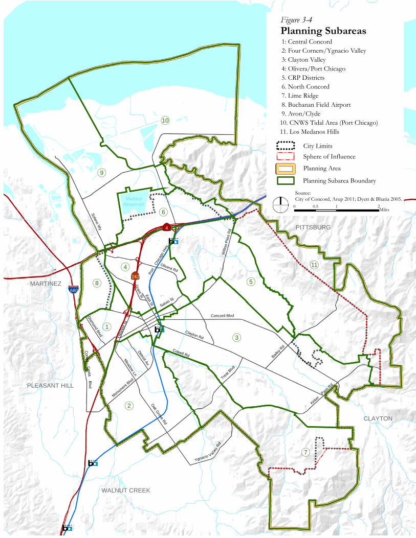
General Plan Land Use by Planning Subareas
Concord is divided into eleven planning subareas, as shown in Figure 3-4. The City’s subareas are defined geographically, following major transportation routes, natural topographic features, or city/neighborhood boundaries. Although all subareas include a variety of land uses, each is generally dominated by one land use type that defines its identity. A description of these subareas follows.
1. Central Concord
The Central Concord subarea lies along both sides of Willow Pass Road from the westerly City limits to the Civic Center near Parkside Drive. The subarea includes West Concord, Stanwell Business Park, Concord Industrial Park (south of Willow Pass Road), Central Downtown (between SR 242 and Port Chicago Highway), Sun Valley Mall and the Willows Shopping Center, and frontages along Willow Pass Road between Downtown and the Civic Center.
2. Four Corners/Ygnacio Valley
The Four Corners/Ygnacio Valley subarea is a diverse residential area located north and south of the Monument Boulevard business corridor. The subarea includes the following neighborhoods: Ellis Lake, Meadow Homes, Cambridge, San Miguel, Treehaven, Colony Park, and north Ygnacio Valley including the Oak Grove/Treat area. The subarea is bounded by the Concord City limits on the west, Clayton Road near Downtown on the north, and the Contra Costa Canal and its regional trail on the east and the south.
3. Clayton Valley
The Clayton Valley subarea is the most extensive developed subarea in the City. The subarea encompasses the Clayton Road corridor and the residential areas lying to the north and south of the commercial corridor. The neighborhoods in Clayton Valley include:

Concord 2030 General Plan
3-22
Crawford Village, El Monte, Canterbury, Turtle Creek, Crossings/Walnut Country, Clayton Valley Highlands, Farm Bureau/Walnut Lands, Dana Estates/Landana, Westwood, Mt. View, Silverwood, Ayers Ranch, and Kirkwood. The Clayton Valley subarea is bounded by Willow Pass Road, the Concord Reuse Project area, the City of Clayton, Pine Hollow Road, Ygnacio Valley Road, and Cowell Road.
4. Olivera/Port Chicago
This subarea is a large residential area extending from downtown Concord north to SR 4; the subarea is bounded on the east by the Concord Reuse Project area and to the west by the Concord City limits and Buchanan Field Airport. This subarea contains various neighborhoods including Hillcrest, Uplands, Holbrook, and Sun Terrace, as well as the North Todos Santos area, which is the oldest and most historically significant neighborhood in the City. The other neighborhoods in this subarea were, for the most part, built during the period of the 1940s to the 1960s.
5. Concord Reuse Project (CRP) Area
The CRP subarea is located south of SR 4 and generally comprises the flatter portions of the former Concord Naval Weapons Station lnland Area, including those areas planned for future development. The subarea adjoins the North Concord – Martinez BART station and SR 4, the Los Medanos Hills to the east, and developed properties (primarily single family lots) along the south and west edges of the Navy lands. Most of this area is vacant, although there are remnants of the site’s prior use as a military weapons storage facility.
6. North Concord
The North Concord subarea is the developed industrial land north of SR 4. The subarea extends from the eastern City limit to Solano Way; it includes the administrative area of the former CNWS, which is now planned for a County First Responder (police and fire training) Facility. It also includes Diablo Creek Golf Course (owned and operated by the City), the Bates Avenue and North Point areas, Mallard Reservoir and Bollman Treatment Plant (owned and operated by the Contra Costa Water District), the Concord North Industrial Park, the Military Ocean Terminal (operated by the US. Army) and those properties along Arnold Industrial Way between Port Chicago Highway and Solano Way.
Concord Blvd
Willo
w P
ass
Rd
Clayton Rd
Bailey
Rd
Cowell Rd
Olivera Rd
Port
Ch
icago
Hwy
Oak Grove Rd
Treat B
lvd
Monument B
lvd
Salvio St
Contra C
osta Blv d
East St
Solano Wy
Ygnacio Val
ley R
d
Kirker
Pas
s Rd
Mar
ket S
t
Detroit Av
Meadow Ln
Diamond Blvd
Grant St
!(3
!(7
!(5
!(9
!(11
!(10
!(2
!(4
!(6
!(1
!(8
PITTSBURG
PLEASANT HILL
MARTINEZ
WALNUT CREEK
|ÿ4
|ÿ242
E
CLAYTON
Cont
raC
osta
Cana
lMallard
Reservoir
Planning SubareasFigure 3-4
1: Central Concord 2: Four Corners/Ygnacio Valley 3: Clayton Valley 4: Olivera/Port Chicago 5. CRP Districts 6. North Concord 7. Lime Ridge 8. Buchanan Field Airport 9. Avon/Clyde10. CNWS Tidal Area (Port Chicago)11. Los Medanos Hills
0 1 20.5Miles
Source: City of Concord, Arup 2011; Dyett & Bhatia 2005.
City LimitsSphere of Influence
Planning Area
!!
!
! ! ! ! ! !!!
!!!!!!!
%&'(680
Planning Subarea Boundary

Concord 2030 General Plan
3-24
7. Lime Ridge
The Lime Ridge subarea includes Inner Lime Ridge (northwest of Treat Boulevard), Middle Lime Ridge (between Treat Boulevard and Ygnacio Valley Road), and Upper Lime Ridge (south of Ygnacio Valley Road). There is significant low density residential development at the periphery of this subarea along Cowell Road, in the Kaski-Hitchcock neighborhood, along Ygnacio Valley Road, and near Pine Hollow Road. A large portion of the subarea is permanent open space owned by the City of Concord abutting additional permanent open space owned by the City of Walnut Creek.
8. Buchanan Field Airport
The Buchanan Field Airport subarea includes the airport and commercial development on airport property (owned and managed by Contra Costa County) located near Concord Avenue. The subarea is bounded on the south by Concord Avenue, the east by Walnut Creek, the north by SR 4, and on the west by Marsh Drive (at the west side of the airport) and Contra Costa Boulevard near Concord Avenue.
9. Avon/Clyde
The Avon/Clyde subarea encompasses that area north of SR 4 that is not part of either the North Concord or Port Chicago subareas. The subarea contains the Avon Refinery now owned by Tesoro Co., the area north of Mallard Reservoir and southwest of the Port Chicago subarea, plus the community of Clyde. The subarea is bounded by the Walnut Creek on the west; Suisun Bay on the north; marsh lands and Los Medanos Hills on the east; and the North Concord subarea on the south.
10. CNWS–Tidal Area (Port Chicago)
The CNWS–Tidal Area (Port Chicago) subarea is comprised of the developed portion of the tidal area including the related docks and nearby railway transport facilities. This area is designated as a “Port Priority Use” area in the San Francisco Seaport Plan. The tidal area also includes extensive salt-water marsh areas which have been preserved as permanent open space east and west of the developed area. This subarea includes the lands formerly occupied by the town of Port Chicago before that community was acquired by the Federal Government for safety reasons in the middle of the 20th century. A large majority of this subarea is either owned by the U. S. Government or identified for preservation and protection as a salt-water marsh at the south edge of Suisun Bay. The Southern Pacific Railroad and Atchison-Topeka & Santa Fe Railroad both traverse the study area in an east-west alignment.

Land Use
3-25
11. Los Medanos Hills
The Los Medanos Hills subarea consists of the hills lying along the northeastern edge of the Planning Area on both sides of Highway 4. It also includes the Mt Diablo Creek corridor on the Concord Reuse Project site. The hills are an important topographic feature that provide an open space “frame” between Concord and Pittsburg. This area is largely undeveloped, with some remnant uses from former military activities. The area is planned for long-term conservation as open space.
3.3 GOALS, PRINCIPLES, AND POLICIES Residential Neighborhoods
Residential Neighborhoods are areas of the City characterized by housing, parks, and public facilities. Most residential neighborhoods have land use designations of Rural Residential, Low Density Residential, Medium Density Residential, and High Density Residential. Residential Neighborhoods are also envisioned within the CRP Neighborhood and Village Districts and Concord Reuse Project Transit Oriented Development District designations.
GOAL LU-1: LIVABLE AND ENJOYABLE RESIDENTIAL NEIGHBORHOODS
Principle LU-1.1: Preserve and Enhance Neighborhood Character.
Policy LU-1.1.1: Support land use decisions that reinforce and capitalize on neighborhood strengths and benefit neighborhood identity and scale.
Policy LU-1.1.2: Require new development in residential areas to preserve and enhance positive neighborhood characteristics.
New design standards for residential development will help implement this policy.
Policy LU-1.1.3: Ensure that the scale, operation, location, and other characteristics of community facilities, including parks, schools, childcare facilities, religious institutions, and other public and

Concord 2030 General Plan
3-26
quasi-public facilities, enhance the character and quality of neighborhoods.
This will be addressed by design guidelines and standards for transitions between different uses.
Policy LU-1.1.4: Protect residential uses from the impacts of more intensive land uses through good site planning and/or appropriate mitigation and operational measures.
Screening, landscaping, restrictions on driveway access, and limitations on hours of operation can help minimize adverse impacts.
Policy LU-1.1.5: Identify opportunities for public/private cooperation and City actions for the mitigation of noise, traffic, and other potential conflicts between commercial uses, multi-family residential uses, and single-family residential neighborhoods.
Policy LU-1.1.6: Prohibit conversion of residences backing onto roadways to commercial or office uses which would gain access or seek visibility from the roadways.
Policy LU-1.1.7: Encourage high quality design upgrades for existing multi-family uses and require high quality design for new multi-family projects.
Policy LU-1.1.8: Continue to support and promote housing conservation and home remodeling, expansion, and updating to maintain the quality of the housing stock.
Examples of the City programs that will be used are in the Housing Element.
Policy LU-1.1.9: Preserve visible hillsides and open space areas through techniques such as cluster development or density transfers.
Policy LU-1.1.10: Ensure that new development in historic neighborhoods is compatible in scale and style to the character of that neighborhood, and

Land Use
3-27
encourage retention of historic buildings through flexible reuse provisions.
The General Plan has established a new land use designation for the North Todos Santos neighborhood. A zoning district has been created for the neighborhood to help conserve its character.
Policy LU-1.1.11: Allow residential care and group homes in a manner consistent with State law, while ensuring that the scale, operation, location and other characteristics of these facilities does not adversely impact the character and quality of neighborhoods.
Policy LU-1.1.12: Adopt design guidelines for single family homes in existing neighborhoods to ensure that new construction and exterior alterations and additions are compatible in scale to the character of surrounding homes.
These guidelines could address such issues as the design of second story additions and limitations on house size based on lot size.
Principle LU-1.2:Facilitate Community-Oriented Neighborhoods.
Policy LU-1.2.1: Provide opportunities for neighborhood participation in the land use decision-making process.
The City will encourage and support community input in the review of new projects adjacent to residential areas. This will provide an opportunity to identify key issues and allow applicants to respond early in the process.
Policy LU-1.2.2: Pursue neighborhood planning strategies to conserve and enhance neighborhood livability and safety, and eliminate adverse characteristics that lead to neighborhood decline.

Concord 2030 General Plan
3-28
The City is committed to finding solutions to mitigate degradation of neighborhoods. The City embraces Community-Oriented Government joining with neighborhood groups to address problems identified by residents and business owners. Solutions depend on the specific issue, and span the spectrum from adding neighborhood watch groups, implementing traffic calming programs, funding organizations that provide specific neighborhood services, to ensuring that business and residential owners comply with City codes regarding private property maintenance.
Policy LU-1.2.3: Foster amenities and services that make Concord’s neighborhoods desirable places to live.
Examples include sidewalks, appropriate street lighting, bike paths, trees, parks, high quality schools and natural features, which enhance neighborhood character.
Policy LU-1.2.4: Encourage neighborhood retail and service uses within convenient walking distance of all residential neighborhoods, where feasible.
Principle LU-1.3: Encourage Infill Residential Development.
Policy LU-1.3.1: Encourage a variety of housing types on infill development sites.
Townhomes, zero-lot line single family dwellings, courtyard apartments, and small-scale multi-family projects are some of the types of housing that are suitable for infill sites.
Policy LU-1.3.2: Establish standards to address the transition between existing neighborhoods and new infill development.
Such standards could include height and setback requirements and standards for screening, lighting, landscaping, refuse collection, and location of parking.

Land Use
3-29
Policy LU-1.3.3: Support higher density and mixed use development in Downtown and near transit centers and corridors.
Condominiums, apartments, or offices above stores are typical of mixed use development that would be appropriate.
Principle LU-1.4: Protect the Unique Character of Rural Residential Areas Throughout the City.
Policy LU-1.4.1: Maintain the character of rural residential areas by preserving large lot sizes and limiting lot coverage.
Policy LU-1.4.2: Allow the keeping of horses on lots larger than one-half acre in a manner that preserves the public health, safety, and general welfare of the surrounding neighborhood.
Centers
Concord is a City of neighborhoods, connected by several clusters of commercial uses that provide goods, services, and employment opportunities to both local residents and people from the surrounding communities. These clusters—referred to as “centers”—are the basis for organizing policies in the General Plan that pertain to maintaining and improving the quality and selection of commercial opportunities in Concord. The General Plan identifies three types of centers in Concord: Neighborhood/ Village Centers, Regional Centers, and Central Concord.
Neighborhood/ Village Centers
A neighborhood center is typically located on an accessible, main transportation artery and is composed of low-scale commercial land uses that provide goods and services to the local community. It is often surrounded by higher density housing, which helps to support ridership for a transit stop. Existing neighborhood centers are found throughout Concord, such as at the intersections of Treat Boulevard and Oak Grove Road, or at Ygnacio Valley Road and Clayton Road. Neighborhood centers are also planned on the Concord Reuse Project site, where they form the focal point of residential “villages” surrounding them. To ensure that a diverse range of neighborhood shopping opportunities is available and easily accessible in Concord, the Plan promotes the vitality of existing centers and their renovation. As appropriate, it also promotes the creation of new centers.

Concord 2030 General Plan
3-30
GOAL LU-2: VIABLE AND ACCESSIBLE NEIGHBORHOOD VILLAGE CENTERS
Principle LU-2.1: Foster Viable, Neighborhood-Oriented Commercial Centers.
Policy LU-2.1.1: Maintain attractive and viable neighborhood-serving centers.
Policy LU-2.1.2: Encourage existing neighborhood centers to expand or adapt to market changes through reuse, rehabilitation, and infill development.
Examples of existing neighborhood centers that have undergone renovation are Clayton Valley Shopping Center, Dana Plaza, The Willows, and Olivera Crossings. The City will continue to work with shopping center owners to ensure retail success while meeting the needs of the surrounding neighborhoods.
Policy LU-2.1.3: Plan for new commercial development to expand the variety of goods and services to meet neighborhood-serving needs.
Policy LU-2.1.4: Establish standards to address the transition between new retail uses and abutting uses to reduce adverse impacts.
These standards may include transitional height requirements, setback provisions, and standards for screening, lighting, landscaping, location of parking, loading, refuse collection, and recycling facilities.
Principle LU-2.2: Maintain Community Office Uses.
Policy LU-2.2.1: Designate sites for local-serving office use in close proximity to neighborhoods that provide convenient access to local patrons, complement nearby retail enterprise, and buffer residential uses from arterial streets.
The Land Use Map shows where these sites are located, and includes a Community Office designation. Office uses are also encouraged in the various mixed use districts located

Land Use
3-31
throughout the City, including the Concord Reuse Project Area.
Policy LU-2.2.2: Allow resident-serving offices in existing neighborhood commercial centers so long as they are ancillary in size, scope, and location to primary retail uses. Resident-serving offices are also permitted in new neighborhood commercial centers, and need not be ancillary to retail uses in such cases if sufficient retail choices exist nearby.
Resident-serving offices are small offices serving walk-in clientele, such as accounting, legal aid, real estate brokers, and insurance and travel agents.
Regional Centers
Shopping and the use of services are activities that provide for social contact as well as business transactions. Since Concord attracts shoppers from a large region, and stores in one part of the City are often frequented by residents from other neighborhoods, regional centers are critical in shaping the identity and image of the City in the region and the neighborhoods within the City itself.
GOAL LU-3: VIABLE AND ACCESSIBLE REGIONAL CENTERS
Principle LU-3.1: Foster Strong Region-Serving Commercial Centers.
Policy LU-3.1.1: Provide for regional centers that have an appealing mix of tenants and are designed with site amenities to attract customers from both local neighborhoods and region-wide communities.
Policy LU-3.1.2: Maintain and enhance existing region-serving centers so that they are competitive and offer a wide spectrum of retail products.
Policy LU-3.1.3: Encourage existing region-serving centers to expand or adapt to market changes through reuse, rehabilitation, and infill development.

Concord 2030 General Plan
3-32
Policy LU-3.1.4: Plan for new commercial development to expand or enhance the variety of goods and services to meet region-serving as well as local needs.
Policy LU-3.1.5: Identify new areas for region-serving commercial uses at locations that take advantage of major transportation routes.
These areas include, but are not limited to, Central Concord, North Concord, and the Concord Reuse Project (CRP) area.
Policy LU-3.1.6: Ensure the timely implementation of necessary infrastructure to support existing and new region-serving development.
Policy LU-3.1.7: Capitalize on the opportunity for a new regional center adjacent to the North Concord – Martinez BART Station.
The CRP Area Plan calls for a new regional center including retail, office, and multi-unit residential uses in mid-rise buildings adjacent to the North Concord - Martinez BART Station. Retail and service uses at the center will complement those in other centers in Concord, and provide new shopping, dining, and entertainment choices for residents from across the City and region, as well as future residents of the CRP site and persons working nearby.
Central Concord
Central Concord is the historic, economic, and cultural heart of the City. It encompasses the original townsite that grew into Concord, and this rich historic legacy is visible in the number and variety of historic sites in the area, such as Todos Santos Plaza, the Salvio Pacheco Adobe, and the County Fire House. Central Concord is also a focal point for modern-day activities in the City. Its shopping opportunities, cultural activities, and pedestrian-oriented scale in the Downtown area ensure that it remains a main attraction for residents and visitors alike. Many of the City’s major employers are also located in Central Concord, including the Bank of America Concord Technology Center, Chevron Credit Card Center, the Civic Center, and Police Headquarters. The General Plan policies for this area aim

Land Use
3-33
to support the many roles that Central Concord plays in shaping the City’s character and development by preserving its historic resources, promoting its social value, and creating an attractive environment in which to do business.
GOAL LU-4: IDENTIFIABLE AND DISTINCTIVE DISTRICTS WITHIN CENTRAL CONCORD
Principle LU-4.1: Promote Central Concord as the economic, social, symbolic, and historic center of the City.
Policy LU-4.1.1: Continue to expand Central Concord’s role as a focal point for business, entertainment, dining, cultural, and civic gatherings.
Policy LU-4.1.2: Integrate the distinct districts within Central Concord with unifying streetscape and pedestrian amenities.
The Concord Downtown Streetscape Improvements includes a detailed list of improvements and phasing concepts along with Concord Downtown Streetscape Design Guidelines, which address private development.
Policy LU-4.1.3: Integrate mixed uses at an urban scale.
Future design guidelines will provide further direction on the design and form of mixed use development.
Principle LU-4.2: Capitalize on Downtown’s Sense of Place.
Policy LU-4.2.1: Require a mix of uses to promote an active commercial and residential center.
This can be achieved by establishing standards for ground floor retail space and active street frontages, particularly around Todos Santos Plaza, and through limitations on uses that would not be compatible with or supportive of a pedestrian environment.

Concord 2030 General Plan
3-34
Policy LU-4.2.2: Allow for urban-scale development, including both amenities and services for workers and residents.
Policy LU-4.2.3: Promote pedestrian-oriented urban design.
Policy LU-4.2.4: Encourage new development projects to include amenities for public benefit, such as affordable housing, pedestrian-oriented facilities, and historic preservation.
Pedestrian-oriented facilities are enhanced with amenities such as outdoor seating, plazas, public art, weather protection, transit waiting areas (benches and shelters), and links to regional trails and bikeways.
Policy LU-4.2.5: Allow multiple anchor uses and mixed use development surrounding Todos Santos Plaza to attract retail clientele and encourage pedestrian activity.
The Development Code will allow for mixed use and will ensure that uses directly facing Todos Santos Plaza activate the street and encourage pedestrian activity.
Policy LU-4.2.6: Limit building heights for new structures in the blocks immediately adjacent to Todos Santos Plaza with an inclined daylight plane requiring upper-story setbacks to ensure sunlight access for public spaces.
This is the preferred approach for height limits around downtown squares. The total amount of floor area will be governed by the floor area ratio.
Policy LU-4.2.7: Facilitate the relocation of gas stations, auto repair, and service uses to service commercial areas throughout the City.
Policy LU-4.2.8: Encourage preservation of historic buildings to the maximum extent feasible.
Policy LU-4.2.9: Designate land around the Downtown BART Station as a transit overlay zone and offer incentives to support the use of mass transit.

Land Use
3-35
Employment Districts
Employment Districts are relatively large areas of the City dominated by low-rise to high-rise office, high technology, light industrial and other job generating land uses. The associated land use designations are Business Park, Heavy Industrial, West Concord Mixed Use, and Downtown Mixed Use. The Concord Reuse Project Area also includes Employment District designations, including TOD Districts and Non-Residential Districts.
GOAL LU-5: A DYNAMIC AND DIVERSIFIED OFFICE SECTOR
Principle LU-5.1: Expand and Enhance Regional Office Uses in Central Concord and the North Concord - Martinez BART Station Area.
Policy LU-5.1.1: Maintain and expand Concord as a regional employment center.
The central focus of the City’s economic development strategy is to enhance Concord’s role as a regional center.
Policy LU-5.1.2: Promote a large, diverse regional office sector to ensure a resilient economic base.
Policy LU-5.1.3: Provide sites for professional, administrative, and headquarters office space in Central Concord and other transit-oriented development (TOD) locations.
Policy LU-5.1.4: Assure high quality design and site planning of regional offices that establish a cosmopolitan image and contribute to the character of the City as a whole.

Concord 2030 General Plan
3-36
GOAL LU-6: A THRIVING RESEARCH, DEVELOP-MENT, AND PRODUCTION SECTOR
Principle LU-6.1: Encourage the Development of Office and Business Parks.
Policy LU-6.1.1: Provide sites for research and development, professional and medical offices, and similar uses in campus-like settings.
A distinction will be made between business park areas intended to accommodate offices in a landscaped environment, and business park areas that would be more industrial in character, with uses that require outdoor activities or outdoor storage of vehicles and goods. The former would be in an Office Business Park Zoning District and the latter would be in an Industrial Business Park Zoning District.
Policy LU-6.1.2: Provide sites for employment-generating businesses, technology-based businesses, and light industrial uses wishing to locate in Concord.
The establishment of both the Office Business Park and Industrial Business Park Zoning Districts will enable the City to identify areas where these uses can be located. Future planning for the Concord Reuse Project site may make similar distinctions.
Policy LU-6.1.3: Encourage the reuse of existing heavy industrial uses with light industrial, office, and/or industrial business park uses.
Policy LU-6.1.4: Restrict retail in office and business park areas to wholesale, bulk retail, and small-scale uses serving employees.
Policy LU-6.1.5: Establish standards for outdoor storage and uses incidental to primary uses.

Land Use
3-37
Screened outdoor storage areas may be allowed as an incidental use in the Industrial Business Park zoning district.
Public/Quasi–Public Uses
Public/Quasi-Public uses are located throughout the City and include the Buchanan Field Airport, John Muir Medical Center, and the California State University.
GOAL LU-7: AN EXCELLENT FULL SERVICE COMMUNITY
Principle LU-7.1: Foster the Viability and Expansion of Buchanan Field Airport.
Policy LU-7.1.1: Support augmentation of the airport operation that is consistent with the City’s Economic Vitality Strategy.
Policy LU-7.1.2: Provide for compatibility between the airport and neighboring land uses within the Airport Influence Area through review of new development projects for consistency with noise, safety, and airspace protection.
Policy LU-7.1.3: Enforce safety compatibility criteria consistent with the County Airport Land Use Commission (ALUC) Plan for new development projects within airport safety zones.
Policy LU-7.1.4: Forward applications for general plan amendments, rezoning requests, and major land use actions as appropriate to the County Airport Land Use Commission (ALUC) for review.
Policy LU-7.1.5: Adopt development standards for new development projects within the Airport overlay district.
Principle LU-7.2: Provide for a Premier Medical Center.
Policy LU-7.2.1: Support and encourage the expansion and continued renewal of the John Muir Medical Center and activities.

Concord 2030 General Plan
3-38
Policy LU-7.2.2: Require the John Muir Medical Center to minimize impacts, to the maximum extent feasible, on adjacent residential neighborhoods.
Policy LU-7.2.3: Allow medical/dental offices, medical laboratories, clinics, and related support services to cluster around John Muir Medical Center.
Policy LU-7.2.4: Require new hospital facilities to be designed to ensure potential environmental hazards associated with medical care are managed appropriately.
Principle LU-7.3: Promote Higher Education in Concord.
Policy LU-7.3.1: Encourage the development of private and public institutions of higher education.
Policy LU-7.3.2: Promote California State University as a region-serving institution of higher education.
The Concord Reuse Project Area Plan includes an approximately 120-acre site designated for a future campus. A new CSU Campus is one potential use for the site.
Policy LU-7.3.3: Coordinate with the California State University to help ensure that their improvements, such as roadways, utilities, and campus facilities, are consistent with City plans.
Principle LU-7.4: Support Concord’s Port.
Policy LU-7.4.1: Coordinate with the County and the marine terminal owner to promote “Port Priority Uses” in the Concord Naval Weapons Station–Tidal Area, consistent with the San Francisco Seaport Plan.
Policy LU-7.4.2: Allow non-port uses such as public access and commercial recreation development only if such uses would not impair existing or future use of Concord’s port area for port purposes.

Land Use
3-39
Concord Reuse Project (CRP)
A transformed former Concord Naval Weapons Station (Concord Reuse Project) with land uses and design features that enhances the quality of life for all Concord residents.
GOAL LU-8:
Principle LU-8.1: Achieve a complete and diverse community that provides well-connected neighborhoods and districts with high-quality urban design and convenient access to open space, daily necessities, and regional transit.
Policy LU-8.1.1: Provide diverse housing choices on the CRP site, including ownership and rental housing, a variety of unit types and densities, and a mix of price levels.
Multiple housing types (including ownership and rental housing) should be located on individual or adjacent blocks where possible, helping to fulfill the vision of a mixed income community serving many different household types.
Policy LU-8.1.2: Create multiple distinct neighborhoods within the CRP site, organized around village centers or transit-oriented development areas with neighborhood services, open spaces, and community facilities.
Policy LU-8.1.3: On the portions of the CRP site that adjoin existing Concord neighborhoods, design open spaces and new buildings to be compatible in scale with adjacent established uses.
Policy LU-8.1.4: Provide a variety of workplaces and shopping areas on the CRP site, designed for easy access by transit, pedestrians and bicycles.
Policy LU-8.1.6: Design built features and the circulation system to respond to the CRP site’s natural form. Where slopes of 30 % of greater occur within planned development areas on the CRP site, they should generally be set aside as open space.

Concord 2030 General Plan
3-40
Policy LU-8.1.7: Follow community design principles which reduce greenhouse gas emissions and support environmental sustainability.
These principles include an emphasis on pedestrian and bicycle travel, easy access to transit from all new development, mixing of land uses to reduce trip generation, higher densities near the BART Station, and the creation of attractive streetscapes which make walking or bicycling comfortable and safe.
Policy LU-8.1.8: Maximize views from public rights of way and public spaces on the CRP site to natural features, including but not limited to Mount Diablo, the California Delta, and the Los Medanos Hills, provided the resulting design is consistent with the climate action program.
Policy LU-8.1.9: Provide street and open space connections between the CRP site and established Concord neighborhoods at appropriate locations to improve accessibility and create a more cohesive and connected city.
Principle LU-8.2: Provide for a balance between development and open space on the CRP site.
Policy LU-8.2.1: Designate the most environmentally sensitive portions of the CRP site, including the Los Medanos Hills and the Mt Diablo Creek corridor, as permanent open space.
Policy LU-8.2.2: Incorporate a network of greenways within the CRP site that help define neighborhood edges, connect residents to services and workplaces, and provide access to recreational features and open space.
Policy LU-8.2.3: Develop new community and neighborhood parks within proposed CRP development areas which complement and expand the citywide park system.

Land Use
3-41
Policy LU-8.2.4: Include small scale open spaces such as pocket parks and plazas in the CRP site’s community gathering places, such as Village Centers and the transit-oriented district around the BART station.
Design of Buildings, Public Spaces and Infrastructure
Site and Building Design
GOAL LU-9: WELL-DESIGNED DEVELOPMENT
Principle LU-9.1: Require High Quality Building Design and Site Planning.
Policy LU-9.1.1: Establish design standards that achieve the highest quality of building design and use high-quality materials.
Policy LU-9.1.2: Establish design standards that provide for cohesive, well-integrated, functional development and ensure neighborhood compatibility with appropriate height transitions, setbacks, screening and buffering for adjacent residential development.
Design standards or guidelines will be developed or updated following the update of the Concord Development Code.
Policy LU-9.1.3: Require new commercial development to provide comprehensive landscaping, including hardscape and parking lot areas as well as pervious areas.
Policy LU-9.1.4: Require parking areas to be screened, to the maximum extent possible, from the public rights-of-way or located behind commercial structures instead of adjacent to the right-of-way.
Policy LU-9.1.5: Require utilities to be placed underground or screened from public view.
This policy is intended for telecommunication lines and electric distribution systems and related ancillary facilities, and would not apply to solar panels. Using underground vaults and screening for exterior transformers

Concord 2030 General Plan
3-42
and other types of utility equipment can reduce visual impacts.
Policy LU-9.1.6: Establish standards for new development and additions to existing development to incorporate green building measures.
Green building measures will be established through the City’s Climate Action Plan.
Policy LU-9.1.7: Incorporate green building principles and practices into the planning, design, construction, management, renovation, operations and demolition of all facilities that are constructed, owned, managed or financed by the City.
Policy LU-9.1.8: Capitalize on the opportunities presented by the Concord Reuse Project site to become a national model for sustainable development and innovative architecture and design.
Principle LU-9.2: Enhance function and efficiency of infill development.
Policy LU-9.2.1: Encourage land assembly to achieve building sites large enough for safe, efficient, on-site vehicular circulation, and ample landscaping.
Policy LU-9.2.2: Allow unique, diverse, and creative design solutions for infill development that are compatible with and enhance existing neighborhoods and shopping areas.
The Development Code will provide for flexibility for infill projects, as long as a project meets General Plan policies and does not adversely impact neighborhoods. See also Policy LU-1.3.2.
Policy LU-9.2.3: Apply site planning techniques that minimize the amount of impervious paving, promote pedestrian safety, and reduce urban runoff in commercial centers.
All new development in California is required to follow Best Management Practices (BMPs) that reduce erosion, sedimentation and other

Land Use
3-43
urban runoff from parking lots and commercial centers through the use of permeable surfaces, on-site detention, sediment trapping and filtering and landscaping. Permeable pavements, in particular, have tremendous potential for stormwater management. Pedestrian safety can be achieved through installing better security lighting and signage, creating grade-separated walkways, and marking pedestrian crossings.
Public Spaces and Infrastructure
GOAL LU-10:HIGH-QUALITY URBAN DESIGN IN PUBLIC SPACES AND INFRASTRUCTURE
Principle LU-10.1: Create Attractive, Inviting Public Spaces and Streets that Enhance the Image and Character of the City.
Policy LU-10.1.1: Encourage streetscape and façade improvements to enhance the appearance of existing uses along major arterials.
Policy LU-10.1.2: Require new development to provide and maintain right-of-way improvements along project frontages such as landscaping, street trees, and other amenities that enhance the streetscape appearance.
Policy LU-10.1.3: Maintain an aesthetically pleasing street network that helps frame and define the community while meeting the needs of pedestrians, bicyclists, and motorists.
Policy LU-10.1.4: Enhance the appearance of the streetscape by expanding and maintaining Concord’s landscaping within its public rights-of-way.
Policy LU-10.1.5: Require trees and other landscaping within parking lots.
Trees provide shading and also screen cars, reducing the visual impacts of large parking lots.

Concord 2030 General Plan
3-44
Policy LU-10.1.6: Strengthen the identity and upgrade the appearance of important City gateways, including the City’s two BART stations.
Policy LU-10.1.7: Implement urban design measures which visually and functionally integrate the Concord Reuse Project site into the existing City and reduce perceptions that the site is a separate community.
Planning Area Boundary
The Land Use Map in Figure 3-2 identifies an area outside the City’s corporate limit and Sphere of Influence that is inside the Concord “Planning Area Boundary.” This area is delineated because of the City’s interest in protecting open space and preserving the open space character on hillsides visible from Concord’s neighborhoods and commercial districts. The following policies are intended to assert the City’s commitment to coordinating open space planning with neighboring jurisdictions to protect the surrounding hillsides from visible development.
GOAL LU-11:OPEN SPACE PROTECTION
Principle LU-11.1: Protect Ridgelines and Visible Hillsides.
Policy LU-11.1.1: Encourage the County and adjacent cities to prohibit new development on ridgelines and in protected viewsheds, but allow appropriate beneficial and reasonable open space uses in these areas, to preserve the open space character of areas visible from Concord’s neighborhoods and commercial districts.
Policy LU-11.1.2: On any land to be annexed to the City, require new development to be clustered to reduce both environmental and visual impacts of hillside development.
Policy LU-11.1.3: Work with the County and adjacent jurisdictions to ensure that zoning and subdivision regulations applicable to all unincorporated development visible from or environmentally impacting the City’s Planning Area reflect General Plan Policy direction.

Land Use
3-45
Actions the City will request of the County and adjacent jurisdictions include:
• Designating protected ridgelines, creeks, and other significant resource areas, along with daylight plane or setback standards;
• Defining protected viewsheds; and
• Designating growth limits and clustering provisions for very low-density hillside residential development based on slope and elevation to ensure viewshed protection.
Policy LU-11.1.4: Minimize cut-and-fill of natural hillsides.
Policy LU-11.1.5: Ensure that developers of projects in the City work with landowners in adjacent jurisdictions and appropriate regulatory agencies to incorporate natural creekways as open space amenities into the design of projects as a condition of approval.
Policy LU-11.1.6: Work with the County, landowners, and developers to set back buildings between Evora Road and State Route 4 from the edge of State Route 4 to mitigate visual and noise impacts.
Policy LU-11.1.7: Encourage new development in all adjacent jurisdictions to provide trailheads and linkages to a multi-use trail system.
Policy LU-11.1.8: Encourage the provision of wildlife corridors to ensure the integrity of habitat linkages and preserve the character of visible hillsides and open space.
Policy LU-11.1.9: Oppose any expansion of the County Urban Limit Line (ULL) that would allow development in protected viewsheds or on visible hillsides or other environmental impacts located within the unincorporated portion of the City’s Planning Area Boundary.

Concord 2030 General Plan
3-46
While the City is not opposed to expansion of the County’s ULL per se, the City will raise objections to any new development in the unincorporated area that results in visible development on slopes and hillsides areas within the City’s Planning Area Boundary. The City will evaluate all development proposals by neighboring cities and the County within Concord’s Planning Area Boundary to determine if there are potential visual impacts.
Policy LU-11.1.10: Recognize the Los Medanos Hills between
Concord and Pittsburg/ Bay Point as an essential part of the City’s character and open space “frame”, and take steps to preserve this area as permanent open space.