3.0 alternatives
TRANSCRIPT

3.0 ALTERNATIVES
Alternatives to the Alberta Clipper Project were analyzed to determine whether they would be reasonable and environmentally preferable to the proposed action. Identification and evaluation of alternatives to the proposed Project considered public comments and input received from federal, state, tribal and local agency representatives and the public. Enbridge held a variety of public open houses and agency and stakeholder meetings while developing the proposed route. In addition, DOS held 13 scoping meetings during development of the proposed Project to identify and evaluate alternatives that could avoid or minimize potential impacts.
In the initial stages of route selection studies for the Alberta Clipper Project, Enbridge based its evaluations on two primary routing assumptions. First, since the new pipeline would have the same origination and destination points as the existing Enbridge pipelines in this area (i.e., originating at the U.S./Canada border near Neche, North Dakota and extending to the existing Superior Terminal), installing it adjacent to the existing pipelines would be preferable to constructing a new route through undisturbed areas. A route along the existing Enbridge pipeline corridor would also result in more efficient and effective management of operation and maintenance of the new pipeline compared to a route that would not be adjacent to the existing pipelines. The second assumption was that when building a new pipeline adjacent to an existing pipeline, the best location is on the side of the existing right-of-way that was used as the working side for the most recent pipeline construction. This would reduce the extent of environmental impacts by using areas disturbed during previous pipeline construction. These analyses resulted in the subsequent proposed Project that is described throughout Sections 2.0 and 4.0 of this EIS. The currently proposed Project incorporates the crossing of the FDL Reservation along the existing Enbridge right-of-way since FDL and Enbridge have come to an agreement that will allow FDL to permit the Alberta Clipper Project to cross the reservation subsequent to the DEIS.
DOS has further evaluated various alternatives to the Project, as proposed by Enbridge, to assess (1) whether environmentally protective means other than a new pipeline are available to transport oil; and (2) if a new pipeline is to be constructed, whether alternative routes could further avoid and minimize potential environmental impacts. Several factors were considered in the analysis and selection of the proposed Project route and alternatives; they also were used to determine whether alternatives would be environmentally preferable to the proposed Project. These include:
� The Project’s purpose and need;
� The locations of receipt and delivery points along the proposed route;
� The availability of existing linear corridors and aboveground facilities for collocation of a new pipeline to reduce the amount of previously undisturbed land needed for construction and operation of a new pipeline;
� The presence of sensitive environmental and human use features along the pipeline route; and
� The engineering, technical, and practical feasibility of constructing and operating the Project.
The following alternatives analysis describes several types of alternatives that were considered (e.g., No Action, system, major route alternatives, and route variations) and assesses whether they would meet the stated purpose and need for the Project and the above objectives. The following text includes:
� No Action Alternative (Section 3.1), which assumes that the proposed Project is not built;
� System Alternatives (Section 3.2), which considers other methods for providing crude oil supplies to Midwest markets and beyond;
FEIS Alberta Clipper Project 3-1
� Major Route Alternatives (Section 3.3), which assesses the feasibility of other pipeline routes for transporting crude oil from the U.S./Canada border near Neche, North Dakota to the Superior Terminal;
� Route Variations (Section 3.4), which evaluates relatively short alternative routes to avoid or minimize impacts to specific features such as residences or waterbodies;
� Aboveground Facility Alternatives (Section 3.5), which considers other locations for siting pump stations; and
� Superior Terminal Expansion Alternatives (Section 3.6), which describes alternative sites for expansion of the Superior Terminal, a connected action to the proposed Project.
3.1 NO ACTION ALTERNATIVE
Under the No Action Alternative, the Alberta Clipper Project would not be constructed and operated as described in Section 2.0. Therefore, selection of the No Action Alternative would not require issuance of a DOS Presidential Permit for the Alberta Clipper pipeline (the proposed action).
Denial of the proposed action would mean that any environmental impacts discussed in this EIS would not occur. While this alternative would eliminate the environmental impacts directly associated with the Alberta Clipper Project, it would not meet the purpose and need for the proposed action. As stated in Section 1.2.1, the overall purpose of the Alberta Clipper Project is to transport additional crude oil into the United States and eastern Canada from existing Enbridge facilities in western Canada to meet the growing demand of refineries and markets in those areas. Enbridge has proposed the Project to (1) meet the increased demand for crude oil in the United States and offset the decreasing domestic crude oil supply; (2) reduce U.S. dependence on less reliable supply of foreign oil through increased access to stable, secure Canadian crude oil supplies; and (3) meet demonstrated shipper interest in an overall Enbridge system expansion.
To meet the anticipated demand, the proposed Alberta Clipper Project would provide an average of approximately 450,000 bpd of crude oil capacity. The capacity provided by the proposed pipeline would provide independent utility to Enbridge and its customers, who would use the pipeline for the transportation of products to Superior and subsequent delivery to interconnected existing pipeline systems. The existing pipeline systems would allow delivery of the crude oil primarily to refineries in the Midwest, but could also deliver the oil to refineries south to the U.S. Gulf Coast and north to Canada.
Although the No Action Alternative would eliminate the direct impacts of the Alberta Clipper Project in the Project area, it would not reduce the global or national demand for oil. As discussed in Section 1.2.2.2, global demand is expected to continue to increase, although the rate of increase has slowed due to the current economic downturn. With the No Action Alternative, crude oil from Canadian oil sands that could have been transported to the United States by pipeline would likely be shipped to overseas markets, such as China and Japan. As a result, the No Action Alternative would not decrease the long-term development of the Canadian oil sands, and the environmental impacts of the transportation of the crude oil to overseas destinations would substantially increase some environmental impacts relative to the proposed Alberta Clipper Project. This is especially true with regard to air emissions associated with oil transportation, and overseas transportation may also substantially increase emissions associated with refining and end use at overseas destinations. Therefore, the No Action Alternative would not stop the development or the refining of oil sands/products.
As discussed in Section 1.2.2.1, the demand for crude oil in the United States is expected to rise slightly until about 2030. U.S. refiners have upgraded their refineries to process heavy crude oil, much of which is obtained from relatively unstable and insecure overseas sources. The current EIA projection is that meeting domestic demand will require the “unconventional” oil supply from Canada, which is predominately heavy
FEIS Alberta Clipper Project 3-2
crude from reserves in western Canada, and that the Canadian oil supply will grow from approximately 1.5 million bpd in 2008 to over 4.3 million bpd by 2030 (EIA 2009). Implementation of the No Action Alternative would not alter the increasing need for Canadian crude oil in the United States or the need for oil resources throughout the world.
Energy conservation and renewable energy have been identified as potential alternatives to the proposed Project. Energy conservation alone cannot reasonably offset the demand for oil or other forms of energy for end users that ultimately would be served by the proposed Project. Consequently, it cannot negate the need for the Project. Although energy conservation and efficiency measures are important elements in addressing future energy demands for the Midwest market, current and projected participation in energy conservation and efficiency measures will reduce the energy demands by a small fraction of the projected energy demand within the foreseeable future. Renewable energy sources, including wind and solar power, will increasingly play an important role in power generation for the Midwest market, especially as it relates to electrical demand. However, these sources represent a small fraction of the projected energy demands for this market for the foreseeable future, especially related to providing refined petroleum products for the transportation sector.
If the No Action Alternative is implemented, refiners would seek other means of obtaining the heavy Canadian crude oil, or attempt to obtain additional supplies from less stable and less reliable sources. This could involve actions such as constructing other pipelines to transport the crude oil from the Canadian oil sands into the United States or increasing overseas import of heavy crude oil by tanker, rail, or truck, which may also require new pipelines or expansion of existing pipeline systems.
Although it is not possible to quantify the impacts of such conceptual actions, it is likely that the impacts associated with those and other actions taken to meet the demand for heavy crude oil would cause environmental impacts that would be at least comparable to those of the proposed Project and would probably be substantially greater. Further, increasing reliance on less stable and less secure supplies of heavy crude oil would not be in the national interest because it may result in an unreliable supply of energy.
3.2 SYSTEM ALTERNATIVES
System alternatives are alternatives to the proposed Project that would make use of other existing, modified, or proposed pipeline systems—or non-pipeline systems—to meet the stated objectives of the proposed Project. A system alternative would make it unnecessary to construct all or part of the proposed Alberta Clipper Project, although some modifications or additions to other existing pipeline systems may be required to increase their capacity. These modifications or additions may result in environmental impacts that are less than, similar to, or greater than those associated with construction of the proposed Project. The purpose of identifying and evaluating system alternatives is to determine whether potential environmental impacts associated with construction and operation of the proposed facilities could be avoided or reduced by using another pipeline system, while still meeting the objectives of the proposed Alberta Clipper Project.
The following analysis examines several existing and proposed crude oil pipeline systems that currently or eventually could serve the markets targeted by the proposed Alberta Clipper Project. The analysis considers whether those systems could meet the proposed objectives while offering an environmental advantage over the proposed Project. Specifically, the system alternatives considered include:
� Expansion or replacement of existing pipeline systems (Enbridge Pipeline System and North Dakota System);
� Construction of other pipeline systems (TransCanada Keystone and Keystone XL); and
� Hauling via truck, railroad, or barge.
FEIS Alberta Clipper Project 3-3
3.2.1 Existing Pipeline Systems
Enbridge operates the Enbridge Pipeline System that transports oil from Neche, North Dakota through Clearbrook, Minnesota to Superior, Wisconsin and the Enbridge North Dakota System that transports oil from Canada across North Dakota to Clearbrook, Minnesota. No other existing liquids pipeline system could carry oil from Canada to Superior, Wisconsin.
The Enbridge Pipeline System consists of five pipelines operating between Neche, North Dakota and Clearbrook, Minnesota and four pipelines between Clearbrook, Minnesota and Superior, Wisconsin. Enbridge considered adding new pipeline loops to the existing system and determined that new loops would be incapable of meeting the need for a continuous, direct pipeline for crude oil. As part of the Enbridge Pipeline System, Enbridge constructed and began operations (April 2009) of the Southern Lights LSr pipeline, a 20-inch crude oil pipeline from the U.S./Canada border at Cavalier County, North Dakota to Clearbrook, Minnesota in order to increase delivery capacity for existing light crude oil sources. This project is intended to replace an existing pipeline and would not meet the need for additional heavy crude oil capacity between Neche, North Dakota and Clearbrook, Minnesota. It also would not provide any capacity between Clearbrook and Superior, Wisconsin.
Since the Enbridge North Dakota System currently is operating at its capacity, neither of these existing pipeline systems would be able to provide the incremental capacity available from the proposed Alberta Clipper pipeline (450,000 bpd); therefore, they are not practical alternatives to the proposed action. No further review of these alternatives was conducted.
Because multiple Enbridge pipelines extend from the U.S./Canada border in North Dakota to Superior, Wisconsin, comments were received regarding the potential to replace one of the existing Enbridge pipelines with a larger diameter pipeline to transport its current volume of heavy crude oil plus the volume of the proposed Project. Two existing pipelines transport heavy crude oil along this right-of-way: one with a diameter of 34 inches and one with a 36-inch diameter pipeline. Both operate at or near capacity, which is over 400,000 bpd. Thus, a replacement pipeline would need to have the capacity to transport current volumes in addition to the 450,000 bpd proposed for the Alberta Clipper pipeline. This would likely require a new pipeline with a 42- to 48-inch diameter.
Additionally, one comment was received recommending that the older and smaller pipelines be replaced from the north side of the existing right-of-way and that they be replaced with a 48-inch-diameter crude oil pipeline and a 20-inch-diameter diluent pipeline. The commenter then states that enough area would be available within the existing right-of-way to install a third, larger crude oil pipeline. However, the northernmost pipeline is a 18- to 20-inch-diameter pipeline that transports light products such as liquid petroleum gas (LPG). The crude pipeline is actually located on the south side of the right-of-way and ranges between 36 and 48 inches in diameter. Therefore, since the two recommended pipelines for replacement are not adjacent to one another, removing the LPG pipeline would provide no benefit over installing the crude oil pipeline, and replacement would require an even larger diameter pipeline than 48 inches.
There would be various constraints on replacing an existing heavy crude oil pipe with a larger diameter one, but the largest concern is safety since the heavy crude oil lines are not typically located on the outside of the existing Enbridge pipeline configuration. Thus, replacing the pipe would require accessing, excavating, spoil handling, removal of the old pipe, and installation of the new pipe without impacting the other petroleum pipelines on either side of the pipe being replaced.
The equipment to transport and handle non-standard, larger diameter pipe is not available in the United States. Other construction equipment such as bending and welding machines would also need to be retrofitted to
FEIS Alberta Clipper Project 3-4
work on a larger diameter pipeline. Retrofitting of equipment could lead to delays in construction and the commencement of construction (e.g., seasonal construction windows) and operations for the proposed Project.
Beyond safety and equipment, pipe replacement would be constrained by the work area—both along the pipeline to be replaced and the right-of-way outside the pipelines. Virtually the entire area between the pipelines on either side of the replacement pipe would need to be excavated to remove and replace the pipe, especially for a larger diameter pipe that would require a deeper and therefore wider trench. Since there would not be enough space to install both the replacement pipe and the Diluent Project pipeline side-by-side, this approach would require replacing one pipeline and installing a new pipeline on the outside of the existing pipeline configuration (for additional information on the Diluent Project, see Section 1.7.1.1). Since the duration of construction would be constrained by construction windows and season, this could require having adequate room to store separate spoil, old pipe, and new pipe; allow access to actively construct along both trench lines; and provide a traffic route along the right-of-way. Thus, it is not expected that pipe replacement would substantially reduce the construction right-of-way width or associated environmental impacts.
Therefore, pipe replacement is not considered environmentally preferable to the proposed Project.
3.2.2 New Pipeline System Alternatives
Other oil pipelines under construction or recently proposed to transport oil from Canada to or through the upper Midwest include the TransCanada Keystone Pipeline (Keystone) project and the proposed TransCanada Keystone XL Project. The FEIS was issued for the Keystone Project in January 2008, and construction was initiated in North Dakota in summer 2008. When completed, the U.S. portion of the Keystone project will extend from the U.S./Canada border in Pembina County, North Dakota (near the crossing point for the proposed Alberta Clipper Project) almost due south to the Nebraska/Kansas state line. In Nebraska, the pipeline system will split, with one pipeline extending to Cushing, Oklahoma and the other extending to southern Illinois.
To serve the markets of the proposed Project in the upper Midwest, such as Minnesota, Wisconsin, Michigan, and northern Illinois and Indiana, the Keystone Project would require a branch line from Pembina County, North Dakota to at least Superior, Wisconsin. Conversely, there could be a branch line from the terminus of the Keystone Project in southern Illinois back north to the upper Midwest market. Such a branch line would at least duplicate the pipeline length of the proposed Alberta Clipper Project and would offer no significant environmental advantages over the proposed Project.
TransCanada is also proposing a complementary pipeline project to the Keystone Project, the Keystone XL Project. Keystone XL would serve existing refineries and markets along the U.S. Gulf Coast in Texas. The proposed project is an approximately 1,980-mile crude oil pipeline that would begin in Hardisty, Alberta and extend southeast through Saskatchewan, Montana, South Dakota, and Nebraska. It would incorporate a portion of the Keystone pipeline to be constructed through Kansas to Cushing, Oklahoma, before continuing through Oklahoma to a delivery point near existing terminals in Texas. Just as with the Keystone pipeline, a branch line would be required to serve the markets of the proposed Project, which would be two to three times longer than the proposed Project extending from western South Dakota or central Nebraska to Minnesota and Wisconsin. Thus, environmental impacts would be expected to be substantially greater than those of the proposed Project.
FEIS Alberta Clipper Project 3-5

3.2.3 Hauling
3.2.3.1 Trucking
Hauling crude oil from Enbridge’s Cromer, Manitoba facility to Superior, Wisconsin (or refineries farther south and east) is a potential alternative to constructing the proposed Project. The trucking alternative would only require construction of a loading terminal at the Cromer facility and an unloading terminal in Superior, Wisconsin. DOS would have no regulatory or permitting authority over a trucking alternative. The following disadvantages are associated with the trucking alternative compared to the proposed Project, even assuming that trucks traveled only to the Superior Terminal:
� According to DOT safety statistics, pipeline transport of liquids is safer than vehicle transport. The Bureau of Transportation Statistics (2009) reported that the transport of hazardous liquids (including crude oil) on highways resulted in five times as many fatalities as transportation of hazardous liquids by pipeline between 1975 and 2007.
� The trucking alternative would add congestion to Minnesota and Wisconsin highways. Based on the incremental capacity available from the proposed Alberta Clipper pipeline (450,000 bpd), the trucking alternative would result in millions of highway miles driven by tank trucks per year (about 500,000,000 miles in the United States requiring 50,000,000 gallons of fuel assuming 10 miles per gallon).
� The trucks would consume millions of gallons of fuel per year, with subsequent exhaust emissions (presumably over 85 percent of the fuel usage and emissions in the United States).
� Enbridge reports that trucking would be more costly than pipeline transport.
� Trucking would likely be subject to interruptions due to unfavorable weather and road conditions.
3.2.3.2 Railroad
If an existing and direct rail line were located between Hardisty, Alberta and Superior, Wisconsin, the impacts of this alternative would be limited to operations of a rail line. However, there is no existing rail line between the two locations and developing this rail line would require construction of spur lines, terminal facilities, and upgrades to existing rail lines with corresponding environmental impacts. Once operational, this configuration would require hauling oil south and diluent north, totaling approximately 25,000 tank cars per year to transport the same volume that would be carried via the Alberta Clipper Project (whether diluent is transported to the north in the tankers or the tankers return to the north empty). It is expected that this configuration would result in substantially more environmental impacts during construction and operation than the proposed Alberta Clipper Project. The Minnesota Office of Environmental Services concluded that this alternative would create significant environmental disruption and increase public safety risks (ALJ 2008).
3.2.3.3 Barge
Barging the oil would not be feasible due to the lack of a large waterway system between Hardisty, Alberta (or Pembina County, North Dakota) to Superior capable of supporting barge traffic.
3.3 MAJOR ROUTE ALTERNATIVES
Major route alternatives were considered to determine whether they would avoid or reduce impacts to environmentally sensitive resources that would be crossed by the proposed pipeline and in response to suggestions by tribes, agencies, and the public. The origin and delivery points of a major route alternative are
FEIS Alberta Clipper Project 3-6
the same as for the corresponding portion of the proposed pipeline (i.e., a border crossing at Neche, North Dakota and delivery point at Superior, Wisconsin). However, the alternatives could follow significantly different routes from the proposed pipeline along major portions of the pipeline route.
The alternatives analysis for major route alternatives focused on specific environmental impacts to the following factors:
� Native American lands;
� Wetlands, especially forested wetlands;
� Soil conditions (e.g., prime farmland, hydric soils, and erodible soils);
� Forest and herbaceous lands;
� Agricultural lands;
� Perennial and intermittent waterbodies; and
� Railroad and road crossings.
The analysis for major route alternatives focused on minimizing the length of the pipeline to the extent practical, while also minimizing the environmental impacts to specific resources. For context, each mile of the proposed Project typically would impact approximately 17 acres during construction and 9 acres during operation (the exact acreage is dependent on such factors as the specific construction methods, workspaces, and access roads). The extent, shape, and prevalence of many resources preclude complete avoidance of all resources. For example, a 300-mile corridor that approximated a straight line would intersect rivers, roads, and railroads. In addition, collocation of new linear facilities with existing linear facilities reduces the overall acreage of impact beyond the existing right-of-way and limits fragmentation of habitat and land uses.
Consideration of potential routes also is influenced by control points. Control points at specific locations along the pipeline route serve to anchor the route at the beginning and end, and possibly midpoints, thereby defining specific portions of the final route. Control points were considered in the route development process. Primary control points include the delivery point to the United States (near Neche, North Dakota), the Clearbrook Terminal in Minnesota, and the Superior Terminal in Superior, Wisconsin. Secondary control points include the existing pump stations.
Since the proposed Project generally approximates a straight line that connects the control points (U.S./Canada border crossing, Clearbrook Terminal, and Superior Terminal), most theoretical large-scale route alternatives would generally increase the pipeline length, and thus the acreage impacted. However, a Straight Line Alternative was considered to evaluate relative impacts. In addition, the major route alternatives analysis entailed closer evaluation of two other major route alternatives to potentially reduce environmental impacts along substantial portions of the proposed Project route associated with the CNF and LLR (Great Lakes Gas [GLG] Alternative) and in the vicinity of the FDL Reservation (FDL Alternative).
Additionally, the State of Wisconsin requested that Enbridge conduct an alternatives analysis for the pipeline route that would cross lands of Wisconsin. As with the analysis of route alternatives for the Project as a whole, specific control points influenced the analysis of route alternatives in Wisconsin. Those control points in the State of Wisconsin were identified as the delivery point to Wisconsin at the border with Minnesota and the Superior Terminal in Superior, Wisconsin. The focus of the State-specific alternatives analysis was the same as the analysis of alternative routes for the overall project, with additional emphasis on state-designated resources. Seven route alternatives were analyzed in Wisconsin. The complete analysis is contained in the Construction Project Consolidated Permit Application Supplemental Information – Section 10 submitted by Enbridge to WDNR in January 2009 (Enbridge 2009).
FEIS Alberta Clipper Project 3-7
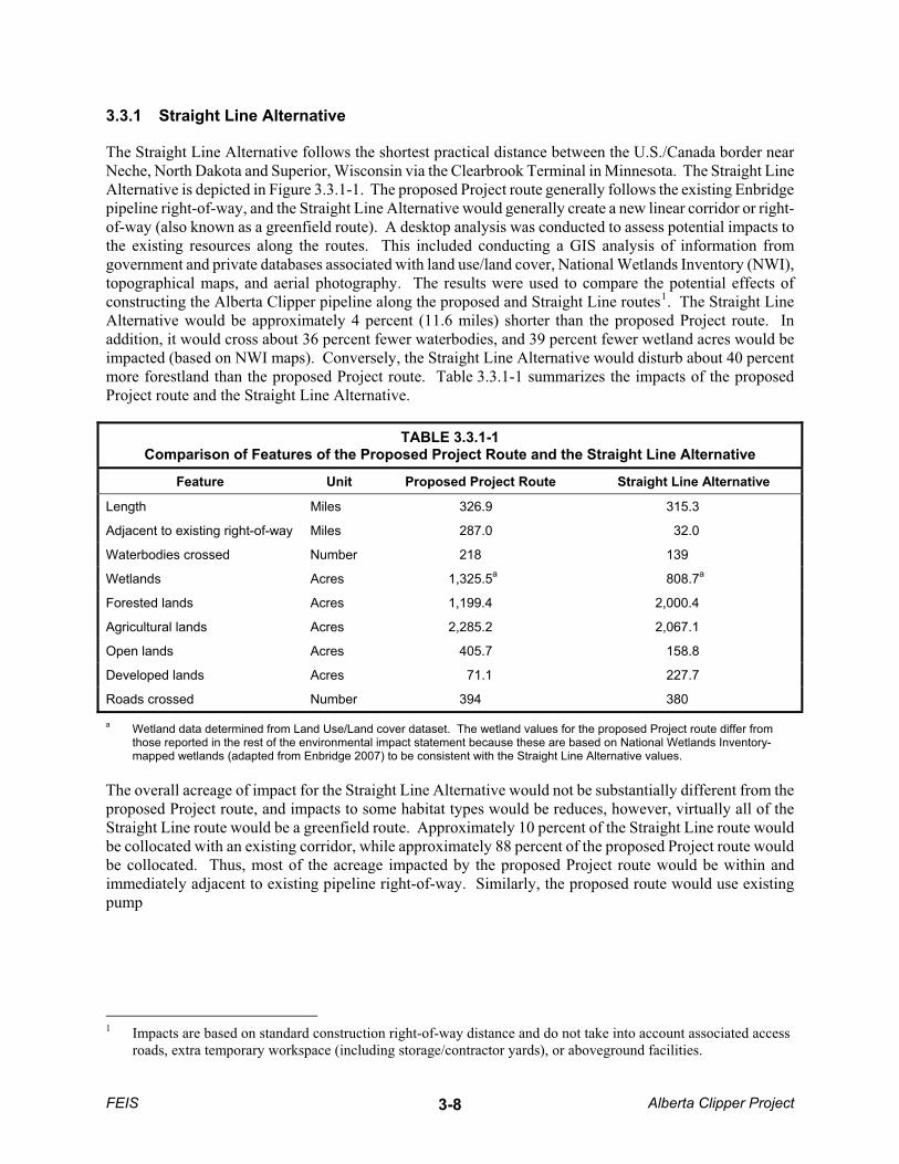
3.3.1 Straight Line Alternative
The Straight Line Alternative follows the shortest practical distance between the U.S./Canada border near Neche, North Dakota and Superior, Wisconsin via the Clearbrook Terminal in Minnesota. The Straight Line Alternative is depicted in Figure 3.3.1-1. The proposed Project route generally follows the existing Enbridge pipeline right-of-way, and the Straight Line Alternative would generally create a new linear corridor or right-of-way (also known as a greenfield route). A desktop analysis was conducted to assess potential impacts to the existing resources along the routes. This included conducting a GIS analysis of information from government and private databases associated with land use/land cover, National Wetlands Inventory (NWI), topographical maps, and aerial photography. The results were used to compare the potential effects of constructing the Alberta Clipper pipeline along the proposed and Straight Line routes1. The Straight Line Alternative would be approximately 4 percent (11.6 miles) shorter than the proposed Project route. In addition, it would cross about 36 percent fewer waterbodies, and 39 percent fewer wetland acres would be impacted (based on NWI maps). Conversely, the Straight Line Alternative would disturb about 40 percent more forestland than the proposed Project route. Table 3.3.1-1 summarizes the impacts of the proposed Project route and the Straight Line Alternative.
TABLE 3.3.1-1 Comparison of Features of the Proposed Project Route and the Straight Line Alternative
Feature Unit Proposed Project Route Straight Line Alternative
Length Miles 326.9 315.3
Adjacent to existing right-of-way Miles 287.0 32.0
Waterbodies crossed Number 218 139
Wetlands Acres 1,325.5a 808.7a
Forested lands Acres 1,199.4 2,000.4
Agricultural lands Acres 2,285.2 2,067.1
Open lands Acres 405.7 158.8
Developed lands Acres 71.1 227.7
Roads crossed Number 394 380
a Wetland data determined from Land Use/Land cover dataset. The wetland values for the proposed Project route differ from those reported in the rest of the environmental impact statement because these are based on National Wetlands Inventory-mapped wetlands (adapted from Enbridge 2007) to be consistent with the Straight Line Alternative values.
The overall acreage of impact for the Straight Line Alternative would not be substantially different from the proposed Project route, and impacts to some habitat types would be reduces, however, virtually all of the Straight Line route would be a greenfield route. Approximately 10 percent of the Straight Line route would be collocated with an existing corridor, while approximately 88 percent of the proposed Project route would be collocated. Thus, most of the acreage impacted by the proposed Project route would be within and immediately adjacent to existing pipeline right-of-way. Similarly, the proposed route would use existing pump
1 Impacts are based on standard construction right-of-way distance and do not take into account associated access roads, extra temporary workspace (including storage/contractor yards), or aboveground facilities.
FEIS Alberta Clipper Project 3-8

CA
NA
DA
ND
WI
MN
ST. L
OU
IS
ITA
SCA
CAS
S
POLK
BELT
RA
MI
AITK
IN
MA
RS
HA
LL
KITT
SON
PEM
BIN
A
HU
BBA
RD
CAR
LTO
ND
OU
GLA
S
PEN
NIN
GTO
N
RED
LA
KE
CLE
AR
WAT
ER
Nec
he
Supe
rior
Cle
arbr
ook
915
875
935
815
855
895
955
835
975
995
775
795
1055
1075
1095
1035
1015
020
4010
Mile
s¯
Lege
ndA
lber
ta C
lippe
r Pip
elin
eP
roje
ct M
ilepo
stS
traig
ht L
ine
Alte
rnat
ive
Chi
ppew
a N
atio
nal F
ores
tFo
nd d
u La
c S
tate
For
est
Fond
du
Lac
Indi
an R
eser
vatio
nLe
ech
Lake
Indi
an R
eser
vatio
n
IAN
E
SD
MN
ND
WI IL
MT
MI
WY C
OO
HIN
PA
MO
WV
KS
MI
NY
KY
CA
NA
DA
FIG
UR
E 3.
3.1-
1ST
RA
IGH
T LI
NE
ALT
ERN
ATIV
E
ALB
ERTA
CLI
PPER
PR
OJE
CT
Sour
ce: E
nbrid
ge 2
009
��D
NR
Dat
a D
eli 2
008
FEIS Alberta Clipper Project3-9

stations, and the Straight Line Alternative would require new construction for all pump stations (except Clearbrook), resulting in additional impacts to land use, visual resources, and existing noise levels.
As primarily a greenfield route, the Straight Line Alternative would result in a greater disruption to existing land uses and habitat fragmentation during construction and operation relative to the proposed Project route. The Straight Line Alternative would generally result in a completely new corridor located relatively close to the existing pipeline corridor extending from Neche, North Dakota to Superior, Wisconsin. Consequently, the Straight Line Alternative is not considered environmentally preferable to the proposed Project route.
3.3.2 Great Lakes Gas Alternative
Alternatives were considered to avoid expanding the existing Enbridge corridor through the CNF. The existing corridor within the CNF also crosses boundaries of the LLR and parcels owned or held in trust for LLBO. The CNF has developed its Land and Resource Management Plan, which divides the CNF into management areas with specific management purposes. The management areas potentially affected by the proposed Project and alternatives contain existing utility corridors. Utility transmission corridors can be allowed as a special use within certain management areas. More detailed information regarding the CNF and its management areas is included in Appendix U. The existing Enbridge pipeline right-of-way extends 34.1 miles across CNF. This route also would extend through 42.7 miles of the LLR. This right-of-way parallels U.S. Highway 2, and a railroad is in the same basic corridor.
Desktop analysis indicated that completely avoiding the CNF and the LLR to the north or to the south would result in substantially greater impacts because it would substantially increase the length of the pipeline, especially to the north of Cass Lake. Traversing either north or south of the CNF would also result in the establishment of a greenfield route.
Within CNF and the LLR, there is only one other existing right-of-way in a west-to-east configuration: the Great Lakes Gas Transmission Company right-of-way. The GLG Alternative route would depart from the proposed Project route west of CNF near Bemidji, Minnesota (MP 946), paralleling along the south side of the existing Great Lakes Gas Transmission Company right-of-way for about 32 miles. The GLG Alternative would cross CNF and Forest Service lands for 34.6 miles and 22.9 miles, respectively. The GLG Alternative would terminate near Bena, Minnesota (MP 974), where it would rejoin the existing Enbridge right-of-way (Figure 3.3.2-1). Table 3.3.2-1 summarizes the impacts of the corresponding portion of the proposed Project route and the GLG Alternative. The proposed Project route and the alternative route would be essentially the same distance (the GLG Alternative route is 0.5 mile longer). The GLG Alternative route would follow an existing right-of-way for the entire length with the exception of 0.3 mile of greenfield route. The GLG Alternative route crosses fewer miles of NWI wetlands and NWI forested wetlands, and fewer miles of highly erodible soils. The corresponding portion of the proposed Project route would parallel the existing Enbridge pipeline right-of-way, except for approximately 1.1 miles of greenfield. The proposed Project route would cross less open water and prime farmland, and require fewer road crossings.
Based on this analysis, the primary advantages of the GLG Alternative are that it would be farther removed from the U.S. Highway 2 corridor (because of potential impacts on visual resources), it would require no railroad crossings, and it would cross fewer miles of highly erodible soils. U.S. Highway 2 is a scenic highway, and the area around the highway has greater recreational use along the proposed route than along the GLG Alternative route. However, along this portion of the route, the existing Enbridge pipeline right-of-way is largely blocked from view along U.S. Highway 2 by the elevated railbed and trees. In addition, the primary visual impacts along the proposed route would be limited to a few months of construction. The benefit of
FEIS Alberta Clipper Project 3-10

965
960
955
950
975
945
970
FIG
UR
E 3.
3.2-
1G
REA
T LA
KES
GA
S A
LTER
NAT
IVE
Sour
ce: E
nbrid
ge 2
009
��D
NR
Dat
a D
eli 2
008
¯0
24
1M
iles
ALB
ERTA
CLI
PPER
PR
OJE
CT
Lege
nd
Albe
rta C
lippe
r Pip
elin
e
Proj
ect M
ilepo
st
Gre
at L
akes
Gas
Alte
rnat
ive
Leec
h La
ke In
dian
Res
erva
tion
CA
NA
DA
MN
ND
WI
FEIS Alberta Clipper Project3-11

construction near U.S. Highway 2 is existing adequate access for construction vehicles, which would require constructing fewer access roads compared to the more remote GLG Alternative route.
TABLE 3.3.2-1 Comparison of Features of the Proposed Project Route and the Great Lakes Gas Alternative
Feature Unit Proposed Project Route Great Lakes Gas Alternative
Length Miles 34.1 34.6
Existing right-of-way Miles 33.0 34.3
Greenfield route Miles 1.1 0.3
NWI wetlands Miles 11.3 10.7
NWI forested wetlands Miles 3.9 2.2
Highly wind-erodible soils Miles 26.7 21.8
Hydric soils Miles 10.5 11.1
Prime farmland Miles 3.7 9.2
Forested lands Miles 28.0 28.0
Agricultural lands Miles 1.2 3.9
Herbaceous lands Miles 1.7 0.2
Open water crossed Miles 0.04 0.2
Waterbodies crossed Number 7 8
Railroad crossings Number 2 0
Roadway crossings Number 26 36
NWI = National Wetland Inventory.
It should be noted that both the CNF and LLBO have expressed serious concerns about the GLG Alternative. The CNF has indicated that the GLG Alternative would result in substantially greater impact on its Experimental Forest. In addition, LLBO opposes consideration of the GLG Alternative due to increased impacts to sensitive forestland and wetland resources.
In conclusion, the GLG Alternative is not considered environmentally preferable to the proposed Project route.
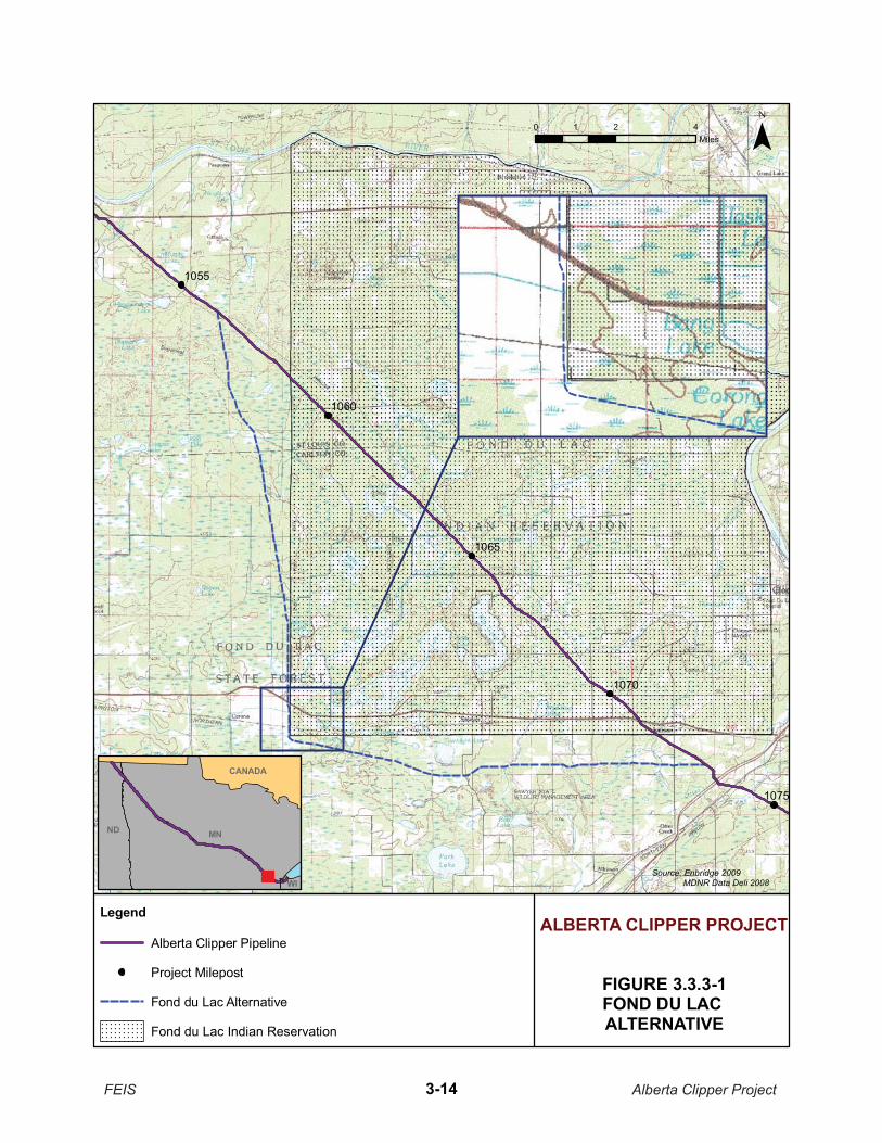
3.3.3 Fond du Lac Alternative
The existing Enbridge pipeline corridor traverses the FDL Reservation (from approximately MP 1058 to MP 1072). Prior to March 2009, the FDL had not agreed to the proposed Alberta Clipper Project traversing the FDL Reservation. Therefore, alternative routes were considered to avoid the FDL Reservation.
Initially, alternative routes were considered around the FDL Reservation to the north and to the south to reconnect with the existing Enbridge pipeline right-of-way on the southeast side of the FDL Reservation. Skirting the reservation to the north would require diverting from the existing Enbridge right-of-way on the west side of the FDL Reservation and heading north, then east, and then south. Skirting the reservation to the south would require diverting from the existing Enbridge right-of-way on the west side of the FDL Reservation, heading south, and then east before rejoining the Enbridge right-of-way at approximately MP 1072. Because the potential route to the north would be a greenfield route, would be substantially longer
FEIS Alberta Clipper Project 3-12

than a route around the south of the reservation (likely 10 miles longer or more), and would require crossing the St. Louis River twice, a route to the north was dismissed from further consideration.
To minimize potential impacts of a route to the south, potential routes were screened based on minimizing the length of the route and possibly collocating the route with existing linear corridors. No existing linear corridors would directly skirt around the reservation. The most appropriate corridor appeared to be a transmission line that would divert from the existing Enbridge right-of-way at the Enbridge Gowan Pump Station (MP 1052.4) and then parallel Highways 86 and 73 to Cromwell, Minnesota, where it would rejoin the Enbridge right-of-way southeast of the FDL Reservation. This corridor was rejected during the screening process because it would substantially increase the length of the pipeline (by approximately 10 miles or more) and would pass near numerous residences and residential areas along Highways 86 and 73.
The proposed Project identified in the DEIS included a greenfield route that Enbridge had previously proposed in the vicinity of the FDL Reservation. This route was intended to avoid the reservation, while limiting the pipeline length and associated environmental impacts. The route would skirt just outside the FDL Reservation by departing the existing Enbridge right-of-way at MP 1056.2, turning south, and then east to rejoin the Enbridge pipeline right-of-way at MP 1072. Subsequent to the issuance of the DEIS, Enbridge and the FDL reached an agreement (in principle) that would allow the proposed Project to cross the FDL Reservation. Enbridge has notified DOS that the route paralleling the existing Enbridge pipeline right-of-way across the FDL Reservation has now been incorporated into its proposed route. Thus, the currently proposed Project route (described in the DEIS as the FDL Alternative) would parallel the existing Enbridge pipeline right-of-way across the reservation. The FDL Alternative route is now considered to be the route that would skirt just outside the reservation (Figure 3.3.3-1).
A comparative analysis was conducted to evaluate the potential impacts associated with the currently proposed Project route that would follow the existing Enbridge pipeline right-of-way through the FDL Reservation to the potential impacts of the previously identified greenfield route around the reservation. The currently proposed Project route would be shorter (by 4.8 miles) and would not include any greenfield construction. All of the proposed route would be collocated with the existing Enbridge right-of-way. Table 3.3.3-1 provides a summary of the comparison of the impacts associated with the currently proposed Project route (through the FDL Reservation) and the current FDL Alternative (the greenfield route around the reservation).
As described above, impacts to specific resources would generally be fewer or the same along the currently proposed Project route than for the current FDL Alternative. For example, geologic conditions are not expected to vary significantly between the proposed Project route and the FDL Alternative. The proposed Project route would cross less prime farmland soils, highly erodible soils, and hydric soils, resulting in less impact to these important soil resources compared to the corresponding portion of the FDL Alternative.
No intermittent waterbodies would be crossed by either route, but the current FDL Alternative would cross five more waterbodies than the corresponding portion of the currently proposed Project route, and thus would be expected to result in greater environmental impact, primarily associated with temporary turbidity and sedimentation during construction. As identified in Table 3.3.3-1, the currently proposed Project route would result in significantly less impact to wetland resources than the current FDL Alternative in terms of both acreage and greenfield construction.
FEIS Alberta Clipper Project 3-13
1065
1055
1075
1060
1070
FIGURE 3.3.3-1FOND DU LAC ALTERNATIVE
Source: Enbridge 2009 �DNR Data Deli 2008
¯0 2 41Miles
ALBERTA CLIPPER PROJECT
CANADA
MNND
WI
Legend
Alberta Clipper Pipeline
Project Milepost
Fond du Lac Alternative
Fond du Lac Indian Reservation
FEIS Alberta Clipper Project3-14

TABLE 3.3.3-1 Comparison of Features of the Proposed Project Route and the Fond du Lac Alternative
Feature Unit Proposed Project
Route Fond du Lac
Alternative (Greenfield)
Total length Miles 16.82 21.62
Greenfield route Miles 0.0 21.62
Collocated with existing right-of-way Miles 16.82 0.0
Collocated with existing Enbridge right-of-way
Miles 16.82 0.0
Federal lands crossed number / length (mi.) 1 / 12.94 0 / 0
State lands crossed number /length (mi.) 11 / 1.80 44 / 9.37
County lands crossed number / length (mi.) 26 / 5.07 36 / 7.37
Road crossings Number 13 7
Railroad crossings Number 1 1
Waterbody crossings a Number 9 14
DNR PWI waterbody crossings/cold water fisheries
Number 1 / 0 4 / 4
Emergent wetland crossings number / length (ft) 46 / 31,242 21 / 8,930
Scrub-shrub wetland crossings number / length (ft) 18 / 10,985 53 / 16,660
Forested wetland crossings number / length (ft) 16 / 8,518 58 / 34,235
DNR PWI wetland crossings Number 0 0
Developed land Miles 0.30 0.14
Residents within 200 feet of proposed centerline
Number 3 2
Shallow bedrock Miles 0.0 0.0
Forested land Miles 6.30 9.20
Agricultural land Miles 0.72 0.52
Prime farmland Miles 0.93 1.20
Herbaceous lands Miles 0.87 0.53
DNR-PWI = Department of Natural Resources – Public Waters Inventory a To provide the most accurate data available, waterbody delineations were conducted for both the Proposed Project Route
and the and the Fond du Lac Alternative (Greenfield) instead of NHDH data
It is expected that utilizing the proposed Project route would result in a decrease in forested and herbaceous impacts compared to the FDL Alternative but may result in a short-term increase in impacts to agricultural lands (for one growing season). The currently proposed Project route would result in substantially less impact
FEIS Alberta Clipper Project 3-15

to forested land/natural vegetation communities than the current FDL Alternative, both in terms of acreage and greenfield construction. The current FDL Alternative would impact nearly twice the area of forested and wetland habitats as the currently proposed Project route. Other wildlife impacts would be similar along either route. Overall, the currently proposed Project route would result in substantially less impact to wildlife habitat than the current FDL Alternative.
As described in Table 3.3.3-1, the currently proposed Project route would impact fewer waterbodies than the current FDL Alternative. As a result, it is expected that the currently proposed Project route would result in less environmental impact to fisheries resources.
Both the currently proposed Project route and the current FDL Alternative would cross habitats of species that are federally, state, or tribally designated as endangered, threatened, or candidate species and that are species of conservation concern identified by tribal and state resource agencies. In general, the currently proposed Project route would have a smaller potential to affect sensitive species because it would cross more disturbed areas relative to the forested and wetland habitats that would be crossed by the current FDL Alternative.
In general, it is expected that the FDL could realize more economic benefit from the currently proposed Project route compared to the current FDL Alternative from easement negotiations as well as public services provided during pipeline construction.
Neither the proposed Project route nor the FDL Alternative would impact historic properties identified to date, although FDL has expressed concerns associated with two historic trails that would be crossed along the current FDL Alternative route (that would not be crossed by the currently proposed Project route). The FDL has also expressed concerns about potential impacts to wild rice lakes located downstream of the pipeline route during construction or operation of a pipeline along the current FDL Alternative route. These wild rice lakes are located upstream of the currently proposed Project route and would not be impacted by construction or operation of a pipeline along the currently proposed Project route.
Construction of the pipeline along the currently proposed Project route would potentially result in less fugitive dust generation and fossil fuel consumption because of its shorter length and the availability of paved roads relative to the current FDL Alternative. However, the current FDL Alternative would likely result in fewer impacts to residents along the route. Operation of this portion of the pipeline is expected to result in negligible impacts to air quality along either the currently proposed Project route or the current FDL Alternative. Similarly, construction noise impacts to humans would be expected to be slightly higher along the currently proposed Project route because of the closer proximity of residences. Any operational noise along either route would be negligible because there would be no pump stations located along them.
In conclusion, the current FDL Alternative that would skirt the FDL Reservation (to the west and south) is not considered environmentally preferable to the currently proposed Project route.
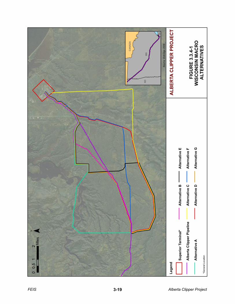
3.3.4 Wisconsin Macro Alternatives
WDNR requested that Enbridge evaluate major corridor alternatives in Wisconsin in addition to the proposed corridor in Wisconsin that follows the existing Enbridge right-of-way. The complete evaluation was included in Enbridge’s Construction Project Consolidated Permit Application submitted to WDNR (Enbridge 2009). These corridor alternatives maintained the control points of the border crossing between Minnesota and Wisconsin and the Superior Terminal. Enbridge evaluated alternatives that were capable of being implemented and considered the ability of a feasible alternative to avoid or minimize impacts compared to the proposed Project route along the existing Enbridge corridor.
FEIS Alberta Clipper Project 3-16
The existing Enbridge right-of-way is essentially a direct line from the delivery point at the Minnesota and Wisconsin border to the Superior Terminal. By paralleling the existing right-of-way, impacts could be minimized to environmental resources could be minimized by utilizing the maintained portion of the existing right-of-way as compared to other routes that do not have a collocation option.
At the request of WDNR, Enbridge reviewed eight corridor alternatives. One alternative, the North Trail Corridor, was not evaluated in detail because the trail is currently used as an all-terrain vehicle (ATV) and walking trail. The trail is narrow (15 feet wide) with relatively steep sides. The initial analysis of the North Trail Corridor Alternative determined that it was not practical due to constructability issues. The remaining seven corridor alternatives were evaluated further, and were compared to the proposed action, as presented in Table 3.3.4-1. Figure 3.3.4-1 shows the proposed route and the seven alternative corridors evaluated.
No alternative corridor reduces permanent impacts to environmental resources substantially more than the proposed Project route.
Alternative A would result in a greater temporary and permanent environmental, social, and economic impact than the proposed Project route. Alternative A would require over 11 miles of greenfield route, which would increase the impacts to forested lands, wetlands, and waterbodies relative to the proposed Project route.
Alternative B would result in a greater temporary and permanent environmental, social, and economic impact than the proposed Project route. Alternative B would require only 0.7 mile of new corridor; however, Alternative B would cross three State-designated waterbodies and six additional wild rice production area drainages. Alternative B would also increase wetland impacts from the permanent right-of-way by 15 acres compared to the proposed Project route. The alternative would reduce overall impacts to the Pokegama-Carnegie Wetland Complex; however, as discussed in Section 3.4.2.24, the proposed Project route incorporates a route variation and construction modifications that would reduce impacts to the wetland complex.
Alternative C would result in a greater temporary and permanent environmental, social, and economic impact than the proposed Project route. While Alternative C does avoid some State-designated lands, almost 19 acres of greenfield construction would be required. Alternative C would increase impacts to wetlands and forested wetlands by 20.6 and 6.2 acres, respectively compared to the proposed Project route. Alternative C would also cross 15 additional waterbodies, including one impaired waterbody.
Alternative D would result in a greater temporary and permanent environmental, social, and economic impact than the proposed Project route. Alternative D would require 14.4 miles of greenfield construction. Although fewer waterbodies and fewer State-designated areas would be crossed by Alternative D, wetland and forested wetland impacts would increase with Alternative D compared to the proposed Project route.
Alternative E would result in a greater temporary and permanent environmental, social, and economic impact than the proposed Project route. The alternative would reduce the crossings of State-designated natural areas; however, it would increase impacts to almost every other resource analyzed. Alternative E would create 13.7 miles of new greenfield pipeline corridor and increase the impacts to wetlands, waterbodies, recreational areas, and several State-designated lands compared to the proposed Project route.
Alternative F would result in a greater temporary and permanent environmental, social, and economic impact than the proposed Project route; although, to a lesser degree than Alternatives A, C, D, and E. Alternative F would require only 4.4 miles of new pipeline corridor, and it would avoid all State-designated natural areas. However, impacts to wetlands, forested wetlands, waterbodies, and recreational areas would be greater under Alternative F than the proposed Project route.
FEIS Alberta Clipper Project 3-17
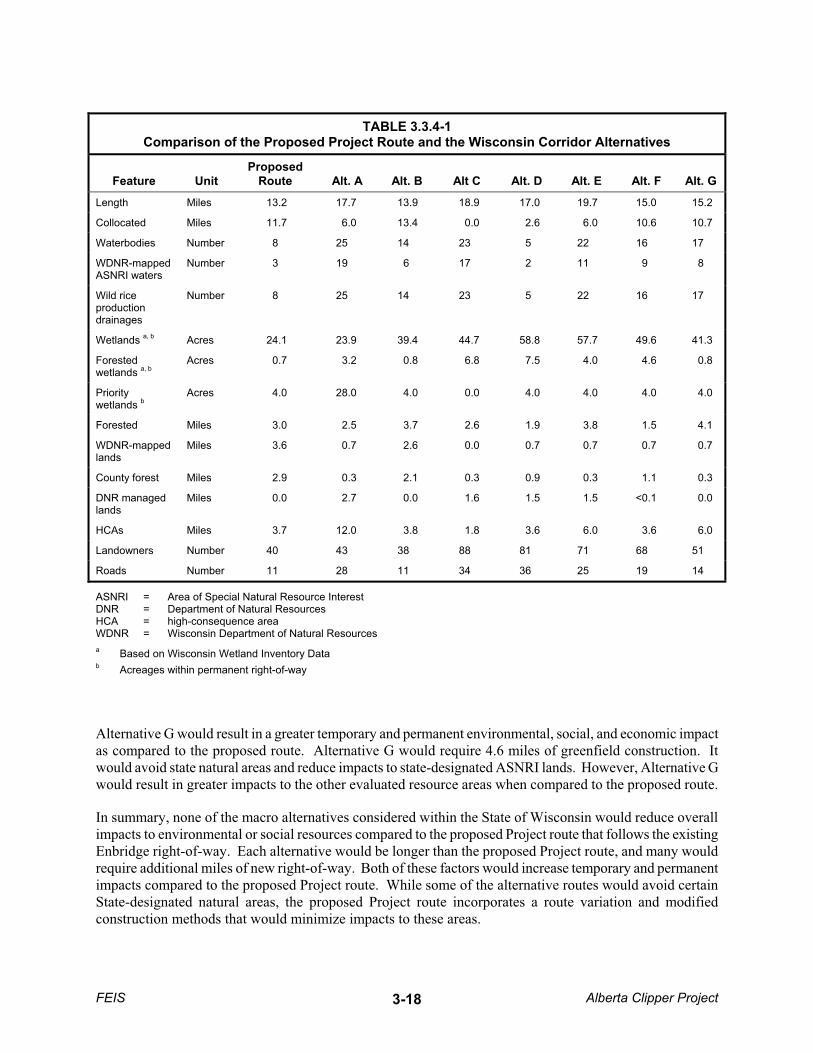
TABLE 3.3.4-1 Comparison of the Proposed Project Route and the Wisconsin Corridor Alternatives
Feature Unit Proposed
Route Alt. A Alt. B Alt C Alt. D Alt. E Alt. F Alt. G
Length Miles 13.2 17.7 13.9 18.9 17.0 19.7 15.0 15.2
Collocated Miles 11.7 6.0 13.4 0.0 2.6 6.0 10.6 10.7
Waterbodies Number 8 25 14 23 5 22 16 17
WDNR-mappedASNRI waters
Number 3 19 6 17 2 11 9 8
Wild rice productiondrainages
Number 8 25 14 23 5 22 16 17
Wetlands a, b Acres 24.1 23.9 39.4 44.7 58.8 57.7 49.6 41.3
Forestedwetlands a, b
Acres 0.7 3.2 0.8 6.8 7.5 4.0 4.6 0.8
Priority wetlands b
Acres 4.0 28.0 4.0 0.0 4.0 4.0 4.0 4.0
Forested Miles 3.0 2.5 3.7 2.6 1.9 3.8 1.5 4.1
WDNR-mappedlands
Miles 3.6 0.7 2.6 0.0 0.7 0.7 0.7 0.7
County forest Miles 2.9 0.3 2.1 0.3 0.9 0.3 1.1 0.3
DNR managed lands
Miles 0.0 2.7 0.0 1.6 1.5 1.5 <0.1 0.0
HCAs Miles 3.7 12.0 3.8 1.8 3.6 6.0 3.6 6.0
Landowners Number 40 43 38 88 81 71 68 51
Roads Number 11 28 11 34 36 25 19 14
ASNRI = Area of Special Natural Resource Interest DNR = Department of Natural Resources HCA = high-consequence area WDNR = Wisconsin Department of Natural Resources a Based on Wisconsin Wetland Inventory Data b Acreages within permanent right-of-way
Alternative G would result in a greater temporary and permanent environmental, social, and economic impact as compared to the proposed route. Alternative G would require 4.6 miles of greenfield construction. It would avoid state natural areas and reduce impacts to state-designated ASNRI lands. However, Alternative G would result in greater impacts to the other evaluated resource areas when compared to the proposed route.
In summary, none of the macro alternatives considered within the State of Wisconsin would reduce overall impacts to environmental or social resources compared to the proposed Project route that follows the existing Enbridge right-of-way. Each alternative would be longer than the proposed Project route, and many would require additional miles of new right-of-way. Both of these factors would increase temporary and permanent impacts compared to the proposed Project route. While some of the alternative routes would avoid certain State-designated natural areas, the proposed Project route incorporates a route variation and modified construction methods that would minimize impacts to these areas.
FEIS Alberta Clipper Project 3-18
FIG
UR
E 3.
3.4-
1W
ISC
ON
SIN
MA
CR
O
ALT
ERN
ATIV
ES
Sour
ce: E
nbrid
ge 2
009
¯
ALB
ERTA
CLI
PPER
PR
OJE
CT
CA
NA
DA
MN
ND
WI
*Gen
eral
Loc
atio
n
Lege
nd
Supe
rior T
erm
inal
*
Alb
erta
Clip
per P
ipel
ine
Alte
rnat
ive
A
Alte
rnat
ive
B
Alte
rnat
ive
C
Alte
rnat
ive
D
Alte
rnat
ive
E
Alte
rnat
ive
F
Alte
rnat
ive
G
01
20.
5M
iles
FEIS Alberta Clipper Project3-19
3.4 ROUTE VARIATIONS
Route variations differ from system or major route alternatives in that they are intended to resolve or reduce landowner concerns and construction impacts to localized, specific resources—such as cultural resource sites, wetlands, recreational lands, residences, and terrain conditions. While route variations may be a few miles in length, most are relatively short and in close proximity to the proposed route. Because route variations are identified in response to specific local concerns, they are often the result of landowner comments. Several factors were considered in identifying and evaluating route variations, including length, land requirements, the potential for reducing or minimizing impacts to natural resources, and addressing landowner concerns.
Since the completion of the DEIS, additional minor route variations have been analyzed to address landowner issues and resource agency concerns. MDNR raised various concerns with specific minor route variations, construction methods, and site-specific restoration and mitigation procedures (MDNR 2008). MDNR and Enbridge have coordinated on these issues, and Enbridge has attempted to address MDNR’s concerns in its current proposal.
The discussion below describes Enbridge’s analysis of route selection and variations incorporated into the Alberta Clipper Project, including four incorporated since the DEIS. Additional information on construction methods, restoration procedures, and mitigation measures is provided in Section 4.0.
3.4.1 Selection of Specific Corridors
As part of the proposed Project route development and selection process, various route variations were identified and evaluated by Enbridge relative to maximizing collocation with the existing Enbridge right-of-way while attempting to minimize environmental impacts. We received a comment that the EIS did not provide sufficient information on the reasons why the proposed corridor was selected in seven areas where the existing pipelines form two separate but parallel corridors. In general, the commenter was primarily concerned about wetland impacts in the selection of a route. The following subsections provide summary information on the rationale for selecting the proposed Project route in those areas based on a range of environmental impacts, landowner concerns, and engineering constraints. We reviewed the available information and accept Enbridge’s rationale for proposing the specific corridor in each case. These locations usually involve constrained areas and the choice of one corridor as opposed to the other was generally in an effort to avoid direct impacts to residences, businesses, or other urban development.
3.4.1.1 MP 951.6 to MP 958.4
This portion of the route is in the general vicinity of Cass Lake where the existing corridor splits into two corridors; each corridor contains two pipelines. Enbridge proposed the southern corridor for the following reasons:
� In following the basic routing assumptions described in Section 3.0, the pipeline was routed adjacent to the corridor that was impacted most recently by pipeline construction. The proposed route is adjacent to the south side of the southern corridor since that area was most recently disturbed. The southern corridor through the Cass Lake area contains the 36-inch-diameter Terrace III pipeline that was constructed in 2002 and is generally located on the southern side of the corridor.
� Construction along the northern corridor through the LLR would require construction through several local businesses. At a minimum, that would disrupt business operations and would likely require demolition of some of the buildings and structures.
FEIS Alberta Clipper Project 3-20
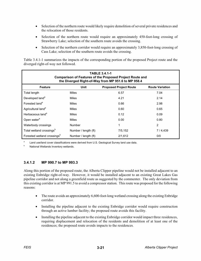
� Selection of the northern route would likely require demolition of several private residences and the relocation of those residents.
� Selection of the northern route would require an approximately 450-foot-long crossing of Strawberry Lake; selection of the southern route avoids the crossing.
� Selection of the northern corridor would require an approximately 3,850-foot-long crossing of Cass Lake; selection of the southern route avoids the crossing.
Table 3.4.1-1 summarizes the impacts of the corresponding portion of the proposed Project route and the diverged right-of-way not followed.
TABLE 3.4.1-1 Comparison of Features of the Proposed Project Route and
the Diverged Right-of-Way from MP 951.6 to MP 958.4
Feature Unit Proposed Project Route Route Variation
Total length Miles 6.57 7.04
Developed landa Miles 4.21 2.14
Forested landa Miles 0.66 2.98
Agricultural landa Miles 0.60 0.65
Herbaceous landa Miles 0.12 0.09
Open watera Miles 0.00 0.80
Waterbody crossings Number 1 2
Total wetland crossingsb Number / length (ft) 7/5,152 7 / 4,439
Forested wetland crossingsb Number / length (ft) 2/1,612 0/0
a Land use/land cover classifications were derived from U.S. Geological Survey land use data. b National Wetlands Inventory wetlands.
3.4.1.2 MP 990.7 to MP 993.3
Along this portion of the proposed route, the Alberta Clipper pipeline would not be installed adjacent to an existing Enbridge right-of-way. However, it would be installed adjacent to an existing Great Lakes Gas pipeline corridor and not along a greenfield route as suggested by the commenter. The only deviation from this existing corridor is at MP 991.5 to avoid a compressor station. This route was proposed for the following reasons:
� The route avoids an approximately 6,600-foot-long wetland crossing along the existing Enbridge corridor.
� Installing the pipeline adjacent to the existing Enbridge corridor would require construction through an active lumber facility; the proposed route avoids this facility.
� Installing the pipeline adjacent to the existing Enbridge corridor would impact three residences, requiring displacement and relocation of the residents and demolition of at least one of the residences; the proposed route avoids impacts to the residences.
FEIS Alberta Clipper Project 3-21

Table 3.4.1-2 summarizes the impacts of the corresponding portion of the proposed Project route and the diverged right-of-way not followed.
TABLE 3.4.1-2 Comparison of Features of the Proposed Project Route and the
Diverged Right-of-Way from MP 990.7 to MP 993.3
Feature Unit Proposed Project Route Route Variation
Total length Miles 2.67 2.64
Developed landa Miles 0.02 0.33
Forested landa Miles 1.13 0.14
Agricultural landa Miles 0.80 0.68
Herbaceous landa Miles 0.02 0.09
Open watera Miles 0.00 0.00
Waterbody crossings Number 2 2
Total wetland crossingsb Number / length (ft) 4/3,681 3 / 7,402
Forested wetland crossingsb Number / length (ft) 3/3,320 2 / 4,709
a Land use/land cover classifications were derived from U.S. Geological Survey land use data. b National Wetlands Inventory wetlands.
3.4.1.3 MP 995.8 to MP 1004.5
The commenter suggested that although there are two existing corridors in the vicinity of this portion of the proposed Project route, Enbridge had selected a route that was north and separate from those corridors. That is not accurate. Enbridge has not selected a third corridor but has proposed a route that is parallel and adjacent to the existing northern corridor, which includes two existing Enbridge pipelines. This route was proposed over the southern Enbridge corridor in this area for the following reasons:
� In following the basic routing assumptions described in Section 3.0, the proposed pipeline was routed adjacent to the corridor that was impacted most recently by pipeline construction. The proposed route is adjacent to the north side of the northern corridor since that area was most recently disturbed. The northern corridor contains Enbridge’s Terrace III pipeline that was constructed in 2002 and is generally located on the northern side of the corridor in this area.
� Construction along the southern corridor would involve two more waterbody crossings than required for the northern corridor (Blackwater Creek and a tributary to White Oak Lake).
� Construction along the southern corridor would require one more crossing of U.S. Highway 2 than the proposed Project route, and would likely require demolition and displacement of a small business. Further, due to the proximity of the southern corridor to U.S. Highway 2, it would not be feasible to cross under the existing pipelines.
Table 3.4.1-3 summarizes the impacts of the corresponding portion of the proposed Project route and the diverged right-of-way not followed.
FEIS Alberta Clipper Project 3-22

TABLE 3.4.1-3 Comparison of Features of the Proposed Project Route and the
Diverged Right-of-Way from MP 995.8 to MP 1004.5
Feature Unit Proposed Project Route Route Variation
Total length Miles 8.04 7.94
Developed landa Miles 0.35 0.71
Forested landa Miles 3.41 1.86
Agricultural landa Miles 1.33 1.11
Herbaceous landa Miles 0.43 0.52
Open watera Miles 0.00 0.00
Waterbody crossings Number 1 3
Total wetland crossingsb Number / length (ft) 22/13,306 26/19,725
Forested wetland crossingsb Number / length (ft) 3/3,320 2 / 4,709
a Land use/land cover classifications were derived from U.S. Geological Survey land use data. b National Wetlands Inventory wetlands.
3.4.1.4 MP 1005.3 to MP 1011.6
Along this portion of the route (Grand Rapids area), the northern corridor was chosen for the following reasons:
� In following the basic routing assumptions described in Section 3.0, the pipeline was routed adjacent to the corridor that was impacted most recently by pipeline construction. The proposed route is adjacent to the side of the corridor that was most recently disturbed. The northern corridor through Grand Rapids contains Enbridge’s Terrace III pipeline that was constructed in 2002 and is generally located on the northern side of the corridor in this area.
� Expansion of the northern corridor through Grand Rapids would cause less impact to adjacent urban development than the southern corridor. For example, the southern corridor traverses the Itasca Community College baseball diamond.
Table 3.4.1-4 summarizes the impacts of the corresponding portion of the proposed Project route and the diverged right-of-way not followed.
FEIS Alberta Clipper Project 3-23

TABLE 3.4.1-4 Comparison of Features of the Proposed Project Route and the
Diverged Right-of-Way from MP 1005.3 to MP 1011.6
Feature Unit Proposed Project Route Route Variation
Total length Miles 6.84 6.27
Developed landa Miles 0.28 1.48
Forested landa Miles 2.52 2.22
Agricultural landa Miles 0.48 0.73
Herbaceous landa Miles 2.05 1.23
Open watera Miles 0.02 0.01
Waterbody crossings Number 1 1
Total wetland crossingsb Number / length (ft) 5/7,908 10/3,131
Forested wetland crossingsb Number / length (ft) 3/5,378 0/0
a Land use/land cover classifications were derived from U.S. Geological Survey land use data. b National Wetlands Inventory wetlands.
3.4.1.5 MP 1027.8 to MP 1030
There are two existing corridors along this portion of the route. Enbridge has proposed to install the pipeline adjacent to the south side of the southern corridor, an area that is not a greenfield route, as suggested by a commenter. Enbridge proposed this route for the following reasons:
� Installing the pipeline adjacent to the northern corridor would require two crossings of the existing pipelines. The southern side of the southern corridor was proposed to avoid those crossings;
� Use of the area adjacent to the northern corridor would require workspace that would directly impact the yards of three residences; use of the southern corridor does not directly impact any residences.
� The southern corridor contains the most recently constructed Enbridge pipeline (albeit Line 4 that was installed in the 1970s).
Table 3.4.1-5 summarizes the impacts of the corresponding portion of the proposed Project route and the diverged right-of-way not followed.
FEIS Alberta Clipper Project 3-24
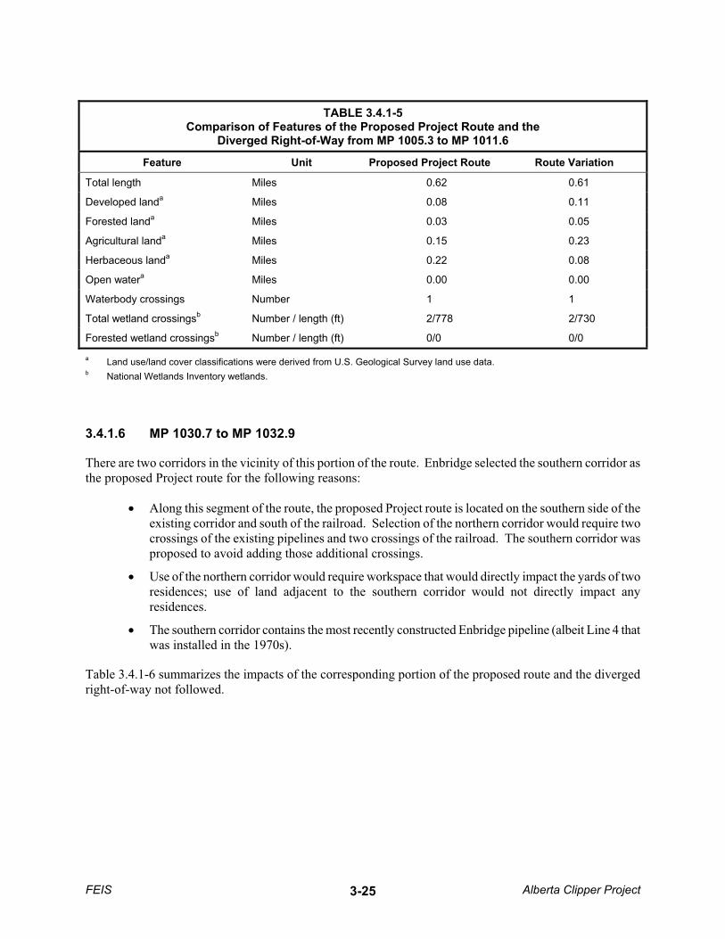
TABLE 3.4.1-5 Comparison of Features of the Proposed Project Route and the
Diverged Right-of-Way from MP 1005.3 to MP 1011.6
Feature Unit Proposed Project Route Route Variation
Total length Miles 0.62 0.61
Developed landa Miles 0.08 0.11
Forested landa Miles 0.03 0.05
Agricultural landa Miles 0.15 0.23
Herbaceous landa Miles 0.22 0.08
Open watera Miles 0.00 0.00
Waterbody crossings Number 1 1
Total wetland crossingsb Number / length (ft) 2/778 2/730
Forested wetland crossingsb Number / length (ft) 0/0 0/0
a Land use/land cover classifications were derived from U.S. Geological Survey land use data. b National Wetlands Inventory wetlands.
3.4.1.6 MP 1030.7 to MP 1032.9
There are two corridors in the vicinity of this portion of the route. Enbridge selected the southern corridor as the proposed Project route for the following reasons:
� Along this segment of the route, the proposed Project route is located on the southern side of the existing corridor and south of the railroad. Selection of the northern corridor would require two crossings of the existing pipelines and two crossings of the railroad. The southern corridor was proposed to avoid adding those additional crossings.
� Use of the northern corridor would require workspace that would directly impact the yards of two residences; use of land adjacent to the southern corridor would not directly impact any residences.
� The southern corridor contains the most recently constructed Enbridge pipeline (albeit Line 4 that was installed in the 1970s).
Table 3.4.1-6 summarizes the impacts of the corresponding portion of the proposed route and the diverged right-of-way not followed.
FEIS Alberta Clipper Project 3-25
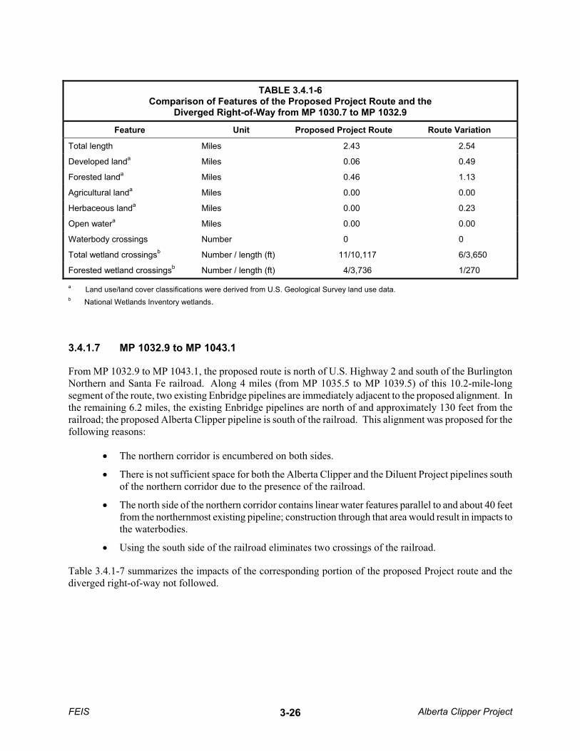
TABLE 3.4.1-6 Comparison of Features of the Proposed Project Route and the
Diverged Right-of-Way from MP 1030.7 to MP 1032.9
Feature Unit Proposed Project Route Route Variation
Total length Miles 2.43 2.54
Developed landa Miles 0.06 0.49
Forested landa Miles 0.46 1.13
Agricultural landa Miles 0.00 0.00
Herbaceous landa Miles 0.00 0.23
Open watera Miles 0.00 0.00
Waterbody crossings Number 0 0
Total wetland crossingsb Number / length (ft) 11/10,117 6/3,650
Forested wetland crossingsb Number / length (ft) 4/3,736 1/270
a Land use/land cover classifications were derived from U.S. Geological Survey land use data. b National Wetlands Inventory wetlands.
3.4.1.7 MP 1032.9 to MP 1043.1
From MP 1032.9 to MP 1043.1, the proposed route is north of U.S. Highway 2 and south of the Burlington Northern and Santa Fe railroad. Along 4 miles (from MP 1035.5 to MP 1039.5) of this 10.2-mile-long segment of the route, two existing Enbridge pipelines are immediately adjacent to the proposed alignment. In the remaining 6.2 miles, the existing Enbridge pipelines are north of and approximately 130 feet from the railroad; the proposed Alberta Clipper pipeline is south of the railroad. This alignment was proposed for the following reasons:
� The northern corridor is encumbered on both sides.
� There is not sufficient space for both the Alberta Clipper and the Diluent Project pipelines south of the northern corridor due to the presence of the railroad.
� The north side of the northern corridor contains linear water features parallel to and about 40 feet from the northernmost existing pipeline; construction through that area would result in impacts to the waterbodies.
� Using the south side of the railroad eliminates two crossings of the railroad.
Table 3.4.1-7 summarizes the impacts of the corresponding portion of the proposed Project route and the diverged right-of-way not followed.
FEIS Alberta Clipper Project 3-26

TABLE 3.4.1-7 Comparison of Features of the Proposed Project Route and the
Diverged Right-of-Way from MP 1032.9 to MP 1043.1
Feature Unit Proposed Project Route Route Variation
Total length Miles 10.18 10.24
Developed landa Miles 0.02 0.42
Forested landa Miles 0.49 0.10
Agricultural landa Miles 0.22 0.06
Herbaceous landa Miles 0.14 0.05
Open watera Miles 0.00 0.00
Waterbody crossings Number 5 9
Total wetland crossingsb Number / length (ft) 28/49,182 8/50,695
Forested wetland crossingsb Number / length (ft) 7/5,082 2/716
a Land use/land cover classifications were derived from U.S. Geological Survey land use data. b National Wetlands Inventory wetlands.
3.4.2 Route Variations
Route variations were assessed in 25 areas along the existing Enbridge corridor. Most of the route variations analyzed have been incorporated into the proposed Project to avoid or minimize impacts to natural or cultural resources, reduce or eliminate engineering and constructability concerns, and avoid or minimize conflicts with existing or proposed residential and agricultural land uses. Each of the route variations analyzed is listed in Table 3.4.2-1 and summarized below.
In addition to the route variations described above, the scoping process identified public concerns related to route location such as proximity to homes. It is recognized that additional minor alignment shifts would be required prior to and during construction to accommodate unforeseen site-specific constraints related to other engineering, landowner, and environmental concerns.
TABLE 3.4.2-1 Pipeline Route Variations Evaluated for the Alberta Clipper Project
Route Variation Milepost (MP) Reason for Route Variation
Coulee Crossing Variation MP 805.4 to MP 805.5 Minnesota Provide easier constructability in the Coulee.
Donaldson Station Variation MP 814.0 to MP 814.4 Minnesota Avoid a confined construction corridor between Donaldson Station and Minnesota Highway 11.
Farmstead Tract 970 Variation MP 822.8 to MP 823.1 Minnesota Accommodate a landowner request.
Farmstead Tract 947 Variation MP 831.3 to MP 831.5 Minnesota Avoid a confined area between the existing pipeline right-of-way and an adjacent farmstead.
FEIS Alberta Clipper Project 3-27

TABLE 3.4.2-1 (continued) Pipeline Route Variations Evaluated for the Alberta Clipper Project
Route Variation Milepost (MP) Reason for Route Variation
Fen Avoidance Variation MP 852.9 to MP 854.9 Minnesota Avoid a sensitive wetland area.
Calcareous Fen Avoidance Variation MP 893 Minnesota Avoid a sensitive wetland area.
Ruffy Brook Crossing MP 912.4 to MP 916.0 Minnesota Avoid a site of potential cultural significance, eliminate four crossings of Ruffy Brook, provide a more perpendicular crossing at two locations, and satisfy a landowner request.
Wilton Variation MP 932.6 to MP 935.2 Minnesota Avoid three residences.
Bemidji Power Line Variation MP 936.4 to MP 937.3 Minnesota Avoid construction and operational conflicts with the Bemidji Power Line.
Bemidji Residential Subdivision Variation
MP 937.7 to MP 938.6 Minnesota Avoid a residential area.
Necktie River Variation MP 946.0 to MP 946.7 Minnesota Agency request for different crossing method or alternative crossing location
Upper Sucker Lake MP 964.1 to MP 964.6 Minnesota Tribal request for different crossing method or alternative crossing location
Portage Lake Residences Variation MP 970.5 to MP 972.3 Minnesota Avoid impacts to residences and minimize wetland impacts.
Mississippi River Variation MP 984.7 to MP 988.2 Minnesota Avoid homes and provide more appropriate spacing and angles for the horizontally directionally drilled crossing of the Mississippi River.
Blackberry Variation MP 1011.3 to MP 1016.9 Minnesota
Avoid native grasslands per landowner request and avoid a feedlot.
Swan River Variation MP 1024.1 to MP 1024.3 Minnesota
Allow for a perpendicular crossing of the Swan River.
Forsythe Lake Variation MP 1004 to MP 1005.6 Minnesota
Landowners requests to place the pipeline on the north side of Forsythe Lake and avoid residences.
Shallow Lake Variation MP 1021.8 to MP 1025.2 Minnesota
Minimize impacts to the shore of Shallow Lake and residences along the shoreline.
FEIS Alberta Clipper Project 3-28

TABLE 3.4.2-1 (continued) Pipeline Route Variations Evaluated for the Alberta Clipper Project
Route Variation Milepost (MP) Reason for Route Variation
Floodwood Station Variation MP 1043.9 to MP 1045.4 Minnesota
Provide more working room for the horizontal directionally drilled crossing under U.S. Highway 2, avoid multiple pipelines near Floodwood Station, and avoid an open water crossing on the west side of the existing Enbridge pipelines.
Farmstead 169 Variation MP 1051.6 to MP 1052.0 Minnesota
Accommodate landowner request.
Farmstead 72 Variation MP 1077.5 to MP 1079.9 Minnesota
Avoid a residence.
Stream 37 Variation MP 1086.1 to MP 1086.5 Wisconsin
Minimize crossings of a tributary to Pokegama River.
Farmstead 25 Variation MP 1089.3 to MP 1089.7 Wisconsin
Minimize wetland impacts.
Pokegama-Carnegie Wetland Variation
MP 1090.6 to MP 1094.1 Wisconsin
Minimize wetland impacts.
Nemadji Golf Course Variation MP 1096.3 to MP 1096.9 Wisconsin
Minimize impacts to a golf course and avoid a high-quality wetland complex.
3.4.2.1 Coulee Crossing Variation
The Coulee Crossing Variation would parallel the existing Enbridge pipeline corridor near MP 805, as shown in Figure 3.4.2-1. The variation would shift approximately 50 feet to the southwest along 600 feet of the pipeline route to provide a more constructible crossing of Coulee Creek. Differences in disturbance to soil types and vegetative communities are negligible compared to the initially proposed route. The variation was incorporated into the proposed Project route.
3.4.2.2 Donaldson Station Variation
The Donaldson Station Variation would turn south-southeast from the southwest corner of Donaldson Station, cross Minnesota Highway 11, pass between an electrical substation and an abandoned farmstead, and then turn east to continue in a generally northwest-to-southeast direction to rejoin the existing Enbridge right-of-way at MP 814.4, as shown in Figure 3.4.2-2. The variation would be slightly longer (less than 0.1 mile) but would avoid the difficulty of construction in the congested area between Donaldson Station and Minnesota Highway 11. The variation was incorporated into the proposed Project route.
FEIS Alberta Clipper Project 3-29
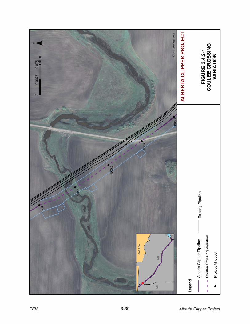
805.
3
805.
4
805.
5
805.
7
805.
6
FIG
UR
E 3.
4.2-
1C
OU
LEE
CR
OSS
ING
VA
RIA
TIO
NSour
ce: E
nbrid
ge 2
009
¯0
0.07
50.
0375
Mile
s
ALB
ERTA
CLI
PPER
PR
OJE
CT
Lege
nd
Albe
rta C
lippe
r Pip
elin
e
Cou
lee
Cro
ssin
g Va
riatio
n
Proj
ect M
ilepo
st
Exis
ting
Pip
elin
e
CA
NA
DA
MN
ND
WI
FEIS Alberta Clipper Project3-30
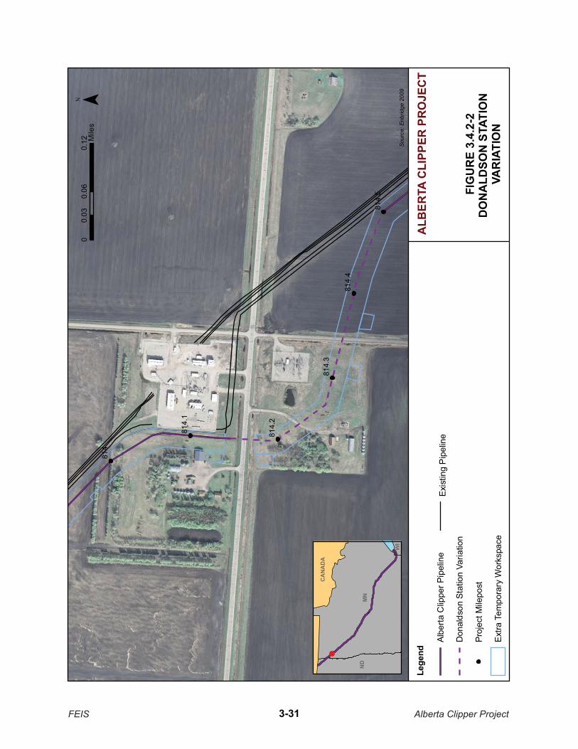
814
814.
1
814.
5
814.
2
814.
3
814.
4
FIG
UR
E 3.
4.2-
2D
ON
ALD
SON
STA
TIO
N
VAR
IATI
ON
Sour
ce: E
nbrid
ge 2
009¯
00.
060.
120.
03M
iles
ALB
ERTA
CLI
PPER
PR
OJE
CT
Lege
nd
Albe
rta C
lippe
r Pip
elin
e
Don
alds
on S
tatio
n Va
riatio
n
Proj
ect M
ilepo
st
Extra
Tem
pora
ry W
orks
pace
Exis
ting
Pip
elin
e
CA
NA
DA
MN
ND
WI
FEIS Alberta Clipper Project3-31

3.4.2.3 Farmstead Tract 970 Variation
The Farmstead Tract 970 Variation would turn south from the existing Enbridge pipeline corridor, pass to the west of a farmstead, and then turn east-southeast to rejoin the existing pipeline corridor, as shown in Figure 3.4.2-3. This variation is slightly longer (less than 0.1 mile) than following the existing Enbridge right-of-way and was incorporated in response to a landowner request.
3.4.2.4 Farmstead Tract 947 Variation
The Farmstead Tract 947 Variation would cross under the existing Enbridge pipelines, parallel the existing right-of-way approximately 50 feet to the north, and then cross back under the existing pipelines to the southwest side at MP 831.5, as shown in Figure 3.4.2-4. The variation would result in comparable environmental impacts relative to collocation with the existing right-of-way but would avoid a confined area between the existing right-of-way and an adjacent farmstead. The variation was incorporated into the proposed Project route.
3.4.2.5 Fen Avoidance Variation
The Fen Avoidance Variation (MP 852.9 to MP 854.9) would cross under the existing Enbridge pipelines to the north side, parallel the existing corridor approximately 50 feet to the north, and then cross back under the existing Enbridge pipelines to the south side, as shown in Figure 3.4.2-5. The currently proposed route would avoid a wetland area at the request of MDNR.
3.4.2.6 Calcareous Fen Variation
Enbridge identified a calcareous fen at MP 893 that could provide habitat for state-listed species of plants (Figure 3.4.2-6). Enbridge has developed a slight variation north of its existing right-of-way in this area to avoid the fen and any impacts to it. The variation is about 1.8 miles in length starting at MP 892.6 and rejoining the existing right-of-way at MP 894.4. Additional construction and restoration measures were developed in coordination with MDNR and the COE to minimize impacts to the fen (see Section 4.4). The variation was incorporated into the proposed Project route.
3.4.2.7 Ruffy Brook Crossing Variation
The Ruffy Brook Crossing Variation was evaluated to avoid and minimize impacts to environmental resources and residences. The route variation would take the pipeline south of the existing Enbridge right-of-way for about 1.5 miles of greenfield alignment before rejoining the existing right-of-way near MP 915.7, as shown in Figure 3.4.2-7. Table 3.4.2-2 summarizes the impacts of the Ruffy Brook Crossing Variation, which as been incorporated as the proposed Project route, and the existing pipeline right-of-way.
This variation would avoid an area of a historical oil release on the north side of the existing right-of-way (near MP 914.2), be farther from residences, and respond to a landowner request for the pipeline to be sited on the south side of the existing right-of-way at MP 916.0. The proposed variation south of the existing right-of-way eliminates two crossings of Ruffy Brook. Additionally, the route variation provides a more perpendicular crossing of Ruffy Brook, compared to a more paralleled crossing to the north. Comments were received in preference of following the existing right-of-way; however, while the proposed variation would require approximately 1.5 miles of greenfield construction, the reduced impacts to Ruffy Brook and residences, and avoiding any potential contamination from the historical oil release are considered to cause less environmental impact than following the existing right-of-way to the north. The variation was incorporated into the proposed Project route.
FEIS Alberta Clipper Project 3-32

TABLE 3.4.2-2 Comparison of the Ruffy Brook Crossing Variation and the Existing
Right-of-Way Route from MP 913.5 to MP 915.7
Feature Unit
Ruffy Brook Crossing Variation / Proposed
Project Route Existing Right-of-Way
Route
Total length Miles 2.43 2.42
Greenfield route Miles 1.54 0
Collocated with existing Enbridge right-of-way Miles 0.88 2.42
Road crossings Number 1 1
Railroad crossings Number 0 0
DNR PWI waterbody crossings/cold water fisheries Number 1 / 0 1 / 0
DNR PWI wetland crossings Number 0 0
Developed land Miles 0.01 0.00
Residences within 200 feet of proposed centerline Number 0 0
Forested land Miles 1.24 0.71
Agricultural land Miles 0.49 1.22
Prime farmland Miles 1.09 0.93
Herbaceous lands Miles 0.00 0.01
Waterbody crossingsa Number 3 2
Wetland crossingsa Number / length (ft.) 15 / 3,642.8 7 / 2,538.6
Forested wetland crossingsa Number / length (ft.) 6 / 1,327.9 1 / 1,099.7
DNR-PWI = Department of Natural Resources – Public Waters Inventory a Table comparisons are based on NHDH and National Wetland Inventory (NWI) data. Waterbody and wetland delineations for
the Ruffy Brook Crossing Variation/proposed Project route indicated 10 wetland crossings for a total length of 3,518.4 feet andfour forested wetland crossings for a total length of 1,222.7 feet. Only NHDH and NWI data are presented for the existing right-of-way route, because no field delineations of wetlands or waterbodies were conducted.
FEIS Alberta Clipper Project 3-33

823
823.1
822.6
822.7
822.8
822.9
822.5
FIGURE 3.4.2-3FARMSTEAD TRACT 970
VARIATION
Source: Enbridge 2009
¯
ALBERTA CLIPPER PROJECTLegend
Alberta Cipper Pipeline
Farmstead Tract 970 Variation
Project Milepost
Extra Temporary Workspace
Existing Pipeline
CANADA
MNND
WI
0 0.09 0.180.045Miles
FEIS Alberta Clipper Project3-34

831.
2
831.
3
831.
4
831.
5
FIG
UR
E 3.
4.2-
4FA
RM
STEA
D T
RA
CT
947
VAR
IATI
ON
Sour
ce: E
nbrid
ge 2
009
¯0
0.07
0.03
5M
iles
ALB
ERTA
CLI
PPER
PR
OJE
CT
Lege
nd
Albe
rta C
ippe
r Pip
elin
e
Farm
stea
d Tr
act 9
47 V
aria
tion
Proj
ect M
ilepo
st
Extra
Tem
pora
ry W
orks
pace
Exis
ting
Pip
elin
e
CA
NA
DA
MN
ND
WI
FEIS Alberta Clipper Project3-35
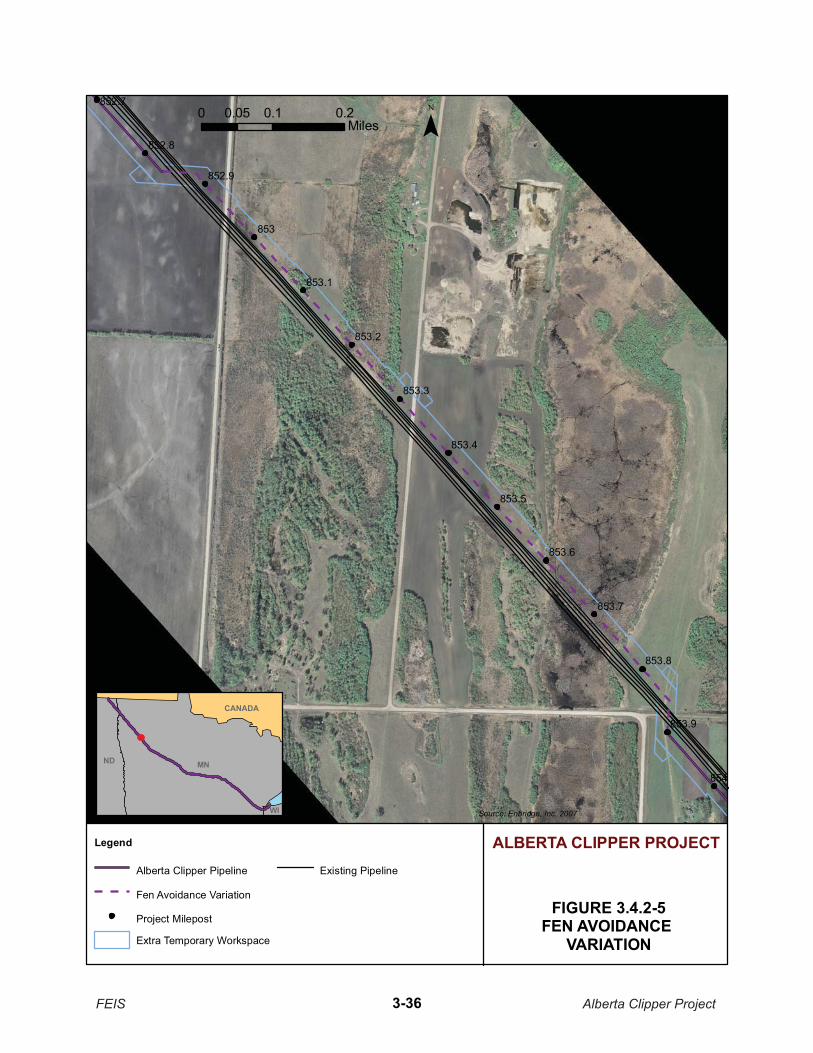
853
854
853.5
853.2
853.6
853.7
852.7
852.8
853.8
853.3
852.9
853.9
853.4
853.1
FIGURE 3.4.2-5FEN AVOIDANCE
VARIATION
Source: Enbridge, Inc. 2007
¯
ALBERTA CLIPPER PROJECTLegend
Alberta Clipper Pipeline
Fen Avoidance Variation
Project Milepost
Extra Temporary Workspace
Existing Pipeline
CANADA
MNND
WI
0 0.1 0.20.05Miles
FEIS Alberta Clipper Project3-36
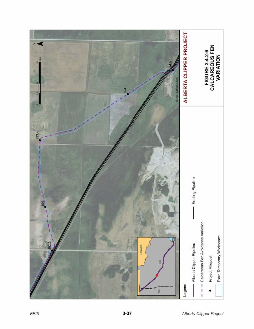
893
894
892.
5
893.
4
894.
5
FIG
UR
E 3.
4.2-
6C
ALC
AR
EOU
S FE
NVA
RIA
TIO
N
Sour
ce: E
nbrid
ge 2
009
¯0
0.2
0.4
0.1
Mile
s
ALB
ERTA
CLI
PPER
PR
OJE
CT
Lege
nd
Albe
rta C
lippe
r Pip
elin
e
Cal
care
ous
Fen
Avoi
danc
e Va
riatio
n
Proj
ect M
ilepo
st
Extra
Tem
pora
ry W
orks
pace
Exis
ting
Pipe
line
MN
ND
WI
FEIS Alberta Clipper Project3-37
CA
NA
DA

914
915
917
912
913
916
FIG
UR
E 3.
4.2-
7R
UFF
Y B
RO
OK
CR
OSS
ING
VAR
IATI
ON
Sour
ce: E
nbrid
ge 2
009
The
DN
R D
ata
Del
i 200
8
¯0
0.3
0.6
0.15
Mile
s
ALB
ERTA
CLI
PPER
PR
OJE
CT
Lege
nd
Albe
rta C
lippe
r Pip
elin
e
Ruf
fy B
rook
Cro
ssin
g Va
riatio
n
Proj
ect M
ilepo
st
Exis
ting
Pip
elin
eCA
NA
DA
MN
ND
WI
FEIS Alberta Clipper Project3-38

3.4.2.8 Wilton Variations
Enbridge initially considered five different variations in the area of Wilton, Minnesota, including constructing on either the north or the south side of the existing Enbridge right-of-way, either the north or the south side of the existing Great Lakes Gas right-of-way, and a final consideration of combining a route that collocated with an existing power line and greenfield. The proposed route, the Wilton Variation, would generally parallel the existing Enbridge right-of-way until MP 932.5 where it would deviate to avoid an existing power line substation and then follow the existing power line right-of-way for about 0.5 mile. Once the route crosses Melby Lane, a greenfield route would be developed for about 1.0 mile before rejoining with the power line right-of-way. This route would be located up to 1,200 feet southwest of the existing Enbridge right-of-way, as shown in Figure 3.4.2-8. This variation would require some greenfield construction and would affect an additional 630 feet of NWI-mapped wetlands relative to collocating the pipeline with the existing Enbridge right-of-way. However, the variation would avoid several residences and a construction work area constrained by utilities within the existing corridors. Table 3.4.2-3 summarizes the impacts of the Wilton Variation, which has been incorporated as the proposed Project route and the existing pipeline right-of-way route.
The alignment north of the existing Enbridge right-of-way was not considered environmentally preferable to the currently proposed Project route due to encroachment on six residences, and a crossing of Grant Creek (which meanders and has a relatively large wetland complex at this location). The alignment along the south side of the existing Enbridge right-of-way would be greatly constrained and not practical due to the existing Enbridge pipelines, Gas Lakes Gas pipelines, and Melby Lane (MP 932.6 to MP 933.8). Additionally, the alignment on the south side would encroach on three residences. The alignment along the north side of the Great Lakes Gas right-of-way would have similar constraints as the alignment along the south side of the existing Enbridge right-of-way. Construction along the south side of the existing Great Lakes Gas right-of-way is constrained because of a power line located on that side. Additionally, this alignment would require a variation from the right-of-way to avoid a parallel crossing of an oxbow associated with Grant Creek, and four residences would be encroached upon by the alignment to the south of the Great Lakes Gas right-of-way.
Following the DEIS, comments were received asking that an additional route variation be evaluated near Wilton. Several commenters suggested that the proposed pipeline route could follow an abandoned rail line located to the east of the existing Enbridge right-of-way. The route variation would be 3.5 miles in length and begin where the rail line and the existing right-of-way are adjacent to each other near MP 931.7. The rail line travels in a southeast direction, crosses U.S. Highway 2, and joins back with the existing right-of-way near MP 935.2. The abandoned rail line is elevated above the ground surface and narrow (about 20 feet wide), with drainage ditches along the sides. Enbridge evaluated the route and determined that the elevated grade would require larger acreages of additional temporary workspace to accommodate the large volume of spoil material that would be required to bury the pipeline. Additionally, an extensive wetland/forested wetland is located along the majority of the rail line variation route. Because of the constructability issues and extensive wetlands, the rail line variation was not evaluated further.
FEIS Alberta Clipper Project 3-39
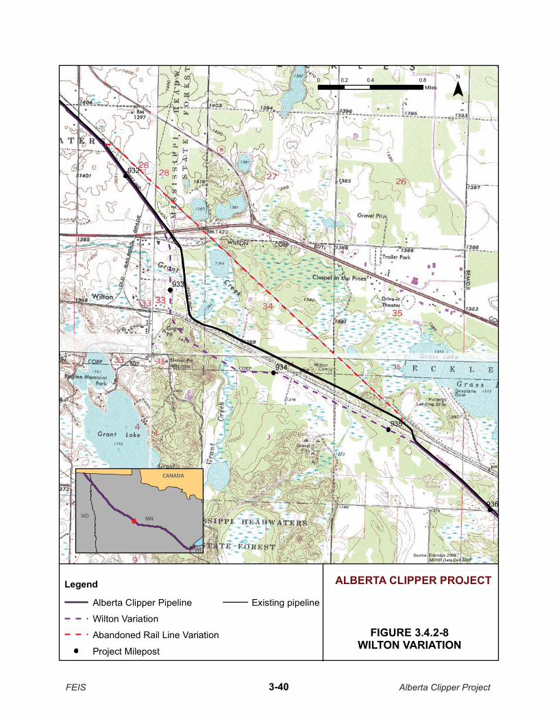
932
934
935
933
936
FIGURE 3.4.2-8WILTON VARIATION
Source: Enbridge 2009 �DNR Data Deli 2008
¯0 0.4 0.80.2Miles
ALBERTA CLIPPER PROJECTLegend
Alberta Clipper Pipeline
Wilton Variation
Abandoned Rail Line Variation
Project Milepost
Existing pipeline
MNND
WI
FEIS Alberta Clipper Project3-40
CANADA

TABLE 3.4.2-3 Comparison of the Wilton Variation and the Existing
Right-of-Way Route from MP 931. 7 to MP 935.0
Feature Unit Wilton Variation / Proposed Project Route
Existing Right-of-Way Route
Total length Miles 3.47 3.25
Greenfield route Miles 1.00 0.09
Collocated with existing right-of-way
Miles 1.98 0.57
Collocated with existing Enbridge right-of-way
Miles 1.01 0.0
Federal lands crossed Number / length (mi.)
0.0 2.38
Road crossings Number 0.24 0.65
Railroad crossings Number 1.30 1.26
DNR PWI waterbody crossings/cold water fisheries
Number 4 1
DNR PWI wetland crossings Number 1 3 (2 – abandoned railroad grade)
Developed land Miles 2 / 0 0 / 0
Residences within 200 feet of proposed centerline
Number 0 0
Shallow bedrock Miles 0.24 0.60
Forested land Miles 2 4
Agricultural land Miles 0.00 0.00
Prime farmland Miles 1.93 1.56
Herbaceous lands Miles 0.64 0.15
Waterbody crossingsa Number 3 1
Wetland crossingsa Number / length (ft.) 4 / 1,291.0 4 / 1,382.6
Forested wetland crossingsa Number / length (ft.) 0 / 0.0 0 / 0.0
DNR-PWI = Department of Natural Resources – Public Waters Inventory a Table comparisons are NHDH and National Wetlands Inventory (NWI) data. Waterbody and wetland delineations for the Wilton
Variation/proposed Project route indicated six wetland crossings for a total length of 2,220.9 feet. Only NHDH and NWI data are presented for the existing right-of-way route because no field delineations of wetlands or waterbodies were conducted.
FEIS Alberta Clipper Project 3-41

3.4.2.9 Bemidji Power Line Variation
The Bemidji Power Line Variation would parallel the Enbridge right-of-way to the south and west near MP 937, as shown in Figure 3.4.2-9. The variation would avoid a constrained working space by being located farther from the existing Enbridge right-of-way while providing additional distance from the Bemidji Power Line. The variation was incorporated into the proposed Project route.
3.4.2.10 Bemidji Residential Subdivision Variation
The Bemidji Residential Subdivision Variation would deviate from the existing Enbridge right-of-way up to 1,000 feet to the south and west near MP 938, as shown in Figure 3.4.2-10. The variation would reduce congestion conflicts with two residential areas and businesses. The variation was incorporated into the proposed Project route.
3.4.2.11 Necktie River Variation
The existing Enbridge right-of-way west of the Necktie River diverges into two rights-of-way with three pipelines in the northern right-of-way and one in the southern. Additionally, non-Enbridge pipelines lie in another right-of-way south of the southern Enbridge right-of-way. This area of multiple pipeline rights-of way is further constrained by the meandering Necktie River to the north, which is generally paralleling the pipelines before they all cross the river. Enbridge proposed to follow the southern right-of-way and cross under the non-Enbridge pipelines to the south from MP 945.0 to MP 946.1. At MP 946.1, Enbridge proposed to cross back to the north and follow its existing southern right-of-way for about 1 mile to cross the Necktie River and rejoin the existing northern right-of-way.
Following the issuance of the DEIS, DOS received comments from federal and state agencies stating that the route approach to the river should be revised to incorporate the northern right-of-way, or utilize a dry crossing method for the crossing of the Necktie River. The northern right-of-way crosses the Necktie River twice and becomes constrained between the river and U.S. Highway 2. Enbridge evaluated a route variation that would parallel the wider, non-Enbridge pipeline right-of-way for a greater distance before joining the southern Enbridge right-of-way for the Necktie River crossing. The Necktie River Variation would continue along the non-Enbridge pipeline right-of-way for about 0.5 mile before turning north to the southern Enbridge right-of-way, creating about 0.2 mile of greenfield route, as shown in Figure 3.4.2-11 Resource impacts associated with the proposed Project route and the Necktie River Variation would be similar, except that the variation would include the greenfield portion, as detailed in Table 3.4.2-4. In addition, Enbridge has agreed to utilize a dry crossing method of the Necktie River; therefore, an alternate construction method is considered environmentally preferable, but the Necktie River Variation is not considered to be preferable to the proposed Project route.
FEIS Alberta Clipper Project 3-42

937
936.9
936.4
937.1
936.5
936.6
936.7
936.8
FIGURE 3.4.2-9BEMIDJI POWER LINE
VARIATION
Source: Enbridge 2009
¯0 0.05 0.10.025Miles
ALBERTA CLIPPER PROJECTLegend
Alberta Clipper
Bemidji Power Line Variation
Project Milepost
Extra Temporary Workspace
Existing Pipeline
MNND
WI
FEIS Alberta Clipper Project3-43
CANADA

938
FIGURE 3.4.2-10BEMIDJI RESIDENTIAL
SUBDIVISION VARIATION
Source: Enbridge 2009
¯
ALBERTA CLIPPER PROJECTLegend
Alberta Clipper Pipeline
Bemidji Residential Subdivision Variation
Project Milepost
Extra Temporary Workspace
Existing Pipeline
MNND
WI
0 0.07 0.140.035Miles
FEIS Alberta Clipper Project3-44
CANADA

946
947
945
947.
5
946.
5
945.
5
FIG
UR
E 3.
4.2-
11N
ECK
TIE
RIV
ERVA
RIA
TIO
N
Sour
ce: E
nbrid
ge 2
009
¯0
0.2
0.4
0.1
Mile
s
ALB
ERTA
CLI
PPER
PR
OJE
CT
Lege
nd
Albe
rta C
lippe
r Pip
elin
e
Nec
ktie
Riv
er V
aria
tion
Proj
ect M
ilepo
st
Extra
Tem
pora
ry W
orks
pace
Exis
ting
Pipe
line
MN
ND
WI
FEIS Alberta Clipper Project3-45
CAN
AD
A
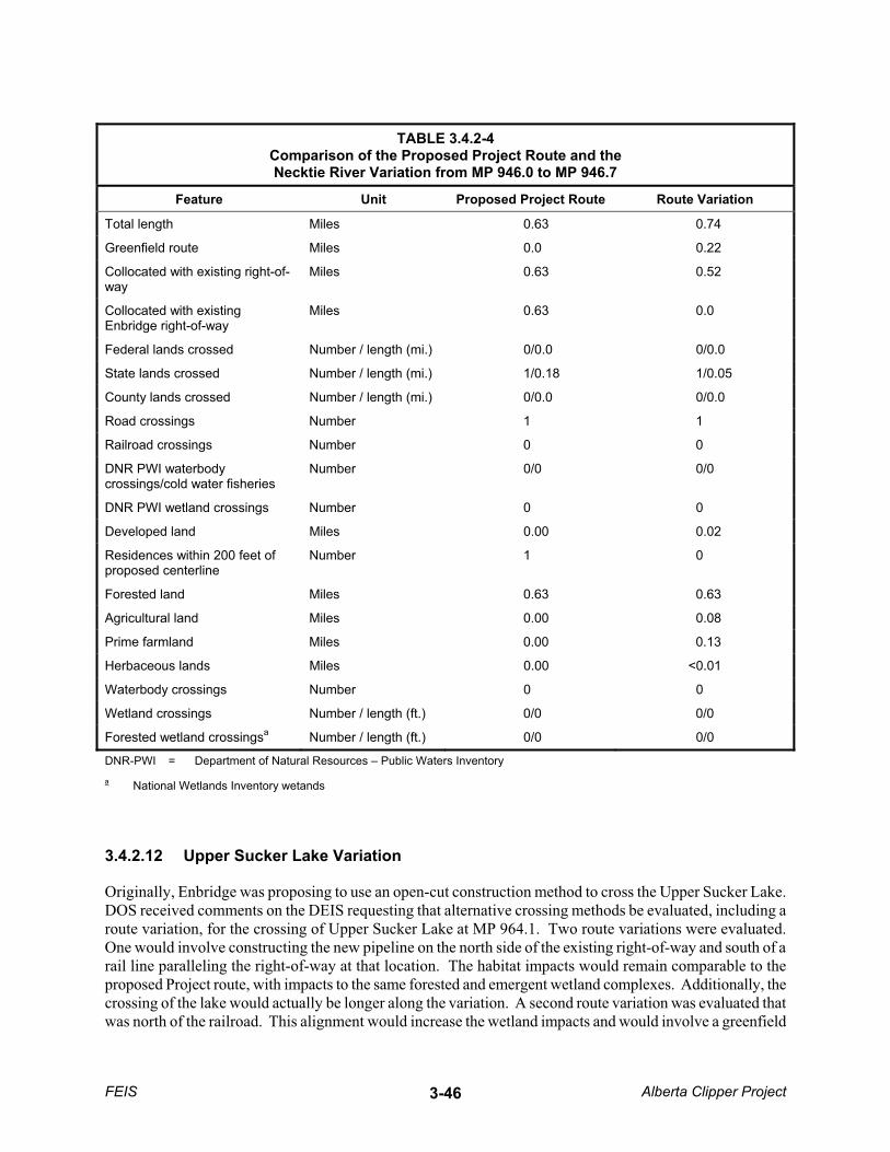
TABLE 3.4.2-4 Comparison of the Proposed Project Route and the Necktie River Variation from MP 946.0 to MP 946.7
Feature Unit Proposed Project Route Route Variation
Total length Miles 0.63 0.74
Greenfield route Miles 0.0 0.22
Collocated with existing right-of-way
Miles 0.63 0.52
Collocated with existing Enbridge right-of-way
Miles 0.63 0.0
Federal lands crossed Number / length (mi.) 0/0.0 0/0.0
State lands crossed Number / length (mi.) 1/0.18 1/0.05
County lands crossed Number / length (mi.) 0/0.0 0/0.0
Road crossings Number 1 1
Railroad crossings Number 0 0
DNR PWI waterbody crossings/cold water fisheries
Number 0/0 0/0
DNR PWI wetland crossings Number 0 0
Developed land Miles 0.00 0.02
Residences within 200 feet of proposed centerline
Number 1 0
Forested land Miles 0.63 0.63
Agricultural land Miles 0.00 0.08
Prime farmland Miles 0.00 0.13
Herbaceous lands Miles 0.00 <0.01
Waterbody crossings Number 0 0
Wetland crossings Number / length (ft.) 0/0 0/0
Forested wetland crossingsa Number / length (ft.) 0/0 0/0
DNR-PWI = Department of Natural Resources – Public Waters Inventory a National Wetlands Inventory wetands
3.4.2.12 Upper Sucker Lake Variation
Originally, Enbridge was proposing to use an open-cut construction method to cross the Upper Sucker Lake. DOS received comments on the DEIS requesting that alternative crossing methods be evaluated, including a route variation, for the crossing of Upper Sucker Lake at MP 964.1. Two route variations were evaluated.One would involve constructing the new pipeline on the north side of the existing right-of-way and south of a rail line paralleling the right-of-way at that location. The habitat impacts would remain comparable to the proposed Project route, with impacts to the same forested and emergent wetland complexes. Additionally, the crossing of the lake would actually be longer along the variation. A second route variation was evaluated that was north of the railroad. This alignment would increase the wetland impacts and would involve a greenfield
FEIS Alberta Clipper Project 3-46

route. Therefore, neither route variation would reduce environmental impacts to resources in the area compared to the proposed Project route.
Because the route variations did not lessen the impacts, alternative construction methods were evaluated along the proposed Project route. A guided bore would not be feasible for a pipeline the diameter of that proposed for the Alberta Clipper Project at this crossing distance. Due to the engineering constraints associated with an HDD at this location, Enbridge is currently proposing to use a push-pull method for the Alberta Clipper pipeline. The variation was not incorporated into the proposed Project route.
3.4.2.13 Portage Lake Residences Variation
The existing Enbridge right-of-way near this variation is adjacent to a residence located along the south side of the right-of-way (Figure 3.4.2-12). The proposed route in this area, therefore, is an 0.8-mile greenfield route south of the existing right-of-way that avoids the residence and an area of future residential development (MP 970.5 to MP 972.3). The alternative to the initially proposed route would cross under the existing pipelines to the north side of the existing right-of-way to avoid the residence and would then cross back under the existing pipelines to the south side to avoid a large wetland complex near MP 971.6. Additionally, construction on the north side of the existing right-of-way would require the clearing of a wooded buffer between the existing Enbridge right-of-way and the railroad for about 1.0 mile. Landowners in the area expressed concerns regarding noise and visual impacts from the loss of this buffer, which would be avoided with this variation. The variation was incorporated into the proposed Project route.
3.4.2.14 Mississippi River Variation
There are two separate west-to-east Enbridge pipeline rights-of-way within 1,000 feet of each other between approximately Bena, Minnesota (MP 973.6) and the east side of the Mississippi River (MP 986). In general, the proposed Alberta Clipper pipeline would be collocated along the northern Enbridge right-of-way in this area. The Mississippi River Variation would divert from the northern Enbridge right-of-way at MP 986.7, turn south to join the southern Enbridge right-of-way on the east side of the Mississippi River crossing, and parallel the southern right-of-way before the two rights-of-way rejoin at about MP 988.2 (Figure 3.4.2-13). Not only does the northern Enbridge right-of-way pass near residences, but it is also constrained by paralleling roadways and a railroad. This variation would require approximately 1,000 feet of new greenfield right-of-way between the two existing rights-of-way, but the variation is currently proposed because it would provide greater distance from residences.
3.4.2.15 Blackberry Variation
The Blackberry Variation would parallel the existing Enbridge pipeline right-of-way on the north side. The variation would divert from the existing right-of-way at MP 1011.3 near the Village of Blackberry and would rejoin the existing right-of-way at MP 1016.9. The variation would be about 0.6 mile longer than if the pipeline followed the existing right-of-way, but it would avoid encroachment on a feedlot and grasslands at the request of a landowner, as shown in Figure 3.4.2-14. The variation was incorporated into the proposed Project route.
FEIS Alberta Clipper Project 3-47

971
972
970.
5
971.
5
972.
5
FIG
UR
E 3.
4.2-
1�PO
RTA
GE
LAK
E R
ESID
ENC
ESVA
RIA
TIO
N
Sour
ce: E
nbrid
ge 2
009
¯0
0.2
0.4
0.1
Mile
s
ALB
ERTA
CLI
PPER
PR
OJE
CT
Lege
nd
Albe
rta C
lippe
r Pip
elin
e
Porta
ge L
ake
Res
iden
ces
Varia
tion
Proj
ect M
ilepo
st
Extra
Tem
pora
ry W
orks
pace
Exis
ting
Pipe
line
MN
ND
WI
FEIS Alberta Clipper Project3-48
CAN
AD
A

987.
5
988.
5
985.
5
986.
5
FIG
UR
E 3.
4.2-
1�M
ISSI
SSIP
PI R
IVER
VA
RIA
TIO
N
Sour
ce: E
nbrid
ge 2
009
¯0
0.2
0.4
0.1
Mile
s
ALB
ERTA
CLI
PPER
PR
OJE
CT
Lege
nd
Albe
rta C
lippe
r Pip
elin
e
Mis
siss
ippi
Riv
er V
aria
tion
Proj
ect M
ilepo
st
Exis
ting
Pipe
lineMN
ND
WI
FEIS Alberta Clipper Project3-49
CAN
AD
A

1015
1016
1017
1011
1012
1013
1014
FIG
UR
E 3.
4.2-
1�B
LAC
KB
ERRY
VA
RIA
TIO
N
Sour
ce: E
nbrid
ge 2
009
MD
NR
���
���
���2
008
¯0
0.5
10.
25M
iles
ALB
ERTA
CLI
PPER
PR
OJE
CT
Lege
nd
Albe
rta C
lippe
r Pip
elin
e
Blac
kber
ry V
aria
tion
Proj
ect M
ilepo
st
Exis
ting
Pipe
line
1015
MN
ND
WI
FEIS Alberta Clipper Project3-50
CAN
AD
A
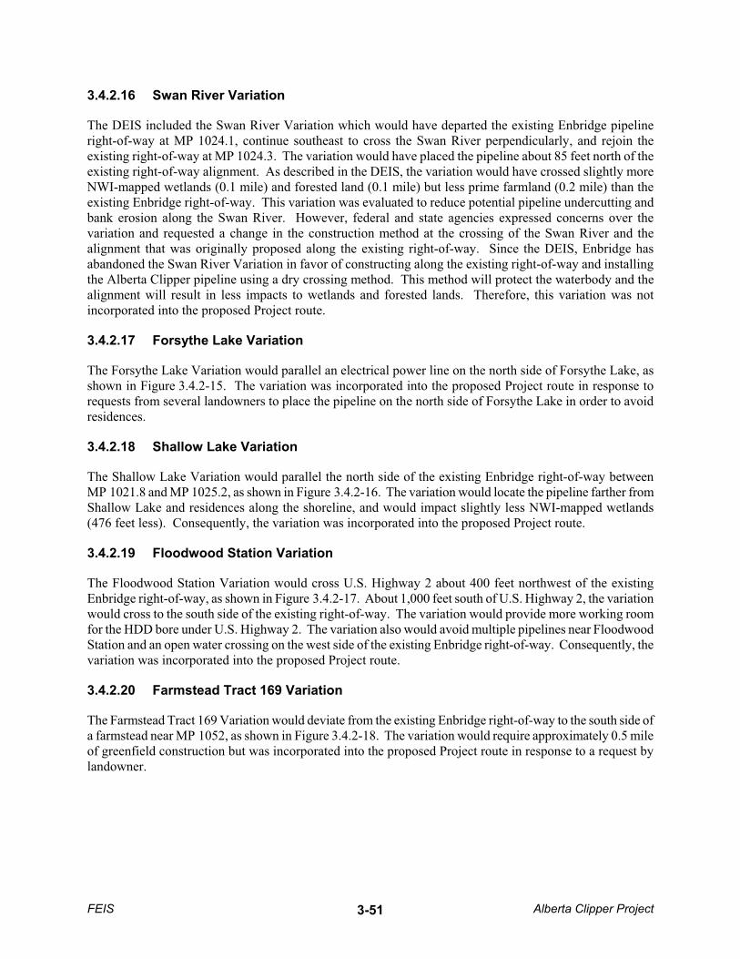
3.4.2.16 Swan River Variation
The DEIS included the Swan River Variation which would have departed the existing Enbridge pipeline right-of-way at MP 1024.1, continue southeast to cross the Swan River perpendicularly, and rejoin the existing right-of-way at MP 1024.3. The variation would have placed the pipeline about 85 feet north of the existing right-of-way alignment. As described in the DEIS, the variation would have crossed slightly more NWI-mapped wetlands (0.1 mile) and forested land (0.1 mile) but less prime farmland (0.2 mile) than the existing Enbridge right-of-way. This variation was evaluated to reduce potential pipeline undercutting and bank erosion along the Swan River. However, federal and state agencies expressed concerns over the variation and requested a change in the construction method at the crossing of the Swan River and the alignment that was originally proposed along the existing right-of-way. Since the DEIS, Enbridge has abandoned the Swan River Variation in favor of constructing along the existing right-of-way and installing the Alberta Clipper pipeline using a dry crossing method. This method will protect the waterbody and the alignment will result in less impacts to wetlands and forested lands. Therefore, this variation was not incorporated into the proposed Project route.
3.4.2.17 Forsythe Lake Variation
The Forsythe Lake Variation would parallel an electrical power line on the north side of Forsythe Lake, as shown in Figure 3.4.2-15. The variation was incorporated into the proposed Project route in response to requests from several landowners to place the pipeline on the north side of Forsythe Lake in order to avoid residences.
3.4.2.18 Shallow Lake Variation
The Shallow Lake Variation would parallel the north side of the existing Enbridge right-of-way between MP 1021.8 and MP 1025.2, as shown in Figure 3.4.2-16. The variation would locate the pipeline farther from Shallow Lake and residences along the shoreline, and would impact slightly less NWI-mapped wetlands (476 feet less). Consequently, the variation was incorporated into the proposed Project route.
3.4.2.19 Floodwood Station Variation
The Floodwood Station Variation would cross U.S. Highway 2 about 400 feet northwest of the existing Enbridge right-of-way, as shown in Figure 3.4.2-17. About 1,000 feet south of U.S. Highway 2, the variation would cross to the south side of the existing right-of-way. The variation would provide more working room for the HDD bore under U.S. Highway 2. The variation also would avoid multiple pipelines near Floodwood Station and an open water crossing on the west side of the existing Enbridge right-of-way. Consequently, the variation was incorporated into the proposed Project route.
3.4.2.20 Farmstead Tract 169 Variation
The Farmstead Tract 169 Variation would deviate from the existing Enbridge right-of-way to the south side of a farmstead near MP 1052, as shown in Figure 3.4.2-18. The variation would require approximately 0.5 mile of greenfield construction but was incorporated into the proposed Project route in response to a request by landowner.
FEIS Alberta Clipper Project 3-51

1004
1006
1005
1005
.5
1004
.5
FIG
UR
E 3.
4.2-
1�FO
RSY
THE
LAK
EVA
RIA
TIO
N
Sour
ce: E
nbrid
ge 2
009
¯0
0.1
0.2
0.3
0.05
Mile
s
ALB
ERTA
CLI
PPER
PR
OJE
CT
Lege
nd
Albe
rta C
lippe
r Pip
elin
e
Fors
ythe
Lak
e Va
riatio
n
Proj
ect M
ilepo
st
Extra
Tem
pora
ry W
orks
pace
Exis
ting
Pipe
line
MN
ND
WI
FEIS Alberta Clipper Project3-52
CAN
AD
A
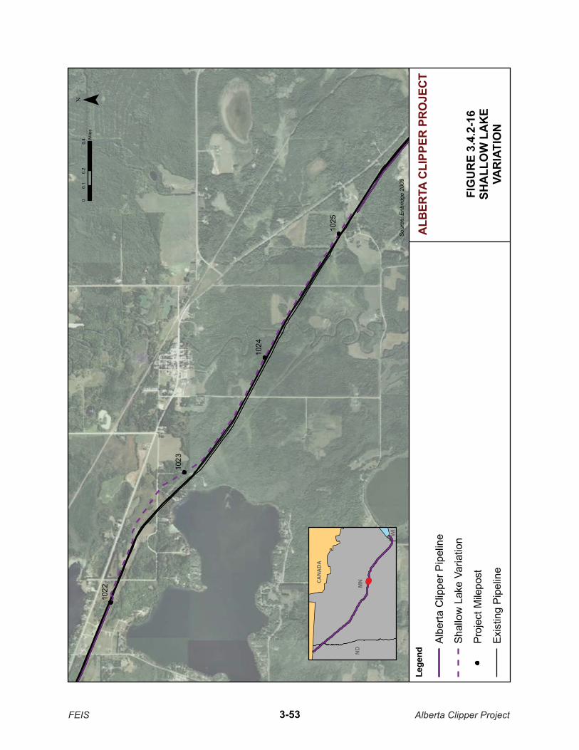
1023
1022
1024
1025
FIG
UR
E 3.
4.2-
1�SH
ALL
OW
LA
KE
VAR
IATI
ON
Sour
ce: E
nbrid
ge 2
009
¯0
0.2
0.4
0.1
Mile
s
ALB
ERTA
CLI
PPER
PR
OJE
CT
MN
ND
WI
Lege
nd
Albe
rta C
lippe
r Pip
elin
e
Shal
low
Lak
e Va
riatio
n
Proj
ect M
ilepo
st
Exis
ting
Pip
elin
e
FEIS Alberta Clipper Project3-53
CAN
AD
A
1045
1045.1
1044.3
1045.3
1044.5
1044.7
1043.9
1044.9
1044.1
FIGURE 3.4.2-1�FLOODWOOD STATION
VARIATION
Source: Enbridge 2009
¯0 0.250.125
Miles
ALBERTA CLIPPER PROJECTLegend
Alberta Clipper Pipeline
Floodwood Station Variation
Project Milepost
Extra Temporary Workspace
Existing pipeline
MNND
WI
FEIS Alberta Clipper Project3-54
CANADA

1052.1
1052.3
1051.5
1052.5
1051.7
1051.9
FIGURE 3.4.2-1�FARMSTEAD TRACT 169
VARIATION
Source: Enbridge 2009
¯
ALBERTA CLIPPER PROJECTLegend
Alberta Clipper Pipeline
Farmstead Tract 169 Variation
Project Milepost
Extra Temporary Workspace
Existing Pipeline
MNND
WI
0 0.1 0.20.05Miles
FEIS Alberta Clipper Project3-55
CANADA
3.4.2.21 Farmstead Tract 72 Variation
The Farmstead Tract 72 Variation would cross from the south to north side of the existing Enbridge right-of-way at MP 1077.5, as shown in Figure 3.4.2-19. The variation would cross slightly more NWI-mapped wetland habitat (130 feet), but was incorporated into the proposed Project route at the request of the landowner to move the route farther from a residence.
3.4.2.22 Stream 37 Variation
A route variation was evaluated from MP 1086.1 to MP 1086.5 to minimize impacts to an unnamed tributary to the Pokegama River (Figure 3.4.2-20). The meandering tributary is located in the center of the existing pipeline right-of-way that Enbridge is proposing to follow in this area. The route variation includes moving the construction and permanent right-of-way north of the existing right-of-way to avoid the approximate 1,300-foot section of the tributary that is located within the existing right-of-way. This incorporated variation would also minimize impacts to wetlands associated with the tributary.
3.4.2.23 Farmstead 25 Variation
A route variation was evaluated from MP 1089.3 to MP 1089.7 due to a request from the landowner (Figure 3.4.2-21). The proposed route variation is a greenfield route through an actively cultivated hay field south of the existing right-of-way. The variation would result in two additional waterbody crossings of unnamed drainage ditches in the hay field; however, it would also result in the reduction of wetland impacts by 4.3 acres and address the landowner concern. Thus, this variation was incorporated into the proposed Project route.
3.4.2.24 Pokegama-Carnegie Wetland Complex Variation
At the request of the WDNR, Enbridge conducted a more detailed route variation analysis of the Pokegama-Carnegie Wetland Complex located between MP 1090.6 and MP 1094.1 (Appendix T). To summarize, the Pokegama-Carnegie Wetland Complex is an Area of Special Natural Resource Interest (ANSRI), a portion of which is also designated as a State Natural Area. The existing right-of-way and proposed Project route traverse the wetland complex. Within the wetland complex, Enbridge proposes to install the pipeline on the north side, utilize its existing corridor during construction, and decrease the spacing between the pipelines to minimize impacts to the complex. Enbridge would essentially be reducing the normal 50-foot permanent right-of-way width to 10 feet within the wetland complex.
In consultation with WDNR and the COE, Enbridge evaluated three route variations (PC1, PC2, and PC3) to avoid the wetland complex. Each of the evaluated variations would avoid the wetland complex, although not completely. However, each variation would result in a longer route and require a new right-of-way (140 feet for construction and 75 feet for operation), which would result in increases to temporary and permanent effects compared to the proposed Project route. Additionally, each variation would generally affect about 17 acres during construction and 9 acres during operation per mile of right-of-way. The proposed Project route and construction modifications would result in temporary impacts to approximately 6 acres and permanent impacts to 1.2 acres. Therefore, collocation with the existing right-of-way would result in fewer impacts to environmental resources as a whole in the area of the Pokegama-Carnegie Wetland Complex and none of the three route variations were incorporated into the proposed Project route.
FEIS Alberta Clipper Project 3-56

1077
.9
1077
.5
1077
.7
FIG
UR
E 3.
4.2-
FAR
MST
EAD
TR
AC
T 72
VAR
IATI
ON
Sour
ce: E
nbrid
ge 2
009
¯0
0.05
0.1
0.02
5M
iles
ALB
ERTA
CLI
PPER
PR
OJE
CT
Lege
nd
Albe
rta C
lippe
r Pip
elin
e
Farm
stea
d Tr
act 7
2 Va
riatio
n
Proj
ect M
ilepo
st
Extra
Tem
pora
ry W
orks
pace
Exis
ting
Pipe
lines
MN
ND
WI
FEIS Alberta Clipper Project3-57
CAN
AD
A

1086
.3
1086
.1
1086
.5
FIG
UR
E 3.
4.2-
20ST
REA
M 3
7VA
RIA
TIO
N
Sour
ce: E
nbrid
ge 2
009
¯0
0.04
0.08
0.02
Mile
s
ALB
ERTA
CLI
PPER
PR
OJE
CT
Lege
nd
Albe
rta C
lippe
r Pip
elin
e
Stre
am 3
7 Va
riatio
n
Proj
ect M
ilepo
st
Extra
Tem
pora
ry W
orks
pace
Exis
ting
Pip
elin
es
CA
NA
DA
MN
ND
WI
FEIS Alberta Clipper Project3-58

1089
.5
1089
.7
1089
.3
FIG
UR
E 3.
4.2-
21FA
RM
STEA
D T
RA
CT
25VA
RIA
TIO
N
Sour
ce: E
nbrid
ge 2
009
¯0
0.05
0.1
0.02
5M
iles
ALB
ERTA
CLI
PPER
PR
OJE
CT
Lege
nd
Albe
rta C
lippe
r Pip
elin
e
Farm
stea
d Tr
act 2
5 Va
riatio
n
Proj
ect M
ilepo
st
Extra
Tem
pora
ry W
orks
pace
Exis
ting
Pip
elin
es
CA
NA
DA
MN
ND
WI
FEIS Alberta Clipper Project3-59
3.4.2.25 Nemadji Golf Course Variation
The existing Enbridge pipeline right-of-way crosses the Nemadji Golf Club in Superior, Wisconsin between MP 1096.2 and MP 1096.9 (Figure 3.4.2-22). Construction along the existing Enbridge right-of-way would restrict use of some golf course facilities, remove trees along the golf course, and create noise and dust. The City of Superior requested that Enbridge develop a route variation to avoid crossing the golf course. Enbridge initially identified a route variation to the west of the golf course that would follow an existing railroad into the Superior Terminal. However, the variation west of the golf course would cross a wetland area that is designated as an ASNRI, and several comments were received on the DEIS regarding the route variation through the specially designated wetland area. Subsequent to the DEIS, Enbridge identified a new variation to try to better balance impacts to both the golf course and the wetland. The new variation would be on the golf course property; however, it would follow the western boundary of the property for about 2,900 feet before rejoining the existing right-of-way. The route variation would avoid the impacts to the wetland area to the west of the golf course and be slightly less obtrusive to the golf course since it would be located along the edge of the facility. This new variation was incorporated into the proposed Project route.
3.5 ABOVEGROUND FACILITY ALTERNATIVES
The proposed Project was designed to follow the existing Enbridge pipeline alignment throughout most of its length. Consequently, the proposed Project would pass close to existing pump stations. The proposed Project was designed with all additional pumping equipment to be installed within the boundaries of the existing pump stations. Alternative pump station sites would involve developing new pump stations that would create new industrial facilities in rural areas and cause new environmental disturbances. Because no potential alternative pump station sites would result in fewer environmental impacts than the proposed Project, no further investigation was conducted regarding aboveground facility alternatives.
3.6 SUPERIOR TERMINAL EXPANSION ALTERNATIVES
To support the expected volume of crude oil transported by the Alberta Clipper pipeline, Enbridge states that 1,000,000 barrels of dedicated tankage breakout capacity is required. To meet this need, Enbridge plans to construct five additional tanks (each with 250,000-barrel capacity) at the Superior Terminal to provide storage prior to the oil being distributed to the target markets. The regular operating capacity of a 250,000-barrel tank is approximately 200,000 barrels because oil tanks are not filled to 100-percent capacity.
According to Enbridge, the proposed tanks must be located in the immediate vicinity of the Superior Terminal to efficiently meet operational, technical, and economical requirements of the pipeline system. The Superior Terminal has the ability to readily distribute oil via existing infrastructure to markets located east and south of Superior, Wisconsin. The construction and operation of storage tanks at a different facility would result in additional environmental impacts associated with connecting a new terminal to the existing distribution routes. Relocation of the project beyond the immediate vicinity of the Superior Terminal would result in Enbridge determining that the storage tank expansion project is not practical.
Regulatory evaluation of the Superior Terminal Expansion Project is ongoing by the appropriate federal, state, and local regulatory agencies (e.g., the COE and WDNR). DOS does not have regulatory or permit authority over the Superior Terminal Expansion Project. As a connected action to the Alberta Clipper Project, the proposed Superior Terminal Expansion Project is described throughout Section 4.0 of this FEIS.
As part of the environmental review for the Superior Terminal Expansion Project by the COE and WDNR, Enbridge was asked by the COE and WDNR to prepare an alternatives analysis for siting the additional tanks.
FEIS Alberta Clipper Project 3-60
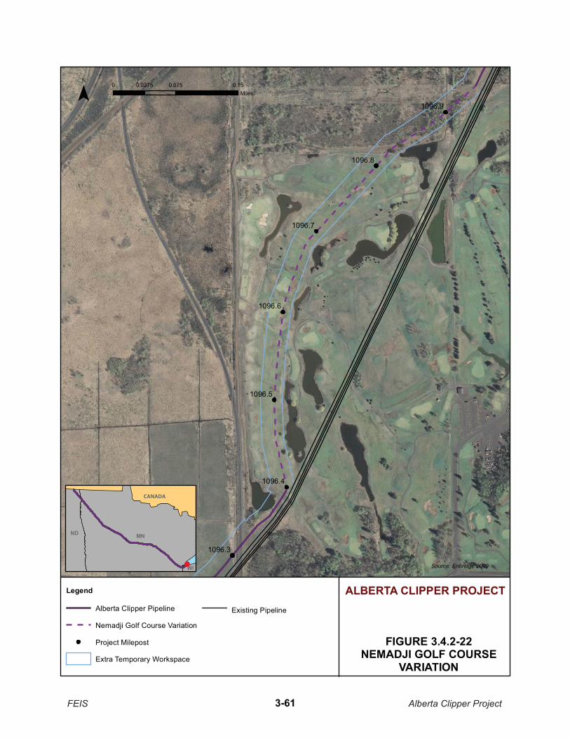
1096.4
1096.5
1096.6
1096.7
1096.8
1096.9
1096.3
FIGURE 3.4.2-22NEMADJI GOLF COURSE
VARIATION
Source: Enbridge 2009
¯
ALBERTA CLIPPER PROJECTLegend
Alberta Clipper Pipeline
Nemadji Golf Course Variation
Project Milepost
Extra Temporary Workspace
Existing Pipeline
MNND
WI
0 0.075 0.150.0375Miles
FEIS Alberta Clipper Project3-61
CANADA

The alternatives analysis evaluated a range of alternative sites and configurations for the Superior Terminal Expansion Project (Appendix S). The broad categories of alternatives included no-build; upstream alternatives along the existing pipeline corridor; off-site locations within Superior, Wisconsin and over 1 mile from the Superior Terminal; off-site locations within 1 mile of the Superior Terminal; on-site alternatives; and tank volume adjustments to reduce the number of storage tanks required. Each alternative is described in detail in Appendix S. The following sections provide an overall summary of Appendix S.
3.6.1.1 No-Construct Alternative
The No-Construct Alternative would result in refusing service to the clients or the need to use existing tankage to service incoming product from the Alberta Clipper pipeline. The No-Construct Alternative was rejected by Enbridge because the target market of the oil being transported by the Alberta Clipper pipeline is primarily in the U.S. Midwestern states, which are already connected to the Enbridge system via existing pipelines. Other existing terminals do not have direct distribution capabilities to reach the target markets. Additionally, the existing terminals are at their maximum capacity and using them to meet the needs of the additional incoming crude oil would result in insufficient capacity to meet demand.
3.6.1.2 Upstream Alternatives
Upstream alternative locations were identified along the existing Enbridge pipeline corridor where Enbridge either owned property or could purchase property that contained at least 25 acres. Based on these criteria, three sites were identified at the request of the COE and WDNR: the Enbridge terminal at Clearbrook, Minnesota; a mainline pump station near Floodwood, Minnesota; and expansion of an existing tank storage facility (not owned by Enbridge) near Wrenshall, Minnesota. Detailed descriptions and figures depicting the locations of each of these facilities are located in Appendix S.
Each of the three upstream locations would require more construction than what would be required at the Superior Terminal. Greater environmental impacts would result from each of these when compared to the Superior Terminal because construction of additional pipelines, pumps, and manifolds would be required for each of these facilities to adequately handle the additional volumes for storage. Additional staff and equipment would also be required at the upstream locations to minimize emergency response times compared to the Superior Terminal, which already has the appropriate staff and equipment in place.
3.6.1.3 Off-Site Alternatives in Superior: Greater Than 1 Mile from the Superior Terminal
Two off-site alternative locations greater than 1 mile from the central manifold of the Superior Terminal were identified within Superior, Wisconsin. One location is a 22-acre tract at the former Amoco storage tank facility (see Figure 4 of Appendix S). The former storage tanks have been removed from the site, and WDNR maintains open environmental files associated with potential contamination that would need to be resolved prior to future development of the site. Construction of five 36-inch pipelines through the City of Superior would be required to connect the site to the Superior Terminal, about 5.5 miles away.
The second off-site location, the former Unical and Murphy Oil storage tank facility, is about 5.5 miles from the Superior Terminal (see Appendix S). The property is comprised of five tracts, bisected by a railroad. Contamination issues exist on both sites; however, some clean-up/restoration has been performed on one of the tracts. Wetlands and an unnamed stream are located on the northeastern portion of the site, which would prevent development in that area. The amount of remaining acreage and layout of the tract would then prevent development of the site for use by Enbridge.
In summary, both off-site locations greater than 1 mile from the Superior Terminal are about 5.5 miles to the northwest. Each would require pipeline construction through the City of Superior and would encumber
FEIS Alberta Clipper Project 3-62

existing infrastructure, roads, and developments (primarily residential). Both sites also have contamination issues associated with them. For these reasons, Enbridge concluded that neither site was environmentally superior to the proposed expansion of the existing Superior Terminal.
3.6.1.4 Off-Site Alternatives in Superior: within 1 Mile of the Superior Terminal
Alternative sites considered by Enbridge for the locations within one mile of the Superior Terminal included industrial-zoned lands containing a minimum of 25 acres. Properties either owned by Enbridge or available for purchase were considered. Figure 6 in Appendix S illustrates the properties located within 1 mile of the Superior Terminal: the Superior Terminal, a portion of the Murphy Oil Refinery and Terminal, residential developments, a portion of the Nemadji Golf Course, wetlands, and 100-year floodplain associated with the Nemadji River. Of these identified areas, excluding the Superior Terminal, only the area west of the Murphy Oil Refinery and the area contained within the Nemadji Golf Course were considered viable for further evaluation.
The golf course is owned by the City of Superior. The purchase of 25 acres for construction of the proposed breakout tanks would reduce the size of the current course, currently a 36-hole golf course. Construction on the golf course would also affect wetlands located on the property.
The area to the west of the Murphy Oil Refinery, referred to as the Hill Avenue Alternative in Appendix S, is a 107-acre site that has been previously developed. Arranged in the most compressed configuration and utilizing the greatest available upland area, the total footprint of the expansion project would be 15.3 acres—all of which would be permanent wetland impact and 2.3 acres of temporary wetland impact from installation of new piping to connect the site to the existing mainline. The site contains a historical wetland complex that has been fragmented by railroads, roadways, stormwater conveyance ditches, and industrial development. Along with wetlands, surveys of the site documented the presence of state-listed rare plants and special designation of this site as a “Priority Wetland Area” by WDNR. The Hill Avenue Alternative was rejected because of a lack of existing infrastructure, the high quality of undisturbed wetlands on the site, and WDNR designation as a priority wetland.
The alternatives analysis concluded that neither off-site alternative within 1 mile of the Superior Terminal is considered environmentally preferable to the proposed action.
3.6.1.5 On-Site Alternatives
Two locations were identified (10th Street Alternative and Stinson Avenue Alternative) within the boundaries of the Superior Terminal that could be developed with the five proposed breakout tanks and associated equipment. At each location, three alternative configurations were further evaluated to determine which one would best meet the construction and operation requirements while minimizing environmental impacts. The 10th Street Alternatives (A1, A2, and A3) and the Stinson Avenue Alternatives (B1, B2, and B3) are discussed in detail in Appendix S, including Figures 8 through 13.
10th Street Alternative
The 10th Street Alternative is a 59.3-acre site owned by Enbridge. This area had been developed as residential but over time, structures have been removed that allowed reestablishment of wetlands. Trash and household debris, including electronics and furniture, occasionally are dumped on this site. Some remnants remain of structural foundations, sidewalks, alleys, and inactive streets. A portion of the existing terminal is located on this parcel, west of East 10th Street, where six tanks currently operate. Several historical and recently observed occurrences of state-listed rare plants have been documented in this area, including Vasey’s rush, arrowhead sweet coltsfoot, spike rush, and black sedge.
FEIS Alberta Clipper Project 3-63

The 10th Street Alternative is located near a residential neighborhood. Existing pipeline infrastructure in the area could be used to connect the tanks to the main pipeline, which would be used to carry product out from the terminal. Pre-project consultations with the COE and WDNR have indicated that this area may be the most feasible to permit of all properties evaluated that are owned by Enbridge and are adjacent to the existing terminal.
The alternatives analysis concluded that configuration A-3 (see Figure 10 in Appendix S) would have the least environmental impact of the three evaluated configurations of the 10th Street Alternatives. Arranged in the most compressed configuration and utilizing the greatest available upland area, the total footprint of the project, if located at this location, would be 14.1 acres. This location would result in 11.3 acres of permanent wetland impact and 3.20 acres of temporary wetland impact from installation of new piping to connect the site to the existing pipeline. This configuration, however, would also result in the loss of observed occurrences of state-listed rare plants documented at this location. The plants, Vasey’s rush, and potentially the arrowhead sweet coltsfoot, require the highly disturbed nature of the site for establishment. Enbridge is continuing to consult with the COE and WDNR regarding the rare species. This configuration at the 10th Street location is the preferred alternative for the proposed Superior Terminal Expansion Project.
Stinson Avenue Alternative
The Stinson Avenue Alternative is located on a 106.9-acre site currently owned by Enbridge. The site also contains areas of previous disturbance. A 100-foot wide pipeline corridor runs through the area; the site is bounded to the north by two rail lines, to the east by a raised utility corridor, and to the south by the Nemadji Golf Course. Most of the site is wetlands, and not enough uplands exist to avoid constructing the proposed facility almost entirely in wetland areas. Because of the segmented nature of the tract, the three evaluated configurations vary in shape and locations at the site.
Configuration B-2 (see Figure 12 in Appendix S) consists of the most compressed configuration and utilized the greatest available upland area. With this configuration, the total footprint of the project would be 20.9 acres, including 17.4 acres of permanent wetland impact and 1.1 acres of temporary wetland impact from installation of new piping to connect the site to the existing pipeline.
This alternative was rejected because the area with the most available upland was not feasible for placement of the tanks without extensive earthwork and resulting impacts to adjacent wetlands. A portion of this parcel borders the Nemadji Golf Course to the south and includes portions of the golf course fairway and paved trail. A snowmobile trail also runs through a portion of this area from Bardon Avenue west to the pipeline corridor. Uplands in this portion of the property include relatively steep slopes to a creek that drains to the Nemadji River. This alternative was rejected due to a lack of existing infrastructure, the inability to compress the project configuration to avoid wetland impacts compared to other sites, and its location adjacent to a public recreation facility.
In summary, two on-site locations and six alternate configurations were analyzed for the construction of the five proposed breakout storage tanks. Configuration A-3 (10th Street Alternative) is the Enbridge preferred alternative. Alternative A-3 would utilize a previously disturbed area associated with the Superior Terminal, would impact the least amount of wetland compared to the other configurations, and could make for a more efficient use of existing infrastructure.
3.6.1.6 Summary
Enbridge evaluated several alternatives to the proposed Superior Terminal Expansion. Based on the purpose and need for the Superior Terminal Expansion Project and analysis of the alternatives, the alternatives analysis concluded that the preferred Alternative A-3 (on-site location off 10th Street) would be located on the
FEIS Alberta Clipper Project 3-64
existing terminal property, thus requiring the least amount of associated construction, and resulting in the least impact. The COE and WDNR are currently evaluating the technical basis and conclusions of the alternatives analysis as part of their regulatory review of the Superior Terminal Expansion Project.
3.7 CONCLUSIONS
Several types of alternatives were analyzed in this EIS to determine whether they would be reasonable and environmentally preferable to the proposed action. A No Action Alternative, system alternatives, major route alternatives, route variations, and aboveground facility alternatives were considered.
While the No Action Alternative would eliminate the environmental impacts directly associated with the proposed Alberta Clipper Project, it would not meet the proposed action’s purpose and need or provide the United States with a secure source for its energy needs. Therefore, we concluded that the No Action Alternative is not a reasonable alternative.
System alternatives assessed in this EIS include existing and proposed oil pipelines, such as TransCanada’s Keystone and TransCanada’s proposed Keystone XL Projects, Enbridge’s existing pipeline system, and hauling alternatives (by trucks, rail, or barge). Based on our analysis, none of the alternatives would provide sufficient capacity to meet the proposed Project’s needs, nor were they environmentally preferable.
Three major route alternatives (Straight Line, GLG, and FDL) were analyzed in the EIS. None of the three major route alternatives is considered environmentally preferable to the proposed Project route. At the time of the DEIS, the proposed route avoided the FDL Reservation and the route traversing the reservation was evaluated as an alternative. Since then, Enbridge and FDL have agreed that the traverse route is preferable and it has now been incorporated into the proposed route. Alternately, the route that avoids the FDL Reservation is now presented as the FDL Alternative.
Additionally, WDNR requested that Enbridge evaluate eight specific route alternatives to the proposed Project route in the State of Wisconsin. One of those alternatives, the North Trail Corridor, was not considered practical due to constructability issues. The remaining seven alternatives suggested by WDNR were further evaluated. When compared to the proposed Project route through Wisconsin, these alternatives were not determined to be environmental preferable.
It has been stated throughout this EIS that Enbridge tried to select a route that would collocate the Alberta Clipper Pipeline with its existing right-of-way as much as possible. In certain locations, the Enbridge right-of-way diverges and two rights-of-way have been established. Comments were received on the DEIS requesting justification and an evaluation of why one right-of-way was chosen over the other. The commenter’s primary concerns were regarding wetland impacts. Seven specific locations were brought to our attention, and the EIS presents an analysis of each of those locations.
The EIS describes route variations that Enbridge evaluated in 25 locations along the proposed route. Most of these variations were identified to avoid sensitive resources, residences, constructability constraints, and/or other landowner requests along the existing Enbridge right-of-way. The majority of these variations were incorporated into the proposed route for the Alberta Clipper Project. In some cases, Enbridge proposed a method of construction (usually a dry method) that was acceptable to the commenters and the route variation was not incorporated.
Several alternatives are presented regarding the Superior Terminal Expansion Project for the five proposed breakout storage tanks, which is considered a connected action to the Alberta Clipper Project. The Enbridge analysis indicates that the proposed site on 10th Street, adjacent to the existing Superior Terminal, would result in the least environmental impact.
FEIS Alberta Clipper Project 3-65

FEIS Alberta Clipper Project 3-66
3.8 REFERENCES
Administrative Law Judge. 2008. Filed by Eric L. Lipman, July 17, 2008. Summary of Testimony at the Public Hearings, Findings of Fact, Conclusions and Recommendations. State of Minnesota Office of Administrative Hearings for the Public Utilities Commission. Filed by Eric L. Lipman. July 17, 2008. (Docket Number PL9/CN-07-465.)
ALJ. See Administrative Law Judge.
Bureau of Transportation Statistics. 2009. Available online at: http://www.bts.gov/.
EIA. See Energy Information Agency.
Enbridge. See Enbridge Inc..
Enbridge, Inc.. 2007. Environmental Assessment: Alberta Clipper Pipeline Project. Prepared for the U.S. Department of State, Washington, D.C. Prepared by Natural Resources Group, Inc., Minneapolis, Minnesota.
Enbridge, Inc.. July 8, 2008. Letter from David H. Coburn to Ms. Elizabeth Orlando, U.S. Department of State. Regarding Enbridge Alberta Clipper Project – Revised Preferred Alignment. Dated July 8, 2008.
Enbridge, Inc.. January 2009. Wisconsin Department of Natural Resources Construction Project Consolidated Permit Application Supplemental Information and Appendices. Prepared by Natural Resource Group, L.L.C.
Enbridge, Inc. 2009. Responses to Data Requests dated February 18, 2009, February 22, 2009, and April 1, 2009. Provided to the Department of State from February 18, 2009 through April 30, 2009.
Energy Information Agency. 2009. Annual Energy Outlook 2009. Report # DOE/EIA-0383(2009). March 2009. Available online at: http://www.eia.doe.gov/oiaf/aeo/index.html.
MDNR. See Minnesota Department of Natural Resources.
Minnesota Department of Natural Resources. 2008. The DNR Data Deli Available online at: http://deli.dnr.state.mn.us/.
Minnesota Department of Natural Resources. 2008. Letter from Matt Langan to Ms. Elizabeth Orlando, U.S. Department of State (September 18, 2008). Regarding MDNR’s review of the Alberta Clipper Preliminary Draft Environmental Impact Statement. Dated September 18, 2008.