36122 federal register /vol. 66, no. 132/tuesday, july 10 ... · federal register/vol. 66, no....
TRANSCRIPT
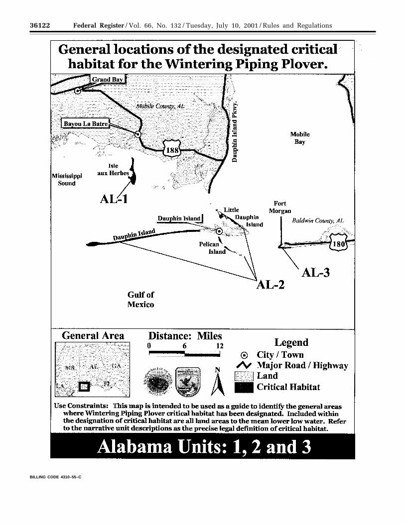
36122 Federal Register / Vol. 66, No. 132 / Tuesday, July 10, 2001 / Rules and Regulations
BILLING CODE 4310–55–C
VerDate 11<MAY>2000 11:26 Jul 09, 2001 Jkt 194001 PO 00000 Frm 00086 Fmt 4701 Sfmt 4700 E:\FR\FM\10JYR2.SGM pfrm06 PsN: 10JYR2
36123Federal Register / Vol. 66, No. 132 / Tuesday, July 10, 2001 / Rules and Regulations
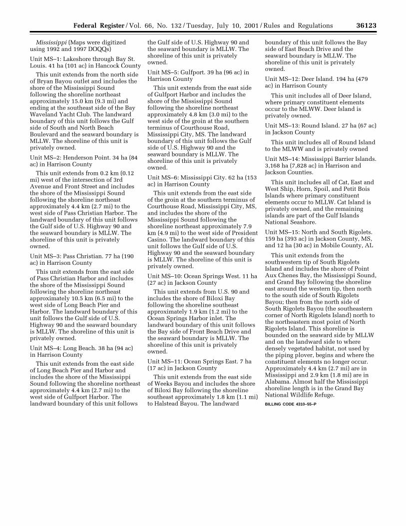
Mississippi (Maps were digitizedusing 1992 and 1997 DOQQs)
Unit MS–1: Lakeshore through Bay St.Louis. 41 ha (101 ac) in Hancock County
This unit extends from the north sideof Bryan Bayou outlet and includes theshore of the Mississippi Soundfollowing the shoreline northeastapproximately 15.0 km (9.3 mi) andending at the southeast side of the BayWaveland Yacht Club. The landwardboundary of this unit follows the Gulfside of South and North BeachBoulevard and the seaward boundary isMLLW. The shoreline of this unit isprivately owned.
Unit MS–2: Henderson Point. 34 ha (84ac) in Harrison County
This unit extends from 0.2 km (0.12mi) west of the intersection of 3rdAvenue and Front Street and includesthe shore of the Mississippi Soundfollowing the shoreline northeastapproximately 4.4 km (2.7 mi) to thewest side of Pass Christian Harbor. Thelandward boundary of this unit followsthe Gulf side of U.S. Highway 90 andthe seaward boundary is MLLW. Theshoreline of this unit is privatelyowned.
Unit MS–3: Pass Christian. 77 ha (190ac) in Harrison County
This unit extends from the east sideof Pass Christian Harbor and includesthe shore of the Mississippi Soundfollowing the shoreline northeastapproximately 10.5 km (6.5 mi) to thewest side of Long Beach Pier andHarbor. The landward boundary of thisunit follows the Gulf side of U.S.Highway 90 and the seaward boundaryis MLLW. The shoreline of this unit isprivately owned.
Unit MS–4: Long Beach. 38 ha (94 ac)in Harrison County
This unit extends from the east sideof Long Beach Pier and Harbor andincludes the shore of the MississippiSound following the shoreline northeastapproximately 4.4 km (2.7 mi) to thewest side of Gulfport Harbor. Thelandward boundary of this unit follows
the Gulf side of U.S. Highway 90 andthe seaward boundary is MLLW. Theshoreline of this unit is privatelyowned.
Unit MS–5: Gulfport. 39 ha (96 ac) inHarrison County
This unit extends from the east sideof Gulfport Harbor and includes theshore of the Mississippi Soundfollowing the shoreline northeastapproximately 4.8 km (3.0 mi) to thewest side of the groin at the southernterminus of Courthouse Road,Mississippi City, MS. The landwardboundary of this unit follows the Gulfside of U.S. Highway 90 and theseaward boundary is MLLW. Theshoreline of this unit is privatelyowned.
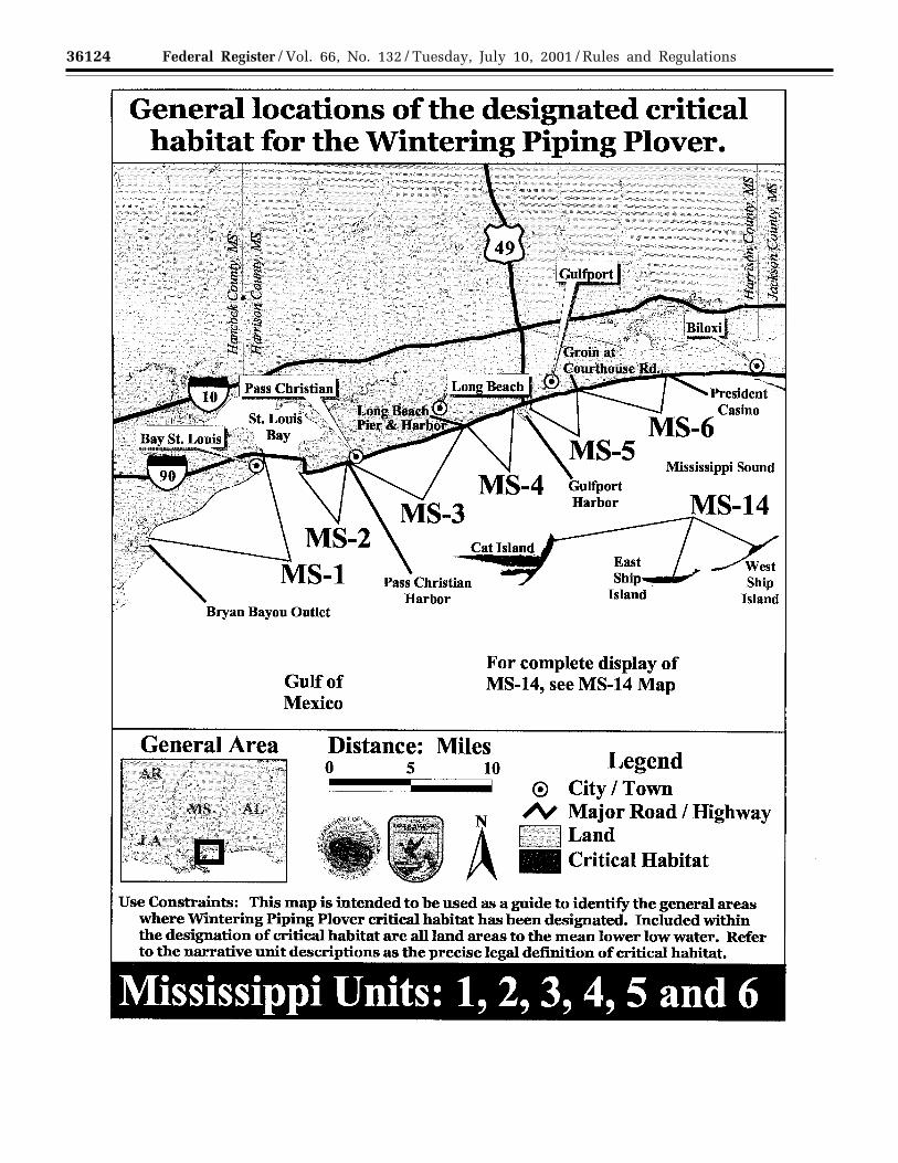
Unit MS–6: Mississippi City. 62 ha (153ac) in Harrison County
This unit extends from the east sideof the groin at the southern terminus ofCourthouse Road, Mississippi City, MS,and includes the shore of theMississippi Sound following theshoreline northeast approximately 7.9km (4.9 mi) to the west side of PresidentCasino. The landward boundary of thisunit follows the Gulf side of U.S.Highway 90 and the seaward boundaryis MLLW. The shoreline of this unit isprivately owned.
Unit MS–10: Ocean Springs West. 11 ha(27 ac) in Jackson County
This unit extends from U.S. 90 andincludes the shore of Biloxi Bayfollowing the shoreline southeastapproximately 1.9 km (1.2 mi) to theOcean Springs Harbor inlet. Thelandward boundary of this unit followsthe Bay side of Front Beach Drive andthe seaward boundary is MLLW. Theshoreline of this unit is privatelyowned.
Unit MS–11: Ocean Springs East. 7 ha(17 ac) in Jackson County
This unit extends from the east sideof Weeks Bayou and includes the shoreof Biloxi Bay following the shorelinesoutheast approximately 1.8 km (1.1 mi)to Halstead Bayou. The landward
boundary of this unit follows the Bayside of East Beach Drive and theseaward boundary is MLLW. Theshoreline of this unit is privatelyowned.
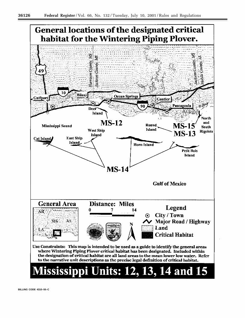
Unit MS–12: Deer Island. 194 ha (479ac) in Harrison County
This unit includes all of Deer Island,where primary constituent elementsoccur to the MLWW. Deer Island isprivately owned.
Unit MS–13: Round Island. 27 ha (67 ac)in Jackson County
This unit includes all of Round Islandto the MLWW and is privately owned
Unit MS–14: Mississippi Barrier Islands.3,168 ha (7,828 ac) in Harrison andJackson Counties.
This unit includes all of Cat, East andWest Ship, Horn, Spoil, and Petit BoisIslands where primary constituentelements occur to MLLW. Cat Island isprivately owned, and the remainingislands are part of the Gulf IslandsNational Seashore.
Unit MS–15: North and South Rigolets.159 ha (393 ac) in Jackson County, MS,and 12 ha (30 ac) in Mobile County, AL
This unit extends from thesouthwestern tip of South RigoletsIsland and includes the shore of PointAux Chenes Bay, the Mississippi Sound,and Grand Bay following the shorelineeast around the western tip, then northto the south side of South RigoletsBayou; then from the north side ofSouth Rigolets Bayou (the southeasterncorner of North Rigolets Island) north tothe northeastern most point of NorthRigolets Island. This shoreline isbounded on the seaward side by MLLWand on the landward side to wheredensely vegetated habitat, not used bythe piping plover, begins and where theconstituent elements no longer occur.Approximately 4.4 km (2.7 mi) are inMississippi and 2.9 km (1.8 mi) are inAlabama. Almost half the Mississippishoreline length is in the Grand BayNational Wildlife Refuge.BILLING CODE 4310–55–P
VerDate 11<MAY>2000 11:26 Jul 09, 2001 Jkt 194001 PO 00000 Frm 00087 Fmt 4701 Sfmt 4700 E:\FR\FM\10JYR2.SGM pfrm06 PsN: 10JYR2
36124 Federal Register / Vol. 66, No. 132 / Tuesday, July 10, 2001 / Rules and Regulations
VerDate 11<MAY>2000 11:26 Jul 09, 2001 Jkt 194001 PO 00000 Frm 00088 Fmt 4701 Sfmt 4725 E:\FR\FM\10JYR2.SGM pfrm06 PsN: 10JYR2
36125Federal Register / Vol. 66, No. 132 / Tuesday, July 10, 2001 / Rules and Regulations
VerDate 11<MAY>2000 11:26 Jul 09, 2001 Jkt 194001 PO 00000 Frm 00089 Fmt 4701 Sfmt 4725 E:\FR\FM\10JYR2.SGM pfrm06 PsN: 10JYR2
36126 Federal Register / Vol. 66, No. 132 / Tuesday, July 10, 2001 / Rules and Regulations
BILLING CODE 4310–55–C
VerDate 11<MAY>2000 11:26 Jul 09, 2001 Jkt 194001 PO 00000 Frm 00090 Fmt 4701 Sfmt 4700 E:\FR\FM\10JYR2.SGM pfrm06 PsN: 10JYR2

36127Federal Register / Vol. 66, No. 132 / Tuesday, July 10, 2001 / Rules and Regulations
Louisiana (Maps were digitized using1998 DOQQs)
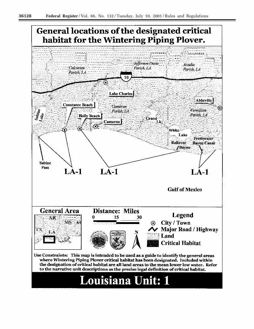
Unit LA–1: Texas/Louisiana border toCheniere au Tigre. 2,650 ha (6,548 ac) inCameron and Vermilion Parishes
This unit extends from the east sideof Sabine Pass (Texas/Louisiana border)and includes the shore of the Gulf ofMexico from the MLLW following theshoreline east 25.7 km (16.0 mi) to thewest end of Constance Beach[approximately 2 km (1.2 mi) east of theintersection of Parish Road 528 and thebeach]; it extends from the east end ofthe town of Holly Beach [0.25 km (0.16mi) east of the intersection of BaritarickBoulevard and the beach] following theshoreline approximately 97 km (60.3mi) east to the eastern boundary line ofRockefeller Wildlife Refuge [3.4 km (2.1mi) east of Rollover Bayou]; and itextends from the east side of FreshwaterBayou Canal following the shorelineeast for approximately 15 km (9.3 mi) to1.3 km (0.81 mi) east of where theboundary of Paul J. Rainey WildlifeSanctuary (National Audubon Society)meets the shoreline. All three sectionsof this unit include the land from theseaward boundary of MLLW to wheredensely vegetated habitat, not used bythe piping plover, begins and where theconstituent elements no longer occur.The shoreline in this unit is both stateand privately owned.
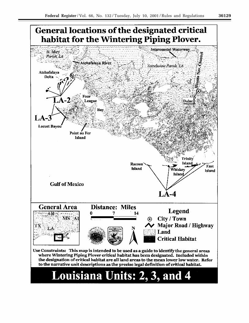
Unit LA–2: Atchafalaya River Delta. 921ha (2,276 ac) in St. Mary Parish, LA
This unit is located in the easternportion of the State-owned AtchafalayaDelta Wildlife Management Area(WMA) and includes all exposed landand islands where primary constituentelements occur east and southeast of themain navigation channel of theAtchafalaya River to the MLLW. Theislands located south and southeast of
the deltaic splay, Donna, T–Pat, andSkimmer Islands and the un-named birdisland, are also included in this unit.This unit includes the entire islandswhere primary constituent elementsoccur to the MLLW.
Unit LA–3: Point Au Fer Island. 195 ha(482 ac) in Terrebonne Parish.
This unit includes the entire smallisland at the northwest tip of Point AuFer Island to MLLW, then extends fromthe northwest tip of Point Au Fer Islandfollowing the shoreline southeastapproximately 7.7 km (4.8 mi) to thepoint where the un-named oil and gascanal extending southeast from LocustBayou meets the shoreline [0.8 km (0.5mi) southeast from Locust Bayou]. Thisshoreline is bounded on the seawardside by MLLW and on the landwardside to where densely vegetated habitat,not used by the piping plover, beginsand where the constituent elements nolonger occur. This entire unit isprivately owned.
Unit LA–4: Isles Dernieres. 795 ha(1,964 ac) in Terrebonne Parish
This unit includes the State-ownedIsles Dernieres chain, includingRaccoon, Whiskey, Trinity and EastIslands. This unit includes the entireislands where primary constituentelements occur to the MLLW.
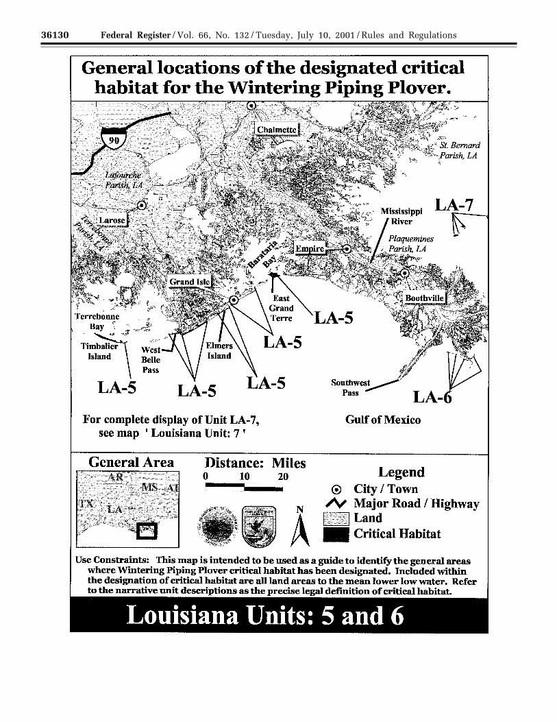
Unit LA–5: Timbalier Island to EastGrand Terre Island. 2,321 ha (5,735 ac)in Terrebonne, Lafourche, Jefferson, andPlaquemines Parishes
This unit includes: all of TimbalierIsland where primary constituentelements occur to the MLLW, all ofBelle Pass West [the ‘‘peninsula’’extending north/northwestapproximately 4.8 km (3.0 mi) from thewest side of Belle Pass] where primaryconstituent elements occur to MLLW;
the Gulf shoreline extendingapproximately 11 km (6.8 mi) east fromthe east side of Belle Pass bounded onthe seaward side by MLLW and on thelandward side to where denselyvegetated habitat, not used by the pipingplover, begins and where theconstituent elements no longer occur;all of Elmers Island peninsula whereprimary constituent elements occur toMLLW and the Gulf shoreline fromElmers Island to approximately 0.9 km(0.56 mi) west of Bayou Thunder VonTranc bounded on the seaward side byMLLW and on the landward side towhere densely vegetated habitat, notused by the piping plover, begins andwhere the constituent elements nolonger occur; the Gulf shoreline ofGrand Isle from the Gulf side of thehurricane protection levee to MLLW;and all of East Grand Terre Island whereprimary constituent elements occur tothe MLLW.
Unit LA–6: Mississippi River Delta. 105ha (259 ac) in Plaquemines Parish, LA
This unit is part of the State-ownedPass a Loutre Wildlife ManagementArea and includes un-named sand(spoil) islands off South Pass of theMississippi River near Port Eads. Theentire islands to MLLW are included inthis unit.
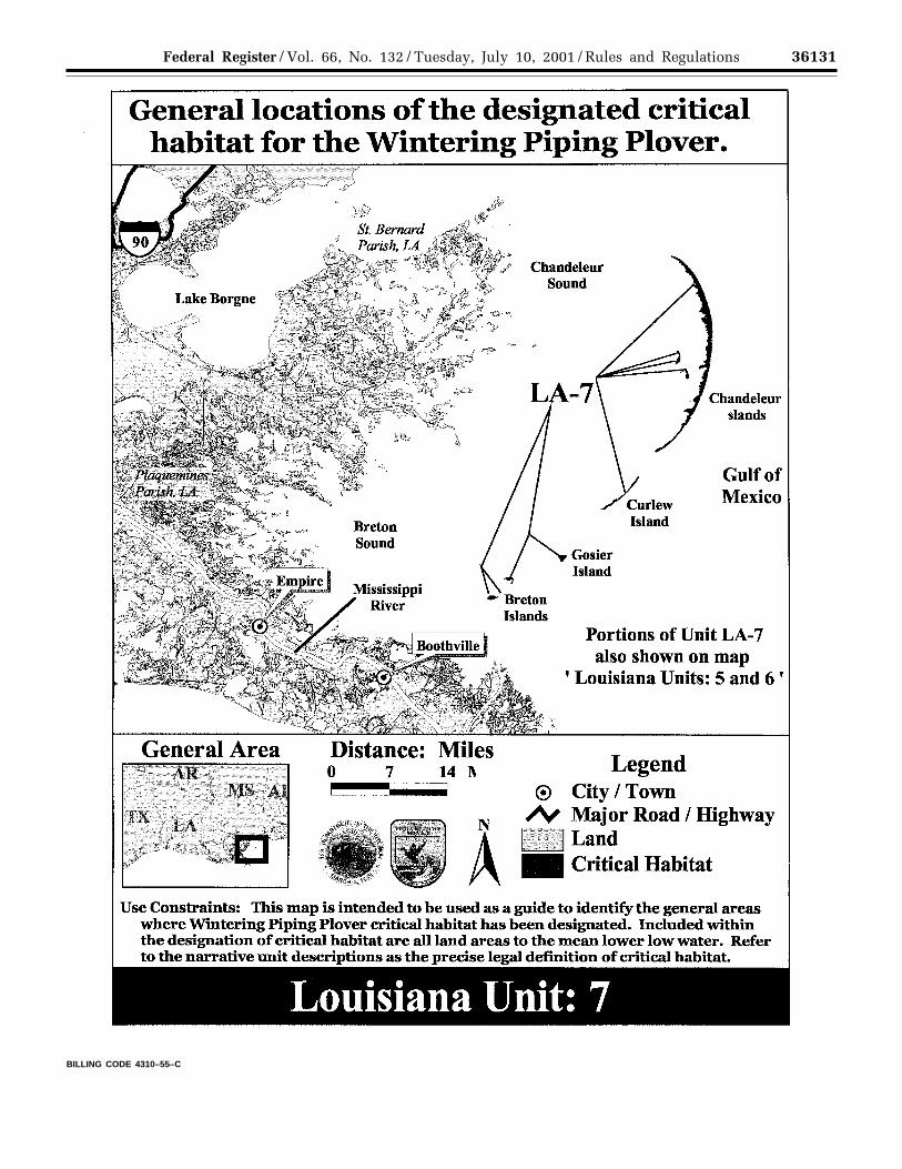
Unit LA–7: Breton Islands andChandeleur Island Chain. 3,116 ha(7,700 ac) in Plaquemines and St.Bernard Parishes, LA
This unit includes Breton, GrandGosier, and Curlew Islands and theChandeleur Island chain. Those islandsare part of the Breton National WildlifeRefuge or are state owned. The entireislands where primary constituentelements occur to MLLW are includedin this unit.BILLING CODE 4310–55–P
VerDate 11<MAY>2000 11:26 Jul 09, 2001 Jkt 194001 PO 00000 Frm 00091 Fmt 4701 Sfmt 4700 E:\FR\FM\10JYR2.SGM pfrm06 PsN: 10JYR2
36128 Federal Register / Vol. 66, No. 132 / Tuesday, July 10, 2001 / Rules and Regulations
VerDate 11<MAY>2000 11:26 Jul 09, 2001 Jkt 194001 PO 00000 Frm 00092 Fmt 4701 Sfmt 4725 E:\FR\FM\10JYR2.SGM pfrm06 PsN: 10JYR2
36129Federal Register / Vol. 66, No. 132 / Tuesday, July 10, 2001 / Rules and Regulations
VerDate 11<MAY>2000 11:26 Jul 09, 2001 Jkt 194001 PO 00000 Frm 00093 Fmt 4701 Sfmt 4725 E:\FR\FM\10JYR2.SGM pfrm06 PsN: 10JYR2
36130 Federal Register / Vol. 66, No. 132 / Tuesday, July 10, 2001 / Rules and Regulations
VerDate 11<MAY>2000 11:26 Jul 09, 2001 Jkt 194001 PO 00000 Frm 00094 Fmt 4701 Sfmt 4725 E:\FR\FM\10JYR2.SGM pfrm06 PsN: 10JYR2
36131Federal Register / Vol. 66, No. 132 / Tuesday, July 10, 2001 / Rules and Regulations
BILLING CODE 4310–55–C
VerDate 11<MAY>2000 11:26 Jul 09, 2001 Jkt 194001 PO 00000 Frm 00095 Fmt 4701 Sfmt 4700 E:\FR\FM\10JYR2.SGM pfrm06 PsN: 10JYR2
36132 Federal Register / Vol. 66, No. 132 / Tuesday, July 10, 2001 / Rules and Regulations
Texas (Maps were digitized using1995 and 1996 DOQQs and NationalOceanic and AtmosphericAdministration’s (NOAA) MediumResolution Digital Vector Shoreline)
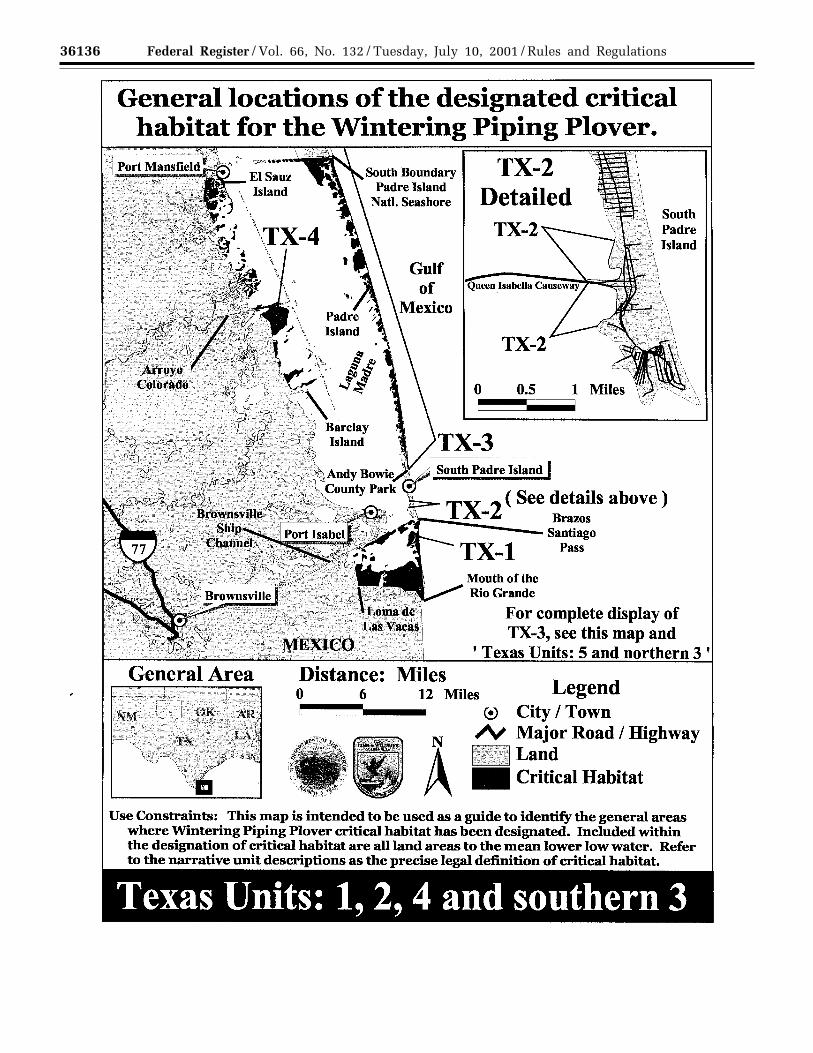
Unit TX–1: South Bay and Boca Chica.2,920 ha ( 7,217 ac) in Cameron County
The boundaries of the unit are:starting at the Loma Ochoa, followingthe Brownsville Ship Channel to thenortheast out into the Gulf of Mexico toMLLW, then south along a linedescribing MLLW to the mouth of theRio Grande, proceeding up the RioGrande to Loma de Las Vacas, then fromthat point along a straight line north toLoma Ochoa. The unit does not includedensely vegetated habitat within thoseboundaries. It includes wind tidal flatsthat are infrequently inundated byseasonal winds, and includes the tidalflats area known as South Bay. Beacheswithin the unit reach from the mouth ofthe Rio Grande northward to BrazosSantiago Pass, south of South PadreIsland. The southern and westernboundaries follow the change in habitatfrom wind tidal flat, preferred by thepiping plover, to where denselyvegetated habitat, not used by the pipingplover, begins and where theconstituent elements no longer occur.The upland areas extend to wheredensely vegetated habitat, not used bythe piping plover, begins and where theconstituent elements no longer occurand include areas used for roosting bythe piping plover. Portions of this unitare owned and managed by the LowerRio Grande Valley National WildlifeRefuge, the South Bay Coastal Preserve,Boca Chica State Park, and privatecitizens.
Unit TX–2: Queen Isabella Causeway. 2ha (6 ac) in Cameron County
The area extends along the LagunaMadre west of the city of South PadreIsland. The southern boundary is theQueen Isabella State Fishing Pier, andthe northern boundary is at theshoreline due west of the end of SunnyIsles Street. The Queen Isabellacauseway bisects this shore but is notincluded within critical habitat. Theeastern boundary is where developedareas and/or dense vegetation begins,and the western boundary is MLLW.This unit contains lands known as windtidal flats that are infrequentlyinundated by seasonal winds.
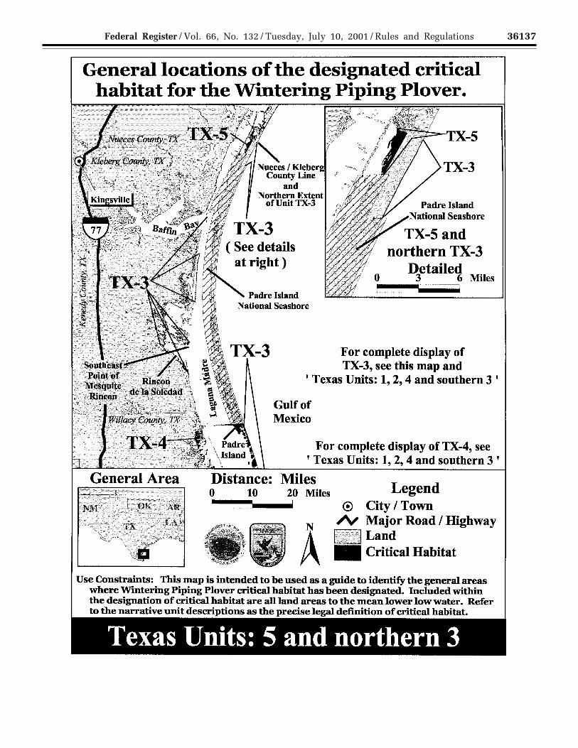
Unit TX–3: Padre Island. 10,924 ha(26,983 ac) in Cameron, Willacy,Kenedy, and Kleberg Counties
This unit consists of four subunits:(1) The southern boundary of this
subunit is at Andy Bowie County Park
in South Padre Island, and the northernboundary is the south boundary ofPAIS. The eastern boundary is MLLW inthe Gulf of Mexico, and the westernboundary is MLLW in the LagunaMadre. Areas of dense vegetation are notincluded in critical habitat. This subunitincludes lands known as wind tidal flatsthat are infrequently inundated byseasonal winds.
(2) The boundaries of this subunitextend from Rincon de la Soledad to thesoutheast point of Mesquite Rincon,continue from that point west to theLaguna Madre shoreline at itsintersection with the King Ranchboundary, and from that point to Rinconde la Soledad. This subunit includeslands known as wind tidal flats that areinfrequently inundated by seasonalwinds.
(3) This subunit is within the LagunaMadre and extends from the westernboundary of PAIS to the GulfIntercoastal Waterway. Its northernboundary is a line extending westwardfrom the northwest corner of PAIS, andits southern boundary is a lineextending westward from the southernboundary of PAIS. This subunitincludes lands known as wind tidal flatsthat are infrequently inundated byseasonal winds.
(4) This subunit extends along thegulf shore of Padre Island from thenorthern boundary of PIAS at the shore,north to the Nueces-Kleberg county line.The inland boundary is where densevegetation begins, and the seawardboundary is MLLW. This subunitincludes lands known as wind tidal flatsthat are infrequently inundated byseasonal winds.
Portions of this unit are owned andmanaged by TGLO, and private citizenswith a significant portion being ownedand managed by The NatureConservancy on South Padre Island.
Unit TX–4: Lower Laguna MadreMainland. 4,980 ha (12,307 ac) inCameron and Willacy Counties
The southern boundary is an east-west line at the northern tip of BarclayIsland, and the southern boundary is aneast-west line 0.9 km (0.5 mi) south ofthe boundary of the City of PortMansfield; the western boundary is theline where dense vegetation begins, andthe eastern boundary is the GulfIntercoastal Waterway. The unitincludes bayside flats that are exposedduring low tide regimes and wind tidalflats that are infrequently inundated byseasonal winds. Portions of this unit arewithin the Laguna Atascosa NationalWildlife Refuge, are TGLO-owned, orare privately owned. Beaches andinterior wetlands may or may not be
used each year because of varying waterlevels, storm events, or changes in beachcharacteristics and tidal regime. Waterstages vary in this area withmeteorological conditions. The uplandareas extend to where densely vegetatedhabitat, not used by the piping plover,begins and where the constituentelements no longer occur and includeupland areas used for roosting by thepiping plover.
Unit TX–5: Upper Laguna Madre. 436ha (1,076 ac) in Kleberg County
The southern boundary is thenorthern boundary of PAIS, and thenorthern boundary is the Kleberg/Nueces County line. The easternboundary is the line where densevegetation begins, and the westernboundary is MLLW. This unit includesa series of small flats along the baysideof Padre Island in the Upper LagunaMadre. It includes wind tidal flats andsparsely-vegtated upland areas used forroosting by the piping plover. Theseboundaries receive heavy use by largenumbers of shorebirds, including pipingplovers. The upland areas extend towhere densely vegetated habitat, notused by the piping plover, begins andwhere the constituent elements nolonger occur, and include upland areasused for roosting by the piping plover.
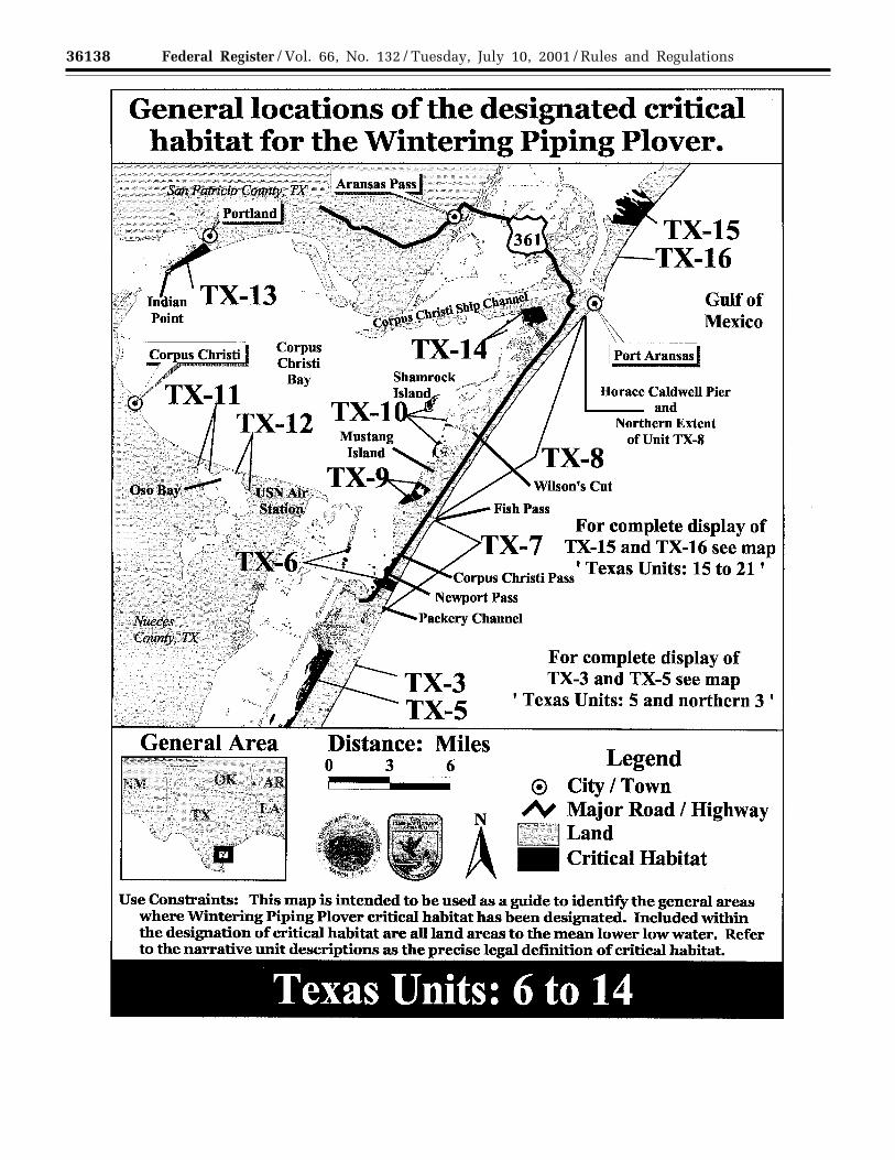
Unit TX–6: Mollie Beattie CoastalHabitat. 241 ha (596 ac) in NuecesCounty
This unit will be described as twosubunits:
(1) Subunit is bounded on the northby Beach Access Road 3, on the east bythe inland boundary of critical habitatUnit TX–7, on the south by Zahn road,and on the west by Zahn Road.
(2) The subunit is bounded on thenorth by Corpus Christi Pass, on the eastby US 361, on the south by the northside of Packery Channel, and on thewest by the Gulf Intercoastal Watersay.
Some of the uplands are privatelyowned and the remaining are ownedand managed by the TGLO. This unitincludes two hurricane washover passesknown as Newport and Corpus ChristiPasses, and wind tidal flats that areinfrequently inundated by seasonalwinds. The upland areas extend towhere densely vegetated habitat, notused by the piping plover, begins andwhere the constituent elements nolonger occur and include upland areasused for roosting by the piping plover.
Unit TX–7: Newport Pass/CorpusChristi Pass Beach. 42 ha (104 ac) inNueces County
This unit is along a stretch of Gulfbeach 8.5 km (5.3 mi) long. It is
VerDate 11<MAY>2000 11:26 Jul 09, 2001 Jkt 194001 PO 00000 Frm 00096 Fmt 4701 Sfmt 4700 E:\FR\FM\10JYR2.SGM pfrm06 PsN: 10JYR2
36133Federal Register / Vol. 66, No. 132 / Tuesday, July 10, 2001 / Rules and Regulations
bounded on the north by Fish Pass, onthe east by MLLW, on the south by St.Bartholomew Avenue, and on the westby a line marking the beginning of densevegetation. Portions of the unit aremanaged by the Texas Parks andWildlife Department as part of MustangIsland State Park. This unit includeslands known as wind tidal flats that areinfrequently inundated by seasonalwinds.
Unit TX–8: Mustang Island Beach. 97 ha(239 ac) in Nueces County
This is a stretch of Gulf beachextending from Fish Pass to the HoraceCaldwell Pier on Holiday Beach withinthe City of Port Aransas, TX. Thelandward boundary is beginning ofdense vegetation, and the gulf-wardboundary is MLLW. This unit includeslands known as wind tidal flats that areinfrequently inundated by seasonalwinds.
Unit TX–9: Fish Pass Lagoons. 130 ha(323 ac) in Nueces County
This unit encompasses flats facingCorpus Christi Bay that extend 1.0 km(0.6 mi) on either side of Fish Pass. Theinland boundary is the line indicatingbeginning of dense vegetation, and thebayside boundary is MLLW. It includesinterior lagoons and wind tidal flats thatare infrequently inundated by seasonalwinds. This unit includes upland areasused for roosting by the piping plover.
Unit TX–10: Shamrock Island andAdjacent Mustang Island Flats. 87 ha(216 ac) in Nueces County
This unit encompasses ShamrockIsland, an unnamed small sand flat tothe north of Wilson’s Cut, and a lagooncomplex that extends 3.5 km (2.2 mi) tothe southwest of Wilson’s Cut. Criticalhabitat includes land to the linemarking the beginning of densevegetation down to MLLW. This unitincludes lands known as wind tidal flatsthat are infrequently inundated byseasonal winds.
Unit TX–11: Blind Oso. 2 ha (5 ac) inNueces County
This unit is the flats of the Blind Oso,part of Oso Bay, from Hans and PatSuter Wildlife Refuge (owned andmanaged by the City of Corpus Christi)northeast to Corpus Christi Bay andthen southeast along the edge of TexasA&M University—Corpus Christi. Thelandward boundaries extend to wheredensely vegetated habitat, not used bythe piping plover, begins, and extendsout from the landward boundaries toMLLW. This unit includes lands knownas wind tidal flats that are infrequentlyinundated by seasonal winds.
Unit TX–12: Adjacent to Naval AirStation-Corpus Christi. 2 ha (6 ac) inNueces County
This unit is along the shore of OsoBay on flats bordered by Naval AirStation-Corpus Christi and Texas Spur 3to a point 2.5 km (1.5 mi) south of thebridge between Ward Island and theNaval Air Station. The landwardboundary is the line where densevegetation begins, and the boundary inthe Bay is MLLW. This unit includeslands known as wind tidal flats that areinfrequently inundated by seasonalwinds.
Unit TX–13: Sunset Lake. 176 ha (435ac) in San Patricio County
This unit is triangle shaped, withState Highway 181 as the northwestboundary, and the limits of the City ofPortland as the northeast boundary. Theshore on Corpus Christi Bay is the thirdside of the triangle, with the actualboundary being MLLW off this shore.This unit is a large basin with a seriesof tidal ponds, sand spits and wind tidalflats. This unit is owned and managedby the City of Portland within a systemof city parks. Some of the described areafalls within the jurisdiction of theTGLO. It includes two city park unitsreferred to as Indian Point and SunsetLake. Much of the unit is a recentacquisition by the city, and managementconsiderations for the park include thearea’s importance as a site for winteringand resident shorebirds. This unitincludes lands known as wind tidal flatsthat are infrequently inundated byseasonal winds.
Unit TX–14: East Flats. 194 ha (481 ac)in Nueces County
This unit is bordered on the north bydredge placement areas bordering theCorpus Christi Ship Channel, on thewest by MLLW in Corpus Christi Bay,on the east by the limits of the City ofPort Aransas, and on the south by aneast-west line at the sourthern-mostpoint of Pelone Island. It is also bisectedby a navigation channel, which is notincluded in the critical habitat. Aportion of this unit at the west end fallswithin State-owned (TGLO) intertidallands. The remainder of the unit isprivately owned. The upland areasextend to where densely vegetatedhabitat, not used by the piping plover,begins and where the constituentelements no longer occur, includingupland areas used for roosting by thepiping plover. This unit includes landsknown as wind tidal flats that areinfrequently inundated by seasonalwinds.
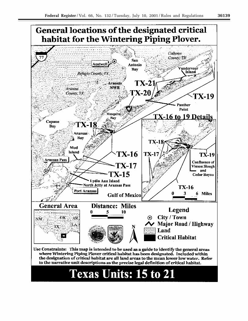
Unit TX–15: North Pass. 447 ha (1,106ac) in Aransas County
The unit is bounded on north byNorth Pass, on the northwest by the lineindicating MLLW, on the southwest bythe northeast side of Lydia Ann Island,on the south by a line running due eastfrom the northeast side of Lydia AnnIsland, and on the southeast by thelandward boundary of Unit. This unit isa remnant of a hurricane washover onthe privately owned San Jose Island.The upland areas extend to wheredensely vegetated habitat, not used bythe piping plover, begins and where theconstituent elements no longer occur,including upland areas used for roostingby the piping plover. This unit includeslands known as wind tidal flats that areinfrequently inundated by seasonalwinds.
Unit TX–16: San Jose Beach. 187 ha(463 ac) in Aransas County
This unit occupies a 33 km (20 mi)stretch of beach from the North Jetty ofAransas Pass at the south, to theconfluence of Vinson Slough and CedarBayou at the north end of San JoseIsland. The inland boundary is the lineindicating the beginning of denselyvegetated habitat, and the gulf-wardboundary is MLLW. This unit includeslands known as wind tidal flats that areinfrequently inundated by seasonalwinds.
Unit TX–17: Allyn’s Bight. 5 ha (14 ac)in Aransas County
This unit includes shoreline of SanJose Island on Aransas Bay from Allyn’sBight to Blind Pass, the channelbetween San Jose Island and MudIsland. The inland boundary is wherethe line of dense vegetation begins, andthe bay-ward boundary is MLLW. Thisunit includes lands known as wind tidalflats that are infrequently inundated byseasonal winds.
Unit TX–18: Cedar Bayou/VinsonSlough. 3,051 ha (7,539 ac) in AransasCounty
Beginning at the confluence of VinsonSlough and Cedar Bayou, this unit’sboundary follows the shore of SpaldingCove to Long Reef, then continues alonga line extending (2.5 mi) southwest ofLong Reef to the shore of San JoseIsland, then along the shore of theisland to the landward boundary of UnitTX–16. The unit boundaries extendlandward to the line indicating thebeginning of dense vegetation. This unitis a remnant of a hurricane washoverarea, and includes the highly dynamicarea of Cedar Bayou, the pass thatseparates San Jose Island and MatagordaIsland. This area includes a small
VerDate 11<MAY>2000 11:26 Jul 09, 2001 Jkt 194001 PO 00000 Frm 00097 Fmt 4701 Sfmt 4700 E:\FR\FM\10JYR2.SGM pfrm06 PsN: 10JYR2

36134 Federal Register / Vol. 66, No. 132 / Tuesday, July 10, 2001 / Rules and Regulations
section of Matagorda Island NationalWildlife Refuge with much of theremaining areas occurring on theprivately owned island of San Jose. Theupland areas extend to where denselyvegetated habitat, not used by the pipingplover, begins and where theconstituent elements no longer occurand include upland areas used forroosting by the piping plover. This unitincludes lands known as wind tidal flatsthat are infrequently inundated byseasonal winds.
Unit TX–19: Matagorda Island Beach.395 ha (976 ac) in Calhoun County
This stretch of beach along the Gulf ofMexico on Matagorda Island extends adistance of 60 km (36 mi) from CedarBayou on the southwest (where it abutsTX–18), to Pass Cavallo on thenortheast. The inland boundary is theline indicating the beginning of densevegetation, and the gulf-ward boundaryis MLLW. This unit includes landsknown as wind tidal flats that areinfrequently inundated by seasonalwinds. The unit falls entirely within theboundary of the Matagorda IslandNational Wildlife Refuge.
Unit TX–20: Ayers Point. 397 ha (982ac) in Calhoun County
This unit is an unnamed lake onMatagorda Island between Shell ReefBayou and Big Brundrett Lake, with SanAntonio Bay to the north. The unitboundary extends landward from thelake to the line where dense vegetationbegins and where the constituentelements no longer occur and includesupland areas used for roosting by thepiping plover. This unit includes marshand flats at Ayers Point on MatagordaIsland National Wildlife Refuge. Thisunit includes lands known as wind tidalflats that are infrequently inundated byseasonal winds.
Unit TX–21: Panther Point to PringleLake. 863 ha (2,133 ac) in CalhounCounty
This unit represents a narrow band ofbayside habitats on Matagorda Islandfrom Panther Point to the northeast endof Pringle Lake. The landward boundaryis the line indicating where densevegetation begins, and the baywardboundary is MLLW. The unit is entirelywithin Matagorda Island NationalWildlife Refuge. This unit includeslands known as wind tidal flats that areinfrequently inundated by seasonalwinds.
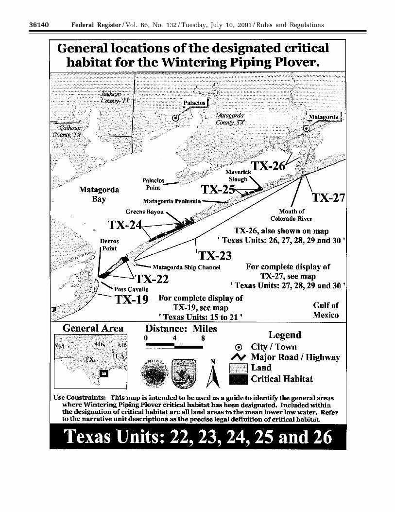
Unit TX–22: Decros Point. 450 ha (1,114ac) at the Matagorda/Calhoun CountyLine
This unit includes about 7.0 km (4.3mi) of beach habitat around the islandat the western tip of MatagordaPeninsula between the natural openingto Matagorda Bay and the MatagordaShip Channel. The upland boundary isthe line where dense vegetation begins,and the seaward boundary is MLLW.The adjacent upland is privately owned.This unit includes lands known as windtidal flats that are infrequentlyinundated by seasonal winds.
Unit TX–23: West Matagorda PeninsulaBeach. 311 ha (769 ac) of Shoreline inMatagorda County
This unit extends 40 km (24 mi) alongthe Gulf of Mexico from the jetties at theMatagorda Ship Channel to the oldColorado River channel. The inlandboundary is the line indicating wheredense vegetation begins, and thegulfside boundary is MLLW. This unitincludes lands known as wind tidal flatsthat are infrequently inundated byseasonal winds.
Unit TX–24: West Matagorda Bay/Western Peninsula Flats. 756 ha (1,868ac) in Matagorda County
This unit extends along the bayside ofMatagorda Peninsula from 7.5southwest of Greens Bayou to 2.5 km(1.6 mi) northwest of Greens Bayou. Thelandward boundary is the lineindicating the beginning of densevegetation, and the bayside boundary isMLLW. This unit includes lands knownas wind tidal flats that are infrequentlyinundated by seasonal winds.
Unit TX–25: West Matagorda Bay/Eastern Peninsula Flats. 232 ha (575 ac)in Matagorda County
This unit follows the bayside ofMatagorda Peninsula from MaverickSlough southwest for 5 km (3 mi). Theunit begins at Maverick Slough to thenortheast and extends 5 km (3 mi) to thesouthwest, enclosing a series of flatsalong Matagorda Bay. The upland areasextend to where densely vegetatedhabitat, not used by the piping plover,begins and where the constituentelements no longer occur and includeupland areas used for roosting by thepiping plover. This unit includes landsknown as wind tidal flats that areinfrequently inundated by seasonalwinds.
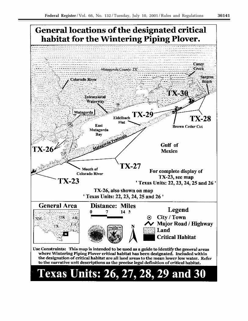
Unit TX–26: Colorado River DiversionDelta. 5 ha (13 ac) in Matagorda County
This unit follows the shore of theextreme eastern northeast corner ofWest Matagorda Bay from Culver Cut to
Dog Island Reef. The southeasterntidally emergent portion of Dog IslandReef is included within the unit. Thelandward boundary is the lineindicating the beginning of densevegetation, and the bayside boundary isMLLW. The upland areas includesupland areas used for roosting by thepiping plover. This unit includes landsknown as wind tidal flats that areinfrequently inundated by seasonalwinds.
Unit TX–27: East Matagorda Bay/Matagorda Peninsula Beach West. 295(728 ac) of shoreline in MatagordaCounty
This unit extends along Gulf beach onthe Matagorda Peninsula from themouth of the Colorado River northeastalong the peninsula 23 km (14 mi) to apoint on the beach opposite EidelbachFlats. The landward boundary is theline indicating the beginning of densevegetation, and the gulfside boundary isMLLW. This unit includes lands knownas wind tidal flats that are infrequentlyinundated by seasonal winds.
Unit TX–28: East Matagorda Bay/Matagorda Peninsula Beach East. 129 ha(321 ac) in Matagorda County
This unit extends along the Gulfbeach on the northeast end of MatagordaPeninsula from a point 0.8 km (0.5 mi)southwest of FM 457 southwest 10 km(6 mi.) to the southwest side of BrownCedar Cut. This unit abuts with UnitTX–29 to the north. The landwardboundary is the line indicating thebeginning of dense vegetation, and thegulfside boundary is MLLW. This unitincludes lands known as wind tidal flatsthat are infrequently inundated byseasonal winds.
Unit TX–29: Brown Cedar Cut. 119 ha(294 ac) in Matagorda County
This unit extends 2 km (1.2 mi.) bothsouthwest and northeast of the mainchannel of Brown Cedar Cut along thebayside of Matagorda Peninsula in EastMatagorda Bay, and abuts unit TX–28 tothe southeast. The landward boundaryis the line indicating the beginning ofdense vegetation, and the baysideboundary is MLLW. The easternboundary of TX–29 follows the changein habitat from mud flats preferred bythe piping plover, to slightly vegetateddune system adjacent to TX–28. Thisunit includes upland areas used forroosting by the piping plover. This unitincludes lands known as wind tidal flatsthat are infrequently inundated byseasonal winds.
VerDate 11<MAY>2000 11:26 Jul 09, 2001 Jkt 194001 PO 00000 Frm 00098 Fmt 4701 Sfmt 4700 E:\FR\FM\10JYR2.SGM pfrm06 PsN: 10JYR2
36135Federal Register / Vol. 66, No. 132 / Tuesday, July 10, 2001 / Rules and Regulations
Unit TX–30: Northeast Corner EastMatagorda Bay. 120 ha (297 ac) inMatagorda County
This unit is bounded on the north bythe Gulf Intercoastal Waterway, on theeast by the northeast limit of Matagordabay up the line where dense vegetationbegins, on the south by the boundary ofUnit TX–28, and on the west by MLLW.It is a system of flats associated withtidal channels. This unit includesupland areas used for roosting by thepiping plover and lands known as windtidal flats that are infrequentlyinundated by seasonal winds.
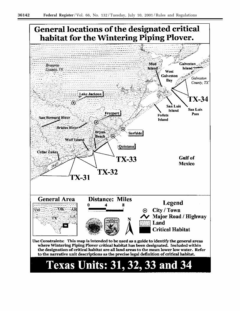
Unit TX–31: San Bernard NWR Beach.166 ha (410 ac) in Matagorda andBrazoria Counties
This is a unit composed of Gulf beach,8.0 km (5.0 mi), and extends from themouth of the San Bernard River to apoint along the beach 14.0 km (8.7 mi)to the southwest. The landwardboundary is the line indicating thebeginning of dense vegetation, and thegulfside boundary is MLLW. This unitincludes lands known as wind tidal flatsthat are infrequently inundated byseasonal winds.
Unit TX–32: Gulf Beach Between Brazosand San Bernard Rivers. 108 ha (269 ac)of shoreline in Brazoria County
This unit is a segment of Gulf beachbetween the Brazos River and the SanBernard River. This unit borders an areaknown as Wolf Island. The landwardboundary is the line indicating thebeginning of dense vegetation, and thegulfside boundary is MLLW. This unitincludes lands known as wind tidal flats
that are infrequently inundated byseasonal winds.
Unit TX–33: Bryan Beach and AdjacentBeach. 157 ha (388 ac) in BrazoriaCounty
The boundaries enclose a length ofGulf beach between the mouth of theBrazos River and FM 1495. Thelandward boundary is the lineindicating the beginning of densevegetation, and the gulfside boundary isMLLW. A portion of this area is ownedand managed by the Texas Parks andWildlife Department. This unit includeslands known as wind tidal flats that areinfrequently inundated by seasonalwinds.
Unit TX–34: San Luis Pass. 110 ha (272ac) near the Brazoria/Galveston Countyline
This unit extends along the Gulf sideof Galveston Island from San Luis Passto the site of the former town of RedFish Cove (USGS 1:24,000 map, SanLuis Pass, Texas; 1963, photorevision1974). The landward boundary is theline indicating the beginning of densevegetation, and the gulfside boundary isMLLW. Approximately 57 percent of theunit includes flats in the floodtide deltathat are State-owned and managed bythe TGLO. This unit includes landsknown as wind tidal flats that areinfrequently inundated by seasonalwinds.
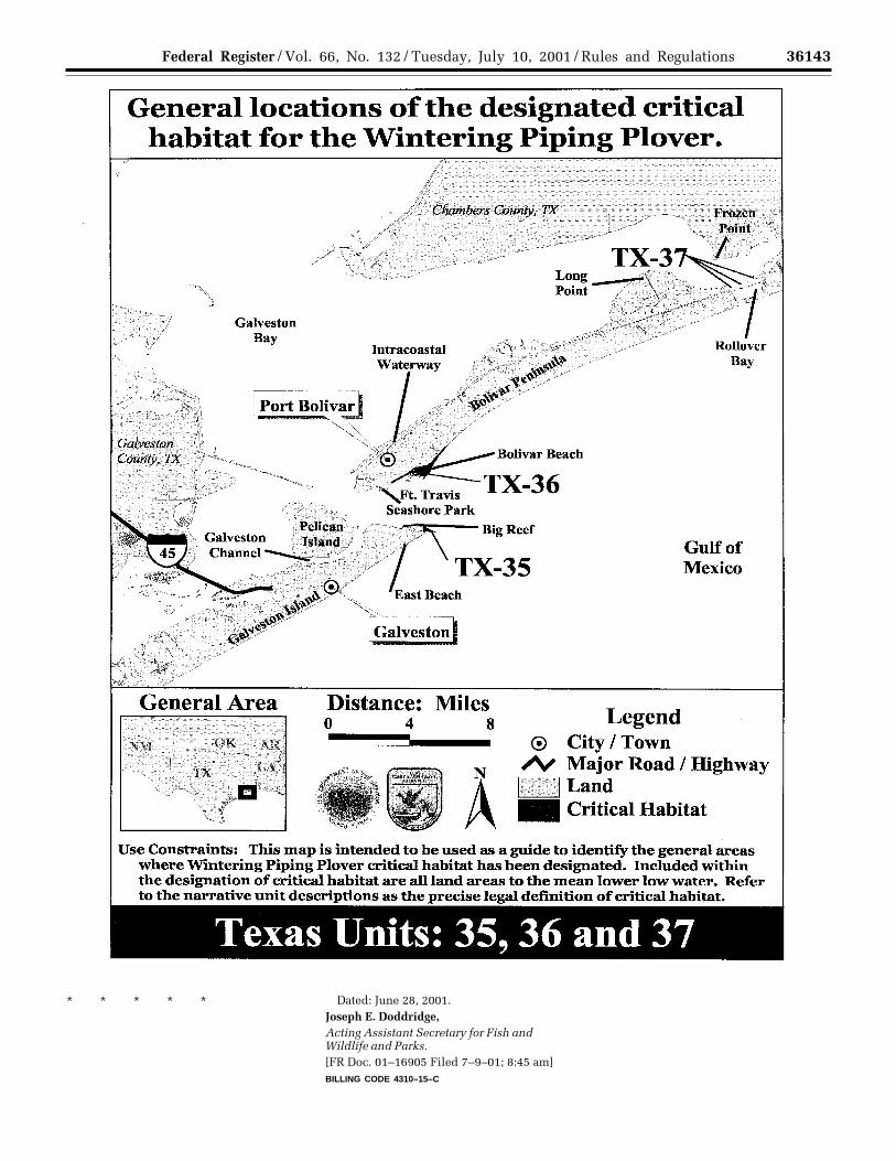
Unit TX–35: Big Reef. 47 ha (117 ac) inGalveston County
This unit consists of beach and sandflats on the north, west, and east shoreof Big Reef, down to MLLW. South Jetty
is not included. The area is currentlymanaged by the City of Galveston. Thisunit includes lands known as wind tidalflats that are infrequently inundated byseasonal winds.
Unit TX–36: Bolivar Flats. 160 ha (395ac) in Galveston County
This unit extends from the jetties onthe southwest end of the BolivarPeninsula to a point on the Gulf beach1 km (0.6 mi) north of Beacon Bayou. Itincludes 5.0 km (3 mi) of Gulf shoreline.The landward boundary is the lineindicating the beginning of densevegetation, and the gulfside boundary isMLLW. The area is leased from TGLOby Houston Audubon Society andmanaged for its important avianresources. The upland areas are used forroosting by the piping plover. This unitincludes lands known as wind tidal flatsthat are infrequently inundated byseasonal winds.
Unit TX–37: Rollover Pass. 6 ha (16 ac)in Galveston County
This unit consists of Rollover Bay onthe bayside of Bolivar Peninsula. Thelandward boundary is the lineindicating the beginning of densevegetation, and the bayside boundary isMLLW. It includes flats on State-ownedland managed by the TGLO. This unitcaptures the intertidal complex of thebay, and is bounded by the towns ofGilchrist to the east and the Gulf beachof the Bolivar Peninsula to the south.This unit includes lands known as windtidal flats that are infrequentlyinundated by seasonal winds.BILLING CODE 4310–55–P
VerDate 11<MAY>2000 11:26 Jul 09, 2001 Jkt 194001 PO 00000 Frm 00099 Fmt 4701 Sfmt 4700 E:\FR\FM\10JYR2.SGM pfrm06 PsN: 10JYR2
36136 Federal Register / Vol. 66, No. 132 / Tuesday, July 10, 2001 / Rules and Regulations
VerDate 11<MAY>2000 11:26 Jul 09, 2001 Jkt 194001 PO 00000 Frm 00100 Fmt 4701 Sfmt 4725 E:\FR\FM\10JYR2.SGM pfrm06 PsN: 10JYR2
36137Federal Register / Vol. 66, No. 132 / Tuesday, July 10, 2001 / Rules and Regulations
VerDate 11<MAY>2000 11:26 Jul 09, 2001 Jkt 194001 PO 00000 Frm 00101 Fmt 4701 Sfmt 4725 E:\FR\FM\10JYR2.SGM pfrm06 PsN: 10JYR2
36138 Federal Register / Vol. 66, No. 132 / Tuesday, July 10, 2001 / Rules and Regulations
VerDate 11<MAY>2000 11:26 Jul 09, 2001 Jkt 194001 PO 00000 Frm 00102 Fmt 4701 Sfmt 4725 E:\FR\FM\10JYR2.SGM pfrm06 PsN: 10JYR2
36139Federal Register / Vol. 66, No. 132 / Tuesday, July 10, 2001 / Rules and Regulations
VerDate 11<MAY>2000 11:26 Jul 09, 2001 Jkt 194001 PO 00000 Frm 00103 Fmt 4701 Sfmt 4725 E:\FR\FM\10JYR2.SGM pfrm06 PsN: 10JYR2
36140 Federal Register / Vol. 66, No. 132 / Tuesday, July 10, 2001 / Rules and Regulations
VerDate 11<MAY>2000 11:26 Jul 09, 2001 Jkt 194001 PO 00000 Frm 00104 Fmt 4701 Sfmt 4725 E:\FR\FM\10JYR2.SGM pfrm06 PsN: 10JYR2
36141Federal Register / Vol. 66, No. 132 / Tuesday, July 10, 2001 / Rules and Regulations
VerDate 11<MAY>2000 11:26 Jul 09, 2001 Jkt 194001 PO 00000 Frm 00105 Fmt 4701 Sfmt 4725 E:\FR\FM\10JYR2.SGM pfrm06 PsN: 10JYR2
36142 Federal Register / Vol. 66, No. 132 / Tuesday, July 10, 2001 / Rules and Regulations
VerDate 11<MAY>2000 11:26 Jul 09, 2001 Jkt 194001 PO 00000 Frm 00106 Fmt 4701 Sfmt 4725 E:\FR\FM\10JYR2.SGM pfrm06 PsN: 10JYR2
36143Federal Register / Vol. 66, No. 132 / Tuesday, July 10, 2001 / Rules and Regulations
* * * * * Dated: June 28, 2001.Joseph E. Doddridge,Acting Assistant Secretary for Fish andWildlife and Parks.[FR Doc. 01–16905 Filed 7–9–01; 8:45 am]BILLING CODE 4310–15–C
VerDate 11<MAY>2000 16:13 Jul 09, 2001 Jkt 194001 PO 00000 Frm 00107 Fmt 4701 Sfmt 4700 E:\FR\FM\10JYR2.SGM pfrm07 PsN: 10JYR2