3g’s for modern geotourism
TRANSCRIPT

ORIGINAL ARTICLE
3G’s for Modern Geotourism
Thomas A. Hose
Received: 2 February 2011 /Accepted: 6 December 2011 /Published online: 10 January 2012# Springer-Verlag 2012
Abstract Since the initial recognition and definition in theearly 1990s of geotourism in the UK by a few academicgeologists, and its emergence in Europe as a niche form ofsustainable tourism, new stakeholders have become involved;the latter’s background is often commercial and lacking in anysignificant academic or scientific engagement. Consequently,the geosite/geomorphosite management and promotionalapproaches they adopt are usually founded on practitionerand supply side led approaches rather than the geoconserva-tion requirements of geosites/geomorphosites and the needsand expectations of their geotourists. This is probably becausethe new stakeholders have limited knowledge and understand-ing of the relevance of the history, development and philoso-phy of landscape conservation and promotion (that isgeohistory), and the lessons that can be gleaned from suchconsiderations in managing and promoting geosites. This pa-per seeks to redress this situation by providing an outline of thehistorical and theoretical underpinnings of geotourism andapproaches to its sustainable management. It especially exam-ines and defines, underpinned by UK examples, three keyinterrelated aspects (the ‘3G’s’) of modern geotourism: geo-conservation, geohistory and geo-interpretation. It furtherupdates a prior published geohistorical model and provides anew summary topology and a geotourism chronosequence.Finally, it addresses, within the framework of the new defini-tion and its approach, some of the issues generated by thedevelopment of geoparks in Europe in the first decade of thetwenty-first century.
Keywords Geoconservation . Geohistory .
Geo-interpretation . Geotourism
Geotourism Established
Modern geotourism was first defined (Hose 1995a), the firstfocus of university research (Hose 1994a, 2003), and promoted(Hose 1996) in the UK as a new form of niche tourism (Hose2005a) prior to its emergence in Europe (Hose 1997, 2000). Itwas developed following recognition in the late 1980s byschool, university and museum geologists of the then acceler-ating loss of mines and quarries to unsympathetic after-usesand reclamation programmes; similarly, but to a lesser degree,natural geological exposures and geomorphosites were alsoincreasingly being lost because of unsympathetic planningdecisions that permitted, for example, the obscuring of road-side exposures with soil and netting (Baird 1994) and theconstruction of hard coastal defences (Leafe 1998). Moderngeotourism’s purpose then was initially seen as means bywhich to promote and possibly fund geoconservation, espe-cially for mines and quarries, by maintaining access to suchgeosites through the development of sustainable tourism prod-ucts and services ranging from leaflets and guided walks tomajor new construction projects such as visitor centres. Itsearly antecedents include the nineteenth century aesthetic andnature conservation movements that contributed to the devel-opment of sustainable tourism’s development. The aesthetic‘Romantic’movement in particular was an essential prelude tonature conservation and sustainable development because it“…valued the spiritual over the material, and humans came tobe seen as part of nature, not superior to it” (Hardy et al. 2002,p. 476). It coincided with the first formal attempts in the UK,especially contemporaneously in the English Lake District(Ritvo 2009), to promote and then preserve wildlife, landscapes
T. A. Hose (*)School of Earth Sciences, University of Bristol,Wills Memorial Building, Queens Road, Clifton,Bristol, BS8 1RJ, UKe-mail: [email protected]
Geoheritage (2012) 4:7–24DOI 10.1007/s12371-011-0052-y

and geological features much as modern geotourism seeks toachieve. It was the Lake District (Hose 2008) and the ScottishHighlands (Hose 2010a) that by the first quarter of thenineteenth century drew artists to capture their splendour, andin so doing also their geology and scenery. They interpreted andthen painted what lay before them through the cultural filter(Hose 2010b) of the ‘Romantic’ aesthetic movement (Hebron2006) to produce literal and philosophical views of land-scapes. These views are generally unknown to many of thenewer stakeholders involved in modern geotourism who lacka geohistorical perspective, but are pervasive in much mod-ern landscape and geological conservation endeavour. Possi-bly the ‘Romantic’ movement’s greatest legacy to moderntravellers and tourists, and for populist geotourism provision,is their preference to spend time appreciating aestheticallyattractive ‘wild’ or ‘natural’ landscapes rather than the ‘con-trolled’ and ‘brutal’ spaces of mining and industry; mountainsand cliff-edged coastal lands are particularly preferred places.Genuine ‘wild’ or ‘natural’ areas are, especially within thecrowded space of the UK and Europe, almost non-existenttoday. However, the perception persists today, as it has fromthe ‘Romantic’ period, that if the influence of humankind is notimmediately obvious, there being no buildings or evidence ofindustry, then a scenically spectacular or rural area must be asNature created it andworthy of some protective or promotionalrecognition such as a national park (NP), an area of outstandingnatural beauty (AONB), or even a geopark. Consequently,urban areas and those with extensive mining and industriallegacies struggle to achieve such recognition; generally, at best,they will be considered, and often sanitised, for recognitionand promotion as part of the ‘industrial heritage’. Yet, suchareas were often the most significant places in the developmentof scientific geology and in the past attracted the attention ofearly geotourists (Hose 2008).
Modern geotourism provision, with a particular emphasison rural localities and geoparks (Kavecic and Peljhan 2010),has burgeoned since the turn of the present century, especiallywith the emergence of geoparks, although its growth is diffi-cult to accurately quantify, as a recent overview (Dowling2011) exemplifies. Some measure of this growth can begauged from changes in geotourism provision in Scotlandwhere it was noted at the opening of the century that it wasthen “…a relatively new concept and current facilities thatpromote public understanding and appreciation of rocks, fos-sils and landforms are relatively few and far between”(McKirdy 2000, p. 103). However, by the close of the cen-tury’s first decade, it was suggested that in Scotland it is nowthe case that “Geotourism is a growing component of thetourism industry, both globally and in Scotland, as recognisedby the activities of local communities to develop geoparks andto provide interpretation of local geological landscapes andlandmarks” (Gordon and Barron 2011, p. 39). As tourismassociated with geosites and geomorphosites and collections,
it involves ‘special interest travel’ for people going “…some-where because they have a particular interest that can be pur-sued in a particular region or at a particular destination” (Read1980, p. 195). It is a form of ‘special interest’ tourism in whichthe “…traveller’s motivation and decision-making are primarilydetermined by a particular special interest…” (Hall and Weiler1992, p. 5) and overlaps with ‘sustainable tourism’ and ‘eco-tourism’. The former gained academic credibility with the 1993launch of the ‘Journal of Sustainable Tourism’. Sustainabledevelopment meets present-day needs, but not “…at theexpense of future generations, so that a balance should bestruck between using natural resources and promote theirconservation” (Cavuoto 2005, p. 49). Sustainable tourismcan subsume ecotourism, an approach that the World TourismOrganization (1997) suggests manages tourism resources sothat economic, social and aesthetic needs can be fulfilledwhilst maintaining cultural integrity; furthermore, essentialecological processes and biodiversity are protected. It seeksto meet the needs of present and future tourists and hostcommunities whilst ensuring the protection and enhancementof the places they visit. Over the past 20 years, ecotourism hasdeveloped from an obscure niche trend to a dominant one intourism provision (Weaver and Lawton 2007). It onlyappeared for the first time in the academic literature in the late1980s, gaining credibility with the 2002 launch of the ‘Journalof Ecotourism’, perhaps a rather similar time frame to that ofmodern geotourism and the launch of ‘Geoheritage’ in 2009.
Recognising and Defining Geotourism
Before any discussion of the significant elements of moderngeotourism can be contemplated, some understanding andknowledge of how the concept has evolved and been variouslydefined is needed to contextualise the selection of specificelements. Given the demonstrated early roots of geotourism(Hose 2008), it should be understood that modern geotourismprovision, depending upon how and by whom it is defined, isbarely three or four decades old; it is even younger whenconsidered from the perspective of serious academic study(Hose 2003). The first ‘national’, indeed the first anywhere,geotourism conference (Robinson 1998) was held at the UlsterMuseum, Belfast, in 1998; whilst sponsored by various agen-cies, the Geological Society’s GeoConservation Commissionsponsorship in particular underscored the key element ofinitial geotourism. However, few of the wholly unpublishedpresentations addressed the definition of geotourism, withmost except for Hose (1998) focussing on examples and casestudies of its provision, a somewhat similar situation to thepresentations at the two ‘global’ geotourism conferences (see,for example, Dowling and Newsome 2008a) in 2008 and2010. At the time of the first national geotourism conferencein the UK, only a few European authors had made any, and
8 Geoheritage (2012) 4:7–24

usually slight, references to tourism and geology (for example,De Bastion 1994; Jenkins 1992; Maini and Carlisle 1974;Martini 1994; Page 1998; Spiteri 1994), and few had madeany attempt at its definition. These tended to be quite vaguedefinitions such as “travelling in order to experience, learnfrom and enjoy our Earth heritage” (Larwood and Prosser1998, p. 98), but commendably its authors included withintheir discussion the apposite assertion that geotourism is partly“…a consequence of successful Earth heritage conservation asthis ensures the presence of a resource to ‘experience and learnfrom and enjoy’” (Larwood and Prosser 1998, p. 98); theirdefinition readily falls within the remit of special interesttourism (Hall and Weiler 1992) and special interest travel(Read 1980, p. 195). Again, outside and much farther afieldthan mainland Europe, in Malaysia geotourism (Komoo andDeas 1993; Komoo 1997) and ‘tourism geology’ were men-tioned, but not defined. It was suggested that the latter, as anaspect of applied geology, could support ecotourism’s growthand also put “…conservation geology at the same levelof importance as…conservation biology…” (Komoo 1997,p. 2973), an early linking of geotourism and geoconservation.
Modern geotourism, although undoubtedly practised forsome time before (Hose 2008), was actually unrecognisedand undefined until the mid-1990s; then, in a themed issue,entitled ‘Let’s Get Physical’ devoted to Earth science inter-pretation of ‘environmental education’, a commissionedarticle about conserving the UK’s geoheritage by promotingit to tourists defined it as “The provision of interpretive andservice facilities to enable tourists to acquire knowledge andunderstanding of the geology and geomorphology of a site(including its contribution to the development of the Earthsciences) beyond the level of mere aesthetic appreciation”(Hose 1995a, p. 17). However, it had first been informallyand similarly defined a year earlier at the Visitor StudiesAssociation conference in the USA (Hose 1994b). Theoriginal formal definition had evolved from an earlier work-ing definition for evaluation research, informally undertakenfor the statutory nature conservation agency English Nature(Hose 1994c, 1995b), on ‘site-specific geologic interpretation’:“The promotion and explanation to a non-specialist audienceof the geologic features and/or significance of a delimited areaby either a fixed facility and/or populist publication” (Hose1994c, p. 2). Following further research, it was subsequentlyredefined as “The provision of interpretative facilities andservices to promote the value and societal benefit of geologicaland geomorphological sites and their materials, and to ensuretheir conservation, for the use of students, tourists and othercasual recreationalists” (Hose 2000, p. 136). As variouslydefined and redefined by Hose, geotourism always encom-passes an examination of the physical basis, interpretativemedia and promotion of geological and geomorphologicalsites (‘geosites’ and ‘geomorphosites’, respectively); it furtherencompasses their associated geoscientists’ lives, work,
collections, publications, artworks, field notes, personalpapers, workplaces, residences, and even final resting placesandmonuments. At the outset, Hose envisaged that geotourismwould both constituency build and provide some funding forgeoconservation. Martini (2000) also inclined to the latter viewand suggested that geotourism could fund geoconservationwhen Europe’s governments were unwilling to provide suchfinancial support.
Following the Belfast conference and the disseminationand undoubted acceptance in the geotourism and tourismcommunities, with the widespread republication and citationof the original (Hose 1995a) and revised (Hose 2000) def-initions, several attempts at its redefinition were publishedby other authors. The original definition and the approachsurrounding it was accepted and promoted within UNESCOin the development of the geopark concept. Significantly formodern global geotourism, it was actually incorporatedwithin UNESCO’s initial geopark documentation in whichit was stated that “Geotourism came into common usagefrom the mid-1990s onwards…” (UNESCO 2000, p. 31).The documentation also accepted that the first widely pub-lished definition was that by Hose (1995a, b) and included,almost verbatim from contemporary published sources andconference presentations, his approach to geotourism andgeoconservation; it noted that “There is no demonstrableconflict between geoconservation and tourism promotionand therefore much to support geotourism’s inclusion withinsustainable tourism-schemes” (UNESCO 2000, p. 31), andthis approach has underpinned a recent European geoheritageinitiatives (Kavecic and Peljhan 2010).
In Europe, it was redefined in Germany by Frey (2008)from her experiences in the Vulkaneifel region where geo-scientific considerations were included alongside those ofcommerce and politics in developing geology-based tourismprovision; she suggested at a 1998 meeting of the GermanGeological Society that “Geotourism means interdisciplinarycooperation within an economic, success-orientated and fast-moving discipline that speaks its own language. Geotourism isa new occupational and business sector. The main tasks ofgeotourism are the transfer and communication of geoscien-tific knowledge and ideas to the general public.” This is arather commercially orientated approach, akin to that of thegeoparks. In Poland, in the introductory paper of the first issueof the journal ‘Geoturystyka’, it was redefined as an “…offshoot of cognitive tourism and/or adventure tourism basedupon visits to geological objects (geosites) and recognition ofgeological processes integrated with aesthetic experiencesgained by the contact with a geosite” (Slomka and Kicinska-Swiderska 2004, p. 6). The paper’s abstract indicated that theauthors considered “geotourism as a specialized educationcourse and a new interdisciplinary scientific field.” However,it was published a decade after the original geotourism defini-tion and early published studies that had noted the importance
Geoheritage (2012) 4:7–24 9

of interpretation, that formal educational approaches wereinappropriate for geotourists and that it was self-evidently amultidisciplinary field.
Somewhat further afield, in Asia, geotourism was redefinedin Iran as “…knowledge-based tourism, an interdisciplinaryintegration of the tourism industry with conservation andinterpretation of abiotic nature attributes, besides consideringrelated cultural issues, within the geosites for the generalpublic” (Sadry 2009, p. 17). Within a year, a further redefini-tion was published in the same country as part of a majorpublished report on its geopark and geotourism resources:“Geotourism is a conscientious and accountable touring innature with the aim of visiting and recognizing geologicalphenomena, their development and learning about their for-mation” (Amrikazemi 2010, p. 442); in a discussion of thisdefinition, the author makes the point that he considers geo-tourism to only take place in natural places and cannot involvemuseum visits since these are apparently a complimentaryactivity. However, the original and revised definitions (Hose1995a, 2000) had made the geoconservation link betweengeosites and geo-collections an important element of geotour-ism provision in the UK and Europe which had both played apivotal role in the development of scientific geology.
Much further afield, in South America, geotourism wasredefined in Brazil in 2005 as being “a segment of the touristactivity that he/she has the geological patrimony as his/hermain attraction and his/her search protection through theconservation of their resources and of the tourist’s Environ-mental Awareness, using, for this, the interpretation of thispatrimony the tornado accessible to the lay public, besidespromoting his/her popularization and the development of theof the Earth sciences” (Ruchkys 2005, p. 23). This was laterrefined to it being “…part of the tourist’s activity in whichthey have the geological patrimony as their main attraction.Their objective is to search for the protected patrimonythrough the conservation of their resources and of the tourist’sEnvironmental Awareness. For that, the use of the interpreta-tion of the patrimony makes it accessible to the lay public,promoting its popularization and the development of the Earthsciences” (Ruchkys 2007, p. 23). Silva (2007) affirmed in thecontext of geotourism in Brazil that geomorphology andgeology contribute to the scenic aspect of the landscape, andthat is the aspect most valued by tourists.
Finally and very much further afield, in Australia, the firstmention of geotourism was in a presentation to a GeologicalSociety of Australia conference (Casey and Stephenson 1996),with the first definition initially published electronically in2006 as “people going to a place to look at and learn aboutone or more aspects of geology and geomorphology” (Joyce2006). However, a much earlier study of geology and tourismhad been published (Jenkins 1992) and rather neglected by thecountry’s geology community. This seminal study reported ona survey of the activities and needs of amateur geologists, and
the nature of the provision made for them by the touristindustry, in northern New South Wales. Its conclusions arenoteworthy in reporting similar issues of concern that werealso found in a major UK geotourism research project (Hose2003) and a comparatively minor but useful recent Australianstudy (Mao et al. 2009). The Australia-based editors of the firstgeotourism textbook (Dowling and Newsome 2008b) sug-gested, no doubt influenced by their previous major text(Newsome et al. 2002), that it is mainly a form of natural areatourism, and they have defined natural areas as “…regionswhich have not been significantly altered by humankind…where the natural forms and processes are not materiallyaltered by human exploitation and occupation. Thus the land-forms, wildlife and ecological processes are found largely intheir natural state” (Newsome et al. 2002, p. 3). They exten-sively cite the definitions provided by Hose (1995a, 1996,2000) and then discuss various approaches to geotourism, butstate their support for that of Hose (2006), without actuallyformally providing one of their own in an otherwise fairoverview of the then state of geotourism. In their second geo-tourism textbook, in which they provided a by no meansexhaustive table of definitions (see Newsome and Dowling2010, Table 1.1), they again noted that there is a need for auniformly accepted definition of geotourism (Dowling andNewsome 2010, pp. 231–232); again, they support the seminalauthor’s original view (Hose 1995a, b) that it is a geology-focussed activity. Their latest definition that geotourism is “…aform of natural area tourism that specifically focuses ongeology and landscape. It promotes tourism to geosites andthe conservation of geo-diversity and an understanding ofearth sciences through appreciation and learning. This isachieved through independent visits to geological features, useof geo-trails and view points, guided tours, geo-activities andpatronage of geosite visitor centres” (Dowling and Newsome2010, p. 232) is clearly derived from his original definition; it isreiterated in a recent overview paper by one of these authors(Dowling 2011) on the global growth of geotourism. Apart fromit length, its major weakness is its focus on specific currentactivities that in themselves have no common definition. Itseems clearly aimed particularly at the geoparks’ communitywhich they seem to assume provides most of the current ormajor geotourism developments. They suggest that their redef-inition is an attempt to recognise a broad range of stakeholdersand infrastructure, which is a laudable objective given the ever-expanding range of geotourism’s stakeholders. Crucially, theirredefinition ignores, even in their discussion, the significant pastand present role of museums and geo-collections in geotourismand geoconservation. However, in that discussion, they com-mendably refute National Geographic’s erroneous claim to havesingularly coined the term, in seeming ignorance of the widelypublished geology-focussed work in Europe, in the USA. ForNational geographic, geotourism is an essentially geographicalapproach referring to a “…destination’s geographic character—
10 Geoheritage (2012) 4:7–24

the entire combination of natural and human attributes thatmake one place distinct from another…” (Stueve et al. 2002,p. 1); as such, it is sustainable tourism with a holistic approachto landscape. National Geographic’s vague non-geologicalusage has also confusingly pervaded parts of Europe, espe-cially with Norway signing up to their Geotourism Charter in2005.
The scope and range of the various geology-focussedgeotourism definitions can be gauged from the summarytable (Table 1) herein presented; likewise, their relationshipto the new definition of geotourism is proposed in this paper.It is inevitable that various authors, dependent upon theiracademic and professional foci, will ascribe different attributesto their approaches to geotourism. Thus, with his professionaland academic background in Earth sciences, museums, natureconservation and environmental interpretation, the originalauthor presently redefined modern global geotourism as “Theprovision of interpretative and service facilities for geosites andgeomorphosites and their encompassing topography, togetherwith their associated in situ and ex situ artefacts, toconstituency-build for their conservation by generating appre-ciation, learning and research by and for current and futuregenerations.” This new definition has the benefits of demon-strably building upon the author’s previously widely accepteddefinitions (Hose 1995a, 2000), including the recent landscape
studies work (Hose 2008, 2010a, b). It reinforces the initialgeoconservation rationale for its development. It is a succinctsummary, employing an easily translatable vocabulary, of thenature, focus and location of modern geology-focussed globalgeotourism.
Many of geotourism’s newer practitioners seemingly lacka good knowledge and understanding of geology both as ascience and as a historic force in societal change, arguablyessential to inform and underpin geoconservation-focussedsustainable geotourism and its associated geo-interpretation.They often have a limited understanding of the developmentof geology and the history and significance of its geosites,their relation to geo-collections and their associated person-alities—that is, geohistory. Geology’s professionalisationespecially from the mid-1970s, with its dependence uponhigh and expensive technologies and the diminished role offield observation coupled with the development of coursesin the history of science (many of whose graduates lackscientific training) from the 1990s, has rather reinforced thatmisguided view. Furthermore, many academic and profes-sional geologists believe that providing geological and geo-morphological information at the level and the focus ofpublic interest is actually ‘dumbing down’ and diminishingthe science. They also commonly believe that geohistoricstudies are only undertaken by geologists in the twilight of
Table 1 Summary matrix of geotourism definitions and their discussions
This summary inevitably required some qualitative judgement in assessing the meanings and emphasis given to particular phrases within bothdefinitions and their associated discussions. For ease of comparison with other definitions, Hose’s are shown in yellow and the three key elementsare shown in dark grey
Geoheritage (2012) 4:7–24 11

their careers; real geologists get on with the real science, andthe rest is done by amateurs. Too many academic geologistsare unconcerned about preserving geosites, until they arethreatened, and jealously guard, and even sometimes damage(MacFadyen 2007a, 2008), them for their own research andpublication purposes. Commercially engaged geologists usu-ally view geoconservation as a threat to their livelihood andthe profits of their companies. This paper addresses thesevarious negative perceptions by providing an explanationand theoretical framework, and hence a justification, for threekey interrelated aspects that underpin the new redefinition ofmodern global geotourism:
& Geohistory& Geoconservation& Geo-interpretation
The relative significance of these aspects, the 3G’s, ofgeotourism and their relationship to geoconservation can bevisualised in a simple topological diagram (Fig. 1). The threeaspects have been selected from a range of geotourism ele-ments, including geo-attractions, geo-collections, geo-diversity, geo-education, geoheritage, geo-media, geositesand geomorphosites, and geotourists, because two (geocon-servation and geo-interpretation) are the elements that mustunderpin any approach to sustainable geotourism at geositesand geomorphosites and the remaining one provides both itsphilosophical basis and an understanding of the evolution ofthe need for its provision. This is particularly important whenthere is the danger that geosites in particular can be conservedand promoted without regard to any material from themalready in museums and university research collections; often,such material is difficult or impossible to collect from a geo-site today because of its nature or limited initial abundance.
Geohistory
The initial geotourism historical model (Hose 2010b) indicatedvarious practical outcomes and that ‘historical studies’ providethe context for geotourism research. It should perhaps alsohave been better indicated that desktop studies are the initialstage of scientific geological research; the revised versionherein provided (Fig. 2) addresses this shortcoming. It istherefore useful to define geohistory as the “study, evaluationand application of a systematic narrative of geological andgeomorphological discoveries, events, personages and institu-tions contextualised within contemporary socio-economic andcultural trends”. The history, from the nineteenth centuryonwards, of scientific geology and geomorphologywas literallygrounded in fieldwork in Britain and Europe, although the latterdiscipline also benefited from fieldwork in North America. Thelocalities and stratigraphical nomenclature of that period are stillprevalent and relevant to modern geology and geomorphology.The preservation and the availability of some of its keylocalities, and likewise their geological publications (such aspalaeontological monographs, field guides, geological mapsand sections), are essential to geotourism and some scientificgeology. It was also in the nineteenth century that the aestheticmovements, and their associated antiquarian and natural sci-ence bodies and personalities, promoted landscape tourism,the antecedent of modern geotourism. The most significantaesthetic movement, the ‘Romantic’, coincided with the riseof scientific geology and its burgeoning scientific and populistliterature. It was particularly influential on artists, travellersand tourists between 1780 and 1850. It more than coinciden-tally matched the growing urbanisation and industrialisationof the UK and Europe that saw the concomitant increase in thenumbers and influence of the middle class which aspired tothe tastes and travel inclinations of the aristocracy. The devel-oping technology of the period, in terms of transportation andpublishing, facilitated that engagement. It both initially drove
Fig. 1 3G’s topological diagram. In this visualisation of the 3G’sapproach to geotourism, the sizes of the individual elements and theirlinking arrows indicate their relative significances
Fig. 2 Revised geohistorical model. This revised model both indicatesthe various practical outcomes of an examination of geotourism’shistory and that such historical studies can also be part of the initialstage of scientific geological research
12 Geoheritage (2012) 4:7–24
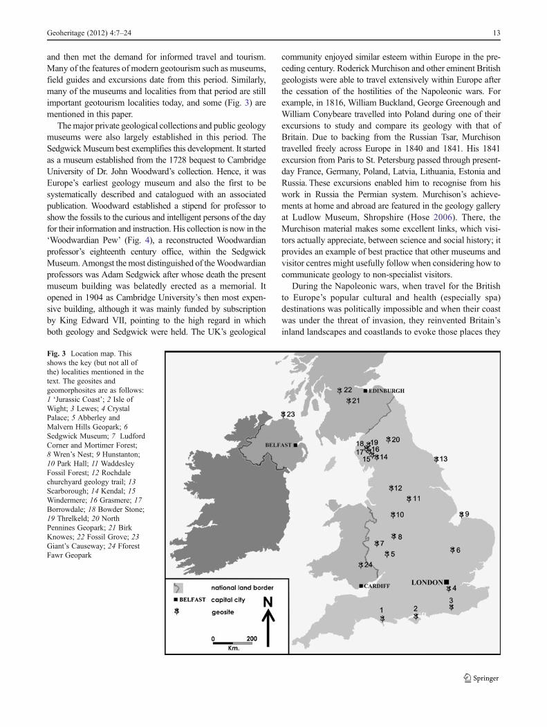
and then met the demand for informed travel and tourism.Many of the features of modern geotourism such as museums,field guides and excursions date from this period. Similarly,many of the museums and localities from that period are stillimportant geotourism localities today, and some (Fig. 3) arementioned in this paper.
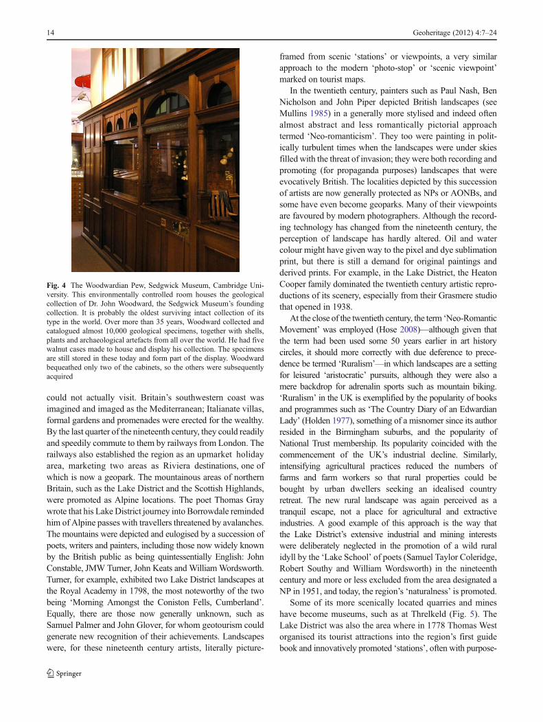
Themajor private geological collections and public geologymuseums were also largely established in this period. TheSedgwickMuseum best exemplifies this development. It startedas a museum established from the 1728 bequest to CambridgeUniversity of Dr. John Woodward’s collection. Hence, it wasEurope’s earliest geology museum and also the first to besystematically described and catalogued with an associatedpublication. Woodward established a stipend for professor toshow the fossils to the curious and intelligent persons of the dayfor their information and instruction. His collection is now in the‘Woodwardian Pew’ (Fig. 4), a reconstructed Woodwardianprofessor’s eighteenth century office, within the SedgwickMuseum.Amongst themost distinguished of theWoodwardianprofessors was Adam Sedgwick after whose death the presentmuseum building was belatedly erected as a memorial. Itopened in 1904 as Cambridge University’s then most expen-sive building, although it was mainly funded by subscriptionby King Edward VII, pointing to the high regard in whichboth geology and Sedgwick were held. The UK’s geological
community enjoyed similar esteem within Europe in the pre-ceding century. Roderick Murchison and other eminent Britishgeologists were able to travel extensively within Europe afterthe cessation of the hostilities of the Napoleonic wars. Forexample, in 1816, William Buckland, George Greenough andWilliam Conybeare travelled into Poland during one of theirexcursions to study and compare its geology with that ofBritain. Due to backing from the Russian Tsar, Murchisontravelled freely across Europe in 1840 and 1841. His 1841excursion from Paris to St. Petersburg passed through present-day France, Germany, Poland, Latvia, Lithuania, Estonia andRussia. These excursions enabled him to recognise from hiswork in Russia the Permian system. Murchison’s achieve-ments at home and abroad are featured in the geology galleryat Ludlow Museum, Shropshire (Hose 2006). There, theMurchison material makes some excellent links, which visi-tors actually appreciate, between science and social history; itprovides an example of best practice that other museums andvisitor centres might usefully follow when considering how tocommunicate geology to non-specialist visitors.
During the Napoleonic wars, when travel for the Britishto Europe’s popular cultural and health (especially spa)destinations was politically impossible and when their coastwas under the threat of invasion, they reinvented Britain’sinland landscapes and coastlands to evoke those places they
Fig. 3 Location map. Thisshows the key (but not all ofthe) localities mentioned in thetext. The geosites andgeomorphosites are as follows:1 ‘Jurassic Coast’; 2 Isle ofWight; 3 Lewes; 4 CrystalPalace; 5 Abberley andMalvern Hills Geopark; 6Sedgwick Museum; 7 LudfordCorner and Mortimer Forest;8 Wren’s Nest; 9 Hunstanton;10 Park Hall; 11 WaddesleyFossil Forest; 12 Rochdalechurchyard geology trail; 13Scarborough; 14 Kendal; 15Windermere; 16 Grasmere; 17Borrowdale; 18 Bowder Stone;19 Threlkeld; 20 NorthPennines Geopark; 21 BirkKnowes; 22 Fossil Grove; 23Giant’s Causeway; 24 FforestFawr Geopark
Geoheritage (2012) 4:7–24 13
could not actually visit. Britain’s southwestern coast wasimagined and imaged as the Mediterranean; Italianate villas,formal gardens and promenades were erected for the wealthy.By the last quarter of the nineteenth century, they could readilyand speedily commute to them by railways from London. Therailways also established the region as an upmarket holidayarea, marketing two areas as Riviera destinations, one ofwhich is now a geopark. The mountainous areas of northernBritain, such as the Lake District and the Scottish Highlands,were promoted as Alpine locations. The poet Thomas Graywrote that his Lake District journey into Borrowdale remindedhim of Alpine passes with travellers threatened by avalanches.The mountains were depicted and eulogised by a succession ofpoets, writers and painters, including those now widely knownby the British public as being quintessentially English: JohnConstable, JMW Turner, John Keats and WilliamWordsworth.Turner, for example, exhibited two Lake District landscapes atthe Royal Academy in 1798, the most noteworthy of the twobeing ‘Morning Amongst the Coniston Fells, Cumberland’.Equally, there are those now generally unknown, such asSamuel Palmer and John Glover, for whom geotourism couldgenerate new recognition of their achievements. Landscapeswere, for these nineteenth century artists, literally picture-
framed from scenic ‘stations’ or viewpoints, a very similarapproach to the modern ‘photo-stop’ or ‘scenic viewpoint’marked on tourist maps.
In the twentieth century, painters such as Paul Nash, BenNicholson and John Piper depicted British landscapes (seeMullins 1985) in a generally more stylised and indeed oftenalmost abstract and less romantically pictorial approachtermed ‘Neo-romanticism’. They too were painting in polit-ically turbulent times when the landscapes were under skiesfilled with the threat of invasion; they were both recording andpromoting (for propaganda purposes) landscapes that wereevocatively British. The localities depicted by this successionof artists are now generally protected as NPs or AONBs, andsome have even become geoparks. Many of their viewpointsare favoured by modern photographers. Although the record-ing technology has changed from the nineteenth century, theperception of landscape has hardly altered. Oil and watercolour might have given way to the pixel and dye sublimationprint, but there is still a demand for original paintings andderived prints. For example, in the Lake District, the HeatonCooper family dominated the twentieth century artistic repro-ductions of its scenery, especially from their Grasmere studiothat opened in 1938.
At the close of the twentieth century, the term ‘Neo-RomanticMovement’ was employed (Hose 2008)—although given thatthe term had been used some 50 years earlier in art historycircles, it should more correctly with due deference to prece-dence be termed ‘Ruralism’—in which landscapes are a settingfor leisured ‘aristocratic’ pursuits, although they were also amere backdrop for adrenalin sports such as mountain biking.‘Ruralism’ in the UK is exemplified by the popularity of booksand programmes such as ‘The Country Diary of an EdwardianLady’ (Holden 1977), something of a misnomer since its authorresided in the Birmingham suburbs, and the popularity ofNational Trust membership. Its popularity coincided with thecommencement of the UK’s industrial decline. Similarly,intensifying agricultural practices reduced the numbers offarms and farm workers so that rural properties could bebought by urban dwellers seeking an idealised countryretreat. The new rural landscape was again perceived as atranquil escape, not a place for agricultural and extractiveindustries. A good example of this approach is the way thatthe Lake District’s extensive industrial and mining interestswere deliberately neglected in the promotion of a wild ruralidyll by the ‘Lake School’ of poets (Samuel Taylor Coleridge,Robert Southy and William Wordsworth) in the nineteenthcentury and more or less excluded from the area designated aNP in 1951, and today, the region’s ‘naturalness’ is promoted.
Some of its more scenically located quarries and mineshave become museums, such as at Threlkeld (Fig. 5). TheLake District was also the area where in 1778 Thomas Westorganised its tourist attractions into the region’s first guidebook and innovatively promoted ‘stations’, often with purpose-
Fig. 4 The Woodwardian Pew, Sedgwick Museum, Cambridge Uni-versity. This environmentally controlled room houses the geologicalcollection of Dr. John Woodward, the Sedgwick Museum’s foundingcollection. It is probably the oldest surviving intact collection of itstype in the world. Over more than 35 years, Woodward collected andcatalogued almost 10,000 geological specimens, together with shells,plants and archaeological artefacts from all over the world. He had fivewalnut cases made to house and display his collection. The specimensare still stored in these today and form part of the display. Woodwardbequeathed only two of the cabinets, so the others were subsequentlyacquired
14 Geoheritage (2012) 4:7–24

built structures, at which tourists could best observe the land-scape whilst perusing a literary description. These stationswhere artifices whereas previously specific features, such ascaverns or grand houses as was the case in the Peak District(Hose 2008), were tourist attractions. However, his ‘stations’were not universally welcomed; in 1799, one at Windermere’swas considered “too finished and artificial” (Ousby 1990,p. 158). Such reservations did not stop the development ofnatural features as commercial tourist attractions. The BowderStone (Fig. 6), a huge balanced boulder, was turned into itsfirst geo-attraction by Joseph Pocklington; by 1807, he haderected a cottage (for the resident guides), a Druid’s stone,small chapel and a ladder so visitors could climb to the top ofthe stone. In reducing the landscape to a series of stations witherudite explanations, tourist behaviours that can be observedalmost anywhere today with, for example, well-advertised carparking where they can take digital snapshots, was estab-lished. Their influence can be seen, perhaps unknowingly bymany practitioners, embedded in today’s geo-interpretation.
Geoconservation
In introducing a report on the European Geosites IUGS-sponsored scheme, its authors made the point, still a truism adecade later, that “Sadly, many geoscientists fail to see thefundamental supportive role of geosite conservation. Its role isto keep available the vital site resource that our communityneeds for future research, as well as for education and training.In essence, it is a simple principle,—no sites, no science”(Wimbledon et al. 2000). However, there is evidence that bythe close of this century’s first decade, geoconservation is
finally becoming recognised as an emergent geoscience andthat these attitudes might well be changing, especially with therecognition of the importance of geosites for sustainabledevelopment education (Henriques et al. 2011). Prior tothe twentieth century, there was little perceived need forthe conservation of either cultural (such as architecturaland industrial) or natural (such as species and habitats)resources. Indeed, the general consensus was that theworld and its resources were inexhaustible and placedthere for people’s use by a benevolent creator. One ofthe purposes in the nineteenth century for systematicallyarranged biological and geological collections was initially tosee the Creator’s design in Nature. Field natural history, ofwhich geology was a component, was the means to observeand appreciate this design in its natural setting. Gradually,scientific geology evolved and the value of fossils in establish-ing stratigraphical correlation was established. Extracting andselling fossils and minerals to tourists and collectors werecommon in the nineteenth century (Woodward 1907, p. 115)and continue today. Many of the early collectors financiallyrewarded quarry workers and miners for good quality geolog-ical specimens. At many classic geosites, the commercialcollecting, preparing and selling of fossils, and the encourage-ment of amateurs’ collecting, still forms part of their tourismmarketing portfolio; however, the large number of touristsnow attracted to some of these by modern mass marketingtechniques is potentially a major geoconservation issue. Somemodern marketing campaigns such as those for the ‘JurassicCoast’, unlike those for biological sites where the emphasis isalmost always on acquiring photographs, actually promote the
Fig. 5 Threlkeld Quarry and Mining Museum, Cumbria. Situated nearKeswick in the Lake District, it is a private museum established in1995 and is open from Easter to October. It has a small on-sitemuseum, together with a collection of mining machinery, and offersan underground mine tour accessed via the mine entrance seen in themiddle of the photograph
Fig. 6 The Bowder Stone, Cumbria. This image is slightly modifiedfrom a postcard produced in the 1880s–1890s of one of the LakeDistricts’s best-known tourist features. It is a perched 1,250-tonneblock some 9 m high, 16 m across and 29 m in circumference isdelicately balanced on a pedestal. It is not a local rock and wasprobably transported by ice from Scotland in the Ice Age. Its odd namederives from Balder, son of the Norse God Odin, but there are nolegends attached to this boulder. The Stone and the surrounding hillswere presented to the National Trust by Princess Louise, daughter ofQueen Victoria, and brother of King Edward VII in memory of theKing, when he died in 1910
Geoheritage (2012) 4:7–24 15

collection and removal of geological specimens. At some ofthese more scientifically significant geosites, a monitoringscheme is needed so that collected material is at least seenand recorded by a geologist before it is taken off-site; that way,significant new finds could at least be recognised and offeredto an appropriate museum or university.
Many scientifically important fossils are only recognisedby researchers following the efforts of commercial collectorsand preparators who perform, if appropriately regulated andmanaged, a valuable service to academic geologists. However,the commercial pursuit of perfect specimens can lead to theloss of many scientifically important specimens and geosites’despoliation, such as at Birk Knowes (MacFadyen 2007b)near Lesmahagow in Lanarkshire, Scotland. There is a grow-ing body of evidence that even protected geosites are increas-ingly threatened by unscrupulous collectors (Wimbledon2006) and museums that do not seem to fully respect thestatutory protection afforded in the place of origin of someof their more recent acquisitions, as with some of the BirkKnowes material that ended up at Berlin’s HumboldtMuseum(MacFadyen 2007b). Information and education programmes,which clearly need an international element, can be fruitful inadvising commercial collectors and museum staffs of thescientific importance of a specimen’s stratigraphical contextand its encasing matrix; an early such scheme was establishedon the Isle of Wight (Anon ND) and another on the ‘JurassicCoast’ (Anon 2004). However, the scientific community canalso damage sites by their research activities, and rock coring,despite the publication of a 20-year-old code of conduct, hasbecome a particular issue even at SSSIs and within geoparks,such as at the Malvern and Abberley Hills (personal observa-tion), and rightly has been termed ‘geovandalism’ (MacFadyen2007a). Indeed, “if we are unsuccessful in instilling a sense ofresponsibility toward the conservation of our Earth heritageamong fellow Earth scientists what hope have we got ofpersuading the rest of the population?” (MacFadyen 2007a,p. 13); it is a disappointment that the problem is still prevalent(Wind 2010). Hence, geoconservation requires collaborativerelationships between collectors (commercial and amateur)and researchers especially in classic localities, geoparks andWorld Heritage Sites such as the ‘Jurassic Coast’ where “…interest is conserved so that scientific investigation can con-tinue, key scientifically important specimens enter the collec-tion of registered museums, fossils are recovered rather thandestroyed….The real issue is to ensure that fossils are collectedresponsibly and at a level that is sustainable” (Edmonds et al.2005, p. 9). It also requires that statutory protection is actuallyenforced in the courts (Wimbledon 2006). Measurable sustain-able management objectives are required to assess the scientificinterest of geosites, their condition and collecting potential.They should ensure the maintenance, if not enhancement, oftheir chief scientific value, that collecting activities do notthreaten them and that important finds are reported. Other
objectives could include modifying geotourists’ behaviourthrough a collecting code.
The initial geotourism approach predicated that it couldprovide the funding and a commercial rationale for geocon-servation, establishing an early sustainable tourism element inits provision. In Europe, Martini (2000) inclined to the viewthat when governments were reluctant to do so, it could fundgeoconservation. Similarly, many landholders and quarryingcompanies see geoconservation as an assault on their profits,but frequently a necessary expense to either continue or gainnew mineral extraction permissions from increasinglyconservation-minded planning authorities. In the UK, the1968 Countryside Act promoted urban fringe tourism throughthe establishment of Country Parks for informal recreation.Some of these, such as Park Hall in Staffordshire, were estab-lished on former quarries; unsurprisingly, this geologicalinterest was usually ignored in their interpretative provision.To many stakeholders, quarries and mines are dangerous eye-sores or ruined landscape to be removed by restoration tosome commercial or leisure use; societally approved land-scapes are cultural constructions whose perception is an admix-ture of observation and cultural interpretation (Pepper 1996;Hose 2010b). Such a constructed approach underpinned latetwentieth century mine and quarry after-use; too conveniently,this was often reliant on infilling with, and sometimesland-forming, domestic and industrial waste. Landfill was thepremier reason for the loss of many especially, worked inDevonian, Carboniferous and Cretaceous limestone and vol-canics, hard-rock quarries. Other, especially soft rock such asthose in near-surface worked Upper Cretaceous and Quater-nary sand and gravel, quarries were allowed or encouraged toflood to replace wetlands lost from the end of the eighteenthcentury to land drainage for agriculture; they are irrevocablylost when their working ceases because their geological sig-nificance is not appreciated.
For the purposes of this paper, geoconservation is defined as“The act of protecting geosites and geomorphosites from dam-age, deterioration or loss through the implementation of pro-tection and management measures.” Geoconservation hasaesthetic, amenity, historical and cultural values and supportswildlife. Hence, sustainable geotourism must consider whatscale of collecting is sustainable; for fossils, sustainable man-agement “…also addresses the wide range of values placed on,and potential uses of, the fossil resource.…Sustainable man-agement integrates scientific, environmental, educational andsocial considerations” (Edmonds et al. 2005, p. 10). Geocon-servation is about ensuring that the current geoheritage ispassed on to future generations as a potential:
& Research opportunity for advancing science and industry& Means to understand andmonitor environmental sensitivity& Palaeoenvironmental record, preserved in landforms and
sediments
16 Geoheritage (2012) 4:7–24
& Training ground for geologists, geomorphologists andpedologists
& Formal and informal education facility& Tourism resource
The first recorded UK attempt to conserve a geomorpho-site was in the 1860s when the Cheesewring, a tor structure,was underpinned to protect it from the effects of the adjacentquarry. However, most geomorphosites or landforms areconserved by maintaining their dynamic systems underwhich they were developed. The conservation of coastal andriver geomorphosites together with caves is probably the mostchallenging, if unrecognised, aspect of geoconservation. Theyare the most threatened by generic tourism developments, letalone geotourism development involving construction, slopestability and coastal defence work. Cave systems are actuallythe most popular geo-attractions. They are threatened by bothinternal and external pressures. Internal pressures are due tocave exploration, recreational usage and scientific investiga-tion; these can all lead to damage to individual passages, cavedecorations and sediments as well as faunal disturbance. Ex-ternal pressures include changes in water levels, chemicalcomposition and sediments resulting from land drainage, waterabstraction, pollution (especially from agricultural sources)and mineral extraction.
Geosites can be categorised for geoconservation purposesin a number of ways, but usefully for geotourism in thecontext of this paper is their primary geotourist interest(whether mineralogical, palaeontological, or petrological)and their physical and intellectual accessibility (Hose 1997),especially since the latter has some geo-interpretative relation-ship with geoconservation. It is the most easily physically andintellectually accessible geosites that are most threatened bythe actions of geotourists. Due to its exposure and possibilitiesof anthropomorphic projection, bioconservation has a muchhigher public profile than geoconservation, even though thelatter is vital to the former because it is the diversity of rocks,sediments, soils and geomorphological processes that directlyunderlie habitats and their floral and faunal communities.Managing dynamic habitats requires an adequate understand-ing of the physical landscape and its geomorphological pro-cesses. Similarly, sustainable development necessitates aconsideration of the sensitivity of extant dynamic and relictlandforms to natural change and humankind’s interference.Conserving terrestrial geomorphosites, with their Quaternaryand Holocene sediments, is challenging due to their economicvalue (as aggregate) and agricultural possibilities (such asmarket gardening and forestry). The geoconservation of spe-cifically geological geosites is somewhat different be-cause retaining access to their benefits from debris removalthrough the limited disturbance created by well-managedspecimen collecting, ensuring that the disturbance is limited,is one of the challenges of geo-interpretation.
Geo-interpretation
For the purposes of this paper, geo-interpretation is defined as‘The art or science of determining and then communicatingthe meaning or significance of a geological or geomorpholog-ical phenomenon, event, or location.” Commonly, it is thehuman interest of the science of a geosite or geomorphosite,rather than the pure science itself, that most engages people’sattention. Hence, geohistory can underpin efficacious geo-interpretation (Hose 1997, 1998, 2005b). It is often a geosite’sreadily observed features rather than its complex geologicalstory that initially attract geotourists’ attention and interest.Having thus gained geotourists’ interest and attention by aninitial account based on the geosite’s human interest and/orobvious feature, more complex accounts of scientific geologyand stratigraphy can then be delivered with a greater likeli-hood than otherwise would be the case that they will be wellreceived. Hence, geo-interpretation is not about ‘dumbingdown’ the science but developing vehicles to carry the mes-sage to geotourists along a graded journey of knowledge andunderstanding to the destination of comprehension and empa-thy with the appropriate mix of text and graphics (Hose2005b). Geo-interpretation is more than about the mere trans-mission of facts; its equally important role is to engenderconcern for a geosite and empathy for geoconservation.Geotourism, underpinned by geoconservation and dependentupon geo-interpretation provision, is a late twentieth centurydevelopment built upon the earlier foundations of best envi-ronmental education practice drawn initially from the USAand implemented and evolved in the UK from the 1960sonwards.
However, the UK had some of the earliest attempts tointerpret and present geology to non-specialist audiences inthe nineteenth century. Two of the most significant wereprobably the world’s first urban geology trail (Baldwin andAlderson 1996) and the world’s first attempt to create life-sized reconstructions of fossil animals (Doyle and Robinson1993; McCarthy and Gilbert 1994). The former was estab-lished in a Rochdale churchyard in 1881. It consisted of 30stone pillars, each inscribed with an identification label anda biblical quote, but there does not appear to have been anyassociated published leaflet. Unfortunately, over a hundredyears, several of the pillars were damaged or lost. Fortunately,in 2010, plans were put in hand to restore the trail by replacingthe missing columns and cleaning a small area of the originalones to make their examination easier, altogether an unusualgeoconservation project. The world’s first attempt to illustrateprehistoric life based upon fossil evidence, from Dorset, wasDe la Beche’s 1830 oil painting ‘Duria antiquior’, of whichthere are several copies, including one at the SedgwickMuseum. The world’s first geological theme park, withlaudable educational aims, with three-dimensional recon-structions of prehistoric animals (Fig. 7) and plants on accurately
Geoheritage (2012) 4:7–24 17

rendered geological sections was at the Crystal Palace (Doyleand Robinson 1993). The 15 life-size reconstructions werecommissioned in 1852 for the opening of the Crystal PalacePark. They included reconstructions of the three dinosaur spe-cies then known, from just a few bones at the time, to thescientific world in the 1850s, sculpted by BenjaminWaterhouseHawkins under the guidance of the eminent paleontologistRichard Owen. Despite their inaccuracies, even today on firstview, it is possible to appreciate why they caused a nationalsensation, although unlike in Victorian times neither journalsnor newspapers would praise their frightening realism! After a£4 m restoration, completed in 2007, the iron-reinforced con-crete and brick dinosaur reconstructions were designated byEnglish Heritage as grade I architectural structures.
The preservation of spectacular fossils in situ was alsodeveloped in the UK in the late nineteenth century. A ‘fossilforest’ was unearthed in 1873 at the then South YorkshireCounty Lunatic Asylum (Sorby 1875, p. 458) and subsequentlyprotected by two small viewing sheds, However, these fell intodisrepair and the site became overgrown before being exca-vated by archaeologists and then reburied as a protectivemeasure in the late 1990s (Cleal and Thomas 1995a,pp. 208–210). Another fossil forest was uncovered in 1887 inGlasgow (Cleal and Thomas 1995b, pp. 189–191) when anold quarry was being landscaped for a park, in an earlyexample of such restoration, to commemorate Queen Victoria’sJubilee; the scheme was also, as in modern geoparks, intendedto provide much needed employment for former shipbuilders.The site’s most obvious features were 11 fossil tree stumps,some of them almost a metre high, preserved in the position in
which they once grew. A fallen trunk, about 8 m long, andsmaller branch and root fragments had also survived. Thedecision was quickly taken to preserve the forest by erecting apermanent building and to open it to the public. ‘Fossil Grove’opened on 1st January 1890, and it is the UK’s longest contin-uously open geo-attraction. These last two examplesconsiderably pre-date the similar approach adopted in theHaute-Provence Geopark and its associated museum at Digne.
The UK’s and the world’s first purpose-built geologymuseum open to the public was The Rotunda Museum atScarborough (Fig. 8). It was designed by William Smithand opened in 1829. The Geological Survey’s Museumof Economic Geology only opened in 1841 in London.After various relocations in converted buildings, it movedto purpose-built premises and reopened in 1935. Its displayspartly reflected the content and coverage of the regionalgeology publications of the Geological Survey. Its 1973 mul-timedia exhibition ‘The Story of the Earth’ was the firstpermanent exhibition to cover plate tectonics. However, inthe 1980s, it was absorbed by the adjacent Natural HistoryMuseum. In 1996, two new galleries were opened, one ofwhich, ‘Restless Earth’, was probably the first UK permanentexhibition with a geomorphological focus.
The UK also led the way in developing populist geologicalpublications, especially those produced by Gideon Mantell.
Fig. 7 Crystal Palace, London. One of the Wealden (Upper Creta-ceous) reconstructions of a Hyaeolosaur; the body is the originalWaterhouse construction, but the head is a modern fibreglass replace-ment. The whole creature was modelled on the specimen from TilgateForest, Sussex, that was then barely prepared from its encasing matrix;it was presented to the Natural History Museum in 1839 by GideonMantell who had discovered it in 1832 and who also named it from thatspecimen
Fig. 8 Rotunda Museum, Scarborough. Designed by William Smith,the ‘father of English geology’, and opened in 1829, this was theworld’s first purpose-built building to house a geology museum. Itwas opened 2 years after the foundation of the ‘The ScarboroughPhilosophical Society’ which, being in some of England’s finest Jurassicand Cretaceous geology outcrops, enabled its members to collect asubstantial number of fossils, including large marine vertebrates. Mem-bers soon discussed the possibility of a museum, and William Smith,recently employed as a land steward on a nearby estate, was at one ofthese meetings. He became the designer and then foreman of works of thenew Scarborough Museum; it became ‘The Rotunda’ because of itsdistinctive cylindrical shape. A unique feature of the museum was thesloping shelves that Smith used to display rocks and fossils in their correctstratigraphical positions
18 Geoheritage (2012) 4:7–24

‘The Fossils of the South Downs’ (Mantell 1822) and‘Illustrations of the Geology of Sussex’ (Mantell 1827) werelarge illustrated costly library volumes rich in locality infor-mation.Mantell’s ‘The Geology of the South-East of England’of 1833 was his first pocketable volume and could, ignoringits expense, have been taken into the field and included geo-tourism information; for example, the beach near Rottingdean“…contains semi-translucent pebbles of agate, and chalcedo-ny, of a bluish grey colour. These are collected by visitors andwhen cut and polished are used for bracelets and other
ornamental purposes…” (Mantell 1833, pp. 40–41). Hisgreatest contribution to modern geo-interpretation is the firsttrue geological field guide, ‘Geological Excursion Round theIsle of Wight and the Adjacent Coast of Dorsetshire’ of 1847;further 1851 and 1854 (Fig. 9) editions indicated how well itsold. It was a readily pocketable and relatively inexpensiveillustrated field guide. The first edition’s Preface justified thebook’s approach: “…the Geology of the Island is but littleknown or regarded by the majority of the intelligent personswho every season flock by thousands to its shores, and, rapidly
Fig. 9 Frontispiece of GideonMantell’s ‘GeologicalExcursion Round the Isle ofWight and the Adjacent Coastof Dorsetshire’ of 1854 (thirdedition). First published in1847, this is the genesis of themodern, compact illustratedgeology field guide
Geoheritage (2012) 4:7–24 19

traversing the accustomed routes, visit the picturesque locali-ties noted in the numerous handbooks, and take their departurewithout suspecting that they have been travelling over a coun-try rich with the spoils of nature…of the highest interest to theinstructed observer. Even the inhabitants…manifest an extraor-dinary degree of apathy in everything relating to the Geologyof the Island” (Mantell 1847). His earlier (Mantell 1846) ‘ADay’s Ramble in and around the Ancient Town of Lewes’ of1846 adopted a more holistic approach to geology, with only 1of its 11 chapters dealing with geology. He also pioneered(Mantell 1849) children’s geology books with his 1849‘Thoughts on a Pebble’ (Fig. 10). The establishment of theGeologists’ Association in 1858 helped popularise geologyfield trips, mainly for amateur geologists, and these werereported in its Proceedings and also a few summary volumes.
Until the 1960s, few other UK geo-interpretation develop-ments are recorded. After the country’s first geological, theWren’s Nest, National Nature Reserve’s 1956 designation, amajor management challenge was the “…danger from over-collecting, and the approach changed to one of look-and-seerather than hammer-and-take” (Robinson 1996, p. 211). Severalversions of its trail guide were supplemented by an on-sitedisplay in 1996. The 1973 ‘Mortimer Forest Geology Trail’(Lawson 1977) near Ludlowwas the first purposely establishedrural educational geology trail. In the late 1980s, geology-focussed visitor centres, such as the National Stone Centre(Thomas and Hughes 1993) and the Charmouth Heritage CoastCentre (Edmonds 1996), providing a range of activities such astalks, identification services and guidedwalks were established.
Concomitantly, interpretative panels began to be erected, andamongst the earliest of these were two by English Natureat the coastal resorts of Hunstanton (Hose 1994b, 1995b) andScarborough (Page 1994). Commemorative plaques, such asthat for the Silurian at Ludford Corner near Ludlow (Fig. 11),placed in the late 1970s are rare. They should be more widelyemployed to increase public awareness of the significant rolethat the UK and Europe played in scientific geology’s devel-opment, and perhaps then their neglect will become an issue;at Ludford Corner, a commemorative bench for a local resi-dent was within a few years placed immediately in front of theinternational commemorative plaque!
Geoparks and their Significance for the Three KeyElements
Because not all of the world’s scientifically or historicallyimportant geosites could meet the ‘outstanding universalvalue’ criterion required by the 1972 UNESCOWorld HeritageConvention, an alternative UNESCO designation seemed nec-essary to recognise and promote their significance; hence, geo-parks were proposed and the original UK author’s geotourism
Fig. 10 Plate 5 from ‘Thoughts on a Pebble’ by Gideon Mantell.Published in 1849, this was an early, if not the first, attempt at apopulist geology book for children. The plate shows the pebble de-scribed and explained in the book, although one would never find sucha pebble of this composition and fossil content in the real world!
Fig. 11 Commemorative plaque at Ludford Corner, Ludlow, Shrop-shire. This was placed at the key exposure of the Ludlow Bone Bed(Upper Silurian) in 1989, to mark the 150th anniversary of the estab-lishment of the Silurian System, and then subsequently obscured by acommemorative bench for a local resident within a few years; it is notdifficult to imagine how the two could have been better integrated bythe simple repositioning of the bench at the site and perhaps indicateshow poorly the significance of the local geology and the specificlocality, despite the available and relatively abundant scientific andpopulist literature, is appreciated by the local community
20 Geoheritage (2012) 4:7–24

definition and approach was incorporated within the proposaldocumentation (UNESCO 2000). This envisaged that theywould recognise the relationships between people and geologyand the potential for economic development. The programme’smajor benefit was to focus attention directly on geological andgeomorphological conservation and the related issue of sustain-able development. Ideally, the geological interest was to beallied to some archaeological, cultural, historical or ecologicalinterest. Within geoparks, educational provision is required tomaintain membership. Significantly for geoconservation, thesale of geological material, whether local or imported, is pro-hibited within geoparks. UNESCO supported the establishmentof European Geoparks as a small network of European siteswith significant geological heritage and a sustainable develop-ment strategy. In June 2000, the European Geoparks Network(EGN) was established when four founding geoparks signed aconvention to share information and expertise. In April 2001,the EGN signed a collaboration agreement with UNESCO’sDivision of Earth Sciences on placing it under its auspices. InOctober 2004, the Network signed the Madonie declarationrecognising the EGN as the official branch of the UNESCOGlobal Geoparks Network for Europe. The EGN is representedin ten countries with some 25 geoparks.
In many EGN geoparks, some account is given of the pastexploitation and use of their rocks and minerals. They continueand develop the trends in geo-interpretation resulting from the1970s’ industrial heritage boom that had similar desired out-comes. The first UK geopark, in 2001, was the Marble ArchCaves in Northern Ireland. The first in England, in 2003, wasthe North Pennines. That geopark gave some consideration ofthe history of geology and the major personalities involved forits area within its documentation. The recognition of geoparkswithin the Brecon Beacons (Fforest Fawr) NP inWales and the
North West Highlands in Scotland, in 2006 and 2007, respec-tively, coupled with newer geoparks (Abberley and MalvernHills, English Riviera GeoMon–Anglesey, Lochaber, andShetland) and geopark candidates (Cornwall and the WelshBorderland) created nine UK EGN geoparks, but the Abberleyand Malvern Hills withdrew from the EGN in 2010.
For geoconservation purposes, the impact of people atgeosites and geomorphosites can be reduced by adoptingsingly or in combination various measures:
& Concentrating the activities in ‘honey pot’ locations soas to reduce geotourists’ disturbance and impact
& Spreading and restricting (especially seasonally to reducebiodiversity impacts) the activities geographically andtemporally so as to dilute geotourists’ disturbance andimpact
& Segregating different activities and geotourist types tocreate relatively undisturbed zones
& Providing geo-interpretation to facilitate geotourists’self-regulation and behavioural modification
World Heritage Site designation has only been achieved bythe Giant’s Causeway (1986) and the ‘Jurassic Coast’ (2001),so geoparks are currently the major geotourism developmentin the UK, but other geotourism provision at a local levelprobably equals or surpasses their total output. Geoparks are anatural development of the nineteenth century approach tolandscape promotion, and, as in the Lake District’s Kendalto Windermere railway of 1847 (Hose 2008), their develop-ment is linked to the regeneration of local and regional econ-omies. The key geoconservation issue is learning the lessonsfrom popular nineteenth century regions where access devel-opments exemplify issues around the impact of higher touristnumbers. In making such landscapes too physically and
Fig. 12 Summary chronography of geotourism. Apart from the estab-lishment of the Woodwardiam Museum in 1728, most of the majorgeotourism events (with an inevitable UK emphasis) are indicated and
contextualised within the approximate timeframes of some of Europe’skey artistic movements
Geoheritage (2012) 4:7–24 21

intellectually accessible, there is the danger that something oftheir inherently spiritual nature is lost. The continued devel-opment of geoparks will re-ignite the debate that Words-worth’s elite approach to landscape accessibility generated; itis already the case that at many designated geosites, onlypermit holders, with high-level research and academic creden-tials, are permitted access and collection, when previouslyboth were allowed to the public.
Closing Comments
Geoparks, to the credit of their marketing and promotionalteams, will, as they have already done so, continue to attractnew and larger audiences than thitherto to geology; in turn,they will generate new demands and pressures on geosites,for which solution will need to be found from researchprogrammes. Consequently, there will be an ongoing debateabout the correct balance to strike between geoconservationand geo-exploitation; presently, it could justifiably be arguedfor some geosites in geoparks andWorld Heritage Sites that thebalance is inappropriate for sustainable geotourism. Furtherresearch and evaluation work to generate geosite and landscapeinventories is required to aid the better selection of appropriategeopark candidates; the establishment of new geoparks needsto be more firmly rooted in spectacular and scientifically sig-nificant geology within obvious topographical boundaries thanis currently the case. Too often, geopark designation is given toareas already protected by legislation or promoted by otherschemes; this seems a waste of endeavour when there are justso many worthy geosites in need of some protective designa-tion and protection. The geology and geomorphology of mostgeoparks and World Heritage Sites requires revision and newresearch to redress the over-reliance on legacy sources. Theactual geological interest within most geoparks requires greaterappreciation and emphasis by both managers and visitors.
Geopark and World Heritage Site geotourism promotiongenerally exhibit limited understanding of the relevance of thehistory, development and philosophy of landscape promotion(that is geohistory), and modern geotourism itself; hence, achronology of geotourism is herewith presented (Fig. 12).Furthermore, the lessons that can be gleaned from such con-siderations need to be applied. Modern geotourism’s antece-dents and modern approach required a fundamental shift inhow landscapes were perceived and then exploited for tour-ism. Curiosity and aesthetic worth developed before scientificworth as motivators for tourists. The nineteenth century rise ofscientific geology encouraged field excursions, and to supportthese, field guides were published. Their locations andactivities are embedded within modern geotourism. Themajor change has been the nature of the relationship thatmodern geotourists enjoy with the landscape compared withtheir historic predecessors. Theirs is a greater emphasis on
pleasure and leisure than intellectual endeavour and spiritualawareness. However, this does not preclude adopting geotour-ism approaches to educate them on geology’s past and presentscientific and cultural significance.
Acknowledgements The most constructive review of an earlier draftof this paper by a referee is gratefully acknowledged. This paper has alsobenefited from the author’s engagement at conferences and on fieldworkwith numerous co-workers. Whilst it would be invidious to attempt toname all of them, acknowledgement is readily given to colleagues inGeoConservationUK (GCUK), the Regionally Important Geological andGeomorphological Sites (RIGS) movement, and ProGEO.
References
Amrikazemi A (2010) Atlas of geopark and geotourism resources ofIran: geoheritage of Iran. Geological Survey of Iran, Tehran
Anon (2004) Fossil collecting on the Jurassic Coast. Dorset CountyCouncil, Dorchester
Anon (ND) Guidelines for collecting fossils on the Isle of Wight. Isleof Wight County Council, Newport
Baird JC (1994) Naked rock and the fear of exposure. In: O'HalloranD, Green C, Harley M, Stanley M, Knill J (eds) Geological andlandscape conservation. The Geological Society, London,pp 335–336
Baldwin A, Alderson DM (1996) A remarkable survivor: a nineteenthcentury geological trail in Rochdale, England. Geological Curator6(6):227–231
Casey JN, Stephenson AE (1996) Putting geology into tourism—sometips and practical experience. Geological Society of Australia,13th Australian Geological Convention, Canberra, February1996, Abstracts 41, p 79
Cavuoto B (2005) “Sustainable development”: an elusive concept.Queen Mary Law J 5:49–60
Cleal CJ, Thomas BA (1995a) Wadsley fossil forest. In: Cleal CJ,Thomas BA (eds) Geological conservation review, vol 12: Palae-ozoic palaeobotany of Great Britain. Chapman and Hall, London,pp 208–210
Cleal CJ, Thomas BA (1995b) Victoria Park. In: Cleal CJ, Thomas BA(eds) Geological conservation review, vol 12: Palaeozoic Palaeobo-tany of Great Britain. Chapman and Hall, London, pp 188–191
De Bastion R (1994) The private sector—threat or opportunity? In:O'Halloran D, Green C, Harley M, Stanley M, Knill J (eds)Geological and landscape conservation. The Geological Society,London, pp 391–395
Dowling RK (2011) Geotourism’s global growth. Geoheritage 3:1–13Dowling RK, Newsome D (eds) (2008a) Inaugural Global Geotourism
Conference (Australia 2008) Conference Proceedings. EdithCowan University, Perth, Western Australia
Dowling RK, Newsome D (eds) (2008b) Geotourism. Elsevier,London
Dowling RK, Newsome D (2010) The future of geotourism: where tofrom here? In: Newsome D, Dowling RK (eds) Geotourism: thetourism of geology and landscapes. Goodfellow, Oxford, pp 231–244
Doyle P, Robinson JE (1993) The Victorian geological illustrations ofCrystal Palace Park. Proc Geol Assoc 104(4):181–194
Edmonds RPH (1996) The potential of visitor centres: a case history.In: Page KN, Keene P, Edmonds RPH, Hose TA (eds) EnglishNature Research Reports No. 176—Earth Heritage Site interpreta-tion in England: a review of principle techniques with case studies.English Nature, Peterborough, pp 16–23
22 Geoheritage (2012) 4:7–24

Edmonds R, Larwood J, Weighell T (2005) Sustainable site-basedmanagement of collecting pressure on palaeontological sites.English Nature, Peterborough
Frey M (1998) Geologie—Geo-Tourismus—Umweltinbildung: Themenund Tatigkeistbereiche in Spannungsfeld Okonomie und NachhaltigeEntwicklung, Terra Nostra, Schriften der Alfred-Wegner Stiftung, 98/3, 150 Jahre Dt. Geol. Ges.,n 06-09/10/’1998. Programme andSummary of Meeting Contributions. Berlin Technical University,Berlin
Frey M-L (2008) Geoparks—a regional European and global policy.In: Dowling RK, Newsome D (eds) Geotourism. Elsevier, London,pp 95–117
Gordon JE, Barron HF (2011) Scotland’s geodiversity: development ofthe basis for a national framework. Scottish Natural HeritageCommissioned Report No. 417. Scottish Natural Heritage,Edinburgh
Hall CM, Weiler B (1992) What’s special about special interest tourism?In: Weiler B, Hall CM (eds) Special interest tourism. Belhaven,London, pp 1–14
Hardy A, Beeton JS, Pearson L (2002) Sustainable tourism: an overviewof the concept and its position in relation to conceptualisations oftourism. J Sustain Tour 10(6):475–496
Hebron S (2006) The Romantics and the British landscape. BritishLibrary, London
Henriques MH, dos Reis RP, Brilha J, Mota T (2011) Geoconservationas an emerging geoscience. Geoheritage 3:117–128
Holden E (1977) The Country Diary of an Edwardian Lady. MichaelJoseph, London
Hose TA (1994a) Telling the story of stone—assessing the client base.In: O'Halloran D, Green C, Harley M, Stanley M, Knill S (eds)Geological and landscape conservation. Geological Society, London,pp 451–457
Hose TA (1994b) Rockhounds Welcome!—Assessing the UnitedKingdom client base for site-specific geological interpretation.Unpublished paper delivered to the Visitor Studies AssociationAnnual Conference, 26–30 July 1994, Raleigh, North Carolina,USA
Hose TA (1994c) Interpreting geology at Hunstanton Cliffs SSSI Norfolk:a summative evaluation (1994). The Buckinghamshire College, HighWycombe
Hose TA (1995a) Selling the story of Britain's stone. Env Interpret 10(2):16–17
Hose TA (1995b) Evaluating interpretation at Hunstanton. Earth Heritage4:20
Hose TA (1996) Geotourism, or can tourists become casual rockhounds? In: Bennett MR (ed) Geology on your doorstep. TheGeological Society, London, pp 207–228
Hose TA (1997) Geotourism—selling the earth to Europe. In:Marinos PG,Koukis GC, Tsiamaos GC, Stournass GC (eds) Engineering geologyand the environment. AA Balkema, Rotterdam, pp 2955–2960
Hose TA (1998) Is it any fossicking good? Or behind the signs—acritique of current geotourism interpretative media. Unpublishedpaper delivered to the Tourism in Geological Landscapes Conference(DoENI/Geological Survey NI/GeoConservation Commission),Ulster Museum, Belfast
Hose TA (2000) European geotourism—geological interpretation andgeoconservation promotion for tourists. In: Barretino D,WimbledonWP, Gallego E (eds) Geological heritage: its conservation andmanagement. Instituto Tecnologico Geominero de Espana, Madrid,pp 127–146
Hose TA (2003) Geotourism in England: a two-region case studyanalysis. Unpublished PhD thesis, University of Birmingham,Birmingham
Hose TA (2005a) Geo-tourism—appreciating the deep time of landscapes.In: Novelli M (ed) Niche tourism: contemporary issues, trends andcases. Elsevier, London, pp 27–37
Hose TA (2005b) Writ in stone: a critique of geoconservation panelsand publications in Wales and the Welsh borders. In: Coulson MR(ed) Stone in Wales. Cadw, Cardiff, pp 54–60
Hose TA (2006)Geotourism and interpretation. In: Dowling R, NewsomeD (eds) Geotourism. Elsevier, London, pp 221–241
Hose TA (2008) Towards a history of geotourism: definitions, ante-cedents and the future. In: Burek CV, Prosser C (eds) The historyof geoconservation (Special Publication 300). Geological Society,London, pp 37–60
Hose TA (2010a) Volcanic geotourism in West Coast Scotland. In:Erfurt-Cooper P, Cooper M (eds) Volcano and geothermal tourism:sustainable geo-resources for leisure and recreation. Earthscan,London, pp 259–271
Hose TA (2010b) The significance of aesthetic landscape appreciationto modern geotourism provision. In: Newsome D, Dowling RK(eds) Geotourism: the tourism of geology and landscapes. Good-fellow, Oxford, pp 13–25
Jenkins JM (1992) Fossickers and rockhounds in northern New SouthWales. In: Weiler B, Hall CM (eds) Special interest tourism.Belhaven, London, pp 129–140
Joyce EB (2006) Geological heritage of Australia: selecting the best forGeosites and World Heritage, and telling the story for geotourismand Geoparks. AESC 2006 Extended Abstract
Kavecic M, Peljhan M (2010) Geological heritage as an integral part ofnatural heritage conservation through its sustainable use in theIdrija Region (Slovenia). Geoheritage 2:137–154
Komoo I (1997) Conservation geology: a case for the ecotourismindustry of Malaysia. In: Marinos PG, Koukis GC, TsiambaosGC, Stournas GC (eds) Engineering geology and the environment.Balkema, Rotterdam, pp 2969–2973
Komoo I, Deas KM (1993) Geotourism: an effective approach towardsconservation of geological heritage. Unpublished paper, Badung,Malaysia, Symposium of Indonesia–Malaysia Culture
Larwood J, Prosser C (1998) Geotourism, conservation and tourism.Geol Balacania 28(3–4):97–100
Lawson JD (1977) Mortimer forest geological. Nature ConservancyCouncil, London
Leafe R (1998) Conserving our coastal heritage—a conflict resolved.In: Hooker J (ed) Coastal Defence and Earth Science Conservation.Proceedings of the Conference on Coastal Defence and EarthScience Conservation, Portsmouth, 1997. Geological Society,London, pp 10–19
MacFadyen C (2007a) When coring 0 geovandalism. Earth Heritage27:12–13
MacFadyen C (2007b) Missing Birk Knowes fossils: SNH calls it aday. Earth Heritage 27:8–9
MacFadyen C (2008) Coreholes: a widespread problem. Earth Heritage28:17
Maini JS, Carlisle A (1974) Conservation in Canada: a conspectus—Publication No. 1340. Department of the Environment/CanadianForestry Service, Ottawa
Mantell GA (1822) The fossils of the South Downs. Lupton Relfe,London
Mantell GA (1827) Illustrations of the geology of Sussex. LuptonRelfe, London
Mantell GA (1833) The geology of the south-east of England. Longman,London
Mantell GA (1846) A day’s ramble in and around the ancient town ofLewes. Henry Bohn, London
Mantell GA (1847) Geological excursion round the Isle of Wight andalong the adjacent Coast of Dorsetshire (2nd edn.), Henry G.Bohn, London
Mantell GA (1849) Thoughts on a pebble. Benham and Reeve, LondonMao I, Robinson AM, Dowling R (2009) Potential geotourists: an
Australian case study. Leisure Solutions, Turramura, New SouthWales
Geoheritage (2012) 4:7–24 23

Martini G (1994) The protection of geological heritage and economicdevelopment: the saga of the Digne ammonite slab in Japan. In:O'Halloran D, Green C, Harley M, Stanley M, Knill J (eds)Geological and landscape conservation. The Geological Society,London, pp 383–386
Martini G (2000) Geological heritage and geo-tourism. In: Barretino D,Wimbledon WP, Gallego E (eds) Geological heritage: its conser-vation and management. Instituto Tecnologico Geominero deEspana, Madrid, pp 147–156
McCarthy S, Gilbert M (1994) The Crystal Palace Dinosaurs: the storyof the world’s first prehistoric sculptures. Crystal Palace Foundation,London
McKirdy A (2000) Environmental geology: reaching out to a wideraudience. Scott J Geol 36:105–109
Mullins E (1985) A love affair with nature. Phaidon, OxfordSadry BN (2009) Fundamentals of geotourism: with emphasis on Iran.
Samt Organization Publishing, TehranNewsome D, Dowling RK (eds) (2010) Geotourism: the tourism of
geology and landscapes. Goodfellow, OxfordNewsome D, Moore SA, Dowling R (2002) Natural area tourism:
ecology, impacts and management. Channel View Publications,Clevedon
Ousby I (1990) The Englishman’s England: taste, travel and the rise oftourism. Cambridge University Press, Cambridge
Page KN (1994) Information signs for geological and geomorphologicalsites: basic principles. In: O'Halloran D, Green C, HarleyM, StanleyM, Knill S (eds) Geological and landscape conservation. GeologicalSociety, London, pp 433–437
Page KN (1998) England's Earth heritage resource—an asset for every-one. In: Hooke J (ed) Coastal defence and Earth science conserva-tion. The Geological Society, London, pp 196–209
Pepper D (1996) Modern environmentalism: an introduction. Routledge,London
Read SE (1980) A prime force in the expansion of tourism in the nextdecade: special interest travel. In: Hawkins DE, Shafer EL, RovelstadJM (eds) Tourism marketing and management issues. GeorgeWashington University Press, Washington, DC
Ritvo H (2009) The dawn of green: Manchester, Thirlemere andmodern environmentalism. University of Chicago Press, Chicago
Robinson E (1996) GEOLOGY RESERVE: Wren’s Nest revised. GeolToday 12(6):211–213
Robinson E (1998) Tourism in geological landscapes. Geol Today 14(4):151–153
Ruchkys UdeA (2005) Patrimônio Geológico e Geoconservação doQuadrilátero Ferrífero, Minas Gerais. Belo Horizonte. Qualificaçãode Doutorado. Instituto de Geociências. Universidade Federal deMinas Gerais, Brazil
Ruchkys U de A (2007) Patrimônio Geológico e Geoconservação noQuadrilátero Ferrífero, Minas Gerais: potencial para criação deum geoparque da UNESCO. Tese de Doutorado—Instituto deGeociências, Universidade Federal de Minas Gerais, Minas Gerais,Brazil
Silva FR (2007) A paisagem no Quadrilátero Ferrífero, MG: potencialpara o uso turístico da sua geologia e geomorfologia. Dissertaçãode Mestrado, Programa de Pós-Graduação, Departamento deGeografia–UFMG, Belo Horizonte
Slomka T, Kicinska-Swiderska A (2004) Geotourism—the basic concepts.Geoturystyka 1:5–7
Sorby HC (1875) On the remains of a fossil forest in the coal-measuresat Wadesley, near Sheffield. Quart J Geol Soc 31:458–459
Spiteri A (1994) Malta: a model for the conservation of limestoneregions. In: O'Halloran D, Green C, Harley M, Stanley M, KnillJ (eds) Geological and landscape conservation. The GeologicalSociety, London, pp 205–208
Stueve AM, Cock SD, Drew D (2002) The geotourism study: phase 1executive summary. National Geographic, Washington, DC
Thomas IA, Hughes K (1993) Reconstructing ancient environments.Teach Earth Sci 18:17–19
UNESCO (2000) UNESCO Geoparks Programme Feasibility Study,August 2000. UNESCO, Paris
Weaver DB, Lawton LJ (2007) Twenty years on: the state of contempo-rary ecotourism research. Tour Manag 28:1168–1179
Wimbledon WAP (2006) Commercial exploitation versus sustainableuse. Earth Heritage 27:7–8
WimbledonWAP, Ishchenko AA, GerasimenkoNP, Karis LO, SuominenV, Johansson CE, Freden C (2000) Geosites—an IUGS initiative:science supported by conservation. In: BarretinoD,WimbledonWP,Gallego E (eds) Geological heritage: its conservation and manage-ment. Instituto Tecnologico Geominero de Espana, Madrid, pp 69–94
Wind A (2010) Vandals, wha hae wi’ samples fled. Geosci 20(1):5Woodward HB (1907) The history of the Geological Society of London.
The Geological Society, LondonWorld TourismOrganization (1997)What tourismmanagers need to know:
a practical guide for the development and application of indicators ofsustainable tourism. World Tourism Organisation, Madrid
24 Geoheritage (2012) 4:7–24