identification of the geotourism potential of …
TRANSCRIPT

GeoJournal of Tourism and Geosites Year XIV vol 36 no 2spl 2021 p630-636 ISSN 2065-1198 E-ISSN 2065-0817 DOI 1030892gtg362spl10-692
httpgtgwebhostuoradearo
IDENTIFICATION OF THE GEOTOURISM POTENTIAL
OF AFGHANISTAN A CASE STUDY BAMIYAN COUNTY
Morteza ESMAELNEJAD
University of Birjand Faculty of Literature and Humanities South Khorasan Iran e-mail Esmailnejadmbirjandacir
Citation Esmaelnejad M (2021) IDENTIFICATION OF THE GEOTOURISM POTENTIAL OF AFGHANISTAN A CASE STUDY BAMIYAN COUNTY GeoJournal of Tourism and Geosites 36(2spl) 630ndash636 httpsdoiorg1030892gtg362spl10-692
Abstract Afghanistan is a wilderness and varied country in the geo-tourism sector The aim of this study was to investigate the capabilities of geotourism and also to identify the capacities of geotourism development in Bamiyn province In this area model Hadžić et al (2010) has been used the survey was conducted using 20 tourists and 5 experts Geographic information system were effectively used for identification of the potential ecotourism sites It is the indicator of a vast range of geo logical and geomorphic forms in Bamyan state The result indicates that the study area has strengths and opportunities for the development of geotourism that are not well identified and introduced
Key words Afghanistan Geotourism Dynamic Model Local Development
INTRODUCTION
Tourism is typically associated with certain economic benefits including income employment and in the case of
international tourism foreign exchange earnings which then stimulate wider economic growth (Sharpley 2009) In fact the
tourism structure of a place can affect the tourists demand (Law 2002) and the organization of tourism in one place begins
with a plan to understand the behavior of tourists in that place (Bansal et al 2004) The natural landscapes have structured
attractions in themselves which make people more motivated to demand tourism and visit them Geomorphologic climatic
mineral water vegetation and animal species attractions along with underground waterways with or without water are among the most important factors in economic tourism studies and policies (Fennel 1999) The basic disciplines associated with
geotourism include science economics social science education and media (Olafsdoacutettir et al 2018) Visiting natural places
with scenic beauty is a traditional practice However the concept of geotuorism taken shape in recent times (Singhand and
Ghosh 2021) Geotourism is often defined by researchers in the general context of tourism in geological prospects of
geomorphology (Hadžić et al 2010 Coratza and Giusti 2005 Nemanj 2011 Gordon 2018 Maghsoudi and Rahmati 2018)
While geotourism is not mere tourism in geological geomorphological prospects but geotourism inclusion is very grate
(Dowling 2008) Thus geotourism means the tourism that maintains or enhances the geographic identity of a place
encompasses not only the environment but also the heritage of the culture and aesthetics of the place and most importantly the
welfare of the locals (Pereira and Dias 2008) Geotourism targets are often geosites or geographical phenomena that can be
used as geopolitical heritage in the form of a geopark as a tool for tourism development (Abdi et al 2005) Geomorphologic
tourist places are defined as geomorphologic forms and processes Therefore human perception of the geological geomorphological historical and social influences of these places has aesthetic scientific historical or socio-economic values
(Mokhtari et al 2012) These geomorphological attractive geological locations are defined as geomorphosites (Panizza 2001)
Geomorphosites are one of the new concepts that have entered the tourism literature with an emphasis on recognizing
special places (Ielenicz 2009) Geomorphosites refer to the geomorphological assets of geological heritage the term being a
contraction of lsquogeomorphological sitesrsquo (Panizza 2001) According to human perception geomorphosites can be said to have
two principal values sciences and value added (Reynard 2007 cited in Shayan et al 2014) Today Geomorphosites have a
high value among scientists and the general public which causes cultural syncretism and increased interactions between
different places while helping the local economy of neighborhoods of Geomorphosites These places have a huge potential for
attracting tourists according to which most countries and organizations are planning to introduce and promote such areas to
attract tourists from all over of the world The geopark information system of Iran was created in 2009 with the assistance of
the Geological Survey of Iran based on the model of the UNESCO international geopark network by geoscience databases
(Koshraftar 2007) The UNESCO Organization identifies the most important tourist potentials of these places as follow Caves valleys faults waterfalls springs synclines and anticlines volcanoes exterior igneous materials stalactite and
stalagmite within caves canyons and man-made forms related to geomorphologic factors For example inscriptions on the
steep walls are among the most important sources of tourism land (Rahimpour 1991) Anna and Zadzillo consider geotourism
to be of four main perspectives scientific research education and training access to geotourism and conservation The
typology of site classification includes the following domains geochemistry geomorphology soil science history
hydrogeology mineralogy palaeogeology paleontology petrography sedimentation stratigraphy structural tectonics mineral
Corresponding author
Identification of the Geotourism Potential of Afghanistan A Case Study Bamiyan County
631
deposits science (Solarska and Zdzisław 2010) Assessing the geotourist capability of areas is a process to identify and
predict the potential of the regions in such a way that the findings from its implementation are used to plan for the
improvement or approval of areas (Coratza and Giusti 2005) The main methods for conducting environmental assessments
in the world are the matrix anatomical checklist integration and system analysis (Canter 1992) On the global level there
has been a great deal of research on the assessment of the potential of geotourism in different regions the most important of
which are the following Pralong (2005) introduced the method of using an identification card as a document for evaluating and managing geomorphologic locations that was widely researched by researchers Brilha (2009) examined European
geological heritage including the Portuguese geoparks and developed the necessary strategies to protect the geoparks
Hadzik et al (2010) determined the value of geoparks using a dynamic model In this study the criteria for geotouristic
attraction of areas were determined and then evaluated Nemanj (2011) examined the Geotourist potential of the Lazar Canyon
In this research using the questionnaire of geotourism features of the area the tourist value of the Lanzar canyon was
evaluated Comanescu (2011) studied the capability of the Ponoare protected geomorphosites In this research five
scientific aesthetic cultural economic and management indicators were introduced for evaluating of geomorphosites Due
to the increase in geoconservation studies several methods of qualitative and quantitative assessment of geosites have been
published since the 1990s (Mucivuna et al 2019) The recognition of geological structures and geomorphological
landforms as heritage however is relatively ancient (Reynard et al 2016) In Afghanistan with its geological potentials
little effort has been made to introduce them to tourists and the public and to interpret their scientific value Due to the lack
of familiarity with dealing with land heritage and its capacity it has caused damage to sites and environmental degradation Therefore this study was conducted to identify the geotourism potentials of Bamyan region
STUDY AREA
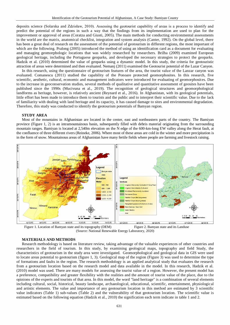
Most of the mountains in Afghanistan are located in the center east and northeastern parts of the country The Bamiyan
province (Figure 1 2) is an intramountainous basin subsequently filled with debris material originating from the surrounding
mountain ranges Bamiyan is located at 2540m elevation on the N edge of the 600-km-long EW valley along the Herat fault at
the confluence of three different rivers (Reineke 2006) Where most of these areas are cold in the winter and more precipitation is
in the form of snow Mountainous areas of Afghanistan have many fertile fields where people are farming and livestock raising
Figure 1 Location of Bamyan state and its topography (DEM) Figure 2 Bamyan state and its Landuse (Source National Renewable Energy Laboratory 2020)
MATERIALS AND METHODS
Research methodology is based on literature review taking advantage of the valuable experiences of other countries and
researchers in the field of tourism In this study by examining geological maps topography and field Study the
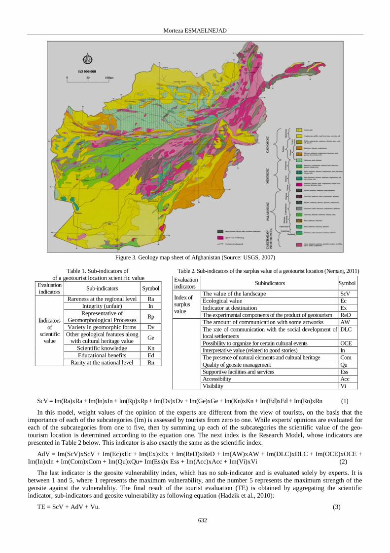
characteristics of geotourism in the study area were investigated Geomorphological and geological data in GIS were used to locate areas potential to geotourism (figure 1 3) Geological map of the region (Figure 3) was used to determine the type
of formations and faults in the region The research methodology is an applied analytical study that evaluates the research
from a geotourism location based on the research model and data available in the model In this research Hadzik et al
(2010) model was used There are many models for assessing the tourist value of a region However the present model has
a preference compatibility and greater flexibility with the realities and the amount of tourist value of the place due to the
opinions of the experts and tourists of that area In this model the word land heritage is a combination of several elements
including cultural social historical beauty landscape archaeological educational scientific entertainment physiological
and artistic elements The value and importance of any geotourism location in this method are estimated by 3 scientific
value indicators (Table 1) sub-values (Table 2) and the vulnerability of that geotourism location The scientific value is
estimated based on the following equation (Hadzik et al 2010) the signification each term indicate in table 1 and 2
Morteza ESMAELNEJAD
632
Figure 3 Geology map sheet of Afghanistan (Source USGS 2007)
Table 1 Sub-indicators of of a geotourist location scientific value
Symbol Sub-indicators Evaluation indicators
Ra Rareness at the regional level
Indicators of
scientific value
In Integrity (unfair)
Rp Representative of
Geomorphological Processes
Dv Variety in geomorphic forms
Ge Other geological features along
with cultural heritage value
Kn Scientific knowledge
Ed Educational benefits
Rn Rarity at the national level
Table 2 Sub-indicators of the surplus value of a geotourist location (Nemanj 2011)
Evaluation indicators
Subindicators Symbol
Index of surplus
value
The value of the landscape ScV
Ecological value Ec
Indicator at destination Ex
The experimental components of the product of geotourism ReD
The amount of communication with some artworks AW
The rate of communication with the social development of local settlements
DLC
Possibility to organize for certain cultural events OCE
Interpretative value (related to good stories) In
The presence of natural elements and cultural heritage Com
Quality of geosite management Qu
Supportive facilities and services Ess
Accessibility Acc
Visibility Vi
ScV = Im(Ra)xRa + Im(In)xIn + Im(Rp)xRp + Im(Dv)xDv + Im(Ge)xGe + Im(Kn)xKn + Im(Ed)xEd + Im(Rn)xRn (1)
In this model weight values of the opinion of the experts are different from the view of tourists on the basis that the
importance of each of the subcategories (Im) is assessed by tourists from zero to one While experts opinions are evaluated for
each of the subcategories from one to five then by summing up each of the subcategories the scientific value of the geo-
tourism location is determined according to the equation one The next index is the Research Model whose indicators are
presented in Table 2 below This indicator is also exactly the same as the scientific index
AdV = Im(ScV)xScV + Im(Ec)xEc + Im(Ex)xEx + Im(ReD)xReD + Im(AW)xAW + Im(DLC)xDLC + Im(OCE)xOCE +
Im(In)xIn + Im(Com)xCom + Im(Qu)xQu+ Im(Ess)x Ess + Im(Acc)xAcc + Im(Vi)xVi (2)
The last indicator is the geosite vulnerability index which has no sub-indicator and is evaluated solely by experts It is
between 1 and 5 where 1 represents the maximum vulnerability and the number 5 represents the maximum strength of the
geosite against the vulnerability The final result of the tourist evaluation (TE) is obtained by aggregating the scientific
indicator sub-indicators and geosite vulnerability as following equation (Hadzik et al 2010)
TE = ScV + AdV + Vu (3)
Identification of the Geotourism Potential of Afghanistan A Case Study Bamiyan County
633
The present model is more preferred adaptive and flexible with the realities and the amount of tourist value of the place
because of both the opinion of both experts and visitors of the area Some of the sub-indicators are thematic (for example the
value of the landscape) which explores the views of tourists and visitors from that area In this method there are many
indicators that examine scientific and historical values outlook ecological cultural and other factors (Figure 4) Considering that
geotouristic locations require at least the necessary knowledge regarding the formation of geological and geomorphological forms
Figure 4 Process of geotourism analysis in Bamiyan Afghanistan
Table 3 Final evaluation of the geotourism value of the study area
assessment of tourist value of Geopark
Obtained score
Excellent 100-130
Very good 70-100
Good 40-70
Average 20-40
Low 0-20
And given the fact that most tourists are not from the scientific community and do not know the exact geomorphological form and geomorphological processes in the site experts opinions will be higher than that of tourists If all the tourists and
experts give the highest score to a geopark based on this index its score will be 130 Therefore based on the final result of the
score experts and tourists can provide an assessment as shown in the table below
DISCUSSION AND RESULTS
Afghanistan has a wide range of geomorphic elements and processes to attract tourists interested in earth sciences Many
river processes including the formation of sandy sculptures a variety of meanders) free meanders and valley meanders
(cutting the banks of the river walls and other forms are visible (Figure 3) Also there are wide variations of mass wasting
including slopes stones landslides falls and creeps in the area (Figure 4) Due to the existence of almost soluble
formations including gypsum in some parts of the region there is capacity of creating caves of different sizes and caves have
been created in different shapes There are more than 2000 large and small caves in Afghanistan Regarding the tectonic activation of the area due to the presence of various faults visible in the valleys and steep walls (Figure 5)
The study area with regard to natural features such as national parks and unique protected regions like Band-e Amir
national park (figure 6) Wakhan protected national park visual water falls along with the acquisition of valuable cultural
assets can have a special place in south Asia (Movahed and Aman 2019) for example Band -e- Amir it is a national park
and one of natural heritages is the world that has 4200- hectares area it was shelter birds to different kinds of fish in 1973
(Aman 2016) These factors have led to the creation of unique geosites in the region 1- Existence of carbonate and carbonate dolomite formations 2- Expansion of gap systems (due to mechanical and chemical weathering) 3- Relatively suitable rainfall and water circulation inside the limestone 4- Suitable height and predominance of acidic waters 5- Solubility process in carbonate and dolomite rocks
Figure 5 The mountain pattern of the Bamyan Figure 6 Types of slopes overlooking the lake (National park of Amir)
Morteza ESMAELNEJAD
634
The shape created in this area is influenced by fiction karst including cave Dolin spring natural bridge (Figure 7)
Weathering processes have led to the massive destruction of bare and naked stones and the result of this process is the
formation of very large debris cones in favorable slopes Almost all active geomorphologic elements in semi-humid areas can
be identified in this area In Afghanistan from the east to the west the height of the mountains is reduced and the high
mountains gradually move to deep valleys deserted and windy plains But in the center of the country as far as the eye can
reach there are mountains and mountains and deep valleys have clear days and extremely cold nights This region is considered to be the most structurally complex part of Afghanistan (Shareq 1981) The study area has a wide range of
geomorphic elements and processes to attract tourists interested in earth sciences More than river processes including the
formation of sand benches different types of meander Even the passageways of this land are in some areas with an altitude of
over 2000 meters above sea level Indeed Afghanistan with its immense masses is a wonderful world of beauties This rug-
ged highland is interspersed with valleys and basins all of which have a general northeast trend (Treloar and Izatt 1993)
The melting of glaciers in ldquoBadakhshanrdquo and the Hindu Kush mountains is associated with flooding and rivers rage and in
many snowy areas sliding glaciers also occur In the vast region of Jaghatu to Jaghori there are about 2500 historical caves of
the Paleolithic Paleolithic Medieval Neolithic Historical and Indigenous Periods of the Buddhist period and in the period of
the Kings of the region in which there are many works of mixed Indian Greek Roman and Sassanid arts (Azimi 2015)
Figure 7 Site selection of getourism in Bamyan
Table 4 Evaluation of Bamyan State Value
Indicators with Visitors and Experts Views
Evaluation
indicator Sub-indicators
Score of
visitors
Score of
experts
Scientific value
indicators
Rareness at the regional level 81 42
Integrity (indisputable) 92 43
Representative of Geomorphological Process
91 41
Variety in geomorphic forms 95 43
Other geological features along with valuable cultural heritage
89 39
Scientific knowledge 83 39
Educational profit 90 4
Rareness in national level 53 3
Table 5 Evaluation of sub-value indicators with Visitors and Experts Views about Bamyan Area
Evaluation indicator Sub-indicator Visitors scores Experts scores
Surplus value indicator
Landscape value 092 45
Ecological value 084 42
Indicator at destination 079 43
The experimental components of the product of geotourism 074 39
The amount of communication with some artworks 045 2
The rate of communication with the social development of local settlements 075 21
Possibility to organize for certain cultural events 040 14
Interpretative value (related to good stories) 045 1
The presence of natural elements and cultural heritage 096 5
Quality of geosite management 010 1
Supportive facilities and services 010 1
Accessibility 020 1
Visibility 052 19
In order to assess the geotourism potential of the study area based on the research model on September 11 2017 20
tourists were surveyed who came to visit the area According to specialized research questions and questionnaire the
questionnaire was described generally before the completion of the questionnaire by tourists regarding the questions (Table 4
5) In order to assess the opinion of experts 4 specialists who had masters degree and PhD degree in geography geology and
tourism were used In evaluating the opinions of specialists people were firstly familiarized with the studied area and at least
once went to the area and they had acquaintance with the concepts of tourism science For this reason the number of experts was reduced in terms of the criteria The results of the evaluation of the scientific value indicators by tourists and specialists
are presented in Table 1 According to the table of geological characteristics along with the cultural heritage has obtained the
highest score among specialists and tourists which indicates a very wide range of geological and geomorphic forms in the
area The rareness index at the national level has the lowest score and it is quite logical The main point in Table 1 is the
disagreement between the two groups in geomorphological indicators and the index of diversity in geomorphologic forms
Identification of the Geotourism Potential of Afghanistan A Case Study Bamiyan County
635
As tourists rated the two indexes higher while the experts gave the two indexes a near average rating Considering the
specialized nature of the two indicators it can be said that the region is in the medium of two indicators In this regard experts
can be considered superior to tourists because the answer to this question requires familiarity with a wide range of Earth
science phenomena In other indicators the opinions of the experts and the views of tourists are similar The relationship
between the two groups was evaluated and the score below the scientific value indices was 21752
ScV = 081 (Ra)x 42 + 092 (In)x 43 + 091 (Rp)x 41+ 095 (Dv)x 43 + 089(Ge)x 39 +083(Kn)x 39 + 090 (Ed)x 4 + 057 (Rn)x 3= 2722 (4)
Source (Hadžić et al 2010) components of the formula has been explained in Table 2
The results of the evaluation of the sub-indicators are shown in Table 2 It needs to be explained that the answer to the
indicators of scientific values does not require much scientific and specialized knowledge in the subject matter of the research
Therefore the comments of each questioner can be cited Based on the table below the index of the presence of natural
elements and cultural heritage has earned the highest score The presence of cultural elements related to historical periods in
most parts of the studied area along with the natural and active elements of the region caused the region to become a tourist site
and this factor has been found by experts and tourists The landscape indicator has earned a very high score The region has a
fantastic beauty effect that gives it more points The interpretive value index has earned the lowest score for both groups A
very noticeable point in this table is that the indicators that are related to the management of geosites facilities and supportive
services and accessibility due to the availability of reliable and good ways in terms of both groups have received the lowest score which indicates that the study area has a major management weakness that failed to provide the necessary infrastructure
for the development of geotourism and tourism in the region despite the availability of the potential which was found typically
in experts views Therefore it is necessary to provide integrated management and facilities for better development and
attraction of domestic and foreign tourists This is due to the fact that in the studied area there is no suitable accommodation for
tourists By providing the conditions cultural programs can provide educational programs for students or geoscientists
interested in the potential of almost the entire region The amount of vulnerability assessment was 3 due to the fact that one of
the main criteria for attracting tourists in this region is the existence of historical monuments Due to the long history these
highly weathered works are very vulnerable to natural destructive factors These historic monuments are also beside headlands
or hillsides that sharpen the vulnerability On the other hand geotouristic forms of this region are located in exacerbated
geological formations and are dominated with sharp hillsides so vulnerability of natural forms with geotourist values increases
by natural disasters Major landslides and riverbeds in loose formations every year have caused geotourism to be eroded or sometimes create other forms One of the major criteria for vulnerability is the amount of attention support and protection of
related organizations from geosite According to the data obtained from the questionnaire and field surveys the level of
protection from the historical and geotouristic forms of the region is low (Hadžić et al 2010)
AdV = 092 (ScV) x 45 +084 (Ec)x 42 + 079 (Ex)x 43 + 074(ReD)x 39 +045 (AW)x 2 + 075 (DLC)x 21+ 040
(OCE)x14 +045 (In)x 1 + 096 (Com)x 5 + 010 (Qu)x1+ 010(Ess)x 1+ 010 (Acc)x 1 + 052(Vi)x 19= 24475 (5)
Final evaluation of the geotourism value of the region
Finally with the sum of the indicators of scientific values secondary values and vulnerability of the geosite the final score
of the geosite is estimated The final value of the site was 53 as shown in equation (6) According to Table 3 the tourist value of the area is good It should be noted that factors that reduce the tourist value of the study area are mostly the indicators
related to the management and welfare facilities available in site whose improvement will increase significantly in terms of
amenities in the regions tourism value The dynamic model studied in this study shows the potential and capability of the
region to attract tourists especially in the field of earth tourism which in case of providing the weaknesses in this research it
will be one of the active tourist hubs
TE =244 + 2722 + 3=5462 (6)
CONCLUSION
Tourism which emphasizes the maintenance and protection of the five key dimensions of the graphic features of a
region - the environment culture beauty science education and the well-being of local people can play a special role in
preserving the capacities of local communities In this study has been discussed about tourism capability of Bamyan province This area has a wide range of elements and geomorphic processes to attract tourists interested in earth sciences It
is one of the most important historical centers of Afghanistan culturally and historically Considering the nature of tourism
which in addition to assessing the tourism features of its regions and its attractiveness also addresses the structure and
functioning of the -site management so one should use a model to cover all -tourist aspects of the areas
On the other hand according to a highly specialized tourism discussion it is not merely possible to estimate the value of
a -site with the reliance of touristsrsquo opinions Accordingly we should use tourist and morphology specialists view In this
research we have used the dynamic model to consider the above considerations to a large extent Many of the river
processes the types of slopes the existence of almost pure soluble formations including Gypsum in the parts of the area and
the ability to form caves in different sizes and shapes and existing of visible tectonic activation in valleys and steep walls
and the creation of very beautiful scenes with different types of faults and fault elements high temperature difference
during seasons and performance of weathering processes there are special -tourist attractions in this place which has a scientific value for earth scientist and educational value for students of the Earth sciences Therefore assessing the tourism
Morteza ESMAELNEJAD
636
value of the region will provide significant assistance in terms of economic cultural tourist ecological and sustainable
development of the region On the other hand whether the lack of knowing these capabilities or believing that they are not
attractive tourist attractions by the relevant authorities the lack of appropriate communication paths the lack of suitable
accommodation facilities for tourists the lack of a tour guide aware of tourism capabilities and historical value of the region
are of most important problems and weaknesses of the region for developing of tourism
REFERENCES Abdi M Nick Siri M amp Nasiri S (2021) Introduction of Damavand Park National sciences Database Quantities morphological
research 9(2) 18-33 (in Persian) Aman S (2016) Environmental Protection First Edition Jalalabad Publishing House Kabul Afghanistan Azimi M (2012) Ecotourism in Afghanistan Sobh Omid Publication Kabul Afghanistan (in Persian) Bansal P Arnold J Elberg MA Kalda J Soesoo A amp Van Milligen BP (2004) Melt extraction and accumulation from partially
molten rocks Lithos 78(1) 25-42 httpsdoi101016jlithos200404041 Brilha J (2009) Geological heritage and European parks in Portugal Proceedings of the VIII European parks Conference Idanha-a-
Nova Portugal Canter LW (1996) Environmental impact assessment McGraw-Hill Publication Baltmore USA Comanescu LA Nedelea R amp Dobre L (2012) The Evaluation of Morphosits from the Ponoare protected area Journal of Geography
5(1) 54-61 httpsdoi105775FG2067-46352012037I Coratza P Giusti C (2005) Methodological proposal for the assessment of the scientific quality of morphosites Geacuteomorphologie Relief
Processus Environnement 18(1) 307- 313 httpsdoi 104000 7942 Dowling R (2008) The emergence of tourism and parks Journal of Tourism 9(2) 227- 236 Dowling R amp Newsome D (2017) Handbook of Geotourism Edward elgar publishing Inc Northampton Massachuset USA Fennel D (1998) Ecotourism in Canada Annals of Tourism Research 25 (1) 231-234 httpsdoi101177004728759803700143 Gordon J (2018) Heritage tourism and the Cultural Landscape Enhancing the Visitor Experience and Promoting conservation
Geosciences 8 (4) 136 httpsdoiorg103390sciences8040136 Hadžić O Marković SB Vasiljević DjA amp Nedeljković M (2010) A Dynamical Model for Assessing Tourism Market Attractiveness
of a site 1st International Conference on heritage amp tourism Research TRENDS 2010 Novi Sad Serbia Ielenicz M (2009) Geotope Geosite Geomorphosites The Annals of Valahia University of Targoviste Geographical seriesTome 9 Koshraftar R (2007) Parks Earth Sciences and Economic Growth Proceedings of the park Conference of Qeshm Qeshm Island (in Persian) Law C (2002) Urban Tourism the visitor economy and the growth of large cities Continuum London UK Maghsoudi M Rahmati M (2018) Morphosites assessment of lorestan province in Iran by comparing of Zouros and Comanescursquos
methods (case study Poldokhtar Area Iran) Journal of Tourism and Geosites 21(1) 226ndash238 httpsdoi 1030892gtg21118-283 Mokhtari D Karami F amp Bayati Khatibi M (2011) Identification of active morphogenetic forms in Payam pass with the aim of planning
tourism Geographical Research Quarterly 26 (4) 67-92 (in Persian) httpsdoi1022059jphgr201660824 Movahed A amp Aman S (2019) The examining of strategies for ecotourism development in Afghanistan International Congress on Future
of Tourism Innovation Entrepreneurship and Sustainability Tehran Iran (in Persian) Mucivuna VC Reynard E amp Garcia M (2019) Morphsites Assessment Methods Comparative Analysis and Typology Heritage 11
1799ndash1815 httpsdoi 101007s12371-019-00394-x Nemanj T (2011) The Potential of Lazar Canyon (Serbia) as a tourism Destination Inventory and Evaluation Geographica Pannonica
15(3) 103-112 httpsdoi 10 0354-87241103103T Olafsdoacutettir R amp Tverijonaite E (2018) Tourism a Systematic Literature Review Sciences 8 234 httpsdoiorg103390sciences8070234 Panizza M (2001) Morphosites Concepts Methods and Examples of morphological Survey Chinese Science Bulletin 46(3) 4-6
httpsdoi101007BF03187227 Pereira D amp Dias G (2008) Masters course on logical Heritage and conservation European logistics 26-31 Pralong JP (2005) A method for assessing the tourist potential and use of morphological sites Morphology Relief Processes
Environment (4)3 189-196 Rahimpour A (2007) Tourism a Journey through the Wonders of the Earth Iranian Publication Tehran Iran (in Persian) Reineke T (2006) Environmental Assessment of the Bamiyan Valley in the Central Highlands of Afghanistan In University of Aachen
Bamiyan Masterplan Campaign 2005 Aachen Reynard E Coratza P amp Hobleacutea F (2016) Current research on geomorphosites Geoheritage 8(1) 1ndash3 httpsdoi101007s12371-016-0174-3 Reynard E Fontana G Kozlik L amp Scapozza CA (2007) Method for assessing scientific and additional values of morphosites
Geographica Helvetica 62(3) 148ndash158 httpsdoiorg105194gh-62-148 Shareq A (1981) Geological and geophysical investigations carried out in Afghanistan over the period 1972ndash1979 in Gupta HK and
Delany FM eds Zagros Hindu Kush HimalayamdashGeodynamic evolution American Geophysical Union Geodynamics 3(1) 75ndash86 Sharply R (2009) Tourism Environment and Development Series Earthscan Pub London UK Shayan S Bani S Zare M amp Nafiseh F (2013) Assessing the Capacity of Sustainable Tourism Development of morphosites with
Emphasis on the Comansco Method (Case Study morphosites of Karaj-Chalous to Kandovan Tunnel) Journal of Tourism Planning and Development 2(5) 93-78 (in Persian) httpsdoiorg1022080jtpd20181762
Singhand RS Ghosh P (2021)Tourism potential of coal mines An appraisal of Sonepur-Bazari open cast project India International Journal of heritage and Parks In Press Corrected Proof httpsdoiorg101016jijp202102007
Solarska A amp Zdzisław J (2010) Heritage and tourism Potential of the Strzelin Hills (Sudetic Foreland SW Poland) Geographica Pannonica 14 (4) 118-125
Treloar PJ amp Izatt CN (1993) Tectonics of the Himalayan collision between the Indian Plate and the Afghan Block a synthesis eds Himalayan Logical Society London Special Publications 74 69-87 httpsdoiorg101144GSLSP19930740106
NREL International Activities Website (2020) National Renewable Energy Laboratory Afghanistan Resources Maps and Toolkits wwwnrelgovapplying_technologiesgeospatial_toolkitshtml
USGS (2007) Geological map of Afghanistan Environmental Monitoring and Assessment USA
Article history Received 09022021 Revised 15042021 Accepted 10062021 Available online 30062021
Identification of the Geotourism Potential of Afghanistan A Case Study Bamiyan County
631
deposits science (Solarska and Zdzisław 2010) Assessing the geotourist capability of areas is a process to identify and
predict the potential of the regions in such a way that the findings from its implementation are used to plan for the
improvement or approval of areas (Coratza and Giusti 2005) The main methods for conducting environmental assessments
in the world are the matrix anatomical checklist integration and system analysis (Canter 1992) On the global level there
has been a great deal of research on the assessment of the potential of geotourism in different regions the most important of
which are the following Pralong (2005) introduced the method of using an identification card as a document for evaluating and managing geomorphologic locations that was widely researched by researchers Brilha (2009) examined European
geological heritage including the Portuguese geoparks and developed the necessary strategies to protect the geoparks
Hadzik et al (2010) determined the value of geoparks using a dynamic model In this study the criteria for geotouristic
attraction of areas were determined and then evaluated Nemanj (2011) examined the Geotourist potential of the Lazar Canyon
In this research using the questionnaire of geotourism features of the area the tourist value of the Lanzar canyon was
evaluated Comanescu (2011) studied the capability of the Ponoare protected geomorphosites In this research five
scientific aesthetic cultural economic and management indicators were introduced for evaluating of geomorphosites Due
to the increase in geoconservation studies several methods of qualitative and quantitative assessment of geosites have been
published since the 1990s (Mucivuna et al 2019) The recognition of geological structures and geomorphological
landforms as heritage however is relatively ancient (Reynard et al 2016) In Afghanistan with its geological potentials
little effort has been made to introduce them to tourists and the public and to interpret their scientific value Due to the lack
of familiarity with dealing with land heritage and its capacity it has caused damage to sites and environmental degradation Therefore this study was conducted to identify the geotourism potentials of Bamyan region
STUDY AREA
Most of the mountains in Afghanistan are located in the center east and northeastern parts of the country The Bamiyan
province (Figure 1 2) is an intramountainous basin subsequently filled with debris material originating from the surrounding
mountain ranges Bamiyan is located at 2540m elevation on the N edge of the 600-km-long EW valley along the Herat fault at
the confluence of three different rivers (Reineke 2006) Where most of these areas are cold in the winter and more precipitation is
in the form of snow Mountainous areas of Afghanistan have many fertile fields where people are farming and livestock raising
Figure 1 Location of Bamyan state and its topography (DEM) Figure 2 Bamyan state and its Landuse (Source National Renewable Energy Laboratory 2020)
MATERIALS AND METHODS
Research methodology is based on literature review taking advantage of the valuable experiences of other countries and
researchers in the field of tourism In this study by examining geological maps topography and field Study the
characteristics of geotourism in the study area were investigated Geomorphological and geological data in GIS were used to locate areas potential to geotourism (figure 1 3) Geological map of the region (Figure 3) was used to determine the type
of formations and faults in the region The research methodology is an applied analytical study that evaluates the research
from a geotourism location based on the research model and data available in the model In this research Hadzik et al
(2010) model was used There are many models for assessing the tourist value of a region However the present model has
a preference compatibility and greater flexibility with the realities and the amount of tourist value of the place due to the
opinions of the experts and tourists of that area In this model the word land heritage is a combination of several elements
including cultural social historical beauty landscape archaeological educational scientific entertainment physiological
and artistic elements The value and importance of any geotourism location in this method are estimated by 3 scientific
value indicators (Table 1) sub-values (Table 2) and the vulnerability of that geotourism location The scientific value is
estimated based on the following equation (Hadzik et al 2010) the signification each term indicate in table 1 and 2
Morteza ESMAELNEJAD
632
Figure 3 Geology map sheet of Afghanistan (Source USGS 2007)
Table 1 Sub-indicators of of a geotourist location scientific value
Symbol Sub-indicators Evaluation indicators
Ra Rareness at the regional level
Indicators of
scientific value
In Integrity (unfair)
Rp Representative of
Geomorphological Processes
Dv Variety in geomorphic forms
Ge Other geological features along
with cultural heritage value
Kn Scientific knowledge
Ed Educational benefits
Rn Rarity at the national level
Table 2 Sub-indicators of the surplus value of a geotourist location (Nemanj 2011)
Evaluation indicators
Subindicators Symbol
Index of surplus
value
The value of the landscape ScV
Ecological value Ec
Indicator at destination Ex
The experimental components of the product of geotourism ReD
The amount of communication with some artworks AW
The rate of communication with the social development of local settlements
DLC
Possibility to organize for certain cultural events OCE
Interpretative value (related to good stories) In
The presence of natural elements and cultural heritage Com
Quality of geosite management Qu
Supportive facilities and services Ess
Accessibility Acc
Visibility Vi
ScV = Im(Ra)xRa + Im(In)xIn + Im(Rp)xRp + Im(Dv)xDv + Im(Ge)xGe + Im(Kn)xKn + Im(Ed)xEd + Im(Rn)xRn (1)
In this model weight values of the opinion of the experts are different from the view of tourists on the basis that the
importance of each of the subcategories (Im) is assessed by tourists from zero to one While experts opinions are evaluated for
each of the subcategories from one to five then by summing up each of the subcategories the scientific value of the geo-
tourism location is determined according to the equation one The next index is the Research Model whose indicators are
presented in Table 2 below This indicator is also exactly the same as the scientific index
AdV = Im(ScV)xScV + Im(Ec)xEc + Im(Ex)xEx + Im(ReD)xReD + Im(AW)xAW + Im(DLC)xDLC + Im(OCE)xOCE +
Im(In)xIn + Im(Com)xCom + Im(Qu)xQu+ Im(Ess)x Ess + Im(Acc)xAcc + Im(Vi)xVi (2)
The last indicator is the geosite vulnerability index which has no sub-indicator and is evaluated solely by experts It is
between 1 and 5 where 1 represents the maximum vulnerability and the number 5 represents the maximum strength of the
geosite against the vulnerability The final result of the tourist evaluation (TE) is obtained by aggregating the scientific
indicator sub-indicators and geosite vulnerability as following equation (Hadzik et al 2010)
TE = ScV + AdV + Vu (3)
Identification of the Geotourism Potential of Afghanistan A Case Study Bamiyan County
633
The present model is more preferred adaptive and flexible with the realities and the amount of tourist value of the place
because of both the opinion of both experts and visitors of the area Some of the sub-indicators are thematic (for example the
value of the landscape) which explores the views of tourists and visitors from that area In this method there are many
indicators that examine scientific and historical values outlook ecological cultural and other factors (Figure 4) Considering that
geotouristic locations require at least the necessary knowledge regarding the formation of geological and geomorphological forms
Figure 4 Process of geotourism analysis in Bamiyan Afghanistan
Table 3 Final evaluation of the geotourism value of the study area
assessment of tourist value of Geopark
Obtained score
Excellent 100-130
Very good 70-100
Good 40-70
Average 20-40
Low 0-20
And given the fact that most tourists are not from the scientific community and do not know the exact geomorphological form and geomorphological processes in the site experts opinions will be higher than that of tourists If all the tourists and
experts give the highest score to a geopark based on this index its score will be 130 Therefore based on the final result of the
score experts and tourists can provide an assessment as shown in the table below
DISCUSSION AND RESULTS
Afghanistan has a wide range of geomorphic elements and processes to attract tourists interested in earth sciences Many
river processes including the formation of sandy sculptures a variety of meanders) free meanders and valley meanders
(cutting the banks of the river walls and other forms are visible (Figure 3) Also there are wide variations of mass wasting
including slopes stones landslides falls and creeps in the area (Figure 4) Due to the existence of almost soluble
formations including gypsum in some parts of the region there is capacity of creating caves of different sizes and caves have
been created in different shapes There are more than 2000 large and small caves in Afghanistan Regarding the tectonic activation of the area due to the presence of various faults visible in the valleys and steep walls (Figure 5)
The study area with regard to natural features such as national parks and unique protected regions like Band-e Amir
national park (figure 6) Wakhan protected national park visual water falls along with the acquisition of valuable cultural
assets can have a special place in south Asia (Movahed and Aman 2019) for example Band -e- Amir it is a national park
and one of natural heritages is the world that has 4200- hectares area it was shelter birds to different kinds of fish in 1973
(Aman 2016) These factors have led to the creation of unique geosites in the region 1- Existence of carbonate and carbonate dolomite formations 2- Expansion of gap systems (due to mechanical and chemical weathering) 3- Relatively suitable rainfall and water circulation inside the limestone 4- Suitable height and predominance of acidic waters 5- Solubility process in carbonate and dolomite rocks
Figure 5 The mountain pattern of the Bamyan Figure 6 Types of slopes overlooking the lake (National park of Amir)
Morteza ESMAELNEJAD
634
The shape created in this area is influenced by fiction karst including cave Dolin spring natural bridge (Figure 7)
Weathering processes have led to the massive destruction of bare and naked stones and the result of this process is the
formation of very large debris cones in favorable slopes Almost all active geomorphologic elements in semi-humid areas can
be identified in this area In Afghanistan from the east to the west the height of the mountains is reduced and the high
mountains gradually move to deep valleys deserted and windy plains But in the center of the country as far as the eye can
reach there are mountains and mountains and deep valleys have clear days and extremely cold nights This region is considered to be the most structurally complex part of Afghanistan (Shareq 1981) The study area has a wide range of
geomorphic elements and processes to attract tourists interested in earth sciences More than river processes including the
formation of sand benches different types of meander Even the passageways of this land are in some areas with an altitude of
over 2000 meters above sea level Indeed Afghanistan with its immense masses is a wonderful world of beauties This rug-
ged highland is interspersed with valleys and basins all of which have a general northeast trend (Treloar and Izatt 1993)
The melting of glaciers in ldquoBadakhshanrdquo and the Hindu Kush mountains is associated with flooding and rivers rage and in
many snowy areas sliding glaciers also occur In the vast region of Jaghatu to Jaghori there are about 2500 historical caves of
the Paleolithic Paleolithic Medieval Neolithic Historical and Indigenous Periods of the Buddhist period and in the period of
the Kings of the region in which there are many works of mixed Indian Greek Roman and Sassanid arts (Azimi 2015)
Figure 7 Site selection of getourism in Bamyan
Table 4 Evaluation of Bamyan State Value
Indicators with Visitors and Experts Views
Evaluation
indicator Sub-indicators
Score of
visitors
Score of
experts
Scientific value
indicators
Rareness at the regional level 81 42
Integrity (indisputable) 92 43
Representative of Geomorphological Process
91 41
Variety in geomorphic forms 95 43
Other geological features along with valuable cultural heritage
89 39
Scientific knowledge 83 39
Educational profit 90 4
Rareness in national level 53 3
Table 5 Evaluation of sub-value indicators with Visitors and Experts Views about Bamyan Area
Evaluation indicator Sub-indicator Visitors scores Experts scores
Surplus value indicator
Landscape value 092 45
Ecological value 084 42
Indicator at destination 079 43
The experimental components of the product of geotourism 074 39
The amount of communication with some artworks 045 2
The rate of communication with the social development of local settlements 075 21
Possibility to organize for certain cultural events 040 14
Interpretative value (related to good stories) 045 1
The presence of natural elements and cultural heritage 096 5
Quality of geosite management 010 1
Supportive facilities and services 010 1
Accessibility 020 1
Visibility 052 19
In order to assess the geotourism potential of the study area based on the research model on September 11 2017 20
tourists were surveyed who came to visit the area According to specialized research questions and questionnaire the
questionnaire was described generally before the completion of the questionnaire by tourists regarding the questions (Table 4
5) In order to assess the opinion of experts 4 specialists who had masters degree and PhD degree in geography geology and
tourism were used In evaluating the opinions of specialists people were firstly familiarized with the studied area and at least
once went to the area and they had acquaintance with the concepts of tourism science For this reason the number of experts was reduced in terms of the criteria The results of the evaluation of the scientific value indicators by tourists and specialists
are presented in Table 1 According to the table of geological characteristics along with the cultural heritage has obtained the
highest score among specialists and tourists which indicates a very wide range of geological and geomorphic forms in the
area The rareness index at the national level has the lowest score and it is quite logical The main point in Table 1 is the
disagreement between the two groups in geomorphological indicators and the index of diversity in geomorphologic forms
Identification of the Geotourism Potential of Afghanistan A Case Study Bamiyan County
635
As tourists rated the two indexes higher while the experts gave the two indexes a near average rating Considering the
specialized nature of the two indicators it can be said that the region is in the medium of two indicators In this regard experts
can be considered superior to tourists because the answer to this question requires familiarity with a wide range of Earth
science phenomena In other indicators the opinions of the experts and the views of tourists are similar The relationship
between the two groups was evaluated and the score below the scientific value indices was 21752
ScV = 081 (Ra)x 42 + 092 (In)x 43 + 091 (Rp)x 41+ 095 (Dv)x 43 + 089(Ge)x 39 +083(Kn)x 39 + 090 (Ed)x 4 + 057 (Rn)x 3= 2722 (4)
Source (Hadžić et al 2010) components of the formula has been explained in Table 2
The results of the evaluation of the sub-indicators are shown in Table 2 It needs to be explained that the answer to the
indicators of scientific values does not require much scientific and specialized knowledge in the subject matter of the research
Therefore the comments of each questioner can be cited Based on the table below the index of the presence of natural
elements and cultural heritage has earned the highest score The presence of cultural elements related to historical periods in
most parts of the studied area along with the natural and active elements of the region caused the region to become a tourist site
and this factor has been found by experts and tourists The landscape indicator has earned a very high score The region has a
fantastic beauty effect that gives it more points The interpretive value index has earned the lowest score for both groups A
very noticeable point in this table is that the indicators that are related to the management of geosites facilities and supportive
services and accessibility due to the availability of reliable and good ways in terms of both groups have received the lowest score which indicates that the study area has a major management weakness that failed to provide the necessary infrastructure
for the development of geotourism and tourism in the region despite the availability of the potential which was found typically
in experts views Therefore it is necessary to provide integrated management and facilities for better development and
attraction of domestic and foreign tourists This is due to the fact that in the studied area there is no suitable accommodation for
tourists By providing the conditions cultural programs can provide educational programs for students or geoscientists
interested in the potential of almost the entire region The amount of vulnerability assessment was 3 due to the fact that one of
the main criteria for attracting tourists in this region is the existence of historical monuments Due to the long history these
highly weathered works are very vulnerable to natural destructive factors These historic monuments are also beside headlands
or hillsides that sharpen the vulnerability On the other hand geotouristic forms of this region are located in exacerbated
geological formations and are dominated with sharp hillsides so vulnerability of natural forms with geotourist values increases
by natural disasters Major landslides and riverbeds in loose formations every year have caused geotourism to be eroded or sometimes create other forms One of the major criteria for vulnerability is the amount of attention support and protection of
related organizations from geosite According to the data obtained from the questionnaire and field surveys the level of
protection from the historical and geotouristic forms of the region is low (Hadžić et al 2010)
AdV = 092 (ScV) x 45 +084 (Ec)x 42 + 079 (Ex)x 43 + 074(ReD)x 39 +045 (AW)x 2 + 075 (DLC)x 21+ 040
(OCE)x14 +045 (In)x 1 + 096 (Com)x 5 + 010 (Qu)x1+ 010(Ess)x 1+ 010 (Acc)x 1 + 052(Vi)x 19= 24475 (5)
Final evaluation of the geotourism value of the region
Finally with the sum of the indicators of scientific values secondary values and vulnerability of the geosite the final score
of the geosite is estimated The final value of the site was 53 as shown in equation (6) According to Table 3 the tourist value of the area is good It should be noted that factors that reduce the tourist value of the study area are mostly the indicators
related to the management and welfare facilities available in site whose improvement will increase significantly in terms of
amenities in the regions tourism value The dynamic model studied in this study shows the potential and capability of the
region to attract tourists especially in the field of earth tourism which in case of providing the weaknesses in this research it
will be one of the active tourist hubs
TE =244 + 2722 + 3=5462 (6)
CONCLUSION
Tourism which emphasizes the maintenance and protection of the five key dimensions of the graphic features of a
region - the environment culture beauty science education and the well-being of local people can play a special role in
preserving the capacities of local communities In this study has been discussed about tourism capability of Bamyan province This area has a wide range of elements and geomorphic processes to attract tourists interested in earth sciences It
is one of the most important historical centers of Afghanistan culturally and historically Considering the nature of tourism
which in addition to assessing the tourism features of its regions and its attractiveness also addresses the structure and
functioning of the -site management so one should use a model to cover all -tourist aspects of the areas
On the other hand according to a highly specialized tourism discussion it is not merely possible to estimate the value of
a -site with the reliance of touristsrsquo opinions Accordingly we should use tourist and morphology specialists view In this
research we have used the dynamic model to consider the above considerations to a large extent Many of the river
processes the types of slopes the existence of almost pure soluble formations including Gypsum in the parts of the area and
the ability to form caves in different sizes and shapes and existing of visible tectonic activation in valleys and steep walls
and the creation of very beautiful scenes with different types of faults and fault elements high temperature difference
during seasons and performance of weathering processes there are special -tourist attractions in this place which has a scientific value for earth scientist and educational value for students of the Earth sciences Therefore assessing the tourism
Morteza ESMAELNEJAD
636
value of the region will provide significant assistance in terms of economic cultural tourist ecological and sustainable
development of the region On the other hand whether the lack of knowing these capabilities or believing that they are not
attractive tourist attractions by the relevant authorities the lack of appropriate communication paths the lack of suitable
accommodation facilities for tourists the lack of a tour guide aware of tourism capabilities and historical value of the region
are of most important problems and weaknesses of the region for developing of tourism
REFERENCES Abdi M Nick Siri M amp Nasiri S (2021) Introduction of Damavand Park National sciences Database Quantities morphological
research 9(2) 18-33 (in Persian) Aman S (2016) Environmental Protection First Edition Jalalabad Publishing House Kabul Afghanistan Azimi M (2012) Ecotourism in Afghanistan Sobh Omid Publication Kabul Afghanistan (in Persian) Bansal P Arnold J Elberg MA Kalda J Soesoo A amp Van Milligen BP (2004) Melt extraction and accumulation from partially
molten rocks Lithos 78(1) 25-42 httpsdoi101016jlithos200404041 Brilha J (2009) Geological heritage and European parks in Portugal Proceedings of the VIII European parks Conference Idanha-a-
Nova Portugal Canter LW (1996) Environmental impact assessment McGraw-Hill Publication Baltmore USA Comanescu LA Nedelea R amp Dobre L (2012) The Evaluation of Morphosits from the Ponoare protected area Journal of Geography
5(1) 54-61 httpsdoi105775FG2067-46352012037I Coratza P Giusti C (2005) Methodological proposal for the assessment of the scientific quality of morphosites Geacuteomorphologie Relief
Processus Environnement 18(1) 307- 313 httpsdoi 104000 7942 Dowling R (2008) The emergence of tourism and parks Journal of Tourism 9(2) 227- 236 Dowling R amp Newsome D (2017) Handbook of Geotourism Edward elgar publishing Inc Northampton Massachuset USA Fennel D (1998) Ecotourism in Canada Annals of Tourism Research 25 (1) 231-234 httpsdoi101177004728759803700143 Gordon J (2018) Heritage tourism and the Cultural Landscape Enhancing the Visitor Experience and Promoting conservation
Geosciences 8 (4) 136 httpsdoiorg103390sciences8040136 Hadžić O Marković SB Vasiljević DjA amp Nedeljković M (2010) A Dynamical Model for Assessing Tourism Market Attractiveness
of a site 1st International Conference on heritage amp tourism Research TRENDS 2010 Novi Sad Serbia Ielenicz M (2009) Geotope Geosite Geomorphosites The Annals of Valahia University of Targoviste Geographical seriesTome 9 Koshraftar R (2007) Parks Earth Sciences and Economic Growth Proceedings of the park Conference of Qeshm Qeshm Island (in Persian) Law C (2002) Urban Tourism the visitor economy and the growth of large cities Continuum London UK Maghsoudi M Rahmati M (2018) Morphosites assessment of lorestan province in Iran by comparing of Zouros and Comanescursquos
methods (case study Poldokhtar Area Iran) Journal of Tourism and Geosites 21(1) 226ndash238 httpsdoi 1030892gtg21118-283 Mokhtari D Karami F amp Bayati Khatibi M (2011) Identification of active morphogenetic forms in Payam pass with the aim of planning
tourism Geographical Research Quarterly 26 (4) 67-92 (in Persian) httpsdoi1022059jphgr201660824 Movahed A amp Aman S (2019) The examining of strategies for ecotourism development in Afghanistan International Congress on Future
of Tourism Innovation Entrepreneurship and Sustainability Tehran Iran (in Persian) Mucivuna VC Reynard E amp Garcia M (2019) Morphsites Assessment Methods Comparative Analysis and Typology Heritage 11
1799ndash1815 httpsdoi 101007s12371-019-00394-x Nemanj T (2011) The Potential of Lazar Canyon (Serbia) as a tourism Destination Inventory and Evaluation Geographica Pannonica
15(3) 103-112 httpsdoi 10 0354-87241103103T Olafsdoacutettir R amp Tverijonaite E (2018) Tourism a Systematic Literature Review Sciences 8 234 httpsdoiorg103390sciences8070234 Panizza M (2001) Morphosites Concepts Methods and Examples of morphological Survey Chinese Science Bulletin 46(3) 4-6
httpsdoi101007BF03187227 Pereira D amp Dias G (2008) Masters course on logical Heritage and conservation European logistics 26-31 Pralong JP (2005) A method for assessing the tourist potential and use of morphological sites Morphology Relief Processes
Environment (4)3 189-196 Rahimpour A (2007) Tourism a Journey through the Wonders of the Earth Iranian Publication Tehran Iran (in Persian) Reineke T (2006) Environmental Assessment of the Bamiyan Valley in the Central Highlands of Afghanistan In University of Aachen
Bamiyan Masterplan Campaign 2005 Aachen Reynard E Coratza P amp Hobleacutea F (2016) Current research on geomorphosites Geoheritage 8(1) 1ndash3 httpsdoi101007s12371-016-0174-3 Reynard E Fontana G Kozlik L amp Scapozza CA (2007) Method for assessing scientific and additional values of morphosites
Geographica Helvetica 62(3) 148ndash158 httpsdoiorg105194gh-62-148 Shareq A (1981) Geological and geophysical investigations carried out in Afghanistan over the period 1972ndash1979 in Gupta HK and
Delany FM eds Zagros Hindu Kush HimalayamdashGeodynamic evolution American Geophysical Union Geodynamics 3(1) 75ndash86 Sharply R (2009) Tourism Environment and Development Series Earthscan Pub London UK Shayan S Bani S Zare M amp Nafiseh F (2013) Assessing the Capacity of Sustainable Tourism Development of morphosites with
Emphasis on the Comansco Method (Case Study morphosites of Karaj-Chalous to Kandovan Tunnel) Journal of Tourism Planning and Development 2(5) 93-78 (in Persian) httpsdoiorg1022080jtpd20181762
Singhand RS Ghosh P (2021)Tourism potential of coal mines An appraisal of Sonepur-Bazari open cast project India International Journal of heritage and Parks In Press Corrected Proof httpsdoiorg101016jijp202102007
Solarska A amp Zdzisław J (2010) Heritage and tourism Potential of the Strzelin Hills (Sudetic Foreland SW Poland) Geographica Pannonica 14 (4) 118-125
Treloar PJ amp Izatt CN (1993) Tectonics of the Himalayan collision between the Indian Plate and the Afghan Block a synthesis eds Himalayan Logical Society London Special Publications 74 69-87 httpsdoiorg101144GSLSP19930740106
NREL International Activities Website (2020) National Renewable Energy Laboratory Afghanistan Resources Maps and Toolkits wwwnrelgovapplying_technologiesgeospatial_toolkitshtml
USGS (2007) Geological map of Afghanistan Environmental Monitoring and Assessment USA
Article history Received 09022021 Revised 15042021 Accepted 10062021 Available online 30062021
Morteza ESMAELNEJAD
632
Figure 3 Geology map sheet of Afghanistan (Source USGS 2007)
Table 1 Sub-indicators of of a geotourist location scientific value
Symbol Sub-indicators Evaluation indicators
Ra Rareness at the regional level
Indicators of
scientific value
In Integrity (unfair)
Rp Representative of
Geomorphological Processes
Dv Variety in geomorphic forms
Ge Other geological features along
with cultural heritage value
Kn Scientific knowledge
Ed Educational benefits
Rn Rarity at the national level
Table 2 Sub-indicators of the surplus value of a geotourist location (Nemanj 2011)
Evaluation indicators
Subindicators Symbol
Index of surplus
value
The value of the landscape ScV
Ecological value Ec
Indicator at destination Ex
The experimental components of the product of geotourism ReD
The amount of communication with some artworks AW
The rate of communication with the social development of local settlements
DLC
Possibility to organize for certain cultural events OCE
Interpretative value (related to good stories) In
The presence of natural elements and cultural heritage Com
Quality of geosite management Qu
Supportive facilities and services Ess
Accessibility Acc
Visibility Vi
ScV = Im(Ra)xRa + Im(In)xIn + Im(Rp)xRp + Im(Dv)xDv + Im(Ge)xGe + Im(Kn)xKn + Im(Ed)xEd + Im(Rn)xRn (1)
In this model weight values of the opinion of the experts are different from the view of tourists on the basis that the
importance of each of the subcategories (Im) is assessed by tourists from zero to one While experts opinions are evaluated for
each of the subcategories from one to five then by summing up each of the subcategories the scientific value of the geo-
tourism location is determined according to the equation one The next index is the Research Model whose indicators are
presented in Table 2 below This indicator is also exactly the same as the scientific index
AdV = Im(ScV)xScV + Im(Ec)xEc + Im(Ex)xEx + Im(ReD)xReD + Im(AW)xAW + Im(DLC)xDLC + Im(OCE)xOCE +
Im(In)xIn + Im(Com)xCom + Im(Qu)xQu+ Im(Ess)x Ess + Im(Acc)xAcc + Im(Vi)xVi (2)
The last indicator is the geosite vulnerability index which has no sub-indicator and is evaluated solely by experts It is
between 1 and 5 where 1 represents the maximum vulnerability and the number 5 represents the maximum strength of the
geosite against the vulnerability The final result of the tourist evaluation (TE) is obtained by aggregating the scientific
indicator sub-indicators and geosite vulnerability as following equation (Hadzik et al 2010)
TE = ScV + AdV + Vu (3)
Identification of the Geotourism Potential of Afghanistan A Case Study Bamiyan County
633
The present model is more preferred adaptive and flexible with the realities and the amount of tourist value of the place
because of both the opinion of both experts and visitors of the area Some of the sub-indicators are thematic (for example the
value of the landscape) which explores the views of tourists and visitors from that area In this method there are many
indicators that examine scientific and historical values outlook ecological cultural and other factors (Figure 4) Considering that
geotouristic locations require at least the necessary knowledge regarding the formation of geological and geomorphological forms
Figure 4 Process of geotourism analysis in Bamiyan Afghanistan
Table 3 Final evaluation of the geotourism value of the study area
assessment of tourist value of Geopark
Obtained score
Excellent 100-130
Very good 70-100
Good 40-70
Average 20-40
Low 0-20
And given the fact that most tourists are not from the scientific community and do not know the exact geomorphological form and geomorphological processes in the site experts opinions will be higher than that of tourists If all the tourists and
experts give the highest score to a geopark based on this index its score will be 130 Therefore based on the final result of the
score experts and tourists can provide an assessment as shown in the table below
DISCUSSION AND RESULTS
Afghanistan has a wide range of geomorphic elements and processes to attract tourists interested in earth sciences Many
river processes including the formation of sandy sculptures a variety of meanders) free meanders and valley meanders
(cutting the banks of the river walls and other forms are visible (Figure 3) Also there are wide variations of mass wasting
including slopes stones landslides falls and creeps in the area (Figure 4) Due to the existence of almost soluble
formations including gypsum in some parts of the region there is capacity of creating caves of different sizes and caves have
been created in different shapes There are more than 2000 large and small caves in Afghanistan Regarding the tectonic activation of the area due to the presence of various faults visible in the valleys and steep walls (Figure 5)
The study area with regard to natural features such as national parks and unique protected regions like Band-e Amir
national park (figure 6) Wakhan protected national park visual water falls along with the acquisition of valuable cultural
assets can have a special place in south Asia (Movahed and Aman 2019) for example Band -e- Amir it is a national park
and one of natural heritages is the world that has 4200- hectares area it was shelter birds to different kinds of fish in 1973
(Aman 2016) These factors have led to the creation of unique geosites in the region 1- Existence of carbonate and carbonate dolomite formations 2- Expansion of gap systems (due to mechanical and chemical weathering) 3- Relatively suitable rainfall and water circulation inside the limestone 4- Suitable height and predominance of acidic waters 5- Solubility process in carbonate and dolomite rocks
Figure 5 The mountain pattern of the Bamyan Figure 6 Types of slopes overlooking the lake (National park of Amir)
Morteza ESMAELNEJAD
634
The shape created in this area is influenced by fiction karst including cave Dolin spring natural bridge (Figure 7)
Weathering processes have led to the massive destruction of bare and naked stones and the result of this process is the
formation of very large debris cones in favorable slopes Almost all active geomorphologic elements in semi-humid areas can
be identified in this area In Afghanistan from the east to the west the height of the mountains is reduced and the high
mountains gradually move to deep valleys deserted and windy plains But in the center of the country as far as the eye can
reach there are mountains and mountains and deep valleys have clear days and extremely cold nights This region is considered to be the most structurally complex part of Afghanistan (Shareq 1981) The study area has a wide range of
geomorphic elements and processes to attract tourists interested in earth sciences More than river processes including the
formation of sand benches different types of meander Even the passageways of this land are in some areas with an altitude of
over 2000 meters above sea level Indeed Afghanistan with its immense masses is a wonderful world of beauties This rug-
ged highland is interspersed with valleys and basins all of which have a general northeast trend (Treloar and Izatt 1993)
The melting of glaciers in ldquoBadakhshanrdquo and the Hindu Kush mountains is associated with flooding and rivers rage and in
many snowy areas sliding glaciers also occur In the vast region of Jaghatu to Jaghori there are about 2500 historical caves of
the Paleolithic Paleolithic Medieval Neolithic Historical and Indigenous Periods of the Buddhist period and in the period of
the Kings of the region in which there are many works of mixed Indian Greek Roman and Sassanid arts (Azimi 2015)
Figure 7 Site selection of getourism in Bamyan
Table 4 Evaluation of Bamyan State Value
Indicators with Visitors and Experts Views
Evaluation
indicator Sub-indicators
Score of
visitors
Score of
experts
Scientific value
indicators
Rareness at the regional level 81 42
Integrity (indisputable) 92 43
Representative of Geomorphological Process
91 41
Variety in geomorphic forms 95 43
Other geological features along with valuable cultural heritage
89 39
Scientific knowledge 83 39
Educational profit 90 4
Rareness in national level 53 3
Table 5 Evaluation of sub-value indicators with Visitors and Experts Views about Bamyan Area
Evaluation indicator Sub-indicator Visitors scores Experts scores
Surplus value indicator
Landscape value 092 45
Ecological value 084 42
Indicator at destination 079 43
The experimental components of the product of geotourism 074 39
The amount of communication with some artworks 045 2
The rate of communication with the social development of local settlements 075 21
Possibility to organize for certain cultural events 040 14
Interpretative value (related to good stories) 045 1
The presence of natural elements and cultural heritage 096 5
Quality of geosite management 010 1
Supportive facilities and services 010 1
Accessibility 020 1
Visibility 052 19
In order to assess the geotourism potential of the study area based on the research model on September 11 2017 20
tourists were surveyed who came to visit the area According to specialized research questions and questionnaire the
questionnaire was described generally before the completion of the questionnaire by tourists regarding the questions (Table 4
5) In order to assess the opinion of experts 4 specialists who had masters degree and PhD degree in geography geology and
tourism were used In evaluating the opinions of specialists people were firstly familiarized with the studied area and at least
once went to the area and they had acquaintance with the concepts of tourism science For this reason the number of experts was reduced in terms of the criteria The results of the evaluation of the scientific value indicators by tourists and specialists
are presented in Table 1 According to the table of geological characteristics along with the cultural heritage has obtained the
highest score among specialists and tourists which indicates a very wide range of geological and geomorphic forms in the
area The rareness index at the national level has the lowest score and it is quite logical The main point in Table 1 is the
disagreement between the two groups in geomorphological indicators and the index of diversity in geomorphologic forms
Identification of the Geotourism Potential of Afghanistan A Case Study Bamiyan County
635
As tourists rated the two indexes higher while the experts gave the two indexes a near average rating Considering the
specialized nature of the two indicators it can be said that the region is in the medium of two indicators In this regard experts
can be considered superior to tourists because the answer to this question requires familiarity with a wide range of Earth
science phenomena In other indicators the opinions of the experts and the views of tourists are similar The relationship
between the two groups was evaluated and the score below the scientific value indices was 21752
ScV = 081 (Ra)x 42 + 092 (In)x 43 + 091 (Rp)x 41+ 095 (Dv)x 43 + 089(Ge)x 39 +083(Kn)x 39 + 090 (Ed)x 4 + 057 (Rn)x 3= 2722 (4)
Source (Hadžić et al 2010) components of the formula has been explained in Table 2
The results of the evaluation of the sub-indicators are shown in Table 2 It needs to be explained that the answer to the
indicators of scientific values does not require much scientific and specialized knowledge in the subject matter of the research
Therefore the comments of each questioner can be cited Based on the table below the index of the presence of natural
elements and cultural heritage has earned the highest score The presence of cultural elements related to historical periods in
most parts of the studied area along with the natural and active elements of the region caused the region to become a tourist site
and this factor has been found by experts and tourists The landscape indicator has earned a very high score The region has a
fantastic beauty effect that gives it more points The interpretive value index has earned the lowest score for both groups A
very noticeable point in this table is that the indicators that are related to the management of geosites facilities and supportive
services and accessibility due to the availability of reliable and good ways in terms of both groups have received the lowest score which indicates that the study area has a major management weakness that failed to provide the necessary infrastructure
for the development of geotourism and tourism in the region despite the availability of the potential which was found typically
in experts views Therefore it is necessary to provide integrated management and facilities for better development and
attraction of domestic and foreign tourists This is due to the fact that in the studied area there is no suitable accommodation for
tourists By providing the conditions cultural programs can provide educational programs for students or geoscientists
interested in the potential of almost the entire region The amount of vulnerability assessment was 3 due to the fact that one of
the main criteria for attracting tourists in this region is the existence of historical monuments Due to the long history these
highly weathered works are very vulnerable to natural destructive factors These historic monuments are also beside headlands
or hillsides that sharpen the vulnerability On the other hand geotouristic forms of this region are located in exacerbated
geological formations and are dominated with sharp hillsides so vulnerability of natural forms with geotourist values increases
by natural disasters Major landslides and riverbeds in loose formations every year have caused geotourism to be eroded or sometimes create other forms One of the major criteria for vulnerability is the amount of attention support and protection of
related organizations from geosite According to the data obtained from the questionnaire and field surveys the level of
protection from the historical and geotouristic forms of the region is low (Hadžić et al 2010)
AdV = 092 (ScV) x 45 +084 (Ec)x 42 + 079 (Ex)x 43 + 074(ReD)x 39 +045 (AW)x 2 + 075 (DLC)x 21+ 040
(OCE)x14 +045 (In)x 1 + 096 (Com)x 5 + 010 (Qu)x1+ 010(Ess)x 1+ 010 (Acc)x 1 + 052(Vi)x 19= 24475 (5)
Final evaluation of the geotourism value of the region
Finally with the sum of the indicators of scientific values secondary values and vulnerability of the geosite the final score
of the geosite is estimated The final value of the site was 53 as shown in equation (6) According to Table 3 the tourist value of the area is good It should be noted that factors that reduce the tourist value of the study area are mostly the indicators
related to the management and welfare facilities available in site whose improvement will increase significantly in terms of
amenities in the regions tourism value The dynamic model studied in this study shows the potential and capability of the
region to attract tourists especially in the field of earth tourism which in case of providing the weaknesses in this research it
will be one of the active tourist hubs
TE =244 + 2722 + 3=5462 (6)
CONCLUSION
Tourism which emphasizes the maintenance and protection of the five key dimensions of the graphic features of a
region - the environment culture beauty science education and the well-being of local people can play a special role in
preserving the capacities of local communities In this study has been discussed about tourism capability of Bamyan province This area has a wide range of elements and geomorphic processes to attract tourists interested in earth sciences It
is one of the most important historical centers of Afghanistan culturally and historically Considering the nature of tourism
which in addition to assessing the tourism features of its regions and its attractiveness also addresses the structure and
functioning of the -site management so one should use a model to cover all -tourist aspects of the areas
On the other hand according to a highly specialized tourism discussion it is not merely possible to estimate the value of
a -site with the reliance of touristsrsquo opinions Accordingly we should use tourist and morphology specialists view In this
research we have used the dynamic model to consider the above considerations to a large extent Many of the river
processes the types of slopes the existence of almost pure soluble formations including Gypsum in the parts of the area and
the ability to form caves in different sizes and shapes and existing of visible tectonic activation in valleys and steep walls
and the creation of very beautiful scenes with different types of faults and fault elements high temperature difference
during seasons and performance of weathering processes there are special -tourist attractions in this place which has a scientific value for earth scientist and educational value for students of the Earth sciences Therefore assessing the tourism
Morteza ESMAELNEJAD
636
value of the region will provide significant assistance in terms of economic cultural tourist ecological and sustainable
development of the region On the other hand whether the lack of knowing these capabilities or believing that they are not
attractive tourist attractions by the relevant authorities the lack of appropriate communication paths the lack of suitable
accommodation facilities for tourists the lack of a tour guide aware of tourism capabilities and historical value of the region
are of most important problems and weaknesses of the region for developing of tourism
REFERENCES Abdi M Nick Siri M amp Nasiri S (2021) Introduction of Damavand Park National sciences Database Quantities morphological
research 9(2) 18-33 (in Persian) Aman S (2016) Environmental Protection First Edition Jalalabad Publishing House Kabul Afghanistan Azimi M (2012) Ecotourism in Afghanistan Sobh Omid Publication Kabul Afghanistan (in Persian) Bansal P Arnold J Elberg MA Kalda J Soesoo A amp Van Milligen BP (2004) Melt extraction and accumulation from partially
molten rocks Lithos 78(1) 25-42 httpsdoi101016jlithos200404041 Brilha J (2009) Geological heritage and European parks in Portugal Proceedings of the VIII European parks Conference Idanha-a-
Nova Portugal Canter LW (1996) Environmental impact assessment McGraw-Hill Publication Baltmore USA Comanescu LA Nedelea R amp Dobre L (2012) The Evaluation of Morphosits from the Ponoare protected area Journal of Geography
5(1) 54-61 httpsdoi105775FG2067-46352012037I Coratza P Giusti C (2005) Methodological proposal for the assessment of the scientific quality of morphosites Geacuteomorphologie Relief
Processus Environnement 18(1) 307- 313 httpsdoi 104000 7942 Dowling R (2008) The emergence of tourism and parks Journal of Tourism 9(2) 227- 236 Dowling R amp Newsome D (2017) Handbook of Geotourism Edward elgar publishing Inc Northampton Massachuset USA Fennel D (1998) Ecotourism in Canada Annals of Tourism Research 25 (1) 231-234 httpsdoi101177004728759803700143 Gordon J (2018) Heritage tourism and the Cultural Landscape Enhancing the Visitor Experience and Promoting conservation
Geosciences 8 (4) 136 httpsdoiorg103390sciences8040136 Hadžić O Marković SB Vasiljević DjA amp Nedeljković M (2010) A Dynamical Model for Assessing Tourism Market Attractiveness
of a site 1st International Conference on heritage amp tourism Research TRENDS 2010 Novi Sad Serbia Ielenicz M (2009) Geotope Geosite Geomorphosites The Annals of Valahia University of Targoviste Geographical seriesTome 9 Koshraftar R (2007) Parks Earth Sciences and Economic Growth Proceedings of the park Conference of Qeshm Qeshm Island (in Persian) Law C (2002) Urban Tourism the visitor economy and the growth of large cities Continuum London UK Maghsoudi M Rahmati M (2018) Morphosites assessment of lorestan province in Iran by comparing of Zouros and Comanescursquos
methods (case study Poldokhtar Area Iran) Journal of Tourism and Geosites 21(1) 226ndash238 httpsdoi 1030892gtg21118-283 Mokhtari D Karami F amp Bayati Khatibi M (2011) Identification of active morphogenetic forms in Payam pass with the aim of planning
tourism Geographical Research Quarterly 26 (4) 67-92 (in Persian) httpsdoi1022059jphgr201660824 Movahed A amp Aman S (2019) The examining of strategies for ecotourism development in Afghanistan International Congress on Future
of Tourism Innovation Entrepreneurship and Sustainability Tehran Iran (in Persian) Mucivuna VC Reynard E amp Garcia M (2019) Morphsites Assessment Methods Comparative Analysis and Typology Heritage 11
1799ndash1815 httpsdoi 101007s12371-019-00394-x Nemanj T (2011) The Potential of Lazar Canyon (Serbia) as a tourism Destination Inventory and Evaluation Geographica Pannonica
15(3) 103-112 httpsdoi 10 0354-87241103103T Olafsdoacutettir R amp Tverijonaite E (2018) Tourism a Systematic Literature Review Sciences 8 234 httpsdoiorg103390sciences8070234 Panizza M (2001) Morphosites Concepts Methods and Examples of morphological Survey Chinese Science Bulletin 46(3) 4-6
httpsdoi101007BF03187227 Pereira D amp Dias G (2008) Masters course on logical Heritage and conservation European logistics 26-31 Pralong JP (2005) A method for assessing the tourist potential and use of morphological sites Morphology Relief Processes
Environment (4)3 189-196 Rahimpour A (2007) Tourism a Journey through the Wonders of the Earth Iranian Publication Tehran Iran (in Persian) Reineke T (2006) Environmental Assessment of the Bamiyan Valley in the Central Highlands of Afghanistan In University of Aachen
Bamiyan Masterplan Campaign 2005 Aachen Reynard E Coratza P amp Hobleacutea F (2016) Current research on geomorphosites Geoheritage 8(1) 1ndash3 httpsdoi101007s12371-016-0174-3 Reynard E Fontana G Kozlik L amp Scapozza CA (2007) Method for assessing scientific and additional values of morphosites
Geographica Helvetica 62(3) 148ndash158 httpsdoiorg105194gh-62-148 Shareq A (1981) Geological and geophysical investigations carried out in Afghanistan over the period 1972ndash1979 in Gupta HK and
Delany FM eds Zagros Hindu Kush HimalayamdashGeodynamic evolution American Geophysical Union Geodynamics 3(1) 75ndash86 Sharply R (2009) Tourism Environment and Development Series Earthscan Pub London UK Shayan S Bani S Zare M amp Nafiseh F (2013) Assessing the Capacity of Sustainable Tourism Development of morphosites with
Emphasis on the Comansco Method (Case Study morphosites of Karaj-Chalous to Kandovan Tunnel) Journal of Tourism Planning and Development 2(5) 93-78 (in Persian) httpsdoiorg1022080jtpd20181762
Singhand RS Ghosh P (2021)Tourism potential of coal mines An appraisal of Sonepur-Bazari open cast project India International Journal of heritage and Parks In Press Corrected Proof httpsdoiorg101016jijp202102007
Solarska A amp Zdzisław J (2010) Heritage and tourism Potential of the Strzelin Hills (Sudetic Foreland SW Poland) Geographica Pannonica 14 (4) 118-125
Treloar PJ amp Izatt CN (1993) Tectonics of the Himalayan collision between the Indian Plate and the Afghan Block a synthesis eds Himalayan Logical Society London Special Publications 74 69-87 httpsdoiorg101144GSLSP19930740106
NREL International Activities Website (2020) National Renewable Energy Laboratory Afghanistan Resources Maps and Toolkits wwwnrelgovapplying_technologiesgeospatial_toolkitshtml
USGS (2007) Geological map of Afghanistan Environmental Monitoring and Assessment USA
Article history Received 09022021 Revised 15042021 Accepted 10062021 Available online 30062021
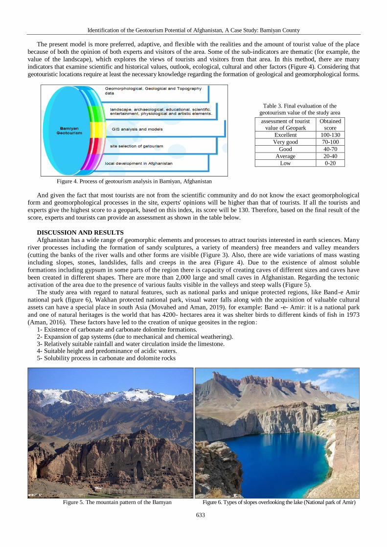
Identification of the Geotourism Potential of Afghanistan A Case Study Bamiyan County
633
The present model is more preferred adaptive and flexible with the realities and the amount of tourist value of the place
because of both the opinion of both experts and visitors of the area Some of the sub-indicators are thematic (for example the
value of the landscape) which explores the views of tourists and visitors from that area In this method there are many
indicators that examine scientific and historical values outlook ecological cultural and other factors (Figure 4) Considering that
geotouristic locations require at least the necessary knowledge regarding the formation of geological and geomorphological forms
Figure 4 Process of geotourism analysis in Bamiyan Afghanistan
Table 3 Final evaluation of the geotourism value of the study area
assessment of tourist value of Geopark
Obtained score
Excellent 100-130
Very good 70-100
Good 40-70
Average 20-40
Low 0-20
And given the fact that most tourists are not from the scientific community and do not know the exact geomorphological form and geomorphological processes in the site experts opinions will be higher than that of tourists If all the tourists and
experts give the highest score to a geopark based on this index its score will be 130 Therefore based on the final result of the
score experts and tourists can provide an assessment as shown in the table below
DISCUSSION AND RESULTS
Afghanistan has a wide range of geomorphic elements and processes to attract tourists interested in earth sciences Many
river processes including the formation of sandy sculptures a variety of meanders) free meanders and valley meanders
(cutting the banks of the river walls and other forms are visible (Figure 3) Also there are wide variations of mass wasting
including slopes stones landslides falls and creeps in the area (Figure 4) Due to the existence of almost soluble
formations including gypsum in some parts of the region there is capacity of creating caves of different sizes and caves have
been created in different shapes There are more than 2000 large and small caves in Afghanistan Regarding the tectonic activation of the area due to the presence of various faults visible in the valleys and steep walls (Figure 5)
The study area with regard to natural features such as national parks and unique protected regions like Band-e Amir
national park (figure 6) Wakhan protected national park visual water falls along with the acquisition of valuable cultural
assets can have a special place in south Asia (Movahed and Aman 2019) for example Band -e- Amir it is a national park
and one of natural heritages is the world that has 4200- hectares area it was shelter birds to different kinds of fish in 1973
(Aman 2016) These factors have led to the creation of unique geosites in the region 1- Existence of carbonate and carbonate dolomite formations 2- Expansion of gap systems (due to mechanical and chemical weathering) 3- Relatively suitable rainfall and water circulation inside the limestone 4- Suitable height and predominance of acidic waters 5- Solubility process in carbonate and dolomite rocks
Figure 5 The mountain pattern of the Bamyan Figure 6 Types of slopes overlooking the lake (National park of Amir)
Morteza ESMAELNEJAD
634
The shape created in this area is influenced by fiction karst including cave Dolin spring natural bridge (Figure 7)
Weathering processes have led to the massive destruction of bare and naked stones and the result of this process is the
formation of very large debris cones in favorable slopes Almost all active geomorphologic elements in semi-humid areas can
be identified in this area In Afghanistan from the east to the west the height of the mountains is reduced and the high
mountains gradually move to deep valleys deserted and windy plains But in the center of the country as far as the eye can
reach there are mountains and mountains and deep valleys have clear days and extremely cold nights This region is considered to be the most structurally complex part of Afghanistan (Shareq 1981) The study area has a wide range of
geomorphic elements and processes to attract tourists interested in earth sciences More than river processes including the
formation of sand benches different types of meander Even the passageways of this land are in some areas with an altitude of
over 2000 meters above sea level Indeed Afghanistan with its immense masses is a wonderful world of beauties This rug-
ged highland is interspersed with valleys and basins all of which have a general northeast trend (Treloar and Izatt 1993)
The melting of glaciers in ldquoBadakhshanrdquo and the Hindu Kush mountains is associated with flooding and rivers rage and in
many snowy areas sliding glaciers also occur In the vast region of Jaghatu to Jaghori there are about 2500 historical caves of
the Paleolithic Paleolithic Medieval Neolithic Historical and Indigenous Periods of the Buddhist period and in the period of
the Kings of the region in which there are many works of mixed Indian Greek Roman and Sassanid arts (Azimi 2015)
Figure 7 Site selection of getourism in Bamyan
Table 4 Evaluation of Bamyan State Value
Indicators with Visitors and Experts Views
Evaluation
indicator Sub-indicators
Score of
visitors
Score of
experts
Scientific value
indicators
Rareness at the regional level 81 42
Integrity (indisputable) 92 43
Representative of Geomorphological Process
91 41
Variety in geomorphic forms 95 43
Other geological features along with valuable cultural heritage
89 39
Scientific knowledge 83 39
Educational profit 90 4
Rareness in national level 53 3
Table 5 Evaluation of sub-value indicators with Visitors and Experts Views about Bamyan Area
Evaluation indicator Sub-indicator Visitors scores Experts scores
Surplus value indicator
Landscape value 092 45
Ecological value 084 42
Indicator at destination 079 43
The experimental components of the product of geotourism 074 39
The amount of communication with some artworks 045 2
The rate of communication with the social development of local settlements 075 21
Possibility to organize for certain cultural events 040 14
Interpretative value (related to good stories) 045 1
The presence of natural elements and cultural heritage 096 5
Quality of geosite management 010 1
Supportive facilities and services 010 1
Accessibility 020 1
Visibility 052 19
In order to assess the geotourism potential of the study area based on the research model on September 11 2017 20
tourists were surveyed who came to visit the area According to specialized research questions and questionnaire the
questionnaire was described generally before the completion of the questionnaire by tourists regarding the questions (Table 4
5) In order to assess the opinion of experts 4 specialists who had masters degree and PhD degree in geography geology and
tourism were used In evaluating the opinions of specialists people were firstly familiarized with the studied area and at least
once went to the area and they had acquaintance with the concepts of tourism science For this reason the number of experts was reduced in terms of the criteria The results of the evaluation of the scientific value indicators by tourists and specialists
are presented in Table 1 According to the table of geological characteristics along with the cultural heritage has obtained the
highest score among specialists and tourists which indicates a very wide range of geological and geomorphic forms in the
area The rareness index at the national level has the lowest score and it is quite logical The main point in Table 1 is the
disagreement between the two groups in geomorphological indicators and the index of diversity in geomorphologic forms
Identification of the Geotourism Potential of Afghanistan A Case Study Bamiyan County
635
As tourists rated the two indexes higher while the experts gave the two indexes a near average rating Considering the
specialized nature of the two indicators it can be said that the region is in the medium of two indicators In this regard experts
can be considered superior to tourists because the answer to this question requires familiarity with a wide range of Earth
science phenomena In other indicators the opinions of the experts and the views of tourists are similar The relationship
between the two groups was evaluated and the score below the scientific value indices was 21752
ScV = 081 (Ra)x 42 + 092 (In)x 43 + 091 (Rp)x 41+ 095 (Dv)x 43 + 089(Ge)x 39 +083(Kn)x 39 + 090 (Ed)x 4 + 057 (Rn)x 3= 2722 (4)
Source (Hadžić et al 2010) components of the formula has been explained in Table 2
The results of the evaluation of the sub-indicators are shown in Table 2 It needs to be explained that the answer to the
indicators of scientific values does not require much scientific and specialized knowledge in the subject matter of the research
Therefore the comments of each questioner can be cited Based on the table below the index of the presence of natural
elements and cultural heritage has earned the highest score The presence of cultural elements related to historical periods in
most parts of the studied area along with the natural and active elements of the region caused the region to become a tourist site
and this factor has been found by experts and tourists The landscape indicator has earned a very high score The region has a
fantastic beauty effect that gives it more points The interpretive value index has earned the lowest score for both groups A
very noticeable point in this table is that the indicators that are related to the management of geosites facilities and supportive
services and accessibility due to the availability of reliable and good ways in terms of both groups have received the lowest score which indicates that the study area has a major management weakness that failed to provide the necessary infrastructure
for the development of geotourism and tourism in the region despite the availability of the potential which was found typically
in experts views Therefore it is necessary to provide integrated management and facilities for better development and
attraction of domestic and foreign tourists This is due to the fact that in the studied area there is no suitable accommodation for
tourists By providing the conditions cultural programs can provide educational programs for students or geoscientists
interested in the potential of almost the entire region The amount of vulnerability assessment was 3 due to the fact that one of
the main criteria for attracting tourists in this region is the existence of historical monuments Due to the long history these
highly weathered works are very vulnerable to natural destructive factors These historic monuments are also beside headlands
or hillsides that sharpen the vulnerability On the other hand geotouristic forms of this region are located in exacerbated
geological formations and are dominated with sharp hillsides so vulnerability of natural forms with geotourist values increases
by natural disasters Major landslides and riverbeds in loose formations every year have caused geotourism to be eroded or sometimes create other forms One of the major criteria for vulnerability is the amount of attention support and protection of
related organizations from geosite According to the data obtained from the questionnaire and field surveys the level of
protection from the historical and geotouristic forms of the region is low (Hadžić et al 2010)
AdV = 092 (ScV) x 45 +084 (Ec)x 42 + 079 (Ex)x 43 + 074(ReD)x 39 +045 (AW)x 2 + 075 (DLC)x 21+ 040
(OCE)x14 +045 (In)x 1 + 096 (Com)x 5 + 010 (Qu)x1+ 010(Ess)x 1+ 010 (Acc)x 1 + 052(Vi)x 19= 24475 (5)
Final evaluation of the geotourism value of the region
Finally with the sum of the indicators of scientific values secondary values and vulnerability of the geosite the final score
of the geosite is estimated The final value of the site was 53 as shown in equation (6) According to Table 3 the tourist value of the area is good It should be noted that factors that reduce the tourist value of the study area are mostly the indicators
related to the management and welfare facilities available in site whose improvement will increase significantly in terms of
amenities in the regions tourism value The dynamic model studied in this study shows the potential and capability of the
region to attract tourists especially in the field of earth tourism which in case of providing the weaknesses in this research it
will be one of the active tourist hubs
TE =244 + 2722 + 3=5462 (6)
CONCLUSION
Tourism which emphasizes the maintenance and protection of the five key dimensions of the graphic features of a
region - the environment culture beauty science education and the well-being of local people can play a special role in
preserving the capacities of local communities In this study has been discussed about tourism capability of Bamyan province This area has a wide range of elements and geomorphic processes to attract tourists interested in earth sciences It
is one of the most important historical centers of Afghanistan culturally and historically Considering the nature of tourism
which in addition to assessing the tourism features of its regions and its attractiveness also addresses the structure and
functioning of the -site management so one should use a model to cover all -tourist aspects of the areas
On the other hand according to a highly specialized tourism discussion it is not merely possible to estimate the value of
a -site with the reliance of touristsrsquo opinions Accordingly we should use tourist and morphology specialists view In this
research we have used the dynamic model to consider the above considerations to a large extent Many of the river
processes the types of slopes the existence of almost pure soluble formations including Gypsum in the parts of the area and
the ability to form caves in different sizes and shapes and existing of visible tectonic activation in valleys and steep walls
and the creation of very beautiful scenes with different types of faults and fault elements high temperature difference
during seasons and performance of weathering processes there are special -tourist attractions in this place which has a scientific value for earth scientist and educational value for students of the Earth sciences Therefore assessing the tourism
Morteza ESMAELNEJAD
636
value of the region will provide significant assistance in terms of economic cultural tourist ecological and sustainable
development of the region On the other hand whether the lack of knowing these capabilities or believing that they are not
attractive tourist attractions by the relevant authorities the lack of appropriate communication paths the lack of suitable
accommodation facilities for tourists the lack of a tour guide aware of tourism capabilities and historical value of the region
are of most important problems and weaknesses of the region for developing of tourism
REFERENCES Abdi M Nick Siri M amp Nasiri S (2021) Introduction of Damavand Park National sciences Database Quantities morphological
research 9(2) 18-33 (in Persian) Aman S (2016) Environmental Protection First Edition Jalalabad Publishing House Kabul Afghanistan Azimi M (2012) Ecotourism in Afghanistan Sobh Omid Publication Kabul Afghanistan (in Persian) Bansal P Arnold J Elberg MA Kalda J Soesoo A amp Van Milligen BP (2004) Melt extraction and accumulation from partially
molten rocks Lithos 78(1) 25-42 httpsdoi101016jlithos200404041 Brilha J (2009) Geological heritage and European parks in Portugal Proceedings of the VIII European parks Conference Idanha-a-
Nova Portugal Canter LW (1996) Environmental impact assessment McGraw-Hill Publication Baltmore USA Comanescu LA Nedelea R amp Dobre L (2012) The Evaluation of Morphosits from the Ponoare protected area Journal of Geography
5(1) 54-61 httpsdoi105775FG2067-46352012037I Coratza P Giusti C (2005) Methodological proposal for the assessment of the scientific quality of morphosites Geacuteomorphologie Relief
Processus Environnement 18(1) 307- 313 httpsdoi 104000 7942 Dowling R (2008) The emergence of tourism and parks Journal of Tourism 9(2) 227- 236 Dowling R amp Newsome D (2017) Handbook of Geotourism Edward elgar publishing Inc Northampton Massachuset USA Fennel D (1998) Ecotourism in Canada Annals of Tourism Research 25 (1) 231-234 httpsdoi101177004728759803700143 Gordon J (2018) Heritage tourism and the Cultural Landscape Enhancing the Visitor Experience and Promoting conservation
Geosciences 8 (4) 136 httpsdoiorg103390sciences8040136 Hadžić O Marković SB Vasiljević DjA amp Nedeljković M (2010) A Dynamical Model for Assessing Tourism Market Attractiveness
of a site 1st International Conference on heritage amp tourism Research TRENDS 2010 Novi Sad Serbia Ielenicz M (2009) Geotope Geosite Geomorphosites The Annals of Valahia University of Targoviste Geographical seriesTome 9 Koshraftar R (2007) Parks Earth Sciences and Economic Growth Proceedings of the park Conference of Qeshm Qeshm Island (in Persian) Law C (2002) Urban Tourism the visitor economy and the growth of large cities Continuum London UK Maghsoudi M Rahmati M (2018) Morphosites assessment of lorestan province in Iran by comparing of Zouros and Comanescursquos
methods (case study Poldokhtar Area Iran) Journal of Tourism and Geosites 21(1) 226ndash238 httpsdoi 1030892gtg21118-283 Mokhtari D Karami F amp Bayati Khatibi M (2011) Identification of active morphogenetic forms in Payam pass with the aim of planning
tourism Geographical Research Quarterly 26 (4) 67-92 (in Persian) httpsdoi1022059jphgr201660824 Movahed A amp Aman S (2019) The examining of strategies for ecotourism development in Afghanistan International Congress on Future
of Tourism Innovation Entrepreneurship and Sustainability Tehran Iran (in Persian) Mucivuna VC Reynard E amp Garcia M (2019) Morphsites Assessment Methods Comparative Analysis and Typology Heritage 11
1799ndash1815 httpsdoi 101007s12371-019-00394-x Nemanj T (2011) The Potential of Lazar Canyon (Serbia) as a tourism Destination Inventory and Evaluation Geographica Pannonica
15(3) 103-112 httpsdoi 10 0354-87241103103T Olafsdoacutettir R amp Tverijonaite E (2018) Tourism a Systematic Literature Review Sciences 8 234 httpsdoiorg103390sciences8070234 Panizza M (2001) Morphosites Concepts Methods and Examples of morphological Survey Chinese Science Bulletin 46(3) 4-6
httpsdoi101007BF03187227 Pereira D amp Dias G (2008) Masters course on logical Heritage and conservation European logistics 26-31 Pralong JP (2005) A method for assessing the tourist potential and use of morphological sites Morphology Relief Processes
Environment (4)3 189-196 Rahimpour A (2007) Tourism a Journey through the Wonders of the Earth Iranian Publication Tehran Iran (in Persian) Reineke T (2006) Environmental Assessment of the Bamiyan Valley in the Central Highlands of Afghanistan In University of Aachen
Bamiyan Masterplan Campaign 2005 Aachen Reynard E Coratza P amp Hobleacutea F (2016) Current research on geomorphosites Geoheritage 8(1) 1ndash3 httpsdoi101007s12371-016-0174-3 Reynard E Fontana G Kozlik L amp Scapozza CA (2007) Method for assessing scientific and additional values of morphosites
Geographica Helvetica 62(3) 148ndash158 httpsdoiorg105194gh-62-148 Shareq A (1981) Geological and geophysical investigations carried out in Afghanistan over the period 1972ndash1979 in Gupta HK and
Delany FM eds Zagros Hindu Kush HimalayamdashGeodynamic evolution American Geophysical Union Geodynamics 3(1) 75ndash86 Sharply R (2009) Tourism Environment and Development Series Earthscan Pub London UK Shayan S Bani S Zare M amp Nafiseh F (2013) Assessing the Capacity of Sustainable Tourism Development of morphosites with
Emphasis on the Comansco Method (Case Study morphosites of Karaj-Chalous to Kandovan Tunnel) Journal of Tourism Planning and Development 2(5) 93-78 (in Persian) httpsdoiorg1022080jtpd20181762
Singhand RS Ghosh P (2021)Tourism potential of coal mines An appraisal of Sonepur-Bazari open cast project India International Journal of heritage and Parks In Press Corrected Proof httpsdoiorg101016jijp202102007
Solarska A amp Zdzisław J (2010) Heritage and tourism Potential of the Strzelin Hills (Sudetic Foreland SW Poland) Geographica Pannonica 14 (4) 118-125
Treloar PJ amp Izatt CN (1993) Tectonics of the Himalayan collision between the Indian Plate and the Afghan Block a synthesis eds Himalayan Logical Society London Special Publications 74 69-87 httpsdoiorg101144GSLSP19930740106
NREL International Activities Website (2020) National Renewable Energy Laboratory Afghanistan Resources Maps and Toolkits wwwnrelgovapplying_technologiesgeospatial_toolkitshtml
USGS (2007) Geological map of Afghanistan Environmental Monitoring and Assessment USA
Article history Received 09022021 Revised 15042021 Accepted 10062021 Available online 30062021
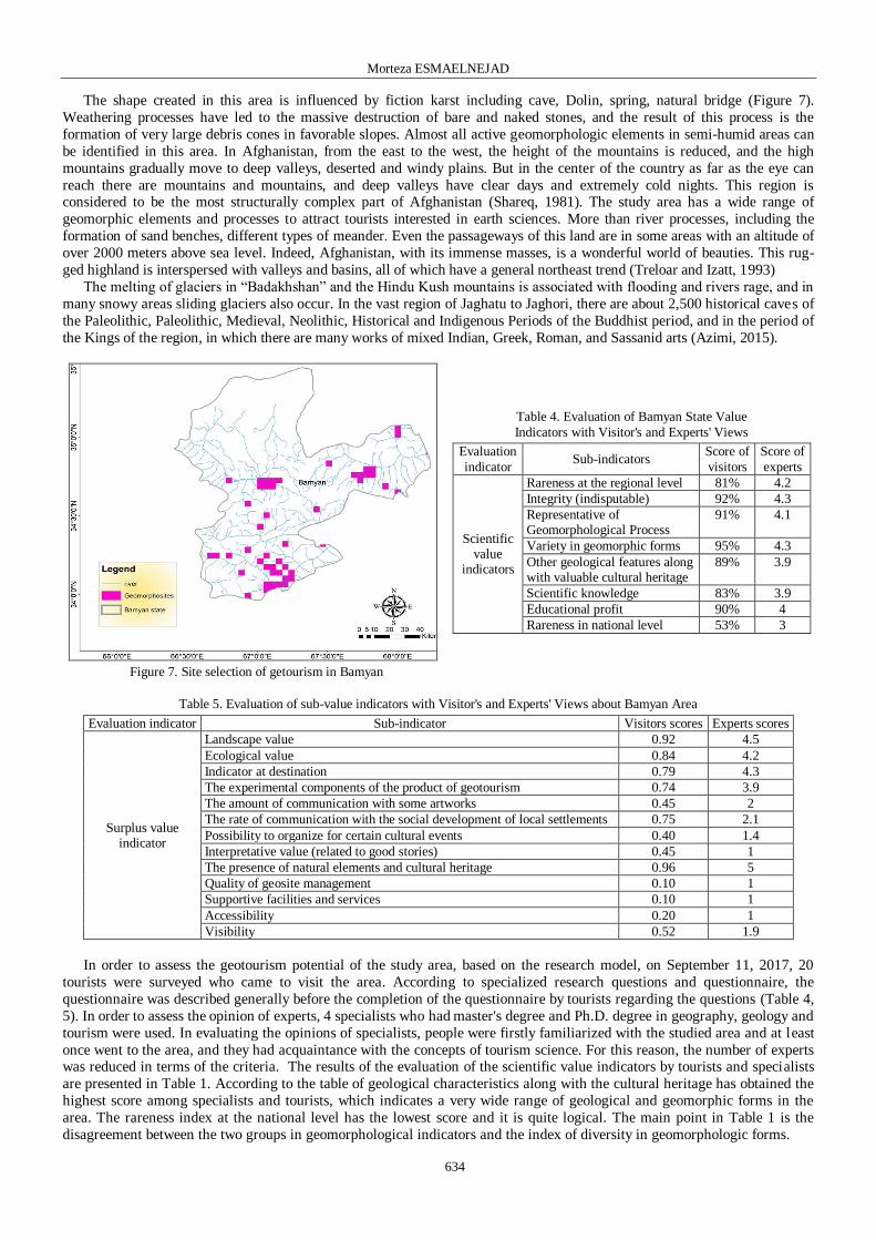
Morteza ESMAELNEJAD
634
The shape created in this area is influenced by fiction karst including cave Dolin spring natural bridge (Figure 7)
Weathering processes have led to the massive destruction of bare and naked stones and the result of this process is the
formation of very large debris cones in favorable slopes Almost all active geomorphologic elements in semi-humid areas can
be identified in this area In Afghanistan from the east to the west the height of the mountains is reduced and the high
mountains gradually move to deep valleys deserted and windy plains But in the center of the country as far as the eye can
reach there are mountains and mountains and deep valleys have clear days and extremely cold nights This region is considered to be the most structurally complex part of Afghanistan (Shareq 1981) The study area has a wide range of
geomorphic elements and processes to attract tourists interested in earth sciences More than river processes including the
formation of sand benches different types of meander Even the passageways of this land are in some areas with an altitude of
over 2000 meters above sea level Indeed Afghanistan with its immense masses is a wonderful world of beauties This rug-
ged highland is interspersed with valleys and basins all of which have a general northeast trend (Treloar and Izatt 1993)
The melting of glaciers in ldquoBadakhshanrdquo and the Hindu Kush mountains is associated with flooding and rivers rage and in
many snowy areas sliding glaciers also occur In the vast region of Jaghatu to Jaghori there are about 2500 historical caves of
the Paleolithic Paleolithic Medieval Neolithic Historical and Indigenous Periods of the Buddhist period and in the period of
the Kings of the region in which there are many works of mixed Indian Greek Roman and Sassanid arts (Azimi 2015)
Figure 7 Site selection of getourism in Bamyan
Table 4 Evaluation of Bamyan State Value
Indicators with Visitors and Experts Views
Evaluation
indicator Sub-indicators
Score of
visitors
Score of
experts
Scientific value
indicators
Rareness at the regional level 81 42
Integrity (indisputable) 92 43
Representative of Geomorphological Process
91 41
Variety in geomorphic forms 95 43
Other geological features along with valuable cultural heritage
89 39
Scientific knowledge 83 39
Educational profit 90 4
Rareness in national level 53 3
Table 5 Evaluation of sub-value indicators with Visitors and Experts Views about Bamyan Area
Evaluation indicator Sub-indicator Visitors scores Experts scores
Surplus value indicator
Landscape value 092 45
Ecological value 084 42
Indicator at destination 079 43
The experimental components of the product of geotourism 074 39
The amount of communication with some artworks 045 2
The rate of communication with the social development of local settlements 075 21
Possibility to organize for certain cultural events 040 14
Interpretative value (related to good stories) 045 1
The presence of natural elements and cultural heritage 096 5
Quality of geosite management 010 1
Supportive facilities and services 010 1
Accessibility 020 1
Visibility 052 19
In order to assess the geotourism potential of the study area based on the research model on September 11 2017 20
tourists were surveyed who came to visit the area According to specialized research questions and questionnaire the
questionnaire was described generally before the completion of the questionnaire by tourists regarding the questions (Table 4
5) In order to assess the opinion of experts 4 specialists who had masters degree and PhD degree in geography geology and
tourism were used In evaluating the opinions of specialists people were firstly familiarized with the studied area and at least
once went to the area and they had acquaintance with the concepts of tourism science For this reason the number of experts was reduced in terms of the criteria The results of the evaluation of the scientific value indicators by tourists and specialists
are presented in Table 1 According to the table of geological characteristics along with the cultural heritage has obtained the
highest score among specialists and tourists which indicates a very wide range of geological and geomorphic forms in the
area The rareness index at the national level has the lowest score and it is quite logical The main point in Table 1 is the
disagreement between the two groups in geomorphological indicators and the index of diversity in geomorphologic forms
Identification of the Geotourism Potential of Afghanistan A Case Study Bamiyan County
635
As tourists rated the two indexes higher while the experts gave the two indexes a near average rating Considering the
specialized nature of the two indicators it can be said that the region is in the medium of two indicators In this regard experts
can be considered superior to tourists because the answer to this question requires familiarity with a wide range of Earth
science phenomena In other indicators the opinions of the experts and the views of tourists are similar The relationship
between the two groups was evaluated and the score below the scientific value indices was 21752
ScV = 081 (Ra)x 42 + 092 (In)x 43 + 091 (Rp)x 41+ 095 (Dv)x 43 + 089(Ge)x 39 +083(Kn)x 39 + 090 (Ed)x 4 + 057 (Rn)x 3= 2722 (4)
Source (Hadžić et al 2010) components of the formula has been explained in Table 2
The results of the evaluation of the sub-indicators are shown in Table 2 It needs to be explained that the answer to the
indicators of scientific values does not require much scientific and specialized knowledge in the subject matter of the research
Therefore the comments of each questioner can be cited Based on the table below the index of the presence of natural
elements and cultural heritage has earned the highest score The presence of cultural elements related to historical periods in
most parts of the studied area along with the natural and active elements of the region caused the region to become a tourist site
and this factor has been found by experts and tourists The landscape indicator has earned a very high score The region has a
fantastic beauty effect that gives it more points The interpretive value index has earned the lowest score for both groups A
very noticeable point in this table is that the indicators that are related to the management of geosites facilities and supportive
services and accessibility due to the availability of reliable and good ways in terms of both groups have received the lowest score which indicates that the study area has a major management weakness that failed to provide the necessary infrastructure
for the development of geotourism and tourism in the region despite the availability of the potential which was found typically
in experts views Therefore it is necessary to provide integrated management and facilities for better development and
attraction of domestic and foreign tourists This is due to the fact that in the studied area there is no suitable accommodation for
tourists By providing the conditions cultural programs can provide educational programs for students or geoscientists
interested in the potential of almost the entire region The amount of vulnerability assessment was 3 due to the fact that one of
the main criteria for attracting tourists in this region is the existence of historical monuments Due to the long history these
highly weathered works are very vulnerable to natural destructive factors These historic monuments are also beside headlands
or hillsides that sharpen the vulnerability On the other hand geotouristic forms of this region are located in exacerbated
geological formations and are dominated with sharp hillsides so vulnerability of natural forms with geotourist values increases
by natural disasters Major landslides and riverbeds in loose formations every year have caused geotourism to be eroded or sometimes create other forms One of the major criteria for vulnerability is the amount of attention support and protection of
related organizations from geosite According to the data obtained from the questionnaire and field surveys the level of
protection from the historical and geotouristic forms of the region is low (Hadžić et al 2010)
AdV = 092 (ScV) x 45 +084 (Ec)x 42 + 079 (Ex)x 43 + 074(ReD)x 39 +045 (AW)x 2 + 075 (DLC)x 21+ 040
(OCE)x14 +045 (In)x 1 + 096 (Com)x 5 + 010 (Qu)x1+ 010(Ess)x 1+ 010 (Acc)x 1 + 052(Vi)x 19= 24475 (5)
Final evaluation of the geotourism value of the region
Finally with the sum of the indicators of scientific values secondary values and vulnerability of the geosite the final score
of the geosite is estimated The final value of the site was 53 as shown in equation (6) According to Table 3 the tourist value of the area is good It should be noted that factors that reduce the tourist value of the study area are mostly the indicators
related to the management and welfare facilities available in site whose improvement will increase significantly in terms of
amenities in the regions tourism value The dynamic model studied in this study shows the potential and capability of the
region to attract tourists especially in the field of earth tourism which in case of providing the weaknesses in this research it
will be one of the active tourist hubs
TE =244 + 2722 + 3=5462 (6)
CONCLUSION
Tourism which emphasizes the maintenance and protection of the five key dimensions of the graphic features of a
region - the environment culture beauty science education and the well-being of local people can play a special role in
preserving the capacities of local communities In this study has been discussed about tourism capability of Bamyan province This area has a wide range of elements and geomorphic processes to attract tourists interested in earth sciences It
is one of the most important historical centers of Afghanistan culturally and historically Considering the nature of tourism
which in addition to assessing the tourism features of its regions and its attractiveness also addresses the structure and
functioning of the -site management so one should use a model to cover all -tourist aspects of the areas
On the other hand according to a highly specialized tourism discussion it is not merely possible to estimate the value of
a -site with the reliance of touristsrsquo opinions Accordingly we should use tourist and morphology specialists view In this
research we have used the dynamic model to consider the above considerations to a large extent Many of the river
processes the types of slopes the existence of almost pure soluble formations including Gypsum in the parts of the area and
the ability to form caves in different sizes and shapes and existing of visible tectonic activation in valleys and steep walls
and the creation of very beautiful scenes with different types of faults and fault elements high temperature difference
during seasons and performance of weathering processes there are special -tourist attractions in this place which has a scientific value for earth scientist and educational value for students of the Earth sciences Therefore assessing the tourism
Morteza ESMAELNEJAD
636
value of the region will provide significant assistance in terms of economic cultural tourist ecological and sustainable
development of the region On the other hand whether the lack of knowing these capabilities or believing that they are not
attractive tourist attractions by the relevant authorities the lack of appropriate communication paths the lack of suitable
accommodation facilities for tourists the lack of a tour guide aware of tourism capabilities and historical value of the region
are of most important problems and weaknesses of the region for developing of tourism
REFERENCES Abdi M Nick Siri M amp Nasiri S (2021) Introduction of Damavand Park National sciences Database Quantities morphological
research 9(2) 18-33 (in Persian) Aman S (2016) Environmental Protection First Edition Jalalabad Publishing House Kabul Afghanistan Azimi M (2012) Ecotourism in Afghanistan Sobh Omid Publication Kabul Afghanistan (in Persian) Bansal P Arnold J Elberg MA Kalda J Soesoo A amp Van Milligen BP (2004) Melt extraction and accumulation from partially
molten rocks Lithos 78(1) 25-42 httpsdoi101016jlithos200404041 Brilha J (2009) Geological heritage and European parks in Portugal Proceedings of the VIII European parks Conference Idanha-a-
Nova Portugal Canter LW (1996) Environmental impact assessment McGraw-Hill Publication Baltmore USA Comanescu LA Nedelea R amp Dobre L (2012) The Evaluation of Morphosits from the Ponoare protected area Journal of Geography
5(1) 54-61 httpsdoi105775FG2067-46352012037I Coratza P Giusti C (2005) Methodological proposal for the assessment of the scientific quality of morphosites Geacuteomorphologie Relief
Processus Environnement 18(1) 307- 313 httpsdoi 104000 7942 Dowling R (2008) The emergence of tourism and parks Journal of Tourism 9(2) 227- 236 Dowling R amp Newsome D (2017) Handbook of Geotourism Edward elgar publishing Inc Northampton Massachuset USA Fennel D (1998) Ecotourism in Canada Annals of Tourism Research 25 (1) 231-234 httpsdoi101177004728759803700143 Gordon J (2018) Heritage tourism and the Cultural Landscape Enhancing the Visitor Experience and Promoting conservation
Geosciences 8 (4) 136 httpsdoiorg103390sciences8040136 Hadžić O Marković SB Vasiljević DjA amp Nedeljković M (2010) A Dynamical Model for Assessing Tourism Market Attractiveness
of a site 1st International Conference on heritage amp tourism Research TRENDS 2010 Novi Sad Serbia Ielenicz M (2009) Geotope Geosite Geomorphosites The Annals of Valahia University of Targoviste Geographical seriesTome 9 Koshraftar R (2007) Parks Earth Sciences and Economic Growth Proceedings of the park Conference of Qeshm Qeshm Island (in Persian) Law C (2002) Urban Tourism the visitor economy and the growth of large cities Continuum London UK Maghsoudi M Rahmati M (2018) Morphosites assessment of lorestan province in Iran by comparing of Zouros and Comanescursquos
methods (case study Poldokhtar Area Iran) Journal of Tourism and Geosites 21(1) 226ndash238 httpsdoi 1030892gtg21118-283 Mokhtari D Karami F amp Bayati Khatibi M (2011) Identification of active morphogenetic forms in Payam pass with the aim of planning
tourism Geographical Research Quarterly 26 (4) 67-92 (in Persian) httpsdoi1022059jphgr201660824 Movahed A amp Aman S (2019) The examining of strategies for ecotourism development in Afghanistan International Congress on Future
of Tourism Innovation Entrepreneurship and Sustainability Tehran Iran (in Persian) Mucivuna VC Reynard E amp Garcia M (2019) Morphsites Assessment Methods Comparative Analysis and Typology Heritage 11
1799ndash1815 httpsdoi 101007s12371-019-00394-x Nemanj T (2011) The Potential of Lazar Canyon (Serbia) as a tourism Destination Inventory and Evaluation Geographica Pannonica
15(3) 103-112 httpsdoi 10 0354-87241103103T Olafsdoacutettir R amp Tverijonaite E (2018) Tourism a Systematic Literature Review Sciences 8 234 httpsdoiorg103390sciences8070234 Panizza M (2001) Morphosites Concepts Methods and Examples of morphological Survey Chinese Science Bulletin 46(3) 4-6
httpsdoi101007BF03187227 Pereira D amp Dias G (2008) Masters course on logical Heritage and conservation European logistics 26-31 Pralong JP (2005) A method for assessing the tourist potential and use of morphological sites Morphology Relief Processes
Environment (4)3 189-196 Rahimpour A (2007) Tourism a Journey through the Wonders of the Earth Iranian Publication Tehran Iran (in Persian) Reineke T (2006) Environmental Assessment of the Bamiyan Valley in the Central Highlands of Afghanistan In University of Aachen
Bamiyan Masterplan Campaign 2005 Aachen Reynard E Coratza P amp Hobleacutea F (2016) Current research on geomorphosites Geoheritage 8(1) 1ndash3 httpsdoi101007s12371-016-0174-3 Reynard E Fontana G Kozlik L amp Scapozza CA (2007) Method for assessing scientific and additional values of morphosites
Geographica Helvetica 62(3) 148ndash158 httpsdoiorg105194gh-62-148 Shareq A (1981) Geological and geophysical investigations carried out in Afghanistan over the period 1972ndash1979 in Gupta HK and
Delany FM eds Zagros Hindu Kush HimalayamdashGeodynamic evolution American Geophysical Union Geodynamics 3(1) 75ndash86 Sharply R (2009) Tourism Environment and Development Series Earthscan Pub London UK Shayan S Bani S Zare M amp Nafiseh F (2013) Assessing the Capacity of Sustainable Tourism Development of morphosites with
Emphasis on the Comansco Method (Case Study morphosites of Karaj-Chalous to Kandovan Tunnel) Journal of Tourism Planning and Development 2(5) 93-78 (in Persian) httpsdoiorg1022080jtpd20181762
Singhand RS Ghosh P (2021)Tourism potential of coal mines An appraisal of Sonepur-Bazari open cast project India International Journal of heritage and Parks In Press Corrected Proof httpsdoiorg101016jijp202102007
Solarska A amp Zdzisław J (2010) Heritage and tourism Potential of the Strzelin Hills (Sudetic Foreland SW Poland) Geographica Pannonica 14 (4) 118-125
Treloar PJ amp Izatt CN (1993) Tectonics of the Himalayan collision between the Indian Plate and the Afghan Block a synthesis eds Himalayan Logical Society London Special Publications 74 69-87 httpsdoiorg101144GSLSP19930740106
NREL International Activities Website (2020) National Renewable Energy Laboratory Afghanistan Resources Maps and Toolkits wwwnrelgovapplying_technologiesgeospatial_toolkitshtml
USGS (2007) Geological map of Afghanistan Environmental Monitoring and Assessment USA
Article history Received 09022021 Revised 15042021 Accepted 10062021 Available online 30062021