4 existing environment - home | nz transport … nci-3pre-1pla-rpt-0018 project no. 250310 | page 40...
TRANSCRIPT
File NCI-3PRE-1PLA-RPT-0018 Project No. 250310 | Page 40
4.1 Overview This Section provides a description of the existing human, physical and natural aspects of the existing environment within which the Project will be constructed and operated. It draws on more detailed information that can be found in the Technical Assessments contained within Volume 3. The potential effects of the Project on this environment and any mitigation measures are detailed in Sections 9 and 10 of this AEE.
4.2 Human Environment Land use and settlement patterns, consented activities as well as resource use have been considered to provide an overview of the human environment in the wider Project area.
4.2.1 Land Use The existing built environment within and surrounding the Project area is predominantly characterised by the existing transport corridor, adjacent business/commercial/industrial land uses and established residential neighbourhoods concentrated at Unsworth Heights to the immediate south of SH18 as well as the Pinehill and Fairview Heights areas adjacent SH1 undergoing residential development. This land use profile is evident in the aerial photograph provided in Figure 9 below.
The Project area is reflective of the historic development of the North Shore in general. Agricultural development commenced in the late 19th century converting the bush covered landscape to paddocks with dispersed residential properties. The area continued to be rural in nature until relatively recently, with little development apart from the construction of the wastewater treatment facilities at Rosedale in the late 1950s and more recently motorway construction in the late 1990s. Since construction of the motorway, residential development and associated infrastructure has developed significantly adjacent to the corridor.
To the north, on the western side of SH1 is the Albany industrial estate which is still under development. It forms part of a wider mixed use development area containing the Albany Mega Shopping Centre and a Westfield. The area contains big box retail warehousing, and multi-storey buildings set in lots with car parking and landscaping.
Of note is the proportion of commercial / industrial land use within the Project area. The North Harbour Business Park is located to the north of the UHH between Paul Matthews Road and the Albany Highway (North Harbour East). Another cluster is located along Constellation Drive/Apollo Way/Rosedale Road with a third block straddling Rosedale Road to the west of its intersection with SH1. These collectively are known as the North Harbour East area.
A network of open space is interspersed throughout the Project area with a number of key sporting facilities also present which are discussed further at Section 4.2.5 below.
Notable land uses within the Project area include the Rosedale Closed Landfill located to the east of SH1 at Rosedale Road and the Rosedale Wastewater Treatment Plant (RWWTP) which straddles either side of SH1 above the UHH Interchange. These facilities are described in more detail at Sections 4.2.10 and 4.2.11 below.
4 Existing Environment

File NCI-3PRE-1PLA-RPT-0018 Project No. 250310 | Page 41
Figure 9 Built Environment within the Project Area
Source: Auckland Council GIS Viewer
N

File NCI-3PRE-1PLA-RPT-0018 Project No. 250310 | Page 42
A number of residential suburbs exist within the Project area including Albany Heights, Fairview Heights, Oteha Valley (Northcross), Pinehill, Fairview, Burnside and Fernhill (North Harbour East), Windsor Park, Unsworth Heights and Sunnynook. The residential areas within the southern section of the Study area are considered to be well-established suburban residential typically characterised by detached dwellings at low to medium densities. The newer residential areas to the north, are generally medium to low densities. The housing typology is mixed with a number of town house developments present. The majority of the residential land use is set back from the Project area along SH1 but the recent subdivision occurring at the western edge of the Pinehill/Fairview area will result in the uses abutting. Residential development at Unsworth Heights follows the UHH alignment.
The Census Area Units (CAUs) through which the Project traverses have a combined residential population as per the 2013 Census of 39,895 individuals. The Project area correlates to the Upper Harbour area which contains a significant business community. The number of businesses within this area has consistently grown by 5.2% in 2014 to 9,242 and grown by 58.0% in the past 10 years3.
4.2.2 Zoning and District Plan Features The zoning adjacent the Project area is varied.
The majority of the land within the Project area is zoned for some form of business purposes under the AUP as illustrated in Figure 10. The bulk of the properties adjacent to the northern section of SH1 north of the UHH Interchange and SH18 have a light industrial zoning. The Albany Retail Precinct is zoned as a mixed use metropolitan centre.
Residential zoning is located to the south of the UHH Interchange and SH18 as well as to the east of the northern section of the Project area. The residential areas noted at Section 4.2.1 are the subject of a variety of residential zones, which includes Special Housing Areas. Interspersed through these zones are areas of open space, the largest of which extends over the Rosedale Closed Landfill area situated between Greville Road and Rosedale Road.
3 Statistics on the economy in the Upper Harbour Local Board Area 2015, Auckland Council

File NCI-3PRE-1PLA-RPT-0018 Project No. 250310 | Page 43
Figure 10 Auckland Council Unitary Plan Zoning
Source: Auckland Unitary Plan (Operative in Part, 15 November 2016)
The Project area does not contain any items listed in the following sections of the AUP:
Schedule 10 Notable Trees;
Schedule 12 Sites and Places of Significance to Mana Whenua; and
Schedule 14 Historic Heritage Schedule.
The entire Project area lies within a Stormwater Management Area control (SMAF) under the AUP and there are SEA overlays4 at Lucas Creek, to the east of Tawa Drive, to the north of Alexandra Stream and extending over both ponds at RWWTP (Figure 11).
4 Subject to appeals, see section 3.11 of this Report.

File NCI-3PRE-1PLA-RPT-0018 Project No. 250310 | Page 44
Figure 11 Auckland Council Unitary Plan Features and Overlays
Source: Auckland Unitary Plan (Operative in Part, 15 November 2016)
4.2.3 Consented Activities Table 5 outlines the resource consents within the Project area that are currently unimplemented or pending a decision from AC at sites which lie in the immediate vicinity of the Project area. To the east of SH1 along Spencer Road, there is a consented subdivision which is in the process of development. The Metlifecare Greenwich Village facility located off of Barbados Drive is currently progressing the staged construction of the site.

File NCI-3PRE-1PLA-RPT-0018 Project No. 250310 | Page 45
Table 5 Consented Activities adjoining the Project Area
Address Activity Status
22 Colliston Rise, Pinehill Proposed new dwelling Unimplemented
2 Coxton Lane, Pinehill Proposed new dwelling Unimplemented
40 Masons Road, Oteha Establish and operate a motor home park facility
Decision: 16/05/2014
Unimplemented
59 Corinthian Drive, Albany Construction of a commercial building with office, warehouse and showroom components
Decision: 03/03/2015
Unimplemented
63 Corinthian Drive, Albany Proposed construction of new warehouse/distribution buildings Unimplemented
4.2.4 Community Services and Facilities The Project area services not only the local community (including the residential suburbs of Sunnynook, Rosedale, Mairangi Bay, Murrays Bay, Rothesay Bay, Pinehill, Albany and Browns Bay) but also the wider Auckland region, particularly north and north-west Auckland (Helensville, Dairy Flat and Kaukapakapa).
There are a number of community services and other facilities within the vicinity of the Project area which act as attractions to the area, including:
Albany Metropolitan Centre shopping and retail precinct;
North Harbour (QBE) Stadium;
Massey University’s Albany Campus;
Employment and economic activity in commercial and light industrial areas (North Harbour Industrial Area) between the Greville Road Interchange and the UHH Interchange;
Constellation Drive retail area;
NHHS; and
Access to the East Coast Beach areas such as Mairangi Bay and Browns Bay.
There are a number of schools located within the vicinity of the Project area, many of which have catchment areas that straddle the boundary of the Project area, however none directly abut the alignment. There are many early childhood facilities within the vicinity of the Project area and within the Project area itself (but not within the proposed designation footprint).
4.2.5 Parks and Recreation There are several parks and reserves adjacent to the main alignment of the Project, namely:
Tawa Reserve (to the west of the Greville Road interchange), a grassed area with no facilities or formal access;
Arrenway Reserve (between SH1 and Arrenway Reserve) a grassed area with no facilities or formal access;
Centorian Reserve (adjacent to Holder Place) a grassed area with no facilities or formal access;
Rosedale South Reserve (west of UHH interchange) a grassed area with no facilities or formal access;
Constellation Reserve which accommodates the NHHS complex;
Meadowood Reserve (south of SH18) which contains a play area, crèche and community centre;

File NCI-3PRE-1PLA-RPT-0018 Project No. 250310 | Page 46
Alexandra Stream Reserve (south of SH18), an esplanade reserve with a pedestrian/cycle way;
Omega Reserve (between SH18 and Paul Matthews Road), an esplanade reserve with a pedestrian/cycle way;
Rook Reserve (south of SH18), a recreation reserve with grassed area, fitness equipment and pedestrian/cycle way; and
Bluebird Reserve (between SH18 and Bluebird Crescent), contains a pocket park at its north-eastern extent which contains a play area and grassed area while the remainder is bush.
The NHHS facility is situated to the west of Constellation Reserve as part of Rosedale Park, to the north of the UHH. The facility consists of three hockey turfs, a clubhouse and ancillary buildings, car parking and football field.
Rosedale Park South is at the eastern end of Constellation Reserve. This land is not used for recreation purposes due to the unsuitable topography and access restrictions. It provides stock grazing and acts as a buffer between the Unsworth Heights residential area and the RWWTP. AC has long-term aspirations that the site be used for a future sports field development.
Rosedale Park North is home to the North Harbour Softball Association, the Albany United Football Club, a BMX facility, Rosedale Pony Club and a number of other recreational sports fields. This park also provides for informal recreation including walking and cycling.
From Rosedale Park North there is a corridor of reserves migrating south through the area each with different functions: Omega Reserve is a riparian esplanade reserve adjacent to Alexandra Stream, Rook Reserve is a pocket park providing passive recreation; and Unsworth Reserve consists of mainly native bush (conservation) in a gully-like setting which provides amenity and passive recreational value to the Unsworth Heights community. At the southern end of the Unsworth Reserve are sports fields.
There are many other parks and reserves scattered through the wider area. These are predominantly small neighbourhood parks with some larger parks and reserves located further west in Albany.
All reserves directly affected by the Project are Recreation Reserves under the RA. Table 4 in Section 3 provides further detail around these reserves, including their legal status.
4.2.6 Cultural Environment The Iwi identified as having mana whenua over the Project area are Ngai Tai ki Tamaki, Ngāti Manuhiri, Ngāti Maru, Ngāti Paoa, Ngāti Te Ata Waiohua, Ngāti Whatua and Te Ākitai Waiohua. All have declared an interest in the Project, attending a site visit in May 2016 as well as a series of Project Hui (see Section 8). Ngāti Tamaoho and Te Kawerau a Maki have advised that the Project Area was outside their rohe. Ngai Tai Ki Tamaki, Ngāti Manuhiri and Te Ākitai Waiohua have provided Cultural Value Assessments (CVAs) which are attached as Appendix F.
The cultural values pertaining to the wider Project area and environment have been identified by mana whenua in these CVAs. Key concepts relating to cultural values are summarised as: Mauri – All elements of the natural environment, including people, possess mauri (life
force) and all forms of life are related. The interconnectedness of all things means that the wellbeing of any part of the environment will directly impact on the wellbeing of the people. The primary objective of Māori environmental management is to maintain the integrity of mauri and the interconnectedness of all forms of life.

File NCI-3PRE-1PLA-RPT-0018 Project No. 250310 | Page 47
Kaitiakitanga – Māori therefore, have an obligation to protect and enhance the mauri of all natural resources, for the benefit of themselves, other people living in their homeland and for future generations.
Ki uta, ki tai – The mauri of the waterways is also viewed holistically and includes from the source of the waterway (mountains, springs and wetlands) to the sea. This reinforces the view that activities upstream also impact on the well-being of the river downstream and aligns with the integrated management of catchments.
A longstanding relationship with the entire north east of Tamaki Makaurau and eastern Kaipara and its environs especially between Te Oneroa Kahu (Long Bay) and Ōteha (Albany) is identified. The wider Ōteha area was central along a major overland pathway between the east and west coast / Upper Waitemata. The western end of a portage route was Okahukura (Lucas Creek), the immediate receiving environment for the streams in the Ōteha catchment that discharges into the Upper Waitemata. As such, there is a cultural and spiritual association with the area.
4.2.7 Heritage Environment There are no recorded or listed historic buildings or items within or immediately abutting the Project alignment. Additionally, there are no archaeological sites recorded in the Project area.
The closest recorded archaeological sites are two midden sites (R10/804 - CHI 11158 and R10/891-CHI 11242) found in Hooton Reserve and adjacent Lucas Creek. Neither of these sites are affected by the Project.
With regard to built heritage sites, there are three identified on AC’s Cultural Heritage Inventory (CHI) all of which are located at 40 Masons Road, Albany, being the premises of the North Shore Branch of the Vintage Car Club of New Zealand. The buildings are the former Takapuna Police Station (CHI 20118); the former Takapuna Jailhouse (CHI 20119) and historic villa (CHI 20120). These buildings were relocated to the site during the late 1990s and are not affected by the Project.
Further historic research and a field survey of the Project corridor by Clough & Associates has not identified any previously unrecorded archaeological remains, with the Project corridor generally found to have been significantly modified by previous urban development. The Assessment of Archaeological Effects (see Technical Assessment 2) provides a detailed description of the historical context and archaeological profile of the Project area.
4.2.8 Noise Environment To confirm the existing noise environment both short and long duration surveys were undertaken in April and May 2016 in the vicinity of the Project area, including along local roads crossing SH1 and SH18. Measured and derived noise levels ranged from 60 to 68 dB LAeq(24h) (Table 6). These levels show the impact of the proximity of major roads in the area (SH1 and SH18) and their contribution to the existing noisy urban environment.
Table 6 Noise Level Survey Results
Item Measured noise level Derived noise level
Long duration measurements dB LAeq(24h) dB LAeq(24h)
14 Wren Place 61 n/a
49 Barbados Drive 61 n/a
21 Cabello Place 61 n/a
16 Lavender Garden Lane 60 n/a

File NCI-3PRE-1PLA-RPT-0018 Project No. 250310 | Page 48
Item Measured noise level Derived noise level
18/71 Spencer Road 60 n/a
Short duration measurements dB LAeq(15min) dB LAeq(24h)
112 Unsworth Drive (Medical Centre) 70 68
82 Bluebird Crescent 64 62
16 Saturn Place (Childcare Centre) 67 65
29 Arrenway Drive (businesses) 70 68
17 Tawa Drive (SH17) 65 63
80 Paul Matthews Road (Hockey) 68 66
Rook Place - Reserve 65 63
The majority of the dwellings between Oteha Valley and Greville Road are reasonably new and have been developed under the High Noise Route requirements of the legacy Auckland Council District Plan: North Shore Section (ACDP: NS), with some bunding and fencing installed between the residential development and the State highway. There is a new subdivision between Spencer Road and Greville Road which currently has no buildings on the lots. Building consent documentation for proposed dwellings has been lodged and has demonstrated that the dwellings will be built in accordance with the legacy ACDP: NS with mechanical ventilation included for habitable rooms facing the State highway.
4.2.9 Utilities The following network utilities and service infrastructure are located in the Project area, some of which will need to be protected and/or relocated for the Project:
Watercare (provider of regional water and wastewater services):
Existing Wairau Sewer (TS5) and East Coast Bays Branch Sewer (TS7) which are major lines leading to the Rosedale Wastewater Treatment Plant;
A section of 250dia. watermain on Rosedale Road; and
A 100dia watermain on Paul Matthews Road.
Vector (distributor of electricity and gas);
Existing 11KV, 33KV and 110KV lines in multiple locations.
Transpower (owner and operator of the National Grid);
Existing 220KV power lines (Constellation Drive to UHH and then through NHHS and RWWTP).
Chorus NZ Ltd (telecommunications infrastructure provider); and
Existing underground infrastructure in multiple locations.
The Project area also contains a number of other utilities such as local telecommunications and electrical supply infrastructure providing smaller connections. These utilities will be managed to maintain supply during Project construction.
4.2.10 Rosedale Closed Landfill A land use of significance is the Rosedale Closed Landfill located on the eastern side of SH1 between Greville Road to the north, Hugh Green Drive to the east, and Rosedale Road to the south. Approximately 23ha of the 34.5ha site was used for refuse disposal. The top of the Rosedale Closed

File NCI-3PRE-1PLA-RPT-0018 Project No. 250310 | Page 49
Landfill is approximately 45m above SH1 and has a maximum depth of 28m. There is currently no public access to the site.
Prior to the establishment of the Rosedale Closed Landfill, the land was pasture with the Oteha Stream and several small tributaries flowing through the northern area of site. The stream and its tributaries were diverted when the Rosedale Closed Landfill was extended towards Greville Road.
The Rosedale Closed Landfill began accepting general refuse in the 1950s. It ceased operation in 2002 and is currently in its aftercare programme. Approximately 3.3 million tonnes of waste has been deposited into the Rosedale Closed Landfill. The capped surface is mainly grassed with some areas of established vegetation. Stormwater ponds are present at the eastern and western boundary of the site.
4.2.11 Rosedale Wastewater Treatment Plant The RWWTP is operated by Watercare and the facility consists of the treatment plant buildings, treatment tanks and treatment ponds contained within a grassed buffer area. This is a significant land holding extending from Jack Hinton Drive in the west to Apollo Road in the east with the facility bisected by the SH1 causeway across the treatment ponds. The two ponds are connected by a weir and pipe system, with an additional bypass link. A vehicle link is also provided under SH1 linking both parts of the site. There is no public access to the facility.
The embankment over which SH1 travels was created at the same time as the treatment ponds in the early 1960s. The embankment partly acts as a large dam as it holds back water and failure could result in an uncontrolled release of water downstream. The western embankment of Pond 1 also acts as a dam.
Major upgrades to Pond 1 and the spillway system were undertaken between 1994 and 2000 with dam management systems improved. The RWWTP (including the Pond 1 dam) was re-consented in 2000 and 2001 (Project Rosedale). Several upgrades have continued from this project including stormwater management and storage improvements, UV treatment and a new outfall tunnel.
Stormwater from the surrounding catchments is prevented from entering the ponds by a series of open channels that run along the southern side of each pond and which discharge downstream of Pond 1.
4.3 Transport Environment An overview of the existing transport environment including the State highway corridor, interchanges, bridges, the local road network, public transport, and walking and cycling infrastructure within the vicinity of the Project area is provided in the following sub section.
4.3.1 Existing State Highway Corridors SH1 forms the key interregional link that traverses north-south through the Auckland region and throughout the Project area. SH1 is a six-lane motorway with three lanes in both directions north of the Oteha Valley Road Interchange. This reduces to two lanes north and south bound through the Interchange before returning to three lanes. SH1 then decreases to two lanes in either direction south of the Greville Road Interchange until the UHH Interchange, approximately 3.8 km south of the Oteha Valley Road Interchange. SH1 traverses through the RWWTP over a causeway with two lanes in either direction. Just to the north of the Sunset Road overbridge the north bound carriageway increases to three lanes.
To the west of the UHH Interchange, SH18 commences which is predominantly a four-lane (two west bound/ two east bound lanes) expressway for approximately 2 km through to the Albany Highway Interchange, where it becomes a motorway. There are two at-grade intersections with local roads, these being; Caribbean Drive and Paul Matthews Road. There is an at-grade west bound only slip

File NCI-3PRE-1PLA-RPT-0018 Project No. 250310 | Page 50
onto Unsworth Drive. SH18 reduces to a single lane in the westbound direction between Paul Matthews Road and Unsworth Drive. This link serves as a key intra-regional link from SH1 to West Auckland and the wider North Shore area whilst serving suburbs in between such as Greenhithe and Hobsonville Point.
4.3.2 Interchanges The Oteha Valley Road Interchange is the northernmost interchange within the Project corridor. It serves the residential suburbs of Fairview Heights, Oteha, Northcross and Torbay to the east of the interchange in addition to the Albany metropolitan centre to the west. SH1 crosses Oteha Valley Road on an overbridge structure with both north and south bound on/off ramps provided.
Greville Road is the second major interchange and serves the residential communities of Browns Bay, Pinehill, Rothesay Bay and Murrays Bay to the east, and the Albany metropolitan centre to the west via the Albany Expressway. Again, SH1 traverses the local road on an overbridge structure. On/off ramps are provided for southbound traffic but only an off-ramp is in place for those travelling north.
The UHH Interchange is the intersection between SH1 and SH18. It includes both north-facing and south-facing ramps with signalised intersections at both the UHH and Constellation Drive ramps. It serves as the primary access to the Constellation Bus Station (including the park and ride) and the residential suburbs further east. To the west, it serves the residential suburb of Unsworth Heights and the North Harbour industrial area. Both north and south bound on/off ramps are provided to enter/ exit SH1 which crosses the UHH and Constellation Drive on an overbridge.
4.3.3 Bridges There are in total six existing bridge structures within the Project area. These consist of local road over bridges and underpasses spanning SH1 and SH18.
Set out in Table 7 below is a summary of the existing bridge structures as described from north to south.
Table 7 Bridge Structures in the Project corridor
Bridge Name Bridge Detail
Oteha Valley Road Underpass
Oteha Valley Road passes beneath SH1 to provide access between the Albany metropolitan centre and the Oteha and Fairview communities. Footpaths are located in both directions under the bridge.
McClymonts Road Bridge
Two-lane road providing a connection over SH1 between the Albany metropolitan centre and the Pinehill and Oteha residential communities. There is a formalised footpath on the northern side of the bridge and an incomplete footpath along the southern side. Two span pre-stressed precast Double Hollow Core (DHC) bridge, supported on in-situ columns and piles at all supports, with Mechanically Stabilized Earth (MSE) small block infill abutment walls.
Greville Road Underpass
The arterial four-lane connection between Greville Road and the Albany Expressway crosses beneath SH1 interchange with a footpath located along the northern length of the underpass. Three span bridge consisting of pre-stressed U-shape precast girders with a 180-200mm thick deck, supported on in-situ piers and piled spill through abutments.
Rosedale Road Underpass
The underpass is a two-lane local road connecting the Rosedale business area to the North Harbour industrial area to the west. Footpaths and cycle lanes are provided in both directions. Single span pre-stressed precast DHC bridge with MSE block abutment walls and a shallow pad abutment foundation.
File NCI-3PRE-1PLA-RPT-0018 Project No. 250310 | Page 51
Constellation Drive bridge (SH1 over)
SH1 crosses over above the intersection of Constellation Drive and SH18. Traffic signals and a pedestrian link are located beneath the bridge. Two span pre-stressed precast DHC bridge with in-situ piers and soldier pile and panel abutment walls.
Alexandra Stream Pedestrian Underpass
A pedestrian / cycleway underpass providing north/south connectivity from Unsworth Heights. Armco corrugated circular steel culvert with an infill concrete floor slab for pedestrians. Culvert has been previously repaired by means of an inner steel culvert with reinforced concrete between the outer and inner culvert “skins”
4.3.4 Local Road Network AT administers the local roads within the Project area. All local roads connect with SH1 via an interchange. There are several local road bridges, underpasses and intersections that continue the local road network (predominantly arterial) across SH1 and SH18 within the Project area (see Figure 12 below and as described in detail in the Assessment of Transport Effects provided at Technical Assessment 12).

File NCI-3PRE-1PLA-RPT-0018 Project No. 250310 | Page 52
Figure 12 Road network within the Project Area
Source: Auckland Council GIS Viewer, 2016
The key arterial roads as shown on Figure 12 form a loop around the Project area with connections via secondary arterials. The key primary arterial roads near the Project include Greville Road, Albany Highway, East Coast Road and Sunset Road. Secondary arterial routes include Oteha Valley Road, Albany Expressway and Constellation Drive.
4.3.5 Public Transport Network The Northern Busway currently begins at the Auckland Harbour Bridge and terminates just south of the Constellation Bus Station. The Busway is situated along the eastern length of SH1 (Northern Motorway) and includes five existing stations. Albany Bus Station is not currently serviced by the Busway, however there is a high demand for the park and ride facility located adjacent to the Albany metropolitan centre to the west of SH1. Bus services are required to re-enter the general traffic on SH1 in order to travel between the Constellation Bus Station and Albany Bus Station. In addition, bus services travel east-west along Constellation Drive and SH18 to Paul Matthews Road.

File NCI-3PRE-1PLA-RPT-0018 Project No. 250310 | Page 53
4.3.6 Walking and Cycling Accessibility The majority of local road connections (as described above) that cross the State highway corridor provide for pedestrian access, however, very few of these are continuous in both directions without the interruption of traffic signals or with appropriate measures to prioritise pedestrians.
The existing cycleways present significant gaps that prevent cyclists from having a well-connected and continuous route. Cyclists often have no safe facilities in the most challenging locations such as intersections and interchanges along the State highway corridor.
Both the UHH and Greville Road interchanges form part of the existing or proposed Regional Cycle Network (Figure 13). There are currently no dedicated facilities at the UHH Interchange for cyclists which has resulted in the creation of a dangerous environment which discourages active transport modes. A footpath connects from Constellation Drive through the UHH Interchange to Caribbean Drive however, the facilities are not continued further west along SH18, nor is there a pedestrian or cyclist connection between the Constellation Bus Station and the North Harbour Business Park or the NHHS.
Figure 13 North Auckland Cycle Network
Source: Auckland Transport Northern Cycle Map

File NCI-3PRE-1PLA-RPT-0018 Project No. 250310 | Page 54
4.4 Physical Environment The existing physical environment is described by reference to the topography, landscape, geology and hydrogeology of the Project area and the surrounding vicinity.
4.4.1 Topography and landscape The Project area is generally characterised as being contained within two valleys, the Oteha Valley and the Albany Valley. Oteha Valley is located between the Oteha escarpment to the north of the Project area and the Albany Ridge traced by Spencer Road. The Albany Valley is located between Spencer Road and the Sunset Road ridge to the south of the UHH Interchange. East Coast Road, to the east of the Project area, occupies a prominent ridgeline which runs north to south.
The landscape within and surrounding the Project area is predominantly built up with several notable landscape characteristics in the surrounding context. These include; the vegetation along the Oteha Escarpment to the north of the Project area, the large trees within the Albany Scenic Reserve, the Rosedale Closed Landfill, the RWWTP ponds and an associated stand of large pine trees adjacent to Constellation Drive.
There is a variety of vegetation within and surrounding the Project area which occupies parks, reserves, road reserves and private properties. The most notable vegetation includes the grassed areas at the Rosedale South Park, the Rosedale Closed Landfill, the indigenous forest at Pigeonwood Reserve, the Burnside Escarpment, the Days Bridge Esplanade Reserve and the Manuka/Kanuka forest along the northern slopes of Oteha Valley.
4.4.2 Geology The Project area is located within the Albany Basin with an overall gently undulating terrain, surrounded by a series of ridges and spurs. Residually weathered soils of the Waitemata Group are found across the project area as silty clays, sandy silts and clayey silts. As well major depressions and watercourse valleys contain alluvial deposits, the most recent of which consist of organic silty clay with gravel occurring at the bases of streams and watercourses. Engineered fills are also present throughout the project area, mainly in embankments, although they may also occur in other landscaping features.
The main soil types are impeded allophanic (characterised by generally stable topsoils) at the very northern part of the project area with ultic soils (characterized by clayey subsoils with low permeability) dominating through the central part of the alignment and along the UHH.
4.4.3 Hydrogeology 4.4.3.1 Groundwater There are no known aquifers located within the Project area. Groundwater is deepest below topographically higher standing ridges such as Sunset Road in the southern end of the Project area, with shallower groundwater levels in low lying areas. The groundwater levels in the Waitemata Group soils near the ponds at the RWWTP are influenced by the standing water levels within the treatment ponds.
4.4.3.2 Catchments The Project area falls within the Oteha Valley Stream and Lucas Creek catchments. The catchment area of the Oteha Valley catchment is approximately 1,310ha to the confluence of Lucas Creek (approximately 4km downstream of SH1). The catchment (Figure 14) includes the RWWTP, Massey University campus, Rosedale Closed Landfill, as well as residential and commercial land uses.
The Lucas Creek catchment (Figure 14) is approximately 625ha to the confluence with Oteha Valley Stream (some 2.5km downstream of SH1). The upstream catchment land uses are mostly residential,

File NCI-3PRE-1PLA-RPT-0018 Project No. 250310 | Page 55
and downstream of the SH1 crossing, the catchment is a mix of rural and residential uses, and also contains the Massey University campus and Albany Bus Station.
Figure 14 Oteha Valley and Lucas Creek Catchment Plan
There are several locations within the Project area that have been identified as having existing flood risk. The locations are identified in Figure 15 and detailed in Table 8.

File NCI-3PRE-1PLA-RPT-0018 Project No. 250310 | Page 56
Figure 15 Existing flood prone locations within Project Area
Table 8 Details of flood risk areas within Project Area
Figure Label Flood risk area
A SH1 Greville Road Interchange – flooding on local Road under motorway
B SH1 Rosedale Road - flood plain adjacent to motorway
C SH18 – Caribbean Drive Intersection
D SH18 – major overland flow path parallel to eastbound carriageway
E Overflow to RWWTP
A detailed description of the existing stormwater infrastructure and level of treatment currently applied to SH1 and SH18 is set out in the Assessment of Stormwater Management provided in Technical Assessment 11.
4.5 Natural Environment The terrestrial and freshwater environment has been assessed in order to understand the existing environmental baseline for the natural environment within the Project area. There are no areas identified within the Project area as having an Outstanding Natural Landscape or Outstanding Natural Feature overlay within the AUP. There are four SEA identified by the AUP within the Project area. These are located at Lucas Creek, the RWWTP ponds and Alexandra Stream. Overall, the botanical and aquatic ecological values of the environments within the Project area are considered to be of a low value, with moderate value environments being those unmodified by the existing State highway corridor and adjacent developments.
Bioresearches Limited has carried out both freshwater and terrestrial assessments of the Project area and a more detailed description of the existing freshwater and terrestrial environment of the Project area is contained within the Assessment of Freshwater Ecology Effects and the Assessment of Terrestrial Ecological Effects (see Technical Assessments 5 and 13 respectively).
4.5.1 Freshwater environment The freshwater habitats within the Project area comprise Lucas Creek, Alexandra Stream, Oteha Stream, the tributaries of Lucas Creek, Oteha Stream and Alexander Stream, and existing AC and NZ Transport Agency stormwater ponds. All watercourses flow north and west to Lucas Creek to discharge to the Upper Waitemata Harbour near Albany Village.
A
B
C
D
E
File NCI-3PRE-1PLA-RPT-0018 Project No. 250310 | Page 57
4.5.1.1 Lucas Creek and tributaries
Lucas Creek flows beneath and traverses SH1 immediately north of Oteha Valley Road. The creek at this location is in a highly shaded, natural channel with steeply incised, near vertical banks. It averages 3.5m wide (maximum 8.3m) and 0.3m deep (maximum 0.81m).
Survey results of this part of Lucas Creek indicate that the macroinvertebrates present are dominated by the freshwater snail (Potamopyrgus antipodarum) and the sandfly larvae (Austrosimulium). Crans bully (Gobiomorphus breviceps) and shortfin eel (Anguilla australis) were the only native fish recorded. Freshwater crayfish (Paranephrops planifrons; koura) and exotic mosquito fish (Gambusia affinis) were also present.
A search of the New Zealand freshwater fish database for Lucas Creek returned fish records for four additional native fish, longfin eel (Anguilla dieffenbachii), banded kokopu (Galaxias fasciatus), common bully (Gobiomorphus cotidianus), redfin bully (Gobiomorphus huttoni); and for the freshwater mussel (Hyridella menziesi).
Site visits revealed that the quality of native galaxiidae spawning habitat was poor. Although shading was high, the banks were near vertical and there were no flatter stream banks with low growing vegetation necessary for spawning. The riparian vegetation further east is sparse and fragmented.
A small tributary to Lucas Creek drains the catchment north and west of the Oteha Valley Road northern on-ramp to SH1 to an adjacent stormwater pond. The watercourse follows a narrow run with shallow pools and averaged 0.5m wide (maximum 1.1m) and 0.08m deep. The stream has moderate freshwater ecological values due to its largely natural state and the presence of a variety of substrates for macroinvertebrates, good shading and regenerating bush.
4.5.1.2 Oteha Stream and tributaries
The northern tributary of Oteha Stream within the Project area flows from north to south for approximately 90m from an upstream culvert to a second culvert before running under the Albany Expressway and discharging to Oteha Stream. It forms a natural channel with steeply incised, near vertical banks with no connection with the floodplain. A very low number of macroinvertebrates were found and these were dominated by midges (Chrionomids) along with some freshwater snails and springtails (Collembola). The overall habitat had a low Macroinvertebrate Community Index (MCI) score and a poor Semi-Quantitative MCI (SQMCI) ranking. Shortfin eel was the only native fish recorded and the quality of native galaxiidae spawning habitat is poor.
A short reach of the upper most open section of Oteha Stream is located within Tawa Reserve. The banks have been stabilised with large rocks and were covered in a mix of weed species. The stormwater ponds at the Greville Road intersection and upper Greville Road catchment drain to the Oteha Stream via a large (3000mm diameter) stormwater culvert. The water discharges to the stream over a culvert apron to bedrock. The stream bed is exposed bedrock without macrophytes, and has little cover for fish or substrate suitable for macroinvertebrates. The aquatic ecological values of the part of Oteha Stream located within the Project area are low.
4.5.1.3 Alexandra Stream and tributaries
Alexandra Stream drains south to north to a culvert under the UHH.
The southern arm averages 2m wide and 0.3m deep and forms a well shaded, natural channel with sloping banks. There are a variety of favourable aquatic habitats present including woody debris, riffles, undercut banks, root mats and other stable habitats. Macroinvertebrates identified from the stream survey are dominated by the freshwater snail (Potamopyrgus antipodarum) and dragonfly larvae (Xanthocnemis zelandica). However, the overall habitat has a low MCI score. Crans bully and shortfin eel were the only native fish recorded. No koura or other larger invertebrates were found in the creek, but the exotic mosquito fish was present. A search of the New Zealand freshwater fish
File NCI-3PRE-1PLA-RPT-0018 Project No. 250310 | Page 58
database for Alexandra Stream returned fish records for four additional native fish; longfin eel, banded kokopu, common bully, and redfin bully. The quality of native galaxiidae spawning habitat is low.
The northern arm of the Alexandra Stream drains south to north from the SH18 culvert to a culvert under Paul Matthews Drive. It averages 1.9m wide and 0.3m deep and forms a well shaded, natural channel with sloping banks. Macroinvertebrates identified from the stream survey are dominated by the freshwater snail and dragonfly larvae. Longfin eel, shortfin eel and crans bully were recorded from this northern reach with slightly elevated levels of longfin eel in comparison to other Auckland streams.
A section of tributary to the Alexandra Stream flows through Bluebird Reserve from west to east and forms a boggy watercourse at the base of a series of culverts adjacent SH18. Although recent riparian planting has been carried out the stream area has been highly modified with straightening of the watercourse, a series of gabion basket weirs, and culverts with concrete energy dissipation zones. The overall value of the aquatic habitat within the Alexandra Stream tributary is low.
4.5.1.4 Rosedale Wastewater Treatment Plant
There are a number of drains and watercourses within the RWWTP site that form part of its stormwater system.
South of Arrenway Reserve lies an open section of drain and a stormwater system collects water from the south and drains north to a large culvert that discharges west (under SH1) and north to Oteha Stream. The stormwater drain is lined with concrete and is 0.9m wide. Shortfin eel were noted in the drain during the survey.
The stormwater system is a narrow, open concrete lined channel draining generally east to west adjacent to the southern banks of Pond 2, then draining via culverts and open drains north and west to Oteha Stream. There is no effective shading on the drain and no quality habitat for aquatic fauna.
A stormwater pond approximately 73m by 25m is located adjacent to the UHH off ramp south, near Centurion Reserve. It discharges via a culvert under SH18 to drain overland via a wetland-like area to a stormwater drain on the southern edge of Pond 1. Survey results confirm the presence of shortfin eel and mosquito fish only.
Immediately north of the UHH in line with Caribbean Drive (and south of Pond 1), are a series of watercourse and stormwater drains. Despite its highly modified condition, the watercourse to the west of the Caribbean Drive intersection is considered to be an ‘intermittent stream’ under the AUP and is potentially permanent in some places. The watercourses in this area are highly modified and are confined to a concrete lined open drain, 1m wide with 0.4m concrete block sides. Survey results confirm the presence of shortfin eel and mosquito fish only.
Pond 1 and Pond 2 form part of the RWWTP treatment system, with Pond 1 being the main settlement pond. Their aquatic ecological values are low.
Overall the freshwater aquatic values of this area are low to very low.
4.5.1.5 Stormwater Ponds
Two stormwater ponds (SWP1 - east) and (SWP2 - west) are located north of Oteha Valley Road with both divided into two by a central bund. SWP 1 covers an area approximately 43m by 13m and SWP 2 is approximately 75m by 12m. Survey work confirms the presence of Shortfin eel in these ponds. The aquatic ecological values of these ponds are considered to be low.
A stormwater pond approximately 30m by 18m is located adjacent to the SH1 southbound below Masons Road and Lavender Garden Lane. It discharges over a weir to a small wetland that drains via a culvert under SH1 towards Lucas Creek. Survey work indicates the presence of shortfin eel and adult banded kokopu.

File NCI-3PRE-1PLA-RPT-0018 Project No. 250310 | Page 59
The stormwater pond adjacent 35 Corinthian Drive of dimensions 72m by 29m, is noted to contain shortfin eel and late stage tadpoles.
A large stormwater pond approximately 86m by 30m is located in the Rosedale Closed Landfill adjacent to Greville Road and the Greville Road on-ramp southbound. It discharges to a culvert under SH18 that drains to Oteha Stream. Survey of this pond confirmed the presence of introduced green and golden bell frogs (Litoria aurea) only.
A stormwater pond is located within the round-a-bout formed by the Greville Road on-ramp north and a second stormwater pond is located immediately south of the on-ramp north. Both ponds drain to the Oteha Stream via a 3000mm diameter culvert. No fish or frogs were noted in either pond.
The stormwater pond in Omega Reserve, adjacent to Alexandra Stream is approximately 56m by 27m and its survey confirmed the presence of shortfin eel.
Overall, the aquatic ecological values of these stormwater ponds are low.
4.5.2 Terrestrial environment 4.5.2.1 Vegetation and Flora
Vegetation within the Project area contains a mixture of exotic and native species typical of residential areas and transport environments. As the existing environment is characterised by an urban setting, ecological values are generally low.
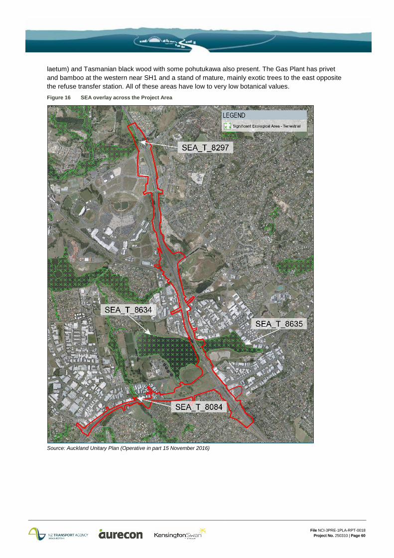
The areas affected by the Project that are identified within the SEA overlay in the AUP are shown in Figure 16.
A SEA occupies the steep south-facing scarp above Lucas Creek and part of this SEA extends along the western side of the northbound on-ramp at the Oteha Valley Road (SEA_T_8297). There is a considerable amount of native vegetation5 surrounding SH1 in this area, including regenerating podocarp broadleaved forest. In general the riparian vegetation along Lucas Creek is of good quality with moderate to high botanical values while the SEA vegetation further up the slope is weedier with a significant component of exotic trees and moderate to low botanical values.
There is little vegetation of note on the southern side of Oteha Valley Road at either side of SH1, and that present is predominantly located on the western side of the motorway comprising isolated strip planting shrubs and trees such as cabbage trees (Cordyline australis), kanuka, karo (Pittosporum crassifolium), flax, lacebark, karamu, kohuhu, oioi and carex species. The botanical values are considered to be very low.
Between McClymonts Road and Rosedale Road, there is little vegetation of note. Wattles, gorse (Ulex europaeus), and macrocarpa (Cupressus macrocarpa) are located on the corner of McClymonts Road and the southbound SH1 on-ramp. There is also standard motorway revegetation on both sides of the on-ramp as well as a group of eucalypts (Eucalyptus sp.).
The Greville Road Interchange area contains mixed exotic and native vegetation with restoration planting surrounding the existing stormwater pond. The eastern end of Tawa Reserve adjacent the Greville Road Interchange consists of young revegetation planting (kanuka, cabbage trees, kohuhu, flax and karamu) and is weedy in character.
Vegetation within the extent of the Rosedale Closed Landfill within the Project area consists of some small eucalypts, various wattle species, karamu, cabbage trees, flax, manuka, ngaio (Myoporum
5 E.g: tall kanuka (Kunzea robusta), tanekaha (Phyllocladus trichomanoides), rewarewa (Knightia excelsa) and kahikatea (Dacrycarpus dacrydioides) over an understorey of silver tree fern (Cyathea dealbata), pate (Schefflera digitata), mapou (Myrsine australis), mahoe (Melicytus ramiflorus) and karamu (Coprosma robusta)
File NCI-3PRE-1PLA-RPT-0018 Project No. 250310 | Page 60
laetum) and Tasmanian black wood with some pohutukawa also present. The Gas Plant has privet and bamboo at the western near SH1 and a stand of mature, mainly exotic trees to the east opposite the refuse transfer station. All of these areas have low to very low botanical values. Figure 16 SEA overlay across the Project Area
Source: Auckland Unitary Plan (Operative in part 15 November 2016)
File NCI-3PRE-1PLA-RPT-0018 Project No. 250310 | Page 61
With respect to the Project area between Rosedale Road and Constellation Drive, there is minimal vegetation (grass and isolated exotics) on the eastern side of SH1. The botanical value of vegetation adjacent the Project within the RWWTP is low and consists of the following:
North-east of Pond 2- radiata pines and open grassland with young revegetation planting consisting mainly of kanuka abutting SH1;
South-east of Pond 2 - mainly open grassland with sparsely planted native trees (kahikatea, puriri, kowhai, titoki and kanuka) including flax and cabbage trees in wetter areas. A hedge/ shelterbelt of tall ngaio (c. 10m), pohutukawa and puriri runs east north east to SH1; and
North-west of Pond 1 - a stand of pines, eucalypts and other exotic trees opposite to the Arrenway Reserve and an area of eucalypts and pines sweet gum with an understorey of karamu, lacebark, karo, houpara and young puriri to the north of the commercial area in Holder Place.
A number of reserves straddle SH18 (Omega Reserve, Rook Reserve and Bluebird Reserve) and are typical of urban reserves that have received native restoration planting. Omega Reserve is an SEA (SEA_T_8084). All have some botanical values, however these are generally low.
4.5.2.2 Fauna
A desktop analysis indicated the presence of nine sites within and immediately adjacent the Project area that could support potential lizard habitat. SEA_T_8297 is the most valuable with historic reporting indicating the presence of copper skink, ornate skink, forest gecko, green gecko and pacific gecko. Bluebird Reserve off SH18 supports an area of dense tree ferns which provide retreat sites for ground dwelling skinks and geckos with the overall habitat quality of this area assessed as low. The remaining areas (Albany Expressway Scrub, Tawa Reserve, RWWTP Ponds 1 and 2, Rook Reserve and Omega Reserve) typically have sparse understorey vegetation and areas of bare ground and are of marginal habitat quality. No native lizards were recorded from either habitat searches or funnel traps.
The RWWTP has habitat suitable to support a bat population (threatened long-tailed bat - Chalinolobus tuberculatus), being the tall pine trees on the northern bank to Pond 2. A bat survey was conducted with no bats recorded over the survey period nor was there evidence of previous occupation in the area. It is unlikely that bats use any of the environment within the Project area, even on an intermittent basis.
The vegetated and undeveloped areas along the Project area have the potential to support avifauna. The RWWTP ponds provide habitat for a wide range of species including New Zealand dabchick- Poliocephalus rufopectus; weweia (an ‘At Risk’ and ‘Threatened’ species) black swan, mallard/grey duck hybrids, paradise shelduck, Canada goose and pied stilt and are utilized for breeding. A relatively large population of birds is typically present, especially when numbers of Canada goose are high. The population has acclimatised to industrial activities at the RWWTP, farming activities and motorway works and operation, together with overflights of helicopters using the adjacent Helitranz heliport.
While New Zealand dotterel (Charadrius obscurus) generally roost and nest in open coastal areas (sandy beaches and shell banks), they are known to breed inland on open, short grass areas. The vacant land around the Albany commercial block is one such area.
Results of the avifauna survey carried out in the Project area, identified a total of 22 species, comprising 13 native species. With the exception of the New Zealand dabchick, none of the species recorded are classed as ‘At Risk’ or ‘Threatened’. The areas of SEA_T_8297, Rook Reserve, Omega Reserve and Bluebird Reserve host both an introduced and native bird population including fantail (Rhipidura fuliginosa placabilis; piwakawaka), Silvereye (Zosterops lateralis lateralis) and Tui (Prosthemadera novaeseelandiae). Kereru (Hemiphaga novaeseelandiae) were noted at SEA_T_8297.