4 neighborhoods
TRANSCRIPT

San Rafael GENERAL PLAN 2040 | City Council Draft Page 4-1
N E I G H B O R H O O D S E L E M E N T
4 Neighborhoods
San Rafael is a city of neighborhoods. Surrounded by great natural beauty, the city’s neighborhoods form
a quilt of homes, shops, schools, and open spaces that collectively define San Rafael’s overall character.
Neighborhoods provide the basic social units and physical building blocks of the city and create a sense of
pride and belonging for their residents. The policies in this section extend this legacy by applying citywide
policies at the neighborhood level. They encourage diverse and well-maintained housing, safe and
efficient streets, well-managed services and public facilities, protected natural resources, protection from
environmental hazards, and improved access to all the amenities San Rafael has to offer.
The City of San Rafael has been planning for its neighborhoods since the 1970s. Between 1979 and 1997,
the City prepared plans for Gerstle Park (1979), Sun Valley/Fairhills (1980), Peacock Gap (1980),
Northgate Activity Center (1982), East San Rafael (1991), Downtown (1993), Montecito/ Happy Valley
(1996), Canal (1996), and North San Rafael (1997). Beginning in the early 2000s, the focus of
neighborhood planning shifted to areas with the greatest potential for future change. A design plan was
prepared for the Canal waterfront in 2009. Station Area Plans were prepared for the Downtown SMART
station and Civic Center SMART station in 2011-12. Looking to the future, the highest priorities for
neighborhood planning are the areas around Northgate Mall and the Southeast San Rafael/Canal District.
The Neighborhoods Element recognizes that although San Rafael is one city, it is comprised of smaller
communities with distinct landscapes, issues, and opportunities. The Element provides a tool to express
citywide policies at a more fine-grained level. It also provides a means of incorporating prior neighborhood
plans and place-specific recommendations into the General Plan. The Element helps ensure internal
consistency among neighborhood policies by relating these policies to the broader vision for the city as a
whole.
Another important aspect of the Neighborhoods Element is that it gives voice to the organizations that
represent San Rafael’s neighborhoods. Most of the policies in this Element were crafted with direct input
from the city’s neighborhood associations and advocacy groups. As part of the General Plan Update
process, these organizations were surveyed and asked to express their priorities, issues, and future
aspirations. Each organization had an opportunity to review the prior General Plan text for their
neighborhood and offer suggested edits and new content.
The City of San Rafael has had a long-standing commitment to working with its neighborhoods to protect
and conserve their best qualities. This does not mean that neighborhoods will not change in the future.
Neighborhoods are dynamic, evolving places. New housing can be harmoniously integrated, and change
can make neighborhoods more attractive and livable. In most neighborhoods, only a small amount of
change is expected. In others, more substantial changes may take place. The livability of San Rafael
depends on the collective vitality and success of all of its neighborhoods.
This chapter organizes the city into five planning areas, as shown on Figure 4-1 and listed below:
• Downtown
• Central San Rafael
• North San Rafael
• Southeast San Rafael/Canal
• San Pedro Peninsula

Page 4-2 San Rafael GENERAL PLAN 2040 | City Council Draft
N E I G H B O R H O O D S E L E M E N T
A brief narrative is provided for each area, followed by one or more policies. This is followed by a profile of
each neighborhood within the planning area, with policies and programs included as appropriate. At the
end of each section, the text provides broad direction for unincorporated parts of the Planning Area. While
the unincorporated areas are outside the city limits, they rely on San Rafael for goods and services and can
impact the quality of life in the city.
More than 30 distinct neighborhoods are addressed. The policies reflect issues of interest to their
residents and businesses and in some cases provide guidance on individual large sites. Where topics are
not specifically addressed, citywide policies apply. In a few cases, such as Downtown, other plans are
referenced as a source for more detailed guidance. The General Plan provides a framework for these
plans and ensures that they pursue shared forecasts and goals.

Figure 4-1:
Planning Areas and Neighborhoods
1. Downtown
2. West End
3. Sun Valley
4. Fairhills
5. Lincoln/San Rafael Hill
6. Dominican/Black Canyon
7. Montecito/Happy Valley
8. Bret Harte
9. Picnic Valley
10. Gerstle Park
11. California Park
12. Canal Waterfront
13. Near Southeast
14. Canal
15. Spinnaker Point/Bay Point
Lagoons
16. Andersen/Shoreline
17. North San Rafael Town
Center
18. Terra Linda
19. Mont Marin/San Rafael Park
20. Rafael Meadows/Merrydale
21. Northgate Industrial Park/
Los Gamos
22. Civic Center
23. Smith Ranch
24. Los Ranchitos
25. Lucas Valley-Marinwood
26. Santa Venetia
27. Peacock Gap
28. Glenwood
29. Loch Lomond/Canal North
Shore
30. Rock Quarry
31. Bayside Acres
32. Country Club
33. China Camp

Page 4-4 San Rafael GENERAL PLAN 2040 | City Council Draft
N E I G H B O R H O O D S E L E M E N T
CE
NT
RA
L S
AN
RA
FA
EL
DO
WN
TO
WN
N
OR
TH
SA
N R
AF
AE
L
SO
UT
HE
AS
T/ C
AN
AL
SA
N P
ED
RO
PE
NIN
SU
LA
DOWNTOWN
Downtown is the cultural, economic, civic, and historic heart of San Rafael. It is a lively and authentic place
that blends “urban” and “small town” qualities. It provides an array of employment, shopping, services,
entertainment, and housing choices in a walkable, picturesque setting. Downtown’s architectural heritage
and traditional scale make it a place for events and celebrations that attract the entire community. It is a
cherished part of the city that belongs to everyone in San Rafael.
The Downtown Planning Area extends roughly 1.5 miles from east to west and one-half mile from north to
south. Its edges are defined by the Second/Fourth Street “gateway” on the west and San Rafael High
School on the east, and by Mission Avenue on the north and San Rafael/Mahon Creek and First Street on
the south. Geographically, this is a small part of San Rafael, but it is an essential hub of economic and
social activity. Downtown has approximately 2,300 residents and 9,000 jobs. It includes 1.5 million square
feet of office space and 1.7 million square feet of retail space. It also includes one of San Rafael’s two
SMART rail stations and is home to the San Rafael Transit Center, one of the largest transit hubs in the
North Bay.
Much of San Rafael’s long-range planning over the last three decades has focused on making Downtown a
more dynamic and successful mixed use neighborhood. A long-range Vision for the area was adopted in
1993, resulting in new planning policies and zoning districts that shaped Downtown growth for over 25
years. In 2012, the City completed a Station Area Plan for the area around the SMART rail station. A new
Downtown Precise Plan was prepared concurrently with General Plan 2040, building on the principles of
prior plans while updating the vision for Downtown’s future and providing new zoning standards. Key
recommendations of that Plan are incorporated in the Neighborhoods Element.

San Rafael GENERAL PLAN 2040 | City Council Draft Page 4-5
N E I G H B O R H O O D S E L E M E N T
DO
WN
TO
WN
C
EN
TR
AL
SA
N R
AF
AE
L
SO
UT
HE
AS
T/ C
AN
AL
NO
RT
H S
AN
RA
FA
EL
SA
N P
ED
RO
PE
NIN
SU
LA
The 2040 General Plan continues to focus San Rafael’s growth in the Downtown area. Between 2020 and
2040, roughly half of the City’s housing and job growth is projected to occur within its boundaries. The
number of housing units Downtown will more than double, while the number of jobs will increase by over
20 percent. The impacts of this growth will be transformative. Attractive mid-rise buildings will bring new
life to the area, creating housing opportunities for residents of all incomes and modern space for business
expansion. Fourth Street will become a more pedestrian-oriented outdoor space, leveraging the recent
trend toward outdoor dining. Improved parks, plazas, streets, and public spaces will make Downtown a
place where people want to be.
Achieving the 2040 vision for Downtown will require creative implementation strategies. The 1993 Vision
was not fully realized, in part because of obstacles to revitalization that persist today. This includes a
pattern of small, individually-owned parcels that are difficult to assemble into larger, more viable
development sites. Downtown must also compete with suburban shopping centers and newer office parks
with modern space and easy parking. It is further challenged by changes in retail shopping patterns and
high land and construction costs. A combination of public improvements, economic and regulatory
incentives, and public-private partnerships are included in the Precise Plan to address these challenges.
New higher-density housing is an important part of the Downtown vision and helps achieve multiple goals.
It addresses the region’s critical housing shortage and accommodates local housing needs. It reduces
future greenhouse gas emissions through transit-oriented growth, creating a neighborhood where services
are easily accessible and residents can be less dependent on their cars. It will help keep the Fourth Street
shopping district “alive after five,” with an expanded customer base for local businesses. Height incentives
are provided for projects that include affordable units and other community benefits such as child care
facilities. New programs are proposed to avoid the displacement of lower-income Downtown residents and
help small businesses succeed.
General policies and programs for Downtown are presented below. This is followed by a discussion of
Downtown sub-areas, or districts. The Precise Plan should be consulted for more specific guidance.
Policy NH-1.1: A Thriving Downtown Sustain and improve Downtown San Rafael as a safe, attractive, convenient, well-maintained place to visit,
shop, recreate, work, and live.
Program NH-1.1A: Downtown Precise Plan and Form Based Code. Implement the Downtown
Precise Plan and Form Based Code to strengthen the identity of Downtown districts and guide new
development and investment.
Program NH-1.1B: Quality Downtown Services. Support the Downtown Business Improvement
District (BID), the Chamber of Commerce, and other organizations in efforts to maintain the quality
of Downtown as a great place to do business. Encourage investment in services and amenities
that project a positive image of Downtown and make it a destination of choice within Marin County.
Program NH-1.1C: Capital Improvements. Incorporate projects and programs identified in the
Downtown Precise Plan into the City’s Capital Improvement Program and operating budget.
Explore potential funding sources for capital projects, including grants that recognize the benefits
of accommodating sustainable growth and responding to climate change. Maintain existing
facilities, such as lighting and landscaping, so that Downtown remains an attractive place to visit.
Program NH-1.1D: Downtown Public Safety. Continue public safety, maintenance, and social
service initiatives that keep Downtown safe and address the needs of Downtown businesses,
visitors, and residents of all incomes.

Page 4-6 San Rafael GENERAL PLAN 2040 | City Council Draft
N E I G H B O R H O O D S E L E M E N T
CE
NT
RA
L S
AN
RA
FA
EL
DO
WN
TO
WN
N
OR
TH
SA
N R
AF
AE
L
SO
UT
HE
AS
T/ C
AN
AL
SA
N P
ED
RO
PE
NIN
SU
LA
Policy NH-1.2: Economic Success Encourage the success of Downtown businesses by limiting regulatory barriers, encouraging private
investment, and making Downtown an inviting place for new and established businesses, customers, and
patrons. Local regulations and programs should recognize the importance of being responsive to market
changes and should help business weather economic downturns.
Program NH-1.2A: Adapting to Changes in Retail. Work with the owners and tenants of ground
floor spaces, especially along Fourth Street, to respond to changes in the demand for retail space.
Ensure that zoning and building regulations are flexible so that these spaces remain usable and
can support active uses.
See the Economic Vitality Element for economic development programs and Chapter 8 of the
Downtown Precise Plan for additional implementation measures.
Downtown’s Form Based Code
The Downtown Precise Plan includes a Form Based Code, which replaces conventional
use-based zoning regulations for properties within the area. The Form Based Code
establishes new districts and design-oriented standards that maintain the historic scale of
Downtown, and encourage more attractive streets and public spaces. The Code provides
greater flexibility for land use but is more prescriptive in terms of the character of new
buildings, their transitions to established neighborhoods, and the City’s expectations for
key opportunity sites. By providing clear guidance and predictable outcomes for these
sites, the Form Based Code is intended to streamline the approval process when projects
are proposed.
San Rafael GENERAL PLAN 2040 | City Council Draft Page 4-7
N E I G H B O R H O O D S E L E M E N T
DO
WN
TO
WN
C
EN
TR
AL
SA
N R
AF
AE
L
SO
UT
HE
AS
T/ C
AN
AL
NO
RT
H S
AN
RA
FA
EL
SA
N P
ED
RO
PE
NIN
SU
LA
Policy NH-1.3: Downtown Housing Support Downtown’s continued growth as a mixed-use neighborhood and quality residential environment.
New housing should include a mix of affordable and market-rate units, including expanded resources for
unsheltered persons and extremely low-income households. Housing should take advantage of
Downtown’s amenities and views and contribute to its character as a dynamic neighborhood.
Program NH-1.3A: Development Incentives. Implement and expand incentives for the private
sector to provide more affordable housing, community amenities and public space. These
incentives should substantially increase the stock of units that are permanently affordable.
Policy NH-1.4: Preventing Displacement Existing housing should be preserved and upgraded while preventing the displacement of Downtown’s
lower income residents and persons with special housing needs.
Program NH-1.4A: Supportive Housing. Work with local social service and non-profit
organizations to address the needs of unsheltered residents in Downtown, including the provision
of additional permanent supportive housing.
See the Downtown Precise Plan for Anti-displacement strategies, including measures to protect
tenants.
Policy NH-1.5: Downtown Employment Continue to attract a diverse set of employers to create a more resilient and robust Downtown economy.
Downtown San Rafael should be promoted as a convenient and attractive office and retail location, with a
mix of large and small businesses. Retention of small and locally owned businesses is strongly
encouraged to retain Downtown’s character and legacy.
Policy NH-1.6: Public Realm Improve the quality and usefulness of public space Downtown, including streets, sidewalks, alleys, plazas,
parks, and other civic spaces. Public investments in these spaces should be directed in a way that
supports Downtown development. Downtown public space should be safe, comfortable, and well-
maintained.
Program NH-1.6A: Court Street Plaza. Enhance the Court Street Plaza and adjacent area of 4th
Street as a public gathering space. Implement pilot programs that reimagine this part of Fourth
Street as a “shared street” that functions as civic space and accommodates multiple travel modes.
Program NH-1.6B: Transit Gateway Improvements. Create a new public space adjacent to the
SMART station that would provide an amenity for Downtown residents, workers, visitors, and
transit passengers. The space should create a welcoming “first impression” of Downtown.
Provisions for ongoing programming, maintenance, and safety should be developed prior to
construction.
Program NH-1.6C: Pocket Parks and Private Plazas. Use incentives such as additional building
height to create accessible outdoor spaces such as plazas and paseos in new development.
Program NH-1.6D: Downtown Alleys. Activate key Downtown alleys as public spaces.
See Downtown Precise Plan Chapter 8 for a list of proposed public realm improvements

Page 4-8 San Rafael GENERAL PLAN 2040 | City Council Draft
N E I G H B O R H O O D S E L E M E N T
CE
NT
RA
L S
AN
RA
FA
EL
DO
WN
TO
WN
N
OR
TH
SA
N R
AF
AE
L
SO
UT
HE
AS
T/ C
AN
AL
SA
N P
ED
RO
PE
NIN
SU
LA
Policy NH-1.7: Context-Sensitive Design Ensure that new construction and redevelopment is sensitive to Downtown’s existing context, with
thoughtful transitions to established neighborhoods and retention of important historic buildings and
building elements. As Downtown grows, it should retain its sense of history and authenticity.
Program NH-1.7A: Downtown Form Based Code. Adopt and maintain a Form Based Code that
provides greater predictability in what will be built and emphasizes pedestrian-friendly design.
Development standards should reinforce the unique character of Downtown while allowing its built
form to evolve and improve. The Code should allow for a streamlined permitting and approval
process, increased certainty for developers, and more predictable outcomes for the community as
new projects are proposed.
See the Community Design and Preservation Element for additional policies and programs on
designing buildings to complement and enhance Downtown’s character and create a pedestrian-
friendly environment.
Policy NH-1.8: Historic Resources Enrich Downtown’s identity by encouraging historic preservation and ensuring that development is
sensitive to historic context. Renovation and adaptive reuse of historic buildings is strongly encouraged.
Program NH-1.8A: Context Sensitive Design. Implement Form Based Code provisions to ensure
that new development adjacent to historic resources or within historic districts is sympathetic to
the scale and character of older buildings.
Program NH-1.8B: Historic Districts. Consider the use of historic districts to conserve the
character of parts of Downtown with high concentrations of important older buildings. These
districts should continue to accommodate infill development on vacant and underutilized sites, but
should provide incentives for preservation and adaptive reuse, including tax benefits and transfer
of development rights.
Program NH-1.8C: Addressing Functional
Obsolescence. Work with property owners
to modernize functionally obsolete spaces in
older buildings. Seek solutions which allow
updating and alteration of interior spaces
without losing the historic integrity of the
building exterior.
Program NH-1.8D: Historic Inventory.
Regularly update the inventory of historic and
cultural resources in Downtown.
See Community Design and Preservation
Element Goal 5 for additional guidance

San Rafael GENERAL PLAN 2040 | City Council Draft Page 4-9
N E I G H B O R H O O D S E L E M E N T
DO
WN
TO
WN
C
EN
TR
AL
SA
N R
AF
AE
L
SO
UT
HE
AS
T/ C
AN
AL
NO
RT
H S
AN
RA
FA
EL
SA
N P
ED
RO
PE
NIN
SU
LA
Policy NH-1.9: Downtown Arts Promote Downtown as the cultural and entertainment center of San Rafael and Marin County. Recognize
the potential for the arts to be an economic engine and stimulate other Downtown business opportunities.
See the Arts and Culture Element for implementation programs, including maintaining Downtown’s
designation as a Cultural Arts District and promotion of special events and activities
Policy NH-1.10: Downtown Circulation
Provide a safe, well-connected transportation network that efficiently serves all modes of travel. This
network should promote safety for all travelers and create a street network that is safer and more
comfortable for pedestrians.
Program NH-1.10A: Multi-Modal Improvements. Implement the improvements in the Downtown
Precise Plan to improve the safety and comfort of all travel modes in Downtown, particularly
pedestrians and bicycles. This includes additional bike routes and lanes; safer pedestrian
crossings; wider sidewalks in some locations; street trees and landscaping; converting B, C, and D
Streets to two-way traffic; and creating a “north/south greenway” for bicycles and pedestrians
along the Tamalpais Avenue corridor.
Program NH-1.10B: Evolving Mobility Needs. Design Downtown streets so that they can adapt
to changing transportation trends such as ride-hailing and micro-mobility (electric bikes and
scooters), changing parking demand, and changes in technology, including autonomous vehicles.
Technology should also be used to make Downtown safer and easier to navigate for all users, for
example, with the use of pedestrian-activated crossing signals, timed traffic signals, and digital
information on parking.
Program NH-1.10C: Wayfinding. Build upon ongoing efforts to implement a clear wayfinding
strategy to orient transit passengers, motorists exiting Highway 101, and other visitors to
Downtown. Use consistent signage and streetscape elements to enable visitors to navigate
Downtown easily.
Creating a Balanced Transportation System
The Downtown Precise Plan identifies priority travel
modes on each major street in the Downtown area. This
affects how these streets will be planned and managed
in the future. For example, Fourth Street has been
identified as a pedestrian and bicycle priority street,
meaning that improvements will tend to favor pedestrian
and bicycle movements even if the outcome may be less
convenient for motorists. Second and Third Streets are
recognized as streets where auto volumes are very high
and will remain high in the future. The design of these
streets will continue to accommodate regional
automobile traffic, even as pedestrian and bicycle safety
improvements are made. The priority street designations
will help guide the location of new bike lanes and paths,
and new pedestrian paseos and other areas where
walking will be the dominant mode of travel.
Page 4-10 San Rafael GENERAL PLAN 2040 | City Council Draft
N E I G H B O R H O O D S E L E M E N T
CE
NT
RA
L S
AN
RA
FA
EL
DO
WN
TO
WN
N
OR
TH
SA
N R
AF
AE
L
SO
UT
HE
AS
T/ C
AN
AL
SA
N P
ED
RO
PE
NIN
SU
LA
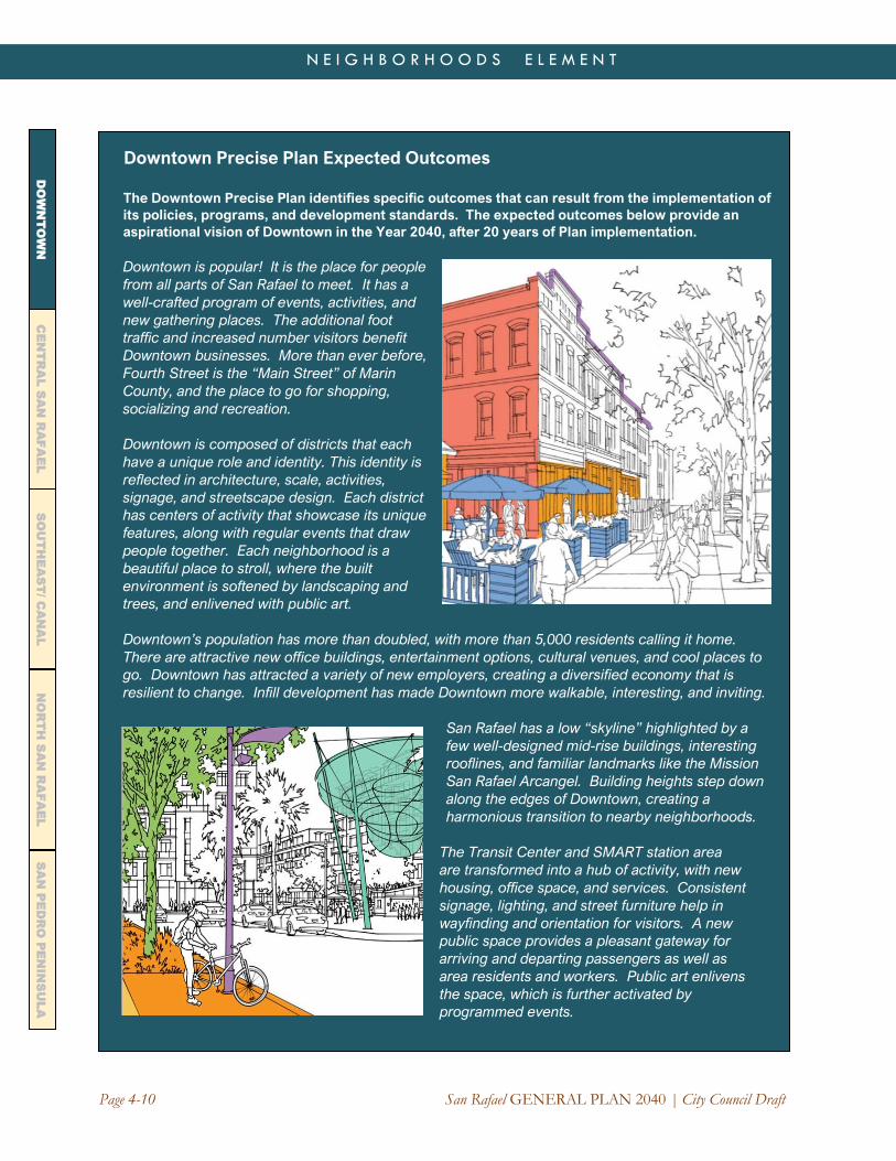
Downtown Precise Plan Expected Outcomes
The Downtown Precise Plan identifies specific outcomes that can result from the implementation of
its policies, programs, and development standards. The expected outcomes below provide an
aspirational vision of Downtown in the Year 2040, after 20 years of Plan implementation.
Downtown is popular! It is the place for people
from all parts of San Rafael to meet. It has a
well-crafted program of events, activities, and
new gathering places. The additional foot
traffic and increased number visitors benefit
Downtown businesses. More than ever before,
Fourth Street is the “Main Street” of Marin
County, and the place to go for shopping,
socializing and recreation.
Downtown is composed of districts that each
have a unique role and identity. This identity is
reflected in architecture, scale, activities,
signage, and streetscape design. Each district
has centers of activity that showcase its unique
features, along with regular events that draw
people together. Each neighborhood is a
beautiful place to stroll, where the built
environment is softened by landscaping and
trees, and enlivened with public art.
Downtown’s population has more than doubled, with more than 5,000 residents calling it home.
There are attractive new office buildings, entertainment options, cultural venues, and cool places to
go. Downtown has attracted a variety of new employers, creating a diversified economy that is
resilient to change. Infill development has made Downtown more walkable, interesting, and inviting.
San Rafael has a low “skyline” highlighted by a
few well-designed mid-rise buildings, interesting
rooflines, and familiar landmarks like the Mission
San Rafael Arcangel. Building heights step down
along the edges of Downtown, creating a
harmonious transition to nearby neighborhoods.
The Transit Center and SMART station area
are transformed into a hub of activity, with new
housing, office space, and services. Consistent
signage, lighting, and street furniture help in
wayfinding and orientation for visitors. A new
public space provides a pleasant gateway for
arriving and departing passengers as well as
area residents and workers. Public art enlivens
the space, which is further activated by
programmed events.

San Rafael GENERAL PLAN 2040 | City Council Draft Page 4-11
N E I G H B O R H O O D S E L E M E N T
DO
WN
TO
WN
C
EN
TR
AL
SA
N R
AF
AE
L
SO
UT
HE
AS
T/ C
AN
AL
NO
RT
H S
AN
RA
FA
EL
SA
N P
ED
RO
PE
NIN
SU
LA
Downtown streets are safe places to walk or
ride a bike. Fourth Street is a place where
bicycles and pedestrians co-exist with slow
moving vehicles—including new self-driving
cars! The street itself is occasionally closed to
vehicles for events, activities, outdoor dining,
and community gatherings. Elsewhere in
Downtown, new bike lanes and paths make it
easier to get around without a car. For those
who drive, new programs encourage a "park
once and walk" approach that uses the existing
parking supply more efficiently.
Downtown has a variety of housing types,
including market rate rental and ownership units, “missing middle” units that are affordable by design,
and units that are specifically reserved for lower income and special needs households. Effective
strategies to avoid displacement are in place, and people of all incomes feel secure that they can
remain in San Rafael.
Historic resources are conserved and adapted to modern uses. New buildings complement older
buildings, with setbacks, height, and massing that respect historic patterns of development. Building
markers, plaques, walking tours, and educational programs have raised awareness of the City’s
history and made Downtown a destination for visitors as well as residents.
Downtown has a variety of gathering places, recreation areas, natural areas, and places to relax and
enjoy the view and sunshine. Court Street Plaza is expanded and reimagined, while other small
open spaces along Fourth Street provide places to sit, dine, or play. Boyd Park and Albert Park are
better connected to Downtown and are more widely enjoyed and appreciated as open spaces.
Green infrastructure has been incorporated into streets and public spaces, reducing stormwater
runoff to creeks and the Bay, and creating a healthier environment. The San Rafael Canal is cleaner
and has become a more visible and well-used amenity, with a paseo along its banks.
Restored creeks and wetlands reduce
localized flooding while providing an open
space amenity and improving wildlife habitat.
New development near San Rafael, Irwin, and
Mahon Creeks includes design features to
reduce flood risks.
The entitlement and development process for
Downtown projects is simple, transparent,
timely, and cost-effective. Public-private
partnerships and development incentives
promote affordable housing and other
community benefits. New incentive programs
have facilitated the assembly of small parcels
into larger sites, making development more
feasible and attracting new investment.

Page 4-12 San Rafael GENERAL PLAN 2040 | City Council Draft
N E I G H B O R H O O D S E L E M E N T
CE
NT
RA
L S
AN
RA
FA
EL
DO
WN
TO
WN
N
OR
TH
SA
N R
AF
AE
L
SO
UT
HE
AS
T/ C
AN
AL
SA
N P
ED
RO
PE
NIN
SU
LA
Policy NH-1.11: Parking Pursue creative solutions to meeting Downtown parking needs without losing the sense of the area as a
pedestrian-oriented district. These solutions should include better management of the existing parking
supply, additional private parking (including spaces available for public use) in high-demand areas such as
the transit center vicinity, more efficiently designed parking structures, and improved signage and visibility
of public parking facilities.
See the Mobility Element for programs to improve parking management and meet parking needs
more efficiently, including programs tailored to Downtown San Rafael
Policy NH-1.12: Hazard Resilience Develop Downtown development and adaptation strategies that improve resilience to sea level rise,
wildfire, and other natural hazards.
Program NH-1.12A: Sea Level Rise Adaptation. Develop a comprehensive set of sea level rise
adaptation strategies for future development that draw from citywide and regional strategies.
These strategies could include tidal gates, levee improvements, wetland restoration, and elevation
requirements for new buildings.
See the Safety and Resilience Element for additional flood protection and wildfire prevention
measures

San Rafael GENERAL PLAN 2040 | City Council Draft Page 4-13
N E I G H B O R H O O D S E L E M E N T
DO
WN
TO
WN
C
EN
TR
AL
SA
N R
AF
AE
L
SO
UT
HE
AS
T/ C
AN
AL
NO
RT
H S
AN
RA
FA
EL
SA
N P
ED
RO
PE
NIN
SU
LA
Downtown Districts
The Downtown Precise Plan organizes Downtown into four districts (see Figure 4-2). The highest densities
and building heights are planned for a “Downtown GatewayTransit Village” district located in the area near
the SMART station and the relocated San Rafael Transit Center. West of this area, the “Downtown Core”
district will be strengthened as a walkable mixed use neighborhood, with pedestrian activity focused on
Fourth Street. West of E Street, building heights and densities step down in scale to the West End Village
district. On the east side of Highway 101, the Montecito Commercial district provides a transition between
Downtown and the residential areas further east, with new housing and commercial development on infill
sites and improved access to the San Rafael Canal.
Table 4-1 indicates the 20-year buildout projections for each of the four Districts and for Downtown as a
whole. As the table indicates, these projections anticipate 2,200 new housing units and roughly 2,020 new
jobs (about 700,000 square feet of commercial space). This includes projects that were approved or under
construction at the time of General Plan adoption, including about 330 housing units, 280,000 square feet
of commercial space, and a 140-room hotel.
The remaining development potential is associated with “opportunity sites” in each area. These sites were
identified based on their size and physical characteristics, the value of improvements relative to land, and
existing uses. The Precise Plan does not mandate that these sites are developed, nor does it limit
development to these sites only. The actual pattern of development that occurs over the next 20 years will
depend on the decisions of many private property owners and market conditions.
The illustrative renderings in the Precise Plan show one possible scenario and were used to develop order
of magnitude estimates of what might be expected in each of the four districts. Table 4-1 effectively
establishes a 20-year “floating cap” that may be used throughout the Downtown Plan area. Exceeding the
total buildout projections shown in Table 4-1 would require a General Plan Amendment and additional
environmental review; however, development potential may be transferred from one sub-district to another
without an Amendment.1
Table 4-1: Downtown Precise Plan Development Caps (for environmental review purposes) (*)
Downtown
Development Type Projected New Development, 2020-2040
Residential 2,200,000 SF 2,200 units
Non-Residential 700,000 SF 2,020 jobs
Development Potential Estimates by District
Downtown District Residential Non-Residential
Downtown Gateway Transit
Village District
830 units 640 jobs
Downtown Core 620 units 1,040 jobs
West End Village 360 units 200 jobs
Montecito Commercial District 390 units 140 jobs
Total 2,200 units 2,020 jobs (*) includes projects approved but not yet completed in 2020-21
1 Transferring development potential from the “Residential” to “Non-Residential” category may also be possible without a General
Plan Amendment, especially at the District level. However, this would require an evaluation to ensure that the transfer is consistent
with the broader goals and policies of the General Plan, which include developing a substantial amount of new Downtown housing.

Page 4-14 San Rafael GENERAL PLAN 2040 | City Council Draft
N E I G H B O R H O O D S E L E M E N T
CE
NT
RA
L S
AN
RA
FA
EL
DO
WN
TO
WN
N
OR
TH
SA
N R
AF
AE
L
SO
UT
HE
AS
T/ C
AN
AL
SA
N P
ED
RO
PE
NIN
SU
LA
Figure 4-2: Downtown Districts
A profile of the four districts is provided below. The Downtown Precise Plan should be consulted for
further information on each district.
TRANSIT VILLAGEDOWNTOWN GATEWAY
The Downtown Gateway Transit Village District serves as the principal entrance gateway to Downtown San
Rafael for motorists and transit users. It includes the US 101 freeway on- and off-ramps, the SMART
station, and the San Rafael Transit Center. The area includes the San Rafael Corporate Center (south of
Second Street), pedestrian-oriented retail uses along Fourth Street and Lincoln Avenue, and a mixed
residential and office district along Fifth Avenue and Mission Avenue.
The Corporate Center is a legacy of the 1993 Downtown Vision, which reimagined this former industrial
area as a successful office district. The area north of Second Street is less cohesive. While It has excellent
access to Downtown amenities, it lacks a strong image, quality outdoor public space, and destinations that
generate active street life. The Precise Plan envisions this area as a more dynamic district with new
housing, offices, and public space, including a “greenway” along Tamalpais AvenueStreet connecting the
Mahon Creek Trail and the bike path over Puerto Suelo Hill.

San Rafael GENERAL PLAN 2040 | City Council Draft Page 4-15
N E I G H B O R H O O D S E L E M E N T
DO
WN
TO
WN
C
EN
TR
AL
SA
N R
AF
AE
L
SO
UT
HE
AS
T/ C
AN
AL
NO
RT
H S
AN
RA
FA
EL
SA
N P
ED
RO
PE
NIN
SU
LA
DOWNTOWN CORE
The Downtown Core is the heart of the Precise Plan Area. It includes the most active section of the Fourth
Street shopping district, as well as iconic local buildings like the Rafael Theater and Mission San Rafael
Arcangel. The Downtown Core is also home to specialty stores, restaurants, art galleries, cultural
institutions, and City (Court Street) Plaza. The area includes a substantial concentration of office space,
and a growing number of multi-family housing units. It is also home to City Hall, the Public Library, the San
Rafael Community Center, and the Public Safety Center.
Much of Fourth Street has retained its historic character. The scale of the built environment makes this an
attractive destination and provides a memorable “downtown experience.” This is particularly true along
Fourth Street and along parts of A and B Streets. Second and Third Streets are less inviting due to their
high traffic volumes, but there are still opportunities to improve pedestrian and bicycle crossings. This is
important to connect Downtown to Albert Park and the Gerstle Park neighborhood, while also providing
better access from those areas to Boyd Park and neighborhoods to the north.
The vision for the Downtown Core includes a substantial amount of new housing as well as new office
space, civic uses, and other commercial activities. As the demand for retail space changes, some of the
existing ground floor spaces may need to be adapted to new uses. The Precise Plan proposes a historic
district in the core area along around Fourth and BA Streets, providing potential incentives for adaptive
reuse while ensuring that new infill development will respect historic context.
WEST END VILLAGE
The West End Village District includes the portion of Downtown west of E Street. It is the western entrance
to Downtown, with signage and landscaping that welcomes vehicles, pedestrians, and bicyclists. It has an
eclectic feel, with a mix of traditional “small town” and mid-20th Century “suburban” building forms along
Fourth Street, as well as residential development from different eras in San Rafael’s history. The area
provides a transition between the Downtown Core and the low-density neighborhoods on Downtown’s
perimeter. It is a unique, friendly, desirable place to live and shop, with one-of-a-kind businesses that meet
the needs of surrounding neighborhoods.
Editor’s note: Resize photo after
tracked changes are accepted

Page 4-16 San Rafael GENERAL PLAN 2040 | City Council Draft
N E I G H B O R H O O D S E L E M E N T
CE
NT
RA
L S
AN
RA
FA
EL
DO
WN
TO
WN
N
OR
TH
SA
N R
AF
AE
L
SO
UT
HE
AS
T/ C
AN
AL
SA
N P
ED
RO
PE
NIN
SU
LA
The quality of the streetscape in the West End Village varies. Some blocks provide pleasant settings for
walking and interesting storefronts, while other blocks face large surface parking lots, with buildings
oriented away from the street. The larger sites provide opportunities for new housing, office, retail, and
mixed use projects. Where such developments occur, it will be important to preserve the scale and
character of adjacent residential districts, especially for projects adjacent to Latham Street and Fifth
Avenue.
MONTECITO COMMERCIAL DISTRICT The Montecito Commercial District is located on the east end of Downtown, between Irwin Street and the
Montecito/Happy Valley neighborhood. San Rafael High School abuts the eastern edge of this area and the
San Rafael Canal forms the southern edge. This is primarily a retail/service district. There are three
supermarkets, several shopping centers, and a number of office buildings within its boundaries. The
southern edge of the area is almost entirely commercial, while the northern area has a finer-grained
character with mixed residential and commercial uses.
The Downtown Precise Plan anticipates infill development on a number of underutilized commercial
parcels, especially along the Second and Third Street corridors. Some of these parcels contain one-story
commercial buildings surrounded by large parking lots. The Downtown Precise Plan and Form Based
Code support their redevelopment over time with multi-story buildings that include ground floor
commercial uses, upper story housing, and structured parking. Better connections for pedestrians and
bicycles will be an important part of this vision, especially along Second and Third Streets and Grand
Avenue. More active ground floor uses along this segment of Fourth Street are also envisioned.
The Montecito Commercial District is also where Downtown San Rafael meets the waterfront. Access to
the San Rafael Canal is currently limited to a service drive behind the Montecito Shopping Center. The
Center itself faces a large surface parking lot along Third Street and turns its back to the water. The
Precise Plan recognizes the opportunity to someday redevelop this site with a water-oriented project with
housing, shopping, and a waterfront paseo. Buildout of the site is not included in the Downtown growth
forecasts but could be considered as part of future planning process.

Page 4-17 San Rafael GENERAL PLAN 2040 | City Council Draft
N E I G H B O R H O O D S E L E M E N T
DO
WN
TO
WN
C
EN
TR
AL
SA
N R
AF
AE
L
SO
UT
HE
AS
T/ C
AN
AL
SA
N P
ED
RO
PE
NIN
SU
LA
N
OR
TH
SA
N R
AF
AE
L
CENTRAL SAN RAFAEL
The neighborhoods of Central San Rafael form a crescent around Downtown, extending up the slopes of
hills and valleys in the San Rafael Creek watershed. These neighborhoods include some of the City’s
oldest residential areas, beloved parks and community facilities, and historic institutions such as Dominican
University. A few Central San Rafael neighborhoods feature distinct architectural styles and lot patterns,
but most are eclectic, giving this part of the City a “hometown” feel that is cherished by residents. The
area’s character is further enhanced by its picturesque natural setting, including a mature urban forest and
views of Mount Tamalpais, San Francisco Bay, and Downtown San Rafael.
Ten individual neighborhoods are profiled below. Some represent a mosaic of smaller neighborhoods and
subdivisions that share common natural features, issues, and goals. Over the years, Central San Rafael
neighborhoods have formed associations and organizations that advocate on the community’s behalf.
Many neighborhoods have organized programs related to emergency preparedness, neighborhood
beautification, and traffic safety. These associations also work closely with the City on planning and
development issues, both individually and collectively through the Federation of San Rafael
Neighborhoods.
Central San Rafael neighborhoods are identified in Figure 4-1. Collectively these neighborhoods cover
roughly 4.5 square miles, or about 25 percent of the City’s land area. They are home to 20,000 residents,
or about one-third of the City’s population. The neighborhoods are mostly comprised of single family
homes but include a variety of housing types, ranging from rural estates to high-density apartments and
condominiums. The area relies on Downtown (including the Montecito Commercial area) and Southeast
San Rafael for most of its commercial services. However, it includes shopping and business districts along
the Miracle Mile and Lincoln Avenue, as well as long-established neighborhood businesses.
For the purposes of this Element, neighborhood policies are presented clockwise in the following
sequence:
• West End
• Sun Valley
• Fair Hills
• Lincoln/San Rafael Hill
• Dominican/Black Canyon
• Montecito/Happy Valley
• Bret Harte
• Picnic Valley
• Gerstle Park
The final section addresses unincorporated Central San Rafael, including California Park.

Page 4-18 San Rafael GENERAL PLAN 2040 | City Council Draft
N E I G H B O R H O O D S E L E M E N T
CE
NT
RA
L S
AN
RA
FA
EL
DO
WN
TO
WN
N
OR
TH
SA
N R
AF
AE
L
SO
UT
HE
AS
T/ C
AN
AL
SA
N P
ED
RO
PE
NIN
SU
LA
WEST END The West End neighborhood is located between Downtown San Rafael and San Anselmo. It includes
Fourth Street’s “Miracle Mile” and extends up the hills on both sides of Fourth to the ridgetops. The
neighborhood consists primarily of single family homes, including historic Victorians as well as along with
several duplexes and apartment buildings. Small businesses are located along West End Avenue and the
Miracle Mile (Fourth Street). West-enders take pride in being a friendly neighborhood, with social events
that encourage neighborhood unity. The neighborhood includes many smaller subareas created by
historic development patterns and topography, such as the tree-lined streets, including walkable Greenfield
Avenue and Santa Margarita Drive, with its unique the Spanish Mediterranean homes. Redwood trees
cover the north-facing slopes where summer homes for San Franciscans were originally built. The West
End Neighborhood Association organizes many social events during the year, including the popular annual
picnic. on Santa Margarita Drive, and hillside homes shaded by redwoods.
West End residents enjoy their proximity to Downtown, its walkable streets, and the neighborhood’s
comfortable small-town feel. The neighborhood has its own identity, distinct from Downtown San Rafael
and the West End Village area, a separate neighborhood located to the east. Residents seek to maintain
the established scale of the West End, with smaller buildings and local-serving stores along Fourth Street.,
generous front yards along residential streets, and tree planting that enhances neighborhood character.
The community would like increased has also expressed a desire for pedestrian and bicycle safety
improvements along Second Street and at the busy crossing of Second, Third, Fourth, West End, and
Marquard. such as wider sidewalks, closing gaps in the sidewalk network, more clearly marked
crosswalks, and pPedestrian pathways, stairways and trails easements that make the neighborhood more
walkable. Other priorities include Landscaping improvements and maintenance of medians along the
Second Street, Miracle Mile and West End Avenue, as well as attractive setback landscaping along all
streets, increase the beauty and value of the neighborhood. additional tree planting, and tree protection
when new development takes place. Tree planting and preservation should be included in new
development to maintain and enhance this character.
Development potential in the West End is limited, but there are a number of opportunity sites along Fourth
Street and West End Avenue where older non-residential uses could be replaced over time. There are
also a few undeveloped hillside properties on the neighborhood’s southern slopesRemaining undeveloped
hillside properties are constrained by limited access, narrow winding roads, and steep slopes. The scale of
future projects along Fourth Street is constrained by heavy and fast-moving traffic and limited ingress and
egress to Fourth Street. Where commercial or mixed development does occur, neighborhood-serving
uses (rather than regional or “drive-thru” type uses) are encouraged. would be most appropriate on the
ground level. Design should avoid “strip mall” style buildings and instead feature pedestrian-friendly
features that are compatible with the scale and character of nearby homes. With traffic circulation
improvements, Aa limited amount of housing in mixed use projects may be consideredalso would be
desirable here.
Policy NH-2.1: Miracle Mile Land Uses Retain the Miracle Mile as a vital neighborhood commercial district. Improve the area’s appearance,
parking, landscaping, and vehicular access from side streets. New development or redevelopment should
be of a scale and intensity consistent with existing development.
Program NH-2.1A: Neighborhood Plan. In the event that significant changes to currently
allowable land uses or densities are proposed in the future, develop a neighborhood/corridor plan
for the Miracle Mile.

San Rafael GENERAL PLAN 2040 | City Council Draft Page 4-19
N E I G H B O R H O O D S E L E M E N T
DO
WN
TO
WN
C
EN
TR
AL
SA
N R
AF
AE
L
SO
UT
HE
AS
T/ C
AN
AL
SA
N P
ED
RO
PE
NIN
SU
LA
N
OR
TH
SA
N R
AF
AE
L
Policy NH-2.2: Miracle Mile West End
Circulation Improve circulation, provisions for cross-traffic and “U-turn”
movements, bicycle and pedestrian safety, and traffic
controls along Second Street and the Miracle MileFourth
Street, especially at intersections with side-streets.
Program NH-2.2A: West End Circulation
ImprovementsRoss Valley Intersection.
Consider Pursue the following circulation
improvements in the West End Neighborhood:
a) Rreconfigureing the traffic signal at Ross Valley
Drive and Fourth Street to incorporate Santa
Margarita Drive, thereby improving safety;
b) Implement pedestrian/bicycle safety
improvements across and along Second/Fourth
Streets, including the crosswalks at the
Marquard/West End intersection and the East
Street intersection, and wider, safer sidewalks
along both sides of Second Street between
Marquard and Shaver Streets.
a)c) .Complete the Grove Hill Estates pedestrian
path along the easement created in 1983 to
connect Tamal Vista Drive to the Sun Valley
neighborhood.
Policy NH-2.3: Noise Abatement Consider the benefits and practicality of noise abatement
techniques when designing or implementing capital
improvements or approving new development along the
Miracle Mile and adjacent Second/Third Street corridors.
Program NH-2.3A: Noise Improvements. Use the
capital improvement program and development
review process to consider noise abatement
techniques for the Miracle Mile and adjacent
thoroughfares, including the use of attractive
fencing, trees and landscaping, and sound-
absorbing pavement.
Policy NH-2.4: Development of Remaining
Vacant Residential Lots Ensure adequate provisions for emergency vehicle access
and water supply prior to constructing additional homes on
vacant lots in the West End, especially on narrow and
substandard streets and in hillside areas.
See also Policy CDP-1.3 on hillside development
West End Speaks
The West End Neighborhood Association
(WENA) invited recommendations from
local residents, the WENA board, and
other San Rafael neighborhood
associations. These recommendations
included:
1. Family oriented stores on the Miracle
Mile and West End Village.
2. Level and unobstructed sidewalks
throughout the West End.
3. Limit building on steep hillsides to
mitigate erosion, landslide
prevention, and native tree removal.
4. Unobstructed pedestrian access to
fire roads and trails for residents to
freely enjoy.
5. Completion of the Grove Hill Estates
path connecting 5th Avenue and
Tamal Vista Drive, as designated on
City maps.
6. Monitoring and discouraging
homeless encampments particularly
on Forbes Hill reservoir.
7. Improved bicycle access along
Greenfield Avenue as the East-West
bicycle corridor.
8. Underground power lines and fiber
optic internet.
9. A rebuilt, non-sound reflective wall
on the south side of the Miracle Mile.
10. Maintain a proactive neighborhood
association.

Page 4-20 San Rafael GENERAL PLAN 2040 | City Council Draft
N E I G H B O R H O O D S E L E M E N T
CE
NT
RA
L S
AN
RA
FA
EL
DO
WN
TO
WN
N
OR
TH
SA
N R
AF
AE
L
SO
UT
HE
AS
T/ C
AN
AL
SA
N P
ED
RO
PE
NIN
SU
LA
SUN VALLEY
Sun Valley extends along the floor and slopes of a box valley extending to the northwest of Downtown San
Rafael. It is a beautiful neighborhood with a proud past and a shared vision for its future. The oldest area
of the neighborhood—the Forbes Addition-- was subdivided between 1882 and 1916. The Sun Valley
subdivision was built after World War II. Rafael Highlands and Racquet Club were built in the 1960s and
70s, while Grove Hill and Shannon Lane were built in the 1980s. More recent development has consisted
of small infill development and individual homes.
The neighborhood primarily consists of residential and open space uses. There are a few non-residential
uses along Fifth Avenue, including the historic copper-domed Victrola Pavilion (San Rafael Improvement
Club), West End Nursery, Andy’s Market, Sun Valley School, and Mt. Tamalpais Cemetery. Sun Valley is
also home to Rotary Manor, an affordable senior housing complex. There are a number of small
apartments, triplexes, and duplexes, but most of the community’s homes are single family residences.
A major topographic feature of the neighborhood is Sun Valley Slope, which serves not only as a wildlife
corridor but also as the neighborhood’s largest open space. It provides a hiking connection to Terra Linda,
San Anselmo, and the Terra Linda/Sleepy Hollow Open Space Preserve. The Slope was purchased in
1985 through the combined of efforts of local residents, the City of San Rafael, the County Open Space
District, and the Marin Trust for Public Land. Mahon Creek also has its headwaters in Sun Valley,
meandering through open space and backyards along its upper reaches before entering an underground
culvert.
A Neighborhood Plan was for Sun Valley was adopted in 1980, in part to establish development standards
for 170 acres of undeveloped land. In 2020, the only significant undeveloped parcels remaining are the
Camgros and Duca properties, comprising about 5.5 acres. These parcels are the last vestiges of the
area’s agricultural past and remain in unincorporated Marin County.
As part of General Plan 2040, Sun Valley residents outlined a vision for their neighborhood that included
goals for 2040 (see text box). Sun Valley seeks to retain its character as a residential neighborhood with
diverse housing choices, beautiful open spaces, and a strong appreciation for its history. The
neighborhood has also expressed a commitment to reducing its carbon footprint, promoting renewable
energy, encouraging native landscaping, and encouraging more sustainable transportation modes. Sun
Valley strives to retain existing gathering places and neighborhood businesses, while creating a new
community center for education, emergency preparedness, culture, and environmental understanding.
Policy NH-2.5: Sun Valley Neighborhood Maintain the scale, diversity, and small-town character of Sun Valley, including its affordable housing stock
and scenic open spaces. Housing shall continue to be the dominant land use in the neighborhood.
Program NH-2.5A: Neighborhood-Serving Commercial Uses. Encourage retention of existing
neighborhood commercial uses. Allow new commercial uses only if they benefit the neighborhood,
will not impair its residential character or impact health and safety, and have been vetted through a
community process.
Policy NH-2.6: Neighborhood Sustainability Adapt existing buildings, energy, and transportation systems to reduce the neighborhood’s carbon
footprint, improve energy self-sufficiency, phase out gas-powered utilities and vehicles, reduce overhead
wires and service lines, increase awareness of natural systems, and improve environmental health.

San Rafael GENERAL PLAN 2040 | City Council Draft Page 4-21
N E I G H B O R H O O D S E L E M E N T
DO
WN
TO
WN
C
EN
TR
AL
SA
N R
AF
AE
L
SO
UT
HE
AS
T/ C
AN
AL
SA
N P
ED
RO
PE
NIN
SU
LA
N
OR
TH
SA
N R
AF
AE
L
Policy NH-2.7: Natural Features Conserve Sun Valley’s natural
environment, including clean-up and
maintenance of Mahon Creek.
Policy NH-2.8: Sun Valley
Development Ensure that new development and
significant remodels retain neighborhood
character, especially in areas of smaller
or historic homes. Development should
support the City’s sustainability and
wildfire prevention goals.
Program NH-2.8A: Camgros/Duca
Properties. Ensure that any future use
on these properties supports and
sustains neighborhood character. The
neighborhood has expressed that it
supports acquisition of these sites for a
neighborhood/community cultural center,
or dedication of land for such a site in
future development. Such a center could
also provide for outdoor education,
emergency response and training,
community functions, and delivery of
local services. The potential for housing
on this site also must be recognized. In
the event residential development is
pursued, clustering of the allowable units
should be encouraged to preserve open
space areas. Development should
comply with the City’s Hillside Guidelines
and should establish a wildlife corridor
and protected riparian area along a
restored Mahon Creek.
Sun Valley Speaks
As part of General Plan 2040, a group of about 20 Sun
Valley residents gathered to share their vision for the
neighborhood’s future. Working in collaboration with the
Sun Valley Neighborhood Association, they presented the
following goals for 2040 to the City, with the overarching
goal of adapting to the global climate crisis:
• Develop a local, self-sustaining source of electrical
energy
• Underground electrical lines and fiber optic internet
• Develop environmental health and safety policies
regarding any new technology that seeks to use
neighborhood airwaves
• Build new/renewed multi-use sidewalks
• Develop new designs for traffic flow, for daily life and
emergencies
• Develop policies for new and renovated homes and
businesses
• Develop collaboration among neighborhood, city,
school, and business
• Develop a robust neighborhood center
• Involve a significant majority of stakeholders when
alternative land uses are proposed
• Maintain an active neighborhood association
Sun Valley residents developed more prescriptive goals
and policies for housing, environment, development,
circulation, economy, culture, design, and emergency
preparedness. Some of these goals are captured in the
policies in this Element and others are reflected in
citywide policies elsewhere in the General Plan.

Page 4-22 San Rafael GENERAL PLAN 2040 | City Council Draft
N E I G H B O R H O O D S E L E M E N T
CE
NT
RA
L S
AN
RA
FA
EL
DO
WN
TO
WN
N
OR
TH
SA
N R
AF
AE
L
SO
UT
HE
AS
T/ C
AN
AL
SA
N P
ED
RO
PE
NIN
SU
LA
Policy NH-2.9: Sun Valley Circulation Improve circulation for all modes of travel in Sun Valley, with an emphasis on improvements for
pedestrians, bicyclists, and transit users. This should include provisions for safer sidewalks and footpaths,
new bike routes, public transit, and traffic flow improvements along Fifth Avenue.
Program NH-2.9A: Neighborhood Circulation Concepts. Pursue the following circulation
improvements in the Sun Valley Neighborhood:
a) Potential roundabouts at Fifth/California and Fifth at Happy Lane or River Oaks (would require
additional right-of-way).
b) Removal of hazardous crosswalk at Fifth Avenue and I Street.
c) Completion of sidewalks along both sides of Fifth Avenue, and removal of sidewalk hazards.
d) Designation of alternate evacuation routes in the event Fifth Avenue is blocked.
e) Potential bike route along Center Avenue.
f) A new sidewalk on California Street from Fifth to Windsor.
g) New trails through neighborhood open spaces and connecting to the West End neighborhood.
h) Consideration of shuttle or jitney service from Downtown along Fifth Avenue.
i) Alternatives to meeting neighborhood parking needs.
Policy NH-2.10: Sun Valley Gathering Places Sustain existing neighborhood gathering places in Sun Valley. Pursue opportunities to create new places
where Sun Valley residents can meet, learn, play, and build a stronger sense of community.
Program NH-2.10A: Community Center. Consider the feasibility of a community cultural and
environmental center in the Sun Valley area. In addition, strengthen the function of Sun Valley
School and Sun Valley Park as neighborhood gathering places. This includes continued
agreements with the School for access to the school yard after hours as well as access to the Dan
Abraham Trail. These agreements could be expanded to allow for community meetings,
emergency response, and other activities on school property.
FAIRHILLS The Fairhills neighborhood is located northwest of Downtown San Rafael. The neighborhood combines
easy access to Downtown with a picturesque natural setting and some of San Rafael’s most distinctive
homes. The southern part of the neighborhood includes gracious Victorians and craftsman bungalows
over a century old. The northern part of the neighborhood includes larger lots, winding streets, and newer
hillside homes, many with panoramic views. No two homes are the same and there is much architectural
diversity. The Fairhills Neighborhood Association represents about 180 homes in this area.
Most of Fairhills is single family residential, with the exception of lower Forbes Avenue, which includes a
few duplex and triplex buildings. Other features of the neighborhood include the former Red Rock Quarry,
a visually significant topographic feature that has been developed with single family homes. For planning
purposes, the neighborhood boundaries include Marin Academy, the Falkirk Cultural Center, and the Elks
Lodge, all on the north side of Mission Avenue.
Fairhills abuts Boyd Park and Mountain Park, two large public open spaces. Wildfires have originated in
this area in recent years, creating an ongoing concern for residents. The community is actively involved in
fire prevention and seeks continued vegetation management and restrictions on open fire sources.
Fairhills residents also support continued investment in the community’s older homes. Some of the original
homes from the 1940s and 50s are dated, and owners are likely to modernize or replace them in the

San Rafael GENERAL PLAN 2040 | City Council Draft Page 4-23
N E I G H B O R H O O D S E L E M E N T
DO
WN
TO
WN
C
EN
TR
AL
SA
N R
AF
AE
L
SO
UT
HE
AS
T/ C
AN
AL
SA
N P
ED
RO
PE
NIN
SU
LA
N
OR
TH
SA
N R
AF
AE
L
coming decades. Residents generally support construction that is compatible with the neighborhood,
conforms to Hillside Residential Design Guidelines, and addresses parking and other issues.
Policy NH-2.11: Fairhills Neighborhood Retain the character of Fairhills as a scenic hillside neighborhood. Development and remodeling should
respect and enhance the character of the neighborhood and maintain those homes with historic value.
Continued efforts should be made to reduce fire hazards and ensure adequate emergency access.
Program NH-2.11A: Hillside Construction. Ensure that hillside areas are protected by continuing
to apply the Hillside Residential Design Guidelines for new construction and major remodels. The
siting, height, and design of new or expanded structures should be carefully evaluated to ensure
adequate emergency vehicle access, slope and foundation stability, adequate surface and sub-
surface drainage, and erosion control. Buildings that are out of scale, damage the natural
landscape, cause excessive tree loss or habitat destruction, or obstruct scenic vistas from public
vantage points, should be discouraged.
LINCOLN/SAN RAFAEL HILL Lincoln/San Rafael Hill extends north from Downtown San Rafael along the west side of Highway 101.
Lincoln Avenue forms the spine of neighborhood, running parallel to the freeway between Downtown and
the other side of Puerto Suelo Hill where it becomes Los Ranchitos Road. This is one of the oldest
neighborhoods in San Rafael, although development has occurred gradually and organically. Lincoln
Avenue itself is eclectic, with single family homes, apartments, offices, motels, social services, churches,
and other small businesses and commercial services. Some of the offices are in converted single family
homes; others are in more traditional office buildings.
Away from Lincoln Avenue, the neighborhood primarily consists of single-family homes, including a mix of
older cottages, mid-century homes, and more contemporary construction. The narrow, winding streets
and hilly terrain afford panoramic views and create a strong sense of neighborhood character. Closer to
Downtown, there are charming smaller apartment buildings along Laurel Place and nearby side streets.
Boyd Park and Mountain Park form the western edge of the neighborhood. The threat of wildfire has been
an ongoing concern.
In addition to fire safety, planning issues in the neighborhood include traffic congestion and pavement
maintenance along Lincoln, traffic speed and safety, parking on hillside streets and limited parking along
Lincoln Avenue. There are a number of development opportunities along Lincoln Avenue, particularly on
older commercial sites where existing uses may no longer be economically viable. If these sites are
redeveloped, the neighborhood seeks to retain the existing three-story height profile and avoid the
“canyon” effect of having taller buildings on both sides of the street. Residents also seek a small
neighborhood park, as there are no improved park areas in the vicinity.
Elsewhere in the neighborhood, there are vacant lots on some of the hillside streets west of Lincoln (Fair
Drive, Chula Vista Drive, etc.). These areas should develop in a way that protects natural resources,
reduces hazards, and respects the scale and character of nearby homes.

Page 4-24 San Rafael GENERAL PLAN 2040 | City Council Draft
N E I G H B O R H O O D S E L E M E N T
CE
NT
RA
L S
AN
RA
FA
EL
DO
WN
TO
WN
N
OR
TH
SA
N R
AF
AE
L
SO
UT
HE
AS
T/ C
AN
AL
SA
N P
ED
RO
PE
NIN
SU
LA
Policy NH-2.12: Lincoln/San Rafael Hill Maintain low-density development in the hillside areas above Lincoln Avenue, consistent with existing
densities and with access, fire hazard, and environmental constraints. Ensure that residents of the areas
above Lincoln Avenue are engaged in plans for development along Lincoln itself.
Policy NH-2.13: Lincoln Avenue Corridor Allow higher density residential development along Lincoln Avenue between Hammondale Court and
Mission Avenue, recognizing the availability of public transit along this corridor and the established pattern
of development. Where development occurs, landscaped setbacks and tree planting should be required to
visually reduce the “wall effect” along Lincoln Avenue. Underground parking should be encouraged to
reduce overall building height and mass. Consolidation of smaller lots into larger parcels should be
encouraged, in order to create more viable development sites, meet parking needs, and minimize the
number of ingress/egress points to Lincoln Avenue.
Program NH-2.13A: Lincoln Avenue Development Standards. Maintain development standards
that preserve the character of Lincoln Avenue, including:
a) 36-foot (three story) height limit2
b) 15’ front yard setbacks
c) Continued allowances for multi-family residential and office uses. This includes a continued
prohibition on the conversion of existing residential space to office use unless replacement
residential units are provided.
d) Prohibition of most new retail uses (while allowing existing uses to continue)
e) Requirements to mitigate noise impacts from SMART, the freeway, and Lincoln Avenue traffic,
where appropriate.
2 Subject to density bonuses for affordable housing

San Rafael GENERAL PLAN 2040 | City Council Draft Page 4-25
N E I G H B O R H O O D S E L E M E N T
DO
WN
TO
WN
C
EN
TR
AL
SA
N R
AF
AE
L
SO
UT
HE
AS
T/ C
AN
AL
SA
N P
ED
RO
PE
NIN
SU
LA
N
OR
TH
SA
N R
AF
AE
L
Program NH-2.13B: Lincoln/San Rafael Hill Park. Pursue opportunities to develop a small
neighborhood park in the northern part of the Lincoln/San Rafael neighborhood.
DOMINICAN/BLACK CANYON Located in the geographic center of San Rafael, Dominican/Black Canyon is a pleasant residential
neighborhood with a wealth of history and outdoor beauty. The centerpiece of the neighborhood is
Dominican University, an historic California institution. Single family homes, a number of which were built
in the late 19th and early 20th Century, surround the campus. The neighborhood has a parklike character,
created by large and abundant trees, landscaped yards, and attractive architecture. The Dominican area
also includes duplexes, a few condominiums, Coleman Elementary School, the Marin Tennis Club, and
Marin Ballet. Black Canyon lies just north of the University, with Mountain View Avenue extending up the
valley floor.
The neighborhood is bordered by Highway 101 on the west, and large hillside open space areas on the
north and east, including Barbier Memorial Park/Gold Hill. Hillside trails provide spectacular views of San
Rafael and the surrounding area. Creeks originating in the open spaces flow through the residential areas
and the Dominican campus, with riparian areas providing natural habitat.
The Convent of Dominican Sisters has been a presence in the community since 1889. In 1915, the Sisters
opened a junior college, which soon became the four-year institution known as Dominican College. The
college expanded through the 1920s, adding academic buildings and residence halls, and purchasing
Forest Meadows for athletics. Another wave of expansion occurred in the 1950s and early 1960s with new
properties acquired and new buildings added. In 2000, Dominican College became Dominican University
of California. Today, Dominican has more than 1,700 students on its 80-acre campus.

Page 4-26 San Rafael GENERAL PLAN 2040 | City Council Draft
N E I G H B O R H O O D S E L E M E N T
CE
NT
RA
L S
AN
RA
FA
EL
DO
WN
TO
WN
N
OR
TH
SA
N R
AF
AE
L
SO
UT
HE
AS
T/ C
AN
AL
SA
N P
ED
RO
PE
NIN
SU
LA
In 1998, the City approved a Master Use Permit and Campus Plan for Dominican’s development, including
a four-phase expansion. Projects completed under this Permit included the 29,000 square foot (SF)
recreational facility and pool at Forest Meadows, a 35,000 SF science building, a 9,000 SF chapel, a 40,000
SF residence hall, and a soccer field and amphitheater expansion. Parking and landscaping improvements
were included with each phase. The Master Use Permit was amended in 2008-2010 to allow conversion of
Magnolia House to academic use, renovations to the Edgehill Mansion, historic landmarking of both
buildings, and addition of an 18.7-acre forested hillside to the Campus Plan area. Improvements called for
by the Master Use Permit have largely been completed. Further improvements on the University’s
properties are possible and should be closely coordinated with the neighborhood.
Beyond the University properties, development potential in Dominican/Black Canyon is limited. New
residential development may occur on the remaining vacant lots, and through limited subdivision of several
large private properties. There may also be opportunities for further open space acquisition. Longstanding
priorities for residents include developing a neighborhood park and playground, reducing the impacts of
freeway noise, and minimizing the impact of the university on surrounding residential areas. The
neighborhood is also concerned about reducing wildfire and landslide hazards and is working to improve
emergency preparedness and response.
Policy NH-2.14: Dominican University Sustain Dominican University as a valued community institution and contributor to San Rafael’s economy
and culture. University operations and events should be compatible with surrounding residential areas,
and the impacts of facilities, activities, and events on the neighborhood should be minimized. Continue to
foster a cooperative relationship between the University’s students, faculty, visitors, and residents.
Program NH-2.14A: University-Neighborhood Coordination. Maintain on-going coordination
between Dominican University, the Dominican-Black Canyon Neighborhood Association, the City
of San Rafael, and campus neighbors to address concerns such as traffic, parking, noise, and
vegetation management in the University area. In the event future development or campus
expansion is proposed, amendments to the Master Use Permit shall be required. Creation of
neighborhood advisory committees to advise and collaborate on proposed development projects
and address issues of concern is strongly encouraged.
Program NH-2.14B: Dominican Hillside Parcels. Work with Dominican University and
neighborhood residents to plan for the undeveloped hillside parcels located east of Deer Park
Avenue and south of Gold Hill Grade. Much of the property is steep and heavily wooded. Other
portions have the potential for housing, including student housing and faculty/staff housing, which
is a significant local and community need. In the event housing is pursued, the permitted density
should reflect site constraints. Development should conform to the City’s Hillside Residential
Design Guidelines and include provisions for substantial open space. The neighborhood should be
involved in the planning and review process, which would include an amendment to the Master
Use Permit and the PD-district zoning.
Policy NH-2.15: Dominican/Black Canyon Area Resources and Hazards Proactively work to conserve and restore natural resources and reduce environmental hazards in the
Dominican/Black Canyon area, including wildfire, landslide, and noise hazards.
Program NH-2.15A: Emergency Preparedness. Continue collaborative efforts to improve
emergency preparedness, including vegetation management on public open space and private
property, evacuation and emergency response, and community awareness and training.

San Rafael GENERAL PLAN 2040 | City Council Draft Page 4-27
N E I G H B O R H O O D S E L E M E N T
DO
WN
TO
WN
C
EN
TR
AL
SA
N R
AF
AE
L
SO
UT
HE
AS
T/ C
AN
AL
SA
N P
ED
RO
PE
NIN
SU
LA
N
OR
TH
SA
N R
AF
AE
L
Program NH-2.15B: Noise Reduction. Continue to work with Caltrans to reduce freeway noise in
the Dominican/Black Canyon area. This should include maintenance of landscaping along the
freeway sound wall, noise-reducing pavement, and other sound absorption technologies.
Program NH-2.15C: Open Space Dedication. Consider offers to dedicate vacant sites, including
the 17.9-acre parcel at the end of Dominican Drive (also with frontage on Glen Park Avenue), as
public open space. If City ownership is infeasible, consider dedication to Marin County Parks.
MONTECITO/HAPPY VALLEY
Montecito/Happy Valley is nestled in two valleys located north of the San Rafael Canal and northeast of
Downtown. It is one of San Rafael’s oldest and well-established neighborhoods and features a beautiful
natural setting, mature street trees, a convenient location, and a diverse mix of housing types and uses.
Housing ranges from elegant historic homes and smaller bungalows to multi-family complexes,
condominiums, and a retirement community. Residents enjoy easy access to Downtown, shopping centers
and services, Highway 101, and public transportation.
A neighborhood plan for Montecito/Happy Valley was adopted in 1996. The plan reduced development
potential in the neighborhood, primarily by reducing the extent of multi-family zoning in areas developed
with single family homes. The vision expressed in the neighborhood plan is to maintain Montecito/Happy
Valley as a beautiful, desirable place with diverse architecture, pleasant, shaded streets, community
gathering places, and a variety of uses within walking distance. This continues to be the vision today. Area
residents will continue to work together to keep the neighborhood secure, clean, safe, and attractive, and
to celebrate Montecito’s success as a strong and diverse community.
While the residential portion of Montecito/Happy Valley is mostly built out, the adjacent commercial district
functions as the east end of Downtown San Rafael and will evolve as a mixed-use neighborhood in the
coming decades. New development in this area has the potential to make Downtown’s east end more
attractive and walkable. However, the area is heavily congested, has limited street parking, and provides
essential services such as grocery stores to much of Central San Rafael and the San Pedro Peninsula. As
development occurs, it will be essential to address traffic impacts, keep the streets safe for pedestrians and
bicyclists, maintain important neighborhood-serving uses, and ensure that the scale of new projects is
compatible with the residential heart of the neighborhood.
San Rafael High School has been a continuous presence in Montecito/Happy Valley since 1924. In
addition to classroom buildings, the 32-acre campus includes Madrone Continuation High School, several
athletic fields, a recently refurbished track and football field, a pool and gymnasium complex, parking, and
the School District corporation yard on Union Street. A long-standing planning concept has been to
relocate the corporation yard and repurpose the land for affordable housing and/or a neighborhood park.
Montecito currently lacks a park, despite having a large number of apartment dwellers with limited options
for outdoor play and relaxation. This concept remains valid and should be pursued with the School
District.
Policy NH-2.16: Montecito Residential Densities Preserve the existing mix of single family, duplex, medium-, and high-density housing in Montecito/Happy
Valley’s residential areas.
Policy NH-2.17: High School Campus Plans Facilitate communication between San Rafael City Schools and the neighborhood on issues related to
traffic, parking, noise, operations, and development on the high school campus.

Page 4-28 San Rafael GENERAL PLAN 2040 | City Council Draft
N E I G H B O R H O O D S E L E M E N T
CE
NT
RA
L S
AN
RA
FA
EL
DO
WN
TO
WN
N
OR
TH
SA
N R
AF
AE
L
SO
UT
HE
AS
T/ C
AN
AL
SA
N P
ED
RO
PE
NIN
SU
LA
Program NH-2.17A: Corporation Yard Reuse. Encourage relocation of the bus/maintenance
yard located on the northwest corner of the high school campus (Union and Mission), thereby
allowing for development of:
a) Affordable multi-family housing. To the extent feasible, housing on the site should serve older
adults and/or School District staff. Any development on this site should maintain, enhance,
and protect the view corridor down Fourth Street to the High School’s west portico.
b) Montecito Neighborhood Park. A small neighborhood park and children’s playground should
be included in any plans to repurpose school property. In the event a park is infeasible on the
Union and Mission site, consider other locations on the campus where such a facility is
possible, including a joint use park on the field east of the corporation yard.
If any part of the high school campus is closed or sold before the horizon of the General Plan, a
priority should be placed on developing affordable housing or neighborhood parkland.
Program NH-2.17B: Joint Use. Work with San Rafael City Schools to accommodate greater
public access to open space and athletic fields at the High School during hours when school is not
in session.
Program NH-2.17C: School-Related Traffic. Work with San Rafael City Schools to improve the
safety and effectiveness of drop-off areas at San Rafael High School. Encourage continued
communication and cooperation to address access and scheduling improvements.
Policy NH-2.18: Architecture Maintain a mix of architecture styles in the Montecito/Happy Valley Neighborhood, compatible with the
character of the area’s attractive older buildings. Newer buildings should be well designed, blend well with
existing homes and provide a pedestrian-friendly street front.
See also Program CDP-5.2B (Community Design and Preservation Element) identifying Montecito/
Happy Valley as one of several priority areas for a historic resource inventory update.
Policy NH-2.19: Traffic Circulation Continue to develop solutions to
neighborhood traffic congestion and safety.
Local residential streets should be
designed for low volumes with appropriate
traffic control. Continued efforts should be
made to improve circulation on streets in
the adjacent commercial area and to
improve pedestrian and bicycle safety
through this area.

San Rafael GENERAL PLAN 2040 | City Council Draft Page 4-29
N E I G H B O R H O O D S E L E M E N T
DO
WN
TO
WN
C
EN
TR
AL
SA
N R
AF
AE
L
SO
UT
HE
AS
T/ C
AN
AL
SA
N P
ED
RO
PE
NIN
SU
LA
N
OR
TH
SA
N R
AF
AE
L
Program NH-2.19A: Access to Downtown. Provide safe access from the Montecito-Happy Valley
area to Fourth Street, the Montecito Shopping Center, the Canal waterfront, and the transit center
area. Streetscape improvements in the eastern end of Downtown should create an inviting,
comfortable environment for walking.
Program NH-2.19B: Pedestrian Improvements. Improve the safety and condition of
neighborhood sidewalks, including improvements to crosswalks, posting of speed limits, and
improvements to pedestrian paths and rights-of-way. Work with the neighborhood to gather
information on sidewalks and paths needing improvement.
Policy NH-2.20: Parking Provide street parking that is convenient and does not dominate the neighborhood. New residential
development should provide attractive and adequate off-street parking.
Program NH-2.20A: Parking Improvements. Continue to explore practical and cost-effective
solutions to manage parking in the Montecito area. These measures could include residential
permit parking, time limits on parking on specific high-demand streets, working with apartment
owners to restore parking spaces being used for storage, working with property owners to add on-
site parking where feasible, and posting no parking signs on narrow streets with access constraints
for emergency vehicles.
Policy NH-2.21: Downtown Transition Areas Ensure that future development in the Montecito commercial area respects the context, scale, and
character of development in the adjacent residential neighborhood. Building height and mass along the
north and east edges of Downtown should step down in order to minimize impacts on neighborhood
character and well-being.
Program NH-2.21A: Reuse of Commercial Properties. Actively solicit input from Montecito-
Happy Valley residents on plans for the reuse, redevelopment, and improvement of properties in
the commercial area between US 101 and San Rafael High School, including the Montecito
Shopping Center.
BRET HARTE The Bret Harte neighborhood rises from Woodland Avenue to the crest of Southern Heights Ridge
southeast of Downtown San Rafael. Once a dairy farm, the neighborhood was mostly developed in the
1940s. Land use in the neighborhood is primarily residential, with high density apartments along
Woodland Avenue, single family homes in the heart of the neighborhood and large lot “view” homes on the
top of the ridge. The neighborhood also includes significant public open space areas on its steeper slopes.
Bret Harte Park is a central fixture of the neighborhood and the setting for many community events and
activities.
The neighborhood has an active community association—the Bret Harte Community Association—that
organizes multiple events each year designed to strengthen relationships between neighbors. While the
neighborhood is small, it is close knit, with many long-time residents. Residents appreciate its affordability
to young couples and families, central location, easy freeway and transit access, and sense of community.

Page 4-30 San Rafael GENERAL PLAN 2040 | City Council Draft
N E I G H B O R H O O D S E L E M E N T
CE
NT
RA
L S
AN
RA
FA
EL
DO
WN
TO
WN
N
OR
TH
SA
N R
AF
AE
L
SO
UT
HE
AS
T/ C
AN
AL
SA
N P
ED
RO
PE
NIN
SU
LA
Bret Harte Speaks
As part of General Plan 2040, the Bret Harte Community Association conducted a neighborhood
survey and invited residents to share their ideas for the area’s future. Residents were asked:
As you visualize your neighborhood in 20 years, what major changes or improvements
would you like to see?
Some of the responses are listed below:
• “I would like to see the park maintained
and more play structures”
• “Better access to downtown on foot”
• “More flood control in the lower areas of
the neighborhood”
• “Use parking permits so only residents can
park on the neighborhood streets”
• “Improvement of drainage and sidewalks”
• “The SMART train being elevated above
downtown intersections”
• “Would love all power lines to be
underground”
• “Keep it clean, continue with events, no
major changes”
• “More differentiation between residential
and nearby commercial areas”
• “Speed bumps on upper Irwin above Bret
Harte Park”
• “Would love the hill in the park to be
landscaped to stop erosion”
• “A local shopping area with cafes /
restaurants”
• “Rehab some of the surrounding light-
industrial zone into retail for walkable
services (grocery, drug store, etc)”
• “Upgrades to Woodland and Lovell area,
especially upgraded sidewalks”
• “Attractive ‘Welcome to Bret Harte’ signs at
end of DuBois and Irwin Streets--could be
colorful mosaic tiles created by
neighborhood kids”
• “Increased attention to potential slide areas
and more proactive slide prevention”
• “I hope it doesn't change too much!”

San Rafael GENERAL PLAN 2040 | City Council Draft Page 4-31
N E I G H B O R H O O D S E L E M E N T
DO
WN
TO
WN
C
EN
TR
AL
SA
N R
AF
AE
L
SO
UT
HE
AS
T/ C
AN
AL
SA
N P
ED
RO
PE
NIN
SU
LA
N
OR
TH
SA
N R
AF
AE
L
Access to the Bret Harte neighborhood relies on often-congested interchanges along US 101 and I-580,
and arterial streets passing through an industrial area. The SMART train extension to Larkspur has also
impacted the neighborhood. Monitoring traffic along Woodland, Anderson, and varying cross-streets is
important, and making adjustments to lessen impacts is a high priority. Bret Harte residents also are
concerned about wildfire hazards, including hazards associated with unauthorized encampments on the
wooded hillsides around the community.
Looking to 2040, new development in the neighborhood is expected to be limited to accessory dwelling
units (ADUs), the expansion of existing smaller homes, and a handful of remaining vacant residentially
zoned parcels. The neighborhood’s hillsides should be protected as open space to the extent feasible.
Parking should be carefully managed, as the Bret Harte area is impacted by employee parking from nearby
industrial areas and parking from a growing number of ADUs. Maintenance of local access roads,
including Irwin, Dubois, and Rose Streets, should continue to be a priority. Pedestrian safety
improvements also are desired, particularly for students walking to nearby Davidson and Laurel Dell
schools.
Bret Harte residents also seek proactive strategies to reduce the impacts of climate change on the
neighborhood. Maintenance and improvement of gutters, culverts, and storm drains will be important to
reduce flooding. Landslides from the open space above Irwin Street have caused significant damage to
the area above Glenaire Drive in the past and continue to pose a risk. Aggressive vegetation management
is needed to reduce the risk of wildfire, and emergency preparedness for local residents remains essential.
Aging power lines represent another risk, given the abundance of street trees and high winds.
Policy NH-2.22: Bret Harte Neighborhood Maintain Bret Harte as a great neighborhood, with continued efforts to reduce hazards, preserve open
space, enhance public facilities and infrastructure, and encourage reinvestment in the existing housing
stock.
Program NH-2.22A: Bret Harte Neighborhood Priorities. Recognize the following neighborhood
priorities in planning and development decisions for the Bret Harte area:
a) Maintain strict limits on hillside development. Existing hillside open spaces should be reinforced
and proactively managed to prevent future landslides.
b) Encourage safety improvements to infrastructure, including undergrounding power lines and
monitoring aging gas lines through residential yards.
c) Improve bicycle and pedestrian access along Woodland Avenue, providing safer routes to school,
and better access to Downtown San Rafael.
d) Improve neighborhood aesthetics and landscaping, particularly at the neighborhood gateways at
DuBois and Irwin Streets. Additional trees should be planted throughout the area, and existing
trees should be maintained.
e) Continue improvements to Bret Harte Park, including hillside landscaping to prevent erosion,
community art projects, shade tree maintenance, completion of restroom improvements, and
replacement of the water tank while preserving the historic wooden structure that surrounds it.
f) Expand emergency preparedness activities, particularly for older adults.
g) Encourage renovation of the Bret Harte Shopping Center.
h) Monitor and discourage homeless encampments in the open space below Southern Heights Ridge.

Page 4-32 San Rafael GENERAL PLAN 2040 | City Council Draft
N E I G H B O R H O O D S E L E M E N T
CE
NT
RA
L S
AN
RA
FA
EL
DO
WN
TO
WN
N
OR
TH
SA
N R
AF
AE
L
SO
UT
HE
AS
T/ C
AN
AL
SA
N P
ED
RO
PE
NIN
SU
LA
PICNIC VALLEY The Picnic Valley neighborhood is located south of Downtown San Rafael and includes the area between
Davidson Middle School and the top of Southern Heights Ridge. The neighborhood takes its name from the
Laurel Grove Picnic Grounds, the site of civic events and celebrations during San Rafael’s early days.
Picnic Valley is characterized by steep wooded hillsides traversed by winding, narrow streets and
footpaths. Housing includes a mix of older bungalows and cottages, mid-century hillside homes, and
modern homes, many with panoramic views. There are a number of apartment and condominium
complexes in the Davidson School area and a few duplexes in the hillside areas. The neighborhood
includes Laurel Dell Elementary School.
Picnic Valley is a mostly built out neighborhood with only a few vacant sites. There are a number of
development and redevelopment opportunities in the lower part of the neighborhood near Davidson
School. The upper hillsides are constrained by limited access, narrow roads, and steep slopes. The
neighborhood seeks continued improvement of older non-conforming streets such as Bungalow Avenue,
and enforcement of parking regulations to ensure safety and emergency vehicle access.
GERSTLE PARK Gerstle Park is located south and southwest of Downtown. The area developed in the late 1800s as one of
San Rafael’s first residential neighborhoods. Some of the earliest residences were summer homes for
wealthy San Franciscans. The early 1900s saw the development of craftsman bungalows, many of which
survive today. The flatter portions of the neighborhood are on the southern flank of Downtown and were
zoned to allow apartments during an era when San Rafael was growing rapidly. Today these areas include
a mix of single-family homes, apartments, and small offices, sometimes side by side. Most of the
apartments were built in the 1950s, 60s, and 70s. A Gerstle Park Neighborhood Plan was adopted in 1980.
Today, Gerstle Park retains its charm and takes pride in its historic housing stock, walkable scale, mature
street trees, and well-kept properties. It is a quintessential hometown neighborhood, with many longtime
residents and a strong sense of community. The area retains one of the largest concentrations of Victorian
and early 20th Century architecture in Marin County. It also includes Gerstle Park itself, a six-acre estate
and community park donated to the City by the Gerstle family in 1930. Short Elementary School is also
located in the neighborhood.
As a mature, mostly built out community, the priority in Gerstle Park is maintaining and enhancing local
streets, sidewalks, and infrastructure; supporting investment in the existing housing stock; and managing
neighborhood traffic and parking. The neighborhood abuts the busy Second/Third Street corridor and is
bisected by D Street/Wolfe Grade. Continued efforts are needed to reduce cut-through traffic and
speeding, beautify local streets, and address parking issues on neighborhood streets. Opportunities to
refurbish and improve older apartment buildings so they are more compatible with neighborhood character
are encouraged. Historic preservation should continue to be strongly supported. As in all parts of San
Rafael, fire safety and emergency preparedness are essential.

San Rafael GENERAL PLAN 2040 | City Council Draft Page 4-33
N E I G H B O R H O O D S E L E M E N T
DO
WN
TO
WN
C
EN
TR
AL
SA
N R
AF
AE
L
SO
UT
HE
AS
T/ C
AN
AL
SA
N P
ED
RO
PE
NIN
SU
LA
N
OR
TH
SA
N R
AF
AE
L
Policy NH-2.23: Gerstle Park Preserve and enhance the residential and historic character of the Gerstle Park neighborhood by:
a) Protecting the mixed-density residential area, strictly limiting rezoning to higher densities.
b) Prohibiting additional non-residential development in Gerstle Park except as already allowed in zoning
regulations.
c) Protecting hillside ridges and the visual backdrop of the ridges on the edges of the neighborhood.
d) Preserving and enhancing the distinctive design character of the neighborhood, including historic
design features. New development or significant remodels should enhance and respect the
architectural character of the neighborhood.
e) Requiring that adjacent Downtown land use designations and developments are compatible with and
do not negatively affect the neighborhood, and that sensitive transitions occur where Downtown
development abuts neighborhood residences.
Program NH-2.23A: Short School. Coordinate with San Rafael City Schools on the future of
Short Elementary School. Uses should be compatible with the surrounding residential
neighborhood and sensitive to potential impacts on parking, traffic, noise, and similar factors.
See also Program CDP-5.2B (Community Design and Preservation) identifying Gerstle Park as one
of several priority areas for a historic resource inventory update.
Policy NH-2.24: Natural Features Protect and enhance important natural features in the Gerstle Park area, including Mahon/San Rafael
Creek, mature street trees, and community open spaces, hillsides, and woodlands.

Page 4-34 San Rafael GENERAL PLAN 2040 | City Council Draft
N E I G H B O R H O O D S E L E M E N T
CE
NT
RA
L S
AN
RA
FA
EL
DO
WN
TO
WN
N
OR
TH
SA
N R
AF
AE
L
SO
UT
HE
AS
T/ C
AN
AL
SA
N P
ED
RO
PE
NIN
SU
LA
Policy NH-2.25: Pedestrian Linkages and Landscaping Improve bicycle and pedestrian linkages and landscape treatment of major gateways from Downtown.
Program NH-2.25A: Gateway Improvements. Provide landscaping improvements along B, C,
and D Streets.
UNINCORPORATED NEIGHBORHOODS The only unincorporated neighborhood in Central San Rafael is California Park, which is located between
the Bret Harte neighborhood and the 101 Freeway just north of the Larkspur city limits. A small portion of
the Sun Valley area is also unincorporated and is addressed in the Sun Valley section of this chapter.
CALIFORNIA PARK
The California Park neighborhood encompasses 103 acres in the southeast part of Central San Rafael.
This is a single-family residential neighborhood with a handful of multi-family properties and a Montessori
School. The neighborhood is situated on a bowl-shaped hillside surrounding a flat low-lying area along
Auburn Street. The low-lying area, known as the Scheutzen Park subdivision, consists of over 200
antiquated 25’ x 100’ vacant lots, most of which have been consolidated into larger parcels. The
Scheutzen Park area has a number of environmental constraints, including wetlands and flood hazards.
Residents of California Park value the small-town neighborly feel of their community, and its central,
convenient location. Their vision for the community’s future includes conservation of the Scheutzen Park
wetlands and the neighborhood’s hillside open spaces. Any development on the Scheutzen site should be
clustered on upland areas so that the wetlands can be protected and enhanced. Residents seek to
preserve the neighborhood’s natural, informal feel while improving older properties, reducing nuisances
and illegal dumping, and creating safer conditions for pedestrians.
Ph
oto
reprin
ted fro
m G
oog
le Earth
, 2020
Page 4-35 San Rafael GENERAL PLAN 2040 | City Council Draft
N E I G H B O R H O O D S E L E M E N T C
EN
TR
AL
SA
N R
AF
AE
L
DO
WN
TO
WN
N
OR
TH
SA
N R
AF
AE
L
SO
UT
HE
AS
T/ C
AN
AL
SA
N P
ED
RO
PE
NIN
SU
LA
SOUTHEAST SAN RAFAEL/CANAL
The Southeast San Rafael/Canal area encompasses about two square miles between Downtown San
Rafael and the Richmond-San Rafael Bridge. It includes San Rafael’s largest employment district and most
of its industrial land, its highest-density residential neighborhood, some of its largest sales tax generators,
and essential utility and transportation infrastructure. The area is home to about 20 percent of San Rafael’s
population and includes the vibrant and multi-cultural Canal neighborhood. Southeast San Rafael also
includes abundant natural resources, including wetlands, several miles of shoreline, and wooded hillsides.
The Southeast area presents unique opportunities. The area is centrally located, with direct access to
Highway 101, Interstate 580, and the Richmond-San Rafael Bridge. It is the economic engine of San
Rafael, generating nearly two-thirds of San Rafael’s sales tax revenue and employing more than 12,000
people. It fills a critical niche in the Marin County economy, providing space for auto sales and repair,
building services and construction, home furnishings, and essential light industrial activities. The Canal
area of Southeast San Rafael provides an important lower-income housing resource for San Rafael and
Marin County and is home to a workforce that provides the foundation of the local economy.
Some of San Rafael’s greatest challenges are also evident here, including vulnerability to sea level rise and
traffic congestion. And the Canal community, while dynamic and vital, experiences unacceptable rates of
poverty, as well as overcrowded and unaffordable housing conditions. The General Plan’s focus on climate
change, equity, and resilience is intended to address these challenges and provide a safe, secure future for
those who live and work in Southeast San Rafael.
The Southeast San Rafael/Canal section of the Neighborhoods Element is organized into the following five
sections corresponding to different geographic subareas:
• Canal Waterfront
• Near Southeast (Francisco Blvd West)
• Canal District
• Spinnaker Point/Baypoint Lagoons
• Shoreline/Andersen East
This subarea also includes the Marin Islands, two small islands and submerged tidelands that are part of a
National Wildlife Refuge located in San Rafael Bay. The islands will remain uninhabited through the horizon
of this Plan and will continue to be protected and enhanced as a wildlife habitat area.
The following guiding policy applies to the entire Southeast area. More place-specific policies following on
the next pages:
Policy NH-3.1: Southeast San Rafael/Canal Strengthen Southeast San Rafael/Canal as a local and regional employment center and a community of
diverse, resilient neighborhoods.
Program NH-3.1A: Southeast San Rafael Community Plan. Prepare a Plan for the Southeast
San Rafael area, including its business districts and the Canal neighborhood. The Plan should be
comprehensive in scope, covering land use, transportation, housing, public safety, conservation,
sea level adaptation, and economic vitality issues. The Plan should be based on an inclusive
public process that gives voice to Canal residents and Southeast San Rafael businesses. The type
of Plan to be prepared (Precise Plan, Specific Plan, etc.) will be determined based on available
resources and project objectives.

Page 4-36 San Rafael GENERAL PLAN 2040 | City Council Draft
N E I G H B O R H O O D S E L E M E N T
CE
NT
RA
L S
AN
RA
FA
EL
DO
WN
TO
WN
N
OR
TH
SA
N R
AF
AE
L
SO
UT
HE
AS
T/ C
AN
AL
SA
N P
ED
RO
PE
NIN
SU
LA
CANAL WATERFRONT Policies in this section apply to both sides of the San Rafael Canal between Highway 101 and the mouth of
the Canal at Pickleweed Park. While the Canal waterfront is not a neighborhood per se, it is a unique
natural feature that has been the focus of past plans. The Canal provides a connecting seam that joins four
of the five planning areas that comprise San Rafael.
A Canalfront Conceptual Design Plan for the Canal waterfront was completed in 2009, accompanied by
Design Guidelines. Some of the Plan’s recommendations, such as the Grand Avenue pedestrian/bicycle
bridge and Beach Park improvements, have been implemented. The longer-term vision of a shoreline
paseo and a new pedestrian/bicycle crossing east of Grand Avenue has yet to be fulfilled. Public access to
the canal waterway remains limited.
Existing uses along the San Rafael Canal include shopping centers, offices, apartments and condominiums,
single family homes, marinas, restaurants, boat repair and storage, parks, and open space. There continue
to be opportunities to improve pedestrian access, especially through redevelopment of shoreline
properties and improvements between Grand Avenue and Harbor Street. Water-oriented businesses are
encouraged, including mixed use development with activities such as restaurants on the ground floor and
housing above. A public promenade along either side of the channel in this area remains a desired
outcome. A shorter-term objective may be a waterfront trail along the south side of Canal between Grand
Avenue and Beach Park.
Dredging of the Canal is needed both to maintain its navigability and to address water quality and flooding
hazards. The Army Corps of Engineers allocated funds for a dredging plan in 2020. This work should be
linked to ongoing efforts related to sea level rise and resiliency planning.
Policy NH-3.2: San Rafael Canal Promote the San Rafael Canal as a community-wide asset for public and marine-related uses. Public
access and views of the water should be improved, and sensitive wildlife habitat should be protected.
Program NH-3.2A: Design Plan and Vision for the Canalfront. Continue implementation of the
Canalfront Conceptual Design Plan, including circulation and access improvements and
development of a waterfront paseo. (see text box on page 4-37).
Policy NH-3.3: Canal Maintenance Ensure the long-term maintenance of the Canal as a navigable waterway, including regular dredging.
Encourage the maintenance of docks, along with litter removal and water quality improvements.
Program NH-3.3A: Canal Dredging. Support efforts to dredge the San Rafael Canal to ensure its
continued navigability, effectiveness for flood control and sea level rise resilience, and value as
natural habitat and a recreational resource. Pursue a reliable ongoing funding source for dredging
and channel maintenance, potentially including a maintenance assessment district and federal
funding.
See also Policy CSI-1.11 in the Community Services and Infrastructure Element

San Rafael GENERAL PLAN 2040 | City Council Draft Page 4-37
N E I G H B O R H O O D S E L E M E N T
CE
NT
RA
L S
AN
RA
FA
EL
DO
WN
TO
WN
N
OR
TH
SA
N R
AF
AE
L
SO
UT
HE
AS
T/ C
AN
AL
SA
N P
ED
RO
PE
NIN
SU
LA
Canalfront Conceptual Design Plan
In December 2009, the City completed a Conceptual Design Plan for the San Rafael Canal, along with
Design Guidelines for Canalfront properties. The Plan recognizes the Canal as a defining feature of San
Rafael that provides recreational, aesthetic, and environmental benefits. Among the recommendations
are development of a waterfront paseo from Downtown to Pickleweed Park on the south bank, and along
the Montecito waterfront on the north bank. The Plan envisions a thriving maritime presence, with sailing,
boating, rafting, kayaking, and fishing. Habitat for birds and plants is restored, creating a healthier
ecosystem.
The Design Plan includes recommendations for four waterfront subareas based on the vision of a more
accessible, environmentally healthy, economically active, and resilient waterfront:
• In the Transit Center area, the Plan proposes public art, water quality and habitat improvements, and
a safer pedestrian and bicycle connection under Highway 101 to connect to the Mahon Creek path
• In the West Canal area between Highway 101 and the San Rafael Yacht Harbor, the Plan proposes
new water-facing mixed-use development on underutilized sites, with new waterfront access points.
• In the Canal Street area from the Yacht Harbor to Pickleweed Park, the Plan proposes a bike lane
along Canal Street. A shoreline walkway also is proposed, but is constrained by existing
development patterns.
• In the Pickleweed Park area, the Plan recommends bike route improvements, a new non-motorized
boat launch, new seating areas, and wetland restoration with interpretive signage.
The Plan includes an implementation program identifying priority actions and responsible parties. A
companion document provides design guidelines for future development along the Canal, including new
spaces accessible to the public. Collectively, these actions will raise the profile of the Canal and help
make it an inviting, safe, and interesting destination that welcomes everyone who lives and works in San
Rafael.

Page 4-38 San Rafael GENERAL PLAN 2040 | City Council Draft
N E I G H B O R H O O D S E L E M E N T
CE
NT
RA
L S
AN
RA
FA
EL
DO
WN
TO
WN
N
OR
TH
SA
N R
AF
AE
L
SO
UT
HE
AS
T/ C
AN
AL
SA
N P
ED
RO
PE
NIN
SU
LA
Policy NH-3.4: Canal Waterfront Land Uses Promote and protect water-oriented uses between Grand Avenue and Harbor Street, including uses that
serve the recreational and live-aboard boating community. Other commercial uses that encourage
pedestrian traffic such as restaurant and retail uses should be permitted. Residential and office uses are
allowed in this area, subject to conditions to ensure they are compatible with nearby uses. Opportunities
for innovative water-dependent housing types such as floating homes and houseboats also should be
considered. East of Harbor Street, residential uses should be retained on both sides of the channel.
Program NH-3.4A: Zoning. Maintain zoning provisions to protect and incentivize water-oriented
uses. Amend zoning as needed to permit floating homes and other water-dependent housing.
Program NH-3.4B: State Lands Commission Title Claims. To assist in redevelopment, resolve
public trust title land claims that enable the City to convey or exchange certain filled lands which
are found to be no longer necessary for use as harbors, commerce, navigation, fisheries, or
appurtenances, consistent with State law.
Policy NH-3.5: Waterfront Design Require new buildings along the Canal waterfront to provide public views of the water and accommodate
public access to the shoreline. Design factors important in reviewing specific development proposals
include pedestrian access, waterfront setbacks, view protection and enhancement, habitat protection,
architectural design quality, and landscaping.
Program NH-3.5A: Canalfront Design Guidelines. Use the development review process to
implement the 2009 Design Guidelines for the Canal Waterfront, including requirements for a 25’
waterside setback for new buildings and a 10’ paseo along the waterfront. Amenities such as
seating, lighting, and bike racks should be provided along the shoreline. The Design Guidelines
include provisions for building materials, architecture, lighting, signage, views, public open space,
landscaping, street furniture, streets and sidewalks, and sustainability.

San Rafael GENERAL PLAN 2040 | City Council Draft Page 4-39
N E I G H B O R H O O D S E L E M E N T
CE
NT
RA
L S
AN
RA
FA
EL
DO
WN
TO
WN
N
OR
TH
SA
N R
AF
AE
L
SO
UT
HE
AS
T/ C
AN
AL
SA
N P
ED
RO
PE
NIN
SU
LA
Policy NH-3.6: Public Access Increase and improve public access to the Canal through the creation of waterfront promenades, a
potential new pedestrian bridge east of Grand Avenue, additional access points within new development,
and waterside access for boats.
Program NH-3.6A: Circulation Improvements. Continue to seek funding opportunities for
pedestrian and bicycle enhancements along the Canal and include such projects in the Capital
Improvement Program as funding becomes available. In addition, explore the feasibility of future
water taxi service between the Downtown/Transit Center area and points along the Canal and
shoreline.
Program NH-3.6B: Water Access. As outlined in the Canalfront Design Guidelines, provide
public access for boat docks and kayak launches in new development where feasible. Waterside
access for boats should be encouraged in new commercial development along the Canal.
Policy NH-3.7: Recreational Boat Facilities Maintain existing recreational boat launch facilities along the Canal unless the demand for such facilities no
longer exists or adequate substitute space can be provided. Encourage the addition of boat launch
facilities, boat trailer parking, and sewage pump out facilities where appropriate.
Program NH-3.7A: Public Boat Launching Facilities. Promote the addition of public boat
launching facilities for small non-motorized watercraft such as kayaks at Beach Park and the
Montecito Shopping Center.
Program NH-3.7B: Boating Sanitation and Dock Safety. Implement the Vessel Sanitation and
Dock Safety provisions of the San Rafael Municipal Code (Chapter 17.40) to protect water quality,
ensure adequate equipment for boat sanitation and sewage pump-out facilities.
See also Conservation/Climate Change Element Policy C-3.6 and Programs C-3.6A, -B, and C-
3.6B on canal water quality, sanitation, and sewage pump out facilities.
Policy NH-3.8: Flood Control Improvements Coordinate development and redevelopment of uses along the Canal with a comprehensive strategy to
reduce flood hazards, adapt to sea level rise and create a more resilient shoreline. This should include
improvements to levees and sea walls, pump stations, and storm drainage infrastructure.
Program NH-3.8A: Pump Station Improvements. Improve the appearance or relocate the City’s
Pump Station at 569 East Francisco Boulevard (near the San Rafael Yacht Harbor).
See also Policies S-3.1 through S-3.9 in the Safety and Resilience Element on Sea Level Rise.

Page 4-40 San Rafael GENERAL PLAN 2040 | City Council Draft
N E I G H B O R H O O D S E L E M E N T
CE
NT
RA
L S
AN
RA
FA
EL
DO
WN
TO
WN
N
OR
TH
SA
N R
AF
AE
L
SO
UT
HE
AS
T/ C
AN
AL
SA
N P
ED
RO
PE
NIN
SU
LA
NEAR SOUTHEAST Near Southeast covers the 160-acre area bounded by Lindaro Street, Mahon Creek, Highway 101, and
Woodland Avenue. The area is bisected by Andersen Drive and the SMART rail tracks and includes
Francisco Boulevard West, Dubois Street/Lincoln Avenue, Rice Drive, and Jordan Street. Near Southeast
includes a mix of heavy industrial uses such as the Shamrock Materials concrete plant, along with large
format retailers and auto dealerships, auto body and repair shops, and numerous light industrial,
production, distribution, and repair (PDR) activities. The area provides roughly 2,800 jobs, including many
in the retail sector and the building, auto, and construction trades.
Retention of industrial and PDR activities in this area has been and will continue to be an important
planning issue. This is the oldest industrial area in the city and there are very few options for businesses to
relocate if they are displaced. Allowances for housing have been made along the northern edge of this
area, which is adjacent to Downtown San Rafael and a short walk from the transit center. The Lindaro area
(along Lindaro and Jordan Streets, adjacent to Downtown) has a mixed-use zoning designation that
encourages live-work and office uses. Multi-family housing is also allowed in, and limited to, the
commercial area along Francisco Boulevard West. Industrial and light industrial uses should be retained
elsewhere.
Policy NH-3.9: Near Southeast Land Uses Protect industrial and commercial uses located in the Near Southeast area due to the area’s central
location and the lack of alternate locations for these uses. Sites for industries that are important to San
Rafael’s economy and needed for the convenience of its residents and businesses (such as those serving
the building and construction trades) should be protected and maintained.
Program NH-3.9A: Consideration of General Plan Amendments. Retain the existing Industrial
and Light Industrial zoning in the Andersen-Woodland corridor in order to preserve the much-
needed industrial base serving both San Rafael and Marin County. In the event General Plan
amendments and rezoning are proposed, a comprehensive assessment of impacts on local
businesses, relocation options, land use compatibility, and fiscal conditions should be required.
Program NH-3.9B: Industrial Area Design Improvements. Upgrade the condition and
appearance of properties as redevelopment or remodeling occurs. When new development and
remodels are proposed, consider visual and view impacts on the Bret Harte and Picnic Valley
neighborhoods, Highway 101, and adjacent transportation routes. As necessary, apply
requirements to screen outdoor storage areas and rooftop mechanical equipment.
Program NH-3.9C: Woodland Avenue. Create a more compatible transition between industrial
and residential properties along Woodland Avenue. New or redeveloping industrial properties
should minimize the potential for adverse impacts to nearby residential uses. Similarly, new
housing on residentially zoned sites should minimize the potential for negative impacts on
industrial uses and business operations.
Program NH-3.9D: Andersen Drive. Continue to minimize vehicular access points onto
Andersen Drive to maintain maximum traffic flow.

San Rafael GENERAL PLAN 2040 | City Council Draft Page 4-41
N E I G H B O R H O O D S E L E M E N T
CE
NT
RA
L S
AN
RA
FA
EL
DO
WN
TO
WN
N
OR
TH
SA
N R
AF
AE
L
SO
UT
HE
AS
T/ C
AN
AL
SA
N P
ED
RO
PE
NIN
SU
LA
Policy NH-3.10: Highway 101 Frontage Encourage the use of properties facing Highway 101 with uses that take advantage of their freeway
visibility. Appropriate uses include automobile sales, bulk retail sales, region-serving retail uses, hotels,
and similar uses. Other uses that generate economic and sales tax benefits should also be permitted,
particularly as market conditions evolve. Heavier manufacturing and storage uses should be discouraged
along the freeway. Offices are an acceptable land use and are particularly encouraged on parcels within
½ mile of the SMART station.
Program NH-3.10A: Francisco Boulevard West Zoning. Maintain zoning regulations for the
Francisco Boulevard West corridor that capitalize on the area’s freeway frontage. Zoning should
be periodically updated to respond to economic and market changes. As the retail environment
changes, other uses with positive fiscal benefits should be permitted and encouraged.
Program NH-3.10B: Property Assembly. For properties along Francisco Boulevard West and
adjacent side streets where significant redevelopment and upgrading is needed, facilitate
cooperative efforts among property owners to assemble and redevelop individual parcels.
Program NH-3.10C: Andersen/Francisco Boulevard West. Facilitate improvement of the older
commercial centers around the intersection of Andersen Drive, Francisco Blvd. West, and the
southbound Highway 101 on- and off-ramps (Graham and Rice Centers). This could include
assistance with lot assembly, substantial upgrading of the properties, and redevelopment with
desired uses.
Policy NH-3.11: Lindaro Mixed Use Encourage improvements to the industrial area around Davidson Middle School, including Jordan and
Lindaro Streets and Lovell Avenue. Live-work uses should be permitted in this area.
Program NH-3.11A: Lindaro Mixed Use Zoning. Maintain the Lindaro Mixed Use Zoning district.
Consider potential expansion of this district to the north side of Andersen and west of Irwin Street,
extending to Mahon Creek, along with its rebranding as an “Innovation District” that capitalizes on
its proximity to Downtown San Rafael and the transit center area.

Page 4-42 San Rafael GENERAL PLAN 2040 | City Council Draft
N E I G H B O R H O O D S E L E M E N T
CE
NT
RA
L S
AN
RA
FA
EL
DO
WN
TO
WN
N
OR
TH
SA
N R
AF
AE
L
SO
UT
HE
AS
T/ C
AN
AL
SA
N P
ED
RO
PE
NIN
SU
LA
CANAL DISTRICT The Canal District (“the Canal”) encompasses the residential and commercial area south of the San Rafael
Canal, east of Highway 101, north of the Bellam corridor, and west of Spinnaker Point/Baypoint Lagoons.
The Canal includes the highest-density residential neighborhood in San Rafael, as well as Pickleweed Park,
the Albert J. Boro Community Center, and Bahia Vista School. The southern part of the neighborhood
includes a mix of local-serving commercial uses, office buildings, auto repair and sales businesses, and
miscellaneous commercial and industrial services.
The Canal District is roughly 230 acres and is home to 12,000 residents, which is equivalent to a population
density of 33,000 persons per square mile. This exceeds the population density of San Francisco’s
Mission District and Russian Hill neighborhoods and is approximately four times greater than the
population density of Los Angeles. Roughly one in five San Rafael residents lives in the Canal, but the
neighborhood represents just two percent of the City’s land area. A majority of the housing consists of
two- and three-story apartment complexes built in the 1960s and 70s.
During the 1980s, the Canal became a gateway community for Vietnamese immigrants. Today, the Canal
is home to the largest Latino community in Marin County, with Latinos representing 88 percent of the
neighborhood’s residents. Over 4,000 residents are Guatemalan, making San Rafael the 10th largest
Guatemalan community in the United States. While the Canal has a large immigrant population, Census
data indicates that 77 percent of its residents emigrated to the United States more than 10 years ago and
53 percent live in the same residence today they did a decade ago. More than 82 percent of employed
Canal workers commute to jobs within Marin County. The Canal labor force is the bedrock of the Marin
County economy.
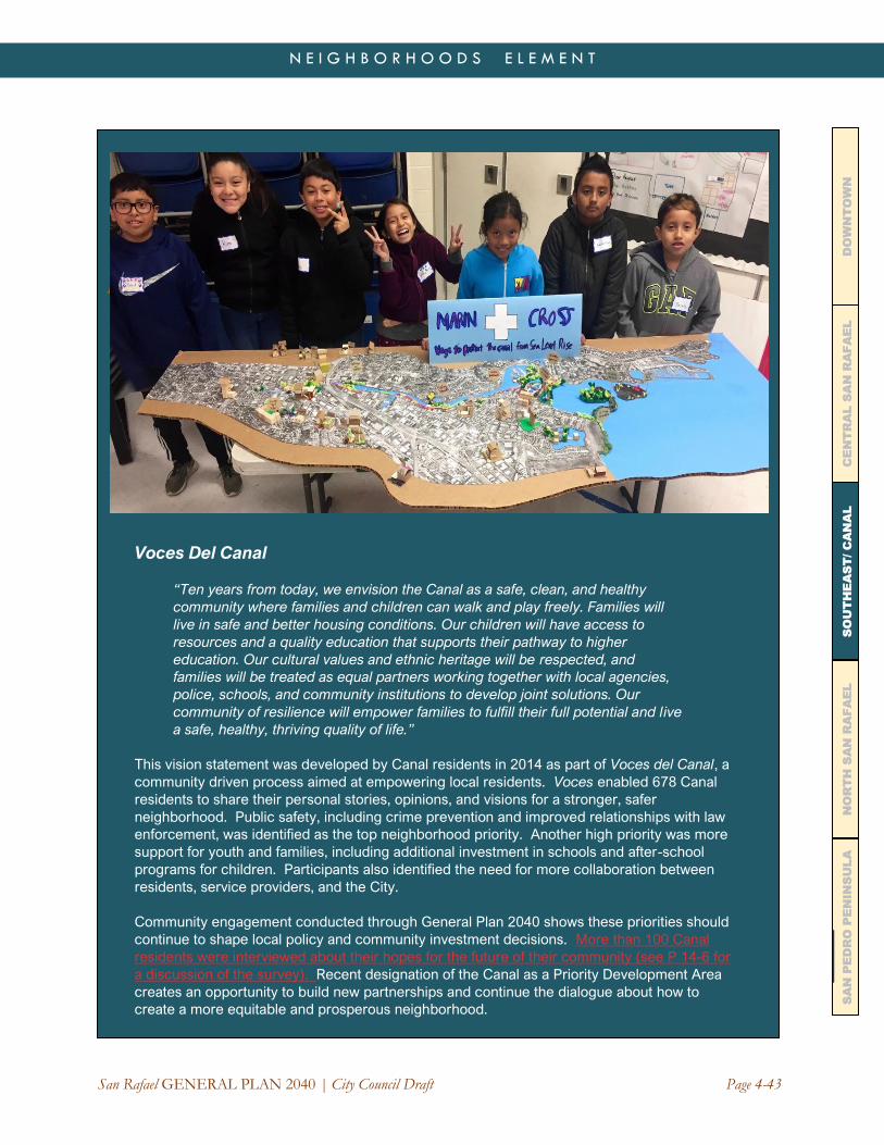
San Rafael GENERAL PLAN 2040 | City Council Draft Page 4-43
N E I G H B O R H O O D S E L E M E N T
CE
NT
RA
L S
AN
RA
FA
EL
DO
WN
TO
WN
N
OR
TH
SA
N R
AF
AE
L
SO
UT
HE
AS
T/ C
AN
AL
SA
N P
ED
RO
PE
NIN
SU
LA
]
Voces Del Canal
“Ten years from today, we envision the Canal as a safe, clean, and healthy
community where families and children can walk and play freely. Families will
live in safe and better housing conditions. Our children will have access to
resources and a quality education that supports their pathway to higher
education. Our cultural values and ethnic heritage will be respected, and
families will be treated as equal partners working together with local agencies,
police, schools, and community institutions to develop joint solutions. Our
community of resilience will empower families to fulfill their full potential and live
a safe, healthy, thriving quality of life.”
This vision statement was developed by Canal residents in 2014 as part of Voces del Canal, a
community driven process aimed at empowering local residents. Voces enabled 678 Canal
residents to share their personal stories, opinions, and visions for a stronger, safer
neighborhood. Public safety, including crime prevention and improved relationships with law
enforcement, was identified as the top neighborhood priority. Another high priority was more
support for youth and families, including additional investment in schools and after-school
programs for children. Participants also identified the need for more collaboration between
residents, service providers, and the City.
Community engagement conducted through General Plan 2040 shows these priorities should
continue to shape local policy and community investment decisions. More than 100 Canal
residents were interviewed about their hopes for the future of their community (see P 14-6 for
a discussion of the survey). Recent designation of the Canal as a Priority Development Area
creates an opportunity to build new partnerships and continue the dialogue about how to
create a more equitable and prosperous neighborhood.

Page 4-44 San Rafael GENERAL PLAN 2040 | City Council Draft
N E I G H B O R H O O D S E L E M E N T
CE
NT
RA
L S
AN
RA
FA
EL
DO
WN
TO
WN
N
OR
TH
SA
N R
AF
AE
L
SO
UT
HE
AS
T/ C
AN
AL
SA
N P
ED
RO
PE
NIN
SU
LA
This is a community rich in cultural traditions, strong networks, and a determination towards economic
self-sufficiency. It is also a community that faces immense social and economic challenges. Despite
relatively high employment rates, nearly one-third of Canal residents live below the federal poverty line.
More than two-thirds of all occupied housing units meet the Census definition of “overcrowded.”3
Housing has become increasingly unaffordable for many residents, creating a high risk of displacement
with few options for relocation. These challenges are complicated by the community’s vulnerability to sea
level rise and flooding. The entire neighborhood is less than 10 feet above sea level.
The vision for the Canal is to increase community stability by improving access to quality housing,
education, employment, health care, recreation, and services. This will require sustained investment in
parks, public facilities, infrastructure, roads, transit, and flood control systems. Opportunities to convert
existing market-rate housing to affordable units should be encouraged, with steps taken to reduce
displacement. The Equity, Diversity, and Inclusion Element of General Plan 2040 addresses these issues
at a citywide level, but in the Canal, they are essential to community survival.
The southern part of the Canal District includes a grid of streets facing Francisco Boulevard East. The
area along Medway Road and Vivian Street is the commercial heart of the neighborhood, but it lacks
cohesion, landscaping, lighting, and other amenities that create the sense of a neighborhood center.
Many of the structures are inexpensive post-war metal buildings. The area could be reimagined with
gathering places, pedestrian spaces, and safer connections to nearby residential areas. New models for
community engagement will be needed to design and create a place that truly meets community needs.
Care must be taken to keep rents affordable and not displace cost-sensitive service uses and small
businesses.
Adjacent to the Medway district on the east and west, the mix of commercial, service, and light industrial
businesses should be retained. There are opportunities for new housing in the Medway area and along
Bellam Boulevard, but most of the business district should retain its Industrial/Office zoning. Francisco
Boulevard East should be improved as a neighborhood gateway, with better sidewalks, signage, land-
scaping, and lighting. The Canal neighborhood is somewhat isolated from Downtown and the rest of the
city and should be better connected by transit, sidewalks, and bicycle lanes.
Policy NH-3.12: Canal Housing Needs Recognize the urgent need for more affordable housing, greater housing stability, and effective anti-
displacement measures in the Canal neighborhood. Support the acquisition, rehabilitation, and conversion
of existing market-rate housing to affordable housing, as well as the development of new affordable
housing projects on underutilized sites within the community. New housing should be designed and
constructed to respond to anticipated sea level rise and other environmental hazards.
Program NH-3.12A: Increasing the Affordable Housing Supply. Use the upcoming San Rafael
Housing Element and Southeast San Rafael Precise Plan processes to identify specific programs
addressing local housing needs.
Policy NH-3.13: Canal Public Safety Work with the Canal community to identify and respond to public safety needs. This should include capital
improvements such as improved street lighting, repaired sidewalks, a police sub-station, and better
relationships between residents, businesses, and law enforcement.
3 2018 Census data indicated that 1,246 of the 1,813 households in Census Tract 1122.01 had more than one person per room, the
federal threshold for overcrowding.

San Rafael GENERAL PLAN 2040 | City Council Draft Page 4-45
N E I G H B O R H O O D S E L E M E N T
CE
NT
RA
L S
AN
RA
FA
EL
DO
WN
TO
WN
N
OR
TH
SA
N R
AF
AE
L
SO
UT
HE
AS
T/ C
AN
AL
SA
N P
ED
RO
PE
NIN
SU
LA
Program NH-3.13A: Police Substation. Pursue development of a police substation to provide
faster, more effective service to the Canal area and Southeast San Rafael.
Policy NH-3.14: Public Facilities Prioritize citywide public facility investment in the Canal neighborhood, recognizing the greater needs for
parks, child care, libraries, public safety, schools, employment development, and social services in the
community; its vulnerability to hazards, public health emergencies, and economic stress; and its high
concentration of children and very low income and immigrant households.
Program NH-3.14A: Bellam/Windward Park. Pursue development of a neighborhood park on
publicly owned land at the southeast corner of Bellam Boulevard and Windward Way, or on an
equivalent publicly-owned property in this area.
Program NH-3.14B: Community Meeting Space. Meet the need for affordable meeting and
activity space, both at the Albert Boro Community Center and through the development of
additional community facilities in new development. Incentives and density bonuses should be
provided for private/non-profit development that sets aside space for neighborhood-based
activities such as child care, education, and job training.
See the Equity, Diversity and Inclusion Element for programs on public facility and infrastructure
investment in the Canal. The Precise Plan for Southeast San Rafael should further address these
needs.
Page 4-46 San Rafael GENERAL PLAN 2040 | City Council Draft
N E I G H B O R H O O D S E L E M E N T
CE
NT
RA
L S
AN
RA
FA
EL
DO
WN
TO
WN
N
OR
TH
SA
N R
AF
AE
L
SO
UT
HE
AS
T/ C
AN
AL
SA
N P
ED
RO
PE
NIN
SU
LA
Policy NH-3.15: Parking and Transportation Improve parking and transportation management in the Canal area. Access improvements are needed,
given the limited capacity of Bellam Boulevard and Francisco Boulevard East, their vulnerability to flooding,
and the configuration of the I-580/US 101 interchange.
Program NH-3.15A: Canal Parking Management. Continue to implement measures to manage
parking in the Canal, including time-limited parking and enforcement of parking rules. Consider
additional measures to balance supply and demand, including shared parking with private
businesses, increasing supply, and improving other transportation modes, such as transit and
bicycling.
Program NH-3.15B: Community Based Transportation Plan (CBTP) Update. Update the Canal
CBTP to reflect progress made since completion of the 2006 Plan and address current
transportation issues.
See also Policy NH-3.22 on the I-580/US 101 interchange.
Policy NH-3.16: Local Business Support Create additional opportunities for local entrepreneurs and neighborhood-serving businesses in the
commercial and industrial districts adjacent to the Canal neighborhood.
Program NH-3.16A: Core Canal Industrial/Office (CCI/O) District. Amend the Core Canal
Industrial/Office zoning district to provide more flexibility for neighborhood businesses that are
compatible with the existing mix of commercial and industrial activities in this zone. Housing
should not be permitted in the CCI/O district.
Policy NH-3.17: Medway Commercial District
Improve the Medway-Vivian Commercial District so that it functions as a town center for the Canal area,
including:
a) Additional community gathering places and civic space.
b) Street trees, landscaping, and better pedestrian connections through the Medway/Vivian block.
c) Broader shopping choices and services for the Canal neighborhood.
d) Additional social services, such as childcare and health care.
e) Housing, especially affordable units for families.
f) Upgrading of existing business areas.
g) Additional off-street parking.
Program NH-3.17A: Public Plaza. Encourage the creation of a public plaza to serve the Canal
community. If a site cannot be identified in the Medway-Vivian area, pursue acquisition and
improvement of another site nearby. The plaza should be planned and programmed by and for the
Canal community, using the Precise Plan process as a starting point.
Policy NH-3.18: Education Support efforts of the School District to provide all Canal children with access to quality education,
including access to safe, modern school facilities. Work with San Rafael City Schools to address the
transportation needs of students traveling to and from school.

San Rafael GENERAL PLAN 2040 | City Council Draft Page 4-47
N E I G H B O R H O O D S E L E M E N T
CE
NT
RA
L S
AN
RA
FA
EL
DO
WN
TO
WN
N
OR
TH
SA
N R
AF
AE
L
SO
UT
HE
AS
T/ C
AN
AL
SA
N P
ED
RO
PE
NIN
SU
LA
Policy NH-3.19: Libraries and Community Programs Continue to invest in and expand library facilities at the Albert J Boro Community Center. Support
continuing programs at this facility and at other facilities serving the Canal community, including bilingual
and ESL classes, pre-school, and after school programs.
Program NH-3.19A: Youth and Family Services. Prioritize additional programs for youth and
families in the Canal area, including child care and more activities for young people.
Policy NH-3.20: Neighborhood Appearance Improve the physical appearance of the Canal neighborhood, including the addition of greenery and green
space, street trees and landscaping, maintenance of buildings and property, enforcement of illegal
dumping regulations, abatement of code violations, and more regular street cleaning.
SPINNAKER POINT/BAYPOINT LAGOONS Spinnaker Point and Baypoint Lagoons are two adjacent master-planned communities developed in the
late 1980s/early 1990s near the mouth of San Rafael Creek. Collectively, the communities include about
450 homes and have a population of about 1,100 people. Both communities feature amenities such as on-
site recreation facilities for residents, walking paths, and greenbelts. The neighborhoods adjoin a lagoon
and wetland area that includes nesting islands for migratory birds. Beyond the lagoon, the Bay Trail runs
along the shoreline levee, connecting Pickleweed Park on the west to Jean Starkweather Shoreline Park
on the south. Spinnaker/Baypoint also borders the Canal neighborhood on the west.
Page 4-48 San Rafael GENERAL PLAN 2040 | City Council Draft
N E I G H B O R H O O D S E L E M E N T
CE
NT
RA
L S
AN
RA
FA
EL
DO
WN
TO
WN
N
OR
TH
SA
N R
AF
AE
L
SO
UT
HE
AS
T/ C
AN
AL
SA
N P
ED
RO
PE
NIN
SU
LA
Residents of Spinnaker Point/Baypoint Lagoons enjoy waterfront access and views, pleasant and well-
maintained neighborhood character, and a convenient location that is central to commute routes and
services. The community faces a number of challenges, including threats from sea level rise, spillover
parking from the adjacent Canal area, and dry season water quality/odor problems for the portion of the
lagoon adjacent to the levee. Ongoing efforts to improve community resilience, remediate odor issues,
and reduce flood hazards are needed.
Policy NH-3.21: Spinnaker Point/Baypoint Lagoons Maintain the safety, security, and appeal of Spinnaker Point/Baypoint Lagoons. Plans for Southeast San
Rafael and the Canal area should acknowledge and conserve the unique characteristics of this area.
Program NH-3.21A: Sea Level Rise Adaptation. Engage the Spinnaker Point/Baypoint Lagoons
community in sea level rise adaptation, odor mitigation, and flood control efforts.
Program NH-3.21B: Parking Spillover. Continue efforts to manage parking on neighborhood
streets. Ensure that new development in the vicinity of Spinnaker/Baypoint includes provisions to
meet parking demand without worsening existing shortages (see also Program SENH-3.15A).
SHORELINE/ANDERSEN EAST This is the largest business district in San Rafael, encompassing about 675 acres in the southeast corner of
the city. It extends from the 101/580 interchange to the south and east and includes a diverse mix of
commercial, industrial, and utility land uses. The area is bisected by Interstate 580. On the north/ east side
of I-580, it includes the Kerner/ Irene “Loop,” the Canalways property, Shoreline Center, and a number of
business parks and light industrial uses along Kerner and Francisco Boulevard East. On the south/west
side of I-580, it includes retail uses and building suppliers, as well as large-scale utility uses such as the
PG&E Service Center, Central Marin Sanitation Agency’s wastewater treatment plant, Marin Sanitary’s
Resource Recovery Center, and the Golden Gate Bridge Highway and Transportation District maintenance
yard. In total, there are about 6,600 jobs within the Shoreline/Andersen East area.
Shoreline/ Andersen East has significant potential for growth and development in the next 20 years. The
area is centrally located in Marin County and is Marin’s gateway to and from the East Bay. It has a number
of large vacant and/or underutilized sites, and a substantial inventory of high-quality office/flex space.
Challenges in this area include peak hour traffic congestion, flood hazards, and seismic hazards.
Improvement plans for the 101/580 interchange will have a major impact on this area, particularly around
Bellam Boulevard. Current plans call for a direct ramp from northbound 101 to eastbound 580, allowing
access to the Richmond Bridge without using surface streets. Several alignments and designs are under
consideration. The project presents opportunities to improve local access to Southeast San Rafael,
including bicycle, pedestrian, and transit improvements. Historically, the City has also planned to improve
connections between the north and south sides of I-580 in this area through a potential future crossing at
Irene Street or Shoreline Parkway.
While the Shoreline/Far Southeast area is mostly urbanized, it also has outstanding natural features. The
area includes a two-mile long shoreline park and trail as well as wetlands that provide habitat for shorebirds
and other wildlife. The area also includes the north slope of San Quentin Ridge. This hillside provides an
open space separator between San Rafael and Larkspur/San Quentin and is one of the city’s defining
visual features.

San Rafael GENERAL PLAN 2040 | City Council Draft Page 4-49
N E I G H B O R H O O D S E L E M E N T
CE
NT
RA
L S
AN
RA
FA
EL
DO
WN
TO
WN
N
OR
TH
SA
N R
AF
AE
L
SO
UT
HE
AS
T/ C
AN
AL
SA
N P
ED
RO
PE
NIN
SU
LA
Policy NH-3.22: Highway 101/I-580 Interchange Improve the US 101/I-580 interchange to alleviate freeway and local street congestion and improve local
access to and from Southeast San Rafael.
Program NH-3.22A: Interchange Improvement Process. Ensure local participation and
advocacy in planning, design, and environmental review for the 101/580 interchange. The project
should include mitigation measures that facilitate local access and circulation in Southeast San
Rafael, and benefit all modes of travel, including bicycles, pedestrians, and transit. Expansion of
the project scope should be considered so it includes the segment of I-580 between US 101 and
the Richmond-San Rafael Bridge as well as safety and functional requirements to improve access
to Bellam Boulevard and other major thoroughfares in Southeast San Rafael.
Policy NH-3.23: Marin Square/Gary Place Encourage reinvestment in the Marin Square/Gary Place area, either through redevelopment of the 13-
acre area or improvement of existing uses so they function cohesively. Redevelopment of the site should
permit retail, high-density residential, hotel, office, and other compatible uses.
Policy NH-3.24: Canalways (see also text box, page 4-5049) Recognize the potential for the Canalways site to achieve multiple goals, including habitat conservation,
wetland restoration, sea level rise adaptation, and provision of affordable housing, along with creation of
additional jobs, economic activity, and tax revenue. The City supports a plan for the site that balances
conservation and development objectives. Development should be economically viable for the site’s
owners, beneficial for the surrounding community, and responsive to protect the site’s environmental
resources, and be responsive to natural and hazards. In general, development should be located in
upland areas that are not critical habitat for endangered species.
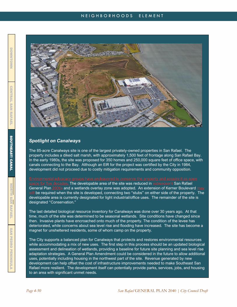
Page 4-50 San Rafael GENERAL PLAN 2040 | City Council Draft
N E I G H B O R H O O D S E L E M E N T
CE
NT
RA
L S
AN
RA
FA
EL
DO
WN
TO
WN
N
OR
TH
SA
N R
AF
AE
L
SO
UT
HE
AS
T/ C
AN
AL
SA
N P
ED
RO
PE
NIN
SU
LA
Spotlight on Canalways
The 85-acre Canalways site is one of the largest privately-owned properties in San Rafael. The
property includes a diked salt marsh, with approximately 1,500 feet of frontage along San Rafael Bay.
In the early 1980s, the site was proposed for 350 homes and 250,000 square feet of office space, with
canals connecting to the Bay. Although an EIR for the project was certified by the City in 1984,
development did not proceed due to costly mitigation requirements and community opposition.
Environmental advocacy groups have endeavored to conserve the property and acquire it as open
space for five decades. The developable area of the site was reduced in subsequent San Rafael
General Plan 2000s and a wetlands overlay zone was adopted. An extension of Kerner Boulevard may
will be required when the site is developed, connecting two “stubs” on either side of the property. The
developable area is currently designated for light industrial/office uses. The remainder of the site is
designated “Conservation.”
The last detailed biological resource inventory for Canalways was done over 30 years ago. At that
time, much of the site was determined to be seasonal wetlands. Site conditions have changed since
then. Invasive plants have encroached onto much of the property. The condition of the levee has
deteriorated, while concerns about sea level rise and flooding have increased. The site has become a
magnet for unsheltered residents, some of whom camp on the property.
The City supports a balanced plan for Canalways that protects and restores environmental resources
while accommodating a mix of new uses. The first step in this process should be an updated biological
assessment and delineation of wetlands, providing a baseline for future site planning and sea level rise
adaptation strategies. A General Plan Amendment could be considered in the future to allow additional
uses, potentially including housing in the northwest part of the site. Revenue generated by new
development can help offset the cost of infrastructure improvements needed to make Southeast San
Rafael more resilient. The development itself can potentially provide parks, services, jobs, and housing
to an area with significant unmet needs.

San Rafael GENERAL PLAN 2040 | City Council Draft Page 4-51
N E I G H B O R H O O D S E L E M E N T
CE
NT
RA
L S
AN
RA
FA
EL
DO
WN
TO
WN
N
OR
TH
SA
N R
AF
AE
L
SO
UT
HE
AS
T/ C
AN
AL
SA
N P
ED
RO
PE
NIN
SU
LA
Program NH-3.24A: Canalways Conservation and Development Plan. Encourage preparation
of a Canalways Conservation and Development Plan by the landowners. Such a Plan could
become the basis for defining the developable are and permitting aa future General Plan
Amendment to defining allow a larger development footprint than is shown on the General Plan
2040 Land Use Map, and to permit additional land uses. The first step of this process should be a
biological assessment and updated delineation of wetlands. This can shape the development plan
and provide the basis for mitigation measures in the event these resources will be impacted by the
site’s development.
Policy NH-3.25: Windward Way Encourage medium-density residential uses on the privately-owned 2.3-acre parcel located on the east
side of Windward Way (APN 009-330-01). Development may be clustered on the site to retain views and
respond to site constraints, including transmission lines. Compatible office or light industrial uses are
permitted on the west side of Windward Way, consistent with zoning.
Policy NH-3.26: Shoreline Center Support development of the few vacant and underutilized sites remaining in the Shoreline Center with light
industrial/office, specialty retail, region-serving retail, hotel, R&D, biotech, and similar uses that generate
jobs and revenue. Land use changes to permit other uses, including housing, could be considered through
a future planning process, subject to environmental analysis and a program to mitigate potential conflicts or
constraints.
Policy NH-3.27: San Quentin Ridge Preserve San Quentin Ridge as open space due to its visual significance, importance as a community
separator, slope stability problems, and habitat value. Any development permitted in this area should be
on the lower, less steep portion of the hillside.
Policy NH-3.28: Adaptation Prioritize the southeast waterfront (including the Canal shoreline) for sea level rise adaptation programs,
including repair and replacement of levees, and measures to improve natural resilience such as horizontal
levees and restored coastal features. Public shoreline access should be maintained throughout this area.
See the Safety and Resilience Element for a discussion of sea level rise adaptation programs

San Rafael GENERAL PLAN 2040 | Draft for Public Review Page 4-52
N E I G H B O R H O O D S E L E M E N T C
EN
TR
AL
SA
N R
AF
AE
L
DO
WN
TO
WN
N
OR
TH
SA
N R
AF
AE
L
SO
UT
HE
AS
T/ C
AN
AL
SA
N P
ED
RO
PE
NIN
SU
LA
NORTH SAN RAFAEL
North San Rafael includes neighborhoods on the west and east sides of US 101 north of Puerto Suelo Hill.
The area has a distinct character, history, and natural setting, creating a strong sense of local identity.
North San Rafael includes the Las Gallinas Valley, a once tranquil rural area that was transformed at the
end of World War II when Highway 101 became an interstate highway. Starting in the early 1950s, the
pasture lands of the former Freitas family ranch were developed with suburban homes, shopping centers,
churches, schools, and offices. As the area matured, apartments, condominiums, townhomes, and senior
living developments made use of the remaining developable space.
In 2018, North San Rafael had a population of 30,200 residents. Of this total, 18,000 lived within the San
Rafael City limits and 12,200 lived in the unincorporated San Rafael Planning Area. The unincorporated
population includes roughly 7,000 residents in Marinwood-Lucas Valley, 4,800 residents in Santa Venetia,
and 400 residents in Los Ranchitos. North San Rafael represents 40 percent of the San Rafael Planning
Area’s population and nearly half of its land area. It is the largest of the five sub-areas addressed in the
Neighborhoods Element.
The area includes the Gallinas Creek watershed and most of the Miller Creek watershed. Elevation ranges
from sea level along San Pablo Bay to nearly 1,900 feet at Big Rock Ridge, the highest point in the San
Rafael Planning Area. Much of the area is protected open space as a result of bond measures approved
by San Rafael voters in the early 1970s.
The community is renowned for its natural environment, thriving businesses, excellent schools, and mix of
housing, including more than 1,700 modernist homes in Terra Linda, Lucas Valley, and Marinwood
developed built by Joseph Eichler. While single family homes are predominant, 40 percent of the housing
units in North San Rafael are multi-family or attached. Seventy percent of North San Rafael’s housing units
were built between 1940 and 1979. Most of the area was unincorporated at the time of its initial
development and was annexed by San Rafael in the 1960s and early 1970s. Substantial areas remain
unincorporated today and are within County Service Areas and various independent special districts.

Page 4-53 San Rafael GENERAL PLAN 2040 | Draft for Public Review
N E I G H B O R H O O D S E L E M E N T C
EN
TR
AL
SA
N R
AF
AE
L
DO
WN
TO
WN
N
OR
TH
SA
N R
AF
AE
L
SO
UT
HE
AS
T/ C
AN
AL
SA
N P
ED
RO
PE
NIN
SU
LA
North San Rafael contains several of the City’s largest employers. Northgate Mall initially opened in the
mid-1960s and continues to be one of the largest regional shopping centers in Marin County. It forms the
hub of a commercial district that includes smaller shopping centers (Northgate One and Northgate Three),
office buildings, hospitality uses, and services. The Marin County Civic Center—an internationally
renowned architectural landmark as well as the seat of County government—is situated east of US 101 and
is another major employer. Kaiser Medical Center and associated medical facilities constitute a third
employment center in Terra Linda.
The area also includes Northgate Industrial Park and a number of smaller business parks and commercial
areas along Redwood Highway and Los Gamos Drive. There are also several small neighborhood
shopping centers, medical and health care facilities, corporate offices, and schools. The area provides
numerous recreational opportunities, including the Terra Linda Community Center and pool, the
Marinwood Community Center, the Marin YMCA and JCC, local parks and playgrounds, and a network of
hiking and multi-use trails on hillside open space.
The Neighborhoods Element provides policy and program guidance for the following subareas within the
City limits:
• North San Rafael Town Center (Northgate)
• Terra Linda (including Santa Margarita Valley and southern Los Gamos Drive)
• Mont Marin/San Rafael Park
• Rafael Meadows/Merrydale
• Northgate Business Park/Los Gamos
• Civic Center
• Smith Ranch (including Contempo Marin/Deer Park)
These neighborhoods and business districts are interconnected. They share watersheds, road and transit
networks, schools, economic activities, and recreational facilities. But each has a unique identity that
merits special consideration in the General Plan.
At the end of this section, more generalized guidance is provided for three unincorporated subareas:
• Los Ranchitos
• Lucas Valley/Marinwood
• Santa Venetia
Prior plans for North San Rafael include a community-driven “Vision” plan prepared in 1997. The Vision
included a statement of community values; a vision statement (see text box); a series of concepts, goals,
and actions; and an implementation strategy. The plan is built around concepts related to environmental
protection, transportation, business vitality, new housing opportunities, improved community services, and
beautification.
Among the important recommendations of this Plan was creation of a “North San Rafael Promenade” from
the Terra Linda Recreation Center to the Civic Center, a concept that was further refined through a
community planning effort in 2002. One of the objectives of the Promenade was to connect upstream and
downstream communities bisected by Highway 101. Several segments have been completed, including a
half-mile Class I bike lane along Las Gallinas Avenue between Northgate Drive and the south end of the
Mall. The North San Rafael Vision also reimagined the Northgate commercial district as a “town center,”
including design improvements and complementary uses such as offices and housing. Although the Vision
Plan was prepared more than two decades ago, it continues to resonate as a statement of community
values, issues, and aspirations. It should provide the starting point for an updated plan focused on those
areas of North San Rafael with the greatest potential for change in the future.

Page 4-54 San Rafael GENERAL PLAN 2040 | City Council Draft
N E I G H B O R H O O D S E L E M E N T
CE
NT
RA
L S
AN
RA
FA
EL
DO
WN
TO
WN
N
OR
TH
SA
N R
AF
AE
L
SO
UT
HE
AS
T/ C
AN
AL
SA
N P
ED
RO
PE
NIN
SU
LA
Vision for North San Rafael
The Vision Statement below was crafted in 1997 through a community-driven planning process. It
remains a relevant and timely expression of local values and aspirations. Additional planning is
needed to reflect today’s economic, environmental and transportation challenges and determine how
this vision can be realized.
We are a balanced, vital and evolving community with a diverse population.
Our entire community is beautiful and well-maintained, with excellent, well-integrated
architecture, abundant landscaping, and tree-lined streets. As we come home to our clean and
friendly neighborhood,we pass through attractive, distinctive gateways. Getting around our
community and out to surrounding areas is easy—whether by foot , bicycle, bus, rail or car.
Our business community continues to be healthy and innovative, supporting entrepreneurship.
We are known for economic stability with a full range of employment opportunities. Various
vibrant centers provide opportunities for us to meet, interact and reaffirm our sense of
community. We enjoy gathering together at local shopping areas, restaurants, cultural
attractions and plazas.
We offer a variety of housing options for our diverse and changing population. Our concern for
residents of all ages is expressed in excellent schools, libraries, youth activities, senior
services, entertainment, recreational and cultural opportunities.
We gracefully adapt to changing needs of residents and businesses while respecting our
environment and quality of life. Neighborhoods and businesses work together. Through
cooperation, we create a community everyone loves.

Page 4-55 San Rafael GENERAL PLAN 2040 | Draft for Public Review
N E I G H B O R H O O D S E L E M E N T C
EN
TR
AL
SA
N R
AF
AE
L
DO
WN
TO
WN
N
OR
TH
SA
N R
AF
AE
L
SO
UT
HE
AS
T/ C
AN
AL
SA
N P
ED
RO
PE
NIN
SU
LA
In 2013, the City finalized a Station Area Plan for the Civic Center SMART station area (see text box on
page 4-6712). The focus of the Plan is on improving connections between the station and surrounding
neighborhoods and business districts. Recommendations from the Station Area Plan are incorporated in
the General Plan.
Policy NH-4.1: North San Rafael Maintain North San Rafael’s character as an attractive, suburban community with a strong sense of
community identity and easy access to well-managed open space and parks, convenient shopping and
services, and excellent schools. The City is committed to protecting and restoring North San Rafael’s
natural environment, investing in multi-modal transportation improvements that make it easier to get
around, creating new gathering places and activity centers, sustaining business vitality, and creating new
housing options that respond to diverse community needs. Plans for North San Rafael need to should
recognize that this is a distinct and unique part of San Rafael. Standards for density, design, traffic, and
parking shall should be tailored to reflect local context. North San Rafael residents will be invited to should
have a voice at the citywide level and be directly involved in shaping decisions about the future of their
community.
NORTH SAN RAFAEL TOWN CENTER
The North San Rafael Town Center includes Northgate Mall, the Northgate One and Northgate Three
shopping centers, and the commercial and institutional properties along Freitas Parkway, Las Gallinas
Avenue, and Los Ranchitos Road. The area is developed with retail, service, automotive, and office uses
but includes other uses including Mount Olivet Cemetery and the headquarters campus of Guide Dogs for
the Blind. The north fork of Gallinas Creek flows along the northern edge of this area in a trapezoidal
channel, while the south fork flows near the SMART station on the southern edge.
Primary access to the Town Center is via the Freitas Parkway interchange from US 101. The Merrydale
Overcrossing and Freitas Parkway provide pedestrian, vehicle, and bike connections to the east side of
101, while a multi-use bike path along the SMART tracks and Los Ranchitos Road provides a connection to
Downtown San Rafael. Portions of the North San Rafael Promenade pedestrian and bike path also pass
through the area, although most of this planned greenway remains unbuilt The Civic Center SMART station
is located at the southeast corner of this area.
The Town Center is anchored by Northgate Mall, a 775,000 square foot regional shopping mall on a 44-
acre site. For more than 55 years, the Mall has filled a unique retail niche in Marin County, complementing
Downtown San Rafael and its neighborhood shopping centers and providing a location for community
events and gatherings. In the 1980s, the Mall underwent several renovations, enclosing the central plaza
and adding a theater complex and segment of the Promenade. Another renovation took place in 2008.
Recent expansion of on-line shopping, rising rents, competition from other centers, and changes in
consumer preferences have led to declining vitality and the loss of several major tenants. The vision of
Northgate as a community hub and gathering place is still widely embraced, but there are divergent views
on what this ultimately means and how it should be achieved.

Page 4-56 San Rafael GENERAL PLAN 2040 | City Council Draft
N E I G H B O R H O O D S E L E M E N T
CE
NT
RA
L S
AN
RA
FA
EL
DO
WN
TO
WN
N
OR
TH
SA
N R
AF
AE
L
SO
UT
HE
AS
T/ C
AN
AL
SA
N P
ED
RO
PE
NIN
SU
LA
The Town Center has been the focus of several planning studies. In 1997, the North San Rafael Vision
described it as a place where the values and history of the community would be expressed and supported,
community identity would be strengthened, and neighborhood cohesion would be fostered. The area was
envisioned as a gathering place with public art, a variety of unique shops, many places to eat, and a
number of entertainment options. Northgate was described as a walkable destination that would change,
expand, and evolve to become the heart of North San Rafael. It would feature a town square and a
pedestrian-oriented environment. The Promenade, featuring a beautiful walkway and bikeway along a
restored Gallinas Creek, is central to the Town Center concept.
The policies below carry forward still-relevant elements of the 1997 vision. While the Vision’s goals remain,
it is anticipated that some (or all) of these policies may be amended or replaced following completion of a
detailed plan for the Town Center area to be completed in the coming years. The plan must take a hard
look at the outlook for retail and office uses in the coming decades, the need for housing (particularly
affordable housing), changing modes and patterns of transportation, issues related to climate change and
natural hazards, opportunities to restore creeks and natural systems, and the implications of the recent
public health emergency on the design of public and private space. Continued community dialogue on
these issues should guide decision-making as a new plan takes shape.
Policy NH-4.2: North San Rafael Town Center Strengthen the role of the North San Rafael Town Center as an attractive, thriving heart for the North San
Rafael community: an economically viable centerpiece of commerce and activity with diverse activities for
persons of all ages. This should include revitalizing Northgate Mall and surrounding business areas by
encouraging:
a) A distinctive and vibrant mix of uses, consistent with the area’s characteristics
b) A variety of high-quality stores, entertainment uses, and services to foster local patronage and adapt to
the ongoing evolution of retail and commercial activities

San Rafael GENERAL PLAN 2040 | City Council Draft Page 4-57
N E I G H B O R H O O D S E L E M E N T
CE
NT
RA
L S
AN
RA
FA
EL
DO
WN
TO
WN
N
OR
TH
SA
N R
AF
AE
L
SO
UT
HE
AS
T/ C
AN
AL
SA
N P
ED
RO
PE
NIN
SU
LA
c) Upgrading of anchor and specialty stores, including an additional high-quality retail anchor if needed
for economic vitality, consistent with traffic circulation standards
d) Nightlife activities, such as a late-night restaurant or coffee shops that harmonize with existing activities
e) Expanding the Mall, including improving the mix of activities and uUpgrading the appearance of the
buildings and landscaping
f) Additional outdoor public places that support public gatherings and public art
g) Continued community services, which may include an expanded public library
h) Completion of the North San Rafael Promenade through the site
i) Allowing the addition of housing, including maximizing the potential for affordable housing
j) Preserving and strengthening Northgate Mall as a significant tax revenue generator for the City.
The scale of any improvements should be compatible with the surrounding community and should not
exceed infrastructure capacity. New or expanded structures should demonstrate how views, sightlines,
visual integrity, and character will be impacted and addressed. Promenade improvements described in the
North San Rafael Promenade Conceptual Plan (2002) should be included in any substantial rehabilitation
or expansion of the Mall. Opportunities to include green infrastructure and low impact development (LID)
methods also should be pursued.
Program NH-4.2A: North San Rafael Town Center Plan. Pursue funding to prepare a more
detailed plan for the North San Rafael Town Center area (such as a precise plan or a specific plan),
including Northgate Mall and commercial properties in the vicinity. The plan shall should include a
community-driven process that fully engages property owners, business owners, community
residents, and government agencies. It should update the 1997 vision and identify strategies to
strengthen the Town Center as a community gathering place, while recognizing market conditions,
retail and office trends, housing needs, transportation and infrastructure capacity, and the potential
for off-site impacts.
See also Program LU-3.1A on the North San Rafael Town Center Community Plan, as well as
policies in the Land Use, Community Design, and Noise Elements on land use compatibility.
Program NH-4.2B: Outdoor Gathering Places. Include outdoor public places that support
community activities and entertainment such as a public plaza for periodic arts and cultural events,
outdoor cafes with music, restaurants with sidewalk or patio dining, children’s play areas, teen-
centered spaces, and other uses that provide outdoor seating. Design of retail spaces should be
flexible enough to support these types of activities in the future.
Program NH-4.2C: Incentives. Provide development incentives to attract desired uses to the
Town Center, including retail, office, housing, and community services. Allow a height bonus of
two stories (24 feet) for affordable housing. Percentage targets for housing affordability should be
set during the Town Center planning process and should be the focus of a community discussion
about new approaches to meeting the housing needs for persons of all incomes.
Program NH-4.2D: Farmers Market. Consider a partnership with the Agricultural Institute of
Marin (AIM) to bring the Farmers Market to the Town Center as a permanent feature, as feasible.

Page 4-58 San Rafael GENERAL PLAN 2040 | City Council Draft
N E I G H B O R H O O D S E L E M E N T
CE
NT
RA
L S
AN
RA
FA
EL
DO
WN
TO
WN
N
OR
TH
SA
N R
AF
AE
L
SO
UT
HE
AS
T/ C
AN
AL
SA
N P
ED
RO
PE
NIN
SU
LA
Policy NH-4.3: Design Excellence Encourage harmonious and aesthetically pleasing design for new and existing development in the Town
Center area, including upgrading of landscaping, signage, lighting. and building design. Uses on the
perimeter of the area should “step down” in height and intensity along edges where the Town Center
adjoins lower-density residential uses.
Program NH-4.3A. Pedestrian-Friendly Design. Provide design guidance through the Town
Center planning process. One of the objectives of this process should be to give the area a
stronger pedestrian feel and improve its walkability, including landscaped walkways and improved
connectivity to surrounding neighborhoods.
Policy NH-4.4: Transportation Safety and Accessibility Improve access and bicycle/pedestrian connections between Northgate One, the Mall at Northgate,
Northgate Three, the Civic Center SMART station, the Civic Center, and surrounding neighborhoods.
Program NH-4.4A: Promenade and Other Improvements. Use the development review and
capital improvement program process to complete the North San Rafael Promenade through the
Town Center. Considerations include:
a) Routing of the Promenade to include safer crossings from the Civic Center and along Freitas
Parkway. Consistent with the 2013 Station Area Plan and more recent community input, this
also includes long-term improvements along Merrydale (on the east side of Mt. Olivet
Cemetery) and through the Northgate III site in the event that site is redeveloped.
b) Implementing Bicycle and Pedestrian Master Plan (2018) improvements through the Town
Center area, including increased availability of bicycle racks
c) Increasing public transit to and from the Town Center and making it safer and easier to access
bus stops. This includes possible shuttle service to Civic Center station.
d) Implementing traffic calming on parking lot access roads, and redesigning traffic flow to
minimize conflict between vehicles, bicycles, and pedestrians
e) Designing any new parking structures to provide safe pedestrian access and reduced traffic
conflicts.
Program NH-4.4B: Improved Entrance to the Mall. Support redesign of intersections along Las
Gallinas, Northgate Drive, Del Presidio, and Merrydale to improve traffic flow and improve safety
for pedestrians and bicyclists. Support realignment of driveways along Las Gallinas to form safer
intersections and pedestrian crossings.
See also Mobility Element Policy M-2.5 on Level of Service standards for road segments and
intersections in the North San Rafael Town Center vicinity, including requirements for traffic
studies. The standards reflect anticipated future traffic volumes and will provide the basis for
future improvements to ensure safe and adequate access.

San Rafael GENERAL PLAN 2040 | City Council Draft Page 4-59
N E I G H B O R H O O D S E L E M E N T
CE
NT
RA
L S
AN
RA
FA
EL
DO
WN
TO
WN
N
OR
TH
SA
N R
AF
AE
L
SO
UT
HE
AS
T/ C
AN
AL
SA
N P
ED
RO
PE
NIN
SU
LA
TERRA LINDA Terra Linda extends west and northwest from the North San Rafaelgate Town Center, occupying the floor
of the Las Gallinas Valley.. The valley was initially settled by Coastal Miwok (Ewu) and became part of a
Mexican land grant in the 1850s. In 1898, it became the ranch and dairy farm of Manuel T. Freitas.
Large-scale subdivision of the valley began in the early 1950s. Between 1955 and 1965, about 900 homes
were developed by Joseph Eichler in the “mid-century modern” architectural style. These one-story
homes featured post and beam construction, glass walls opening to private yards, internal atriums, and
hydronic heat in concrete slab floors. The Eichler homes were complemented by Alliance and Kenney
homes featuring similar features, creating a unifying architectural element that still defines the
neighborhood today. Joseph Eichler and his company were pioneers in opposing racial housing
discrimination, insisting on inclusionary practices in Eichler developments while advocating against
redlining and housing discrimination at the state and national levels.
It is one of the larger neighborhoods in San Rafael and is developed primarily with single family homes.
Condominiums and apartments are located at the end of Freitas Parkway, along Los Gamos Road, above
Northgate Drive, and along Nova Albion Way.
Architectural styles vary throughout the neighborhood, but most homes are single-story Eichler, Kenney,
Alliance, or ranch-style homes built in the 1950s and 1960s.
Commercial development in Terra Linda began in 1957 with construction of Scotty’s Market and the Terra
Linda Shopping Center. Guide Dogs for the Blind was also an early arrival, moving into its current campus
on Las Gallinas Avenue in 1947. The 1960s saw Terra Linda become a full-service community, with the
construction of Terra Linda High School (1960) and St. Isabella’s Church and School (1961), as well as
offices and shopping in the adjacent Northgate area. Kaiser San Rafael Medical Center was established in
the neighborhood in 1976, one of three major hospitals in Marin County. The 1960s and 70s also saw
condos developed at the western end of Freitas Parkway, as well as the addition of apartment buildings
along Nova Albion Way. Today, there are Sseveral senior residential and assisted living facilities are
located in Terra Linda, including Villa Marin, Maria B Freitas, Golden Home, Nazareth House, Drake
Terrace, and Alma Via. There are also a number of churches, child care facilities, and group homes in the
community.
In addition to Terra Linda High School, the neighborhood is home to Two public schools – Vallecito
Elementary, three private schools, and and Terra Linda High School – are located in the area, as is the
headquarters of the Miller Creek School District. It includes and the Terra Linda Community Garden,
created by volunteers in 1972 and now one of the largest in the County. The area also includes three
private schools—St. Isabella, Mark Day, and Montessori de Terra Linda. The Kaiser San Rafael Medical
Center, Marin Health Surgery Center, and Terra Linda Shopping Center (Scotty’s Market) are also located
in the neighborhood. The area Neighborhood parks includes the Terra Linda Recreation Center and Pool,
Freitas Park, Oleander Park, Santa Margarita Park, and Hoffman Field, as well as small green spaces along
Freitas Parkway. The 1,172-acre Terra Linda/Sleepy Hollow Open Space preserve flanks the western
edge of the neighborhood, providing a beautiful backdrop for the community as well an ecological and
recreational resource. separator between San Rafael, San Anselmo, and Lucas Valley.
Terra Linda The neighborhood is traversed by the north branch of Gallinas Creek, which is channelized in
the center of Freitas Parkway east of Del Ganado Road. Santa Margarita Creek, a northern tributary, is
likewise channelized in the median of Del Ganado from Freitas Parkway to just west of Las Ovejas Avenue.
Plans to restore Gallinas Creek have been developed, with the goal of restoring ecological and hydrologic
functions. This could include moving traffic to one side of the roadbed and reducing the road width, thus
creating a larger footprint for the creek, a more attractive and natural appearance, and a new tree-lined
trail and bike path. This improvement will create a real, visible, and beneficial linkage between upstream
ridges, the Town Center, and the marshes and baylands on the eastern edge of North San Rafael. Funding

Page 4-60 San Rafael GENERAL PLAN 2040 | City Council Draft
N E I G H B O R H O O D S E L E M E N T
CE
NT
RA
L S
AN
RA
FA
EL
DO
WN
TO
WN
N
OR
TH
SA
N R
AF
AE
L
SO
UT
HE
AS
T/ C
AN
AL
SA
N P
ED
RO
PE
NIN
SU
LA
for Gallinas Creek restoration is needed and should be a priority (see also Program C-1.9C). Together with
the North San Rafael Promenade, creek restoration would create a neighborhood amenity that would help
decrease car traffic, enhance the environment, and proactively address global climate change.
Freitas Parkway provides the primary access to Terra Linda, with most traffic to and from the neighborhood
passing through the Northgate/Town Center area. Other major neighborhood thoroughfares include Las
Gallinas Avenue/Los Ranchitos Road, Nova Albion Way, Montecillo Road, and Northgate Drive. Two hourly
bus lines serve the area, and another runs weekdays every half-hour, providing access to the Mall, the
Civic Center SMART station, and Downtown San Rafael. Bike lanes, sidewalks, and linear green spaces
along Freitas Parkway comprise a segment of the North San Rafael Promenade, but the vision of a
continuous green space from the Recreation Center to the Civic Center has yet to be realized.
Terra Linda is mostly built out, with limited opportunities for new development. There is growing
appreciation of the neighborhood’s modernist 900 Eichler homes as a cultural resource to be cherished
today and in the future. Likewise, the neighborhood has hundreds of similarly modernist Alliance, Kenney,
and other ranch-style homes built in the mid-1950s and 60s in planned neighborhoods with curved
residential streets. Some of the neighborhood’s older commercial properties, such as the Terra Linda
Shopping Center, are in need of revitalization and could potentially be augmented with housing or other
complementary uses. Civic spirit and community pride are strong, and arts and cultural events are a staple
of community life. Residents value the safe, family-centered community and its close interface with the
natural environment.
Local concerns expressed during development of the General Plan 2040 include preservation of
neighborhood character, emergency preparedness, traffic and transportation safety, parking, and
environmental quality. Residents seek active involvement in planning for the North San Rafael Town
Center and support completion of the North San Rafael Promenade, undergrounding of power lines,
improvement of neighborhood gateways, and additional services for youth and seniors. The neighborhood
has a growing population of older adults, increasing needs related to the Terra Linda Community Center,
and ongoing issues related to access and congestion, especially along Freitas Parkway and in the Town
Center vicinity.

San Rafael GENERAL PLAN 2040 | City Council Draft Page 4-61
N E I G H B O R H O O D S E L E M E N T
CE
NT
RA
L S
AN
RA
FA
EL
DO
WN
TO
WN
N
OR
TH
SA
N R
AF
AE
L
SO
UT
HE
AS
T/ C
AN
AL
SA
N P
ED
RO
PE
NIN
SU
LA
The policies below are intended to guide future planning and development activities:
Policy NH-4.5: Eichler and Alliance Homes. Preserve the design character of the neighborhood’s iconic Eichler, Alliance, Kenney, and other single-
story mid-century modern homes.
Program NH-4.5A: Eichler-Alliance Overlay. Continue to enforce provisions of the Eichler-
Alliance Overlay District, including height limits and design review requirements for most roof
modifications. Consider preparation of design guidelines to preserve the characteristic features of
these homes, and possible expansion of the Overlay District to include additional homes with
similar features
Policy NH-4.6: Terra Linda Shopping Center Encourage improvements to Terra Linda Shopping Center. Incorporate improvements for the North San
Rafael Promenade into shopping center upgrade.
Program NH-4.6A: Shopping Center Improvements. Work with the property owners, tenants,
and neighborhood residents to achieve the following objectives:
a) Retention of popular local businesses, such as Scotty’s Market
b) A pedestrian-oriented plaza with shade trees, outdoor seating, and outdoor dining
c) Coordinated, refreshed entry signage at Freitas and Del Ganado
d) A limited amount of housing, including smaller and affordable units that would provide
opportunities for seniors and local employees while not intruding on the surrounding lower
density neighborhood.

Page 4-62 San Rafael GENERAL PLAN 2040 | City Council Draft
N E I G H B O R H O O D S E L E M E N T
CE
NT
RA
L S
AN
RA
FA
EL
DO
WN
TO
WN
N
OR
TH
SA
N R
AF
AE
L
SO
UT
HE
AS
T/ C
AN
AL
SA
N P
ED
RO
PE
NIN
SU
LA
Policy NH-4.7: Terra Linda Community Improvements Invest in upgraded community facilities in Terra Linda, including places for youth, families, and older adults
to gather and explore their interests.
Program NH-4.7A: Community Improvements. Consider the following improvements in the
Terra Linda area:
a) Modernization of the Terra Linda Community Center to meet current and future needs
b) Additional recreation facilities for youth, such as a teen center or skate park
c) Upgraded pocket parks along Freitas Parkway (Arbor, Munson, and Hillview), linked to a
broader effort to restore Gallinas Creek (see next policy)
d) Retention of the Kaiser Permanente Medical Center, including improvements to address traffic
and parking
e) Implementation of North San Rafael Promenade improvements, especially between the
Community Center and Freitas Parkway to encourage access by foot and bike
f) Improved pedestrian walkways connecting Terra Linda streets
g) Additional public recreational opportunities at School District-owned sports fields, such as
those at Santa Margarita School
g)h) Safety improvements to infrastructure (see NH-4.8A(a) below).
See also Policy NSR-2 on the Northgate Branch Library
Policy NH-4.8: Community Beautification and Environmental Restoration Continue efforts to beautify Terra Linda and restore its natural environment.
Program NH-4.8A: Beautification and Restoration Projects. Pursue the following beautification
and restoration projects in Terra Linda:
a) Undergrounding of utilities along Freitas Parkway and Del Ganado Road
b) Additional landscaping and street trees
c) Improvements Restoring the hydrologic function of to the Santa Margarita Creek, including
possible removal of the concrete channel bottom and expansion of planting area for successful
in the Del Ganado Road median, including tree planting. An expanded tree canopy will help to
lower water temperatures and protect water quality.
d) Restoration of Las Gallinas Creek
e) Daylighting of creeks and drainageways in other locations wherever feasible.
Creek restoration projects should be designed to restore a more natural hydrologic flow, stabilize
creek beds, increase stormwater absorption, improve riparian habitat and water quality, maintain
storm drainage capabilities, and avoid flooding. Opportunities to combine creek restoration, utility,
and promenade projects for funding purposes are strongly encouraged, and will make projects
more competitive in the grant application process.

San Rafael GENERAL PLAN 2040 | City Council Draft Page 4-63
N E I G H B O R H O O D S E L E M E N T
CE
NT
RA
L S
AN
RA
FA
EL
DO
WN
TO
WN
N
OR
TH
SA
N R
AF
AE
L
SO
UT
HE
AS
T/ C
AN
AL
SA
N P
ED
RO
PE
NIN
SU
LA
MONT MARIN/SAN RAFAEL PARK Mont Marin/San Rafael Park is a suburban neighborhood of approximately 550 homes located between
Terra Linda and Marinwood. The neighborhood consists almost entirely of single family residential uses
and was developed during the mid-1960s and 1970s. Most of the homes are owner-occupied.
Topography is rolling to hilly, and many of the homes feature picturesque views and sloped yards. The
neighborhood enjoys easy access to public open space and trails, including Jerry Russom Memorial Park
along its western boundary. A significant open space ridge forms the eastern boundary of the
neighborhood.
Mont Marin/San Rafael Park is essentially built out, with little change expected. The neighborhood
continues to be a prime location for families with young children and those who value the proximity to open
space, Highway 101, and nearby shopping. While the neighborhood lacks a defining public facility or
“center,” it is anticipated that Mont Marin San Rafael Park will continue to establish its identity as a
desirable and tight-knit community over the next 20 years.
RAFAEL MEADOWS/MERRYDALE
Rafael Meadows is a predominantly residential area located southeast of the North San Rafael Town
Center. The heart of the community is a single family neighborhood comprised of about 200 homes built in
the early 1950s, bounded by the SMART tracks on the west and north and Merrydale Road on the east.
Just south of the Meadows is Redwood Village, a newer 133-home community built on a former PG&E
storage site. Redwood Village includes 3-acre Los Ranchitos Park, with a walking path, restrooms, and
picnic areas. Merrydale Road and Redwood Highway form the eastern edge of the neighborhood,
providing a buffer between the lower density areas and the 101 Freeway. These two streets run parallel to
Highway 101 and includes a mix of apartments, condominiums senior housing, restaurants, a small grocery
store, self-storage facilities, and various small businesses.
The SMART Civic Center station serves this area, as well as the larger Civic Center employment center.
Pedestrian and bicycle access is provided via a new multi-use path that runs along the SMART tracks,
including a non-vehicular crossing at Walter Place. The path also serves Redwood Village and the
unincorporated Los Ranchitos area to the southwest. The South Fork of Gallinas Creek flows underground
on the northern edge of this area--new development on Merrydale Road is required to pump water during
the rainy season and may be further impacted by future sea level rise.
The presence of SMART creates an opportunity for a limited amount of transit-oriented development
adjacent to the station, particularly along Merrydale Road. A 48-unit townhome development was recently
approved near the station and an 89-unit assisted living facility is under construction. Other opportunity
sites have been identified, including self-storage facilities adjacent to the station. Densities and heights in
this area must be compatible with the adjacent residential neighborhoods and should recognize the
suburban context. Residential development in this area also should consider health impacts related to its
proximity to US 101.
Residents of the Rafael Meadows and Redwood Village neighborhoods are concerned about increasing
traffic associated with development along Merrydale and elsewhere near the North San Rafael Town
Center. Both neighborhoods enjoy low traffic volumes and safe walking and cycling conditions on their
local streets. Because Merrydale and Redwood Highway are effectively “dead ends,” there are limited
ingress and egress points for emergency vehicles. There is also a need to improve pedestrian and bicycle
access to the station area, and to provide a vehicle “turn-around” for passenger pick-up and drop-off at the
ends of Merrydale.

Page 4-64 San Rafael GENERAL PLAN 2040 | City Council Draft
N E I G H B O R H O O D S E L E M E N T
CE
NT
RA
L S
AN
RA
FA
EL
DO
WN
TO
WN
N
OR
TH
SA
N R
AF
AE
L
SO
UT
HE
AS
T/ C
AN
AL
SA
N P
ED
RO
PE
NIN
SU
LA
Policy NH-4.9: Neighborhood Character Strengthen Rafael Meadows and Redwood Village as attractive low to moderate density neighborhoods.
Improve connectivity between these neighborhoods and nearby amenities, such as the Civic Center
SMART station, the Marin Civic Center, and the North San Rafael Town Center, particularly for local
pedestrians and cyclists.
Policy NH-4.10: Merrydale Area Encourage attractive, productive land uses along Merrydale Road and Redwood Highway, including
housing, commercial, and office uses near the Civic Center SMART station. Any development in this area
should have a cohesive and positive impact on North San Rafael, maintain local quality of life, and be
compatible with adjacent lower density residential uses.
Program NH-4.10A: Station Area Plan Implementation. Consider additional development
opportunities along Merrydale Road consistent with the land use recommendations of the Civic
Center Station Area Plan (2012). Existing height limits should be maintained at currently allowed
levels. Any project in this vicinity should reflect traffic, water, and sewer capacity and emergency
vehicle access constraints and be compatible with neighborhood character.
Program NH-4.10B: Pedestrian and Bicycle Access to the Station. Develop an ADA compatible
path on the south side of the SMART rail line to connect Merrydale Road with Civic Center Drive
(east of 101). Implement other access and circulation recommendations as called for by the Civic
Center Station Area Plan (2013) to improve pedestrian and bicycle access to the station and
nearby destinations, including a safe pedestrian/bicycle crossing of the tracks between the north
and south segments of Merrydale.
Program NH-4.10C: Merrydale/Southbound 101 Improvements. Consistent with the Station
Area Plan, pursue improvements to the Southbound 101 on and off ramps at Merrydale.

San Rafael GENERAL PLAN 2040 | City Council Draft Page 4-65
N E I G H B O R H O O D S E L E M E N T
CE
NT
RA
L S
AN
RA
FA
EL
DO
WN
TO
WN
N
OR
TH
SA
N R
AF
AE
L
SO
UT
HE
AS
T/ C
AN
AL
SA
N P
ED
RO
PE
NIN
SU
LA
NORTHGATE BUSINESS PARK/LOS GAMOS Northgate Business Park/Los Gamos includes the business and industrial park area generally located east
of Highway 101 from the Merrydale overcrossing north to Smith Ranch Road. It also includes the area
along Los Gamos Drive west of 101 from Lucas Valley Road south to the road barrier. This is primarily an
employment district, although there are residential areas accessed from Professional Center Parkway in
the hills east of Redwood Highway. The North Fork of Gallinas Creek crosses this area, transitioning to a
tidal wetland on its eastern edge. The wetland includes sensitive natural habitat for several endangered
species but is adversely impacted by trash dumping and urban encroachment.
In 2015, there were approximately 5,800 persons employed in this area, making it one of the largest and
most important business districts in San Rafael. The area along Redwood Highway and adjacent streets
such as Mitchell Boulevard and Paul Drive include a mix of office and industrial uses, providing spaces
suited to small businesses, distributors and light manufacturers, contractors and building suppliers, start-up
companies, and others. The area includes projects like The Vineyard, a 130,000 square office
condominium complex on the site of the former Fairchild Semiconductor site. A number of parcels in this
area are underutilized, creating opportunities for new employment uses, and in some instances housing.
The area along Los Gamos Road includes the County Emergency Operations Facility (including the
Sherriff’s Office), the Marin YMCA, and a recently approved medical office conversion. A residential
project is under consideration on a vacant, privately-owned 11-acre hillside parcel at the south end of Los
Gamos Drive. A prominent open space ridgeline provides a natural separator between this area and the
Mont Marin/San Rafael Park neighborhood to the west. A deed restriction prevents the barrier between
north and south Los Gamos from being opened as a through-street.
Policy NH-4.11: Northgate Business Park Protect and maintain existing industrial uses and industrial sites that are important to San Rafael’s economy
and needed for the convenience of its residents and businesses. Allow uses such as delis and copy shops
that serve businesses and employees in the area.
Program NH-4.11A: Zoning. Ensure that zoning for the Northgate Business/Industrial Park area
protects the viability of industrial uses while adapting to new uses and trends in production,
distribution, repair, and sales. Parcels with “Office” zoning along Redwood Highway may be
considered for other uses, including live-work and multi-family housing, provided these uses are
compatible with adjacent activities.
Program NH-4.11B: Access to Civic Center Station. Improve access to the Civic Center SMART
station from this area, potentially including shuttle service along Redwood Highway and additional
pathways as recommended by the 2013 Station Area Plan.
See also Program NH-4.18A on Gallinas Creek and marsh protection in this area
Policy NH-4.12: Redwood Highway Improvements Upgrade and unify the architecture, signage, and landscaping along Redwood Highway between Freitas
Parkway and Smith Ranch Road.
Program NH-4.12A: Design and Landscaping. Upgrade building design and landscaping
through new construction and remodeling projects, particularly along Redwood Highway. Evaluate
the design of projects, including views from Highway 101, with particular attention paid to rooftop
equipment and screening of mechanical equipment.

Page 4-66 San Rafael GENERAL PLAN 2040 | City Council Draft
N E I G H B O R H O O D S E L E M E N T
CE
NT
RA
L S
AN
RA
FA
EL
DO
WN
TO
WN
N
OR
TH
SA
N R
AF
AE
L
SO
UT
HE
AS
T/ C
AN
AL
SA
N P
ED
RO
PE
NIN
SU
LA
Program NH-4.12B: Pedestrian Safety. Improve pedestrian and bicycle safety along Redwood
Highway with improved sidewalks, bike amenities, and landscaping.
Policy NH-4.13: West of Los Gamos Drive Require any development on the steep, highly visible parcels south and west of the YMCA to be clustered
to retain community-wide visible hillside resources.
CIVIC CENTER
The Civic Center neighborhood includes land east of Highway 101 and south of the Merrydale
overcrossing, extending to the crest of Puerto Suelo Hill. It is home to the historic 81-acre Marin County
Civic Center complex designed by Frank Lloyd Wright, including the iconic main building (Administration
and the Hall of Justice), Lagoon Park, and surrounding buildings such as the post office, Veterans
Memorial Auditorium, and exhibit hall. The Marin County Farmers Market and Marin County Fair are also
held on Civic Center grounds. The surrounding neighborhood is developed with single-family homes,
condominiums, apartments, offices and commercial uses, a hotel, a dog park, and a newly reconstructed
fire station.
In 2017, SMART rail service was initiated to the Civic Center station, located underneath Highway 101 on
the northwest edge of this area. A number of related transportation improvements have been completed,
including a roundabout at Civic Center Drive and Memorial Drive, and new sidewalks and pathways.
Dedicated station parking has not been provided, and the issue of passenger parking encroaching into
neighborhoods continues to be a concern today.
The Civic Center Area includes important natural resources, including the South Fork of Gallinas Creek,
riparian areas along the creek, and a salt marsh along the northern and eastern edge. It also includes the
manmade Civic Center Lagoon. These resources should be protected and conserved in the future, with
public viewing areas where appropriate. Much of the area around the Civic Center is close to sea level and
will be subject to more frequent tidal flooding due to climate change.
While earlier plans for the Civic Center complex considered the potential for housing, this is not envisioned
either at the Civic Center or on nearby sites on the east side of the freeway. The County has adopted
Design Guidelines (2005) to ensure that modernization of Civic Center facilities and any County facilities on
the site are consistent with its historic character.
Policy NH-4.14: Design Considerations for the Civic Center Vicinity Maintain the Marin County Civic Center as a significant visual and cultural resource. Modernization and
any additional development in the vicinity should enhance this resource, be consistent with the Marin
County Civic Center Master Design Guidelines (2005), and adhere to the following principles:
a) Implement those recommendations in the Civic Center Station Area Plan (2013) that were formally
adopted by the City
b) Require urban design analysis to ensure compatibility of materials, color and building masses with the
Civic Center
c) Require functional inter-connection with the Civic Center
d) Design should complement Civic Center architecture rather than compete with it
e) Site design should retain vistas to Mt. Tamalpais and screen the maintenance yard from view from
Highway 101.
f) Historic structures should be retained

San Rafael GENERAL PLAN 2040 | City Council Draft Page 4-67
N E I G H B O R H O O D S E L E M E N T
CE
NT
RA
L S
AN
RA
FA
EL
DO
WN
TO
WN
N
OR
TH
SA
N R
AF
AE
L
SO
UT
HE
AS
T/ C
AN
AL
SA
N P
ED
RO
PE
NIN
SU
LA
g) Any changes in low-lying areas should consider risks associated with sea level rise, and evaluate
opportunities to improve environmental quality, including restoration of the South Fork of Gallinas
Creek and restoration of surface water quality in the Civic Center Lagoon
h) Enhance the Civic Center Drive area with safe and pleasant walkways, including completion of a
sidewalk on the west side of Civic Center Drive
i) Support renovations and additions to cultural and entertainment facilities
Program NH-4.14A: Civic Center Design. Monitor, review and comment on County development
at and around the Civic Center. Encourage the County to go through a design review process and
involve the North San Rafael community in the evaluation and review of proposed changes at the
Civic Center. Request that the County provide sufficient opportunity for review of major
development proposals at the Civic Center by the Design Review Board, Planning Commission and
City Council.
Policy NH-4.15: Civic Center SMART Station Continue to improve connections from the SMART station to surrounding neighborhoods and workplaces,
manage impacts of the station on parking and circulation, and consider opportunities for transit-oriented
development in the station vicinity.
Program NH-4.15B: Station Area Plan. Implement the recommendations prescribed in the Civic
Center Station Area Plan (See text box on next page). Continue to evaluate parking needs and
develop plans to avoid adverse effects of parking on neighborhoods.
Policy NH-4.16: Pedestrian, Bicycle, and Transit Connections Provide pedestrian, bicycle, and transit improvements that better connect the Civic Center to the North
San Rafael Town Center, the Northgate Business Park and McInnis Park areas, and Central San Rafael.
Ph
oto
Cred
it: Jeff Bo
yd

Page 4-68 San Rafael GENERAL PLAN 2040 | City Council Draft
N E I G H B O R H O O D S E L E M E N T
CE
NT
RA
L S
AN
RA
FA
EL
DO
WN
TO
WN
N
OR
TH
SA
N R
AF
AE
L
SO
UT
HE
AS
T/ C
AN
AL
SA
N P
ED
RO
PE
NIN
SU
LA
Civic Center Station Area Plan
The City completed the Civic Center Station Area Plan in 2013 following a two-year public process.
The Plan’s objective was to develop a community vision for area around the SMART station, building
on previous plans and maximizing the benefits of the new station for surrounding neighborhoods.
Much of the Plan’s focus is on improving access to the station for pedestrians, bicyclists, and transit
users and leveraging the rail station for housing and economic development. An important outcome of
the planning process was a priority on preserving the character of surrounding neighborhoods,
managing parking at the station, and protecting nearby creeks and wetlands.
The Plan includes the following recommendations:
• Provide wider sidewalks, improved bicycle facilities, streetscape improvements, and directional
signage on the major streets in the station vicinity
• Complete the Promenade from Las Gallinas Avenue to North San Pedro Road along Merrydale
(e.g., through Northgate Three, along the Merrydale edge of Mt. Olivet Cemetery, along the
SMART tracks, and then south along Civic Center Drive)
• Maintain and improve the Walter Place crossing (from Los Ranchitos Road to Rafael Meadows)
• Provide a pedestrian/bicycle link across the SMART tracks between the northern and southern
segments of Merrydale Road and add bike parking at the station
• Support SMART’s proposal for two shuttle “loop” routes from the station—one serving the Mall
area, Kaiser, and the Civic Center, and the other serving Redwood Highway/Regency Center
• Construct a bus transfer point adjacent to the station
• Construct vehicle turn-arounds at the ends of Merrydale on both sides of the tracks
• Implement traffic flow and safety improvements along Las Gallinas Avenue, at the Freitas/101
interchange, and the Merrydale/southbound 101 on-off ramps
• Consider residential permit parking and time limits to reduce encroachment into neighborhoods
• Protect single family neighborhoods and focus new residential uses and limited retail uses on sites
closest to the station
• Develop design guidelines for Northgate, and the Redwood Highway/East of 101 area
• Restore natural resources, including wetlands, creeks, and hillsides
• Maintain existing height limits along Merrydale and Redwood Highway, and study potential
increases in height at Northgate
These recommendations are reflected in the text of this Element and on the General Plan Map.

San Rafael GENERAL PLAN 2040 | City Council Draft Page 4-69
N E I G H B O R H O O D S E L E M E N T
CE
NT
RA
L S
AN
RA
FA
EL
DO
WN
TO
WN
N
OR
TH
SA
N R
AF
AE
L
SO
UT
HE
AS
T/ C
AN
AL
SA
N P
ED
RO
PE
NIN
SU
LA
Program NH-4.16A: Bicycle and Pedestrian Improvements. Pursue improvements consistent
with the Bicycle and Pedestrian Master Plan and the North San Rafael Vision Promenade Plan to
improve pedestrian and bicycle safety, including:
a) Completion of the southern segment of the North San Rafael Promenade to Civic Center Drive,
consistent with community input
b) Lighting and sidewalks on both sides of Civic Center Drive between the Civic Center and the
Merrydale overcrossing
c) Extension of the McInnis Parkway sidepath across the south fork of Gallinas Creek, providing a
trail connection to McInnis Park in the SMART right-of-way while protecting creek and marsh
habitat
d) Bicycle and pedestrian safety improvements on North San Pedro Road between Los Ranchitos
Road and Civic Center Drive
e) Working with Golden Gate Transit to provide for safer bus pad locations and design along
Highway 101.
SMITH RANCH The Smith Ranch neighborhood is located along both sides of Smith Ranch Road east of Highway 101,
extending to John F. McInnis County Park. The sub-area extends beyond the City limits and includes large
wetland areas at the mouth of Miller Creek and Gallinas Creek. The St. Vincent’s/Silveira properties abut
this area on the north. The Las Gallinas Valley Sanitary District lies at the end of Smith Ranch Road on
County property.
Smith Ranch is a newer part of San Rafael, with much of the development dating from the 1970s and 80s.
On the south side of Smith Ranch Road, the neighborhood includes the Regency Center office complex
and cinema, Captain’s Cove Townhomes, and the Contempo Mobile Home Park, with nearly 400 units. On
the north side of Smith Ranch Road, there are a number of master-planned residential and commercial
projects, including office buildings, a small shopping center, and apartments and townhomes on hillside
sites. The area includes a nursing home and senior residential project.
This area includes the 119.5-acre San Rafael Airport, Marin County’s only privately owned executive
airport, located between the North and South forks of Gallinas Creek south of McInnis Park. Flights are
limited to aircraft based at the airport. Commercial flight activity, flight training, and helicopters are
prohibited. An 85,000 square foot community sports center is under construction at the site.
North of the airport, McInnis Park includes softball and soccer fields, tennis courts, a golf driving range and
9-hole course, a clubhouse and restaurant, a canoe launch, batting cages, a skate park, and nature trails.
There are a number of public and institutional uses north of the park, including a residential treatment
facility, and the Las Gallinas Valley wastewater treatment plant. The surrounding area includes wetlands
and riparian corridors, both of which provide important habitat for plants and wildlife, including federally
listed threatened and endangered species.
While there may be infill opportunities on County-owned land and potential redevelopment opportunities
on older commercial sites, the neighborhood is essentially built out. Continued wetland restoration and
adaptation projects are encouraged, as the eastern part of this area will be increasingly affected by sea
level rise in the coming decades.

Page 4-70 San Rafael GENERAL PLAN 2040 | City Council Draft
N E I G H B O R H O O D S E L E M E N T
CE
NT
RA
L S
AN
RA
FA
EL
DO
WN
TO
WN
N
OR
TH
SA
N R
AF
AE
L
SO
UT
HE
AS
T/ C
AN
AL
SA
N P
ED
RO
PE
NIN
SU
LA
Policy NH-4.17: San Rafael Airport Retain an “Airport/Recreation” General Plan designation for the San Rafael Airport that is consistent with
the land use covenant agreed to by the City, the County, and the property owner. Recognize the unique
and valuable recreational and environmental characteristics of the site, as well as its vulnerability to sea
level rise. The following uses are allowed:
• Uses consistent with the Master Use Permit as amended through the time of General Plan 2040
adoption, including the airport and ancillary airport services and light industrial uses.
• Private and public recreational uses, as specified in the 2014 Master Use Permit.
• Public utility uses as approved by the appropriate government agencies, including flood control,
sanitary sewer, gas, and electric, and public safety facilities.
• Open space including restored wetlands.
Program NH-4.17A. San Rafael Airport. As needed, require improvements consistent with this
policy through the development review process.
Policy NH-4.18: Habitat Enhancement. Enhance the habitat values of the Smith Ranch area, including Smith Ranch Pond and McInnis Marsh.
Program NH-4.18A. Wetland Management. Support efforts to:
a) Conserve and enhance the McInnis Marsh wetlands, including sea level rise adaptation
projects
b) Maintain Smith Ranch Pond, including removal of exotic plants, habitat enhancement, and
potentially adding a public observation area
c) Restore and enhance the North and South Forks of Gallinas Creek, including the marshland
area south of Contempo Marin and east of Northgate Business Park.
d) Monitor for presence of Ridgway’s Rail along the North Fork.

San Rafael GENERAL PLAN 2040 | City Council Draft Page 4-71
N E I G H B O R H O O D S E L E M E N T
CE
NT
RA
L S
AN
RA
FA
EL
DO
WN
TO
WN
N
OR
TH
SA
N R
AF
AE
L
SO
UT
HE
AS
T/ C
AN
AL
SA
N P
ED
RO
PE
NIN
SU
LA
UNINCORPORATED NEIGHBORHOODS Residents of unincorporated North San Rafael enjoy their ties to open space, creeks, and local community
associations and institutions. However, these areas are directly affected by decisions made within San
Rafael, just as the City is affected by decisions made by the County. There is a need for both jurisdictions
to work together and integrate their planning in a way that enhances North San Rafael, while supporting
the needs and desires of local residents.
LOS RANCHITOS
The unincorporated Los Ranchitos area is an approximately 230-acre rural neighborhood surrounded on
all sides by the City of San Rafael. There are roughly 170 homes, most on lots of one acre or more. The
Los Ranchitos Improvement Association has represented the neighborhood since 1952.
Los Ranchitos is subject to County agricultural zoning, with a one-acre minimum lot size and allowances for
horses and other livestock. The area has very little potential for change and wishes to retain the elements
that contribute to its rural quality, such as the absence of sidewalks and street lighting. It is expected that
this area will remain unincorporated for the duration of the planning period. Adjacent City and County
open spaces provide an important community separator as well as ephemeral creeks that feed into the
South Fork of Gallinas Creek.
LUCAS VALLEY-MARINWOOD
The Lucas Valley and Marinwood neighborhoods extend west from Highway 101 just north of the San
Rafael city limits. Recent census data indicates the community has 2,450 housing units, 96 percent of
which are single family homes or townhomes. Both Lucas Valley and Marinwood are outside the San
Rafael sphere of influence as well as the city limits. The Marinwood Community Services District provides
fire protection, parks and open space, street lighting, and recreation services to most of the area. A
portion of the area receives park and recreation services through the Lucas Valley HOA and structural fire
protection through County Service Area 13.
Lucas Valley-Marinwood is the largest unincorporated community in the San Rafael Planning Area. The
neighborhoods were mostly developed in the 1950s, 60s, and 70s, with newer housing on the western
edge of the valley. The area includes Mary Silveira and Lucas Valley Elementary Schools and Miller Creek
Middle School. It includes a private school (Waldorf), a number of County-operated facilities, and a small
commercial area on Marinwood Avenue at Miller Creek Road. A number of neighborhood and community
parks are located in the area, as well as two heavily used community pools and the Marinwood and Lucas
Valley community centers.
More than half of the Lucas Valley-Marinwood sub-area is hillside open space. This includes public open
space preserves, lands managed by the Marinwood CSD and the Lucas Valley HOA, and several private
ranches zoned for agricultural uses. The western edge of the area includes Grady Ranch, which at one
time was proposed for a 270,000 square foot Lucasfilm production studio. While plans for the studio were
dropped in 2012, the City will continue to coordinate closely with the County in the event the status of this
property changes. Any future activity on this property must consider the potential for downstream impacts
on Miller Creek, including impacts to threatened species. Creek restoration programs in the upper
watershed area should be strongly supported.
Minimal change is anticipated in Lucas Valley-Marinwood in the coming years. The County has approved
development of an assisted living facility and 28-lot subdivision on the former Daphne (now “Oakview”)
property, located at the northwest corner of 101 and Lucas Valley Road. The project includes freeway

Page 4-72 San Rafael GENERAL PLAN 2040 | City Council Draft
N E I G H B O R H O O D S E L E M E N T
CE
NT
RA
L S
AN
RA
FA
EL
DO
WN
TO
WN
N
OR
TH
SA
N R
AF
AE
L
SO
UT
HE
AS
T/ C
AN
AL
SA
N P
ED
RO
PE
NIN
SU
LA
ramp improvements and a 70-acre open space dedication. Redevelopment of the Marinwood Shopping
Center is also under consideration.
SANTA VENETIA
Santa Venetia was initially conceived as a “mini-Venice” in the early 1900s, with waterfront lots along man-
made canals. Most of the lots remained vacant until after World War II, when the community developed
rapidly. Today Santa Venetia includes approximately 1,700 housing units, most of which are single family
homes. However, the area also includes condominiums and apartments, including affordable and senior
housing developments. It also includes several small commercial areas, the Jewish Community Center,
several community churches, Venetia Valley (K-8) school, a private high school, the Old Gallinas Children’s
Center, and the now vacant McPhail Elementary School campus.
While much of the neighborhood is located on flat, low-lying terrain, this sub-area also includes large
hillside open space areas, and a few developable sites on higher ground. Santa Venetia is also the
northern gateway to China Camp State Park. The sub-area includes several open space preserves,
including Santa Margarita Island, Santa Venetia Marsh, and San Pedro Ridge. More recent open space
acquisitions in this area include Buck’s Landing and Heron Hill.
In 2017, the County of Marin prepared a Community Plan for Santa Venetia. The Plan includes goals and
policies for protecting natural resources, managing environmental hazards, and planning for land use,
parks and open space, and transportation. Much of the emphasis is on conserving and restoring natural
resources, responding to flooding and sea level rise hazards, and managing growth on the few remaining
developable sites in the community. The City of San Rafael will work closely with the County as this Plan is
implemented. Future development must address ingress and egress along North San Pedro Road, which
is often very congested during peak hours.
Ph
oto
Cred
it: http
s://com
mo
ns.w
ikimed
ia.o
rg/w
/ind
ex.ph
p?cu
rid=8
818
432

San Rafael GENERAL PLAN 2040 | Draft for Public Review Page 4-73
N E I G H B O R H O O D S E L E M E N T
CE
NT
RA
L S
AN
RA
FA
EL
DO
WN
TO
WN
N
OR
TH
SA
N R
AF
AE
L
SO
UT
HE
AS
T/ C
AN
AL
SA
N P
ED
RO
PE
NIN
SU
LA
SAN PEDRO PENINSULA
The San Pedro Peninsula is a beautiful part of
San Rafael combining residential
neighborhoods, marinas, local retail uses, an
active rock quarry, wetlands, and large hillside
open spaces. It is also one of San Rafael’s
defining geographic features, extending
roughly three miles eastward along the spine of
San Pedro Ridge to form the divide between
San Pablo Bay to the north and San Francisco
Bay to the south. Today the Peninsula is home
to roughly 6,500 residents, most along its
southern shore. The northern shore is largely
contained within China Camp State Park and
Santa Venetia (both unincorporated).4
Neighborhoods on the San Pedro Peninsula
are connected by Point San Pedro Road, the
sole arterial street providing local access to
Highway 101 and Downtown San Rafael. Point
San Pedro Road also serves as the access
route to the San Rafael Rock Quarry. The Point
San Pedro Road Coalition, a non-profit
organization representing the interests of
residents and homeowner associations along
the Point San Pedro Road corridor, was formed
in 1999 to represent the community on matters
related to the Quarry and associated
transportation issues. Over the past two
decades, the Coalition’s role has expanded to
include advocacy and education on
environmental, land use, emergency
preparedness, and other issues.
The San Pedro Peninsula has played an important role in San Rafael history. When George and John
McNear purchased the land in 1869, they envisioned a shipping terminal and railroad there. Ultimately, the
McNears developed a brickyard, quarry, beach resort, and dairy. Suburban development started with the
Marin Golf and Country Club (1908) and Bayside Acres (1911). The country club closed in 1939 and was
redeveloped as the Country Club neighborhood beginning in 1948. Most of the Peninsula was developed
in the late 1950s and early 1960s, with Loch Lomond starting construction in 1956, Glenwood in 1957 and
Peacock Gap in 1959. The northern side of the Peninsula has its own legacy, described later in this chapter
(see China Camp State Park, page 9).
4 Santa Venetia is addressed in the North San Rafael section of this Element.
Ph
oto
Cred
it: Yvon
ne H
un
ter

Page 4-74 San Rafael GENERAL PLAN 2040 | City Council Draft
N E I G H B O R H O O D S E L E M E N T
CE
NT
RA
L S
AN
RA
FA
EL
DO
WN
TO
WN
N
OR
TH
SA
N R
AF
AE
L
SO
UT
HE
AS
T/ C
AN
AL
SA
N P
ED
RO
PE
NIN
SU
LA
General Plan 2040 does not envision major changes on the San Pedro Peninsula during the time horizon of
this Plan. A strong focus should be placed on emergency preparedness, adaptation to sea level rise, and
wildfire prevention. As noted in the text on pages 7-8, the Quarry presents long-term opportunities for
reuse. However, General Plan 2040 assumes continuation of existing uses and activities for the foreseeable
future. Ongoing dialogue between the Quarry operators and neighbors is important to ensure that Quarry
operations remain compatible with permit conditions and neighborhood well-being.
The neighborhood discussions below cover the following sub-areas:
• Peacock Gap
• Glenwood
• Loch Lomond/Canal North Shore
The final part of this section addresses unincorporated areas, including:
• San Rafael Rock Quarry
• Country Club
• Bayside Acres
• China Camp
The following overarching policies apply to the entire Peninsula:
Policy NH-5.1: San Pedro Peninsula Maintain the San Pedro Peninsula as an attractive, residential area with scenic waterfront and open space
amenities, quality community services and facilities, protected environmental resources, and continued
improvements to public safety and emergency preparedness. Work with Marin County to address issues of
mutual concern to the City, County, and residents of incorporated and unincorporated areas, including
flooding, speed enforcement, and sidewalk and median maintenance on Point San Pedro Road.
Program NH-5.1A: Hazard Mitigation. Implement programs to improve the resilience of the San
Pedro Peninsula to natural hazards, including:
a) Reinforcing the shoreline to reduce flooding and sea level rise hazards and explore other
mitigations.
b) Managing wildfire hazards, particularly through vegetation management on hillside open
space, replacement of hazardous trees with native species when possible, and coordination
with the State and other open space stewards to reduce hazards in China Camp State Park
and McNears Beach.
c) Working with utility operators to ensure a reliable power supply and telecommunication
services at all times (i.e, before, during, and after an emergency).
d) Continuing emergency preparedness efforts, including evacuation procedures and
identification of short-term and longer-term shelter locations, medical services, and supplies.
e) Identification of alternate emergency evacuation routes via China Camp and North San Pedro
Road.
f) Support for micro-grids to improve the reliability and sustainability of electrical service and
minimize the impacts of outages.
g) Innovative solutions to flooding and sea level rise, such as creation of artificial beaches,
reworking rip rap to attenuate wave energy, and improving the promenade west of the McNear
Brickyard, among others.

San Rafael GENERAL PLAN 2040 | City Council Draft Page 4-75
N E I G H B O R H O O D S E L E M E N T
CE
NT
RA
L S
AN
RA
FA
EL
DO
WN
TO
WN
N
OR
TH
SA
N R
AF
AE
L
SO
UT
HE
AS
T/ C
AN
AL
SA
N P
ED
RO
PE
NIN
SU
LA
Program NH-5.1B: Community Center. Explore opportunities to create a public community
center that can serve as a location for programs, recreational services, community events, and
emergency preparedness/response. This should include opportunities created at such time that
the San Rafael Rock Quarry/McNear Brickyard ceases operations and is planned for reuse.
Program NH-5.1C: Wetlands. Explore forward-thinking and sustainable ways to maintain and
improve the vitality of the wetlands along the Peninsula shoreline. Work cooperatively with the
County to manage wetlands in the unincorporated area.
Policy NH-5.2: Point San Pedro Road Maintain Point San Pedro Road as a safe, attractive, well-maintained transportation route serving San Pedro
Peninsula neighborhoods.
Program NH-5.2A: Point San Pedro Road Improvements. Continue efforts to maintain Point San
Pedro Road as a vital community lifeline. This should include long-term plans to raise the road
elevation and increase the height of the rock wall along the shoreline. It should also include
maintaining traffic capacity and flow, exploring opportunities for public transit, reducing vehicle
noise through special pavement, providing safer conditions for bicyclists and pedestrians, ensuring
emergency vehicle access, and maintaining the median and roadside areas.
PEACOCK GAP5
The Peacock Gap neighborhood is developed with single family homes, townhomes, and the Peacock Gap
Golf Club. The Golf Club, which is privately owned but open to the public, includes an 18-hole golf course,
driving range, clubhouse, restaurant and pro shop. The neighborhood includes two City parks (Peacock
and Riviera) as well as San Rafael Fire Station 55. The hills above the neighborhood provide a scenic visual
backdrop as well as trail access to China Camp State Park. The community has recreational access to San
Pablo Bay at McNears Beach and also includes Peacock Gap Lagoon, an aquatic area with native and
migratory waterfowl.
Peacock Gap was initially developed as a master planned community. There is a distinct and open feel to
the neighborhood that residents have worked hard to maintain. Other subdivisions in the vicinity, including
Marin Bay Park, Chapel Cove, and Ridge of San Rafael, have similar characteristics, creating a cohesive
quality that is valued by residents.
Other than upgrades by individual homeowners, little change is expected in the residential portion of the
neighborhood over the next 20 years. Emergency preparedness remains a priority. Peacock Gap is
vulnerable to wildfire and flooding, and lower portions of the neighborhood and lagoon area will be more
susceptible to sea level rise in the future. Residents have also expressed a need for park maintenance and
reinvestment, improved utility reliability, water quality improvements at the Lagoon, and improved
vegetation management and hazard reduction. The future of the San Rafael Rock Quarry and McNear
Brickyard, located just south of Peacock Gap at Point San Pedro, is of critical importance to the
neighborhood. Residents should be closely involved in future planning activities (see pages 4-77 to -79).
5 (see “Unincorporated Neighborhoods” section for Rock Quarry Discussion)
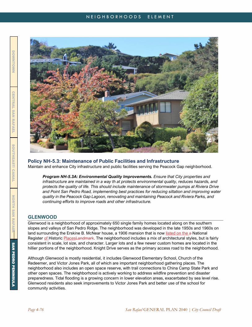
Page 4-76 San Rafael GENERAL PLAN 2040 | City Council Draft
N E I G H B O R H O O D S E L E M E N T
CE
NT
RA
L S
AN
RA
FA
EL
DO
WN
TO
WN
N
OR
TH
SA
N R
AF
AE
L
SO
UT
HE
AS
T/ C
AN
AL
SA
N P
ED
RO
PE
NIN
SU
LA
Policy NH-5.3: Maintenance of Public Facilities and Infrastructure Maintain and enhance City infrastructure and public facilities serving the Peacock Gap neighborhood.
Program NH-5.3A: Environmental Quality Improvements. Ensure that City properties and
infrastructure are maintained in a way th at protects environmental quality, reduces hazards, and
protects the quality of life. This should include maintenance of stormwater pumps at Riviera Drive
and Point San Pedro Road, implementing best practices for reducing siltation and improving water
quality in the Peacock Gap Lagoon, renovating and maintaining Peacock and Riviera Parks, and
continuing efforts to improve roads and other infrastructure.
GLENWOOD Glenwood is a neighborhood of approximately 650 single family homes located along on the southern
slopes and valleys of San Pedro Ridge. The neighborhood was developed in the late 1950s and 1960s on
land surrounding the Erskine B. McNear house, a 1906 mansion that is now listed on the a National
Register of Historic PlacesLandmark. The neighborhood includes a mix of architectural styles, but is fairly
consistent in scale, lot size, and character. Larger lots and a few newer custom homes are located in the
hillier portions of the neighborhood. Knight Drive serves as the primary access road to the neighborhood.
Although Glenwood is mostly residential, it includes Glenwood Elementary School, Church of the
Redeemer, and Victor Jones Park, all of which are important neighborhood gathering places. The
neighborhood also includes an open space reserve, with trail connections to China Camp State Park and
other open spaces. The neighborhood is actively working to address wildfire prevention and disaster
preparedness. Tidal flooding is a growing concern in lower elevation areas, exacerbated by sea level rise.
Glenwood residents also seek improvements to Victor Jones Park and better use of the school for
community activities.

San Rafael GENERAL PLAN 2040 | City Council Draft Page 4-77
N E I G H B O R H O O D S E L E M E N T
CE
NT
RA
L S
AN
RA
FA
EL
DO
WN
TO
WN
N
OR
TH
SA
N R
AF
AE
L
SO
UT
HE
AS
T/ C
AN
AL
SA
N P
ED
RO
PE
NIN
SU
LA
LOCH LOMOND/CANAL NORTH SHORE The Loch Lomond area includes several
neighborhoods along Point San Pedro Road between
Country Club and Bayside Acres, including Loch
Lomond, Loch Lomond Highlands, The Village at Loch
Lomond Marina (including The Strand), and Villa Real.
This area also includes adjacent smaller subdivisions
on the north shore of the San Rafael Canal such as
Harbor Estates, Marina Vista, Porto Bello, Royal Court,
San Pedro Cove, and Seastrand. While each
neighborhood has its own identity, they share common
issues and objectives shaped by their proximity to the
shoreline and hillside open spaces.
The neighborhood is home to the 131-acre Loch
Lomond Marina, one of the largest marinas in the
North Bay. There are 517 berths, including 52
approved for “live-aboards.” Initially established in the
early 1950s, the Marina has been extensively
renovated, including new docks, a public launch ramp,
and a new boardwalk and green along the water’s
edge. The newly reinforced breakwater offers
pedestrian access along the shoreline and striking
views of the Bay, the Richmond-San Rafael Bridge, Mt.
Tamalpais, and the Marin Islands. Restoration of
seasonal wetlands on the site has recently been
completed, with fencing to ensure protection of
wildlife.
In 2007, the City approved a development plan for the
area between the Marina and Point San Pedro Road.
Construction on The Village at Loch Lomond Marina
began in 2013. The neighborhood will ultimately have
81 residential units, including detached residences,
cottages, and townhomes, as well as condominiums in
a mixed-use building to be developed on Loch
Lomond Drive. Andy’s Market has been rebuilt as a
full-service grocery store and re-opened in 2017. The
Village project includes numerous publicly accessible
recreation amenities, all of which were privately
constructed. These are maintained through a
Community Facilities District (CFD), with an annual
assessment levied on property owners within the
boundaries.
The Point San Pedro Road Median:
The Power of Partnerships
The Point San Pedro Road Median
Assessment District is a testament to the
community spirit and creative energy of San
Pedro Peninsula residents. In the early 2010s,
funding to maintain the medians had
evaporated due to the Great Recession,
prompting property owners to organize, fund
raise, and eventually vote to establish a 20-
year special assessment to cover these costs.
The Assessment District was created in 2011
and established a reliable funding source to
plant and maintain 4.5 miles of roadway
median along the length of the Peninsula.
Through a unique partnership with the
City’s Department of Public Works, more
than 245 new trees and thousands of
shrubs were planted and aging irrigation
systems were replaced. The special district
helped finance the project and established a
stable funding source for ongoing
operations and maintenance.

Page 4-78 San Rafael GENERAL PLAN 2040 | City Council Draft
N E I G H B O R H O O D S E L E M E N T
CE
NT
RA
L S
AN
RA
FA
EL
DO
WN
TO
WN
N
OR
TH
SA
N R
AF
AE
L
SO
UT
HE
AS
T/ C
AN
AL
SA
N P
ED
RO
PE
NIN
SU
LA
Beyond Loch Lomond Marina, there are few opportunities for development in the neighborhood. The area
is mostly built out and its vacant sites are constrained by steep slopes, flooding, and access. Ongoing
efforts should be made to maintain infrastructure and roads, reduce fire hazards, address sea level rise,
and ensure the compatibility of new construction with existing development. The community is also
interested in working with San Rafael City Schools to address construction, traffic congestion, safety, and
drainage issues at San Pedro Elementary School.
Policy NH-5.4: Loch Lomond Marina
Maintain and enhance the Loch Lomond Marina and adjacent properties as a community asset, new
neighborhood and commercial center, and gathering place and recreational amenity for the San
Pedro Peninsula. Conditions of approval and provisions of the amended Master Plan for the Village
at Loch Lomond Marina shall be honored as work on the project continues.
Program NH-5.4A: Completion of Village Improvements. Pursue timely completion of the
Village at Loch Lomond Marina project consistent with approved plans, as amended. This
should include:
a) Completion of the remaining residential units and mixed-use building.
b) Construction of the Harbormasters office, boat repair facility, fuel storage and pumping
facility/fuel dock, and reskinning of the yacht club building.
c) Completion of recreational improvements, including a kayak dock and launch ramp and
public access improvements in the center plaza.
d) Flood-related repair work to previously completed areas and further measures to
reduce flooding during peak storm events and king tides.
e) Completion of the pedestrian access path.
f) Off-site road and utility improvements along Point San Pedro Road.
g) Installation of a bird viewing area and interpretive signage.

San Rafael GENERAL PLAN 2040 | City Council Draft Page 4-79
N E I G H B O R H O O D S E L E M E N T
CE
NT
RA
L S
AN
RA
FA
EL
DO
WN
TO
WN
N
OR
TH
SA
N R
AF
AE
L
SO
UT
HE
AS
T/ C
AN
AL
SA
N P
ED
RO
PE
NIN
SU
LA
Program NH-5.4B: Parking and Traffic Studies. Consistent with the conditions of approval,
monitor traffic and parking conditions at Loch Lomond Marina. A traffic and parking study should
be done within one year of completion of the project as required under the permits to determine
the need to retain areas currently reserved for future parking.
Program NH-5.4C: Common Area Maintenance. Continue to maintain publicly-accessible
parks, shoreline areas, and a marina green through a community facilities (Mello-Roos)
district.
Program NH-5.4D: Community Engagement. Continue to engage the community,
including representatives of nearby homeowner and neighborhood associations, in the
review of progress and resolution of issues related to the Village development and Marina
operations.
Program NH-5.4E: Coordination with Regulatory Agencies. Continue coordination of
project- related activities with natural resource agencies, including the Bay Conservation
and Development Commission, the US Fish and Wildlife Service, and other agencies with
responsibility for the Bay and wetland areas.
Policy NH-5.5: Loch Lomond Area and Canal North Shore Neighborhoods Sustain the Loch Lomond and Canal North Shore areas as safe and attractive parts of San Rafael
featuring waterfront and hillside neighborhoods, accessible open space and shoreline areas, and
well-managed roads, infrastructure and public facilities.
Program NH-5.5A: Disaster Preparedness. Continue efforts to improve disaster
preparedness and reduce hazards, including a fire break along the ridgeline above Loch
Lomond Highlands, continued maintenance of storm drainage facilities, and adaptation to
sea level rise along San Rafael Bay and the San Rafael Creek shoreline.
UNINCORPORATED NEIGHBORHOODS
While much of the San Pedro Peninsula was annexed to San Rafael as it was developed, several of
the older neighborhoods—and the San Rafael Rock Quarry—remain unincorporated. Bayside Acres
and Country Club are County “islands” surrounded by the City of San Rafael. Large-scale annexation
of these areas is not anticipated, although individual properties or groups of properties could
potentially be annexed with property owner support. The unincorporated areas also participate in the
Special Tax District funding the upgrade and maintenance of the medians on the roadway and have a
vested interest in their upkeep.
SAN RAFAEL ROCK QUARRY AND MCNEAR BRICKYARD
The San Rafael Rock Quarry and McNear Brickyard remain operational and continue to mine,
manufacture, and transport aggregate, asphalt, brick, and construction materials via truck and
barge to points throughout the San Francisco Bay Area, Sacramento River Delta, and beyond. The
Rock Quarry provides vital infrastructure for the region. An Amended Reclamation Plan for the
Quarry was approved by the County in 2010 after considerable public input. The 2010 Plan calls for
the property to be reclaimed in phases parallel to the completion of mining operations and envisions
its future redevelopment with a harbor and marina along with commercial, residential, neighborhood
commercial, administrative/professional, and open space uses.

Page 4-80 San Rafael GENERAL PLAN 2040 | City Council Draft
N E I G H B O R H O O D S E L E M E N T
CE
NT
RA
L S
AN
RA
FA
EL
DO
WN
TO
WN
N
OR
TH
SA
N R
AF
AE
L
SO
UT
HE
AS
T/ C
AN
AL
SA
N P
ED
RO
PE
NIN
SU
LA
The operator of the Quarry has submitted an application to extend its Reclamation Plan and
operations through 2044 to allow access to rock reserves remaining under the existing Quarry
entitlements. This application has yet to undergo environmental review and approval by the County.
The timing for future activities, including phasing of reclamation, will be assessed as part of the
County review process. In 2004, the Quarry was found by a court to have vested (“grandfathered”)
rights to mine, subject to limits imposed by its operating permit.
Although the Quarry has applied to extend operations beyond the horizon year of this General Plan, it
could potentially cease operation before 2040. Therefore, issues related its future use and development
are addressed in the polices below. The City will also take an active role in environmental review and
restoration plans related to the Quarry and will engage the Quarry operators in emergency preparedness
planning and long-range planning for public access. A planning process for the post-reclamation use of
the site should commence as soon as practical and well before operations conclude.
Policy NH-5.6: San Rafael Rock Quarry Operations Continue to work with the County of Marin, the Quarry operator, and area residents to address
community concerns and minimize impacts of Quarry operations on surrounding residents, including
noise, air quality, vibration, street maintenance, and truck traffic.
Program NH-5.6A: Quarry Impacts. Seek ongoing input into County code enforcement
activities, land use entitlements, and negotiations with Quarry operator that might reduce
impacts on City infrastructure or properties in the City of San Rafael. The City will urge the
County to require support Best Management Practices for Quarry operations, including air
quality testing, water quality monitoring and improvements, and runoff controls that reflect
the latest technology and scientific methods. The City will further promote joint City-County
Ph
oto
Cred
it: Wa
lter Siegm
un
d, 2
00
9. P
oin
tSan
Ped
ro 0
77
98

San Rafael GENERAL PLAN 2040 | City Council Draft Page 4-81
N E I G H B O R H O O D S E L E M E N T
CE
NT
RA
L S
AN
RA
FA
EL
DO
WN
TO
WN
N
OR
TH
SA
N R
AF
AE
L
SO
UT
HE
AS
T/ C
AN
AL
SA
N P
ED
RO
PE
NIN
SU
LA
and Quarry operator efforts to address flooding and sea level rise, pedestrian and bicycle
safety, wetlands restoration, and noise mitigation.
Program NH-5.6B: Environmental Review. If and when the Quarry applies for modifications
to its existing Operating Permit, participate in discussions to ensure that:
a) Potential environmental impacts and hazards are minimized.
b) Public health, safety and quality of life are protected.
c) Traffic and noise impacts are addressed, particularly impacts on Point San Pedro Road.
d) Future costs associated with reclamation, such as long-term environmental restoration
and infrastructure repair, are objectively evaluated and considered in decisions about
future Quarry operations.
e) Collaborate with residents to ensure that any modifications to the existing Operating
Permit remain within the restrictions imposed by existing and future court orders.With
input from residents, confirm that Quarry operations and any proposed Operating Permit
changes do not violate, and are in conformance with, applicable court orders and non-
conforming use restrictions.
Policy NH-5.7: San Rafael Rock Quarry and McNear Brickyard Long-Term Plans If operations cease during the timeframe of this Plan, consider annexation and redevelopment of the
San Rafael Rock Quarry and McNear Brickyard, taking into account the following:
a) Consider the County’s Amended Reclamation Plan, as it may be further amended in the future, in
land use decisions. The current Reclamation Plan supports a mixture of single family
residences, townhomes, and condominium units; a marina; commercial, recreational, hospitality,
and other neighborhood-serving uses; and open space. A revised Reclamation Plan is
anticipated during the timeframe of this General Plan and could alter the planned post-mining
uses. Specific future uses would be determined through a separate entitlement process that
would potentially include annexation into the City.
b) Consider redevelopment of the site to the extent that traffic capacity is available and the project
can meet the City’s transportation standards, including performance of intersections between
the site and US 101. Alternative modes of transportation may be considered to facilitate
compliance with City standards. Water transit (including water taxis and potential ferry service)
should be considered in any phase of the project and factored into the transportation analysis.
c) If needed for traffic capacity and to the extent consistent with City traffic standards, Point San
Pedro Road should be expanded to four lanes east of Riviera Drive, including traffic calming
measures and bicycle lanes consistent with the Bicycle and Pedestrian Master Plan.
d) Create a public use park band along the existing shoreline averaging at least 100 feet in width
linking McNears Beach with the public walkway along Point San Pedro Road, as approved by
the Bay Conservation and Development Commission.
e) Consider opportunities for multi-use community facilities serving residents of the San Pedro
Peninsula and beyond, such as a center for the arts, education, and the environment.
f) Protect and enhance the freshwater marsh and ponds, taking sea level rise impacts into
consideration. Consider some degree of tidal action in the restoration of the saltwater marsh as
options for both habitat improvement and potential sea level rise mitigation as part of a larger
adaptation plan restoring the saltwater marsh to tidal action.
g) Preserve and gradually restore tree species native to the site’s woodland areas.
h) Incorporate some of the historic brickyard into the project’s design.
i) Consider redevelopment of the site in phases as reclamation is completed in specific areas. The
McNear Brickyard would likely be the first phase and would require a site access road from
Point San Pedro Road that is separate from the road accessing the mining and asphalt

Page 4-82 San Rafael GENERAL PLAN 2040 | City Council Draft
N E I G H B O R H O O D S E L E M E N T
CE
NT
RA
L S
AN
RA
FA
EL
DO
WN
TO
WN
N
OR
TH
SA
N R
AF
AE
L
SO
UT
HE
AS
T/ C
AN
AL
SA
N P
ED
RO
PE
NIN
SU
LA
operations. Phased redevelopment would require amendments to the existing Quarry
entitlements to be approved by the County in coordination with the property owner.
Program NH-5.7A: Quarry Planning. Participate, through the County of Marin, in any
revisions to the San Rafael Rock Quarry Reclamation Plan, which should form the basis for
decisions about future land uses and possible annexation.
Program NH-5.7B: Shoreline Use. Use the development review process to establish a bay
frontage linear park that connects McNear Beach to the existing shoreline walkway along
Point San Pedro Road. The park should incorporate sea level rise adaptation measures.
BAYSIDE ACRES
Bayside Acres is one of the oldest neighborhoods on the Peninsula. It includes about 100 homes on
the inland (hill) side of Point San Pedro Road and 65 homes on the bay side. Homes on the hill side
have a semi-rural quality and are located are on larger lots accessed by narrow winding streets.
Homes on the bay side are on smaller lots, many with waterfront access. This area includes Chicken
Point, which was once a small island surrounded by marshes. Saltwater marshland remains along
Beach Drive today.
No land use changes are envisioned in Bayside Acres during the timeframe of General Plan 2040. The
City will work with the County and neighborhood residents to address local issues, including sea level
rise adaptation and wildfire hazard reduction. The community has expressed interest in installing a
back-up generator at the Beach Drive pump station, reducing sedimentation of the inlet between
Bayside Acres and Loch Lomond Marina, and continuing efforts to mitigate noise and traffic from the
Rock Quarry.
COUNTRY CLUB
Country Club is the largest of the unincorporated pockets surrounded by the City of San Rafael,
encompassing roughly 300 acres. While most of the neighborhood consists of larger lots on hillside
sites, the area also includes a portion of the Lowrie’s Yacht Harbor and nearby suburban development
closer to Point San Pedro Road. Almost all of the lots in the community are developed. No land use
changes are anticipated during the timeframe of General Plan 2040. Residents share the same
concerns as those in nearby City neighborhoods regarding wildfire and landslide hazards, sea level rise
and flooding, and traffic congestion along Point San Pedro as it transitions to Third Street.
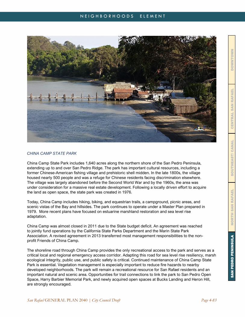
San Rafael GENERAL PLAN 2040 | City Council Draft Page 4-83
N E I G H B O R H O O D S E L E M E N T
CE
NT
RA
L S
AN
RA
FA
EL
DO
WN
TO
WN
N
OR
TH
SA
N R
AF
AE
L
SO
UT
HE
AS
T/ C
AN
AL
SA
N P
ED
RO
PE
NIN
SU
LA
CHINA CAMP STATE PARK
China Camp State Park includes 1,640 acres along the northern shore of the San Pedro Peninsula,
extending up to and over San Pedro Ridge. The park has important cultural resources, including a
former Chinese-American fishing village and prehistoric shell midden. In the late 1800s, the village
housed nearly 500 people and was a refuge for Chinese residents facing discrimination elsewhere.
The village was largely abandoned before the Second World War and by the 1960s, the area was
under consideration for a massive real estate development. Following a locally driven effort to acquire
the land as open space, the state park was created in 1976.
Today, China Camp includes hiking, biking, and equestrian trails, a campground, picnic areas, and
scenic vistas of the Bay and hillsides. The park continues to operate under a Master Plan prepared in
1979. More recent plans have focused on estuarine marshland restoration and sea level rise
adaptation.
China Camp was almost closed in 2011 due to the State budget deficit. An agreement was reached
to jointly fund operations by the California State Parks Department and the Marin State Park
Association. A revised agreement in 2013 transferred most management responsibilities to the non-
profit Friends of China Camp.
The shoreline road through China Camp provides the only recreational access to the park and serves as a
critical local and regional emergency access corridor. Adapting this road for sea level rise resiliency, marsh
ecological integrity, public use, and public safety is critical. Continued maintenance of China Camp State
Park is essential. Vegetation management is especially important to reduce fire hazards to nearby
developed neighborhoods. The park will remain a recreational resource for San Rafael residents and an
important natural and scenic area. Opportunities for trail connections to link the park to San Pedro Open
Space, Harry Barbier Memorial Park, and newly acquired open spaces at Bucks Landing and Heron Hill,
are strongly encouraged.

Page 4-84 San Rafael GENERAL PLAN 2040 | City Council Draft
N E I G H B O R H O O D S E L E M E N T
This page intentionally blank.