41-43 town centre, hatfield, al10 0jj sustainable urban
TRANSCRIPT

G:\My Drive\Projects\190303_Hatfield Student Accomodation\190303_41-43 Town Centre Hatfield_SUDS Analysis.docx
41-43 Town Centre, Hatfield, AL10 0JJ
SUSTAINABLE URBAN DRAINAGE SYSTEM ANALYSIS
41-43 Town Centre, Hatfield, AL10 0JJ
SHA Environmental 69 Preston Manor Road
Tadworth
Surrey
KT20 5FB
www.SHAenvironmental.co.uk
0203 6370427

G:\My Drive\Projects\190303_Hatfield Student Accomodation\190303_41-43 Town Centre Hatfield_SUDS Analysis.docx
41-43 Town Centre, Hatfield, AL10 0JJ
DOCUMENT CONTROL
PRODUCED BY REVIEWED BY ISSUED BY DATE
Dion Mellows Charlotte Mellows Dion Mellows 23.04.2019
VERSION STATUS
1.0 Planning Issue

G:\My Drive\Projects\190303_Hatfield Student Accomodation\190303_41-43 Town Centre Hatfield_SUDS Analysis.docx
41-43 Town Centre, Hatfield, AL10 0JJ
CONTENTS
CONTENTS .................................................................................................................................................................. 1
1. EXECUTIVE SUMMARY ....................................................................................................................................... 2
2. Introduction ....................................................................................................................................................... 3
2.1 Site Location and Description ............................................................................................................................ 3
3. STATUTORY REGULATIONS AND TARGETS ........................................................................................................ 5
3.1 National Planning Policy Framework Pollution Prevention Guidelines ............................................................. 5
3.1.1 Peak Flow Control Policy S3 Requirements ....................................................................................... 5
3.1.1.1 Response: ........................................................................................................................................... 5
3.1.2 Volume control Policy S5 Requirements ............................................................................................ 5
3.1.2.1 Response: ........................................................................................................................................... 5
3.2 Flood risk within the development .................................................................................................................... 5
3.2.1 Policy S7 Requirements ...................................................................................................................... 5
3.2.1.1 Response: ........................................................................................................................................... 5
3.2.2 Policy S8 Requirements ...................................................................................................................... 5
3.2.2.1 Response: ........................................................................................................................................... 5
3.2.3 Policy S9 Requirements ...................................................................................................................... 5
3.2.3.1 Response: ........................................................................................................................................... 5
3.3 Land Drainage Act and Local Bylaws .................................................................................................................. 5
4. Methodology ...................................................................................................................................................... 6
4.1 Treatment of run-off .......................................................................................................................................... 6
4.2 Hydrological Input Data ..................................................................................................................................... 6
5. Surface water run-off analysis ........................................................................................................................... 7
5.1 Existing surface water disposal strategy ............................................................................................................ 7
5.2 Estimation of existing peak run-off rate ............................................................................................................ 7
5.1 Proposed surface water disposal strategy ......................................................................................................... 7
6. Flood Risk ......................................................................................................................................................... 10
7. References ....................................................................................................................................................... 11
8. Appendix I_Thames Water Sewer Flooding Report ......................................................................................... 12
9. Thames Water_Commercial Drainage Report ................................................................................................. 13
10. Thames Water Assest Location Search ........................................................................................................ 14

47

47

G:\My Drive\Projects\190303_Hatfield Student Accomodation\190303_41-43 Town Centre Hatfield_SUDS Analysis.docx
41-43 Town Centre, Hatfield, AL10 0JJ
Figure 4 Google Map showing local bus stops
The development site also benefits from being with 1 mile of Hatfield train station which take 15 minutes walking from the Site.

G:\My Drive\Projects\190303_Hatfield Student Accomodation\190303_41-43 Town Centre Hatfield_SUDS Analysis.docx
41-43 Town Centre, Hatfield, AL10 0JJ
3. STATUTORY REGULATIONS AND TARGETS
3.1 NATIONAL PLANNING POLICY FRAMEWORK POLLUTION PREVENTION GUIDELINES
3.1.1 PEAK FLOW CONTROL POLICY S3 REQUIREMENTS
For developments which were previously developed, the peak runoff rate from the development to any drain, sewer or surface water body for the 1 in 1 year rainfall event and the 1 in 100 year rainfall event should be as close as reasonably practicable to the greenfield runoff rate from the development for the same rainfall event, but should never exceed the rate of discharge from the development prior to redevelopment for that event.
3.1.1.1 RESPONSE:
There is no increase in impermeable are of the site because of the development. Therefore, there is no increase in the surface water run-off from the site for any modelled scenario.
3.1.2 VOLUME CONTROL POLICY S5 REQUIREMENTS
Where reasonably practicable, for developments which have been previously developed, the runoff volume from the development to any highway drain, sewer or surface water body in the 1 in 100 year, 6 hour rainfall event must be constrained to a value as close as is reasonably practicable to the greenfield runoff volume for the same event, but should never exceed the runoff volume from the development site prior to redevelopment for that event.
3.1.2.1 RESPONSE:
There is no increase in impermeable are of the site because of the development. Therefore, there is no increase in the surface water run-off from the site for any modelled scenario.
3.2 FLOOD RISK WITHIN THE DEVELOPMENT
3.2.1 POLICY S7 REQUIREMENTS
The drainage system must be designed so that, unless an area is designated to hold and/or convey water as part of the design, flooding does not occur on any part of the site for a 1 in 30-year rainfall event.
3.2.1.1 RESPONSE:
The development proposals do not include any water storage as part of the SuDS strategy for the development due to no increase in impermeable area as part of the development proposals.
3.2.2 POLICY S8 REQUIREMENTS
The drainage system must be designed so that, unless an area is designated to hold and/or convey water as part of the design, flooding does not occur during a 1 in 100-year rainfall event in any part of: a building (including a basement) or in any utility plant susceptible to water (e.g. pumping station or electricity substation within the development.
3.2.2.1 RESPONSE:
The proposals are to utilise the existing combined drainage on the site as the system has been designed to support
the flows from the development. Appendix I confirms that there have been no instances of sewer water flooding in
the area.
3.2.3 POLICY S9 REQUIREMENTS
The design of the site must ensure that so far as is reasonably practicable, flows resulting from rainfall in excess of a 1 in 100-year rainfall event are managed in exceedance routes that minimise the risks to people and property.
3.2.3.1 RESPONSE:
The development is proposing to utilise the existing drainage infrastructure for the proposed development. The network has not experienced any flooding as confirmed in the Sewer flooding report provided in Appendix I.
3.3 LAND DRAINAGE ACT AND LOCAL BYLAWS
Land Drainage Act or Bylaw Consent will be required to carry out any work on or adjacent to, and for any
discharge into, any watercourse or sewer on the development site.
Landowners have the primary responsibility for safeguarding their land and other property against
flooding. Riparian owners have the responsibility of maintenance of the watercourse which bound their
property. Individual property owners and users are also responsible for managing the drainage of their
land so that they do not adversely impact neighbouring land.
G:\My Drive\Projects\190303_Hatfield Student Accomodation\190303_41-43 Town Centre Hatfield_SUDS Analysis.docx
41-43 Town Centre, Hatfield, AL10 0JJ
4. METHODOLOGY
The ‘Infiltration volume estimation’ tool on the website www.uksuds.com has been used to estimate the depth of storage required for the bio-retention area. The tool has also been used to calculate the greenfield rate run-off equivalent with a soil HOST class of 5 which is the most representative of an impermeable soil type and is therefore the most suitable for this development. This has then been compared with the as proposed development with the comparison between the two compared. The tool applies the method defined originally established in the report Infiltration Drainage (CIRIA report R156, 1996), which is restated in the SuDS Manual C753. Whilst the tool is widely used across the UK for exactly this purpose, the analysis using this tool should be regarded as providing an approximate volume which should theoretically be checked using more accurate design tools before construction of the drainage system proceeds. This will be achieved through correspondence with the systems manufacturers.
4.1 TREATMENT OF RUN-OFF
With Reference to Table 4.3 of the SuDS Manual[2], Domestic Roofs require the removal of gross solids
and sediments. With Reference to Table 26.2 of the SuDS Manual[2], pollution hazard indices for:
• Domestic Roofs are 0.2 (TSS), 0.2 Metals & 0.05 Hydrocarbons (there are no commercial activities
on the site that would require a higher level of treatment than a domestic roof).
4.2 HYDROLOGICAL INPUT DATA
G:\My Drive\Projects\190303_Hatfield Student Accomodation\190303_41-43 Town Centre Hatfield_SUDS Analysis.docx
41-43 Town Centre, Hatfield, AL10 0JJ
5. SURFACE WATER RUN-OFF ANALYSIS
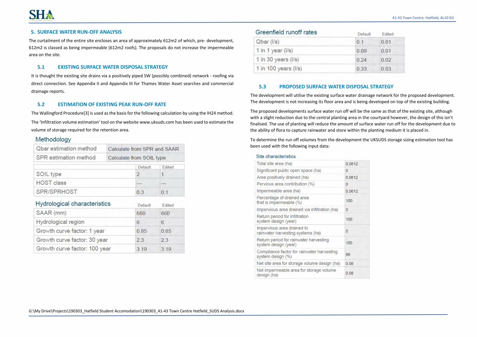
The curtailment of the entire site encloses an area of approximately 612m2 of which, pre- development,
612m2 is classed as being impermeable (612m2 roofs). The proposals do not increase the impermeable
area on the site.
5.1 EXISTING SURFACE WATER DISPOSAL STRATEGY
It is thought the existing site drains via a positively piped SW (possibly combined) network - roofing via
direct connection. See Appendix II and Appendix III for Thames Water Asset searches and commercial
drainage reports.
5.2 ESTIMATION OF EXISTING PEAK RUN-OFF RATE
The Wallingford Procedure[3] is used as the basis for the following calculation by using the IH24 method.
The ‘Infiltration volume estimation’ tool on the website www.uksuds.com has been used to estimate the
volume of storage required for the retention area.
5.3 PROPOSED SURFACE WATER DISPOSAL STRATEGY
The development will utilise the existing surface water drainage network for the proposed development.
The development is not increasing its floor area and is being developed on top of the existing building.
The proposed developments surface water run off will be the same as that of the existing site, although
with a slight reduction due to the central planting area in the courtyard however, the design of this isn’t
finalised. The use of planting will reduce the amount of surface water run off for the development due to
the ability of flora to capture rainwater and store within the planting medium it is placed in.
To determine the run off volumes from the development the UKSUDS storage sizing estimation tool has
been used with the following input data:

G:\My Drive\Projects\190303_Hatfield Student Accomodation\190303_41-43 Town Centre Hatfield_SUDS Analysis.docx
41-43 Town Centre, Hatfield, AL10 0JJ
The discharge rates and volumes for the development are provided below. The discharge rate has been
set at 5l/s to ensure that there is sufficient flow through the system to prevent blockages. The data in the
following pages presents the storage volumes calculated using the Wallingford procedure shows that the
post development volume of run-off for a 1 in 100-year 6-hour storm event to be 46.3m3
Site values used in design: - Total site area = 0.0521 ha Climate change factor = 30% Pre-dev area drained = 0.0521 ha Post-dev area drained = 0.0521 ha Imperm runoff factor = 98% Perm runoff factor = 20%
Pre-development Area to soakaways
=
0.0000
ha
Area to
other SUDS
=
0.0000 ha
Perv. area to SUDS = 0.0000 ha Pre-dev flow to drain = 0.00 l/s Post-development Area to soakaways
=
0.0000
ha
Area to
other SUDS
=
0.0000 ha
Perv. area to SUDS = 0.0000 ha Post-dev flow to drain = 0.00 l/s
Calculations: -
Revised Post-dev Imperm. area = 0.052 ha Equiv. Post-dev Imperm. area = 0.051 ha Equiv. Post-dev Perm. area = 0.000 ha Total Pre-dev equiv. area ha = 0.051 ha Total Post-dev equiv. area ha = 0.051 ha
100 yr 6 hour mean intensity = 9.90mm/hr
Results: - Pre-dev peakflow runoff (l/s) (m³/s)
R.P. 15 30 60 120 240 360 480 600 Max CCF Final R.P. 1 17.9 11.7 7.1 4.3 2.6 2.0 1.6 1.3 17.9 N/A 17.9 1
30 43.8 27.9 17.0 10.1 5.9 4.2 3.4 2.8 43.8 N/A 43.8 30 100 56.9 36.6 22.4 13.3 7.7 5.5 4.4 3.6 56.9 N/A 56.9 100
Post-dev peakflow runoff (l/s) R.P. 15 30 60 120 240 360 480 600 Max CCF Final R.P. 1 17.9 11.7 7.1 4.3 2.6 2.0 1.6 1.3 17.9 30 23.3 1
30 43.8 27.9 17.0 10.1 5.9 4.2 3.4 2.8 43.8 30 56.9 30 100 56.9 36.6 22.4 13.3 7.7 5.5 4.4 3.6 56.9 30 73.9 100

G:\My Drive\Projects\190303_Hatfield Student Accomodation\190303_41-43 Town Centre Hatfield_SUDS Analysis.docx
41-43 Town Centre, Hatfield, AL10 0JJ
100-year 6-hour (x Climate Change Factor) storm gives: -
Pre-dev runoff volume m³ = 30.3m³ Post-dev rainfall volume = 39.4m³ Post-dev volume m³ (excess above SUDS) = 39.4m³
100 yr 6 hour mean intensity = 9.90mm/hr Pre-dev volume to drain at 0 l/s = 0.0 m³ Post-dev volume to drain at 0 l/s = 0.0 m³ Post-dev storage volume = 39.4m³
Post-dev 5mm imperm volume = 2.6 m³ Post-dev 5mm perm volume = 0.0 m³
QBAR(rural) = 0.087 l/s or 1.671 l/s/ha or 0.000 cumecs - from IoH 124
Peak runoff: - Pre-development 1-year storm (15min) = 21.1 l/s [ 6A] Pre-development 100-year storm (15min) = 66.8 l/s [6C] Post-development 1-year storm (15min) = 21.1 l/s [6B]
Post-development 100-year storm (15min) = 66.78 l/s [6D]
Greenfield runoff: -
QBAR(rural) = 0.102 l/s or 1.671 l/s/ha or 0.000 cumecs - from IoH 124.
Climate change factor: - CCF = 30%
Volumes: -
Pre-development 100 yr/6hr storm [12A] = 39.4m³
Post-development 100 yr/6hr storm (add. volume with no SUDS) [12B] = 39.4m³ Post-development 100 yr/6hr storm (add. volume with SUDS) = 39.4m³ Post-development add. predicted volume (No SUDS) [12C] = 0.0m³
Definitions and method
Hydrology
The hydrological constants are derived from the Wallingford maps. They are used to calculate location specific rainfall figures.
Site values and factors
Areas of the site should be entered in hectares (10000 m²). If the Pre-development site is a green field, this box is blank.
Climate Change Factor is initially set at 20% - this may be changed as required. Greenfield runoff is calculated using the method described in IoH 124.
Runoff factors
The impermeable runoff factor is initially set at 98% The permeable runoff factor is initially set at 20%
Note: the CCF and the runoff factors may be changed by the user to suit the development The areas draining to soakaways and other SUDS are entered in the appropriate box (in hectares)
Calculations
The post-development area is reduced by subtracting the areas that drain to soakaways or other SUDS, to give a revised figure.
All areas are then multiplied by the appropriate runoff factor to give an equivalent area with 100% runoff. These are then summated.
This gives a total pre-development equivalent area, and a similar figure for the post-development area. The 'Post-dev volume to drain (no SUDS)' gives the total runoff to drain if no SUDS were used.
Results
The pre- and post-development areas are subjected to 1,30 and 100-year return period storms with a duration of 15 to 600 minutes.
The Revised Post-dev Imperm. area is the area (in ha) that is not going to SUDS x impervious runoff factor.
The runoff rates are calculated for the chosen hydrograph (Summer or Winter) as l/s. Figures in red indicate m³/s the peak value is measured, multiplied by the CCF and the total maximum rate is shown.
The pre- and post-development volumes for a 100 year / 6-hour storm is calculated from the area under the hydrograph curve.
Post-dev volume (i.e. excess above SUDS) is that volume produced by the drained area that does not go to SUDS. Qbar(rural) is calculated in accordance with the procedure laid down in IoH 124

G:\My Drive\Projects\190303_Hatfield Student Accomodation\190303_41-43 Town Centre Hatfield_SUDS Analysis.docx
41-43 Town Centre, Hatfield, AL10 0JJ
6. FLOOD RISK
The following flood map obtained from the Environment Agency confirms that the development is not at risk of
flooding.

G:\My Drive\Projects\190303_Hatfield Student Accomodation\190303_41-43 Town Centre Hatfield_SUDS Analysis.docx
41-43 Town Centre, Hatfield, AL10 0JJ
7. REFERENCES
[1] Anon. Code of practice for Foundations. Technical Report BS8004:1986, BSi, 1986.
[2] CIRIA. The SUDS manual. Technical report, CIRIA, 2015.
[3] H R Wallingford, Howbery Park, Wallingford, Oxfordshire. The Wallingford Procedure, volume 1
edition, 1981.
[4] C Hassell and B Coombes. Green roofs. Technical report, CIBSE, 2007.

G:\My Drive\Projects\190303_Hatfield Student Accomodation\190303_41-43 Town Centre Hatfield_SUDS Analysis.docx
41-43 Town Centre, Hatfield, AL10 0JJ
8. APPENDIX I_THAMES WATER SEWER FLOODING REPORT

Page 1 of 3
Search address supplied 41-43
41 Town Centre Hatfield AL10 0JJ
Your reference 171201 Our reference SFH/SFH Standard/2018_3730219 Received date 30 January 2018 Search date 30 January 2018
SHA Environmental
Thames Water Utilities Ltd Property Searches, PO Box 3189, Slough SL1 4WW DX 151280 Slough 13
[email protected] www.thameswater-propertysearches.co.uk 0845 070 9148

Page 2 of 3
Search address supplied: 41-43,41,Town Centre,Hatfield,AL10 0JJ This search is recommended to check for any sewer flooding in a specific address or area TWUL, trading as Property Searches, are responsible in respect of the following:- (i) any negligent or incorrect entry in the records searched; (ii) any negligent or incorrect interpretation of the records searched; (iii) and any negligent or incorrect recording of that interpretation in the search
report (iv) compensation payments
Thames Water Utilities Ltd Property Searches, PO Box 3189, Slough SL1 4WW DX 151280 Slough 13
[email protected] www.thameswater-propertysearches.co.uk 0845 070 9148

Page 3 of 3
History of Sewer Flooding
Is the requested address or area at risk of flooding due to overloaded public sewers?
The flooding records held by Thames Water indicate that there have been no incidents of flooding in the requested area as a result of surcharging public sewers.
For your guidance: • A sewer is “overloaded” when the flow from a storm is unable to pass
through it due to a permanent problem (e.g. flat gradient, small diameter). Flooding as a result of temporary problems such as blockages, siltation, collapses and equipment or operational failures are excluded.
• “Internal flooding” from public sewers is defined as flooding, which enters a building or passes below a suspended floor. For reporting purposes, buildings are restricted to those normally occupied and used for residential, public, commercial, business or industrial purposes.
• “At Risk” properties are those that the water company is required to include in the Regulatory Register that is presented annually to the Director General of Water Services. These are defined as properties that have suffered, or are likely to suffer, internal flooding from public foul, combined or surface water sewers due to overloading of the sewerage system more frequently than the relevant reference period (either once or twice in ten years) as determined by the Company’s reporting procedure.
• Flooding as a result of storm events proven to be exceptional and beyond the reference period of one in ten years are not included on the At Risk Register.
• Properties may be at risk of flooding but not included on the Register where flooding incidents have not been reported to the Company.
• Public Sewers are defined as those for which the Company holds statutory responsibility under the Water Industry Act 1991.
• It should be noted that flooding can occur from private sewers and drains which are not the responsibility of the Company. This report excludes flooding from private sewers and drains and the Company makes no comment upon this matter.
• For further information please contact Thames Water on Tel: 0800 316 9800 or website www.thameswater.co.uk
Thames Water Utilities Ltd Property Searches, PO Box 3189, Slough SL1 4WW DX 151280 Slough 13
[email protected] www.thameswater-propertysearches.co.uk 0845 070 9148

G:\My Drive\Projects\190303_Hatfield Student Accomodation\190303_41-43 Town Centre Hatfield_SUDS Analysis.docx
41-43 Town Centre, Hatfield, AL10 0JJ
9. APPENDIX II_THAMES WATER COMMERCIAL DRAINAGE REPORT

Thames Water Utilities Ltd Property Searches, PO Box 3189, Slough SL1 4WW DX 151280 Slough 13
[email protected] www.thameswater-propertysearches.co.uk 0845 070 9148
Your reference 171201 Our reference CDWS/CDWS Standard/2018_3730575 Received date 31 January 2018 Search date 1 February 2018
SHA Environmental 69, preston manner road tadworth KT20 5FB
Search address supplied Old Tesco Store, 41-43, Town Centre, Hatfield, AL10 0JJ
Keeping you up-to-date Identifying the status associated with drainage and water is a vital part of commercial property conveyancing. To get the most comprehensive view surrounding drainage and water, it is important to obtain an official search. A CommercialDW Drainage & Water Enquiry will:
• Confirm to the buyer that a property is connected to the mains supply and mains drainage • Bring to light any potential risk of internal sewer flooding • Provide information about trade effluent consent licenses and invert and cover levels • Find out if wayleaves and easements affect the property/site, and • Offer £2 million, £5 million, or £10 million of indemnity against any potential risks.

CommercialDWDrainage & Water Enquiry
Thames Water Utilities Ltd, Property Searches, PO Box 3189, Slough SL1 4W, DX 151280 Slough 13
T 0845 070 9148 E [email protected] I www.thameswater-propertysearches.co.uk
Page 2 of 26
Question Summary Answer
Maps, Wayleaves, Easements, Manhole Cover and Invert levels
1.1 Where relevant, please include a copy of an extract from the public sewer map. Map Provided _______________________________________________________________________________________________________________________________________________________________________________________________________________________
1.2 Where relevant, please include a copy of an extract from the map of waterworks. Map Provided _______________________________________________________________________________________________________________________________________________________________________________________________________________________
1.3 Is there a wayleave/easement agreement giving Thames Water the right to lay or maintain assets or right of access to pass through private land in order to reach the Company’s assets? No _______________________________________________________________________________________________________________________________________________________________________________________________________________________
1.4 On the copy extract from the public sewer map, please show manhole cover, depth and invert levels where the information is available. See Details
_______________________________________________________________________________________________________________________________________________________________________________________________________________________
Drainage
2.1 Does foul water from the property drain to a public sewer? Connected _______________________________________________________________________________________________________________________________________________________________________________________________________________________
2.2 Does surface water from the property drain to a public sewer? Connected _______________________________________________________________________________________________________________________________________________________________________________________________________________________
2.3 Is a surface water drainage charge payable? See Details _______________________________________________________________________________________________________________________________________________________________________________________________________________________
2.4 Does the public sewer map indicate any public sewer, disposal main or lateral drain within the boundaries of the property? Yes
_______________________________________________________________________________________________________________________________________________________________________________________________________________________
2.4.1 Does the public sewer map indicate any public pumping station or any other ancillary apparatus within the boundaries of the property? No _______________________________________________________________________________________________________________________________________________________________________________________________________________________
2.5 Does the public sewer map indicate any public sewer within 30.48 metres (100 feet) of any buildings within the property? Yes
_______________________________________________________________________________________________________________________________________________________________________________________________________________________
2.5.1 Does the public sewer map indicate any public pumping station or any other ancillary apparatus within the 50metres of any buildings within the property? No
_______________________________________________________________________________________________________________________________________________________________________________________________________________________
2.6 Are any sewers or lateral drains serving, or which are proposed to serve the property, the subject of an existing adoption agreement or an application for such an agreement? No
_______________________________________________________________________________________________________________________________________________________________________________________________________________________
2.7 Has a sewerage undertaker approved or been consulted about any plans to erect a building or extension on the property over or in the vicinity of a public sewer, disposal main or drain? No
_______________________________________________________________________________________________________________________________________________________________________________________________________________________
2.8 Is the building which is or forms part of the property, at risk of internal flooding due to overloaded public sewers? Not At Risk
_______________________________________________________________________________________________________________________________________________________________________________________________________________________
2.9 Please state the distance from the property to the nearest boundary of the nearest sewage treatment works. 2.373 Kilometres
_______________________________________________________________________________________________________________________________________________________________________________________________________________________
Water
3.1 Is the property connected to mains water supply? Connected _______________________________________________________________________________________________________________________________________________________________________________________________________________________
3.2 Are there any water mains, resource mains or discharge pipes within the boundaries of the property? No
_______________________________________________________________________________________________________________________________________________________________________________________________________________________
3.3 Is any water main or service pipe serving or which is proposed to serve the property, the subject of an existing adoption agreement or an application for such an agreement? No
_______________________________________________________________________________________________________________________________________________________________________________________________________________________
3.4 Is the property at risk of receiving low water pressure or flow? No _______________________________________________________________________________________________________________________________________________________________________________________________________________________
3.5 What is the classification of the water supply for the property? Very Hard _______________________________________________________________________________________________________________________________________________________________________________________________________________________
3.6 Please include details of the location of any water meter serving the property. See Details
_______________________________________________________________________________________________________________________________________________________________________________________________________________________

CommercialDWDrainage & Water Enquiry
Thames Water Utilities Ltd, Property Searches, PO Box 3189, Slough SL1 4W, DX 151280 Slough 13
T 0845 070 9148 E [email protected] I www.thameswater-propertysearches.co.uk
Page 3 of 26
Question Summary Answer Charging
4.1.1 Who are the sewerage undertakers for the area? Thames Water _______________________________________________________________________________________________________________________________________________________________________________________________________________________
4.1.2 Who are the water undertakers for the area? Affinity Water _______________________________________________________________________________________________________________________________________________________________________________________________________________________
4.2 Who bills the property for sewerage services? See Details _______________________________________________________________________________________________________________________________________________________________________________________________________________________
4.3 Who bills the property for water services? See Details ______________________________________________________________________________________________________________________________________________________________________________________________________________________
4.4 Is there a meter installed at this property? Yes _______________________________________________________________________________________________________________________________________________________________________________________________________________________
4.5 Are there any trade effluent consents relating to this site/property for disposal of chemically enhanced waste? No
_______________________________________________________________________________________________________________________________________________________________________________________________________________________

CommercialDWDrainage & Water Enquiry
Search address supplied: Old Tesco Store, 41-43, Town Centre, Hatfield, AL10 0JJ Any new owner or occupier will need to contact Thames Water on 0800 316 9800 or log onto our website www.thameswater.co.uk and complete our online form to change the water and drainage services bills to their name. The following records were searched in compiling this report: - the map of public sewers, the map of waterworks, water and sewer billing records, adoption of public sewer records, building over public sewer records, the register of properties subject to internal foul flooding, the register of properties subject to poor water pressure and the drinking water register. Thames Water Utilities Ltd (TWUL) holds all of these. TWUL, trading as Property Searches, are responsible in respect of the following:- (i) any negligent or incorrect entry in the records searched (ii) any negligent or incorrect interpretation of the records searched (iii) any negligent or incorrect recording of that interpretation in the search report (iv) and compensation payments Please refer to the attached Terms & Conditions. Customers and clients are asked to note these terms, which govern the basis on which this Commercial Drainage and Water search is supplied.
Thames Water Property Searches is an Executive member of CoPSO (Council of Property Search Organisations).

CommercialDWDrainage & Water Enquiry
Thames Water Utilities Ltd, Property Searches, PO Box 3189, Slough SL1 4W, DX 151280 Slough 13
T 0845 070 9148 E [email protected] I www.thameswater-propertysearches.co.uk
Page 5 of 26
Maps, Wayleaves, Easements, Manhole Cover and Invert levels 1.1 Where relevant, please include a copy of an extract from the public sewer map.
A copy of an extract of the public sewer map is included, showing the public sewers, disposal mains and lateral drains in the vicinity of the property.
1.2 Where relevant, please include a copy of an extract from the map of waterworks.
A copy of an extract from the map of waterworks is included in which the location of the property is identified.
1.3 Wayleaves & Easements
Is there a wayleave/easement agreement giving Thames Water the right to lay or maintain assets or right of access to pass through private land in order to reach the Company’s assets?
No.
1.4 Manhole
On the copy extract from the public sewer map, please show manhole cover, depth and invert levels where the information is available. Details of any manhole cover and invert levels applicable to this site are enclosed.
Drainage 2.1 Does foul water from the property drain to a public sewer?
Records indicate that foul water from the property drains to a public sewer. 2.2 Does surface water from the property drain to a public sewer?
Records indicate that surface water from the property drains to a public sewer. 2.3 Is a surface water drainage charge payable?
Records indicate that a surface water charge is applicable at this property.

CommercialDWDrainage & Water Enquiry
Thames Water Utilities Ltd, Property Searches, PO Box 3189, Slough SL1 4W, DX 151280 Slough 13
T 0845 070 9148 E [email protected] I www.thameswater-propertysearches.co.uk
Page 6 of 26
2.4 Does the public sewer map indicate any public sewer, disposal main or lateral drain within the boundary of the property?
The public sewer map included indicates that there is a public sewer, disposal main or lateral drain within the boundaries of the property. However, from the 1st October 2011 there may be additional public sewers, disposal mains or lateral drains which are not recorded on the public sewer map but which may further prevent or restrict development of the property.
2.4.1 Does the public sewer map indicate any public pumping station or any other ancillary apparatus within the boundaries of the property?
The public sewer map included indicates that there is no public pumping station within the boundaries of the property.
2.5 Does the public sewer map indicate any public sewer within 30.48 metres (100 feet) of
any buildings within the property?
The public sewer map included indicates that there is a public sewer within 30.48 metres (100 feet) of a building within the property.
2.5.1 Does the public sewer map indicate any public pumping station or any other ancillary apparatus within 50 metres of any buildings within the property?
The public sewer map included indicates that there is no public pumping station within 50 metres of any buildings within the property.
2.6 Are any sewers or lateral drains serving, or which are proposed to serve, the property
the subject of an existing adoption agreement or an application for such an agreement?
Records confirm that Foul sewers serving the development, of which the property forms part are not the subject of an existing adoption agreement or an application for such an agreement. The Surface Water sewer(s) and/or Surface Water lateral drain(s) are not the subject of an adoption agreement.
2.7 Has a sewerage undertaker approved or been consulted about any plans to erect a
building or extension on the property over or in the vicinity of a public sewer, disposal main or drain?
There are no records in relation to any approval or consultation about plans to erect a building or extension on the property over or in the vicinity of a public sewer, disposal main or drain. However, the sewerage undertaker might not be aware of a building or extension on the property over or in the vicinity of a public sewer, disposal main or drain.

CommercialDWDrainage & Water Enquiry
Thames Water Utilities Ltd, Property Searches, PO Box 3189, Slough SL1 4W, DX 151280 Slough 13
T 0845 070 9148 E [email protected] I www.thameswater-propertysearches.co.uk
Page 7 of 26
2.8 Is the building which is or forms part of the property, at risk of internal flooding due to overloaded public sewers?
The property is not recorded as being at risk of internal flooding due to overloaded public sewers. From the 1st October 2011 most private sewers, disposal mains and lateral drains were transferred into public ownership It is therefore possible that a property may be at risk of internal flooding due to an overloaded public sewer which the sewerage undertaker is not aware of. For further information it is recommended that enquiries are made of the vendor.
2.9 Please state the distance from the property to the nearest boundary of the nearest
sewage treatment works.
The nearest sewage treatment works is Mill Green STW which is 2.373 kilometres to the north east of the property.
Water 3.1 Is the property connected to mains water supply?
Records indicate that the property is connected to mains water supply.
3.2 Are there any water mains, resource mains or discharge pipes within the boundary of the property?
The map of waterworks does not indicate any water mains, resource mains or discharge pipes within the boundaries of the property.
3.3 Is any water main or service pipe serving, or which is proposed to serve, the property
the subject of an existing adoption agreement or an application for such an agreement?
Records confirm that water mains or service pipes serving the property are not the subject of an existing adoption agreement or an application for such an agreement.
3.4 Is the property at risk of receiving low water pressure or flow?
Records confirm that the property is not recorded on a register kept by the water undertaker as being at risk of receiving low water pressure or flow.
3.5 What is the classification of the water supply for the property?
The water supplied to the property has an average water hardness of 143mg/l calcium whichis defined as Very Hard by Affinity Water.
3.6 Please include details of the location of any water meter serving the property.
Records indicate that the property is served by a water meter, which is not located within the property.

CommercialDWDrainage & Water Enquiry
Thames Water Utilities Ltd, Property Searches, PO Box 3189, Slough SL1 4W, DX 151280 Slough 13
T 0845 070 9148 E [email protected] I www.thameswater-propertysearches.co.uk
Page 8 of 26
Charging 4.1.1 – Who is responsible for providing the sewerage services for the property?
Thames Water Utilities Limited, Clearwater Court, Reading, RG1 8DB is the sewerage undertaker for the area.
4.1.2 – Who is responsible for providing the water services for the property?
Affinity Water Ltd, Tamblin Way, Hatfield, AL10 9EZ, is the water undertaker for the area.
4.2 Who bills the property for sewerage services?
If you wish to know who bills the sewerage services for this property then you will need to contact the current owner. For a list of all potential retailers of sewerage services for the property please visit www.open-water.org.uk
4.3 Who bills the property for water services?
If you wish to know who bills the water services for this property then you will need to contact the current owner. For a list of all potential retailers of water services for the property please visit www.open-water.org.uk
4.4 Is there a meter installed at this property?
Records indicate that there is a meter installed at this property. 4.5 Trade Effluent Consent
Are there any trade effluent consents relating to this site/property for disposal of chemically enhanced waste?
No.
Payment for this Search A charge will be added to your suppliers account. Please note that none of the charges made for this report relate to the provision of Ordnance Survey mapping information.

Thames Water Utilities Ltd, Property Searches, PO Box 3189, Slough SL1 4W, DX 151280 Slough 13
T 0845 070 9148 E [email protected] I www.thameswater-propertysearches.co.uk
Page 9 of 26
CommercialDW Drainage and Water Enquiry Sewer Map- CDWS/CDWS Standard/2018_3730575
The width of the displayed area is 200m
The position of the apparatus shown on this plan is given without obligation and warranty, and the accuracy cannot be guaranteed. Service pipes are not shown but their presence should be anticipated. No liability of any kind whatsoever is accepted by Thames Water for any error or omission. The actual position of mains and services must be verified and established on site before any works are undertaken. Based on the Ordnance Survey Map with the Sanction of the controller of H.M. Stationery Office, License no. 100019345 Crown Copyright Reserved.
225
300
525
225
225
300225
225
225
450
225
375
610 225
600
300
600
375
60
3
U
%%
%
%
% %
%
%
%%
%
%
%
%
% %
%
%
%
471A
4701
5609 5607
3701
4604
4702
4605
4516
4609
4514
4602
4513
4501
4505
4610
4507
4509
4506
4508
4601
4504
4502
4503
5503
5502
56
3501
3504
3503
3601
3602
3502
4606
3603
4510
4512
4515
4607
4603
4608
4511
=
=!
=
=
!
!!
!
!=
=
=
!=
=
=
!
=
=!
!
!
!
!
=! =
!
!
=
!=
=
== ==
=
!!
!
!
!
HATFIELD
Town
Bank
Centre
to
Market Place
Dog Kennel Lane
21
31
35
60
29
24
15
39
23
80
7372
74
322
5
86
62
19
82.3m
LB
17d
White Lion House
PCs
1 to 72
Shelter
88 to 96
41 to 45
El Sub Sta
Bank
Bank
Bank
25
2
Library
Queensway House
31
3029
22
47
16
26
33
uperstore
HO
OD
LAN
E
OMMON
toto
23

Thames Water Utilities Ltd, Property Searches, PO Box 3189, Slough SL1 4W, DX 151280 Slough 13
T 0845 070 9148 E [email protected] I www.thameswater-propertysearches.co.uk
Page 10 of 26
NB. Levels quoted in metres Ordnance Newlyn Datum. The value -9999.00 indicates no survey information is available.
Manhole Reference Manhole Cover Level Manhole Invert Level
5503 5607 5608 4603 4514 4604 4608 4609 4610 4602 4513 4605 4507 4505 4509 4601 4506 4508 4702 4701 471A 451A 451B 451D 4502 4504 4503 5502 5609 3701 3503 3504 4510 3502 4515 4516 4511 4512 4607 4606 3603 3602 3601
n/a 82.27 82.33 81.73 81.74 81.72 81.92 81.74 81.7 81.65 81.65 82.22 82.17 n/a 81.6 81.76 82.16 81.77 81.95 81.97 n/a n/a n/a n/a n/a n/a n/a 81.93 n/a 82.46 81.53 81.43 81.19 81.35 81.49 81.48 81.49 81.76 82.02 82.1 82.53 82.43 82.44
n/a 79.56 77.49 78.62 78.63 77.92 79.46 79.48 79.53 79.62 78.45 79.95 77.47 n/a 78.3 79.55 77.5 78.29 80.61 80.59 n/a n/a n/a n/a n/a n/a n/a 78.25 n/a 79.21 77.12 79.81 79 78.72 78.63 78.64 78.55 78.42 79.45 79.36 79.21 78.36 78.05
The position of the apparatus shown on this plan is given without obligation and warranty, and the accuracy cannot be guaranteed. Service pipes are not shown but their presence should be anticipated. No liability of any kind whatsoever is accepted by Thames Water for any error or omission. The actual position of mains and services must be verified and established on site before any works are undertaken.

Thames Water Utilities Ltd, Property Searches, PO Box 3189, Slough SL1 4W, DX 151280 Slough 13
T 0845 070 9148 E [email protected] I www.thameswater-propertysearches.co.uk
page 11 of 26
Sewer Key - Commercial Drainage and Water Enquiry
Foul: A sewer designed to convey waste water from domestic andindustrial sources to a treatment works.
Surface Water: A sewer designed to convey surface water (e.g. rainwater from roofs, yards and car parks) to rivers or watercourses.
Combined: A sewer designed to convey both waste water and surfacewater from domestic and industrial sources to a treatment works.
Trunk Surface Water
Storm Relief
Vent Pipe
Proposed Thames SurfaceWater Sewer
Gallery
Surface Water RisingMain
Sludge Rising Main
Vacuum
Public Sewer Types (Operated & Maintained by Thames Water)
Notes:
1) All levels associated with the plans are to Ordnance Datum Newlyn.
2) All measurements on the plans are metric.
3) Arrows (on gravity fed sewers) or flecks (on rising mains) indicate direction offlow.
4) Most private pipes are not shown on our plans, as in the past, this information hasnot been recorded.
5) ‘na’ or ‘0’ on a manhole level indicates that data is unavailable.
Trunk Foul
Trunk Combined
Bio-solids (Sludge)
Proposed Thames WaterFoul Sewer
Foul Rising Main
Combined Rising Main
Proposed Thames WaterRising Main
Sewer FittingsA feature in a sewer that does not affect the flow in the pipe. Example: a ventis a fitting as the function of a vent is to release excess gas.
Operational ControlsA feature in a sewer that changes or diverts the flow in the sewer. Example:A hydrobrake limits the flow passing downstream.
Air Valve
Dam Chase
Fitting
Meter
Vent Column
Control Valve
Drop Pipe
Ancillary
Weir
End ItemsEnd symbols appear at the start or end of a sewer pipe. Examples: anUndefined End at the start of a sewer indicates that Thames Water has noknowledge of the position of the sewer upstream of that symbol, Outfall on asurface water sewer indicates that the pipe discharges into a stream or river.
Outfall
Undefined End
Inlet
Other SymbolsSymbols used on maps which do not fall under other general categories
Summit
Public/Private Pumping Station/
Invert Level
Change of characteristic indicator (C.O.C.I.)
Other Sewer Types (Not Operated or Maintained by Thames Water)
Areas
Lines denoting areas of underground surveys, etc.
Agreement
Chamber
Operational Site
Conduit Bridge
Foul Sewer
Combined Sewer
Culverted Watercourse
Surface Water Sewer
Gulley
Proposed
Abandoned Sewer
Tunnel
6) The text appearing alongside a sewer line indicates the internal diameter ofthe pipe in milimetres. Text next to a manhole indicates the manholereference number and should not be taken as a measurement. If you areunsure about any text or symbology present on the plan, please contact amember of Property Searches on 0118 925 1504.
P P
M
W

Thames Water Utilities Ltd, Property Searches, PO Box 3189, Slough SL1 4W, DX 151280 Slough 13
T 0845 070 9148 E [email protected] I www.thameswater-propertysearches.co.uk
Page 12 of 26

Thames Water Utilities Ltd, Property Searches, PO Box 3189, Slough SL1 4WW, DX 151280 Slough 13
T 0845 070 9148 E [email protected] I www.thameswater-propertysearches.co.uk
Page 13 of 26
For your guidance: • Thames Water Property Searches Complaints Procedure:
o Thames Water Property Searches offers a robust complaints procedure. Complaints can be made by telephone, in writing, by email ([email protected]) or through our website (www.thameswater-propertysearches.co.uk)
As a minimum standard Thames Water Property Searches will:
o endeavour to resolve any contact or complaint at the time of receipt. If this isn’t possible, we will advise of timescales;
o investigate and research the matter in detail to identify the issue raised (in some cases third party consultation will be required);
o provide a response to the customer within 10 working days of receipt of the complaint;
o provide compensation, if no response or acknowledgment that we are investigating the case is given within 10 working days of receipt of the complaint;
o keep you informed of the progress and, depending on the scale of investigation required, update with new timescales as necessary;
o provide an amended search, free of charge, if required; o provide a refund if we find your complaint to be justified; take the necessary action
within our power to put things right. If you want us to liaise with a third party on your behalf, just let us know. If you are still not satisfied with the outcome provided, we will refer the matter to a Senior Manager, for resolution, who will respond again within 5 working days. If you remain dissatisfied with our final response you may refer your complaint for consideration under The Property Ombudsman scheme (TPOs). Please refer to the final page of the search for further details.
Question 1.1
For your guidance: • The Water Industry Act 1991 defines Public Sewers as those which Thames Water have
responsibility for. Other assets and rivers, watercourses, ponds, culverts or highway drains may be shown for information purposes only.
• The company is not generally responsible for rivers, watercourses, ponds, culverts or highway drains. If any of these are shown on the copy extract they are shown for information only.
• Any private sewers or lateral drains which are indicated on the extract of the public sewer map as being subject to an agreement under Section 104 of the Water Industry Act 1991 are not an ‘as constructed’ record. It is recommended these details be checked with the developer.
• Assets other than public sewers may be shown on the copy extract, for information.

Thames Water Utilities Ltd, Property Searches, PO Box 3189, Slough SL1 4WW, DX 151280 Slough 13
T 0845 070 9148 E [email protected] I www.thameswater-propertysearches.co.uk
Page 14 of 26
Question 1.2 For your guidance: • The “water mains” in this context are those, which are vested in and maintainable by the
water company under statute. • Assets other than public water mains may be shown on the plan, for information only. • Water companies are not responsible for private supply pipes connecting the property to the
public water main and do not hold details of these. These may pass through land outside of the control of the seller, or may be shared with adjacent properties. The buyer may wish to investigate whether separate rights or easements are needed for their inspection, repair or renewal.
• If an extract of the public water main record is enclosed, this will show known public water mains in the vicinity of the property. It should be possible to estimate the likely length and route of any private water supply pipe connecting the property to the public water network.
Question 2.1
For your guidance: • Water companies are not responsible for any private drains that connect the property to the
public sewerage system and do not hold details of these. The property owner will normally have sole responsibility for private drains serving the property. These may pass through land outside the control of the seller and the buyer may wish to investigate whether separate rights or easements are needed for their inspection, repair or renewal.
• If foul water does not drain to the public sewerage system, the property may have private facilities in the form of a cesspit, septic tank or other type of treatment plant.
• An extract from the public sewer map is enclosed. This will show known public sewers in the vicinity of the property and it should be possible to estimate the likely length and route of any private drains and/or sewers connecting the property to the public sewerage system.

Thames Water Utilities Ltd, Property Searches, PO Box 3189, Slough SL1 4WW, DX 151280 Slough 13
T 0845 070 9148 E [email protected] I www.thameswater-propertysearches.co.uk
Page 15 of 26
Question 2.2 For your guidance: • Sewerage Undertakers are not responsible for any private drains that connect the property
to the public sewerage system, and do not hold details of these. • The property owner will normally have sole responsibility for private drains serving the
property. These private drains may pass through land outside of the control of the seller and the buyer may wish to investigate whether separate rights or easements are needed for their inspection, repair or renewal.
• In some cases, ‘Sewerage Undertakers’ records do not distinguish between foul and surface water connections to the public sewerage system.
• At the time of privatisation in 1989, Sewerage Undertakers were sold with poorly-kept records of sewerage infrastructure. The records did not always show which properties were connected for surface water drainage purposes. Accordingly, billing records have been used to provide an answer for this element of the drainage and water search.
• Due to the potential inadequacy of ‘Sewerage Undertakers’ infrastructure records with respect to surface water drainage, it is the customer’s responsibility to inform the Sewerage Undertaker that they do not receive the surface water drainage service. If on inspection, the buyer finds that surface water from the property does not drain to a public sewer, then the property may be eligible for a rebate of the surface water drainage charge. If you wish to know who bills the sewerage services for this property then you will need to contact the current owner. For a list of all potential retailers of sewerage services for the property please visit www.open-water.org.uk.
• If surface water from the property does not drain to the public sewerage system, the property may have private facilities in the form of a soakaway or private connection to a watercourse.
• An extract from the public sewer map is enclosed. This will show known public sewers in the vicinity of the property and it should be possible to estimate the likely length and route of any private drains and/or sewers connecting the property to the public sewerage system.
Question 2.3
For your guidance: • If surface water from the property drains to a public sewer, then a surface water drainage
charge is payable. • Where a surface water drainage charge is currently included in the property’s water and
sewerage bill but, on inspection, the buyer finds that surface water from the property does not drain to a public sewer, then the property may be eligible for a rebate of the surface water drainage charge. If you wish to know who bills the sewerage services for this property then you will need to contact the current owner. For a list of all potential retailers of sewerage services for the property please visit www.open-water.org.uk.
Thames Water Utilities Ltd, Property Searches, PO Box 3189, Slough SL1 4WW, DX 151280 Slough 13
T 0845 070 9148 E [email protected] I www.thameswater-propertysearches.co.uk
Page 16 of 26
Question 2.4 For your guidance: • Thames Water has a statutory right of access to carry out work on its assets. Employees of
Thames Water or its contractors may, therefore, need to enter the property to carry out work.
• Please note if the property was constructed after 1st July 2011 any sewers and/or lateral drain within the boundary of the property are the responsibility of the householder.
• The approximate boundary of the property has been determined by reference to the Ordnance Survey Record or the map supplied.
• The presence of a public sewer running within the boundary of the property may restrict further development. The Company has a statutory right of access to carry out work on its assets, subject to notice. This may result in employees of the Company, or its contractors, needing to enter the property to carry out work.
• Any private sewers or lateral drains which are indicated on the extract of the public sewer map as being subject to an agreement under Section 104 of the Water Industry Act 1991 are not an ‘as constructed’ record. It is recommended these details be checked with the developer.
Thames Water Utilities Ltd, Property Searches, PO Box 3189, Slough SL1 4WW, DX 151280 Slough 13
T 0845 070 9148 E [email protected] I www.thameswater-propertysearches.co.uk
Page 17 of 26
Question 2.4.1 For your guidance: • Private pumping stations installed before 1st July 2011 will be transferred into the
ownership of the sewerage undertaker. • From the 1st October 2016 private pumping stations which serve more than one property
have been transferred into public ownership but may not be recorded on the public sewer map.
• The approximate boundary of the property has been determined by reference to the Ordnance Survey Record or the map supplied.
• The presence of a public pumping station within the boundary of the property may restrict further development. The company has a statutory right of access to carry out work on its assets, subject to notice. This may result in employees of the company, or its contractors, needing to enter the property to carry out work.
• Any private sewers or lateral drains which are indicated on the extract of the public sewer map as being subject to an agreement under Section 104 of the Water Industry Act 1991 are not an ‘as constructed’ record. It is recommended these details be checked with the developer.
Question 2.5
For your guidance: • From the 1st October 2011 there may be additional lateral drains and/or public sewers
which are not recorded on the public sewer map but are also within 30.48 metres (100 feet) of a building within the property.
• The presence of a public sewer within 30.48 metres (100 feet) of the building(s) within the property can result in the local authority requiring a property to be connected to the public sewer.
• The measurement is estimated from the Ordnance Survey record, between the building(s) within the boundary of the property and the nearest public sewer.
• Any private sewers or lateral drains which are indicated on the extract of the public sewer map as being subject to an agreement under Section 104 of the Water Industry Act 1991 are not an ‘as constructed’ record. It is recommended these details be checked with the developer.
Question 2.5.1
For your guidance: • Private pumping stations installed before 1st July 2011 will be transferred into the
ownership of the sewerage undertaker. • From the 1st October 2016 private pumping stations which serve more than one property
have been transferred into public ownership but may not be recorded on the public sewer map.
• The presence of a public pumping station within 50 metres of the building(s) within the property can result in the local authority requiring a property to be connected to the public sewer.
• The measurement is estimated from the Ordnance Survey record, between the building(s) within the boundary of the property and the nearest public sewer.
• Any private sewers or lateral drains which are indicated on the extract of the public sewer map as being subject to an agreement under Section 104 of the Water Industry Act 1991 are not an ‘as constructed’ record. It is recommended these details be checked with the developer.

Thames Water Utilities Ltd, Property Searches, PO Box 3189, Slough SL1 4WW, DX 151280 Slough 13
T 0845 070 9148 E [email protected] I www.thameswater-propertysearches.co.uk
Page 18 of 26
Question 2.6 For your guidance: • Any sewers and/or lateral drains within the boundary of the property are not the subject of
an adoption agreement and remain the responsibility of the householder. Adoptable sewers are normally those situated in the public highway.
• This enquiry is of interest to purchasers who will want to know whether or not the property will be linked to a public sewer.
• Where the property is part of a very recent or ongoing development and the sewers are not the subject of an adoption application, buyers should consult with the developer to ascertain the extent of private drains and sewers for which they will hold maintenance and renewal liabilities.
• Final adoption is subject to the developer complying with the terms of the adoption agreement under Section 104 of the Water Industry Act 1991 and meeting the requirements of ‘Sewers for Adoption’ 6th Edition.
Question 2.7
For your guidance: • From the 1st October 2011 most private sewers, disposal mains and lateral drains were
transferred into public ownership and the sewerage undertaker may not have been approved or consulted about any plans to erect a building or extension on the property over or in the vicinity of these.
• Buildings or extensions erected over a sewer in contravention of building controls may have to be removed or altered.

Thames Water Utilities Ltd, Property Searches, PO Box 3189, Slough SL1 4WW, DX 151280 Slough 13
T 0845 070 9148 E [email protected] I www.thameswater-propertysearches.co.uk
Page 19 of 26
Question 2.8 For your guidance: • For reporting purposes buildings are restricted to those normally occupied and used for
residential, public, commercial, business or industrial purposes. • A sewer is “overloaded” when the flow from a storm is unable to pass through it due to a
permanent problem (e.g. flat gradient, small diameter). Flooding as a result of temporary problems such as blockages, siltation, collapses and equipment or operational failures are excluded.
• “Internal flooding” from public sewers is defined as flooding, which enters a building or passes below a suspended floor. For reporting purposes, buildings are restricted to those normally occupied and used for residential, public, commercial, business or industrial purposes.
• “At Risk” properties are those that the water company is required to include in the Regulatory Register that is presented annually to the Director General of Water Services. These are defined as properties that have suffered, or are likely to suffer, internal flooding from public foul, combined or surface water sewers due to overloading of the sewerage system more frequently than the relevant reference period (either once or twice in ten years) as determined by the Company’s reporting procedure.
• Flooding as a result of storm events proven to be exceptional and beyond the reference period of one in ten years are not included on the At Risk Register.
• Properties may be at risk of flooding but not included on the Register where flooding incidents have not been reported to the Company.
• Public Sewers are defined as those for which the Company holds statutory responsibility under the Water Industry Act 1991.
• It should be noted that flooding can occur from private sewers and drains which are not the responsibility of the Company. This report excludes flooding from private sewers and drains and the Company makes no comment upon this matter.
• For further information please contact Thames Water Utilities Ltd on Tel: 0800 316 9800 or website www.thameswater.co.uk
Question 2.9
For your guidance: • The nearest sewage treatment works will not always be the sewage treatment works
serving the catchment within which the property is situated. • The sewerage undertaker’s records were inspected to determine the nearest sewage
treatment works. • It should be noted that there may be a private sewage treatment works closer than the one
detailed above that has not been identified. • As a responsible utility operator, Thames Water Utilities Ltd seeks to manage the impact of
odour from operational sewage works on the surrounding area. This is done in accordance with the Code of Practice on Odour Nuisance from Sewage Treatment Works issued via the Department of Environment, Food and Rural Affairs (DEFRA). This Code recognises that odour from sewage treatment works can have a detrimental impact on the quality of the local environment for those living close to works. However DEFRA also recognises that sewage treatment works provide important services to communities and are essential for maintaining standards in water quality and protecting aquatic based environments. For more information visit www.thameswater.co.uk

Thames Water Utilities Ltd, Property Searches, PO Box 3189, Slough SL1 4WW, DX 151280 Slough 13
T 0845 070 9148 E [email protected] I www.thameswater-propertysearches.co.uk
Page 20 of 26
Question 3.1 For your guidance: • The Company does not keep details of private supplies. The situation should be checked
with the current owner of the property. Question 3.2
For your guidance: • The boundary of the property has been determined by reference to the plan supplied.
Where a plan was not supplied, the Ordnance Survey Record was used. If the Water undertaker mentioned in Question 4.1.2 is not Thames Water Utilities Ltd the boundary of the property has been determined by the Ordnance Survey.
• The presence of a public water main within the boundary of the property may restrict further development within it. Water companies have a statutory right of access to carry out work on their assets, subject to notice. This may result in employees of the Company, or its contractors, needing to enter the property to carry out work.
Question 3.3
For your guidance: • This enquiry is of interest to purchasers who will want to know whether or not the property
will be linked to the mains water supply.

Thames Water Utilities Ltd, Property Searches, PO Box 3189, Slough SL1 4WW, DX 151280 Slough 13
T 0845 070 9148 E [email protected] I www.thameswater-propertysearches.co.uk
Page 21 of 26
Question 3.4
For your guidance: • “Low water pressure” means water pressure below the regulatory reference level, which is
the minimum pressure when demand on the system is not abnormal. • Water Companies are required to include in the Regulatory Register that is presented
annually to the Director General of Water Services, properties receiving pressure below the reference level, provided that allowable exclusions do not apply (i.e. events which can cause pressure to temporarily fall below the reference level)
• The reference level of service is a flow of 9 litres/minute at a pressure of 10metres / head on the customer's side of the outside stop valve (osv). The reference level of service must be applied on the customer's side of a meter or any other company fittings that are on the customer's side of the main stop tap. The reference level applies to a single property. Where more than one property is served by a common service pipe, the flow assumed in the reference level must be appropriately increased to take account of the total number of properties served. For two properties, a flow of 18 litres/minute at a pressure of 10metres/head on the customers' side of the osv is appropriate. For three or more properties the appropriate flow should be calculated from the standard loadings provided in BS6700 or the Institute of Plumbing handbook.
• Allowable exclusions The Company is required to include in the Regulatory Register properties receiving pressure below the reference level, provided that allowable exclusions listed below do not apply.
• Abnormal demand: This exclusion is intended to cover abnormal peaks in demand and not the daily, weekly or monthly peaks in demand, which are normally expected. Companies should exclude from the reported figures properties which are affected by low pressure only on those days with the highest peak demands. During the report year companies may exclude, for each property, up to five days of low pressure caused by peak demand.
• Planned maintenance: Companies should not report low pressures caused by planned maintenance. It is not intended that companies identify the number of properties affected in each instance. However, companies must maintain sufficiently accurate records to verify that low-pressure incidents that are excluded because of planned maintenance are actually caused by maintenance.
• One-off incidents: This exclusion covers a number of causes of low pressure; mains bursts; failures of company equipment (such as pressure reducing valves or booster pumps); firefighting; and action by a third party. However, if problems of this type affect a property frequently, they cannot be classed as one-off events and further investigation will be required before they can be excluded.
• Low-pressure incidents of short duration: Properties affected by low pressure, which only occur for a short period, and for which there is evidence that incidents of a longer duration would not occur during the course of the year, may be excluded from the reported figures.
• Please contact your water undertaker mentioned in Question 4.1.2 if you require further information on water pressure.
Thames Water Utilities Ltd, Property Searches, PO Box 3189, Slough SL1 4WW, DX 151280 Slough 13
T 0845 070 9148 E [email protected] I www.thameswater-propertysearches.co.uk
Page 22 of 26
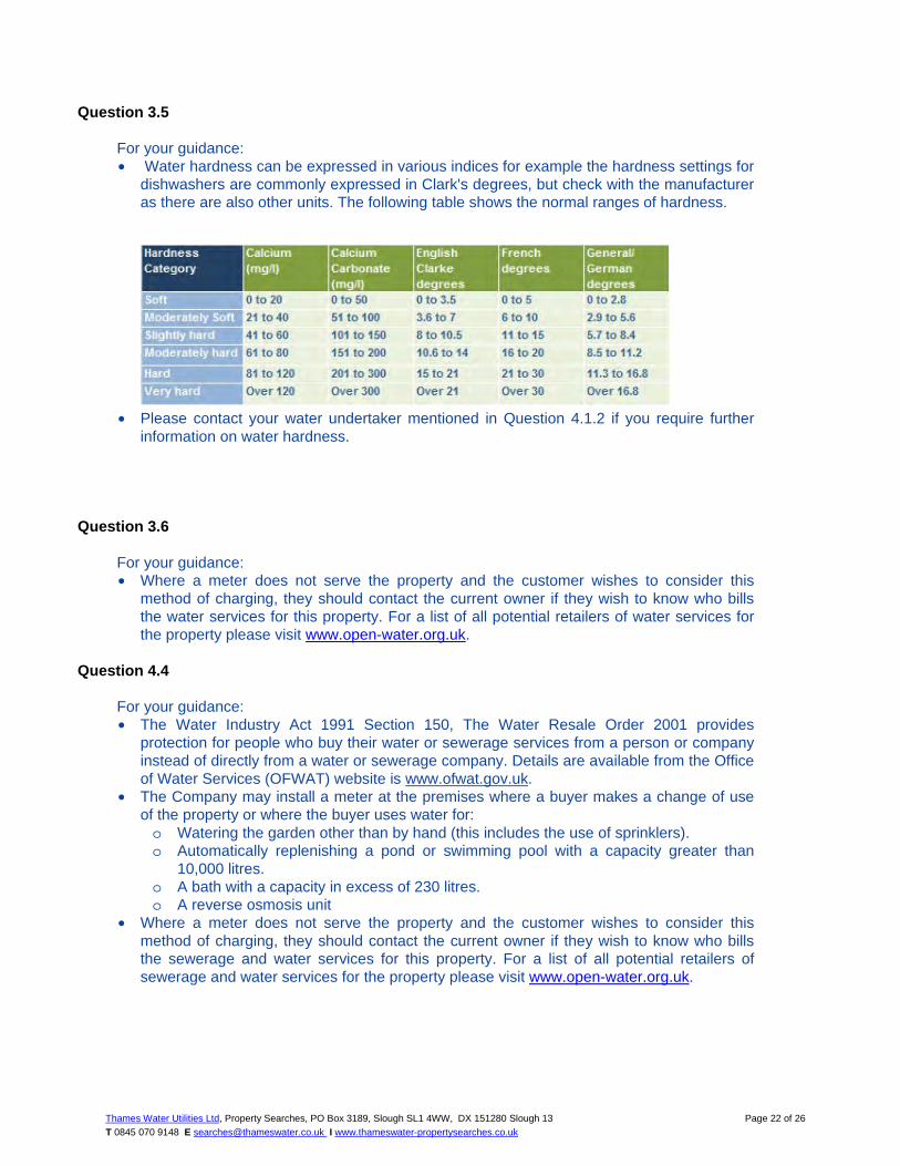
Question 3.5
For your guidance: • Water hardness can be expressed in various indices for example the hardness settings for
dishwashers are commonly expressed in Clark's degrees, but check with the manufacturer as there are also other units. The following table shows the normal ranges of hardness.
• Please contact your water undertaker mentioned in Question 4.1.2 if you require further information on water hardness.
Question 3.6 For your guidance: • Where a meter does not serve the property and the customer wishes to consider this
method of charging, they should contact the current owner if they wish to know who bills the water services for this property. For a list of all potential retailers of water services for the property please visit www.open-water.org.uk.
Question 4.4
For your guidance: • The Water Industry Act 1991 Section 150, The Water Resale Order 2001 provides
protection for people who buy their water or sewerage services from a person or company instead of directly from a water or sewerage company. Details are available from the Office of Water Services (OFWAT) website is www.ofwat.gov.uk.
• The Company may install a meter at the premises where a buyer makes a change of use of the property or where the buyer uses water for: o Watering the garden other than by hand (this includes the use of sprinklers). o Automatically replenishing a pond or swimming pool with a capacity greater than
10,000 litres. o A bath with a capacity in excess of 230 litres. o A reverse osmosis unit
• Where a meter does not serve the property and the customer wishes to consider this method of charging, they should contact the current owner if they wish to know who bills the sewerage and water services for this property. For a list of all potential retailers of sewerage and water services for the property please visit www.open-water.org.uk.

Thames Water Utilities Ltd, Property Searches, PO Box 3189, Slough SL1 4WW, DX 151280 Slough 13
T 0845 070 9148 E [email protected] I www.thameswater-propertysearches.co.uk
Page 23 of 26
Question 4.5 For your guidance: • If a Trade effluent consent applies to the premises which are the subject of this search, it is
for the applicant to satisfy itself as to the suitability of the consent for its client's requirements. The occupier of any trade premises in the area of a sewerage undertaker may discharge any trade effluent proceeding from those premises into the undertaker's public sewers if he does so with the undertaker's consent. If, in the case of any trade premises, any trade effluent is discharged without such consent or other authorisation, the occupier of the premises shall be guilty of an offence.
• Please note any existing consent is dependent on the business being carried out at the property and will not transfer automatically upon change of ownership.
• For further information regarding Trade Effluent consents please contact: Trade Effluent Control, Crossness STW, Belvedere Road, Abbey Wood London SE2 9AQ.

CommercialDW Drainage and Water Enquiry Terms and Conditions
Thames Water Utilities Ltd, Property Searches, PO Box 3189, Slough SL1 4W, DX 151280 Slough 13
T 0845 070 9148 E [email protected] I www.thameswater-propertysearches.co.uk
Page 24 of 26
Customer and Clients are asked to note these terms, which govern the basis on which this CommercialDW Drainage & Water Enquiry is supplied Definitions ‘Client’ means the person, company or body who is the intended recipient of the Report with an actual or potential interest in the Property. ‘Company’ means a water service company or their data service provider producing the Report. ‘Customer’ means the person, company, firm or other legal body placing the Order, either on their own behalf as Client, or, as an agent for a Client. ‘Order’ means any request completed by the Customer requesting the Report. ‘Property’ means the address or location supplied by the Customer in the Order. ‘Report’ means the drainage and/or water report prepared by The Company in respect of the Property. ‘Thames Water” means Thames Water Utilities Limited registered in England and Wales under number 2366661 whose registered office is at Clearwater Court, Vastern Road, Reading, Berks, RG1 8DB; Agreement 1 Thames Water agrees to supply the Report to the Customer and the Client
subject to these terms. The scope and limitations of the Report are described in paragraph 2 of these terms. Where the Customer is acting as an agent for the Client then the Customer shall be responsible for bringing these terms to the attention of the Client. The Customer and Client agree that the placing of an Order for a Report indicates their acceptance of these terms.
The Report
2. Whilst Thames Water will use reasonable care and skill in producing the Report, it is provided to the Customer and the Client on the basis that they acknowledge and agree to the following:-
2.1 The information contained in the Report can change on a regular basis so Thames Water cannot be responsible to the Customer and the Client for any change in the information contained in the Report after the date on which the Report was produced and sent to the Client.
2.2 The Report does not give details about the actual state or condition of the Property nor should it be used or taken to indicate or exclude actual suitability or unsuitability of the Property for any particular purpose, or relied upon for determining saleability or value, or used as substitute for any physical investigation or inspection. Further advice and information from appropriate experts and professionals should always be obtained.
2.3 The information contained in the Report is based upon the accuracy, completeness and legibility of the address and other information supplied by the Customer or Client.
2.4 The Report provides information as to the location and connection of existing services and should not be relied on for any other purpose. The Report may contain opinions or general advice to the Customer and the Client and Thames Water cannot ensure that any such opinion or general advice is accurate, complete or valid and accepts no liability therefore.
2.5 The position and depth of apparatus shown on any maps attached to the Report are approximate, and are furnished as a general guide only, and no warranty as to its correctness is given or implied. The exact positions and depths should be obtained by excavation trial holes and the maps must not be relied on in the event of excavation or other works made in the vicinity of apparatus shown on any maps.
Liability 3 Thames Water shall not be liable to the Client for any failure, defect or non-
performance of its obligations arising from any failure of, or defect in any machine, processing system or transmission link or anything beyond Thames Water’s reasonable control or the acts or omissions of any party for whom Thames Water are not responsible.
3.1 Where the Customer sells this report to a Client (other than in the case of a bona fide legal adviser recharging the cost of the Report as a disbursement) Thames Water shall not in any circumstances (whether for breach of contract, negligence or any other tort, under statute or statutory duty or otherwise at all) be liable for any loss or damage whatsoever and the Customer shall indemnify Thames Water in respect of any claim by the Client.
3.2 Where a report is requested for an address falling within a geographical area where Thames Water and another Company separately provide Water and Sewerage Services, then it shall be deemed that liability for the information given by Thames Water or the Company as the case may be will remain with Thames Water or the Company as the case may be in respect of the accuracy of the information supplied. Where Thames Water is supplying information which has been provided to it by another Company for the purposes outlined in this agreement Thames Water will therefore not be liable in any way for the accuracy of that information and will supply that information as agent for the Company from which the information was obtained.
3.3 Except in respect of death or personal injury caused by negligence, or as expressly provided in these Terms:
3.3.1 The entire liability of Thames Water or the Company as the case may be in respect of all causes of action arising under or in connection with the Report (whether for breach of contract, negligence or any other tort, under statute or statutory duty or otherwise at all) shall not exceed £2,000,000 (two million pounds); and
3.3.2 Thames Water shall not in any circumstances (whether for breach of contract, negligence or any other tort, under statute or statutory duty or otherwise at all) be liable for any loss of profit, loss of goodwill, loss of reputation, loss of business or any indirect, special or consequential loss, damage or other claims, costs or expenses;
Copyright and Confidentiality 4. The Customer and the Client acknowledge that the Report is confidential and
is intended for the personal use of the Client. The copyright and any other intellectual property rights in the Report shall remain the property of Thames Water or the Company as the case may be. No intellectual or other property rights are transferred or licensed to the Customer or the Client except to the extent expressly provided
4.1 The Customer or Client is entitled to make copies of the Report but is not permitted to copy any maps contained in, or attached to the Report
4.2 The maps contained in the Report are protected by Crown Copyright and must not be used for any purpose outside the context of the Report.
4.3 The Customer and Client agree (in respect of both the original and any copies made) to respect and not to alter any trademark, copyright notice or other property marking which appears on the Report.
Payment 5. Unless otherwise stated all prices are inclusive of VAT. The Customer shall
pay for the price of the Report specified by Thames Water, without any set off, deduction or counterclaim.
5.1 Unless payment has been received in advance, Customers shall be invoiced for the agreed fee once their request has been processed. Any such invoice must be paid within 14 days. Where the Customer has an account with Thames Water, payment terms will be as agreed with Thames Water.
5.2 No payment shall be deemed to have been received until Thames Water has received cleared funds.
5.3 If the Customer fails to pay Thames Water any sum due Thames Water shall be entitled but not obliged to charge the Customer interest on the sum from the due date for payment at the annual rate of 2% above the base lending rate from time to time of Natwest Bank, accruing on a daily basis until payment is made. Thames Water reserves the right to claim interest under the Late Payment of Commercial Debts (Interest) Act 1998.
5.4 Thames Water reserves the right to increase fees on reasonable prior written notice at any time.
Cancellations or Alterations 6. Once an Order is placed, Thames Water shall not be under any obligation to
accept any request to cancel that Order and payment for the Order shall still be due upon completion of the Report. In cases where an error has been made in the original Order (e.g. the Customer has supplied an incorrect address), the Customer will need to place a second Order, detailing the correct information, and shall be liable to pay a second charge in accordance with clause 5 above.
Delivery 7. On receiving your order the reports will be posted to you within 10 working
days from receipt. 7.1 Delivery is subject to local post conditions and regulations. All items should
arrive within 12 working days, but Thames Water cannot be held responsible should delays be caused by local post conditions, postal strikes or other causes beyond the control of Thames Water.
General 8. If any provision of these terms is or becomes invalid or unenforceable, it will
be taken to be removed from the rest of these terms to the extent that it is invalid or unenforceable. No other provision of these terms shall be affected.
8.1 These terms shall be governed by English law and all parties submit to the exclusive jurisdiction of the English courts.
8.2 Nothing in this notice shall in any way restrict the Customer or Clients statutory or any other rights of access to the information contained in the Report.
These Terms & Conditions are available in larger print for those with impaired vision.

Terms and Conditions
Thames Water Utilities Ltd, Property Searches, PO Box 3189, Slough SL1 4W, DX 151280 Slough 13
T 0845 070 9148 E [email protected] I www.thameswater-propertysearches.co.uk
Page 25 of 26
All sales are made in accordance with Thames Water Utilities Limited (TWUL) standard terms and conditions unless previously agreed in writing.
1. All goods remain in the property of TWUL until full payment is received. 2. Provision of service will be in accordance with all legal requirements and published TWUL policies. 3. All invoices are strictly due for payment 14 days from due date of the invoice. Any other terms must
be accepted/agreed in writing prior to provision of goods or service, or will be held to be invalid. 4. TWUL does not accept post-dated cheques-any cheques received will be processed for payment on
date of receipt. 5. In case of dispute TWUL’s terms and conditions shall apply. 6. Penalty interest may be invoked by TWUL in the event of unjustifiable payment delay. Interest
charges will be in line with UK Statute Law ‘The Late Payment of Commercial Debts (Interest) Act 1998’.
7. Interest will be charged in line with current Court Interest Charges, if legal action is taken. 8. A charge may be made at TWUL’s discretion for increased administration costs.
A copy of TWUL’s standard terms and conditions are available from the Commercial Billing Team ([email protected]). We publish several Codes of Practice including a guaranteed standards scheme. You can obtain copies of these leaflets by calling us on 0800 316 9800. If you are unhappy with our service you can speak to your original goods or customer service provider. If you are not satisfied with the response, your complaint will be reviewed by the Customer Services Director. You can write to her at: Thames Water Utilities Ltd. PO Box 492, Swindon, SN38 8TU. If the goods or services covered by this invoice falls under the regulation of the Water Industry Act 1991, and you remain dissatisfied you can refer your complaint to CC Water on 0845 039 2837 (it will cost you the same as a local call) or write to them at 11 Belgrave Road, London SW1V 1RB.
Ways to pay your bill
By Post – Cheque only, made payable to ‘Thames Water Utilities Ltd’ writing your Thames Water account number on the back. Please fill in the payment slip below and send it with your cheque to Thames Water Utilities Ltd., PO Box 223, Swindon SN38 2TW
By BACS Payment direct to our bank on account number 90478703, sort code 60-00-01 may be made. A remittance advice must be sent to Thames Water Utilities Ltd., PO Box 223, Swindon SN38 2TW. Or fax to 01793 424599 or email: [email protected]
Telephone Banking By calling your bank and quoting your invoice number and the Thames Water`s bank account number 90478703 and sort code 60-00-01
By Swift Transfer You may make your payment via SWIFT by quoting NWBKGB2L together with our bank account number 90478703, sort code 60-00-01 and invoice number
Thames Water Utilities Ltd Registered in England & Wales No. 2366661 Registered Office Clearwater Court, Vastern Rd, Reading, Berks, RG1 8DB.

Thames Water Utilities Ltd, Property Searches, PO Box 3189, Slough SL1 4W, DX 151280 Slough 13
T0845 070 [email protected] I www.thameswater-propertysearches.co.uk
Page 26 of 26
Search Code IMPORTANT CONSUMER PROTECTION INFORMATION This search has been produced by Thames Water Property Searches, Clearwater Court, Vastern Road, Reading RG1 8DB, which is registered with the Property Codes Compliance Board (PCCB) as a subscriber to the Search Code. The PCCB independently monitors how registered search firms maintain compliance with the Code. The Search Code:
• provides protection for homebuyers, sellers, estate agents, conveyancers and mortgage lenders who rely on the information included in property search reports undertaken by subscribers on residential and commercial property within the United Kingdom
• sets out minimum standards which firms compiling and selling search reports have to meet • promotes the best practise and quality standards within the industry for the benefit of consumers and
property professionals • enables consumers and property professionals to have confidence in firms which subscribe to the
code, their products and services. By giving you this information, the search firm is confirming that they keep to the principles of the Code. This provides important protection for you. The Code’s core principles Firms which subscribe to the Search Code will:
• display the Search Code logo prominently on their search reports • act with integrity and carry out work with due skill, care and diligence • at all times maintain adequate and appropriate insurance to protect consumers • conduct business in an honest, fair and professional manner • handle complaints speedily and fairly • ensure that products and services comply with industry registration rules and standards and relevant
laws • monitor their compliance with the Code
Complaints If you have a query or complaint about your search, you should raise it directly with the search firm, and if appropriate ask for any complaint to be considered under their formal internal complaints procedure. If you remain dissatisfied with the firm’s final response, after your complaint has been formally considered, or if the firm has exceeded the response timescales, you may refer your complaint for consideration under The Property Ombudsman scheme (TPOs). The Ombudsman can award compensation of up to £5,000 to you if he finds that you have suffered actual loss as a result of your search provider failing to keep to the Code. Please note that all queries or complaints regarding your search should be directed to your search provider in the first instance, not to TPOs or to the PCCB. TPOs Contact Details The Property Ombudsman scheme Milford House 43-55 Milford Street Salisbury Wiltshire SP1 2BP Tel: 01722 333306 Fax: 01722 332296 Email: [email protected] You can get more information about the PCCB from www.propertycodes.org.uk PLEASE ASK YOUR SEARCH PROVIDER IF YOU WOULD LIKE A COPY OF THE SEARCH CODE

G:\My Drive\Projects\190303_Hatfield Student Accomodation\190303_41-43 Town Centre Hatfield_SUDS Analysis.docx
41-43 Town Centre, Hatfield, AL10 0JJ
10. APPENDIX III_THAMES WATER ASSEST LOCATION SEARCH

Thames Water Utilities Ltd Property Searches, PO Box 3189, Slough SL1 4WW DX 151280 Slough 13
[email protected] www.thameswater-propertysearches.co.uk
0845 070 9148
SHA Environmental 69 TADWORTH KT20 5FB
Search address supplied 41-43 41 Town Centre Hatfield AL10 0JJ
Your reference 171201 Our reference ALS/ALS/24/2018_3730218 Search date 30 January 2018
Keeping you up-to-date Knowledge of features below the surface is essential in every development. The benefits of this not only include ensuring due diligence and avoiding risk, but also being able to ascertain the feasibility for any commercial or residential project. An asset location search provides information on the location of known Thames Water clean and/or wastewater assets, including details of pipe sizes, direction of flow and depth. Please note that information on cover and invert levels will only be provided where the data is available.

Thames Water Utilities Ltd, Property Searches, PO Box 3189, Slough SL1 4WW, DX 151280 Slough 13
T 0845 070 9148 E [email protected] I www.thameswater-propertysearches.co.uk
Page 2 of 10
Search address supplied: 41-43, 41, Town Centre, Hatfield, AL10 0JJ Dear Sir / Madam An Asset Location Search is recommended when undertaking a site development.It is essential to obtain information on the size and location of clean water and sewerage assets to safeguard against expensive damage and allow cost-effective service design. The following records were searched in compiling this report: - the map of public sewers & the map of waterworks. Thames Water Utilities Ltd (TWUL) holds all of these. This searchprovides maps showing the position, size of Thames Water assets close to the proposed development and also manhole cover and invert levels, where available. Please note that none of the charges made for this report relate to the provision of Ordnance Survey mapping information. The replies contained in this letter are given following inspection of the public service records available to this company. No responsibility can be accepted for any error or omission in the replies. You should be aware that the information contained on these plans is current only on the day that the plans are issued. The plans should only be used for the duration of the work that is being carried out at the present time. Under no circumstances should this data be copied or transmitted to parties other than those for whom the current work is being carried out. Thames Water do update these service plans on a regular basis and failure to observe the above conditions could lead to damage arising to new or diverted services at a later date. Contact Us If you have any further queries regarding this enquiry please feel free to contact a member of the team on 0845 070 9148, or use the address below: Thames Water Utilities Ltd Property Searches PO Box 3189 Slough SL1 4WW Email: [email protected] Web: www.thameswater-propertysearches.co.uk

Thames Water Utilities Ltd, Property Searches, PO Box 3189, Slough SL1 4WW, DX 151280 Slough 13
T 0845 070 9148 E [email protected] I www.thameswater-propertysearches.co.uk
Page 3 of 10
Waste Water Services
Please provide a copy extract from the public sewer map. Enclosed is a map showing the approximate lines of our sewers. Our plans do not show sewer connections from individual properties or any sewers not owned by Thames Water unless specifically annotated otherwise. Records such as "private" pipework are in some cases available from the Building Control Department of the relevant Local Authority. Where the Local Authority does not hold such plans it might be advisable to consult the property deeds for the site or contact neighbouring landowners. This report relates only to sewerage apparatus of Thames Water Utilities Ltd, it does not disclose details of cables and or communications equipment that may be running through or around such apparatus. The sewer level information contained in this response represents all of the level data available in our existing records. Should you require any further Information, please refer to the relevant section within the 'Further Contacts' page found later in this document. For your guidance: • The Company is not generally responsible for rivers, watercourses, ponds, culverts
or highway drains. If any of these are shown on the copy extract they are shown for information only.
• Any private sewers or lateral drains which are indicated on the extract of the public sewer map as being subject to an agreement under Section 104 of the Water Industry Act 1991 are not an ‘as constructed’ record. It is recommended these details be checked with the developer.
Clean Water Services
Please provide a copy extract from the public water main map. With regard to the fresh water supply, this site falls within the boundary of another water company. For more information, please redirect your enquiry to the following address: Affinity Water Ltd Tamblin Way Hatfield AL10 9EZ Tel: 0845 7823333

Thames Water Utilities Ltd, Property Searches, PO Box 3189, Slough SL1 4WW, DX 151280 Slough 13
T 0845 070 9148 E [email protected] I www.thameswater-propertysearches.co.uk
Page 4 of 10
For your guidance: • Assets other than vested water mains may be shown on the plan, for information
only. • If an extract of the public water main record is enclosed, this will show known public
water mains in the vicinity of the property. It should be possible to estimate the likely length and route of any private water supply pipe connecting the property to the public water network.
Payment for this Search A charge will be added to your suppliers account.

Thames Water Utilities Ltd, Property Searches, PO Box 3189, Slough SL1 4WW, DX 151280 Slough 13
T 0845 070 9148 E [email protected] I www.thameswater-propertysearches.co.uk
Page 5 of 10
Further contacts:
Waste Water queries
Should you require verification of the invert levels of public sewers, by site measurement, you will need to approach the relevant Thames Water Area Network Office for permission to lift the appropriate covers. This permission will usually involve you completing a TWOSA form. For further information please contact our Customer Centre on Tel: 0845 920 0800. Alternatively, a survey can be arranged, for a fee, through our Customer Centre on the above number. If you have any questions regarding sewer connections, budget estimates, diversions, building over issues or any other questions regarding operational issues please direct them to our service desk. Which can be contacted by writing to:
Developer Services (Waste Water) Thames Water Clearwater Court Vastern Road Reading RG1 8DB Tel: 0800 009 3921 Email: [email protected]
Clean Water queries Should you require any advice concerning clean water operational issues or clean water connections, please contact:
Developer Services (Clean Water) Thames Water Clearwater Court Vastern Road Reading RG1 8DB
Tel: 0800 009 3921 Email: [email protected]

Thames Water Utilities Ltd, Property Searches, PO Box 3189, Slough SL1 4W, DX 151280 Slough 13
T 0845 070 9148 E [email protected] I www.thameswater-propertysearches.co.uk
Page 6 of 10
Asset Location Search Sewer Map - ALS/ALS/24/2018_3730218
The width of the displayed area is 200 m and the centre of the map is located at OS coordinates 522435,208633 The position of the apparatus shown on this plan is given without obligation and warranty, and the accuracy cannot be guaranteed. Service pipes are not shown but their presence should be anticipated. No liability of any kind whatsoever is accepted by Thames Water for any error or omission. The actual position of mains and services must be verified and established on site before any works are undertaken.
Based on the Ordnance Survey Map with the Sanction of the controller of H.M. Stationery Office, License no. 100019345 Crown Copyright Reserved.
225
300
525
225
225
300225
225
225
450
225
610 225
600
300
600
375
600
30
U
%
%
%
%
%
% %
%
%
%%
%
%
%
%
% %
%
%
%
471A
4701
5609 5607
3701
4604
4702
4605
4516
4609
4514
4602
4513
4505
4610
4507
4509
4506
4508
4601
4504
4503
5503
5502
560
3501
3504
3503
3601
3602
3502
4606
3603
4510
4512
4515
4607
4603
4608
4511
=
=!
=
=
!
!!
!
!=
=
!=
=
=
!
=
=!
!
!
!
!
=! =
!
!
=
!=
=
== ==
=
!!
!
!
!
HATFIELD
Town
Bank
Centre
to
Market Place
Dog Kennel Lane
21
31
35
60
29
24
15
39
23
80
7372
74
32
25
86
62
19
82.3m
LB
17d
White Lion House
PCs
1 to 72
Shelter
88 to 96
41 to 45
El Sub Sta
Bank
Bank
Bank
25
2
Library
Queensway House
31
3029
22
47
16
26
33
Car Park
uperstore
HO
OD
LAN
E
OMMON
toto
23

Thames Water Utilities Ltd, Property Searches, PO Box 3189, Slough SL1 4W, DX 151280 Slough 13
T 0845 070 9148 E [email protected] I www.thameswater-propertysearches.co.uk
Page 7 of 10
NB. Levels quoted in metres Ordnance Newlyn Datum. The value -9999.00 indicates that no survey information is available
Manhole Reference Manhole Cover Level Manhole Invert Level 5503 5607 5608 4603 4514 4604 4608 4609 4610 4602 4513 4605 4505 4509 4601 4506 4508 4702 4701 471A 451A 451B 451D 4502 4504 4503 5502 5609 3701 3504 4510 3502 4515 4516 4511 4512 4607 4606 3603 3602 3601
n/a 82.27 82.33 81.73 81.74 81.72 81.92 81.74 81.7 81.65 81.65 82.22 n/a 81.6 81.76 82.16 81.77 81.95 81.97 n/a n/a n/a n/a n/a n/a n/a 81.93 n/a 82.46 81.43 81.19 81.35 81.49 81.48 81.49 81.76 82.02 82.1 82.53 82.43 82.44
n/a 79.56 77.49 78.62 78.63 77.92 79.46 79.48 79.53 79.62 78.45 79.95 n/a 78.3 79.55 77.5 78.29 80.61 80.59 n/a n/a n/a n/a n/a n/a n/a 78.25 n/a 79.21 79.81 79 78.72 78.63 78.64 78.55 78.42 79.45 79.36 79.21 78.36 78.05
The position of the apparatus shown on this plan is given without obligation and warranty, and the accuracy cannot be guaranteed. Service pipes are not shown but their presence should be anticipated. No liability of any kind whatsoever is accepted by Thames Water for any error or omission. The actual position of mains and services must be verified and established on site before any works are undertaken.

Thames Water Utilities Ltd, Property Searches, PO Box 3189, Slough SL1 4W, DX 151280 Slough 13
T 0845 070 9148 E [email protected] I www.thameswater-propertysearches.co.uk
Page 8 of 10
ALS Sewer Map Key
Foul: A sewer designed to convey waste water from domestic andindustrial sources to a treatment works.
Surface Water: A sewer designed to convey surface water (e.g. rainwater from roofs, yards and car parks) to rivers or watercourses.
Combined: A sewer designed to convey both waste water and surfacewater from domestic and industrial sources to a treatment works.
Trunk Surface Water
Storm Relief
Vent Pipe
Proposed Thames SurfaceWater Sewer
Gallery
Surface Water RisingMain
Sludge Rising Main
Vacuum
Public Sewer Types (Operated & Maintained by Thames Water)
Notes:
1) All levels associated with the plans are to Ordnance Datum Newlyn.
2) All measurements on the plans are metric.
3) Arrows (on gravity fed sewers) or flecks (on rising mains) indicate direction offlow.
4) Most private pipes are not shown on our plans, as in the past, this information hasnot been recorded.
5) ‘na’ or ‘0’ on a manhole level indicates that data is unavailable.
Trunk Foul
Trunk Combined
Bio-solids (Sludge)
Proposed Thames WaterFoul Sewer
Foul Rising Main
Combined Rising Main
Proposed Thames WaterRising Main
Sewer FittingsA feature in a sewer that does not affect the flow in the pipe. Example: a ventis a fitting as the function of a vent is to release excess gas.
Operational ControlsA feature in a sewer that changes or diverts the flow in the sewer. Example:A hydrobrake limits the flow passing downstream.
Air Valve
Dam Chase
Fitting
Meter
Vent Column
Control Valve
Drop Pipe
Ancillary
Weir
End ItemsEnd symbols appear at the start or end of a sewer pipe. Examples: anUndefined End at the start of a sewer indicates that Thames Water has noknowledge of the position of the sewer upstream of that symbol, Outfall on asurface water sewer indicates that the pipe discharges into a stream or river.
Outfall
Undefined End
Inlet
Other SymbolsSymbols used on maps which do not fall under other general categories
Summit
Public/Private Pumping Station/
Invert Level
Change of characteristic indicator (C.O.C.I.)
Other Sewer Types (Not Operated or Maintained by Thames Water)
Areas
Lines denoting areas of underground surveys, etc.
Agreement
Chamber
Operational Site
Conduit Bridge
Foul Sewer
Combined Sewer
Culverted Watercourse
Surface Water Sewer
Gulley
Proposed
Abandoned Sewer
Tunnel
6) The text appearing alongside a sewer line indicates the internal diameter ofthe pipe in milimetres. Text next to a manhole indicates the manholereference number and should not be taken as a measurement. If you areunsure about any text or symbology present on the plan, please contact amember of Property Insight on 0845 070 9148.
P P
M
W

Terms and Conditions
Thames Water Utilities Ltd, Property Searches, PO Box 3189, Slough SL1 4W, DX 151280 Slough 13
T 0845 070 9148 E [email protected] I www.thameswater-propertysearches.co.uk
Page 9 of 10
All sales are made in accordance with Thames Water Utilities Limited (TWUL) standard terms and conditions unless previously agreed in writing.
1. All goods remain in the property of Thames Water Utilities Ltd until full payment is received. 2. Provision of service will be in accordance with all legal requirements and published TWUL policies. 3. All invoices are strictly due for payment 14 days from due date of the invoice. Any other terms must
be accepted/agreed in writing prior to provision of goods or service, or will be held to be invalid. 4. Thames Water does not accept post-dated cheques-any cheques received will be processed for
payment on date of receipt. 5. In case of dispute TWUL`s terms and conditions shall apply. 6. Penalty interest may be invoked by TWUL in the event of unjustifiable payment delay. Interest
charges will be in line with UK Statute Law ‘The Late Payment of Commercial Debts (Interest) Act 1998’.
7. Interest will be charged in line with current Court Interest Charges, if legal action is taken. 8. A charge may be made at the discretion of the company for increased administration costs.
A copy of Thames Water’s standard terms and conditions are available from the Commercial Billing Team ([email protected]). We publish several Codes of Practice including a guaranteed standards scheme. You can obtain copies of these leaflets by calling us on 0800 316 9800 If you are unhappy with our service you can speak to your original goods or customer service provider. If you are not satisfied with the response, your complaint will be reviewed by the Customer Services Director. You can write to her at: Thames Water Utilities Ltd. PO Box 492, Swindon, SN38 8TU. If the Goods or Services covered by this invoice falls under the regulation of the 1991 Water Industry Act, and you remain dissatisfied you can refer your complaint to Consumer Council for Water on 0121 345 1000 or write to them at Consumer Council for Water, 1st Floor, Victoria Square House, Victoria Square, Birmingham, B2 4AJ.
Ways to pay your bill
Credit Card Call 0845 070 9148 quoting your invoice number starting CBA or ADS / OSS
BACS Payment Account number 90478703 Sort code 60-00-01 A remittance advice must be sent to: Thames Water Utilities Ltd., PO Box 3189, Slough SL1 4WW. or email [email protected]
Telephone Banking By calling your bank and quoting: Account number 90478703 Sort code 60-00-01 and your invoice number
Cheque Made payable to ‘Thames Water Utilities Ltd’ Write your Thames Water account number on the back. Send to: Thames Water Utilities Ltd., PO Box 3189, Slough SL1 4WW or by DX to 151280 Slough 13
Thames Water Utilities Ltd Registered in England & Wales No. 2366661 Registered Office Clearwater Court, Vastern Rd, Reading, Berks, RG1 8DB.

Thames Water Utilities Ltd, Property Searches, PO Box 3189, Slough SL1 4W, DX 151280 Slough 13
T0845 070 [email protected] I www.thameswater-propertysearches.co.uk Page 10 of 10
Search Code
IMPORTANT CONSUMER PROTECTION INFORMATION
This search has been produced by Thames Water Property Searches, Clearwater Court, Vastern Road, Reading RG1 8DB, which is registered with the Property Codes Compliance Board (PCCB) as a subscriber to the Search Code. The PCCB independently monitors how registered search firms maintain compliance with the Code.
The Search Code: • provides protection for homebuyers, sellers, estate agents, conveyancers and mortgage lenders who
rely on the information included in property search reports undertaken by subscribers on residential and commercial property within the United Kingdom
• sets out minimum standards which firms compiling and selling search reports have to meet• promotes the best practise and quality standards within the industry for the benefit of consumers and
property professionals• enables consumers and property professionals to have confidence in firms which subscribe to the
code, their products and services.
By giving you this information, the search firm is confirming that they keep to the principles of the Code. This provides important protection for you.
The Code’s core principles Firms which subscribe to the Search Code will:
• display the Search Code logo prominently on their search reports• act with integrity and carry out work with due skill, care and diligence• at all times maintain adequate and appropriate insurance to protect consumers• conduct business in an honest, fair and professional manner• handle complaints speedily and fairly• ensure that products and services comply with industry registration rules and standards and relevant
laws• monitor their compliance with the Code
Complaints If you have a query or complaint about your search, you should raise it directly with the search firm, and if appropriate ask for any complaint to be considered under their formal internal complaints procedure. If you remain dissatisfied with the firm’s final response, after your complaint has been formally considered, or if the firm has exceeded the response timescales, you may refer your complaint for consideration under The Property Ombudsman scheme (TPOs). The Ombudsman can award compensation of up to £5,000 to you if he finds that you have suffered actual loss as a result of your search provider failing to keep to the Code.
Please note that all queries or complaints regarding your search should be directed to your search provider in the first instance, not to TPOs or to the PCCB.
TPOs Contact Details The Property Ombudsman scheme Milford House 43-55 Milford Street Salisbury Wiltshire SP1 2BP Tel: 01722 333306 Fax: 01722 332296 Email: [email protected]
You can get more information about the PCCB from www.propertycodes.org.uk
PLEASE ASK YOUR SEARCH PROVIDER IF YOU WOULD LIKE A COPY OF THE SEARCH CODE