4.9ransportation and t infrastructure - new cable vision – cable ... tracks run east-west...
TRANSCRIPT

Affected Environment and Environmental Consequences—Transportation 4-199
4.9 Transportation and Infrastructure
4.9.1 Methodology
Transportation
The objective of the transportation analysis is to
evaluate the impact on vehicle, pedestrian, and
bicyclist movements in relation to the construction and
operation of flooding mitigations within the Study Area.
The data collected includes traffic volumes of vehicles,
pedestrians, bicycles, and public transportation. Crash
data was also provided by the City of Hoboken along
with traffic signal timings at various intersections.
This information was used to evaluate the impacts
of temporary detours during construction and any
permanent modifications to roadways, pedestrian
walkways, and bikeways. A full discussion of existing
traffic conditions within the Study Area can be found
in Traffic Technical Memorandum, Rebuild by Design
Hudson River Project, January 2017 (see Attachment
2).
Infrastructure
As part of the Project’s feasibility study, the spatial
locations of various surface and subsurface utilities
were obtained in either digital or paper format from the
following utility companies:
• North Hudson Sewerage Authority (NHSA) -Storm-
Sewer network in Hoboken and Weehawken
• Public Service Enterprise Group (PSE&G) – Electric
and Gas
• Verizon – Communications (Telephone and
Internet)
• Cable Vision – Cable Television
• United Water – Drinking Water
• Jersey City Municipal Utilities (JCMUA) – Storm-
Sewer network in Jersey City
Utility locations will be staked out and locations
identified in coordination with utility providers prior to
completion of final design and again in preparation
for construction. It should be noted that surface and
subsurface utility data such as electric conduits and
others owned by NJ TRANSIT and the Port Authority
of New York and New Jersey (PANYNJ) were not
obtained.
4.9.2 Affected Environment
4.9.2.1 TransportationDue to the natural topography and the presence of
significant transportation system infrastructures, the
Study Area has concentrated access to its immediate
surrounding communities. The speed limit within the
Study Area is an overall 25 mph, unless mentioned
otherwise. To the north are the access ramps (NJ
Route 495), toll facilities and the portal of the Lincoln
Tunnel. To the south are the tracks and yards of NJ
TRANSIT’s Hoboken Terminal, and beyond that are
the Holland Tunnel portal with toll plaza, NJ Turnpike
Holland tunnel extension (I-78), and NJ Route 139
(leading to US Routes 1 and 9). These exclusive
means of ingress and egress, though few, provide
the Study Area with exceptional regional multi-modal
accessibility to and from New Jersey and New York
City.
Northern Ingress and Egress
To provide access to and from the north end of
Hoboken, two north-south bridge viaducts (Willow
Avenue and Park Avenue) convey traffic over the
Hudson Bergen Light Rail (HBLR) system. These
tracks run east-west across Hoboken’s north border,
limiting access of most north-south ground level
roadways, including Clinton Street and Grand Street,
as they dead-end approaching the HBLR tracks.
The Willow Avenue and Park Avenue viaducts
facilitate access between Hoboken and Weehawken
(see Figure 4.92). There is a moderate amount of
congestion, particularly in the morning hours. The
Willow Avenue viaduct, a major arterial, contains
narrow unprotected sidewalks on both sides that
do not experience high pedestrian volumes. The
Park Avenue viaduct contains a single six-foot wide
sidewalk protected by half-section (Jersey) barrier on
its northbound side.
Below the Park Avenue viaduct, Harbor Boulevard
provides a connection to southbound Park Ave.
Harbor Boulevard provides pedestrian and cycling
access to the Hudson waterfront and southbound
vehicular movement from regional connectors such as
Port Imperial Boulevard to northern Hoboken.
There is a mild amount of congestion in this area,
more so in the morning peak hours. NJ TRANSIT
buses utilize all three viaducts. The area has moderate
to low pedestrian traffic and low bicycle utilization.
Southern Ingress and Egress
A system of Interstate and major regional routes
crossing north Jersey City connect with Hoboken by
way of four north-south streets: Jersey Avenue, Grove
Street, Marin Boulevard, and 18th St. Of these four,
Grove Street, Marin Boulevard, and Jersey Avenue
enter Hoboken (see Figure 4.92).
Similar to Weehawken in the north, the continuation
of the Palisades and NJ TRANSIT railroad tracks
limit the number of local connections to Jersey City in
the south. The Hoboken Terminal rail yard prevents
north-south access over the eastern half of Hoboken’s
southern border.
Just north and running parallel to the Hoboken
Terminal rail yard is Observer Highway, a two-lane
(one lane each way, with 14-foot striped median
and parking along both sides) Urban Minor Arterial
(average annual daily traffic 22,934 vehicles per day).
Observer Highway contains a wide sidewalk along
its northern edge and connects to a sidewalk along
its southern edge after “crossing” Newark Street (see
Figure 4.93). Adjacent to the south side of Observer
Highway is a two-way protected bicycle lane for travel
to and from Jersey City, Washington Street, the NJ
TRANSIT Terminal, and Port Authority Trans Hudson
(PATH station). The bicycle lanes see a moderate
amount of bicycle traffic during both morning and
evening peak hours.

Rebuild by Design Hudson River: Resist Delay Store Discharge FINAL Environmental Impact Statement4-200 Affected Environment and Environmental Consequences—Transportation
Figure 4.92 Transportation Map

Affected Environment and Environmental Consequences—Transportation 4-201
Newark Street, similarly a two-lane (one lane each
way, with center turn lanes and striped wide medians
but no parking) Urban Minor Arterial (average annual
daily traffic of 7,496 vehicles/day) intersects with
Observer Highway to the west and has a full sidewalk
along its northern edge and a disjointed and poorly
maintained sidewalk along its south edge with no
designated bicycling infrastructure. This corridor
experiences high levels of congestion in the morning
hours and moderate to high congestion in the evening
hours. In the areas of access to Jersey City, there is a
moderate amount of pedestrians during both morning
and evening hours.
Only three streets provide direct connectivity to
and from Hoboken’s south border and the regional
transportation links. These access streets are: Marin
Boulevard, Grove Street, and Jersey Avenue. All three
of these streets have sidewalks on both sides. All
three streets also convey bus transit. Jersey Avenue
has a designated bicycle lane that comes from the
western portion of 18th Street, along Jersey Avenue
in Jersey City, under the NJ TRANSIT tracks and
into Hoboken. This dedicated bicycle lane separates
from the roadway and continues northward to the 2nd
Street HBLR station.
Within Jersey City, 14th Street and 12th Street, (urban
interstate roadways) provide connectivity between the
Holland Tunnel , I-78 west, and NJ Route 139 west.
The Holland Tunnel connects Jersey City to Lower
Manhattan.
Interstate 78 is a four-lane (two lanes each direction)
New Jersey Turnpike Authority toll road. This
segment, leading to the NJ Turnpike, is also known
as the Newark Bay Hudson County Extension, which
provides connections to Newark Airport, north and
central New Jersey, and Pennsylvania. Adjoining
I-78 at both 12th and 14th street intersections in
Jersey City is NJ Route 139. Westbound NJ Route
139 separates into a stacked roadway; the lower
section is a two-lane principal arterial express section
which runs in a cut and provides direct access to
the Pulaski Skyway and US Routes 1 and 9, and the
upper section is a two-lane surface minor collector,
which provides local access through a succession of
signalized intersections.
Western Ingress and Egress
Jersey City and Union City lie inland of Hoboken to
the west. At 14th Street in Hoboken, a viaduct leads
west from Willow Avenue over the HBLR tracks and
Palisades to Union City. The 14th Street viaduct
ends on the Palisades at an intersection with S. Wing
Viaduct, which travels south along the Palisades,
and Manhattan Avenue, which travels north along
the Palisades. These roads both contain unprotected
sidewalks for pedestrian access.
At the southeast end of Hoboken, Observer Highway
continues west to New York Avenue. The roadway
continues under Palisades Ave and surfaces to
intersect with Ravine Avenue in Jersey City. This
roadway has a sidewalk on one side with barrier
protection east of the underground portion of the
roadway.
Exclusive pedestrian access is available at the 9th
Street HBLR station, where an elevator and pedestrian
bridge provide access to the Congress Street Station
from Paterson Plank Road.
4.9.2.1.1 Roadway Operations
Data Collection
Traffic data was gathered and analyzed for the
roadways within the Study Area. Existing conditions
for motor vehicles were established based on
signal timings and traffic volumes including turning
movements, lane configurations, and observations
Figure 4.93 Transportation Map; Map Source: Imagery © 2017 Google, Map data
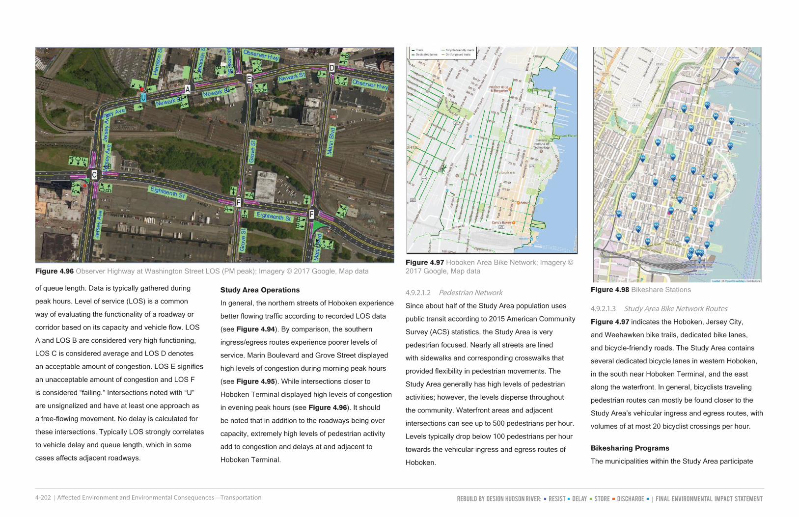
Figure 4.94 Hoboken Northern Ingress/Egress LOS (PM Peak); Map Source: Imagery © 2017 Google, Map data
Figure 4.95 Observer Highway at Washington Street LOS (PM peak); Map Source: Imagery © 2017 Google, Map data
Rebuild by Design Hudson River: Resist Delay Store Discharge FINAL Environmental Impact Statement4-202 Affected Environment and Environmental Consequences—Transportation
of queue length. Data is typically gathered during
peak hours. Level of service (LOS) is a common
way of evaluating the functionality of a roadway or
corridor based on its capacity and vehicle flow. LOS
A and LOS B are considered very high functioning,
LOS C is considered average and LOS D denotes
an acceptable amount of congestion. LOS E signifies
an unacceptable amount of congestion and LOS F
is considered “failing.” Intersections noted with “U”
are unsignalized and have at least one approach as
a free-flowing movement. No delay is calculated for
these intersections. Typically LOS strongly correlates
to vehicle delay and queue length, which in some
cases affects adjacent roadways.
Study Area Operations
In general, the northern streets of Hoboken experience
better flowing traffic according to recorded LOS data
(see Figure 4.94). By comparison, the southern
ingress/egress routes experience poorer levels of
service. Marin Boulevard and Grove Street displayed
high levels of congestion during morning peak hours
(see Figure 4.95). While intersections closer to
Hoboken Terminal displayed high levels of congestion
in evening peak hours (see Figure 4.96). It should
be noted that in addition to the roadways being over
capacity, extremely high levels of pedestrian activity
add to congestion and delays at and adjacent to
Hoboken Terminal.
4.9.2.1.2 Pedestrian Network
Since about half of the Study Area population uses
public transit according to 2015 American Community
Survey (ACS) statistics, the Study Area is very
pedestrian focused. Nearly all streets are lined
with sidewalks and corresponding crosswalks that
provided flexibility in pedestrian movements. The
Study Area generally has high levels of pedestrian
activities; however, the levels disperse throughout
the community. Waterfront areas and adjacent
intersections can see up to 500 pedestrians per hour.
Levels typically drop below 100 pedestrians per hour
towards the vehicular ingress and egress routes of
Hoboken.
4.9.2.1.3 Study Area Bike Network Routes
Figure 4.97 indicates the Hoboken, Jersey City,
and Weehawken bike trails, dedicated bike lanes,
and bicycle-friendly roads. The Study Area contains
several dedicated bicycle lanes in western Hoboken,
in the south near Hoboken Terminal, and the east
along the waterfront. In general, bicyclists traveling
pedestrian routes can mostly be found closer to the
Study Area’s vehicular ingress and egress routes, with
volumes of at most 20 bicyclist crossings per hour.
Bikesharing Programs
The municipalities within the Study Area participate
Figure 4.96 Observer Highway at Washington Street LOS (PM peak); Imagery © 2017 Google, Map dataFigure 4.97 Hoboken Area Bike Network; Imagery © 2017 Google, Map data
Figure 4.98 Bikeshare Stations

Affected Environment and Environmental Consequences—Transportation 4-203
in bikesharing programs. These programs allow
individuals to rent bikes, use them as needed for
their commute, and check them back in to rental
stations or kiosks when not in use. Hudson Bike Share
launched with 17 stations and has since expanded,
currently operating over 25 rental stations throughout
Hoboken and in the Lincoln Harbor neighborhood
of Weehawken. Bikeshare stations are located
throughout Hoboken, in general no more than a 3- to
5-minute walk from any given location. Bikes may
be rented on a single use, monthly membership, or
yearly membership basis, with free and reduced-
priced membership to Hoboken residents of Hoboken
Housing Authority and in Section 8 housing. Citi Bike
operates a similar bikeshare program in Jersey City,
although no Citi Bike rental stations or kiosks are
located within the Study Area. Figure 4.98 shows
bikeshare stations within the Study Area.
4.9.2.1.4 Bus Transit
NJ TRANSIT bus routes provide circulation to, from,
and within the Study Area and make use of the
majority of the previously described perimeter access
routes in and out of the Study Area, including:
• Park Avenue (Local Routes 23/63/64H/68)
• Willow Avenue (Local Routes 64H/89; PABT
Routes 119/126)
• 14th Street (Local Routes 22/64H; PABT Routes
119)
• Paterson Avenue (Local Routes 22X/85/87/64H)
• Jersey Avenue (Local Route 64H)
• Grove Street (PABT Route 126)
• Marin Boulevard (Local Routes 63/64/68)
Figure 4.99 identifies the Hoboken, Jersey City, and
Weehawken streets that contain NJ TRANSIT bus
routes and bus stops within and beyond the Study
Area.
Figure 4.100 shows the Hoboken “Hop” shuttle
service network. The Hop runs three lines within
Hoboken that connect various parts of the city to the
Hoboken Terminal. The Hop shuttle service runs
between 7 am to 8 pm every half hour.
Figure 4.101 shows the Hoboken Senior Shuttle
service network with information confirmed within the
Figure 4.99 Bus Routes with Bus Stops; GTFS NJ TRANSIT GIS
Figure 4.100 Hoboken “Hop” Shuttle Service Network; City of Hoboken, NJ TRANSIT, PANYNJ
Figure 4.101 Hoboken Senior Shuttle Network; City of Hoboken
Figure 4.102 HBLR System; Source: NJ TRANSIT

Rebuild by Design Hudson River: Resist Delay Store Discharge FINAL Environmental Impact Statement4-204 Affected Environment and Environmental Consequences—Transportation
city limits. The Senior Shuttle is only within the city
limits of Hoboken and runs every hour.
4.9.2.1.5 Rail Transportation
Hoboken Terminal is located in the southeastern
portion of the Study Area. The Hoboken Terminal
serves as a transportation hub for a variety of
transportation modes (Photographs 4.46 and 4.47).
PATH trains originate at the site of Hoboken Terminal
with service to New York City and Jersey City, with
connections to Harrison and Newark. According to
the 2016 PATH Ridership Report, released by the
PANYNJ, approximately 28,000 passenger trips were
served by the Hoboken PATH station on an average
weekday in 2016, and nearly 270,000 served by the
entire PATH system.
NJ TRANSIT rail lines that originate in Hoboken
include the Main Line with service to Suffern and
Port Jervis, the Bergen County Line, the Pascack
Valley and Port Jervis Line, the Spring Valley Line,
the Montclair and Boonton Line, the Morris and Essex
Line, and the North Jersey Coast Line. According to
the Fiscal Year 2016 report, revised February 2017,
the terminal served approximately 16,000 weekday
boardings in 2016 for these service lines.
The HBLR also operates within the Study Area. This
system serves over 51,000 unlinked passenger trips
on an average weekday in 2016, according to the
NJ TRANSIT report noted above. North of Hoboken,
the HBLR runs along Port Imperial Boulevard and
Waterfront Terrace. Once entering Hoboken, the
HBLR follows just inside the city’s northern border
and continues along Hoboken’s west edge where they
make two stops at 9th Street-Congress Street and
2nd Street. The HBLR then travels along the southern
border of Hoboken where it connects with Hoboken
Terminal. The HBLR also connects residential
Bayonne and western Jersey City with Jersey City’s
Exchange Place and Newport Center (see Figure
4.102).
In the event of disruption of service, NJ TRANSIT
uses a variety of resources to reach its customers.
As stated in NJ TRANSIT meeting minutes from the
January 11, 2017 board meeting:
“In times of emergency or severe weather, NJ
TRANSIT uses the web and social media, as well
as press releases, live interviews, and push alerts,
in order to provide up-to-the minute information
regarding service, conditions, schedule, and other
factors affecting NJ TRANSIT’s customers. When
NJ TRANSIT’s Emergency Operations Center is
activated both in times of emergency or of significant
public events, NJ TRANSIT’s public information team
monitors social media channels in real time and
informs the New Jersey Transit Police Department,
customer service, as well as the respective operating
lines of any imminent situation that requires attention
being posted by customers.”
NJ TRANSIT performed an Environmental
Assessment (EA) for the Long Slip Fill and Rail
Enhancement project. The EA identified NJ TRANSIT
emergency operation procedures. According to the
EA, emergency preparations at the Hoboken Terminal
are started four days prior to a storm. Removal of track
switch motors would be initiated at that time; after
removal, only four of the sixteen passenger tracks can
be in service until after the storm event is over and
the switches can be reinstalled. This means that the
coordination activities can be integrated into the NJ
TRANSIT emergency procedures well before a storm
event.
4.9.2.1.6 Ferry Service
Ferry service to New York City is available in the
Study Area at three locations (see Figure 4.103).
The Lincoln Harbor ferry stop (located at the end of
19th Street and Harbor Boulevard in Weehawken)
Photograph 4.46 View of Hoboken Rail Yard from HBLR
Photograph 4.47 View of Hoboken Terminal
Figure 4.103 Study Area Ferry Locations; Imagery © 2017 Google, Map data

Affected Environment and Environmental Consequences—Transportation 4-205
Figure 4.104 Sanitary and Storm Sewer Map

Rebuild by Design Hudson River: Resist Delay Store Discharge FINAL Environmental Impact Statement4-206 Affected Environment and Environmental Consequences—Transportation
provides a connection to Midtown New York/West
39th Street. The Hoboken 14th Street ferry stop
provides connections to Midtown/West 39th Street, as
well as the World Financial Center. The third ferry stop
is located at the Hoboken Terminal and it provides
connections to Paulus Hook in Jersey City and Pier
11/Wall Street and the World Financial Center in
Lower Manhattan.
4.9.2.1.7 On Street Parking
According to Hoboken Department of Transportation
and Parking, most streets are designated on one
side (the north or west side) as “Resident Permit
Parking Only” and the other side (south or east side)
as “Permit Parking Only”. The streets that are not
designated in that way are typically in commercial
areas and are instead designated as metered parking.
4.9.2.1.1 Off Street Parking
Within the Study Area, the city of Hoboken manages
five municipal parking garages. Three are located
along Hudson Street near the Hoboken Terminal, one
is located adjacent to the Hoboken University Medical
Center (at Clinton Street between 4th and 3rd Streets),
and one is located on Garden Street, between 9th
and 10th Streets. Also within the Study Area limits
are approximately 20 privately owned parking lots,
including garages and surface lots.
According to the City of Hoboken’s website in the
event of an emergency, the City alerts residents
which municipal parking lots will be made available
for residents who typically use street parking. Such
lots will have limited parking, and will be “available on
a first-come-first-serve basis, usually in 12 or 24 hour
increments,” after which normal rates resume.
4.9.2.2 InfrastructureThe following is a discussion of the utilities within the
Study Area.
Sanitary and Storm Sewer
NHSA provided mapping of the existing combined
sewer system for the purposes of this discussion. The
system consists of inlets, manholes, pipes, outfalls,
and related facilities. The network within the study
area has 1,639 manholes, 781 inlets, 12 miles of
gravity driven sewer pipes, and four pump stations. In
addition to the gravity sewers, there are 0.61 miles of
interceptors, 0.70 miles of siphons, and 0.53 miles of
forced mains within the Study Area. Hoboken sewage
is conveyed and treated at the NHSA – Adams Street
Wastewater Treatment Plant, located in northwest
Hoboken. The Adams Street Wastewater Treatment
Plant also treats approximately 83 percent of sewage
generated in Weehawken and 45 percent of sewage
generated in Union City as of 2011 (NHSA Fiscal Year
2011 Annual Report).
Within the Study Area, NHSA has several drainage
areas, also referred to as “sewersheds”, identified
as H1 through H7, as shown on Figure 4.104.
Stormwater and sanitary sewage are collected in
gravity sewers that are located along each street,
mostly running in a north-south orientation; however,
there are some east-west oriented sewers along
Observer Highway, 1st Street, 3rd Street, 7th Street,
11th Street, 14th Street, and 15th Street. Drainage
flows in a generally west to east direction and is
collected in the interceptor lines that run along River
Street between Observer Highway and 5th Street, as
well as along Hudson Street from 5th Street to 15th
Street. Pump stations, located near the intersection of
Washington Street and Observer Highway, 5th Street
and Sinatra Drive, and 11th Street and Hudson Street,
provide pressure to convey the flow northwest to the
wastewater treatment plant. Figure 4.104 shows the
layout of the NHSA system and direction of sewer
flows. During longer duration and higher intensity
storms events that cause combined sewer overflows
(CSOs), stormwater and sewer are conveyed to
the wastewater treatment plant as usual until the
maximum capacity of the treatment plant is reached.
At these maximum capacity points, flow regulators
(also known as weirs) within the sewer system allow
the excess capacity to overflow into the CSO outfall
pipes and flow directly into the Hudson River.
Water
United Water provides potable water to the Study
Area. The service connections are privately-owned
and maintained. No water supply wells are located in
Hudson County. The Study Area’s water supply comes
from the Jersey City Reservoir in the Town of Boonton
and the Split Rock Reservoir in Rockaway Township.
Electric and Gas
PSE&G provided information on the existing
aboveground and underground electric utilities. There
are major underground lines running along portions of
Washington, 1st, 2nd, 11th, 12th, and Grand Streets,
as well as southeast and northeast areas of Hoboken.
Transmission lines run along the western side of the
Study Area, from the vicinity of Hoboken Housing
Authority through Monroe Street and continues along
Waterfront Terrace.
Telecommunications
Cablevision’s utilities exist both underground and
aboveground; however, the majority of the utility is
located aboveground. Verizon’s utilities consists
of conduits, duct banks, and manholes. One duct
bank consisting of six conduits is located along the
western curb line on Washington Street between
Observer Highway and 15th Street. The conduits are
interconnected and accessible via manholes at each
intersection along the corridor. Other Verizon conduits
are located along Newark Street and portions of 14th
Street and Willow Avenue.
4.9.3 Environmental Consequences
4.9.3.1 Impacts on TransportationThe location of the Resist features and gates are, for
the most part, adjacent to buildings and streets along
sidewalks and the edges of streets. The construction
of these features would result in temporary
inconvenience for residents and business owners
with regard to pedestrian and vehicular access. The
intervening streets, which require gates, break up the
construction work into segments, which may serve

Affected Environment and Environmental Consequences—Transportation 4-207
to contain the construction and localize the effects of
closures.
During construction of a Resist structure within a
sidewalk area, one or more lanes occupied by traffic
would likely have to be closed off and, for the duration
of construction, all adjacent parking, sidewalks, and
bicycle lanes would also have to be closed off.
Alternative 1
Short -Term, Construction Impacts
The construction of Alternative 1’s Resist component
would have short-term, moderate adverse impacts
on traffic and circulation within the Study Area.
Under Alternative 1, there are more gates than any
other alternative (29 gates in Option 1 and 31 gates
in Option 2) and the length of the Resist structure
is longer than under any other alternative. For
these reasons, the impacts on traffic and circulation
during construction are greatest under Alternative 1
compared to the other alternatives.
Much of the northern and southern waterfront Resist
feature of Alternative 1 are located in park areas.
Since significant portions of this alternative’s northern
Resist feature would be constructed atop relieving
platforms, wharves, and other structures, temporary
pedestrian detours would need to be implemented
for ferry travelers at the 14th Street Station. Some
restrictions on pedestrian access, such as to Maxwell
Place and Cove Parks, are anticipated during
construction. Additionally, the roadways in these areas
are limited in their widths and the adjoining Frank
Sinatra Drive and Sinatra Drive North are also narrow
and typically not appropriate for trucks. One-way
traffic, or even full closure of Frank Sinatra Drive may
be required in the north. Pedestrian and bicycle traffic
would be re-routed similar to vehicular traffic in the
event of any closure.
For Alternative 1, in Weehawken, Harbor Boulevard
is only two lanes wide. To a certain extent this
alternative’s Resist feature work, as developed
at the south end of the Project, is principally in
the promenade area. Thus, user groups such as
pedestrians and bicyclists would be impacted in
these areas and would be temporarily re-routed.
Access to parking garages at waterfront properties
may be temporarily suspended. A bus stop on Harbor
Boulevard would need to be temporarily relocated.
The Port Imperial Boulevard at Harbor Boulevard/
Baldwin Avenue crossing consists of a sliding
gate (northbound side), as well as a swinging gate
(southbound side). The Resist structure runs along the
north side of the intersection before turning to run in
the east-west direction. Port Imperial Boulevard at this
location is a four-lane road (two lanes each direction)
with a large 25-foot median. It has sidewalks on both
sides and runs parallel to the overhead HBLR train
tracks. Port Imperial Boulevard provides access to
waterfront condominiums, parks, the Lincoln Harbor
Light Rail Station, and the HBLR train tracks, which
run parallel on the west side. It carries approximately
1,800 vehicles during peak hour. On both sides of the
roadway, including under the HBLR tracks, there is
ample room for construction vehicles and activities. In
the event of a full road closure, the southern access
to Port Imperial Boulevard would be closed, thus
detouring traffic to John F. Kennedy Boulevard via
either Baldwin Avenue or Pershing Road. Due to the
limited access to Port Imperial Boulevard, detours
would be extensive. Night construction may be
required to minimize impacts.
Gate construction under Alternative 1 in the southern
portion of the Study Area would impact all three of
the major routes providing ingress and egress to
Hoboken, as well as the primary east-west access
route. The four-lane Jersey Avenue carries up to
1,800 vehicles during the peak hour. Most of the
work at this gate location would be off the road, but
construction would require periodic closures of up to
two lanes and relocation of pedestrian and bicycle
traffic to the non-construction side of the road. Impacts
are expected to be similar on the two-lane Grove
Street, which has traffic volume of 1,000 vehicles
during the peak hour. The two-lane Marin Boulevard
carries 1,200 vehicles during the peak hour. During
construction, the crossing has a setback from the track
way in which to work, with multiple options to avoid
full roadway closure. One option would be to utilize
an existing unpaved roadway alongside the track,
from the parking stalls along the property line of NJ
TRANSIT’s facilities. The other option would take the
east curb lane of Luis Munoz Marin Boulevard and the
south parking stalls. In the event of a full road closure,
traffic would have to be detoured to the remaining two
access points, which are Jersey Avenue and Grove
Street, both of which intersect with Newark Street
once inside Hoboken.
Observer Highway, a main east-west access corridor
in the southern part of the Study Area has a peak
volume of 900 vehicles per hour and a moderate
amount of pedestrian use. Both sides of Observer
Highway have areas for construction vehicles
and work zone phasing. To the south is a paved
“no parking” area that can easily be occupied for
construction. To the north is a parking lot that may
also be occupied for construction activity. In the event
of a full closure, drivers would have to be detoured
north on either Bloomfield Street or Washington
Street in order to continue east on Newark Street to
reach waterfront attractions. The bicycle lane along
the south side of Observer Highway would likely
be temporarily closed for Alternative 1 Option 2. A
temporary bicycle lane would likely not be set in place.
Bicyclists may dismount and travel as pedestrians.
Closure of any kind would affect NJ TRANSIT,
Hoboken Hop green line, and Hoboken Senior Shuttle
service. There are several bus stops along the length
of Observer Highway. Depending on the length of the
construction zone, stops may be moved to another
location along the roadway and bus routes would need
to be detoured.
Alternative 1 also includes construction of Resist
structure and gates along 1st Street, continuing
northward onto Frank Sinatra Drive. The one-way 1st
Street carries up to 4,400 vehicles per day and closure
of one side of the street would be likely for Resist
Rebuild by Design Hudson River: Resist Delay Store Discharge FINAL Environmental Impact Statement4-208 Affected Environment and Environmental Consequences—Transportation
installation. Frank Sinatra drive would become a one-
way northbound route during construction, though
full closure of the road could also be required. NJ
TRANSIT and HOP bus line routes would need to be
relocated, but no bus stops would be impacted.
Construction of Resist features under Alternative
1 would result in no impacts to ferry or rail service.
Minor, short-term impacts to vehicular, bus,
pedestrian, and bicycle traffic are as described above.
Once construction is complete, flood gates would
remain in the open position until a flood event occurs.
Motorist and bicycle traffic, as well as public transit,
would continue to operate as it did before construction.
Access to waterfront pedestrian and recreational
space would be altered; however, all amenities would
remain accessible.
As part of the DSD infrastructure, 61 ROW storage
tanks, typically 25 feet by six feet in size, would
be located under sidewalks throughout Hoboken.
“Clustered tanks,” classified as at least two or more
tanks located near or next to each other, would most
likely cause a longer closure during construction.
“Isolated tanks” are fairly separated from any other
tank and are usually located in between intersections.
Due to the size of the tanks, full roadway or
intersection closures would not be likely. Construction
vehicles would occupy the sidewalk and parking
spaces adjacent to the work zone during installation.
If a portion of the roadway needs to be occupied,
all parking and bike lanes for the length of the work
zone would be suspended in order to accommodate
vehicles. Pedestrian traffic would need to be routed to
the opposite side of the road at the nearest crosswalk.
No impacts to rail, ferry, or bus traffic is anticipated
from installation of the ROW tanks.
The DSD infrastructure also includes three large
storage tanks: the BASF, Block 10, and NJ TRANSIT
sites. During construction, road closure should not be
necessary at these sites. The work can be expected
to remain within the property limits. Sidewalks and
parking surrounding the construction site would likely
be temporarily unavailable. In the event that roadways
need to be temporarily closed, traffic would be re-
routed onto adjacent roadways. However, residential
parking lots at the NJ TRANSIT site would need to be
temporarily relocated during construction. In addition,
road closures would be required for installation of the
high-level storm sewer collection system in the vicinity
of each of these large stormwater storage sites. These
road closures could impact both vehicular and bus
traffic and require relocation of all pedestrian and
bicycle traffic to one side of the road. Construction at
these three large stormwater storage site would not
result in any impacts to rail or ferry traffic.
Long-Term Operational Impacts
During non-emergency conditions, circulation
throughout the Study Area would continue similar
to pre-construction conditions. Flood gate storage
has been designed as not to inhibit daily movements
and activities. However, periodically the gates would
need to be maintained and tested, which may result
in short-term roadway closures. Closures would be
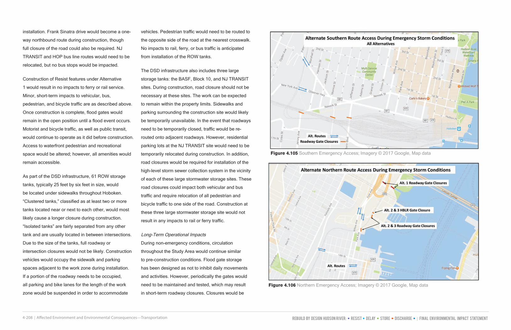
Figure 4.105 Southern Emergency Access; Imagery © 2017 Google, Map data
Figure 4.106 Northern Emergency Access; Imagery © 2017 Google, Map data

Affected Environment and Environmental Consequences—Transportation 4-209
planned to minimize inconvenience to residents and
businesses. For motorists, bicyclists, and pedestrians,
the long-term effects would be negligible. No roads
would be permanently closed. With the exception of
a few locations where roads are slightly narrower, the
Resist structures should not cause issues for vehicle
travelers and commuters. Additionally, required set-
backs at intersections would be adhered to in the
final design. The public would be affected by periodic
maintenance and testing, but would be able to resume
regular activity at all other times.
As described in Section 3.6, Alternative 1 includes
two options along the Hoboken Terminal rail yard;
Option 1 is located within the rail yard, whereas
Option 2 parallels Observer Highway, just north of
the rail yard property. Option 2 would not involve
long term operational impacts to the rail yard;
however, Option 1 would require NJ TRANSIT to
decommission infrastructure north of the Resist
structure. It is noted that the area to the north of
Option 1, within the rail yard, is part of the Hoboken
Yard Redevelopment Area, as described in Section
4.8.2.2, and the decommission of rail infrastructure
within the area north of Option 1 would occur as part
of that redevelopment plan. NJ TRANSIT, the property
owner, is aware of both Option 1 and Option 2 on their
property. The option constructed will be determined
when a final agreement is made concerning the
Hoboken Yard Redevelopment Area between NJ
TRANSIT, the developer of record and the City of
Hoboken.
Emergency Operation Impacts
Recognizing the extensive coordination effort between
the municipalities, agencies, and the community, an
Operations and Maintenance (O&M) plan for the RBD-
HR project is being prepared. The plan will describe
the procedures and responsibilities for routine
maintenance, communication, and timing of activation
(closure of gates) in the event of an impending storm
condition, and detail the coordination between the
project’s gate closures and suspension of services
pursuant to transit agencies’ existing emergency
management procedures. The O&M plan will
include the procedures to be followed by the various
stakeholders, such as NJ TRANSIT, other public
transit operators and local officials so that the timing
of gate closures and public transit service closures
is coordinated. An O&M Subcommittee is currently
developing the O&M plan. The participants in the O&M
subcommittee currently include, but are not limited
to, entities such as the NJDEP; the cities of Hoboken,
Jersey City, and Weehawken; NJ TRANSIT; PANYNJ;
Hudson County; JCMUA; NHSA; and the New Jersey
Office of Emergency Management.
In a flood gate deployment condition, some areas
would be impassible whether by vehicle, bicycle, or on
foot. Under Alternative 1, with an alignment along the
waterfront, access would be restricted onto properties
located on the piers in Weehawken and Hoboken
east of the Resist structure upon deployment of the
gates. The gate closures would be similar to detours in
place during construction. Flood gates would remain
in the deployed position for the duration of the flood
event as outlined in the O&M plan and would open
once water recedes to a safe level. Access to the NJ
TRANSIT rail yard and certain maintenance areas
would be impacted, but not entirely isolated. The
closure of gates would impact accessibility to transit
stops and could impact bus routes. The closure of
gates along Observer Highway (at Hudson Street for
Option 1 and at Washington Street for Option 2) would
impact accessibility for those individuals who access
Hoboken Terminal from Observer Highway. Under
a gate closure condition, these individuals would
still be able to access Hoboken Terminal, but would
Figure 4.107 NJ TRANSIT Hoboken Bus Routes; NJ TRANSIT

Rebuild by Design Hudson River: Resist Delay Store Discharge FINAL Environmental Impact Statement4-210 Affected Environment and Environmental Consequences—Transportation
require walking one block to the north, to Newark
Street, before proceeding south along Hudson Street
to Hudson Place. Detours and evacuation routes will
be identified as part of the project’s O&M plan, in
coordination with transit providers, and routes would
be clearly marked in the event of a storm (accessibility
to public transit under a gate deployment condition is
also described in Section 4.8.3.8).
Once flood gates are in the closed position, there
would be no direct access between southern Hoboken
and Jersey City. Jersey Avenue, Grove Street, and
Marin Boulevard. Alternate routes would be available
from western Hoboken via New York Avenue/
Observer Highway (see Figure 4.105) and Paterson
Plank Road. Access to Hoboken Terminal would be
limited to Hudson Street and points east.
Gate deployment under this alternative would not
impact train service of NJ TRANSIT trains (i.e., the
structure and gates would not involve track crossings
at the Hoboken Terminal rail yard). The Resist
structure’s Option 2 gate deployment would block
access to the NJ TRANSIT Engine House, and both
Options 1 and 2 would block access to NJ TRANSIT
employee parking lots south of the rail yard upon gate
deployment and reduce NJ TRANSIT staff access to
the yard itself.
Closure of gates to access these areas will be
closely coordinated with NJ TRANSIT operations,
Hudson County and municipal area emergency
management operations and activities. The timing of
gate closures will be incorporated into NJ TRANSIT,
Hudson County and Municipal revised emergency
management plans, but it is not anticipated that
gate closures for this project would impact Hoboken
Terminal train operations. According to NJ TRANSIT’s
Comprehensive Emergency Management Plan
(CEMP), HBLR and heavy rail cease operations 12 to
18 hours prior to a storm event. It is anticipated that
gate closures will be coordinated with NJ TRANSIT
to occur after NJ TRANSIT has already ceased
operations per their own emergency management
operational procedures. This would reduce impacts
to NJ TRANSIT service and emergency evacuation
procedures.
In northern Hoboken, existing access via Willow
Avenue and Park Avenue bridges would remain open.
Under Alternative 1, Weehawken ferry and piers would
be inaccessible including some waterfront properties.
Lastly, Alternative 1 proposes Port Imperial Boulevard
to be closed just north of Baldwin Ave during an
emergency. Proceeding west, the structure would
continue under the HBLR tracks. Alternative 1 would
not require a gate crossing or closure of the HBLR
tracks during a storm event (see Figure 4.106).
Pedestrians would experience the same limitations
as motorists. Efforts would be made to accommodate
bicyclists during construction; however, there may be
times when bicyclists should utilize the same detour
as motorists.
NJ TRANSIT Bus Route Impacts
Under Alternative 1 deployment of the gates would
interrupt bus routes using Jersey Avenue, Grove
Street, and Marin Boulevard. The locations of these
Resist elements are adjacent to the NJ TRANSIT rail
viaduct, and are depicted by green circles on Figure
4.107). Deployment of the Resist gates for Alternative
1 would, in addition to the above, interrupt NJ
TRANSIT Bus Route 23, which makes use of Frank
Sinatra Drive, where there would be gate structures
located just south of its intersection with Sinatra Drive
North, and just north of its intersection with Sinatra
Drive. It would also interrupt NJ TRANSIT Bus Routes
156R, 158, and 159R at their southern entry onto
Port Imperial Boulevard, where there would be a gate
structure just north of its intersection with Baldwin
Avenue/Harbor Boulevard. These three locations are
depicted with red circles on Figure 4.88. Closures on
Observer Highway would also impact bus routes.
While gate closures in the north and south would
impact bus routes, it is not anticipated that gate
closures would impact public transit service because
at the time of closure, prior to a flood, transit operators
would already have had to suspend service in order
to relocate vehicles and equipment out of vulnerable
areas. The details of the timing of gate closure
would be developed as part of the O&M plan. Gate
deployment under Alternative 1 would result in loss of
access to piers and waterfront amenities.
Additional Flooding
As described in Section 4.1.3.5, the coastal flood
computer model results show that the project’s
Resist infrastructure may cause an increase in
flooding to the western part of the Hoboken Terminal
rail yard by up to 6.5 inches at the peak of a 100-
year coastal storm event. The RBD-HR Project
has been coordinating with NJ TRANSIT to identify
vulnerable critical infrastructure within the yard to
evaluate specific impacts based on the elevation of
infrastructure components compared to the projected
increase in flooding. This coordination is being done in
conjunction with NJ TRANSIT’s own resiliency efforts,
and will continue into final design, which will also
involve further site-specific floodplain and hydrology
analysis.
While the peak coastal flooding amount is anticipated
to be up to 6.5 inches greater than under the No
Action Alternative within the western portion of the rail
yard, the actual duration of flooding is anticipated to be
less. This is because under the No Action Alternative,
coastal surge waters pass through the rail yard and
flood western Hoboken and Jersey City. When the
coastal surge begins to recede, these waters drain
back out through the rail yard to the Hudson River.
With the Resist infrastructure in place, this water
is prevented from entering western Hoboken and
Jersey City; therefore, no water is draining back out
through the rail yard at the end of the storm. Because
flood durations are anticipated to be reduced for any
given coastal event, this could allow NJ TRANSIT
operations to begin post-storm recovery efforts earlier,
which could allow for service restoration sooner than
under current conditions.

Affected Environment and Environmental Consequences—Transportation 4-211
Based on flood modeling, the privately owned surface
parking lot at 1 Washington Street will also experience
slightly higher flood levels at the peak of a coastal
storm. As discussed in Section 4.1.3.5, this lot may
experience about 2.5 inches of additional flooding
greater than what currently exists at the peak of a
coastal storm event. This lot holds approximately 200
vehicles; however, resident evacuation notifications
would occur before water levels reach this lot. For
additional information regarding impacts to this
property and mitigation requirements pursuant to
N.J.A.C. 7:13, please see Section 4.1.3.5.
Alternative 2
Short-term, Construction Impacts
Alternative 2 would have short-term, moderate
adverse impacts on traffic and circulation within the
Study Area. Under Alternative 2, there are 21 gates
in Option 1 and 25 gates in Option 2 and the length of
the Resist structure is substantially shorter than under
Alternative 1. For these reasons, the impacts on traffic
and circulation are less under Alternative 2 compared
to Alternative 1.
For Alternative 2, the northern area impacts would
be principally in the two blocks of Washington Street
between 13th and 15th Street. The western sidewalk
of Washington Street would be reconstructed under
Alternative 2 and the very high volume of pedestrians
would be routed to the eastern sidewalk. Due to
roadway widths and existence of roadside parking,
full closure would not be likely; however, in the event
of a full closure, traffic would be detoured north to
15th Street using either Bloomfield Avenue or River
Street, to continue in the east/west direction. Two NJ
TRANSIT bus stops along Washington Street would
need to be temporarily relocated or suspended.
A barrier crossing is proposed at the west side of
14th Street and Washington Street. Fourteenth Street
is striped as two lanes in the eastbound direction
and one lane in the westbound direction with both
sidewalks and parking on either side. The intersection
has bulb outs for parking and brick crosswalks on all
sides. Fourteenth Street carries approximately 600
vehicles during peak hour. This crossing generally
does not experience congestion during peak hours.
The proposed Resist structure would run along
the west side of the intersection of 15th Street and
Washington Street. Fifteenth Street is a two-lane road
with sidewalks on both sides and diagonal parking
along the eastbound side. The proposed barrier would
run through existing bulb outs on the south ends,
which support the diagonal parking on both 15th
Street and Washington Street. Fifteenth Street carries
approximately 650 vehicles during peak hour and
operates with little congestion. Due to the roadway
width of both streets, and the existence of parking,
full closures would not be likely. During construction,
similar to the 14th Street crossing, the large volume
of pedestrians would need to be rerouted from the
western sidewalk to the eastern sidewalk. In the event
of a full closure, traffic would need to be detoured
south to 14th Street via either Hudson Street or Park
Avenue to continue in the east-west direction.
Under Alternative 2, there is a gate required on Harbor
Boulevard and a Resist structure along the length of
the road from Park Avenue to 19th Street. The road is
a minor road with no sidewalks or parking. It is fairly
narrow once it converts to a one-way road due to its
proximity to the bridge supports on the south side, as
well as the train tracks on the north side. This road can
be used to access Hoboken via Park Avenue. Despite
the width of the road, full closure during construction is
not anticipated. Any impacts to vehicles, pedestrians,
and bicyclists from this construction would be short-
term.
Under Alternative 2, a gate would be installed at the
19th Street and Waterfront Terrace Intersection.
The barrier would be located on the west side of the
intersection next to a set of at-grade train tracks.
Nineteenth Street is a four-lane (two lanes in each
direction) road with sidewalks on both sides and
a small painted median. It forms a three-legged
signalized intersection with Waterfront Terrace.
Nineteenth Street carries approximately 1,400
vehicles during peak hour. The widths of the crossing
roadways should allow for staged construction. In
the event of a full closure, vehicles would have to be
detoured around the barrier using Harbor Boulevard,
as well as Baldwin Avenue and John F. Kennedy
Boulevard. There is a gate west of Waterfront Terrace
that would cross the HBLR tracks. Construction of
the gate across the HBLR tracks and other work in
the area would need to be coordinated closely with
NJ TRANSIT. Given the HBLR is a 7-day, 24 hour
operation, there would be some outages associated
with construction of the gate across the tracks;
however, impacts to service would be limited to
weekends and off-peak hours whenever possible.
Construction impacts for Resist infrastructure in the
southern portion of the Study Area and for DSD are as
described under Alternative 1.
There would be no impacts to ferry service under
Alternative 2.
Once construction is complete, flood gates would
remain in the open position until a flood event occurs.
Motorist and bicycle traffic, as well as public transit
would continue to flow as it did before construction.
Long-Term Operational Impacts
The long-term operational impacts would be as
described under Alternative 1.
Emergency Operation Impacts
Emergency Operation Impacts for Alternative 2 are
similar to Alternative 1 and will be addressed through
the implementation of the RBD-HR O&M plan.
Under Alternative 2, some roads would be closed off
to vehicular, bicycle, and pedestrian access while
gates are deployed. Gate deployment for Alternative
2 would require alternate routes, but properties
would still be accessible. The gate closures would
require detours similar to those put in place during
construction.

Rebuild by Design Hudson River: Resist Delay Store Discharge FINAL Environmental Impact Statement4-212 Affected Environment and Environmental Consequences—Transportation
Under Alternative 2 deployment, Harbor Boulevard
would be closed off just north of Hoboken, limiting
access to Weehawken through Willow Avenue and
Park Avenue. Additionally, under Alternative 2, 19th
Street would be closed just west of the intersection
of 19th Street and Waterfront Terrace. This closure
should not have an effect on resident evacuations.
Lastly, Alternative 2 proposes Port Imperial Boulevard
to be closed just north of Baldwin Avenue. Proceeding
west, the Resist structure would continue across the
HBLR tracks with a gate just south of the Lincoln
Harbor Light Rail Station. This would be the only
track closure for Alternative 2. The HBLR track
closure associated with a gate closure, should not
affect evacuation routes because the O&M plan
would time the gate closure after train service has
stopped operations due to a pending storm event.
As per NJ TRANSIT’s CEMP, the HBLR train service
ceases operations and secures light rail vehicles at
designated storage locations between 12 and 18
hours prior to a coastal storm event. Gate closure
timing procedures will be coordinated with NJ
TRANSIT and the overall emergency management
plan for the area. As in Alternative 1, gate deployment
under this alternative would not inhibit movement of
NJ TRANSIT trains at Hoboken Terminal, but Option
2 deployment would block access to the NJ Transit
Engine House, and both Options 1 and 2 would block
access to NJ TRANSIT employee parking lots south
of the rail yard upon deployment. See Alternative 1
impacts for additional discussion regarding operational
impacts.
Pedestrians would experience the same limitations
as motorists. Efforts would be made to accommodate
bicyclists during construction; however, there may be
times when bicyclists should utilize the same detour
as motorists.
NJ TRANSIT Bus Route Impacts
Deployment of the Resist gates under Alternative 2
would interrupt routes using Jersey Avenue, Grove
Street, and Marin Boulevard. The locations of these
Resist elements are adjacent to the NJ TRANSIT rail
viaduct and are depicted by green circles on Figure
4.107.
In addition to the three locations previously described
on the south end of Hoboken, deployment of the
Resist elements for Alternative 2 would interrupt bus
service with a gate across 19th Street just east of the
HBLR tracks, NJT Bus Routes 63, 64H and 66, which
utilize 19th Street to make a loop at Lincoln Harbor
using Waterfront Terrace and Harbor Boulevard,
returning via 19th Street. It would also, via a gate
across 14th Street immediately west of Washington
Street, interrupt NJ routes 22, 23, 63, 64, 68, 89
& 126. Closures on Observer Highway would also
impact bus routes.
Hoboken HOP and Senior Shuttle services are limited
to Hoboken. Closures in the North at 14th and 15th
Street and in the South on Observer Highway would
impact bus routes; however, during emergency
conditions it is likely that these shuttle services would
already be suspended. While gate closures in the
north and south would impact bus routes, and the
closure in the north would impact the HBLR, it is not
anticipated that gate closures would impact public
transit service because at the time of closure, prior
to a flood, transit operators would already have had
to suspend service in order to locate vehicles and
equipment out of vulnerable areas. The details of the
timing of HBLR and gate closure would be developed
as part of the O&M plan.
Additional Flooding
Additional flooding impacts to the Hoboken Terminal
rail yard would be the same as described under
Alternative 1.
Alternative 3
Short-term Construction Impacts
Alternative 3 would have short-term, moderate
adverse impacts on traffic and circulation within the
Study Area. Alternative 3 has the least number of
gates of any alternative (19 gates in Option 1 and
23 gates in Option 2) and the length of the Resist
alignment is shortest among all alternatives. For these
reasons, the impacts on traffic and circulation are least
under Alternative 3 compared to the other alternatives.
Alternative 3 would have similar impacts on
Washington Street to Alternative 2, except over a
shorter distance.
The Bloomfield Street gate crosses Bloomfield Street
between 14th Street and 15th Street. Bloomfield Street
is a one-way road northbound with both sidewalks and
parking on either side. The proposed gate location
runs through the paved pedestrian pathway that
crosses Bloomfield Street. During construction, traffic
and pedestrians would have to be detoured east to
Washington Street via 14th Street or 15th Street.
The gate at 15th Street and Garden Street crosses
15th Street at a 45 degree angle between the
northwest corner of the intersection and the southeast
corner of the intersection. Garden Street is a dead-end
road that ends between 25th Street and 14th Street
with a loading zone on the west side of the street
and no street parking. It carries minor traffic, mainly
used for truck deliveries. Fifteenth Street is a two-lane
road with sidewalks on both sides. It widens, moving
westward through the intersection, transitioning to
a two-lane approach as it intersects Park Avenue. It
carries approximately 650 vehicles during peak hour.
Due to the width of the roadways, construction staging
may be possible. In the event of a full closure during
construction, traffic would be detoured south to 14th
Street via Washington Street to continue in the east-
west directions.
Construction impacts for Resist features in the
southern portion of the Study Area and for DSD are as
described under Alternative 1.
There would be no impacts to ferry service under
Alternative 3.
Once construction is complete, flood gates would
remain in the open position until a flood event occurs.
Motorist and bicycle traffic, as well as public transit,

Affected Environment and Environmental Consequences—Transportation 4-213
would continue to flow as it did before construction.
Long-Term Operational Impact
The long-term operational impacts would be as
described under Alternative 1 and include periodic
mechanical testing and maintenance.
Emergency Operation Impacts
The long-term operational and emergency impacts
under Alternative 3 would be similar to the impacts
under Alternative 2.
Additional Flooding
Additional flooding impacts to the Hoboken Terminal
rail yard would be the same as described under
Alternative 1.
No Action Alternative
Under the No Action Alternative, there would be no
short-term impacts on traffic or circulation. It should
be noted; however, that traffic and circulation would
be impacted during future storm events (both coastal
surge and rainfall flood events), as streets and transit
systems are forced to close due to high water. This
impact would be expected to continue with increased
frequency and intensity into the future due to sea-level
rise and climate change.
4.9.3.2 Mitigation Measures and BMPs included in Alternatives 1, 2, and 3
The following measures would be implemented to
minimize impacts from the Resist component of the
project on transportation:
Traffic closures for gate installation would be
minimized and performed during off-peak hours.
Gate testing and maintenance activities following
installation would be performed during non-peak traffic
hours to the extent practicable.
Recognizing the extensive coordination effort between
the municipalities, agencies, and the community
an O&M plan for the RBD-HR project is being
prepared. The plan will describe the procedures
and responsibilities for routine maintenance,
communication and timing of activation in the event
of an impending storm condition. The O&M plan will
include the procedures to be followed by the various
stakeholders, such as NJ TRANSIT, other public
transit operators, and local officials so that the timing
of gate closures and public transit service closures
is coordinated. The participants in the O&M planning
and development currently include, but are not limited
to, entities such as NJDEP; the cities of Hoboken,
Jersey City, and Weehawken; NJ TRANSIT; PANYNJ;
Hudson County; JCMUA; NHSA; and the New Jersey
Office of Emergency Management.
The following measures would be implemented
to minimize impacts from the Resist and DSD
components of the project on traffic and transportation:
• All closures for traffic and pedestrians, including
temporary detour routes, would be coordinated well
in advance with local jurisdictions
4.9.3.3 Infrastructure
Alternative 1
Minor to moderate short-term impacts would occur
to properties adjacent to proposed construction
locations. This would be in the form of short-term
disruption of service due to necessary relocation of
utilities for the construction of project infrastructure.
Alternative 1 would require approximately 86 to 87
utility crossings and the relocation of approximately
4,860 to 4,600 linear feet of utilities for Options 1 and
2, respectively.
Alternative 2
Minor short-term impacts would occur to properties
adjacent to proposed construction locations. This
would be in the form of short-term disruption of
service due to necessary relocation of utilities for the
construction of project infrastructure. Alternative 2
would require approximately 69 utility crossings and
the relocation of approximately 2,300 to 2,060 linear
feet of utilities for Options 1 and 2, respectively.
Portions of the Resist structure for Alternative 2 would
be located in upland areas. As a result, areas on
the river side of the structure would still experience
flooding during a 100-year coastal storm surge event.
To prevent backflow from this area from flooding areas
on the inland side of the Resist feature, the combined
storm and sanitary sewer would be separated. This
would involve construction of a new high-level storm
system that intercepts stormwater from this area and
discharges into new outfalls. The existing storm sewer
system would be sealed and lined to prevent surface
water infiltration and backflow preventers would be
installed to prevent a reverse flow of water into the
system on the inland side of the Resist structure.
Alternative 3
Minor short-term impacts would occur to properties
adjacent to proposed construction locations. This
would be in the form of short-term disruption of
service due to necessary relocation of utilities for
the construction of project infrastructure. Alternative
3 would require approximately 64 utility crossings
and the relocation of approximately 1,280 to 1,030
linear feet of utilities for Options 1 and 2, respectively.
Alternative 3 would result in the fewest impacts to
utilities out of all three Build Alternatives.
Portions of the Resist structure for Alternative 3 would
be located in upland areas. As a result, areas on
the river side of the structure would still experience
flooding during a 100-year coastal storm surge event.
To prevent backflow from this area from flooding
areas on the inland side of the Resist structure,
the combined storm and sanitary sewer would be
separated. This would involve construction of a new
high-level storm system that intercepts stormwater
from this area and discharges into new outfalls. The
existing storm sewer system would be sealed and
lined to prevent surface water infiltration and backflow
preventers would be installed to prevent a reverse
flow of water into the system on the inland side of the
Resist structure.

Rebuild by Design Hudson River: Resist Delay Store Discharge FINAL Environmental Impact Statement4-214 Affected Environment and Environmental Consequences—Transportation
No Action Alternative
Under the No Action Alternative, there would be
no short-term impacts to infrastructure or utilities.
However, inundations from future coastal storm surge
or rainfall flood events would continue to represent
challenges for utility providers, potentially disrupting
service to customers and residents within the Study
Area.
4.9.3.4 Mitigation Measures and BMPs included in Alternatives 1, 2, and 3
Coordinate with utilities and local property owners/
residents to address any utility disruptions during
construction of Resist and DSD components of the
project.