5.0 assessment of options - home - roads and … · 5.0 assessment of options ... minor or...
TRANSCRIPT

BUILT HERITAGE AND ARCHAEOLOGICAL LANDSCAPE INVESTIGATION : WINDSOR BRIDGE OPTIONS FINAL DRAFT REPORT OCTOBER 2009
46
5.0 ASSESSMENT OF OPTIONS
5.1 INTRODUCTIONIn total, nine options to cross the Hawkesbury River at Windsor have been proposed by the RTA. Eight options require building a new bridge crossing and adjacent approach roads, the ninth option would require refurbishing the existing bridge and maintaining the existing alignments. Each option has been assessed with regard to the potential impacts associated with road re-development (including potential widening) and historical heritage constraints, including built heritage, archaeological sites and landscape values. The analysis presented in this section takes into consideration items listed on statutory and non-statutory lists and is intended to present enough detail to assist in informed decision making on the most feasible option.
Development impacts are expected to consist of:
Construction of a new concrete bridge over the Hawkesbury River at Windsor. Realignment of approaches on both sides of the bridge. Construction of new alignments for certain options. Relocation of utilities and services. Excavation, stockpiling and associated activities.
For the purposes of this analysis “heritage items” includes those listed on statutory registers such as the SHR and Schedule 1 (Heritage Items) of the Hawkesbury LEP 1989 and the RNE as well as non-statutory heritage resisters such as the National Trust (NSW). Further, as all historical archaeological sites in NSW are protected under the Heritage Act 1977, all known and potential archaeological sites are included in the analysis.
This report aims to identify all heritage issues within Windsor and Pitt Town. By taking this approach, not only are all items (whether single entities or groups) identified but consideration is given to the values that make Windsor and Pitt Town significant historical landscapes that function well in the present.

BUILT HERITAGE AND ARCHAEOLOGICAL LANDSCAPE INVESTIGATION : WINDSOR BRIDGE OPTIONS FINAL DRAFT REPORT OCTOBER 2009
47
Figure 5.1: Eight of the nine options under consideration for the Windsor Bridge Upgrade. The ninth option is the refurbishment of the existing bridge. Source: generated by Austral Archaeology, using the 1:25 000 Scale Wilberforce 90301-N Topographic Map © Department of Lands 2006.

BUILT HERITAGE AND ARCHAEOLOGICAL LANDSCAPE INVESTIGATION : WINDSOR BRIDGE OPTIONS FINAL DRAFT REPORT OCTOBER 2009
48
Figure 5.2: Detail of Windsor township showing seven of the options under consideration for the Windsor Bridge Upgrade. Source: generated by Austral Archaeology, using the 1:25 000 Scale Wilberforce 90301-N Topographic Map © Department of Lands 2006.

BUILT HERITAGE AND ARCHAEOLOGICAL LANDSCAPE INVESTIGATION : WINDSOR BRIDGE OPTIONS FINAL DRAFT REPORT OCTOBER 2009
49
Figure 5.3: Detail of Pitt Town showing the eighth option under consideration for the Windsor Bridge Upgrade. Source: generated by Austral Archaeology, using the 1:25 000 Scale Wilberforce 90301-N Topographic Map © Department of Lands 2006.

BUILT HERITAGE AND ARCHAEOLOGICAL LANDSCAPE INVESTIGATION : WINDSOR BRIDGE OPTIONS FINAL DRAFT REPORT OCTOBER 2009
50
5.2 OPTIONS ANALYSIS
5.2.1 OPTIONS ANALYSIS SUMMARY
A detailed analyses of the varying options for the Hawkesbury River Bridge construction works are presented in Sections 5.2.2 – 5.2.9. Each analyses takes into account the number of heritage listings and the likelihood that archaeological sites exist within the proposed area of impact. The information for each option is summarised below.
5.2.1.1 OPTIONS 1 & 2Options 1 & 2 have the potential to affect 15 items listed on the SHR. One of these items ‘Thompson Square Conservation Area’ includes 15 items within its listing (the Former School of Arts is not listed on the SHR individually but is included in the Thompson Square Conservation Area listing).
In addition, Options 1 & 2 have the potential to impact upon 2 known archaeological sites (a brick sewer & former punt wharf) and 3 potential archaeological sites, none of which are listed individually or within the Thompson Square Conservation Area but potentially occur within the SHR curtilage.
A total of 18 technical reports would be required for a total of 20 permit applications under the Heritage Act 1977. It may be possible to reduce the total number of applications and their associated technical reports but consultation with the Heritage Council would be required to ascertain this. Two notifications to Hawkesbury City Council under the provisions of the ISEPP 2007 accompanied by the relevant technical reports would also be required.
5.2.1.2 OPTION 3Option 3 has the potential to affect a total of 16 SHR listed items. One of these items ‘Thompson Square Conservation Area’ includes 15 items within its listing (the Former School of Arts is not listed on the SHR individually but is included in the Thompson Square Conservation Area listing).
In addition, Option 3 has the potential to impact 1 known archaeological site (a brick sewer) and 3 potential archaeological sites, none of which are listed individually or within the Thompson Square Conservation Area but potentially occur within the SHR curtilage.
A total of 17 technical reports would be required for a total of 19 permit applications under the Heritage Act 1977. It may be possible to reduce the total number of applications and their associated technical reports but consultation with the Heritage Council would be required to ascertain this. Two notifications to Hawkesbury City Council under the provisions of the ISEPP 2007 accompanied by the relevant technical reports would also be required.
5.2.1.3 OPTION 4Option 4 has the potential to affect 3 items listed in the Hawkesbury LEP 1989. There are no SHR listed items that would be potentially directly affected.
In addition, Option 4 has the potential to impact upon 3 potential archaeological sites.
This option will require at least 1 report (and possibly up to 3 reports) to support archaeological permit applications under the Heritage Act 1977. Three notifications to Hawkesbury City Council under the provisions of the ISEPP 2007 accompanied by the relevant technical reports would also be required.
5.2.1.4 OPTION 5Option 5 has the potential to affect 5 items listed in the Hawkesbury LEP 1989. There are no SHR listed items that would be potentially directly affected.
In addition, Option 5 has the potential to impact upon 4 potential archaeological sites.
This option will require 4 reports to support S140 permit applications under the Heritage Act 1977.Up to five notifications to Hawkesbury City Council under the provisions of the ISEPP 2007accompanied by the relevant technical reports would also be required.

BUILT HERITAGE AND ARCHAEOLOGICAL LANDSCAPE INVESTIGATION : WINDSOR BRIDGE OPTIONS FINAL DRAFT REPORT OCTOBER 2009
51
5.2.1.5 OPTION 6Option 6 has the potential to affect 1 item listed on the SHR and the Hawkesbury LEP 1989 and 1 archaeological site.
This option will require 2 reports to support permit applications under the Heritage Act 1977: one S140 application and one S60 application. Two notifications to Hawkesbury City Council under the provisions of the ISEPP 2007 accompanied by the relevant technical reports would also be required.
5.2.1.6 OPTION 7Option 7 has the potential to affect 6 items listed on the SHR (although one of those items has two separate components), 1 item listed on a S170 Register, 4 archaeological sites, and 4 sites and a conservation area listed in the Hawkesbury LEP 1989.
This option would require the preparation of a total of 9 reports to support permit applications under the Heritage Act 1977: 5 technical reports addressing physical and visual impacts to built heritage items and 4 archaeological assessments. Five notifications to Hawkesbury City Council under the provisions of the ISEPP 2007 accompanied by the relevant technical reports would also be required.
5.2.1.7 OPTION 8Option 8 has the potential to affect 2 items listed on the SHR, 1 item listed on the Hawkesbury LEP 1989, 1 item nominated to the National Heritage List and 2 (or possibly 3) archaeological sites.
This option would require the preparation of a total of up to 5 reports to support permit applications under the Heritage Act 1977: 2 technical reports addressing physical and visual impacts to built heritage items and 2 (or possibly 3) archaeological assessments. One notification to Hawkesbury City Council under the provisions of the ISEPP 2007 accompanied by the relevant technical report would also be required.
ln addition one report may be required as a referral under the EPBC Act to the DEWHA re the NHL nomination for the “Pitt Town Cultural Precinct”.
5.2.1.8 OPTIONS 9A AND 9BBoth Options 9A and 9B would require 1 notification to the Heritage Council. A supporting report in the form of a Statement of Heritage Impact would be required. The Heritage Council have a period of 40 days to respond in the instance that is deemed to be of State heritage significance. One notification to Hawkesbury City Council under the provisions of the ISEPP 2007accompanied by the relevant technical report would also be required.

BUILT HERITAGE AND ARCHAEOLOGICAL LANDSCAPE INVESTIGATION : WINDSOR BRIDGE OPTIONS FINAL DRAFT REPORT OCTOBER 2009
52
5.2.1.9 EXPLANATION OF TABLES
A Summary Table of Listings has been included within each discussion of all Options. The table includes all heritage items or potential heritage items that are likely to be physically or visually impacted by the option under review, the statutory protection for each listed item and the relevant approval application/s that would be required to progress the project.
The Summary Table of Actions sets out the type of approval and technical report required for each type of listing. For instance, an item that is identified under an Option as being listed on the SHR will require the submission of a Section 60 application (Heritage Act 1977) or Exemption Notification to the Heritage Council. The documentation required for either application would be a statement in accordance with an endorsed CMP, or in the absence of a CMP, a Heritage Assessment and Statement of Heritage Impact (SoHI) for structures and/or an Archaeological Assessment and Statement of Heritage Assessment for archaeological sites. The technical report to support a Section 60 application for an archaeological site would also require a Research Design to guide the archaeological excavation.
Table 5.1: Summary Table of Actions
Listing Approval Technical Report NHL Referral to the
Minister (DEWHA) Heritage Assessment and SoHI
SHR Section 60 application
or
In accordance with endorsed CMP or accompanied by a Heritage Assessment and SoHI
Exemption Notification
In accordance with endorsed CMP or accompanied by a Heritage Assessment and SoHI
LEP
or
PotentialHeritage Items (Built Heritage)
Consultation with Hawkesbury City Council for development that is likely to have an impact that is not minor or inconsequential
Heritage Assessment & SoHI
RNE* Referral to the Federal Minister
Heritage Assessment and SoHI
Archaeological site (no listing)
Section 140
or
Archaeological Assessment & Research Design
Exception Notification
Archaeological Assessment or Supporting Statement
NT (NSW) N/A N/A
* Note that statutory requirements under the EPBC Act 1999 only applies to RNE listed items that are owned by the Commonwealth.

BUILT HERITAGE AND ARCHAEOLOGICAL LANDSCAPE INVESTIGATION : WINDSOR BRIDGE OPTIONS FINAL DRAFT REPORT OCTOBER 2009
53
5.2.2 OPTIONS 1 & 25.2.2.1 DESCRIPTION: Option 1 & 2 proposes the following:
Option 1 High level - 35 metre (m) downstream of existing bridge. Option 2 Low level - 35 metre downstream of existing bridge.
Options 1 and 2 are both a continuation of the existing Bridge Street corridor and located 35 m downstream of the existing structure. They provide a crossing that is central to the Windsor township, connecting the northern side of the Hawkesbury River from within the township of Windsor. There would be easier access to the southern river bank by continuing The Terrace under the bridge. This would also provide safe pedestrian access along the southern river bank.
5.2.2.1.1 OPTION 1 HIGH LEVEL BRIDGE
Option 1 would provide clearance of approximately 4.5 m for the bridge from The Terrace. This would allow access for service vehicles including garbage trucks, cars and coaches under the bridge from the Windsor side.
The length of this option is in the order of 470 m, consisting of 200 m of new approaches, 160 m of new bridge, with 110 m of upgrade to existing road.
5.2.2.1.2 OPTION 2 - LOW LEVEL BRIDGE
Option 2 would provide clearance of approximately 3.5 m for the bridge from The Terrace. This would only allow access for cars under the bridge. However, by reducing the vertical clearance between The Terrace and the new bridge to 3.5 m it would place the bridge below the 1 in 5 year flood level.
The length of this option is in the order of 470 m, consisting of 200 m of new approaches, 160 m of new bridge, with 180m of upgrade to existing road.
Figure 5.4: Options 1 and 2. Base map source RTA © 2009.
Option 1 proposes to acquire property in the Riverside Park Reserve, the Public Park Reserve at Thompson Square and on the northern bank of the river. The image has been rotated to orient North at the top.

BUILT HERITAGE AND ARCHAEOLOGICAL LANDSCAPE INVESTIGATION : WINDSOR BRIDGE OPTIONS FINAL DRAFT REPORT OCTOBER 2009
54
Table 5.2: Options 1 & 2 may require the acquisition of:
ITEM LOT/DP HERITAGE LISTED Thompson Square (part) Lot 345 DP 752061 SHR; LEP; RNE Two sections on the south bank Lot 7008 DP 1029964 No One section of the north bank with part of an existing turf farm
Lot 2 DP 65136 No
Part of an existing turf farm Lot 2 DP 1096472 No
5.2.2.2 OPTIONS 1 & 2: EXISTING ENVIRONMENT
The topography of Options 1 & 2 is defined by the graded road approach to the existing bridge with the road sweeping through the much-modified southern riverbank. The road approach is flanked by a high level terrace to the west and a remnant of the graded riverbank to the east (Old Bridge Street). The south western quadrant of the precinct is the graded landform of the public reserve. The landform north of the river is graded to the ridge along which Wilberforce Road is built. Beyond the ridge the land is generally level farmland.
The various elements that make up ‘Thompson Square Conservation Area’ (hereafter referred to as “Thompson Square”) as it is listed on the SHR can create some confusion when discussing single elements of the listing; therefore the terms used throughout the remainder of the options analysis are as follows:
“Thompson Square” means the area defined graphically by the SHR listing (Figure 5.7), which is described as consisting of George Street, Bridge Street, Thompson Square and The Terrace. These streets surround a small turfed reserve with pleasant trees that helps to conserve an attractive frontage to the important surrounding buildings (SHR Data Base number 5045195). When referring to specific elements of the Conservation Area in this report, they will be defined by their function. Thus, the road that runs adjacent to the Macquarie Arms Hotel to 1-3 Thompson Square will be referred to as “the Thompson Square roadway”. The Reserve located directly adjacent to the Thompson Square roadway is referred to as “the reserve” (of Thompson Square). The small public green space is referred to as “the lower public green space” (of Thompson Square). Specific buildings will be defined by their street address or Lot and DP numbers.
The elevated character of the western side of Thompson Square and the associated upper public green space in the centre, Old Bridge Street and the lower public green space between Bridge Street and Old Bridge Street provide a vantage point to view the Hawkesbury River, the farmland beyond and the backdrop of the Blue Mountains. Wilberforce Road and the northern bank of the river provide views to Thompson Square and this view has been documented by generations in paintings, drawings and photographs. The existing bridge itself is now of historic interest and can be viewed from the park. The park also provides views to neighbouring buildings, in particular the buildings on the ridge to the south (George Street) and to the graded terrace to the west (Thompson Square).
The public open space of Thompson Square is a place of longstanding amenity in Windsor and this is reflected in the mature tree plantings, commemorative plaques and stones, and public seating. The reserve was originally designed as a civic space and the north-east corner of the park (the lower public green space) has been graded and terraced to provide public car parking. The focus on Lachlan Macquarie’s impact in the colony by the “Thematic Listings Program 2009-2010” (Heritage Branch of the Department of Planning) is an indication of the added importance of the centre of Windsor and other Macquarie Towns. Thompson Square has been impacted by road improvements to the bridge; nevertheless it retains the village square character originally intended by Macquarie.
After settlement at Windsor began, crossing the Hawkesbury River at this location was achieved by ferry from at least 1814, initially under private ownership, later taken over by government in 1832. It is likely that use of the punt and wharf would have decreased after the bridge was opened in 1874 but plans as late as 1894 and a photograph from 1901 show what can be assumed to be

BUILT HERITAGE AND ARCHAEOLOGICAL LANDSCAPE INVESTIGATION : WINDSOR BRIDGE OPTIONS FINAL DRAFT REPORT OCTOBER 2009
55
an operational wharf in the same location. Wharf remains on the opposite bank were not noted but should be a consideration in any technical report assessing the significance and integrity of the existing remains.
Mention has also been made of one or two brick drains as part of Howe and McGrath’s contract (c.1815) to construct the punt wharf (Heritage Concepts 2008: 24). The scope of the original brief for the punt wharf included “…a sewer in the middle of the Square with Channels leading thereto or to Sink and Erect two sewers one on each side of the Square…” (Mitchell Library Manuscripts in Heritage Concepts 2008: 24). Legend has it that the drain was used as a smugglers’ tunnel connecting the Macquarie Arms Hotel to the river. The legend is unlikely to be true but parts of the drain are likely to survive within the Thompson Square reserve. Based on visual observations in the past, the drain ran through the centre of Thompson Square but was heavily impacted in part by the construction of the present approach to the Bridge (Higginbotham 1986: 41).
The Hawkesbury River and its reserve has provided amenity in the town over generations. This is demonstrated in the pavements, shade trees, views and vistas. The riverbank provides a green corridor. In this locality, the Windsor Bridge is a listed heritage item (Hawkesbury LEP 1989 Item No. 276) and there are relics associated with the wharf and punt at the base of Old Bridge Street that can be seen from the existing bridge. The historic punt wharf remains are separate and further to the west than the functioning wharf also visible on the Windsor side of the Hawkesbury River.
The rural land north and west of the Hawkesbury River demonstrates a continuation of primary economic activity dating from the late eighteenth century. The open rural nature of the north bank provides both a backdrop to the town and a contrast to the urbanised south bank.
Options 1 & 2 are located within the centre of both the Green Hills of the mid 1790s and Macquarie’s later replanning of that settlement in the 1810s to form Windsor. The built form of the area has evolved from the earliest days of British settlement, which collectively is recognised as having a heritage value that warrants statutory protection as the “Thompson Square Conservation Area” (SHR Database (DB) No. 5045195) which includes:
The Doctor's House - 1-3 Thompson Square, Windsor. House & outbuildings - 5 Thompson Square, Windsor. Hawkesbury Museum - 7 Thompson Square, Windsor. Macquarie Arms Hotel - cnr Thompson and George Streets, Windsor. Vacant site - 60 George St (not shown on Six Viewer & not identified in field). Cottage - 62 George St, Windsor. Shops - 64, 66, 68 George St, Windsor. 70, 72 George St, Windsor (Formerly Hawkesbury Garage, now a shop). 74 George St, Windsor (A.C Stearn Building). 82 George St, Windsor. Vacant site - 4 Bridge St, Windsor (shown as part of 6 Bridge Street on Six Viewer). House & outbuildings - 6 Bridge St, Windsor. House & outbuildings - 10 Bridge St, Windsor. House - 17 Bridge St, Windsor. Former School of Arts - 14 Bridge St (cnr George St) Windsor.
Individual SHR listings within the Options 1 & 2 corridor and vicinity include the following:
Reserve & Streets Crown Land (DB # 5045106). Doctor’s House 1-3 Thompson Square, Windsor (DB #5045706). Shop 80 George St, Windsor (DB # 5051761). Shop 82 George St, Windsor (DB # 5045437). Macquarie Arms Hotel, Thompson Square, Windsor (DB # 5045146). House 6 Bridge St, Windsor (DB # 5045433). House & outbuildings 5 Thompson Square, Windsor (DB # 5045184). Hawkesbury Museum 7 Thompson Square, Windsor (DB #5044975). Cottage 17 Bridge St, Windsor (DB # 5045429).

BUILT HERITAGE AND ARCHAEOLOGICAL LANDSCAPE INVESTIGATION : WINDSOR BRIDGE OPTIONS FINAL DRAFT REPORT OCTOBER 2009
56
Precinct of land & buildings 62-68 George St, Windsor (on same lot as 17 Bridge St) (DB # 5045428).
Bungalow 4 Bridge St, Windsor (DB # 5001096). 10 Bridge St, Windsor (DB # 5045645). A.C Stern Building (DB # 5045542). Stables at the rear of Police Station (DB # 5045305) – the stables are on a different Lot/DP
to the Police Station, although the masonry wall on the Police Station grounds are included in this listing.
The Hawkesbury LEP 1989 Heritage Schedule lists Thompson Square (Item No. 273) inclusive of:
The Doctor’s House, Nos 1–3 Thompson Square. No 5 Thompson Square. Museum, No 7 Thompson Square. Thompson Square, part George Street, part The Terrace, and part Bridge Street. Macquarie Arms Hotel. Public Reserve, Thompson Square. House, No 4 Bridge Street. House, No 6 Bridge Street. House, No 10 Bridge Street. Former School of Arts, 14 Bridge Street. No 17 Bridge Street. Nos 62–68 George Street. Nos 70–72 George Street. AC Stearn Building, No 74 George Street. Shops, Nos 80–82 George Street. No 88 George Street. Nos 92–98 George Street.
These heritage items are significant individually and collectively in forming streetscapes of heritage value in George Street, Old Bridge Street and Thompson Square, and by defining street corners and ridge lines, and terminating views from the park.
Other Hawkesbury LEP 1989 listed items within the existing environment or in the vicinity of Options 1 & 2 are:
20 Bridge St, Windsor (Item No. 147). “Lock up” Ruin at the front of the Police Station 32-34 Bridge St, Windsor (Item No. 148). The Toll House 40 Bridge St, Windsor (Item No. 150). Old Barrack Wall (on the Court St side of the Police Station at 32-34 Bridge St, Windsor
(Item No. 157). “The Windsor Tavern” (now the “Jolly Frog Hotel”) 27 Bridge St, Windsor, over 2 lots (Item
No. 151). “Bridgeview” at No. 27 Wilberforce Rd Freemans Reach (Item No. 274).
Options 1 & 2 are in the vicinity of the listed heritage items.
5.2.2.3 OPTIONS 1 & 2: POTENTIAL INDICATIVE IMPACTS
Options 1 & 2 may require impact to a section of the lower public green space in Thompson Square between Bridge Street and Old Bridge Street as well as some of the larger trees on the eastern perimeter of the Thompson Square reserve. The lower green space of Thompson Square (Lot 345 DP 752061) appears to be within the indicative boundary of impact as shown in the options drawing.
In addition to the items listed on the SHR data sheet, heritage items that occur within the SHR curtilage (Figure 5.7) such as archaeological sites and sandstone kerbs are also protected under the SHR listing and therefore would require management either through a Section 60 application or an Exemption Notification. These heritage items include the following:

BUILT HERITAGE AND ARCHAEOLOGICAL LANDSCAPE INVESTIGATION : WINDSOR BRIDGE OPTIONS FINAL DRAFT REPORT OCTOBER 2009
57
Brick sewer (if it occurs within the SHR curtilage): within the indicative boundary of impact as shown in the option drawing. It is uncertain how much of this structure survives as its location in not visible; however the precautionary approach would be to assume that it survives in some form until it is assessed in detail. The brick sewer may also survive as a relic in the vicinity of the punt wharf remains, which puts it outside of the SHR curtilage.
Sandstone kerbs and gutters along Old Bridge Street within the indicative boundary of impact as shown in the option drawing.
Two potential archaeological features in the vicinity of the existing roundabout at George and Bridge Streets (refer to Figure 5.6 – Nos. 3 and 4) the curtilage of which appears to be within the impact area – further research is required to confirm.
An early road alignment from the Macquarie Arms Hotel to the punt wharf (refer to Figure 5.6 No. 1). The road alignment may pass, in part, within the indicative boundary of impact as shown in the options drawing.
Beyond the SHR curtilage the remains of the former punt wharf approximately 41 m east of the centre line of the road on the existing bridge is likely to be within the options route road reserve in whole and would thus require detailed assessment to determine if its removal is an appropriate heritage outcome. The former punt remains constitute a “relic” under the Heritage Act 1977 not a “work”, as it can be definitively demonstrated that the item is redundant (refer to Figure 5.6 No. 2).
Archaeological potential in the vicinity of the bridge abutments and punt wharf is likely to vary. Heritage Concepts concluded that limited potential exists for archaeological resources in the vicinity of the bridge as a result of its construction and the effects of erosion caused by the Hawkesbury River. If relics related to the bridge construction survive, they are likely to be in the vicinity of the impact area for Options 1 & 2 but not within the impact area.
The option has the potential to impact on the visual amenity of Thompson Square triggering the requirement for Section 60 applications to address this issue.
5.2.2.4 OPTIONS 1 & 2: FURTHER ASSESSMENTS
Options 1 & 2 have the potential to impact upon a total of 15 SHR listed items, 2 known archaeological sites (a brick sewer & former punt wharf) and 3 potential archaeological sites (that may be addressed in one report).
A total of 18 technical reports would be required for a total of 20 permit applications under the Heritage Act 1977. It may be possible that some of the applications, and their associated technical reports could be combined but consultation with the Heritage Council would be required to ascertain the possibility of this.
2 notifications under the provisions of the ISEPP 2007 to Hawkesbury City Council accompanied by the relevant technical reports would also be required.
It should be noted that the c.1815 brick sewer may survive within and beyond the SHR curtilage for Thompson Square, which may require two separate applications for the same archaeological item: that is, a S60 application and a S140 application. Consultation with the Heritage Branch may clarify the most effective way to manage any excavation permits (Section 140) for relics that cross SHR boundaries.
All archaeological items within an SHR curtilage require a S60 Application to the Heritage Council with accompanying technical report for major impacts or an Exemption Notification (under Section 57(2) with accompanying statement if proposed impacts fall within the appropriate terms of reference.
All archaeological items NOT included within an SHR curtilage require a S140 application to the Heritage Council with accompanying technical reports or an Exception Notification under Section 139(4) with accompanying statement if the impact falls within the appropriate terms of reference.
Management of heritage items listed on the Hawkesbury LEP 1989 requires that written notification of the proposal is provided to the relevant local Council, which involves providing Council with the relevant technical reports as would be required for a Development Application.
BUILT HERITAGE AND ARCHAEOLOGICAL LANDSCAPE INVESTIGATION : WINDSOR BRIDGE OPTIONS FINAL DRAFT REPORT OCTOBER 2009
58
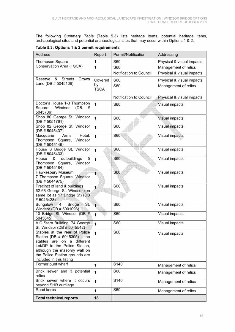
The following Summary Table (Table 5.3) lists heritage items, potential heritage items, archaeological sites and potential archaeological sites that may occur within Options 1 & 2.
Table 5.3: Options 1 & 2 permit requirements
Address Report Permit/Notification Addressing
Thompson Square Conservation Area (TSCA)
11
S60S60Notification to Council
Physical & visual impacts Management of relics Physical & visual impacts
Reserve & Streets Crown Land (DB # 5045106)
CoveredbyTSCA
S60S60
Notification to Council
Physical & visual impacts Management of relics
Physical & visual impacts Doctor’s House 1-3 Thompson Square, Windsor (DB # 5045706)
1 S60 Visual impacts
Shop 80 George St, Windsor (DB # 5051761)
1 S60 Visual impacts
Shop 82 George St, Windsor (DB # 5045437)
1 S60 Visual impacts
Macquarie Arms Hotel, Thompson Square, Windsor (DB # 5045146)
1 S60 Visual impacts
House 6 Bridge St, Windsor (DB # 5045433)
1 S60 Visual impacts
House & outbuildings 5 Thompson Square, Windsor (DB # 5045184)
1 S60 Visual impacts
Hawkesbury Museum 7 Thompson Square, Windsor (DB # 5044975)
1 S60 Visual impacts
Precinct of land & buildings 62-68 George St, Windsor (on same lot as 17 Bridge St) (DB # 5045428)
1 S60 Visual impacts
Bungalow 4 Bridge St, Windsor (DB # 5001096)
1 S60 Visual impacts
10 Bridge St, Windsor (DB # 5045645)
1 S60 Visual impacts
A.C Stern Building, 74 George St, Windsor (DB # 5045542)
1 S60 Visual impacts
Stables at the rear of Police Station (DB # 5045305) – the stables are on a different Lot/DP to the Police Station, although the masonry wall on the Police Station grounds are included in this listing
1 S60 Visual impacts
Former punt wharf 1 S140 Management of relics Brick sewer and 3 potential relics
1 S60 Management of relics
Brick sewer where it occurs beyond SHR curtilage
1 S140 Management of relics
Road kerbs 1 S60 Management of relics
Total technical reports 18

BUILT HERITAGE AND ARCHAEOLOGICAL LANDSCAPE INVESTIGATION : WINDSOR BRIDGE OPTIONS FINAL DRAFT REPORT OCTOBER 2009
59
It may be possible to combine the technical reports required for some items thereby reducing the total number required. For instance, it may be appropriate to address the 3 potential archaeological sites in one report.

BU
ILT
HE
RIT
AG
E A
ND
AR
CH
AE
OLO
GIC
AL
LAN
DS
CA
PE
INV
ES
TIG
ATI
ON
: W
IND
SO
R B
RID
GE
OP
TIO
NS
FI
NA
L D
RA
FT R
EP
OR
T O
CTO
BE
R 2
009
60
Tabl
e 5.
4: O
ptio
ns 1
& 2
Sum
mar
y Ta
ble
Item
Nam
e N
atur
e Li
stin
g (It
em
No.
)Si
gnifi
canc
e A
pplic
atio
n of
SH
R
crite
riaR
elia
bilit
y of
as
sess
men
t D
egre
e of
Impa
ct
Thom
pson
Squ
are
Con
serv
atio
n A
rea
(par
t) (re
fer
Figu
re 5
.7 fo
r SH
R c
urtil
age)
Bui
lt &
ope
n sp
ace
SH
R (5
0451
95)
LEP
(273
) R
NE
(316
6)
NT
(105
10)
Sta
te
A; C
; F
Hig
h W
ithin
opt
ion
rout
e ro
ad re
serv
e in
par
t; al
so v
isua
l
Res
erve
& S
treet
s C
row
n La
nd
Bui
lt &
ope
n sp
ace
S
HR
(504
5106
) LE
P (2
73)
RN
E (3
167)
Sta
te
A; C
; F
Hig
h W
ithin
opt
ion
rout
e ro
ad re
serv
e in
par
t; al
so v
isua
l
Doc
tor’s
Hou
se 1
-3 T
hom
pson
S
quar
e, W
inds
or
Bui
lt S
HR
(504
5706
) LE
P (2
73)
RN
E (3
168)
N
T (1
1446
)
Sta
te
A; C
; F
Hig
h V
isua
l
Sho
p 80
Geo
rge
St,
Win
dsor
B
uilt
S
HR
(505
1761
) LE
P (2
73)
Sta
te
A; C
; F
Hig
h V
isua
l
Sho
p 82
Geo
rge
St,
Win
dsor
B
uilt
SH
R (5
0454
37)
LEP
(273
) S
tate
A
; C; F
H
igh
Vis
ual
Mac
quar
ie A
rms
Hot
el,
Thom
pson
Squ
are,
Win
dsor
B
uilt
SH
R (5
0451
46)
LEP
(273
) R
NE
(317
1)
NT
(105
10)
Sta
te
A; C
; F
Hig
h V
isua
l
Hou
se 6
(8) B
ridge
St,
Win
dsor
B
uilt
SH
R (5
0454
33)
LEP
(273
) R
NE
(317
3)
NT
(114
51)
Sta
te
A; C
; F
Hig
h V
isua
l
Hou
se &
out
build
ings
, 5
Thom
pson
Squ
are,
Win
dsor
B
uilt
SH
R (5
0451
84)
LEP
(273
) R
NE
(316
9)
NT
(114
47)
Sta
te
A; C
; F
Hig
h V
isua
l
Haw
kesb
ury
Mus
eum
7
Thom
pson
Squ
are,
Win
dsor
B
uilt
SH
R (5
0449
75)
LEP
(273
) R
NE
(317
0)
NT
(114
48)
Sta
te
A; C
; F
Hig
h V
isua
l
Pre
cinc
t of l
and
& b
uild
ings
62-
Bui
lt S
HR
(504
5428
) S
tate
A
; C; F
H
igh
Vis
ual

BU
ILT
HE
RIT
AG
E A
ND
AR
CH
AE
OLO
GIC
AL
LAN
DS
CA
PE
INV
ES
TIG
ATI
ON
: W
IND
SO
R B
RID
GE
OP
TIO
NS
FI
NA
L D
RA
FT R
EP
OR
T O
CTO
BE
R 2
009
61
Item
Nam
e N
atur
e Li
stin
g (It
em
No.
)Si
gnifi
canc
e A
pplic
atio
n of
SH
R
crite
riaR
elia
bilit
y of
as
sess
men
t D
egre
e of
Impa
ct
68 G
eorg
e S
t, W
inds
or (o
n sa
me
Lot a
s 17
Brid
ge S
t) LE
P (2
73)
RN
E (3
176)
N
T (1
1454
) A
.C S
tern
Bui
ldin
g 74
Geo
rge
St,
Win
dsor
B
uilt
SH
R (5
0455
42)
LEP
(273
) R
NE
(317
7)
Sta
te
A; C
; F
Hig
h V
isua
l
Bun
galo
w 4
Brid
ge S
t, W
inds
or
Bui
lt S
HR
(500
1096
) LE
P (2
73)
NT
(114
55)
Sta
te
A; C
; F
Hig
h V
isua
l
10 B
ridge
St,
Win
dsor
B
uilt
SH
R (5
0456
45)
LEP
(273
) R
NE
(317
4)
NT
(114
52)
Sta
te
A; C
; F
Hig
h
Vis
ual
Bric
k se
wer
(c.1
815)
Sec
tion
with
in T
hom
pson
Squ
are
Con
serv
atio
n A
rea
Cur
tilag
e
Arc
haeo
logi
cal
(pot
entia
l) S
HR
(504
5195
) S
tate
In
divi
dual
item
not
fo
rmal
ly a
sses
sed
M
oder
ate
(req
uire
s de
taile
das
sess
men
t)
With
in o
ptio
n ro
ute
road
rese
rve
in p
art
Bric
k se
wer
(as
abov
e) b
eyon
d S
HR
cur
tilag
e
Arc
haeo
logi
cal
N/A
S
tate
In
divi
dual
item
not
fo
rmal
ly a
sses
sed
Mod
erat
e (r
equi
res
deta
iled
asse
ssm
ent)
With
in o
ptio
n ro
ute
road
rese
rve
in p
art
2 fo
rmer
bui
ldin
gs in
the
loca
tion
of th
e in
ters
ectio
n of
G
eorg
e an
d B
ridge
Stre
ets
show
n on
184
2 pl
an
Arc
haeo
logi
cal
(pot
entia
l) S
HR
(504
5195
) S
tate
In
divi
dual
item
not
fo
rmal
ly a
sses
sed
Mod
erat
e (r
equi
res
deta
iled
asse
ssm
ent)
With
in o
ptio
n ro
ute
road
rese
rve
in w
hole
or
par
t
Ear
ly ro
ad a
lignm
ent f
rom
the
Mac
quar
ie A
rms
Hot
el to
the
punt
sho
wn
on 1
842
plan
Arc
haeo
logi
cal
(pot
entia
l) S
HR
(504
5195
) S
tate
In
divi
dual
item
not
fo
rmal
ly a
sses
sed
Mod
erat
e (r
equi
res
deta
iled
asse
ssm
ent)
With
in o
ptio
n ro
ute
road
rese
rve
in w
hole
or
par
t
Roa
d ke
rbs
B
uilt
SH
R (5
0451
95)
Sta
te
Indi
vidu
al it
em n
ot
form
ally
ass
esse
d M
oder
ate
(req
uire
s de
taile
d
With
in o
ptio
n ro
ute
road
rese
rve
in w
hole

BU
ILT
HE
RIT
AG
E A
ND
AR
CH
AE
OLO
GIC
AL
LAN
DS
CA
PE
INV
ES
TIG
ATI
ON
: W
IND
SO
R B
RID
GE
OP
TIO
NS
FI
NA
L D
RA
FT R
EP
OR
T O
CTO
BE
R 2
009
62
Item
Nam
e N
atur
e Li
stin
g (It
em
No.
)Si
gnifi
canc
e A
pplic
atio
n of
SH
R
crite
riaR
elia
bilit
y of
as
sess
men
t D
egre
e of
Impa
ct
asse
ssm
ent)
The
punt
wha
rf ar
chae
olog
ical
si
te (L
ot 7
008
DP
102
9964
) A
rcha
eolo
gica
l N
/A
Sta
te
Indi
vidu
al it
em n
ot
form
ally
ass
esse
d M
oder
ate
(req
uire
s de
taile
das
sess
men
t)
With
in o
ptio
n ro
ute
road
rese
rve
in w
hole
Bar
n at
5 F
reem
ans
Rea
ch
Roa
d B
uilt
N/A
P
oten
tial l
ocal
In
divi
dual
item
not
fo
rmal
ly a
sses
sed
Mod
erat
e (r
equi
res
deta
iled
asse
ssm
ent)
Cur
tilag
e on
ly w
ithin
th
e im
pact
are
a; a
lso
visu
al

BUILT HERITAGE AND ARCHAEOLOGICAL LANDSCAPE INVESTIGATION : WINDSOR BRIDGE OPTIONS FINAL DRAFT REPORT OCTOBER 2009
63
5.2.2.5 OPTIONS 1 & 2: BUILT HERITAGE
Thompson Square Reserve. View to the south. A section of 1-3 Thompson Square – “The Doctor’s House”. View to the north west.
Example of road kerbing around Thompson Square. 7 Thompson Square (Windsor Museum). View to the west.
5 Thompson Square. View to the west. Slab building – rear yard, 5 Thompson Square. View to the west.

BUILT HERITAGE AND ARCHAEOLOGICAL LANDSCAPE INVESTIGATION : WINDSOR BRIDGE OPTIONS FINAL DRAFT REPORT OCTOBER 2009
64
14 Bridge Street - School of Arts. View to the south east.
62 - 68 George Street. The buildings face onto Thompson Square. View to the south west.
10 Bridge Street. View to the north east. 4 & 8 Bridge Street. View to the north east.
Monument to the pioneering families of Windsor (in Thompson Square) with the Macquarie Arms Hotel in the background. View to the west.
The south east corner of Bridge and George Street, now a modern motel is a potential archaeological site. The site is adjacent to the upgrade works proposed for Options 1 & 2. View to the south east.

BUILT HERITAGE AND ARCHAEOLOGICAL LANDSCAPE INVESTIGATION : WINDSOR BRIDGE OPTIONS FINAL DRAFT REPORT OCTOBER 2009
65
Punt Wharf remnants at the end of Old Bridge Street. View to the east.
View to the Hawkesbury River and beyond from the front of 8 Bridge Street. Note the retaining wall to the property on the right. The punt wharf remnant is at the end of the street. View to the north.
27 Wilberforce Road, Freemans Reach. View to the north.
Old structure close to the corner of Freemans Reach and Wilberforce Roads that may require further investigation.
View back to the corner of Wilberforce and Freemans Reach Roads. A large roundabout is proposed for the area where the bend is now.
Views south west to Windsor from the vicinity of Freemans Reach Road.

BUILT HERITAGE AND ARCHAEOLOGICAL LANDSCAPE INVESTIGATION : WINDSOR BRIDGE OPTIONS FINAL DRAFT REPORT OCTOBER 2009
66
Large tree on the edge of Thompson Square reserve looking across Bridge Street to numbers 4, 8 & 10. View to the east.

BUILT HERITAGE AND ARCHAEOLOGICAL LANDSCAPE INVESTIGATION : WINDSOR BRIDGE OPTIONS FINAL DRAFT REPORT OCTOBER 2009
67
5.2.2.6 OPTIONS 1 & 2: POTENTIAL ARCHAEOLOGICAL SITES
Figure 5.5: “Sketch showing the Land & Fields belonging to the Government at Windsor” c.1825. The items that are circled in red may survive archaeologically along Bridge Street. The circled buildings may be the same ones represented in the 1842 survey plan (Figure 5.6) (North shown). From the “Surveyor’s Sketchbooks, Volume 1” State Records, here reproduced from Proudfoot 1987: 140).

BUILT HERITAGE AND ARCHAEOLOGICAL LANDSCAPE INVESTIGATION : WINDSOR BRIDGE OPTIONS FINAL DRAFT REPORT OCTOBER 2009
68
Figure 5.6: Armstrong’s survey of 1842. The area circled in red includes the majority of Thompson Square showing the original road (1) to the punt (2), stables (3) and a building “Govnmt Build”, possibly beneath the existing roundabout on George Street (4) (North is to the left). Source: Mitchell Library - ZM2 811.11222/1842/1.
1
32 4

BUILT HERITAGE AND ARCHAEOLOGICAL LANDSCAPE INVESTIGATION : WINDSOR BRIDGE OPTIONS FINAL DRAFT REPORT OCTOBER 2009
69
Figure 5.7: Plan of Thompson Square Conservation area as defined by the SHR listing (shaded in grey). (Source: Heritage Branch Website SHR DB No. 5045195).

BUILT HERITAGE AND ARCHAEOLOGICAL LANDSCAPE INVESTIGATION : WINDSOR BRIDGE OPTIONS FINAL DRAFT REPORT OCTOBER 2009
70
5.2.3 OPTION 35.2.3.1 DESCRIPTION: UPSTREAM OF EXISTING BRIDGE
Option 3 provides a crossing that is central to Windsor township, connecting the northern side of the Hawkesbury River from within the township of Windsor. There would be new access to southern river bank by continuing The Terrace under the bridge. This would also provide safe pedestrian and vehicle access along the southern river bank.
This option is located 10 m upstream of the existing bridge, crossing the Hawkesbury River using the same road approaches, with realignment to the west of the current approach. The close proximity of both existing and proposed bridges could cause construction difficulties.
The length of this option is in the order of 490 m, consisting of 180 m of new approaches, 160 m of new bridge, with 150 m of upgrade to existing road.
This option retains traffic along a realigned Bridge Street, north from the existing George Street roundabout, veering to the west of the existing bridge on a tighter curvilinear approach to align with a new bridge across the Hawkesbury River, turning right to align with the existing east/west alignment of Wilberforce Road.
Figure 5.8: Option 3. Base map source RTA © 2009. Option 3 proposes to acquire part of Macquarie Park and on the northern bank of the river, as well as property on the southern bank of the river.
The image has been rotated to orient North at the top.

BUILT HERITAGE AND ARCHAEOLOGICAL LANDSCAPE INVESTIGATION : WINDSOR BRIDGE OPTIONS FINAL DRAFT REPORT OCTOBER 2009
71
Table 5.5: Option 3 may require the acquisition of:
ITEM LOT/DP HERITAGE LISTED Doctors House 1- 3 Thompson Square may be acquired as the road would be built in very close proximity
Lot B DP 161643 Lot 1 DP 196531
SHR, LEP, RNE, NT
South bank; west side of bridge Lot 7011 DP 1030959 (part)
No
North bank; west side of bridge Lot 1 DP 226141 (part) No
Turf farm (part) Lot 2 DP 65136 No
Turf farm (part) Lot 2 DP 1096472 No
Turf farm (part) Lot 1 DP 1096472 No
5.2.3.2 OPTION 3: EXISTING ENVIRONMENT
The topography of Option 3 is defined by the graded road approach to the existing bridge with the road sweeping through the much-modified southern riverbank. The road approach is flanked by a high level terrace to the west (Thompson Square) and a remnant of the graded riverbank to the east (Old Bridge Street). The southwestern quadrant of the precinct is the graded landform of the public reserve. The landform north of the river is graded as far as the ridge which is now defined by Wilberforce Road. Beyond the ridge the land is generally level farmland.
The elevated and open ground of the park, Thompson Square and Old Bridge Street provides a vantage point to view the river, the farmland beyond and the backdrop of the Blue Mountains. Wilberforce Road and the northern bank of the river provide views to Thompson Square and this view has been documented for generations in paintings, drawings and photographs. The existing bridge itself is now of historic interest and can be viewed from the park. The park also provides views to neighbouring buildings, in particular the buildings on the ridge to the south (George Street) and to the graded terrace to the west (Thompson Square).
The public open space of Thompson Square is a place of longstanding amenity in Windsor and this is reflected in the mature tree plantings and commemorative plaques and stones. The reserve was originally designed as a civic space and the north-east corner of the park (the lower public green space) has been graded and terraced to provide public car parking. Thompson Square has been impacted by road improvements to the bridge; nevertheless it retains the village square character originally intended by Macquarie.
Option 3 is located within the centre of both the Green Hills of the mid 1790s and Macquarie’s later replanning of that settlement in the 1810s to form Windsor. The built form of the area has evolved from the earliest days of British settlement, which collectively is recognised as having a heritage value that warrants statutory protection as the “Thompson Square Conservation Area” (SHR DB No. 5045195) which includes:
The Doctor's House - 1-3 Thompson Square. House & outbuildings - 5 Thompson Square. Hawkesbury Museum - 7 Thompson Square. Macquarie Arms Hotel - cnr Thompson and George Streets . Vacant site - 60 George Street (not shown on Six Viewer & not identified in field). Cottage - 62 George Street. Shops - 64, 66, 68 George Street. 70, 72 George Street (Formerly Hawkesbury Garage, now a shop). 74 George Street (A.C Stearn Building). 82 George Street. Vacant site - 4 Bridge Street (shown as part of 6 Bridge Street on Six Viewer). House & outbuildings - 6 Bridge Street. House & outbuildings - 10 Bridge Street. House - 17 Bridge Street.

BUILT HERITAGE AND ARCHAEOLOGICAL LANDSCAPE INVESTIGATION : WINDSOR BRIDGE OPTIONS FINAL DRAFT REPORT OCTOBER 2009
72
Former School of Arts - cnr Bridge Street and George Street.
Individual SHR listings located within the Option 3 corridor and vicinity are:
Reserve & Streets Crown Land (DB # 5045106). Doctor’s House 1-3 Thompson Square, Windsor (DB # 5045706). Shop 80 George St, Windsor (DB # 5051761). Shop 82 George St, Windsor (DB # 5045437). Macquarie Arms Hotel, Thompson Square, Windsor (DB # 5045146). House 6 Bridge St, Windsor (DB # 5045433). House & outbuildings 5 Thompson Square, Windsor (DB # 5045184). Hawkesbury Museum 7 Thompson Square, Windsor (DB #5044975). Cottage 17 Bridge St, Windsor (DB # 5045429). Precinct of land & buildings 62-68 George St, Windsor (on same lot as 17 Bridge St) (DB #
5045428). Bungalow 4 Bridge St, Windsor (DB # 5001096). 10 Bridge St, Windsor (DB # 5045645). A.C Stern Building (DB # 5045542). Stables at the rear of Police Station (DB # 5045305) – the stables are on a different Lot/DP
to the Police Station, although the masonry wall on the Police Station grounds are included in this listing
The Hawkesbury LEP 1989 Heritage Schedule lists Thompson Square (Item No. 273) inclusive of:
The Doctor’s House, Nos 1–3 Thompson Square. No 5 Thompson Square. Museum, No 7 Thompson Square. Thompson Square, part George Street, part The Terrace, and part Bridge Street. Macquarie Arms Hotel. Public Reserve, Thompson Square. House, No 4 Bridge Street. House, No 6 Bridge Street. House, No 10 Bridge Street. Former School of Arts, Bridge Street. No 17 Bridge Street. Nos 62–68 George Street. Nos 70–72 George Street. AC Stearn Building, No 74 George Street. Shops, Nos 80–82 George Street. No 88 George Street. Nos 92–98 George Street.
These heritage items are significant individually and collectively in forming streetscapes of heritage value in George Street, Bridge Street and Thompson Square, and by defining street corners and ridge lines, and terminating views from the park.
The Hawkesbury River and its reserve has provided amenity in the town over generations. In this locality, the Windsor Bridge is a listed heritage item (Hawkesbury LEP 1989 Item No. 276) and there are archaeological relics associated with the wharf and punt.
The semi-rural land north and west of the Hawkesbury River demonstrates a continuation of primary economic activity dating from the late eighteenth century. The open rural nature of the north bank provides both a backdrop to the town and a contrast to the urbanised south bank. The Option is in the vicinity of a listed heritage item “Bridgeview” at No 27 Wilberforce Road, Freemans Reach (Hawkesbury LEP 1989 Item No. 274).
The original form of Thompson Square has been modified through time and the early road from Old Bridge Street and Thompson Square roadway may survive archaeologically. Later road making and maintenance may have obliterated any evidence of the early roads and configuration of Thompson Square (refer Figures 3.35 and 5.10); however, at the level of investigation required for this report, it is a difficult assessment to make.

BUILT HERITAGE AND ARCHAEOLOGICAL LANDSCAPE INVESTIGATION : WINDSOR BRIDGE OPTIONS FINAL DRAFT REPORT OCTOBER 2009
73
Scrutiny of historical images of Thompson Square indicates that ground levels within the reserve have been modified since the 1870s and then again since 1965 (and reconfigured since 1981 (refer images on SHR DB No. 5045195), suggesting that the Thompson Square reserve (also listed as “Reserve & Streets” SHR DB No. 5045106) retains archaeological evidence of its earlier form (refer also to Figure 3.9 – this report, which shows the southern extent of the reserve and the earlier ground levels).
5.2.3.3 OPTION 3: POTENTIAL INDICATIVE IMPACTS
Option 3 is very similar to Options 1 & 2 in that the majority of the impact would be within the Thompson Square Conservation Area and the associated elements of the SHR listing. Under this option the potential also exists for acquisition of The Doctor’s House (1-3 Thompson Square) where the proposed alignment enters The Terrace to cross the Hawkesbury River. The retaining wall at the base of the Thompson Square roadway, falls within the SHR curtilage and appears to be partly within the option route road reserve.
Views from the properties on Old Bridge Road (No. 4 – 10) to the existing configuration of Thompson Square are likely to be affected by the removal of large trees from the public green spaces.
The creation of Option 3 would accommodate current and future traffic use, imposing greater visual impacts within the early town centre and detracting from the village character in this part of the town.
The proposal would require widening of the existing road from the George and Bridge Street intersection on the north side encroaching upon the reserve and trees as well as four potential archaeological features:
Brick sewer (if it occurs within the SHR curtilage) within the indicative boundary of impact as shown in the option drawing. It is uncertain how much of this structure survives as its location in not visible; however the precautionary approach would be to assume that it survives in some form until it is assessed in detail.
A potential archaeological feature of a small structure shown in a c.1825 surveyor’s sketchbook (Figure 5.9) that appears to be within the wider corridor – further research is required to confirm.
A potential archaeological feature in the vicinity of the existing roundabout at George and Bridge Streets (refer Figure 5.10 – No. 2) the curtilage of which appears to be within the impact area – further research is required to confirm.
An early road alignment from the Macquarie Arms Hotel to the punt wharf (refer Figure 5.10 – No. 1).
Sandstone kerbs and gutters along Old Bridge Street (may not be impacted).
In addition to the items that occur within the Thompson Square Conservation Area SHR curtilage, there is also a barn at 5 Freemans Reach Road, the curtilage only of which may be within the impact area. The barn is located on Lot 2 DP 226141.
5.2.3.4 OPTION 3: FURTHER ASSESSMENTS
This option has the potential to impact upon a total of 16 SHR listed items, 1 known archaeological site (a brick sewer) and 3 potential archaeological sites (that may be addressed in one report).
A total of 17 technical reports would be required for a total of 19 permit applications under the Heritage Act 1977. It may be possible to reduce some of the applications and their associated technical reports but consultation with the Heritage Council would be required to ascertain this.
Two notifications under the provisions of the ISEPP 2007 to Hawkesbury City Council accompanied by the relevant technical reports would also be required.
All items of built heritage require a S60 Application to the Heritage Council with accompanying technical reports for major impacts or an Exemption Notification under Section 57(2) of the Heritage Act 1977 with accompanying statement for minor impacts.

BUILT HERITAGE AND ARCHAEOLOGICAL LANDSCAPE INVESTIGATION : WINDSOR BRIDGE OPTIONS FINAL DRAFT REPORT OCTOBER 2009
74
All archaeological items within an SHR curtilage require a S60 Application to the Heritage Council with accompanying technical report for major impacts or an Exemption Notification under Section 57(2) of the Heritage Act 1977 with accompanying statement if proposed impacts fall within the appropriate terms of reference.
All archaeological items NOT included within an SHR curtilage require a S140 application to the Heritage Council with accompanying technical reports or an Exception Notification under Section 139(4) of the Heritage Act 1977 with accompanying statement if the impact falls within the appropriate terms of reference.
Management of heritage items listed on the Hawkesbury LEP 1989 requires that written notification of the proposal is provided to the local Council, which involves providing Council with the relevant technical reports as would be required for a Development Application.
Table 5.6: Option 3 permit requirements:
Address Report Permit/Notification Addressing
Thompson Square Conservation Area (TSCA)
11
S60S60Notification to Council
Physical & visual impacts Management of relics Physical & visual impacts
Reserve & Streets Crown Land (DB # 5045106)
CoveredbyTSCA
S60S60
Notification to Council
Physical & visual impacts Management of relics
Physical & visual impacts Doctor’s House 1-3 Thompson Square, Windsor (DB # 5045706)
1 S60 Visual impacts
Retaining wall adjacent to Doctors House below the Thompson Square roadway
1 S60 Physical impacts
Shop 80 George St, Windsor (DB # 5051761)
1 S60 Visual impacts
Shop 82 George St, Windsor (DB # 5045437)
1 S60 Visual impacts
Macquarie Arms Hotel, Thompson Square, Windsor (DB # 5045146)
1 S60 Visual impacts
House 6 Bridge St, Windsor (DB # 5045433)
1 S60 Visual impacts
House & outbuildings 5 Thompson Square, Windsor (DB # 5045184)
1 S60 Visual impacts
Hawkesbury Museum 7 Thompson Square, Windsor (DB #5044975)
1 S60 Visual impacts
Precinct of land & buildings 62-68 George St, Windsor (on same lot as 17 Bridge St) (DB # 5045428)
1 S60 Visual impacts
Bungalow 4 Bridge St, Windsor (DB # 5001096)
1 S60 Visual impacts
10 Bridge St, Windsor (DB # 5045645)
1 S60 Visual impacts
A.C Stern Building, 74 George St, Windsor (DB # 5045542)
1 S60 Visual impacts
Stables at the rear of Police Station, 32-34 Bridge St,
1 S60 Visual impacts

BUILT HERITAGE AND ARCHAEOLOGICAL LANDSCAPE INVESTIGATION : WINDSOR BRIDGE OPTIONS FINAL DRAFT REPORT OCTOBER 2009
75
Address Report Permit/Notification Addressing Windsor (DB # 5045305) – the stables are on a different lot/DP to the Police Station, although the masonry wall on the Police Station grounds is included in this listing Brick sewer and 3 potential relics
1 S60 Management of relics
Road kerbs 1 S60 Management of relics
Total technical reports 17

BU
ILT
HE
RIT
AG
E A
ND
AR
CH
AE
OLO
GIC
AL
LAN
DS
CA
PE
INV
ES
TIG
ATI
ON
: W
IND
SO
R B
RID
GE
OP
TIO
NS
FI
NA
L D
RA
FT R
EP
OR
T O
CTO
BE
R 2
009
76
Tabl
e 5.
7: O
ptio
n 3
Sum
mar
y Ta
ble
Ite
m N
ame
Nat
ure
List
ing
(Item
N
o.)
Sign
ifica
nce
App
licat
ion
of S
HR
cr
iteria
Rel
iabi
lity
of
asse
ssm
ent
Deg
ree
of Im
pact
Thom
pson
Squ
are
Con
serv
atio
n A
rea
(par
t) (re
fer
Figu
re 5
.7 fo
r SH
R c
urtil
age)
Bui
lt &
ope
n sp
ace
SH
R (5
0451
95)
LEP
(273
) R
NE
(316
6)
NT
(105
10)
Sta
te
A; C
; F
Hig
h W
ithin
indi
cativ
e bo
unda
ry o
f im
pact
as
show
n in
opt
ion
plan
s;
also
vis
ual.
Res
erve
& S
treet
s C
row
n La
nd
Bui
lt &
ope
n sp
ace
S
HR
(504
5106
) LE
P (2
73)
RN
E (3
167)
Sta
te
A; C
; F
Hig
h W
ithin
indi
cativ
e bo
unda
ry o
f im
pact
as
show
n in
opt
ion
plan
s;
also
vis
ual.
Doc
tor’s
Hou
se 1
-3 T
hom
pson
S
quar
e, W
inds
or
Bui
lt S
HR
(504
5706
) LE
P (2
73)
RN
E (3
168)
N
T 11
446
Sta
te
A; C
; F
Hig
h V
isua
l
Sho
p 80
Geo
rge
St,
Win
dsor
B
uilt
S
HR
(505
1761
) LE
P (2
73)
Sta
te
A; C
; F
Hig
h V
isua
l
Sho
p 82
Geo
rge
St,
Win
dsor
B
uilt
SH
R (5
0454
37)
LEP
(273
) S
tate
A
; C; F
H
igh
Vis
ual
Mac
quar
ie A
rms
Hot
el,
Thom
pson
Squ
are,
Win
dsor
B
uilt
SH
R (5
0451
46)
LEP
(273
) R
NE
(317
1)
NT
(105
10)
Sta
te
A; C
; F
Hig
h V
isua
l
Hou
se 6
(8) B
ridge
St,
Win
dsor
B
uilt
SH
R (5
0454
33)
LEP
(273
) R
NE
(317
3)
NT
(114
51)
Sta
te
A; C
; F
Hig
h V
isua
l
Hou
se &
out
build
ings
, 5
Thom
pson
Squ
are,
Win
dsor
B
uilt
SH
R (5
0451
84)
LEP
(273
) R
NE
(316
9)
NT
(114
47)
Sta
te
A; C
; F
Hig
h V
isua
l
Haw
kesb
ury
Mus
eum
7
Thom
pson
Squ
are,
Win
dsor
B
uilt
SH
R (5
0449
75)
LEP
(273
) R
NE
(317
0)
NT
(114
48)
Sta
te
A; C
; F
Hig
h V
isua
l

BU
ILT
HE
RIT
AG
E A
ND
AR
CH
AE
OLO
GIC
AL
LAN
DS
CA
PE
INV
ES
TIG
ATI
ON
: W
IND
SO
R B
RID
GE
OP
TIO
NS
FI
NA
L D
RA
FT R
EP
OR
T O
CTO
BE
R 2
009
77
Item
Nam
e N
atur
e Li
stin
g (It
em
No.
)Si
gnifi
canc
e A
pplic
atio
n of
SH
R
crite
riaR
elia
bilit
y of
as
sess
men
t D
egre
e of
Impa
ct
Pre
cinc
t of l
and
& b
uild
ings
62-
68 G
eorg
e S
t, W
inds
or (o
n sa
me
lot a
s 17
Brid
ge S
t)
Bui
lt S
HR
(504
5428
) LE
P (2
73)
RN
E (3
176)
N
T (1
1454
)
Sta
te
A; C
; F
Hig
h V
isua
l
A.C
Ste
rn B
uild
ing
74 G
eorg
e S
t, W
inds
or
Bui
lt S
HR
(504
5542
) LE
P (2
73)
RN
E (3
177)
Sta
te
A; C
; F
Hig
h V
isua
l
Bun
galo
w 4
Brid
ge S
t, W
inds
or
Bui
lt S
HR
(500
1096
) LE
P (2
73)
NT
(114
55)
Sta
te
A; C
; F
Hig
h V
isua
l
10 B
ridge
St,
Win
dsor
B
uilt
SH
R (5
0456
45)
LEP
(273
) R
NE
(317
4)
NT
(114
52)
Sta
te
A; C
; F
Hig
h
Vis
ual
Bric
k se
wer
(c.1
815)
Sec
tion
with
in T
hom
pson
Squ
are
Con
serv
atio
n A
rea
Cur
tilag
e
Arc
haeo
logi
cal
(pot
entia
l) S
HR
(504
5195
) S
tate
In
divi
dual
item
not
fo
rmal
ly a
sses
sed
M
oder
ate
(req
uire
s de
taile
das
sess
men
t)
With
in in
dica
tive
boun
dary
of i
mpa
ct a
s sh
own
in o
ptio
n pl
ans
Form
er b
uild
ing
show
n on
182
5 pl
anA
rcha
eolo
gica
l (p
oten
tial)
SH
R (5
0451
95)
Sta
te
Indi
vidu
al it
em n
ot
form
ally
ass
esse
d M
oder
ate
(req
uire
s de
taile
das
sess
men
t)
With
in in
dica
tive
boun
dary
of i
mpa
ct a
s sh
own
in o
ptio
n pl
ans
Form
er b
uild
ing
in th
e lo
catio
n of
the
inte
rsec
tion
of G
eorg
e an
d B
ridge
Stre
ets
show
n on
18
42 p
lan
Arc
haeo
logi
cal
(pot
entia
l) S
HR
(504
5195
) S
tate
In
divi
dual
item
not
fo
rmal
ly a
sses
sed
Mod
erat
e (r
equi
res
deta
iled
asse
ssm
ent)
With
in in
dica
tive
boun
dary
of i
mpa
ct a
s sh
own
in o
ptio
n pl
ans
Ear
ly ro
ad a
lignm
ent f
rom
the
Mac
quar
ie A
rms
Hot
el to
the
punt
sho
wn
on 1
842
plan
Arc
haeo
logi
cal
(pot
entia
l) S
HR
(504
5195
) S
tate
In
divi
dual
item
not
fo
rmal
ly a
sses
sed
Mod
erat
e (r
equi
res
deta
iled
asse
ssm
ent)
With
in in
dica
tive
boun
dary
of i
mpa
ct a
s sh
own
in o
ptio
n pl
ans
Roa
d ke
rbs
B
uilt
SH
R (5
0451
95)
Sta
te
Indi
vidu
al it
em n
ot
form
ally
ass
esse
d M
oder
ate
(req
uire
s W
ithin
indi
cativ
e bo
unda
ry o
f im
pact
as

BU
ILT
HE
RIT
AG
E A
ND
AR
CH
AE
OLO
GIC
AL
LAN
DS
CA
PE
INV
ES
TIG
ATI
ON
: W
IND
SO
R B
RID
GE
OP
TIO
NS
FI
NA
L D
RA
FT R
EP
OR
T O
CTO
BE
R 2
009
78
Item
Nam
e N
atur
e Li
stin
g (It
em
No.
)Si
gnifi
canc
e A
pplic
atio
n of
SH
R
crite
riaR
elia
bilit
y of
as
sess
men
t D
egre
e of
Impa
ct
deta
iled
asse
ssm
ent)
show
n in
opt
ion
plan
s
Bar
n at
5 F
reem
ans
Rea
ch
Roa
d B
uilt
N/A
P
oten
tial l
ocal
In
divi
dual
item
not
fo
rmal
ly a
sses
sed
Mod
erat
e (r
equi
res
deta
iled
asse
ssm
ent)
Cur
tilag
e on
ly w
ithin
th
e im
pact
are
a; a
lso
visu
al

BUILT HERITAGE AND ARCHAEOLOGICAL LANDSCAPE INVESTIGATION : WINDSOR BRIDGE OPTIONS FINAL DRAFT REPORT OCTOBER 2009
79
5.2.3.5 OPTION 3: BUILT HERITAGE
Thompson Square roadway in front of the “Doctor’s House”. The current bridge is visible on the right. Note the sandstone kerbs. View to the north.
View back across the reserve at Thompson Square from the roadway. View to the south east.
Retaining wall beneath the “Doctor’s House”. View to the south west.
7 Thompson Square (Windsor Museum). View to the west.
5 Thompson Square. View to the west. Slab building, rear yard, 5 Thompson Square. View to the west.

BUILT HERITAGE AND ARCHAEOLOGICAL LANDSCAPE INVESTIGATION : WINDSOR BRIDGE OPTIONS FINAL DRAFT REPORT OCTOBER 2009
80
14 Bridge Street - School of Arts. View to the south east.
62 - 68 George Street. The buildings face onto Thompson Square. View to the south west.
10 Bridge Street. View to the east. 4 & 8 Bridge Street. View to the north west.
4 Bridge Street. The yard to the north of the building is an archaeological site. View to the north east.
The side yard of 4 Bridge Street, showing the remains of a structure comprised of sandstock bricks. View to the east.

BUILT HERITAGE AND ARCHAEOLOGICAL LANDSCAPE INVESTIGATION : WINDSOR BRIDGE OPTIONS FINAL DRAFT REPORT OCTOBER 2009
81
5.2.3.6 OPTION 3: POTENTIAL ARCHAEOLOGICAL SITES
Figure 5.9: “Sketch shewing the Land & Fields belonging to the Government at Windsor” c.1825. The red circled area indicates an earlier structure within the area of Option 3 that may survive archaeologically. From the “Surveyor’s Sketchbooks, Volume 1” State Records, here reproduced from Proudfoot 1987: 140).

BUILT HERITAGE AND ARCHAEOLOGICAL LANDSCAPE INVESTIGATION : WINDSOR BRIDGE OPTIONS FINAL DRAFT REPORT OCTOBER 2009
82
Figure 5.10: The red circle indicates the area of what is now Thompson Square that would be impacted by Option 3. The number 1 represents the early road from the vicinity of the Macquarie Arms Hotel to the former punt wharf. Number 2 marks the approximate location of the current roundabout on the corner of George and Bridge Streets, shown to be adjacent to a building shown on plan. Plan prepared by Surveyor J. Armstrong.Source: Mitchell Library - ZM2 811.11222/1842/1.
12

BUILT HERITAGE AND ARCHAEOLOGICAL LANDSCAPE INVESTIGATION : WINDSOR BRIDGE OPTIONS FINAL DRAFT REPORT OCTOBER 2009
83
5.2.4 OPTION 45.2.4.1 DESCRIPTION: UPSTREAM OF EXISTING BRIDGE
Option 4 would take traffic along Macquarie Street via Baker Street, crossing the Hawkesbury River at Macquarie Park on the northern river bank. It will involve the reconstruction of the intersection of Macquarie Street and Baker Street, and the possible removal of parking along Baker Street. It may also require traffic control facilities at the entrance to the bridge along The Terrace or alternatively removing access to The Terrace from Baker Street completely.
The length of this option is in the order of 600 m, consisting of 300 m of existing Baker Street alignment, 30 m of existing raised pedestrian threshold, 125 m of new approaches, with 145 m of new bridge.
Figure 5.11: Option 4. Base map source RTA © 2009.
The Option proposes to acquire property in Baker Street, the riverside park reserve, The Terrace, and on the northern bank of the river.
The image has been rotated to orient north at the top.

BUILT HERITAGE AND ARCHAEOLOGICAL LANDSCAPE INVESTIGATION : WINDSOR BRIDGE OPTIONS FINAL DRAFT REPORT OCTOBER 2009
84
Table 5.8: Option 4 may require the acquisition of:ITEM LOT/DP HERITAGE LISTING
Vacant lot on corner of Baker & Macquarie Streets
Lot B DP 158748 No
92-98 George Street (building on George and building set back on corner)*
Lot 1 DP 730435 LEP, NT
Rear of 92 George Street (on Baker Street)* Lot 2 DP 730435 LEP (part)
10 The Terrace (house) Lot 1 DP 542705 No
South Bank Lot 1 DP 1030959 No
North Bank in Macquarie Park Lot B DP 386334 (part)
No
* The buildings on Lot 1 and 2 DP 730435 are numbered 92-96 George Street on the Department of Lands Six Viewer, 96-98 George Street by the National Trust, and 92-98 on the Heritage Schedule of the Hawkesbury LEP 1989. These buildings are included in the Hawkesbury LEP 1989 listing for “Thompson Square” (Item No. 273). The National Trust appears to classify only the two-storey building on George Street.
5.2.4.2 OPTION 4: EXISTING ENVIRONMENT
The topography of Option 4 is varied but in general terms takes in the southern edge of the ridge of the town along Macquarie Street and crosses and crests the ridge along Baker Street. The landform north of the Baker Street intersection with George Street slopes to the southern bank of the Hawkesbury River. The landform north of the river slopes to a ridge defined by Wilberforce Road. Beyond the ridge the land is generally level farmland.
No notable distant views were observed although Wilberforce Road provides views to Windsor, and Macquarie Park provides views along the course of the river. The Hawkesbury River, the reserve and Howe Park have provided amenity in the town over generations. This is demonstrated in the pavements, seats and shade trees that have been established. The riverbank provides a green corridor, uninterrupted aside from the area around the existing bridge crossing.
The crossing of Baker Street with George Street provides axial views along George Street, which retains many historic buildings. The axial view to the north down Baker Street is terminated by the river and treed reserve.
Option 4 is located within the area of Macquarie’s town plan sited between the old established area at the Green Hills (Thompson Square) and the new town to the west. Aside from Macquarie’s continuation of George and Macquarie Streets, little of this aspect of the town seems to have been discussed in the material reviewed, although the cross streets of Baker, Kable and Fitzgerald had been formed by 1827.26 It therefore seems correct to state that Option 4 crosses Macquarie’s town plan.
The lots on the east side of Baker Street between George and Macquarie are shown in an 1842 plan (see Figure 5.12) with five buildings located across the space. It is unclear whether any of these buildings survive (the existing single-storey structure may be shown on this plan), however, some of these items may now be present as archaeological sites.
The narrow width of the southern half of Baker and George Streets reflects their nineteenth century origin. Macquarie Street however appears to have been widened in the last century (1930s-1960s) on its southern side to provide an arterial road and this might account for the built environment of the street. The northern half of Baker Street side (east side) also seems to have been widened.
Option 4 is located within an area of Windsor that is characterised by commercial development, but there are pockets of residences around The Terrace.
26 Barkley and Nichols 1994, p.64

BUILT HERITAGE AND ARCHAEOLOGICAL LANDSCAPE INVESTIGATION : WINDSOR BRIDGE OPTIONS FINAL DRAFT REPORT OCTOBER 2009
85
The built form of Option 4 is varied and demonstrates phases in the development of Windsor from the mid nineteenth century through to the present century, but the prevailing built character is not considered cohesive given the number of cleared sites and modern infill developments. The varied building uses both present and past demonstrate/d residential and commercial associations, which in the following individual instances (both in and near Baker Street) have been recognised as having a heritage value that warrants statutory protection in the Heritage Schedule of the Hawkesbury LEP 1989. There are no SHR listings on Baker Street. The items listed by the Hawkesbury LEP 1989 are:
Uralla, No. 3 Baker Street (Lot 1 DP 135466) (Hawkesbury LEP 1989 Item No. 139) (does not exist according to the Department of Lands information on Six Viewer. Probably now part of 6-16 Kable St, Lot 1 DP1005845).
No. 9 Baker Street (Lot 1 DP 572611) (Hawkesbury LEP 1989 Item No. 140) (According to the Department of Lands information on Six Viewer it is listed as Lot 1 DP 871860).
No. 11 Baker Street (Lot 1 DP 111632) (Hawkesbury LEP 1989 Item No. 141) Nos. 158–160 George Street (Hawkesbury LEP 1989 Item No. 189) Nos. 92-98 George Street (Lot 1 DP 730435 & part Lot 2 DP 730435) (Hawkesbury LEP
1989 “Thompson Square” Item No. 273)
Of particular note, is the proximity of Baker Street to the western edge of the Thompson Square Conservation Area (SHR DB No. 5045195).
The rural land west of the Hawkesbury River demonstrates a continuation of primary economic activity dating from the late eighteenth century. The open rural nature of the north bank provides both a backdrop to the town and a contrast to the urbanised south bank. This option is in the vicinity of a listed heritage item “Bridgeview” at No. 27 Wilberforce Rd Freemans Reach (Hawkesbury LEP 1989 Item No. 274).
5.2.4.3 OPTION 4: POTENTIAL INDICATIVE IMPACTS
A number of heritage items are located within the proposed road reserve of Option 4. These are the Victorian two-storey building and attached single-storey shed at 92-98 George Street (corner of George and Baker Streets) and the building facing Baker Street (no identified street number; Lot 2 DP 730435). The vacant lot on the corner of Baker and Macquarie Streets (Lot B DP 158748) is also within the proposed road reserve.
If there are archaeological remains of the five buildings shown on the east side of Baker Street between George and Macquarie shown in an 1842 plan, they would be located in part, within the Option 4 road reserve.
Houses at 9 and 11 Baker Street (both listed in the Heritage Schedule of the Hawkesbury LEP 1989) are located very close to the indicative boundary of the proposed road reserve as shown in the Option 4 drawing although not within it.
Option 4 also passes in close proximity to the current Windsor Police Station located at 32-34 Bridge Street which may contain archaeological sites within its boundaries.
5.2.4.4 OPTION 4: FURTHER ASSESSMENTS:
At least 1 technical report supporting a S140 application of the Heritage Act 1977 would be required to address the potential archaeological sites on the blocks of land on the eastern side of Baker Street between Macquarie and George Streets (Lot B DP 158748, Lot 1 DP 730435 and Lot 2 DP 730435). If each lot is to be assessed separately, then 3 technical reports will be required to support S140 applications to the Heritage Council.
This option would also require at least 1 technical report to address physical impacts to the built items, which are listed on the Hawkesbury LEP 1989 (as part of Item No. 273 “Thompson Square”) and classified by the National Trust (ID No. 7087) under the address “96-98 George Street cnr Baker Street”. The property fronting the eastern side of Baker Street, which does not have a street number, is listed in part, on the Hawkesbury LEP 1989 with the “Thompson Square” group. It appears that only the building is listed rather than the entire lot.
In addition, 2 technical reports and notification to Council would be required for Nos. 9 and 11 Baker Street as development of Option 4 would be in the vicinity of these heritage items.

BUILT HERITAGE AND ARCHAEOLOGICAL LANDSCAPE INVESTIGATION : WINDSOR BRIDGE OPTIONS FINAL DRAFT REPORT OCTOBER 2009
86
All archaeological items within an SHR curtilage require a S60 Application to the Heritage Council with accompanying technical report for major impacts or an Exemption Notification (under Section 57(2) with accompanying statement if proposed impacts fall within the appropriate terms of reference.
All archaeological items NOT included within an SHR curtilage require a S140 application to the Heritage Council with accompanying technical reports or an Exception Notification under Section 139(4) with accompanying statement if the impact falls within the appropriate terms of reference.
Management of heritage items listed on the Hawkesbury LEP 1989 requires that written notification of the proposal is provided to the relevant local Council, which involves providing Council with the relevant technical reports as would be required for a Development Application.
Table 5.9: Option 4 permit requirements
Address Report Permit/Notification Addressing
11 Macquarie Street (Lot B DP 158748)
1* S140 Management of relics
92-98 George Street (Lot 1 DP 730435 & part Lot 2 DP 730435) The “part” refers to the building
Covered byabove
Notification to Council Impact that is not minor or inconsequential ISEPP 2007
3 Baker Street (Lot 1 DP 135466 on Hawkesbury LEP 1989)(Now part of 6-16 Kable St, Lot 1 DP1005845)
1 Notification to Council Impact that is not minor or inconsequential ISEPP 2007
9 Baker Street (Lot 1 DP 572611 on LEP) (Actual address is Lot 1 DP 871860)
1 Notification to Council Impact that is not minor or inconsequential ISEPP 2007
11 Baker Street (Lot 1 DP 111632)
1 Notification to Council Impact that is not minor or inconsequential ISEPP 2007
Cottage 17 Bridge St (actually at 62-68 George St), Windsor (DB # 5045429)
1 S60 Possible visual impacts
Total technical reports 5*
It may be possible to combine the technical reports required for some items with the approval of the Hawkesbury Council or the Heritage Branch thereby reducing the total number required.
* If individual reports are required by the Heritage Branch then two additional reports and permit applications will be required.

BU
ILT
HE
RIT
AG
E A
ND
AR
CH
AE
OLO
GIC
AL
LAN
DS
CA
PE
INV
ES
TIG
ATI
ON
: W
IND
SO
R B
RID
GE
OP
TIO
NS
FI
NA
L D
RA
FT R
EP
OR
T O
CTO
BE
R 2
009
87
Tabl
e 5.
10: O
ptio
n 4
Sum
mar
y Ta
ble
Item
Nam
e N
atur
e Li
stin
g (It
em
No.
)Si
gnifi
canc
e A
pplic
atio
n of
SH
R
Crit
eria
Rel
iabi
lity
of
Ass
essm
ent
Deg
ree
of Im
pact
Vic
toria
n bu
ildin
gs
at
92-9
8 G
eorg
e S
treet
(c
nr
Bak
er
Stre
et) (
Lot 1
DP
730
435)
Bui
lt &
arch
aeol
ogic
al
(pot
entia
l)
LEP
(273
)
NT
(708
7)
Loca
l N
/A
Mod
erat
e W
ithin
opt
ion
rout
e ro
ad
rese
rve
in
who
le o
r par
t
Bui
ldin
g on
Bak
er S
treet
(Lo
t 2
DP
730
435)
(Par
t) B
uilt
& ar
chae
olog
ical
(p
oten
tial)
LEP
(273
) Lo
cal
N/A
M
oder
ate
With
in o
ptio
n ro
ute
road
re
serv
e in
w
hole
or p
art
11 M
acqu
arie
Stre
et (
Lot
B D
P 15
8748
) A
rcha
eolo
gica
l (p
oten
tial)
N/A
U
nass
esse
d N
/A
Mod
erat
e W
ithin
opt
ion
rout
e ro
ad
rese
rve
in
who
le o
r par
t
9 B
aker
S
treet
(L
ot
1 D
P
5726
11
on
Haw
kesb
ury
LEP
19
89)
(Act
ual
addr
ess
is L
ot 1
D
P 8
7186
0)
Bui
lt LE
P (1
40)
Loca
l N
/A
Mod
erat
e V
isua
l
11
Bak
er
Stre
et
(Lot
1
DP
11
1632
) B
uilt
LEP
(141
) Lo
cal
N/A
M
oder
ate
Vis
ual

BUILT HERITAGE AND ARCHAEOLOGICAL LANDSCAPE INVESTIGATION : WINDSOR BRIDGE OPTIONS FINAL DRAFT REPORT OCTOBER 2009
88
5.2.4.5 OPTION 4: BUILT HERITAGE
11 Macquarie Street, Lot B DP 158748, currently an empty lot is a potential archaeological site. View north west across to the buildings on the west side of Baker Street.
11 Macquarie Street, Lot B DP 158748; view east along Macquarie Street.
92 George St – frontage of Baker St, Lot 2 DP 730435 (on the left) is a potential archaeological site. Macquarie Street in the distance. View to the south.
92 George Street (listed as 92-98 on the Hawkesbury LEP 1989). View to the south east. These buildings are identified for acquisition under Option 4.

BUILT HERITAGE AND ARCHAEOLOGICAL LANDSCAPE INVESTIGATION : WINDSOR BRIDGE OPTIONS FINAL DRAFT REPORT OCTOBER 2009
89
5.2.4.6 OPTION 4: POTENTIAL ARCHAEOLOGICAL SITES
Figure 5.12: Armstrong’s survey of 1842. The area circled in red takes in the block between Macquarie and George Streets and clearly shows buildings across the lots that may be impacted by the proposed works included in Option 4.

BUILT HERITAGE AND ARCHAEOLOGICAL LANDSCAPE INVESTIGATION : WINDSOR BRIDGE OPTIONS FINAL DRAFT REPORT OCTOBER 2009
90
5.2.5 OPTION 55.2.5.1 DESCRIPTION: KABLE STREET – FROM WINDSOR ROAD, ALONG MACQUARIE STREET
Option 5 takes traffic from Windsor Road west along Macquarie Street, turning right into Kable Street crossing the Hawkesbury River at Macquarie Park on the northern river bank.
The length of this option is in the order of 740 m, consisting of 320 m of existing Kable Street alignment, 30 m of existing raised pedestrian threshold, 220 m of new approaches, with 170 m of new bridge.
Figure 5.13: Option 5. Base map source RTA © 2009.
Option 5 proposes to acquire property in Kable Street, the riverside park reserve and on the northern bank of the Hawkesbury River.
The image has been rotated to orient north at the top.
Table 5.11: Option 5 may require the acquisition of:
ITEM LOT/DP HERITAGE LISTINGS 13 Kable St, Windsor Lot B DP 85772 No 22 Kable St, Windsor Lot 1 DP 998061 LEP, NT 134-136 George St, Windsor Lot 2 DP 659668 LEP, NT
137 George St, Windsor Lot 1 DP 448270 LEP, NT
141 George St, Windsor Lot A DP 160933 LEP, NT
146 George St, Windsor Lot 4 DP 558970 LEP, NT
35 Macquarie St, Windsor (part) Lot 1 DP 633325 (part) No 33 Macquarie St, Windsor Lot 3 DP 2995 LEP

BUILT HERITAGE AND ARCHAEOLOGICAL LANDSCAPE INVESTIGATION : WINDSOR BRIDGE OPTIONS FINAL DRAFT REPORT OCTOBER 2009
91
5.2.5.2 OPTION 5: EXISTING ENVIRONMENT
The topography of Option 5 is varied but in general terms takes in the southern edge of the ridge of the town along Macquarie Street and crosses and crests the ridge along Kable Street. The landform north of the Kable Street intersection with George Street slopes down to the southern bank of the river. The landform north of the river slopes to a ridge demarcated by Wilberforce Road and by continuation west. Beyond the ridge the land is generally level farmland.
No notable distant views were observed although Wilberforce Road provides views to the Windsor township, and the riverside park reserve provides views along the course of the river. The crossing of Kable Street with George Street provides axial views along George Street Mall, which retains many historic buildings. The axial view to the north down Kable Street is terminated by the river and treed reserve.
Option 5 is located within the area of Macquarie’s town plan sited between the old established area at the Green Hills (Thompson Square) and the new town to the west. Aside from Macquarie’s continuation of George and Macquarie Streets little of this aspect of the town seems to have been discussed in the material reviewed, although the cross streets of Baker, Kable and Fitzgerald had been formed by 1827.27 It therefore seems correct to state this Option crosses Macquarie’s town plan.
“Elourea” at 33 Macquarie Street is a federation cottage, currently painted blue and used for commercial purposes; it is listed on the Hawkesbury LEP 1989. Another building adjacent to “Elourea” and on the same lot is on the site of the former Noons Cordial Factory built in 1910 “adjacent to the old congregational church” (Barkley et al 1994: 110). Photographic evidence (SL NSW GPO 1 – 06249) confirms that the “old congregational church” is the same building that is currently the Masonic Temple at 22 Kable Street, suggesting that the building at No. 33 is part of, or built on the former cordial factory site. Given the style in which the cottage on the corner is built, it is more likely that it was part of the factory or directly adjacent (between the cottage and the Masonic temple).
No. 22 Kable Street is listed on the Hawkesbury LEP 1989. To the north again on the corner of Kable and George Streets at Nos. 134-136, the purpose-built commercial buildings are listed on the Hawkesbury LEP 1989 (Item No. 183) and are classified by the National Trust (ID 7086). Further, the same image confirming the congregational church and the Masonic Temple are one and the same building, also shows at least two early Victorian buildings on Kable Street beneath Nos. 134-136.
To the north, along Kable Street, at 146 George Street, is the former NSW bank building, listed on the Hawkesbury LEP 1989 and classified by the National Trust. Across George Street to No. 141 George Street, the former Commercial Banking Company of Sydney is another heritage-listed property that will require acquisition under Option 5. It includes the former bank building as well as outbuildings and stables in the rear yard.
To the north and separated from the former bank building by Union Lane is 13 Kable Street, a fibro cement and masonry cottage, which does not appear on any heritage lists but has some merit as an item of potential heritage significance.
The car park on the corner of Kable Street and The Terrace is the site of Andrew Thompson’s brewery dating from around 1806 and is therefore likely to be a significant archaeological site. Whilst this property has not been identified for acquisition by the RTA, the proposed route is in immediate proximity to its eastern boundary.
The narrow width of Kable and George Streets belie their nineteenth century origin. Macquarie Street however appears to have been widened in the last century (1930s-1960s) on its southern side to provide an arterial road and this might account for the built environment of the street.
Option 5 is located within an area of Windsor that is characterised by commercial development, but there are pockets of residences around The Terrace. The built form of Option 5 is varied and demonstrates phases in the development of Windsor from the 1830s through to the present century. The varied building uses represent both present and past demonstrate/d residential, 27 Barkley and Nichols 1994, p.64.

BUILT HERITAGE AND ARCHAEOLOGICAL LANDSCAPE INVESTIGATION : WINDSOR BRIDGE OPTIONS FINAL DRAFT REPORT OCTOBER 2009
92
church and commercial associations, which in the following instances (both in and near Kable Street) have been recognised as having a heritage value that warrants statutory protection on the SHR:
Loder House 126 George Street (SHR DB No. 5045756)
And on the Hawkesbury LEP 1989 :
Shops, Nos 111–113 George Street (Hawkesbury LEP 1989 Item No. 176). Loder House, No 126 George Street (Hawkesbury LEP 1989 Item No. 179). Nos 127 George Street (Hawkesbury LEP 1989 Item No. 180). Nos 129–131 George Street (Hawkesbury LEP 1989 Item No. 181). Nos 133–135 George Street (Hawkesbury LEP 1989 Item No. 182). Nos 134–136 George Street ( Hawkesbury LEP 1989 Item No. 183). No 137 George Street (Hawkesbury LEP 1989 Item No. 184). Former Commercial Banking Company of Sydney Ltd., No 141 George Street (Hawkesbury
LEP 1989 Item No. 185). Former Bank of New South Wales, No 146 George Street (Hawkesbury LEP 1989 Item No.
186). Commonwealth Bank, Lot 3, DP 558970. No 156 George Street (Hawkesbury LEP 1989 Item
No. 187). “Elourea” 33 Macquarie Street Lot 3 DP 2995 (Hawkesbury LEP 1989 Item 476).
These heritage items are significant individually and collectively in both forming a streetscape of heritage value in George Street and also by defining the street corners of the crossing of Kable Street with George Street.
The Hawkesbury River and Howe Park have provided amenity in the town over generations. This is demonstrated in the pavements, seats and shade trees that have been established. The riverbank provides an uninterrupted green corridor aside from the existing bridge crossing.
The rural land west of the Hawkesbury River demonstrates a continuation of primary economic activity dating from the late eighteenth century. The open rural nature of the north bank provides both a backdrop to the town and a contrast to the urbanised south bank. Option 5 is located in the vicinity of a listed heritage item “Bridgeview” at No. 27 Freemans Reach Road, Wilberforce (Hawkesbury LEP 1989 Item No. 274).
5.2.5.3 OPTION 5: POTENTIAL INDICATIVE IMPACTS
Option 5 will potentially impact 6 of the listed heritage items and 4 potential archaeological sites. “Elourea” 33 Macquarie Street (Hawkesbury LEP 1989 Item No. 476) is partly within the option route road reserve as shown in the option drawing. The former Noon Cordial Factory located on the same lot at 33 Macquarie Street may exist as an archaeological site although more detailed examination of the existing building is required to clarify if the building on this site is part of the Cordial Factory.
Examination of the option drawing suggests that the curtilage (facing the street) of the Masonic Temple at 22 Kable Street is also within option route road reserve. Similarly, the curtilage of the commercial buildings at 134-136 George Street (on the corner of Kable Street) may also be affected by Option 5. It should be noted that the three properties between Macquarie and George Streets on the eastern side of Kable Street have been identified for possible acquisition by the RTA.
On the western side of Kable Street, the property at 146 George Street was formerly the Bank of NSW. This item, which is listed on the Hawkesbury LEP 1989 (Item No. 186) is partly within the option route road reserve as shown in the option drawing and is identified for acquisition.
Across the road, the former Commercial Banking Company of Sydney Ltd at 141 George Street is listed on the Hawkesbury LEP 1989 (Item No. 185) and located partly within the option route road reserve as shown in the option drawing. It is also identified for possible acquisition. Potential impacts include a narrow wedge on the eastern side of the property being claimed for the road upgrade.

BUILT HERITAGE AND ARCHAEOLOGICAL LANDSCAPE INVESTIGATION : WINDSOR BRIDGE OPTIONS FINAL DRAFT REPORT OCTOBER 2009
93
Potential archaeological sites exist on either side of Kable Street. As mentioned, the corner of Kable and Macquarie Streets on the eastern side is the site of the former Noon Cordial Factory. The property opposite located at 35 Macquarie Street, is now a car park and was not definitively identified as a potential archaeological site but given its location within an early section of the town and the obvious subsequent development, the potential for this to be an archaeological site should be considered if Option 5 is adopted. Early maps and plans consulted for this report do not indicate any early structures on this site but given its location on the Macquarie Town plan, it is a possibility that requires further investigation.
Another potential archaeological site has been identified in this report on the property currently occupied by the commercial buildings at 134-136 George Street. The evidence for this is suggested by a photograph of the Masonic Temple at 22 Kable Street (SL NSW GPO 1 – 06249), which shows early Victorian cottages in the background (the photograph has not been reproduced in this report as permission has not been sought to publish).
The final potential archaeological site identified in this study is located at 26 The Terrace (Lot C DP 413535 and Lot 3 DP 529241). The site is the location of Andrew Thompson’s Brewery dating from around 1810 and is currently a car park. A narrow slice of the allotment on the eastern edge of the car park appears to be located within the option route road reserve, although it is difficult to ascertain how much of the archaeological site would be potentially affected by Option 5.
5.2.5.4 OPTION 5: FURTHER ASSESSMENTS
Potential impacts to 6 of the listed heritage items and 5 potential archaeological sites would require a total of 11 reports to address associated heritage issues.
Proposals that have the potential to cause impacts that are not minor or inconsequential require consultation to be conducted with the relevant local Council. The consultation process includes providing Council with the relevant technical reports addressing listed sites and relics. Therefore, an archaeological assessment and research design supporting an excavation permit application (S140) would also need to be sent to Council for comment.
Five excavation permits (S140 of the Heritage Act 1977) supported by their associated technical reports would also need to be submitted to the Heritage Council.
All archaeological items within an SHR curtilage require a S60 Application to the Heritage Council with accompanying technical report for major impacts or an Exemption Notification (under Section 57(2) with accompanying statement if proposed impacts fall within the appropriate terms of reference.
All archaeological items NOT included within an SHR curtilage require a S140 application to the Heritage Council with accompanying technical reports or an Exception Notification under Section 139(4) with accompanying statement if the impact falls within the appropriate terms of reference.
Management of heritage items listed on the Hawkesbury LEP 1989 requires that written notification of the proposal is provided to the local Council, which involves providing Council with the relevant technical reports as would be required for a Development Application.
Table 5.12: Option 5 permit requirements
Address Report Permit/Notification Addressing
33 Macquarie Street 1 1
Notification to Council S140/Exception
Impact ISEPP 2007 Management of relics
35 Macquarie Street 1 S140/Exception Management of relics
13 Kable Street 1 S140/Exception Management of relics
22 Kable Street 1 Notification to Council ISEPP 2007
134-136 George Street 1 1
Notification to Council S140/Exception
N/AManagement of relics
137 George Street 1 Notification to Council ISEPP 2007

BUILT HERITAGE AND ARCHAEOLOGICAL LANDSCAPE INVESTIGATION : WINDSOR BRIDGE OPTIONS FINAL DRAFT REPORT OCTOBER 2009
94
Address Report Permit/Notification Addressing
141 George Street 1 Notification to Council ISEPP 2007
146 George Street 1 Notification to Council ISEPP 2007
26 The Terrace 1 S140/Exception Management of relics
Total Technical Reports 11
It may be possible to combine the technical reports required for some items with the approval of the Hawkesbury Council or the Heritage Branch thereby reducing the total number required.

BU
ILT
HE
RIT
AG
E A
ND
AR
CH
AE
OLO
GIC
AL
LAN
DS
CA
PE
INV
ES
TIG
ATI
ON
: W
IND
SO
R B
RID
GE
OP
TIO
NS
FI
NA
L D
RA
FT R
EP
OR
T O
CTO
BE
R 2
009
95
Tabl
e 5.
13: O
ptio
n 5
Sum
mar
y Ta
ble
Item
Nam
e N
atur
e Li
stin
g (It
em
No.
)Si
gnifi
canc
e A
pplic
atio
n of
SH
R
Crit
eria
Rel
iabi
lity
of
Ass
essm
ent
Deg
ree
of Im
pact
126
Geo
rge
Stre
et
(Lod
er
Hou
se) (
Lot 1
DP
580
752)
B
uilt
SH
R
(504
5045
756)
Sta
te
A, C
, D, E
, F, G
H
igh
Vis
ual
22
Kab
le
Stre
et
(Lot
1,
D
P 99
8061
) B
uilt
LEP
(239
) Lo
cal
N/A
M
oder
ate
Rig
ht o
n th
e ed
ge
of
the
wid
er
corr
idor
33 M
acqu
arie
Stre
et (L
ot 3
DP
29
95)
Arc
haeo
logi
cal
(pot
entia
l) LE
P (4
76)
Unk
now
n N
/A
Mod
erat
e W
ithin
opt
ion
rout
e ro
ad re
serv
e in
par
t
35 M
acqu
arie
Stre
et (
Lot
1 D
P 63
3325
) A
rcha
eolo
gica
l (p
oten
tial)
N/A
U
nkno
wn
N/A
M
oder
ate
With
in o
ptio
n ro
ute
road
rese
rve
in p
art
134-
136
Geo
rge
Stre
et (
Lot
2 D
P 6
5966
8)
Bui
lt
Arc
haeo
logi
cal
(pot
entia
l)
LEP
(183
)
N/A
Loca
l
Unk
now
n
N/A
N/A
Mod
erat
e
Mod
erat
e
Rig
ht o
n th
e ed
ge
the
wid
er c
orrid
or
137
Geo
rge
Stre
et (
Lot
1 D
P
4482
70)
Bui
ltLE
P (1
84)
NT
(911
5)
Loca
lN
/AM
oder
ate
Rig
ht o
n th
e ed
ge
the
wid
er c
orrid
or
141
Geo
rge
Stre
et (
Lot
A, D
P 16
0933
) B
uilt
LE
P (1
85)
NT
(909
7)
Loca
l N
/A
Mod
erat
e W
ithin
opt
ion
rout
e ro
ad re
serv
e in
par
t
146
Geo
rge
Stre
et (
Lot
4, D
P
5589
70)
Bui
lt LE
P (1
86)
NT
(107
99)
Loca
l N
/A
Mod
erat
e W
ithin
opt
ion
rout
e ro
ad re
serv
e in
par
t
26
The
Terra
ce
(Lot
C
D
P
4135
35 &
Lot
3 D
P 5
2924
1)
(site
of
A
ndre
w
Thom
pson
’s
brew
ery)
.
The
adja
cent
tw
o bl
ocks
at
11
Kab
le S
treet
(Lo
t 2 D
P 53
5141
) &
13
Kab
le S
t (Lo
t B D
P 8
5772
) m
ay a
lso
be o
n to
p of
the
sam
e po
tent
ial a
rcha
eolo
gica
l site
.
Arc
haeo
logi
cal
(pot
entia
l) N
/A
Unk
now
n N
/A
Mod
erat
e W
ithin
opt
ion
rout
e ro
ad re
serv
e in
par
t

BUILT HERITAGE AND ARCHAEOLOGICAL LANDSCAPE INVESTIGATION : WINDSOR BRIDGE OPTIONS FINAL DRAFT REPORT OCTOBER 2009
96
5.2.5.4 OPTION 5: BUILT HERITAGE
33 Macquarie Street. A federation cottage on the site of the Noon’s Cordial Factory (on the eastern corner of Kable and Macquarie Streets). The house is of the right date to have been part of the factory site. This lot is identified for acquisition as part of Option 5. View to the north east.
The car park of the fast food outlet at 35 Macquarie Street (on the western corner of Kable and Macquarie Streets). Prt of this lot is identified for acquisition as part of Option 5. It is a potential archaeological site. View to the south west.
22 Kable Street, the Masonic Temple is a former Congregational Church. Construction began in 1869 and it was converted to a Masonic Temple in 1922. The building is listed on the Hawkesbury LEP 1989 and by the National Trust. This lot is identified for acquisition as part of Option 5. View to the east.
136 George Street: listed on the Hawkesbury LEP 1989 and the National Trust it includes the building on the corner as well as the extension to the right of the image. An historical image of the Masonic Temple (SL NSW GPO 1 – 06249) shows a small cottage in the location of this building. It is a potential archaeological site related to the early phase of Windsor.
146 George Street, the former Bank of NSW building. The building is listed on the LEP and by the National Trust. This lot is identified for acquisition under Option 5. View to the south west.
141 George Street, the former CBC building opposite 146 George Street. This item is listed the Hawkesbury LEP 1989 and by the National Trust This lot is identified for acquisition under Option 5. View to the north west.

BUILT HERITAGE AND ARCHAEOLOGICAL LANDSCAPE INVESTIGATION : WINDSOR BRIDGE OPTIONS FINAL DRAFT REPORT OCTOBER 2009
97
Rear of 141 George Street. This is a former stable and is included in the listing with the main building (former CBC building). The area in front of this building will form part of Option 5 but the building will remain. View to the west.
13 Kable Street is a fibro and brick cottage. There is a possibility that it is on the former brewery site owned by Andrew Thompson. View to the west.
26 The Terrace (on the corner of Kable Street) is currently a parking lot but was the site of Andrew Thompson’s brewery. It is a potential archaeological site. View to the south west
The public viewing platform to the Hawkesbury from Howe Park at the end of Kable Street on The Terrace. This item is within the corridor of Option 5. It is not a heritage item but contributes to the amenity of the walk along The Terrace. View to the north west.

BUILT HERITAGE AND ARCHAEOLOGICAL LANDSCAPE INVESTIGATION : WINDSOR BRIDGE OPTIONS FINAL DRAFT REPORT OCTOBER 2009
98
5.2.6 OPTION 65.2.6.1 DESCRIPTION: PALMER STREET
Option 6 begins at a new signalised T-intersection on Windsor Road, north of Pitt Town Road, travels east by a new bridge across South Creek and runs parallel and to the east of Palmer Street, proceeding to a new bridge over the Hawkesbury River, intersecting with Wilberforce Road at a T-intersection.
The length of the Palmer Street option is in the order of 1125 m, consisting of 55 m of a bridge over South Creek, 180 m of new bridge over the Hawkesbury River, 860 m of new roadway, with 30 m of upgrade to existing road.
Figure 5.14: Option 6. Base map source RTA © 2009.
Option 6 proposes to acquire property on the alignment of the bypass between Windsor Road and Palmer Street, and on the northern bank of the Hawkesbury River.
This image has been rotated to orient north at the top.

BUILT HERITAGE AND ARCHAEOLOGICAL LANDSCAPE INVESTIGATION : WINDSOR BRIDGE OPTIONS FINAL DRAFT REPORT OCTOBER 2009
99
Table 5.14: Option 6 may require the acquisition of:ITEM LOT/DP HERITAGE LISTINGS
0 Palmer St, Windsor (part) Lot M DP 38709 No 10 Mulgrave Rd, Mulgrave (as shown on Six Viewer Dept of Lands)
Lot 1 DP 656975 No
43 Wilberforce Rd, Wilberforce (part) Lot 68 DP 751665 No
63 Wilberforce Rd, Wilberforce (part) Lot 1 DP 520343 No
5.2.6.2 OPTION 6: EXISTING ENVIRONMENT
The topography of Option 6 is generally characterised by low-lying land sited to the south and east of the town. The landform slopes to the river to the north of George Street and south of Wilberforce Road.
No notable views were observed into Windsor along Palmer Street although Wilberforce Road provides views to the Windsor township. Views from Tebutt’s Observatory located at the southern end of Palmer Street do not reach across to Windsor as Pitt Street forms a ridge between the two. South Creek is visible across the paddocks to the west, where the view is currently rural in nature.
Option 6 skirts the Macquarie era town entirely. The area east of Arndell Street and south of Pitt Street was subdivided in 1842 and the existing mixed nature of the land holdings exhibited here in the narrow town allotments and open paddocks is derived from the 1842 land release. The farmland holdings around Wilberforce Road are derived from Crown land grants of the 1790s and the semi-rural land demonstrates a continuation of primary economic activity dating from the early nineteenth century. In most instances the paddocks are open although a section of Palmer Street south of Pitt Street has been enclosed by hedges and timber stock fences. With the exception of Windsor Road, the existing road alignment and form (width, level, undulation, etc.) generally demonstrates nineteenth century characteristics albeit upgraded to suit modern day vehicular traffic.
Option 6 is located within an area of Windsor that is characterised by semi-rural development in the areas east of Palmer Street, west of Palmer Street, south of North Street, and along the southern and northern banks of the Hawkesbury River.
The Option is in the vicinity of the following listed heritage items:
Tebbutt’s Peninsula House and Observatory, Palmer Street, Windsor (SHR DB No. 5045697; Hawkesbury LEP 1989 Item No. 254; RNE Identifier 3162).
Farm, Wilberforce Road, Wilberforce (Hawkesbury LEP 1989 Item No. 275; Lot 616 DP 863291)
At least two “old slab” buildings are noted in 1885 in Surveyor Mackenzie’s Fieldbook 1 (No. 3106) directly south of South Creek and very possibly within the proposed impact zone. Originally on Andrew Thompson’s grant, the building(s) on the eastern side of Windsor Road are on John McQuade’s property and the western side, on Mrs Drew’s property. Further to the south the location of an “old MILESTONE” is shown on Mackenzie’s survey and further still is the symbol “A.P” suggesting the location of an alignment post (perhaps installed by the surveyor). Option 6 traverses some low lying and potentially flood-prone land and the construction methods are as yet unknown.
Another potential heritage item was identified in the field survey. This is a remnant stockyard located on Lot M DP 38709 on the immediate south west corner of Pitt and Palmer Streets.
5.2.6.3 OPTION 6: POTENTIAL INDICATIVE IMPACTS
Although Option 6 would pass the eastern end of North Street, views across to the more open rural lands east of the town would be busier with traffic.
The only potential physical impacts that can be identified at this stage of the process are those that would affect archaeological sites along Windsor Road shown on the Mackenzie survey plan of 1885. In his survey Mackenzie recorded structures to the south of the bridge at South Creek in addition to a milestone and a possible alignment post (possibly stone) further to the south. If this option is chosen, at least some of the potential archaeological resource would be within the indicative boundary of impact.

BUILT HERITAGE AND ARCHAEOLOGICAL LANDSCAPE INVESTIGATION : WINDSOR BRIDGE OPTIONS FINAL DRAFT REPORT OCTOBER 2009
100
The remnant stockyard located on Lot M DP 38709 on the south west corner of Pitt and Palmer Streets may be within the indicative boundary of impact and may also be affected. This item is not listed on the Hawkesbury LEP 1989 and as potential impacts related to Option 6 are likely to be minor, no further action is required.
Option 6 avoids the Tebbutt’s Observatory SHR curtilage which is defined by Palmer Street to the south west, Stiles Street (unformed) to the north west, John Street (unformed) to the south east and Livingstone Street (unformed) to the north east. But this option is likely to affect the rural character and visual amenity surrounding the Tebbutt’s Peninsula House Group. Visual impacts to and from the SHR listed item are a potential issue that will need to be addressed in a technical report.
Another potential heritage item partly within the option route road reserve is located on the Wilberforce side of the Hawkesbury River at 63 Wilberforce Road, Wilberforce (Lot 1 DP 520343). This item consists of a barn and a late Victorian cottage but as this group is not listed and potential impacts related to Option 6 are likely to be minor, no further action is required.
The semi-rural character of Palmer Street contributes to the aesthetic qualities of the area. Timber stock fences and hedges delineating public space from private property that occur within the vicinity of the wider corridor of Option 6 may be affected by the proposal.
5.2.6.4 OPTION 6: FURTHER ASSESSMENTS
Option 6 would require 2 technical reports to support permit applications under the Heritage Act 1977: one archaeological assessment and research design addressing potential archaeological issues (sites recorded by Mackenzie in 1885) where the Option 6 alignment turns from Windsor Road toward Palmer Street but remaining on the south eastern side of South Creek; and one report addressing visual impacts to and from Tebbutt’s Peninsula House Group. The rural character of surrounding Palmer Street contributes to the aesthetic qualities of this part of Windsor. Consideration should be given to including these items in any reports addressing visual impacts from the Tebbutt’s Peninsula House Group.
The barn located at 40 Pitt Street (Lot 1 DP 770404) directly adjacent to the Tebbutt’s Peninsula House Group is a potential heritage item. This item appears to be in the vicinity of Option 6 but neither within the indicative boundary nor the route road reserve. If the current design of Option 6 changes with potential to impact the barn or its allotment, an assessment and SoHI would be required to determine the cultural values of the place and recommend appropriate management strategies.
All archaeological items within an SHR curtilage require a S60 Application to the Heritage Council with accompanying technical report for major impacts or an Exemption Notification (under Section 57(2) with accompanying statement if proposed impacts fall within the appropriate terms of reference.
All archaeological items NOT included within an SHR curtilage require a S140 application to the Heritage Council with accompanying technical reports or an Exception Notification under Section 139(4) with accompanying statement if the impact falls within the appropriate terms of reference.
Management of heritage items listed on the Hawkesbury LEP 1989 requires that written notification of the proposal is provided to the local Council, which involves providing Council with the relevant technical reports as would be required for a Development Application.
Table 5.15: Option 6 permit requirements
Address Report Permit/Notification Addressing
Tebbutt’s Peninsula House Group (Lot 1, DP 731655)
1 S60/Exemption Notification to Council
Visual impacts Impact - ISEPP 2007
Directly to the south of South Creek within the Windsor Rd road reserve running through Lot 1 DP 656975
1 S140/Exception Notification to Council
Management of relics Impact - ISEPP 2007
Total Technical Reports 2

BU
ILT
HE
RIT
AG
E A
ND
AR
CH
AE
OLO
GIC
AL
LAN
DS
CA
PE
INV
ES
TIG
ATI
ON
: W
IND
SO
R B
RID
GE
OP
TIO
NS
FI
NA
L D
RA
FT R
EP
OR
T O
CTO
BE
R 2
009
101
Tabl
e 5.
16: O
ptio
n 6
Sum
mar
y Ta
ble
Item
Nam
e N
atur
e Li
stin
g (It
em
No.
)Si
gnifi
canc
e A
pplic
atio
n of
SH
R
Crit
eria
Rel
iabi
lity
of
Ass
essm
ent
Deg
ree
of Im
pact
Tebb
utt’s
Pen
insu
la H
ouse
G
roup
(Lot
1, D
P 7
3165
5)
Built
&
arch
aeol
ogy
(pot
entia
l)
SH
R(5
0456
97)
LEP
(254
)
RN
E (3
162)
Sta
te
A,C
,F,G
H
igh
Vis
ual
Pot
entia
l ar
chae
olog
ical
si
te
loca
ted
to t
he s
outh
of
Sou
th
Cre
ek
with
in
the
Win
dsor
R
d ro
ad
rese
rve
runn
ing
thro
ugh
Lot 1
DP
656
975
Arc
haeo
logi
cal
(pot
entia
l) N
one
Unk
now
n U
nass
esse
d M
oder
ate
With
in
optio
n ro
ute
road
re
serv
e in
w
hole

BUILT HERITAGE AND ARCHAEOLOGICAL LANDSCAPE INVESTIGATION : WINDSOR BRIDGE OPTIONS FINAL DRAFT REPORT OCTOBER 2009
102
5.2.6.5 OPTION 6: BUILT HERITAGE
Tebbutt’s Observatory – part of the Peninsula House group is listed on the SHR and is in the vicinity of the proposed route for Option 6.
A slab barn clad in corrugated iron on the lot adjacent to Tebbutt’s Observatory. This is a potential heritage item and in the vicinity of the proposed route for Option 6.
Tebbutt’s Observatory (right) and Peninsula House. Both are listed on the SHR and are in the vicinity of Option 6. View to the east.
Tebbutt’s Observatory and Peninsula House from the corner of Palmer and Pitt Streets. View to the south east.
A stock yard on the south west corner of Pitt and Palmer Streets. This is a potential heritage item that may be affected by Option 6. View to the south west.
Detail of the stock yard fence on the south west corner of Pitt and Palmer Streets. View to the south west.

BUILT HERITAGE AND ARCHAEOLOGICAL LANDSCAPE INVESTIGATION : WINDSOR BRIDGE OPTIONS FINAL DRAFT REPORT OCTOBER 2009
103
View north west along Palmer Street towards the Hawkesbury River. Option 6 will see an upgrade of the road from approximately the location of the photographer.
The view back toward Windsor from the turn north along Option 6. The slab and corrugated iron shed is behind the photographer.
Rural views from the corner of Pitt and Palmer Streets. View to the north west toward Windsor.
Remnant stock ramp to the east of the road verge in Option 6. South Creek is indicated by the tall Eucalypts in the background.
The eastern side of Windsor Road on the southern approach to Fitzroy Bridge over South Creek. The car is parked on a wide road verge which is separated from this laneway by an old post and wire fence. The general area is a potential archaeological site as recorded by Mackenzie in 1885 but requires targeted research to clarify the location of the potential sites.
The southern approach to the Fitzroy Bridge over South Creek. This area requires further scrutiny as earlier relics related to Windsor Road and associated items indicated on the 1885 Mackenzie Plan may survive as archaeological sites in this area. It is the same route, but extends further to the south than Option 7.

BUILT HERITAGE AND ARCHAEOLOGICAL LANDSCAPE INVESTIGATION : WINDSOR BRIDGE OPTIONS FINAL DRAFT REPORT OCTOBER 2009
104
5.2.6.6 OPTION 6: POTENTIAL ARCHAEOLOGICAL SITES
Figure 5.15: Armstrong’s survey of 1842. This plan indicates that the bridge over South Creek narrowed over the water. It also shows the remnants of another “Old Bridge” a little to the east (up) outside of any areas of impact. Remnants at the location of the existing bridge (Fitzroy Bridge) may survive in the bank.

BUILT HERITAGE AND ARCHAEOLOGICAL LANDSCAPE INVESTIGATION : WINDSOR BRIDGE OPTIONS FINAL DRAFT REPORT OCTOBER 2009
105
Figure 5.16: Surveyor Roderick Baylis Mackenzie’s survey (1885) shows slab buildings, fence lines as well as a mile stone and possible alignment post “A.P” (Refer Figure 5.17) in the vicinity of proposed construction works for the road upgrade associated with Option 6. Some of the potential archaeological resource may be within the indicative boundary of impact. Source: Mackenzie Field Book 1; 3106.

BUILT HERITAGE AND ARCHAEOLOGICAL LANDSCAPE INVESTIGATION : WINDSOR BRIDGE OPTIONS FINAL DRAFT REPORT OCTOBER 2009
106
Figure 5.17: Page 67 of Mackenzie’s “Field Book 1” showing the possible location of an “old MILE STONE” and an alignment post “A.P” (both indicated by red arrows). These items are within the construction zone for Option 6. Source: Mackenzie Field Book 1; 3106.

BUILT HERITAGE AND ARCHAEOLOGICAL LANDSCAPE INVESTIGATION : WINDSOR BRIDGE OPTIONS FINAL DRAFT REPORT OCTOBER 2009
107
5.2.7 OPTION 75.2.7.1 DESCRIPTION: COURT/NORTH STREETS AND THEN ALONG PALMER STREET
Option 7 would provide a signalised T-intersection on Windsor Road to enable traffic to turn right into Court/North Streets, meeting at a T-intersection with Palmer Street and proceeding north along Palmer Street to a new bridge over the Hawkesbury River.
The length of the Court/North/Palmer Street option is approximately 560 m, consisting of 230 m of existing Court Street, North Street and Palmer Street, 150 m of new roadway with 180 m of new bridge over the Hawkesbury River.
Figure 5.18: Option 7. Base map source RTA © 2009.
The Option proposes to acquire property in Windsor Street, Court Street, North Street, and on the northern bank of the Hawkesbury River.
The image has been rotated so that north is up.

BUILT HERITAGE AND ARCHAEOLOGICAL LANDSCAPE INVESTIGATION : WINDSOR BRIDGE OPTIONS FINAL DRAFT REPORT OCTOBER 2009
108
Table 5.17: Option 7 may require the acquisition of:
ITEM LOT/DP HERITAGE LISTED
32 Bridge St, Windsor (part) Lot 7017 DP 1030415 LEP, NT
40 Bridge St, Windsor (The Toll House) Lot 1 DP 583229 LEP, NT, RNE
46 Court St, Windsor Lot 1 DP 196752 No
44 Court St, Windsor (part) Lot 6 S9 DP 759096 No
42 Court St, Windsor (part) Lot 5 S9 DP 759096 No
34 Court St Windsor (part) Windsor Courthouse
Lot 7018 DP 1060980 SHR, LEP, RNE, NT
26 North St, Windsor (part) Lot 1 DP 749299 SHR, LEP, RNE, NT
24 North St, Windsor (part) Lot 1 DP 509811 No
2 Pitt St, Windsor (part) Lot 8 S9 DP 759096 No 43 Wilberforce Rd, Wilberforce (part) Lot 68 DP 751665 No
63 Wilberforce Rd, Wilberforce (part) Lot 1 DP 520343 No
5.2.7.2 OPTION 7: EXISTING ENVIRONMENT
The topography of Option 7 is varied but in general terms takes in the southern slope of the hill rising from South Creek and crested at Thompson Square. Court Street at its western end rises from Windsor Road to a slight rise and continuing as North Street, falls to the low-lying land demarcated by the alignment of Palmer Street at its eastern end. The landform slopes to the river to the north of George Street and south of Wilberforce Road.
The varied landform and mixed nature of development provides views from the high ground east down North Street to the open farmland. Wilberforce Road provides views to the Windsor township.
Option 7 is located within an area of Windsor that is characterised by residential development in Court Street, North Street and Palmer Street. The areas east of Palmer Street, south of North Street near the Palmer Street intersection and along the southern and northern banks of the Hawkesbury River, are semi-rural. The route takes in the South Creek crossing at Fitzroy Bridge and Windsor Road, which has some commercial premises and is the location of the Police Station.
Option 7 is located within the Macquarie era town plan in the areas of Windsor Road and Court Street. The area east of Arndell Street was subdivided in 1842 and the existing mixed nature of the land holdings exhibited here in the narrow town allotments and open paddocks are derived from the 1842 land release. The group of early Victorian buildings between Arndell and Palmer Streets was built between 1842 and the 1860s, inclusive of the former Peninsular Hotel (37-39 North Street). The group was purchased by the National Trust of Australia (NSW) in the 1970s for restoration and is considered to be the most intact group from the 1840s in Windsor (SHI DB No. 5045190).
The farmland holdings around Wilberforce Road are derived from Crown land grants of the 1790s. With the exception of Windsor Road, the existing road alignment and form (width, level, undulation, etc.) generally demonstrates nineteenth century characteristics albeit upgraded to suit modern day vehicular traffic.
The built form of the developed area of Option 7 is varied and demonstrates phases in the development of Windsor from the 1820s through to the late twentieth century. The varied building uses both present and past demonstrate residential, civic, and commercial associations, which in the following instances have been recognised as having a heritage value that warrants statutory protection on the SHR:
Old Barrack Wall, Court Street (part of SHR DB No. 5045305).
Stables at rear of Police Station, Bridge Street (SHR DB No. 5045305).

BUILT HERITAGE AND ARCHAEOLOGICAL LANDSCAPE INVESTIGATION : WINDSOR BRIDGE OPTIONS FINAL DRAFT REPORT OCTOBER 2009
109
House, No. 25 North Street (SHR DB No. 5045174).
House, No. 28 North Street (SHR DB No. 5045190 – identified as no. 26 on Six Viewer).
House, No. 29 North Street (SHR DB No. 5045198).
House, Nos. 31–33 North Street (SHR DB No. 5045182).
House, No. 35 North Street (SHR DB No. 5045201).
House, Nos. 37–39 North Street (SHR DB No. 5045187).
Court House, No. 34 North Street (SHR DB No. 5045175).
And on the Hawkesbury LEP 1989:
The Jolly Frog (former Windsor Tavern), Windsor Road (Hawkesbury LEP 1989 Item No. 151.)
Old Barrack Wall, Court Street (Hawkesbury LEP 1989 Item No. 157.) The Toll House (Hawkesbury LEP 1989 Item No. 150.) Stables at rear of Police Station, Bridge Street (Hawkesbury LEP 1989 Item No. 149.) North Street Conservation Area (Hawkesbury LEP 1989 Item No. 253) including the
following individual heritage items: o House, No. 25 North Street. o House, No. 28 North Street. o House, Nos. 31–33 North Street. o House, No. 35 North Street. o House, Nos. 37–39 North Street. o Court House, No. 34 North Street.
The semi-rural land east of Palmer Street and south of Pitt Street demonstrates a continuation of primary economic activity dating from the early nineteenth century. There are no listed items within the indicative boundary or in the vicinity along Palmer Street although Tebbutt’s Peninsula House and Observatory are located a short distance to the southeast.
The North Street streetscape is an excellent example of a significant, intact street dating from the early Victorian period that unusually, retains a rural character.
The semi-rural land over the Hawkesbury River in Wilberforce demonstrates a continuation of primary economic activity dating from the late eighteenth century.
Across South Creek on the eastern side of the road and now adjacent to the bridge abutments is the Toll House, rebuilt in 1862 after the first one in the same spot was destroyed by flood. A Toll House had been built nearby in the early nineteenth century but does not exist now.
To the north of the Toll House, No. 46 Court Street is a large inter-war bungalow, which is not listed but is considered, in this report, to be a potential heritage item. Armstrong’s survey plan of 1842 (Figure 5.20) indicates a number of early buildings located along properties fronting Bridge Street (although this part is now known as Windsor Road) between South Creek and Court Street.
Windsor Police Station located at 32 Bridge Street is listed only on the NSW Police Service Heritage & Conservation Register (S170), therefore is acknowledged as a heritage item regardless of its exclusion from the Hawkesbury LEP 1989 or the SHR. Quite importantly, it is also the site of a military barracks at least from 1825 (c.1825 survey Figure 5.19). It is also the site of the former “lock-up” shown on Armstrong’s 1842 survey along with the other barrack buildings, and currently visible as a raised area on the footpath in front of the police station. Behind the existing police station and accessed from Court Street are the “Stables at rear of the police station”. The stables structure is at the rear of an “L” shaped block approximately 55 m and visible from the street.
The masonry wall on the Court Street side of the Police Station is likely to be of early construction and is likely to belong to the military barracks phase of land use. The wall along the front of the property at Bridge Street was removed some years ago but another small section survives bordering the driveway of the adjacent house at 26 Bridge Street. These walls are included in the listing for the Police Stables (SHR DB No. 5045305).

BUILT HERITAGE AND ARCHAEOLOGICAL LANDSCAPE INVESTIGATION : WINDSOR BRIDGE OPTIONS FINAL DRAFT REPORT OCTOBER 2009
110
The original Windsor Gaol, which is likely to survive as an archaeological site, is also located on the south side of Court Street in the vicinity of 46 - 42 Court Street and 2 Pitt Street.
5.2.7.3 OPTION 7: POTENTIAL INDICATIVE IMPACTS
There may be potential impacts to some heritage items and sites under Option 7; these include buildings on Court, Pitt and North Streets and potential and confirmed archaeological sites on Bridge and Court Streets. This option contains a large number of significant buildings, a significant streetscape and potentially significant archaeological sites. Potential impacts to land facing the street from Windsor Courthouse – 34 Court Street and the house located at 28 North Street (shown as No. 26 on the Department of Lands Six Viewer) involve the masonry fences of both of these properties, which lie within the indicative boundary of impact shown on the Option 7 drawing.
Implementation of this option may also compromise the character and setting of Court Street/North Street. Nos. 25, 31 - 33, 37 - 39 and 29 North Street are SHR listed properties that would be affected by this option as they are all within the identified wider corridor. Visual impacts to the Jolly Frog Hotel (former Windsor Tavern located at 27 Bridge Street) may also need to be addressed.
The Toll House located at 40 Bridge Street is partly within the indicative boundary of impact which may also encompass a potential archaeological resource related to the two earlier Toll Houses (refer to Figure 5.20). The whole of this allotment is earmarked for acquisition.
The properties located at 2 Pitt Street and 42-44 Court Street are also within the indicative boundary of impact and are also earmarked for partial acquisition. These may host part of the original Windsor Gaol.
Whilst the house located at 46 Court Street is not a listed item, it is of interest as a potential heritage item as well as being a potential archaeological site (possibly the gaol site) relating to the 1842 town of Windsor. Armstrong’s 1842 plan shows a significant number of structures along the allotments on the northeast side of Bridge Street, between South Creek and Court Street (Figure 5.20).
In addition, the information on the option drawing suggests that the potential archaeological sites along Windsor Road may be within the wider corridor of Option 7 or adjacent to it (Figures 5.21 and 5.22). These potential archaeological sites are likely to be related to the slab buildings and the possible alignment stone recorded in Mackenzie’s survey (1885).
5.2.7.3 OPTION 7: FURTHER ASSESSMENT
Option 7 has potential to affect 5 of the items listed on the SHR (although one of those items has two separate components), 1 item listed on a S170 list, 4 archaeological sites, and 4 sites and a conservation area listed in the Hawkesbury LEP 1989.
This option would require the preparation of a total of 10 reports to support permit applications under the Heritage Act 1977: 6 technical reports addressing physical and visual impacts to built heritage items and 4 archaeological assessments. It will also require 5 notifications accompanied by the relevant technical reports under the provisions of the ISEPP 2007 to Hawkesbury City Council.
The masonry wall on the Court Street side of the Police Station will require a heritage assessment to clarify its significance. At present, it is listed on the Hawkesbury LEP 1989 (Item No. 157) and mentioned in the SHR data sheet for the “Stables at rear of the Police Station” (SHR DB No. 5045305) but not actually included in the physical description or the lot and DP. The Police Station itself is listed on the NSW Police Service Heritage & Conservation Register (S170) and will require a notification to the Heritage Council with a supporting report.
Under S170A of the Heritage Act 1977, a government instrumentality must give the Heritage Council prescribed notice before it: removes any item from its register under S170; transfers ownership of any item in its register; or ceases to occupy or demolishes any place, building or work entered in its register.
All archaeological items within an SHR curtilage require a S60 Application to the Heritage Council with accompanying technical report for major impacts or an Exemption Notification (under Section

BUILT HERITAGE AND ARCHAEOLOGICAL LANDSCAPE INVESTIGATION : WINDSOR BRIDGE OPTIONS FINAL DRAFT REPORT OCTOBER 2009
111
57(2) with accompanying statement if proposed impacts fall within the appropriate terms of reference.
All archaeological items NOT included within an SHR curtilage require a S140 application to the Heritage Council with accompanying technical reports or an Exception Notification under Section 139(4) with accompanying statement if the impact falls within the appropriate terms of reference.
Management of heritage items listed on the Hawkesbury LEP 1989 requires that written notification of the proposal is provided to the local Council, which involves providing Council with the relevant technical reports as would be required for a Development Application.
It may be possible to combine some of the technical reports to reduce the total number of documents and permit applications under the Heritage Act 1977.
Table 5.18: Option 7 permit requirements
Address Report Permit/Notification Addressing
Land area directly to the south of Fitzroy Bridge within the Windsor Rd road reserve running through Lot 1 DP 656975
1 S140 & Notification to Council
Management of Relics ISEPP 2007
The Toll House (40 Bridge Street - Lot 1 DP 583229)
1 S140 & Notification to Council
Management of Relics
1 Notification to Council (re building)
ISEPP 2007
Police Station (32 Bridge Street – Lot 7017 DP 1030415) and masonry wall listed on the LEP
1 S140 Notification to Council
Management of Relics ISEPP 2007
1 Notification to Heritage Council (NSW Police)
S170 obligations
Stables at rear of Police Station (Lot 11 Sec 10 DP 759096)
1 S60 Visual impacts
Masonry wall on Court Street is likely to belong to the military use of the site
1 S60 Requires assessment
Physical impacts to the masonry wall on Court Street
Potential archaeological site (42, 44 and 46 Court Street & 2 Pitt Street)
1 S140 Notification to Council
Management of Relics ISEPP 2007
Houses (25, 31-33, 35, 37-39, 29 North Street). North St Conservation Area
1 S60 Visual impact to built environment Management of relics
House (28 North Street also shown as No. 26 on Sixviewer)
1 S60 Visual impact to built environment Management of relics
Court House (34 Court Street Windsor)
1 S60 Visual Impact to built environment
Total Technical Reports 10

BU
ILT
HE
RIT
AG
E A
ND
AR
CH
AE
OLO
GIC
AL
LAN
DS
CA
PE
INV
ES
TIG
ATI
ON
: W
IND
SO
R B
RID
GE
OP
TIO
NS
FI
NA
L D
RA
FT R
EP
OR
T O
CTO
BE
R 2
009
112
Tabl
e 5.
19: O
ptio
n 7
Sum
mar
y Ta
ble
Item
Nam
e N
atur
e Li
stin
gSi
gnifi
canc
e A
pplic
atio
n of
SH
R C
riter
ia
Rel
iabi
lity
of
Ass
essm
ent
Deg
ree
of Im
pact
Land
are
a di
rect
ly to
the
sout
h of
Fi
tzro
y B
ridge
with
in th
e W
inds
or
Rd
road
rese
rve
runn
ing
thro
ugh
Lot 1
DP
656
975
Arc
haeo
logi
cal
(pot
entia
l) N
one
Unk
now
n U
nass
esse
d M
oder
ate
With
in o
ptio
n ro
ute
road
rese
rve
in
who
le
The
Toll
Hou
se, 4
0 B
ridge
St
(Lot
1 D
P 5
8322
9)
Built
&
arch
aeol
ogic
al
LEP
(150
) N
T (1
0534
) R
NE
(317
8)
Loca
l N
/A
Low
W
ithin
opt
ion
rout
e ro
ad re
serv
e in
par
t
Form
er m
ilitar
y “lo
ck-u
p”,
Win
dsor
Pol
ice
Sta
tion,
32
Brid
ge
St (
Lot 7
017
DP
103
0415
)
Arc
haeo
logi
cal
LEP
(148
) S
170
Loca
lS
tate
N/A
Lo
w
With
in o
ptio
n ro
ute
road
rese
rve
in p
art
Win
dsor
Pol
ice
Sta
tion
mas
onry
w
alls
(Bar
rack
Wal
ls) o
n C
ourt
Stre
et (L
ot 7
017
DP
103
0415
)
Bui
lt S
HR
(504
5305
) LE
P (1
57)
RN
E (3
202)
Loca
l but
po
tent
ially
Sta
te
N/A
M
oder
ate
With
in o
ptio
n ro
ute
road
rese
rve
in p
art
Sta
bles
at r
ear o
f Win
dsor
Pol
ice
Sta
tion
(Lot
11
Sec
10
DP
7590
96)
Bui
lt S
HR
(504
5305
) LE
P (1
49)
RN
E (3
202)
N
T (9
281)
Loca
l N
/A
Mod
erat
e V
isua
l
Hou
se 2
Pitt
Stre
et (L
ot 8
Sec
9
DP
759
096)
A
rcha
eolo
gica
l N
/A
Loca
l N
/A
Mod
erat
e W
ithin
opt
ion
rout
e ro
ad re
serv
e in
par
t
Hou
se 4
2 C
ourt
Stre
et (L
ot 5
Sec
9
DP
759
096)
A
rcha
eolo
gica
l N
/A
Loca
l N
/A
Mod
erat
e W
ithin
opt
ion
rout
e ro
ad re
serv
e in
par
t
Hou
se 4
4 C
ourt
Stre
et (L
ot 6
Sec
9
DP
759
096)
A
rcha
eolo
gica
l N
/A
Loca
l N
/A
Mod
erat
e W
ithin
opt
ion
rout
e ro
ad re
serv
e in
par
t
Hou
se 4
6 C
ourt
Stre
et (L
ot 1
DP
19
6752
) Bu
ilt &
ar
chae
olog
ical
N
/A
Loca
l N
/A
Mod
erat
e W
ithin
opt
ion
rout
e ro
ad re
serv
e in
par
t
Hou
se 2
5, N
orth
Stre
et
Bui
lt &
ar
chae
olog
ical
S
HR
(504
5174
) LE
P (2
53)
RN
E (3
157)
Sta
te
Not
pro
vide
d
Hig
h V
isua
l
Hou
se 2
8 N
orth
Stre
et (a
lso
Bui
lt &
S
HR
(504
5190
) S
tate
N
ot p
rovi
ded
H
igh
With
in o
ptio
n ro
ute

BU
ILT
HE
RIT
AG
E A
ND
AR
CH
AE
OLO
GIC
AL
LAN
DS
CA
PE
INV
ES
TIG
ATI
ON
: W
IND
SO
R B
RID
GE
OP
TIO
NS
FI
NA
L D
RA
FT R
EP
OR
T O
CTO
BE
R 2
009
113
Item
Nam
e N
atur
e Li
stin
gSi
gnifi
canc
e A
pplic
atio
n of
SH
R C
riter
ia
Rel
iabi
lity
of
Ass
essm
ent
Deg
ree
of Im
pact
show
n as
No.
26
on S
ixvi
ewer
) Lo
t 1 D
P 7
4929
9 ar
chae
olog
ical
LE
P (2
53)
RN
E (3
158)
N
T (1
0680
)
road
rese
rve
in p
art;
also
vis
ual
Hou
ses
31-3
3 N
orth
Stre
et
Bui
lt &
ar
chae
olog
ical
S
HR
(504
5182
) LE
P (2
53)
RN
E (3
159)
N
T (6
837)
Sta
te
Not
pro
vide
d H
igh
Vis
ual
Hou
se 3
5 N
orth
Stre
et
Bui
lt &
ar
chae
olog
ical
S
HR
(504
5201
) LE
P (2
53)
RN
E (3
160)
N
T (7
150)
Sta
teN
ot p
rovi
ded
Hig
h V
isua
l
Hou
ses
37-3
9 N
orth
Stre
et
Bui
lt &
ar
chae
olog
ical
S
HR
(504
5187
) LE
P (2
53)
RN
E (3
161)
Sta
te
Not
pro
vide
d H
igh
Vis
ual
Win
dsor
Cou
rt H
ouse
– 3
4 C
ourt
Stre
et, L
ot 7
018
DP
106
0980
B
uilt
S
HR
(504
5175
) LE
P (2
53)
Sta
te
A, B
, C, D
H
igh
With
in o
ptio
n ro
ute
road
rese
rve
in p
art

BUILT HERITAGE AND ARCHAEOLOGICAL LANDSCAPE INVESTIGATION : WINDSOR BRIDGE OPTIONS FINAL DRAFT REPORT OCTOBER 2009
114
5.2.7.3 OPTION 7: BUILT HERITAGE
34 Court Street - Windsor Court House. View to the south.
37-39 North Street – the former Court House Hotel was built prior to 1831. View to the north east.
31-33 North Street. View to the north west. 29 North Street. View to the north west.
25 North Street. View to the north. View along North Street taken from the intersection with Palmer Street. View to the south west.

BUILT HERITAGE AND ARCHAEOLOGICAL LANDSCAPE INVESTIGATION : WINDSOR BRIDGE OPTIONS FINAL DRAFT REPORT OCTOBER 2009
115
46 Court Street on the south east corner of Court and Bridge Streets. This property is a potential heritage item as well as a potential archaeological site dating from at least 1842. View to the south east.
A sign indicating the location of the first gaol in Windsor is located between 2 Pitt Street and 42 Court Street. View to the south.
The masonry wall on the Court Street side of Windsor Police Station is not included on the SHR listing with the Police Stables but belongs to the early military phase of Windsor. View to the north west
The location of the “Lock-up” archaeological site listed on the Hawkesbury LEP (148). It is related to the early military use of the site. The road on the left is Bridge Street. View to the north east.
40 Bridge Street – The Toll House – rebuilt 1865 after flood damaged an earlier building. An even earlier toll house is believed to be in the vicinity, which makes this property a potential archaeological site.
The southern approach to the Fitzroy Bridge over South Creek. This area requires further scrutiny; earlier relics related to Windsor Road and associated items as indicated on the 1885 Mackenzie Plan may survive as archaeological sites in this area.

BUILT HERITAGE AND ARCHAEOLOGICAL LANDSCAPE INVESTIGATION : WINDSOR BRIDGE OPTIONS FINAL DRAFT REPORT OCTOBER 2009
116
Governor Philip Park between the Hawkesbury River and George Street at the end of Palmer Street. Options 6 & 7 will cross the park where the photograph was taken from.
Old barn on the river side of Wilberforce Road at number 76. It is a potential heritage item and adjacent to a property listed on the Hawkesbury LEP 1989.
A Victorian cottage at 63 Wilberforce Road on the river side of the road is a potential heritage item in the vicinity of the proposed road for Options 6 & 7.
A slab barn at 63 Wilberforce Road is a potential heritage item in the vicinity of the proposed road for Options 6 & 7.
Note that 87 Wilberforce Road (Hawkesbury LEP 1989 Item No. 275) was not photographed. It is along the proposed route for Options 6 & 7 but is not within the boundary of impact.

BUILT HERITAGE AND ARCHAEOLOGICAL LANDSCAPE INVESTIGATION : WINDSOR BRIDGE OPTIONS FINAL DRAFT REPORT OCTOBER 2009
117
5.2.7.4 OPTION 7: POTENTIAL ARCHAEOLOGICAL SITES
Figure 5.19: “Sketch shewing the Land & Fields belonging to the Government at Windsor” c.1825. The item circled in red is part of the military barracks and may survive archaeologically in the forecourt of what is now the Windsor Police Station. The original toll house is circled in blue and now probably survives as an archaeological site to the west of the existing Toll House building. The circled buildings may be the same ones represented in the 1842 survey plan (Figure 5.20) (North shown). From the “Surveyor’s Sketchbooks, Volume 1” State Records, here reproduced from Proudfoot 1987: 140).

BUILT HERITAGE AND ARCHAEOLOGICAL LANDSCAPE INVESTIGATION : WINDSOR BRIDGE OPTIONS FINAL DRAFT REPORT OCTOBER 2009
118
Figure 5.20: Armstrong’s survey of 1842. The area circled in red includes the former military barracks and “lock up” now surviving archaeologically and the stables in the lot to the rear. The area circled in blue includes the first toll house, which now may survive archaeologically in the vicinity of the existing toll house building. The green circle encompasses the area in which the early bridge was located – the plan also indicates features along the river bank that appear to be cultural features. Note the location of an “old bridge” on South Creek further along the river to the north. In addition, a number of items are shown between the toll house and the corner of Bridge and Court Street, which may exist as archaeological sites (North is to the left).

BUILT HERITAGE AND ARCHAEOLOGICAL LANDSCAPE INVESTIGATION : WINDSOR BRIDGE OPTIONS FINAL DRAFT REPORT OCTOBER 2009
119
Figure 5.21: Surveyor Roderick Baylis Mackenzie’s survey (1885) shows slab buildings, fence lines as well as a mile stone and possible alignment post “A.P” (refer to Figure 5.22) in the vicinity of construction works for the road upgrade associated with Option 7. Source: Mackenzie Field Book 1; 3106.

BUILT HERITAGE AND ARCHAEOLOGICAL LANDSCAPE INVESTIGATION : WINDSOR BRIDGE OPTIONS FINAL DRAFT REPORT OCTOBER 2009
120
Figure 5.22: Page 67 of Mackenzie’s “Field Book 1” showing the possible location of an “old MILE STONE” and an alignment post “A.P” (both indiated by red arrows). These items are within the construction zone for Option 7. Source: Mackenzie Field Book 1; 3106.

BUILT HERITAGE AND ARCHAEOLOGICAL LANDSCAPE INVESTIGATION : WINDSOR BRIDGE OPTIONS FINAL DRAFT REPORT OCTOBER 2009
121
5.2.8 OPTION 85.2.8.1 DESCRIPTION: PITT TOWN ROAD
Option 8 begins at the intersection of Pitt Town Road and Windsor Road, travels east along the existing alignment of Pitt Town Road, Bathurst Street and Punt Road, then by viaduct or low embankment and bridge across Bardenarang Creek, across the floodplain and Hawkesbury River to intersect with King Road at a T-intersection. Traffic will then turn left (westbound) into King Road and intersect with Wilberforce/Singleton Road at the existing T-intersection at Wilberforce.
The length of the Pitt Town Road option is in the order of 8.7 km, consisting of 6.8 km of existing Pitt Town Road and Bathurst Street, 400 m of Punt Road, 60 m bridge over Bardenarang Creek, 220 m of new bridge over the Hawkesbury River, with 1210 m of new roadway.
Figure 5.23: Option 8. Base map source RTA © 2009.
Option 8 proposes to acquire land in Pitt Town Bottoms on the south side of the Hawkesbury River as well as on the north side of the river in Wilberforce.
The image has been rotated so that north is up.

BUILT HERITAGE AND ARCHAEOLOGICAL LANDSCAPE INVESTIGATION : WINDSOR BRIDGE OPTIONS FINAL DRAFT REPORT OCTOBER 2009
122
Table 5.20: Option 8 may require the acquisition of:
ITEM LOT/DP HERITAGE LISTED
1 Punt Rd, Pitt Town Bottoms – The Manse Farm (part)
Lot 101 DP 635129 LEP
549 Pitt Town Bottoms Rd, Pitt Town Bottoms (part)
Lot 70 DP 623101 No
0 Pitt Town Ferry Rd, Wilberforce (part) Lot 1 DP 61164 No
0 King Rd, Wilberforce (part) Lot 21 DP 812690 No
0 King Rd, Wilberforce (part) Lot 1 DP 811506 No
112-114 King Rd, Wilberforce (part) Lot 7 DP 706517 No
106-110 King Rd, Wilberforce (part) Lot 6 DP 706517 No
86 King Rd, Wilberforce (part) Lot 471 DP 1111956 No
74 King Rd, Wilberforce (part) Lot 1 DP 552802 No
5.2.8.2 OPTION 8: EXISTING ENVIRONMENT
The topography of Option 8 is characterised by low-lying river flats rising to higher ground at Wilberforce and Pitt Town. At Pitt Town the low-lying area is bisected by Bardenarang Creek that leads to Bardenarang or Pitt Town Lagoon sited below the village.
Both the Wilberforce and Pitt Town sides of the Option traverse private property and it was not possible to inspect the route. Notable views observed from the public domain include those from Hall Street on higher ground that provide a clear vantage point across the top of the Manse Farm to the west and north west and across the south west to Windsor.
The prevailing land use of this sparsely populated area is rural and incorporates land originally granted to settlers in the 1790s. These land grants are still discernible in the property boundaries although subdivision has been undertaken. The rural character of the land demonstrates a continuation of primary economic activity dating from the late eighteenth century. In most instances the paddocks are cleared with trees fringing the watercourses and around the handful of farmhouses.
The existing road alignments and their form (width, level, undulation, etc.) generally demonstrate nineteenth century characteristics albeit upgraded to suit modern day vehicular traffic. This is particularly evident with Punt Road, which has no through traffic.
Option 8 is in the immediate vicinity of the former manse at Pitt Town which is a heritage item (Hawkesbury LEP 1989 Item No. 310) known also as “The Manse Farm” or the “The Old Manse Farm”. However, the area of Option 8 exhibits heritage values that are associational rather than explicitly stated in fabric. For example, Option 8 takes in King Road, which was reserved as a public road in the 1810s as part of the Macquarie town plan of Wilberforce. The proposed intersection with King Street is approximately centred on the town square (Wilberforce Park) and the church reserve (St John’s Anglican Church and Schoolhouse) set aside by Macquarie and sited to the north of King Street. The Option traverses the eastern edge of the precinct of 1790s farms at Pitt Town Bottoms that has been nominated as a heritage item of State significance. The Option at Punt Road neighbours the site of Blighton, the model farm established by Governor Bligh in 1806.
Option 8 crosses Bardenarang Creek, which is believed to be the locality of Governor Phillip’s significant contact with local Aboriginal men in 1791. The landscape painting published in 1825 of the Hawkesbury River and Wilberforce by the convict artist Joseph Lycett was probably from Blighton and Option 8 traverses the area depicted in its entirety.
Both proposed connections with the existing roads at Wilberforce and Pitt Town are remote from existing centres of development in the region and developed road networks. Future connection of

BUILT HERITAGE AND ARCHAEOLOGICAL LANDSCAPE INVESTIGATION : WINDSOR BRIDGE OPTIONS FINAL DRAFT REPORT OCTOBER 2009
123
the new bridge with Windsor Road will necessitate upgrading Bathurst Street and Pitt Town Road, which are associated with a large number of individual heritage items of local and state significance as well as archaeological sites and retain visual links to Windsor and the river. Bathurst Street is lined on both sides with heritage listed and potentially significant residences, churches, slab buildings, rows of trees, remnant orchards, the ruin of the Macquarie Arms Inn and associated structures and the former Bird in Hand Inn.
The landscape surrounding Pitt Town Road retains the rural character and colonial form. The qualities that first attracted the early settlers to the place are still evident, with fresh water and fertile soils for growing the colony’s crops. An area approximately 1680 hectares in size within this landscape has been nominated to the National Heritage List (Place ID 105809) and is currently under consideration. “The Pitt Town District Cultural Precinct National Heritage List Nominated Place” The nominated boundary encompasses a wide expanse of the landscape that begins at approximately 1.7 km from the Pitt Town Road-Windsor Road junction and takes in land to the north, east and west. Option 8 transects the nominated area as far as the southern bank of the Hawkesbury River.
The Pitt Town Nature Reserve, located on the western side of Pitt Town Road in the approximate location of Pitt Town Lagoon is a registered place on the RNE. It is registered for its natural heritage values and is the only open wetland in the Hawkesbury Valley that is being actively preserved (RNE Place ID 3188).
5.2.8.3 OPTION 8: POTENTIAL INDICATIVE IMPACTS
The consequences of Option 8 would be direct physical impact to the curtilage of The Manse House as well as to a potentially significant contact site. The old punt wharf remnants at the terminus of Punt Road would also be potentially affected should the road be upgraded and the level of traffic increase.
The final approach to the bridge would require an upgrade of Punt Road, which retains its unmade, rural form down to the river and the remnants of an earlier punt crossing. In addition, the approach would require construction of a road through the curtilage of The Manse House which is a recognised heritage item listed on the Hawkesbury LEP 1989. The land which will form the approach to the bridge crossing at this point is also potentially significant as an early contact site between Philip’s exploration group, including Aboriginal men from Sydney and the local area.
“Blighton”, the former model farm established in 1806, lies on the immediate east side of Punt Road. While not heritage listed, it is likely this site has a high degree of archaeological potential. The option drawing for this area does not show an encroachment onto this allotment but any change to the proposed alignment on the east side may have an impact.
A number of heritage items listed on the Hawkesbury LEP 1989 are in the vicinity but as the ISEPP 2007 prevails in this case and impacts are considered at this stage to be minor (either minor physical or simply visual), no action is required with regard to the Hawkesbury Council.
Redirected traffic from Windsor Road, to Pitt Town Road and then Bathurst Street would impact on the character of the Pitt Town and Pitt Town Bottoms area through the increase in traffic and road upgrades, should they be necessary. It is likely that the current rural character consisting of significant heritage items, places and archaeological sites would be affected.
5.2.8.4 OPTION 8: FURTHER ASSESSMENT
This option would require 4 (or possibly 5 as detailed below) technical reports to support permit applications under the Heritage Act 1977. Two of these reports would address visual impacts to the former “Bird in Hand” Inn and the former “Macquarie Arms Inn” both of which are listed on the SHR. Two archaeological assessments would be required (for The Manse and the contact site) while a third archaeological assessment may be required if Blighton Farm is to be impacted. It will also require one of the archaeological assessments (for The Manse) to be forwarded to the Hawkesbury Council as a notification under the provisions of the ISEPP 2007 as it is listed on the Hawkesbury LEP 1989.
Further to these, one other report may be required to address impacts to the “Pitt Town Cultural Precinct” which has been nominated for the NHL (its status has, as yet, not been determined);

BUILT HERITAGE AND ARCHAEOLOGICAL LANDSCAPE INVESTIGATION : WINDSOR BRIDGE OPTIONS FINAL DRAFT REPORT OCTOBER 2009
124
consultation with the DEWHA should be undertaken to ascertain the necessity for referral of a nominated item.
All archaeological items within an SHR curtilage require a S60 Application to the Heritage Council with accompanying technical report for major impacts or an Exemption Notification (under Section 57(2) with accompanying statement if proposed impacts fall within the appropriate terms of reference.
All archaeological items NOT included within an SHR curtilage require a S140 application to the Heritage Council with accompanying technical reports or an Exception Notification under Section 139(4) with accompanying statement if the impact falls within the appropriate terms of reference.
Management of heritage items listed on the Hawkesbury LEP 1989 requires that written notification of the proposal is provided to the local Council, which involves providing Council with the relevant technical reports as would be required for a Development Application.
Table 5.21: Option 8 permit requirements
Address Report Permit/Notification Addressing
Former “Bird in Hand Inn” 81 Bathurst Street Pitt Town or (85 Eldon Street Pitt Town) (Lot 1 DP 786863 & Lot 43 DP 838321)
1 S60 Visual impacts
Macquarie Arms Inn (former), 104-106 Bathurst Street Pitt Town (Lot 2 DP 515997)
1 S60 Visual impacts
Pitt Town Cultural Precinct 1 Possibly a referral (EPBC Act 1999)
Actions that are likely to impact
House - 22 Bathurst Street Pitt Town (Lot 1 DP 986055)
None Impact will be minor
Slab Barn, 85 Bathurst Street Pitt Town (Lot 3 DP 627983)
None Impacts will be minor
Barn (now blown over) 89 Bathurst Street Pitt Town (Lot 1 DP 627983) identified as 93 Bathurst St on SHI
None Impacts will be minor
House & Garden 96 Bathurst Street Pitt Town
None Impacts will be minor
Scots Uniting Church, 99 Bathurst Street Pitt Town
None Impacts will be minor
St James Anglican Church 112 Bathurst Street Pitt Town (listed as 110 Bathurst St on LEP and RNE)
None Impacts will be minor
Barn, 92 Bathurst Street Pitt Town
None Impacts will be minor
House, 120 Bathurst Street Pitt Town
Potential heritage item Impacts will be minor
House, 126 Bathurst Street Pitt Town
None Impacts will be minor
132-134 Bathurst Street Pitt Town
None Impacts will be minor

BUILT HERITAGE AND ARCHAEOLOGICAL LANDSCAPE INVESTIGATION : WINDSOR BRIDGE OPTIONS FINAL DRAFT REPORT OCTOBER 2009
125
Address Report Permit/Notification Addressing
Slab Barn & House, 142 Bathurst Street Pitt Town
None Impacts will be minor
144 Bathurst Street Pitt Town Potential heritage item Impacts will be minor
“The Manse” 1 Punt Road, Pitt Town
1 S140 Notification to Council
Management of relics Impact - ISEPP 2007
Contact Site Pitt Town 1 S140 Management of relics
“Bligh House”, 14 Hall Street Pitt Town
None No impact
Blighton Farm Pitt Town 1 S140 if impacted Management of relics
Total Technical Reports 6

BU
ILT
HE
RIT
AG
E A
ND
AR
CH
AE
OLO
GIC
AL
LAN
DS
CA
PE
INV
ES
TIG
ATI
ON
: W
IND
SO
R B
RID
GE
OP
TIO
NS
FI
NA
L D
RA
FT R
EP
OR
T O
CTO
BE
R 2
009
126
Tabl
e 5.
22: O
ptio
n 8
Sum
mar
y Ta
ble
Item
Nam
e N
atur
e Li
stin
g (It
em
No.
)Si
gnifi
canc
e A
pplic
atio
n of
SH
R
Crit
eria
Rel
iabi
lity
of
Ass
essm
ent
Deg
ree
of Im
pact
Form
er “B
ird in
Han
d In
n” 8
1 B
athu
rst S
treet
Pitt
Tow
n or
(85
Eld
on S
treet
Pitt
Tow
n) (L
ot 1
D
P 7
8686
3 &
Lot 4
3 D
P
8383
21)
Bui
lt
SH
R
(504
5168
) LE
P (2
79)
NT
RN
E
N
ot p
rovi
ded
Hig
h V
isua
l
“Mac
quar
ie A
rms
Inn
(form
er)
104-
106
Bat
hurs
t Stre
et P
itt
tow
n (L
ot 2
DP
515
997)
Bui
lt &
arch
aeol
ogic
al
SH
R(5
0450
22)
LEP
(282
) N
T (9
067)
Loca
l A
, C, E
, F
Mod
erat
e (m
ay
requ
ire re
-as
sess
men
t to
clar
ify
sign
ifica
nce)
Vis
ual
Hou
se -
22 B
athu
rst S
treet
Pitt
To
wn
(Lot
1 D
P 9
8605
5)
Bui
lt LE
P (2
77)
Loca
l N
ot p
rovi
ded
Mod
erat
e –
appe
ars
to h
ave
cist
ern
and
othe
r po
tent
ial r
elic
s (m
ay re
quire
re-
asse
ssm
ent)
Vis
ual
Sla
b B
arn,
85
Bat
hurs
t Stre
et
Pitt
Tow
n (L
ot 3
DP
627
983)
B
uilt
LEP
(280
) Lo
cal
A, C
, G
Mod
erat
e (m
ay
requ
ire re
-as
sess
men
t to
clar
ify
sign
ifica
nce
Vis
ual
Bar
n (n
ow b
low
n ov
er) 8
9 B
athu
rst S
treet
Pitt
Tow
n (L
ot 1
D
P 6
2798
3) id
entif
ied
as 9
3 B
athu
rst S
t on
SH
I
Arc
haeo
logi
cal
LEP
(469
) Lo
cal
A, C
, F, G
Lo
w –
the
barn
ha
s bl
own
dow
n V
isua
l
Hou
se &
Gar
den
96 B
athu
rst S
t, P
itt T
own
(Lot
1 D
P 7
1988
5)
Bui
lt LE
P (2
87)
Loca
l C
, G
Hig
h V
isua
l

BU
ILT
HE
RIT
AG
E A
ND
AR
CH
AE
OLO
GIC
AL
LAN
DS
CA
PE
INV
ES
TIG
ATI
ON
: W
IND
SO
R B
RID
GE
OP
TIO
NS
FI
NA
L D
RA
FT R
EP
OR
T O
CTO
BE
R 2
009
127
Item
Nam
eN
atur
eLi
stin
g (It
em
No.
)Si
gnifi
canc
eA
pplic
atio
n of
SH
R
Crit
eria
Rel
iabi
lity
of
Ass
essm
ent
Deg
ree
of Im
pact
Sco
ts U
nitin
g C
hurc
h, 9
9 B
athu
rst S
t, P
itt T
own
(Lot
D,
DP
392
264)
Bui
lt &
arch
aeol
ogic
al
LEP
(281
) R
NE
(312
8)
Loca
l A
, C, D
, E, G
H
igh
Vis
ual
St J
ames
Ang
lican
Chu
rch,
112
B
athu
rst S
t, P
itt T
own
Bui
lt &
arch
aeol
ogic
al
LEP
(283
) R
NE
(312
6 &
31
27)
Loca
l A
, C, D
, E, G
Vis
ual
Bar
n, 1
02 B
athu
rst S
t, P
itt T
own
Bui
lt N
one
Loca
l N
/A
Mod
erat
e V
isua
l
Hou
se 1
20 B
athu
rst S
t, P
itt
Tow
nB
uilt
Non
e Lo
cal
N/A
M
oder
ate
Vis
ual
Hou
se, 1
26 B
athu
rst S
t, P
itt
Tow
nB
uilt
LE
P (2
84)
Loca
l N
/A
Mod
erat
e V
isua
l
Sla
b C
otta
ge &
Bar
n, 1
32 -1
34
Bat
hurs
t St,
Pitt
Tow
n B
uilt
LEP
(285
) Lo
cal
N/A
M
oder
ate
Vis
ual
Sla
b B
arn
& H
ouse
, 142
B
athu
rst S
t, P
itt T
own
Bui
lt LE
P (2
88)
Loca
l N
/A
Hig
h V
isua
l
Hou
se, 1
44 B
athu
rst S
t, P
itt
Tow
nB
uilt
Non
e Lo
cal
N/A
H
igh
Vis
ual
“The
Man
se” 1
Pun
t Roa
d, P
itt
Tow
nB
uilt
& p
oten
tial
arch
aeol
ogic
al
LEP
(310
) N
T (8
867)
R
NE
(312
5)
Loca
l N
/A
Hig
h W
ithin
opt
ion
rout
e ro
ad
rese
rve
in w
hole
Con
tact
site
, Pitt
Tow
n A
rcha
eolo
gica
l (p
oten
tial)
Non
e U
nkno
wn
N/A
M
oder
ate
With
in
optio
n ro
ute
road
re
serv
e in
who
le
“Blig
h H
ouse
”, 14
Hal
l Stre
et,
Pitt
Tow
n B
uilt
LEP
(297
) Lo
cal
C, G
H
igh
Vis
ual

BU
ILT
HE
RIT
AG
E A
ND
AR
CH
AE
OLO
GIC
AL
LAN
DS
CA
PE
INV
ES
TIG
ATI
ON
: W
IND
SO
R B
RID
GE
OP
TIO
NS
FI
NA
L D
RA
FT R
EP
OR
T O
CTO
BE
R 2
009
128
Item
Nam
eN
atur
eLi
stin
g (It
em
No.
)Si
gnifi
canc
eA
pplic
atio
n of
SH
R
Crit
eria
Rel
iabi
lity
of
Ass
essm
ent
Deg
ree
of Im
pact
1 H
all S
t, P
itt T
own,
loca
tion
of
form
er “B
light
on” (
Blig
h’s
mod
el
farm
)
Arc
haeo
logi
cal
Non
e S
tate
(p
oten
tially
) N
/A
Mod
erat
e C
urtil
age
only
w
ithin
the
im
pact
ar
ea

BUILT HERITAGE AND ARCHAEOLOGICAL LANDSCAPE INVESTIGATION : WINDSOR BRIDGE OPTIONS FINAL DRAFT REPORT OCTOBER 2009
129
5.2.8.5 OPTION 8: BUILT HERITAGE
The field assessment for this project included inspecting the heritage items along Bathurst Street and Pitt Town Road, of which only some have been included in this report due to the high number of items.
The Manse Farm House from the gate on Punt Road
Punt Road taken from halfway along. The Manse Farm House is on the right behind the trees and Bligh’s Farm “Blighton” was on the rise to the left. View to the south.
Remnants of the punt wharf at the end of Punt Road, Pitt Town. View to the east.
Remnants of the punt wharf at the end of Punt Road, Pitt Town. View to the east.
View of the former “Blighton”, Bligh’s model farm. Photograph taken from Punt Road. View to the north east.
View across the area identified by The Hawkesbury History – Heritage Inc., the Centenary of Federation Committee and the Pitt Town Progress Association as being a significant contact site.

BUILT HERITAGE AND ARCHAEOLOGICAL LANDSCAPE INVESTIGATION : WINDSOR BRIDGE OPTIONS FINAL DRAFT REPORT OCTOBER 2009
130
The interpretation panel identifying the general area as a significant contact site. Located on Pitt Town Bottoms Road adjacent to 1 Punt Road. View to the north.
A plaque commemorating contact between Philip’s exploration party and local Aboriginal men. Same location as interpretation panel. View to the north.
The north side of the Hawkesbury River taken from the former punt wharf at the end of Punt Road. View to the north.
Remnants of the punt wharf at the end of Punt Road, Pitt Town. View to the north.
View across the higher ground at Pitt Town to the Blue Mountains. The Hawkesbury River is indicated by the row of trees in the middle ground. View north west. This is the type of view that Joseph Lycett painted early in the 19th century.
The landscape around the Manse Farm on Punt Road. Photograph taken from Hall Street on higher ground.

BUILT HERITAGE AND ARCHAEOLOGICAL LANDSCAPE INVESTIGATION : WINDSOR BRIDGE OPTIONS FINAL DRAFT REPORT OCTOBER 2009
131
5.2.9 OPTION 95.2.9.1 DESCRIPTION: REFURBISHMENT OF THE EXISTING BRIDGE
There are two options to refurbish the existing Hawkesbury River Bridge (RTA No. 415).
5.2.9.1.1 OPTION 9A
Option 9A would not require the removal of the existing bridge deck. The width of the traffic lanes would remain the same as for the current bridge.
The Condition Assessment Report identified two key structural issues, spalling of girders, and graphitisation of cast iron piers.
Refurbishment works would be required for bridge joints, concrete slabs, deck drainage and the beams. The cast iron piers would require strengthening by concrete jacketing. Additional steel girders would be required between the existing concrete beams.
This option would provide only a 25 year life span.
5.2.9.1.2 OPTION 9B
Option 9B would require removal of the existing bridge deck.
Substantial works would be required to refurbish the existing bridge. The Condition Assessment Report identified two key structural issues, spalling of girders, and graphitisation of cast iron piers.
The refurbishment would involve the removal and disposal of the existing superstructure including the existing bridge deck. The rubble in the existing cast iron casings would be drilled out and then replaced with a reinforced concrete infill to create permanently cased bored piles.
The bridge super structure including head stock, beams and deck would be constructed to accommodate wider road platform.
As per this refurbishment option, only very little of the existing bridge would remain for future use.
5.2.9.1.3 OPTION 9:
This Option would not require the acquisition of any properties as the road alignment on each side of the bridge will not be altered.
5.2.9.2 OPTION 9: EXISTING ENVIRONMENT
The bridge (RTA No. 415) is listed on the RTA S170 Register (Item No. 4309589) and the Hawkesbury LEP 1989 Heritage Schedule as Item No. 276 (“Windsor Bridge MR 182 Hawkesbury River”). The bridge is not listed on the SHR or by the National Trust. In 2005 the bridge was ranked as the eighth most significant bridge in a group of 78 bridges assessed by Burns and Roe Worley for the RTA (Heritage Concepts 2008: 1).
The topography of Option 9 is defined by the graded road approach to the existing bridge with the road sweeping through the much-modified southern riverbank. The road approach is flanked by a high level terrace to the west and a remnant of the graded riverbank to the east (Old Bridge Street). The south-western quadrant of the precinct is the graded landform of the public reserve. The landform north of the river is graded to the ridge along which Wilberforce Road is built. Beyond the ridge the land is generally level farmland.
There has been some form of river crossing at the site of the bridge commencing with a punt in 1814. Since it’s opening in August 1874, the bridge has been modified a substantial number of times. Originally intended to be 406 feet (123.75 m) in length the design was modified during construction to bring it to 480 ft (146.30 m) in length.
The original height of the bridge was low enough to suffer flooding on a regular basis and in 1896-97 the deck was raised with the addition of eight foot (2.4 m) cylinders onto the existing piers. The roadway was re-decked in tallow wood with iron bark kerbing (Heritage Concepts 2008: 18). During this time a temporary bridge was constructed to maintain access and plans suggest it was placed upstream (west) of the main bridge (Heritage Concepts 2008: 18).

BUILT HERITAGE AND ARCHAEOLOGICAL LANDSCAPE INVESTIGATION : WINDSOR BRIDGE OPTIONS FINAL DRAFT REPORT OCTOBER 2009
132
In 1922, the second timber deck was replaced with reinforced concrete and in 1936 the timber kerbs were also replaced with concrete. The steel pier bracing was renewed in 1941 with the old steel being donated to the Windsor Council Salvage Fund for the War Effort.
The bridge was widened in 1968 - almost twenty years after the original request by the Council. The original handrail (which was apparently collapsible) was relocated to the new edge of the footway and crash railing installed at the edge of the bridge. The collapsible railing was replaced after a fatal accident in 1980.
The abutments of the bridge are dissimilar in construction. Abutment A located on the Windsor bank is constructed of three caissons fronting an endwall and cast concrete wingwalls. Abutment B located on the Wilberforce bank comprises nine piles supporting a mass concrete platform, cast when the concrete decking was constructed in 1922. Nine piers, consisting of two cast iron cylinders with cross bracing were raised by the addition of caissons and the original cast iron cross bracing was removed and replaced with concrete cross girders during the modifications in 1922. The use of concrete cross girders is an early use of the technology (RTA S170). More recently, sheet piling has been added to Abutment B to alleviate scouring. Gabion walls have been constructed around both abutments also. The timber piles noted during the inspection by Heritage Concepts (2005: 25) may be related to the temporary bridge erected for the 1922 modifications.
The piers were originally intended to carry what would be considered today as light traffic on a timber structure. As has been pointed out (Heritage Concepts 2008: 26), the fine engineering quality of the original structure has allowed for modifications to maintain the bridge’s performance as timber has been replaced by concrete, the width of the bridge has increased, the level of traffic has grown and the size and weight of vehicles has increased considerably. The piers however, appear to be the surviving original parts of the bridge as built in 1874. Nevertheless, the general form of the bridge remains familiar and the crossing at this point is not only significant but an important connection for the population on both sides of the Hawkesbury River.
The RTA Heritage Inventory listing for the bridge contains a Statement of Significance based on the SHR criteria, attributing it a State level of significance. In 2005 Burns and Roe Worley stated that it is of State significance (Heritage Concepts 2008: 33). The significance of the bridge is embodied in its historical values (SHR Criterion A), technical achievement and aesthetic characteristics (including landmark qualities) (SHR Criterion C), social associational value to the community (SHR Criterion D) and its scientific and technical values (SHR Criterion E). Regarding the cast iron piers the Statement of Significance asserts in part:
The sinking of the piers through drift wood, silt and boulders was an engineering feat of its period. The longevity of the Bridge is testament to the skill and care dedicated to the sinking of the piers.
And later:
The Bridge is of State significance for its technical merits. It shows the successive alterations and adaptations that enabled the Bridge to survive as a major thoroughfare for over 130 years. The modifications form an integral part of the Bridge’s significance as evidence of a structure intended for alteration. (Heritage Concepts 2008: 33).
In evaluating the proposed changes to the bridge, it is worthwhile considering the overall role that a bridge at this river crossing point plays in the life of the town. Windsor is an historic town with a substantial investment in tourist traffic. Part of the charm of the place is in the views to and from Windsor and the bridge enables access from Thompson Square to Macquarie Park, on the north bank of the Hawkesbury. Retention of a bridge in this location acknowledges the historical significance of the crossing place and maintains the aesthetic and social values implicit in its presence. It will also help maintain the existing amenity of Windsor and Freemans Reach.
5.2.9.3 OPTION 9: POTENTIAL INDICATIVE IMPACTS
As stated above, Option 9 does not require any land acquisitions nor changes to the road alignment on each side of the bridge. In the case of 9A, the proposed refurbishment option only has the potential to affect the actual bridge structure itself. As such no consideration of the surrounding historic environment or landscapes is required. For Option 9B, there may be impacts to the landform where new abutments would be constructed. It is considered however that the

BUILT HERITAGE AND ARCHAEOLOGICAL LANDSCAPE INVESTIGATION : WINDSOR BRIDGE OPTIONS FINAL DRAFT REPORT OCTOBER 2009
133
impacts from the existing and previous abutments that have been constructed there combined with scouring and other effects, will have reduced any archaeological potential.
5.2.9.3.1 OPTION 9A: POTENTIAL INDICATIVE IMPACTS
This option mainly involves structural strengthening of the bridge and would not result in dramatic changes to either the fabric or its general appearance.
The main refurbishment works to the bridge joints, concrete slabs, deck drainage and the beams will be largely unnoticeable and could generally be considered as maintenance works. The addition of steel girders between the existing concrete beams below the deck will also be largely unnoticeable unless viewed from beneath.
The main potential impact of Option 9A lies in the proposed strengthening of the cast iron piers by jacketing them in concrete. These cast iron piers are considered to be the only remaining elements of the original 1874 structure and these works will potentially change their appearance but not their function.
The heritage significance of the bridge resides mainly in its historical values, technical achievement and aesthetic characteristics, social associational value and its scientific and technical values. The main potential impact of this option relates to only one of these values – the aesthetic characteristics of the cast iron piers. All other technical/scientific heritage values will be unaffected. Overall the option constitutes one more modification to the ongoing history of the bridge and its adaptation to changing circumstances.
In summary it can be stated that the potential impacts of Option 9A on the heritage significance of the bridge would be minimal.
5.2.9.3.2 OPTION 9B: POTENTIAL INDICATIVE IMPACTS
This option involves many more changes to the bridge than Option 9A.
Changes would include removal of the existing concrete bridge deck (1922) and all of the existing superstructure, including the alterations and additions made in 1922, 1936, 1941, 1968 and 1980. While the cast iron piers would be retained, they would be drilled out and then replaced with a reinforced concrete infill to create permanently cased bored piles. The new superstructure including concrete headstock, beams and deck would be constructed to accommodate a wider road platform.
These changes would potentially adversely affect two of the identified significant attributes of the bridge in a major way via its technical achievement /aesthetic characteristics, and its technical / scientific values. The Statement of Significance asserts that the addition of a reinforced concrete beam deck to replace the timber deck in the 1920s is a relatively early use of this technology and one which provides a valuable benchmark for the understanding of this bridge form. On the other hand, the retention of the cast ion piers maintains an aspect of the technical achievement and technical / scientific values.
The other identified significant attributes of historical and social value would be affected in a lesser manner; for example the historical use of the original crossing place at the river is maintained, and the part of the original fabric (the cast iron piers) would still be in situ. In addition a refurbished bridge would fulfil the social associational role of the previous one. It could also be argued that the landmark value of the bridge will not be altered or diminished by a refurbished version.
In summary however, it can be stated that the potential impacts of Option 9B on the heritage significance of the bridge would be considerable.
5.2.9.4 OPTION 9: FURTHER ASSESSMENT
Both Options 9A and 9B would require 1 notification to the Heritage Council. A supporting report in the form of a SoHI would be required. The Heritage Council have a period of 40 days to respond in the instance that is deemed to be of State heritage significance. It would also require 1 notification under the provisions of the ISEPP 2007 to Hawkesbury City Council.
Under S170A of the Heritage Act 1977, a government instrumentality must give the Heritage Council prescribed notice before it: removes any item from its register under S170; transfers ownership of any item in its register; or ceases to occupy or demolishes any place, building or work entered in its register.

BUILT HERITAGE AND ARCHAEOLOGICAL LANDSCAPE INVESTIGATION : WINDSOR BRIDGE OPTIONS FINAL DRAFT REPORT OCTOBER 2009
134
All archaeological items within an SHR curtilage require a S60 Application to the Heritage Council with accompanying technical report for major impacts or an Exemption Notification (under Section 57(2) with accompanying statement if proposed impacts fall within the appropriate terms of reference.
All archaeological items NOT included within an SHR curtilage require a S140 application to the Heritage Council with accompanying technical reports or an Exception Notification under Section 139(4) with accompanying statement if the impact falls within the appropriate terms of reference.
Management of heritage items listed on the Hawkesbury LEP 1989 requires that written notification of the proposal is provided to the relevant local Council, which involves providing Council with the relevant technical reports as would be required for a Development Application.
Table 5.23: Option 9A and 9B permit requirements
Address Report Permit/Notification Addressing Hawkesbury River Bridge (RTA No. 415)
1 Notification to Heritage Council (RTA S170)
S170 obligations
Hawkesbury River Bridge (RTA No. 415)
1 Notification to Council ISEPP 2007

BU
ILT
HE
RIT
AG
E A
ND
AR
CH
AE
OLO
GIC
AL
LAN
DS
CA
PE
INV
ES
TIG
ATI
ON
: W
IND
SO
R B
RID
GE
OP
TIO
NS
FI
NA
L D
RA
FT R
EP
OR
T O
CTO
BE
R 2
009
135
Tabl
e 5.
24: O
ptio
n 9A
Sum
mar
y Ta
ble
Item
Nam
e N
atur
e Li
stin
g (It
em
No.
)Si
gnifi
canc
e A
pplic
atio
n of
SH
R
Crit
eria
Rel
iabi
lity
of
Ass
essm
ent
Deg
ree
of Im
pact
Haw
kesb
ury
Riv
er B
ridge
(R
TA
No.
415
) B
uilt
LE
P (2
76)
S17
0S
tate
A
, C, D
, E
Hig
h W
ithin
opt
ion
rout
e ro
ad
rese
rve
in w
hole
Tabl
e 5.
25: O
ptio
n 9B
Sum
mar
y Ta
ble
Item
# &
Nam
e N
atur
e Li
stin
gSi
gnifi
canc
e A
pplic
atio
n of
SH
R
Crit
eria
Rel
iabi
lity
of
Ass
essm
ent
Deg
ree
of Im
pact
Haw
kesb
ury
Riv
er B
ridge
(R
TA
No.
415
) B
uilt
LE
P (2
76)
S17
0S
tate
A
, C, D
, E
Hig
h W
ithin
opt
ion
rout
e ro
ad
rese
rve
in w
hole

BUILT HERITAGE AND ARCHAEOLOGICAL LANDSCAPE INVESTIGATION : WINDSOR BRIDGE OPTIONS FINAL DRAFT REPORT OCTOBER 2009
136
7.0 REFERENCES
7.1 REPORTS
Attenbrow, V. 2002. Sydney’s Aboriginal Past: Investigating the Archaeological and Historical Records. UNSW Press: Sydney.
Garling, S. & J. McDonald (Jo McDonald Cultural Heritage Management) 1998. Archaeological Salvage Excavation of an Aboriginal site, corner of Baker and George Streets, Windsor NSW. Report to Hopewood Partners Pty Ltd. NSW NPWS: Sydney (unpublished report).
Higginbotham E, 1986, Historical and Archaeological Investigation of Thompson Square, Windsor, NSW. Report Prepared for the Hawkesbury Shire Council (July).
7.2 SECONDARY SOURCES CONSULTED
Aplin, G. (ed.), Sydney Before Macquarie: A Difficult Infant, NSW University Press, Kensington, 1988Ashton, P. and D. Waterson, Sydney takes Shape: a history in maps, HEMA Maps, Brisbane, 2000
Barkley, J. and M. Nicholls, Hawkesbury 1794-1994: The First 200 Years of the Second Colonisation, Hawkesbury City Council, Windsor, 1994
Bowd, D. G., Up the Windsor Road from Baulkham HilIs, Library of Australian History, Sydney, 1986
Broadbent, J, and J. Hughes, Francis Greenway Architect, Historic Houses Trust of NSW, Glebe, 1997
Graham Brooks and Associates Pty Ltd, ‘Pitt Town, Local Environment Study: Cultural Heritage Component Review,’ undated (2002)
Heritage Concepts, ‘Statement of Heritage Impact: Hawkesbury River Bridge,’ October 2008
Ian Jack Heritage Consulting Pty Ltd, ‘RTA Regional Heritage Study: Hawkesbury, Baulkham Hills and Hornsby Sub-region’, June 2004
Jack, I., Exploring the Hawkesbury, Kangaroo Press, Kenthurst, 1990
Macquarie, Lachlan, Journal of his Tours in NSW and Van Diemans Land 1810-1822: Tour of NSW 1810, (1979)
Maze, W. H., Land Utilisation Surveys in the Kurrajong-Windsor District, New South Wales,’ The Australian Geographer, 1943:162-174.
Morris, C. and G. Britton, ‘Colonial Landscapes and the Cumberland Plain and Camden, NSW: A Survey of selected pre-1860 Cultural Landscapes from Wollondilly to Hawkesbury LGAs,’ Draft report to National Trust of Australia (NSW), August 2000
Proudfoot, H., Exploring Sydney’s West, Kangaroo Press, Kenthurst, 1987
Proudfoot, H., The Historic Buildings of Windsor and Richmond, Kangaroo Press, Kenthurst, 1987b
Stubbs, R. A History of Early Pitt Town, Volumes 1 and 2, Windsor. 1983
Tench, W., Sydney’s first four years: a narrative of the expedition to Botany Bay and a complete account of the settlement at Port Jackson 1788-1791, introduction and annotations by L. F. Fitzhardinge, Library of Australian History, Sydney, 1979
MAPS
ELECTRONIC RESOURCES

BUILT HERITAGE AND ARCHAEOLOGICAL LANDSCAPE INVESTIGATION : WINDSOR BRIDGE OPTIONS FINAL DRAFT REPORT OCTOBER 2009
137
http://www.hawkesburyhistory.org.au/buildings/ij_stables.html
http://www.bom.gov.au/climate/averages/tables/cw_067009.shtml).
http://www.campbelltown.nsw.gov.au/home
http://www.liverpool.nsw.gov.au/home