5.2 traffic and circulation - huntingtonbeachca.gov · project from a traffic and circulation...
TRANSCRIPT
Brookhurst Street/Adams Avenue Intersection Improvements Project EIR
Public Review Draft ● July 2013 5.2-1 Traffic and Circulation
5.2 TRAFFIC AND CIRCULATION This section is based upon the Brookhurst Street/Adams Avenue Improvement Project Traffic Impact Analysis (Traffic Impact Analysis) (April 11, 2013), prepared by RBF Consulting, which is included as Appendix 13.3, Traffic Impact Analysis. The purpose of the Traffic Impact Analysis is to evaluate the proposed project from a traffic and circulation standpoint. This analysis considers the potential traffic impacts of the proposed project on the Brookhurst Street/Adams Avenue intersection due to proposed widening improvements. The analysis also considers any hazards that implementation of the project would create in regards to vehicles, bicyclists, and pedestrians. Mitigation measures are recommended, as necessary, to avoid or reduce project impacts on traffic, circulation, and safety. The Traffic Impact Analysis analyzes existing and future weekday daily a.m. and p.m. peak hour traffic conditions for the following conditions:
Existing; Existing Plus Project; Forecast Year 2030 Without Project; and Forecast Year 2030 With Project.
5.2.1 EXISTING SETTING STUDY AREA Study Intersection The study intersection analyzed within the Traffic Impact Analysis includes the Brookhurst Street/Adams Avenue signalized intersection (a City-designated Principal Intersection). INTERSECTION ANALYSIS METHODOLOGY Level of service (LOS) is commonly used as a qualitative description of intersection operation and is based on the capacity of the intersection and the volume of traffic using the intersection. The Intersection Capacity Utilization (ICU) analysis method is utilized by the City of Huntington Beach to determine the operating LOS of signalized intersections. The ICU analysis methodology describes the operation of an intersection using a range of LOS from LOS A (free-flow conditions) to LOS F (severely congested conditions), based on the corresponding volume to capacity (V/C) ratios shown in Table 5.2-1, Signalized Study Intersection V/C and LOS Ranges.
Table 5.2-1 Signalized Study Intersection V/C and LOS Ranges
V/C Ratio LOS
< 0.60 A 0.61 to < 0.70 B 0.71 to < 0.80 C 0.81 to < 0.90 D 0.91 to < 1.00 E
> 1.00 F Note: V/C Ratio = Volume to Capacity Ratio. Source: RBF Consulting, Brookhurst Street/Adams Avenue Improvement Project Traffic Impact Analysis, April 11, 2013.

Brookhurst Street/Adams Avenue Intersection Improvements Project EIR
Public Review Draft ● July 2013 5.2-2 Traffic and Circulation
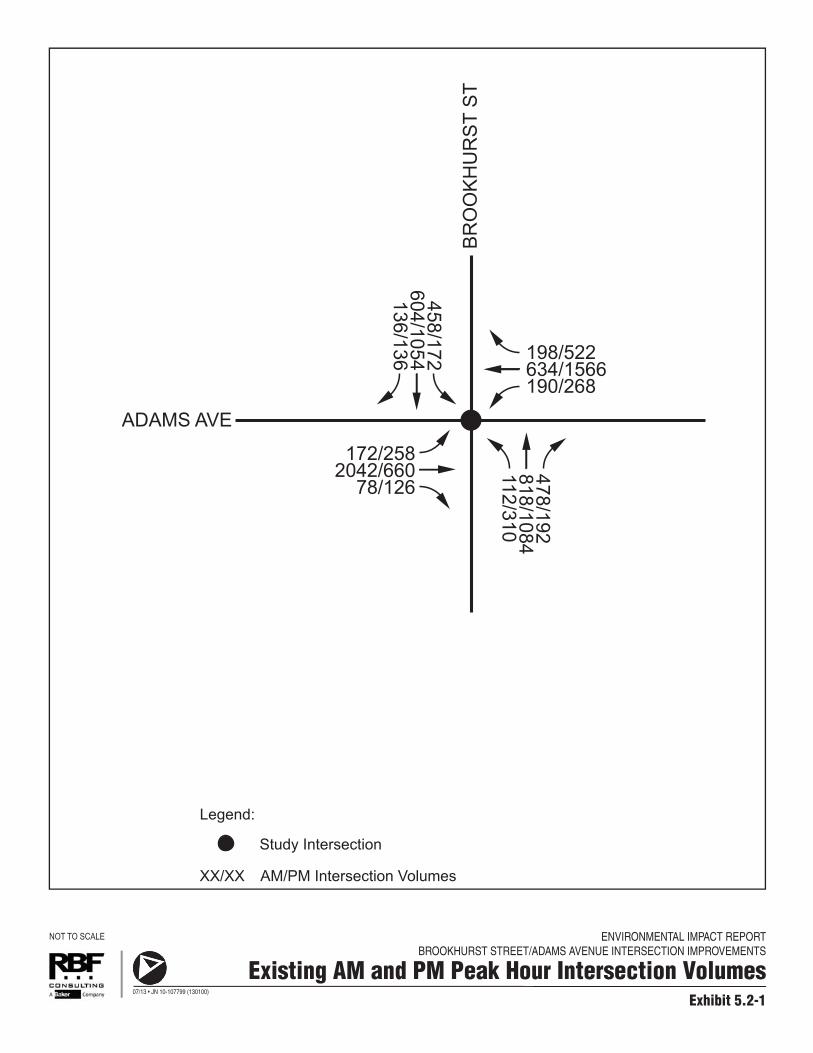
Performance Criteria The City of Huntington Beach target for peak hour operation of the study intersection (Principal Intersection) is LOS D or better. Traffic Volumes and LOS Assumptions This analysis utilizes existing and forecast future year 2030 traffic volumes at the study intersection contained in the Brookhurst Street and Adams Avenue Intersection Improvements, CC-1377 Project Report (Project Report) (prepared by Harris & Associates, March 12, 2013) (included as Appendix 13.7, Project Report, of this EIR). Additionally, ICU LOS results for existing conditions, forecast year 2030 without project conditions, and forecast year 2030 with project conditions are also from the Project Report. Forecast existing plus project conditions were subsequently prepared as part of the Traffic Impact Analysis since it was not contained in the Project Report. EXISTING CONDITIONS Table 5.2-2, Existing Conditions AM and PM Peak Hour Intersection LOS, and Exhibit 5.2-1, Existing AM and PM Peak Hour Intersection Volumes, summarize the existing peak hour LOS for the Brookhurst Street/Adams Avenue study intersection based on existing traffic volumes and current street geometry using the City’s analysis methodology.
Table 5.2-2 Existing Conditions AM and PM Peak Hour Intersection LOS
As shown in Table 5.2-2, the Brookhurst Street/Adams Avenue study intersection is currently operating at an acceptable LOS (LOS D or better) according to City of Huntington Beach performance criteria. FORECAST YEAR 2030 WITHOUT PROJECT CONDITIONS To determine potential traffic impacts associated with the proposed project at forecast year 2030, forecast year 2030 without project conditions are examined prior to forecast year 2030 with project conditions. Table 5.2-3, Forecast Year 2030 Without Project Conditions AM and PM Peak Hour Level of Service, summarizes forecast year 2030 without project conditions a.m. peak hour and p.m. peak hour LOS of the Brookhurst Street/Adams Avenue study intersection.
Study Intersection AM Peak Hour PM Peak Hour
V/C LOS V/C LOS
Brookhurst Street/Adams Avenue 0.89 D 0.76 C Notes: V/C = volume to capacity ratio Source: RBF Consulting, Brookhurst Street/Adams Avenue Improvement Project Traffic Impact Analysis, April 11, 2013.
ENVIRONMENTAL IMPACT REPORTBROOKHURST STREET/ADAMS AVENUE INTERSECTION IMPROVEMENTS
Exhibit 5.2-1
Existing AM and PM Peak Hour Intersection Volumes
NOT TO SCALE
07/13 • JN 10-107799 (130100)
ADAMS AVE
BR
OO
KH
UR
ST
ST
AM/PM Intersection VolumesXX/XX
Legend:
172/2582042/660
78/126
198/522634/1566190/268
458/172604/1054136/136
478/192818/1084112/310
Study Intersection

Brookhurst Street/Adams Avenue Intersection Improvements Project EIR
Public Review Draft ● July 2013 5.2-4 Traffic and Circulation
Table 5.2-3 Forecast Year 2030 Without
Project Conditions AM and PM Peak Hour Intersection LOS
Study Intersection
Forecast Year 2030 Without Project Conditions
AM Peak Hour PM Peak Hour
V/C – LOS V/C – LOS
Brookhurst Street/Adams Avenue 1.03 – F 1.05 – F Notes: 1. Deficient intersection operations are shown in bold. 2. V/C = volume to capacity ratio. Source: RBF Consulting, Brookhurst Street/Adams Avenue Improvement Project Traffic Impact
Analysis, April 11, 2013.
As shown in Table 5.2-3, the Brookhurst Street/Adams Avenue study intersection is forecast to operate at a deficient LOS (LOS E or worse) during both the a.m. and p.m. peak hours according to City of Huntington Beach performance criteria for forecast year 2030 without project conditions. 5.2.2 REGULATORY SETTING ORANGE COUNTY TRANSPORTATION AUTHORITY OCTA is a multi-modal transportation agency that began in 1991 with the consolidation of seven separate agencies. OCTA serves Orange County residents and travelers by providing countywide bus and paratransit service, Metrolink rail service, the 91 Express Lanes, freeway, street and road improvement projects, individual and company commuting solutions, motorist aid services, and by regulating taxi operations. State statute requires that a congestion management program be developed, adopted, and updated biennially for every county that includes an urbanized area and requires that it include every city and the county government within that county. As the Congestion Management Agency for Orange County, OCTA is responsible for implementing the CMP for the County. The purpose of the Orange County CMP is to develop a coordinated approach to managing and decreasing traffic congestion by linking the various transportation, land use, and air quality planning programs throughout the County. The City of Huntington Beach is required to show continued compliance with the countywide CMP. The benefits of compliance with the CMP provisions include the allocation of the City’s fair share of gas tax subventions collected by the State of California. CITY OF HUNTINGTON BEACH City of Huntington Beach General Plan Based on the City’s General Plan Circulation Element, the basic function of the circulation system is to provide for the movement of goods and people, including pedestrians, bicycles, buses, trucks, and the automobile. The Circulation Element provides the guidance to ensure the circulation system meets the City’s key objectives, including accommodating movement and preserving the City’s

Brookhurst Street/Adams Avenue Intersection Improvements Project EIR
Public Review Draft ● July 2013 5.2-5 Traffic and Circulation
quality living environment. The Circulation Element designates both Brookhurst Street and Adams Avenue as Major Arterials, with vehicle capacities of approximately 50,000 average daily traffic. In addition, the Element designates the Brookhurst Street/Adams Avenue signalized intersection as a Principal Intersection. The City has identified enhancements at the Brookhurst Street/Adams Avenue intersection within its Circulation Element as a “Recommended Long-Range Improvement” required to meet the City’s LOS standard through 2030. As such, the City has proposed the Brookhurst Street/Adams Avenue Intersection Improvements Project to implement planned capacity enhancements that would achieve the goals of its Circulation Element. MEMORANDUM OF UNDERSTANDING C-6-0834 The City is a participant in the Memorandum of Understanding C-6-0834 Among Cities of Costa Mesa, Fountain Valley and Huntington Beach and the Orange County Transportation Authority Regarding Agency Responsibilities for Implementing the Consensus Recommendation for the Garfield-Gisler Bridge Crossing over the Santa Ana River. This Memorandum of Understanding (MOU) was signed by all participants, including the City of Huntington Beach, in 2006. The MOU establishes a multi-jurisdictional approach to alleviating traffic congestion along the Garfield Avenue (within Huntington Beach and Fountain Valley) and Gisler Avenue (within Costa Mesa) corridors. The MOU identifies numerous transportation improvements within the Garfield Avenue/Gisler Avenue study area to be implemented by the cities of Costa Mesa, Fountain Valley, and Huntington Beach in lieu of constructing the Garfield-Gisler Bridge Crossing. As specified in the MOU, the following items are the City’s responsibilities with respect to the intersection of Brookhurst Street and Adams Avenue:
1. Install a bus turnout at the existing bus stop at northbound Brookhurst Street at Adams Avenue;
2. Install a bus turnout at the existing bus stop at southbound Brookhurst Street at Adams Avenue;
3. Consolidate driveways on the northbound and southbound sides of Brookhurst Street at Adams Avenue; and
4. Add a fourth through lane in the north, south, east, and westbound approaches at Brookhurst Street/Adams Avenue. Add dedicated right-turn lanes in the north and southbound approaches.
Although the MOU included the specific improvements to be implemented by the City (described above), the MOU states that while the “program of projects is specific, it is not meant to be prescriptive. If a city is able to identify an alternative traffic flow improvement which meets the overall objective of achieving and/or maintaining Level of Service (LOS) D at any location within the study area, then that improvement shall be considered an acceptable alternative and shall be implemented as a substitute solution to the original recommendation.”1 As such, subsequent traffic analyses conducted by the City determined that a fourth northbound and southbound through lane 1 Cities of Costa Mesa, Fountain Valley, Huntington Beach and the Orange County Transportation Authority, Memorandum of Understanding C-6-0834 Among Cities of Costa Mesa, Fountain Valley and Huntington Beach and the Orange County Transportation Authority Regarding Agency Responsibilities for Implementing the Consensus Recommendation for the Garfield-Gisler Bridge Crossing over the Santa Ana River (page 8 of 11), 2006.

Brookhurst Street/Adams Avenue Intersection Improvements Project EIR
Public Review Draft ● July 2013 5.2-6 Traffic and Circulation
on Brookhurst Street was unnecessary to provide acceptable traffic operations. Rather, a second northbound right-turn lane has been included in the proposed project to provide for satisfactory intersection operation. Thus, the proposed project would accomplish the City’s responsibilities under the 2006 MOU. 5.2.3 IMPACT THRESHOLDS
AND SIGNIFICANCE CRITERIA DEFINITION OF SIGNIFICANT IMPACT Intersection Traffic Impact Criteria Traffic impacts are identified if a project would result in a significant adverse change in traffic conditions on an analyzed facility. A significant impact is typically identified if traffic generated by a project would cause service levels to deteriorate beyond a threshold limit specified by the overseeing agency. Impacts can also be significant if an intersection is already operating below the poorest acceptable level and project traffic would substantially worsen the condition, thereby causing a further decline below the threshold. Based on the City’s General Plan Circulation Element, the City goal for peak hour intersection operation for a Principal Intersection is LOS D or better. City of Huntington Beach To determine whether the addition of project-related trips at a signalized Principal Intersection results in a significant impact, and thus requires mitigation, the City of Huntington Beach has established the following thresholds of significance:
A significant impact occurs when a proposed project causes an intersection to change from an acceptable LOS (LOS D or better) to a deficient LOS (LOS E or F); or
A significant impact occurs when a proposed project increases the LOS by 0.01 at a study intersection operating at a deficient LOS (LOS E or F) without the project.
Significance Criteria
Environmental impact thresholds as indicated in Appendix G of the CEQA Guidelines (Initial Study Checklist Form) and within the City’s Environmental Assessment Checklist are also used as significance thresholds in this analysis. As such, a project would create a significant impact if it would:
Conflict with an applicable plan, ordinance or policy establishing measures of effectiveness for the performance of the circulation system, taking into account all modes of transportation including mass transit and non-motorized travel and relevant components of the circulation system, including but not limited to intersections, streets, highways and freeways, pedestrian and bicycle paths, and mass transit;

Brookhurst Street/Adams Avenue Intersection Improvements Project EIR
Public Review Draft ● July 2013 5.2-7 Traffic and Circulation
Conflict with an applicable congestion management program, including, but not limited to level of service standards and travel demand measures, or other standards established by the county congestion management agency for designated roads or highways;
Result in a change in air traffic patterns, including either an increase in traffic levels or a change in location that results in substantial safety risks (refer to Section 10.0, Effects Found Not To Be Significant);
Substantially increase hazards due to a design feature (e.g., sharp curves or dangerous intersections) or incompatible uses;
Result in inadequate emergency access;
Result in inadequate parking capacity (refer to Section 5.1, Land Use and Relevant Planning); and
Conflict with adopted policies, plans, or programs regarding public transit, bicycle, or pedestrian facilities, or otherwise decrease the performance or safety of such facilities (refer to Section 10.0, Effects Found Not To Be Significant).
5.2.4 IMPACTS AND MITIGATION MEASURES
FORECAST EXISTING PLUS PROJECT CONDITIONS
M PROJECT IMPLEMENTATION WOULD NOT CAUSE A SIGNIFICANT
INCREASE IN TRAFFIC AT THE BROOKHURST STREET/ADAMS AVENUE INTERSECTION UNDER THE EXISTING CONDITIONS SCENARIO.
Impact Analysis: Forecast existing plus project conditions assumes the proposed project geometry and the existing AM and PM peak hour volumes contained in the Project Report. Exhibit 5.2-2, Proposed Project Improvements, depicts the existing and proposed intersection geometry. The proposed project would include intersection widening improvements, and would not implement any land uses capable of generating vehicle trips. Table 5.2-4, Forecast Existing Plus Project Conditions AM and PM Peak Hour Intersection LOS, summarizes forecast existing plus project conditions AM and PM peak hour LOS of the study intersection. As shown in Table 5.2-4, with the proposed project intersection improvements, the Brookhurst Street/Adams Avenue study intersection is forecast to continue to operate at an acceptable LOS (LOS D or better) according to City of Huntington Beach performance criteria.

ENVIRONMENTAL IMPACT REPORTBROOKHURST STREET/ADAMS AVENUE INTERSECTION IMPROVEMENTS
Exhibit 5.2-2
Proposed Project Improvements
NOT TO SCALE
07/13 • JN 10-107799 (130100)
ADAMS AVE
EXISTING GEOMETRY
BR
OO
KH
UR
ST
ST
ADAMS AVE
PROJECT IMPROVEMENTSGEOMETRY
BR
OO
KH
UR
ST
ST
Legend:
Existing Lane
Additional Lane
Signal-Controlled Intersection
Brookhurst Street/Adams Avenue Intersection Improvements Project EIR
Public Review Draft ● July 2013 5.2-9 Traffic and Circulation
Table 5.2-4 Forecast Existing Plus Project Conditions AM and PM Peak Hour Intersection LOS
Study Intersection
Existing Conditions Forecast Existing Plus Project Conditions
Significant Impact? AM Peak Hour PM Peak Hour AM Peak Hour PM Peak Hour
V/C – LOS V/C – LOS V/C – LOS V/C – LOS
Brookhurst Street/Adams Avenue 0.89 – D 0.76 – C 0.70 – B 0.66 – B No Notes: V/C = volume to capacity ratio. Source: RBF Consulting, Brookhurst Street/Adams Avenue Improvement Project Traffic Impact Analysis, April 11, 2013.
As also shown in Table 5.2-4, based on City of Huntington Beach established thresholds of significance, no significant impact at the Brookhurst Street/Adams Avenue study intersection is forecast to occur for forecast existing plus project conditions. Mitigation Measures: No mitigation measures are required. Level of Significance: Less Than Significant Impact. FORECAST YEAR 2030 WITH PROJECT CONDITIONS M PROJECT IMPLEMENTATION WOULD NOT CAUSE A SIGNIFICANT
INCREASE IN TRAFFIC AT THE BROOKHURST STREET/ADAMS AVENUE INTERSECTION UNDER THE FORECAST YEAR 2030 SCENARIO.
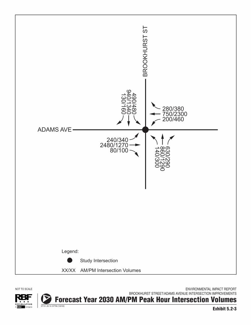
Impact Analysis: To determine potential traffic impacts associated with the project, the long-range operational year 2030 traffic with the proposed project is considered in comparison to the long-range operational year 2030 traffic conditions without the project. Forecast year 2030 with project conditions assumes the proposed project geometry and the forecast year 2030 AM and PM peak hour volumes contained in the Project Report. The proposed project would include intersection widening improvements, and would not implement any land uses capable of generating vehicle trips. Exhibit 5.2-3, Forecast Year 2030 AM and PM Peak Hour Intersection Volumes, shows forecast year 2030 AM and PM peak hour volumes at the study intersection. Table 5.2-5, Forecast Year 2030 Conditions AM and PM Peak Hour Intersection LOS, summarizes forecast year 2030 without and with project conditions AM and PM peak hour LOS of the Brookhurst Street/Adams Avenue study intersection. Forecast year 2030 with project conditions assumes the proposed project geometry and the forecast year 2030 AM and PM peak hour volumes contained in the Project Report. As shown in Table 5.2-5, the Brookhurst Street/Adams Avenue study intersection is forecast to operate at a deficient LOS (LOS E or worse) during both the AM and PM peak hours according to City of Huntington Beach performance criteria. However, with the proposed project intersection improvements, the Brookhurst Street/Adams Avenue intersection is forecast to operate at an acceptable LOS (LOS D or better) according to City of Huntington Beach performance criteria. As such, the project is anticipated to result in a beneficial impact in regards to intersection operation under the forecast year 2030 scenario.
ENVIRONMENTAL IMPACT REPORTBROOKHURST STREET/ADAMS AVENUE INTERSECTION IMPROVEMENTS
Exhibit 5.2-3
Forecast Year 2030 AM/PM Peak Hour Intersection Volumes
NOT TO SCALE
07/13 • JN 10-107799 (130100)
ADAMS AVE
BR
OO
KH
UR
ST
ST
AM/PM Intersection VolumesXX/XX
Legend:
240/3402480/1270
80/100
280/380750/2300200/460
490/480940/1340130/160
630/290860/1290140/300
Study Intersection
Brookhurst Street/Adams Avenue Intersection Improvements Project EIR
Public Review Draft ● July 2013 5.2-11 Traffic and Circulation
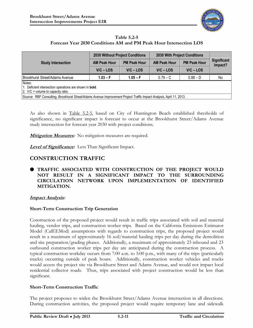
Table 5.2-5 Forecast Year 2030 Conditions AM and PM Peak Hour Intersection LOS
Study Intersection
2030 Without Project Conditions 2030 With Project Conditions
Significant Impact? AM Peak Hour PM Peak Hour AM Peak Hour PM Peak Hour
V/C – LOS V/C – LOS V/C – LOS V/C – LOS
Brookhurst Street/Adams Avenue 1.03 – F 1.05 – F 0.79 – C 0.88 – D No Notes: 1. Deficient intersection operations are shown in bold. 2. V/C = volume to capacity ratio. Source: RBF Consulting, Brookhurst Street/Adams Avenue Improvement Project Traffic Impact Analysis, April 11, 2013.
As also shown in Table 5.2-5, based on City of Huntington Beach established thresholds of significance, no significant impact is forecast to occur at the Brookhurst Street/Adams Avenue study intersection for forecast year 2030 with project conditions. Mitigation Measures: No mitigation measures are required. Level of Significance: Less Than Significant Impact. CONSTRUCTION TRAFFIC
M TRAFFIC ASSOCIATED WITH CONSTRUCTION OF THE PROJECT WOULD
NOT RESULT IN A SIGNIFICANT IMPACT TO THE SURROUNDING CIRCULATION NETWORK UPON IMPLEMENTATION OF IDENTIFIED MITIGATION.
Impact Analysis: Short-Term Construction Trip Generation Construction of the proposed project would result in traffic trips associated with soil and material hauling, vendor trips, and construction worker trips. Based on the California Emissions Estimator Model (CalEEMod) assumptions with regards to construction trips, the proposed project would result in a maximum of approximately 16 soil/material hauling trips per day during the demolition and site preparation/grading phases. Additionally, a maximum of approximately 23 inbound and 23 outbound construction worker trips per day are anticipated during the construction process. A typical construction workday occurs from 7:00 a.m. to 5:00 p.m., with many of the trips (particularly trucks) occurring outside of peak hours. Additionally, construction worker vehicles and trucks would access the project site via Brookhurst Street and Adams Avenue, and would not impact local residential collector roads. Thus, trips associated with project construction would be less than significant. Short-Term Construction Traffic The project proposes to widen the Brookhurst Street/Adams Avenue intersection in all directions. During construction activities, the proposed project would require temporary lane and sidewalk

Brookhurst Street/Adams Avenue Intersection Improvements Project EIR
Public Review Draft ● July 2013 5.2-12 Traffic and Circulation
closures to accommodate the proposed expansion of ROW and other project improvements. As noted above, the construction process is expected to last approximately six months, with construction activity taking place on all four quadrants of the intersection concurrently. These activities have the potential to result in traffic disruption and delays within and surrounding the intersection. To minimize potential circulation impacts during the short-term construction process, Mitigation Measure TR-1 would require the City to prepare a Traffic Management Plan (TMP). The TMP would specify various measures to minimize impacts, which may include (but not be limited to) construction signage and/or a detailed re-routing plan for vehicles, bicyclists, and pedestrians. Although traffic flow in the area would be temporarily impacted during construction, the City would maintain at least one open traffic lane in each direction along Brookhurst Street and Adams Avenue at all times. Though construction would last approximately six months, lane and sidewalk closures would occur for only a portion of the overall construction duration. Any impacts to traffic operations during construction would be short-term in nature and would cease upon project completion. As such, continuous access would be maintained in all directions at all times, and impacts in this regard would be less than significant upon implementation of Mitigation Measure TR-1. Mitigation Measures: TR-1 Prior to commencement of any construction activities, the City of Huntington Beach
shall prepare a Traffic Management Plan (TMP) to address temporary safety and traffic concerns at and surrounding the Brookhurst Street/Adams Avenue intersection. At a minimum, the TMP shall include plans clearly denoting any proposed lane closures, proposed vehicle/bicyclist/pedestrian rerouting plans, and a traffic signage plan to ensure adequate circulation during the short-term construction process. The TMP shall be subject to review and approval by the City of Huntington Beach City Engineer. In addition, road/lane closure notification shall be provided to the Huntington Beach Fire Department and Police Department.
Level of Significance: Less Than Significant Impact with Mitigation Incorporated. PROPERTY ACCESS M THE PROPOSED PROJECT WOULD NOT RESULT IN SIGNIFICANT IMPACTS
RELATED TO ACCESS TO PROPERTIES ADJACENT TO THE BROOKHURST STREET/ADAMS AVENUE INTERSECTION.
Impact Analysis: Short-Term Construction The proposed project would result in the temporary disruption of various access points to adjacent properties during the short-term construction process. It is expected that the construction process would occur in a single phase over approximately six months, with construction activity taking place on all four quadrants of the intersection concurrently. However, impacts to access points for adjacent properties would occur for only brief intervals at varying times during the six-month construction process.

Brookhurst Street/Adams Avenue Intersection Improvements Project EIR
Public Review Draft ● July 2013 5.2-13 Traffic and Circulation
The proposed project would temporarily affect the following driveways:
Southeast Quadrant. The project would affect a total of four driveways within the southeast quadrant of the intersection, all associated with the commercial center. These include the two northern-most driveways along Brookhurst Street and the two western-most driveways along Adams Avenue.
Southwest Quadrant. The project would affect a total of three driveways within the southwest quadrant of the intersection, all associated with the commercial center. These include the northern-most driveway along Brookhurst Street and the two eastern-most driveways along Adams Avenue.
Northwest Quadrant. The project would affect a total of five driveways within the northwest quadrant of the intersection, all associated with the commercial center. These include the two northern-most driveways along Brookhurst Street and the three driveways along Adams Avenue.
Northeast Quadrant. The project would affect a total of five driveways within the northeast quadrant of the intersection, all associated with the commercial center. These include the southern-most driveway along Brookhurst Street and the three driveways along Adams Avenue.
Although individual access points to commercial centers on all four quadrants of the intersection would be temporarily affected by the project, a minimum of one driveway would remain open to traffic at all times. It is anticipated that each driveway affected by the project would be subject to closure for a maximum of seven days, with closures staggered so that alternate access points to each commercial center would be continuously available. As noted above, the construction process would last approximately six months, and all impacts would cease upon completion of the construction process. Since access to all properties adjacent to the project site would remain available at all times during construction and any driveway closures would be short-term (a maximum of seven days, staggered throughout the construction process), impacts in this regard would be less than significant. Access to all residential areas (including Picadilly Lane at the Huntington Bay community and Lawson Lane) would remain open at all times. The frontage roads along the northern side of Adams Avenue (to the east and west of Brookhurst Street) would not be affected by the project. Long-Term Operations The proposed project would not alter access patterns for any property adjacent to the project site. Since existing circulation and access patterns would be maintained, no long-term operational impacts would occur. Mitigation Measures: No mitigation measures are required. Level of Significance: Less Than Significant Impact.
Brookhurst Street/Adams Avenue Intersection Improvements Project EIR
Public Review Draft ● July 2013 5.2-14 Traffic and Circulation
HAZARDOUS DESIGN FEATURES AND EMERGENCY ACCESS M IMPLEMENTATION OF THE PROJECT WOULD NOT RESULT IN HAZARDS
TO VEHICLES, BICYCLISTS, OR PEDESTRIANS DUE TO A DESIGN FEATURE OR INCOMPATIBLE USES NOR WOULD IT SIGNIFICANTLY AFFECT EMERGENCY ACCESS UPON IMPLEMENTATION OF IDENTIFIED MITIGATION.
Impact Analysis: Short-Term Construction As noted above, the project proposes to widen the Brookhurst Street/Adams Avenue intersection in all directions. During construction activities, the proposed project would require temporary lane and sidewalk closures to accommodate the proposed expansion of ROW and other project improvements. The construction process is expected to last approximately six months, with construction activity taking place on all four quadrants of the intersection concurrently. To minimize potential hazards and potential impacts to emergency access during the short-term construction process, Mitigation Measure TR-1 would require the City to implement a TMP. The TMP would specify various measures to minimize impacts, which may include (but not be limited to) construction signage and/or a detailed re-routing plan for vehicles, bicyclists, and pedestrians. As stated above, although traffic flow in the area would be temporarily impacted during construction, the City would maintain at least one open traffic lane in each direction along Brookhurst Street and Adams Avenue at all times. Though construction would last approximately six months, lane and sidewalk closures would occur for only a portion of the overall construction duration. Any impacts to traffic operations during construction would be short-term in nature and would cease upon project completion. As such, continuous access would be maintained for vehicles and emergency personnel, and impacts in this regard would be less than significant upon implementation of Mitigation Measure TR-1. Long-Term Operations The proposed project is not anticipated to result in significant impacts related to long-term operation of the project. As noted above, the proposed project would not alter access patterns to properties adjacent to the project site. Access to all residential areas (including Picadilly Lane at the Huntington Bay community and Lawson Lane) would remain open at all times. The frontage roads along the northern side of Adams Avenue (to the east and west of Brookhurst Street) would not be affected by the project. Sidewalks would be restored to meet existing City and Americans with Disabilities Act (ADA) requirements. Crosswalks within the project site (which are limited to the Brookhurst Street/Adams Avenue intersection) would be maintained. Since widening of the intersection would occur, pedestrian signal timing would be adjusted as necessary to meet Manual of Uniform Traffic Control Devices (MUTCD) recommendations to ensure adequate time for pedestrians crossing the intersection.

Brookhurst Street/Adams Avenue Intersection Improvements Project EIR
Public Review Draft ● July 2013 5.2-15 Traffic and Circulation
Bicycle travel within and immediately surrounding the project site would not be affected during long-term operations. Currently, there are no striped bicycle lanes along Brookhurst Street or Adams Avenue. The proposed project would not alter travel patterns for bicyclists. The project would implement intersection widening improvements that would reduce existing and anticipated future congestion at the Brookhurst Street/Adams Avenue intersection, and improve the efficiency of traffic flow within the project area. The proposed project would not contribute to any hazards in the project area related to vehicle queuing, including Ranger Lane (located approximately 400 feet east of the project site). There are no identified capacity deficiencies at the Adams Avenue/Ranger Lane intersection under both existing and forecast conditions. It is anticipated that the increased capacity created by the project would result in beneficial impacts related to vehicle queuing, within and surrounding the project site. The project would not result in increased hazards for ingress/egress at the Huntington Bay community. The access to the Huntington Bay complex (Piccadilly Lane) would not be affected during construction or operations. In addition, while it can be difficult for motorists to identify an acceptable gap in traffic when attempting a left turn (eastbound) movement from Piccadilly Lane onto Adams Avenue, this condition would occur with our without the project. The project would result in beneficial impacts related to intersection operation and would not exacerbate this condition. As discussed above, the Brookhurst Street/Adams Avenue intersection is forecast to operate at a deficient LOS (LOS E or worse) during both the AM and PM peak hours according to City of Huntington Beach performance criteria. However, with the proposed project intersection improvements, the Brookhurst Street/Adams Avenue intersection is forecast to operate at an acceptable LOS (LOS D or better) according to City of Huntington Beach performance criteria. As such, the project is anticipated to result in a beneficial impact in regards to intersection operation under the forecast year 2030 scenario. Emergency access and response would also be improved since congestion would be reduced with widening of the intersection. Therefore, implementation of the proposed project would not result in hazardous conditions or have adverse effects on emergency response. Impacts in this regard would be less than significant. Mitigation Measures: Refer to Mitigation Measure TR-1. Level of Significance: Less Than Significant Impact with Mitigation Incorporated. 5.2.5 CUMULATIVE IMPACTS M THE PROPOSED PROJECT ALONG WITH OTHER RELATED CUMULATIVE
PROJECTS WOULD NOT RESULT IN CUMULATIVELY CONSIDERABLE IMPACTS RELATED TO TRAFFIC AND CIRCULATION.
Impact Analysis: The basis for cumulative analysis is presented in Section 4.0, Basis of Cumulative Analysis. As outlined in Table 4-1, Cumulative Projects List, and illustrated on Exhibit 4-1, Cumulative Project Locations, the related projects and other possible development would occur throughout Huntington Beach. Based on the projects identified in Table 4-1, only two would occur within one mile of the project site (Lamb School and Wardlow School residential projects).

Brookhurst Street/Adams Avenue Intersection Improvements Project EIR
Public Review Draft ● July 2013 5.2-16 Traffic and Circulation
Traffic from cumulative projects was considered in the long-range 2030 with and without project conditions. The analysis provided above within Section 5.2.4 for the forecast year 2030 includes development and growth associated with buildout of the City’s General Plan through 2030. As determined above, the proposed project does not propose a trip-generating land use and would not result in cumulatively considerable traffic impacts in regards to local intersections under the forecast year 2030 conditions. In addition, given the nature and location of the identified cumulative projects, it is not anticipated that cumulatively considerable impacts related to hazardous traffic conditions would occur. The proposed project, in combination with identified cumulative developments, would not result in the creation of dangerous design features or hazardous intersections. Each project would undergo review by the City of Huntington Beach to ensure that circulation and access components comply with existing City standards. As such, the proposed project would not have the potential to result in cumulatively considerable impacts in combination with the identified range of cumulative projects. Mitigation Measures: No mitigation measures are required. Level of Significance: Less Than Significant Impact. 5.2.6 SIGNIFICANT UNAVOIDABLE IMPACTS No significant unavoidable impacts related to traffic and circulation have been identified following implementation of the recommended mitigation measure.