6 agricultural and forestry resources
TRANSCRIPT

Merced County 6-1 2030 Merced County General Plan November 2012 Draft PEIR
6 AGRICULTURAL AND FORESTRY RESOURCES
This chapter provides an evaluation of the potential environmental effects of implementing the proposed 2030 Merced County General Plan (2030 General Plan) on agricultural resources. As established in the Notice of Preparation for this EIR (see Appendix A, Notice of Preparation), urban development and other activities subject to the updated General Plan may result in degradation of agricultural resources within Merced County. Biological resources impacts, including potential impacts to oak woodland habitat, are evaluated in Chapter 8, Biological Resources of this Draft PEIR.
The following environmental assessment includes a review of agricultural resources potentially affected by the implementation of the 2030 General Plan, including a description of existing agricultural resources, potential conversion of farmlands, impacts due to interference with continuing agricultural operations, and conflicts with Williamson Act contracts and the Williamson Act Agricultural Preserve. Also assessed are the effects that could result from urban development that would be allowed under the proposed 2030 General Plan, as well as the effects on forestry resources, including forest land, timberland, and timberland production.
This analysis also includes a review of applicable regulations, requirements, plans and policies from the following state and Merced County sources:
• California Air Resources Board Forest Protocols • Open Space Lands Act (Government Code §65560 et. seq.) • California Agriculture Land Evaluation and Site Assessment Model (1997) • California Department of Conservations Farmland Mapping and Monitoring Program • California Department of Forestry and Fire Protection Forestry and Range Assessment
Project • California Land Conservation Act of 1965 (Williamson Act Program) (Govt. Code, Section
51200, et seq.) • Right-to-Farm Ordinance • Agricultural Conservation Easements • Merced County Year 2000 General Plan.
The existing conditions of agricultural resources in the Merced County General Plan study area were determined by a review of important farmlands classified by the California Department of Conservation Farmland Mapping and Monitoring Program (FMMP), the Williamson Act Program, existing agricultural conservation easements, examination of aerial photographic records and other mapping data, and consultations with agricultural experts and regulators. Rules and regulations influencing the agricultural resources were identified by a review of state and local regulations and the Merced County General Plan. Potential impacts related to agricultural resources, compiled and analyzed based on CEQA assessment criteria, were determined by comparing urban development that would likely be constructed under total buildout of the 2030 General Plan to the existing environment, using guidelines adopted by Merced County.

Agricultural and Forestry Resources
2030 Merced County General Plan 6-2 Merced County Draft PEIR November 2012
6.1 SETTING The environmental and regulatory setting of Merced County with respect to agricultural resources is described in detail in the General Plan Background Report (Merced County 2007; updated 2012). That document is incorporated by reference into this Draft PEIR pursuant to State CEQA Guidelines Section 15150 as though fully set forth herein. The updated Background Report is available for download from the Merced County General Plan website at:
http://www.co.merced.ca.us/index.aspx?NID=1926.
Printed copies of the Background Report may be viewed during standard business hours (8:30 a.m. to 4:30 p.m.), Monday through Friday, at the Merced County Planning and Community Development Department, 2222 M Street, Merced, California 95340, and at the Main Branch of the Merced County Library located at 2100 O Street, Merced California 95340.
Important Terms
Several similar terms are used to describe farmland or agricultural soil quality by the California Department of Conservation Farmlands Mapping and Monitoring Program (FMMP) and the US Department of Agriculture, Natural Resources Conservation Service (NRCS). In general, the FMMP describes areas of farmlands in terms of their soil quality and their predominant use. Uses as monitored by the FMMP range from urban to rural. FMMP categories are explained further in Table 6-2 of this Chapter. Historically, the NRCS has classified soils in terms of their physical characteristics to support agriculture. Recently, the FMMP and NRCS definitions have converged.
In this EIR, the following terms frequently are used:
Prime Farmland (FMMP) - Lands with the “…best combination of physical and chemical features able to sustain long-term agricultural production…has soil quality, growing season, and moisture supply needed to produce sustained high yields.” The land must have been in irrigated production at some time during the previous four years.
Important Farmlands (FMMP) – As defined by the FMMP and used in this EIR, this category is a combination of the following FMMP farmland classifications: prime farmlands, unique farmlands, farmland of statewide importance, and farmlands of local importance. Within this EIR, for FMMP data for 2008 and 2010, important farmlands have been broadened to include the FMMP confined animal agriculture category. The FMMP agricultural land classification not identified as important farmland is grazing land. Important farmlands are sometimes described as “farmlands of concern”; this phrase is not used in this EIR.
The following terms are used less frequently in this EIR:
Prime Farmland (NRCS) - Those soils that have the best combination of physical and chemical characteristics for producing food, feed, forage, fiber, and oil seed crops, and are also available for these uses (the land could be cropland, pastureland, range-land, forestland, or other land, but not urban built-up land or water). It has the soil quality, growing season and moisture supply needed to economically produce sustained high yields or crops when treated and managed, including water management, according to acceptable farming practices.
Productive Farmlands (Merced County 2000 General Plan) – The 2000 General Plan used the term “Productive Farmlands” in its evaluation of farmland conversion. According to the 2000 General Plan, this category consisted of three FMMP farmland categories - prime farmlands, unique farmlands, and farmland of statewide importance. This term is not used in this EIR, which relies upon the FMMP definition of important farmlands as set forth above in its evaluation of farmland conversion.

Agricultural and Forestry Resources
Merced County 6-3 2030 Merced County General Plan November 2012 Draft PEIR
6.1.1 ENVIRONMENTAL SETTING The Background Report’s discussion of the agriculture environmental setting describes the key features that rank Merced County fifth among all counties in California, and sixth in the nation in the annual market value of farm products. The environmental setting highlights features such as the agricultural zoning, Williamson Act contracts, policies, farmland trends, rich soils, accessible irrigation water, favorable climate, the large labor force, and reliable access to local, national, and global markets that make Merced County a thriving agricultural community. Table 6-1 presents a snapshot of some of Merced County’s important facts regarding its agricultural resources.
Table 6-1 Snapshot of Merced County Agriculture
Category Description
Land 1.16 to 1.17 million agricultural acres1; 92 percent of county’s total area. (2010, 2012) Soils Gently sloping alluvial plain in the middle of the world’s most diverse agricultural region - the
San Joaquin Valley. Prime soils (271,100 acres) account for 23.4 percent of total agricultural land in Merced County. Other cropland (325,430 acres) accounts for 28 percent, and grazing land (562,471 acres) accounts for 48.6 percent.
Market Value of Agricultural Products
$2.73 billion. (2010)
All Farms 2,607 farms average 399 acres in size. (2007) Commodities 90 different crop and animal products; at least 53 have annual market values of $1 million or
more. Major commodity groups in annual market value are: 1) Animal Products (including Milk) $1.54 billion; 2) Fruits and Nuts $465.7 million; 3) Field Crops $325 million; 4) Vegetable Crops $317.8 million. (2010)
Irrigated Farmland 514,162 acres on 2,127 farms. (2007) Agricultural Animals 320,884 cattle and calves; 77,744,725 chickens; 2,306,709 turkeys. (2010) The Agricultural Landscape
The largest sectors of the agricultural landscape are: 45.9 percent in grazing land (567,391 acres); 43.5 percent in row crops (537,716 acres); 11.7 percent in orchards (144,863 acres); and 3.1 percent in dairies (277 dairy farms) (2007, 2011) At least $8.1 billion in total economic activity, assuming an average 3x multiplier for the $2.7 billion in market value of products. (2010)
Local Economic Impacts of Agriculture About one-third of all employed persons in the county are directly or indirectly connected to
agriculture, including persons employed in food manufacturing (the top employment sector in the county), support services, crop production, and animal production. (2005)
1 Differing amounts of acreage depending upon the source: the Merced County Agricultural Commissioner (MCAC) or the California Department of Conservation. Depending upon the analysis, comparisons are like to like (e.g., consistent MCAC data when discussing crops as a percentage of all agricultural land).
Sources: Merced County Agricultural Commissioner, Annual Report of Agriculture, 2011; U.S. Census of Agriculture, 2009; California Department of Conservation, Division of Land Resource Protection, Merced County: 2008-2010 Land Use Conversion 2012; Maxwell Norton, UC Cooperative Extension, “Merced County Agriculture,” 2005.
Agricultural resources discussed in the Background Report, including the major findings, include:
• Agricultural Zoning. Zoning is the County’s principal regulatory mechanism for protecting farmland, primarily through the designation of minimum parcel sizes and allowable uses in particular zones. There are three agricultural zoning districts in the existing General Plan, including districts for General Agricultural (Zone A-1), General Agricultural (Zone A-1-40), and Exclusive Agriculture (Zone A-2).

Agricultural and Forestry Resources
2030 Merced County General Plan 6-4 Merced County Draft PEIR November 2012
• Williamson Act. Merced County came late to the California Land Conservation Act of 1965 (Williamson Act), California’s preferential property tax program, adopting it in 2000, more than 30 years after it was enacted in 1965. At the time, the debate on whether or not to participate in the state program weighed the benefits of protecting farmland from urban conversion and reducing property taxes for agricultural landowners against the loss of revenue for County government and special districts. As of 2009, Merced County had 467,679 acres enrolled in Williamson Act contracts, 45 percent of all agricultural land, including approximately 1,100 landowners and 3,649 parcels. Approximately 6,200 acres are in non-renewal. Figure 6-1 shows the locations of the Williamson Act lands currently under contract within Merced County. About 55 percent of enrolled acres are cropland (labeled as “prime”), while the rest is grazing (“nonprime”) land. Williamson Act land is located throughout the county’s agricultural regions, generally some distance from the urban centers along SR 99. In order to participate in the Williamson Act program the land must be located within the Williamson Act Agricultural Preserve. In order to accommodate the maximum number of possible contracts, in the year 2000, the County created one large preserve boundary encompassing most all agriculturally designated property within the County. The total size of the preserve in 2012 is 982,599 acres. As of 2010, the State reduced or removed their property tax subvention program. The County has been financially impacted, resulting in a decision by the Board of Supervisors to suspend entering into any new contracts.
• Right-to-Farm Ordinance. Merced County’s Right-to-Farm Ordinance is administered by the Planning Department and has been in place since 1986. It requires a disclosure of the importance and protection of agriculture in the residential development process, when subdivisions or parcel splits are approved and building permits are issued. The disclosure is passed on to future property buyers through the title process.
• Conservation Easements. As compared to the temporary restrictions imposed by zoning and Williamson Act contracts, easements permanently protect farms and other open space land from conversion to urban use. Easements are formed when landowners voluntarily sell or donate the development rights of particular parcels in perpetuity, while retaining all other ownership rights, in return for cash or tax benefits. Easements also have legal status, as they are formally recorded on property deeds as permanent restrictions. As of 2011, the Central Valley Farmland Land Trust, which covers a four-county area (Sacramento, San Joaquin, Stanislaus, and Merced), managed 86 percent of their easements in Merced, covering approximately 11,668 acres. More than 133,260 easement acres are also located in the Grasslands Wildlife Management Area, a wetlands preserve managed by the U.S. Fish and Wildlife Service (USFWS).

Merced County General Plan UpdateFigure 6-1
Williamson Act Lands in Merced CountySOURCE: Merced County, October, 2012

Agricultural and Forestry Resources
2030 Merced County General Plan 6-6 Merced County Draft PEIR November 2012
• Urban Conversion. Because agricultural land represents more than 90 percent of the county’s land base, it provides the primary location for new urban development. To keep track of urban conversion trends and other land use changes since the mid-1980s, the California Department of Conservation developed the Farmland Mapping and Monitoring Program (FMMP) to generate reports every two years on the land use changes affecting important agricultural lands. Prior to 2008, the FMMP identified eight classifications of land uses; five different categories are used for agricultural land and three others are used for urban, other land uses, and water. In 2008, additional classifications were added to inventories for counties such as Merced to account for rural residential and confined animal agricultural land uses. Four of the categories of agricultural lands - Prime, Statewide Importance, Unique, and Local Importance - are collectively labeled by the FMMP as “important farmlands.” For purposes of this EIR, due to its importance to the local economy, the post-2008 FMMP category of “Confined Animal Agriculture” is also categorized as important farmland.
Table 6-2 sets forth the agricultural land use categories as used in the 2010 FMMP for Merced County, and each category’s respective acreage in the county. Figure 6-2 shows the locations of these farmland types.

Agricultural and Forestry Resources
Merced County 6-7 2030 Merced County General Plan November 2012 Draft PEIR
Table 6-2 Agricultural and Other Land Use Categories in the Farmland Mapping and Monitoring Program
Land Use Category Definition Acres in Merced
County, 2010
Prime Farmland Lands with the “…best combination of physical and chemical features able to sustain long-term agricultural production…has soil quality, growing season, and moisture supply needed to produce sustained high yields.” The land must have been in irrigated production some time during the previous four years.
271,100
Farmland of Statewide Importance
Similar to prime, “but with minor shortcomings, such as greater slopes or less ability to store soil moisture.” The land must have been in irrigated production some time during the previous four years.
151,340
Unique Farmland “…lesser quality soils used for the production of the state’s leading agricultural crops.” Usually irrigated, but may include non-irrigated vineyards or orchards. The land must have cropped at some time during the previous four years.
109,030
Farmland of Local Importance Lands that have the physical characteristics that would qualify for Prime or Statewide Importance except for the lack of irrigation water. Also, lands that produce crops not listed under unique, but are “…of importance to the local economy”.
65,057
Grazing Land “Land on which the existing vegetation is suited to the grazing of livestock.” Minimum mapping unit is 40 acres.
562,461
Confined Animal Agriculture1 Lands occupied by poultry facilities, feedlots, dairy facilities, and fish farms. Prior to 2008, these facilities were classified as Farmland of Local Importance in Merced County, or were classified based on the characteristics of the underlying soils.
14,339
Nonagricultural and Natural Vegetation1
Lands including heavily wooded, rocky, or barren areas, riparian and wetland areas, grassland areas that do not qualify for Grazing Land due to their size or land management restrictions, small water bodies, and recreational water ski lakes. Constructed wetlands are also included in this category.
12,737
Semi-Agricultural and Rural Commercial1 Land
Lands that include farmsteads, agricultural storage and packing sheds, unpaved parking areas, composting facilities, equine facilities, firewood lots, and campgrounds
3,666
Vacant or Disturbed Lands1 Lands including open field areas that do not qualify for any other agricultural category, mineral and oil extraction areas, off-road vehicle areas, electrical substations, channelized canals, and rural freeway interchanges.
15,234
Rural Residential and Commercial Land1
Residential areas of one to five dwellings per 10 acres. 5,418
Urban and Built-up Land “…occupied by structures with a building density of at least one dwelling to 1.5 acres, or approximately 6 structures to a 10-acre parcel.” Used for residential, industrial, commercial, and other developed purposes.
38,376
Water Area Areas of lakes, rivers and other waters. 16,859
Total All FMMP mapped lands (inc. urban and rural non-agricultural lands)
1,265,617
1 Prior to 2008 in Merced County, rural residences, brush, timber, wetlands, confined animal facilities, etc., were categorized by the FMMP as “Other Land.”
Source: California Department of Conservation, Farmland Mapping and Monitoring Program, 2012.

Merced County General Plan UpdateFigure 6-2
Important Farmlands in Merced CountySOURCE: Merced County, 2012; FMMP 2010

Agricultural and Forestry Resources
Merced County 6-9 2030 Merced County General Plan November 2012 Draft PEIR
Urban conversion of agricultural land in Merced County has been a steady but slow process, according to FMMP data. Table 6-3 shows the trends for 1992-2010.
Table 6-3 Agricultural and Other Land Use Changes, 1992-2010
Land Use Category Acres, 1992 Acres, 2010 1992-2010 Change
Percent Change
Average Annual Change in Acres
Prime Farmland 288,920 271,100 -17,820 -6.2% -990
Other Important Farmland1 309,670 325,427 15,757 5.0% 875
Grazing Land 581,798 562,461 -19,337 -3.3% -1,074
Total Agricultural Land 1,180,388 1,158,988 -21,400 -1.7% -1,189
Urban and Built-Up Land 28,326 38,376 10,050 35.5% 558
Other Land 35,759 51,394 15,635 43.7% 869
Water Area 16,946 16,859 -8 -0.5% -5 1 Includes other cropland—farmland of statewide importance, unique farmland, and farmland of local
importance. 2 Because the FMMP has revised the land use categories reported in its analyses, the information reported
in this Table does not match the categories set forth in Table 6-2. For example, the Other Land category reported above was disaggregated in 2008 to report the additional quasi-rural land uses described in Table 6-2. To permit comparison with data from years prior to 2008 or with data in other counties still reporting the old categories, the FMMP reports information using the pre-2008 categories. A potentially large implication for Merced County is that confined animal facilities were categorized as Other Land prior to 2008.
Source: California Department of Conservation, Farmland Mapping and Monitoring Program, 2012
During this 18-year period, total agricultural land decreased from 1.18 million acres to 1.16 million acres (excluding confined animal agriculture) - a decrease of 21,400 acres or 1.7 percent. At the same time, urban and built-up land increased from 28,326 to 38,376 acres - an increase of 10,050 acres or 35.5 percent. Annually, the loss averaged approximately 1,074 acres per year. Only a part of the loss is due to the growth of urban areas. Although not explicitly reflected in Table 6-3, the increase of lands in the Other Land category may represent land being fallowed or lost to other types of rural developed uses. Additionally, much of the loss of grazing lands over the period may be due to the development of irrigation facilities and the cultivation of lands formerly classified as Grazing Land. Such conversion may act to mask the loss of important farmlands to non-agricultural uses, since the loss may be offset in part as grazing lands are converted to more productive agricultural activities. Until recently (2008), reported FMMP numbers did not accurately document the impact of single family, low-density rural residential or commercial development on farmland. Therefore, the gross numbers reported by the FMMP may underestimate the extent of the agricultural land converted to other non-agricultural uses.
Agricultural and Forestry Resources
2030 Merced County General Plan 6-10 Merced County Draft PEIR November 2012
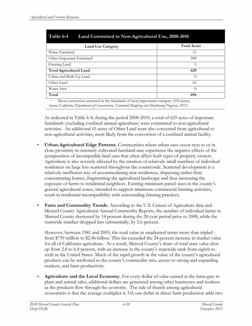
Table 6-4 Land Committed to Non-Agricultural Use, 2008-2010
Land Use Category Total Acres
Prime Farmland 31
Other Important Farmland1 598
Grazing Land 0
Total Agricultural Land 629
Urban and Built-Up Land 0
Other Land 65
Water Area 0
Total 694 1 Most conversion occurred in the farmland of local importance category (516 acres).
Source: California Department of Conservation, Farmland Mapping and Monitoring Program, 2012.
As indicated in Table 6-4, during the period 2008-2010, a total of 629 acres of important farmlands (excluding confined animal agriculture) were committed to non-agricultural activities. An additional 65 acres of Other Land were also converted from agricultural to non-agricultural activities, most likely from the conversion of a confined animal facility.
• Urban-Agricultural Edge Patterns. Communities where urban uses occur next to or in close proximity to intensely cultivated farmland may experience the negative effects of the juxtaposition of incompatible land uses that often affect both types of property owners. Agriculture is also severely affected by the creation of relatively small numbers of individual residences on large lots scattered throughout the countryside. Scattered development is a relatively inefficient way of accommodating new residences, dispersing rather than concentrating homes, fragmenting the agricultural landscape and thus increasing the exposure of farms to residential neighbors. Existing minimum parcel sizes in the county’s general agricultural zones, intended to support minimum commercial farming activities, result in residential incompatibility with surrounding farming practices.
• Farm and Commodity Trends. According to the U.S. Census of Agriculture data and Merced County Agricultural Annual Commodity Reports, the number of individual farms in Merced County decreased by 14 percent during the 20-year period prior to 2008, while the statewide number dropped less substantially, by 2.6 percent.
However, between 1981 and 2005, the total value in unadjusted terms more than tripled - from $759 million to $2.46 billion. This far exceeded the 24 percent increase in market value for all of California agriculture. As a result, Merced County’s share of total state value shot up from 2.8 to 6.8 percent, with an increase in the county’s statewide rank from eighth to sixth in the United States. Much of the rapid growth in the value of the county’s agricultural products can be attributed to the county’s commodity mix, access to strong and expanding markets, and farm productivity.
• Agriculture and the Local Economy. For every dollar of value earned at the farm-gate in plant and animal sales, additional dollars are generated among other businesses and workers as the products flow through the economy. The rule of thumb among agricultural economists is that the average multiplier is 3.0; one dollar in direct farm production adds two

Agricultural and Forestry Resources
Merced County 6-11 2030 Merced County General Plan November 2012 Draft PEIR
additional dollars in indirect activity (shipping, processing, farm equipment and supplies, fuel, etc.), for a total of three dollars in overall economic value. Using the multiplier standard, the $2.7 billion in farm market value in 2010 translates into more than $8.1 billion in total economic value for Merced County.
Employment patterns also explain the economic impacts of farm production, since about a third of all workers in Merced County are directly or indirectly tied to local agriculture. Food manufacturing, crop production, agriculture support, and animal production make up the top four related industries, and account for 25 percent of the total reported employment in the county. Productive farms also depend on the support and services of other sectors that provide the economic infrastructure that sustains agricultural production, such as suppliers of animal feed and fertilizer, land services, pesticide applicators, harvesting services, farm machinery, equipment manufacturers, trucking, warehousing, and management services. The supply chain for local agriculture extends beyond Merced County.
• Operator Characteristics. Farming and ranching has been recognized as a way of life as well as a business enterprise. Farms are also the places of residence for many operators, with more than 70 percent of the operators in the county residing on the farm. Further, the majority of Merced County farms and ranches are family enterprises.
The aging of the farm operator population is a key issue for the agricultural future of Merced County and other California areas. Between 1987 and 2007, the average age of local operators increased from 52.3 to 56.4 years, the continuation of a steady trend that began some years before. For Merced County, however, the aging trend has been less rapid than for California as a whole.
• Agricultural Land Markets. Land markets are another set of local conditions that affect the prosperity of agriculture in Merced County. The sales availability and prices of land for agricultural use is particularly important to farmers and ranchers seeking to expand their operations, usually to increase income by making more efficient use of equipment, time, labor, management expertise, and other resources. Reported market values of Merced County agricultural land have increased in recent years, sharply escalating for some land depending on location and farm use. These increases were seen in cropland in areas with reliable water supply and land used for growing almonds and walnuts. Rangeland and cropland on the west side, served by federal water sources increased more modestly during this period. Some of these differences are based largely on information provided by rural land appraisers, who find that the major determinants of local agricultural land values are farm economics, water supply and quality, dairy requirements, residential demand, and the influence of UC Merced.
• Agricultural Water. Located in the middle of the San Joaquin Valley, a semi-arid region with little rainfall occurring during the crop growing season, the county’s local agriculture depends on a reliable, voluminous and inexpensive supply of irrigation water, delivered directly to the fields and farm animal facilities at the right times. As in California, county agricultural uses account for the great majority of water consumption, relying on more than 80 percent of all applied water for domestic, industrial, and environmental uses. The last U.S. Census of Agriculture, covering the year 2007, reported 514,162 irrigated acres in the county contained in 2,127 farms. This represented a little more than half of the total one million

Agricultural and Forestry Resources
2030 Merced County General Plan 6-12 Merced County Draft PEIR November 2012
agricultural acres in the county in 2007, and about 81 percent of all of the county’s farms. With such high water consumption rates, Merced ranked fifth among counties in the state in agricultural acres irrigated, and fourth in the number of farms with irrigated land. Table 6-5 shows that local irrigated acres steadily expanded between 1992 and 2007, increasing by about 86,000 acres or one-fifth during this 15-year period.
Table 6-5 Irrigated Agricultural Land in Merced County, 1992-2007
Year Acres Farms
1992 427,815 (43.7 percent of all agricultural land) 2,409 (83.6 percent of all farms)
1997 504,711 (54.8 percent) 2,340 (72.7 percent)
2002 518,538 (51.5 percent) 2,169 (73.1 percent)
2007 514,162 (49.3 percent) 2,127 (81.6 percent)
Source: U.S. Census of Agriculture, 2007.
The system that makes this all possible consists of multiple sources of water, and an extensive storage and delivery network of rivers, reservoirs, canals, ditches, pumps, and outlets. Organized around more than 25 irrigation and other local special districts and several private companies, the county’s water infrastructure is highly decentralized. For the most part, the districts are independent entities, created under state law, governed by separately-elected boards and managed by their own staffs. Merced County government has no control over the districts, and is not directly involved in water policy or management. Also, there is no countywide water agency or authority in Merced, unlike the arrangement in several other California counties.
Additional findings of the Background Report with respect to agricultural resources are set forth below.
• The urban threat to farmland and agriculture is only in part a result of the intensive urbanization typified by city expansion and large residential subdivisions, office buildings, and shopping. The more serious impact, the 2000 General Plan suggests, comes from “land parceled into small rural holdings which are too small for efficient farming” (p. I-19), but provide large lot home sites.
• Cited also in the 2000 General Plan are the negative impacts on the county’s agricultural operations from adjacent and nearby residential development, the clash of incompatible land uses at the so-called residential-agricultural “edge.” Different objectives and policies call for compact urban boundaries to minimize such conflicts, protecting farmers from nuisance claims, and educating urban populations about the realities of agriculture.
• Merced County’s Right-to-Farm Ordinance, which has been in place since 1986, requires disclosure via the signing of an acknowledgement of the right-to-farm notice by prospective residents during residential development processes, and when building permits are issued.
• Conservation easements are a promising and growing tool for farmland and open space protection. They provide permanent protection for farms and open space from conversion to urban uses. Although no countywide total of land under agricultural or open space easements is available, the Central Valley Farmland Land Trust, which covers a four-county

Agricultural and Forestry Resources
Merced County 6-13 2030 Merced County General Plan November 2012 Draft PEIR
area, manages approximately 11,668 easement acres and holds 10,053 acres in the county (86 percent).
• By far, most of the county’s population increases and urban development occur in incorporated communities, because of city-provided urban services and the County’s land use policies that emphasize an urban centered growth strategy.
• According to the 2000 General Plan, there has been a history of incompatible land uses and conflicts due to nuisances along the residential-agricultural “edge.” This is because the county’s agricultural operations often occur adjacent to or close to residential development.
• Three agricultural commodity processing plants in Merced County are among the largest of their kind in the world – wine making (E. and J. Gallo), cheese production (Hilmar Cheese), and poultry processing (Foster Farms).
• With more than a half million acres on more than 2,127 farms in irrigated land, local agriculture is heavily dependent on a reliable and inexpensive water supply.
• Major challenges to the agricultural water supplies include declining aquifer levels, expected reductions of Merced River supplies due to environmental constraints, regular redirections in deliveries by the Bureau of Reclamation for Central Valley Project water, and the increased energy costs of pumping water.
6.1.2 REGULATORY SETTING The Background Report’s discussion of the agricultural regulatory setting includes the following state and county regulations:
STATE • Williamson Act Program. The Williamson Act conserves agricultural land and open space
lands through property tax incentives and voluntary restrictive land use contracts administered by the County, in accordance with state regulations. The program allows landowners to restrict their land to agricultural and open space uses under minimum nine-year rolling term contracts. Land is assessed for property taxes according to the actual use instead of the potential market value. All land under contract must be located within the Williamson Act Agricultural Preserve, and the Preserve contains additional land use restrictions beyond the underlying agricultural zoning.
• Farmland Mapping and Monitoring Program. The California Department of Conservation manages the Farmland Mapping and Monitoring Program (FMMP), which develops mapping tools and statistical data that analyzes land use changes to farmland. By 2010 for Merced County, the program has evolved to evaluate agricultural land, and its conversion to other uses, according to the following classifications: prime farmland, farmland of statewide importance, unique farmland, farmland of local importance, grazing land, confined animal agriculture, nonagricultural and natural vegetation, semi-agricultural and rural commercial land, vacant or disturbed land, rural residential land, urban and built-up land, and water.

Agricultural and Forestry Resources
2030 Merced County General Plan 6-14 Merced County Draft PEIR November 2012
• Open Space Lands Act. (Government Code Section 65560 et. seq). The Open Space Lands Act requires all cities and counties to prepare an Open Space Element in their local General Plans, which must address open space for natural resource preservation, managed production of resources, outdoor recreation, public health and safety, military installations, and the protection of places, features, and objects of significance to Native American tribes.
COUNTY • 2000 Merced County General Plan. Protecting and enhancing Merced County’s
agricultural resources and prosperity are the top priorities of the County’s existing 2000 General Plan. The Agricultural Element is more wide-ranging than the others. It is not a state-mandated element, unlike other elements of the General Plan. Rather, it is a discretionary element, first added in 1984. It reflects the significance the County assigns to its agricultural resources. The Agricultural Element describes a number of factors that affect the viability of local farming and ranching. Its purpose is to present “…policies that will improve the viability of agricultural operations and promote the conservation of agricultural land.”
• Right-to-Farm Ordinance. The ordinance addresses the problem of the encroachment of urban growth on adjacent agricultural operations by seeking to reduce the opposition of residential neighbors to the nuisances created by commercial farming. The ordinance is an educational and disclosure measure, not a regulatory requirement. It informs purchasers of property about the local importance of agriculture, and the possible negative impacts and inconveniences of locating residences near normal farm operations.
6.2 ENVIRONMENTAL EFFECTS
The agricultural analysis evaluates whether implementation of the proposed urban development that would occur from total buildout under the 2030 General Plan project, or implementation of General Plan policies could result in adverse effects to agricultural resources.
6.2.1 SIGNIFICANCE CRITERIA The following criteria have been established to quantify the level of significance of an adverse effect being evaluated pursuant to State CEQA Guidelines Appendix G: Environmental Checklist Form, Section II. Agriculture and Forestry Resources. Implementation of the 2030 General Plan would result in a significant agricultural or forestry resource impact if the Plan would:
• Convert Prime Farmland, Unique Farmland, or Farmland of Statewide Importance (Farmland) as shown on the maps prepared pursuant to the Farmland Mapping and Monitoring Program of the California Resources Agency, to non-agricultural use. (II.a) This EIR evaluates the conversion of important farmland, defined as prime farmland, unique farmland, or farmland of statewide importance, farmland of local importance, and confined animal agriculture.
• Conflict with existing zoning for agricultural use, or a Williamson Act Contract. (II.b) This EIR additionally includes conflicts with a Williamson Act Agricultural Preserve designation as a type of conflict with a Williamson Act Contract.
• Conflict with existing zoning for, or cause rezoning of, forest land (as defined in Public Resources Code Section 12220(g)), timberland (as defined by Public Resources Code Section

Agricultural and Forestry Resources
Merced County 6-15 2030 Merced County General Plan November 2012 Draft PEIR
4526), or timberland zoned Timberland Production (as defined by Government Code Section 51104(g)). (II.c)
• Result in the loss of forest land or conversion of forest land to non-forest use. (II.d) • Involve other changes in the existing environment which, due to their location or nature,
could result in conversion of Farmland, to non-agricultural use or conversion of forest land to non-forest use. (II.e)
6.2.2 ANALYSIS METHODOLOGY The agricultural resources evaluation includes a review of agricultural resources potentially affected by the implementation of the 2030 General Plan project, and the total buildout envisioned under the Plan. To determine the estimated amount of future important farmland (specifically the amount of prime farmland, farmland of statewide importance, unique farmland, farmland of local importance, and confined animal agriculture) that would be converted to non-agricultural uses under the proposed 2030 General Plan, an inventory of all important farmland (as cataloged by the 2010 Farmland Mapping and Monitoring Program) within each urban area (City Planning Area, Urban Community) project boundary was completed. Using Geographic Information Systems (GIS), the amount of developed land was calculated by summing the acreage in the “urban/built-up” and “rural residential” land classifications. The “rural residential” classification, a recently added FMMP classification, includes partially developed land with one to five structures for every ten acres. The remaining undeveloped land within each plan area was calculated by subtracting the sum of the two urban land classifications in the FMMP data set from the total land area existing within each urban area boundary.
The total acreage of important farmlands with the potential to be affected by development was calculated by determining the amount of prime, farmland of statewide importance, unique, farmland of local importance, and confined animal agriculture within urban area boundaries where growth would be directed under the 2030 General Plan. These numbers were then divided by the amount of remaining undeveloped land within each plan area to determine the percentage of each farmland type that would be affected by urban development. The analysis did not include the remaining unincorporated areas of the county because these areas do not have a confined boundary necessary for determining farmland impacts. Although the 2030 General Plan goals and policies would direct growth to city planning areas and urban communities, and away from rural locations, it is possible that some future urban development may occur within Rural Centers, Rural Residential Centers, and Highway Interchange Centers. The effects of urban development on important farmlands in these areas were assessed qualitatively.
An evaluation was also conducted to evaluate the potential effects of the minor subdivision of agricultural land (four or fewer parcels), using both GIS analysis and research into the potential effects of smaller parcels and subsequent residential uses on agricultural lands and agricultural uses within surrounding farmlands. See Impacts AG-5 and AG-6 for this evaluation.
The evaluation determines whether the 2030 General Plan land use designations for agricultural and urban land uses would conflict with land under Williamson Act contracts. Whether land under Williamson Act contracts and within the Williamson Act Agricultural Preserve would be impacted was examined by comparing the proposed Land Use Diagram with parcels under Williamson Act contracts and in the Preserve. The evaluation also determines whether the goals and policies in the 2030 General Plan promote the protection of agricultural resources.

Agricultural and Forestry Resources
2030 Merced County General Plan 6-16 Merced County Draft PEIR November 2012
6.2.3 ENVIRONMENTAL IMPACTS The following discussion examines the potential impacts of the proposed project based on the impact threshold criteria described above.
Impact AG-1: Convert Important Farmland as shown on the maps prepared pursuant to the Farmland Mapping and Monitor ing Program of the Cal i fornia Resources Agency to non-agr i cul tural use – Development o f Urban and Other Non-Agricul tural Uses .
Implementation of the proposed 2030 General Plan would lead to urban development and other developed land uses, such as surface mining, the construction of infrastructure, and scattered rural residences that could convert prime farmland, unique farmland, farmland of statewide importance, farmland of local importance, and confined animal agriculture to non-agricultural uses. While the 2030 General Plan would protect the majority of important farmlands, specifically under the Agricultural land use designation and via the Agricultural Element goals and policies, because the 2030 General Plan would allow for some conversion of farmlands to non-agricultural use to accommodate future urban development, infrastructure necessary to serve such development, and developed rural land uses (agriculturally related industries, mining, scattered rural residences) located on farmlands, this would be a potentially significant impact.
According to the County Agricultural Commissioner’s 2010 Report on Agriculture1, Merced County contains approximately 1.16 million acres in agriculture, which cover 92 percent of the county’s total land area. In 2010, the state FMMP categorized 610,866 acres of the total farmland as prime farmland, farmland of statewide importance, unique farmland, farmland of local importance, and confined animal agriculture in Merced County. This important farmland represents approximately 48 percent of all land in the county. According to the FMMP as shown in Table 6-3, over an 18-year period ending in 2010, total agricultural land within Merced County decreased by 21,400 acres to 1.16 million acres. Within this overall loss, the area of important farmlands decreased countywide by 2,063 acres from 1992-2010. During the same period, urban and built-up land increased from 28,326 to 33,376 acres (an increase of 10,050 acres). Annually, the loss of all farmland averaged approximately 1,189 acres per year, with the greatest losses occurring in the grazing land category by acreage (-19,937 acres) and prime farmland by percentage (-6.2 percent).
Although there are indications that farmland loss, specifically in the prime and grazing categories, has accelerated in recent years, much of the loss can be attributed to fallowing of prime or statewide import farmlands, or the conversion of grazing land to more important farmland types due to the availability of irrigation and subsequent cultivation. For example, even though 2,082 acres of prime farmland went out of production between 2008-2010, the last FMMP reporting period, the majority was converted to farmland of local importance or “other land” due to fallowing or the loss of irrigation water. Conversion of prime and other important farmlands to urban uses totaled 153 acres over the period.
Future growth resulting from the implementation of the proposed 2030 General Plan would result in both direct and indirect conversion of important farmlands to urban or non-agricultural uses. 1 A copy of this report is on file with the County Department of Agriculture at 2139 Wardrobe Avenue, Merced or
online at http://www.co.merced.ca.us/index.aspx?NID=58.

Agricultural and Forestry Resources
Merced County 6-17 2030 Merced County General Plan November 2012 Draft PEIR
This conversion would be primarily due to urban development, and the construction of infrastructure such as roadways and utility improvements. Total buildout of urban land uses designated by the 2030 General Plan could result in the new development of up to 14,683 acres by 20302. As a result, such development has the potential to occur on important farmlands within the county. Additional information on urban buildout assumptions is provided in Chapter 4, Introduction to the Analysis.
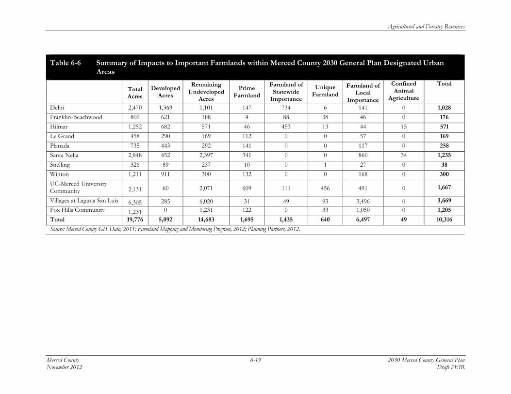
While one of the primary objectives of the 2030 General Plan is to direct growth to designated urban areas, many of these urban designated areas contain important farmlands that would be converted to non-agricultural uses to provide the estimated 14,683 acres of new development that could occur within designated urban areas, according to the total acreage designated in the approved 2000 General Plan for urban areas. According to FMMP data, as of 2010 and based on urban and rural residential land use classifications, approximately 5,092 acres of urban development has occurred within these existing urban designated areas. This leaves 14,683 undeveloped acres remaining; these acres are expected to be converted to urban uses upon buildout of each urban designated area. Of the remaining developable acres, approximately 10,316 acres consist of important farmlands. Table 6-6 sets forth the total acres of developable land, developed land, remaining undeveloped land, and important farmland types within each designated urban area. The table includes only the designated urban areas, where the majority of new growth would occur within the county.
The 2030 General Plan Land Use Diagram was designed to direct urban growth into the incorporated cities and unincorporated urban planning areas. Table 6-6 summarizes the total amount of important farmlands within each urban area that have the potential to be converted to urban uses under the proposed 2030 General Plan. As shown, even by directing future growth to designated communities within the unincorporated county, the proposed 2030 General Plan has the potential to convert up to 10,316 acres of important farmland within the remaining undeveloped land within each urban area boundary. Of this amount, approximately 1,695 acres, or 16 percent, would consist of prime farmland. The largest conversion of farmland, approximately 6,497 acres or 63 percent, would consist of farmland of local importance. Although farmland of local importance has the least value for agriculture of the important farmland types, the classification of important farmlands can shift from one category to another due to fallowing or changes in the availability of irrigation. As set forth in Table 6-2, both prime and statewide important farmlands must have both irrigation and recent cultivation. Lands that do not possess both of these values would be classified as locally important farmland, even though the underlying soils are the same as those classified as prime or statewide important.
This summary does not account for farmland conversion that may result over time from urban development within smaller designated urban areas, nor does it account for rural residential development that may occur outside unincorporated designated community areas. For example, total buildout has the potential to result in up to an additional 14,683 developed acres. Even though the majority of development would be directed to cities’ spheres of influence and designated urban communities, these areas may not be able to accommodate the projected growth. For example, if approximately 14,683 acres remain within community plan areas, and roughly 14,000 acres could be
2 Note, however, that the 2030 General Plan does not propose any changes in land use designations as compared to
the 2000 General Plan.

Agricultural and Forestry Resources
2030 Merced County General Plan 6-18 Merced County Draft PEIR November 2012
developed, this growth may be pushed outside designated community areas to other portions of the unincorporated county. Therefore, while the 2030 General Plan would limit new development in unincorporated rural areas outside of urban area boundaries, important farmlands scattered among parcels within existing unincorporated rural communities, including Rural Centers and Highway Interchange Centers that have not yet been built out, and on existing and future rural subdivided parcels, are also likely to be converted to urban or developed uses.
Because there are 610,866 total acres of important farmlands within the unincorporated area of the county, it is reasonable to assume that total buildout of all urban or developed land uses designated in the 2030 General Plan Land Use Diagram would have the potential to result in greater impacts than the conversion of important farmlands only within designated urban areas. Also, while open space, agriculture, and park land uses are designated for the remaining undeveloped lands in the urban area boundaries, and it is not likely that all important farmlands within these urban areas would be converted to urban uses, land outside these urban areas at rural locations could be converted to urban uses due to development. This additional conversion of important farmlands would be associated with development within other designated, but smaller, rural communities, such as Rural Centers, and as a result of some development of agricultural, industrial, scattered residential development, and other uses within agricultural lands.
Agricultural and Forestry Resources
Merced County 6-19 2030 Merced County General Plan November 2012 Draft PEIR
Table 6-6 Summary of Impacts to Important Farmlands within Merced County 2030 General Plan Designated Urban Areas
Total Acres
Developed Acres
Remaining Undeveloped
Acres
Prime Farmland
Farmland of Statewide
Importance
Unique Farmland
Farmland of Local
Importance
Confined Animal
Agriculture
Total
Delhi 2,470 1,369 1,101 147 734 6 141 0 1,028
Franklin-Beachwood 809 621 188 4 88 38 46 0 176
Hilmar 1,252 682 571 46 453 13 44 15 571
Le Grand 458 290 169 112 0 0 57 0 169
Planada 735 443 292 141 0 0 117 0 258
Santa Nella 2,848 452 2,397 341 0 0 860 34 1,235
Snelling 326 89 237 10 0 1 27 0 38
Winton 1,211 911 300 132 0 0 168 0 300
UC-Merced University Community 2,131 60 2,071 609 111 456 491 0 1,667
Villages at Laguna San Luis 6,305 285 6,020 31 49 93 3,496 0 3,669
Fox Hills Community 1,231 0 1,231 122 0 33 1,050 0 1,205
Total 19,776 5,092 14,683 1,695 1,435 640 6,497 49 10,316
Source: Merced County GIS Data, 2011; Farmland Mapping and Monitoring Program, 2012; Planning Partners, 2012.
Agricultural and Forestry Resources
2030 Merced County General Plan 6-20 Merced County Draft PEIR November 2012
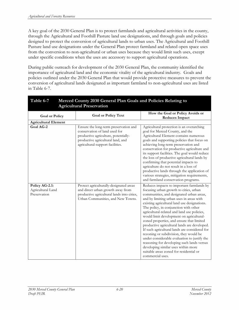
A key goal of the 2030 General Plan is to protect farmlands and agricultural activities in the county, through the Agricultural and Foothill Pasture land use designations, and through goals and policies designed to protect the conversion of agricultural lands to urban uses. The Agricultural and Foothill Pasture land use designations under the General Plan protect farmland and related open space uses from the conversion to non-agricultural or urban uses because they would limit such uses, except under specific conditions when the uses are accessory to support agricultural operations.
During public outreach for development of the 2030 General Plan, the community identified the importance of agricultural land and the economic vitality of the agricultural industry. Goals and policies outlined under the 2030 General Plan that would provide protective measures to prevent the conversion of agricultural lands designated as important farmland to non-agricultural uses are listed in Table 6-7.
Table 6-7 Merced County 2030 General Plan Goals and Policies Relating to Agricultural Preservation
Goal or Policy Goal or Policy Text How the Goal or Policy Avoids or Reduces Impact
Agricultural Element Goal AG-2
Ensure the long-term preservation and conservation of land used for productive agriculture, potentially-productive agricultural land, and agricultural-support facilities.
Agricultural protection is an overarching goal for Merced County, and the Agricultural Element contains numerous goals and supporting policies that focus on achieving long-term preservation and conservation for productive agriculture and its support facilities. The goal would reduce the loss of productive agricultural lands by confirming that potential impacts to agriculture do not result in a loss of productive lands through the application of various strategies, mitigation requirements, and farmland conservation programs.
Policy AG-2.1: Agricultural Land Preservation
Protect agriculturally-designated areas and direct urban growth away from productive agricultural lands into cities, Urban Communities, and New Towns.
Reduces impacts to important farmlands by focusing urban growth to cities, urban communities, and designated urban areas, and by limiting urban uses in areas with existing agricultural land use designations. The policy, in conjunction with other agricultural-related and land use policies, would limit development on agricultural-zoned properties, and ensure that limited productive agricultural lands are developed. If such agricultural lands are considered for rezoning or subdivision, they would be under considerable evaluation to justify the reasoning for developing such lands versus developing similar uses within more suitable areas zoned for residential or commercial uses.

Agricultural and Forestry Resources
Merced County 6-21 2030 Merced County General Plan November 2012 Draft PEIR
Table 6-7 Merced County 2030 General Plan Goals and Policies Relating to Agricultural Preservation
Goal or Policy Goal or Policy Text How the Goal or Policy Avoids or
Reduces Impact Policy AG-2.2: Agricultural Land Mitigation
Protect productive agricultural areas from conversion to non-agricultural uses by establishing and implementing an agricultural mitigation program in cooperation with the six cities in Merced County, with consistent standards for county and city governments, that matches acres converted with farmland acres preserved at a 1:1 ratio. In addition, the Land Evaluation and Site Assessment Model (LESA model) may be used to determine whether the conservation land is of equal or greater value than the land being converted.
Minimizes impacts to important farmlands by establishing a program designed to mitigate the loss of farmland resulting from urban development in the unincorporated areas of Merced County by requiring the permanent protection of farmland based on a 1:1 ratio to the amount of farmland converted. The policy is designed to specifically compensate for the loss of agricultural land. Further, by applying the LESA model, the relative value of conservation land can be determined to ensure that land mitigated is of equal or greater value than the loss agricultural land.
Policy AG-2.3: New Development
Formalize County-City agreements emphasizing concentration of new development in cities that include agricultural mitigation and avoidance of productive agricultural land conversion.
Reduces potential impacts to important farmlands through a formal agreement, similar to a memorandum of understanding, that states the roles and responsibilities among the County and the six cities within Merced County on working together to site new development at locations currently designated for urban uses. Stipulates that when agricultural mitigation may be necessary, that a formal program shall be applied that both local jurisdictions adopt to ensure the loss of agricultural land is minimized.
Policy AG-2.4: Preservation Programs
Encourage property owner participation in programs that preserve farmland, including the Williamson Act, conservation easements, and USDA-funded conservation practices.
Reduces the potential loss of important farmland by supporting programs that encourage private property owners to utilize farmland conservation programs, such as the Williamson Act program and conservation easements.
Policy AG-2.8: Conservation Easements
Support the efforts of public, private, and non-profit organizations to preserve agricultural areas in the County through dedicated conservation easements, and range land held as environmental mitigation.
Minimizes impacts to important farmland by supporting public, private, and non-profits efforts to preserve agricultural areas, thereby providing more opportunity for collaboration on related agricultural preservation goals.
Policy AG-2.9: Infrastructure Extension
Oppose the extension of urban services, such as sewer lines, water lines, or other urban infrastructure, into areas designated for agricultural use, unless necessary to protect public health, safety, and welfare.
Avoids impact to important farmlands by limiting urban services in locations designated for agricultural uses.
Policy AG-2.11: Preservation Collaboration
Collaborate with landowners, cities, State and Federal agencies, colleges, universities, stakeholders, and community-based organizations to continue and expand agricultural preservation in the County.
Minimizes the loss of important farmland by supporting collaboration with other private and governmental entities to expand agricultural preservation.

Agricultural and Forestry Resources
2030 Merced County General Plan 6-22 Merced County Draft PEIR November 2012
Table 6-7 Merced County 2030 General Plan Goals and Policies Relating to Agricultural Preservation
Goal or Policy Goal or Policy Text How the Goal or Policy Avoids or
Reduces Impact Policy AG-2.12: Antiquated Subdivisions
Encourage the voluntary merger of antiquated subdivision lots that conflict with adjacent agricultural uses, and continue to require environmental review of permits that could result in adverse environmental impacts in agricultural and rural areas, including traffic generation, groundwater contamination, stormwater drainage disposal, and air quality deterioration.
Reduces impacts related to residential subdivision activity by encouraging antiquated subdivision lots to merge that pose land use conflicts at nearby agricultural uses, thereby increasing the availability of larger agricultural parcels and reducing nuisances related to land use incompatibility.
Policy AG-2.13: Minimum Agricultural Parcel Size Requirement
Require 40 acre minimum permitted parcel size in areas designated Agricultural to discourage land divisions for rural residential purposes and maintain parcels large enough for efficient commercial agriculture production. Require 160 acre minimum permitted parcel size in areas designated Foothill Pasture and in grassland areas.
Reduces impacts to important farmlands by requiring a minimum permitted parcel size in the agricultural land use designation to ensure the availability of large agricultural parcels and efficient farming and to discourage land divisions.
Policy AG-2.14: Viability of Smaller Parcels
Require applicants seeking to divide agriculturally-zoned parcels to demonstrate the continued viability of lots less than 40 acres for commercial agriculture, using specific standards (i.e., access to agricultural water, joint farm management, access for aerial spraying, size viability for specific commodities) and farm management plans.
Minimizes important farmland impacts by requiring subdivision applicant to show how smaller parcels would be agricultural viable, because while, traditionally, agricultural land was subdivided to preserve family farming, often “ranchettes” or smaller parcels are too small for efficient farming lots and are not viable for commercial agriculture.
Policy AG-2.15: Merced County Agriculture Preserve Consolidation
Modify the Merced County Agricultural Preserve to be consistent with State Subdivision Map Act and Williamson Act rules for allowing parcels less than 10 acres for a limited number of circumstances authorized as exceptions in the County Zoning Code and consistent with State law.
Avoids impacts to important farmlands by revising the agricultural preserve land uses to be consistent with state and County regulations, to ensure that agricultural parcels in the preserve be at least 10 acres unless they meet a limited set of exceptions previously contained in the Zoning Code.
Policy AG-2.16: High Speed Rail Line Location
Coordinate with the California High Speed Rail Authority to locate the high speed rail lines along existing major transportation corridors, such as State Routes 99 or 152, to minimize the conversion of productive agricultural land to non-agricultural uses.
Reduces the likelihood the High Speed Rail Line would be located on productive farmlands, thereby minimizing the conversion of important farmlands.
Land Use Element Goal LU-1 Create a countywide land use pattern
that enhances the integrity of both urban and rural areas by focusing urban growth towards existing or suitably located new communities.
Reduces important farmland impacts by supporting a balanced land use pattern for agricultural and non-agricultural land uses and by directing urban growth towards existing and suitably located new communities.

Agricultural and Forestry Resources
Merced County 6-23 2030 Merced County General Plan November 2012 Draft PEIR
Table 6-7 Merced County 2030 General Plan Goals and Policies Relating to Agricultural Preservation
Goal or Policy Goal or Policy Text How the Goal or Policy Avoids or
Reduces Impact Policy LU-1.1: Countywide Development
Direct urban development to areas within adopted urban boundaries of cities, Urban Communities, and Highway Interchange Centers in order to preserve productive agriculture, limit urban sprawl, and protect natural resources.
Reduces impacts to important farmland by directing urban growth to cities, urban communities, and highway interchange centers in order to preserve agricultural land.
Policy LU-1.2: Rural Centers
Limit the amount of new growth within existing Rural Centers by allowing only agriculture-supporting residential and commercial uses.
Because rural centers include land use designations for isolated parts of the County, with little population and support services, they often provide ideal locations for agricultural services and farm support operations. Limiting urban growth at such locations would help maintain agricultural lands used primarily for farming and provide an alternative location for related agricultural services, operations, and workforce housing.
Policy LU-1.4: Urban Communities
Continue to support compact Urban Communities through the efficient use of land to reduce conflicts with agricultural and open space areas, and minimize public service costs.
Support for compact urban communities would encourage urban growth to occur where public facilities and services are available rather than on productive agricultural lands, thereby preserving important farmland.
Policy LU-1.5: New Urban Communities
Consider the establishment of new Urban Communities in areas off of productive agricultural land (as defined in the General Plan Glossary) which satisfy the policy requirements under Goal LU-5.F, in order to accommodate projected future growth.
Reduces impacts to important farmlands when considering locations for new urban communities by requiring new development occur off productive agricultural land.
Goal LU-2
Preserve, promote, and expand the agricultural industry in Merced County.
Reduces impacts to important farmland by supporting the expansion of the agricultural industry.
Policy LU-2.1: Agricultural Designation
Apply the Agricultural land use designation as the primary designation in the County to support productive agricultural lands and promote the agricultural industry.
Applying agriculture as the primary land use designation would ensure that the majority of unincorporated lands remain in agricultural production, thereby minimizing impacts to important farmland.
Policy LU-2.2: Foothill Pasture Designation
Apply the Foothill Pasture land use designation on agricultural and open space lands located on the eastern and western edges of the County which are recognized for their value as grazing, cropland, and open space.
Applying foothill pasture land use designation would ensure that the important grazing lands, also recognized as valuable cropland, would remain in agricultural production, thereby minimizing impacts to important farmland.
Policy LU-2.3: Land Use Activity Limitations
Limit allowed land uses within Agricultural and Foothill Pasture areas to agricultural crop production, farm support operations, and grazing and open space uses.
Avoids impacts to important farmland by limiting the development of land uses, other than for agricultural crop production, farming, and grazing uses.

Agricultural and Forestry Resources
2030 Merced County General Plan 6-24 Merced County Draft PEIR November 2012
Table 6-7 Merced County 2030 General Plan Goals and Policies Relating to Agricultural Preservation
Goal or Policy Goal or Policy Text How the Goal or Policy Avoids or
Reduces Impact Policy LU-2.4: Secondary Uses in Agricultural Areas
Limit ancillary uses in Agricultural and Foothill Pasture areas to include secondary single-family residences, farm worker housing, agricultural tourism related uses, and agricultural support services.
Minimizes impacts related to the substantial conversion of important farmlands to urban uses by limiting ancillary uses in agricultural areas to single-family residences, farm worker housing, and agricultural-related tourism.
Policy LU-2.6: Redesignation for More Intensive Residential Land Use
Prohibit the redesignation of property outside of Rural Centers, Highway Interchange Centers, or Urban Communities for a more intensive residential land use without a General Plan amendment.
Requiring a General Plan amendment for any re-designation of property for more intensive residential uses would discourage developers from considering agricultural lands for development due to the additional discretionary review that would occur prior to project consideration.
Policy LU-2.9: Special Agricultural Uses
Support special agricultural commercial uses in rural areas when they directly relate to and are part of an existing and permitted agricultural enterprise or operation.
Minimizes the conversion of agricultural lands to non-agricultural uses by only permitting agricultural operations in rural areas.
Goal LU-4 Provide for the continuation of areas designated for rural and agricultural support uses in a manner that minimizes agricultural and environmental impacts while benefiting the surrounding agricultural community.
Reduces the likelihood agricultural uses would be converted to non-agricultural uses by establishing that such uses should be established in a way to minimize loss of agricultural lands.
Policy LU-4.1: Rural Center Development
Allow new rural residential development and agricultural support uses in vacant areas within existing Rural Centers, but prohibit the establishment of new Rural Centers.
Minimizes the conversion of important farmlands to urban uses in Rural Centers by prohibiting the establishment of any new Rural Centers (residential areas that lack water and sewer infrastructure) or new rural residential development that does not support agricultural uses.
Policy LU-4.2: Development Criteria
Require uses within Rural Centers to be limited to: a) Commercial uses serve the daily
convenience needs of the surrounding agricultural and rural areas;
b) Agricultural supply and service businesses;
c) Limited public facilities such as schools, fire stations, post offices, churches, granges, and veterans halls; and/or
d) Housing for agricultural workers at minimum of one unit per acre.
Minimizes the conversion of important farmlands to urban uses in Rural Centers by limiting new uses to commercial uses that serve agricultural areas, agricultural services, farm worker housing.

Agricultural and Forestry Resources
Merced County 6-25 2030 Merced County General Plan November 2012 Draft PEIR
Table 6-7 Merced County 2030 General Plan Goals and Policies Relating to Agricultural Preservation
Goal or Policy Goal or Policy Text How the Goal or Policy Avoids or
Reduces Impact Policy LU-4.3: Commercial and Industrial Uses
Consider locating commercial and industrial uses in Rural Centers in limited cases if they support agricultural operations, serve the daily convenience commercial needs of the surrounding rural area, or provide health and safety benefits to the County in sparsely populated areas.
Reduces the likelihood that agricultural lands would be converted to urban uses by limiting commercial and industrial uses in Rural Centers to those that support agricultural operations.
Goal LU-5.A
Preserve and enhance the character of Merced County by focusing future unincorporated development towards Urban Communities.
Avoids the conversion of agricultural uses by focusing new urban growth towards Urban Communities.
Policy LU-5.A.1: Urban Community Establishment
Allow consideration of new Urban Communities in areas off productive agricultural land (as defined in the General Plan Glossary) that include a balance of land uses for jobs, tax revenues, and housing, and satisfy the policy requirements under Goal LU-5.F.
Minimizes impacts to agricultural lands and the conversion of such lands to non-agricultural uses by only considering new Urban Communities off productive agricultural land.
Goal LU-5.F
Provide for the establishment of new Urban Communities in order to accommodate future growth in the unincorporated parts of Merced County that are located off productive agricultural land or the valley floor.
Minimizes impacts to agricultural lands and the conversion of such lands to non-agricultural uses by only considering new Urban Communities off productive agricultural land or the valley floor.
Policy LU-5.F.1: New Urban Community Size and Location Requirements
Only accept applications for the establishment of additional new Urban Communities if they encompass a minimum area of 320 acres in order to achieve efficiencies in urban service delivery and provide for long-range growth needs. In addition, require that proposed new Urban Communities be located only in areas that: a) Are off the valley floor unless the
project area is clearly located on non-productive soil;
b) Contain few wetlands or significant natural resources;
c) For proposals off the valley floor, do not contain more than 50 percent productive farmland (as defined in the General Plan Glossary) or 10 percent Prime Farmland (as classified on the Statewide Important Farmland Map), and for projects on the valley floor, do not contain more than 10 percent productive farmland;
Minimizes impacts to agricultural lands and the conversion of such lands to non-agricultural uses by only accepting applications for new Urban Communities that meet specific development suitability criteria. Criteria includes, but is not limited to being located off the valley floor, unless the project area is not on productive agricultural soils; does not contain more than 50 percent productive farmland and 10 percent prime farmland if site is located off the valley floor; and for project applications on the valley floor that the site does not contain more than 10 percent productive farmland.

Agricultural and Forestry Resources
2030 Merced County General Plan 6-26 Merced County Draft PEIR November 2012
Table 6-7 Merced County 2030 General Plan Goals and Policies Relating to Agricultural Preservation
Goal or Policy Goal or Policy Text How the Goal or Policy Avoids or
Reduces Impact d) Are not located within two miles of
an existing city or Urban Community; and
e) Are near major transportation routes. Goal LU-7
Ensure that development in county/city fringe areas is well planned and adequately serviced by necessary public facilities and infrastructure.
Reduces impacts related to conversion of agricultural lands by directing development to areas that are adequately serviced by public facilities and infrastructure rather than rural areas, where the majority of the agricultural uses are located.
Policy LU-7.1: Infill Development Focus
Encourage infill development to occur in cities in order to maximize the use of land within existing urbanized areas, minimize the conversion of productive agricultural land, and minimize environmental impacts associated with new development.
Infill development within cities and designated urban communities would maximize the use of land at urbanized locations and minimize the potential for the conversion of agricultural lands.
Natural Resources Element Goal NR-3
Facilitate orderly development and extraction of mineral resources while preserving open space, natural resources, and soil resources and avoiding or mitigating significant adverse impacts.
Limits impacts on agricultural resources by promoting orderly development and limiting the extraction of mineral resources that would impact open space, natural resources, or soil resources.
Policy NR-3.10: Disturbance to Productive Agricultural Farmland
Encourage property reclamation to productive agricultural farmland, rather than habitat or an alternative non-agricultural land use, when a surface mining application involves disturbance of productive agricultural farmland.
Reduces impacts to important agricultural lands by encouraging property reclamation to agricultural farmland after surface mining activities that involve disturbance to productive agricultural farmland.
Policy NR-3.11: Disturbance to Productive Agricultural Farmland
Require reclamation of mining sites concurrent with extraction activities rather than after extraction has been completed.
Preserves agricultural farmland by requiring the reclamation of mining sites concurrent with extraction activities rather than after extraction has been completed, thereby restoring farmland loss sooner.
Policy NR-3.13: Agricultural Land Disturbance
Require mining projects to obtain agricultural conservation easements at a minimum of 1:1 for each acre of productive agricultural land converted as a result of mining and not returned to agricultural production.
Minimizes impacts to agricultural lands by requiring mining projects to obtain agricultural conservation easements at a minimum of 1:1 for each acre of productive agricultural land converted as a result of mining activities, mitigating the loss of farmland.
Source: Merced County, 2011; Planning Partners, 2012.

Agricultural and Forestry Resources
Merced County 6-27 2030 Merced County General Plan November 2012 Draft PEIR
While the 2030 General Plan would allow for the conversion of farmlands for both urban and rural communities, and rural areas, the primary purpose of the General Plan Agricultural and Land Use Elements is to balance urban development with the protection, preservation, and expansion of productive agriculture in Merced County. For instance, Goal AG-2 and its supporting policies in the Agricultural Element ensure the long-term preservation and conservation of land used for productive agriculture, potentially-productive agricultural land, and agricultural-support facilities.
Nevertheless, while there are several General Plan goals and policies designated to protect agricultural lands and mitigate for loss, buildout of the 2030 General Plan would lead to the conversion of some important farmlands to non-agricultural uses, regardless of the General Plan’s goals and policies. However, the 2030 General Plan Land Use Element sets a policy context for the County to achieve a balance of agricultural and non-agricultural (i.e., urban) uses within the six different urban area boundaries of City Planning Areas, Rural Residential Centers, Rural Centers, Urban Communities, Highway Interchange Centers, and Isolated Urban designations. Goal LU-1 and its supporting policies aim to create a countywide land use pattern that enhances the integrity of both urban and rural areas by focusing urban growth towards existing or suitably located new communities. These policies would ensure that limited future urban development occurs outside areas designated for growth, and away from productive agricultural areas.
As stated in the 2030 General Plan Land Use Element, the vast majority of land in Merced County lies outside existing cities, where the Agricultural and Foothill Pasture land use designations are applied to protect productive agricultural land. In order to protect agricultural lands, Goal LU-2 and its policies would preserve, promote, and expand the agricultural industry in Merced County, apply the Agricultural and Foothill Pasture land use designations as the primary designations in the county, limit allowable land uses in these designations to crop production, farm operations, and grazing and open spaces uses, and only allow commercial and industrial uses in rural areas under limited conditions. These policies would promote the Agricultural and Foothill Pasture land use designations, and limit any urban uses that do not support agriculture. There are also several policies that support Goal LU-4 that encourage the continuation of rural and agricultural support uses in a manner that minimizes agricultural and environmental impacts while benefiting the surrounding agricultural community.
Goal LU-5.A would preserve and enhance the character of Merced County by focusing future unincorporated development towards Urban Communities. To accomplish Goal LU-5.A, its several supporting policies only allow the consideration of new Urban Communities in areas not located on productive agricultural land or the valley floor. If proposed development is to be located on productive farmland or the valley floor, new Urban Communities must meet specific development suitability criteria in order to be considered. This would further minimize the applications for residential development proposed on important farmland. Finally, Goal LU-7 would reduce impacts related to the conversion of agricultural lands by directing development to areas that are adequately serviced by public facilities and infrastructure, rather than to rural areas where the majority of the agricultural uses are located.
Merced County is rich in nonfuel minerals and soil resources. Many of these mineral and soil resources are known to occur near important agricultural lands. The Natural Resources Element contains policies that minimize agricultural loss by addressing the extraction of known mineral resources, preventing the encroachment of incompatible uses, and minimizing the loss of agricultural values. Goal NR-3 would limit impacts on agricultural resources by promoting orderly
Agricultural and Forestry Resources
2030 Merced County General Plan 6-28 Merced County Draft PEIR November 2012
development and restricting the extraction of mineral resources that would impact open space, natural resources, or soil resources.
Still, the designation of important farmlands for non-agricultural uses in the General Plan could lead to the conversion of farmland to non-agricultural uses, regardless of the 2030 General Plan’s goals and policies. Agricultural parcels located near existing urban uses, specifically suburban areas, may have limited long-term viability for active agricultural activities due to urban edge conflicts. Nuisance complaints from surrounding neighbors, including but not limited to vandalism, traffic, and limitations on spraying pesticides and herbicides near sensitive receptors, can reduce the viability of productive agricultural operations that are too close to existing urban development. In addition, because many agricultural parcels have grown smaller through subdivision, small agricultural parcels may no longer be viable to pursue future agricultural operations. As a result, keeping agricultural land use designations on these scattered parcels, particularly if they are situated near urban uses, would not ensure ongoing agricultural use.
Overall, the 2030 General Plan recognizes agriculture as the primary land use in the county. Further, the Plan recognizes the continued preservation of agricultural lands through numerous policies that are intended to protect agricultural values and productivity, and to mitigate for their loss. However, the purpose of the 2030 General Plan is also to develop a framework to guide future land use development. As a result, it is inevitable that some farmland conversion would occur to accommodate long-term development needs. Proposed policies would permit the loss of farmland to urban development both within designated urban areas, and as a result of the growth of developed uses at scattered locations outside designated communities. Also, while some proposed policies would fully protect the amount of farmland equal to that removed, no policy would prohibit urban development of farmlands, or result in an increase in the acreage of protected agricultural land. Although the Agricultural Land Mitigation Program (Program AG-B) would mitigate the loss of productive agricultural land, the actual viability of such a program remains unknown because the program has not yet been developed or adopted. Until the details of the mitigation land management program that would oversee and monitor the mitigated land is developed and approved, the proposed 2030 General Plan is assumed to continue to lead to the conversion of agricultural uses to non-agricultural uses, and over time result in a net loss of important farmland. Therefore, the implementation of land uses envisioned in the proposed 2030 General Plan would continue to result in a substantial loss of important agricultural uses, including the loss of important farmland to urban and developed rural uses. This would result in a potentially significant impact.
Significance of Impact: Potentially significant.
Mitigation Measure AG-1a:
Amend Policy AG-2.2: Agricultural Land Mitigation, as follows:
Protect productive agricultural areas from conversion to non-agricultural residential uses by establishing and implementing an agricultural mitigation program in cooperation with the six cities in Merced County, with consistent standards for county and city governments, that matches acres converted with farmland acres of similar quality to those converted preserved at a 1:1 ratio. Coordinate with the six cities in Merced County and the Merced Local Agency Formation Commission (LAFCo), consistent with LAFCo’s statutory mission to preserve agricultural land and open space, to establish consistent standards and mitigation for the loss of

Agricultural and Forestry Resources
Merced County 6-29 2030 Merced County General Plan November 2012 Draft PEIR
farmland. In addition, the Land Evaluation and Site Assessment Model (LESA model) may be used to determine whether the conservation land is of equal or greater value than the land being converted. The County shall may exempt commercial, industrial, and mixed-use projects within Urban Communities and Highway Interchange Centers from this mitigation requirement.
An earlier version of Policy AG-2.2 would have applied the 1:1 mitigation ratio requirement to all urban land uses within the unincorporated area of the county. This earlier policy would have had a similar effect of partially mitigating for the loss of important farmland, but would also not have constituted full mitigation.
Mitigation Measure AG-1b:
Add the following program:
Implementation Program AG-J: Agricultural Conservation Easement Program
In conjunction with the Agricultural Land Mitigation Program (Policies AG-2.2, AG-2.4, and AG-2.8, and Program AG-B), the County shall develop an Agricultural Conservation Easement Program in coordination with appropriate third-party trustees to protect and preserve important farmlands. When the specific parcels have been identified under the Agricultural Land Mitigation Program to match the acres converted, the County shall facilitate the granting or purchase of agricultural conservation easements through a program administered by the appropriate third-party trustees. The program shall require that project applicants dedicate easements or make payments of an in-lieu fee that is sufficient to purchase parcels located in Merced County to be placed under an agriculture conservation easement, farmland deed restriction, or other farmland conservation mechanism to compensate for the loss of productive farmland to developed uses. Consistent with Policy AG-2.2, the in-lieu fee or other conservation mechanism shall recognize the importance of land value, and shall require equivalent mitigation. Where the payment is through in-lieu fees to purchase mitigation land, such funds shall be collected by the County and transferred to the appropriate third-party trustee, which shall arrange for the purchase of conservation easements. Where the conservation easement is to be dedicated by the project applicant, the easement deed shall be turned over to an appropriate third-party trustee for on-going management. In addition to easement funding or dedication, additional fees shall be provided to ensure that on-going management and monitoring is performed, consistent with practices of the third-party trustee.
Mitigation Measure AG-1c:
Amend Policy NR-3.13: Agricultural Land Disturbance, as follows:
Require mining projects to obtain agricultural conservation easements on farmland of similar quality to the farmland converted at a minimum of 1:1 ratio for each acre of productive agricultural land converted as a result of mining and not returned to agricultural production.
Agricultural and Forestry Resources
2030 Merced County General Plan 6-30 Merced County Draft PEIR November 2012
Environmental Effects of Measures: Implementation of Mitigation Measures AG-1a through AG-1c would result in minimizing the impact from the conversion of existing agricultural lands. No changes in land uses are required by the measure, and no environmental effects would occur. Instead, the County policies would support agricultural uses, match acres converted due to urban development or mining activities with farmland acres of similar quality to those converted at a 1:1 ratio, and coordinate regional efforts to preserve farmland in collaboration with entities such as the Central Valley Farmland Trust.
Level of Significance After Mitigation: Significant and unavoidable.
While the revised policies would promote the preservation of agricultural lands, the agricultural land use designations and the policies would not prevent the overall net loss of important farmlands within the county associated with future urban and rural development within agricultural areas. There are no additional or technically feasible mitigation measures available to reduce the net loss of farmland. Consequently, implementation of the 2030 General Plan would convert important farmlands to urban and developed rural uses, and result in a significant and unavoidable impact.
Impact AG-2: Conf l i c t with exist ing zoning for agr i cul tural use , or the provis ions o f
Wil l iamson Act contracts .
Implementation of the proposed 2030 General Plan could lead to urban development and other activities that could conflict with existing zoning for agricultural uses, or could affect lands subject to Williamson Act contracts. Although future urban growth would be directed away from agricultural lands and toward cities, cities’ spheres of influence, and designated urban communities, Williamson Act contracts could be cancelled to speed urban development. While the 2030 General Plan contains various goals and policies that support consistency with the Williamson Act program, it also contains policies for the administration of the Williamson Act that could act to decrease the amount of agricultural land protected from conversion to other uses. For this reason, this would be a potentially significant impact.
Agricultural zoning categories in Merced County, including the principal agricultural zones A-1 (General Agricultural) and A-2 (Exclusive Agriculture), accommodate a variety of agricultural uses in order to conserve farmland. The two zoning districts are consistent with the Agricultural and Foothill Pasture land use designations as shown in the proposed 2030 General Plan Land Use Diagram. The Agricultural land use designation covers the majority of the county’s valley floor, and is made up primarily of areas of good soil quality, adequate water supply, and minimal slopes. The Foothill Pasture land use designation is applied to foothills areas in the Sierra Nevada and Diablo Ranges on the east and west side of the County that require larger areas of land for successful agricultural operations due to poor soil quality, limited water availability, and steeper slopes.
Various state and local programs are also in place to conserve farmland, including the Williamson Act program and the Farmland Security Act (FSA). The Williamson Act conserves agricultural land and open space lands through property tax incentives and voluntary restrictive use contracts administered by the County according to state regulations. The program allows landowners to restrict their land to agricultural and open space uses under minimum nine-year rolling term contracts, and receive property tax assessments according to their actual uses versus the potential market value. The program also functions to discourage premature development on agricultural

Agricultural and Forestry Resources
Merced County 6-31 2030 Merced County General Plan November 2012 Draft PEIR
lands under contract. The Williamson Act requires that all contract lands be located within an Agricultural Preserve of no less than 100 acres. The purpose of the Agricultural Preserve is to protect Williamson Act contracts from nearby incompatible uses. Almost all rural land in the county is included in an Agricultural Preserve.
Williamson Act contracts were initially for 10-year periods, but with passage of AB 1265 in 2011, the term was reduced to nine years if the state reduced their tax subvention payments below 50 percent of the lost tax revenue for the County. Because of the loss of state tax subvention payments, Merced County has suspended accepting applications to enter into new Williamson Act contracts, but has not placed current contracts into non-renewal. Since enactment of AB 1265 through Resolution No. 2011-146, the County Board of Supervisors makes findings regarding the amount of state subvention payments each year during adoption of the County’s fiscal year Final Budget, and considers whether or not to continue the suspension on accepting new contract applications.
Similar to the Williamson Act, the FSA provides landowners with 20-year renewable contracts in return for larger property tax reductions than the standard program. Merced County participates in the standard Williamson Act program, but does not participate in the FSA program.
Since the local adoption of the Williamson Act in 2000, the program has become a major complement to the Zoning Code in support of Merced County’s farmland protection efforts. As of 2009, Merced County had 467,679 acres enrolled in the Williamson Act, or 40 percent of all agricultural land (see Figure 6-1). The program involves approximately 1,100 landowners and 3,649 parcels. Approximately 6,100 acres are in non-renewal. Nonrenewals are often filed by landowners who anticipate converting their farmland to other uses.
The Williamson Act program is implemented by Merced County according to state standards. While under state law lands under contract (enrolled parcels) should be a minimum of 10 acres of prime land or 40 acres of non-prime land, the County requires enrolled parcels to be “large enough to sustain their agricultural use,” which is defined by the County as a minimum of 20 acres for prime agricultural land and 80 acres for non-prime agricultural land (although the County’s rules allow certain exceptions for parcels as small as 10 acres in size to be placed under contract where specific findings can be made).
Land uses designated under the proposed 2030 General Plan could conflict with the provisions of the Williamson Act if the General Plan would result in urban development that would occur on lands subject to Williamson Act contracts. The Plan could also result in indirect conflicts due to the removal of parcels not under Williamson Act contracts from the Agricultural Preserve.
In general, removal of non-contracted lands from the Agricultural Preserve would result in the concentration of enrolled land into the remaining 467,679-acre preserve, reflecting lands still under contract. However, removal of non-contracted lands from the Agricultural Preserve could inadvertently cause the parcels no longer eligible for contracts to be converted to incompatible land uses. As a result, the agricultural resources that remain within the preserve would be impacted by an indirect conversion of nearby agricultural uses to non-agricultural uses that are no longer fully protected from nearby urban development pressure. This is possible because the list of land uses compatible with the Agricultural Preserve is more limited than the list of uses allowed on agriculturally zoned parcels in the County Zoning Code. Therefore, while Williamson Act contracted land would be consolidated within the Agricultural Preserve, the removal of non-contracted parcels
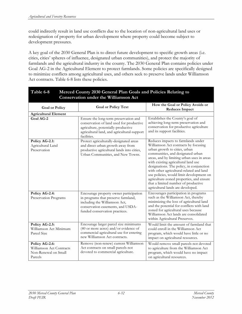
Agricultural and Forestry Resources
2030 Merced County General Plan 6-32 Merced County Draft PEIR November 2012
could indirectly result in land use conflicts due to the location of non-agricultural land uses or redesignation of property for urban development where property could become subject to development pressures. A key goal of the 2030 General Plan is to direct future development to specific growth areas (i.e. cities, cities’ spheres of influence, designated urban communities), and protect the majority of farmlands and the agricultural industry in the county. The 2030 General Plan contains policies under Goal AG-2 in the Agricultural Element to protect farmlands. Some policies are specifically designed to minimize conflicts among agricultural uses, and others seek to preserve lands under Williamson Act contracts. Table 6-8 lists these policies.
Table 6-8 Merced County 2030 General Plan Goals and Policies Relating to Conservation under the Williamson Act
Goal or Policy Goal or Policy Text How the Goal or Policy Avoids or Reduces Impact
Agricultural Element Goal AG-2 Ensure the long-term preservation and
conservation of land used for productive agriculture, potentially-productive agricultural land, and agricultural-support facilities.
Establishes the County’s goal of achieving long-term preservation and conservation for productive agriculture and its support facilities.
Policy AG-2.1: Agricultural Land Preservation
Protect agriculturally-designated areas and direct urban growth away from productive agricultural lands into cities, Urban Communities, and New Towns.
Reduces impacts to farmlands under Williamson Act contracts by focusing urban growth to cities, urban communities, and designated urban areas, and by limiting urban uses in areas with existing agricultural land use designations. The policy, in conjunction with other agricultural-related and land use policies, would limit development on agriculture-zoned properties, and ensure that a limited number of productive agricultural lands are developed.
Policy AG-2.4: Preservation Programs
Encourage property owner participation in programs that preserve farmland, including the Williamson Act, conservation easements, and USDA-funded conservation practices.
Encourages participation in programs such as the Williamson Act, thereby minimizing the loss of agricultural land and the potential for conflicts with land zoned for agricultural uses because Williamson Act lands are consolidated within Agricultural Preserves.
Policy AG-2.5: Williamson Act Minimum Parcel Size
Encourage larger parcel size minimums (40 or more acres) and/or evidence of commercial agricultural use for entering new Williamson Act contracts.
Would limit the amount of farmland that could enroll in the Williamson Act program, which would have little or no impact on agricultural resources.
Policy AG-2.6: Williamson Act Contracts Non-Renewal on Small Parcels
Remove (non-renew) current Williamson Act contracts on small parcels not devoted to commercial agriculture.
Would remove small parcels not devoted to agriculture from the Williamson Act program, which would have no impact on agricultural resources.

Agricultural and Forestry Resources
Merced County 6-33 2030 Merced County General Plan November 2012 Draft PEIR
Table 6-8 Merced County 2030 General Plan Goals and Policies Relating to Conservation under the Williamson Act
Goal or Policy Goal or Policy Text How the Goal or Policy Avoids or Reduces Impact
Policy AG-2.7: Merced County Agricultural Preserve Consolidation
Remove land not under Williamson Act contracts from the Merced County Agriculture Preserve by redrawing the current boundary of the Agricultural Preserve to create one or a series of smaller preserves aligned with contracted land.
Would limit the amount of farmland that could enroll in the Williamson Act program.
Alternative Policy AG-2.7: Modify Agricultural Preserve Rules
Modify the Agricultural Preserve Rules and Procedures to allow parcels smaller than 10 acres for a limited number of circumstances authorized as exceptions in the County Zoning Code and consistent with State law.
Encourages participation in the Williamson Act by an expanding the list of eligible farms, thereby minimizing the loss of agricultural land. Could capture an additional 13 percent of farms that otherwise might not be eligible for the program.
Policy AG-2.15: Merced County Agriculture Preserve Consolidation
Modify the Merced County Agricultural Preserve to be consistent with State Subdivision Map Act and Williamson Act rules for allowing parcels less than 10 acres for a limited number of circumstances authorized as exceptions in the County Zoning Code and consistent with State law.
Encourages participation in the Williamson Act by an expanding the list of eligible farms, thereby minimizing the loss of agricultural land.
Source: Merced County, 2011; Planning Partners, 2012.
Policy AG-2.1 listed above would minimize conflicts with agriculturally-zoned uses and parcels under the Williamson Act by ensuring the long-term preservation of land used for productive agriculture, potentially-productive agricultural land, and agricultural-support facilities. Policy AG-2.4 would encourage participation in programs such as the Williamson Act to preserve the county’s farmland. Keeping agricultural land under Williamson Act contracts would retain the concentration of agricultural land within the Agricultural Preserve boundary, thereby reducing the edge between agricultural and non-agricultural uses, and minimizing land use conflicts.
Lands under contract must be consistent with the County’s General Plan, and the County must ensure that lands under contract fall within designated Agricultural Preserves. The eligibility criteria for Merced County’s existing Williamson Act program requires enrolled parcels to be 20 acres in size for prime farmland and 80 acres for non-prime farmland. Current County eligibility criteria encourage the enrollment of only large parcels efficient for commercial farming, and several of the 2030 General Plan proposed policies would discourage farmers with small agricultural parcels to participate in the Williamson Act program, thereby reducing the total number of agricultural lands enrolled in the program.
The County’s proposed policies demonstrate an effort to ensure that lands contracted under the program remain large enough for economically productive agricultural practices as outlined under Policy AG-2.5, which encourages larger parcel size minimums (40 or more acres). This policy would discourage land owners from enrolling smaller parcels in the Williamson Act program, which could reduce the total acreage enrolled under the program. Similarly, Policy LU-2.6 would remove (non-renew) current Williamson Act contracts on small parcels not devoted to commercial agriculture. As

Agricultural and Forestry Resources
2030 Merced County General Plan 6-34 Merced County Draft PEIR November 2012
a result, Policy LU-2.6 would have a similar environmental effect as Policy LU-2.5 because smaller parcels under Williamson Act contracts that are not consistent with the County’s eligibility criteria would be removed from the program even if part of a larger farming operation, also decreasing the total acreage eligible for participation under the Williamson Act Program.
Policy LU-2.7 would remove land not under Williamson Act contracts from the Merced County Agriculture Preserve by redrawing the current boundary of the Agricultural Preserve to create one or a series of smaller preserves aligned with contracted land. However, removal of non-contracted lands from the Agricultural Preserve could inadvertently cause the parcels no longer eligible for contracts to be converted to incompatible land uses. As a result, the agricultural resources that remain within the preserve would be impacted by an indirect conversion of nearby agricultural uses to non-agricultural uses that are no longer fully protected from nearby urban development pressure. This is possible because the list of land uses compatible with the Agricultural Preserve is more limited than the list of uses allowed on agriculturally zoned parcels in the County Zoning Code. Therefore, while Williamson Act contracted land would be consolidated within the Agricultural Preserve, the removal of non-contracted parcels could indirectly result in land use conflicts due to the location of non-agricultural land uses or redesignation of property for urban development where property could become subject to development pressures.
State law presumes that agricultural parcels are large enough to sustain their agricultural use if the land is at least 10 acres in size if within prime agricultural land, or at least 40 acres in size if on land that is not prime agricultural land. The proposed 2030 General Plan sets forth Policy AG-2.15, which modifies the County’s Agricultural Preserve Rules and Procedures to allow smaller parcel sizes consistent with state standards.
Table 6-9 sets forth the sizes of farms within Merced County as reported in the 2007 Census of Agriculture by the U.S. Department of Agriculture.
Table 6-9 Farm Sizes in Merced County
Size of Farm Number of Farms Percentage of Farms1 1 to 9 acres 337 12.9
10 to 49 acres 1,114 42.7
50 to 179 acres 558 21.4
180 to 499 acres 270 10.4
500 to 999 acres 139 5.3
1,000 acres or more 189 7.2
Average size of farm – acres 399
Median size of farm – acres 40 1 Does not equal 100 percent due to rounding. Source: US Department of Agriculture, National Agricultural Statistics Service, 2007 Census of Agriculture – County Data,
California, Table 1. County Summary Highlights.
In 2007, the latest year for which statistics are available, 55.6 percent of all farms in Merced County were less than 50 acres in size; 12.9 percent were less than 10 acres. If the acreage of farms within the 10 to 49 acre size class were evenly distributed, 616 farms (23.6 percent) would be less than 20 acres in size. Under current County policy, almost one-quarter of all farms would not currently meet

Agricultural and Forestry Resources
Merced County 6-35 2030 Merced County General Plan November 2012 Draft PEIR
the criteria for inclusion in the Williamson Act program, and could not therefore be afforded the protection from development as outlined in Goal AG-2.
Some indirect conversion of agricultural uses may occur by limiting smaller parcels from participating in the Williamson Act program, and from the removal of existing small parcels. Implementation of other proposed goals and policies cited above would encourage participation in the Williamson Act program, and avoid conflicts with existing agricultural uses and lands. Additionally, the majority of future urban development would be directed to designated growth areas within cities, cities’ spheres of influence, and designated urban communities; limited growth would be expected to occur on agricultural lands outside designated communities, or on lands subject to Williamson Act contracts. On balance, implementation of proposed policies AG-2.5, AG-2.6, and AG-2.7 would result in less likelihood that farmlands would be protected from urban encroachment or conversion to other non-agricultural uses, and lead to a potential increase in land use conflicts between such uses and agricultural activities. This would be a potentially significant impact.
Significance of Impact: Potentially significant.
Mitigation Measure AG-2a:
Amend Policy AG-2.5: Williamson Act Minimum Parcel Size, as follows:
Modify the Agricultural Preserve Rules and Procedures to reduce the Williamson Act minimum required parcel size to 10 acres, consistent with State law. For parcels not operated as part of a larger farming operation, eEncourage larger parcel size minimums (40 or more acres) and/or evidence of commercial agricultural use for entering new Williamson Act contracts.
Mitigation Measure AG-2b:
Amend Policy AG-2.6: Williamson Act Contracts Non-Renewal on Small Parcels, as follows:
rRemove (non-renew) current Williamson Act contracts on small parcels not devoted to commercial agriculture and not operated as part of a larger farming operation.
Mitigation Measure AG-2c:
Delete Policy AG-2.7: Merced County Agricultural Preserve Consolidation, and adopt the following alternative policy as set forth in Table 6-9:
Policy AG-2.7: Modify Merced County Agricultural Preserve Rules
Modify the Agricultural Preserve Rules and Procedures to allow parcels smaller than 10 acres for a limited number of circumstances authorized as exceptions in the County Zoning Code and consistent with State law.
Environmental Effects of Measure: Implementation of Mitigation Measures AG-2a, AG-2b, and AG-2c would increase the amount of farmland that could be preserved within Merced County. No land use changes or changes in agricultural activities would result from implementation of the

Agricultural and Forestry Resources
2030 Merced County General Plan 6-36 Merced County Draft PEIR November 2012
measures. For these reasons, there would be no environmental effects from implementing the measures.
Level of Significance After Mitigation: Less than significant.
Impact AG-3: Involve other land use changes that would resul t in convers ion o f farmland to
non-agr i cul tural uses f rom urban deve lopment .
Implementation of the proposed 2030 General Plan would lead to urban development that would result in direct impacts to agricultural resources, including the conversion of important farmland to non-agricultural uses as evaluated in Impact AG-1. Indirect impacts caused by the 2030 General Plan may include the removal of smaller parcels from agricultural production in urban fringe areas, and the construction of residences on existing and/or future subdivided parcels. Because small parcel sizes are not as economically viable and efficient for commercial farming, they are susceptible to nearby urban development pressure. Indirect impacts may also result from the nuisance effects of routine agricultural operations to residential neighbors due to noise, dust, odors, traffic, and the application of herbicides and pesticides. Therefore, because the proposed project would involve direct and indirect land use changes that could convert farmland to non-agricultural uses, this would be a potentially significant impact.
As described in Impact AG-1, the 2030 General Plan would result in direct conversion of important farmlands to urban uses, primarily within designated urban areas established under the proposed 2030 General Plan. Implementation of the 2030 General Plan could also result in the conversion of agricultural lands from scattered residential development outside designated communities, often due to minor subdivision activity and the creation of “rural ranchettes3.” Additionally, as described in Impact AG-2, administrative changes proposed in the County’s Williamson Act program could result in diminishing the number of acres of farmland that would be eligible to be enrolled in the Williamson Act program, thereby reducing the amount of protected farmland.
According to the 2000 Merced County General Plan, there has been a history of incompatible land uses and conflicts due to nuisances along the residential-agricultural “edge,” because the county’s agricultural operations can occur adjacent to or near residential development. Indirect changes caused by urban development may include a variety of nuisance effects due to the expansion of the urban fringe, resulting in “urban-edge” conflicts. For example, communities where urban uses occur near intensely cultivated farmland may experience the negative effects of the juxtaposition of incompatible land uses that often affect both types of property owners. Agricultural operators may experience vandalism, pilferage of crops, dog attacks on livestock, restrictions on pesticide use and other practices, congested local roads, and other impacts that reduce productivity and income. Residential neighbors, for their part, are often sensitive to dust, noise, odors, early morning or nighttime operations, traffic, pesticide and herbicide use, perceived health problems, and other effects on their quality of life. These conflicts may increase costs to the agricultural operations, and, combined with rising land values for residential development, encourage the conversion of farmland to urban or other non-agricultural uses.
3 The potential effects of minor subdivision activity on agricultural resources and practices are evaluated in Impacts
AG-5 and AG-6 in this chapter.

Agricultural and Forestry Resources
Merced County 6-37 2030 Merced County General Plan November 2012 Draft PEIR
These potential “urban-edge” effects may be greater near the various unincorporated urban communities in the county where growth would be directed, including Delhi, Hilmar, Planada, Santa Nella, and Winton. However, these effects may also occur to some degree near smaller unincorporated rural communities, or Rural Centers, that lack sewer and water infrastructure, such as Volta, El Nido, Cressey, and Ballico. While the uses near Rural Centers were designed to provide basic support services to the agricultural industry, new urban uses at these locations may still result in urban-edge land use conflicts.
During public outreach for the 2030 General Plan, the community identified the importance of the economic vitality of the agricultural industry. Because the intent of the 2030 General Plan is to also accommodate future growth, the proposed 2030 General Plan would balance agricultural preservation with the needs of a growing population by directing future development to specific growth areas (i.e. cities, cities’ spheres of influence, designated unincorporated urban communities) in order to protect the majority of farmlands and the agricultural industry in the county. The 2030 General Plan contains numerous policies in the Agricultural and Land Use Elements that are intended to minimize land use changes that would convert important farmlands to non-agricultural uses as shown in Table 6-10.
Table 6-10 Merced County 2030 General Plan Goals and Policies Relating to Minimizing Agricultural Conversion and Promoting Compatibility
Goal or Policy Goal or Policy Text How the Goal or Policy Avoids or Reduces Impact
Agricultural Element
Goal AG-2 Ensure the long-term preservation and conservation of land used for productive agriculture, potentially productive agricultural land, and agricultural-support facilities.
Agricultural protection is an overarching goal for Merced County, and the Agricultural Element contains numerous goals and supporting policies that focus on achieving long-term preservation and conservation for productive agriculture. Minimizes the conversion of important farmlands to non-agricultural uses by ensuring impacts to agriculture do not result in a loss of productive lands through the application of various strategies, mitigation requirements, and farmland conservation programs.
Policy AG-2.1: Agricultural Land Preservation
Protect agriculturally designated areas and direct urban growth away from productive agricultural lands into cities, Urban Communities, and New Towns.
Limits the conversion of important farmlands by focusing urban growth to cities, urban communities, and designated urban areas, and by limiting urban uses in areas with existing agricultural land use designations.

Agricultural and Forestry Resources
2030 Merced County General Plan 6-38 Merced County Draft PEIR November 2012
Table 6-10 Merced County 2030 General Plan Goals and Policies Relating to Minimizing Agricultural Conversion and Promoting Compatibility
Goal or Policy Goal or Policy Text How the Goal or Policy Avoids or Reduces Impact
Policy AG-2.2: Agricultural Land Mitigation
Protect productive agricultural areas from conversion to non-agricultural uses by establishing and implementing an agricultural mitigation program in cooperation with the six cities in Merced County, with consistent standards for county and city governments, that matches acres converted with farmland acres preserved at a 1:1 ratio. In addition, the Land Evaluation and Site Assessment Model (LESA model) may be used to determine whether the conservation land is of equal or greater value than the land being converted.
Minimizes conversion impacts to important farmlands by establishing a program designed to mitigate the loss of farmland resulting from urban development in the unincorporated areas of Merced County by requiring the permanent protection of farmland based on a 1:1 ratio to the amount of farmland converted.
Policy AG-2.3: New Development
Formalize County-City agreements emphasizing concentration of new development in cities that include agricultural mitigation and avoidance of productive agricultural land conversion.
Reduces potential conversion impacts to important farmlands through a formal agreement that states the roles and responsibilities among the County and the six cities within Merced County on working together to site new development at locations currently designated for urban uses.
Policy AG-2.4: Preservation Programs
Encourage property owner participation in programs that preserve farmland, including the Williamson Act, conservation easements, and USDA-funded conservation practices.
Reduces the potential loss of important farmland due to conversion to urban uses by supporting a program that encourages private property owners to utilize farmland conservation programs, such as the Williamson Act program and conservation easements.
Alternative Policy AG-2.7: Modify Agricultural Preserve Rules
Modify the Agricultural Preserve Rules and Procedures to allow parcels smaller than 10 acres for a limited number of circumstances authorized as exceptions in the County Zoning Code and consistent with State law.
Although the County is no longer accepting applications to participate in the Williamson Act due to loss of state funding, this policy would encourage participation in the Williamson Act by an expanding the list of eligible farms, thereby minimizing the loss of agricultural land should the County once again accept applications.
Policy AG-2.8: Conservation Easements
Support the efforts of public, private, and non-profit organizations to preserve agricultural areas in the county through dedicated conservation easements, and range land held as environmental mitigation.
Minimizes impacts to important farmland by supporting public, private, and non-profit efforts to preserve agricultural areas, thereby providing more opportunity for collaboration on related agricultural preservation goals.
Policy AG-2.9: Infrastructure Extension
Oppose the extension of urban services, such as sewer lines, water lines, or other urban infrastructure, into areas designated for agricultural use, unless necessary to protect public health, safety, and welfare.
Avoids impacts to important farmlands by limiting urban services in locations designated for agricultural uses.

Agricultural and Forestry Resources
Merced County 6-39 2030 Merced County General Plan November 2012 Draft PEIR
Table 6-10 Merced County 2030 General Plan Goals and Policies Relating to Minimizing Agricultural Conversion and Promoting Compatibility
Goal or Policy Goal or Policy Text How the Goal or Policy Avoids or Reduces Impact
Policy AG-2.11: Preservation Collaboration
Collaborate with landowners, cities, state and federal agencies, colleges, universities, stakeholders, and community-based organizations to continue and expand agricultural preservation in the county.
Minimizes the conversion of important farmland to urban uses by supporting collaboration with private and governmental entities to expand agricultural preservation.
Policy AG-2.12: Antiquated Subdivisions
Encourage the voluntary merger of antiquated subdivision lots that conflict with adjacent agricultural uses, and continue to require environmental review of permits that could result in adverse environmental impacts in agricultural and rural areas, including traffic generation, groundwater contamination, stormwater drainage disposal, and air quality deterioration.
Reduces impacts related to residential subdivision activity by requiring antiquated subdivision lots that pose land use conflicts at nearby agricultural uses to merge, thereby increasing the availability of larger agricultural parcels and reducing nuisances related to land use incompatibility.
Policy AG-2.13: Minimum Agricultural Parcel Size Requirement
Require a 40 acre minimum permitted parcel size in areas designated Agricultural to discourage land divisions for rural residential purposes and maintain parcels large enough for efficient commercial agriculture production. Require 160 acre minimum permitted parcel size in areas designated Foothill Pasture and in grassland areas.
Reduces conversion impacts to important farmlands by requiring a minimum permitted parcel size in the agricultural land use designation to ensure the availability of large agricultural parcels and efficient farming, and to discourage land divisions.
Policy AG-2.14: Viability of Smaller Parcels
Require applicants seeking to divide agriculturally-zoned parcels to demonstrate the continued viability of lots less than 40 acres for commercial agriculture, using specific standards (i.e., access to agricultural water, joint farm management, access for aerial spraying, size viability for specific commodities) and farm management plans.
Minimizes important farmland impacts by requiring subdivision applicants to show how smaller parcels would be agriculturally viable, because while traditionally agricultural land was subdivided to preserve family farming, often “ranchettes” or smaller parcels are too small for efficient farming.
Policy AG-2.15: Merced County Agriculture Preserve Consolidation
Modify the Merced County Agricultural Preserve to be consistent with State Subdivision Map Act and Williamson Act rules for allowing parcels less than 10 acres for a limited number of circumstances authorized as exceptions in the County Zoning Code and consistent with state law.
Reduces impacts to important farmlands by revising the agricultural preserve land uses to be consistent with state regulations to ensure that agricultural parcels less than 10 acres are allowed under a limited number of circumstances.
Policy AG-2.16: High Speed Rail Line Location
Coordinate with the California High Speed Rail Authority to locate the high speed rail lines along existing major transportation corridors, such as State Routes 99 or 152, to minimize the conversion of productive agricultural land to non-agricultural uses.
Reduces the likelihood the High Speed Rail Line would be located on productive farmlands, thereby minimizing the conversion of important farmlands.

Agricultural and Forestry Resources
2030 Merced County General Plan 6-40 Merced County Draft PEIR November 2012
Table 6-10 Merced County 2030 General Plan Goals and Policies Relating to Minimizing Agricultural Conversion and Promoting Compatibility
Goal or Policy Goal or Policy Text How the Goal or Policy Avoids or Reduces Impact
Goal AG-3 Minimize conflicts between productive agricultural areas and urban land uses, and discourage the parcelization and conversion of large agricultural holdings into rural residential parcels or urban uses.
Reduces the conversion of important farmland to developed uses by stating that an overall goal of the County is to minimize conflicts between agricultural and urban areas, which often result in land use incompatibility that leads to land use conflicts.
Policy AG-3.1: Right-to-Farm Ordinance
Continue to implement the Right-to-Farm Ordinance to define and limit instances where agricultural operations may be considered a nuisance to surrounding residential or urban development.
Reduces nuisance complaints from new urban residents by requiring prospective residents in new developments near agricultural areas to be notified that there may be inconveniences and discomfort associated with normal farming activities, and that such operations are not considered nuisances.
Policy AG-3.2: Agricultural Buffer
Require buffers between proposed non-agricultural uses and adjacent productive agricultural operations to protect farms, dairies, and agricultural-related production facilities from conflicts with non-agricultural uses, specifically residential development.
Minimizes conflicts between agricultural and non-agricultural uses, specifically residential uses, by requiring buffers to separate incompatible uses.
Policy AG-3.3: Agricultural Buffer Standards
Establish agricultural buffer standards based on type of agricultural operation to be applied to residential development proposals adjacent to productive agricultural land and agricultural-related facilities.
Minimizes conflicts between agricultural and non-agricultural uses by establishing agricultural buffer standards according to the type of agricultural operation.
Policy AG-3.4: Residential Buffers from Agriculture
Require a minimum 200-foot buffer between new residential development and existing agricultural operations, and establish design/maintenance guidelines for developers and property owners.
Minimizes conflicts between agricultural and non-agricultural uses by requiring a minimum 200-foot buffer between new residential development and existing agricultural operations.
Policy AG-3.5: Home Site Clustering
Require clustering of homes on agricultural parcels to minimize interference with agricultural operations.
Reduces conflicts between incompatible uses by consolidating residential uses within a defined boundary, in order to minimize the edge, and therefore the interferences, between agricultural and residential uses.
Policy AG-3.7: Public Facility Locations
Discourage public agencies from locating facilities, especially schools, in existing agricultural areas.
Discourages the development or siting of sensitive uses such as public facilities and schools near agricultural areas, thereby limiting nuisances, perceived health issues, and overall conflicts between the different uses.
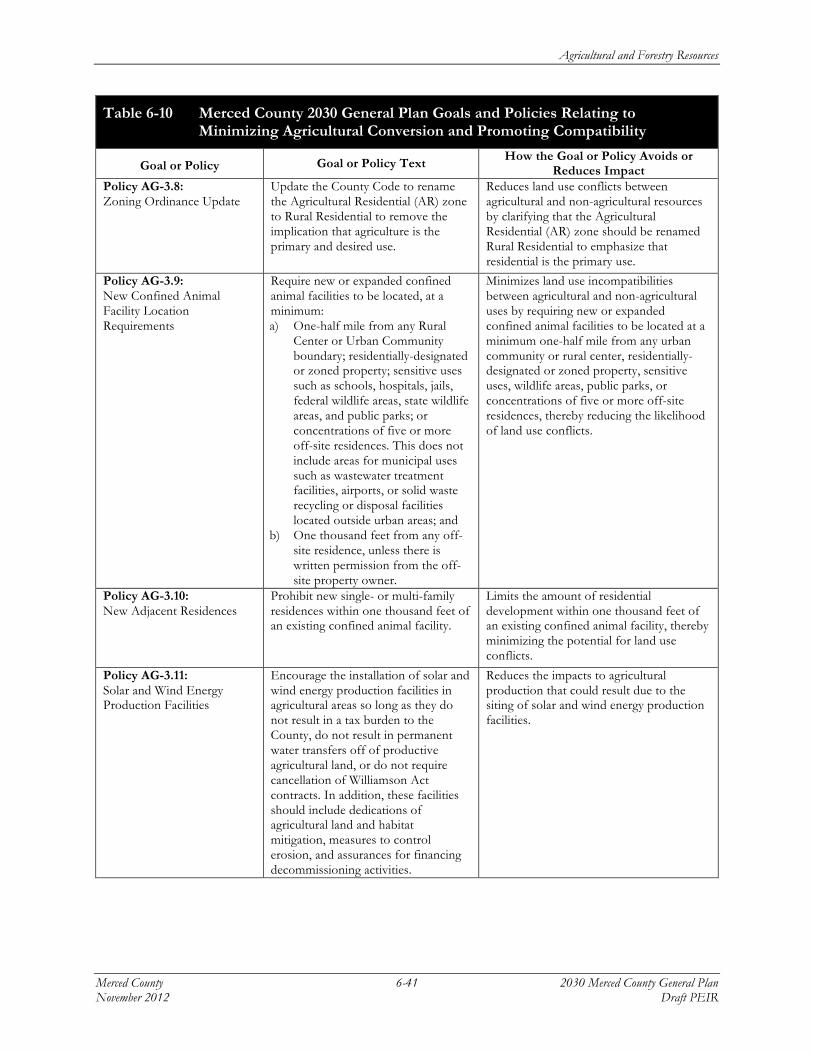
Agricultural and Forestry Resources
Merced County 6-41 2030 Merced County General Plan November 2012 Draft PEIR
Table 6-10 Merced County 2030 General Plan Goals and Policies Relating to Minimizing Agricultural Conversion and Promoting Compatibility
Goal or Policy Goal or Policy Text How the Goal or Policy Avoids or Reduces Impact
Policy AG-3.8: Zoning Ordinance Update
Update the County Code to rename the Agricultural Residential (AR) zone to Rural Residential to remove the implication that agriculture is the primary and desired use.
Reduces land use conflicts between agricultural and non-agricultural resources by clarifying that the Agricultural Residential (AR) zone should be renamed Rural Residential to emphasize that residential is the primary use.
Policy AG-3.9: New Confined Animal Facility Location Requirements
Require new or expanded confined animal facilities to be located, at a minimum: a) One-half mile from any Rural
Center or Urban Community boundary; residentially-designated or zoned property; sensitive uses such as schools, hospitals, jails, federal wildlife areas, state wildlife areas, and public parks; or concentrations of five or more off-site residences. This does not include areas for municipal uses such as wastewater treatment facilities, airports, or solid waste recycling or disposal facilities located outside urban areas; and
b) One thousand feet from any off-site residence, unless there is written permission from the off-site property owner.
Minimizes land use incompatibilities between agricultural and non-agricultural uses by requiring new or expanded confined animal facilities to be located at a minimum one-half mile from any urban community or rural center, residentially-designated or zoned property, sensitive uses, wildlife areas, public parks, or concentrations of five or more off-site residences, thereby reducing the likelihood of land use conflicts.
Policy AG-3.10: New Adjacent Residences
Prohibit new single- or multi-family residences within one thousand feet of an existing confined animal facility.
Limits the amount of residential development within one thousand feet of an existing confined animal facility, thereby minimizing the potential for land use conflicts.
Policy AG-3.11: Solar and Wind Energy Production Facilities
Encourage the installation of solar and wind energy production facilities in agricultural areas so long as they do not result in a tax burden to the County, do not result in permanent water transfers off of productive agricultural land, or do not require cancellation of Williamson Act contracts. In addition, these facilities should include dedications of agricultural land and habitat mitigation, measures to control erosion, and assurances for financing decommissioning activities.
Reduces the impacts to agricultural production that could result due to the siting of solar and wind energy production facilities.
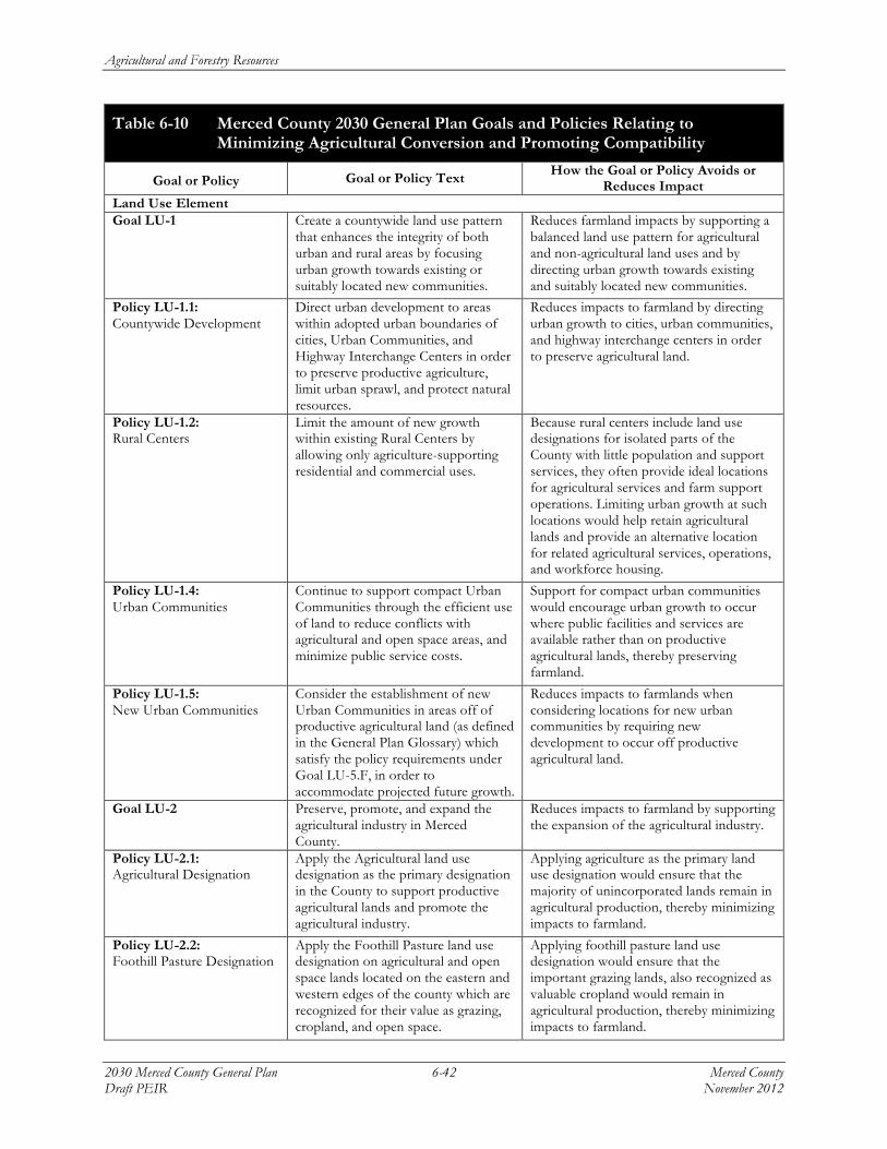
Agricultural and Forestry Resources
2030 Merced County General Plan 6-42 Merced County Draft PEIR November 2012
Table 6-10 Merced County 2030 General Plan Goals and Policies Relating to Minimizing Agricultural Conversion and Promoting Compatibility
Goal or Policy Goal or Policy Text How the Goal or Policy Avoids or Reduces Impact
Land Use Element Goal LU-1 Create a countywide land use pattern
that enhances the integrity of both urban and rural areas by focusing urban growth towards existing or suitably located new communities.
Reduces farmland impacts by supporting a balanced land use pattern for agricultural and non-agricultural land uses and by directing urban growth towards existing and suitably located new communities.
Policy LU-1.1: Countywide Development
Direct urban development to areas within adopted urban boundaries of cities, Urban Communities, and Highway Interchange Centers in order to preserve productive agriculture, limit urban sprawl, and protect natural resources.
Reduces impacts to farmland by directing urban growth to cities, urban communities, and highway interchange centers in order to preserve agricultural land.
Policy LU-1.2: Rural Centers
Limit the amount of new growth within existing Rural Centers by allowing only agriculture-supporting residential and commercial uses.
Because rural centers include land use designations for isolated parts of the County with little population and support services, they often provide ideal locations for agricultural services and farm support operations. Limiting urban growth at such locations would help retain agricultural lands and provide an alternative location for related agricultural services, operations, and workforce housing.
Policy LU-1.4: Urban Communities
Continue to support compact Urban Communities through the efficient use of land to reduce conflicts with agricultural and open space areas, and minimize public service costs.
Support for compact urban communities would encourage urban growth to occur where public facilities and services are available rather than on productive agricultural lands, thereby preserving farmland.
Policy LU-1.5: New Urban Communities
Consider the establishment of new Urban Communities in areas off of productive agricultural land (as defined in the General Plan Glossary) which satisfy the policy requirements under Goal LU-5.F, in order to accommodate projected future growth.
Reduces impacts to farmlands when considering locations for new urban communities by requiring new development to occur off productive agricultural land.
Goal LU-2 Preserve, promote, and expand the agricultural industry in Merced County.
Reduces impacts to farmland by supporting the expansion of the agricultural industry.
Policy LU-2.1: Agricultural Designation
Apply the Agricultural land use designation as the primary designation in the County to support productive agricultural lands and promote the agricultural industry.
Applying agriculture as the primary land use designation would ensure that the majority of unincorporated lands remain in agricultural production, thereby minimizing impacts to farmland.
Policy LU-2.2: Foothill Pasture Designation
Apply the Foothill Pasture land use designation on agricultural and open space lands located on the eastern and western edges of the county which are recognized for their value as grazing, cropland, and open space.
Applying foothill pasture land use designation would ensure that the important grazing lands, also recognized as valuable cropland would remain in agricultural production, thereby minimizing impacts to farmland.

Agricultural and Forestry Resources
Merced County 6-43 2030 Merced County General Plan November 2012 Draft PEIR
Table 6-10 Merced County 2030 General Plan Goals and Policies Relating to Minimizing Agricultural Conversion and Promoting Compatibility
Goal or Policy Goal or Policy Text How the Goal or Policy Avoids or Reduces Impact
Policy LU-2.3: Land Use Activity Limitations
Limit allowed land use within Agricultural and Foothill Pasture areas to agricultural crop production, farm support operations, and grazing and open space uses.
Avoids impacts to farmland by limiting the development of land uses other than for agricultural crop production, farming, and grazing.
Policy LU-2.4: Secondary Uses in Agricultural Areas
Limit ancillary uses in Agricultural and Foothill Pasture areas to include secondary single-family residences, farm worker housing, agricultural tourism related uses, and agricultural support services.
Minimizes impacts related to the substantial conversion of farmlands to developed, non-agricultural uses by limiting ancillary uses in agricultural areas to single-family residences, farm worker housing, and agricultural-related tourism.
Policy LU-2.6: Redesignation for More Intensive Residential Land Use
Prohibit the redesignation of property outside of Rural Centers, Highway Interchange Centers, or Urban Communities for a more intensive residential land use without a General Plan amendment.
Requiring a General Plan amendment for any re-designation of property for more intensive residential uses would discourage developers from considering agricultural lands for development due to the additional discretionary review that would occur prior to project consideration.
Policy LU-2.9: Special Agricultural Uses
Support special agricultural commercial uses in rural areas when they directly relate to and are part of an existing and permitted agricultural enterprise or operation.
Minimizes the conversion of agricultural lands to non-agricultural uses by only permitting agricultural operations in rural areas.
Goal LU-4 Provide for the continuation of areas designated for rural and agricultural support uses in a manner that minimizes agricultural and environmental impacts while benefiting the surrounding agricultural community.
Reduces the likelihood agricultural uses would be converted to non-agricultural uses by encouraging the rural and agricultural supported land use designations.
Policy LU-4.1: Rural Center Development
Allow new rural residential development and agricultural support uses in vacant areas within existing Rural Centers, but prohibit the establishment of new Rural Centers.
Minimizes the conversion of farmlands to urban uses by prohibiting the establishment of any new Rural Centers or new rural residential development that does not support agricultural uses.
Policy LU-4.2: Development Criteria
Require uses within Rural Centers to be limited to: a) Commercial uses to serve the daily
convenience needs of the surrounding agricultural and rural areas;
b) Agricultural supply and service businesses;
c) Limited public facilities such as schools, fire stations, post offices, churches, granges, and veterans halls; and/or
d) Housing for agricultural workers at minimum of one unit per acre.
Minimizes the conversion of farmlands to urban uses in Rural Centers by limiting new uses to commercial uses that serve agricultural areas, agricultural services, farm worker housing, and limiting public facilities.

Agricultural and Forestry Resources
2030 Merced County General Plan 6-44 Merced County Draft PEIR November 2012
Table 6-10 Merced County 2030 General Plan Goals and Policies Relating to Minimizing Agricultural Conversion and Promoting Compatibility
Goal or Policy Goal or Policy Text How the Goal or Policy Avoids or Reduces Impact
Policy LU-4.3: Commercial and Industrial Uses
Consider locating commercial and industrial uses in Rural Centers in limited cases if they support agricultural operations, serve the daily convenience commercial needs of the surrounding rural area, or provide health and safety benefits to the county in sparsely populated areas.
Reduces the likelihood agricultural lands would be converted to urban uses by only limiting commercial and industrial uses in Rural Centers to those that support agricultural operations.
Goal LU-5.A Preserve and enhance the character of Merced County by focusing future unincorporated development towards Urban Communities.
Avoids the conversion of agricultural uses by focusing new urban growth towards Urban Communities.
Policy LU-5.A.1: Urban Community Establishment
Allow consideration of new Urban Communities in areas off productive agricultural land (as defined in the General Plan Glossary) that include a balance of land uses for jobs, tax revenues, and housing, and satisfy the policy requirements under Goal LU-5.F.
Minimizes impacts to agricultural lands and the conversion of such lands to non-agricultural uses by only considering new Urban Communities that are situated off productive agricultural land.
Goal LU-5.F Provide for the establishment of new Urban Communities in order to accommodate future growth in the unincorporated parts of Merced County that are located off productive agricultural land or the valley floor.
Minimizes impacts to agricultural lands and the conversion of such lands to non-agricultural uses by only considering new Urban Communities that are located off productive agricultural land or the valley floor.
Policy LU-5.F.1: New Urban Community Size and Location Requirements
Only accept applications for the establishment of additional new Urban Communities if they encompass a minimum area of 320 acres in order to achieve efficiencies in urban service delivery and provide for long-range growth needs. In addition, require that proposed new Urban Communities be located only in areas that: a) Are off the valley floor unless the
project area is clearly located on non-productive soil;
b) Contain few wetlands or significant natural resources;
c) For proposals off the valley floor, do not contain more than 50 percent productive farmland (as defined in the General Plan Glossary) or 10 percent Prime Farmland (as classified on the Statewide Important Farmland Map), and for projects on the valley floor, do not contain more than 10 percent productive farmland;
Minimizes impacts to agricultural lands and the conversion of such lands to non-agricultural uses by only accepting applications for new Urban Communities that meet specific development suitability criteria. Criteria includes, but is not limited to being located off the valley floor, unless the project area is not on productive agricultural soils; does not contain more than 50 percent productive farmland and 10 percent prime farmland if site is located off the valley floor; and for project applications on the valley floor that the site does not contain more than 10 percent productive farmland.

Agricultural and Forestry Resources
Merced County 6-45 2030 Merced County General Plan November 2012 Draft PEIR
Table 6-10 Merced County 2030 General Plan Goals and Policies Relating to Minimizing Agricultural Conversion and Promoting Compatibility
Goal or Policy Goal or Policy Text How the Goal or Policy Avoids or Reduces Impact
d) Are not located within two miles of an existing city or Urban Community; and
e) Are near major transportation routes.
Goal LU-7 Ensure that development in county/city fringe areas is well planned and adequately serviced by necessary public facilities and infrastructure.
Reduces impacts related to the conversion of agricultural lands by directing development to areas that are adequately serviced by public facilities and infrastructure rather than rural areas, where the majority of the agricultural uses are located.
Policy LU-7.1: Infill Development Focus
Encourage infill development to occur in cities in order to maximize the use of land within existing urbanized areas, minimize the conversion of productive agricultural land, and minimize environmental impacts associated with new development.
Infill development within cities and designated urban communities would maximize the use of land at urbanized locations and minimize the potential for the conversion of agricultural lands.
Source: Merced County, 2011; Planning Partners, 2012.
The Agricultural Element contains various policies that seek to preserve agricultural land and the agricultural industry. These include several policies that outline conservation strategies and mitigation requirements, such as the Williamson Act program and farmland conservation easements. The Agricultural Element also includes various policies that seek to reduce urban and agricultural land use conflicts. Because the expansion of urban uses onto adjacent farmland has been a major issue in Merced County, specific policies are set forth in the proposed 2030 General Plan to minimize such effects. Specific policies that would reduce urban and agricultural land use conflicts include the Right-to-Farm Ordinance, as well as policies that would limit the parcelization of farmland, and require the establishment of adequate buffers between agricultural and urban uses.
As described in Impact AG-1, there are many goals and policies outlined to preserve agricultural land, including Goal AG-2, which states the overall intention of the County to ensure the long-term preservation and conservation of land used for productive agriculture. For example, policies direct growth away from productive agricultural lands, require a mitigation program that matches agricultural acres converted with farmland preserved at a 1:1 ratio, support collaboration with other government, non-profit, and private entities to encourage participation in conservation programs, and various other policies that minimize the impacts of parcelization of agricultural lands to smaller lots that reduce the viability of commercial farming.
There are also numerous goals and policies outlined to reduce urban and agricultural land use conflicts, specifically nuisance complaints from urban residents that can threaten the viability of agriculture. To address this issue, the 2030 General Plan includes Goal AG-3, to minimize conflicts between productive agricultural areas and urban land uses, and discourage the parcelization and conversion of large agricultural holdings into rural residential parcels or urban uses. Supporting this goal are 11 policies designed to support established agricultural operations, minimize land use

Agricultural and Forestry Resources
2030 Merced County General Plan 6-46 Merced County Draft PEIR November 2012
conflicts, reduce farmland conversion, limit the parcelization of farmland, and establish buffers between agricultural and urban uses. Moreover, there are various other policies in the Agricultural Element that support the agricultural industry, research and education, and tourism in order to protect and diversify the economy, help farmers adjust to national and international product demand, and attract visitors.
However, as described under Impact AG-1, the purpose of the 2030 General Plan is also to develop a framework to guide future land use development. As a result, it is inevitable that some farmland conversion would occur to accommodate long-term development needs. Proposed policies would permit the loss of farmland to urban development within designated urban areas, and would continue to permit new rural housing and agricultural-commercial and industrial development at scattered locations outside designated communities, as well as permit the expansion of Rural Residential Centers. The 2030 General Plan would directly result in the conversion of farmland due to urban development, indirectly result in the conversion of farmland due to the removal of smaller parcels from farming at the urban fringe, and additionally result in urban edge patterns that would increase nuisances among incompatible land uses. Therefore, even with the implementation of the listed policies, the potential conversion of additional important farmlands to non-agricultural uses would result in a potentially significant impact.
Significance of Impact: Potentially significant.
Mitigation Measure AG-3a:
Implement Mitigation Measure AG-1a, Amend Policy AG-2.2: Agricultural Land Mitigation; Mitigation Measure AG-1b, create an Agricultural Conservation Easement Program; and Mitigation Measure AG-1c, Amend Policy NR-3.13: Agricultural Land Disturbance.
Mitigation Measure AG-3b:
Amend Policy AG-3.4: Residential Buffers from Agriculture, as follows:
Require a minimum 200-foot buffer between new residential development within designated urban areas and existing agricultural operations, and establish design/maintenance guidelines for developers and property owners.
Mitigation Measure AG-3c:
Amend Policy LU-3.4: New Rural Residential Center Prohibition, as follows:
Prohibit the creation of any new, or the expansion of any existing, Rural Residential Centers in the unincorporated county.
Environmental Effects of Measures: Implementation of these mitigation measures would minimize farmland conversion to non-agricultural uses. No changes in land uses are required by the measures, and no environmental effects would occur. Instead, the County policies would support agricultural uses, reduce potential urban/agricultural land use conflicts, match acres converted due to urban development or mining activities with farmland acres of similar quality to those converted at a 1:1 ratio, require that solar energy projects mitigate adverse effects to agricultural lands, coordinate regional efforts to preserve farmland in collaboration with entities such as the Central

Agricultural and Forestry Resources
Merced County 6-47 2030 Merced County General Plan November 2012 Draft PEIR
Valley Farmland Trust, and remove the impact on agricultural resources from the expansion of very low density Rural Residential Centers, which are an inefficient land use.
Level of Significance After Mitigation: Significant and unavoidable.
While the revised policies would promote the preservation of agricultural lands, the agricultural land use designations and the policies would not prevent the conversion of farmlands within the county associated with direct impacts due to future urban development and indirect impacts due to nuisance effects from land use conflicts along the expanding urban-edge. There are no additional or technically feasible mitigation measures available to reduce the impact. Consequently, implementation of the 2030 General Plan would continue to directly and indirectly convert important farmlands to non-agricultural uses, and result in a significant and unavoidable impact.
Impact AG-4: Conf l i c t with zoning for fores t land or t imber land, resul t in the loss o f fores t
land or cause other changes that could convert fores t land to non- fores t uses .
Implementation of the proposed 2030 General Plan would not lead to urban development and other construction activities that could conflict with the zoning for forest land or timberland, result in the loss of forest land, or cause other changes that could convert forest land to non-forest uses. Because no forest land, timberland, or timberland production areas, as zoned by applicable state regulations, exist within Merced County, the proposed 2030 General Plan would not conflict with forest land zoning, and impacts related to forest land resources would not occur.
Forest land, as defined by Public Resources Code Section 1220(g), and timberland, as defined by Public Resources Code Section 4525, and timberland production areas, as defined by Government Code Section 51104(g) do not exist within Merced County. There are no large forested areas in the county, no commercial forestry production, and therefore, no known timber resources. While the far eastern and western portions of the county include some oak woodland habitat, these areas are not classified as timber lands according to the existing Merced County zoning designations. Instead, these areas are classified as Foothill Pasture zones. Further, neither timber production nor major harvesting operations contribute to the local economy.
Because no forest land, timberland, or timberland production areas, as zoned by applicable state regulations, exist within Merced County, the proposed 2030 General Plan would not conflict with forest land zoning. Therefore, no impacts would occur related to forest land resources.
Significance of Impact: No impact.
Mitigation Measure: None required.

Agricultural and Forestry Resources
2030 Merced County General Plan 6-48 Merced County Draft PEIR November 2012
Impact AG-5: Involve other land use changes that would resul t in convers ion o f farmland to non-agr i cul tural uses due to the Minor Subdivis ion o f Rural Parce l s .
The minor subdivision of rural parcels into four or fewer lots as permitted with the implementation of the proposed 2030 General Plan could lead to the conversion of important farmlands to non-agricultural uses, or otherwise conflict with continued agricultural operations.4 This would be a potentially significant impact.
MINOR SUBDIVISIONS Minor Subdivis ion Def ini t ion
The Merced County Planning and Community Development Department Minor Subdivision application form defines a minor subdivision as “the division of any land into four or fewer parcels for the purpose of sale, lease, financing, or as a gift, except for leases of agricultural land for agricultural purposes.” Thus, a minor subdivision involves splitting a parcel or multiple parcels of land, and assigning new ownership rights to that parcel, as well as the legal right to build more dwelling units. A Minor Subdivision requires approval of both a “Tentative Parcel Map” and a “Parcel Map.”
Ranchet te Deve lopment
Rural residential development, as classified by the FMMP, includes residential areas of one to five structures per ten acres. The rural residential category is not considered a type of important farmland by the FMMP, so that the construction of dwelling units for residential use on such farmlands at these densities would result in the conversion of important farmland to a non-agricultural use. However, a cluster of dwellings on a large parcel, such as a dairy, would not typically constitute a “ranchette” since the homes could not be sold separately. A ranchette would more typically be defined as a smaller rural parcel where the main use and value of the property is for residential purposes rather than agricultural production.
Minor Subdivis ion Act iv i ty f rom 1998 - 2008 on Agricul tural Land
Table 6-11 illustrates the number of approved and recorded Minor Subdivisions on agricultural zoned lands (A-1 and A-2) between January 1998 and March 2008. No similar minor subdivisions have been have been approved in Merced County in the period from 2008 through 2010.
4 This and the following impact statement (AG-6) address the effects of minor subdivision activity with subsequent
residential development on continued agricultural production due to conflicts between agricultural and residential uses, or the potential for increased residential water use. Impact AG-7 evaluates the influence of minimum parcel sizes on continued agricultural productivity. For an evaluation of the cumulative effects of rural residential development together with all other types of urban and rural development permitted under the 2030 General Plan, please refer to Chapters 5 through 22 of this PEIR.

Agricultural and Forestry Resources
Merced County 6-49 2030 Merced County General Plan November 2012 Draft PEIR
Table 6-11 Unincorporated Merced County Minor Subdivision Activity from 1998 - 2008
Minor Subdivisions (MS) Activity Totals
Recorded MS maps in the A-1 & A-2 zones 267
Recorded MS maps in the non–Agriculturally zoned parcels 135
Total MS maps recorded (1998 – 2008) 402
Total parcels resulting from all recorded maps in Agricultural zones 691
MS Applications expired, terminated or not recorded 110
Number of MS Applications (1998 – 2008) 512
Source: Merced County, 2008, 2012.
During the 1998-2008 period, approximately two-thirds (267) of the recorded Minor Subdivisions were located on agriculturally zoned properties (A-1 and A-2) out of 402 total Minor Subdivisions Maps recorded. Over 21 percent (110 out of 512) of all Minor Subdivision approvals during this period expired, terminated, or had not been recorded, which means that despite approval of a tentative parcel map, no property lines changed or were created, nor can they be without submitting a new application and receiving a new approval from the County. Of these 110 tentative maps, the expiration date for 32 has been extended by state action.
Resident ial Act iv i ty Analys is : 1998 – 2008
As a result of the approved Minor Subdivisions during the period 1998-2008, new residences were constructed within the new parcels created as a result of the 267 Minor Subdivisions within the A-1 and A-2 zones. Based on information from the County’s Building Division records, new residences include any Additional Dwelling Occupancy Monitoring Permits (ADOMP) that were approved during the 10-year period, even if the dwelling was pre-existing on the property. ADOMPs include second or third dwelling units on the same parcel. Therefore, the ADOMPs were counted by the County, along with new dwelling unit permits and granny unit permits. Table 6-12 below illustrates building permits over a 10-year period for new residences, and ADOMPs on the 691 subdivided parcels.
Table 6-12 Ten Years of Residential Development Activity
Totals
1st Residential dwelling units 67
ADOMP * (2nd, 3rd or more dwelling units on parcel) 25
Granny units 5
Total new dwelling units (Jan. 98 to Mar. 08) 97
Pre-existing homes (older than ten yrs) 314
Total new dwelling units and pre-existing homes 411
* This process was then repeated with a database including all ADOMPs for family members and farm labor housing on the subdivided parcel areas, and for “granny” units.
Source: Merced County, 2008.

Agricultural and Forestry Resources
2030 Merced County General Plan 6-50 Merced County Draft PEIR November 2012
Of the 97 total units, 30 dwelling units were counted as multiple units located on the same parcel. Table 6-13 illustrates the total annual number of dwelling units constructed on these in the county, and the average annual number of new dwelling units constructed. The total annual number of dwelling units constructed averaged less than 10 (9.7) new homes per year on the 691 parcels.
Table 6-13 Annual Number of Dwelling Units
Totals 1st residential dwelling units 6.7
ADOMP * (2nd, 3rd or more dwelling units on parcel) 2.5
Granny units 0.5
Total new dwelling units per year 9.7
* This process was then repeated with a database including all ADOMPs for family members and farm labor housing on the subdivided parcel areas, and for “granny” units.
Source: Merced County, 2008.
MERCED COUNTY REGULATION OF LAND USES IN AGRICULTURAL ZONING
DISTRICTS The Merced County Zoning Code further regulates allowable uses in areas zoned for A-1, A-1-40, and A-2, agricultural uses (Section 18.02.020 A). Chapter 18.02 of the Zoning Code sets forth considerations for subdivision within agricultural zones, and minimum parcel size requirements. The relevant portions of this section of the Zoning Code are set forth in Appendix C, Merced County Zoning Code – Minor Subdivision/Residential Development in Rural Areas.
Section 18.02.030 B contains standards to be considered by the County prior to approving any subdivision within agricultural zones. Consideration B.1 requires consideration of the general soil capability and productivity of the site and vicinity which can range from intensive farming practices on prime soils - such as orchards and vineyards - to dry grazing or wetlands and similar open space habitat on marginal soils. Consideration B.4 requires the County to evaluate, in the broadest sense, the compatibility of a proposed subdivision and its subsequent developed uses with existing agricultural uses and cropping patterns in the project vicinity.
Section 18.02.030 A establishes minimum parcel sizes in the agricultural zones, and Section 18.020.030 C sets forth exceptions to the application of the minimum parcel size requirement under specific circumstances. Of the 691 resulting parcels recorded from minor subdivision activity in the county, there were a total of 228 parcels (170 in A-1 and 58 in A-2) that were created below the 20-acre A-1 zone minimum and 160-acre A-2 zone minimum. Many of these parcels were approved under the “exemption” provisions and were otherwise in compliance with the County’s Zoning Code.
As shown in Table 6-14, under Section 18.02.020 of the Zoning Code, one residence is permitted by right in agricultural districts (a single-family dwelling). One guest house, not to exceed 400 square feet and specifically excluding any kitchen facilities and/or appliances is also permitted by right so long as the landowner signs an affidavit that he/she will not lease the guest home and/or use it on a continual basis. Additional dwellings for employee housing may be approved with an administrative permit or a conditional use permit.

Agricultural and Forestry Resources
Merced County 6-51 2030 Merced County General Plan November 2012 Draft PEIR
Table 6-14 Permitted and Allowable Residential Uses within Agricultural Zones in Merced County Pursuant to Section 18.02.020 A of the County Code
Residential Uses Bed and breakfast inn (See Section 18.47.080) A Granny house (See Section 18.47.150) A Guest house (See Section 18.47.160) P Labor camp, employee housing (See Section 18.47.140) P19, C20 Single-family dwellings (SFD) (attached or detached) (See Section 18.48.040(B)(3)) P21, A22, C23 Temporary residence (See Section 18.47.200) P
Notes: P = Permitted; A = Allowed with Administrative Permit; C = Allowed with Conditional Use Permit 19. One to 12 employees. 20. 13 or more employees. 21. One SFD, may be a conventional or manufactured dwelling or mobile home. 22. Two to four SFD. 23. Five or more SFD. Source: Merced County, County Code, March 27, 2012.
IMPORTANT FARMLANDS As discussed in Section 6.1.1, Environmental Setting, of this chapter, to track urban conversion trends and other land use changes since the mid-1980s, the California Department of Conservation developed the FMMP). The program produces maps and statistical data needed to analyze impacts to California’s agricultural resources. Table 6-2 details the land use categories in the FMMP, and each category’s respective acreage in the county.
Until 2008, standard FMMP data did not accurately document the impact of single family, low-density rural residential and commercial development on farmland. Because the FMMP has since been modified to classify additional land use categories to determine the impacts of urban conversion on agriculture, it is possible to better understand the impacts minor subdivision activity has on agricultural and open space resources. Table 6-15 shows the amount of minor subdivision activity that occurred from 1998 to 2008 within important farmlands and other categories as documented by the FMMP in 2010.
Table 6-15 Minor Subdivision Activity from 1998 – 2008 within 2010 Farmland Categories
Farmland Type Acres Percentage (%)
Prime Farmland 10,681 36% Farmland of Statewide Importance 4,795 16% Unique Farmland 4,671 16% Farmland of Local Importance 1,695 6% Total Important Farmlands (inc. Confined Animal Agriculture) 22,268 75% Grazing Land 6,338 21% Urban/Built-Up Land 94 0% Water 0 0% Rural Residential 140 0%

Agricultural and Forestry Resources
2030 Merced County General Plan 6-52 Merced County Draft PEIR November 2012
Table 6-15 Minor Subdivision Activity from 1998 – 2008 within 2010 Farmland Categories
Farmland Type Acres Percentage (%)
Vacant 376 1% Confined Animal Agriculture 426 1% Nonagricultural and Natural Vegetation 350 1% Semi-Agricultural and Rural Commercial Land 173 1% Total 29,739 100%
Source: FMMP, 2010; Merced County GIS, 2012.
Between 1998 and 2008, minor subdivision activity occurred on 29,739 acres of land in Merced County that has been classified by the FMMP. Using 2010 FMMP data, approximately 22,268 acres, or 75 percent occurred within important farmlands as defined in this EIR. 6,338 acres, or 21 percent, of minor subdivisions occurred on grazing lands.
DAIRIES In drafting the Animal Confinement Ordinance (ACO) in 2002, Merced County recognized that confined animal facilities such as dairies create a number of effects that could be perceived as nuisances to nearby residents. These effects included the generation of flies and mosquitoes, and odors. To avoid potential nuisance effects, new dairies are prohibited by the ACO from locating the active areas of the dairy (i.e. cattle housing, waste management facilities, etc.) within 1,000 feet of an existing residence. Similarly, existing dairies are prohibited from expanding their active facilities if such facilities would encroach into the 1,000-foot setback from an existing residence. The ACO additionally prohibits owners of adjacent property, not owned by the dairy operator, from constructing a residence without the written permission of the dairy operator if the residence was proposed to be sited within 1,000 feet of an active dairy facility. These setback requirements are codified in Section 18.48.040 of the Zoning Code and proposed within Policies AG-3.9 and AG-3.10 of the 2030 General Plan.
Additionally, dairies are known to be sources of toxic air contaminants, and thus subject to regulation by the San Joaquin Valley Air Pollution Control District (SJVAPCD). For each new or expanded dairy, the SJVAPCD requires that a Health Risk Assessment (HRA) be prepared. This HRA evaluates the potential health risk effects of operating a new or expanded dairy from toxic air contaminants and several criteria air pollutants. Based on the County’s experience in preparing environmental documents for new and expanding dairies within the county, these potential effects are typically limited to the dairy itself. However, it is worth noting that for new dairies, many operators now seek to site the new facility within the middle of their owned parcel to avoid any potential impacts at their property line, one of the thresholds the SJVAPCD uses to determine significant effects.
According to GIS analysis, 118 parcels were created by minor subdivision within the 1,000-foot setback surrounding the active areas of dairies. While it cannot be determined whether many or most of these new parcels were actually within the larger dairy farm operation, there is the potential that future residential development of these parcels could be prohibited if such parcels are not on the owned dairy site, but are within 1,000 feet of active dairy facilities.
Agricultural and Forestry Resources
Merced County 6-53 2030 Merced County General Plan November 2012 Draft PEIR
PESTICIDE USE AND REGULATION Pest i c ide Regulat ion and Overview
The California Department of Pesticide Regulation (DPR) is vested with primary authority through the U.S. Environmental Protection Agency (EPA) to enforce federal and state laws pertaining to the proper and safe use of pesticides. As a part of the federal registration process, the EPA classifies each pesticide product as a “general use pesticide” or “restricted use pesticide.” This classification is based on the potential for the product to cause unreasonable adverse effects on human health or the environment when used according to label directions and without additional regulatory restrictions (FIFRA Section 3(d)(1)(C)). To regulate the “restricted use pesticides,” the Restricted Materials Permit Program (RMPP) was developed as an alternative program to provide for an abbreviated environmental review procedure that serves as the “functional equivalent” to an EIR normally required under CEQA.
The permitting and enforcement of pesticide use in the field is carried out in California’s 58 counties by County Agricultural Commissioners (CAC). In Merced County, this function is performed by the Merced County Agricultural Commissioner (MCAC). Prior to purchasing or using agricultural chemicals, farmers must obtain site-specific permits from their CAC. When the CAC issues permits, it evaluates the proposed use to determine if the pesticide can be used safely. Based on the evaluation, the CAC can deny a permit to use a pesticide, or require specific practices to reduce environmental hazards related to pesticide use. Permit conditions are often contingent upon the application method, time, weather, and buffer zone.
In 1990, the DPR began requiring all agricultural pesticide use to be reported. Under the system, the state requires farmers to submit site-specific information on every pesticide application, thereby permitting the DPR and CACs to track the annual amount of pesticides used, the total number of pesticide applications, and the total acres treated with active pesticides. According to the 2010 Annual Summary of Pesticide Use, the greatest pesticide use within the state occurs in the San Joaquin Valley. In 2010, Fresno, Kern, Tulare, and San Joaquin Counties ranked as the top four counties in the state with the highest pesticide use. In 2009, Merced County applied 5,977,272 pounds of pesticides, ranking it eighth in California among the 58 counties. In 2010, the County’s pesticide use increased to 7,736,269 pounds of pesticide, a 29 percent increase from the previous year, moving its rank to seventh in California (DPR 2010).
When issuing permits for pesticide use, the CACs consider the need for the pesticide, whether a safer pesticide is available, and whether a better application method can be used. Most importantly, CACs determine environmental and health risks associated with the pesticide application to prevent the misapplication of the chemicals and possible contamination of persons, surface and groundwater, and other environmental receptors. As more residents move to rural portions of Merced County, the potential pesticide exposure risks increase. To avoid or minimize such risks, the CAC may condition a proposed application to use a less toxic chemical, or modify the application method to accommodate required setbacks from adjacent residences. Thus, the siting of a residence within an active agricultural district where pesticides are used and regulated may act as a sort of reverse land use control on the actions of adjacent agricultural operators. Additionally, to the extent that increases in minor subdivision activity in agricultural zones may result in the construction of new residences, urban-edge conflicts between residences and agricultural operations due to nuisances, odors, and possible health concerns would be increased.

Agricultural and Forestry Resources
2030 Merced County General Plan 6-54 Merced County Draft PEIR November 2012
Pest i c ide Use in Merced County
The Merced County Agricultural Commissioner’s office has compiled information on pesticide use in Merced County based on the top pesticide active ingredients used by weight, acreage, and commodity (Runyon 2012). This information can be used to understand the common setbacks or “buffers” required under permit conditions for pesticide use. “Buffer” durations of pesticides vary depending on the pesticide, and can range in duration for to up to seven days after the completion of the application. These “buffers” are intended to protect and mitigate any harmful effects of pesticides to persons (employees and public), the environment, and public and private property. These setbacks can also inform the County’s land use regulations for rural residential development in agricultural zones.
Top Twelve Active Ingredients of Pesticides in County. The top 12 active ingredients of pesticides used in Merced County by weight in pounds of active ingredients include: Sulfur; 1, 3 dichloropropene; Potassium n methylcarbamate; Mineral Oil; Petroleum Oil; Glyphosate, isopropylamine salt; Metam sodium; Paraquat dichloride; Methyl bromide; Pendimethalin; Chloropicrin; and Lime Sulfur. Table 6-16 outlines the top twelve pesticide active ingredients used in the county and the corresponding amounts of active ingredients. Each active ingredient may be an ingredient in tens, if not hundreds of different pesticide products. Some materials (especially insecticides) require smaller quantities per acre because of their chemical and pesticidal properties. Materials that are used in smaller quantities may be used more frequently and over greater geographical areas. Restricted materials are conditioned for use and require a notice of intent before application. Non-restricted materials do not require a notice of intent and cannot be conditioned before use. Table 6-16 is followed by a brief discussion of the properties of identified pesticide active ingredients.

Agricultural and Forestry Resources
Merced County 6-55 2030 Merced County General Plan November 2012 Draft PEIR
Table 6-16 Top Twelve Active Pesticides by Weight in Merced County
Pesticide Weight
(pounds) Restricted Material?
Buffer
Sulfur 2,090,662 No Buffers vary*
1,3 dichloropropene 1,036,899 Yes Restricted within 100 ft. of an occupied building, and within 300 ft. of an occupied building, if applied to same site in last 3 years. Livingston-Atwater area has a cap that limits the use due to chronic exposure concerns.
Potassium N- methyldithiocarbamate
599,685 Yes Buffers range between 100-2,500 ft. Most common application method (e.g. shank application method has 100 ft. buffer Drip application has 100 ft. buffer Flood application has a 100-600 ft. buffer Sprinkler has 100-2500 ft. buffer
Mineral Oil 499,579 No Buffers vary*
Petroleum Oil 496,182 No Buffers vary*
Glyphosate, isopropylamine salt 458,614 No Buffers vary*
Metam sodium 269,403 Yes Buffers vary
Paraquat dichloride 185,930 Yes Buffers vary
Methyl bromide 170,539 Yes Require varying buffer zones depending on site, acreage, rate and application method. Inner and outer buffer zone and can be as minimal as 30 and 60 ft.
Pendimethalin 136,017 No Buffers vary*
Chloropicrin 113,835 Yes Buffers range from 25 ft. to 6,020 ft. and dependent on site, acreage, rate, and application method
Lime-sulfur 100,713 No Buffers vary
* Applicator’s Discretion (not conditioned by MCAC). Source: Merced County Agricultural Division, Agricultural Commissioner 2012.
• Sulfur. Sulfur is used in large quantities and is a non-restricted material. It is commonly used
on tomatoes and grapes. It has two formulations. Wettable sulfur is applied like a liquid, and dusting sulfur is applied as a dust. The wettable sulfur is more easily controlled, but less effective. The dusting sulfur is difficult to control, but more effective. Due to the limited lack of control in applying dusting sulfur and increasing regulatory attention to drift concerns, dusting sulfur use is becoming secondary to wettable sulfur.
• 1, 3 dichloropropene. 1, 3 dichloropropene is a liquid, which fumes when injected into the soil. It is heavily used to control nematodes in sweet potatoes and for the replanting of almond trees in sandy soils. According to the Merced County Agricultural Commissioner, 1, 3 dichloropropene permit conditions require that it not be used within 100 feet of an occupied building, or within 300 feet of an occupied building if it has been applied to the same site within the last three years. 1, 3 dichloropropene use is currently being regulated by a township cap for the four townships located around the Livingston-Atwater area. This cap limits the use of the product due to concerns of chronic exposure over the average lifespan of persons in these townships. This is currently one of the less complex fumigants in terms of regulatory issues for growers to use, but cannot be used exclusively in the Livingston-Atwater area because of the township cap limits. This use restriction also makes it imperative

Agricultural and Forestry Resources
2030 Merced County General Plan 6-56 Merced County Draft PEIR November 2012
for growers in these areas to have alternative fumigant options available to them. It is also used in tomatoes and melons outside of the impacted townships.
• Potassium N methyldithiocarbamate (metam potassium) and metam sodium. Metam potassium and metam sodium are active ingredients which share the same permit conditions because they both are MITC (methyl isothiocyanate) generating compounds. MITC is the gaseous break-down product of these materials. It is the actual active ingredient and fumigant that is released once introduced into the soil. Currently, Merced County has ten separate sets of conditions for use of products that generate MITC. These conditions are determined by application method and require the grower to adhere to varying buffer zones, which exclude sensitive sites (such as schools) or occupied buildings. The buffers are determined by method, rate, and acreage. They also require the grower to obtain agreements from neighboring growers to allow permission of the application if the buffer falls onto adjacent property. These buffers can range from 100 to 2,500 feet. The most common application method (e.g. shank application method for sweet potatoes) at typically used rates of application results in a buffer zone of 100 feet, or the chemical is applied in multiple applications to achieve a 100 feet buffer. Additional application methods such as drip (100 foot buffer), flood (100 to 600 foot buffer), and sprinkler (100 to 2,500 foot buffer) are also used. Additional conditions can be applied when required. These products are respiratory and ocular irritants and have the potential (if used improperly) to affect large groups of people because of the fumigants ability to move through the air.
• Mineral oil and petroleum oil. Mineral oil and petroleum oil are pesticides and pesticide adjuvants used to increase the effectiveness of pesticides. Many are commonly known as “sticker” and “spreaders” and are mixed with other pesticides. Some have their own pesticidal properties. Most are typically of lower toxicity. Adjuvants are considered pesticides by California regulations.
• Glyphosate, isopropylamine salt. Glyphosate, isopropylamine salt is a commonly used active ingredient known widely as “Roundup”. It is used as a non-selective herbicide to control weeds and is one of the most common herbicides in regards to the number of applications. It is a lower toxicity pesticide, which has the main risk of damage of non-target crops or plants.
• Paraquat dichloride. Paraquat dichloride is another commonly used non-selective herbicide known as “Gramoxone” and is a widely used as a “burn down” herbicide that is of higher toxicity than Roundup. Its main risk is associated with the handling of the concentrated material by pesticide handlers, and drift onto sensitive sites and surrounding crops. Applications of this restricted herbicide are conditioned on a site-by-site basis when needed.
• Methyl bromide. Methyl bromide is used primarily as a nursery transplant fumigant and is required by some crops such as strawberries and cane berries for quarantine purposes when shipping to other states and countries. Due to its high price and recent shortage of supply due to regulatory restrictions, it is commonly used as a mixture with chloropicrin. Methyl bromide does not have permit conditions. However, the fumigant has significant regulations in California concerning its use. These regulations require varying buffer zones depending on site, acreage, rate and application method that is used. Regulations require that buffer zones to be vacant of houses and other sensitive sites, and for signed agreements to be obtained between neighboring growers when buffers fall onto their property. These regulations require an inner and outer buffer zone and can be as minimal as 30 and 60 feet.

Agricultural and Forestry Resources
Merced County 6-57 2030 Merced County General Plan November 2012 Draft PEIR
Applicators can determine these buffers zones by adjusting the rate, acreage, and method they use when planning the applications. Methyl bromide is usually applied as a mixture of methyl bromide and chloropicrin.
• Pendimethalin. Pendimethalin is non-restricted herbicide commonly used as pre-emergent in almonds and alfalfa. Pendimethalin is relatively safe in regards to toxicity and application methods.
• Chloropicrin. Chloropicrin is a fumigant used by itself, or in combination with methyl bromide or 1, 3 dichloropropene. It is used for the control of soil pathogens (nematodes) and is used mostly in sandy soils of Merced County. Permit conditions require a buffer zone and neighboring property agreements when the buffer falls onto neighboring properties. Its active ingredient is a respiratory and ocular irritant similar to tear gas. As with metam sodium and metam potassium, it has the potential to affect large groups of people because of its ability to move through the air. Buffers can range from 25 feet to 6,020 feet and are dependent on site, acreage, rate, and application method used.
• Lime-sulfur. Lime-sulfur is similar to sulfur. Lime is added to sulfur to reduce the phytotoxity of the sulfur when applied to certain plants.
The following two pesticides are not within the top 12 as applied by weight, but they are used on the top 10 commodities in the county, and are of special concern because of their potential to affect people and property.
• Phenoxy and phenoxy –type herbicides (2,4-D, 2,4-DB, MCPA, Dicamba, Bromoxynil,) Phenoxy herbicides are a class of herbicides grouped together because of their mode of action. These materials are synthetic growth hormones which cause damage to the plant by inducing unregulated growth. Phenoxy herbicide use is common to corn, oat, alfalfa, and wheat crops, but may be restricted from use by permit conditions if aerially applied near sensitive crops (vegetable crops, grapes, cotton, nurseries) within one mile downwind, or a half a mile upwind. Many plants are particularly sensitive to very small quantities of these materials. Although not considered phenoxies, dicamba and bromoxynil are also conditioned in the same manner because of their similar modes of actions and chemical properties. Notices of intent for use of these products can also be conditioned on a case-by-case basis.
• Tributyl phosphorotrithioate is a restricted material used for the defoliation of cotton. Tribufos has a very noticeable odor associated with it. Tribufos applications may not be made within one-half mile of any area zoned as residential where people are actually residing or other inhabited residential area designated by the commissioner, or any school in session or due to be in session within 24 hours. Tribufos applications shall not in any case be made within one-eighth of a mile of any school.
Pesticides Uses of Concern on the Top 10 Commodities in the County. The top 10 commodities produced in Merced County are listed in Table 6-17 by acreage. The table also sets forth typical uses of the top 12 active ingredients or pesticides of concern on the top 10 commodities.

Agricultural and Forestry Resources
2030 Merced County General Plan 6-58 Merced County Draft PEIR November 2012
Table 6-17 Pesticide Uses of Concern for Top Ten Commodities by Acreage1
Crop Acreage Agricultural Pesticide
Almond 119,931 1, 3 dichloropropene, chloropicrin, Paraquat dichloride
Rangeland 106,045 Minimal use of pesticides
Corn 102,208 Phenoxy-type herbicides (2,4-D, Dicamba,)
Alfalfa 84,18 Phenoxy-type herbicides (, 2,4-DB, , ), Paraquat dichloride
Oat 69,404 Phenoxy-type herbicides (2,4-D, , Dicamba, MCPA) herbicide
Wheat 46,334 Phenoxy-type herbicides (2,4-D, , Dicamba, MCPA) herbicide
Cotton 41, 669 Tributyl phosphorotrithioate and Paraquat dichloride are used for defoliation
Tomato 29,195 Sulfur, 1,3 Dichloropropene
Sweet Potato 16,548 1, 3 dichloropropene; metam potassium; metam sodium; methyl bromide; and chloropicrin
Grapes 14,172 Sulfur, Lime sulfur, Paraquat dichloride 1 Pesticides include herbicides, fungicides, defoliants and fumigants. Source: Merced County Agricultural Commissioner 2012
Below is a brief summary of the common pesticide applications and permit conditions by crop type.
• Corn, rangeland, oat, alfalfa, and wheat. Pesticide applications to corn, rangeland, oat, alfalfa, and wheat are generally evaluated on a case-by-case basis. The CAC would consider the type of application, distance to sensitive sites, weather conditions, pesticide, and any other factor that may affect the application. Rangeland is usually of minor concern to the department because of minimal use of pesticides and the remote locations of most sites. Phenoxy (2,4-D, 2,4-DB, Dicamba, MCPA) herbicide use is common to these crops, but restricted from use by permit conditions if aerially applied near sensitive crops (vegetable crops, grapes, cotton, nurseries) within one mile downwind, or a half a mile upwind.
• Almonds. Applications to almonds can sometimes become problematic due to applications using air carrier or “air blast” spray equipment, which blows the material into the air to deposit the pesticide on to the trees. These applications are usually non-restricted materials, which do not allow them to be conditioned on a permit. Fumigant applications of 1, 3 dichloropropene and chloropicrin occur in sandy soil around the Atwater-Livingston for the control of nematodes. Paraquat dichloride is commonly used in orchards to control weeds.
• Cotton. Cotton applications can be done by air or ground. Many cotton growers now chose to use less toxic insecticides and herbicides. Cotton plants must be defoliated for harvest time, which results in the use of materials with higher toxicity and risk. Tributyl phosphorotrithioate s is a restricted material used for defoliation. tributyl phosphorotrithioate s has a very noticeable odor associated with it. Paraquat dichloride is also used for defoliation. By regulation, Paraquat applications (when used as a cotton harvest aid, shall not be made within one-eighth of a mile of any school or any area zoned as residential where people are actually residing or other inhabited residential area designated by the commissioner. Tributyl phosphorotrithioate applications shall not be made within one-half mile of any area zoned as residential where people are actually residing or other inhabited residential area designated by the commissioner or any school in session or due to be in session within 24 hours. Tributyl phosphorotrithioate applications shall not in any case be made within one-eighth of a mile of any school. Cotton plants themselves are also very

Agricultural and Forestry Resources
Merced County 6-59 2030 Merced County General Plan November 2012 Draft PEIR
sensitive to phenoxy herbicides that must be conditioned when used on other crops in proximity to cotton. Growers can choose less toxic materials for defoliation, but these are generally less effective.
• Sweet Potatoes. Sweet potatoes do not require significant pesticide use except for prior to planting. Prior to planting, most fields are fumigated with one or a combination of; 1, 3 dichloropropene; metam potassium; metam sodium; methyl bromide; and chloropicrin. Fumigant conditions, labels, and regulations are significant in quantity and complexity and require significant preparation and adjustment in application planning. Many of the issues around use are focused around the effect of the application to surrounding occupied structures and other sensitive sites
• Tomatoes and Grapes. Tomatoes and grapes do not typically have setback or buffers associated with pesticide use. These are however two of the biggest users of sulfur, which is a non-restricted material, and is not conditioned. As discussed previously, use of dusting sulfur is problematic because of its control issues. Tomatoes and grapes are both considered sensitive crops when in proximity to herbicide applications, especially phenoxy herbicides. 1,3 dichloropropene is also used on tomatoes outside of the impacted township area.
Aerial Applications. Applications to most of the above crops can occur by air or ground. Air applications near sensitive sites are more thoroughly evaluated because of the greater risk of drift to non-target areas. When evaluating aerial applications, the possibility of drift to surrounding sensitive sites, houses, residential areas, schools, waterways, roadways, domestic animals, and sensitive crops and property is evaluated and mitigated with varying conditions based upon the risk. Aerial applications are more difficult to control because of the speed and distance (compared to ground applications) at which the application takes place. Mitigating conditions placed on these applications may include buffers, wind requirements (directions/speed), timing, application method, temperature, and other weather requirements. Conditioning of these applications is highly variable and is dependent on many factors.
Sandy Soils. Areas of Merced County have a very sandy soil type that is very unique in the San Joaquin Valley, and is ideal for growing sweet potatoes. The area of this sandy soil is located roughly between the cities of Atwater and Livingston along the Highway 99 Corridor. This is the area where most of the sweet potato production occurs in Merced County. Sandy soil does present high levels of nematode pest pressure for certain crops such as sweet potatoes and almond trees. Nematode pests are controlled with fumigants. Each of these fumigants presents their own unique use problems, and are conditioned differently when permitted. This geographical area of high fumigant use presents a continual challenge for growers to navigate through a myriad of regulations to find products they can use to successfully grow crops that thrive in this prime sweet potato growing area. The fumigants also have the potential to affect large numbers of people if used improperly because of their ability to travel through the air and to irritate respiratory systems. Often, a seal (such as tarp, water, or compaction) is required by conditions when using these products.
2030 GENERAL PLAN GOALS AND POLICIES The 2030 General Plan sets forth several policies to promote compatibility between agricultural operations and residential land uses that may be located in productive agricultural areas. As shown in Table 6-18, these policies seek to buffer agricultural activities from other, sensitive land uses. For the most part, these policies are aimed at urban/agricultural conflicts and the development of new,
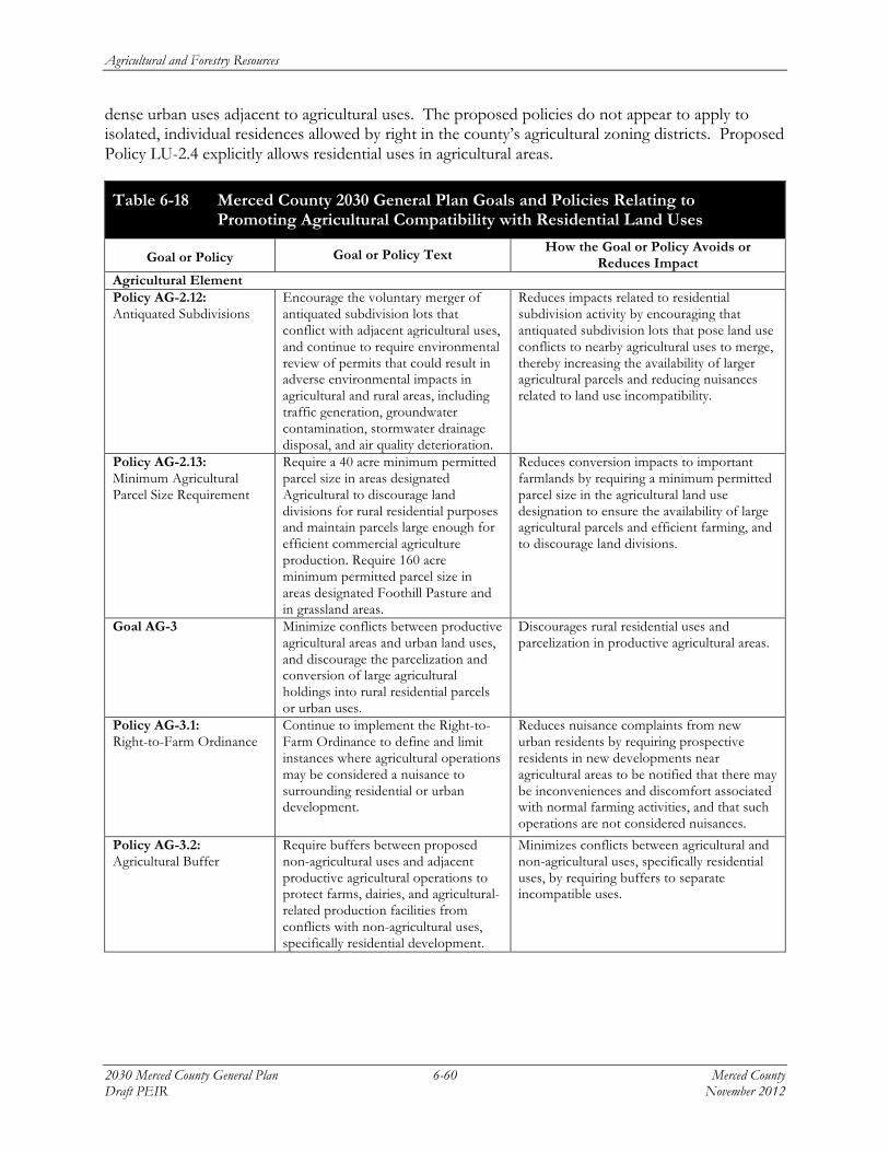
Agricultural and Forestry Resources
2030 Merced County General Plan 6-60 Merced County Draft PEIR November 2012
dense urban uses adjacent to agricultural uses. The proposed policies do not appear to apply to isolated, individual residences allowed by right in the county’s agricultural zoning districts. Proposed Policy LU-2.4 explicitly allows residential uses in agricultural areas.
Table 6-18 Merced County 2030 General Plan Goals and Policies Relating to Promoting Agricultural Compatibility with Residential Land Uses
Goal or Policy Goal or Policy Text How the Goal or Policy Avoids or Reduces Impact
Agricultural Element Policy AG-2.12: Antiquated Subdivisions
Encourage the voluntary merger of antiquated subdivision lots that conflict with adjacent agricultural uses, and continue to require environmental review of permits that could result in adverse environmental impacts in agricultural and rural areas, including traffic generation, groundwater contamination, stormwater drainage disposal, and air quality deterioration.
Reduces impacts related to residential subdivision activity by encouraging that antiquated subdivision lots that pose land use conflicts to nearby agricultural uses to merge, thereby increasing the availability of larger agricultural parcels and reducing nuisances related to land use incompatibility.
Policy AG-2.13: Minimum Agricultural Parcel Size Requirement
Require a 40 acre minimum permitted parcel size in areas designated Agricultural to discourage land divisions for rural residential purposes and maintain parcels large enough for efficient commercial agriculture production. Require 160 acre minimum permitted parcel size in areas designated Foothill Pasture and in grassland areas.
Reduces conversion impacts to important farmlands by requiring a minimum permitted parcel size in the agricultural land use designation to ensure the availability of large agricultural parcels and efficient farming, and to discourage land divisions.
Goal AG-3 Minimize conflicts between productive agricultural areas and urban land uses, and discourage the parcelization and conversion of large agricultural holdings into rural residential parcels or urban uses.
Discourages rural residential uses and parcelization in productive agricultural areas.
Policy AG-3.1: Right-to-Farm Ordinance
Continue to implement the Right-to-Farm Ordinance to define and limit instances where agricultural operations may be considered a nuisance to surrounding residential or urban development.
Reduces nuisance complaints from new urban residents by requiring prospective residents in new developments near agricultural areas to be notified that there may be inconveniences and discomfort associated with normal farming activities, and that such operations are not considered nuisances.
Policy AG-3.2: Agricultural Buffer
Require buffers between proposed non-agricultural uses and adjacent productive agricultural operations to protect farms, dairies, and agricultural-related production facilities from conflicts with non-agricultural uses, specifically residential development.
Minimizes conflicts between agricultural and non-agricultural uses, specifically residential uses, by requiring buffers to separate incompatible uses.

Agricultural and Forestry Resources
Merced County 6-61 2030 Merced County General Plan November 2012 Draft PEIR
Table 6-18 Merced County 2030 General Plan Goals and Policies Relating to Promoting Agricultural Compatibility with Residential Land Uses
Goal or Policy Goal or Policy Text How the Goal or Policy Avoids or Reduces Impact
Policy AG-3.3: Agricultural Buffer Standards
Establish agricultural buffer standards based on type of agricultural operation to be applied to residential development proposals adjacent to productive agricultural land and agricultural-related facilities.
Minimizes conflicts between agricultural and non-agricultural uses by establishing agricultural buffer standards according to the type of agricultural operation.
Policy AG-3.4: Residential Buffers from Agriculture
Require a minimum 200-foot buffer between new residential development and existing agricultural operations, and establish design/maintenance guidelines for developers and property owners.
Minimizes conflicts between agricultural and non-agricultural uses for new residential development within designated urban boundaries by requiring a minimum 200-foot buffer between new residential development and existing agricultural operations.
Policy AG-3.5: Home Site Clustering
Require clustering of homes on agricultural parcels to minimize interference with agricultural operations.
Reduces conflicts between incompatible uses by consolidating residential uses within a defined boundary, in order to minimize the edge, and therefore the interferences, between agricultural and residential uses.
Policy AG-3.7: Public Facility Locations
Discourage public agencies from locating facilities, especially schools, in existing agricultural areas.
Discourages the development or siting of sensitive uses such as public facilities and schools near agricultural areas, thereby limiting nuisances, perceived health issues, and overall conflicts between the different uses.
Land Use Element Policy LU-2.1: Agricultural Designation
Apply the Agricultural land use designation as the primary designation in the County to support productive agricultural lands and promote the agricultural industry.
Applying agriculture as the primary land use designation would ensure that the majority of unincorporated lands remain in agricultural production, thereby minimizing impacts to farmland.
Policy LU-2.2: Foothill Pasture Designation
Apply the Foothill Pasture land use designation on agricultural and open space lands located on the eastern and western edges of the county which are recognized for their value as grazing, cropland, and open space.
Applying foothill pasture land use designation would ensure that the important grazing lands, also recognized as valuable cropland would remain in agricultural production, thereby minimizing impacts to farmland.
Policy LU-2.3: Land Use Activity Limitations
Limit allowed land use within Agricultural and Foothill Pasture areas to agricultural crop production, farm support operations, and grazing and open space uses.
Avoids impacts to farmland by limiting the development of land uses other than for agricultural crop production, farming, and grazing.
Policy LU-2.4: Secondary Uses in Agricultural Areas
Limit ancillary uses in Agricultural and Foothill Pasture areas to include secondary single-family residences, farm worker housing, agricultural tourism related uses, and agricultural support services.
Minimizes impacts related to the substantial conversion of farmlands to developed, non-agricultural uses by limiting ancillary uses in agricultural areas to single-family residences, farm worker housing, and agricultural-related tourism.
Source: Merced County, 2011; Planning Partners, 2012.

Agricultural and Forestry Resources
2030 Merced County General Plan 6-62 Merced County Draft PEIR November 2012
Regarding effects to agricultural resources and production, there are several sources of good data for use at a planning level, including the FMMP and information available from the County Agricultural Commissioner’s office. Based on this information, minor subdivision activity has predominantly occurred on important farmlands, and more specifically, preponderantly on Prime Farmlands as identified by the FMMP.
Although minor subdivision and subsequent residential development may directly result in the loss of important farmlands, a more profound, though indirect, effect is the influence that residential uses in active agricultural areas have on adjacent agricultural practices, especially the use of pesticides. Based on information obtained from the MCAC, required setbacks for pesticide applications vary by the type of adjacent use, but for the top ten commodities listed in Table 6-17, the buffers can range from as little as 25 feet to more than 6,000 feet depending upon many variables, including chemical type and application method. Buffer restrictions mandated by state and federal regulations, and imposed by the MCAC, can directly influence the types of pesticides used by an individual farmer and their application method, and may indirectly affect cropping decisions by restricting crop choice to those that require pesticides with minimal required buffers. This potential effect will tend to worsen over time as more stringent pesticide application requirements are implemented and the number of rural residences increases.
Pesticide regulations are continually becoming stricter, and cropping patterns could change over the long term in response to market conditions and such outside influences as global climate change and water availability. Although growers of row crops have the ability to change their crops from year to year, growers of tree crops and operators of confined animal facilities have made a long-term financial commitment to their operations. The presence of residences within predominantly agricultural areas will result in long-term constraints on agricultural operations. If constraints become too great, it may eventually cause decreases in agricultural productivity as lower value crops with fewer pesticide requirements are substituted, or farmlands are fallowed.
Neither the Zoning Code, as applied, nor the proposed policies of the 2030 General Plan fully mitigate this issue. Rather, the Zoning Code permits one permanent residence and one “guest house” per parcel within agricultural zones by right, and permits the creation of parcels below the typical minimum parcel size of the various zones through a list of “exceptions” in order to host residential and agricultural commercial uses. The 2030 General Plan, while proposing several policies that would result in buffers between agriculture and other sensitive land uses, focuses primarily on the urban edge and the effects of urban development on agricultural activities. While urban edge effects have a large influence on adjacent agricultural activities, the effect of scattered residences within active agricultural districts can have a significant countywide effect throughout the larger agricultural region of the county. This would be a potentially significant impact.
Significance of Impact: Potentially significant.
Mitigation Measure AG-5a:
Amend Policy AG-3.1: Right-to-Farm Ordinance, as follows:
Continue to implement the Right-to-Farm Ordinance to define and limit instances where agricultural operations may be considered a nuisance to surrounding rural residential, residential or urban development.

Agricultural and Forestry Resources
Merced County 6-63 2030 Merced County General Plan November 2012 Draft PEIR
Mitigation Measure AG-5b:
Amend Policy AG-3.2: Agricultural Buffer, as follows:
In consultation with the MCAC, rRequire buffers between proposed non-agricultural uses and adjacent productive agricultural operations to protect farms, dairies, and agricultural-related production facilities from conflicts with non-agricultural uses, specifically rural residences and urban area residential development.
Mitigation Measure AG-5c:
Amend Policy AG-3.3: Agricultural Buffer Standards, as follows:
In consultation with the MCAC, eEstablish agricultural buffer standards based on the type of agricultural operation, and historic cropping and pesticide application patterns, to be applied to rural residences and urban area residential development proposals adjacent to productive agricultural land and agricultural-related facilities.
Mitigation Measure AG-5d:
Amend Policy LU-2.4: Secondary Uses in Agricultural Areas, as follows:
Limit ancillary uses in Agricultural and Foothill Pasture areas to include secondary single-family residences, farm worker housing, agricultural tourism related uses, and agricultural support services, provided that such uses do not interfere with historic agricultural practices or result in adverse health risks.
Mitigation Measure AG-5e:
Add the following policy:
Policy AG-3.12: Subdivision and Residential Uses in Agricultural Areas
Revise the Merced County Zoning Code, Section 18.02.02, Table 4, to allow for two classes of minor subdivisions within the A-1, A-1-40, and A-2 zones: one that would conditionally waive the right by recorded instrument to construct residences on the resulting parcels; and one that would permit the construction of residences on the resulting parcels subject to a conditional use permit.
Mitigation Measure AG-5f:
Add the following program:
Program AG-K: MCAC Consultation to Establish Residential Setbacks
Establish a process to consult with the Merced County Agricultural Commissioner during the discretionary review of minor subdivisions or other urban development where the right to construct residences has not been waived within or adjacent to agriculturally zoned areas to determine the historic cropping and pesticide application patterns on the affected parcel and adjacent parcels. Establish residential setbacks from onsite and adjacent farming operations sufficient to minimize health risks and maintain historic farming practices and cropping patterns, including the application of pesticides.

Agricultural and Forestry Resources
2030 Merced County General Plan 6-64 Merced County Draft PEIR November 2012
Mitigation Measure AG-5g:
Add the following program:
Program AG-L: Program to Permit the Construction of Residences on Non-Residential Minor Subdivisions
Establish a process to consider permitting the construction of residences consistent with the requirements of Section 18.02.020 A of the Merced County Code for parcels within subdivisions where the right to construct residences has previously been waived. The process shall include provisions to consult with the MCAC and establish any required residential setbacks as set forth in Program AG-K.
Mitigation Measure AG-5h:
Implement Mitigation Measure AQ-5a, Amend Policy AQ-2.2: Development Review Process, and Mitigation Measure AQ-5b, Amend Policy AQ-5.1: Residential Buffers.
Environmental Effects of Measure: Implementation of Mitigation Measures AG-5a through AG-5h would minimize farmland conversion to non-agricultural uses, reduce potential interference with continued agricultural operations, and reduce health risks to future residents within productive agricultural areas. No expansion of rural residential or urban land uses are required by the measures, and no environmental effects would occur. Instead, the County policies would support agricultural uses and continued agricultural production.
Level of Significance After Mitigation: Significant and unavoidable.
Implementation of Mitigation Measures AG-5a through AG-h would minimize future farmland conversion to rural residential uses, thereby reducing potential interference with continued agricultural operations and reducing health risks to future residents within productive agricultural areas. Mitigation Measures AG-5a through AG-5d, and AG-5h would also apply to the development of residential uses on existing minor subdivision parcels. For existing minor subdivision parcels, although the establishment of residential uses could not be prohibited, the operation of these mitigation measures would result in the notification to future residents of potential health risks. The measures would also establish buffers between residences and existing productive agricultural operations. However, even with implementation of all identified mitigation measures, single-family residences would be permitted by right on existing minor subdivison parcels within areas designated for agricultural uses. Even with the implementation of buffer requirements identified in Mitigation Measure AG-5c, the dimensions of existing small parcels could preclude buffers of an adequate size to meet pesticide application requirements, both now and in the future, thereby constraining continued crop production. Consequently, implementation of the 2030 General Plan with the identified mitigation measures would not substantially reduce the potential effects to continued agricultural production and health risks posed by rural minor subdivisions to a less-than-significant level. For this reason, the impact would be significant and unavoidable.

Agricultural and Forestry Resources
Merced County 6-65 2030 Merced County General Plan November 2012 Draft PEIR
Impact AG-6: Involve other land use changes that would resul t in convers ion o f farmland to non-agr i cul tural uses due to the Minor Subdivis ion o f Rural Parce l s and resul tant changes in water use .
The minor subdivision of rural parcels into four or fewer lots as permitted with the implementation of the proposed 2030 General Plan could lead to the conversion of important farmlands to non-agricultural uses, or otherwise conflict with continued agricultural operations by increasing the demand for groundwater or surface water in rural areas of Merced County.5 Because the potential water use from rural residences within minor subdivisions would approximately equal or be less than the current crop usage for the same area, this would be a less-than-significant impact.
OVERVIEW OF WATER USE IN MERCED COUNTY California’s geography and Mediterranean climate have allowed it to become one of the most productive agricultural regions in the world (DWR 2012). The state’s location between the Sierra Nevada mountain range and the Pacific Ocean enables it to capture water from the Sierra Nevada snowpack, store and divert the spring runoff in reservoirs, and later transfer the water to the Central Valley to be used for irrigation. The combination of water availability, the State’s water distribution system, and a favorable climate enables the state’s farmers to grow a variety of crops. California produces over 250 types of crops, and leads the nation as the top producer of 75 different agricultural commodities.
Located in the middle of the San Joaquin Valley, a semi-arid region with little rainfall occurring during the crop growing season, Merced County’s local agriculture depends on a reliable, voluminous, and inexpensive supply of irrigation water, delivered directly to the fields and farm animal facilities at the right times. Most of the agriculture production within the county would not be possible without irrigation.
In an average year, the state agricultural industry irrigates 9.6 million acres, using roughly 34 million acre-feet of the 43 million acre-feet diverted from surface waters or pumped from groundwater for consumptive use (DWR 2012). In Merced County, agricultural irrigation constitutes the largest use of water, followed by municipal demands and habitat maintenance (Nolte 2012). According to DWR estimates, in 2005, Merced County consumed approximately 82,032 acre-feet of water for urban uses, compared to 1,285,280 acre-feet of water for agricultural uses, a 15-fold difference in use. Table 6-19 compares annual urban water use to annual applied agricultural water use within the county.
5 This impact statement examines only the potential for increased water use within agricultural areas due to minor
subdivision activity and subsequent residential development. Impact USS-1 as shown in Chapter 20, Utilities and Service Systems, examines the potential depletion of surface and groundwater supplies via increased user demand, and discusses 2030 General Plan goals and policies proposed to improve upon and, at a minimum, maintain an adequate water supply. For an evaluation of overall water demand and supply within Merced County, please refer to that impact discussion.

Agricultural and Forestry Resources
2030 Merced County General Plan 6-66 Merced County Draft PEIR November 2012
Table 6-19 Department of Water Resources Annual Urban Water Use Compared to Annual Agricultural Water Use Within Merced County: 2005 Estimate
Urban Water Use Agriculture Water Use
82,032 acre-feet/year 1,285,280 acre-feet/year
Source: Department of Water Resources 2009; Tipton 2012.
The last U.S. Census of Agriculture, covering the year 2007, reported that 514,162 irrigated acres in the county contained in 2,127 farms (US Census of Agriculture 2007). This represents a little more than half of the total one million agricultural acres in the county, and about 81 percent of all of the county’s farms. Merced ranks fifth among counties in the state in agricultural acres irrigated, and fourth in the number of farms with irrigated land. Table 6-20 shows that local irrigated acres steadily expanded between 1992 and 2007, increasing by about 86,000 acres or one-fifth during this 15-year period.
Table 6-20 Irrigated Agricultural Land in Merced County, 1992-2007
Year Acres Farms
1992 427,815 (43.7 percent of all agricultural land) 2,409 (83.6 percent of all farms)
1997 504,711 (54.8 percent) 2,340 (72.7 percent)
2002 518,538 (51.5 percent) 2,169 (73.1 percent)
2007 514,162 (49.3 percent) 2,127 (81.6 percent)
Source: U.S. Census of Agriculture, 2007.
WATER DEMANDS BY CROP TYPE The California Department of Water Resources estimates irrigated crop acreage, crop evapotranspiration, evapotranspiration of applied water, effective precipitation, and applied water for 20 different crop categories for each sub-watershed area within all counties. The sub-watershed areas within the counties are called County/Detailed Analysis Units (DAU). The DWR estimates irrigation usages using reference evapotranspiration and evaporation pan data, crop development over time, soil characteristics, rooting depths, and the quantity and timing of precipitation. According to the DWR preliminary 2005 water usage estimates, agricultural uses in Merced County constitute approximately 1,285,280 acre-feet of water per year, or roughly 2.5 percent of all water used for irrigation purposes in California (DWR 2009; Tipton 2012). Agricultural water needs are supplied by groundwater and surface water from within the county, and through water deliveries from northern California transported through the State Water Project and Central Valley Project.
Water usage varies by crop type and is also dependent on the seasonal precipitation. Table 6-21 summarizes the annual water usage (by acre-inches/year), or applied water for several of the top agricultural commodities in Merced County.

Agricultural and Forestry Resources
Merced County 6-67 2030 Merced County General Plan November 2012 Draft PEIR
Table 6-21 Annual Water Usage for Top Twelve Fruit, Nut, and Row Crop Types
Crop Type Annual Applied Water (AW) (acre-inches/year)
Alfalfa 54 – 60 acre-inches/year
Almonds* 31.8 acre-inches/year Beans* 17.76 acre-inches/year Melons 30 acre-inches/year
Corn 30 – 36 acre-inches/year
Cotton 30 acre-inches/year
Wine Grape/Vineyard 18 – 36 acre-inches/year
Pistachios* 22.68 acre-inches/year Sweet Potatoes 30 acre-inches/year
Tomatoes 30 acre-inches/year
Walnuts* 23.16 acre-inches/year Wheat 6-12 acre-inches/year
*Indicates an annual applied water rate based on MID estimates. Source: Maxwell 2012; Stoddard 2012; Merced Irrigation District 2012.
Table 6-22 summarizes the annual water usage, or applied water for several of the top agricultural commodities in Merced County grown with water supplied by the Merced Irrigation District.
Table 6-22 Annual Water Usage by Crop Type within Merced Irrigation District
Crop Sum of Acreage Sum of Total Consumption Acre Feet/Acre
Alfalfa 10,184.17 34,862.07 3.42 Almonds 31,261.41 82,954.06 2.65
Beans 67 99.05 1.48 Cherries 11 6.04 0.55
Clover Pasture 822.74 1,477.57 1.80 Corn 19,376.81 56,318.98 2.91 Cotton 2,202.97 6,065.94 2.75
Dairy 36.7 5.95 0.16 Eggplant 16 66.12 4.13
Figs 532.3 1,095.62 2.06 Figs - Mature 40 42.88 1.07 Forage 30 75.94 2.53
Garden 50.8 163.25 3.21 Grain/Oats/Rye 4,139.91 11,871.95 2.87
Grapes 718.7 715.34 1.00 Kiwi 54.3 87.01 1.60
Lawns 89.9 219.75 2.44 Lettuce 141.7 568.7 4.01 Melons 494.6 1,055.01 2.13
Mixed Trees 99.13 314.38 3.17 Mixed Vegetables 241.6 448.37 1.86

Agricultural and Forestry Resources
2030 Merced County General Plan 6-68 Merced County Draft PEIR November 2012
Table 6-22 Annual Water Usage by Crop Type within Merced Irrigation District
Crop Sum of Acreage Sum of Total Consumption Acre Feet/Acre
Nectarines 9.4 1.96 0.21 Nursery 37.7 47.34 1.26
Onion 50 143.68 2.87 Open/Fallow 200.3 342.77 1.71
Peaches 1,282.41 3,335.01 2.60 Peppers 85.8 381.25 4.44 Per-Pasture 8,050.19 20,046.94 2.49
Pistachios 1,417.54 2,675.25 1.89 Plums 132 248.90 1.89
Pomegranate 114.35 127.93 1.12 Ponds 13.22 11.27 0.85
Pre/Post Season Irrigation 92.1 150.55 1.63 Prunes 1,334.10 3,781.47 2.83 Rice 2,709.79 8,533.17 3.15
Squash 185.06 351.84 1.90 Sudan 318.7 587.04 1.84
Sweet Potatoes 3,839.41 9,311.90 2.43 Taro Root 30.3 48.68 1.61 Tomatoes 5,692.65 12,339.53 2.17
Unknown 169.76 291.99 1.72 Walnuts 983.38 1,894.03 1.93
White Potatoes 28 38.51 1.38
Total 97,415.39 263,378.92
Source: Merced Irrigation District, 2012.
URBAN CONVERSION EFFECTS ON WATER USE In contrast to the large agricultural demands within Merced County, urban water demands constitute approximately five to 15 percent of the county’s total water usage (Nolte 2012). According to the DWR preliminary 2005 water usage estimates, urban uses constitute approximately 82,032 acre-feet per year, or approximately eight percent of the total water usage estimate for Merced County (DWR 2009). However, studies have shown that low-density development (i.e., rural residences on large lots) results in higher water consumption than high-density urban development (EPA 2006). Low-density development, such as one dwelling unit per 20 acres or 40 acres, can contribute to increases in per capita water consumption rates because this type of development usually results in higher outdoor water use than a standard urban residence due to the typical ranchette’s more extensive lawns and landscaping. Estimates indicate that a typical household needs between 0.4 to 0.5 acre-feet of water per year (approximately 150,000 gallons) to satisfy domestic home needs and landscaping. The greatest demand on municipal water supplies related to residential uses is outdoor water use, which accounts for approximately 55 percent of residential water use. Lawn watering is the single largest outdoor use of water for most single-family residential users (EPA 2006). Rural residences at the densities permitted for minor subdivision would be served by onsite wastewater treatment systems, which would return treated wastewater to the groundwater system through the percolation
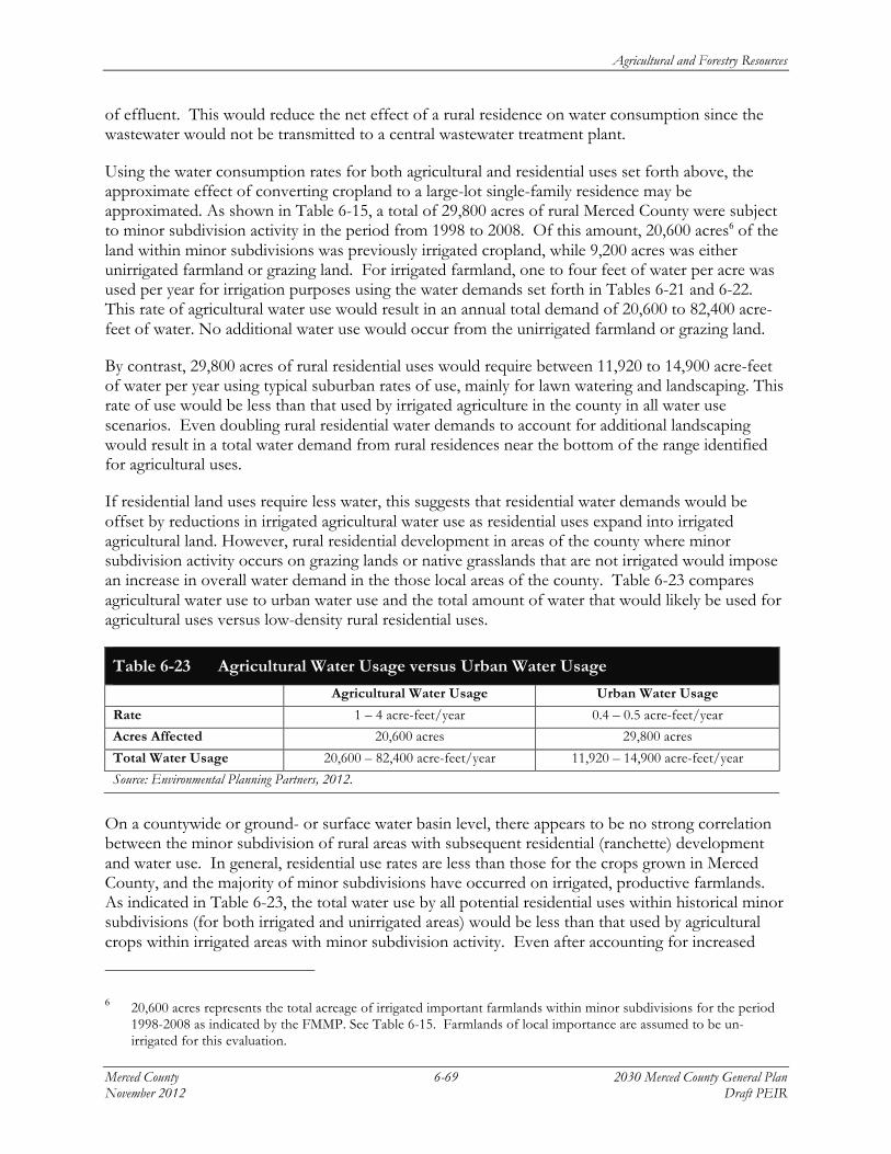
Agricultural and Forestry Resources
Merced County 6-69 2030 Merced County General Plan November 2012 Draft PEIR
of effluent. This would reduce the net effect of a rural residence on water consumption since the wastewater would not be transmitted to a central wastewater treatment plant.
Using the water consumption rates for both agricultural and residential uses set forth above, the approximate effect of converting cropland to a large-lot single-family residence may be approximated. As shown in Table 6-15, a total of 29,800 acres of rural Merced County were subject to minor subdivision activity in the period from 1998 to 2008. Of this amount, 20,600 acres6 of the land within minor subdivisions was previously irrigated cropland, while 9,200 acres was either unirrigated farmland or grazing land. For irrigated farmland, one to four feet of water per acre was used per year for irrigation purposes using the water demands set forth in Tables 6-21 and 6-22. This rate of agricultural water use would result in an annual total demand of 20,600 to 82,400 acre-feet of water. No additional water use would occur from the unirrigated farmland or grazing land.
By contrast, 29,800 acres of rural residential uses would require between 11,920 to 14,900 acre-feet of water per year using typical suburban rates of use, mainly for lawn watering and landscaping. This rate of use would be less than that used by irrigated agriculture in the county in all water use scenarios. Even doubling rural residential water demands to account for additional landscaping would result in a total water demand from rural residences near the bottom of the range identified for agricultural uses.
If residential land uses require less water, this suggests that residential water demands would be offset by reductions in irrigated agricultural water use as residential uses expand into irrigated agricultural land. However, rural residential development in areas of the county where minor subdivision activity occurs on grazing lands or native grasslands that are not irrigated would impose an increase in overall water demand in the those local areas of the county. Table 6-23 compares agricultural water use to urban water use and the total amount of water that would likely be used for agricultural uses versus low-density rural residential uses.
Table 6-23 Agricultural Water Usage versus Urban Water Usage
Agricultural Water Usage Urban Water Usage
Rate 1 – 4 acre-feet/year 0.4 – 0.5 acre-feet/year
Acres Affected 20,600 acres 29,800 acres
Total Water Usage 20,600 – 82,400 acre-feet/year 11,920 – 14,900 acre-feet/year
Source: Environmental Planning Partners, 2012.
On a countywide or ground- or surface water basin level, there appears to be no strong correlation between the minor subdivision of rural areas with subsequent residential (ranchette) development and water use. In general, residential use rates are less than those for the crops grown in Merced County, and the majority of minor subdivisions have occurred on irrigated, productive farmlands. As indicated in Table 6-23, the total water use by all potential residential uses within historical minor subdivisions (for both irrigated and unirrigated areas) would be less than that used by agricultural crops within irrigated areas with minor subdivision activity. Even after accounting for increased
6 20,600 acres represents the total acreage of irrigated important farmlands within minor subdivisions for the period
1998-2008 as indicated by the FMMP. See Table 6-15. Farmlands of local importance are assumed to be un-irrigated for this evaluation.

Agricultural and Forestry Resources
2030 Merced County General Plan 6-70 Merced County Draft PEIR November 2012
lawn and landscaped areas, rural residential water use would tend to be at the lower range of agricultural water use on a per-acre basis.
Minor subdivision with subsequent residential development in unirrigated areas could cause a localized increase in the amount of groundwater used, although at the level of a groundwater basin, the increase would not be noticeable as the groundwater basins7 that are located within or partially within the county contain from 14 million to 30 million acre-feet of storage.
Because the potential water use from rural residences within minor subdivisions would approximately equal or be less than the current crop usage for the same area, there would be no interference with agricultural irrigation on adjacent farms. This would be a less-than-significant impact.
Significance of Impact: Less than significant.
Mitigation Measure: None required.
Impact AG-7: Involve other land use changes that would resul t in convers ion o f farmland to
non-agr i cul tural uses due to inadequate parce l s izes .
Minimum agricultural parcels sizes with the implementation of the proposed 2030 General Plan could be insufficient to support continued agricultural operations, and thereby lead to the conversion of important farmlands to non-agricultural uses, or otherwise conflict with continued agricultural operations. Because the increase in the minimum parcel size from 20 acres under the 2000 Merced County General Plan to 40 acres under the 2030 General Plan would result in more efficient agricultural operations, this would be a less-than-significant impact.
The minimum parcel size established by the 2000 General Plan for areas designated as Agricultural is 20 acres. The Zoning Code additionally permits parcels less than 20 acres under certain circumstances. In summary, Zoning Code Section 18.02.030 maintains the following standards regarding minimum parcel sizes within agricultural zones. The full text of this section of the Zoning Code is set forth in Appendix C of this Draft PEIR.
C. Minimum Parcel Size Exceptions. No agriculturally zoned land may be divided or have the boundaries thereof adjusted for the purposes of sale, lease or financing, whether immediate or future, if any parcel resulting from the division or adjustment contains less than (20) acres in the A-1 zone, forty (40) acres in the A-1-40 zone, and one hundred sixty (160) acres in the A-2 zone as measured from the center of any abutting roadway, waterway, railroad or other public right-of-way forming a boundary line of the parcel, unless one of the following exceptions apply:
7 As discussed in Chapter 13, Hydrology and Water Quality, of this Draft PEIR, these basins are the Turlock, Merced,
Chowchilla east of the San Joaquin River, and the Delta-Mendota to the west of the River. For more information, see Chapter 13.
Agricultural and Forestry Resources
Merced County 6-71 2030 Merced County General Plan November 2012 Draft PEIR
1. When the property owner desires to retain a dwelling which has existed on the property for at least ten (10) years.
2. When the parcel is used as a security instrument for financing an agricultural operation or construction of a single-family residence.
3. When a boundary adjustment meets conditions regarding “antiquated subdivisions”. 4. For any boundary adjustment involving parcels in an antiquated subdivision, all adjusted
parcels must meet the minimum area requirement unless a zone variance is granted as part of a merger and re-subdivision approval in accordance with Section 17.04.074 of the County Code (Subdivision).
5. When the real property is being purchased by a utility or quasi-utility for use such as television or radio antenna sites, electric substation, power generation plant or other similar activity.
6. When a significant agricultural commercial and/or industrial facility has been approved by the County through an Administrative or Conditional Use Permit.
7. Where a parcel is located within an adopted urban boundary, including a specific urban development plan, and the property owner wishes to divide off an existing home from the balance of the property.
8. Where the property before the division meets conditions, a reduction of up to two and one-half percent in parcel area may be accepted.
By contrast, the 2030 General Plan sets forth a 40-acre minimum parcel size in areas designated as Agricultural. Policy AG-2.13: Minimum Agricultural Parcel Size Requirement, establishes the following standard:
Require 40 acre minimum permitted parcel size in areas designated Agricultural to discourage land divisions for rural residential purposes and maintain parcels large enough for efficient commercial agriculture production. Require 160 acre minimum permitted parcel size in areas designated Foothill Pasture and in grassland areas.
California Government Code Section 65860(a) requires that the Zoning Code section (18.02.030) as referenced above be amended from less than 20 acres to less than 40 acres to be consistent with 2030 General Plan Policy AG-2.13 if adopted.
USDA 2007 AGRICULTURAL CENSUS The 2007 Census of Agriculture sets forth the following statistics regarding farm size in Merced County:
Table 6-24 Merced County Highlights from the 2007 Census of Agriculture
Item Value Farms – number 2,607 Average size of farm – acres 399 Median size of farm – acres 40 Farms by size 1 to 9 acres 337 (12.9% of all farms) 10 to 49 acres 1,114 (42.7%) 50 to 179 acres 558 (21.4%) 180 to 499 acres 270 (10.3%) 500 to 999 acres 139 (5.3%)

Agricultural and Forestry Resources
2030 Merced County General Plan 6-72 Merced County Draft PEIR November 2012
Table 6-24 Merced County Highlights from the 2007 Census of Agriculture
Item Value 1,000 acres or more 189 (7.2%) Farms by value of sales Less than $2,500 509 (19.5% of all farms) $2,500 to $4,999 93 (3.6%) $5,000 to $9,999 110 (4.2%) $10,000 to $24,999 279 (10.7%) $25,000 to $49,999 286 (11.0%) $50,000 to $99,999 297 (11.4%) $100,000 or more 1,033 (39.6%) Principal operator by primary occupation Farming 1,551 (59.5% of all farms) Other 1056 (40.5%) Source: USDA, Agricultural Statistics Service, 2007 Census of Agriculture – County Data, Table 1, County Summary Highlights:
2007; December 2009. The most relevant statistics from the Census of Agriculture for the evaluation of minimum parcel sizes and their effect on continued agricultural operations are the following:
• The median8 farm size in 2007 in Merced County was 40 acres; • Over 44 percent of all farms in the county were larger than 50 acres in size; 12.9 percent were
less than 10 acres. If the acreage of farms within the 10 to 49 acre size class were evenly distributed, 616 farms (23.6 percent) would be less than 20 acres in size. Using the same assumption, 55 percent of all farms were 40 acres or larger in size.
• As shown in Table 6-9, approximately 56 percent of all farms were less than 50 acres in size; almost 13 percent were less than 10 acres in area. Making the same assumptions as above, 45 percent of all farms were less than 40 acres in size.
• The gross sales of 51 percent of farms within the county in 2007 were greater than $50,000. • Almost 60 percent of farm operators relied upon the farm as their primary occupation. • Assuming that operators for whom the farm was their primary occupation were also those
with the highest sales, and assuming that sales are evenly spread within sales categories, then approximately 60 percent of operators had 2007 sales of $30,000 or more.
• Assuming a linear relationship between sales and size of farm, then the size of farm necessary to permit a farm operator to rely upon the farm as a primary source of income was greater than 50 acres.
DATA FROM THE MERCED COUNTY AGRICULTURAL COMMISSIONER In August 2011, the MCAC began tracking crop and acreage data for farm operations that a current restricted materials permit, or that have obtained a permit in the past. As of March 2012, the data set was approximately 65 percent complete. Note that the data set is limited to those farms and fields where restricted chemicals are being, or have been, applied. Thus, the data does not typically identify lower value agricultural lands or those lands used for grazing. The following data sets forth 8 The median is a measure of the middle value of all the values in the data set; i.e., half of the values would be smaller
than the median, and half would be larger. Unlike the mean, or average, the median is less affected by values at the poles of the data set. For data with a wide range of values, such as income or farm size, median is often more accurate than mean.

Agricultural and Forestry Resources
Merced County 6-73 2030 Merced County General Plan November 2012 Draft PEIR
the mean and median parcel size by crop type, and the mean and median for all crop types. Because the total is calculated for all fields rather than by crop type, the relative proportion of an individual crop does not bias the totals. Table 6-25 sets forth the mean and median parcel size by crop type for the 12 most important field crops in Merced County.
Table 6-25 Average Field Size by Crop Type
Crop Type Mean Parcel Size Median Parcel Size Alfalfa 51.21 40.85 Almonds 64.18 37.00 Beans 48.50 40.00 Cantaloupe 53.09 47.00 Corn 50.08 39.70 Cotton 46.78 37.70 Grapes 83.81 76.75 Pistachios 105.77 70.00 Sweet Potatoes 32.41 20.00 Tomatoes 63.34 54.93 Walnuts 34.81 25.00 Wheat 558.64 41.00 Average for All Crop Types (with Agricultural Use Permit) 258.06 38.00 Note: Crop types listed include both fields/parcels with only the listed crop and crop fields with combinations of
primary crop and other row crops (wheat, beehives, etc.) Source: Merced County Agricultural Commissioner, March 2012.
The most relevant statistics from information provided by the MCAC for the evaluation of minimum parcel sizes and their effect on continued agricultural operations are the following:
• Except for sweet potatoes and walnuts, the median field size for all crops is greater than 35 acres in size. From this, it may be assumed that the median field sizes listed above are the most efficient and effective sizes for management of each crop.
• The median parcel size for all crops is 38.00 acres; approximately equal to the 2030 General Plan 40 acre minimum.
CONCLUSIONS – MINIMUM PARCEL SIZE Based on information from the Census of Agriculture and the County Agricultural Commissioner, it appears that the 40-acre minimum parcel size in areas designated for Agricultural uses by the 2030 General Plan would assure continued, efficient production for most important crops grown in the county. Although several specialty crops appear to be grown in fields of approximately 20 acres, a 40-acre minimum parcel size would not preclude the operational division of the parcel into two 20-acre fields. Conversely, a less than 40-acre minimum parcel size for areas where crops other than sweet potatoes or walnuts were grown would preclude the development of the most efficient field sizes for such crops.
Because the 2030 General Plan establishes a minimum 40-acre parcel size in areas designated for Agricultural uses, and the majority of important crops in the county are grown in fields of approximately 40 acres or larger, implementation of the 2030 General Plan would encourage continued agricultural production. For this reason, this impact would be less than significant.

Agricultural and Forestry Resources
2030 Merced County General Plan 6-74 Merced County Draft PEIR November 2012
Significance of Impact: Less than significant.
Mitigation Measure: None required