6. survey maps of the river clyde clyde map 1: craigendoran piers
TRANSCRIPT

6. SURVEY MAPS OF THE RIVER CLYDE
CLYDE MAP 1: CRAIGENDORAN PIERS to ARDMORE ISLAND Hinterland Geology and Coastal Geomorphology: Undifferentiated glacial tilloverlain by marine deposits dominate the hinterland. Remnants of a raised shorelineare also present. The coastline is irregular and wide expanses of mudflats are exposeddown to the MLWMST. Ardmore Island has an extensive former raised shoreline. At least two former raised shorelines are represented on Ardmore Island. The site isdesignated an SSSI according to its geological importance. The contact zone betweenthe Palaeozoic Upper and Lower Old Red Sandstone is represented and outcrops onthe north-west corner of the island. The c. 30m high cliff has a distinct wave-cutnotch at its base showing that this feature is an earlier shoreline that has risen wellabove the present beach level as a result of isostatic uplift. A sea cave is present atNS 3150 7873. The coastal edge in front of the cliff is heavily planted with estatewoodland. Erosion Class: This section of coastline was found to be undergoing coastal erosion.At Craigendoran Railway station and to the east, the sea walls protecting the railwayline are undergoing local erosion. The principal factors involved here are wave actionand scouring at the base of the weaker sandstone fabric associated with the olderashlar sea defences. Erosion is more active at the junction of the sandstone ashlarstonework and the more recent concrete seawall, especially where remedial repairs arefailing. The coastline near Ardmore Crossing (NS 3240 7930) is predominantly saltmarsh which is eroding. Building rubble has been dumped at one location where theerosion is close to a field. Built Heritage & Archaeology: The archaeology in this area is minimal above thehigh water mark. Within the intertidal area a large rectangular fish trap is present.The size of the trap suggests that this feature functioned as a small industry rather thanas an opportunistic venture. A ruined cottage overlooks the fish-trap and it is highlyprobable that at some period in the past the occupants of this site managed the fish-trap. Both broad and narrow rig is present at Ardmore and are in parts truncated bythe modern footpath and affected by coastal erosion. A small concrete shelter wasalso seen in the hinterland, badly deteriorated, and is associated with a WWII lookoutpost. The principal feature is the remains of a large fish trap situated on the north sideof the island. The interior of the above mentioned sea cave was found to be empty.In front of the entrance a large mound of spoil rich in midden material was seen. Thisis the remains of interior cave floor layers excavated in the 1960s and finds includedIron Age pottery.
FICL/876/0/27/7/04 99 of 219 CFA

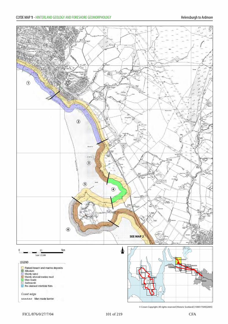
CLYDE MAP 1: HINTERLAND GEOLOGY AND COASTALGEOMORPHOLOGY __________________________________________________________________________________ 1. WEST OF CAIRNDHU POINT toCRAIGENDORAN PIERS
6. SOUTH SIDE OF ARDMORE ISLAND NS 3160 7830
NS 2770 8350 1.8km 4 km Low edge (<10m) Mainly sand Raised beach Low edge (<10m) Marine deposits and remnant fossil shoreline.Marine deposits Degraded cliff and exposed rock platforms. Tidal Devensian age marine deposits dominate with oldraised shoreline present some 0.5km inland. Seadefences with sand and shingle are exposed at lowwater.
mudflats on south side of the island. Mud flatsand shingle present.
2. CRAIGENDORAN PIERS to SEWAGEWORKS
NS 3200 8000 1.8 Mainly mud and sand Low edge (<10m) Marine deposits Marine deposits and outwash gravels present witha fossil shoreline. Irregular coastal edge. Wideintertidal sandflats and shingle.
3. SEWAGE WORKS NS 3200 8000 1.9km Mainly mud and sand Marine deposits Low edge (<10m) Irregular coastal edge. Wide intertidal sandflatsand shingle, more boulders present at MHWMSTthan in the previous unit.
4. NORTH EAST OF ARDMORE ISLAND NS 3250 7920 1km Mainly mud Low edge (<10m) Raised beach Marine deposits and remnant fossil shoreline.Degraded cliff and exposed rock platforms andtidal mudfalts on south side of the island.Saltmarsh gives way to mud and shingle atMHWMST.
5 NORTH SIDE OF ARDMORE ISLAND NS 3150 7900 1.8km Low edge (<10m)) Raised beach Marine deposits and remnant fossil shoreline.Degraded cliff and exposed rock platforms andtidal mudflats on south side of the island.
FICL/876/0/27/7/04 100 of 219 CFA
Helensburgh to ArdmoreCLYDE MAP 1 - HINTERLAND GEOLOGY AND FORESHORE GEOMORPHOLOGY
HELENSBURGH
DUMBARTON
CLYDEBANK
GREENOCK
ROTHESAY
0 1km0.5
Scale 1:25,000
LEGEND
1
2
3
4
5
6
SEE MAP 2
FICL/876/0/27/7/04 101 of 219 CFA
© Crown Copyright. All rights reserved [Historic Scotland] [100017509][2005]

CLYDE MAP 1: EROSION___________________________________________________________________________
1. WEST OF CAIRNDHU POINT toCRAIGENDORAN PIERS NS 2770 8350 4 km Accreting or stable This section of coastline is heavily defended bysea walls that protect Helensburgh. Sand andmud is accreting and the seawalls are lendingstability. 2. CRAIGENDORAN PIERS to ARDMOREISLAND NS 3200 8000 4Km Definitely eroding Parts of this section of coastline were found to beeroding. Up to 50m of cliff section are eroding atNS 3190 8015. A 30m tract of salt marsh isseverely eroding at 3120 7885. 3. ARDMORE ISLAND NS 3130 7860 1.8km Definitely eroding The western and southern parts of Ardmore Islandare undergoing erosion. The main problem hereis scouring at the MHWMST.
FICL/876/0/27/7/04 102 of 219 CFA

Helensburgh to ArdmoreCLYDE MAP 1 - EROSION CLASS
HELENSBURGH
DUMBARTON
CLYDEBANK
GREENOCK
ROTHESAY
0 1km0.5
Scale 1:25,000
LEGEND
1
2
3
SEE MAP 2
FICL/876/0/27/7/04 103 of 219 CFA
© Crown Copyright. All rights reserved [Historic Scotland] [100017509][2005]

CLYDE MAP 1: BUILT HERITAGE AND ARCHAEOLOGY___________________________________________________________________________________
Sites on the Coast Edge & Foreshore Sites on the Hinterland
2. CRAIGENDORAN PIERNS38SW 30 NS 3187 8130 Pier Fair 18th-20th AD Monitor 3. CRAIGENDORAN JUNCTION NS38SW 29 NS 3127 8117 Railway Station Good 18th –20th AD Nil 4. CRAIGENDORAN OLD SLIPWAY NS 3122 3122 Launch site 18th-20th AD Fair Nil 5. CRAGENDOREN OLD PIERNS 3120 8105Pier18th-20thADPoorNil
6. CRAIGENDOREN FISH-TRAP ?NS 3120 8105Fish-trap18th-20thADPoorSurvey 7. CRAGENDORAN SEA WALLNS 3143 8110 Sea defence Fair 18th-19th AD Nil 10. CARDROSSCOTTAGE (RUIN)NS 3196 8001Poor18th-20th ADMonitor
Listed Building (see Appendix 2)
1. Grouped entryHELENSBURGH4, 76, 78 KING STREET EAST Listed C(s)127 CLYDE STREET EAST Listed C(s)3 CRAIGENDORAN AVENUE Listed C(s)4-9 CRAIGENDORAN AVENUE Listed C(s)ROCKFORT LODGE Listed C(s)RIMSDALE AND TRAIGH-NA-MARA ListedC(s)QUEEN'S COURT Listed C(s)CROMALT HOUSE Listed BCROMALT COACH HOUSE AND STABLESListed BROCKLAND Listed AROCKLAND LODGE Listed BTIGH-NA-MARA Listed BTARANDOUN COTTAGE Listed C(s)ROCKFORT LODGE Listed BRIMSDALE AND TRAIGH-NA-MARA ListedC(s)QUEEN'S COURT Listed C(s)CROMALT HOUSE & STABLES Listed BROCKLAND Listed AROCKLAND LODGE Listed BTIGH-NA-MARA Listed BTARANDOUN COTTAGE Listed C(s)149-151 CLYDE STREET EAST Listed C(s)153 CLYDE STREET Listed C(s)165 CLYDE STREET Listed C(s)WILLOWBANK Listed C(s)82 AND 84 CLYDE STREET EAST Listed C(s)EAST BAY, PUBLIC SHELTER &LAVATORIES Listed C(s)104 AND 106 CLYDE STREET EAST ListedC(s)PRINCES STREET EAST Listed C(s)GIFFNOCK HOUSE Listed BST JOSEPH'S RC CHURCH Listed B121 CLYDE STREET EAST Listed BUncertain18th-20th CenUnknownNil
8. CAMIS ESKAN HOUSE & WALLEDGARDENNS38SW 26NS 3195 8125Listed C(s)Good18th-20th ADNil
FICL/876/0/27/7/04 104 of 219 CFA

MAP 1: BUILT HERITAGE AND ARCHAEOLOGY Continued__________________________________________________________________________________
Sites on the Coast Edge & Foreshore Sites on the Hinterland
11. CARDROSS FISH-TRAP NS 3162 7990 Fish-trap Poor 18th-20th ADSurvey
12. CARDROSSTRACKNS 3200 7970Old TrackPoor18th-20th ADNil
13. HILL of ARDMORE FISH-TRAPNS37NW 27NS 3161 7913Fish –trapPoor18th-20th ADSurvey
14. HILL of ARDMORE, RIG& FURROWNS 3158 7898Cultivation remainsPoor18th-20th ADNil
15. HILL of ARDMOREENCLOSURENS 3159 7898Livestock EnclosurePoor18th-20th ADNil
16 HILL of ARDMORE FISH-TRAP ?NS 3184 7895Fish-trapPoor18th-20th ADNil
17. ARDMORE POINT RIG &FURROW NS 3179 7891 Cultivation remains Fair 18th-20th ADMonitor
18. HILL of ARDMORECAVENS37 NW6NS 3150 7870Sea CaveFair4th Mil BC-1st Mill BCNil
19. HILL of ARDMORENS 3132 7852Boat NoostGood17th-20th ADNil
20. HILL of ARDMORENS 3141 7850Rig and FurrowPoor18th-20th ADNil
23. HILL of ARDMORENS 3132 7858Boat NoostGood17th-20th ADNil
24. HILL of ARDMORENS 3144 7839Pill-boxPoorWW2Monitor
25. HILL of ARDMORENS 3150 7840Rig and FurrowGood17th-20th ADNil
26. HILL of ARDMORENS 3190 7821JettyPoor18th-20th ADNil
9. CAMIS ESKAN HOUSE,EAST LODGENS38SW 25NS 3235 8030Listed C(s)Good18th-20 ADNil
21. HILL of ARDMORESAM 5464NS 315 785TowerGood18th-20th ADNil
22. CARDROSS ARDMOREHOUSENS37NW 13NS 3214 7864Listed BResidenceGood18th-20th ADNil
29. MOORPARK HOUSENS37NW 36NS 3247 8143Listed BResidenceGood18th-20th ADNil
FICL/876/0/27/7/04 105 of 219 CFA

MAP 1: BUILT HERITAGE AND ARCHAEOLOGY Continued__________________________________________________________________________________
Sites on the Coast Edge & Foreshore Sites on the Hinterland
27. HILL of ARDMORENS 3224 7830Ballast dump/Fish-trapFair17th-20th ADNil
28. CARDROSSNS 3268 8260WreckPoor20th AD Nil
FICL/876/0/27/7/04 106 of 219 CFA

Helensburgh to ArdmoreCLYDE MAP 1 - BUILT HERITAGE AND ARCHAEOLOGY
HELENSBURGH
DUMBARTON
CLYDEBANK
GREENOCK
ROTHESAY
0 1km0.5
Scale 1:25,000
LEGEND
FICL/876/0/27/7/04 107 of 219 CFA
© Crown Copyright. All rights reserved [Historic Scotland] [100017509][2005]