6.3 existing parks/schools/civic activ 6.4 trip
TRANSCRIPT

Trip Destination Analysis
Several other major employment centers occur in the adjoining communit ies of San Marcos, Vista and Oceanside. Several are close enough to the City of Carlsbad to warrant consideration in this study. They all tend to be accessible along major roadways that connect them with Carlsbad.
6.3 Existing Parks/Schools/Civic Activity Centers Considering the parks and schools independently ofthe other activity centers is intended to emphasize the more local, neighborhood and recreational functions of these centers. Like most communities, Cadsbad's parks and athletic facilities are often associated with the school sites. These centers are used by a much higher percentage of children than the other types of activity centers, which is an important factor in community-wide bicycle facility design. The location of schools, in particular, is a major factor in identifying safe bicycle routes because bicycling has traditionally been an important transportation mode for elementary and middle school age children. (See Figure 6-2, Activity Centers.)
Analysis of the locations of Carlsbad's schools indicate that they are all adjacent to residential areas with quiet streets. However, Carlsbad's schools are no different than any other city's schools in that they are in close proximity to at least one major street. Fortunately, the schools
and the residential neighborhoods they serve tend to fall on the same side ofthe major streets. Therefore, the schools' primary bicycling access is likely to be from the surrounding residential streets that al low children access to their schools without having to ride on the busier streets and minimizes their having to cross them.
6.4 Trip Destinations Summary Schools and parks are the most common bicycling destinations, followed by commercial, retail and employment centers. This is likely to hold true in Carlsbad as well. The schools will draw users from the immediate residential area of up to approximately a mile, which is the typical maximum distance that most children can be expected to want to ride. The major commercial centers such as downtown Carlsbad and the area around Palomar Airport, the retail complexes at the northern end of Carlsbad and several smaller ones scattered elsewhere throughout the central portion ofthe city can also be expected to be popular destinations, and will typically draw users from farther away than the schools.
There are always special destinations that are characteristic of a particular community. In Cadsbad these special destinations include the beaches and coastal strip and, where access is available, the lagoons. These areas also comprise the more level coastal portions of Carlsbad where cycling is easier, making them desirable destinations for visitors as well as residents. Typically, the coastal strip has higher levels of bicycle use than any other part of the city, especially for recreational and exercise cycling. Like the visitors who ride the coastal strip at a more casual pace, many of the exercise cyclists are not Carlsbad residents. They typically pass through Carlsbad as part of a loop training ride on Carlsbad Boulevard. The coastal north San Diego County area is well known as a center for competitive athletic training, especially for cyclists and triathletes. Because of its attractiveness for cycling of various types, the coastal portion of Carlsbad should be considered a destination in itself.
Parks are important destination points, though they tend to serve the immediate community and do not generate longer distance bike commuting trips.
Page 6-2 Chapter 6

Draft Carlsbad Bike Facility Master Plan
EMPLOYMENT DENSITY CITY OF CARLSBAD BIKEWAY MASTER PLAN
Figure
6-1
© Major Employer frk
- 1 1 Under 1 Person 1 -5 ! \
1 I H 5-10 - j^ 10-15 ~\L
15-20
I H i over 20 people
'numbers denote housing per acre by MGRF unit
July 2001
1 Miles
Chapter 6 Page 6-3

Draft Carlsbad Bike Facility Master Plan
ACTIVITY CENTERS CITY OF CARLSBAD BIKEWAY MASTER PLAN
Figure
6-2
Agua Hedionda Lagoon
CARLSBAD
Batiquitos Lagoon
July 2001
1 Miles
Chapter 6 Page 6-5

7-MULTI-MODAL ANALYSIS
The efficiency of bicycle transportation, especially for commuting, can be enhanced by connecting the bicycle facility system with other modes of transportation Cyclists can use their bicycles to get to or from a multi-modal transfer point as part of their regular commute Where transit modes allow bicycles on board, multi-modal transit becomes a very useful transportation option Whether the other modes allow bicycles to be brought on board or not, they allow for much greater flexibility for persons choosing to commute by modes other than the private automobile In the case of Carlsbad, only the frequent-stop local bus routes do not provide a way to take bicycles along The coastal and express buses employ outside bicycle racks and the Coaster commuter rail trains provide interior space for bicycles
71 North County Transit District Though the coastal strip and northwestern Carlsbad are well served by North County Transit District (NCTD) bus routes on arterials and local streets, the central portion of the city IS served primarily by routes on major arterials, and the southeastern sector has few routes or stops This pattern tends to reflect both the topography and the housing density of each area The northwestern and coastal sectors have concentrations of both housing and employment and gentle land form The central sector has little housing, but does contain the majority of Carlsbad's major employers Bus routes do tend to serve the areas of highest employment density, which are generally situated along the major arterials The southeastern sector's dispersed, low density residential development pattern and relatively steep grades probably preclude the efficient implementation of mass transit
The bicycle rack-equipped routes are local route 301 with several stops along the coast on Carlsbad Boulevard, express route 310 which runs from Oceanside to University Towne Center on 1-5 with stops at Carlsbad Village Drive, the Plaza Camino Real shopping com plex and La Costa Avenue, and express route 320 which runs from Oceanside to Escondido and stops at Plaza Camino Real Each bus can carry up to four bicycles
N C T D also provides Coaster commuter tram service from Oceanside to downtown San Diego, with two stops in Carlsbad One is at Carlsbad Village Station in downtown Carlsbad between Grand Avenue and Carlsbad Village Drive and the second at Poinsettia Station near Poinsettia Lane between 1-5 and Carlsbad Boulevard on Avenida Encinas The Coaster tram service allows cyclists to bring bicycles on board without restriction Each car has space for several bicycles (See Figure 7-1, Transfer Points )
7 2 AMTRAK The AMTRAK train stops closest to Carlsbad are immediately to the north in Oceanside and in Solana Beach to the south The Oceanside stop is at the Oceanside transit center, and is the closest and probably the most convenient access for Carlsbad residents It also serves as a transfer point for Greyhound Bus Lines, Metrolink commuter trains providing service from Oceanside and points north and NCTD's Coaster commuter tram serving Oceanside to downtown San Diego AMTRAK allows bicycles on board trains as checked baggage only AMTRAK IS less likely to be used for daily bicycle-related commuting since Coaster service now provides convenient and more complete commuter rail service to Oceanside and points south to downtown San Diego
7 3 Existing Park and Ride Facilities There is only one official park and ride facility in Carlsbad, in far south Carlsbad just east of 1-5 at La Costa Avenue near the south shore of Batiquitos Lagoon (See Figure 7-1, Transfer Points ) Though it is not within Carlsbad's city limits, there is a park and ride lot immediately north of Carlsbad in Oceanside at 1-5 and SR 78
Within Carlsbad, the parking lot at the Poinsettia Station IS large enough to accommodate a park and ride function and is virtually never full Especially since the station IS guarded, it could be used as a park and ride lot, even if it is not officially recognized as such
Bus stops and transit stations can become important multimodal links if bus bicycle racks and on site bicycle lockers are provided

Multi-Modal Analysis
7 4 Existmg Transit Centers There are two transit centers in Carlsbad One is the Cadsbad Village Station in downtown Carlsbad It is served by the Coaster commuter tram and three bus routes, one of which is equipped with bicycle racks The second ts at the Plaza Camino Real retail complex at SR 78 and El Camino Real served by nine bus routes, two of which are bicycle rack-equipped express routes Finally, although not officially recognized as a transit center, the Poinsettia Station is also a Coaster stop and IS served by one bus route which does not provide bicycle racks Bicycle parking at these transit centers consist of both bicycle lockers and racks (See Figure 7-1, Transfer Points )
7 5 Transfer Point Summary The northwestern sector of Carlsbad is served by numerous local bus routes and transit centers at the Carlsbad Village Station and the Plaza Camino Real retail complex Coastal Carlsbad is served by a local bus route along Carlsbad Boulevard and another one along the east side of 1-5 that also accesses the Poinsettia Station, one of two commuter rail stations The remainder ofthe city, comprised ofthe central and southeastern portions of Carlsbad, is served by only two bus routes, one running from Oceanside to Encinitas on El Camino Real and the other from San Marcos to Encinitas on Rancho Santa Fe Road Neither of these routes employs buses equipped with bicycle racks
Secure bike locker facilities are important elements for those cyclists who will not be taking their bicycles aboard buses or commuter rail trains
The Coaster commuter rail system represents an important multi-modal link for cyclists because its trams provide space for bikes on board
Page 7 2 Chapter 7

Carlsbad Bikeway Master Plan
TRANSFER POINTS CITY OF CARLSBAD BIKEWAY MASTER PLAN
Agua Hedionda Lagoon
Babquitos Lagoon
ENCINITAS
July 2001
1 Miles
Chapter 7 Page 7-3

Safety is a pnmary concern in evaluating an existing bicycle facility system or in proposing new facilities or extensions The primary lesson learned from the literature reviewed for this bicycle master plan and others is that installation of bicycle facilities without careful consideration of their specific attributes and drawbacks can actually exacerbate already problematic safety situations This IS particularly true for facilities that are likely to be used by other types of users such as walkers, runners and skaters, in addition to cyclists Well-designed, attractive, off street bicycle facilities tend to become mixed use facilities and the other user types do not move with the relative predictability of vehicles On the other hand, even though they move with more predictability, cyclists using on-street facilities must contend with the omnipresent automobile Safety concerns vary considerably depending on the type of bicycle facility
Safety is reviewed in the following sections through applicable literature, examination of user types and capabilities, analysis of bicycle/roadway compatibility, suitability of specific roadways for cycling, specific problem intersections and user questionnaires
8 1 Literature Review Several references that highlighted the design and safety aspects of bikeway systems were reviewed for this portion of the study A review of the titles and subtitles should reveal that cyclists are not being considered the exclusive users of bicycle facilities These publications included comprehensive literature reviews, technical design criteria and case studies
• Bicycle Transportation - A Guide for Cycling Transporta tion Engineers Second Edition, John Forester
• Guide for the Development of Bicycle Facilities American Association of State Highway and Transportation Officials (AASHTO)
• Bicycle Blueprint - A Plan to Bring Bicycling into the Mainstream in New York City, Transportation Alternatives
• Pedestrian and Bicyclist Safety - A Review of Key Programs and Countermeasure Developments During the 1980's, University of North Carolina Highway Research Safety Center
• The National Bicycling and Walking Study Transporta tion Choices for a Changing Amenca U S Dept of Trans portation. Federal Highway Administration
• Technical Handbook of Bikeway Design - Planning, De sign. Implementation, Second Edition, Velo Quebec, Ministere des Transports du Quebec
8 2 User Types and Capabilities Users can be classified using a number of critena including the cyclists' ages, their cycling experience and physical condition, for examples, to come up with a profile of the types of users expected to make use of a particular bikeway system Such a user classification is very useful for bikeway planning purposes
8 2 1 User Classification The Amencan Association of State Highway and Transportation Officials (AASHTO) is developing a revised edition of their widely used Guide for the Development of Bicycle Facilities A recently publicized excerpt from the new edition is a cyclist classification system designed to be used as a guide to assist in the selection of appropriate facilities The classification system is as follows
• Group A Advanced Bicyclists (Experienced) Group A bicyclists fall into two categories, commuting/utility and sports /touring
• Croup B - Basic Bicyclists (casual, novice, occasional, recreational)
• Group C Children (preteen)
AASHTO estimates that only about 5% of the cycling population are experienced cyclists Though there are no data to support this estimate, this is probably accu rate enough for general use in the United States However, north coastal San Diego County may have a considerably higher percentage of experienced cyclists than other areas ofthe country due to locally favorable topographic, climatic and economic conditions The actual number of expenenced cyclists is probably not verifi able, but this likely higher percentage should be kept in mind during planning and design of any future bicycle facilities in Carlsbad They may be responsible for more than half of bicycle facility use during certain periods, especially along the coastal strip from communities north and south of Carlsbad Even so, it should be noted that the majority of cyclists are not experienced
AASHTO states that, in most circumstances. Group B and Group C cyclists can be combined However, Group C cyclists are much more likely to ride almost daily, and especially to ride bicycles to and from schools during mornings and afternoons most ofthe year This would also include Group B teens The majority of Group B adult cyclists are more likely to ride on weekends and some evenings during the summer since they are more likely to be riding for recreation rather than for commuting More importantly, the groups also tend to ride on different types of streets Group C cyclists tend to stay in residential areas, while Group B cyclists will tend to ride on busier streets if there is sufficient width and bike lanes Parents will usually not allow their young

Safety Analysis children to ride on busy streets, even ones with bike lanes Group A cyclists are accustomed to riding on busy streets, with or without bike lanes
Experience level tends to determine whether an adult is a Group A or Group B cyclist Perhaps one way to distinguish between Group A and Group B cyclists is to observe where they wait for a signal to change at intersections Experienced, Group A cyclists tend to stay far enough to the left of the curb lane to allow nght turning motor vehicles to safely go by on their right When the I ight changes, they steer directly for the right side of the curb lane across the intersection This keeps them m direct view of motorists who are also proceeding straight through the intersection and gets them out of these motorists' path as quickly as possible Since the motorists are starting forward from a standstill, the risk of injury IS minimal Inexperienced, Group B cyclists tend to hug the curb, putting them at risk of vehicular traffic turning right across their paths
Typical bicycle facility system users tend to reflect the AASHTO group categories, though individuals of differ ent groups may choose to ride together, such as when adult parents (Group B) ride with their children (Group C) This combination probably occurs frequently, especially on weekends, but as the AASHTO study author said, these two groups can be combined, making them functionally one group
For this study, bicyclists are classified by AASHTO group However, since it is likely that any Class 1 bicycle facility will attract users other than cyclists, this study tends to regard bicycle paths as multi-use that will also be used by skaters, joggers, recreational and exercise walkers Experience has shown this to be the case, and unless the numbers of users become excessive, this mixed use IS acceptable This mixing of uses tends to occur primarily on paths with relatively benign grades Experienced cyclists who prefer to travel at higher speeds tend to avoid Class 1 facilities that attract other types of slower users in favor of less traveled, more challenging routes, mcluding those with significant hills, usually Class 2 or 3 (See Figure 8-1, User Classification )
8 2 2 User Capabilities Typical user capabilities vary considerably depending on age, experience and physical conditioning Figure 8-1, Bikeway User Classification, summarizes the average speeds and distances of which specific user types are generally capable Note that these averages vary widely within the cyclist groups, and within the non-cyclist user types Skaters' speeds closely approximate cyclist speeds, for instance, while recreational walkers move considerably slower than cyclists It should be noted that speed and maneuverability are inversely proportional
Another crucial aspect of user capability is expenence, which can also be defined as knowledge of appropriate traffic behavior or roadway aptitude This factor is not as tangibly measured as physical capabilities, but it is no less important It can probably be assumed that Group A cyclists are far more knowledgeable about appropriate traffic conduct than other cyclists and are likely to be the most attentive users due to long term roadway expenence However,ibicycle facility design and planning must also take into account the other end of the spectrum, meaning not only the much larger numbers of Group B and Group C cyclists, but also the skaters, joggers and walkers that are likely to use a facility These users can represent all levels of experience and, therefore, all levels of roadway aptitude
8 3 Bicycle/Roadway Compatibility Analysis Another aspect of bicycle facility system safety is the compatibility of specific roadway configurations and roadway conditions with bicycling The existing bikeway system and other potential additions were reviewed for compatibility in terms of problems that have typically been encountered in similar situations in other cities and the specific problems encountered during field investigation in Carlsbad
8 3 1 Typical Roadway/Intersection Conflicts There are a number of different types of conflicts that can occur between motor vehicles and bicycles In many of the cases to be discussed in this section, fault lies with the motorist's failure to see and rightfully yield to the cyclist In other cases, some of these conflicts occur because the cyclist does not rightfully yield to the motor vehicle In either case, the cyclist is bound to suffer the most from the encounter
The first class of conflicts are those that occur while motor vehicles or bicycles are turning at intersections (See Figure 8-2, Controlled Intersection Conflicts ) Many of the scenarios illustrated in the graphic occur where vehicular turning motions catch cyclists unaware because they assume the motorist sees them and expect the vehicle to yield The motorists involved in these scenarios, in many cases, did not see the oncoming cyclists or misjudged the cyclists' speed Many motorists that do not ride bicycles do not realize how fast a bicycle can go, nor that cyclists have equal vehicular rights and responsibilities under California law
Note that several of these accident scenarios (C4-C7) occur at high speed large radius right turn intersections Safety experts generally agree that this configuration is not at all conducive to safe cycling or walking because It encourages motorists to maintain relatively high speeds
Page 8 2 Chapter 8

Carlsbad Bikeway Master Plan
B I K E W A Y U S E R C L A S S I F I C A T I O N CITY OF CARLSBAD BIKEWAY MASTER PLAN
Typical Ages
Preferred Facility
Typical Usage
Days per Speed Average Typical Origins Week Range Distance and Destinations
OQ 6 16
Sidewalks, trails, quiet
streets, flat terrain
(Class I)
Early weekday mornings and
afternoons, weekends
5-6 4 8 mph
1 2 miles
Residences, schools, parks,
open space, retail centers
3 ^T-
o < n Li
18 55
Streets, bike lanes, direct
arterial routes (Class 11 & III)
Early weekday mornings and late afternoons
4 6 10-20 mph
3-20 miles
Fam
ily
Rec
reat
ion
al
(AA
SH
TO
G
rou
p B
/C)
Weekends, occasional 1
early evenings
5 10 mph
2 4 miles
Residences, parks, open space
Fam
ily
Rec
reat
ion
al
(AA
SH
TO
G
rou
p B
/C)
Ad
ult
Exe
rcis
e (A
AS
HT
O
Gro
up
B)
^ L J I Quiet streets 25 65+ scenic trails
Weekends, occasional •] 2
early evenings 8-15 mph
5 20 miles
Residences, parks, open space,
coastal routes
Residences, employment
centers, retail centers
18-55+
Arterials, flat or hilly circuitous
routes (Class II & III)
Weekday mornings and late afternoons,
weekends
2 5
Residences 12-25 20-75 (Rides typically mph miles onginate or extend
outside city)
V)
a; rs Mi 16 45
Quiet streets paved trails, flat terrain
(Class I)
Weekends, occasional
early evenings 1 2
5 15 mph
2 5 miles
Residences, schools, parks, coastal routes
o A 18 55 Sidpwalks ^^'''y weekday bidewa ks mornings and , .
scenic trai s, fla ^^^^ afternoons, ^ 6 terrain (Class I) weekends
5 9 mph
3 5 miles
Residences, parks open space
coastal routes
re £ <« o res u re 16 70+
Sidewalks, Scenic trails, flat terrain
(Class I)
Weekday mornings and late afternoons,
weekends
2 5 3 5 mph
1-2 miles
Residences, parks, retail centers,
coastal routes
01 X
UU >
16 70+
Sidewalks, scenic trails, flat terrain
(Class I)
Weekday mornings and
late afternoons weekends
2 5 4-7
mph 2-4
miles
Residences, parks, open space,
coastal routes
Chapter 8 Page 8 3

Safety Analysis
C O N T R O L L E D INTERSECTION CONFLICTS CITY OF CARLSBAD BIKEWAY MASTER PLAN
C l • Vehicular right turn across bike lane C2 • Vehicular left turn from oncoming traffic C3 • Vehicular nght turn from perpendicular roadway C4 • Vehicular left turn into bicycle exiting a wide radius right turn C5 • Vehicular high speed right tum overtaking straight-through cyclist prior to intersection C6 • Inadequate high speed exit lane passing width C7 • Vehicular high speed right turn into cyclist at intersection
Page 8-4 Chapter 8

Carlsbad Bikeway Master Plan
entering and exiting the intersection This type of movement also encourages the motorist to pay attention to traffic approaching on the left, ignoring pedestrians or cyclists on the right This endangers cyclists both turning or proceeding straight through the intersection This configuration is unsafe for walkers for the same reasons and because it creates a much wider crossing than a standard intersection Redesigning the islands to slow motor vehicle traffic or installing stop signs would improve both bicycle and pedestrian safety
The second major class of conflicts are those that occur at points where motor vehicles can enter or exit the roadway at other than established intersections, such as at curb cuts or freeway ramps Once again, many of these
Right turns across bike lanes are perhaps the most common safety problem These turns occur at intersections as well as non intersection curb cuts
can occur when the motorist fails to see and yield to the cyclist (See Figure 8-3, Uncontrolled Non-Intersection Conflicts) These scenarios are similar to those that can occur at intersections, but those at freeway ramps can be even more devastating to the cyclist because the vehicle may be moving faster than it would at a controlled intersection Accidents can and do occur due to the negligence of the cyclist, but of all six conflicts illustrated in this graphic, only the third one (U3) is most likely the fault of the cyclist
The third class of conflicts are those that occur along roadway segments away from intersections Though the majority of accidents occur at intersections and they are generally the most severe, cyclists can and do get hurt on roadway segments away from intersections (See Figure 8-4, Roadway Segment Conflicts) Most of Carlsbad's arterials are ideal for cyclists in terms of curb lane widths and the limited number of curb cuts However, there is the possibility of a motor vehicle drifting into the bicycle lane at high speed, though this is extremely rare
Note that three of these conflicts involve parked vehicles (R1-R3) Vehicular parking along bicycle routes is generally unsatisfactory in terms of safety, but some types of parking are more problematic than others Vehicles illegally parked on the bicycle route itself (RI) or parallel parking with its inherent door opening conflicts (R3) are still probably not as dangerous as angled parking (R2) This IS because a motorist leaving an angled parking space IS unable to see the approaching cyclist due to the adjacent vehicles Conflict R5 (vehicle backing out of driveway) is very similar to R2 when on-street parking is present Finally, R5 (vehicle overtaking cyclist with inadequate passing width) can occur on bndges where the roadway often narrows
8 3 2 Roadway Segment Suitability Equation A major project task was evaluating all the bicycle facilities in Carlsbad for their suitability for cycling use The evaluation method was published in an American
Angled parking adjacent to bike lanes creates a safety problem since leaving parking spaces requires the driver to back into the bike lane with a substantial blind spot
Temporary stopping or parking in bike lanes is common in areas with limited parking such as along the beach
Chapter 8 Page 8 5

Safety Analysis
m UNCONTROLLED NON-INTERSECTION CONFLICTS CITY OF CARLSBAD BIKEWAY MASTER PLAN
U l • Overtaking vehicle turning right into curb cut
U2 • Vehicular right or left turn from curb cut across bike lane
US • Bicycle left turn to curb cut U4 • Oncoming vehicle left turn to
curb cut U5 • High speed vehicular merge
lane from off-ramp U6 • High speed vehicular merge
to on-ramp
Page 8-6 Chapter 8

Carisbad Bikeway Master Plan
R O A D W A Y
m S E G M E N T C O N F L I C T S
CITY OF CARLSBAD BIKEWAY MASTER PLAN
RI • Vehicles parked in bicycle lane R2 • Vehicle backing out of angled parking space R3 • Vehicle opening door or pulling out of parallel parking space R4 • Overtaking vehicle drifting into cyclist R5 • Vehicle backing out of driveway R6 • Vehicle overtaking cyclist with inadequate passing width
Chapter 8 Page 8 7

Safety Analysis
Society of Civil Engineenng (ASCE) journal that described an equation developed specifically to quantitatively rate roadway segment bicycle suitability Like conventional subjective evaluation methods, each route was first divided into segments based on how each section differed from those at either end of it For examples, changes in the number of lanes, the posted speed limit or the type of bicycle facility warranted designating a section of roadway as a segment
Once the individual segments were designated, each was field surveyed by bicycle and at least once by car Specific observation items were recorded within each segment including the presence or absence of bicycle facilities, the posted speed limit, the number of travel lanes, the estimated outside lane width, and the presence of specific paving and roadway conditions that could adversely affect cycling, such as rough paving or steep grades
After the specific roadway segment observations were noted and compiled, they were incorporated into the equation designed to define each segments' suitability for cycling The observation items were plugged into the equation as coefficients which then yielded a numerical value that defined the cycling suitability of the particular roadway segment The equation is given below, followed by an explanation of the coefficients
Cycling Suitability = ADT / (L x 2500) + S / 35 + (14 W) + PF + LF
• ADT Average Daily Trips - Number of motor vehicles traveling both ways on a particular segment during an average 24 hour period Data acquired from SANDAG
• L Travel lanes Number of travel lanes both ways
• S Posted Speed Limit Posted vehicular speed limit
• W Outside Lane Width Estimated curb lane width in feet coded as good (12' or greater) fair (11'), and inad equate (less than 11')
• PF Pavement Factors - Subjective evaluation of local ized pavement problems such as cracks or potholes (See Figure 8-5, Roadway Segment Suitability Rating Example)
• LF Location Factors Subjective evaluation of problems or advantages specific to location such as parallel park ing or paved shoulders (See Figure 8 5 Roadway Segment Suitability Rating Example)
The quantitative values represented by the first four variables listed above had to be plugged into the equation in a specific manner and therefore had substantial effects on the resulting calculations The last two variables, pavement and location factors, were subjective and their values were simply added on at the end ofthe equation, giving them less weight than the other van
ables in the results Even so, the equation was almost completely quantitative because even these last two variables were succinctly defined, generally by their presence or absence They contributed a positive or negative fractional number to the segment rating The lower the score a segment received, the better its bicycle suitability The numerical scores and their meaning are as follows
• Excellent Less than 1 Extremely favorable for cycling
• Good 1 to 4-Conducive to cycling, but with minor drawbacks Group A cyclists are generally not affected by these drawbacks
• Fair 4 to 7 Marginal desirability for Group A cyclists Not recommended for Group B or C cyclists
• Poor Greater than 7 - Generally not recommended for cycling
The equation was tested on a number of different types of segments to verify a rating scale The equation's "quantitativeness" meant that it could be applied in southern California with minimal modification, even though it was developed in Georgia The modifications that were made involved adding factors specific to Carlsbad or removing others specific to Georgia Once verified, the observation values from all segments were incorporated into the GIS data base for Carlsbad to produce a roadway map coded by cycling suitability (See Figure 8-5 for an example of the rating forms Appendix A contains rating forms for all segments evaluated ) Assuming certain variables such as expected ADT, for example, could be fixed in advance, it is possible that the suitability of future roadways could be predicted using this equation
8 3 3 Roadway Segment Suitability Analysis The roadway segment analysis generated a map portraying Carlsbad's major roadways in terms of bicycle suitability It was evaluated in comparison to field experience and questionnaire responses (See Figure 8-6, Roadway Segment Suitability)
The majority of Carlsbad's major roadway segments received a "fair" rating, followed by a significant number rated as "good" and a few rated as "poor" Only one short segment received a rating of "excellent " This rating reflects the scoring method that weighted the model results toward the middle of the scale Carlsbad's existing roadways actually fared quite well when rated by this bicycling suitability model
The primary reason that the vast majority of Carlsbad's major roadways received a rating of "fair" in the bicycling suitability model was not that there is something fundamentally or physically wrong with most of the city's
Page 8-8 Chapter 8

Carlsbad Bikeway Master Plan
ROADWAY SEGMENT SUITABILITY RATING EXAMPLE
CITY OF CARLSBAD BIKEWAY MASTER PLAN
Bicycle Suitability Rating Formula = ADT/(L X 2500) + S/35 + (14 - W) + PF + LF
Street Cannon Road Segments
Suitability Factors Factor Descriptions and Values 1 2 3 4 5
Existing Bicycle Facilities Multiple use Class 1, II or III 2 2
Posted Speed Limit (S)* Posted speed limit in miles per hour (mph) 35 35 35
Traffic Volume (ADT)* Average daily trips (ADT) 7400 1 7400 8900
Travel Lanes (L)* Number of travel lanes both ways 2 4 1 4
Outside Lane Width (W)* Lane width good (12 ) fair (11') or inadequate (<11') 11 12 12
Pavement Factors (PF)* Curb and gutter
Patched or weathered paving
Cracked paving
Moderate frequency of curb cuts
Rough RR crossing
High frequency of curb cuts
Drainage grates
Potholes or rough pavement edges
0 25
0 25
0 50
0 50
0 50
0 75
0 75
0 75
/ / / Curb and gutter
Patched or weathered paving
Cracked paving
Moderate frequency of curb cuts
Rough RR crossing
High frequency of curb cuts
Drainage grates
Potholes or rough pavement edges
0 25
0 25
0 50
0 50
0 50
0 75
0 75
0 75
Curb and gutter
Patched or weathered paving
Cracked paving
Moderate frequency of curb cuts
Rough RR crossing
High frequency of curb cuts
Drainage grates
Potholes or rough pavement edges
0 25
0 25
0 50
0 50
0 50
0 75
0 75
0 75
Curb and gutter
Patched or weathered paving
Cracked paving
Moderate frequency of curb cuts
Rough RR crossing
High frequency of curb cuts
Drainage grates
Potholes or rough pavement edges
0 25
0 25
0 50
0 50
0 50
0 75
0 75
0 75
Curb and gutter
Patched or weathered paving
Cracked paving
Moderate frequency of curb cuts
Rough RR crossing
High frequency of curb cuts
Drainage grates
Potholes or rough pavement edges
0 25
0 25
0 50
0 50
0 50
0 75
0 75
0 75
Curb and gutter
Patched or weathered paving
Cracked paving
Moderate frequency of curb cuts
Rough RR crossing
High frequency of curb cuts
Drainage grates
Potholes or rough pavement edges
0 25
0 25
0 50
0 50
0 50
0 75
0 75
0 75
Curb and gutter
Patched or weathered paving
Cracked paving
Moderate frequency of curb cuts
Rough RR crossing
High frequency of curb cuts
Drainage grates
Potholes or rough pavement edges
0 25
0 25
0 50
0 50
0 50
0 75
0 75
0 75
Curb and gutter
Patched or weathered paving
Cracked paving
Moderate frequency of curb cuts
Rough RR crossing
High frequency of curb cuts
Drainage grates
Potholes or rough pavement edges
0 25
0 25
0 50
0 50
0 50
0 75
0 75
0 75
Total Pavement Factor
Location Factors (LF)* Typical Section Factors
Moderate grades
Frequent vert curves (poor sight dist)
Frequent hor curves (poor sight dist)
Uncontrolled right turn lanes
Severe grades
Center turn lane
Median present
Paved shoulder
Roadway and Parking Factors
Moderate level of off street parking
High level of off street parking
On street parallel parking
On street angled parking
On street truck parking
Little or no adjacent parking
Typical Section Factors
Moderate grades
Frequent vert curves (poor sight dist)
Frequent hor curves (poor sight dist)
Uncontrolled right turn lanes
Severe grades
Center turn lane
Median present
Paved shoulder
Roadway and Parking Factors
Moderate level of off street parking
High level of off street parking
On street parallel parking
On street angled parking
On street truck parking
Little or no adjacent parking
0 25
0 25
0 25
0 25
0 50
0 25
0 25
0 75
/
Typical Section Factors
Moderate grades
Frequent vert curves (poor sight dist)
Frequent hor curves (poor sight dist)
Uncontrolled right turn lanes
Severe grades
Center turn lane
Median present
Paved shoulder
Roadway and Parking Factors
Moderate level of off street parking
High level of off street parking
On street parallel parking
On street angled parking
On street truck parking
Little or no adjacent parking
0 25
0 25
0 25
0 25
0 50
0 25
0 25
0 75 /
Typical Section Factors
Moderate grades
Frequent vert curves (poor sight dist)
Frequent hor curves (poor sight dist)
Uncontrolled right turn lanes
Severe grades
Center turn lane
Median present
Paved shoulder
Roadway and Parking Factors
Moderate level of off street parking
High level of off street parking
On street parallel parking
On street angled parking
On street truck parking
Little or no adjacent parking
0 25
0 25
0 25
0 25
0 50
0 25
0 25
0 75
Typical Section Factors
Moderate grades
Frequent vert curves (poor sight dist)
Frequent hor curves (poor sight dist)
Uncontrolled right turn lanes
Severe grades
Center turn lane
Median present
Paved shoulder
Roadway and Parking Factors
Moderate level of off street parking
High level of off street parking
On street parallel parking
On street angled parking
On street truck parking
Little or no adjacent parking
0 25
0 50
0 50
0 75
1 00
0 25
/
Typical Section Factors
Moderate grades
Frequent vert curves (poor sight dist)
Frequent hor curves (poor sight dist)
Uncontrolled right turn lanes
Severe grades
Center turn lane
Median present
Paved shoulder
Roadway and Parking Factors
Moderate level of off street parking
High level of off street parking
On street parallel parking
On street angled parking
On street truck parking
Little or no adjacent parking
0 25
0 50
0 50
0 75
1 00
0 25
Typical Section Factors
Moderate grades
Frequent vert curves (poor sight dist)
Frequent hor curves (poor sight dist)
Uncontrolled right turn lanes
Severe grades
Center turn lane
Median present
Paved shoulder
Roadway and Parking Factors
Moderate level of off street parking
High level of off street parking
On street parallel parking
On street angled parking
On street truck parking
Little or no adjacent parking
0 25
0 50
0 50
0 75
1 00
0 25 / / Total Location Factor 0 25 0 5 0 25
Total Pavement and Location Factors 0 0 25 0 5
Segment Bicycling Suitability** 5 48 3 49 4 39
•Bicycle Suitability Rating = ADT/(L x 2500) + S/35 + (14 W) + PF + LF "Excellent = less than 1 (Segments that exhibit extremely favorable
characteristics for cycling) Good = 1 to 4 (Segments which are conducive to cycling but with some minor drawbacks) Fair = 4 to 7 (Segments
of marginal desirability for cycling) Poor = greater than 7 (Segments of questionable desirability and generally not recommended for cycling)
Chapter 8 Page 8 9

Safety Analysis bikeways It is that many of these arterials that were rated as "fair" also have fairly high motor vehicle volumes and speeds The equation used to construct the bicycling suitability model rightfully places the traffic volume and speed coefficients in positions that have significant impact on the model results
8.4 Site-Specific Analysis As useful as the suitability model is for determining roadway segment suitability for cycling, it can not address every concern, including the many forms that site-specific problems can take and that are almost always present in any existing bikeway system The site-specific problems encountered in Carlsbad were not numerous, but were detrimental enough to a safe bicycle facility system to warrant special attention It should be reiterated that having such problems is not unique Every city is different and virtually any city has similar problem sites or has different types of problem sites that are similarly detrimental to maintaining a safe cycling environment
Since employing the suitability model had already highlighted specific segment problems, three problem intersections were singled out for further analysis The vast majority of intersections do not pose a threat to competent cyclists in Carlsbad However, personal experience and field work revealed three that posed special challenges, even for experienced cyclists, and required further analysis
Segments of Rancho Santa Fe Road have very limited widths with no lane markings The raised curb tends to decrease the available space for cyclists and restricts their ability to get off the road quickly if a driver does not provide sufficient space
Roadway widths tend to decrease at bridge crossings and high curbs make marginal lanes even narrower This bridge over 1-5 was recently rebuilt and upgraded, but similar bikeway situations still exist on other bridges in Carlsbad
On street parking and no roadway shoulders combine to make Avenida Encinas a bike unfriendly road
•f *
There are few routes crossing I 5 appropriate for cyclists This photo of Carlsbad Village Drive shows how little curb width IS available approaching 1-5
Page 8-10 Chapter 8

Carlsbad Bikeway Master Plan
ROADWAY SEGMENT SUITABILITY CITY OF CARLSBAD BIKEWAY MASTER PLAN
Figure
8-6
Ufoon
July 2001
1 Miles
Chapter 8 Page 8-11

Carisbad Bikeway Master Plan
8 4 1 Carlsbad Boulevard/State Street This intersection configuration was the result of numerous factors working against each that created an unsafe bicycling situation The factors include the juxtaposition of a grid street pattern intersecting a curvilinear coastal highway route close to where it was necessary to bridge the coastal highway over a rail right of-way (See Figure 8-7, S i te-Spec i f ic Conflicts State Street/Carlsbad Boulevard )
For northbound cyclists on Carlsbad Boulevard, the danger is not so much being struck by a car, but vice versa The cyclist is moving at a fairly high speed approaching the intersection after coming down off the bridge over the rail line and must watch for southbound motor vehicles turning left onto State Street These motor vehicles have a yield sign, not a stop, and the drivers can misjudge the cyclists' speed This IS exacerbated by the speed that experienced cyclists can attain on this grade and the number of serious cyclists who use this route as a training ride The northbound cyclist also wants to move over to the relative safety ofthe curb lane as soon as possible This IS diff icult because of the bl ind intersection conditions created by the acute angle ofthe State Street merge lane, and exacerbated by the planting and structures blocking the cyclist's and motorist's views of each other (See #1 in Figure 8-7)
For southbound cyclists on Cadsbad Boulevard wanting to turn left onto State Street, the situation is reversed They must contend with high speed motor vehicles in a relatively short vertical and horizontal sight distance situation as the vehicles come over the rail bridge and down toward the intersection There is sufficient room to wait for the proper moment to make the left turn, but the cyclists must also be concerned about drivers approaching from behind who know that they have oniy to yield, not to stop (See #2 in Figure 8-7)
The intersection of State Street and Carlsbad Boulevard is an especially difficult one for cyclists
Potential solutions include the following 1 Reroute northbound cyclists onto State Street prior to the intersection at a nearby cross street, such as at Grand Avenue
2 Re-stripe northbound Cadsbad Boulevard and the northbound State Street approach at the current merge point in a manner that would allow for the installation of stop sign control for northbound State Street traffic The introduction of a stop sign at a location where there was previously free movement should always be done with extreme caution and plenty of prior notice In many instances, a red flashing light is placed in advance of the new stop sign for a period of time until local users of the road become accustomed to the new traffic control
3 Re-stripethe southbound Carlsbad Boulevard left turn lane channelization (short bike lane positioned next to the yield sign) to provide a place of sanctuary for cyclists waiting to tum left onto State Street out of the path of motorists also turning left
4 Reconfigure the intersection into a "T" arrangement The new intersection may be signalized, but a stop sign at northbound State Street is probably sufficient consid-enng local traffic volumes
Poor judgement of a cyclist s speed down this hill by a motorist turning left onto State Street from southbound Carlsbad Boulevard could result in a failure to yield situation and collision
8 4 2 Tamarack Avenue/Pio Pico Drive The problems specific to this intersection and the immediate vicinity are numerous They include lack of bicycle facilities, high vehicular traffic volumes, a large number of curb cuts, narrow lanes over the 1-5 bndge, and the close proximity of a perpendicularly intersecting street (Pio Pico Drive) to an interstate highway on-ramp (See Figure 8-8, Site-Specific Conflicts Tamarack Avenue/Pio Pico Drive)
Chapter 8 Page 8-13

Safety Analysis
SITE-SPECIFIC CONFLICTS STATE STREET/CARLSBAD BOULEVARD CITY OF CARLSBAD BIKEWAY MASTER PLAN
1 • Cyclists northbound on Carlsbad Boulevard and northbound vehicular traffic from State Street merging with Carlsbad Boulevard have poor visibil i ty of each other due to a bl ind corner situation created by the acute angle of the intersection occupied by a building, large plant material and signage
The added lane puts northbound cyclists on Carlsbad Boulevard in the middle of motor veh ic le traffic The lane also means that northbound motorists entering from State Street do not have to slow at all for this intersection because they have their own lane to enter and do not have to merge with the traffic in the lane from Carlsbad Boulevard
The situation is compounded by the northbound cyclists' high speed descent from the railway bridge overcrossing immediately south of the intersection, combined with the cyclists' desire to move over to the relative safety of the right curb as soon as possible
2 • It is a difficult lane change transition for cyclists southbound on Carlsbad Boulevard to cross over to State Street because they are forced to cross the northbound lanes of Carlsbad Boulevard to get to State Street at an intersection controlled by a yield sign affecting southbound traffic only Vehicular traffic is fairly high here, and there is no traffic signal close enough to the north of this intersection to cause cars to group together so that cyclists could cross more easily between groups of cars
Page 8 14 Chapter 8

Carisbad Bikeway Master Plan
The close proximity of the Pio Pico Drive/Tamarack Avenue intersection to the 1-5 on-ramp from Tamarack Avenue IS the mam problem which the others problems simply exacerbate Because the on-ramp is so close to where Pio PICO Drive intersects with Tamarack Avenue and appears to be adequate for merging, motorists may make the right turn (westbound) from Pio Pico Drive directly to the 1-5 on-ramp without making certain there are no cyclists approaching westbound on Tamarack Avenue
Potential solutions include the following 1 Tamarack Avenue's physical roadway width will not allow for a westbound bike lane The current striping configuration of southbound Pio Pico Drive provides sufficient width for vehicles turning right onto Tamarack Avenue to pass to the right of other vehicles waiting (for the green light) to turn left This side by-side positioning further impairs the ability of motonsts turning right to see approaching cyclists If the southbound Pio Pico Drive approach was re-striped (narrowed), it
There are no Class 2 facilities on Tamarack Avenue where it crosses I 5 Curb cuts, on ramps and high traffic volume makes this a difficult roadway segment for cyclists
5 > ^ S % . „
^ ^ ^ ^ ^ ^ ^ ^ ^ ^ ^ ^ ^ ^
The freeway type intersection at Palomar Airport Road and Carlsbad Boulevard creates difficult merges across high speed traffic for cyclists
would likely improve the situation, but would not solve the problem of inattentive motorists
2 Another more effective measure, which unfortunately would increase vehicle delays, involves the prohibition of right turns from Pio Pico Dnve during the red light phase A more detailed study would be needed to determine if the added traffic delay during peak periods would result in an unacceptable level of service
8 4 3 Carisbad Blvd /Palomar Airport Road This intersection is particularly complicated for all users, cyclists and motorist alike Its complexity derives from Its design using highway standards intended to avoid motor vehicle delays and stopping as much as possible It was not built with other types of users in mind (See Figure 8-9, Site-Specific Conflicts Cadsbad Boulevard/Palomar Airport Road) The result is multiple instances of commonly occurring problems These in elude high speed merge lanes where cyclists must watch out for motor vehicfe traffic approaching from the rear or the side, depending upon whether the cyclist is do ing the merging or is proceeding straight through the intersection (See #1 in Figure 8-9)
Another problem is the high speed off-ramps that force cyclists to watch for motor vehicles attempting to turn right either in front or behind cyclists that are proceed ing straight through the intersection This situation occurs at three points within this configuration (See #2 in Figure 8-9)
This intersection also has two very narrow bridges with high curbs that could pose a hazard by catching a cyclist's pedals (See #3 in Figure 8-9) No matter what the cyclists' destination after passing through this intersection, cyclists must pass through one or more of the
Bridges over the rail line at Palomar Airport Road and at Poinsettia Lane and the braided ramps of Carlsbad Boulevard are narrow and bike lanes end abruptly Raised curb heights also contribute to limited bike travel lane area
Chapter 8 Page 8 15

Safety Analysis
SITE-SPECIFIC CONFLICTS TAMARACK AVENUE/PIO PICO DRIVE CITY OF CARLSBAD BIKEWAY MASTER PLAN
1 • Inadequate distance b e t w e e n P i o P i c o Dr i ve /Tamarack Avenue intersection and 1-5 on-ramp Because the on-ramp is so close to Pio Pico Drive and a p p e a r s a d e q u a t e for merging, motorists may make the right turn from Pio Pico to 1-5 on-ramp without due regard for other t raf f ic, mcluding cyclists
2 • Tamarack Avenue narrow on bridge over 1-5
3 • High concentration of intersections and curb cuts in this area There are no bicycle facil it ies here, either The combinat ion of curb cuts, high levels of vehicular traffic and lack of bicycle facilities c r e a t e u n s a t i s f a c t o r y cond i t i ons for c y c l i n g
Page 8 16 Chapter 8

Carisbad Bikeway Master Plan
SfTE-SPEGFIC CONFLICTS G R[ BAD BLVDTPALOMARAIRPORT RD CITY OF CARLSBAD BIKEWAY MASTER PLAN
This "intersection" is actually designed to highway interchange standards intended to minimize motor vehicle delays It is, in general, not conducive to bicycling safety because of the high motor vehicular speeds and the following problems
High speed merge lanes occur at several locations around this intersection, forcing cyclists to watch for high speed motor vehicles approaching from the rear or side
High speed off-ramps occur at three locations, forcing cyclists proceeding straight (2) through to watch for high speed motor vehicle traffic approaching from the rear
and attempting to weave m front of or behind cyclists to reach the off-ramp
The two bridges on Palomar Airport Road are narrow and lack bicycle facilities ^ The curbs are high, as well, creating the potential for catcning pedals
Chapter 8 Page 8-17

Safety Analysis situations described above Though this intersection is slated for realignment into a typical " J " configuration, this IS not likely to occur for some time
Potential interim solutions include the following 1 Provide an alternative route for less experienced cyclists However, the nearest alternative east-west routes are well south at Poinsettia Lane where the bridge over the rail line IS also narrow with high curbs, and north at Cannon Road The nearest parallel route is Avenida Encinas In the long term, the Coastal Rail Trail would provide a viable alternative route to bypass this intersection
2 Place stop signs at the merge ramps onto eastbound Palomar Airport Road The other two merge points could only be improved by providing a short bike path prior to the merge point that would permit cyclists to cross the merging lane at a right angle
8 5 User Questionnaire Response and Analysis User questionnaires are often employed in master planning projects to take advantage of the knowledge and experience of local residents A user questionnaire was developed specifically for this project to gather information on user demographics, user satisfaction with the current bicycle facility system, user facility preferences and to determine where users felt new facilities were needed (See page 8-23 )
The questionnaire was distributed through local bicycle shops and the City of Carlsbad Community Development Services counter It was also mailed to members of the San Diego County Bicycle Coalition who live in Carlsbad and surrounding cities The questionnaires were postage-paid to encourage user response (Note that if the percentages for many of the responses to the following questions were added up, they would total more than 100% This is because the instructions to the respondents were to select all answers that they felt applied to them Therefore, percentages are given based on the number of respondents who selected a particular answer divided by the total number of respondents (See Figure 8-10, Carlsbad Bikeway Master Plan Questionnaire)
The first section of the questionnaire gathered conventional demographic information about the bicycle system users in Carlsbad It included questions about residency, age, reasons for cycling, frequency of cycling, typical destinations, and the average distance ridden
The responses to question #1 indicated that 35% were Carlsbad residents, 24% were from Oceanside, 6% each from Vista, San Marcos and Encinitas and the remain
der split between Del Mar, San Diego, Poway and Escondido In responses to question #2, approximately 70% of the respondents described themselves as between the ages of 40 and 59, 30% were between 19 and 39 years old, and 6% were between the ages of 13 and 18 The average respondent's age was 45 years old
Respondents were asked to select from a list of types of cycling they engaged in for question #3 A l l the types were selected in varying numbers in the fol lowing order recreation (82%), exercise (59%), transportation to/ from work (47%), training for competition (35%), social cycling (29%), transportation for shopping or errands (24%), and transportation to/from school (12%) The number of respondents using their bicycles as transportation to and from school appeared to be low, but this IS probably due to the relatively high average age (45) of the respondents and the method of distribution of the questionnaire
Question #5 asked about typical destinations The results indicate that many respondents commute because the highest percentage (70%) of respondents selected "destination beyond Carlsbad " The other choices were as follows beaches (41%), no destination/loop ride (35%), employment centers (29%), shopping centers (24%), parks/sports facilities (18%), and schools or libraries (6%) Under the "other" category, another 6% wrote in "off-road "
The responses to question #6 indicated that the most popular time to ride by far was weekend mornings (75%) and the least popular was weekend evenings (12%) The remainder of the responses were fairly evenly distributed across the week, ranging from 35% for weekday mid-days to 47% for weekday mornings and evenings
The final question of this series (#7) asked for the average distance covered in the respondent's rides The results definitely reflect more experienced cyclists The most popular choice was more than 25 miles (70%), followed by 11-24 miles (29%) and 6-10 miles (6%) It IS noteworthy that no one selected any answer below 6 miles This is another example of the high average cycling experience of the respondents
The next set of questions probed the respondent's attitude concerning cycling in Cadsbad and their specific cycling experiences, not just in Carlsbad It included questions about what prevented the respondent from riding more often, how satisfied the respondent was with current bikeway maintenance in Cadsbad, any involvement in cycling accidents, bikeway facility preferences and specific bikeway facility concerns
Page 8-18 Chapter 8

Carlsbad Bikeway Master Plan
CARLSBAD BIKEWAY MASTER PLAN QUESTIONNAIRE MAP CITY OF CARLSBAD BIKEWAY MASTER PLAN
Oceanside
Using a colored pen or pencil^ please show us
1 where you live 2 Typical destination points of your rides 3 The routes you use most often 4 The routes you avoid 5 where you would like additional routes 6 Any locations with dangerous traffic,
roadway or speed conditions
San Marcos
Existing Major Roads with Bike Facilities Future Major Roads with Bike Facilities Future Major Roads without Bike Facilities Existing Minor Roads without Bike Facilities Rail Line and Transit Stations
Chapter 8 Page 8 19

Safety Analysis
Question #8 asked what prevented the respondent from nding more The most commonly selected response was "trips take too long, can't afford the time," (53%), followed by "lack of safe/direct bikeways," (29%) The remainder ofthe choices received uniformly small response rates of zero to 6%
Question #9 asked how satisfied the respondents were with the current bikeway maintenance in Carlsbad The results were very favorable with the majority saying they were very satisfied (35%) or somewhat satisfied (41%) The choices of somewhat unsatisfied or very unsatisfied received only one response each This question also had space for comments The problems mentioned included debris such as glass and dirt in the bikeway, landscape maintenance vehicles blocking the cyclist's path, and road maintenance and construction
Question #10 asked whether the respondents had been involved in any cycling accidents in the past five years It did not inquire about location, but did ask for a brief descnption ofthe incident Of the 24% ofthe respondents that had been in an accident, all but one involved a motor vehicle and all of those said their accidents were caused by the dnver The one exception was a cyclist who was hit by a loose skateboard The motor vehicle/bicycle accidents included hitting a car door suddenly opened into the cyclist's path, an illegal motor vehicle u-turn across the cyclist's path, a motor vehicle pulling out into cyclist's path, and a motor vehicle turning right across the cyclist's path In this case, even though the cyclist had just passed the motor vehicle at the previous intersection and was wearing bright clothing and was riding with lights, the motor vehicle dnver turned in front of the cyclist without slowing, signaling or easing into the bicycle lane
Question #11 asked what type of bikeway facilities were preferred The majority (53%) preferred Class 2 "bicycle lanes," followed closely by Class 1 "bicycle paths," (47%) The next selections was "trails/single track dirt paths," (35%) followed by a tie between "modified Class 1 (multi-use trail)" and "off-highway dirt roads," (12%) No one selected Class 3 "bicycle routes-signed only"
Question #12 included a list of facility problems and asked respondents to select al I those that concerned them most The ten choices received 6 to 59% response rates in the following order beginning with the most frequently selected narrow roadways (59%), streets with high speed vehicular traffic (47%), parked cars on street (47%), high speed off-ramps and merge lanes (41%), high speed right turns for vehicles (24%), roadway hazards such as grates or poor lighting (24%), high number of mid-block curb cuts or dnveways (12%) and high number of mid-block left turns from oncoming traffic (12%)
The final question asked respondents to select from a list of 11 potential improvements that would convince them to commute or ride more often The most often selected Item was wider streets (47%) This was followed by three Items that tied at41% more Class 2 (striped lanes) along safe streets, more Class 1 (separate pathways) connecting parks, schools, activity centers and workplaces, and bicycle sensitive loops in intersections The remainder of the responses were selected by 6 to 2 9 % of the respondents Several respondents also included comments concerning educating motorists and better enforcement of existing traffic laws One respondent suggested improvements in urban planning to emphasize mixed uses containing housing and employment
The questionnaire also asked for general written comments Among them were requests for more Class 1 and mixed-use off-road trails and information concerning where to legally ride off-road in Carlsbad, better pavement patching, provision of more bicycle racks and lockers at employment and entertainment centers and the construction ofthe rail trail to San Diego One respondent said that "unaware dnvers" were the greatest problem confronting cyclists
Finally, in addition to written comments, the respondents were also instructed to review a city map on the back of the questionnaire and to annotate it with the routes most often used, the routes they tended to avoid and why, where new routes were desirable, and specific locations with dangerous traffic or roadway conditions This data-gathering technique proved to be very useful, particulady in determining where the respondents felt that problems existed within the Carlsbad system They were able to pinpoint problem locations much more accurately than if they had only been able to describe them in words This was especially true of roadway segments that respondents felt were not conducive to cycling, either because of excessive motor vehicle speeds, lack of bicycle facilities or limited width Figure 8-11, Questionnaire Response Summary, represents a compilation of the problem areas that respondents noted on their questionnaire maps One point of interest was that though the respondents did not propose any new on-street routes, several respondents did indicate off-road routes they were currently using or would like to see designated as official routes
Finally, since questionnaire responses and comments mentioned specific roadway segments with problems, it was enlightening to compare the questionnaire summary denved from the annotated maps and wntten comments to the suitability model results There was a considerable amount of concurrence, meaning that the suitability model did generally assign low ratings to roadway segments that the respondents felt had problems
Page 8-20 Chapter 8

Carlsbad Bikeway Master Plan
m Q U E S T I O N N A I R E RESPONSE S U M M A R Y CITY OF CARLSBAD BIKEWAY MASTER PLAN
Oceanside Oceanside
San Marcos
LEGEND
Angled Vehicular Parking Narrow Underpasses
(3) No Facilities/Numerous Parked Cars (4) Narrow Bridges/On and Off Ramps
(5) Inadequate On-ramps (6) Narrow Roadway Segments mmm High Speed Vehicular Traffic 1111 Steep Grades smms "Unofficial" Off-road Routes in current use
Chapter 8 Page 8 21

Safety Analysis
CARLSBAD BIKEWAY MASTER PLAN QUESTIONNAIRE The Oty of Carlsbad is formulating a bikeway master plan lour answen to Ihe following questions will provide vilal infoimation lor this plan
Vou may check more than one box where appropnate After completing these questions please mark up the map on the back of this sheet
Finally please fold and tape this questionnaire shut and drop il in ihe mail soon If you have any questions or need more copies of this
questionnaire please call Sieve JanQ of Ihe City of Carlsbad (438 Mi l ext 4354) or Nike Singleton of KTU+t (4S2 2828) Thank you
I Where do you live?
D Carlsbad • San Marcos • Oceanside • Encinitas
• Vista • Other
3 W h a t types of cycling do you engage in?
n Recreation D Transportation to/fhom work
D Social cycling D Transportation to/from school
D Exercise O Transportation to shopping / errands
D Training for competition • Other
5 W h a t are your typical destinations?
D Schools or library • Employment centers • Beaches
• Shopping centers • Parte / sports facilities • Destination beyond Carlsbad • Other _
2 W h a t age group are you in?
• 5 12 0 40 59 • 13 18 • 60andabove
• 19 39
4 How often do you nde in Carlsbad?
• Daily • Weekly • Monthly
• No destination loop nde only
6 W h e n do you typically nde?
[H Weekday mornings • Weekend mornings • Weekday mid days • Weekend mid-days • Weekday evenings LJ Weekend evenings
7 Average distance of your nde?
Q Under 2 miles D 11 24 miles • 3 5 miles • 6 10 miles
8 W h a t prevents you from riding nnore often?
D Tnps too far can t physically handle D Poor bikeway / street maintenance D Tnps take too long can t afford the time D Unreli^le weather or darkness • Lack of safe / direct bikeways • Can t carry parcels / packs
9 How satisfled are you with current bikeway maintenance in Carlsbad^
n Very satisfied [3 Somewhat unsatisfied
D Somewhat satisfied D Very unsatisfied
D 25 and above
O Change of clothing / shower D Not interested in commuting • other
If a problem list specifics below-
10 Have you been involved in a cycling accident m the past five years? O no [D yes
(If yes bnefly descnoe the circumstances of the accident Include the type of road or bike facility w^ere it occurred type{s) of vehicles involved if pedestrians were involved and the seventy of injunes or any roadway design factors that have contnbuted to the KCtdent)
Wha t type of bike facility would you prefer to use?
n Class 1 trail separated from streets for exclusive use of cyclists (8 16 width)
D Modified Qass I multnpurpose 'U'ail for bikes pedestnans joggers and skaters
D Class 11 stnped bike lanes on streets (4 6 width)
D Oass III routes only marked by silage • Off Highway dirt roads • Trails single track dirt paths
12 Wha t conditions or facility problems concern you most?
D Streets with high speed vehicular traffic iZl Streets wrth high volume of vehicular traffic D Narrow width roadways D Parked cars on street
n High number of curbcuts or drivewa/s midblock betv/een intersections D High number of mid block left tums from oncoming vehicles
D High speed nght tums for vehicles [Zl High speed off ramps and merge lanes D Poor pDad maintenance and debris Q Roadway hazards grates and poor lighting • Other
13 Wou ld you commute or nde more often if
D More Class 11 (stnped lanes) were available along safe streets n Qass I pathways were available connecting parks schools activity centers and vrarkplaces D Bike facilities connected with transit centers (bus or commuter rail) D Employment areas provided showers and lockers D Employers offered incentives D Streets were generally wider
D Low vehicular volume streets were more interconnected across the community D Streets contained medians thereby limiting left turns in front of cyclists D Streets were better maintained
n Intersections included bike sensitive loop detectors for control of left tum and through traffic signals • Other
Any additional comments are welcome Thank you for participating in this study and remember to mark up the map on the back of this sheet and send it in
Page 8-22 Chapter 8
Carlsbad's extensive existing bikeway system provides an excellent foundation for further expansion of the bicycle facilities The system is currently heavily weighted toward Class 2 facilities to take advantage of the arterials built throughout the city Partly because of the preponderance of Class 2 facilities, the opportunities considered below would employ Class 1 facilities Some of the issues discussed in the following sections possess positive attributes, such as the rail right-of-way for example
91 Coastal Rail Trail Opportunities The Coastal Rail Trail is a proposed multi-use trail that will run along the existing rail right-of-way between Oceanside and downtown San Diego passing through all coastal cities It represents an opportunity to provide a regional bicycle facility that can also anchor an extensive and scenic Class 1 bicycle system looping around the lagoons and across the City of Carlsbad
However, detouring the rail trail onto the adjacent streets may be necessary until a planned second trackway is built The present rail bridges over the lagoons wil l not accommodate b icyc le facil i t ies in their current configuration Only when this second trackway is built, along with the bridges capable of supporting a trail, would the rail trail be entirely within the rail right-of-way and be able to avoid city streets altogether Until then, the rail trail would need to be at least partially on the streets and partially on reconstructed bridges
9 2 Oceanside-Escondido Rail Trail Opportunity This rail trail will run along the existing rail right-of-way from Oceanside to Escondido passing through Vista and San Marcos It will provide a regional bicycle facility connection for Carlsbad because it will be linked with Carlsbad via the Coastal Rail Trail just north of Carlsbad in Oceanside The Coastal Rail Trail would provide a direct, scenic, and convenient link to the Oceanside-Escondido Rail Trail
Other connections to the Oceanside-Escondido Rail Trail (from the northern end of Carlsbad across a small portion of Oceanside) are possible, but this may be problematic due to the topography in Oceanside south of the rail trail and the lack of safe crossing points over SR 78 leading into Oceanside The only cJirect connection to the Oceanside-Escondido Rail Trail from Carlsbad other than via El Camino Real would be via the proposed Coastal Rail Trail itself
9 3 Lagoons The lagoons and their drainages can provide relatively level locations for scenic, off-street bicycle facilities Their east-west orientation makes them ideal for connecting the coastal strip's bicycle facilities with those in the central portion of the city Though they could probably be considered pr imari ly for recreat ional cycl ists, implementation of routes continuing eastward of the lagoons would benefit the commuting cyclists of Carlsbad as well These routes could largely bypass the current Class 2 arterials with their steep grades This would make them desirable for both recreational and commuting cyclists
9 4 Future Street Additions and Extensions with Bicycle Facilities Virtually all programmed arterials within the City of Carlsbad are planned to include Class 2 bicycle facilities When this road and bicycle facility development is complete as planned, it will provide a comprehensive network of Class 2 routes throughout the city, closing many of the current gaps that may prevent more bicycle travel Many experienced cyclists prefer on-street facilities and they should find that the finished on-street system wil l provide ample and adequate routes for transportational cycling
9 5 Other Proposed Trails A number of unpaved trails are proposed for development in the open space areas within the city (See Figure 4-3, Existing and Programmed Trail Systems) These trails would provide primarily east-west connections in areas with little planned development This is likely to make them attractive to cyclists as well, and just as off-street Class 1 bicycle paths tend to become multi-use facilities, it is likely that trails will be affected the same way It may be inadvisable to designate specific trails as either bicycle or pedestrian facilities since enforcement will be difficult Referring to all trails as "multi-use" facilities will probably be sufficient to advise users that they should expect different types of users Unless congestion reaches unacceptable levels, mixed-use trails generally function quite well
9 6 Prioritized Safety Issues The study questionnaire revealed that the respondents' primary concerns were about safety Most often mentioned were limited roadway widths, parked cars on streets, high speed vehicular traffic and high speed off-ramps and merge lanes Field experience indicates that general safety priorities should include adequate roadway widths over freeway and rail line bridges, as well as the elimination of angled vehicular parking Other priorities should include the three specific problem intersections described in Section 8 4, (Site-Specific Analysis)

Opportunities and Issues Summary A 9.7 Connectivity Issues The overall configuration of the City of Carlsbad is a series of separated neighborhoods distributed across the city limits Currently, topographic constraints and limited bicycle facilities somewhat restnct transportation between these neighborhoods In many cases, b icyc le transportation means riding on high speed, high volume arterials when traveling any distance east-west or north-south This IS partially due to the fact that many of Carlsbad's major streets have not yet been completed, and may not be built for some time to come The intracity traffic naturally converges on the existing arterials, where the existing bicycle facilities are also located It should be reiterated that the primary reason that the majority of Carlsbad's major roadways received a rating of only "fair" in the bicycling suitability model is that many of the arterials that have bike lanes also have fairly high motor vehicle volumes and speeds and the bicycling suitability equation's coefficients for traffic volume and speed have significant impact on the outcome of the model
A second connectivity issue is the rail line between Carlsbad Village Drive and Tamarack Avenue Though it traverses some of Carlsbad's most densely populated areas, no streets cross the tracks between Carlsbad Village Drive and Tamarack Avenue and access to the rail right-of-way is prohibited There are some illegal crossing points in regular use now, but they are convenient to pedestrians, not cyclists
Finally, like many cities, the interstate highway presents significant problems in terms of connectivity The limited number of crossing points forces cyclists to plan east-west trips based on their locations Even then, where underpasses and overpasses do provide access, the roadway is often narrow and cyclists using it are confronted with motor vehicles making their way to and from high speed vehicular off and on-ramps
9 8 Connectivity Opportunities Implementation of the Coastal Rail Trail and the city's programmed roadways would create more opportunities to develop an improved bikeway system in Carlsbad Specifically, designating Chestnut Avenue as a bikeway and providing an access across the rail right-of-way would create another east-west connection through the largest residential section of Carlsbad, creating a connection between the coast and El Camino Real Chestnut Avenue IS also a good candidate for an east-west connection because it bypasses 1-5 via an existing underpass specifically for Chestnut Avenue The underpass provides no access to i-5, meaning there are no vehicular on-ramps or off-ramps to contend with at this location (See Figure 10-5, Proposed Bikeway System Conceptual Linkages)
The Chestnut Avenue rail crossing is the only one recommended by NCTD Other major crossing points observed during field work occur at State Street, Oak
Avenue, Chinquapin Avenue, at the SDG&E Encinas power plant and just south of Palomar Airport Road The crossing at State Street would be accommodated by programmed trail development along the south shore of Buena Vista Lagoon The SDG&E power plant crossing would be replaced by a proposed east-west trail at Cannon Road connecting to the Coastal Rail Trail
A crossing at Chinquapin Avenue would create a direct connection between an existing east-west Class 2 facility with a safe overcrossing of 1-5 and with the rail trail and the coastal corridor The observed Oak Avenue crossing IS probably not needed since it is so close to the Carlsbad Village Station The observed Palomar Airport Road crossing location is probably not a safe crossing location Instead, an additional crossing is proposed at Manzano Drive just north of Palomar Airport Road This location would provide a safer crossing that also would help to direct users from crossing at Palomar Airport Road
9 9 Projected Bicycle Facility Demand The respondents to the questionnaire distributed for this study felt that the city's bikeway facilities were generally physically sufficient The pnmary concerns with existing facilities were generally about limited roadway widths, parked cars on streets and high speed vehicular traffic The provision of showers and b icyc le lockers at employment centers was commonly mentioned, as well as adequate bicycle lockers at transit centers
However, the most common request for additional facili ties was for off-street facilities such as dirt roads and single-track trails that connect parks, schools, activity centers and workplaces This may be due to a desire to avoid motor vehicle traffic in general, a desire for more experience of open space, or a reflection of the still growing popularity of mountain bikes There appears to be signifi cant demand for informal dirt trails within the city and implementation of the city's programmed trail systems should address much of this off-street demand Such trails would primarily serve recreational users since most commuters will prefer to ride on paved surfaces
Page 9 2 Chapter 9

Based on the previous chapters of this master plan, this chapter describes the general bikeway system improvements recommended for the City of Carlsbad
The following recommendations are intended to take advantage of programmed roadways, bicycle facilities and trails to resolve cyclists' concerns for safety and connectivity The City of Carlsbad has an almost complete system of Class 2 bikeways along its major roadways, and plans to install Class 2 facilities on the as-yet unbuilt roadways as well Implementation of the programmed major roadways will provide greater choice in Class 2 routes between relatively isolated sections of Carlsbad Full implementation of the programmed Class 2 facilities would provide a relatively complete Class 2 system
Short but important gaps in the system now occur, especially on the bridges over highways and rail lines where the roadways tend to narrow significantly Two such potentially important gaps are the crossings of Palomar Airport Road and Poinsettia Lane over the coastal rail line (See Figure 4-2, Existing and Programmed Bicycle Facilities ) However, the widening of both bridges has now been added to the list of programmed facilities and both will then accommodate Class 2 bicycle facilities
While the northern portion of Carlsbad wil l have a sufficient number of points to cross 1-5, the programmed plans do not include many rail line crossings Crossings at Chestnut Avenue and Chinquapin Avenue would help to alleviate the connectivity issues for this area
Carlsbad has no Class 1 facilities, but the potential exists for creating a Class 1 trail system throughout the city (See Figure 10-5, Proposed Bikeway Facility Map ) Figure 10-5 is a map of proposed routes that would facilitate cycling throughout Carlsbad Since Carlsbad already has an extensive Class 2 system, a substantial amount of land designated as open space and no Class 1 routes, most ofthe new routes shown on the map are Class 1 trails
10 1 Proposed Bikeway Facility Map The facilities shown on the Proposed Bikeway Facility Map (See Figure 10-5) represent a number of types rang-ing from Class 1 b ikeways to improvements in intermodal connections to benefit bicycle commuting The following sections describe these bikeway components in detail
10 2 Class 3 Facilities Class 3 bikeways (often called bike routes) are not striped as bike lanes, but are identified by signage and shown on bikeway maps They are recommended for residential streets where motor vehicle traffic volumes are low, for streets where right-of-way restrictions prevent the installation of a Class 2 facility and for rural routes where upgrading to Class 2 facilities is not warranted due to the expense of right-of-way acquisition and construction costs versus the projected volume of bicycle use Since bicycles are permitted on all highways (except for some freeways), the decision to sign a route should be based on the advisability of encouraging bicycle traffic on the route In addition, destination signing of Class 3 routes is advisable where the route covers considerable distances, or provides access to a number of different neighborhoods or destination points
Class 3 facilities are routes designated by signage only, without street stnping Their primary purpose is to create local or neighborhood street connections between Class 2 facilities They are used on roadway segments where bicycle traffic volumes are not large enough to warrant roadway striping and designation as Class 2 facilities, but the segment fulfills the primary purpose just mentioned They are commonly employed in residential areas and to access schools However, they should only be employed on roadway segments with low ADTs and posted speeds
Carlsbad has some Class 3 facilities, but several roadway segments are currently listed withm the S A N D A G data base as parts of "proposed routes" and "existing undesignated routes" that could be upgraded to Class 3 One possible Class 3 includes Las Flores Dnve, sections of Highland Road, Chinquapin Avenue, Adams Street, Highland Drive and Park Drive (See Figure 10-5, Proposed Bicycle Facilities) These six roadway segments form a contiguous link between northwestern Carlsbad near Buena Vista Lagoon and north central Carlsbad near Agua Hedionda Lagoon to near El Camino Real This proposed Class 3 facility would also link proposed trails along the shores of these two lagoons and provide an attractive route through the residential neighborhoods east of 1-5 and then along Agua Hedionda Lagoon The roadway segments proposed for this route are, for the most part, not subject to heavy traffic Park Drive between Monroe Street and Adams Street intersects the previously proposed Class 3 route and connects It with another existing Class 3 that accesses a high school and city pool complex on Monroe Street (See Figure 10-5, Proposed Bicycle Facilities )
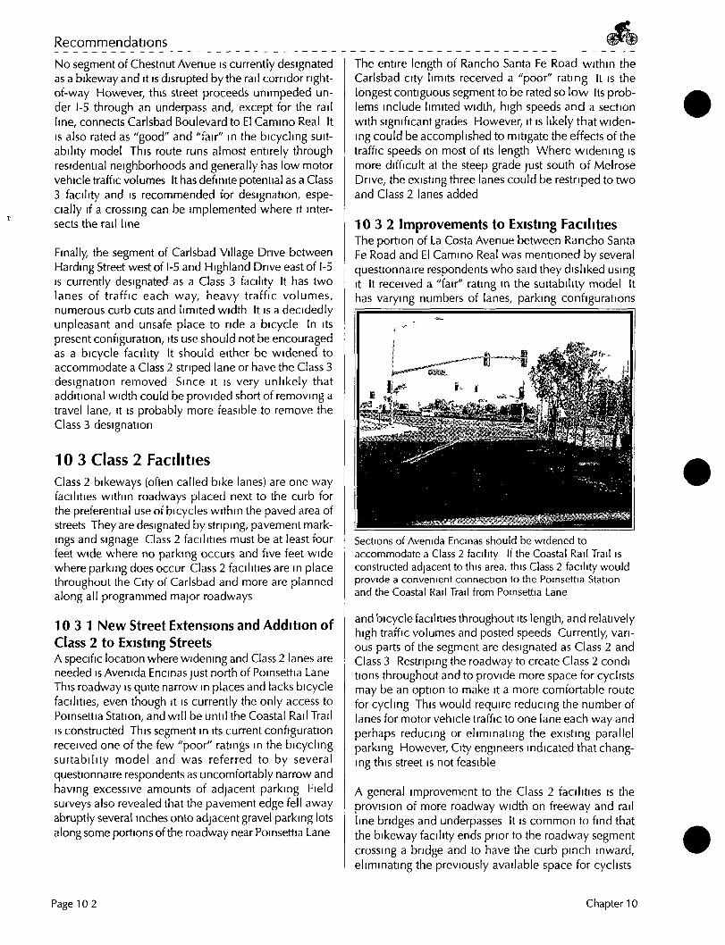
Recommendations
No segment of Chestnut Avenue is currently designated as a bikeway and it is disrupted by the rail corridor right-of-way However, this street proceeds unimpeded under 1-5 through an underpass and, except for the rail line, connects Carlsbad Boulevard to El Camino Real It IS also rated as "good" and "fair" in the bicycling suitability model This route runs almost entirely through residential neighborhoods and generally has low motor vehicle traffic volumes It has definite potential as a Class 3 facility and is recommended for designation, especially if a crossing can be implemented where it intersects the rail line
Finally the segment of Carlsbad Village Drive between Harding Street west of 1-5 and Highland Drive east of 1-5 IS currently designated as a Class 3 facility It has two lanes of traffic each way, heavy traffic volumes, numerous curb cuts and limited width It is a decidedly unpleasant and unsafe place to ride a bicycle In its present configuration, its use should not be encouraged as a bicycle facility It should either be widened to accommodate a Class 2 striped lane or have the Class 3 designation removed Since it is very unlikely that additional width could be provided short of removing a travel lane, it is probably more feasible to remove the Class 3 designation
10 3 Class 2 Facilities Class 2 bikeways (often called bike lanes) are one way facilities within roadways placed next to the curb for the preferential use of bicycles within the paved area of streets They are designated by striping, pavement markings and signage Class 2 facilities must be at least four feet wide where no parking occurs and five feet wide where parking does occur Class 2 facilities are in place throughout the City of Carlsbad and more are planned along all programmed major roadways
10 3 1 New Street Extensions and Addition of Class 2 to Existing Streets A specific location where widening and Class 2 lanes are needed is Avenida Encinas just north of Poinsettia Lane This roadway is quite narrow in places and lacks bicycle facilities, even though it is currently the only access to Poinsettia Station, and will be until the Coastal Rail Trail IS constructed This segment in its current configuration received one ofthe few "poor" ratings in the bicycling suitabil ity model and was referred to by several questionnaire respondents as uncomfortably narrow and having excessive amounts of adjacent parking Field surveys also revealed that the pavement edge fell away abruptly several inches onto adjacent gravel parking lots along some portions ofthe roadway near Poinsettia Lane
The entire length of Rancho Santa Fe Road within the Carlsbad city limits received a "poor" rating it is the longest contiguous segment to be rated so low Its problems include limited width, high speeds and a section with significant grades However, it is likely that widening could be accomplished to mitigate the effects of the traffic speeds on most of its length Where widening is more difficult at the steep grade just south of Melrose Drive, the existing three lanes could be restriped to two and Class 2 lanes added
10 3 2 Improvements to Existing Facilities The portion of La Costa Avenue between Rancho Santa Fe Road and El Camino Real was mentioned by several questionnaire respondents who said they disliked using It It received a "fair" rating in the suitability model It has varying numbers of lanes, parking configurations
Sections of Avenida Encinas should be widened to accommodate a Class 2 facility If the Coastal Rail Trail is constructed adjacent to this area, this Class 2 facility would provide a convenient connection to the Poinsettia Station and the Coastal Rail Trail from Poinsettia Lane
and bicycle facilities throughout its length, and relatively high traffic volumes and posted speeds Currently, various parts of the segment are designated as Class 2 and Class 3 Restriping the roadway to create Class 2 condi tions throughout and to provide more space for cyclists may be an option to make it a more comfortable route for cycling This would require reducing the number of lanes for motor vehicle traffic to one lane each way and perhaps reducing or eliminating the existing parallel parking However, City engineers indicated that changing this street is not feasible
A general improvement to the Class 2 facilities is the provision of more roadway width on freeway and rail line bridges and underpasses It is common to find that the bikeway facility ends prior to the roadway segment crossing a bridge and to have the curb pinch inward, eliminating the previously available space for cyclists
Page 10 2 Chapter 10

Carisbad Bike Facility Master Plan
In addition, many ofthe bridges have excessively high curbs that could potentially catch a cyclist's pedals, especially if the cyclist was attempting to stay far to the right to avoid the motor vehicles on a narrow bridge Many questionnaire respondents noted narrow bridges as a problem in Carlsbad
In general, there are a number of solutions short of the ideal, which would be to actually widen the bridges In some cases, the lanes could be restriped, the sidewalk width decreased or a lane of traffic eliminated In other situations where the motor vehicle volumes and limited width create particularly difficult cycling situations, alternative routes could be provided
10 4 Class 1 Facilities Class 1 bikeways (often called bike paths) are facilities with exclusive right-of-way for bicycles and pedestrians with cross flows by motor vehicles kept to a minimum They are physically separated from motor vehicle routes
A wide physical separation is recommended where a Class 1 facility parallels a motor vehicle route Any separation of less than five feet from the pavement edge of a motor vehicle route requires a physical barrier to prevent cyclists from encroaching onto the roadway Anywhere there is the potential for motor vehicles to encroach onto a Class 1 bicycle facility, a barrier should be provided Class 1 routes immediately adjacent to a street are not recommended because many cyclists will find It less convenient to ride on this type of facility as compared to streets, especially for utility trips such as commuting Other reasons that Class 1 routes immediately adjacent to a street are not recommended is because they can encourage wrong way riding on the street and can create safety problems at intersection crossings
Unlike on-street facilities that already have defined minimum design speeds, the minimum design speed of Class 1 facilities IS a factor to consider In general, the minimum design speed should be 20 mph Speed limits may also be implemented and are generally 10 or 15 mph
Opportunities exist for the installation of several Class 1 facilities that would not only provide the relaxed recreational atmosphere associated with an off-street facility, but would also improve commuter connections Normally, Class 2 facilities are preferred for transportation or commuting purposes However, if no roadways exist through an area, these Class 1 facilities will be useful to commuters Together, these facilities would fill in many of the gaps in the current system where topography and lack of facilities currently limit access The location and alignment of the Class 1 facilities are subject to further study and environmental review (See Figure 10-5, Proposed Bicycle Facilities)
The City has adopted, as part ofthe General Plan Open Space and Conservation Element, a master plan of primarily pedestrian pathways known as the Carlsbad Trails System (CTS) Some of the proposed Class 1 routes follow the planned routes of some of the CTS trails
The Class 1 routes proposed m Figure 10-5 would differ from the CTS trails because they would be wider paved paths designated as Class 1 routes, and designed for multipurpose use versus the generally unpaved surface treat ment and pedestrian orientation endorsed for the adopted trails plan Class 1 paths must be wide enough (12 feet minimum) to accommodate multiple user types and must include an unpaved side path (2 to 4 feet) for users who prefer a softer trail The Class 1 path would not be in addition to any proposed soft surface trail of the CTS, but would replace it where the trails coincide Paving IS recommended for these specihc routes within the context of the overall trail system to maximize their value for recreational and transportational cycl ing throughout Carlsbad Because of the many differences between CTS and the proposed Class 1 routes, a General Plan Amendment would be necessary to develop the Class 1 facilities in this Bikeway Master Plan
Where the use of asphalt or concrete paving conflicts with an approved trails master plan, environmental resources, or where a more informal, rural ambience is desired, soil polymer technology should be investigated Several manufacturers produce soil stabilizing emulsions that are applied on existing or imported soil or decomposed granite to create a natural looking trail surface A light concentration stabilizes the surface and controls dust, while a heavier concentration mixed into the soil and compacted can be used to create a resilient surface suitable for wheelchairs
10 4 1 Coastal Rail Trail The Coastal Rail Trail to run between downtown San Diego and Oceanside within the right-of-way of the existing rail line is currently in design It will connect with another trail being designed within the rail right-of-way between Oceanside and Escondido These facilities will be paved, multi-use, regional routes connecting the coastal cities of San Diego County, as well as the cities roughly paralleling SR78 between the coast and Escondido
The Coastal Rail Trail is commonly regarded as an excellent opportunity to provide a regional trail link connecting Carlsbad with other coastal communities, and by linkage with the Oceanside to Escondido rail trail, to inland communities as well However, it also provides additional trail opportunities within Carlsbad by providing a north-south spine from which to extend a series of east-west trails across the city This system would allow users to
Chapter 10 Page 10 3

Recommendations
traverse the length and breadth ofthe City, including going through areas where they can not currently go, either as a leisurely recreational rider meandering around the lagoons, or as a commuter on routes that shorten the current bicycle travel time between the coastal and inland areas of Carlsbad, all without encountering motor vehicle traffic and limiting street crossings
Because any attractive Class 1 bicycle facility can and will attract many other types of users, such as walkers and skaters, the term "rail trail" is simply a more widely used and generally understood term for what is actually a "rail corridor multi-use path" (See Section 8 2 1, Bikeway User Classification ) With this in mind, a series of typical plan and section details were developed to guide implementation of the rail trail
The details highlight the many different right-of-way configurations likely to be encountered while designing and building the rail trail through Carlsbad and the variations in implementation that may be necessary to provide the maximum level of user safety It is not likely that all the illustrated configurations will be encountered in any one city, but the rail trail through Carlsbad must cross three lagoons, as well as traverse very narrow sections of right-of-way near downtown (See Figures 10-1 to 10-4, Coastal Rail Corridor Multi-Use Trail Improvements)
• Bridges Over Lagoons Except for the relatively short crossing at Agua Hedionda, the bicycle bridges needed to cross the lagoons are planned to be constructed when the current single rail line IS converted to a dual line system At that time, the bridges would be designed and built to accommodate rail and bicycle facilities on a single structure at each lagoon, both to reduce costs and to minimize environmental impacts to wetlands This upgrade is not expected to occur for some time, perhaps not for twenty years For the foreseeable future, the Coastal Rail Trail bicycle route will detour away from the rail right-of-way onto nearby parallel surface roadways, wherever necessary, to bypass the lagoons (See Section 113 4, Bikeway Bridge Improvements, for more information )
• Rail Crossing Points The proposed rail crossing points would follow specific NCTD guidelines for the entire length of the Coastal Rail Trail However, there is dissension between this master plan and NCTD concerning the allowable width of the openings in the fence at the rail crossing points The minimum required width for a multi-use trail to receive official Class 1 bikeway designation is ten feet, so this master
plan calls for fence openings the full width of the trail NCTD does not allow ten foot openings m rail line fencing (Perhaps a compromise can be reached in which openings narrower than ten feet can be implemented with appropriate warning striping and guardrails that would funnel cyclists and pedestrians into the opening while also helping to inform them beforehand that they are approaching a potentially hazardous rail right-of-way Though It IS not generally desirable nor recommended to reduce the width of a Class 1 bikeway to less than ten feet wide at any point, combined with these types of visual warning cues, such narrowing may in this instance, be desirable at these rail line crossing points)
Though It will consider new crossings on a case-by-case basis, the Public Utilities Commission (PUC) prefers no net increase in crossings, meaning that it is desirable to close an old crossing when proposing a new one In some cases, the City can install new crossings if it is will ing to take liability for them The PUC wi l l be more likely to grant permission for a new crossing that can be proven to be substantially safer than the old unofficial one It IS replacing
The Coastal Rail Trail has the potential to be both an important recreational and commuter bike facility
• Rest Stops (including amenities and interpretive options) The design of the proposed rest stops would be purposefully specific to Carlsbad to help to distinguish the city from other municipalities along the route They would occur at three scenic points along the Coastal Rail Trail within Cadsbad and would be equipped with a number of amenities (See Section 11 4, Rail Trail Construction )
Page 10 4 Chapter 10

3" Asphalt Concrete PavenneiM with 6" Granular Sub-base
72" Welded Wire Mesh or Heav7 Gauge Chain
Link Fence
-Graded Shoulders
_ Min. Distance from Edge of ROW
Allow maximum clearance as pennitted by Tield
conditions (Minimun clearance:
25'per NCTD) '
100'
200' Total Right-of-way
Existing Track
SECTION • FULL (200') ROW WIDTH AVAILABLE
®
Existinf 2n<
I I I I I
-I*-
'o r Future I Track
3" Asphalt Concrete Pavement with 6" Granular Sub-base
72" Welded Wire Mesh or Heavy Gauge Chain
Link Fence
I Multi-Use Trail
Graded Shoulders
Min. Distance from Edge of ROW
50'
J 25' - 30'
Allow maximum clearance *ll as permitted by Field •
conditions (Minimun clearance:
25' per NCTD)
100' Total Right-of-way
Existing Track
SECTION • LIMITED (100') ROW AVAILABLE
® Existing or Future
2nd Track
3" Asphalt Concrete Pavement with 6" Granular Sub-base
72" Welded Wire Mesh or Heavy Gauge Chain
Link Fence
% Max.
' hi J i L r Multi-Use Trail I A T / k l Multi-Use Trail IA
1—Graded Shoulders —I -Graded Shoulders
Min. Distance from "Edge of ROW
I
100
200' Total Right-of-way
Allow maximum clearance as permitted by field
conditions (Minimun clearance:
25' per NCTD)
i
n
(Typical)
I I I I I
Existing Track
Existing or Future 2nd Track
3" Asphalt Concrete • Pavement with 6" Granular Sub-base
72" Welded Wire Mesh or Heavy Gauge Chain
Link Fence
Allow maximum clearance as
permitted by field conditions
Min. Distance from (Minimun clearance: Edge of ROW 25' tier NCTD)
100' '
200' Total Right-of-way
Existing Track
Existini 2ni
> or Future 1 Track
SECTION • MULTI-USE TRAIL O N LEVEL G R O U N D
® SECTION* MULTI-USE TRAIL O N FILL SLOPE
®
3" Asphalt Concrete Pavement with 6" Granular Sub-base
72" Welded Wire Mesh or • Heavy Gauge Chain Link Fence (Typical)
Graded Shoulders
Min. Distance from Edge of ROW
Allow maximum clearance | as permitted by Fieid |
corxlitions (Minimun clearatKe:
25'per NCTD)
• Oypical)
I 100'-200'
Right-of-way T
Existing Track
Existing or Future 2nd Track
3" Asphalt Concrete Pavement with 6" Granular Sub-base
72" Welded Wire Mesh or Heavy Gauge Chain Link Fence
15'
Min. Distance ftom Edge of ROW
Allow maximum clearance as permitted by Held
conditions (Minimun clearance:
25' per NCTD)
100'-200'
(Typical)
Right-of-way
Existing Track
Existing or Future 2na Track
SECTION • MULTI-USE TRAIL O N CUT SLOPE W/RETAINING WALLS
(D SECTION • MULTI-USE TRAIL O N CUT SLOPE W/O RETAINING WALLS
®
COASTAL RAIL CORRIDOR MULTI-USE TRAIL IMPROVEMENTS CITY OF CARLSBAD BIKEWAY MASTER PLAN

42" Railing
Wood Trestle Bridge with Wood
Decking
Existing Track
Right-of-way
Multi-Use Trail
SECTION • MULTI-USE TRAIL O N NEW DETACHED BRIDGE
@
• 42" Railings
100'-200'
Right-of-way
SECTION • NEW RAIL BRIDGE WITH INTEGRAL MULTI-USE TRAIL DIRECTLY BELOW MAIN DECK
®
42" Railings
SECTION •
®
NEW RAIL BRIDGE WITH INTEGRAL MULTI-USE TRAIL OFFSET BELOW MAIN DECK SECTION •
®
100'-200'
72" Welded Wire Mesh or Heavy Gauge Chain Link Fence
42" Railing
Right-of-way
NEW RAIL BRIDGE WITH INTEGRAL MULTI-USE TRAIL AS EXTENSION OF MAIN DECK
72" Welded Wire Mesh or Heavy Gauge Chain Link Fence
42" Railing
1
Existing Track
100'-200'
Right-of-way
SECTION • MULTI-USE TRAIL ATTACHED TO EXISTING BRIDGE
®
Existing or Future 2nd Track
SECTION* PEDESTRIAN/TRAIL BRIDGE OVERCROSSING
®
COASTAL RAIL CORRIDOR MULTI-USE TRAIL IMPROVEMENTS CITY OF CARLSBAD BIKEWAY MASTER PLAN

Trail slopes 6-8% to 16' below grade
istli rac
1
Existing Track
Existing or Future 2n3 Track
100'-200'
Right-of-way
^^^^^^
— Lighting
I Depressed Section I 1 of Mul t i -Use Trail I
3" Asphalt Concrete Pavement with 6"
Granular Sut>-base
SECTION* PEDESTRIAN/TRAIL BRIDGE UNDERCROSSING
10' M i n .
3" Asphalt Concrete Pavement with 6" Granular Sub-base
Train-actuated Warning at 10' Opening in 72" Fence
Perpendicular Pedestrian Trail
100'-200'
Right-of-way
Existing Track
Existing or Future 2nd Track
SECTION* PEDESTRIAN/TRAIL CROSSING AT GRADE
@ ® DETAILS
DETAILS
——~ (i BIKE XING
STOP HEM WHENCATt
IS DOWN &
Trail Stop Sign/Barrier
Motorist Warning Signage/ Lighting
Trail VVarning Motorist Signage Warning
Signage Lighting
300' to 500' (rom Crossing
Motorist Warning Signage
PLAN * PASSIVE CONTROL AT MID-BLOCK CROSSING
©
Trail Stop Sign/Barrier with Signal Actuator
Motorist Warn ing Signage/ Lighting
Trail
300' lo 500' from Crossing
Warning Motorist Signage Warning
Signage Lighting
Motorist Warning Signage
10'-6" M i n .
100' £ 3 2 ' „ 8 '
CO) CXD
CDP
72" Fence (Per NCTD)
PLAN * ACTIVE CONTROL AT MID-BLOCK CROSSING
®
Signal Push Button and Sign '
Standard Pedestrian Ramps and Crosswalk
Signal Push Button and Sign
PLAN * DIVERSION TO INTERSECTION
®
Note: For non-signalized intersections, delete signal push buttons and signs.
Standard Pedestrian Ramps and Crosswalk
PLAN * DIVERSION AROUND STATION A N D PARKING
®
m COASTAL RAIL CORRIDOR MULTI-USE TRAIL IMPROVEMENTS CITY OF CARLSBAD BIKEWAY MASTER PLAN