9 geology, mineral resources, overburden and soilseisdocs.dsdip.qld.gov.au/wandoan coal/eis/eis -...
TRANSCRIPT
Wandoan Coal Project
Volume 1 Book 1.2 9-1 2133006C-81091-09-Rev 0
9 GEOLOGY, MINERAL RESOURCES, OVERBURDEN AND SOILS
9.1 INTRODUCTION This chapter outlines the geology, mineral resources, overburden and soil characteristics of
the site and details the rehabilitation requirements of the Wandoan Coal Project (the
Project). A detailed technical report is presented in TR 9-1-V1.5 Geology, Mineral
Resources, Overburden and Soils Impact Assessment. Note that figures and documents
with numbering ending in V1.5 refer to figures/documents contained in Volume 1, Book 5
of the EIS.
9.2 METHODOLOGY OF ASSESSMENT The assessment was conducted in two parts, a soil, land resource and overburden
assessment of the mining lease application (MLA) areas and a desktop soil and land
resource assessment for the gas supply pipeline and MLA associated infrastructure.
9.2.1 EXISTING INFORMATION
Previous investigations that provided information for this report regarding soil, overburden
and landscape characteristics (topography and geomorphology) include:
• Slater, B, Bell, L and Whiteman, P (1980). Wandoan Coal – Resources for Land
Rehabilitation. Progress report on the Research for Brigalow Mines Pty Ltd. University
of Queensland Department of Agriculture
• Slater, B, Bell, L and Whiteman, P (1983). Land Evaluation of Potential Coal Mine Areas
at Wandoan, Queensland. University of Queensland Department of Agriculture
• Gray, H.J and Macnish, S.E (1985) Land Management Field Manual Wandoan District
• Forster, B.A (1985). Evaluation of Agricultural Land in Taroom Shire
• CSR Coal Division (1986). An Assessment of Overburden Rehabilitation Properties of
the Wandoan Coal Project
• Slater, B (1986). Edaphic Properties of Soil and Overburden from a Potential Coal Mine
near Wandoan, Queensland. University of Queensland Department of Agriculture
• Godfrey, N (1992). EPC 157 Wandoan March 1992 Drilling Program Slake Testing
Report
• Envirosciences Pty Limited (1992). Land Capability and Use. Austinvale and Frank
Creek Coal Deposit Areas, Wandoan. MIM Holdings Limited
• MIM Holdings Limited (1997). Consideration of Rehabilitation Strategies Associated
with the Austinvale Coal Deposit, Wandoan, Queensland
• Golders Associates Pty Ltd (2008). Report on Geotechnical Evaluation for Open Pit
Mining, Wandoan Coal Project, Wandoan, Queensland (Draft).

Wandoan Coal Project
9-2 Book 1.2 Volume 1
2133006C-81091-09-Rev 0
9.2.2 OVERBURDEN
An overburden investigation was conducted within the MLA areas. An overburden
assessment was not conducted for the MLA associated infrastructure or gas supply
pipeline, as significant overburden disturbance will not occur for these components of the
Project. The investigation was conducted to assess the following characteristics of the
overburden and interburden:
• erosion potential
• acid generation potential and heavy metal content
• suitability of overburden for use as a capping layer and growth medium.
The overburden investigation included laboratory analysis of rock cores from four
boreholes that were drilled as part of the wider investigation program (refer
Figure 9-2-V1.3).
Findings of previous investigations (e.g. CSR Coal Division 1986, Godfrey 1992,
Slater 1986) were compared to the overburden laboratory analysis results of the current
investigation. Both sets of results were re-assessed and correlated to include most
encountered geological units over a wider area of the MLAs.
Selected overburden samples were tested in a NATA registered laboratory for the following
physical and chemical properties — the method used for each analysis is included in
brackets:
• net acid generation at pH7 (NAG); pH after oxidation; Acid production potential (APP);
Acid neutralising capacity (ANC); Net acid producing potential (NAPP) ) (Miller (1998),
US EPA 600/2-78/054, and Coastech Research methods)
• heavy metals – arsenic, cadmium, chromium, copper, lead, nickel, zinc (US EPA, SW
846, Method 6010)
• exchangeable sodium percentage (ESP) – chemically exchangeable sodium can weaken
the bonds between clay particles thus acting as a dispersing agent. Overburden with
an ESP of more than 15% are considered dispersive and overburden with an ESP less
than 5% are commonly considered as non-dispersive. (Australian Laboratory Services
‘in-house’ methods)
• cation exchange capacity (CEC) – the overburden’s capacity to hold nutrients is
estimated by CEC. Low values (below 5) indicate the overburden is infertile and prone
to leaching and therefore is likely to be a poor growth medium requiring nutrient
application. (Australian Laboratory Services ‘in-house’ methods).
The potential for acid drainage was based on the requirements of the Assessment and
Management of Acid Drainage (Department of Mines and Energy 1995b).
Heavy metal concentrations within the overburden were assessed against the Draft
Guidelines for the Assessment of Contaminated Land in Queensland (Environmental
Protection Agency 1998) for environmental investigation levels and health-based
investigation levels (Department of the Environment 1998).
Wandoan Coal Project
Volume 1 Book 1.2 9-3 2133006C-81091-09-Rev 0
9.2.3 SOILS
A soil investigation was conducted within the MLA area, MLA associated infrastructure area
and gas supply pipeline corridor to:
• characterise the soil types
• define land suitability classification of the sites
• assess available topsoil types and suggested stripping depths
• assess the dispersion and erosion potential of various topsoil and subsoil materials.
The soil investigation comprised a review of existing geotechnical, geological and soil data.
Within the MLA area the investigation included the excavation of test pits, a walk-over
survey of the area, and laboratory testing of selected samples. The investigation was
conducted in accordance with The Planning Guidelines: the Identification of Good Quality
Agricultural Land (Department of Primary Industries and Department of Housing, Local
Government and Planning, 1993).
Soil survey Details of test pit locations are shown in Figure 9-1-V1.3. Test pit locations were selected
based on the geological and topographic features of the site, in consideration with the
provisional layout of the proposed mining operations.
Test pit log records are shown in Attachment A of TR 9-1-V1.5: Geology, Mineral
Resources, Overburden and Soils Impact Assessment, together with a set of explanatory
notes, which define the terms and symbols used in their preparation. Topsoil (A1 horizon)
descriptions are in accordance with those used in the Australian Soil and Land Survey,
Field Handbook (McDonald et al. 1990).
Fieldwork investigations for the Project, which assessed the soil and land capability,
consisted of the following:
• excavation and sampling of 41 test pits within the MLAs
• topsoil, topographic, vegetation and geomorphic observations were also made at
opportunistic locations, such as cuttings, washouts and creeks.
Test pits were excavated up to 2.3 m depth, using a rubber tyred backhoe, hand auger or
a hand shovel. Selected disturbed samples of surface soils and subsurface material were
obtained either at regular intervals or at the change of strata for material identification and
laboratory testing.
The locations of test pits were recorded using a Garmin hand held GPS unit, and checked
(approximately) against site features and map readings. The accuracy of this survey
method is considered to be within an accuracy of approximately 7 m in plan. The
approximate surface elevation (RL) of test locations were determined by GIS (geographic
information systems) using standard interpolation methods from a supplied digital terrain
model.
Soil classification system Classification of soils on the Project was based on field observations, laboratory analytical
data and published soil classification data (refer TR 9-1-V1.5 Geology, Mineral Resources,
Overburden and Soils Impact Assessment).
Wandoan Coal Project
9-4 Book 1.2 Volume 1
2133006C-81091-09-Rev 0
The adopted soil classification system is the Australian Soil Classification System (Isbell
1996). Where soil descriptions correlate with soil types in the resources listed in
Section 9.2.1, soil names used in these resources have been adopted.
Laboratory testing Selected soil samples were tested in a NATA registered laboratory for the following physical
and chemical properties — the method used for each analysis is included in brackets:
• exchangeable sodium percentage (ESP) – ESP is a measure of the sodicity of soils.
Chemically exchangeable sodium can weaken the bonds between clay particles thus
acting as a dispersing agent. Soils with an ESP of more than 15% are considered
dispersive and soils with an ESP less than 5% are commonly considered as non-
dispersive. (Australian Laboratory Services ‘in-house’ methods)
• cation exchange capacity (CEC) – the soil’s capacity to hold nutrients is estimated by
CEC. Low values (below 5) indicate the soil is infertile and prone to leaching and
therefore is likely to be a poor growth medium requiring nutrient application.
(Australian Laboratory Services ‘in-house’ methods)
• conductivity (EC), pH, sulphate as SO4, chloride, total nitrogen, total phosphorous,
organic carbon, water soluble nitrogen, and DTPA soluble iron, manganese, copper and
zinc content of soil (Australian Laboratory Services ‘in-house’ methods).
Laboratory test results are shown in Attachment C of TR 9-1-V1.5 Geology, Mineral
Resources, Overburden and Soils Impact Assessment.
9.2.4 LAND SUITABILITY ASSESSMENT
A land suitability assessment was carried out over the Project area based on the
requirements of Attachment 2 of the Land Suitability Assessment Techniques (Department
of Mines and Energy, 1995a). The Project area was assessed for its suitability for various
uses including dry-land cropping and cattle grazing on improved pasture.
The findings of the land suitability assessment were then assessed against the GQAL
mapping under the former Taroom Shire Council Planning Scheme. (Taroom Shire
Council, 2006) to assess the accuracy of the GQAL mapping (see Section 9.3.7).
The land suitability of the proposed Year 30 mine landform was then compared to the
existing landform to assess the potential impacts of the Project.
Wandoan Coal Project
Volume 1 Book 1.2 9-5 2133006C-81091-09-Rev 0
9.3 EXISTING ENVIRONMENT
9.3.1 TOPOGRAPHY AND GEOMORPHOLOGY
Topography
Mining lease application area and MLA associated infrastructure
A contour map of the Project area is shown on Figure 9-3-V1.3. Two main terrain elements
were identified in the Project area:
• alluvial floodplains of Woleebee Creek, Wandoan (also known as Sundown) Creek,
Frank Creek, Mud Creek, Spring Creek, and their tributaries. These floodplains vary in
width from less than 500 m to about 2 km, and generally have a very gentle slope
towards the creek channel and downstream, generally less than 2%. This landscape
unit occurs at a reduced level (RL) between approximately 230 m and 250 m
Australian height datum (AHD). The floodplains have largely been cleared for
agricultural uses, including beef cattle grazing and limited fodder cropping on the
floodplain edges. Remnant riparian vegetation is present along the creek lines
• low undulating hills, with an RL of between 250 m and 295 m AHD make up the
majority of the Project area. Slopes are generally less than 4%, but up to 15%
gradient for upper slopes in the western portion of the study area. The undulating hills
are generally at a higher altitude in the south of the Project area than to the north.
This is due to a regional slope away from the Great Dividing Range in the south
towards the Dawson River Valley in the north. Land in the undulating terrain is largely
cleared for agricultural uses, with limited fodder crops cultivation on the flatter
gradients, and beef cattle grazing on steeper slopes. Common fodder crops include
oats, wheat and leucaena (Leucaena leucocephala). Grain cropping used to be
prevalent over this area, but has been greatly reduced during the past 20 years,
reportedly due to changed rainfall patterns and economic conditions.
Gas supply pipeline
The topography of the gas supply pipeline corridor is also shown on Figure 9-3-V1.3. The
terrain elements are similar to those in the MLA area, with an overall slope downwards to
the west, and can be described as:
• alluvial floodplains of Roche Creek, Stakeyard Creek and their tributaries. These
floodplains display similar landforms as the floodplains in the MLA area described
above, and occur at an RL between approximately 250 m and 300 m AHD in the
vicinity of the gas supply pipeline corridor
• low undulating hills, with an RL of between 250 m and 280 m AHD in the western
portion of the corridor, increasing in altitude to between 300 m and 340 m AHD in the
eastern portion of the corridor. These hills have a similar form to the undulating hills in
the MLA area described above.
Wandoan Coal Project
9-6 Book 1.2 Volume 1
2133006C-81091-09-Rev 0
9.3.2 GEOLOGY
Regional geology The WJV has conducted detailed studies of the geology of the Wandoan region including
photogeological interpretation (Snodin 2004). This photogeological mapping supports, but
is more detailed than, the Geological Survey of Queensland’s 1:250,000 series Roma and
Taroom sheets. The geologic units in the wider Wandoan region occur in generally west-
north-west to east-south-east trending bands, sub-parallel to the elevated topography of
the Great Dividing Range, which is approximately 50 km south of Wandoan. Soils and the
underlying geology of the Project site are from the following main geological units:
• quaternary age alluvium
• Middle to Upper Jurassic age Injune Creek Group, which, within the Project area,
consists of:
the Westbourne Formation (siltstone, mudstone and fine grained sandstone)
the Springbok Sandstone (friable sandstone with beds of mudstone and thin coal
seams near its base)
the Juandah Coal Measures, consisting of sandstone, siltstone, mudstone and coal
the Tangalooma Sandstone, consisting of clayey sandstone, minor siltstone,
mudstone and coal.
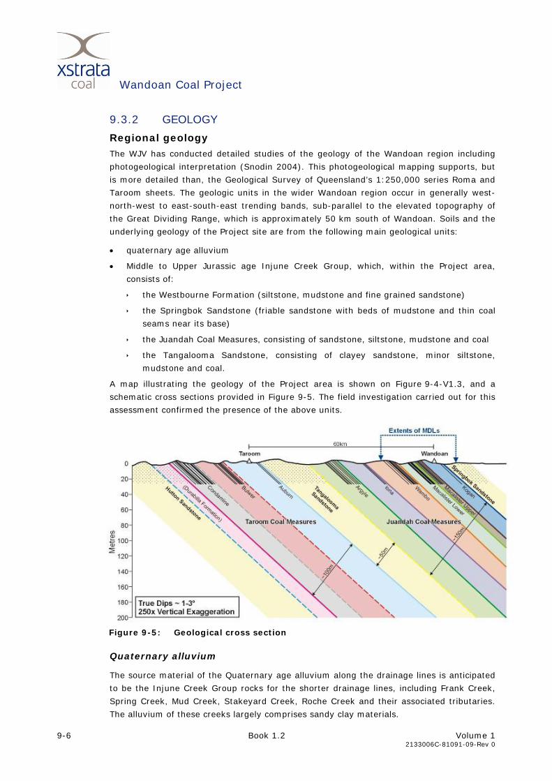
A map illustrating the geology of the Project area is shown on Figure 9-4-V1.3, and a
schematic cross sections provided in Figure 9-5. The field investigation carried out for this
assessment confirmed the presence of the above units.
Figure 9-5: Geological cross section
Quaternary alluvium
The source material of the Quaternary age alluvium along the drainage lines is anticipated
to be the Injune Creek Group rocks for the shorter drainage lines, including Frank Creek,
Spring Creek, Mud Creek, Stakeyard Creek, Roche Creek and their associated tributaries.
The alluvium of these creeks largely comprises sandy clay materials.
Wandoan Coal Project
Volume 1 Book 1.2 9-7 2133006C-81091-09-Rev 0
The longer Woleebee Creek has a higher discharge and flows through the Orallo Formation
and Gubberamunda Sandstone that is further upstream from the Project site. Floodplain
sediments along Woleebee Creek are influenced by these geological units and the higher
discharge in this creek, and are mainly clayey sands.
Injune Creek Group
The Injune Creek Group includes the Westbourne Formation, Walloon Subgroup and
Springbok Sandstone. The units that occur within the Project are the Walloon Subgroup
(including the Juandah Coal Measures) and Springbok Sandstone.
The Juandah Coal Measures contain the economic coal reserves of the Project and
comprises medium to coarse grained lithic sandstone, siltstone, mudstone and coal seams.
The particle size generally increases with depth (Slater 1986).
The Taroom Coal Measures are sub-labile, medium grained sandstone, grading upwards to
interbedded sandstone, siltstone, mudstone and coal. This unit outcrops north of the
Project area.
9.3.3 GEOMORPHOLOGY
Drainage over the Project area is generally towards the north, with sediment slowly
transported by the creeks via the floodplains towards the Dawson River, located to the
north of the Project.
The narrow floodplains, gentle slopes, bedrock controlled channels and confined meanders
of drainage lines suggest the landscape within the Project area is geologically young. The
ephemeral creeks are slowly cutting into and eroding the undulating hills, with lateral
erosion of the valleys being the main large-scale landscape altering activity, together with
channel deepening. Temporary deposition of eroded material occurs on the narrow
floodplains.
Erosion rates are anticipated to be low due to the relatively dry climate and low
topographic gradient. Most erosion will occur during infrequent high rainfall events.
9.3.4 MINERAL RESOURCES
A number of individual coal deposits are present within the Project area as shown on
Figure 9-5. Exploration permits for coal (EPC), mineral development leases (MDLs) and
mining lease applications (MLAs) over these deposits are held by the WJV. The Project will
involve the extraction of coal from these deposits.
No mineral exploration permits or leases exist over the Project area. A petroleum lease
(PL171, held by Roma Petroleum NL), intersects the southern portion of MLA 50230. No
pits or infrastructure are currently proposed within the area of PL171. Petroleum lease
PL176 (granted), held by Santos QNT Ltd, intersects the gas supply pipeline corridor. This
petroleum lease is part of the Peat-Scotia coal seam gas fields from which the gas supply
for the Wandoan Coal Project is proposed to be sourced.
A number of exploration permits for petroleum (EPP) and exploration permits for coal
(EPC) exist over the Project area (refer Figure 9-6-V1.3). These EPP and EPC are
summarised below:
Wandoan Coal Project
9-8 Book 1.2 Volume 1
2133006C-81091-09-Rev 0
• EPP867 (application) held by Paillard Energy Pty Ltd
• EPP869 (application) held by Bow Energy Resources Ltd
• EPP852 (granted), held by Pure Energy Resources Limited
• EPP870 (application) held by Pure Energy Resources Limited
• EPP768 (granted) held by BNG (Surat) Pty Ltd
• EPP606 (granted) held by Origin Energy CSG Limited
• EPP747 (application) held by Arrow Energy Ltd
• a small portion of EPP810 (granted) held by Arrow Energy Ltd
• a small portion of EPP868 (application) held by Vamgas Pty Ltd
• a small portion of EPP692 (granted) held by Origin Energy CSG Limited
• a small portion of EPP 651 (granted) held by Queensland Gas Company Limited
• EPC 1500 (application) held by Holloman Mineral Pty Ltd
• EPC1322 (application) held by Surat Coal Pty Ltd
• EPC1205 (granted) held by Taroom Coal Pty Ltd
• EPC640 (relinquished) formally held by Anglo Coal (Taroom) Pty Ltd
• EPC838 (granted) held by Xstrata Coal Queensland Pty Ltd
• EPC788 (granted) held by Xstrata Coal Queensland Pty Ltd
• EPC792 (granted) held by Xstrata Coal Queensland Pty Ltd.
According to the Department of Mines and Energy’s Interactive Resource and Tenure online
maps (http://www.webgis.dme.qld.gov.au, accessed on 1 August 2008), two exploration
boreholes have previous been drilled within the MLA area, both in the southern portion of
MLA50230. Well 55 was drilled in 1962 for petroleum, with no hydrocarbons located. Well
58380 was drilled in 2002 for coal seam gas, also with no gas located. Further details are
available from company report numbers 897 and 37652 respectively from the Department
of Mines and Energy’s Queensland Digital Exploration Reports System (QDEX).
Numerous exploration and development gas wells occur in the vicinity of the gas supply
pipeline, within the Peat Scotia gasfields. Gas wells in the vicinity of the pipeline include:
• Exploration well 50327 drilled in 1996 with no hydrocarbon located
• Exploration well 57298 drilled in 1996 with gas located
• Exploration well 57333 drilled in 1997 with gas located
• Appraisal well 57671 drilled in 2000 with gas located
• Gas development well 58162, 58138, 58204, 59057, 58567, 59049, 58566, 59048,
59095.
Wandoan Coal Project
Volume 1 Book 1.2 9-9 2133006C-81091-09-Rev 0
Coal resource
Stratigraphy
The Juandah Coal Measures contain the economic coal reserves of the Project. The coal
seams are relatively flat, with a regional dip of approximately zero to two degrees to the
south-west (Golder Associates 2008), with localised steeper dips. Geotechnical drilling has
identified the following seam groups within the Wandoan MLAs:
• Kogan. The Kogan coal seams generally occur in the southern portion of the MLAs and
at shallower depths. The group consists of approximately seven seams, each of which
generally vary in thickness between 0.1 m and 5.0 m
• Macalister Upper. The Macalister Upper coal seams occur below the Kogan seams.
The group consists of approximately five seams, each of which generally vary in
thickness between 0.05 m and 4 m
• Macalister Lower. The Macalister Lower coal seams occur below the Macalister Upper
seams. The group consists of approximately six seams, each of which generally vary in
thickness between 0.01 m and 3.0 m
• Wambo. The Wambo coal seams occur at shallower depths in the northern portion of
the MLAs and below the Macalister Lower seams in the rest of the MLAs. The seam
consists of approximately seven seams, each of which generally vary in thickness
between 0.1 m and 3.0 m.
Coal volumes and delineation
Geological models have been generated to enable estimation of JORC compliant resources
for MDL221 and MDL222 within the Juandah Coal Measures. The status of all boreholes
were made on a seam by seam basis. A set of criteria were used to define resource
category areas according to JORC guidelines. All resources were calculated at an in-situ
moisture of 12% and using modelled relative density where available. Ash content was
reported at 10% inherent moisture.
The work undertaken to prepare the geological model and delineate the resource is
described in Appendix 9-1-V1.4. Table 9-1 presents the resources for MDL221 and
MDL222. MDL221 underlies MLA50230 and 50231, while MDL222 underlies MLA50229.
Table 9-1: In-situ coal resources
Average raw ash Estimate quantity (million tonnes)
Tenement (%air dried, 10% inherent
moisture) Measured Indicated Inferred Total
MDL221 22.2 116.5 469.2 737 1,323
MDL222 26.9 295.3 663 958
Total 116.5 764.5 1,400 2,281
Approximately 500 Mt of the coal resource has a strip ratio of less than 3:1, with the
remainder of the coal typically being in the range of 3:1 to 5:1. A summary of the
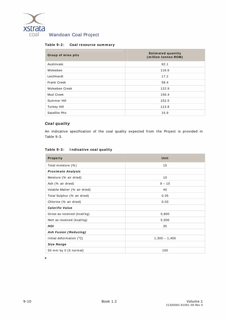
economic coal resources for each group of pits in shown in Table 9-2.
Wandoan Coal Project
9-10 Book 1.2 Volume 1
2133006C-81091-09-Rev 0
Table 9-2: Coal resource summary
Group of mine pits Estimated quantity
(million tonnes ROM)
Austinvale 92.1
Woleebee 116.6
Leichhardt 17.2
Frank Creek 58.4
Woleebee Creek 122.9
Mud Creek 156.4
Summer Hill 152.5
Turkey Hill 113.8
Satellite Pits 15.9
Coal quality
An indicative specification of the coal quality expected from the Project is provided in
Table 9-3.
Table 9-3: Indicative coal quality
Property Unit
Total moisture (%) 15
Proximate Analysis
Moisture (% air dried) 10
Ash (% air dried) 9 – 10
Volatile Matter (% air dried) 40
Total Sulphur (% air dried) 0.35
Chlorine (% air dried) 0.03
Calorific Value
Gross as received (kcal/kg) 5,800
Nett as received (kcal/kg) 5,500
HGI 35
Ash Fusion (Reducing)
Initial deformation (oC) 1,300 – 1,400
Size Range
50 mm by 0 (5 normal) 100
•
Wandoan Coal Project
Volume 1 Book 1.2 9-11 2133006C-81091-09-Rev 0
9.3.5 OVERBURDEN
Overburden and interburden was assessed within the MLA areas. Unless specific
characteristics are described, the term overburden implies both overburden and
interburden. Overburden is defined as all the material overlying the shallowest coal seam
and interburden is the material between economic coal seams.
Overburden in the Austinvale and Woleebee areas consist mostly of sandstone, siltstone,
mudstone, claystone and coal, with minor ironstone. Upward fining sequences are
common, and vertical and lateral changes of facies were observed.
The average depth of overburden is about 23.0 m in the Austinvale area, with about 1.2 m
soil. In the Woleebee area the average depth of overburden is 26.0 m, with soil to about
3.2 m. The depth of the weathering ranges from 10.0 m to 15.0 m in the eastern portion
of the Project area, and from 8.0 m to 25.0 m in the western portion of the Project area.
Acid producing potential The oxidation of sulfidic material to produce sulphuric acid is a natural process resulting
from the exposure of minerals such as pyrite (iron sulfate) to atmospheric conditions
(Environment Australia 1997), and is calculated as the acid producing potential in kg
H2SO4/t. This process can be accelerated during mining operations if large volumes of
sulfidic material are exposed. The resulting acidity may also dissolve metals within
overburden rock. Transport by water can generate highly acidic runoff with high
concentration of dissolved salts of heavy metals.
Carbonate minerals and exchangeable bases, on the other hand, have the ability to
neutralise acid (calculated as the acid neutralising capacity in kg H2SO4/t). Carbonate
minerals (mainly calcite, aragonite and dolomite) have the most significant acid
neutralising capacity.
The net acid producing potential (NAPP), is the difference between the acid producing
potential and the acid neutralising capacity of a material. NAPP gives an indication of a
materials potential to generate acid. A positive result shows acid generation potential and
a negative result indicates that the material is non-acid producing (Department of Mines
and Energy 1995b).
Net acid generation (NAG) differs from the acid producing potential in that it measures the
actual acid production and neutralisation of material, as opposed to the total theoretical
potential. NAG provides an indication of the potential for acid generation following
exposure and weathering of material, and can be used to confirm the NAPP.
Laboratory tests were carried out on samples obtained from five exploration boreholes
through the overburden, with the results summarised in Table 9-4. The negative NAPP
results showed that no samples have the potential to produce acid mine drainage, due to
high acid neutralising capacity (ANC). The test results are shown in Table 9-4 and in
TR 9-1-V1.5 Geology, Mineral Resources, Overburden and Soils Impact Assessment.

Wandoan Coal Project
9-12 Book 1.2 Volume 1
2133006C-81091-09-Rev 0
Table 9-4: Acid generation and neutralisation potential in overburden samples analysed for this study
Range in values encountered Parameter
Weathered rock Fresh rock
Net Acid Production Potential (kg H2SO4/t) -14.6 – -10.4 -48.8 – -4.1
Net acid generation (pH 4.5) (kg H2SO4/t) <0.1 <0.1 – 11.7
Net acid generation (pH 7.0) (kg H2SO4/t) <0.1 <0.1 - 62.2
pH after oxidation 8.3 3.7 – 8.5
Acid neutralising capacity (kg H2SO4/t) 10.7 – 15.6 6.0 – 50.0
Total Sulfur (%) 0.01 – 0.03 0.03 – 0.14
All samples tested as part of the current investigation have negative NAPP, and therefore
plot in the left side of the diagram in Figure 9-7. The samples with a pH(ox) less than 4.5
have low sulphur content, and therefore plot typical of organic acid effects on samples with
minor or no acid rock drainage potential (Miller, 2008).
0
1
2
3
4
5
6
7
8
9
-50 -40 -30 -20 -10 0 10 20 30 40 50
NAPP (kg H2SO4/t)
pH (o
x)
Source: after Miller 2008
Figure 9-7: Classification of acid production potential
The non acid forming nature of the overburden is supported by water quality testing
undertaken at the bulk sample pit site in March 2006 and September 2008, which found
water in the bulk sample pit, water management dam and seepage from rehabilitated
overburden to have neutral to slightly alkaline pH.
Heavy metals Heavy metal content in the overburden samples were assessed against environmental and
health based investigation levels established by the National Environmental Protection
(Assessment of Site Contamination) Measure 1999 (National Environment Protection
Council 1999). Heavy metal analysed include arsenic, cadmium, copper, chromium, lead,
nickel and zinc.
Non acid forming
Potentially acid forming
Uncertain classification with negative NAPP
Uncertain classification with positive NAPP

Wandoan Coal Project
Volume 1 Book 1.2 9-13 2133006C-81091-09-Rev 0
The overburden samples were assessed against the environmental investigation levels and
health-based investigation levels to provide an indication of the potential for overburden
dumps to be a source of heavy metal contaminated leachate, based on the concentrations
in the in-situ overburden material.
As shown in Table 9-5, the concentrations of all heavy metals within the overburden tested
were below the investigation level concentrations. The solubility of most heavy metals
could increase with elevated acidity. However, the overburden is not anticipated to
generate significant acid mine drainage. The above two findings indicate the stockpiling of
overburden is unlikely to be a source of heavy metal contamination.
Table 9-5: Heavy metal concentrations in overburden samples
Substance
Environmental investigation
level mg/kg
Health based investigation
level mg/kg
Concentration range in analysed
overburden samples mg/kg
Samples exceeding
environmental and health
investigation levels*
Arsenic 20 100 <5 – 6 None
Cadmium 3 20 <1 None
Copper 100 1,000 12 – 45 None
Chromium (III) 400 12% <2 – 10 None
Chromium (VI) 1 100 8 – 24 None
Lead 600 300 2 – 12 None
Nickel 60 600 5 – 133 None
* Based on ‘Standard’ residential use as defined in Department of the Environment 1998. This includes garden/accessible soil (home-grown produce contributing less than 10% of fruit and vegetable intake; no poultry); this category includes children’s day-care centres, preschools and primary schools.
Erosion potential The main erosion agents within the Project area are:
• raindrop impact
• water
• wind.
When environmental factors (e.g. vegetation cover and climate) are equal, then the
erosion potential of stockpiled overburden is dependant of the chemical and physical
characteristics of the material.
Dispersion and slaking both result in erosion. Slaking is the breakdown of a materials
structure when exposed to water (e.g. slumping). Dispersion is the transformation of a
solid material into a colloid when in contact with water.
The potential for slaking and dispersion was assessed by Golders Associates (2008). This
assessment found that clay rich, slake prone rocks are present throughout the overburden
across the Project area, although some non-slaking materials were encountered. These
findings support the findings by Godfrey (1992).

Wandoan Coal Project
9-14 Book 1.2 Volume 1
2133006C-81091-09-Rev 0
CSR Coal Division (1966) tested both the general dispersive potential of overburden and
the potential for failure by tunnel erosion when used for earthworks. Most overburden was
found to be highly dispersive, with some siltstone/sandstone materials dispersive
(overburden with more than 70% sandstone and siltstone, with more siltstone than
sandstone) or non-dispersive (overburden with more than 70% siltstone/coal and
sandstone, with more siltstone/coal than sandstone). All materials tested were found to be
highly susceptible to tunnel erosion.
Dispersion is caused by chemically exchangeable sodium dominated clays that form weak
bonds between individual clay particles and layers within the clay minerals, thus acting as
a dispersing agent. Soils with an exchangeable sodium percent (ESP) of more than 15%
are considered dispersive and soils with an ESP less than 5% are commonly considered as
non-dispersive. The current study found ESP values of 23 to 28 for weathered rock and
40 to 71 for fresh rock, indicating the overburden will be highly dispersive. These findings
are in accordance with those by Slater (1986), which found sodium as the dominant base
cation, and ESP values of 14 to 34.
Nutrients and trace elements The nutrient and trace element content of overburden material relates to the suitability of
the material for use as a plant growth medium. Table 9-6 contains suggested values for
various parameters in soil and overburden that are suitable for plant growth. Values
outside the suggested critical values may result in toxicities, or shortages in essential
nutrients required for plant growth.
Table 9-6: Criteria for suggested nutrient availability in soils and overburden
Range in values encountered Parameter
Suggested critical values1 Weathered rock2 Fresh rock2
pH 5.5-8.5 9.2 – 9.9 9.7 – 10.4
Electrical conductivity (µS/cm) 763 – 1080 280 – 1020
Exchangeable calcium (meq/100 g) min. 1.2 15.5 – 15.6 2.8 – 22.3
Exchangeable magnesium (meq/100 g) 0.4-0.8 8.9 – 10.5 0.8 – 5.4
Exchangeable potassium (meq/100 g) 0.2-0.3 0.50 – 0.58 0.46 – 0.97
Extractable Iron (mg/kg) 2.5-4.5 7 – 24 13 – 16
Extractable manganese (mg/kg) min. 2 4 – 5 3 – 5
Extractable copper (mg/kg) min. 0.2 1.0 – 1.6 3.7 – 5.5
Extractable zinc (mg/kg) 0.5-1.0 1.0 – 1.6 3.7 – 5.5
Exchangeable sodium (meq/100 g) 8.02 – 9.81 8.82 – 24.0
Cation exchange capacity (meq/100 g) 34.6 16.8 – 42.4
Exchangeable sodium percent (%) 23.2 – 28.3 40.0 – 71.2
Source: 1. CSR Coal Research (1986) Table 5.3 2. After Slater 1986, Table 4.3, and this current study

Wandoan Coal Project
Volume 1 Book 1.2 9-15 2133006C-81091-09-Rev 0
The overburden has very low organic matter and nitrogen content. The pH of overburden
was found generally to be alkaline, with some siltstone and sandstone samples acidic
(Slater located this acidic overburden under the Rolleston soil profile). The concentration of
exchangeable cations is low, and is dominated by calcium and sodium.
Electrical conductivity levels were medium to high, and trace elements (iron, manganese,
copper, zinc) levels medium to high.
Fossil material There is a potential for fossilised material to be discovered during drilling, excavation and
mining activities. Fossilised leaf impressions were identified in some sandstone samples
collected as part of the geotechnical investigations for the Project (e.g. borehole C7073).
Most fossils uncovered by the mining activities will be common. The significance of a fossil
is not necessarily indicated by the fossil size, with fossils such as budding plants,
uncommon plants or insects being of interest to the Queensland Museum.
Geotechnical properties Geotechnical characteristics of the overburden related to stability have been investigated
by Golders Associates (2008).
Rock strength from boreholes in the eastern portion of the Project was found to be low to
approximately 25 m depth, and then increase to medium strength. In the western portion
of the Project area surface rock strength was also very low to medium, increasing to low to
high strength from about 20-30 m depth.
Clay rich, slake prone rocks are present throughout the overburden and interburden
deposits, although siltstone and mudstone resistant to slaking was encountered at one
borehole site. Material prone to slaking is also present in the proposed pit floors. Atterberg
limit tests of the slaked material indicated this material is highly plastic with poor
engineering properties.
9.3.6 SOILS
Land resource areas Land resource areas (LRAs) are reoccurring landscape units with similar geology,
landforms, soils and vegetation associations. They are used to simplify and aid quick field
identification of land resource unit mapping and subsequent management.
The LRAs of the Project are identified and described in the Wandoan District Land
Management Field Manual (Gray and Macnish 1985), and Evaluation of Agricultural Land in
Taroom Shire (Forster 1985). These studies identified two LRA, which relate to the
landscape units identified in Section 9.3.1, being:
• Brigalow uplands. Undulating plains with broad ridges and low hills, on sandstones
and shales
• Poplar box alluvia. Floodplains of generally narrower width than Coolibah LRA; often
associated with active secondary stream channels; mixed and sandy alluvia.
Identified soil types were related to LRA soil profiles in these references. This allowed
additional physical and chemical characteristics to be inferred for some soils.
Wandoan Coal Project
9-16 Book 1.2 Volume 1
2133006C-81091-09-Rev 0
Soil types and descriptions The soil types encountered in the Project area are shown in Figure 9-8-V1.3 and are
described below. Further details of soils encountered, including photographs, are provided
in TR 9-1-V1.5 Geology, Mineral Resources, Overburden and Soils Impact Assessment.
Brigalow upland cracking clays Brigalow upland cracking clays occur mainly on the mid to lower slopes of the undulating
hills on gradients varying from 1% to 4%. Surface soils are neutral to slightly alkaline, with
low salinity and non-dispersive. Subsoils are generally moderately to strongly alkaline and
are dispersive. Four soil types were identified within the Brigalow upland cracking clay
soils, relating to the soil position in the landscape. These sub-types were:
• Rolleston. These soils occur on mid and lower slopes. The topsoil is dark brown-grey
heavy clay with blocky peds. Subsoils are dispersive, and lower sub-soils are strongly
acidic or strongly alkaline. Under the Australian Soil Classification these soils are Brown
Dermosols.
• Teviot. These soils occur on gently inclined midslopes. The topsoil is brown-grey to
dark brown grey clay. Subsoils are grey-yellow-brown clays and are moderately
alkaline, moderately saline and dispersive, tending to strongly dispersive with depth.
Under the Australian Soil Classification these soils are Brown Vertosols.
• Downfall. These soils occur on mid to lower slopes on areas of sediment/slopewash
accumulation. The topsoil is shallow brown-grey clay. Lower subsoils are dispersive
grey and/or yellow brown heavy clays and are strongly alkaline. Under the Australian
Soil Classification these soils are Brown Vertosols.
• Rugby. These soils occur on ridgetops and are potentially present within the gas
supply pipeline corridor. The topsoil is a yellow-brown sandy loam to clay loam. The
soil has a shallow profile with weathered sedimentary rock generally encountered at
less than 0.5 m depth. Under the Australian Soil Classification these soils are Brown
Dermosols.
Brigalow upland non-cracking clays The soils are shallow non-cracking uniform clays. The topsoil has low to moderate salinity
and is non-dispersive. The soil has formed on weathered sandstone.
Two soil types were identified within the Brigalow upland non-cracking clay soils, relating
to the soil position in the landscape. These sub-types were:
• Cheshire. These soils occur on steeper gradient upper slopes (up to 3%). The topsoil
consists of dark sandy clay to light clay, tending to dispersive in the lower topsoil (A2).
The subsoil is strongly alkaline, highly saline and dispersive. Under the Australian Soil
Classification these soils are Brown Dermosols.
• Kinnoul. These soils occur on ridgetops and upper slopes, and are commonly covered
by Brigalow regrowth. The topsoil consists of dark sandy clay or light clay with well
developed blocky structure. Kinnoul is a shallower version of Cheshire, and often
grades into Cheshire on upper slopes. The yellow-brown subsoil encountered in
Cheshire is generally absent in Kinnoul. Under the Australian Soil Classification these
soils are Brown Dermosols.
Wandoan Coal Project
Volume 1 Book 1.2 9-17 2133006C-81091-09-Rev 0
Poplar box alluvial uniform soils One soil type was identified within the poplar box alluvial uniform soils. This soil is:
• Juandah. These soils occur on floodplains with less than 1% gradient. The topsoil
consists of high plasticity dark brown-grey clay with granular to blocky structure.
Subsoils are dispersive with slight to moderately alkaline pH and low to medium
salinity. Lower subsoils are yellow-brown, massive alkaline clays. The soil profile is
generally greater than 1.5 m deep, and underlain by alluvium. Under the Australian
Soil Classification these soils are Brown Vertosols.
Poplar box alluvial texture contrast soils Two soil types were identified within the Poplar box alluvial texture contract soils, relating
to the soil position in the landscape. These sub-types were:
• Retro. These soils occur on the floodplains on slopes less than 0.5%, and are typically
uncleared of vegetation. The topsoil consists of dark brown-grey clayey loam, which is
non-dispersive, and has neutral pH and low salinity. The subsoils are dark brown heavy
clays with medium blocky peds. Subsoils are non-dispersive with alkaline pH. The soil
profile is approximately 1.0 m deep and underlain by alluvial sediment or colluvium.
Under the Australian Soil Classification these soils are Brown Chromosols.
• Woleebee. These soils occur on the floodplains of Woleebee Creek and Juandah
Creek. The topsoil consists of a grey silty loam, which is dispersive, has neutral pH and
low to medium salinity. The subsoils are dark medium clay, and are strongly alkaline
with medium to high salinity from approximately 0.5 m. Under the Australian Soil
Classification these soils are Brown/Grey Sodosols.
9.3.7 LAND SUITABILITY AND AGRICULTURAL LANDS
Land suitability The land suitability assessment was based on the Land Suitability Classification for
Cropping and Grazing in the Semi-arid Sub-tropics of Queensland (Department of Mines
and Energy, 1995). This classification system evaluates whether an area of land can
sustain potential agricultural uses, regardless of its current use.
The land suitability classes for the Project corridor were derived from a combination of the
identified soil types and geomorphic/topographic position and are not simply a reflection of
spatial distribution of the various soils.
All land within the Project corridor was within one of the following land use classes for
either dryland cropping or beef cattle grazing:
• Class 1 – suitable land with negligible limitations and is highly productive requiring
only simple management practices
• Class 2 – suitable land with minor limitations which either reduce production or require
more than simple management practices to sustain the use
• Class 3 – suitable land with moderate limitations – land which is moderately suited to a
proposed use but which requires significant inputs to ensure sustainable use
• Class 4 – marginal land with severe limitations which make it doubtful whether the
inputs required to achieve and maintain production outweigh the benefits in the long-
term

Wandoan Coal Project
9-18 Book 1.2 Volume 1
2133006C-81091-09-Rev 0
• Class 5 – unsuitable land with extreme limitations that preclude its use.
Distribution of land suitability classes for rain-fed cropping is provided in Figure 9-9-V1.3,
and land suitability for beef cattle grazing is provided in Figure 9-10-V1.3.
The findings of this assessment correlate well with the findings of previous assessments
(Forster (1985), Slater (1986) and Enviroscience (1992)). The Project area is mainly
classified as Class 3 and Class 4 for dry land cropping.
The soils of Cheshire and Kinnoul, which occur on the upper slopes, have been classified as
Class 3 for dry land cropping due to high erosion potential by surface runoff and the
presence of alkaline subsoils that results in low nutrient availability. Alluvial soils are rated
Class 3 due to the potential of flooding.
Downfall, Teviot and Rolleston soils, occurring on the lower slopes, were rated as Class 4
due to high alkalinity within 0.6 m of the soil surface resulting in nutrient deficiency. Some
cropping currently occurs within this Class 4 land, however, long term sustainability is
limited due to low nutrient and high alkalinity conditions, shallow rooting depth, and heavy
application of fertilisers. Small portions of land on the upper margins of the floodplains
with alluvial soils, but impacted by flood to a lesser extent, are considered to be Class 2
land for dryland cropping. Due to the limited extent of these areas, they have not been
included on the mapping.
All land in the Project area is considered Class 2 for beef cattle grazing.
Good quality agricultural land In accordance with Section 2 and Attachment 2 of ‘The Planning Guidelines: The
Identification of Good Quality Agricultural Land’ (Department of Primary Industries and
Department of Housing, Local Government and Planning Queensland 1993), agricultural
land classes A, B and C are considered GQAL in the area formerly known as the Taroom
Shire.
Agricultural land classes A, B and C are respectively defined as:
• Class A: Crop land – land that is suitable for current and potential cropping with
limitations to production which range from none to moderate level
• Class B: Limited crop land – land that is marginal for current and potential cropping
due to severe limitations, and suitable for pastures. Engineering and/or agronomic
improvements may be required before the land is considered for cropping
• Class C: Pasture land – Land that is suitable only for improved or native pastures due
to limitations which preclude continuous cultivation for crop production, but some
areas may tolerate a short period of ground disturbance for pasture establishment.
Under the Taroom Shire Planning Scheme almost all land within the Project area, other
than along creek lines, is classified as Class A agricultural land, as shown in
Figure 9-11-V1.3.
The findings of this land suitability assessment indicate greater than ‘moderate’ limitations
to dryland cropping for areas over the lower slopes of the Brigalow Upland Soils.
Consequently, the findings of this assessment suggest a different distribution of GQAL than
the Taroom Shire Planning Scheme, with Class B agricultural land as a more appropriate
classification for the lower slopes these areas, and the floodplains and upper slopes being
Class A, as shown by land suitability Class 4 and 3 respectively in Figure 9-9-V1.3.

Wandoan Coal Project
Volume 1 Book 1.2 9-19 2133006C-81091-09-Rev 0
9.3.8 SOIL CONSERVATION PLANS
Soil conservation plans can be developed by the Department of Natural Resources and
Water for individual properties or a collection of neighbouring properties to manage water
runoff flow. These plan are generally prepared at the request of landowners, and consist of
a map and specification for soil conservation measures and practices to control erosion.
Plans can also be approved under the Soil Conservation Act 1986.
Eighteen properties in the Project area have registered soil conservation plans with NRW
(refer Table 9-7). Two of the plans are ‘approved soil conservation plans’ under the Soil
Conservation Act 1986. Additional properties may have implemented soil conservation
works (e.g. contour banks) and had plans prepared by Department of Natural Resources
and Water officers, but for which there had been no need to coordinate with neighbouring
properties or utilities, so the plans were not registered as soil conservation plans. The soil
conservation plans show a preferred, or recommended, layout of soil conservation works
used to control erosion, principally on cultivation land; however, the plans may not
necessarily reflect what has actually been implemented.
Table 9-7: Soil conservation plans
Soil conservation Plan No. Approved
Y/N Lot/Plan description
SC345036 N Lot 38 CP899702
SC345024 N Lot 29 FT467
SC345024 N Lot 25 FT481
SC345002 N Lot 29 FT490
SC345034 N Lot 34 FT490
SC345096 N Lot 40 FT503
SC345208 N Lot 42 FT505
SC345033 N Lot 53 FT505
SC345019 N Lot 51 FT507
SC345001 N Lot 50 FT508
SC345084 N Lot 58 FT556
SC345022 N Lot 36 FT575
SC345228 N Lot 37 FT575
SC345695 N Lot 3 FT695
SC345049 N Lot 86 FT782
SC345034 N Lot 35 FT987
SC345079 Y Lot 41 FT603
SC345103 Y Lot 99 FT815
Wandoan Coal Project
9-20 Book 1.2 Volume 1
2133006C-81091-09-Rev 0
9.4 DESCRIPTION OF PROPOSED DEVELOPMENT
9.4.1 MLA AREA
A description of the proposed mine development is provided in Chapter 6 Project
Operations.
Mining pits will be excavated to a maximum depth of between 25 m and 60 m depth,
dependent on the depth of the coal seams. Prior to the initial box cut, vegetation will be
cleared, and topsoil will be stripped and stockpiled for use in future rehabilitation and
revegetation. Initial box-cut strips in each pit are generally proposed to be 60 m wide.
Subsequent mining strips will be approximately 80 m wide, with overburden being placed
in the preceding strip void. Partings and coarse rejects will be used as fill between the
overburden stockpiles. Overburden stockpiles will be levelled out and shaped to provide a
gently undulating landform. Given the low strip ratios, the final landform is anticipated to
be similar to the existing topography, with up to around 5 m, and a maximum of 25 m
increased elevation compared to existing landform. Rehabilitation and revegetation of the
landform is anticipated to commence within two years following a pit strip being mined.
Typically a single final void will remain after completion of mining for each pit. The final
void will be formed by reducing the outer/boxcut slopes and adjacent overburden
stockpiles to a maximum of 15% gradient to infill the void, bringing the pit floor up
towards natural topographical surface. Depths of final voids will vary with the volume of
material available at each pit for infilling. The proposed landform at Year 30 is provided in
Figure 9-12-V1.3. This landform is not the final landform, as available coal resources may
result in future mining beyond the current proposed mining lease, subject to future lease
approvals.. A final landform will be developed for approval by relevant administrative
bodies closer to the proposed closure of the mine.
Following the completion of mining of the Austinvale North Pit in approximately Year 1, this
pit will be used for tailings disposal. Once the Austinvale North pit is filled, tailings
placement will be placed in the Austinvale Pit, which is expected to have capacity to accept
tailings over the remaining life of the mine.
9.4.2 PROJECT INFRASTRUCTURE
The Project includes various items of on-MLA and off-MLA infrastructure as described in
Chapter 6 of the EIS, and shown in Figure 6-3-V1.3. Construction of this on-MLA and off-
MLA area infrastructure will generally involve topsoil stripping, cutting, filling and
benching.
9.4.3 GAS SUPPLY PIPELINE CORRIDOR
Geology and soils vary over the length of the pipeline, with construction of the pipeline
expected to disturb soils up to around 2 m below natural surface. However depth of
pipeline burial may be deeper in some sections due to risk assessments and topographical
considerations over the length of the pipeline that are to be investigated during detailed
design. Clearing widths for the pipeline will typically be 10 m, but up to 20 m may be
required for various sections of the pipeline.

Wandoan Coal Project
Volume 1 Book 1.2 9-21 2133006C-81091-09-Rev 0
9.5 POTENTIAL IMPACTS
9.5.1 TOPOGRAPHY AND GEOMORPHOLOGY
The mining activities will result in topographical changes to the Project area during mine
operation and post-mining, through the removal of existing topographical relief during
overburden stripping and mining, the creation of new topographic highs through the
placement of spoil strips and spoil piles, and topographic lows in the form of voids.
Changes to the location and width of the floodplains will also occur as a result of mining
and creek diversions.
The gas supply pipeline will have negligible impact on topography.
9.5.2 GEOLOGY
Coal resource The WJV has undertaken an extensive drilling program to identify and delineate the coal
resource within the MLAs, and have developed a conceptual 30 year mine plan outlining
the extraction of coal resources to ensure it is undertaken in a planned and effective
method.
The location of infrastructure associated with the Project external to the MLAs was selected
considering publically available information on the locations of coal deposits and gas
resources and this infrastructure has been positioned considering the underlying resources
to minimise the sterilisation of coal and gas resources.
Uncovering fossil material There is a potential for fossilised material to be discovered during drilling, excavation and
mining activities. Most fossils uncovered by the mining activities will be common.
If a large potential fossil is discovered during mining activities, then work in the vicinity of
the find will stop, to preserve the potential fossil, while the Queensland Museum is alerted
to the find.
9.5.3 OVERBURDEN
An overburden assessment was only conducted over the MLA area, and did not include the
MLA associated infrastructure or the gas supply pipeline corridor.
Acid producing potential The overburden and interburden rocks were found to be generally not acid forming
material and are therefore not expected to pose a risk of acid mine drainage (refer
Figure 9-7).
Borehole logs show some coal seams to be pyritic, and layers of overburden adjacent to
coal seams could therefore contain pyrite and have a total sulphur content higher than the
bulk samples tested. These pyritic layers could produce some acid drainage if they are
concentrated near the surface of the spoil. The ANC of the rocks in the spoil is anticipated
to neutralise all acid produced by overburden and interburden material, therefore the
potential impact from acid production is considered low.
Wandoan Coal Project
9-22 Book 1.2 Volume 1
2133006C-81091-09-Rev 0
Heavy metals Heavy metal concentrations in all overburden samples tested were below environmental
and health investigation levels. The excavation and stockpiling of overburden is expected
to have low risk of producing heavy metal contamination by leachate seepage or surface
runoff from the overburden stockpiles.
Growth medium potential Overburden material was found to have low nutrient and organic matter content. The
dispersive nature of the overburden, combined with the low organic matter content, is
anticipated to result in a hard setting surface crust. Untreated, this crust will limit seedling
emergence and water infiltration and will increase overland surface runoff during rain
events, increasing the risk of sheet flow and gully erosion.
Glasshouse trials of buffel grass, wheat and siratro on various overburden substrate
conducted by Slater (1986) found that, even when nutrient deficiencies were overcome by
fertiliser addition, generally other overburden properties such as moisture holding capacity,
pH, salinity and sodicity remained hostile to plants.
The results of these trials suggest weathered sandstone has similar growth medium
potential as subsoils. Fresh sandstone was able to support buffel grass growth when high
rates of fertiliser were applied. Fresh and weathered siltstone were found to be poor
growth media due to high salinity and alkalinity. Wheat and siratro germination and growth
rates were poor on all overburden samples.
Dispersion, slaking and erosion potential When environmental factors (e.g. vegetation cover, climate etc) are equal then the erosion
potential of stockpiled overburden is dependent on the chemical and physical
characteristics of the material and the topography (natural or created) of the terrain. Much
of the overburden has high sodium content, and therefore will readily disperse when left
exposed on the soil surface or otherwise exposed to water (which may lead to tunnel
erosion).
The overburden also has medium to high salinity (measured as EC). Moderate or higher
salinity generally increases erosion potential indirectly by making it more difficult for plants
to take on water, thereby reducing establishment and growth rates of some plants
(Henderson 2008). The greater the period bare spoil is exposed, the higher its erosion
potential.
Stability Assessments of potential slope stability issues have been undertaken by Golder Associates
(2008) and CSR Coal Division (1986). These assessments identified the following potential
issues for highwalls, low walls and overburden dumps:
• highwall:
face instability and rock fall due to slaking and differential weathering of freshly
exposed material
planar failure (deemed unlikely by Golder Associates)
failure of discrete wedges (large wedge failure deemed unlikely by Golder
Associates)
circular slip failure (deemed unlikely by Golders Associates).

Wandoan Coal Project
Volume 1 Book 1.2 9-23 2133006C-81091-09-Rev 0
• low wall:
face instability and rock fall due to slaking and differential weathering of freshly
exposed material
bi-linear two wedge failure (Golder Associates deemed this to be restricted to
limited sections of low wall)
failure of discrete wedges (large wedge failure deemed unlikely by Golders
Associates)
circular slip failure (deemed unlikely by Golder Associates).
• overburden dumps:
dump strength highly dependant of the dip of the seam floor, presence of
weakness plains in the floor rocks, angle of repose and dump height
bi-linear two wedge failure
circular slip failure.
9.5.4 SOILS
The following section contains potential impacts from the construction and operation of the
mine, MLA associated infrastructure and gas supply pipeline.
Alkalinity, sodicity and dispersivity Cheshire, Woleebee, Rolleston and Teviot soils have moderate to extreme alkalinity and
sodicity within the subsoils and are strongly dispersive. All other subsoil within the
Brigalow Uplands LRA can be considered dispersive to a lesser extent (refer
Figure 9-13-V1.3).
Alkaline and sodic soils are generally dispersive, and have high erosion potential if
exposed. Sodic, alkaline soils are also poor plant growth mediums due to low nutrient
availability, and should not be used as such in rehabilitation of disturbed areas. The topsoil
portion of these soils, as shown in Table 9-9, is suitable for use in rehabilitation.
Erosion All soils in the Project area will be subject to erosion if vegetation is removed and
rehabilitation is not undertaken within an appropriate timeframe.
Soils most susceptible to wind erosion are soils with sandy or loamy topsoils, which include
the alluvial soils of Woleebee and Retro.
Soils most susceptible to erosion by flowing water are those with dispersive (sodic) topsoil
or upper subsoil as discussed in “Alkalinity, sodicity and dispersivity” above. Soils on steep
and moderate upper slopes, as occur on the undulating terrain and spoil piles, have higher
risk from erosion by water than soils on gentle slopes and floodplain.
Exposure of dispersive subsoils as described in Section 9.5.3 has the potential to cause
gully erosion problems, even if only small areas of subsoil are exposed. Photo 9-1
illustrates gully formation on a gentle slope due to water runoff over dispersive soils. After
initiation of erosion, for example after vegetation removal or ground disturbance, this
erosion will continue to expand upslope and expose more dispersive soils.

Wandoan Coal Project
9-24 Book 1.2 Volume 1
2133006C-81091-09-Rev 0
Photo 9-1: Gullyhead erosion caused by exposure of dispersive soils in a drainage line on a gentle slope near WS26
Salinity Soil salinity in the Project area is of limited extent and is not considered a high risk.
However, the subsoils of Cheshire, Teviot and Woleebee are moderately to highly saline
and changes to the soil moisture regime due to vegetation removal or other impact may
increase near surface soil salinity.
The use of saline CSM water for dust suppression on roads is unlikely to have a significant
impact on the salinity of soils surrounding roadways due to the moderate salinity of the
water (up to 4,000 mg/L total dissolved solids), the volumes of water that will be used for
dust suppression, relative to other activities that will occur on the site.
Compaction All soils in the project area will be susceptible to compaction if used for infrastructure,
laydown, or other trafficked areas. The compaction of soil breaks down the natural
structure in the surface soils, reducing rainwater infiltration and increasing runoff.
Compaction increases the potential for rainwater induced erosion, and reduces the success
of seed germination and root establishment of vegetation.

Wandoan Coal Project
Volume 1 Book 1.2 9-25 2133006C-81091-09-Rev 0
9.5.5 SOIL CONSERVATION PLANS
Pipeline construction works are likely to impact on two properties with approved soil
conservation plans. These works may require the destruction or alteration of contour banks
or other soil conservation measures.
9.5.6 LAND USE SUITABILITY
During the operation of the mine, existing land uses, such as cattle grazing and broad acre
cropping, may be able to continue within the MLAs in areas not directly impacted by
mining. Areas required for the operation of mining and associated activities will be
excluded from agricultural purposes during the operation of the mine.
Land disturbed by mining will be rehabilitated following mining. Without mitigation
measures, long term impacts to the land suitability classes, as defined in Section 9.3.7, are
expected as follows:
• undisturbed land will be returned to (or retained in) its pre-mining land suitability class
• land used for infrastructure components of the Project (roads, MIA, etc) will have
limitations related to water availability (through compaction and breakdown of the
subsoil structure), and will generally be Class 4 cropping land or Class 3 cattle grazing
land
• spoil stockpiles and tailings dam sites will have limitations related to water availability,
salinity, gradient, erosion and nutrient content, and will generally be Class 5 cropping
land or Class 4 or 5 grazing land
• final voids will be unsuitable for agricultural use, generally being Class 5 for cropping
and cattle grazing.
Planned rehabilitation and mitigation measures to obtain better land suitability
classification are detailed in Section 9.6.5.
9.6 MITIGATION MEASURES The following section generally contains mitigation measures related to the construction
and operation of the mine, MLA associated infrastructure and gas supply pipeline.
Mitigation measures related to the decommissioning of the mine, including post-mine land
suitability, are covered in Chapter 25 Rehabilitation and Decommissioning.
9.6.1 TOPOGRAPHY
Mining lease application (MLA) area The design of the post-mining landform should consider, and where practicable replicate,
the topographic elements discussed in Section 9.3.1. This does not infer that the
topography should be returned to the pre-mining profile, but where hills (e.g. overburden
dumps) are formed, they should be constructed to a similar height, slope angle and profile
(shape) as occur naturally in the area, and if floodplains are formed as part of the final
landform, they should be of similar width and slope angle to those in the Project area pre-
mining if practicable. In general, these measures can be described as:
• concave slope profile
Wandoan Coal Project
9-26 Book 1.2 Volume 1
2133006C-81091-09-Rev 0
• slope gradients of up to 15% (the erosion potential of longer slopes and gradients of
floodplains will need to be considered)
• irregular dump shapes (e.g. with uneven heights, ridgelines and spurs)
• spoil pile relief (height) of up to 50 m between the floor of the floodplain and the hill
crest.
Gas supply pipeline corridor and MLA associated infrastructure No specific topography related mitigation measures are recommended for the gas supply
pipeline or MLA associate infrastructure as these are expected to have negligible impact on
topography.
9.6.2 OVERBURDEN
The following discussion only applies to the MLA area. The gas supply pipeline only impacts
the top couple of metres of soil, and therefore will not impact overburden.
Acid producing potential There is a low to negligible risk of development of acid mine drainage within the
overburden and interburden. Despite this, the following measures are proposed to be
implemented, where appropriate:
• laboratory characterisation of selected samples of overburden material will be
conducted during overburden stripping to confirm the acid generation potential prior to
removal. This characterisation should be in accordance with the Assessment and
Management of Acid Drainage (Department of Primary Industries 1995) and/or other
relevant guidelines
• coal coarse rejects will be fully characterised and a management strategy for this
material developed with regards to potential acid production potential
• layers of coal roof and floor material, partings, coarse coal rejects and any material
that is visually assessed at the time of mining as containing pyrite, will be assessed for
acid producing potential prior to placing within the spoil pile
• layers of coal roof and floor material, partings, coarse coal rejects and any material
that is visually assessed at the time of mining as containing pyrite will not be placed
near the surface of spoil stockpiles unless laboratory testing confirms that the material
is non acid forming
• any potentially acid forming material, as identified by visual assessment or laboratory
characterisation, will not be used as capping material and should be buried within the
waste rock dump together with waste rock that has a positive acid neutralising
capacity.
Growth medium potential The overburden was found to generally be a poor growth medium, but weathered and
fresh sandstone has some limited potential to be used as a subsoil media to provide cover
of spoil and bedding to topsoil. The following measures are proposed be implemented,
where appropriate, in regard to overburden as growth medium:
• the use of overburden material as a topsoil will be avoided
Wandoan Coal Project
Volume 1 Book 1.2 9-27 2133006C-81091-09-Rev 0
• overburden will be capped with subsoil and topsoil prior to revegetation unless
vegetation trials show certain types of overburden as being suitable for direct
revegetation
• spoil dominated by siltstone and mudstone overburden will not be used as a subsoil
media or placed within the rooting zone of plants, unless vegetation trials show
acceptable plant germination and establishment rates to allow successful revegetation
• field trials will be conducted to determine minimum topsoil cover over overburden
which will provide a suitable growth medium for recommended plant communities
• further field trials should be held into the suitability of fresh and weathered sandstone
as a subsoil material.
Dispersion Much of the overburden is considered dispersive and erosion prone. The following
measures are proposed to be implemented where appropriate in regard to overburden:
• testing of dispersion and slaking potential will be conducted prior to or during
overburden stripping. Less dispersive overburden should be managed for use as
capping material
• appropriate designs and locations for spoil pile erosion and drainage control measures
will be established based on the results of dispersion and slaking testing, spoil
management plans, and through the use of drainage and erosion potential trials.
Designs may include the use of ‘durable rock’ lined drains
• due to the potential susceptibility of the overburden to tunnel erosion, the detailed
design and management of benches and/or contour banks on spoil slopes will consider
this risk, will be undertaken by a suitably qualified person
• trials at varying slope angles will be conducted in relation to erosion from dispersion
and slaking. These trials will assist in establishing suitable final landform gradients
• sediment control structures will be used to control surface runoff from all rehabilitated
and disturbed areas to reduce the amount of final sediment loads. An assessment of
available technologies will be undertaken prior to selection of sediment control
structures
• all out of pit spoil piles will be shaped, topsoiled and re-vegetated to reduce potential
for concentration of surface runoff and erosion of spoil material
• rehabilitation strategies will be monitored and adjusted as required to reduce the risk
of spoil erosion and destabilisation of spoil stockpiles.
Stability The following measures are proposed be implemented, where appropriate, in regard to the
stability of overburden:
• the setback distance of overburden piles from the crest of the wall to consider the
wedge failure potential of the low wall
• design overburden dumps to limit dump heights or use benching on dumps to improve
overall stability
• toe of stockpiles to be buttressed with interburden waste as soon as possible after coal
is removed

Wandoan Coal Project
9-28 Book 1.2 Volume 1
2133006C-81091-09-Rev 0
• a comprehensive strength testing program for both fresh and slaked materials will be
undertaken
• a 5 m wide bench will be left between the toe of a weathered overburden cut and the
crest of a weathered overburden cut to reduce the rock fall hazard
• preliminary high wall and low wall and overburden dump design will be conducted to
the cut angles contained in Table 9-8 (Golder Associates 2008).
Table 9-8: Preliminary slope designs angles
Formation Overall angle
Weathered overburden (low wall) 45 degrees
Unweathered overburden or interburden
76 degrees for a 24 m wall height in unweathered material
70 degrees for a 24 to 36 m wall height in unweathered material
63 degrees for a wall height above 36 m in unweathered material
Dragline overburden dump 35 degrees for dump height up to 30 m
30 degrees for dump height greater then 30 m
Fossil material There is a potential for fossils to be located during mining activities. In the event
potentially significant fossilised material is located, the following measures are proposed to
be implemented:
• fossils can be sent to the Queensland Museum Geosciences unit for identification (Dr
Sue Parfrey 2007, per. comm., 25 October 2007)
• if potentially significant fossils, such as large dinosaur bones, are discovered during
mining activities, then work in the vicinity of the find should stop, to preserve the
potential fossil, while the Queensland Museum is immediately alerted to the find.
9.6.3 SOILS
Dispersion and erosion Cheshire, Woleebee, Rolleston and Teviot soils have moderate to extreme alkalinity and
sodicity within the subsoils and are strongly dispersive. All other subsoils within the
Brigalow Uplands LRA can be considered dispersive to a lesser extent. The following
mitigation measures are proposed to be implemented where appropriate:
• preparation of infrastructure specific sediment and erosion control plans following
detailed design and implemented prior to the commencement of construction
• the sediment and erosion control plans should specify the locations and types of
sediment and erosion control measures to be used
• design of all drainage around proposed structures and permanent landforms will
consider the presence of dispersive soils and apply suitable erosion reduction methods.
All disturbed areas should be revegetated, or covered with material that has low
erosion potential, to minimise the potential for erosion
Wandoan Coal Project
Volume 1 Book 1.2 9-29 2133006C-81091-09-Rev 0
• dispersive, clayey soils are suitable for use as embankment materials for water
management structures, provided strict construction quality control measures are
implemented
• gypsum or lime should be used in the treatment of sodic alkaline soils to improve
geotechnical characteristics
• erosion will be remediated as soon as practicable. This may include levelling the
eroded area, capping with non-dispersive topsoil, application of seed and applying
erosion control measures to prevent water impacting the site
• for disturbed or cleared land, including infrastructure areas and pipelines:
unnecessary exposure of alkaline or sodic subsoils (e.g. Cheshire, Woleebee,
Rolleston and Teviot) should be avoided, and should be limited to the minimal
amount of time practicable. Any exposure should be covered with non-dispersive
soil or other suitable material to minimise the infiltration of water into these soils.
Sub-soils from these areas should be buried within the spoil stockpiles and covered
in accordance with site spoil management procedures
clear the minimal amount of vegetation (including grass cover) required for Project
works
minimise disturbance of the ground layer of vegetation by controlled operation of
machinery and equipment selection
site drainage, erosion and sediment controls should be implemented and in place
prior to, or as soon as possible, following the removal of vegetation
water runoff should be directed around topsoil stockpile areas using diversion
bunds, contour banks, and catch drains as appropriate
divert clean water away from disturbed areas
revegetate exposed soils as soon as practical after works have been completed.
This includes the rehabilitation of spoil piles
use watering trucks during windy conditions for dust suppression
install erosion and sediment control measures on disturbed natural or constructed
slopes to minimise erosion and sediment released into waterways. This is
especially important for soils with dispersive subsoils (e.g. Cheshire, Woleebee,
Rolleston and Teviot).
• for infrastructure areas and pipelines:
minimise areas cleared during earthworks, by delineating areas to be cleared with
survey markers or other suitable marking
install sediment traps and silt fences or other suitable sediment control measures
where appropriate
install sediment fencing or other sediment control measures down slope of
disturbed areas to prevent sediment laden water leaving the site.
confine traffic to maintained roads
minimise slope grade within infrastructure areas where possible based on results of
geotechnical data obtained during detailed design phase
locate infrastructure, parking and laydown areas at sites with minimal slope grade
construct hardstands from erosion resistant material

Wandoan Coal Project
9-30 Book 1.2 Volume 1
2133006C-81091-09-Rev 0
install scouring protection works in drains and intensely gullied areas adjacent to
proposed infrastructure
revegetate disturbed areas surrounding infrastructure sites
control drainage and divert away from infrastructure
exposure of alkaline or sodic subsoils (e.g. Cheshire, Woleebee, Rolleston and
Teviot) should be avoided where possible, and should be limited to the minimal
amount of time practicable
alkaline or sodic subsoils should not be left exposed on the surface, and should be
covered with topsoil or other material.
• for topsoil and overburden stockpiles:
long-term stockpiles of topsoil and overburden should be planted with vegetation
to minimise entrainment of soil particles into the air and minimise erosion through
raindrop impact
when areas with topsoil susceptible to wind erosion (e.g. Woleebee and Retro) are
stripped and stockpiled, even if for only a few months, the stockpiles should be
covered by grass, other vegetation, geofabric or less erosion prone topsoil to
minimise wind erosion
divert clean water from areas upslope of all topsoil, subsoil and spoil stockpiles
around stockpile areas using contour banks or diversion channels, thereby reducing
water flowing into the stockpile area
all topsoil, subsoil and spoil stockpiles should be bunded by earthen bunds or
similar, with sediment traps or similar features installed downslope of stockpiles to
prevent eroded sediment entering waterways.
• for the gas supply pipeline:
any soil conservation measures, such as contour banks, that are disturbed during
works should be reinstated following construction
long-term (greater than three months) stockpiles of topsoil will be planted with
vegetation to minimise entrainment of soil particles into the air and minimise
erosion through raindrop impact
fill around the pipeline should be compacted to at least the density of the
surrounding soil material, and the filled trench left slightly higher than the natural
land surface to minimise ponding or infiltration around the trench
all dispersive soils along the corridor should be fully capped with at least 0.2 m of
non-dispersive topsoil. Deeper topsoil depths have the potential to store rainwater
and reduce infiltration into dispersive subsoils
the final land surface should be designed to prevent the ponding of water on Teviot
soils, to reduce the potential for infiltration into subsoils
regular (e.g. weekly or fortnightly) monitoring for erosion should be conducted
during construction, including the trench and water management infrastructure
erosion monitoring should continue until the vegetation cover has become fully
established
monitoring for the development of tunnel erosion should be undertaken every
three months for the 12 months following the completion of construction

Wandoan Coal Project
Volume 1 Book 1.2 9-31 2133006C-81091-09-Rev 0
if monitoring indicates the formation of tunnel erosion, remediation works should
be undertaken immediately, with further monitoring of the area until vegetation
cover has become fully established.
Salinity High salinity levels are toxic to many plant species, and rehabilitation of saline soils can be
difficult and costly. The following measures are proposed to be applied in relation to soil
salinity:
• the topsoil of Teviot is saline and generally will be avoided as a topsoil layer in
rehabilitation. Where suitable supply of other topsoil is available, this will be used in
preference to Teviot, or Teviot soil mixed with this soil. Salt tolerant vegetation species
may be required for rehabilitation on Teviot topsoils
• the subsoils of Cheshire, Teviot and Woleebee are saline and as far as practicable will
be buried within spoil stockpiles and covered with materials that are more stable, or
for the pipeline and infrastructure, should be buried as low as feasible to avoid the
rooting depth of plants and crops.
Compaction The compaction of soil increases the potential for rainwater induced erosion, and reduces
the success of seed germination and root establishment of vegetation. The following
measures are proposed to be applied where appropriate in relation to compaction:
• compaction of topsoil will be reduced by selection of appropriate earthmoving
machinery when working with these soils (i.e. light weight vehicles with large
wheel/track size)
• soils that will be trafficked or compacted during the operation of the mine will have
water control and sediment containment measures installed to minimise potential
erosion and sediment entering into waterways
• previously compacted areas that are to be rehabilitated will be remediated where
practicable by ripping the top layer of soil/overburden material, and then applying
layers of subsoil and topsoil as required to establish a suitable plant growth
environment. The depth of ripping/reworking required is dependent on the impact, and
will be assessed at the time or rehabilitation
• ripping the top layer of soil breaks down the soil structure, and as a result protection
of these areas from re-compaction (i.e. vehicles or grazing animals) after ripping is
required to allow the soil structure to reform.
Topsoil reuse Topsoils and subsoils are anticipated to be stripped from all disturbed areas and should be
stockpiled for use in rehabilitation of disturbed areas. Suggested stripping depths and
identified constraints for various encountered soil types are provided in Table 9-9 below.
Topsoil is proposed to be managed where appropriate as follows:
• topsoil will be stripped separately from subsoil and stockpiled during clearing
• topsoil will be stored in stockpiles no more than 3 m high to retain seed germination
potential
• topsoil will be stored for the shortest period practicable, and where possible reused
within six months of stripping to maximise the retention of the seed bank in the soil

Wandoan Coal Project
9-32 Book 1.2 Volume 1
2133006C-81091-09-Rev 0
• control measures such as fencing will be installed where practicable on newly topsoiled
areas to exclude vehicle or stock access until a vegetation cover has established
• for the pipeline, topsoil will be reused in the general area from which it was stripped
• for the pipeline, topsoil will be spread to a minimum depth of approximately 0.2 m.
Table 9-9: Topsoil stripping depths and potential constraints for reuse
Soil type Surface soil composition
Topsoil stripping
depth (m)
Subsoil stripping
depth (m from surface)
Potential constraints
Brigalow Uplands Cracking Clays
Downfall Clay 0.15 0.5 shallow topsoil depth
dispersive subsoil
Teviot Clay 0.2 0.6 dispersive subsoil
moderately alkaline and saline
Rolleston Clay 0.2 0.6
alkaline
topsoil may be dispersive
dispersive subsoil
Brigalow Uplands non-cracking clays
Cheshire Light clay 0.4 — highly alkaline and saline subsoil
dispersive subsoil
Kinnoul Clay 0.3 0.5
low nutrient availability in topsoil
dispersive subsoil
shallow soil depth
Rugby loam 0.4 — sodic lower subsoil
Poplar box alluvial uniform soils
Juandah Clay 0.1 1.0
dispersive A2 horizon
poor workability when wet
Poplar box alluvial texture contrast soils
Woleebee Silty loam 0.15 —
shallow topsoil depth
dispersive topsoil and subsoil
highly alkaline and saline subsoils
low nutrients and organic matter
poor workability when wet
Retro Clay loam 0.15 1.0 shallow topsoil depth
poor workability when wet

Wandoan Coal Project
Volume 1 Book 1.2 9-33 2133006C-81091-09-Rev 0
Mining specific mitigation measures
As detailed in Section 6.4.4 of TR 9-1-V1.5 Geology, Mineral Resources, Overburden and
Soils Impact Assessment, the stripping of topsoil on the MLA will result in approximately
2.3 million m3 of topsoil and 6.4 million m3 of subsoil available for use in rehabilitation over
the 30 years of mining activities. In addition to the measures provided above, the following
measures are proposed to be applied to topsoil reuse in the MLAs where appropriate:
• the placement of topsoil should consider the landscape position the topsoil was
stripped from, with soils of the undulating topography (Brigalow uplands cracking clays
and non-cracking clays), used on slopes and hilltops, and the alluvial soils (Juandah,
Woleebee and Retro) used in lower slopes and areas where water accumulation may
occur
• the stripping of topsoil should be incorporated into a ‘permit to disturb’ system to
ensure suitable topsoil and subsoil are salvaged prior to disturbance
• a site topsoil register should also be developed for the Project, recording the locations
and volumes of topsoil stockpiles
• topsoil and subsoil should be stripped to the depths shown in Table 9-9.
Soil conservation plans Two approved soil conservation plans exist along the proposed gas supply pipeline, and
other soil conservation measures are present in the Project area. The following measures
are proposed to be undertaken in regard to existing soil conservation measures:
• discussions will be entered into with the Department of Natural Resources and Water
and landowners to amend or revoke the two registered soil conservation plans
• existing soil conservation measures will be retained and maintained where they
currently exist and the land is not required for mining activities
• any soil conservation measures, such as contour banks, that are disturbed during
works will be reinstated following construction.
9.6.4 CONSTRUCTION MATERIALS
Mine infrastructure works will include water management structures (e.g. dams and
levees), haul roads, and a mine infrastructure area. Most of these structures will require
embankment and bulk fill material, but material quality requirements range widely.
Embankment materials for water management structures should generally have high clay
content, intermediate plasticity and low dispersibility potential. Bulk fill for roads and
industrial structures will require physical characteristics that would make them withstand
loads and remain durable in service.
Alluvial soils encountered to about 2-3 m depth, and potentially present to greater depths
along the creeks, comprise clay, silty and sand with minor gravel. Field observations
indicate that the near surface sandy and silty clays of this sequence are of high plasticity
and potentially high shrink-swell potential.
Residual soils encountered on the lower slopes in the undulating terrain were generally
pale grey or pale brown silty/sandy clays of intermediate plasticity and high dispersion
potential.

Wandoan Coal Project
9-34 Book 1.2 Volume 1
2133006C-81091-09-Rev 0
Clayey soils with a liquid limit less than about 70% and low to moderate dispersion
potential (Emerson class number 4 or higher) could be considered for dam and levee
embankment construction.
Based on available data, the alluvial soils are considered more suitable than the residual
soils for water retaining structures, as they are less likely to be dispersive. Physical and
chemical characteristics of soils considered for these structures will need to be confirmed
for each potential source.
Interbedded sandstone and siltstone excavated from road cuttings and quarried from a
number of pits in the area, is used by local authorities for construction of sealed and
unsealed road. This material occurs throughout the MLA areas and appears to be suitable
for use as bulk fill and sub-base for sealed roads, hardstands and pads. It is not considered
suitable for use as base layer for sealed roads or trafficking layer of unsealed roads due to
the presence of high plasticity fines, low durability of gravel fraction and estimated
relatively low California bearing capacity ratio (CBR) value (PB, 2007). Base quality
pavement materials are expected to be sourced off-site from third parties.
Bedding sand for the proposed pipeline is anticipated to be sourced from local sand/loam
pits. Excavated materials from trench excavations are anticipated to be suitable for use as
backfill, except rock fragments larger than about 150 mm. Most excavated weathered rock
is anticipated to be suitable for use as backfill after tracked with heavy earthmoving
machinery such as dozers.
9.6.5 POST MINING LAND USE
The gas supply pipeline is expected to have minimal impact on land suitability as the
pipeline will be buried underground and grazing or dryland cropping is expected to be able
to continue over the top of the pipeline. The erection of structures will be restricted along
the gas pipeline corridor. The gas supply pipeline is therefore not included in the discussion
below.
Post mining land uses are proposed to generally consist of beef cattle grazing and nature
conservation. The post mining land suitability classes proposed to be established for this
Project at a minimum are:
• undisturbed land returned to (or retained in) its pre-mining land suitability class, and
should be able to be used for beef cattle grazing or dry land cropping as existed prior
to mining
• land used for infrastructure components of the Project (e.g. roads and MIA) should be
returned to Class 4 cropping land or Class 3 grazing land, and generally be able to be
used for beef cattle grazing
• spoil stockpiles and tailing dam sites be returned to Class 4 cropping land or Class 3
grazing land, and generally be able to be used for low stock rates of beef cattle
grazing, or alternatively for nature conservation
• final voids will be unsuitable for agricultural use being Class 5 for cropping and cattle
grazing, and should be investigated for alternative beneficial uses such as wetlands or
recreational facilities.

Wandoan Coal Project
Volume 1 Book 1.2 9-35 2133006C-81091-09-Rev 0
The relative areas of land under each suitability class pre-mining and post-mining are
provided in Table 9-10. Comparing pre and estimated post mine land suitability class
areas, the largest reduction will occur from Classes 3 and 4, for dry land cropping to
Classes 4 and 5, with approximately 1,452 ha of Class 5 land, comprising the final voids.
For beef cattle grazing there will be a reduction in land class from Class 2 to Class 3 with
the total estimated area of Class 5 land the same as for dry land cropping. The anticipated
changes for beef cattle grazing are considered acceptable as the land area will remain
largely available for the activity for which it is considered suitable at the present.
Table 9-10: Estimated pre- and post-mine land suitability areas
Estimated area of land Land suitability class
Pre-mining dry land cropping
(ha)
Post-mining dry land cropping*
(ha)
Pre-mining beef cattle grazing
(ha)
Post-mining beef cattle grazing*
(ha)
1 0 0 0 0
2 0 0 32,191 19,793
3 12,564 4,833 0 10,946
4 19,627 25,906 0 0
5 0 1,452 0 1,452
Note: * assume 30 year mine life
Land currently classified as Class 3 for dry land cropping, which will be disturbed by mining
operations, will not be suitable for cropping in the post mine period but will largely be
suitable as pasture land, therefore remaining in agricultural use.
Returning the land to class 4 cropping or class 3 beef cattle grazing will result in a lower
value land use, and so is not an ideal outcome under the rehabilitation strategy.
Rehabilitation activities should aim to return land occupied by infrastructure and low
gradient stockpile slopes to class 3 cropping or class 2 beef cattle grazing. General
limitations that need to be met to obtain this land suitability are contained in Table 6-4 of
TR 9-1-V1.5 Geology, Mineral Resources, Overburden and Soils Impact Assessment. Site
specific investigations will need to be undertaken to define whether these limitations can
practically be developed for the final landform as the Project progresses.
Ideally, where the landform and the land class limitation characteristics can be met, the
preferred post mining land uses proposed to be established are:
• land used for infrastructure components of the Project (e.g. roads and MIA) should be
returned to Class 3 cropping land or Class 2 grazing land, and generally be able to be
used for beef cattle grazing
• flatter gradient sections of spoil stockpiles and tailing dam sites should be returned to
Class 3 cropping land or Class 2 grazing land, and generally be able to be used for beef
cattle grazing. Steeper gradient spoil slopes should be used for nature conservation.

Wandoan Coal Project
9-36 Book 1.2 Volume 1
2133006C-81091-09-Rev 0
9.6.6 FINAL LANDFORM DESIGN
Final voids Final mining voids will exist as part of the post-mining landform. It is estimated that fifteen
void areas will be present at Year 30, occupying approximately 1,452 ha. The banks of the
final void (i.e. the highwall, lowwall and endwalls) will be reshaped to achieve long term
geotechnical stability.
The final voids are not proposed to be used for agricultural purposes, due to steep
gradients and potential to fill with water. Where appropriate, it is proposed to use the final
voids for nature conservation or some other beneficial uses such as wetlands or
recreational facilities. Final landform slopes greater than 20% are proposed be vegetated
with native vegetation, based on Department of Mines and Energy guidelines (1995a).
The coal seam should be covered using pre-strip overburden from adjacent overburden
stockpiles. Voids should be partially filled.
The final slope gradients of each void, including the outer boxcut spoil slopes, low wall of
the final voids, and highwall slopes should be assessed and recommended by a suitably
qualified person based on the risk of long term geotechnical instability. The assessment
can be based on the preliminary investigations undertaken by Golders Associates (2008),
and should consider the implications of the final voids filling with water, and the proximity
of final voids to creek and drainage lines.
Infrastructure areas and roads Following decommissioning, infrastructure areas and roads should be returned to the pre-
mining landform where practicable. Where this is not practicable, bench cuts should be
removed and any steep grades reduced, and the landform returned to a similar profile of
landforms in the region (as defined in Section 9.3.1).
The post mining land use of areas containing infrastructure or roads is proposed to be beef
cattle grazing and dry land cropping, as occurs in the area pre-mining. The Project should
therefore aim to return infrastructure areas to the same land suitability class as existed
pre-mining, or at a minimum, one land suitability class less than the existing pre-mining
class.
Spoil piles and tailing dams Spoil piles should be progressively rehabilitated over the life of the mine, and rehabilitation
should commence within two years of the land becoming available for rehabilitation. The
tailings dams should commence being rehabilitated within two years of reaching capacity
and no longer being required for tailings disposal. Spoil piles and tailings dams should be
reshaped to stable landforms in accordance with Sections 9.6.1 and 9.6.5. Generally the
final gradient should be no more than 15%.
The post mining land use of spoil piles and tailings disposal facilities is proposed to be beef
cattle grazing, with native vegetation on steeper slopes and other areas in which trials
show cattle grazing to be unsustainable.
Spoil piles should aim to be returned to the highest available land suitability class
applicable for the given slope gradient, as outlined in Section 9.6.5. This will be Class 2 to
Class 4 grazing land, or Class 3 to Class 5 cropping land, dependent on slope gradient.
Wandoan Coal Project
Volume 1 Book 1.2 9-37 2133006C-81091-09-Rev 0
Final landform slopes greater than 20% should be vegetated with native vegetation.
Creek diversions Creek diversions will be retained following mine closure. The initial design of the creek
diversion structures will incorporate stability and long term sustainability requirements,
and ongoing monitoring during operation of the mine, as detailed in Chapter 11 and
associated technical reports. At the conclusion of mining, the creek diversions should be
left in a stable and sustainable condition.
9.6.7 MINE REHABILITATION
Detailed rehabilitation objectives and strategies for the Project are provided in Chapter 25.
The following section contains objectives, indicators and strategies related to overburden
and soils.
The broad rehabilitation objectives related to this chapter are:
• to establish a permanent, stable, self sustaining vegetation complex to support the
agreed post mining land use
• to create a stable landform with rates of soil erosion not exceeding the pre-mine
conditions
• to maintain downstream water quality, during the construction, operational and post
operation phases of the Project.
Rehabilitation indicators Rehabilitation indicators provide an auditable means of measuring progress towards the
rehabilitation objectives. The following indicators are proposed for the Project in relation to
soil and overburden properties and final landform:
• slope angle, length and profile
• rate of soil loss
• chemical properties of topsoil and growth medium within plant rooting depth (e.g. pH,
salinity, sodicity, trace elements, nutrients)
• upstream and downstream surface and ground water quality (e.g. sediment load, pH,
heavy metal content)
• physical properties (e.g. depth of topsoil, water infiltration, slope gradient, crusting)
• vegetation cover comparable to desired and agreed land use
• weed cover
• rehabilitation progress and success rate
• achievement of agreed final land use
• ongoing sustainability of agreed final land use.
Rehabilitation strategies Rehabilitation strategies to be implemented to address the rehabilitation objectives and
indicators include the mitigation measures covered in Sections 9.6.1 to and 9.6.3, and the
following additional measures:
• the area of disturbed land at any one time will be minimised through planning, staged
development and designation of specific site areas. The following site specific plans
Wandoan Coal Project
9-38 Book 1.2 Volume 1
2133006C-81091-09-Rev 0
and procedures (or similar) will be developed where appropriate and incorporated into
the operation of the mine:
erosion and sediment control plan
topsoil management plan, including a topsoil register
overburden dump construction procedure
rehabilitation and revegetation plan
stormwater management plan
permit to disturb system
final void geotechnical report.
• the landform design will accommodate spoil limitations, including slope gradient and
profile
• progressive rehabilitation will be undertaken over the life of the mine, and should
commence within two years of land becoming available for rehabilitation. Progressive
rehabilitation of mining rock and soil wastes will consider the following techniques:
all rehabilitation work to be conducted progressively as part of the overall mine
process
the slope gradient to be determined from the results of the physical properties
analysis of the spoil, and to be based on the ability of the spoil to sustain
vegetation and resist erosion
progressive revegetation of disturbed areas or stockpiles to be undertaken as soon
as practicable
revegetation to use native species and species suited for particular landforms and
soil types, where practicable.
• weed management is proposed to be conducted as specified in the Chapter 17A
Ecology of Volume 1, and consider appropriate State and local legislation, policies and
guidance
• revegetation is proposed be conducted as specified in Chapter 17A Ecology of Volume
1, and consider appropriate State and local legislation, policies and guidance
• clean water runoff from upstream of undisturbed areas will be directed around
disturbed areas using diversion bunds and catch drains as appropriate
• training of site personnel will include the concepts of minimising land disturbance and
the philosophy of the erosion and sediment control program. Training in how to
implement erosion and sediment control measures will be part of the site induction
where appropriate and ongoing training
• where long term stockpiles are created for progressive and post operations
rehabilitation, stockpiles will be incorporated into the landscaping process and
vegetated
• a period of time will be required following rehabilitation to allow for development of
protective vegetation cover, to prevent surface deterioration and potential impact on
downstream catchments. No agricultural activities will be carried out on rehabilitated
land prior to full rehabilitation, to reduce the risk of degradation of the surface capping
soil, and erosion
Wandoan Coal Project
Volume 1 Book 1.2 9-39 2133006C-81091-09-Rev 0
• caution will be applied when assessing rehabilitated spoil stockpiles for suitability of
cattle grazing. Stocking levels should be correctly assessed and managed to prevent
erosion of the stockpile slopes.
9.7 RESIDUAL IMPACTS Following mitigation, the residual impacts are anticipated to be as follows:
• change to the land use, both during the mine operation and post-mining. The main
post mining land uses are envisaged to be cattle grazing and nature conservation
• reduction in areas of land suitability classes from Class 3 pre-mining to Class 4 post-
mining for dry land cropping and Class 2 to Class 3 for beef cattle grazing
• redistribution of existing landforms but maintaining general topographic character
• diversion of sections of a number of creeks that traverse the MLAs, including change in
landscape form
• addition of final voids into the landscape. These may fill up with water and become
wetlands or be used for recreational purposes.
9.8 REFERENCES Biggs, AJW and Coutts, AJ and Harris, PS 1999, Central Darling Downs Land Management
Manual. Department of Natural Resources, Queensland. DNRQ990102.
Department of Mines and Energy 1995a, Land Suitability Assessment Techniques in
Technical Guidelines for the Environmental Management of Exploration and Mining in
Queensland.
Department of Mines and Energy 1995b, Assessment and Management of Acid Drainage in
Technical Guidelines for the Environmental Management of Exploration and Mining in
Queensland.
Department of Primary Industries and Department of Housing, Local Government and
Planning 1993, Planning Guidelines: The Identification of Good Quality Agricultural Land,
Queensland.
Department of the Environment, 1998, Draft Guidelines for the Assessment and
Management of Contaminated Land in Queensland, Queensland Government, March 1998.
Environment Australia, 1997, Managing Sulphidic Mine Wastes and Acid Drainage. Best
Practice Environmental Management in Mining, Department of the Environment, Australian
Government, Canberra.
Envirosciences Pty Limited 1992, Land Capability and Use. Austinvale and Frank Creek Coal
Deposit Areas, Wandoan. MIM Holdings Limited.
EPA, 2001, Code of Environmental Compliance for Exploration and Mineral Development
Projects, Queensland Government.
Forster, B.A (1885). Evaluation of Agricultural Land in Taroom Shire.
Geological Survey of Queensland 1971, Australia 1:250,000 Geological Series. Sheet SG
55-12 Roma, Queensland.

Wandoan Coal Project
9-40 Book 1.2 Volume 1
2133006C-81091-09-Rev 0
Geological Survey of Queensland 1967, Australia 1:250,000 Geological Series. Sheet 55-8.
Taroom, Queensland.
Golder Associates 2008, Report on Geotechnical Evaluation for Open Pit Mining, Wandoan
Coal Project, Wandoan, Queensland, Golder Associates Pty Ltd, Brisbane.
Gray, H.J and Macnish, S.E 1985 Land Management Field Manual Wandoan District.
Green D.R. and Chestnutt C., 2007, Wandoan Project Pre Feasibility Study. Volume 2 –
Geology. Confidential Company Report.
Isbell, RF 1996, The Australian soil classification. CSIRO, Canberra.
McDonald, RC, Isbell, RF, Speight, JG, Walker, J, and Hopkins, MS 1990, Australian soil
and land survey, field handbook (2nd edition). CSIRO, Canberra.
MIM Holdings Limited 1997, Consideration of Rehabilitation Strategies Associated with the
Austinvale Coal Deposit, Wandoan, Queensland.
National Environment Protection Council 1999, “Schedule B(1) Guideline on the
Investigation Levels for Soil and Groundwater” in National Environment Protection
(Assessment of Site Contamination) Measure 1999.
PB, 2007, Wandoan Coal Project Material Reconnaissance, Brisbane
PB, 2008, Wandoan Mine Infrastructure, Access Road and Rail Loop Geotechnical
Investigation, June 2008, Brisbane
Slater, B 1986, Edaphic Properties of Soil and Overburden from a Potential Coal Mine near
Wandoan, Queensland. University of Queensland Department of Agriculture.
Slater, B, Bell, L and Whiteman, P 1980. Wandoan Coal – Resources for Land
Rehabilitation. Progress report on the Research for Brigalow Mines Pty Ltd. University of
Queensland Department of Agriculture.
Slater, B, Bell, L and Whiteman, P 1983, Land Evaluation of Potential Coal Mine Areas at
Wandoan, Queensland. University of Queensland Department of Agriculture.
Snodin, S. 2004. Photogeological Interpretation of the Wandoan Area, Queensland.
Confidential unpublished company report, Xstrata Coal.
Sorby, P and Reid RE 2001, Land Resources Bulletin: Soils and Agricultural suitability of
the South Burnett Agricultural Lands, Queensland, Department of Natural Resources and
Mines QNRM01014.
Standards Australia 1995, AS 1289.3.1.2-1995: Methods of testing soils for engineering
purposes – Soil classification tests – Determination of the liquid limit of a soil – One point
Casagrande method (subsidiary method).
Standards Australia 1995, AS 1289.3.2.1-1995: Methods of testing soils for engineering
purposes – Soil classification tests – Determination of the plastic limit of a soil – standard
method.
Standards Australia 1995, AS 1289.3.3.1-1995: Methods of testing soils for engineering
purposes – Soil classification tests – Calculation of the plasticity index of a soil.

Wandoan Coal Project
Volume 1 Book 1.2 9-41 2133006C-81091-09-Rev 0
Standards Australia 1995, AS 1289.3.4.1-1995: Methods of testing soils for engineering
purposes – Soil classification tests – Determination of the linear shrinkage of a soil –
standard method.
Standards Australia 1995, AS 1289.3.6.1-1995: Methods of testing soils for engineering
purposes – Soil classification tests – Determination of the particle size distribution of a soil
– Standard method of analysing by sieving.
Standards Australia 2006, AS 1289.3.8.1-2006: Methods of testing soils for engineering
purposes – Soil classification tests – Determination of Emerson class number of a soil.
US EPA (no date), Test Methods for Evaluating Solid Waste, Physical/Chemical Methods,
Publication no. SW 846. United States Environmental Protection Agency.