a d s u purp o sea nd c t s f of this map
TRANSCRIPT
N orth American Datum of 1983 (N AD 83)U niversal T ransverse M ercator, zone 13
FS-873-0212
In accordance with Federal civil rights law andU .S. Department of Agriculture (U SDA) civil rightsregulations and policies, the U SDA, its Agencies,offices, and employees, and institutionsparticipating in or administering U SDA programsare prohibited from discriminating based on race,color, national origin, religion, sex , gender identity(including gender ex pression), sex ual orientation,disability, age, marital status, family/parentalstatus, inclome derived from a public assistanceprogram, political beliefs, or reprisal or retaliationfor prior civil rights activity, in any program oractivity conducted or funded by U SDA (not allbases apply to all programs). Remedies andcomplaint filing deadlines vary by program orincident.
P ersons with disabilities who require alternativemeans for communication for program information(e.g., Braille, large print, audiotape,American SignLanguage, etc.) should contact the responsibleAgency or U SDA's T ARG ET Center at (202) 720-2600 (voice and T T Y) or contact U SDA throughthe Federal Relay Service at (800) 877-8339.Additionally, program information may be madeavailable in languages other than English.
To file a program discrimination complaint,complete the U SDA P rogram DiscriminationComplaint Form, AD-3027, found online athttp://www.ascr.usda.gov/complaint_filing_cust.html and at any U SDA office or write a letteraddressed to U SDA and provide in the letter all theinformation requested in the form. To request acopy of the complaint form, call (866) 632-9992.Submit your completed form or letter to U SDA by:(1) mail: U .S. Department of Agrigulture, O ffice ofthe Assistant Secretary for Civil Rights, 1400Independence Avenue, S.W ., W ashington, D.C.20250-9410; (2) fax : (202) 690-7442; (3) email:[email protected].
U SDA is an equal opportunity provider, employer,and lender.
!
!
!
!
!
!
!
!
!
!
!
!
!
!
)
)
)
)
)
)
)
)
)
)
)
)
)
))
)
)
)
))
)
)
)
)
)
)
)
)
))
)
)
)
)
)
)
)
)
))
)
)
)
)
)
)
"9"9
"9
"9
"9
"5
"5
"9
"9
"9
"9
!E
"5
JEFFERSON COUNTY
LOST CREEK WILDERNESS
MOUNT EVANS WILDERNESS
Deer Creek
Elk Creek
Michigan Creek
Geneva Creek
North Fork South Platte River
Craig Creek
Rock
Creek
Jefferson Creek
Bear Creek
Scott Gomer C
reek
Crow Gulch
Guernsey Creek
Snyd
er Cr
eek
Buno Gulch
Lost Creek
Indian Creek
North Elk Creek
Peru Creek
Duck Creek
Beave
r Cree
k
Trues
dell C
reek
Payne Creek
Roland Gulch
Camp Creek
Kenosha Creek
Gibbs
Gulch
Smith Creek
Grass Creek
Cub C
reek
Ben Tyler Gulch
Kirby Gulch
Brookside Gulch
Handcart Gulch
Three
mile
Creek
Maxwell Creek
Hoosier Creek
Antelope Gulch
Slaughterhouse Gulch
Callahan Creek
Best Gulch
Smelter Gulch
McAr
thur G
ulch
Volz Gulch
West Yankee Creek
Foster Gulch
Mill G
ulch
Willow Creek
Lamping Creek
Tanglewood Creek
Burning Bear Creek
Chica
go Cr
eek
Frenchman Gulch
Shutetown Creek
Beart
rack C
reek
Corbin Gulc
h
Green Creek
Tumbling Creek
Fran
cis Cr
eek
Sawm
ill G
ulch
Snak
ing R
oad G
ulch
North Fork North Elk Creek
Meadow Brook
Halfmile Gulch
Middle Fork Swan River
Preacher G
ulch
Wisp Creek
Hathaway Gulch
Jackwhacker Gulch
Duck Creek
Rock Creek
6 5 41
31 2 52
6
31 441
2 563
35
24
4 22
13
1
19
8
20
6
27
11
13
19
11
17
11
36
17
11
20
5
11
18
32
11
9
29
10
21
14
9
31
26
3
25
11
11
11
13
18
10
35
10
19
16
77
11
5
8
2
11
21
8
1
28
17
21
24
15
16
24
10
1
33
29
12
20
22
15
27
9
5
32
14
18
15
13
16
3
36
7
21
2123
20
31
5
11
28
2322
14
8
25
12
31
34
22
32
22
27
6
14
16
6
30
3434
29
30
1
12
32
31
15
2
34
27
14
3
15
33
10
35
24
29
9
26
1
26
23
15
15
12
1318
18
8
8
4
15
25
28
35
6
36
11
2
10
16
33
3
5
9
33
26
16
17
12
22
4
17
26
16
16
8
4
36
34
25
23
2
17
16
17
35
20
36
28
24
8
34
18
25
27
21
10
24
36
18
15
7
23
33
29
14
14
2725
9
3
5
27
17
35
16
15
2
23
1513
3
34
20
13
34
12
26
13
1
19 22
32
1
22
2
2221
34
2
30
7 1210
19
21
17
12
7
30
33
22
28 27
24
28
35
12
19
18
4
15
26
14
32
24
17
9
15
21
2
2122
9
10
13
18
14
29
22
18
6
8
26
13
10
1
14
6
35
3
7
4
12
32
27
33
21
23
23
22
17
29
20
36
14
26
7
35
28
25
36 3231
27
19
27
10
22
20
29
19
35
10
18
15
26
30
20
7
25
31
28
21
15
9
13
4
18
34
32
25
4
14
24
25
34
12
33
27
8
30
1
23
9
36
4
30
2827
9
24
24
5
29
16
33
30
25
13
29
36
30
13
33
19
26 25
32
19
28
23
34
36
17
19
17
14
20
13
28
12
26
6
3133
31
30
3
24
20
35 34
32
35
22
31
363231
7
2
35
30
14
3
23
29
25
16
20
16
33
17
10
14
6
18
15
4
13
11
5
21
12
8
26
8
29
1
31
9
24
23
28
25
5
23
27
36
32
10
3635
7
6
14
34
31
30
19
18
7
19
18
7
30
31
6
2627
2322
3534
1514 13
3
18 17
13
12
19 20
29302526
24
3
2423
1615 14 13
29
19
18
20
17
10
8
17
20
30 29
3231
65
7 8
1817
35 36
2 1
1211
31 32
56
78
Jefferson Lake
Duck Lake
Lininger Lake
Naylor Lake
Summit Lake
Chicago Lakes
Baker Lake
AbyssLake
Silver Dollar Lake
Shelf Lake
Murray Lake
Square Top Lakes Arapaho
NationalForest
MOUNT EVANS WILDERNESS
GUANELLA PASS
Webster Pass
ToDillon
South Park Ranger District
PARK COUNTYCLEAR CREEK COUNTY
SUMMIT COUNTY
PARK COUNTY
ArapahoNational Forest
South Park Ranger District
ToDenver
White River National Forest
119
101
KJ62
121
565
KJ43
126 KJ68123
120.C
108.B
KJ64
KJ60
810
120
105
553
811
108
118.E
102
123.A
KJ381
KJ47
552
107
811.A
126.A
811.B
108.A
120.2A
125
849
809
554
849.1A
126.B
119.B
¬«5
100.A
101
565
102.A
126.C
118.D
109.B
125.A
120.2B
KJ43
£¤285
£¤285
47.A
108
108
KJ62
119.A
119
811.B811.A
811
KJ58
849.A
126126
£¤285
KJ77
Pine Junction
ArapahoNationalForest
MOUNT EVANS WILDERNESS
Staunton State Park
GUANELLA PASS
Webster Pass
ToDillon
South Park Ranger District
PARK COUNTYCLEAR CREEK COUNTY
SUMMIT COUNTY
PARK COUNTY
ArapahoNational Forest
South Park Ranger District
ToDenver
SOUT
H PL
ATTE
MOT
OR V
EHIC
LE TR
AVEL
MAP
SEE
BACK
VIE
W
White River National Forest
Teter Michigan
Creek SWA
Mount Evans SWA
MERIDIAN
HANDCART
WHITESIDE PG/THREEMILE THHALL VALLEY
BURNING BEAR
KENOSHA PASS EAST
KENOSHA PASS WEST
DEER CREEK
TIMBERLINE
GENEVA PARK
GENEVA CREEK
DUCK CREEK
Red Cone
Rogers Peak
Mount Logan
Geneva Peak
Mount Evans
Bandit Peak
Mount Wilcox
Mount Warren
Rosalie Peak
Radical Hill
Glacier Peak
Mount Blaine
Santa Fe Peak
Ruby Mountain
Handcart Peak
Mount Spalding
Sheep Mountain
Landslide Peak
Argentine Peak
Teller Mountain
Silver Mountain
Kataka Mountain
Geneva Mountain
Cooper Mountain
Mount BierstadtRevenue Mountain
Epaulet Mountain
Decatur Mountain
Collier Mountain
Sullivan Mountain
Kenosha Mountains
Gray Wolf Mountain
Square Top Mountain
South Twin Cone Peak
North Twin Cone Peak
Brittle Silver Mountain
Whale Peak
Grant
Bailey
Webster
Shawnee
Jefferson
Montezuma
Santa Maria
Saints John
Harris Park
Highland Park
Estabrook
Shaffers Crossing
105°22'30"W
105°22'30"W
105°30'0"W
105°30'0"W
105°37'30"W
105°37'30"W
105°45'0"W
105°45'0"W
105°52'30"W
105°52'30"W
39°30'0"N39°30'0"N
39°22'30"N39°22'30"N
430000
430000
440000
440000
450000
450000
460000
460000
4360000 4360000
4370000 4370000
4380000 4380000
America's Great Outdoors
Ranger DistrictSouth Platte
Pike National Forest
United States Department of Agriculture
Forest Service
South P latte Ranger District(Front V iew)
Index Map
South P latte Ranger District(Back V iew)
South P ark Ranger District
South P ark Ranger District
P ikes P eak Ranger District
T 5S
R75W
T 6S
T 7S
R76W R75W R74W R73W
T 8S
T 7S
T 6S
R72WR73WR74W
R72W
VICINITY MAP
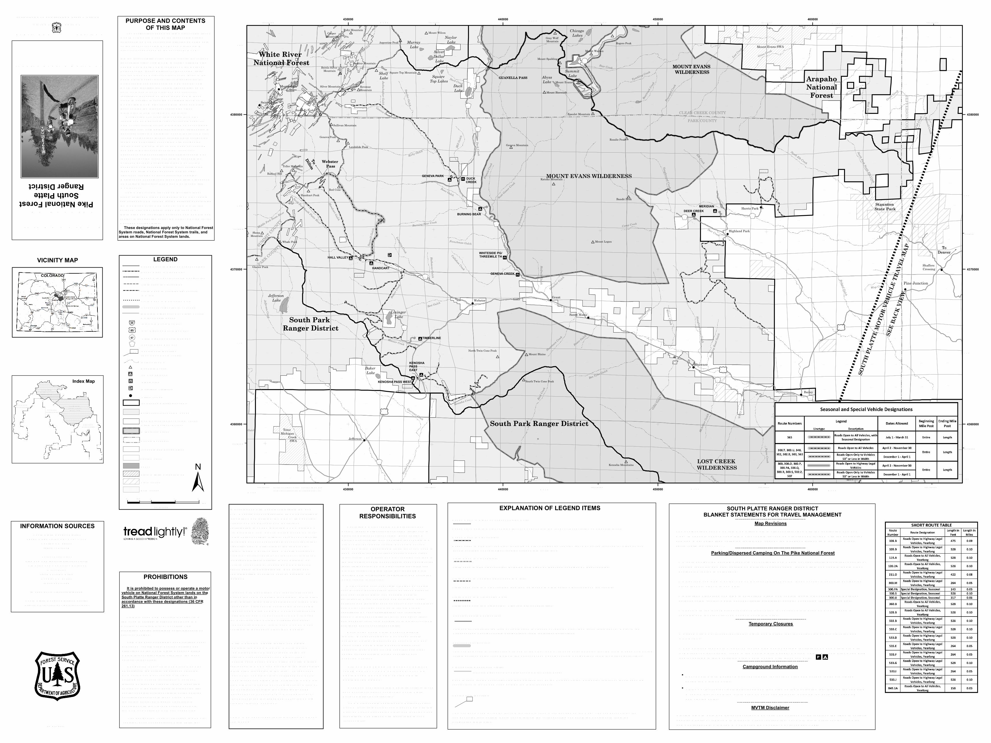
PROHIBITIONS It is prohibited to possess or operate a motorvehicle on National Forest System lands on theSouth Platte Ranger District other than inaccordance with these designations (36 CFR261.13)
V iolators of 36 CFR 261.13 are subject to afine of up to $5,000, imprisonment for up to 6months, or both (18 U .S.C. 3571(e)). T hisprohibition applies regardless of the presence orabsence of signs. T his map does not display nonmotorized uses,over-snow vehicle uses, or other facilities andattractions on the South P latte Ranger District.O btain forest visitor information from the localnational forest office. Designated roads, trails and areas may alsobe subject to temporary, emergency closures.As a visitor, you must comply with signsnotifying you of such restrictions. A nationalforest may issue an order to close a road, trailor area on a temporary basis to protect the life,health, or safety of forest visitors or the naturalor cultural resources in these areas. Suchtemporary and/or emergency closures areconsistent with the T ravel Management Rule(36 CFR 212.52(b); 36 CFR 261 subpart B). T he designation "road or trail open to all motorvehicles" does not supersede State traffic law.
Travel MapMotor Vehicle
EXPLANATION OF LEGEND ITEMSRoads O pen to H ighway Legal V ehicles O nly:Roads open only to motor vehicles licensed under State law for general operation on all public roads.Roads O pen to All V ehicles:Roads open to all motor vehicles, including smaller off highway vehicles that may not be licensed for highway use (not to oversize or overweight vehicles under State traffic law).T rails O pen to All V ehicles:T rails open to all motor vehicles, including both highway legal and nonhighway legal vehicles.
T rails O pen to V ehicles 50"or Less in W idth:T rails open only to motor vehicles less than 50 inches in width at the widest point on the vehicle.
Short Route Identifier:
T his symbol is used for routes that are too short to show a symbol type on the map. T he symbol contains the number of the road or trail. U sers should refer to the corresponding number in the Short Route T able for designation information.
922
O ther P ublic Roads and T rails:
U sed to show routes not designated for motorized use by the Forest Service. P art of the reference layers showing connections to towns and cities outside the forest boundary.
Interstate H ighways, U .S., State, County & O ther P ublic Roads
Special V ehicle Designation:
T his symbol indicates the road or trail is open to classes of vehicles other than those listed above. Refer to theSeasonal and Special V ehicle Designations T able for further instructions.
Seasonal Designation:T his symbol, used in conjunction with one of the other road or trail symbols, indicates that the route is open only duringcertain portions of the year. Refer to the Seasonal and Special V ehicle Designations T able for further instructions.
T rails O pen to Motorcycles O nly:T rails open only to motorcycles. Sidecars are not permitted.
PURPOSE AND CONTENTSOF THIS MAP
T his motor vehicle travel map identifies thoseroads, trails, and areas designated for motor vehicleuse under 36 CFR 212.51 for the purpose of enforcingthe prohibition at 36 CFR 261.13. T his is a limitedpurpose. T he other public roads are shown forinformation and navigation purposes only and are notsubject to designation under the Forest Service travelmanagement regulation.
These designations apply only to National ForestSystem roads, National Forest System trails, andareas on National Forest System lands.
Designation of a road, trail, or area for motorvehicle use by a particular class of vehicle under 36CFR 212.51 should not be interpreted as encouragingor inviting use, or implying that the road, trail or area ispassable, actively maintained, or safe for travel. Motorvehicle designations include parking along designatedroutes and at facilities associated with designatedroutes when it is safe to do so and when not causingdamage to N ational Forest System resources.Seasonal weather conditions and natural events mayrender designated roads and trails impassable forex tended periods. Designated areas may containdangerous or impassable terrain. Many designatedroads and trails may be passable only by high-clearance vehicles or four-wheel drive vehicles.Maintenance of designated roads and trails will dependon available resources, and many may receive littlemaintenance.
INFORMATION SOURCESSouth P latte Ranger District
30403 Kings V alley DR. ST E. 2-115Conifer, CO 80433(303) 275-5610Forest Supervisor
P ike and San Isabel N ational ForestsCimarron and Comanche N ational
G rasslands2840 Kachina DriveP ueblo, CO 81008(719) 553-1400
In case of emergency: Dial 911South P latte Ranger District W ebsite:http://www.fs.usda.gov/goto/psicc/sopl
OPERATORRESPONSIBILITIES
Read and understand this map in its entirety. If youhave questions, please contact the South P latteRanger District for clarification.
O perating a motor vehicle on N ational ForestSystem roads, N ational Forest System trails, and inareas on N ational Forest System lands carries agreater responsibility than operating that vehicle in acity or other developed setting. N ot only must youknow and follow all applicable traffic laws, you need toshow concern for the environment as well as otherforest users. T he misuse of motor vehicles can lead tothe temporary or permanent closure of any designatedroad, trail, or area. As a motor vehicle operator, youare also subject to State traffic law, including Staterequirements for licensing, registration, and operationof the vehicle in question. Motor vehicle use, especially off-highway vehicleuse, involves inherent risks that may cause propertydamage, serious injury, and possibly death toparticipants. Drive cautiously and anticipate roughsurfaces and features, such as snow, mud, vegetation,and water crossings common to remote drivingconditions. By your participation, you voluntarilyassume full responsibility for these damages, risks,and dangers. T ake care at all times to protect yourselfand those under your responsibility. Much of the South P latte Ranger District isremote. Medical assistance may not be readilyavailable. Cellular telephones do not work in manyareas of the South P latte Ranger District. T akeadequate food, water, first aid supplies, and otherequipment appropriate for the conditions andex pected weather.
As a motor vehicle operator on a N ational ForestSystem road, trail, or area, you must comply with thismap, as well as all Federal, State, and local laws andregulations. Compliance with these rules is yourresponsibility.
ALW AYS REMEMBER T O RESP ECT P RIV AT ELAN D! P RO T ECT YO U R P RIV ILEG E. ST AY O NDESIG N AT ED RO ADS AN D T RAILS AN D INDESIG N AT ED AREAS.
0 1 2 30.5Miles
±
LEGEND
WZ25 Interstate Route N umber
£¤85 U .S. H ighway Route N umber
OP67 State H ighway Route N umberKJ97 County Road N umber
Cities, Towns!E Motorized T railhead
P icnic Area"5
FS Campground"9
) Mountain P eaksMajor Streams
533.A Short Route Identifier(See Short Route T able)
Interstate H ighways, U S, State, County & O ther P ublic Roads
Roads O pen to H ighway Legal V ehicles
T rails O pen to V ehicles 50" or Less in W idthT rails O pen to Motorcyles O nly! ! ! ! ! ! ! ! !
T rails open to All V ehicles
Seasonal Designation (SeeT able)
Roads O pen to All V ehiclesRoads with Special V ehicle Designation
Township and Range Lines
County Boundary
W ilderness Areas
N on-N ational Forest System Landswithin the N ational Forest
Forest and District Boundary
1:70,000
State W ildlife Areas (SW A)State LandsBLM Lands
Lakes Section Lines
N ational Forest System Lands
Colorado APR., 2020 T he designations shown on this motor vehicle travelmap (M V T M) were made by the responsible officialpursuant to 36 CFR 212.51; are effective as of the dateon the front cover of this M V T M; and will remain ineffect until superseded by the nex t year's M V T M.It is the responsibility of the user to acquire the currenttravel information. T his M V T M is not the official MotorV ehicle U se Map (MV U M), yet it shows the N ationalForest System roads, N ational Forest System trails,and the areas on N ational Forest System lands in theSouth P latte Ranger District that are designated formotor vehicle use pursuant to 36 CFR 212.51. T hisM V T M also identifies the vehicle classes allowed oneach route and in each area; and any seasonalrestrictions that apply on those routes and in thoseareas. In addition to showing everything that is on theM V U M, this M V T M also shows BLM lands and Statelands outside the forest boundary, plus otherinformation to help navigate on the forest.
T he designations shown on this map will remain in effect until revised with the publication of a new map. In January of each year, this motor vehicle travel map will either be revised with the publication of a new map, or it will be validated for the new year by the Ranger District with a red stamp that says: "V alid for Year 20__"
SOUTH PLATTE RANGER DISTRICTBLANKET STATEMENTS FOR TRAVEL MANAGEMENT
Parking/Dispersed Camping On The Pike National Forest• W here designated parking areas are not available, and where not specifically prohibited, unsafe, or causing resource damage, parking on N ational Forest System lands within one vehicle length off of designated routes is authorized. • Dispersed camping is authorized on N ational Forest System lands ex cept in specially designated areas that are closed to camping. • Motorized dispersed camping is authorized within one vehicle length off of designated N ational Forest System routes, where not specifically prohibited, unsafe, or causing resource damage.• Check with the local N ational Forest District office for current information on areas closed to camping and for other travel management information.
Map Revisions
Temporary Closures• Check with www.fs.usda.gov/psicc, Alerts and N otices tab, for current temporary closures and prohibitions.• See Forest O rder P SICC-2017-11 for camping and/or parking restrictions on and within 1/4 mile of N ational Forest System roads in the South P latte Ranger District. T his O rder only allows camping and/or parking in the Restricted Area where posted with these symbols: pP
Campground Information
Disclaimer: G IS data and product accuracy may vary. T he Forest Service reserves the right to correct, update, modify, or replace G IS products without notification. For more information, contact the P ike and San Isabel N F, Cimarron & Comanche N G , P ueblo, CO . (719) 553-1400.
MVTM Disclaimer
Most South P latte Ranger District developed recreations sites and access roads are closed during the winter months.V isit www.fs.usda.gov/goto/psicc/sopl, and then click on the Recreation tab, then on the camping & cabins tab, for detailed information on each campground, including the estimated opening and closing dates.