a geological report of central strath, skye
TRANSCRIPT

i
The University of Liverpool
A Geological Report of Central Strath, Skye In partial fulfilment for the requirements for the degree of BSc Geology
Isaac Onyett 12-14-2016

i
DECLARATION
NAME: ISAAC ONYETT STUDENT NUM. 201029021
I hereby certify that this dissertation constitutes my own product, that quotation
marks indicate where the language of others is directly reproduced, and that
appropriate credit is given where I have used the language, ideas, expressions or
writings of another to inform my work.
I declare that the dissertation describes original work that has not previously been
presented for the award of any other degree of any institution.
I confirm that I have read and understood the University of Liverpool’s Code of
Practice on Academic Integrity. I confirm that I have not committed plagiarism when
completing the attached piece of work, nor have I colluded with any other student in
the preparation and production of this work.
SIGNATURE DATE

ii
Abstract
The area of central Strath is very rich in its geology, with sedimentary rocks ranging
in age from Pre-cambrian to Early Jurassic. The sequence stratigraphy of central
Strath is separated by two unconformities, one of which can be attributed to the
Caledonian orogeny. Post-Caledonian stratigraphy is characterised by an overall
marine transgressions, with frequent minor fluctuations in sea level. Pre-Caledonian
formations are segregated further by an additional unconformity, representing a
transition from a broadly terrigenous environment to shallow, carbonate seas.
Evidence for the Caledonian orogeny is present as a sequence of Pre-cambrian
sandstones that have been thrusted on top of Ordovician dolostones. The British
Tertiary Igneous Province is represented as a collection of intrusive igneous rocks,
cross-cutting this stratigraphic sequence. The intrusive igneous rocks of central Strath
comprise a suite of basaltic and rhyolitic dykes, a large composite sill, and the Beinn
an Dubhaich granite. A collection of NW-SE orientated dykes provide evidence for an
extensional stress regime with a NE-SW directed minimum principal stress axis. Dykes
are cross-cut by the Tertiary Beinn an Dubhaich Granite, which is hosted within a
large anticline to the north of the investigated area. Intrusion of the granite has led
to spectacular deformation of Ordovician dolostones, with calc-silicate mineral
assemblages of increasing metamorphic grade emerging as the Beinn an Dubhaich
granite is approached.
Acknowledgements
I would like to thank both of my supervisors, Professor John Wheeler and Dr. Janine
Kavanagh for all the help and support throughout this project. I also owe thanks to
Adeel Ahmed, Jake Bookham, Alix Crane-Russel, and Sarah Kanwar for their company
and plentiful moral support throughout weeks of mapping and research in Scotland’s
relentless weather.

iii
Abstract ........................................................................................................................ ii
Acknowledgements ...................................................................................................... ii
1 Introduction ......................................................................................................... 1
1.1 Mapping Area ................................................................................................ 1
1.2 Project Aims ................................................................................................... 3
1.3 Fieldwork Techniques .................................................................................... 3
1.4 Geological Setting .......................................................................................... 4
2 Stratigraphy of Central Strath .............................................................................. 6
2.1 Summary of Formations and GVS ................................................................. 6
2.2 Lonachan Sandstone Formation .................................................................... 8
2.2.1 Lithological Description .......................................................................... 8
2.2.2 Environment of Deposition .................................................................. 10
2.3 Bheinn Shuardail Dolostone Formation ...................................................... 12
2.3.1 Lithological Description ........................................................................ 13
2.3.2 Environment of Deposition .................................................................. 15
2.4 Buidhe Conglomerate Formation ................................................................ 17
2.4.1 Lithological Description ........................................................................ 17
2.4.1.1 Quadrat Analysis of the Buidhe Conglomerate Formation .......... 18
2.4.1.2 Sedimentary Log ........................................................................... 20
2.4.2 Environment of Deposition .................................................................. 21
2.5 Broadford Limestone Formation ................................................................. 24
2.5.1 Lithological Description ........................................................................ 24

iv
2.5.2 Environment of Deposition .................................................................. 26
2.6 Starsaich Sandstone Formation ................................................................... 27
2.6.1 Lithological Description ........................................................................ 28
2.6.2 Environment of Deposition .................................................................. 29
3 Igneous Geology ................................................................................................. 31
3.1 Strathiad Dyke Swarm ................................................................................. 31
3.1.1 Dyke Analysis ........................................................................................ 31
3.1.2 Lithological Descriptions ...................................................................... 32
3.1.2.1 Basaltic Dykes ............................................................................... 32
3.1.2.2 Rhyolitic Dykes .............................................................................. 33
3.1.3 Interpretations ..................................................................................... 33
3.2 Beinn an Dubhaich Granite ......................................................................... 33
3.2.1 Lithological Description ........................................................................ 34
3.2.2 Interpretation and Cooling History ...................................................... 35
3.3 Beinn nan Carn Composite Sill Complex ..................................................... 36
3.3.1 Lithological Description ........................................................................ 36
3.3.1.1 Microgranite ................................................................................. 36
3.3.1.2 Porphyritic Basalt .......................................................................... 37
3.3.2 Interpretations and Emplacement Mechanism ................................... 39
4 Metamorphic Geology ....................................................................................... 41
4.1 Contact Metamorphism of the Bheinn Shuardail Dolostone Formation .... 41
4.1.1 Chert Nodule Analysis .......................................................................... 41
4.1.2 Reaction Pathway ................................................................................. 43

v
4.1.3 Implications for Granite Emplacement ................................................ 46
5 Structural Geology ............................................................................................. 48
5.1 Ductile Deformation .................................................................................... 48
5.1.1 Broadford Anticline .............................................................................. 48
5.1.2 Strathiad Syncline ................................................................................. 49
5.1.3 Small Scale Folds .................................................................................. 49
5.2 Brittle Deformation ..................................................................................... 51
5.2.1 Faulting ................................................................................................. 51
5.2.1.1 Broadford Thrust Fault.................................................................. 51
5.2.1.2 Other Faults .................................................................................. 52
5.2.2 Mineral Veins ....................................................................................... 52
5.3 Structural Setting of Igneous Intrusions ...................................................... 54
5.3.1 Strathiad Dyke Swarm .......................................................................... 54
5.3.2 Beinn an Dubhaich Granite .................................................................. 55
6 Geological History of Central Strath, Skye ......................................................... 57
7 Conclusion .......................................................................................................... 60
8 References .......................................................................................................... 62
9 Appendices ......................................................................................................... 65

-1-
1 Introduction
1.1 Mapping Area
This thesis is a report of 35 days of fieldwork that was undertaken in Strath, Isle of
Skye, Scotland between 3rd July and 23rd August 2016. The Isle of Skye lies off the
western coast of Scotland, separated from the mainland at its closest point by Loch
Alsh. The island is the largest of the Inner Hebrides and is world renowned for its
dramatic landscapes fashioned by its complex and intricate geology, making the Isle
of Skye so appealing to walkers and climbers. The Isle of Skye, meaning ‘cloud island’
owes its name to the famed Cuillin Hills, which are often dramatically cloaked with
mist. Strath is situated to the east of the Cuillin Hills, breaching Elgol and Kilmarie at
the eastern side of Loch Slapin. The investigated area is in Central Strath, and is
confined by the small villages of Broadford, Torrin, and Heaste, spanning
approximately 23km2. The area is easily accessible by car via the B8083, which runs
south from the A87 at Broadford.

-2-
Figure 1: Location maps of the investigated area. a) highlights the location of the Isle of Skye within
Scotland. b) highlights the location of Strath within the Isle of Skye. c) highlights the confines of the
investigated area.

-3-
1.2 Project Aims
The principle aim of this thesis is to present a detailed and thorough geological history
of the area, integrating various aspects of sedimentary, igneous, and metamorphic
geology, and structural relationships between them.
With relation to the sedimentary geology of the investigated area, the aims of this
project are:
1. Characterise and correlate rock units with respect to their composition and
sedimentary structures
2. Analyse palaeoecology using fossil content of the local sedimentary rocks
3. Construct an integrated history of the deposition and evolution of the local
sedimentary rocks
With relation to the igneous and metamorphic geology of the investigated area, the
aims of this project are:
1. Analyse mineral assemblages in and around the Beinn an Dubhaich pluton
2. Quantify pressure and temperature conditions experienced within the aureole of the
pluton
3. Determine magma source and pluton emplacement mechanism
4. Construct an integral history of intrusion, deformation, and metamorphism
1.3 Fieldwork Techniques
In order to achieve the project aims, a number of field techniques were utilised,
including:
Mapping, using outcrop patterns and topographic signatures to place boundaries
between lithologies, both solid and drift.
Detailed sedimentary logging
Quadrat analysis of clast compositions and orientations
Construction of cross-sections
Mineral modal abundance data collection
Stereographic projection
Petrographic descriptions

-4-
1.4 Geological Setting
The oldest rocks of the Isle of Skye, and some of the oldest rocks in Europe, are
Lewisian Gneisses, which outcrop extensively on the Sleat Peninsula. The rocks have
been intensely deformed and unroofed since their deposition approximately 2,800
million years ago. Succeeding a sustained period of uplift and erosion of the Lewisian
Gneisses, the coarse, pebbly sandstones of the Torridonian were laid down by high
energy fluvial channels in a hot and arid climate. At this time Skye was part of a
supercontinent with much of Canada and Greenland (Stephenson and Merritt, 2002).
By the Ordovician period 550 million years ago, the north-west margin of Scotland
sat on the south-east margin of the supercontinent and had been eroded to a
landscape with flat, inferior topography bordered by an extensive continental shelf.
Calm, shallow seas facilitated the deposition of limestones, along with sandstones
and siltstones from the Cambrian to the Middle Ordovician.
There is no geological record on the Isle of Skye for the following 200 million years.
This hiatus is a consequence of the Caledonian Orogeny to the south-east, which saw
the collision of Laurentia and Baltica, forming the Caledonian mountain belt of which
has roots that form the foundations of Scotland.
The Triassic marks the recommencing of the geological record with repeated deposits
of silt, sand, and gravel across broad floodplains in an arid desert environment.
A marine transgression from the south, thought to be related to increased activity at
mid-ocean ridges during the break-up of Pangea lead to a progressive marine
transgression across the Isle of Skye and the UK. As the landscape became submerged
by a warm, shallow, tropical sea teaming with life, deposition of a sequence of
fossiliferous limestones, sandstones, and mudstones was extensive within the
subsiding Hebrides basin, as described by Morton (1990). Towards the end of the
Jurassic, regional drowning of the landscape deposited a thick blanket of mudstone.
The Late Jurassic deposits are succeeded by another hiatus in the geological record
marked by the Late Cimmerian unconformity in which rifting of the North Atlantic
during the break-up of Pangea lead to widespread erosion and volcanic activity across
the UK. Consequently, basaltic lava flows related to the earliest phase of volcanism
in the region make up the majority of northern Skye. These basaltic lava flows are
commonly known as the Skye Main Lava Series (Miller, 2005). The roots of substantial
central volcanoes associated with this North Atlantic rifting are represented on Skye
by the Skye Central Complex, which includes the Cuillin and Red Hills.

-5-
Figure 2: Summary geological map of the Isle of Skye. The area of study is highlighted. After
(Stephenson and Merritt, 2002)
The area of Strath holds a diverse variety of sedimentary, igneous, and metamorphic
rocks, which are expressed by its dramatically heterogeneous landscape. The rock
types that are subject of this study are representative of the diverse geology of Skye,
with sediments ranging in age from the Pre-Cambrian to the Lower Jurassic. These
sediments have been intruded into by mafic and felsic dykes and sills of the Skye
Central Complex, alongside the Beinn an Dubhaich pluton, which has been intensively
studied by Whitten (1961), and King (1960) among others.

-6-
2 Stratigraphy of Central Strath
2.1 Summary of Formations and GVS
The stratigraphy of central Strath consists of five formations ranging in age from Pre-
cambrian to Lower Jurassic. The Lonachan Sandstone Formation and Bheinn
Shuardail Dolostone Formation constitute the pre-Caledonian lithologies of central
Strath. Post-Caledonian lithologies consist of three conformable formations; the
Buidhe Conglomerate formation, Broadford Limestone Formation, and the Starsaich
Sandstone Formation. The pre-Caledonian formations are isolated by an
unconformity. This unconformity represents a 200 Ma hiatus in deposition as a
consequence of uplift and erosion during closure of the Iapetus Ocean. Above this
unconformity are conformable conglomerates, limestones, mudstones, and
sandstones. A second unconformity intervening the Lonachan Sandstone Formation
and Bheinn Shuardail Dolostone Formation segregates the pre-Caledonian formation.
This unconformity represents a hiatus in deposition lasting approximately 500 Ma.

-7-
Figure 3: Generalised vertical section, comprising summarising the chronostratigraphy,
lithostratigraphy, and biostratography of central Strath

-8-
2.2 Lonachan Sandstone Formation
The Lonachan Sandstone Formation outcrops extensively around Bheinn Shuardail and
Bealach a’ Ghlinee. The rock is particularly well exposed along the lower parts of the
north-west facing flank of Bheinn Shuardail and to the south-east of Loch Lonachan.
Exposure is generally moderate to good.
Type locality: Locality 62 GR(163635,822215)
2.2.1 Lithological Description
The minimum thickness of the Lonachan Sandstone Formation is 255 metres,
although the base is not seen. The sandstone is weakly bedded on a decimetre scale.
Some correlation can be observed between grain size and bed thickness, with
thicker beds generally consisting of larger grains. The sandstone displays infrequent
cross bedding and planar laminations with prominent syn-sedimentary structures
throughout. Planar and wavy laminations are seen in finer beds with distinct lamina
of very fine sand to silt sized dark grey minerals. Figure 4 shows convolute
lamination towards the bottom of the image, passing upwards into wavy
laminations, succeeded further by planar laminations towards the top of the image.
Figure 4: Convolute lamination, wavy lamination, and planar lamination within a bed of the
Lonachan sandstone. Assisted by a sketch of convolute lamination (bottom left). Compass clinometer
for scale. Taken at GR(162845,818700)

-9-
Complex folding of heavy-mineral laminae is prevalent throughout the Lonachan
sandstone. Folds are primarily tight and overturned with variation in the complexity
of deformation within decimetre scale beds. In figure 5 the complexity of
deformation of laminae increases upwards from a broad synformal structure to
multiple small, complex folds.
Figure 5: Complex folding of dark mineral lamina in the Lonachan sandstone. Complexity of
deformation increases towards the top of the bed. Assisted with a sketch of intensely deformed area
with inferred water escape pathways. Pencil for scale. Taken at GR(162638,818593)
The Lonachan sandstone has a reddish brown appearance on a fresh surface and
exhibits no major discolouration due to weathering. The Lonachan sandstone
comprises primarily fine to medium (125-500μm) sized grains of quartz (45%), K-
feldspar (20%), plagioclase feldspar (10%), and lithic fragments (5%). The sandstone
is grain supported with 10% silica cement manifested as syntaxial overgrowths that
glimmer in sunlight. Plotting modal abundances of the constituent minerals on the
Pettijohn classification of sandstones, or the ‘Toblerone plot’ (Figure 6) places the
sandstone in the arkosic arenite field.

-10-
Figure 6: 0% matrix sub-
triangle of the Pettijohn
classification of sandstones,
or ‘Toblerone plot’. Lonachan
sandstone composition is
marked as an orange cross
within the arkosic arenite
field.
2.2.2 Environment of Deposition
The Lonachan Sandstone Formation is analogous to the Applecross Formation of
the Torridonian supergroup, which has been dated to the Pre-cambrian using
fossilised worm burrows, and Rb-Sr dating by Moorbath (1969).
The complex morphology of structures within the sandstone, alongside significant
variations in the complexity of deformation within decimetre scale beds, suggests
that they are related to syn-sedimentary processes and are not of tectonic origin.
Structures of this nature are related to soft sediment deformation, in which water-
escape is an intrinsic cause. Upwelling of water from below the deformed region
causes fluidization of the overlying sediment, leading to tight, complex folds, often
with fragmented hinges. A water escape pathway can be inferred by tracing fold
hinges upwards through multiple deformed laminae (Figure 5). Soft sediment
deformation structures within the Applecross Formation have been described
previously by Owen (1995), who invites the possibility that liquefaction is
seismically induced. The scarcity of cross bedding within the formation may be a
consequence of post-depositional deformation of foresets. Where cross bedding
can be identified, foresets dip towards the south-east at 058o, indicative of a south-
east directed palaeocurrent. Figure 5 represents a progressive change in flow
energy from downstream migration of approximately 1cm amplitude bedforms in
the lower flow regime to downstream migration of very low amplitude bedforms in

-11-
the upper flow regime. Development of laminations in the upper flow regime
(upper plane bed) is indicative of a high-velocity flow. Flow velocity can be
quantified using the flow regime diagram (Figure 7), which indicates a mean flow
velocity of 85 – 135 cm/s. The interpretation of a high energy depositional
environment is supported by a lack of fossils in the sandstone.
Figure 7: Flow regime diagram.
Red dashed lines indicate the
mean flow velocity required for
transportation of fine to medium
sand in the upper flow regime
(upper plane bed). After Harms,
Southard, and Walker (1982)
A relatively high modal abundance of unstable feldspar grains within the Lonachan
sandstone indicates that it is compositionally immature. The constituent grains are
sub-rounded and moderately sorted also indicated that the sandstone is texturally
sub-mature. Compositional immaturity and textural sub-maturity suggest a low
degree of transportation from a nearby source to allow unstable feldspar grains to
prevail during sediment transport.
An absence of floodplain deposits such as muds and silts suggests sustained
deposition from multiple fluvial channels during a period of high subsidence rates.
It can thereby be concluded that the depositional setting of the Lonachan Sandstone
is a high energy braided fluvial system with sediment source in close proximity to
the region of sediment deposition.

-12-
Figure 8: A schematic block diagram representing a potential depositional environment of the
Lonachan sandstone in a braided river system.
2.3 Bheinn Shuardail Dolostone Formation
The Bheinn Shuardail Dolostone outcrops extensively towards the top of Bheinn
Shuardail and envelopes the Beinn an Dubhaich Granite at the centre of a broad
antiform. The rock is particularly well exposed around the peaks Bheinn Shuardail and to
the south of Beinn an Dubhaich. The best exposure of this formation is within quarries
peripheral to the granite. The dolostone is characterised by a karstic weathering profile
and rich green vegetation dominated by bracken in the south and dense woodland to the
north. Exposure is generally very good to excellent.
Type Localities: Locality 37 GR(162750, 820295) (dolostone D1)
Locality 38 GR(162175,819150) (dolostone D2)
Locality 48 GR(161290,819060) (dolostone D3)
-13-
2.3.1 Lithological Description
The overall thickness of the Bheinn Shuardail Dolostone Formation is approximately
380 metres. The Bheinn Shuardail Dolostone Formation consists of chert-bearing
siliceous dolostones that can be subdivided into three distinct lithologies, D1, D2, and
D3, that appear sequentially towards the Beinn an Dubhaich granite. Crystal size and
texture vary throughout the formation. At distance from the granite, the dolostone
comprises cryptocrystalline micrite. The texture of the rock shows variation to a more
saccharoidal texture with crystals up to 2 mm in diameter towards the periphery of
the granite. Sedimentary structures are absent throughout this formation.
Dolostone D1 is dark blue/grey but appears pale grey on a weathered surface. Crystal
size ranges from micritic to 1 mm where recrystallization is apparent by pale grey
discoloration on a fresh surface. Chert is abundant and manifested as randomly
distributed dark grey, hackly nodules. Although dolostone D1 is fossiliferous, fossils
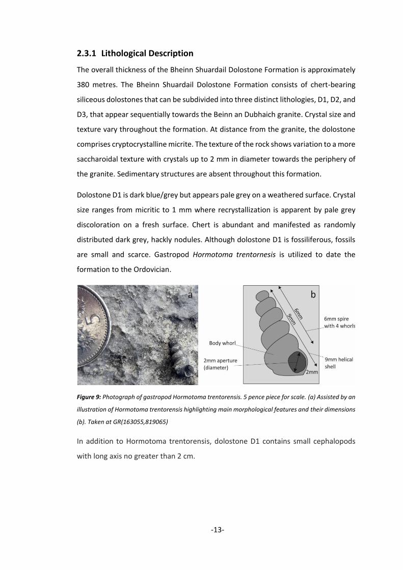
are small and scarce. Gastropod Hormotoma trentornesis is utilized to date the
formation to the Ordovician.
Figure 9: Photograph of gastropod Hormotoma trentorensis. 5 pence piece for scale. (a) Assisted by an
illustration of Hormotoma trentorensis highlighting main morphological features and their dimensions
(b). Taken at GR(163055,819065)
In addition to Hormotoma trentorensis, dolostone D1 contains small cephalopods
with long axis no greater than 2 cm.

-14-
Figure 10 Photograph of small cephalopods within the Bheinn Shuardail Dolostone. Structure of the
shells has been highlighted. Dashed lines represent inferred structure of the shells 5 pence piece for
scale. Taken at GR(163055,819065)
Dolostone D2 is pale grey on both a fresh and weathered surface. Crystal size ranges
from 1 to 2 mm in diameter. The primary diagnostic feature of this lithology is white
chert that forms nodules and layers. The chert nodules are larger than those in
dolostone D1, with long axes reaching up to 17 cm. Chert nodules tend to form
disconnected layers that run parallel to continuous chert layers.
Figure 11: Photograph of dolostone D2 showing white chert layers and nodules. Compass clinometer
for scale. Taken at GR(162175,819150)

-15-
Recrystallization of chert to euhedral trigonal pyramids of quartz is recurrent towards
the centre of large nodules, a likely consequence of increased temperatures during
emplacement of the Beinn an Dubhaich granite.
Dolostone D3 is contiguous with the Beinn an Dubhaich granite towards the centre
of the large antiform. Its appearance is very pale grey to off white on a fresh surface,
however weathers pale grey. Dolostone beds are defined by thin 0.5 – 2.5 cm layers
of dark grey chert that are commonly folded and boudinaged.
Figure 12: Photograph of dolostone D3 showing folded dark grey chert layers. Axial trace of folds are
highlighted by red dashed lines. Pencil for scale. Taken at GR(161480,820160)
2.3.2 Environment of Deposition
The Bheinn Shuardail Dolostone is representative of a warm, shallow, tropical,
carbonate marine environment, facilitating the precipitation of calcite. These
dolostones are regarded in literature as a subdivision of the ‘Durness Group’
(Nicholas, 1994). Deposition of dolostones on a stable, gently sloping shelf along a
northern passive margin is described by Brück et.al (2011). Deposition must have
been succeeded by a period of diagenetic dolomitization of the antecedent

-16-
limestone, which may be responsible for an absence of sedimentary structures. The
presence chert within this formation may be attributed to recrystallization of
siliceous organisms during diagenesis. Nodules of chert are likely to be a consequence
of recrystallization of macro-organisms such as siliceous sponges and corals. Layers
of chert are likely to be a product of recrystallization of siliceous skeletons of
microorganisms that have settled to the bottom of the water column, forming a layer
of a siliceous ooze. The transition from chert nodules to chert layers towards the
centre of the antiform may be representative of a regressive system. Where sea level
is relatively high, the primary source of silica is pelagic fallout of siliceous
microorganisms forming continuous layers of chert. Nodules of chert may
characterise a shallower marine environment in which benthic siliceous macro
organisms are the salient source of silica and pelagic fallout of microorganisms in
negligible.
Figure 13: Schematic block diagram representing a potential depositional environment of the Bhainn
Shuardail Dolostone in a shallow carbonate marine environment. Biological causes of chert nodules
and layers are annotated.

-17-
Subsequent dolomitisation of this formation is described by Swett (1969). The
occurrence of fossils within this formation, including Hotmotoma trentorensis has
allowed biostratigraphical dating to the Ordovician.
2.4 Buidhe Conglomerate Formation
The relatively small thickness of the Buidhe Conglomerate is reflected by its outcrop
style as a narrow strip orientated to the north-west from Bheinn nan Carn, extending
towards Broadford. The Buidhe conglomerate also outcrops locally to the north-west
of Bheinn Shuardail near the B8083. The rock is particularly well exposed to the north
of Bheinn nan Carn and east of Loch an Ellein. Exposure is generally moderate to
good.
Type Localities : Locality 67 GR(164855,821810) (coarse sand matrix)
Locality 69 GR(163805,819350) (red mudstone matrix)
Locality 73 GR(163470,818830) (micrite matrix)
2.4.1 Lithological Description
The overall thickness of the Buidhe Conglomerate Formation is approximately 90
metres. The Buidhe Conglomerate Formation consists of polymictic
paraconglomerates, which due to sporadic and localised variations in composition
are mapped as one unit. Structures within the Buidhe conglomerate are rare, with
one set of cross bedding within a predominantly sandy bed, and infrequent graded
bedding. Bedding planes were often difficult to establish, defined by abrupt changes
in grain size.
The composition of the matrix varies throughout the formation between coarse sand,
red mudstone, and micrite. Although there is some degree of local variation in matrix
the percentage of matrix by volume can also be seen throughout the formation, from
20% to 85% matrix. The dominant composition changes from coarse sand, to red
mudstone, to micrite from the north-east to the south-west respectively.

-18-
Figure 14: Photograph of the Buidhe Conglomerate. A conglomerate with a red mudstone matrix is
overlain by conglomerate with a micrite matrix. Geological hammer for scale.
2.4.1.1 Quadrat Analysis of the Buidhe Conglomerate Formation
Analysis of clasts within 0.5m2 quadrats was conducted at six localities within the
Buidhe conglomerate to acquire an indication of flow energy and the depositional
environment in which this formation was formed.
A rose diagram plot comprising orientations of clast in all 6 quadrats reveals a
relatively strong preferred orientation to the north-east/south-west. This is
suggestive of a palaeocurrent flowing to the north-east or south-west.
Figure 15: A rose diagram displaying
orientations of clasts from six quadrats across
the Buidhe conglomerate. A relatively strong
NW/SE trend can be seen.

-19-
A clast size frequency histogram compiling all quadrat data (Figure 16) shows an
exponential decrease in clast size against frequency. Although the majority of clasts
are below 3cm, there is a significant number of large clasts, with clasts up to 15.2cm
in size. A large spread of clast sizes indicates very poor sorting of clasts in the
conglomerate. A flow with immense energy is required for the transportation and
subsequent deposition of such clasts.
Figure 16: Clast size frequency histogram displaying the relationship between clast size and frequency
within the Buidhe conglomerate. There is an exponential decrease in clast frequency with increasing
size. However, there is a considerable number of large clasts within the formation.
Figure 17 displays the variation in composition and maximum clast size throughout
the conglomerate, from the north-east to the south-west. The amount of quartz in
the conglomerate appears to decrease from the north-east to the south west, with
dolostone (BSD) being the most abundant clast in the south-west. As well as the
Bheinn Shuardail dolostone, intraformational clasts of the Lonachan sandstone are
also present at (162730,821855).
Maximum clast size is significantly higher is conglomerates with micrite (Lst) and
sandstone (Sst) matrix. This is suggestive of a calmer depositional system during
deposition of the conglomerate with a red mudstone (Mud) matrix. A high flow
0
10
20
30
40
50
60
70
80
90
100
1 - 2 2 - 3 3 - 4 4 - 5 5 - 6 6 - 7 7 - 8 8 - 9 9 - 10 >10
FREQ
UEN
CY
CLAST SIZE (CM)
Conglomerate Clast Size Frequency Histogram

-20-
energy must have been sustained througout sediment transport as there is no
progressive decrease in clast size indicative of decreasing flow energy.
Figure 17: Stacked bar chart showing maximum clast size and composition across the Buidhe
conglomerate from the north-ease to the south-west. Composition is based on number of clasts, not
percentage by volume.
2.4.1.2 Sedimentary Log
A 10.8 metre section of the lowermost fraction of the Buidhe Conglomerate
Formation was logged to reveal relationships between compositional variation
within the formation and changes in environment facies.
The base of the section consists of sandstones that do not correspond to other
lithologies within the studied area. Sandstone passes up into red mudstone and
siltstone, succeeded by repeated variations between conglomerates with a coarse
sand matrix and conglomerates with a micrite matrix.
2
4
6
8
12
14
16
164075,819550 163805,81935
GRID REFERENCE
163445,818605 162410,81845
10
CLA
ST S
IZE
(CM
)
0 164855,82182 162730,821855
NE SW
Quartz
Metaquartzite
Dolostone (BSD)
Sandstone (LS) Metapelite
Chert
Sst Sst Sst Mud Lst Lst

-21-
Figure 18: Sedimentary log of a 10.8 metre section of the Buidhe conglomerate and unidentified
sandstones. Cyclic changes in environment are represented here by repeated variation in composition
of conglomerates. Log locality: GR(164320,819650)
2.4.2 Environment of Deposition
The Buidhe Conglomerate Formation is equivalent to the Stornoway Formation, as
described in the literature (Steel & Wilson, 1975). Although a lack of fossil content
makes dating difficult, palaeomagnetic evidence has been utilized by Storetvedt and

-22-
Steel (1993) to date the base of this formation to the Late Permian - Triassic.
Storetvedt and Steel assign a thickness of 4 km to the formation, thus Late Permian
– Triassic stands as an age limit for the conglomerate. Intraformational clasts of the
Lonachan Sandstone Formation and Bheinn Shuardail Dolostone Formation within
the conglomerate represent an unconformity in which the preceding lithologies have
been uplifted, exposed at the surface, and eroded.
The textural immaturity of the Buidhe conglomerate is indicative of a minor degree
of transportation from a proximal source. Flow energy must have been sufficient to
transport clasts up to 15.2cm in size. Minimum flow speed can be quantified using
the Hjulstrom curve (Figure 19), which proposes a high-velocity flow of 110 cm/s.
Figure 19: Hjulstrom curve highlighting the minimum flow speed required to transport clasts 15.2 cm
in size within the Buidhe conglomerate. A high-velocity flow speed of 110 cm/s is required.
Deposition of the conglomerate may have been within an estuarine environment on
a continental plain, accompanied by fluctuations in sea level. Although not present in
the investigated area, the widespread calcretes within the formation suggests an arid
climate during deposition (Morton and Hudson, 1995). The conglomerate with a
coarse sand matrix may have been deposited by a fluvial channel, possibly as crevasse
splay deposits where flow energy peaks at the outermost margin of a meander.
Where the fluvial channel meets the less confined shallow marine, flow energy

-23-
decreases and clasts will be deposited instantaneously. Background precipitation of
calcium carbonate in the shallow marine encases the clasts in a fine micrite matrix. A
red mudstone matrix is indicative of a calm subaerial environment with incidental
background settling of fine particles. Conglomerates with a red mudstone matrix may
have been deposited in floodplain lakes.
A progressive change in matrix composition from coarse sand in the north-east to
micrite in the south-west with intervening conglomerates with a red mudstone
matrix may represent different sub-environments within an estuary. This is
suggestive of fluvial channels dominating the north- east, feeding sediment to a
carbonate sea to the south-west. Potential sub-environments responsible for
variations in matrix composition are highlighted in figure 20.
Figure 20: Block diagram representing a possible depositional environment for the Buidhe
conglomerate, with sub-environments responsible for compositional variation within the conglomerate
highlighted.
Local variations in matrix composition, seen for example in the logged section (Figure
18) may be representative of fluctuations in relative sea level. This will cause
transitions between fluvial-dominated and marine-dominated environments, and
subsequently will be marked as localised changes in matrix composition in the rock
record.

-24-
2.5 Broadford Limestone Formation
Exposure of the Broadford Limestone Formation is generally poor where the
topography is uniform and flat, however the presence of this formation can often be
deduced by the appearance of bracken, which tends to grows on calcareous soils. The
best exposure of this formation can be seen as cliff sections to the north of Beinn nan
Carn, and along river sections, namely Allt na Cloiche Bideiche and Allt a’ Choire.
Type locality: Locality 74 GR(163650, 818805)
2.5.1 Lithological Description
The overall thickness of the Broadford Limestone Formation is approximately 310
metres. The Broadford Limestone Formation consists of limestones and sandstones
interbedded on a decimetre scale. Limestone also occurs less frequently as lenses
within sandstone beds.
The limestones are dark grey to dark blue on a fresh surface, however weather pale
grey. The limestones are fossiliferous, dominated by complete bivalve shells that are
often articulated. The majority of limestone beds within the formation are mud
supported, with fossil content exceeding 10% of the rock by volume. Thus, a
biomicritic wackestone is inferred. Bivalve Liostrea birmanica (Figure 21) has been
utilized to date the formation to the Lower Jurassic.
Figure 21: Photograph of bivalve
Liostrea birmanica. Outline of shell
and internal structure have been
highlighted. Taken at
GR(163650,818805)

-25-
The limestone is predominantly arenaceous with a notable transition at the base of
the formation from pure limestone to arenaceous limestone. Quartz grains range in
size from very fine sand to small pebbles (0.3mm to 35mm).
Figure 22: Photograph of a particularly quartz-rich bed of limestone with an abundance of pebble-sized
quartz clasts. Compass clinometer for scale. Taken at GR(165610,821855)
Sandstone beds are typically considerably thinner than limestone beds and tend to
weather out as resistant ribs. They are often undular and sometimes pinch and swell.
The sandstone appears grey on a fresh surface, with buff weathered surfaces. Grains
size ranges from very fine to coarse sand (187 μm – 350 mm), with a well sorted and
sub-rounded texture. The sandstone is grain supported, and is composed exclusively
of quartz. A silica cement is inferred by an inertia when in contact with hydrochloric
acid and high competence. Hummocky cross stratification, although rare, is also
present.

-26-
Figure 23: Photograph of a typical sequence of limestone and sandstone beds of the Broadford
Limestone Formation. Relative sizes of beds are typical here and thin sandstone bed can be seen
undulating towards the top of the image. A5 notebook for scale. Taken at GR(163650,818805)
2.5.2 Environment of Deposition
The Broadford Limestone Formation is analogous to the Breakish Formation,
previously known as the Lower Broadford Beds (Morton et al., 1999). Repeated
alternations between arenaceous biomicritic wackestones and quartz sandstones
may reflect cyclic changes in climate or sea level, which subsequently influences
sediment supply.
Alternatively, beds of quartz sandstone may represent storm events, activating and
reinforcing fluvial channels that subsequently introduce terrigenous sediment into
the system. This notion is supported by the presence of hummocky cross
stratification within sandstone beds, indicative of deposition above storm-weather
wave base. This is in agreement with Simms et al. (2004), who propose that the
sandstone beds represent offshore sandbars, with wave, tide and possibly storm-
action evident. Additionally, large pebble sized clasts within the limestone at
GR(165610,821855) require substantial flow energy for transportation and
deposition from the provenance of the clasts to a carbonate sea. An abundance of
un-fragmented, commonly articulated bivalve shells within limestone beds are
indicative of a calm marine environment alternating with storm events that inject
terrigenous sediment into the system.

-27-
Depositional environment is likely to be a shallow carbonate sea in close proximity to
the mouth of at least one river feeding the system with terrigenous sediment. This
hypothesis is supported by the presence of Liostrea, which are characteristic of very
shallow water marginal marine environments (Hallam, 2009). Possible depositional
settings are highlighted on figure 24.
Figure 24: Schematic block diagram representing a potential depositional environment of the
Broadford limestone in a shallow carbonate marine above storm-weather wave base. Storm events
cause an influx of terrigenous sediment through reinforcement of fluvial channels.
2.6 Starsaich Sandstone Formation
The Starsaich Sandstone lies conformably above the Broadford Limestone, and also
outcrops in low-lying regions with inferior topography. This formation outcrops most
extensively at the centre of a large synform to the east of the investigated area.
Exposure is generally poor due to heavy vegetation, so sections cut by rivers are
utilized in the study of this formation.
Type locality: Locality 18 GR(163320,822380)

-28-
2.6.1 Lithological Description
The minimum overall thickness of the Starsiach Sandstone Formation is
approximately 180 metres, although the top of this formation is not seen. The
Starsaich sandstone comprises sandstones and micaceous mudstones and siltstones
interbedded on a decimetre scale.
The sandstone has a light to dark grey appearance on a fresh surface, however
weathers brown. Sandstone beds display infrequent tabular and hummocky cross
stratification. The constituent grains are primarily medium (250-500 μm) in size and
are dominated by quartz (85%), with some plagioclase feldspar (5%) and lithic
fragments (10%). Muscovite mica constitutes approximately 5% of the sandstone
and is persistent throughout the formation. Plotting modal abundances of the
constituent minerals on the Pettijohn classification of sandstones, the ‘Toblerone
plot’, reveals that its composition is that of a sublitharenite. Effervescence with
dilute hydrochloric acid signifies that grains are secured by a carbonate cement.
Mudstones and siltstones are dark grey to black on both weathered and fresh
surfaces. Laminations are common, with degree of lamination often corresponding
to grain size. Mudstone beds tend to have more prominent laminations and a higher
degree of fissility. Gain size ranges from clay (< 2 μm) to silt (2-63μm). Mudstone and
siltstone beds are relatively rich in muscovite mica (10%), which is prevalent
throughout the formation. A large proportion of mudstone and siltstone beds are
fossiliferous, dominated by bivalve Gryphaea arcuata.
Figure 25: Photograph of a fossilized Gryphaea arcuata (a) assisted by an illustration highlighting some
morphological features of the shell (b). Taken at GR(165680,821390)

-29-
Casts of Gryphaea are common, as well as shells that have been replaced by calcite,
with rare preservation of shell structure. Orientations of 31 Gryphaea shells within a
1m2 quadrat on a Gryphaea bed reveals a moderate preferred orientation of shells to
the east.
Figure 26: Contoured stereonet displaying
orientations of poles of 31 Gryphaea
shells. A high concentration of Gryphaea
shells can be see orientated to the east.
The uppermost subsection of this formation is characterised by a large (25m) unit of
mudstone outcropping towards the centre of the Strathiad synform to the east at
GR(164660,818540).
2.6.2 Environment of Deposition
The Starsaich Sandstone Formation is referred to in the literature as the Ardnish
Formation, previously known as the Upper Broadford Beds (Hesselbo and Coe 1989).
Interbedded sandstones with mudstones and siltstones are representative of cyclic
changes in depositional setting, possibly associated with fluctuations in climate, sea
level, or a combination of the two. Hummocky cross stratification within sandstone
beds indicates depth of deposition above storm-weather wave base. Contrastingly,
fine laminations within the mudstone suggest settling of fine sediment to substantial
depths within the water column. By the Early Jurassic, Ordovician dolostones (Bheinn
Shuardail Dolostone Formation for the purposes of this project) were completely
submerged underwater (Farris, Oates and Torrens, 1999). This denotes a marine
transgression from the Triassic in which the Ordovician dolostones were subaerially
exposed. Dark grey to black colouration is also indicative of a deep anoxic marine,

-30-
facilitating the preservation of fossils. This marine transgression is described by a
change in palaeoecology from shallow water Liostrea, to Gryphaea, typical of deeper,
more open water environments in which ammonites also occur (Hallam, 2009).
A relatively high modal abundance of quartz accompanied by low a proportion of
unstable feldspar grains suggests that the sandstone is compositionally mature. A
well-sorted texture and sub-rounded grains is also representative of the textural
maturity of the sandstone. This is indicative of a high degree of transportation of
clasts from their source. Thus, the Starsaich sandstone is inferred to have been
deposited in a distal, relatively deep marine environment with temporal variations in
water depth.

-31-
3 Igneous Geology
3.1 Strathiad Dyke Swarm
3.1.1 Dyke Analysis
Detailed analysis of the Strathiad Dyke Swarm was performed throughout the
project, recording composition, width, strike, and dip of 37 dykes. Extensive
investigation shows that the dyke swarm is dominantly basaltic, with scarce rhyolitic
dykes. Regardless of their composition, all dykes have been inferred to be members
of the same dyke swarm as they are similarly orientated to the north-west/south-
east (see section 5).
Figure 27: Pie chart displaying the relative abundance of dykes of different compositions in central
Strath

-32-
3.1.2 Lithological Descriptions
3.1.2.1 Basaltic Dykes
Basaltic dykes are the most abundant in the investigated area and can be sorted into
aphyric (49%) and porphyritic (41%).
Porphyritic basalt dykes consist of large, milky white, lath-shaped plagioclase
phenocrysts within a very fine, dark grey/green ground mass. Mineralogy of the
ground mass is often hard to determine due to very fine crystal size, however
amphiboles and plagioclase have been inferred from flecks of milky white plagioclase
(10%) among a predominantly dark green/grey amphibole-rich ground mass (65%).
Figure 28: Photograph of a porphyritic basalt dyke. Note that this dyke is particularly rich in plagioclase.
10 pence piece for scale.
Towards the periphery of the Beinn an Dubhaich granite, alteration to metabasites is
inferred from the presence of acicular, sometimes radial and fibrous actinolite
crystals within the ground mass (GR[161630,819950]).

-33-
3.1.2.2 Rhyolitic Dykes
Rhyolite dykes are dominantly porphyritic with phenocrysts of k-feldspar in a fine
ground mass of plagioclase feldspar and quartz.
One amygdaloidal rhyolite dyke outcrops at GR(164865,821790), with large vesicles
(3.5 - 5.0mm) constituting ~80% of the dyke. The vesicles are infilled with plagioclase
feldspar, and inter-vesicle spaces are composed of quartz (~20%).
3.1.3 Interpretations
The presence of phenocrysts within approximately half of the basaltic dykes is
indicative of a period in which the magma resides, fostering large, euhedral
plagioclase crystals during its ascent to the surface. A succeeding period of
crystallisation at shallower depths and lower temperatures encases plagioclase
phenocrysts in a very finely crystalline ground mass.
3.2 Beinn an Dubhaich Granite
The Beinn an Dubhaich granite outcrops within the centre of the Broadford anticline
at the north-east of the investigated area. Exposure is generally very good, with
excellent exposure at highest topographic heights of Beinn an Dubhaich, and along
river sections. The extent of the granite at the surface is clearly outlined by a
punctuated change in vegetation from rich green bracken on the enveloping
dolostone, to deep purple heather on the granite. The impermeability of the granite
is reflected by overlying marshland.
Type locality Locality 26 GR(161110,820345)
-34-
3.2.1 Lithological Description
The Beinn an Dubhaich granite is a predominantly coarsely crystalline, equigranular,
felsic igneous rock. The granite consists primarily of anhedral quartz, subhedral to
euhedral k-feldspar, and subhedral plagioclase feldspar with minor amounts of
anhedral biotite mica and hornblende. Peterological investigation along two
transects, spanning both the width (T1) and length (T2) of the pluton has led to its
identification as a mozono-granite, with some local variation to a grano-diorite.
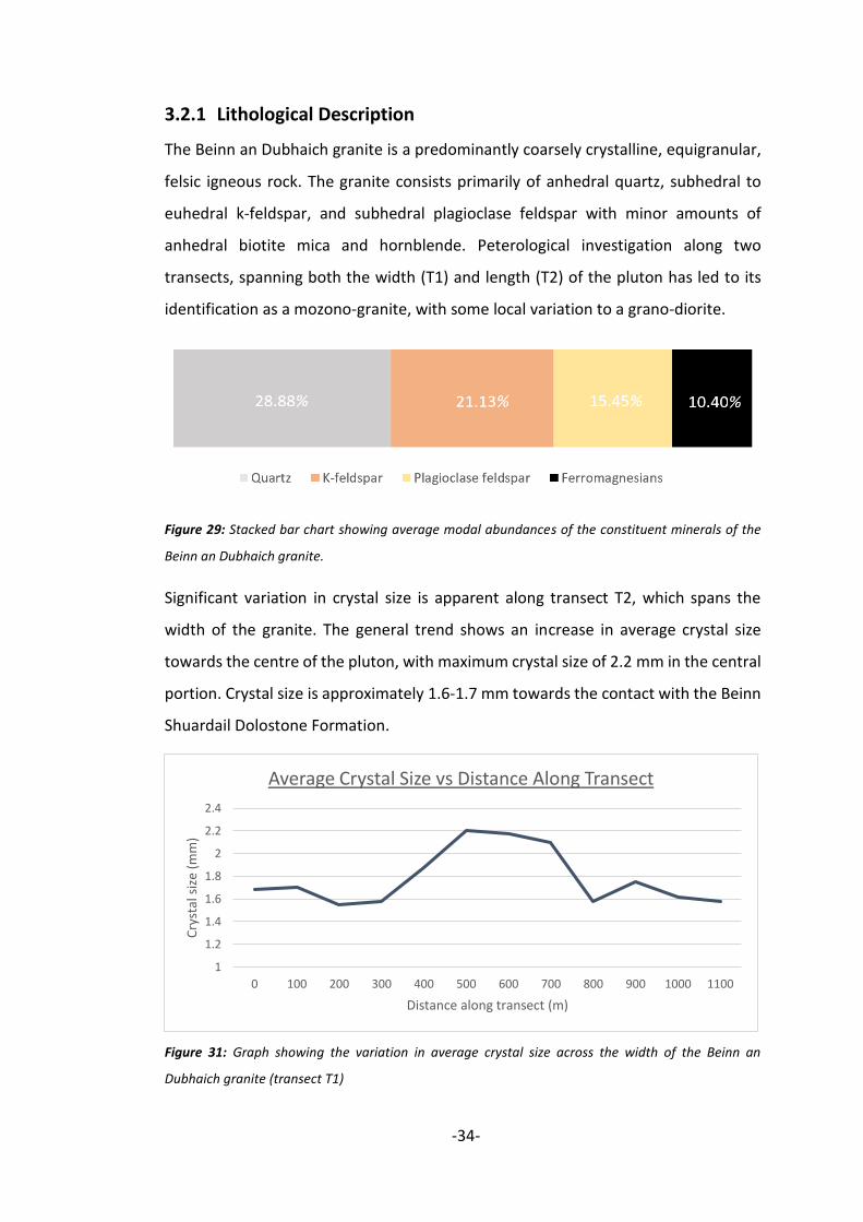
Figure 29: Stacked bar chart showing average modal abundances of the constituent minerals of the
Beinn an Dubhaich granite.
Significant variation in crystal size is apparent along transect T2, which spans the
width of the granite. The general trend shows an increase in average crystal size
towards the centre of the pluton, with maximum crystal size of 2.2 mm in the central
portion. Crystal size is approximately 1.6-1.7 mm towards the contact with the Beinn
Shuardail Dolostone Formation.
Figure 31: Graph showing the variation in average crystal size across the width of the Beinn an
Dubhaich granite (transect T1)
1
1.2
1.4
1.6
1.8
2
2.2
2.4
0 100 200 300 400 500 600 700 800 900 1000 1100
Cry
stal
siz
e (m
m)
Distance along transect (m)
Average Crystal Size vs Distance Along Transect

-35-
Figure 31: Graph showing the variation in
modal abundance of the constituent
minerals of the Beinn an Dubhaich granite
using data from transect T2.
The overall composition of the granite is relatively uniform throughout, however
noteworthy vertical stratification of the pluton is evident. A pronounced increase in
quartz and ferromagnesian minerals is seen from the lowermost regions of the
exposed granite towards the highest topographic heights. K-feldspar remains
relatively constant throughout, however the amount of plagioclase increases subtly
with height up the pluton. An increase in modal abundance of quartz with height up
the Beinn an Dubhaich is also documented by Whitten (1961).
3.2.2 Interpretation and Cooling History
Variation in crystal size within the pluton can be attributed to higher rates of
nucleation and slow rates of crystal growth at the contacts with the cold country rock.

-36-
Slower rates of nucleation and high rates of crystal growth in the central portions of
the granite form larger crystals up to 2.2 mm in size.
Vertical stratification within the Beinn an Dubhaich granite may be due to crystal
fractionation throughout cooling. In this process, dense, mafic, ferromagnesian
minerals crystallise out of the melt during early stages of cooling and begin to sink
under gravity. The melt composition becomes progressively more evolved and
continues to cool, causing the upper portion of the magma chamber to be more felsic,
reflected by increased amounts of quartz.
3.3 Beinn nan Carn Composite Sill Complex
The Beinn nan Carn microgranite outcrops most extensively at the highest
topographic heights of Beinn nan Carn, running north-west as a series of hills and
ridges. Exposure is generally very good with best exposures elevated at heights of
approximately 250 metres above sea level.
Type Locality: Locality 57 (GR163505,818380)
3.3.1 Lithological Description
3.3.1.1 Microgranite
The Beinn nan Carn microgranite appears light grey on a fresh surface, and shows
no major discolouration due to weathering. The bulk of the microgranite is
structureless, with occasional planar features that resemble foresets.
The felsic composition of this rock unit is reflected by a pale colour index of 5 – 10%.
Crystals are predominantly equigranular medium sized (~1 mm). The mineralogy is
dominated by pale, felsic crystals of quartz (10-15%), K-feldspar (10-20%), and
plagioclase feldspar (12-35%). Dark green to grey amphiboles constitute the scarce
mafic minerals within the rock.

-37-
Figure 32: Photograph of microgranite with thin, planar features that resemble foresets, dipping to the
west. Geological hammer for scale. Taken at GR(163505,818380)
3.3.1.2 Porphyritic Basalt
The microgranite is bound at either side by abrupt contacts with a notably
contrasting porphyritic basalt. The basalt is dark grey on a fresh surface, however
weathers a rust brown, indicative of significant iron content. The mafic mineral
content is significantly higher than the microgranite, reflected by a colour index of
70 – 75%. Plagioclase feldspar constitutes approximately 7- 15% of the ground
mass, however it is also present as large, often euhedral, lath-shaped phenocrysts
constituting 10 -15% of the composition. The remaining composition is dominated
by small dark grey/green amphiboles (70%) with trace amounts (2%) of platy biotite
mica.
The upper-most unit of porphyritic basalt at GR(163500,818450) is cross-cut by a
series of light grey, porphyritic rhyolite veins. The composition of the veins are
comparable to that of the microgranite, however consist of pale pink phenocrysts of
K-feldspar. The ground mass is aphanitic and is inferred to be felsic by a low colour
index of 1 - 5%. Large, white metaquartzite enclaves are also encased in the
porphyritic basalt here. Rhyolite veins cross-cut the enclaves, enabling age
relationships to be established.

-38-
Figure 33: Photograph of a metaquartzite enclave within the porphyritic basalt. Enclave is cross-cut by
a vein of porphyritic basalt. Compass clinometer for scale. Taken at GR(163500,818450)
In addition to veins, enclaves of porphyritic rhyolite are also observed in the upper unit of porphyritic
basalt. Enclaves are small and rounded, with long axis up to 3.5 cm. A preferred orientation of the
blebs to the SSE is apparent at a bearing of approximately 150°.
Figure 34: Photograph of porphyritic rhyolite enclaves within the porphyritic basalt. Rounded form and
NE-SE orientation can be seen. Compass clinometer for scale. Taken at GR(163045,818490)

-39-
3.3.2 Interpretations and Emplacement Mechanism
Although only brief direct contact between the microgranite and porphyritic basalt
is evidenced at GR(164960,819030), the grouping of these two lithologies as one
complex is suggested by the following observations. Firstly, the microgranite and
porphyritic basalt are always adjacent to one another, showing close relationships
in outcrop pattern. Secondly, where the porphyritic basalt is exposed, it is
frequently cross-cut by porphyritic rhyolite veins and hosts rounded felsic enclaves.
The rounded appearance of the enclaves is indicative of a cognate origin, as
opposed to a xenolithic origin if angular (Bédard, 1993) and is suggestive of similar a
timing of emplacement of the two units. Finally, and perhaps most importantly, the
baked margins at the upper and lower contacts between the porphyritic basalt and
country rock are of remarkable size. The upper baked margin of quartzite is 64 cm
thick (Figure 35), and the lower baked margin of mudstone is 45 cm thick at
GR(164645,818705). Metamorphism of this degree requires a sizeable causative
body of magma, which is unlikely to be accounted for by the basalt alone.
Figure 35: Photograph of the contact between the Beinn nan Carn Composite Sill and overlying
sandstones. Magnified image shows Large 64 cm baked margin. Taken at GR(163500,818450)
Cross-cutting relationships between rhyolite veins, enclaves, and porphyritic basalt
(Figure 33) allow a general emplacement history to be determined. As can be seen in

-40-
figure 33, the initial injection of magma would have been of mafic composition,
forming porphyritic basalt. Stoping of the country rock during intrusion has
incorporated sandstone enclaves into the melt, which consequently bakes them to a
metaquartzite. After some degree of lithification of the porphyritic basalt, a
secondary injection of significantly more evolved melt has intruded into the centre
of the partially molten porphyritic basalt. Offshoots of felsic magma intrude into the
adjacent porphyritic basalt, cooling rapidly to form rhyolite veins. This cooling history
proposes that the porphyritic basalt and microgranite are part of the same igneous
complex, as a composite sill (Figure 36). Planar features in the microgranite are
inferred to be a product of weathering of less resistant minerals that have segregated
by friction and viscosity during magma transport to create flow banding. This is
suggestive of palaeoflow direction of magma to the west.
Figure 36: Composite sill model for the Beinn nan Carn Composite Sill Complex

-41-
4 Metamorphic Geology
4.1 Contact Metamorphism of the Bheinn Shuardail
Dolostone Formation
The Bheinn Shuardail Dolostone Formation is the only formation within the studied
area to have undergone significant metamorphism. As expected, the metamorphic
grade increases towards the Beinn an Dubhaich granite. A geological map showing
the distribution of metamorphic zones established using index minerals within
concentrically zoned reaction rims around chert nodules can be accessed at the end
of this chapter.
4.1.1 Chert Nodule Analysis
The first mineral to be seen as a reaction rim enveloping chert nodules as the
granite is approached is talc. Talc is characterised by its white colour, greasy lustre,
and ability to be scratched with a fingernail due to its softness. It forms thin, 1 – 2
mm rims around chert nodules, as seen in figure 37.
Figure 37: Photograph of three chert nodules, each with a thin 1-2 mm reaction rim of talc. 1 pence
piece for scale. Taken at GR(163160,819990)

-42-
The next index mineral to appear as the granite is approached is tremolite.
Tremolite is white to grey in colour, opaque and has a vitreous lustre. A diagnostic
feature utilized to identify tremolite is its bladed or acicular crystal habit (figure?).
Tremolite is the most common index mineral within the reaction rims, with
particular abundance in dolostone D2.
Figure 38: Photograph of radial, bladed crystals of tremolite within a reaction rim surrounding a white
chert nodule in dolostone 2D. Taken at GR(162175,819150)
The highest grade index mineral, thus the final mineral to appear as the granite is
approached is serpentine. Serpentine is yellowish green in colour, conchoidal,
vitreous, and has a hardness greater than 7, reflected by its inability to be scratched
with steel. Where serpentine is present, there is often an absence of chert at the
core of the reaction rims. It is important to note that diopside can also be seen
within reaction rims local to the granite, however diopside is only seen co-existing
with serpentine, and is never the highest grade mineral in any reaction rim.

-43-
Figure 39: Photograph of a thin rim of serpentine fringing a zone of acicular tremolite crystals at the
periphery of a reaction rim. Taken at GR(162170,820140)
4.1.2 Reaction Pathway
In order to infer a reaction pathway for the progressive metamorphism of the
Bheinn Shuardail Dolostone Formation, the behaviour of the system must first be
established. An open system behaviour has been inferred by the presence of
symmetrical metasomatic alteration about joints within the dolostone. Veins of
coarse K-feldspar, inferred to have been sourced from granitic fluids, also supports
an open system. This is suggestive of free movement of fluids in and out of the
dolostones as metamorphism occursand allows the fluid composition to be
externally buffered, and the reaction pathway to appear vertical on a T-XCO2 diagram
(Figure 40).

-44-
Figure 40: T-XCO2 diagram for siliceous dolostones at low pressures (P = 0.1 GPa). Key reaction lines
have been highlighted. Blue shaded area represents the highest grade zone established by chert nodule
analysis. (After Winter, 2001)
The first, and lowest temperature reaction to occur is the talc-in isograd. This is a
cross-tie line reaction in which the Dol-Qtz reaction line is replaced by the Dol-Tlc
reaction line. This is of importance as it implies that the composition of the fluid has
a molal fraction of CO2 below 0.7. An open system with XCO2 above 0.7 would see
tremolite as the lowest temperature index mineral.
Figure 41: Compatibility diagrams for siliceous dolostones (shaded half), showing the introduction of
talc through reaction 1. (After Winter, 2001)

-45-
As temperatures increase towards the granite, tremolite is introduced into the
system through reaction 2a. This is an enclosure reaction in which tremolite appears
within the SiO2, Ca, Tlc sub-triangle.
Figure 42: Compatibility diagrams showing the introduction of tremolite into most siliceous dolostones
(shaded half) through reaction 2b. (After Winter, 2001)
When all the quartz is consumed, the assemblage becomes univariant and
temperature proceeds to rise. At this stage, talc will begin to be consumed in the
cross tie-line reaction 2b. This reaction introduces tremolite into most siliceous
dolostones as the bulk of dolostone compositions lies within Cal-Tr-Dol sub-triangle
(Winter, 2001).
Figure 43: Compatibility diagrams showing the introduction of tremolite to most siliceous dolostones
(shaded half) through reaction 3. (After Winter, 2001)

-46-
Forsterite, is introduced into the reaction rims by reaction 3. In this cross tie-line
reaction the Tr-Dol and Fo-Dol tie lines are replaced by a Cal-Fo tie line.
Figure 44: Compatibility diagrams for siliceous dolostones (shaded half), showing the introduction of
forsterite through reaction 3. (After Winter, 2001)
Serpentine is a product of replacement of forsterite in the presence of hydrothermal
fluids during retrograde metamorphism. Although forsterite is no longer visible in the
dolostones, the point at which serpentine is first observed has been classified as the
‘forsterite in’ isograd.
4.1.3 Implications for Granite Emplacement
Although lithostatic pressure at the time of intrusion of the Beinn an Dubhaich granite
is estimated to be on the order of around 500 bars Hoersch (1979), the pathway
described in figure 40 still applies to low pressure, high temperature metamorphism.
It is important to note that there will be some margin of error in interpretations as
these reactions are pressure dependent. The highest grade reaction line to be crossed
within this system is the Tr + Cal = Fo + Dol reaction line. As a fluid composition with
XCO2 < 7 has already been established, this allows an area within the T-XCO2 diagram
to be constrained, and thus peak temperatures during granite emplacement can be
determined as 460 to 620oC. This concurs with Hoersch (1981) who approximates the
maximum temperatures during emplacement to be 600°C.

-47-
Figure 45: Geological map of the Beinn an Dubhaich area showing distribution of metamorphic zones
and isograds within the Bheinn Shuardail Dolostone
-48-
5 Structural Geology
5.1 Ductile Deformation
5.1.1 Broadford Anticline
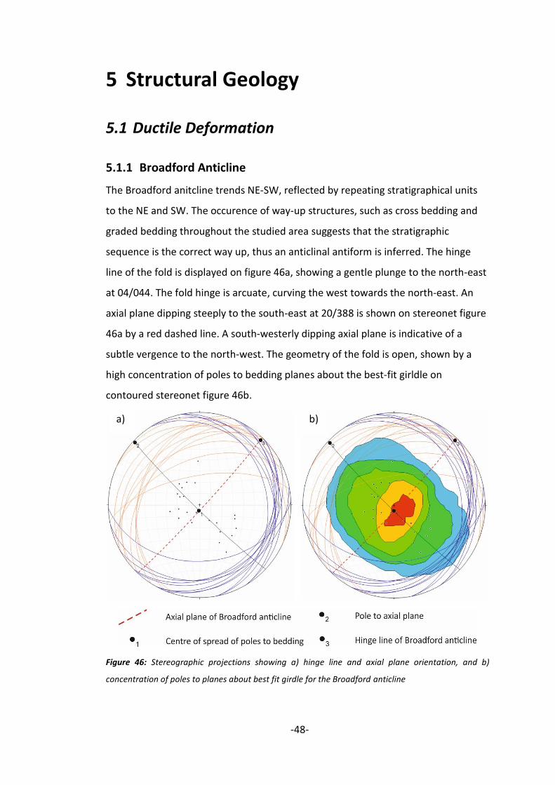
The Broadford anitcline trends NE-SW, reflected by repeating stratigraphical units
to the NE and SW. The occurence of way-up structures, such as cross bedding and
graded bedding throughout the studied area suggests that the stratigraphic
sequence is the correct way up, thus an anticlinal antiform is inferred. The hinge
line of the fold is displayed on figure 46a, showing a gentle plunge to the north-east
at 04/044. The fold hinge is arcuate, curving the west towards the north-east. An
axial plane dipping steeply to the south-east at 20/388 is shown on stereonet figure
46a by a red dashed line. A south-westerly dipping axial plane is indicative of a
subtle vergence to the north-west. The geometry of the fold is open, shown by a
high concentration of poles to bedding planes about the best-fit girldle on
contoured stereonet figure 46b.
Figure 46: Stereographic projections showing a) hinge line and axial plane orientation, and b)
concentration of poles to planes about best fit girdle for the Broadford anticline
a) b)

-49-
5.1.2 Strathiad Syncline
The Strathiad syncline is orientated similarly to the Boradford anticline, with a
north-east trending hinge line. As the stratigraphy of central Strath has been
inferred to be the correct way up, a synclinal synform is deduced. An arcuate hinge
line also mimics that of the Broadford anticline. The fold hinge plunges gently to the
south-west at 08/204, shown on stereonet figure 47a. The fold has an open to
gentle geometry, with beds on both limbs dipping more gently than those of the
Broadford anticline. This is reflected by a remarkably high concentration of poles to
bedding planes about the best fit-girdle on contoured stereonet figure 47b.
Figure 47: Stereographic proctions showing a) and axial plane orientation, and b) concentration of
poles to planes about best fit girdle for the Strathiad syncline
5.1.3 Small Scale Folds
Small scale folds are limited to the Bheinn Shaurdial Dolostone Formation, and are
expressed as folded chert layers. Folds are predominantly close to tight, with fold
hinges orientated to the north-west/south-east. A common characteristic of the
small-scale folds an asymmetrical, overturned geometry with vergence to the
a) b)

-50-
south-east. This is suggestive of an uneven distribution of stress during deformation
of the chert layers, with greater amounts of stress from the north-east. Although
uncommon, folded chert layers also appear to be boudinaged. Fragmentation of the
limbs of folds is a consequence of an extensional regime post-dating the period of
folding.
Figure 48: Photograph of a folded and boudinaged chert layer within dolostone D3, assisted by an
illustration highlighting key features. Taken at GR(161290,819060)
Although not always possible, fold hinge orientations are plotted on stereonet
figure 49. When comparing the hinge line orientations of the small-scale folds in
chert layers to the hinge orientation of the Broadford anticline, it is evident that
these folds are not associated with the Broadford anticline as parasitic folds. A best-
fit girdle for the hinge lines orientations within folded chert layers shows a general
orientation of hinge lines to the NW/SE. This is almost perpendicular to the hinge
line of the Broadford anticline, suggesting that they are product of a contrasting
stress regimes. As illustrated in figure 49, the Broadford anticline is inferred to have
formed in a NW/SE directed compressive stress regime, whilst the small scale folds
were formed in a NE/SW directed compressive stress regime. Hinge lines plunging
away from the axial plane of the Broadford anticline suggests that the chert layers
were folded in a preceding compressive episode.

-51-
Figure 49: Stereographic projection comparing hinge line and axial plane orientations of the Broadford
anticline, and hinge line orientations of small-scale folded chert layers. Annotated with inferred
directions of maximum principal stresses.
5.2 Brittle Deformation
5.2.1 Faulting
5.2.1.1 Broadford Thrust Fault
The contact between the Bheinn Shuardail Dolostone Formation and Lonachan
Sandstone Formation can be clearly traced by the use of vegetation (bracken) and
karstic sink-holes in the dolostone. This contact is a thrust sheet, referred to in
literature as the Kilhorn thrust (Bailey, 1954). The surface expression of the thrust
follows the outcrop pattern of beds folded in the Broadford anticline and indicates
that thrusting pre-dates the folding event. This hypothesis is supported by the
displacement of the thrust being exclusive to the pre-Caledonian formations,
suggesting that it is a denouement of the Caledonian orogeny. Intraformational
clasts of Lonachan Sandstone within the Triassic Buidhe Conglomerate also suggests
subaerial exposure of this formation by this time, for which thrusting is likely to be
responsible.

-52-
5.2.1.2 Other Faults
Although no faults were identifiable by the use of displacement markers in the field,
seven faults are inferred by punctuated contacts with juxtaposing lithologies.
Lengths of faults at the surface range from 59 to 301 metres. Down-throw blocks
have been inferred using the rule that the outcrop pattern of the up-thrown block
will shift in the direction of dip. Approximations of fault orientations are plotted as a
rose (Figure 50), which displays their orientation to the NW-SE. This corresponds to
the dominant orientation of dykes in the area which may have formed in response
to the same tectonic event. Displacement by NW/SE trending faults can be seen in
all lithologies, from Pre-cambrian to Lower Jurassic, thus must have formed in a
post-Jurassic tectonic event.
Figure 50: Rose diagram displaying orientations of faults across central Strath. A strong NW/SE trend
can be seen.
5.2.2 Mineral Veins
Quartz veins are abundant throughout the Lonachan Sandstone Formation and are
arranged in a conjugate pattern with dihedral angles of approximately 60°. Quartz
veins have an average thickness of 2 mm, with some veins possessing lengths as
small as 4 cm, and others being more persistent throughout the beds with lengths
up to 79 cm. A dominant vein orientation is not ascertainable due to multiple sets
with differing orientations. However, conjugate joints are orientated to the NW/SE,

-53-
which allows the stress regime at the time of formation to be estimated (Figure 51).
An extensional regime with minimum principal stress direction from the north-east
and south-west is inferred.
Figure 51: Photograph of conjugate quartz veins in the Lonachan Sandstone Formation. Assisted by
a sketch of conjugate veins with inferred principal stress orientations. Tape measure for scale. Taken
at GR(163635,822215.
When vein orientations are expressed as planes on a stereonet, the orientations of
the principal stress axes can be defined as; σ1 = 76/261°, σ2 = 05/151°, σ3 = 13/060°.
Figure 52: Stereographic projection showing the orientations of the principle stress axis forming
conjugate veins, with sense of shear.

-54-
The only other formation that hosts an abundance of mineral veins is the Broadford
Limestone Formation. Veins are composed of calcite and also display a strong NW-
SE trend. The precursory joints would have formed perpendicular to the minimum
principal stress orientation, thus this arrangement of veins would have formed
during an extensional episode with minimum principal stress axis orientated NE-SW.
5.3 Structural Setting of Igneous Intrusions
5.3.1 Strathiad Dyke Swarm
Following detailed analysis of the Strathiad Dyke Swarm, a collection of data including
strike, dip, and width of 37 dykes alongside host rock composition has been collected.
The vast majority of dykes appear within the Bheinn Shuardail Dolostone Formation,
with the least number of dykes appearing in the Lonachan Sandstone. Figure 53
shows that the Bheinn Shuardail Dolostone is the preferential host rock for the dyke
swarm, with clastic sedimentary rocks being less favourable. This may be attributed
to the brittle nature of carbonate rocks facilitating the formation of fractures, which
in turn provide accommodation space for the proceeding magma.
Figure 53: Pie chart displaying the relative number of dykes hosted within each sedimentary lithology
of central Strath

-55-
Regardless of composition, all dykes have a dominantly NW-SE orientation. Although
no cross-cutting relationships are observed, this homogeneous orientation of the
dyke swarm suggests all dykes were emplaced in temporal-proximity. The
emplacement of dykes generally occurs in an orientation perpendicular to the
minimum principal stress axis, thus, the Strathiad dyke swarm was emplaced during
a period in which the minimum principal stress acting upon the rocks had a NE-SW
orientation. This is congruent with the NE-SW extensional stress regime described by
England (1988) in the volcanic episode of the British Tertiary Volcanic Province.
Figure 54: Rose diagram displaying orientations of dykes of the Strathiad dyke swarm. A strong NW/SE
trend can be seen.
Average dyke width is 1.24 meters, with a total cumulative thickness of 45.8 meters.
Although not all of the dykes in the area could be measured, this is a proxy for the
minimum amount of consequential crustal extension in the area.
5.3.2 Beinn an Dubhaich Granite
At GR(161630,819950) the granite can be seen cross-cutting a basaltic dyke of the
Strathiad Dyke Swarm, indicating emplacement in a succeeding magmatic episode.
However, it is likely that intrusion of the granite occurred soon after the dyke swarm
and may be related to the evolution of one initially mafic magma chamber.

-56-
Rafts of the Bheinn Shuardail Dolostone within the main body of the granite appear
to be relatively undeformed, possessing chert layers with strike and dip comparative
to those at the periphery of the granite. It can thus be concluded that the dolostone
rafts are an in-situ product of differential erosion. King (1960) envisaged these rafts
as unroofed members of the pluton floor, proposing a sheet-like intrusion that may
have exploited the thrust fault during emplacement. However, sub-vertical contacts
with the Bheinn Shuardail Dolostone are well exposed in quarries
GR(161925,819760), and advocate a boss-like morphology of the pluton, as proposed
by Harker (1904). More recent magnetic evidence produced by Hoersch (1979)
suggests that the granite is underlain by gabbro, refuting King’s theory of a sheet-like
emplacement King (1960). In addition to magnetic evidence, unrealistic rates of
erosion imply that the dolostone rafts are remenants of the pluton roof.
The notion that the Broadford anticline formed in response to forceful intrusion of
the Beinn an Dubhaich granite has been reviewed and discredited. If the anticline had
formed through forced intrusion of the granite, compressional deformation features
would be expected in the surrounding tertiary dykes, which have been inferred to
pre-date the granite. The concept of a passive emplacement is further substantiated
by a lack of enclaves within the granite, expected of a more forceful emplacement.
The ‘space problem’ associated with granite emplacement can, in this case, be solved
by doming of the crust, creating accommodation space for a passively intruding
granite within the Broadford anticline.

-57-
6 Geological History of Central Strath,
Skye
This chapter provides a summary of the history of Strath from the Pre-cambrian to
present day based on evidence from a study of the area and is illustrated by a series
of block diagrams.
The geological record of central Strath is initiated in the Pre-cambrian. At this time
north-west Britain was part of a large supercontinent, and was dominated by an arid
terrestrial environment. Fast-flowing braided river systems deposit the sandstones
of the Lonachan Sandstone Formation. A marked change in from the Lonachan
sandstone formation to the Bheinn Shuardail Dolostone formation represents an
unconformity in which sea level has elevated, inundating the Pre-cambrian bedrock
in a warm, clear, shallow, tropical marine (2).
The succeeding 200 years are not represented in the geological record of the Isle of
Skye as a consequence of powerful tectonic and erosive forces of the Caledonian
orogeny. Formidable compressive forces from the south-east has triggered the
Broadford thrust, responsible for the exhumation of the Lonachan Sandstone to the
surface (3-4). Stephenson and Merritt (2002) describe an overall marine regression
from shallow carbonate seas to arid continental planes in the Triassic period, which
marks the recommencing of the geological record. Subaerial exposure of these pre-
Caledonian formations is prerequisite for their deposition as intraformational clasts
within the Triassic Buidhe Conglomerate in an estuarine environment (5). The
succeeding Lower Jurassic sediments are characterised by a transgressive
depositional system with recurrent, cyclic fluctuations in sea level related to a
changing climate (6-7).
The intervening period between the end of Jurassic sedimentation and the initiation
of widespread igneous activity across central Strath is characterised by an episode of
compressional tectonics, fashioning the stratigraphic sequence of central Strath into
the large Broadford anticline and the adjoining Strathiad syncline (8).
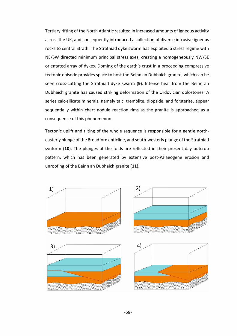
-58-
Tertiary rifting of the North Atlantic resulted in increased amounts of igneous activity
across the UK, and consequently introduced a collection of diverse intrusive igneous
rocks to central Strath. The Strathiad dyke swarm has exploited a stress regime with
NE/SW directed minimum principal stress axes, creating a homogeneously NW/SE
orientated array of dykes. Doming of the earth’s crust in a proceeding compressive
tectonic episode provides space to host the Beinn an Dubhaich granite, which can be
seen cross-cutting the Strathiad dyke swarm (9). Intense heat from the Beinn an
Dubhaich granite has caused striking deformation of the Ordovician dolostones. A
series calc-silicate minerals, namely talc, tremolite, diopside, and forsterite, appear
sequentially within chert nodule reaction rims as the granite is approached as a
consequence of this phenomenon.
Tectonic uplift and tilting of the whole sequence is responsible for a gentle north-
easterly plunge of the Broadford anticline, and south-westerly plunge of the Strathiad
synform (10). The plunges of the folds are reflected in their present day outcrop
pattern, which has been generated by extensive post-Palaeogene erosion and
unroofing of the Beinn an Dubhaich granite (11).

-59-
Figure 55: A series of block diagrams illustrating each increment of the geological history of central
Strath.

-60-
7 Conclusion
To conclude this report, this chapter will summarise the main findings, and propose
some future work that would assist in revealing a more complete and
comprehensive geological history of central Strath.
The area of central Strath holds a diverse range of sedimentary rocks ranging in age
from Pre-cambrian to Early Jurassic. A collection of sedimentological and
palaeontological evidence allows the reconstruction of relative sea level throughout
the sedimentary record of central Strath. The changing sea level is summarised in
figure 56. The local stratigraphy has been intruded in to be a series of intrusive
igneous rocks of the British Tertiary Igneous Province. Orientations and structures of
Tertiary igneous rocks allows the estimation of an evolving stress regime through
time, and are likely to be a consequence of rifting of the NW Atlantic. Extensive
deformation of the rocks of central Strath manifests its self as a Caledonian thrust
fault, alongside a broad NE/SW trending antiform and its adjoining synform. The
antiform to the north of central Strath accommodates the Beinn an Dubhaich
Granite, which has metamorphosed the surrounding dolostones to form a series of
calc-silicate mineral assemblages around chert nodules.
Although many minerals within chert nodule reaction rims are visible to the naked
eye, thin section analysis would enhance this study by revealing microscopic minerals
within the reaction rims. Future work could include the collection of thin section
samples to establish more accurate isograds around the Beinn an Dubhaich granite,
enabling a more accurate cooling history to be inferred. More advanced methods
could be utilised to further our understanding of the emplacement of the Beinn an
Dubhaich granite, for example anisotropy of the magnetic susceptibility (AMS) study.
This would reveal any internal fabric of magnetic minerals within the granite, and
may give an indication of the mechanism that has emplaced the granite. A preferred
orientation of magnetic minerals would suggest a more forcible intrusion, thus may
have implications for the antiform that hosts the granite.

-61-
Figure 56: A summary of the marine transgressions and regressions that have been interpreted
throughout the formation of the stratigraphy of central Strath

-62-
8 References
Bailey, E. 1954. ‘Relations of Torridonian to Durness Limestone in the Broadford–
Strollamus district of Skye’. Geological Magazine, 91(01), 73.
Bédard, L. 1993. ‘Significance of Enclave Roundness: An Inherent Characteristic?’
The Journal of Geology, 101(1), 121-125.
Bell, B.R, Williamson, I.T. 2002. ‘Tertiary igneous activity. 371–407 in: The Geology
of Scotland’. Fourth edition. Trewin, N.H (editor). The Geological Society, London 1
Brück, P., Molyneux, S., Williams, M. and Woodcock, N. 2011. ‘A Revised Correlation
of Cambrian Rocks in the British Isles’. Geological Society, London, Special Report,
1(1), 1.
England, R. 1988. ‘The early Tertiary stress regime in NW Britain: evidence from the
patterns of volcanic activity’. Geological Society, London, Special Publications, 39(1),
381-389.
Farris, M., Oates, M. and Torrens, H. 1999. ‘New evidence on the origin and Jurassic
age of palaeokarst and limestone breccias, Loch Slapin, Isle of Skye’. Scottish Journal
of Geology, 35(1), 25-29.
Hallam, A. 2009. ‘Jurassic environments’ 1st ed. Cambridge [u.a.]: Cambridge
University Press, 132.
Hoersch, A. 1979. ‘General structure of the Skye Tertiary igneous complex and
detailed structure of the Beinn an Dubhaich Granite from magnetic evidence’
Scottish Journal of Geology, 15(3), 231-245.
Hoersch, A.L. 1981. ‘Progressive metamorphism of the chert-bearing Durness
Limestone in the Beinn an Dubhaich aureole, Isle of Skye, Scotland: a re-examination’
American Mineralogist, 66, 491–506.
Hesselbo, N. and Coe, A. 1989. ‘Jurassic sequence stratigraphy in the Hebrides
Basin, NW Scotland’. Marine and Petroleum Geology, 6(3), 243-260.

-63-
King, B. 1960. ‘The Form of the Beinn An Dubhaich Granite, Skye’. Geological
Magazine, 97(04), 326.
Miller, S. 2005. ‘Mountain geology’. The Edinburgh Geologist, (44), 4.
Moorbath, S. 1969, ‘Evidence for the age of deposition of the Torridonian sediments
of north-west Scotland’, Scottish Journal of Geology 5(2), 154-170.
Morton, N., Hesselbo, S., Oates, M. and Jenkyns, H. 1999. ‘The lower Lias Group of
the Hebrides Basin’ Scottish Journal of Geology, Vol. 34(1), 1998, pp. 23-60. Scottish
Journal of Geology, 35(1), 85-88.
Morton, N. and Hudson, J.D. 1995, ‘Field guide to the Jurassic of the Isles of Raasay
and Skye, Inner Hebrides, NW Scotland’. In: Field Geology of the British Jurassic (Ed.
by P.D. Taylor), The Geological Society, London, 209-280..
Morton, N. 1990, ‘Tectonic and eustatic controls of Jurassic genetic sequences in the
Hebrides Basin, SW Scotland’. Bulletin de la Societe Geologique de France, VI(6),
1001-1009.
Nicholas, C. 1994. ‘New stratigraphical constraints on the Durness Group of NW
Scotland’. Scottish Journal of Geology, 30(1), pp.73-85.
Owen, G. 1995, ‘Soft-sediment deformation in Upper Proterozoic Torridonian
sandstones (Applecross formation) at Torridon, northwest Scotland’, Journal of
Sedimentary Research 65A, 495-504.
Simms, M.J., Chidlaw, N., Morton, N. & Page, K.N. 2004, ‘British Lower Jurassic
Stratigraphy’, Geological Conservation Review Series, No. 30, Joint Nature
Conservation Committee, Peterborough, 324
Steel, R J and Wilson, A C, 1975. .Sedimentation and tectonism (?Permo-Triassic) on
the margin of the North Minch Basin, Lewis.. Journal of the Geological Society of
London, Vol.131, 183-202.
Stephenson, D. and Merritt, J. 2002, ‘Skye, A Landscape Fashioned by Geology’
Battelby: Scottish Natural Heritage, 2-5

-64-
Storetvedt, K.M. and Steel, R.J. 1977, ‘Palaeomagnetic evidence for the age of the
Stornoway formation’, Scottish Journal of Geology 13, 263-268.
Swett, K. 1969. ‘Interpretation of depositional and diagenetic history of Cambrian–
Ordovician succession of Northwest Scotland’. In: Kay, M. (ed.) North Atlantic –
Geology and Continental Drift, A Symposium. Memoir of the American Association of
Petroleum Geologists, 12, 630–646
Whitten, E. 1961, ‘Modal Variation and the Form of the Beinn an Dubhaich Granite,
Skye’, Geological Magazine, 98(06), 467.
Winter, J. 2001, ‘An introduction to igneous and metamorphic petrology’. 1st ed.
Upper Saddle River, NJ: Prentice Hall, 588-591.

-65-
9 Appendices
1) Field Slips 1-3
2) Field Notebooks 1-3

-66-
3) Dyke Analysis

-67-
4) Chert Nodule Analysis

-68-

-69-
5) Younging Table for Geological History