rates and mechanisms of bedrock incision and strath
TRANSCRIPT
Bedrock incision and strath terrace formation in a forested catchment
Geological Society of America Bulletin, v. 1XX, no. XX/XX 1
Rates and mechanisms of bedrock incision and strath terrace formation in a forested catchment, Cascade Range, Washington
Brian D. Collins1,†, David R. Montgomery1, Sarah A. Schanz1, and Isaac J. Larsen2
1 Department of Earth and Space Sciences and Quaternary Research Center, University of Washington, Seattle, Washington 98195‑1310, USA
2Department of Geosciences, University of Massachusetts, Amherst, Massachusetts 01003‑9297, USA
ABSTRACT
Measurements of channel bed and bank incision into bedrock coupled with mapping and radiocarbon dating of strath terraces in the West Fork Teanaway River, Washington, provide insight into rates and mechanisms of river incision and strath terrace forma-tion in a forested landscape. The West Fork drains 102 km2 of the slowly exhuming southeastern North Cascade Range, and it is rapidly eroding its bed and creating strath terraces in its lower reach. Minimum vertical incision, measured annually relative to nails embedded in the streambed, was greater in the seasonally exposed, weathering-dominated, high-flow channel (mean = 10.9 mm yr–1) than in the perennially wet, abrasion-domi-nated, low-flow channel (3.8 mm yr–1), docu-menting unsteady lowering of the channel margin. Ages of radiocarbon-dated materials from alluvium on strath terraces, 0.1 m to 5.4 m above the water surface, suggest three episodes of strath abandonment at maximum ages of ca. A.D. 830, A.D. 1560, and A.D. 1890, and average incision rates of 1.3 mm yr–1, 1.4 mm yr–1, and 7.4 mm yr–1 for the oldest to youngest surfaces, respectively. Weathering-promoted vertical incision in the high-flow channel provides a mechanism for “top-down” rapid lateral strath planation in which scour of alluvium on incipient strath terraces incorporates the surface into the high-flow channel, allowing rapid removal of bedrock weathered during wetting and drying cycles. Relationships among channel width, channel confinement by bedrock terrace risers, mod-eled bankfull shear stress, and alluvial bed cover suggest that rapid channel widening could also internally limit vertical incision by slowing incision as shear stresses decline and more alluvium is retained on the bed. The timing of the most recent (ca. A.D. 1890)
strath abandonment corresponds with histor-ical anthropogenic removal of fluvial wood, suggesting that the relative abundance of flu-vial wood may influence episodes of vertical bedrock incision by affecting the retention of alluvium on streambeds.
INTRODUCTION
Bedrock incision by rivers drives the topo-graphic evolution of mountain landscapes and can leave a morphologic signature in the form of strath terraces, which provide important records for interpreting tectonic and climatic history (Pazzaglia, 2013). Because of bedrock incision’s importance, it has been the subject of a number of theoretical and experimental (see review by Lamb et al., 2015) and field studies (e.g., Hancock et al., 1998; Tinkler and Parish, 1998; Whipple et al., 2000; Hartshorn et al., 2002; Stock et al., 2005; Johnson et al., 2010; Lamb and Fonstad, 2010; Cook et al., 2013; Inoue et al., 2014). However, few studies have linked incisional processes with lateral planation of straths or their subsequent incision and stranding as strath terraces (e.g., Montgomery, 2004; Finnegan and Balco, 2013; Johnson and Finnegan, 2015). Here, in a field study of a river that is rapidly eroding its bed and creating strath terraces, we measured annual vertical and lateral incision to address theoretical and laboratory predictions on the relative roles of erosion and weathering processes in shaping channels (e.g., Hancock et al., 2011; Small et al., 2015). We then coupled these measurements with incision rates determined from strath ter-races using radiocarbon dating, and we propose a mechanism of rapid strath planation and how it may, by adjusting channel morphology, inter-nally limit incision.
Background
Bedrock channels erode by processes that include abrasion (removal of rock by impact from saltating particles in the bed load or in sus-
pension), macro-abrasion (fracturing of the bed-rock into pluckable or entrainable sizes through the collision with particles in transport), pluck-ing (hydraulic removal of blocks), dissolution, and cavitation (Whipple et al., 2000). The domi-nance and efficacy of an erosional process in a natural channel depend in part on lithology, joint spacing, fractures, and bedding planes (Whipple et al., 2000). Physical and chemical weather-ing can greatly enhance erosional processes (Howard, 1998; Whipple et al., 2000; Stock et al., 2005; Hancock et al., 2011; Han et al., 2014; Small et al., 2015) by increasing rough-ness (Hancock et al., 1998; Huda and Small, 2014) and decreasing rock strength and thereby enhancing susceptibility to abrasion, expanding fractures along which blocks are removed by plucking (Hancock et al., 1998; Whipple et al., 2000), and comminuting rock into smaller frag-ments (Stock et al., 2005).
The efficacy of at least some erosional and weathering processes is also influenced by the thickness of alluvial cover. For example, labora-tory experiments predict maximum abrasion of streambeds having partial bedrock exposure associated with intermediate sediment supplies that provide the “tools” for abrading the bed without protecting the bed from abrasion (Sklar and Dietrich, 2001). While most applications of this concept to interpreting river incision his-tories have focused on regional- or basin-scale influences on stream power or the supply and caliber of sediment (e.g., changes to base level, climate, or tectonic uplift rates), reach-scale processes that control the routing or retention of sediment in channels, such as landslides that form temporary dams in rivers, could control rates of bedrock incision by altering the dis-tribution of alluvial and bedrock reaches (e.g., Ouimet et al., 2007). In forested regions, such a mechanism could also be provided by in- channel wood accumulations, which can trans-form channels from bedrock to alluvial by alter-ing the balance between sediment transport and supply (Montgomery et al., 1996).
GSA Bulletin; Month/Month 2015; v. 1xx; no. X/X; p. 1–18; doi: 10.1130/B31340.1; 15 figures; 6 tables.; published online XX Month 2015.
For permission to copy, contact [email protected] © 2016 Geological Society of America
as doi:10.1130/B31340.1Geological Society of America Bulletin, published online on 8 January 2016
Collins et al.
2 Geological Society of America Bulletin, v. 1XX, no. XX/XX
Cross-channel variation in processes and rates of bedrock incision shapes channel cross-sectional and planform geometry, which in turn controls hydraulics and the distribution of ero-sive power across the channel (for review, see Hancock et al., 2011). Differential incision rates in a channel’s low-flow and high-flow bed (in this paper, we use “low-flow channel” inter-changeably with “channel thalweg” and “high-flow channel” interchangeably with “channel margins”) can result from differences in weath-ering (Stock et al., 2005; Hancock et al., 2011; Small et al., 2015) or from whether cover or tool effects dominate (Turowski et al., 2008). Differences in rock erodibility can also be a primary influence on the shape of river longi-tudinal profiles (Duvall et al., 2004; Allen et al., 2013). Locally rapid incision is often associ-ated with knickpoints that propagate upstream or that initiate in steeper, smaller-drainage-area parts of a channel network (Crosby and Whipple, 2006). However, several field studies suggest that adjustments to channel width may be as important as changes to channel gradient in maintaining locally high incision rates across longitudinal variations in rock resistance (Mont-gomery and Gran, 2001) or uplift rates (Duvall et al., 2004; Amos and Burbank, 2007; Whit-taker et al., 2007; Turowski et al., 2009; Yanites et al., 2010).
The control alluvial cover exerts on vertical incision implies that lateral erosion dominates in periods when sediment supply is relatively high, and terrace-forming incision dominates when sediment supply is relatively low and the alluvial bed cover thins (Bull, 1990; Pazzaglia and Brandon, 2001). Hence, temporal varia-tion in either sediment or water supply could alter the ratio of vertical to lateral erosion and either create straths (a valley-bottom surface created by lateral stream cutting; Bucher, 1932) or incise and abandon them, creating strath ter-races (abandoned, alluvium-mantled straths, the surface of which is referred to as the tread); this conceptual model is commonly used to interpret the genesis of straths and strath terraces (e.g., Personius et al., 1993; Wegmann and Pazzaglia, 2002; Fuller et al., 2009). By extension, the effects of landslide dams (Ouimet et al., 2007), wood accumulations (Montgomery et al., 2003), or other controls on the retentivity of alluvium could also influence whether rivers erode verti-cally or laterally into rock.
Relative to vertical bedrock incision, less is known about processes and controls on lateral bedrock erosion, but lithology has been dem-onstrated to influence the dominant process of lateral bedrock erosion (Wohl and Ikeda, 1998; Lavé and Avouac, 2001; Montgomery and Gran, 2001; Wohl and Merritt, 2001; Wohl and Achyu-
than, 2002; Finnegan et al., 2007; Spotila et al., 2015) or susceptibility to weathering (Hancock et al., 2011; Johnson and Finnegan, 2015), and thus the efficacy of lateral strath planation of bedrock channels (Montgomery, 2004; García, 2006; Wohl, 2008). Channel planform may also influence rates and patterns of lateral ero-sion; Finnegan and Balco (2013) suggested that a braided channel is more likely to accomplish lateral planation because the channel is more prone to incise laterally along both margins, rather than just one margin.
Incision and terrace creation have long been recognized as inherently unsteady (Gilbert, 1877; Mackin, 1937; Bull, 1990) due to tempo-ral variation in uplift (e.g., Pazzaglia and Gard-ner, 1993; Schoenbohm et al., 2004), base-level fall, and knickpoints that propagate upstream (e.g., Harvey and Wells, 1987; García et al., 2004, Bishop et al., 2005), or climate-forced variations in the relative supply of water and sediment (e.g., Pazzaglia and Brandon, 2001; Hancock and Anderson, 2002; Wegmann and Pazzaglia, 2002; Gibbard and Lewin, 2009; Fuller et al., 2009). More recently, it has been proposed that strath terraces can form in the absence of external tectonic or climate forc-ing, due to internal forcing as meander cutoffs force local knick zones (Finnegan and Dietrich, 2011) or by unsteady meandering arising from spatial contrasts in bank strength (Limaye and Lamb, 2014). In forested regions, where wood jams can remain stable for long periods—in the Pacific Northwest for over 1000 yr in some cases (Hyatt and Naiman, 2001; Montgomery and Abbe, 2006)—and can trigger avulsions, fluvial wood accumulations could also be a viable mechanism for internal forcing of strath incision.
Hancock and Anderson (2002) numerically simulated strath terrace formation in response to temporally changing water and sediment dis-charge associated with Quaternary climatic fluc-tuations and proposed that rivers that incise and create strath terraces spend a large amount of time in lateral planation and relatively little time vertically incising. This proposal was supported by a study that used a large number of radio-carbon dates from Holocene strath terraces (Wegmann and Pazzaglia, 2002) to determine that periods of vertical incision last only 25% of the cycle of strath creation and subsequent incision that creates a strath terrace. Incisional unsteadiness results in a dependence of average incision rates on the time interval over which the rate is measured, commonly referred to as the Sadler effect (Sadler, 1981), and averaged inci-sion rates inferred from strath terraces have been observed to decline with increasing time inter-val (Gardner et al., 1987; Mills, 2000; Finnegan
et al., 2014). However, Gallen et al. (2015) recently proposed this effect could, in many riv-ers, be the result of a systematic bias introduced by use of the modern streambed as the datum for measuring terrace heights.
Approach
To investigate how different erosional pro-cesses operate in space and time to vertically and horizontally incise rivers and create straths, we undertook a field study of a rapidly incis-ing river in a region with slow rock uplift and no known active faulting, the forested West Fork Teanaway River in the southeastern North Cascades of Washington State (Fig. 1). Previ-ously, we reported 1 yr average bedrock inci-sion from the study site (Stock et al., 2005). Here, we report direct field measurements of vertical bed incision and lateral bank reces-sion measured relative to nails in the riverbed and banks annually over a 4 yr period and by repeat surveying of channel cross sections over a 7 yr period, document differential rates of inci-sion in the high-flow and low-flow portions of the channel, and relate the differential to spatial variation in process and temporal variation in streamflow. We also map strath terraces along the 3-km-long reach of the river in which our erosion measurements were made, and we use radiocarbon dating to determine the ages of basal alluvium in strath terraces. We use these observations to explore the controls on bedrock incision and strath terrace formation over the last two millennia.
STUDY AREA
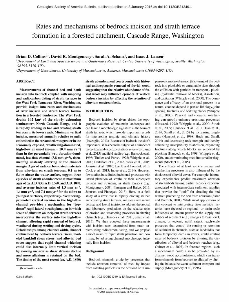
The West Fork Teanaway River originates in rugged, high-relief terrain near the crest of the Cascade Range (Fig. 1). Long-term exhu-mation rates in this region determined from apatite (U-Th)/He cooling are on the order of 0.05 mm yr–1 (Reiners et al., 2003), similar to the postglacial denudation rate of 0.08 mm yr–1 determined from detrital 10Be concentrations in the Peshastin Creek basin adjoining the Teanaway River basin to the northeast (Moon et al., 2011). The river is confined by a steep-sided valley in its upper watershed, where the bedrock is a moderately indurated sandstone of the Eocene Swauk Formation and harder basalt and andesite of the Teanaway Basalt (Tabor et al., 1982). This steep, high-relief upper watershed transitions abruptly to lower-relief, rounded topography at the contact of the Eocene Roslyn Formation, a poorly indurated, medium- to fine-grained, micaceous, lithofeldspathic sandstone with beds of siltstone, conglomerate, and pebbly sandstone (Tabor et al., 1982).
as doi:10.1130/B31340.1Geological Society of America Bulletin, published online on 8 January 2016
Bedrock incision and strath terrace formation in a forested catchment
Geological Society of America Bulletin, v. 1XX, no. XX/XX 3
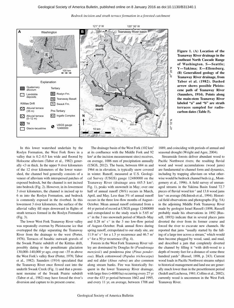
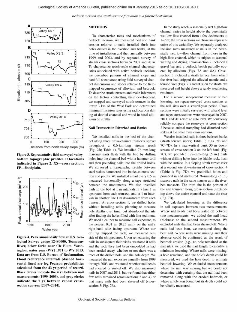
In this lower watershed underlain by the Roslyn Formation, the West Fork flows in a valley that is 0.2–0.5 km wide and floored by Holocene alluvium (Tabor et al., 1982) gener-ally <3 m thick. In the upper 9 river kilometers of the 12 river kilometers of the lower water-shed, the channel bed generally consists of a veneer of alluvium with interspersed patches of exposed bedrock, but the channel is not incised into bedrock (Fig. 2). However, in its lowermost 3 river kilometers, the channel is incised up to 6 m into the Roslyn Formation, and bedrock is commonly exposed in the riverbed. In this lowermost 3 river kilometers, the surface of the alluvial valley fill steps downward in flights of strath terraces formed in the Roslyn Formation (Fig. 3).
The lower West Fork Teanaway River valley was repeatedly overrun by Pleistocene ice that overtopped the ridge separating the Teanaway River from the drainage to the west (Porter, 1976). Terraces of basaltic outwash gravels of the Swauk Prairie subdrift of the Kittitas drift, possibly dating to the penultimate glaciation 130,000–140,000 yr ago, crop out ~35 m above the West Fork’s valley floor (Porter, 1976; Tabor et al., 1982). Saunders (1914) speculated that the Teanaway River once flowed east into the underfit Swauk Creek (Fig. 1) and that a promi-nent moraine of the Swauk Prairie subdrift (Tabor et al., 1982) may have forced the river’s diversion and capture to its present course.
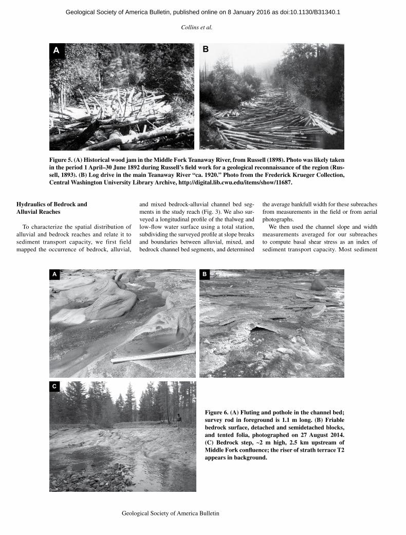
The drainage basin of the West Fork (102 km2 at its confluence with the Middle Fork and 92 km2 at the incision measurement sites) receives, on average, 1006 mm of precipitation annually (USGS, 2012). The basin, between 684 m and 1964 m in elevation, is typically snow covered in winter. Runoff, measured at U.S. Geologi-cal Survey (USGS) gauge 12480000 on the Teanaway River (drainage area 445.5 km2; Fig. 1), peaks with snowmelt in May; over one half of annual runoff (56%) occurs in March, April, and May. Less than 3% of annual runoff occurs in the three low-flow months of August–October. Mean annual runoff estimated from a 44 yr period of record at USGS gauge 12480000 and extrapolated to the study reach is 5.65 m3 s–1 in the 3 mo snowmelt period of March–May and 0.28 m3 s–1 in the 3 mo low-flow period of August–October. Peak annual flows during spring runoff, extrapolated to our study site, are 11.9 m3 s–1 for a 1.5 yr recurrence and 46.7 m3 s–1 for a 50 yr recurrence (Fig. 4).
Forests in the West Fork Teanaway River val-ley are dominated by Douglas fir (Pseudotsuga menziesii) and ponderosa pine (Pinus ponder‑osa). Black cottonwood (Populus trichocarpa) and red alder (Alnus rubra) are also common along stream banks. Fire was historically fre-quent in the lower Teanaway River drainage, with large fires (>4000 ha) occurring every 27 yr over the 433 yr period between 1662 and 1995, and every 11 yr, on average, between 1708 and
1889, and coinciding with periods of annual and seasonal drought (Wright and Agee, 2004).
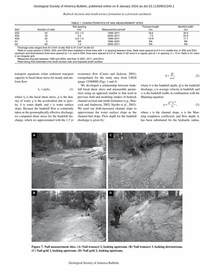
Streamside forests deliver abundant wood to Pacific Northwest rivers; the resulting fluvial wood and wood accumulations (wood jams) are fundamental to channel form and dynamics, including by trapping alluvium on what other-wise would be bedrock channel beds (e.g., Mont-gomery et al., 1996). A field survey of unman-aged streams in the Yakima Basin found 72.7 pieces of fluvial wood km–1 and 13.8 wood jams km–1 on average (McIntosh et al., 1994). Histori-cal field observations and photographs (Fig. 5A) in the adjoining Middle Fork Teanaway River made by geologist Israel Russell (1898; Russell probably made his observations in 1892 [Rus-sell, 1893]) indicate that in several places jams diverted the river from its former course and forced the river to excavate new channels. He reported that jams “usually started by the fall-ing of a large tree across a stream,” which would then become plugged by wood, sand, and mud, and described a jam that completely diverted the channel by filling it “with drift-wood to a depth of twenty feet for a distance of some three hundred yards” (Russel, 1898, p. 243). Current wood loads in Pacific Northwest streams subject to historical management and land use are gener-ally much lower than in the presettlement period (Sedell and Luchessa, 1981; Collins et al., 2002); currently wood is uncommon in the West Fork Teanaway River.
N
Ts
Ttb
KJi
Tr
Yakima R.
Swau
kC
r.
Studyreach
Fork
Fork
Fork
Qls
Teanaway R.
2250 m
555 m
2202 m
10 km 47°
10′ N
47º 2
0’ N
121° 0′ W 120° 50′ W
Middle
North
West
a
b
1964 m
Teanaway River basin
1747 m
B
Explanation
Landslidedeposits
Quaternaryalluvium
Kittitas DriftAlluvial terrace (35 m)
Alluvial terrace(0–12 m)
Till
Glacio-lacustrine
Tertiary
Roslyn Fm.Tr
Teanaway BasaltTtb
Swauk Fm.Ts
KJi Ingalls Complex
USGS gauge12480000
Pre-Tertiary
A
S
Y
100 km
B
Yakima R.
E
Columbia R.
Cas
cade
Ran
ge
Washington
Figure 1. (A) Location of the Teanaway River drainage in the southeast North Cascade Range of Washington. S—Seattle; Y—Yakima; E—Ellensburg. (B) Generalized geology of the Teanaway River drainage, from Tabor et al. (1982). Dashed arrow shows possible Pleisto-cene path of Teanaway River (Saunders, 1914). Points along the main-stem Teanaway River labeled “a” and “b” are strath terraces sampled for radio-carbon dates (Table 5).
as doi:10.1130/B31340.1Geological Society of America Bulletin, published online on 8 January 2016
Collins et al.
4 Geological Society of America Bulletin, v. 1XX, no. XX/XX
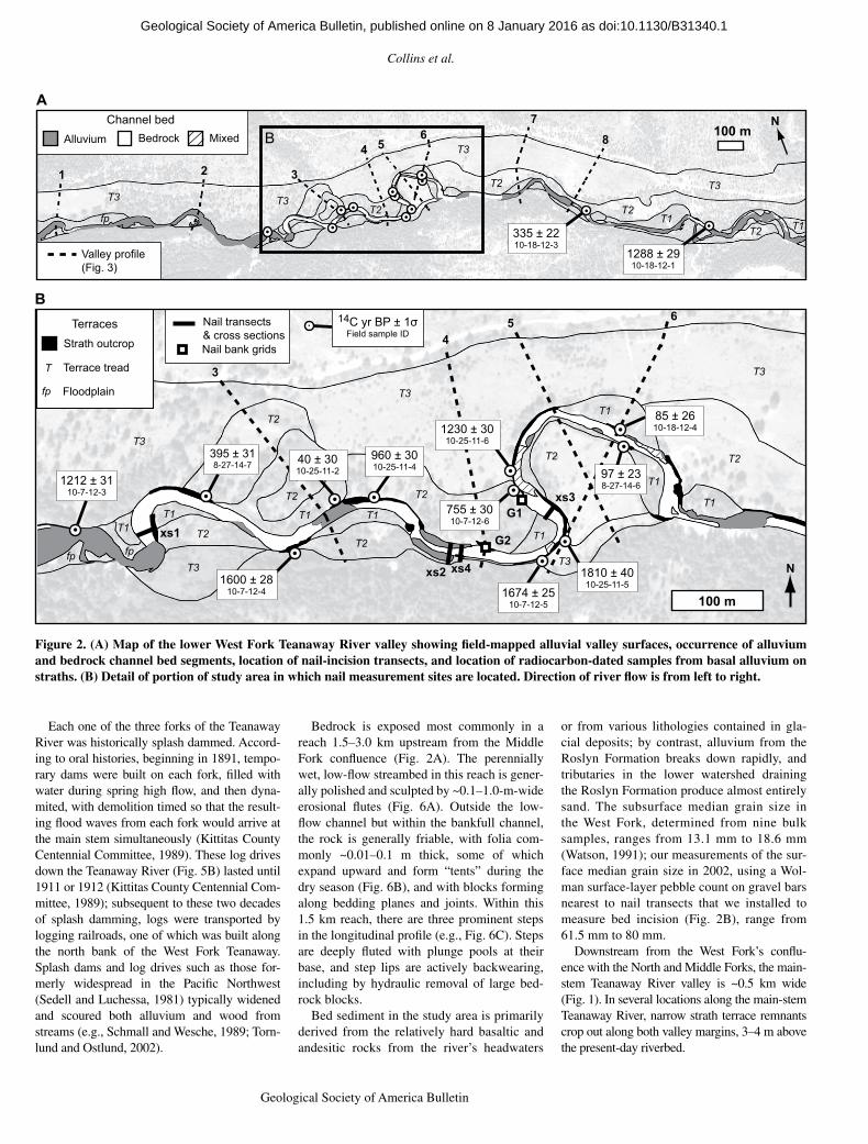
Each one of the three forks of the Teanaway River was historically splash dammed. Accord-ing to oral histories, beginning in 1891, tempo-rary dams were built on each fork, filled with water during spring high flow, and then dyna-mited, with demolition timed so that the result-ing flood waves from each fork would arrive at the main stem simultaneously (Kittitas County Centennial Committee, 1989). These log drives down the Teanaway River (Fig. 5B) lasted until 1911 or 1912 (Kittitas County Centennial Com-mittee, 1989); subsequent to these two decades of splash damming, logs were transported by logging railroads, one of which was built along the north bank of the West Fork Teanaway. Splash dams and log drives such as those for-merly widespread in the Pacific Northwest (Sedell and Luchessa, 1981) typically widened and scoured both alluvium and wood from streams (e.g., Schmall and Wesche, 1989; Torn-lund and Ostlund, 2002).
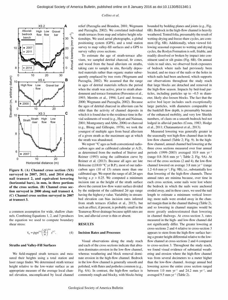
Bedrock is exposed most commonly in a reach 1.5–3.0 km upstream from the Middle Fork confluence (Fig. 2A). The perennially wet, low-flow streambed in this reach is gener-ally polished and sculpted by ~0.1–1.0-m-wide erosional flutes (Fig. 6A). Outside the low-flow channel but within the bankfull channel, the rock is generally friable, with folia com-monly ~0.01–0.1 m thick, some of which expand upward and form “tents” during the dry season (Fig. 6B), and with blocks forming along bedding planes and joints. Within this 1.5 km reach, there are three prominent steps in the longitudinal profile (e.g., Fig. 6C). Steps are deeply fluted with plunge pools at their base, and step lips are actively backwearing, including by hydraulic removal of large bed-rock blocks.
Bed sediment in the study area is primarily derived from the relatively hard basaltic and andesitic rocks from the river’s headwaters
or from various lithologies contained in gla-cial deposits; by contrast, alluvium from the Roslyn Formation breaks down rapidly, and tributaries in the lower watershed draining the Roslyn Formation produce almost entirely sand. The subsurface median grain size in the West Fork, determined from nine bulk samples, ranges from 13.1 mm to 18.6 mm (Watson, 1991); our measurements of the sur-face median grain size in 2002, using a Wol-man surface-layer pebble count on gravel bars nearest to nail transects that we installed to measure bed incision (Fig. 2B), range from 61.5 mm to 80 mm.
Downstream from the West Fork’s conflu-ence with the North and Middle Forks, the main-stem Teanaway River valley is ~0.5 km wide (Fig. 1). In several locations along the main-stem Teanaway River, narrow strath terrace remnants crop out along both valley margins, 3–4 m above the present-day riverbed.
A
B
T1
xs2 xs4
xs3
xs1
100 m
N
3
45 6
1212 ± 3110-7-12-3
1600 ± 2810-7-12-4 1674 ± 25
10-7-12-5
1230 ± 3010-25-11-6
755 ± 3010-7-12-6
1810 ± 4010-25-11-5
395 ± 318-27-14-7
960 ± 3010-25-11-4
Nail transects& cross sectionsNail bank grids
G2
G1
40 ± 3010-25-11-2
T1 T1
T2
T2 T2
T1
T1
T1
T3
T3
T3
8
T3
T2
T2
B
T3 T3T2
3
4 56
7
T2
100 mN
1 2
335 ± 2210-18-12-3
MixedAlluvium
Channel bedBedrock
fp
Valley profile(Fig. 3)
T2
T2
T3
T2
T3
T2
T1
fpfp
Strath outcrop
T
Terraces
Terrace tread
fp Floodplain
T1T1
T3
T1
1288 ± 2910-18-12-1
85 ± 2610-18-12-4
97 ± 238-27-14-6
. 14C yr BP ± 1σField sample ID
Figure 2. (A) Map of the lower West Fork Teanaway River valley showing field-mapped alluvial valley surfaces, occurrence of alluvium and bedrock channel bed segments, location of nail-incision transects, and location of radiocarbon-dated samples from basal alluvium on straths. (B) Detail of portion of study area in which nail measurement sites are located. Direction of river flow is from left to right.
as doi:10.1130/B31340.1Geological Society of America Bulletin, published online on 8 January 2016
Bedrock incision and strath terrace formation in a forested catchment
Geological Society of America Bulletin, v. 1XX, no. XX/XX 5
METHODS
To characterize rates and mechanisms of bedrock incision, we measured bed and bank erosion relative to nails installed flush into holes drilled in the riverbed and banks, at the time of installation and then annually between 1999 and 2003, and by repeated survey of stream cross sections between 2007 and 2014. To characterize reach-scale channel character-istics associated with active bedrock incision, we described patterns of channel slope and bankfull shear stress using field-surveyed chan-nel dimensions and slopes relative to the field-mapped occurrence of alluvium and bedrock. To describe strath terraces and make inferences on the factors controlling their development, we mapped and surveyed strath terraces in the lower 3 km of the West Fork and determined minimum incision rates using radiocarbon dat-ing of detrital charcoal and wood in basal allu-vium on straths.
Nail Transects in Riverbed and Banks
We installed nails in the bed of the chan-nel along three cross-channel transects spread throughout a 0.6-km-long stream reach (Fig. 2B; Table 1). We installed 76-mm-long masonry nails flush with the bed by drilling holes into the channel bed with a hammer drill and then pounding nails into the drilled holes. We surveyed a topographic profile between steel stakes hammered into banks as cross-sec-tion end points. We installed a nail every 0.5 m measured horizontally along a tape stretched between the monuments. We also installed nails in the bed at 1 m intervals in a line 1 m upstream from each transect, and at 1 m inter-vals in another line 1 m downstream from each transect. At cross-section 1, we drilled holes without installing nails, planning to measure hole depths over time, but abandoned the site after finding the holes filled with fine sediment. We used a caliper to measure nail exposure, to the nearest 0.01 in. (0.25 mm), on the nail’s right-hand side facing upstream. Where our drilling chipped the rock, we measured out-side of the chipped area. Upon remeasuring the nails in subsequent field visits, we noted if nails and the rock they had been embedded in had been eroded away, whether or not there was a trace of the drilled hole, and the hole depth. We measured the nail exposure annually from 1999 through 2003, and we noted whether nail heads had sheared or rusted off. We also measured nails in 2007 and 2011, but we found that either few nails remained (cross-sections 2 and 4) or that many nails had been sheared off (cross-section 3; Fig. 2B).
In the study reach, a seasonally wet high-flow channel varies in height above the perennially wet low-flow channel from a few decimeters to 1–2 m; the cross sections we chose are represen-tative of this variability. We separately analyzed incision rates measured at nails in the peren-nially wet, low-flow channel from those in the high-flow channel, which is subject to seasonal wetting and drying. Cross-section 2 included a gravel bar and a bedrock bench partially cov-ered by alluvium (Figs. 7A and 8A). Cross-section 3 included a strath terrace from which the river had stripped the alluvial mantle and a terrace riser (Figs. 7B and 8C); on the strath, we measured nail height above a sandy weathering residuum.
For a second, independent measure of bed lowering, we repeat-surveyed cross sections at the nail sites over a several-year period. Cross sections were initially surveyed with a hand level and tape; cross sections were resurveyed in 2007, 2011, and 2014 with an auto level. We could only reliably compare the resurveys at cross-section 2 because animal trampling had disturbed steel stakes at the other three cross sections.
We also installed nails in three bedrock banks (strath terrace risers; Table 1; Figs. 2B and 7C–7D). In a near-vertical bank 30 m down-stream of cross-section 3 on the left bank (Fig. 7C), we pounded 127-mm-long (5 in.) nails without drilling holes into the friable rock, flush with the surface. In a sloping strath terrace riser at a second site downstream of cross-section 4 (Table 1; Fig. 7D), we predrilled holes and pounded in and measured 76-mm-long (3 in.) masonry nails in the same manner as in the river-bed transects. The third site is the portion of the nail transect along cross-section 3 extend-ing above the active channel and onto the riser (Fig. 7B).
We calculated lowering as the difference in nail exposure between two measurements. Where nail heads had been rusted off between two measurements, we added the nail head thickness to the second measurement. We excluded nails that had been sheared off. Where nails had been bent, we measured along the bent nail. Where nails were missing and their absence could be confirmed as the result of bedrock erosion (e.g., no hole remained at the nail site), we used the nail length to calculate a minimum lowering. Where nails were missing, a hole remained, and the hole’s depth could be measured, we used the hole depth to estimate bedrock lowering. We excluded measurements where the nail was missing but we could not determine with certainty that the nail had been removed along with the eroded bedrock, or where a hole was found but its depth could not be reliably measured.
T3 FP
T1
T3
T3
T2
T2
T3
T1
Valley XS 1
Valley XS 3
Valley XS 4
Valley XS 6
720
725
705
710
715
705
710
715
700
705
710
Ele
vatio
n (m
, abo
ve m
sl)
Distance from north valley slope (m)
T1
A
B
C
D
T3
T2
0 100 200 300
Figure 3. Representative field-surveyed valley- bottom topographic profiles at locations indicated in Figure 2. XS—cross section; FP—floodplain.
0
100
200
Water year
Pea
k an
nual
dis
char
ge (m
3 s–
1 )
Q10
Q2Q1.5
Q50
Rec
urre
nce
inte
rval
(yr)
1970 1990 2010
Figure 4. Peak annual daily flow at U.S. Geo-logical Survey gauge 12480000, Teanaway River, below forks near Cle Elum, Wash-ington, water year (WY) 1971 to WY 2013. Data are from U.S. Bureau of Reclamation. Flood recurrence intervals (dashed hori-zontal lines) are log Pearson probabilities calculated from the 43 yr period of record. Black circles indicate the 4 yr between nail measurements (1999–2003), and gray circles indi cate the 7 yr between repeat cross- section surveys (2007–2014).
as doi:10.1130/B31340.1Geological Society of America Bulletin, published online on 8 January 2016
Collins et al.
6 Geological Society of America Bulletin, v. 1XX, no. XX/XX
Hydraulics of Bedrock and Alluvial Reaches
To characterize the spatial distribution of alluvial and bedrock reaches and relate it to sediment transport capacity, we first field mapped the occurrence of bedrock, alluvial,
and mixed bedrock-alluvial channel bed seg-ments in the study reach (Fig. 3). We also sur-veyed a longitudinal profile of the thalweg and low-flow water surface using a total station, subdividing the surveyed profile at slope breaks and boundaries between alluvial, mixed, and bedrock channel bed segments, and determined
the average bankfull width for these subreaches from measurements in the field or from aerial photographs.
We then used the channel slope and width measurements averaged for our subreaches to compute basal shear stress as an index of sediment transport capacity. Most sediment
A B
Figure 5. (A) Historical wood jam in the Middle Fork Teanaway River, from Russell (1898). Photo was likely taken in the period 1 April–30 June 1892 during Russell’s field work for a geological reconnaissance of the region (Rus-sell, 1893). (B) Log drive in the main Teanaway River “ca. 1920.” Photo from the Frederick Krueger Collection, Central Washington University Library Archive, http://digital .lib .cwu .edu /items /show /11687.
A B
C
Figure 6. (A) Fluting and pothole in the channel bed; survey rod in foreground is 1.1 m long. (B) Friable bedrock surface, detached and semidetached blocks, and tented folia, photographed on 27 August 2014. (C) Bedrock step, ~2 m high, 2.5 km upstream of Middle Fork confluence; the riser of strath terrace T2 appears in background.
as doi:10.1130/B31340.1Geological Society of America Bulletin, published online on 8 January 2016
Bedrock incision and strath terrace formation in a forested catchment
Geological Society of America Bulletin, v. 1XX, no. XX/XX 7
transport equations relate sediment transport capacity to basal shear stress for steady and uni-form flow:
τb = ρghs, (1)
where tb is the basal shear stress, r is the den-sity of water, g is the acceleration due to grav-ity, h is water depth, and s is water surface slope. Because the bankfull flow is commonly taken as the geomorphically effective discharge, we computed shear stress for the bankfull dis-charge, which we approximated with the 1.5 yr
recurrence flow (Castro and Jackson, 2001), extrapolated for the study area from USGS gauge 12480000 (Figs. 1 and 4).
We developed a relationship between bank-full basal shear stress and measurable param-eters using an approach similar to that used in previous field and modeling studies of bedrock channel erosion and strath formation (e.g., Han-cock and Anderson, 2002; Snyder et al., 2003). We used our field-measured channel slope to approximate the water surface slope as the channel-bed slope. Flow depth for the bankfull discharge is given by:
h = Q
u w, (2)
where h is the bankfull depth, Q is the bankfull discharge, u is average velocity at bankfull, and w is the bankfull width, in combination with the Manning equation:
u = h2/3s1/2
n , (3)
where s is the channel slope, n is the Man-ning roughness coefficient, and flow depth, h, has been substituted for the hydraulic radius,
A
B
C
D
Figure 7. Nail measurement sites. (A) Nail transect 2, looking upstream. (B) Nail transect 3, looking downstream. (C) Nail grid 1, looking upstream. (D) Nail grid 2, looking upstream.
TABLE 1. CHARACTERISTICS OF NAIL MEASUREMENT SITES
Site* Number of nailsNail spacing
(m)† Measurement period§Transect length
(m)Bankfull width
(m)XS2 55 0.5–1.0 1999–2011 18.6 30.6XS4 43 0.5 2000–2011 7.5 25.9XS3 55 0.5–1.0 1999–2011 19.0# 11.7G1 4 NA 1999–2001 NA NAG2 62 1.0 2000–2011 NA NA
*Drainage area ranges from 91.0 km2 at site XS2 to 91.3 km2 at site G1.†Nails in cross-section 2 (XS2), XS3, and XS4 were installed in three lines with 1 m spacing between lines. Nails were spaced at 0.5 m in middle line; in XS2 and XS3,
upstream and downstream lines were spaced at 1 m, and in XS4, lines were spaced at 0.5 m. Nails in G2 were in a regular grid at 1 m spacing, 4 × 13 m. Nails in G1 were in an irregular grid.
§Measured annually between 1999 and 2004, and then in 2007, 2011, and 2014.#Nails along XS3 extended onto strath terrace riser and exposed strath surface.
as doi:10.1130/B31340.1Geological Society of America Bulletin, published online on 8 January 2016
Collins et al.
8 Geological Society of America Bulletin, v. 1XX, no. XX/XX
a common assumption for wide, shallow chan-nels. Combining Equations 1, 2, and 3 produces the equation we used to compute boundary shear stress:
τb = ρgn0.6 Qw0.6
s0.7
. (4)
Straths and Valley-Fill Surfaces
We field-mapped strath terraces and mea-sured their heights using a total station and laser range finder. We determined strath terrace height relative to the low-water surface as an appropriate measure of the average local chan-nel elevation, uncomplicated by local channel
relief (Pazzaglia and Brandon, 2001; Wegmann and Pazzaglia, 2002). We correlated individual strath terraces from map and relative height rela-tionships. We used aerial photographs, a global positioning system (GPS), and a total station survey to map valley-fill surfaces and a GPS to survey valley cross sections.
To estimate the age of strath-terrace allu-vium, we sampled detrital charcoal, fir cones, and wood from the basal alluvium on straths, taking care to sample in situ, fluvially depos-ited materials rather than organic matter subse-quently emplaced by tree roots (Wegmann and Paz zaglia, 2002). We assumed that the range in ages of detrital materials reflects the period when the strath was active, prior to strath aban-donment and terrace formation (Personius et al., 1993; Merritts et al., 1994; Lavé and Avouac, 2000; Wegmann and Pazzaglia, 2002). Because the ages of detrital charcoal in alluvium can be older than the activity of channel deposits in which it is found due to the residence time in flu-vial sediments of wood (e.g., Hyatt and Naiman, 2001; Montgomery and Abbe, 2006) or charcoal (e.g., Blong and Gillespie, 1978), we took the youngest of multiple ages from basal alluvium of a given strath as the maximum age at which the strath was abandoned.
We report 14C ages as both conventional radio-carbon ages and as calibrated calendar yr A.D., as determined from the method of Stuiver and Reimer (1993) using the calibration curve by Reimer et al. (2013). Because all ages are late Holocene (≤1810 14C yr B.P.), most of our radio-carbon ages (10 of 15) return more than one calibrated age. We report the range of all 2s ages having a p > 0.25. We computed a minimum incision rate as the height of the strath surface above the current low-flow water surface divided by the midpoint of the calibrated 2s age range having the highest p value. Variability in stream-bed elevation can bias incision rates inferred from strath terraces (Gallen et al., 2015), but such an effect, if present, is probably small in the Teanaway River drainage because uplift rates are low, and alluvial cover is thin or absent.
RESULTS
Incision Rates and Processes
Visual observations along the study reach and each of the cross sections indicate that abra-sion dominates erosion in the low-flow channel, whereas weathering and block removal domi-nate erosion in the high-flow channel. Bedrock in the low-flow channel is generally smooth and polished, with flutes and potholes common (e.g., Fig. 6A). In contrast, the high-flow surface is commonly rough and blocky, with blocks being
bounded by bedding planes and joints (e.g., Fig. 6B). Bedrock in the high-flow channel is heavily weathered. Tented folia, presumably the result of wetting-drying and freeze-thaw cycles, are com-mon (Fig. 6B). Additionally, when viewed fol-lowing seasonal exposure to wetting and drying cycles, the Roslyn Formation is soft, friable, and readily dissolved or broken by impact into con-stituent sand or silt grains (Fig. 6B). On annual visits to nail sites, we observed fresh exposures of bedrock where nails had previously been located, and no trace of the nails or the holes in which nails had been anchored, which supports our observations throughout the study reach that large blocks are detached and removed in the high-flow season. Impacts by bed-load par-ticles, including particles up to ~0.5 m diam-eter, likely also loosen blocks. The fact that the active bed layer includes such exceptionally large particles, with diameters comparable to the bankfull flow depth, is presumably because of the enhanced mobility, and very low Shields numbers, of clasts on a smooth bedrock bed not lodged in alluvial patches (Costa, 1983; Hodge et al., 2011; Chatanantavet et al., 2013).
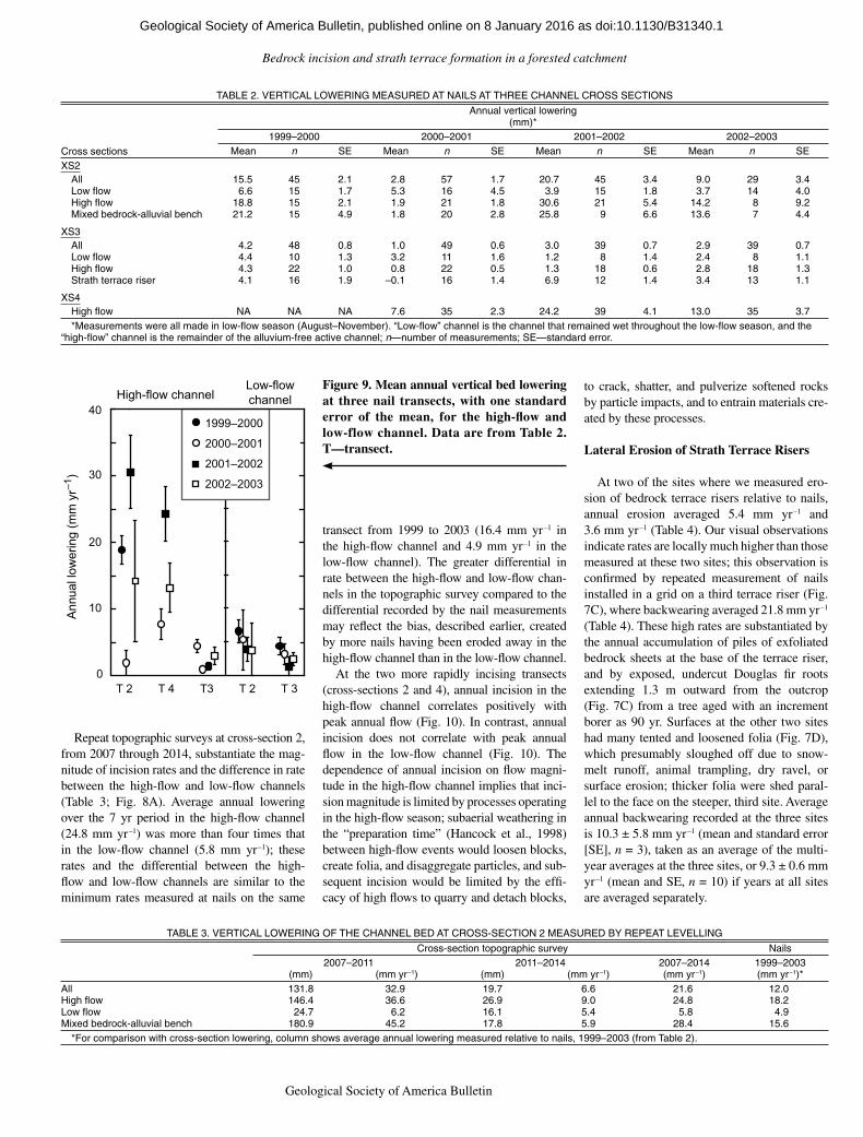
Measured lowering was generally greater in the seasonally wet high-flow channel than in the low-flow channel (Table 2; Fig. 9). In the high-flow channel, annual channel bed lowering at the three cross sections measured over four annual periods (1999–2003) averaged 10.9 mm yr–1 (range 0.8–30.6 mm yr–1; Table 2; Fig. 9A). At two of the cross sections (2 and 4), the low-flow channel lowered on average 3.8 mm yr–1 (range 1.2–6.6 mm yr–1; Fig. 9B), i.e., substantially less than lowering of the high-flow channels. These annual rates are minima because, over time in each cross section, some nails were lost where the bedrock in which the nails were anchored eroded away, and in these cases, we used the nail length to estimate a minimum vertical lower-ing; more nails were eroded away in the chan-nel margin than in the channel thalweg (Table 2), and so lowering in channel margins would be more greatly underestimated than lowering in channel thalwegs. At cross-section 3, rates measured in the high- and low-flow channel did not significantly differ. The greater lowering at cross- sections 2 and 4 relative to cross-section 3 appears to stem from the high-flow surface hav-ing a greater height differential relative to the low-flow channel at cross-sections 2 and 4 compared to cross-section 3. Throughout the study reach, we found visual evidence of substantial weath-ering and erosion where the high-flow channel was from several decimeters to a meter higher than the low-flow channel. Average annual bed lowering across the entire cross section ranged between 1.0 mm yr–1 and 24.2 mm yr–1, and averaged 9.5 mm yr–1 (Table 2).
Horizontal distance (m)
XS 2
30
20
10
08
10
Ele
vatio
n (m
, arb
itrar
y da
tum
)
Alluvial-bedrock bench
High flow
Low flow
A
8
XS 410 B
Ann
ual l
ower
ing
(mm
yr–1
)
XS 3
Strathriser
High flow
6
8
10 CLowflow
2000
2007
0 10 20
0 10 20
0 10 20 30
High flow Low flow
Gravel bar
Strath
Gravel bar
2011
2014
2007
Figure 8. (A) Channel cross section (XS) surveyed in 2007, 2011, and 2014 along nail transect 2, and equivalent lowering (horizontal bars), in mm, in three portions of the cross section. (B) Channel cross sec-tion surveyed in 2000 along nail transect 4. (C) Channel cross section surveyed in 2007 at transect 3.
as doi:10.1130/B31340.1Geological Society of America Bulletin, published online on 8 January 2016
Bedrock incision and strath terrace formation in a forested catchment
Geological Society of America Bulletin, v. 1XX, no. XX/XX 9
Repeat topographic surveys at cross-section 2, from 2007 through 2014, substantiate the mag-nitude of incision rates and the difference in rate between the high-flow and low-flow channels (Table 3; Fig. 8A). Average annual lowering over the 7 yr period in the high-flow channel (24.8 mm yr–1) was more than four times that in the low-flow channel (5.8 mm yr–1); these rates and the differential between the high-flow and low-flow channels are similar to the minimum rates measured at nails on the same
transect from 1999 to 2003 (16.4 mm yr–1 in the high-flow channel and 4.9 mm yr–1 in the low-flow channel). The greater differential in rate between the high-flow and low-flow chan-nels in the topographic survey compared to the differential recorded by the nail measurements may reflect the bias, described earlier, created by more nails having been eroded away in the high-flow channel than in the low-flow channel.
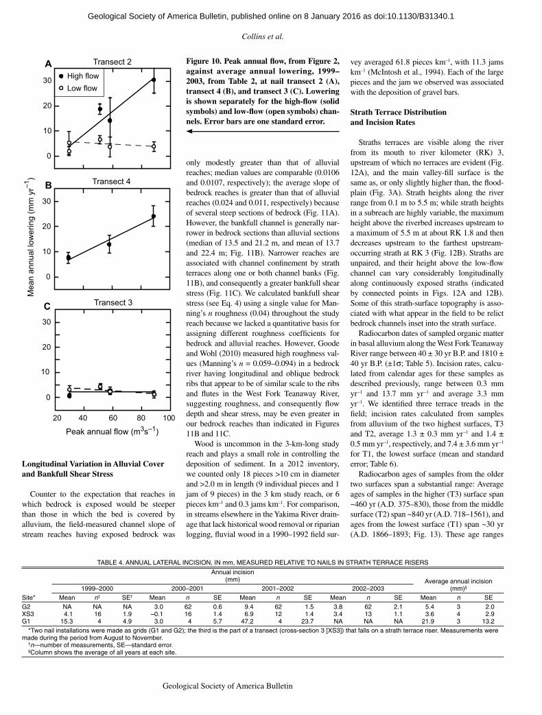
At the two more rapidly incising transects (cross-sections 2 and 4), annual incision in the high-flow channel correlates positively with peak annual flow (Fig. 10). In contrast, annual incision does not correlate with peak annual flow in the low-flow channel (Fig. 10). The dependence of annual incision on flow magni-tude in the high-flow channel implies that inci-sion magnitude is limited by processes operating in the high-flow season; subaerial weathering in the “preparation time” (Hancock et al., 1998) between high-flow events would loosen blocks, create folia, and disaggregate particles, and sub-sequent incision would be limited by the effi-cacy of high flows to quarry and detach blocks,
to crack, shatter, and pulverize softened rocks by particle impacts, and to entrain materials cre-ated by these processes.
Lateral Erosion of Strath Terrace Risers
At two of the sites where we measured ero-sion of bedrock terrace risers relative to nails, annual erosion averaged 5.4 mm yr–1 and 3.6 mm yr–1 (Table 4). Our visual observations indicate rates are locally much higher than those measured at these two sites; this observation is confirmed by repeated measurement of nails installed in a grid on a third terrace riser (Fig. 7C), where backwearing averaged 21.8 mm yr–1 (Table 4). These high rates are substantiated by the annual accumulation of piles of exfoliated bedrock sheets at the base of the terrace riser, and by exposed, undercut Douglas fir roots extending 1.3 m outward from the outcrop (Fig. 7C) from a tree aged with an increment borer as 90 yr. Surfaces at the other two sites had many tented and loosened folia (Fig. 7D), which presumably sloughed off due to snow-melt runoff, animal trampling, dry ravel, or surface erosion; thicker folia were shed paral-lel to the face on the steeper, third site. Average annual backwearing recorded at the three sites is 10.3 ± 5.8 mm yr–1 (mean and standard error [SE], n = 3), taken as an average of the multi-year averages at the three sites, or 9.3 ± 0.6 mm yr–1 (mean and SE, n = 10) if years at all sites are averaged separately.
1999–2000
2000–2001
2001–2002
2002–2003
Ann
ual l
ower
ing
(mm
yr–1
)
High-flow channelLow-flowchannel
0
10
20
30
40
T 2 T 4 T3 T 2 T 3
Figure 9. Mean annual vertical bed lowering at three nail transects, with one standard error of the mean, for the high-flow and low-flow channel. Data are from Table 2. T—transect.
TABLE 2. VERTICAL LOWERING MEASURED AT NAILS AT THREE CHANNEL CROSS SECTIONS
Cross sections
Annual vertical lowering(mm)*
1999–2000 2000–2001 2001–2002 2002–2003Mean n SE Mean n SE Mean n SE Mean n SE
XS2All 15.5 45 2.1 2.8 57 1.7 20.7 45 3.4 9.0 29 3.4Low flow 6.6 15 1.7 5.3 16 4.5 3.9 15 1.8 3.7 14 4.0High flow 18.8 15 2.1 1.9 21 1.8 30.6 21 5.4 14.2 8 9.2Mixed bedrock-alluvial bench 21.2 15 4.9 1.8 20 2.8 25.8 9 6.6 13.6 7 4.4
XS3All 4.2 48 0.8 1.0 49 0.6 3.0 39 0.7 2.9 39 0.7Low flow 4.4 10 1.3 3.2 11 1.6 1.2 8 1.4 2.4 8 1.1High flow 4.3 22 1.0 0.8 22 0.5 1.3 18 0.6 2.8 18 1.3Strath terrace riser 4.1 16 1.9 –0.1 16 1.4 6.9 12 1.4 3.4 13 1.1
XS4High flow NA NA NA 7.6 35 2.3 24.2 39 4.1 13.0 35 3.7*Measurements were all made in low-flow season (August–November). “Low-flow” channel is the channel that remained wet throughout the low-flow season, and the
“high-flow” channel is the remainder of the alluvium-free active channel; n—number of measurements; SE—standard error.
TABLE 3. VERTICAL LOWERING OF THE CHANNEL BED AT CROSS-SECTION 2 MEASURED BY REPEAT LEVELLING
Cross-section topographic survey Nails2007–2011 2011–2014 2007–2014 1999–2003
(mm) (mm yr–1) (mm) (mm yr–1) (mm yr–1) (mm yr–1)*All 131.8 32.9 19.7 6.6 21.6 12.0High flow 146.4 36.6 26.9 9.0 24.8 18.2Low flow 24.7 6.2 16.1 5.4 5.8 4.9Mixed bedrock-alluvial bench 180.9 45.2 17.8 5.9 28.4 15.6
*For comparison with cross-section lowering, column shows average annual lowering measured relative to nails, 1999–2003 (from Table 2).
as doi:10.1130/B31340.1Geological Society of America Bulletin, published online on 8 January 2016
Collins et al.
10 Geological Society of America Bulletin, v. 1XX, no. XX/XX
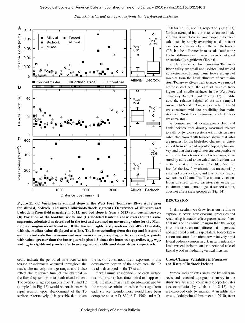
Longitudinal Variation in Alluvial Cover and Bankfull Shear Stress
Counter to the expectation that reaches in which bedrock is exposed would be steeper than those in which the bed is covered by alluvium, the field-measured channel slope of stream reaches having exposed bedrock was
only modestly greater than that of alluvial reaches; median values are comparable (0.0106 and 0.0107, respectively); the average slope of bedrock reaches is greater than that of alluvial reaches (0.024 and 0.011, respectively) because of several steep sections of bedrock (Fig. 11A). However, the bankfull channel is generally nar-rower in bedrock sections than alluvial sections (median of 13.5 and 21.2 m, and mean of 13.7 and 22.4 m; Fig. 11B). Narrower reaches are associated with channel confinement by strath terraces along one or both channel banks (Fig. 11B), and consequently a greater bankfull shear stress (Fig. 11C). We calculated bankfull shear stress (see Eq. 4) using a single value for Man-ning’s n roughness (0.04) throughout the study reach because we lacked a quantitative basis for assigning different roughness coefficients for bedrock and alluvial reaches. However, Goode and Wohl (2010) measured high roughness val-ues (Manning’s n = 0.059–0.094) in a bedrock river having longitudinal and oblique bedrock ribs that appear to be of similar scale to the ribs and flutes in the West Fork Teanaway River, suggesting roughness, and consequently flow depth and shear stress, may be even greater in our bedrock reaches than indicated in Figures 11B and 11C.
Wood is uncommon in the 3-km-long study reach and plays a small role in controlling the deposition of sediment. In a 2012 inventory, we counted only 18 pieces >10 cm in diameter and >2.0 m in length (9 individual pieces and 1 jam of 9 pieces) in the 3 km study reach, or 6 pieces km–1 and 0.3 jams km–1. For comparison, in streams elsewhere in the Yakima River drain-age that lack historical wood removal or riparian logging, fluvial wood in a 1990–1992 field sur-
vey averaged 61.8 pieces km–1, with 11.3 jams km–1 (McIntosh et al., 1994). Each of the large pieces and the jam we observed was associated with the deposition of gravel bars.
Strath Terrace Distribution and Incision Rates
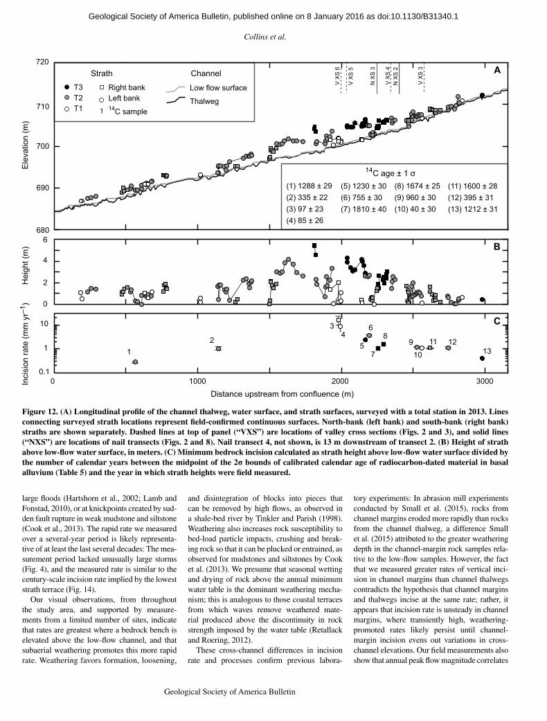
Straths terraces are visible along the river from its mouth to river kilometer (RK) 3, upstream of which no terraces are evident (Fig. 12A), and the main valley-fill surface is the same as, or only slightly higher than, the flood-plain (Fig. 3A). Strath heights along the river range from 0.1 m to 5.5 m; while strath heights in a subreach are highly variable, the maximum height above the riverbed increases upstream to a maximum of 5.5 m at about RK 1.8 and then decreases upstream to the farthest upstream-occurring strath at RK 3 (Fig. 12B). Straths are unpaired, and their height above the low-flow channel can vary considerably longitudinally along continuously exposed straths (indicated by connected points in Figs. 12A and 12B). Some of this strath-surface topography is asso-ciated with what appear in the field to be relict bedrock channels inset into the strath surface.
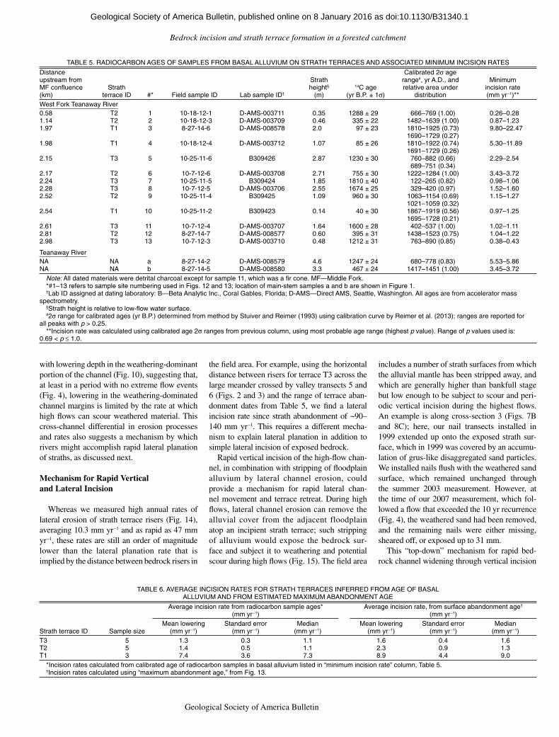
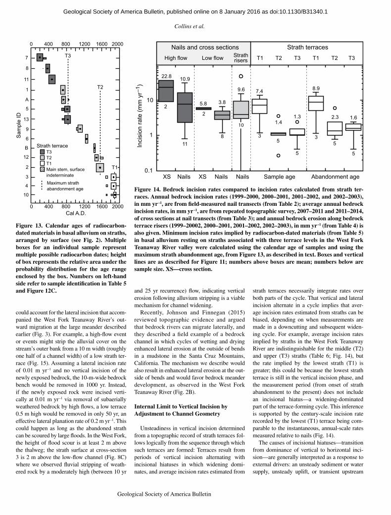
Radiocarbon dates of sampled organic matter in basal alluvium along the West Fork Teanaway River range between 40 ± 30 yr B.P. and 1810 ± 40 yr B.P. (±1s; Table 5). Incision rates, calcu-lated from calendar ages for these samples as described previously, range between 0.3 mm yr–1 and 13.7 mm yr–1 and average 3.3 mm yr–1. We identified three terrace treads in the field; incision rates calculated from samples from alluvium of the two highest surfaces, T3 and T2, average 1.3 ± 0.3 mm yr–1 and 1.4 ± 0.5 mm yr–1, respectively, and 7.4 ± 3.6 mm yr–1 for T1, the lowest surface (mean and standard error; Table 6).
Radiocarbon ages of samples from the older two surfaces span a substantial range: Average ages of samples in the higher (T3) surface span ~460 yr (A.D. 375–830), those from the middle surface (T2) span ~840 yr (A.D. 718–1561), and ages from the lowest surface (T1) span ~30 yr (A.D. 1866–1893; Fig. 13). These age ranges
Mea
n an
nual
low
erin
g (m
m y
r–1) Transect 4
Transect 3
Transect 2
High flowLow flow
Peak annual flow (m3s–1)
0
10
20
30
0
10
20
30
0
10
20
30
20 40 60 80 100
C
B
A Figure 10. Peak annual flow, from Figure 2, against average annual lowering, 1999–2003, from Table 2, at nail transect 2 (A), transect 4 (B), and transect 3 (C). Lowering is shown separately for the high-flow (solid symbols) and low-flow (open symbols) chan-nels. Error bars are one standard error.
TABLE 4. ANNUAL LATERAL INCISION, IN mm, MEASURED RELATIVE TO NAILS IN STRATH TERRACE RISERS
Site*
Annual incision(mm) Average annual incision
(mm)§1999–2000 2000–2001 2001–2002 2002–2003Mean n† SE† Mean n SE Mean n SE Mean n SE Mean n SE
G2 NA NA NA 3.0 62 0.6 9.4 62 1.5 3.8 62 2.1 5.4 3 2.0XS3 4.1 16 1.9 –0.1 16 1.4 6.9 12 1.4 3.4 13 1.1 3.6 4 2.9G1 15.3 4 4.9 3.0 4 5.7 47.2 4 23.7 NA NA NA 21.9 3 13.2
*Two nail installations were made as grids (G1 and G2); the third is the part of a transect (cross-section 3 [XS3]) that falls on a strath terrace riser. Measurements were made during the period from August to November.
†n—number of measurements, SE—standard error.§Column shows the average of all years at each site.
as doi:10.1130/B31340.1Geological Society of America Bulletin, published online on 8 January 2016
Bedrock incision and strath terrace formation in a forested catchment
Geological Society of America Bulletin, v. 1XX, no. XX/XX 11
could indicate the period of time over which terrace abandonment occurred throughout the reach; alternatively, the age ranges could also reflect the residence time of the charcoal in the fluvial system prior to strath abandonment. The overlap in ages of samples from T3 and T2 (sample 1 in Fig. 13) would be consistent with rapid incision upon abandonment of the T3 surface. Alternatively, it is possible that, given
the lack of continuous strath exposures in this downstream portion of the study area, the T2 tread is developed on the T3 strath.
If we assume abandonment of each surface occurred over a short time period and approxi-mate the maximum strath abandonment age by the respective minimum radiocarbon age from each surface, abandonment would have been complete at ca. A.D. 830, A.D. 1560, and A.D.
1890 for T3, T2, and T1, respectively (Fig. 13). Surface-averaged incision rates calculated mak-ing this assumption are more rapid than those calculated by simply averaging all dates from each surface, especially for the middle terrace (T2), but the difference in rates calculated using the two different sets of assumptions is not great or statistically significant (Table 6).
Strath terraces in the main-stem Teanaway River valley are small and isolated, and we did not systematically map them. However, ages of samples from the basal alluvium of two main-stem Teanaway River strath terraces we sampled are consistent with the ages of samples from higher and middle surfaces in the West Fork Teanaway River, T3 and T2 (Fig. 13). In addi-tion, the relative heights of the two sampled surfaces (4.6 and 3.3 m, respectively; Table 5) are consistent with the possibility that main-stem and West Fork Teanaway strath terraces are correlated.
A comparison of contemporary bed and bank incision rates directly measured relative to nails or by cross sections with incision rates calculated from strath terraces shows that rates are greatest for the high-flow channel, as deter-mined from nails and repeated topographic sur-vey, and that these rapid rates are comparable to rates of bedrock terrace riser backwearing mea-sured by nails and to the calculated incision rate of the lowest strath terrace (Fig. 14). Rates are less for the low-flow channel, as measured by nails and cross sections, and least for the higher two straths (T2 and T3). The alternative calcu-lation of strath terrace incision rate using the maximum abandonment age, described earlier, does not affect these groupings (Fig. 14).
DISCUSSION
In this section, we draw from our results to explore, in order: how erosional processes and weathering interact to effect greater rates of ver-tical incision in channel margins than thalwegs; how this cross-channel differential in process and rate could result in rapid lateral bedrock pla-nation and strath formation; how relatively rapid lateral bedrock erosion might, in turn, internally limit vertical incision; and the potential role of fluvial wood in mediating vertical incision.
Cross-Channel Variability in Processes and Rates of Bedrock Incision
Vertical incision rates measured by nail tran-sects and repeated topographic survey in the study area are rapid; compared to reported rates (see compilation by Lamb et al., 2015), they are exceeded only by incision at an artificially created knickpoint (Johnson et al., 2010), from
0
0.02
0.04
0.06
0.08
0.10A
0
20
40
BConfined 2 sides Confined 1 side Unconfined
200
400
600C
0 1000 2000 3000Distance upstream (m)
savg=0.024savg=
0.011
Alluvial Bedrock
wavg=15.4
wavg=22.4
τavg=176.6
τavg=81.4
Alluvial Bedrock
She
ar s
tress
(N m
–2)
B
ankf
ull w
idth
(m)
C
hann
el s
lope
(m/m
)
AlluvialBedrockMixed
Forcedalluvial
0
Figure 11. (A) Variation in channel slope in the West Fork Teanaway River study area for allu vial, bedrock, and mixed alluvial-bedrock segments. Occurrence of alluvium and bedrock is from field mapping in 2012, and bed slope is from a 2013 total station survey. (B) Variation of the bankfull width and (C) modeled bankfull shear stress for the same segments, calculated as described in the text and assumed an unvarying value for the Man-ning’s n roughness coefficient (n = 0.04). Boxes in right-hand panels enclose 50% of the data, with the median value displayed as a line. The lines extending from the top and bottom of each box indicate the minimum and maximum values, excepting outliers (circles), or points with values greater than the inner quartile plus 1.5 times the inner two quartiles. savg, wavg, and τavg in right-hand panels refer to average slope, width, and shear stress, respectively.
as doi:10.1130/B31340.1Geological Society of America Bulletin, published online on 8 January 2016
Collins et al.
12 Geological Society of America Bulletin, v. 1XX, no. XX/XX
large floods (Hartshorn et al., 2002; Lamb and Fonstad, 2010), or at knickpoints created by sud-den fault rupture in weak mudstone and siltstone (Cook et al., 2013). The rapid rate we measured over a several-year period is likely representa-tive of at least the last several decades: The mea-surement period lacked unusually large storms (Fig. 4), and the measured rate is similar to the century-scale incision rate implied by the lowest strath terrace (Fig. 14).
Our visual observations, from throughout the study area, and supported by measure-ments from a limited number of sites, indicate that rates are greatest where a bedrock bench is elevated above the low-flow channel, and that subaerial weathering promotes this more rapid rate. Weathering favors formation, loosening,
and disintegration of blocks into pieces that can be removed by high flows, as observed in a shale-bed river by Tinkler and Parish (1998). Weathering also increases rock susceptibility to bed-load particle impacts, crushing and break-ing rock so that it can be plucked or entrained, as observed for mudstones and siltstones by Cook et al. (2013). We presume that seasonal wetting and drying of rock above the annual minimum water table is the dominant weathering mecha-nism; this is analogous to those coastal terraces from which waves remove weathered mate-rial produced above the discontinuity in rock strength imposed by the water table (Retallack and Roering, 2012).
These cross-channel differences in incision rate and processes confirm previous labora-
tory experiments: In abrasion mill experiments conducted by Small et al. (2015), rocks from channel margins eroded more rapidly than rocks from the channel thalweg, a difference Small et al. (2015) attributed to the greater weathering depth in the channel-margin rock samples rela-tive to the low-flow samples. However, the fact that we measured greater rates of vertical inci-sion in channel margins than channel thalwegs contradicts the hypothesis that channel margins and thalwegs incise at the same rate; rather, it appears that incision rate is unsteady in channel margins, where transiently high, weathering-promoted rates likely persist until channel-margin incision evens out variations in cross-channel elevations. Our field measurements also show that annual peak flow magnitude correlates
21 13
1211
109
8
7
634
5
14C age ± 1 σ
Right bankLeft bank14C sample
Strath
T3T2T1 1
680
690
700
710
0 1000 2000 3000
Distance upstream from confluence (m)
A
B
C
720
0
2
4
6
1
10
0.1N
XS
3
N X
S 2
V X
S 3
V X
S 6
V X
S 4
V X
S 5
(1) 1288 ± 29(2) 335 ± 22(3) 97 ± 23(4) 85 ± 26
(5) 1230 ± 30(6) 755 ± 30(7) 1810 ± 40
(8) 1674 ± 25(9) 960 ± 30(10) 40 ± 30
(11) 1600 ± 28(12) 395 ± 31(13) 1212 ± 31
Low flow surface
Thalweg
Channel
Inci
sion
rate
(mm
yr–
1 )
H
eigh
t (m
)
E
leva
tion
(m)
Figure 12. (A) Longitudinal profile of the channel thalweg, water surface, and strath surfaces, surveyed with a total station in 2013. Lines connecting surveyed strath locations represent field-confirmed continuous surfaces. North-bank (left bank) and south-bank (right bank) straths are shown separately. Dashed lines at top of panel (“VXS”) are locations of valley cross sections (Figs. 2 and 3), and solid lines (“NXS”) are locations of nail transects (Figs. 2 and 8). Nail transect 4, not shown, is 13 m downstream of transect 2. (B) Height of strath above low-flow water surface, in meters. (C) Minimum bedrock incision calculated as strath height above low-flow water surface divided by the number of calendar years between the midpoint of the 2σ bounds of calibrated calendar age of radiocarbon-dated material in basal alluvium (Table 5) and the year in which strath heights were field measured.
as doi:10.1130/B31340.1Geological Society of America Bulletin, published online on 8 January 2016
Bedrock incision and strath terrace formation in a forested catchment
Geological Society of America Bulletin, v. 1XX, no. XX/XX 13
with lowering depth in the weathering-dominant portion of the channel (Fig. 10), suggesting that, at least in a period with no extreme flow events (Fig. 4), lowering in the weathering-dominated channel margins is limited by the rate at which high flows can scour weathered material. This cross-channel differential in erosion processes and rates also suggests a mechanism by which rivers might accomplish rapid lateral planation of straths, as discussed next.
Mechanism for Rapid Vertical and Lateral Incision
Whereas we measured high annual rates of lateral erosion of strath terrace risers (Fig. 14), averaging 10.3 mm yr–1 and as rapid as 47 mm yr–1, these rates are still an order of magnitude lower than the lateral planation rate that is implied by the distance between bedrock risers in
the field area. For example, using the horizontal distance between risers for terrace T3 across the large meander crossed by valley transects 5 and 6 (Figs. 2 and 3) and the range of terrace aban-donment dates from Table 5, we find a lateral incision rate since strath abandonment of ~90–140 mm yr–1. This requires a different mecha-nism to explain lateral planation in addition to simple lateral incision of exposed bedrock.
Rapid vertical incision of the high-flow chan-nel, in combination with stripping of floodplain alluvium by lateral channel erosion, could provide a mechanism for rapid lateral chan-nel movement and terrace retreat. During high flows, lateral channel erosion can remove the alluvial cover from the adjacent floodplain atop an incipient strath terrace; such stripping of alluvium would expose the bedrock sur-face and subject it to weathering and potential scour during high flows (Fig. 15). The field area
includes a number of strath surfaces from which the alluvial mantle has been stripped away, and which are generally higher than bankfull stage but low enough to be subject to scour and peri-odic vertical incision during the highest flows. An example is along cross-section 3 (Figs. 7B and 8C); here, our nail transects installed in 1999 extended up onto the exposed strath sur-face, which in 1999 was covered by an accumu-lation of grus-like disaggregated sand particles. We installed nails flush with the weathered sand surface, which remained unchanged through the summer 2003 measurement. However, at the time of our 2007 measurement, which fol-lowed a flow that exceeded the 10 yr recurrence (Fig. 4), the weathered sand had been removed, and the remaining nails were either missing, sheared off, or exposed up to 31 mm.
This “top-down” mechanism for rapid bed-rock channel widening through vertical incision
TABLE 5. RADIOCARBON AGES OF SAMPLES FROM BASAL ALLUVIUM ON STRATH TERRACES AND ASSOCIATED MINIMUM INCISION RATES
Distance upstream from MF confluence (km)
Strath terrace ID #* Field sample ID Lab sample ID†
Strath height§
(m)
14C age(yr B.P. ± 1σ)
Calibrated 2σ age range#, yr A.D., and relative area under
distribution
Minimum incision rate (mm yr–1)**
West Fork Teanaway River0.58 T2 1 10-18-12-1 D-AMS-003711 0.35 1288 ± 29 666–769 (1.00) 0.26–0.281.14 T2 2 10-18-12-3 D-AMS-003709 0.46 335 ± 22 1482–1639 (1.00) 0.87–1.231.97 T1 3 8-27-14-6 D-AMS-008578 2.0 97 ± 23 1810–1925 (0.73)
1690–1729 (0.27)9.80–22.47
1.98 T1 4 10-18-12-4 D-AMS-003712 1.07 85 ± 26 1810–1922 (0.74)1691–1729 (0.26)
5.30–11.89
2.15 T3 5 10-25-11-6 B309426 2.87 1230 ± 30 760–882 (0.66)689–751 (0.34)
2.29–2.54
2.17 T2 6 10-7-12-6 D-AMS-003708 2.71 755 ± 30 1222–1284 (1.00) 3.43–3.722.24 T3 7 10-25-11-5 B309424 1.85 1810 ± 40 122–265 (0.82) 0.98–1.062.28 T3 8 10-7-12-5 D-AMS-003706 2.55 1674 ± 25 329–420 (0.97) 1.52–1.602.52 T2 9 10-25-11-4 B309425 1.09 960 ± 30 1063–1154 (0.69)
1021–1059 (0.32)1.15–1.27
2.54 T1 10 10-25-11-2 B309423 0.14 40 ± 30 1867–1919 (0.56)1695–1728 (0.21)
0.97–1.25
2.61 T3 11 10-7-12-4 D-AMS-003707 1.64 1600 ± 28 402–537 (1.00) 1.02–1.112.81 T2 12 8-27-14-7 D-AMS-008577 0.60 395 ± 31 1438–1523 (0.75) 1.04–1.222.98 T3 13 10-7-12-3 D-AMS-003710 0.48 1212 ± 31 763–890 (0.85) 0.38–0.43
Teanaway RiverNA NA a 8-27-14-2 D-AMS-008579 4.6 1247 ± 24 680–778 (0.83) 5.53–5.86NA NA b 8-27-14-5 D-AMS-008580 3.3 467 ± 24 1417–1451 (1.00) 3.45–3.72
Note: All dated materials were detrital charcoal except for sample 11, which was a fir cone. MF—Middle Fork.*#1–13 refers to sample site numbering used in Figs. 12 and 13; location of main-stem samples a and b are shown in Figure 1.†Lab ID assigned at dating laboratory: B—Beta Analytic Inc., Coral Gables, Florida; D-AMS—Direct AMS, Seattle, Washington. All ages are from accelerator mass
spectrometry.§Strath height is relative to low-flow water surface.#2σ range for calibrated ages (yr B.P.) determined from method by Stuiver and Reimer (1993) using calibration curve by Reimer et al. (2013); ranges are reported for
all peaks with p > 0.25.**Incision rate was calculated using calibrated age 2σ ranges from previous column, using most probable age range (highest p value). Range of p values used is:
0.69 < p ≤ 1.0.
TABLE 6. AVERAGE INCISION RATES FOR STRATH TERRACES INFERRED FROM AGE OF BASAL ALLUVIUM AND FROM ESTIMATED MAXIMUM ABANDONMENT AGE
Strath terrace ID Sample size
Average incision rate from radiocarbon sample ages*(mm yr–1)
Average incision rate, from surface abandonment age†
(mm yr–1)Mean lowering
(mm yr–1)Standard error
(mm yr–1)Median
(mm yr–1)Mean lowering
(mm yr–1)Standard error
(mm yr–1)Median
(mm yr–1)T3 5 1.3 0.3 1.1 1.6 0.4 1.6T2 5 1.4 0.5 1.1 2.3 0.9 1.3T1 3 7.4 3.6 7.3 8.9 4.4 9.0
*Incision rates calculated from calibrated age of radiocarbon samples in basal alluvium listed in “minimum incision rate” column, Table 5.†Incision rates calculated using “maximum abandonment age,” from Fig. 13.
as doi:10.1130/B31340.1Geological Society of America Bulletin, published online on 8 January 2016
Collins et al.
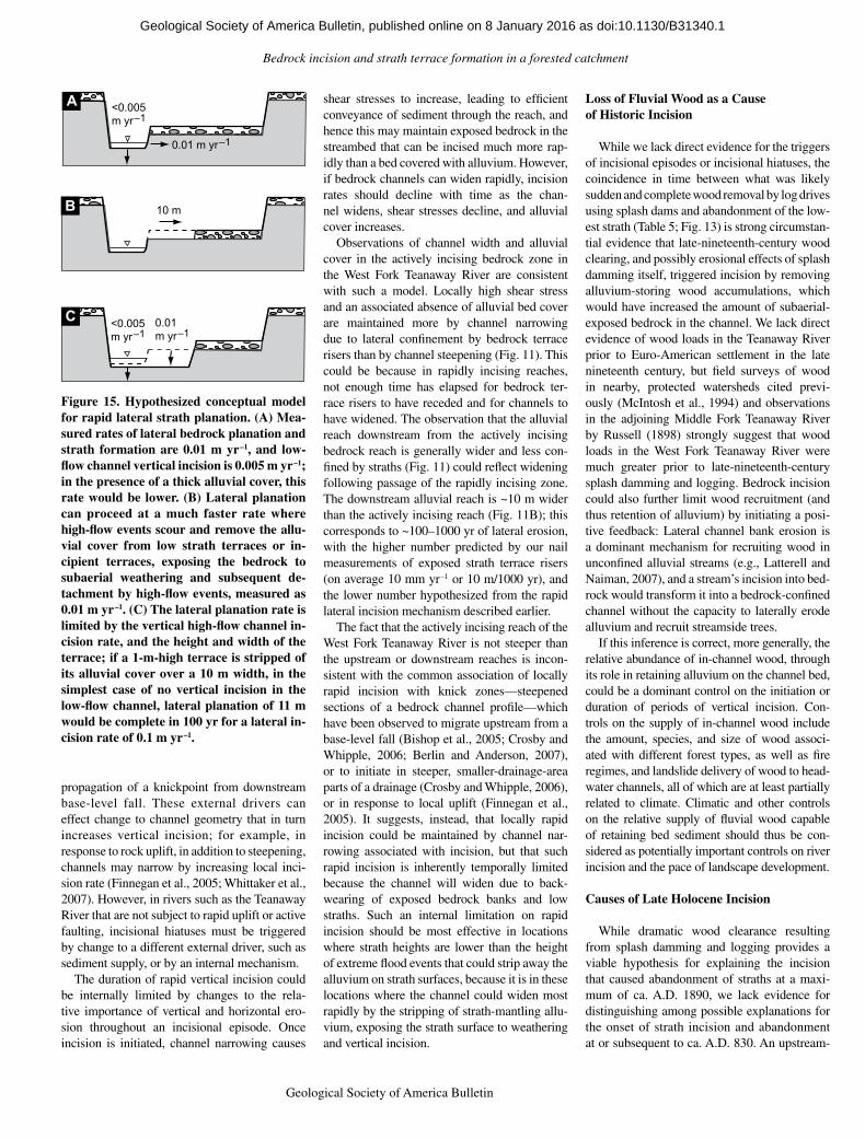
14 Geological Society of America Bulletin, v. 1XX, no. XX/XX
could account for the lateral incision that accom-panied the West Fork Teanaway River’s out-ward migration at the large meander described earlier (Fig. 3). For example, a high-flow event or events might strip the alluvial cover on the stream’s outer bank from a 10 m width (roughly one half of a channel width) of a low strath ter-race (Fig. 15). Assuming a lateral incision rate of 0.01 m yr–1 and no vertical incision of the newly exposed bedrock, the 10-m-wide bedrock bench would be removed in 1000 yr. Instead, if the newly exposed rock were incised verti-cally at 0.01 m yr–1 via removal of subaerially weathered bedrock by high flows, a low terrace 0.5 m high would be removed in only 50 yr, an effective lateral planation rate of 0.2 m yr–1. This could happen as long as the abandoned strath can be scoured by large floods. In the West Fork, the height of flood scour is at least 2 m above the thalweg; the strath surface at cross-section 3 is 2 m above the low-flow channel (Fig. 8C) where we observed fluvial stripping of weath-ered rock by a moderately high (between 10 yr
and 25 yr recurrence) flow, indicating vertical erosion following alluvium stripping is a viable mechanism for channel widening.
Recently, Johnson and Finnegan (2015) reviewed topographic evidence and argued that bedrock rivers can migrate laterally, and they described a field example of a bedrock channel in which cycles of wetting and drying enhanced lateral erosion at the outside of bends in a mudstone in the Santa Cruz Mountains, California. The mechanism we describe would also result in enhanced lateral erosion at the out-side of bends and would favor bedrock meander development, as observed in the West Fork Teanaway River (Fig. 2B).
Internal Limit to Vertical Incision by Adjustment to Channel Geometry
Unsteadiness in vertical incision determined from a topographic record of strath terraces fol-lows logically from the sequence through which such terraces are formed: Terraces result from periods of vertical incision alternating with incisional hiatuses in which widening domi-nates, and average incision rates estimated from
strath terraces necessarily integrate rates over both parts of the cycle. That vertical and lateral incision alternate in a cycle implies that aver-age incision rates estimated from straths can be biased, depending on when measurements are made in a downcutting and subsequent widen-ing cycle. For example, average incision rates implied by straths in the West Fork Teanaway River are indistinguishable for the middle (T2) and upper (T3) straths (Table 6; Fig. 14), but the rate implied by the lowest strath (T1) is greater; this could be because the lowest strath terrace is still in the vertical incision phase, and the measurement period (from onset of strath abandonment to the present) does not include an incisional hiatus—a widening-dominated part of the terrace-forming cycle. This inference is supported by the century-scale incision rate recorded by the lowest (T1) terrace being com-parable to the instantaneous, annual-scale rates measured relative to nails (Fig. 14).
The causes of incisional hiatuses—transition from dominance of vertical to horizontal inci-sion—are generally interpreted as a response to external drivers: an unsteady sediment or water supply, unsteady uplift, or transient upstream
3
T3T2T1Main stem, surfaceindeterminate
Cal A.D.
7
8
11
1
A
13
5
9
6
B
12
2
4
10
Maximum strathabandonment age
Strath terrace
T3
Sam
ple
ID
0 400 800 1200 1600 2000
T2
T1
0 400 800 1200 1600 2000
Figure 13. Calendar ages of radiocarbon-dated materials in basal alluvium on straths, arranged by surface (see Fig. 2). Multiple boxes for an individual sample represent multiple possible radiocarbon dates; height of box represents the relative area under the probability distribution for the age range enclosed by the box. Numbers on left-hand side refer to sample identification in Table 5 and Figure 12C.
0.1
1
10
Inci
sion
rate
(mm
yr–
1 )
High flow
11
2
35
5
2
8
10.9
3.8
7.4
1.41.3
22.8
9.6 8.9
2.3 1.6
5
5
3
Low flow Strathrisers
Nails and cross sections Strath terraces
XS Nails XS Nails Nails Sample age Abandonment age
T1 T2 T3 T1 T2 T3
5.8
10
Figure 14. Bedrock incision rates compared to incision rates calculated from strath ter-races. Annual bedrock incision rates (1999–2000, 2000–2001, 2001–2002, and 2002–2003), in mm yr–1, are from field-measured nail transects (from Table 2); average annual bedrock incision rates, in mm yr–1, are from repeated topographic survey, 2007–2011 and 2011–2014, of cross sections at nail transects (from Table 3); and annual bedrock erosion along bedrock terrace risers (1999–20002, 2000–2001, 2001–2002, 2002–2003), in mm yr–1 (from Table 4) is also given. Minimum incision rates implied by radiocarbon-dated materials (from Table 5) in basal alluvium resting on straths associated with three terrace levels in the West Fork Teanaway River valley were calculated using the calendar age of samples and using the maximum strath abandonment age, from Figure 13, as described in text. Boxes and vertical lines are as described for Figure 11; numbers above boxes are mean; numbers below are sample size. XS—cross section.
as doi:10.1130/B31340.1Geological Society of America Bulletin, published online on 8 January 2016
Bedrock incision and strath terrace formation in a forested catchment
Geological Society of America Bulletin, v. 1XX, no. XX/XX 15
propagation of a knickpoint from downstream base-level fall. These external drivers can effect change to channel geometry that in turn increases vertical incision; for example, in response to rock uplift, in addition to steepening, channels may narrow by increasing local inci-sion rate (Finnegan et al., 2005; Whittaker et al., 2007). However, in rivers such as the Teanaway River that are not subject to rapid uplift or active faulting, incisional hiatuses must be triggered by change to a different external driver, such as sediment supply, or by an internal mechanism.
The duration of rapid vertical incision could be internally limited by changes to the rela-tive importance of vertical and horizontal ero-sion throughout an incisional episode. Once incision is initiated, channel narrowing causes
shear stresses to increase, leading to efficient conveyance of sediment through the reach, and hence this may maintain exposed bedrock in the streambed that can be incised much more rap-idly than a bed covered with alluvium. However, if bedrock channels can widen rapidly, incision rates should decline with time as the chan-nel widens, shear stresses decline, and alluvial cover increases.
Observations of channel width and alluvial cover in the actively incising bedrock zone in the West Fork Teanaway River are consistent with such a model. Locally high shear stress and an associated absence of alluvial bed cover are maintained more by channel narrowing due to lateral confinement by bedrock terrace risers than by channel steepening (Fig. 11). This could be because in rapidly incising reaches, not enough time has elapsed for bedrock ter-race risers to have receded and for channels to have widened. The observation that the alluvial reach downstream from the actively incising bedrock reach is generally wider and less con-fined by straths (Fig. 11) could reflect widening following passage of the rapidly incising zone. The downstream alluvial reach is ~10 m wider than the actively incising reach (Fig. 11B); this corresponds to ~100–1000 yr of lateral erosion, with the higher number predicted by our nail measurements of exposed strath terrace risers (on average 10 mm yr–1 or 10 m/1000 yr), and the lower number hypothesized from the rapid lateral incision mechanism described earlier.
The fact that the actively incising reach of the West Fork Teanaway River is not steeper than the upstream or downstream reaches is incon-sistent with the common association of locally rapid incision with knick zones—steepened sections of a bedrock channel profile—which have been observed to migrate upstream from a base-level fall (Bishop et al., 2005; Crosby and Whipple, 2006; Berlin and Anderson, 2007), or to initiate in steeper, smaller-drainage-area parts of a drainage (Crosby and Whipple, 2006), or in response to local uplift (Finnegan et al., 2005). It suggests, instead, that locally rapid incision could be maintained by channel nar-rowing associated with incision, but that such rapid incision is inherently temporally limited because the channel will widen due to back-wearing of exposed bedrock banks and low straths. Such an internal limitation on rapid incision should be most effective in locations where strath heights are lower than the height of extreme flood events that could strip away the alluvium on strath surfaces, because it is in these locations where the channel could widen most rapidly by the stripping of strath-mantling allu-vium, exposing the strath surface to weathering and vertical incision.
Loss of Fluvial Wood as a Cause of Historic Incision
While we lack direct evidence for the triggers of incisional episodes or incisional hiatuses, the coincidence in time between what was likely sudden and complete wood removal by log drives using splash dams and abandonment of the low-est strath (Table 5; Fig. 13) is strong circumstan-tial evidence that late-nineteenth-century wood clearing, and possibly erosional effects of splash damming itself, triggered incision by removing alluvium-storing wood accumulations, which would have increased the amount of subaerial-exposed bedrock in the channel. We lack direct evidence of wood loads in the Teanaway River prior to Euro-American settlement in the late nineteenth century, but field surveys of wood in nearby, protected watersheds cited previ-ously (McIntosh et al., 1994) and observations in the adjoining Middle Fork Teanaway River by Russell (1898) strongly suggest that wood loads in the West Fork Teanaway River were much greater prior to late-nineteenth-century splash damming and logging. Bedrock incision could also further limit wood recruitment (and thus retention of alluvium) by initiating a posi-tive feedback: Lateral channel bank erosion is a dominant mechanism for recruiting wood in unconfined alluvial streams (e.g., Latterell and Naiman, 2007), and a stream’s incision into bed-rock would transform it into a bedrock-confined channel without the capacity to laterally erode alluvium and recruit streamside trees.
If this inference is correct, more generally, the relative abundance of in-channel wood, through its role in retaining alluvium on the channel bed, could be a dominant control on the initiation or duration of periods of vertical incision. Con-trols on the supply of in-channel wood include the amount, species, and size of wood associ-ated with different forest types, as well as fire regimes, and landslide delivery of wood to head-water channels, all of which are at least partially related to climate. Climatic and other controls on the relative supply of fluvial wood capable of retaining bed sediment should thus be con-sidered as potentially important controls on river incision and the pace of landscape development.
Causes of Late Holocene Incision
While dramatic wood clearance resulting from splash damming and logging provides a viable hypothesis for explaining the incision that caused abandonment of straths at a maxi-mum of ca. A.D. 1890, we lack evidence for distinguishing among possible explanations for the onset of strath incision and abandonment at or subsequent to ca. A.D. 830. An upstream-
10 m
0.01m yr–1
<0.005m yr–1
<0.005m yr–1
0.01 m yr–1
C
A
B
C
Figure 15. Hypothesized conceptual model for rapid lateral strath planation. (A) Mea-sured rates of lateral bedrock planation and strath formation are 0.01 m yr–1, and low-flow channel vertical incision is 0.005 m yr–1; in the presence of a thick alluvial cover, this rate would be lower. (B) Lateral planation can proceed at a much faster rate where high-flow events scour and remove the allu-vial cover from low strath terraces or in-cipient terraces, exposing the bedrock to subaerial weathering and subsequent de-tachment by high-flow events, measured as 0.01 m yr–1. (C) The lateral planation rate is limited by the vertical high-flow channel in-cision rate, and the height and width of the terrace; if a 1-m-high terrace is stripped of its alluvial cover over a 10 m width, in the simplest case of no vertical incision in the low-flow channel, lateral planation of 11 m would be complete in 100 yr for a lateral in-cision rate of 0.1 m yr–1.
as doi:10.1130/B31340.1Geological Society of America Bulletin, published online on 8 January 2016
Collins et al.
16 Geological Society of America Bulletin, v. 1XX, no. XX/XX
progressing base-level disturbance is not consis-tent with the evidence: Strath terrace ages indi-cate incision in the West Fork Teanaway River was synchronous with that in the main-stem Teanaway (Fig. 13; Table 5), and the upstream propagation would have been implausibly rapid, ~15 m yr–1. Moreover, the speculated drainage capture (Saunders, 1914) would have been initi-ated much earlier, by deposition of a terminal moraine from the penultimate glaciation. A second possibility, consistent with a systemic, rather than upstream-progressing, cause is that fluvial excavation of the alluvial valley fill from the penultimate glaciation, represented by fill terraces ~35 m above the current valley bottom (Fig. 1), did not reach the level of the highest strath until the last two millennia; we lack suf-ficient data on the late Quaternary evolution of the Yakima and Teanaway River valleys to assess this possibility.
An additional possibility is that climatic vari-ability changed the balance of sediment supply and streamflow or caused fires that substantially reduced wood supply to the stream for periods of time. The nearest pollen studies in the Okano-gan Highlands to the northeast of the study site indicate a change ca. 2 ka in plant communities suggesting warmer and drier climate (Whitlock, 1992), which could be consistent with a reduc-tion in sediment supply and the onset of inci-sion, but we lack information on whether this change occurred in the east-central Cascade Range or was great enough to trigger strath inci-sion in the Teanaway basin. The Teanaway River may be an example of a system inherently prone to incision, not only because it flows through a mechanically weak and readily weathered lithology (Montgomery, 2004), but because of how basin lithology influences sediment supply; in the West Fork Teanaway, tributaries draining the Roslyn Formation supply little coarse bed material to the river, and what little is contrib-uted breaks down rapidly. The channel’s incision into the Roslyn Formation further limits coarse particle recruitment from the flanking alluvium. As a result, bed material is almost entirely made of more competent rock supplied from the dis-tant upper watershed; although rocks in the upper watershed are more competent, they are subject to attrition over the greater distance they travel. Alluvial cover in such settings is likely to be inherently thin and susceptible to fluctuations in the supply and routing of sediment, water, or wood to the channel.
CONCLUSIONS
In the rapidly incising (~0.01 m yr–1, mea-sured annually) West Fork Teanaway River, the perennially wet, low-flow channel erodes less
rapidly, and by different processes (abrasion) than the seasonally inundated high-flow chan-nel (subaerial weathering that favors plucking, crushing, and macro-abrasion in high-flow events). This observation supports a hypothesis from laboratory experiments that greater rates of weathering of channel margins cause channel margins to erode more rapidly than thalwegs; additionally, measured rates suggest that aver-age annual vertical incision is more rapid in channel margins, pointing to a cross-channel unsteadiness in vertical incision.
This rapid incision in the high-flow channel suggests a mechanism for rapid lateral strath planation: As an incising channel sweeps lat-erally, removing alluvium from an incipient or low strath surface, it incorporates that surface in the high-flow portion of the channel, where weathering-enhanced vertical incision can rap-idly remove the surface, effecting a rapid “top-down” lateral bedrock erosion.
The unsteadiness of vertical bedrock inci-sion recorded by straths in the study area is highlighted by differences among the three strath terrace levels in inferred average incision rates. The fact that inferred average incision rate for the lowest of the three strath terraces, which is currently incising, is greater than that of the older strath terraces suggests that inci-sion rates inferred from straths can be biased by the timing in the cycle of strath terrace forma-tion—the cycle of vertical incision followed by horizontal incision—during which the measure-ment is made.
Rapid lateral erosion of bedrock banks may provide a mechanism for the transition between periods of vertical incision and peri-ods of lateral incision without requiring any change to external drivers (e.g., change to the supply of water or sediment, or tectonic uplift): Narrowing associated with incision, and resulting higher shear stresses, maintains a condition of low alluvial cover and greater incision rates relative to wider reaches, with narrowing relaxing through time as bedrock terrace risers are laterally planed and the chan-nel widens, decreasing shear stresses, favoring an alluvial cover and limiting further vertical incision.
Anthropogenic removal of fluvial wood from the channel a century ago—and loss of that wood’s alluvium-retaining capacity, and thus the alluvium’s bed-protecting function—may have caused the most recent episode of strath abandonment and incision. This raises the pos-sibility that the relative abundance of wood and the climatic factors influencing wood size and abundance may be important, unrecognized controls on the pace of channel incision and landscape evolution.
ACKNOWLEDGMENTS
We thank the Quaternary Research Center at the University of Washington for providing support for radiocarbon dates. For field assistance, we thank Rolf Aalto, Adam Barker, Clay Johnson, David Finlayson, Sarah Harbert, Jenny Hu, Charles Kiblinger, Vivian Leung, Amir Sheikh, Anne Weekes, and Paul Zehfuss.
REFERENCES CITED
Allen, G.H., Barnes, J.B., Pavelsky, T.M., and Kirby, E., 2013, Lithologic and tectonic controls on bedrock channel form at the northwest Himalayan front: Jour-nal of Geophysical Research–Earth Surface, v. 118, p. 1806–1825, doi: 10 .1002 /jgrf .20113 .
Amos, C.B., and Burbank, D.W., 2007, Channel width re-sponse to differential uplift: Journal of Geophysical Research, v. 112, F02010, doi: 10 .1029 /2006JF000672 .
Berlin, M.A., and Anderson, R.S., 2007, Modeling of knick-point retreat on the Roan Plateau, western Colorado: Journal of Geophysical Research, v. 112, F03S06, doi: 10 .1029 /2006JF000553 .
Bishop, P., Hoey, T.B., Jansen, J.D., and Artza, I.L., 2005, Knickpoint recession rate and catchment area: The case of uplifted rivers in eastern Scotland: Earth Sur-face Processes and Landforms, v. 30, p. 767–778, doi: 10 .1002 /esp .1191 .
Blong, R.J., and Gillespie, R., 1978, Fluvially transported charcoal gives erroneous 14C ages for recent deposits: Nature, v. 271, p. 739–741, doi: 10 .1038 /271739a0 .
Bucher, W.H., 1932, ‘Strath’ as a geomorphic term: Science, v. 75, p. 130–131, doi: 10 .1126 /science .75 .1935 .130 -a .
Bull, W.B., 1990, Stream-terrace genesis: Implications for soil development: Geomorphology, v. 3, no. 3–4, p. 351–367, doi: 10 .1016 /0169 -555X (90)90011 -E .
Castro, J.M., and Jackson, P.L., 2001, Bankfull discharge recurrence intervals and regional hydraulic geometry relationships: Patterns in the Pacific Northwest, USA: Journal of the American Water Resources Association, v. 37, p. 1249–1262, doi: 10 .1111 /j .1752 -1688 .2001 .tb03636 .x .
Chatanantavet, P., Whipple, K.X., Adams, M.A., and Lamb, M.P., 2013, Experimental study on coarse grain sal-tation dynamics in bedrock channels: Journal of Geophysical Research–Earth Surface, v. 118, p. 1161–1176, doi: 10 .1002 /jgrf .20053 .
Collins, B.D., Montgomery, D.R., and Haas, A.D., 2002, Historical changes in the distribution and functions of large wood in Puget Lowland rivers: Canadian Journal of Fisheries and Aquatic Sciences, v. 59, p. 66–76, doi: 10 .1139 /f01 -199 .
Cook, K.L., Turowski, J.M., and Hovius, N., 2013, A dem-onstration of the importance of bedload transport for fluvial bedrock erosion and knickpoint propagation: Earth Surface Processes and Landforms, v. 38, p. 683–695, doi: 10 .1002 /esp .3313 .
Costa, J.E., 1983, Paleohydraulic reconstruction of flash-flood peaks from boulder deposits in the Colorado Front Range: Geological Society of America Bulletin, v. 94, p. 986–1004, doi: 10 .1130 /0016 -7606 (1983)94 <986: PROFPF>2 .0 .CO;2 .
Crosby, B.T., and Whipple, K.X., 2006, Knickpoint ini-tiation and distribution within fluvial networks: 236 waterfalls in the Waipaoa River, North Island, New Zealand: Geomorphology, v. 82, p. 16–38, doi: 10 .1016 /j .geomorph .2005 .08 .023 .
Duvall, A., Kirby, E., and Burbank, D., 2004, Tectonic and lithologic controls on bedrock channel pro-files and processes in coastal California: Journal of Geophysical Research, v. 109, F03002, doi: 10 .1029 /2003JF000086 .
Finnegan, N.J., and Balco, G., 2013, Sediment supply, base level, braiding, and bedrock river terrace formation: Arroyo Seco, California, USA: Geological Society of America Bulletin, v. 125, p. 1114–1124, doi: 10 .1130 /B30727 .1 .
Finnegan, N.J., and Dietrich, W.E., 2011, Episodic bedrock strath terrace formation due to meander migration and cutoff: Geology, v. 39, p. 143–146, doi: 10 .1130 /G31716 .1 .
as doi:10.1130/B31340.1Geological Society of America Bulletin, published online on 8 January 2016
Bedrock incision and strath terrace formation in a forested catchment
Geological Society of America Bulletin, v. 1XX, no. XX/XX 17
Finnegan, N.J., Roe, G., Montgomery, D.R., and Hallet, B., 2005, Controls on the channel width of rivers: Implica-tions for modeling fluvial incision of bedrock: Geol-ogy, v. 33, p. 229–232, doi: 10 .1130 /G21171 .1 .
Finnegan, N.J., Sklar, L.S., and Fuller, T.K., 2007, Inter-play of sediment supply, river incision, and channel morphology revealed by the transient evolution of an experimental bedrock channel: Journal of Geophysical Research–Earth Surface, v. 12, p. F03S11, doi: 10 .1029 /2006JF000569 .
Finnegan, N.J., Schumer, R., and Finnegan, S., 2014, A sig-nature of transience in bedrock river incision rates over timescales of 104–107 years: Nature, v. 505, p. 391–394, doi: 10 .1038 /nature12913 .
Fuller, T.K., Perg, L.A., Willenbring, J.K., and Lepper, K., 2009, Field evidence for climate-driven changes in sediment supply leading to strath terrace formation: Geology, v. 37, p. 467–470, doi: 10 .1130 /G25487A .1 .
Gallen, S.F., Pazzaglia, F.J., Wegmann, K.W., Pederson, J.L., and Gardner, T.W., 2015, The dynamic reference frame of rivers and apparent transience in incision rates: Geol ogy, v. 43, p. 623–626, doi: 10 .1130 /G36692 .1 .
García, A.F., 2006, Thresholds of strath genesis deduced from landscape response to stream piracy by Pancho Rico Creek in the Coast Ranges of central California: American Journal of Science, v. 306, p. 655–681, doi: 10 .2475 /08 .2006 .03 .
García, A.F., Zhu, Z., Ku, T.L., Chadwick, O.A., and Chacón Montero, J., 2004, An incision wave in the geologic rec ord, Alpujarran Corridor, southern Spain ( Almería): Geomorphology, v. 60, p. 37–72, doi: 10 .1016 /j .geomorph .2003 .07 .012 .
Gardner, T.W., Jorgensen, D.W., Shuman, C., and Lemieux, C.R., 1987, Geomorphic and tectonic process rates: Ef-fects of measured time interval: Geology, v. 15, no. 3, p. 259–261, doi: 10 .1130 /0091 -7613 (1987)15 <259: GATPRE>2 .0 .CO;2 .
Gibbard, P.L., and Lewin, J., 2009, River incision and ter-race formation in the late Cenozoic of Europe: Tec-tonophysics, v. 474, p. 41–55, doi: 10 .1016 /j .tecto .2008 .11 .017 .
Gilbert, G.K., 1877, Geology of the Henry Mountains: Washington, D.C., Government Printing Office, 170 p.
Goode, J.R., and Wohl, E., 2010, Coarse sediment transport in a bedrock channel with complex bed topography: Water Resources Research, v. 46, p. W11524, doi: 10 .1029 /2009WR008135 .
Han, J., Gasparini, N.M., Johnson, J.P., and Murphy, B.P., 2014, Modeling the influence of rainfall gradients on discharge, bedrock erodibility, and river profile evolu-tion, with application to the Big Island, Hawai’i: Jour-nal of Geophysical Research–Earth Surface, v. 119, p. 1418–1440, doi: 10 .1002 /2013JF002961 .
Hancock, G.S., and Anderson, R.S., 2002, Numerical mod-eling of fluvial strath-terrace formation in response to oscillating climate: Geological Society of America Bulletin, v. 114, p. 1131–1142, doi: 10 .1130 /0016 -7606 (2002)114 <1131: NMOFST>2 .0 .CO;2 .
Hancock, G.S., Anderson, R.S., and Whipple, K.X., 1998, Beyond power: Bedrock river incision processes and form, in Tinkler, K.J., and Wohl, E.E., eds., Rivers over Rock: Fluvial Processes in Bedrock Channels: Ameri-can Geophysical Union Geophysical Monograph 107, p. 35–60, doi: 10 .1029 /GM107p0035 .
Hancock, G.S., Small, E.E., and Wobus, C., 2011, Modeling the effects of weathering on bedrock-floored channel geometry: Journal of Geophysical Research, v. 116, F03018, doi: 10 .1029 /2010JF001908 .
Hartshorn, K., Hovius, N., Dade, W.B., and Slingerland, R.L., 2002, Climate-driven bedrock incision in an ac-tive mountain belt: Science, v. 297, p. 2036–2038, doi: 10 .1126 /science .1075078 .
Harvey, A.M., and Wells, S.G., 1987, Response of Quater-nary fluvial systems to differential epeirogenic up-lift: Aguas and Feos River systems, southeast Spain: Geology, v. 15, p. 689–693, doi: 10 .1130 /0091 -7613 (1987)15 <689: ROQFST>2 .0 .CO;2 .
Hodge, R.A., Hoey, T.B., and Sklar, L.S., 2011, Bed load transport in bedrock rivers: The role of sediment cover in grain entrainment, translation, and deposition: Jour-nal of Geophysical Research, v. 116, F04028, doi: 10 .1029 /2011JF002032 .
Howard, A.D., 1998, Long profile development of bedrock channels: Interaction of weathering, mass wasting, bed erosion, and sediment transport, in Tinkler, K.J., and Wohl, E., eds., Rivers over Rock: Fluvial Process in Bedrock Channels: American Geophysical Union, Geophysical Monograph 107, p. 297–319, doi: 10 .1029 /GM107p0297 .
Huda, S.A., and Small, E.E., 2014, Modeling the effects of bed topography on fluvial bedrock erosion by saltating bed load: Journal of Geophysical Research–Earth Sur-face, v. 119, p. 1222–1239, doi: 10 .1002 /2013JF002872 .
Hyatt, T.L., and Naiman, R.J., 2001, The residence time of large woody debris in the Queets River, Washington, USA: Ecological Applications, v. 11, p. 191–202, doi: 10 .1890 /1051 -0761 (2001)011 [0191: TRTOLW]2 .0 .CO;2 .
Inoue, T., Izumi, N., Shimizu, Y., and Parker, G., 2014, Inter-action among alluvial cover, bed roughness, and incision rate in purely bedrock and alluvial-bedrock channel: Journal of Geophysical Research–Earth Surface, v. 119, p. 2123–2146, doi: 10 .1002 /2014JF003133 .
Johnson, J.P.L., Whipple, K.X., and Sklar, L.S., 2010, Con-trasting bedrock incision rates from snowmelt and flash floods in the Henry Mountains, Utah: Geological Soci-ety of America Bulletin, v. 122, p. 1600–1615, doi: 10 .1130 /B30126 .1 .
Johnson, K.N., and Finnegan, N.J., 2015, A lithologic control on active meandering in bedrock channels: Geological Society of America Bulletin, v. 127, p. 1766–1776, doi: 10 .1130 /B31184 .1 .
Kittitas County Centennial Committee, 1989, A History of Kittitas County Washington, 1989, Volume I: Dallas, Texas, Taylor Publishing Company.
Lamb, M.P., and Fonstad, M.A., 2010, Rapid formation of a modern bedrock canyon by a single flood event: Nature Geoscience, v. 3, p. 477–481, doi: 10 .1038 /ngeo894 .
Lamb, M.P., Finnegan, N.J., Scheingross, J.S., and Sklar, L.S., 2015, New insights into the mechanics of flu-vial bedrock erosion through flume experiments and theory: Geomorphology, v. 244, p. 33–55, doi: 10 .1016 /j .geomorph .2015 .03 .003 .
Latterell, J.J., and Naiman, R.J., 2007, Sources and dynam-ics of large logs in a temperate floodplain river: Eco-logical Applications, v. 17, p. 1127–1141, doi: 10 .1890 /06 -0963 .
Lavé, J., and Avouac, J.P., 2000, Active folding of fluvial terraces across the Siwaliks Hills, Himalayas of cen-tral Nepal: Journal of Geophysical Research–Solid Earth, v. 105, no. B3, p. 5735–5770, doi: 10 .1029 /1999JB900292 .
Lavé, J., and Avouac, J.P., 2001, Fluvial incision and tectonic uplift across the Himalayas of central Nepal: Journal of Geophysical Research–Solid Earth, v. 106, no. B11, p. 26,561–26,591, doi: 10 .1029 /2001JB000359 .
Limaye, A.B., and Lamb, M.P., 2014, Numerical simulations of bedrock valley evolution by meandering rivers with variable bank material: Journal of Geophysical Re-search–Earth Surface, v. 119, p. 927–950, doi: 10 .1002 /2013JF002997 .
Mackin, J.H., 1937, Erosional history of the Big Horn Basin, Wyoming: Geological Society of America Bulletin, v. 48, p. 813–894, doi: 10 .1130 /GSAB -48 -813 .
McIntosh, B.A., Sedell, J.R., Smith, J.E., Wissmar, R.C., Clarke, S.E., Reeves, G.H., and Brown, L.A., 1994, Management History of Eastside Ecosystems: Changes in Fish Habitat over 50 Years, 1935 to 1992: U.S. Department of Agriculture, Forest Service, Pacific Northwest Research Station General Technical Report PNW-GTR-321, 55 p.
Merritts, D.J., Vincent, K.R., and Wohl, E.E., 1994, Long river profiles, tectonism, and eustasy: A guide to in-terpreting fluvial terraces: Journal of Geophysical Re-search–Solid Earth, v. 99, no. B7, p. 14,031–14,050, doi: 10 .1029 /94JB00857 .
Mills, H.H., 2000, Apparent increasing rates of stream inci-sion in the eastern United States during the late Ceno-zoic: Geology, v. 28, no. 10, p. 955–957, doi: 10 .1130 /0091 -7613 (2000)28 <955: AIROSI>2 .0 .CO;2 .
Montgomery, D.R., 2004, Observations on the role of lithol-ogy in strath terrace formation and bedrock channel width: American Journal of Science, v. 304, p. 454–476, doi: 10 .2475 /ajs .304 .5 .454 .
Montgomery, D.R., and Abbe, T.B., 2006, Influence of log-jam-formed hard points on the formation of valley-bot-tom landforms in an old-growth forest valley, Queets River, Washington, USA: Quaternary Research, v. 65, p. 147–155, doi: 10 .1016 /j .yqres .2005 .10 .003 .
Montgomery, D.R., and Gran, K.B., 2001, Downstream variations in the width of bedrock channels: Water Resources Research, v. 37, p. 1841–1846, doi: 10 .1029 /2000WR900393 .
Montgomery, D.R., Abbe, T.B., Buffington, J.M., Peterson, N.P., Schmidt, K.M., and Stock, J.D., 1996, Distribu-tion of bedrock and alluvial channels in forested moun-tain drainage basins: Nature, v. 381, p. 587–589, doi: 10 .1038 /381587a0 .
Montgomery, D.R., Collins, B.D., Buffington, J.M., and Abbe, T.B., 2003, Geomorphic effects of wood in rivers, in Gregory, S.V., Boyer, K.L., and Gurnell, A.M., eds., The Ecology and Management of Wood in World Rivers: Bethesda, Maryland, American Fisher-ies Society, p. 21–47.
Moon, S., Page Chamberlain, C., Blisniuk, K., Levine, N., Rood, D.H., and Hilley, G.E., 2011, Climatic control of denudation in the deglaciated landscape of the Washington Cascades: Nature Geoscience, v. 4, no. 7, p. 469–473, doi: 10 .1038 /ngeo1159 .
Ouimet, W.B., Whipple, K.X., Royden, L.H., Sun, Z., and Chen, Z., 2007, The influence of large landslides on river incision in a transient landscape: Eastern margin of the Tibetan Plateau (Sichuan, China): Geological Society of America Bulletin, v. 119, p. 1462–1476, doi: 10 .1130 /B26136 .1 .
Pazzaglia, F.J., 2013, Fluvial terraces, in Shroder, J., editor in chief, and Wohl, E., ed., Treatise on Geomorphol-ogy: Volume 9. Fluvial Geomorphology: San Diego, California, Academic Press, p. 379–412, doi: 10 .1016 /B978 -0 -12 -374739 -6 .00248 -7 .
Pazzaglia, F.J., and Brandon, M.T., 2001, A fluvial record of long-term steady-state uplift and erosion across the Cascadia forearc high, western Washington State: American Journal of Science, v. 301, no. 4–5, p. 385–431, doi: 10 .2475 /ajs .301 .4 -5 .385 .
Pazzaglia, F.J., and Gardner, T.W., 1993, Fluvial terraces of the lower Susquehanna River: Geomorphology, v. 8, p. 83–113, doi: 10 .1016 /0169 -555X (93)90031 -V .
Personius, S.F., Kelsey, H.M., and Grabau, P.C., 1993, Evi-dence for regional stream aggradation in the central Oregon Coast Range during the Pleistocene-Holocene transition: Quaternary Research, v. 40, p. 297–308, doi: 10 .1006 /qres .1993 .1083 .
Porter, S.C., 1976, Pleistocene glaciation in the southern part of the North Cascade Range, Washington: Geo-logical Society of America Bulletin, v. 87, p. 61–75, doi: 10 .1130 /0016 -7606 (1976)87 <61: PGITSP>2 .0 .CO;2 .
Reimer, P.J., Bard, E., Bayliss, A., Beck, J.W., Blackwell, P.G., Ramsey, C.B., Buck, C.E., Cheng, H., Edwards, R.L., Friedrich, M., Grootes, P.M., Guilderson, T.P., Haflidasen, H., Hajdas, K., Hatte, C., Heaton, T.J., Hoffman, D.L., Hogg, A.G., Hughen, K.A., Kaiser, F.K., Kromer, B., Manning, S.W., Niu, M., Reimer, R.W., Richards, D.A., Scott, E.M., Southon, J.R., Staff, R.A., Turney, C.S.M., and van der Plicht, J., 2013, IntCal13 and Marine 13 radiocarbon age calibra-tion curves 0–50,000 years cal BP: Radiocarbon, v. 55, p. 1869–1887, doi: 10 .2458 /azu_js_rc .55 .16947 .
Reiners, P.W., Ehlers, T.A., Mitchell, S.G., and Montgom-ery, D.R., 2003, Coupled spatial variations in precipita-tion and long-term erosion rates across the Washington Cascades: Nature, v. 426, p. 645–647, doi: 10 .1038 /nature02111 .
Retallack, G.J., and Roering, J.J., 2012, Wave-cut or water-table platforms of rocky coasts and rivers?: GSA Today, v. 22, no. 6, p. 4–10, doi: 10 .1130 /GSATG144A .1 .
Russell, I.C., 1893, A Geological Reconnaissance in Cen-tral Washington: U.S. Geological Survey Bulletin 108, 108 p.
Russell, I.C., 1898, Rivers of North America: A Reading Lesson for Students of Geography and Geology: New York, G.P. Putnam’s Sons, 327 p.
Sadler, P.M., 1981, Sediment accumulation rates and the completeness of stratigraphic sections: The Journal of Geology, v. 89, p. 569–584, doi: 10 .1086 /628623 .
as doi:10.1130/B31340.1Geological Society of America Bulletin, published online on 8 January 2016

Collins et al.
18 Geological Society of America Bulletin, v. 1XX, no. XX/XX
Saunders, E.J., 1914, The coal fields of Kittitas County: Washington Geological Survey Bulletin 9, 204 p.
Schmall, R., and Wesche, T., 1989, Historical implications of the railroad crosstie industry on current riparian and stream habitat management in the central Rocky Mountains, in Gresswell, R.E., Barton, B.A., and Kershner. J.L., eds., Practical Approaches to Riparian Resource Management: Billings, Montana, U.S. Bu-reau of Reclamation, p. 189.
Schoenbohm, L.M., Whipple, K.X., Burchfiel, B.C., and Chen, L., 2004, Geomorphic constraints on surface up-lift, exhumation, and plateau growth in the Red River region, Yunnan Province, China: Geological Society of America Bulletin, v. 116, p. 895–909, doi: 10 .1130 /B25364 .1 .
Sedell, J.R., and Luchessa, K.J., 1981, Using the historical record as an aid to salmonid habitat enhancement, in Arementrout, N.B., ed., Acquisition and Utilization of Aquatic Habitat Inventory Information, Symposium on Acquisition and Utilization of Aquatic Habitat Inven-tory Information: Bethesda, Maryland, American Fish-eries Society, p. 210–223.
Sklar, L.S., and Dietrich, W.E., 2001, Sediment and rock strength controls on river incision into bedrock: Geol-ogy, v. 29, p. 1087–1090, doi: 10 .1130 /0091 -7613 (2001)029 <1087: SARSCO>2 .0 .CO;2 .
Small, E.E., Blom, T., Hancock, G.S., Hyneck, B.M., and Wobus, C.W., 2015, Variability of rock erodibility in bedrock-floored stream channels based on abrasion mill experiments: Journal of Geophysical Research–Earth Surface, v. 120, p. 1455–1469, doi: 10 .1002 /2015JF003506 .
Snyder, N.P., Whipple, K.X., Tucker, G.E., and Merritts, D.J., 2003, Channel response to tectonic forcing: Field analysis of stream morphology and hydrology in the Mendocino triple junction region, northern California: Geomorphology, v. 53, p. 97–127, doi: 10 .1016 /S0169 -555X (02)00349 -5 .
Spotila, J.A., Moskey, K.A., and Prince, P.S., 2015, Geo-logic controls on bedrock channel width in large, slowly-eroding catchments: Case study of the New River in eastern North America: Geomorphology, v. 230, p. 51–63, doi: 10 .1016 /j .geomorph .2014 .11 .004 .
Stock, J.D., Montgomery, D.R., Collins, B.D., Dietrich, W.E., and Sklar, L., 2005, Field measurements of inci-
sion rates following bedrock exposure: Implications for process controls on the long profiles of valleys cut by rivers and debris flows: Geological Society of America Bulletin, v. 117, p. 174–194, doi: 10 .1130 /B25560 .1 .
Stuiver, M., and Reimer, P.J., 1993, Extended 14C database and revised CALIB 3.0 14C age radiocarbon calibration program: Radiocarbon, v. 35, p. 215–230.
Tabor, R.W., Waitt, R.B., Jr., Frizzell, V.A., Jr., Swanson, D.A., Byerly, G.R., and Bentley, R.D., 1982, Geologic Map of the Wenatchee Quadrangle, Central Washing-ton: U.S. Geological Survey Miscellaneous Investiga-tions Series Map I-1311, scale 1:100,000.
Tinkler, K.J., and Parish, J., 1998, Recent adjustments to the long profile of Cooksville Creek, an urbanized bedrock channel in Mississauga, Ontario, in Tinkler, K.J., and Wohl, E.E., eds., Rivers over Rock: Fluvial Processes in Bedrock Channels: American Geophysical Union Geophysical Monograph 107, p. 167–187, doi: 10 .1029 /GM107p0167 .
Tornlund, E., and Ostlund, L., 2002, Floating timber in northern Sweden: The construction of floatways and transformation of rivers: Environment and History, v. 8, p. 85–106, doi: 10 .3197 /096734002129342611 .
Turowski, J.M., Hovius, N., Meng-Long, H., Lague, D., and Men-Chiang, C., 2008, Distribution of erosion across bedrock channels: Earth Surface Processes and Land-forms, v. 33, p. 353–363, doi: 10 .1002 /esp .1559 .
Turowski, J.M., Lague, D., and Hovius, N., 2009, Response of bedrock channel width to tectonic forcing: Insights from a numerical model, theoretical considerations, and comparison with field data: Journal of Geophysical Research–Earth Surface, v. 114, F03016, doi: 10 .1029 /2008JF001133 .
U.S. Geological Survey, 2012, The StreamStats Program for Washington: http:// water .usgs .gov /osw /streamstats /washington .html (accessed 8 January 2015).
Watson, G., 1991, Analysis of Fine Sediment and Dissolved Oxygen in Spawning Gravels of the Upper Yakima River Basin: Olympia, Washington Department of Fisheries, February 1991.
Wegmann, K.W., and Pazzaglia, F.J., 2002, Holocene strath terraces, climate change, and active tectonics: The Clearwater River basin, Olympic Peninsula, Wash-ington State: Geological Society of America Bulletin, v. 114, p. 731–744, doi: 10 .1130 /0016 -7606 (2002)114 <0731: HSTCCA>2 .0 .CO;2 .
Whipple, K.X., Hancock, G.S., and Anderson, R.S., 2000, River incision into bedrock: Mechanics and relative ef-ficiency of plucking, abrasion and cavitation: Geological Society of America Bulletin, v. 112, p. 490–503, doi: 10 .1130 /0016 -7606 (2000)112 <490: RIIBMA>2 .0 .CO;2 .
Whitlock, C., 1992, Vegetational and climatic history of the Pacific Northwest during the last 20,000 years: Im-plications for understanding present-day biodiversity: The Northwest Environmental Journal, v. 8, p. 5–28.
Whittaker, A.C., Cowie, P.A., Attal, M., Tucker, G.E., and Roberts, G.P., 2007, Bedrock channel adjustment to tectonic forcing: Implications for predicting river in-cision rates: Geology, v. 35, p. 103–106, doi: 10 .1130 /G23106A .1 .
Wohl, E., 2008, The effect of bedrock jointing on the forma-tion of straths in the Cache la Poudre drainage, Colo-rado Front Range: Journal of Geophysical Research, v. 113, F01007, doi: 10 .1029 /2007JF000817 .
Wohl, E.E., and Achyuthan, H., 2002, Substrate influences on incised-channel morphology: The Journal of Geol-ogy, v. 110, p. 115–120, doi: 10 .1086 /324207 .
Wohl, E.E., and Ikeda, H., 1998, Patterns of bedrock chan-nel erosion on the Boso Peninsula, Japan: The Journal of Geology, v. 106, p. 331–346, doi: 10 .1086 /516026 .
Wohl, E.E., and Merritt, D.M., 2001, Bedrock channel mor-phology: Geological Society of America Bulletin, v. 113, p. 1205–1212, doi: 10 .1130 /0016 -7606 (2001)113 <1205: BCM>2 .0 .CO;2 .
Wright, C.S., and Agee, J.K., 2004, Fire and vegetation his-tory in the eastern Cascade Mountains, Washington: Ecological Applications, v. 14, p. 443–459, doi: 10 .1890 /02 -5349 .
Yanites, B.J., Tucker, G.E., Mueller, K., Chen, Y.G., Wilcox, T., and Huang, S.Y., 2010, Incision and channel mor-phology across active structures in the Peikang River, central Taiwan: Implications for the importance of channel width: Geological Society of America Bulle-tin, v. 122, p. 1192–1208, doi: 10 .1130 /B30035 .1 .
Science editor: chriStian Koeberl aSSociate editor: Karl W. Wegmann
manuScript received 17 april 2015 reviSed manuScript received 15 october 2015 manuScript accepted 3 december 2015
Printed in the USA
as doi:10.1130/B31340.1Geological Society of America Bulletin, published online on 8 January 2016
Geological Society of America Bulletin
doi: 10.1130/B31340.1 published online 8 January 2016;Geological Society of America Bulletin
Brian D. Collins, David R. Montgomery, Sarah A. Schanz and Isaac J. Larsen forested catchment, Cascade Range, WashingtonRates and mechanisms of bedrock incision and strath terrace formation in a
Email alerting servicesarticles cite this article
to receive free e-mail alerts when newwww.gsapubs.org/cgi/alertsclick
SubscribeAmerica Bulletin
to subscribe to Geological Society ofwww.gsapubs.org/subscriptions/click
Permission request to contact GSAhttp://www.geosociety.org/pubs/copyrt.htm#gsaclick
official positions of the Society.citizenship, gender, religion, or political viewpoint. Opinions presented in this publication do not reflectpresentation of diverse opinions and positions by scientists worldwide, regardless of their race, includes a reference to the article's full citation. GSA provides this and other forums for thethe abstracts only of their articles on their own or their organization's Web site providing the posting to further education and science. This file may not be posted to any Web site, but authors may postworks and to make unlimited copies of items in GSA's journals for noncommercial use in classrooms requests to GSA, to use a single figure, a single table, and/or a brief paragraph of text in subsequenttheir employment. Individual scientists are hereby granted permission, without fees or further Copyright not claimed on content prepared wholly by U.S. government employees within scope of
Notes
articles must include the digital object identifier (DOIs) and date of initial publication. priority; they are indexed by GeoRef from initial publication. Citations to Advance online prior to final publication). Advance online articles are citable and establish publicationyet appeared in the paper journal (edited, typeset versions may be posted when available Advance online articles have been peer reviewed and accepted for publication but have not
Copyright © 2016 Geological Society of America
as doi:10.1130/B31340.1Geological Society of America Bulletin, published online on 8 January 2016