a low cost scalable detection system for forest fires · receiver, an arduino uno, and a display....
TRANSCRIPT

Abstract—This paper presents a wildfire detection system to reduce chances of a large blaze. “PyroVision” detects the temperature and wirelessly transmits it to a receiver in the fire station. The
transmitters are located on a grid system, enabling firefighters to know the location of the fire without using GPS. PyroVision transmitters consist of a temperature sensor, an Arduino board, and a Bluetooth module. The receiver consists of a Bluetooth module, another Arduino board, and a display. In our measurements, the transmission range was 170-250 feet (≈ 51-76 m) in an area with trees, and 290-400 feet (≈ 88-122 m) in a clear area. These measurements support the feasibility and scalability of our proposed
system.
Keywords— fire suppression, wireless system, Bluetooth
transceiver, Arduino.
I. INTRODUCTION
OREST, wild, and bush fires pose danger to humans, drain
resources, and pollute the earth. The cost of wildfires in
the U.S. alone (Fig 1) has been around 1-2 billion dollars per
year, translating to about $200 per acre (≈ 0.25 hectares ≈
4050 m2 ≈ 64 m x 64 m) [1]. Similarly, bush fires in Australia
cost about US$230 million annually [2], and forest fires in
Indonesia cost approximately US$16.1 billion in 2015 [3]. By
2090, it is predicted that wildfire costs in Europe will go up by
200% [4]. Table 1 presents the number of hectares burnt
across Europe, the Middle East, and North Africa in 2014,
emphasizing the need for an efficient solution [5].
In creating a wildfire detection system, we face three
challenges: detecting the fire, locating the fire, and
transmitting the information over a long distance. This paper
proposes a low-cost wildfire detection system that addresses
these challenges and uses wireless technology along with an
architecture that can be easily scaled to a large area.
II. PREVIOUS SOLUTIONS
There have been previous devices created to counteract the
threat of wildfires. Those include the FireAlert MK1 [6] and
the Wildland Detection Systems [7]. The FireAlert MK1 is an
early-warning detection system that uses infrared to sense the
fire. The disadvantages are that IR sensors are expensive and
cannot see through trees. The Wildland Detection Systems
consist of video cameras based on high vantage points to
Jahan Razavi is with the Mirman School, Los Angeles, 90049, USA,
(corresponding author’s phone: (310) 210-5148; fax: (310) 474-0886; e-mail:
Norm Brennan is with the Mirman School, Los Angeles, 90049, USA, (e-
mail: [email protected]).
monitor flames and growth. The disadvantages are that the
video cameras are expensive and they cannot see smoke at
night. Neither solution meets all of the above challenges:
detection, location, and transmission of information.
Fig. 1: Cost of wildfires in the US
TABLE I
NUMBER OF HECTARES BURNT AND NUMBER OF FIRES WITH AREAS
GREATER THAN 40 HECTARES IN EUROPE, THE MIDDLE EAST, AND NORTH
AFRICA IN 2014
A third technique uses satellites to monitor forests and
detect fires [8, 9]. This solution is extremely expensive and it
requires complex algorithms to detect a fire automatically.
A Low-Cost Scalable Detection System for
Forest Fires
Jahan Razavi and Norm Brennan
F
International Journal of Chemical, Environmental & Biological Sciences (IJCEBS) Volume 4, Issue 1 (2016) ISSN 2320–4087 (Online)
53
Thus, there is a need for a system that can perform the three
tasks in a cost-efficient manner.
III. OUR PROPOSED SYSTEM
Figure 2 is an illustration of our system, “PyroVision,” in
arge scale in the field. PyroVision consists of wireless
transmitters, located on the corners of each acre, that send
their information to the fire station. The distance between any
two adjacent transmitters, ≈208 feet (or 64 m), plays a critical
role in the design, which we will describe in Section 5.
Fig. 2: PyroVision high-level diagram
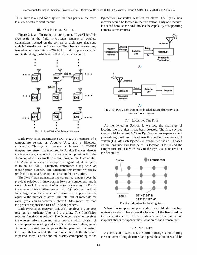
Each PyroVision transmitter (TX), Fig. 3(a), consists of a
temperature sensor, an Arduino Uno, and a Bluetooth
transmitter. The system operates as follows. A TMP37
temperature sensor, manufactured by Analog Devices, detects
the temperature, converts it to a voltage, and provides it to the
Arduino, which is a small, low-cost, programmable computer.
The Arduino converts the voltage to a digital output and gives
it to an nRF24L01 Bluetooth transmitter along with an
identification number. The Bluetooth transmitter wirelessly
sends the data to a Bluetooth receiver in the fire station.
The PyroVision transmitter has several advantages over the
previous solutions. It incorporates low-cost components and is
easy to install. In an area of n2 acres (an n x n array) in Fig. 2,
the number of transmitters needed is (n+1)2. We then find that
for a large area, the number of transmitters is approximately
equal to the number of acres. The total bill of materials for
each PyroVision transmitter is about US$16, much less than
the present suppression cost of US$200 per acre.
Each PyroVision receiver, Fig. 3(b), employs a Bluetooth
receiver, an Arduino Uno, and a display. The PyroVision
receiver functions as follows. The Bluetooth receiver receives
the wireless information and sends the data, which consists of
the temperature reading and the ID of the transmitter, to an
Arduino. The Arduino compares the temperature to a custom
threshold that represents the fire temperature. If the threshold
is passed, there is a fire and the display corresponding to the
PyroVision transmitter registers an alarm. The PyroVision
receiver would be located in the fire station. Only one receiver
is needed because the Arduino has the capability of supporting
numerous transmitters.
Fig 3: (a) PyroVision transmitter block diagram, (b) PyroVision
receiver block diagram.
IV. LOCATING THE FIRE
As mentioned in Section 1, we face the challenge of
locating the fire after it has been detected. The first obvious
idea would be to use GPS in PyroVision, an expensive and
power-hungry solution. To address this problem, we use a grid
system (Fig. 4): each PyroVision transmitter has an ID based
on the longitude and latitude of its location. The ID and the
temperature are sent wirelessly to the PyroVision receiver in
the fire station.
Fig. 4: Grid system for locating fires.
When the temperature passes the threshold, the receiver
registers an alarm that shows the location of the fire based on
the transmitter’s ID. The fire station would have an online
map that shows the approximate location of each transmitter.
V. SCALABILITY
As discussed in Section 1, the third challenge is transmitting
the data over a long distance. One possible solution would be
International Journal of Chemical, Environmental & Biological Sciences (IJCEBS) Volume 4, Issue 1 (2016) ISSN 2320–4087 (Online)
54

to use cellphone technology, but it is even more expensive and
power-hungry than GPS. Bluetooth is a feasible solution that
we employ but we are faced with the problem that Bluetooth
cannot transmit information across a distance of over 140 feet
(≈ 43 meters) with trees present (Section 6). To solve this
issue, two measures are taken. The first is data hopping, which
works as follows: TX1 in Fig. 2, for example, sends its data to
TX2. TX2 packages the data with its own and sends it to TX3,
and so on, until the result reaches the fire station.
In order for data hopping to successfully operate in Figure
2, the transmission range of the Bluetooth transmitters needs
to be about 210 feet (≈ 64 m), which is quite larger than the
140-foot limitation. This limitation is caused by the poor
transmission range of the nRF24L01 antenna [Figure 5(a)].
We addressed this shortcoming by replacing the Bluetooth
receiver antenna with a dipole structure [9] [Figure 5(b)].
Fig. 5: (a) nRF24L01 antenna, (b) dipole antenna diagram, λ/2 ≈ 6.5
cm
The second measure is about the battery. The batteries in
the field, if they stayed on all the time, would drain in about 1-
2 days. To address this drawback, we turn each transmitter on
for 0.1 second every few minutes. This enables a D battery to
last several years. There is a delicate balance between the time
the transmitter stays on and the time it stays off. If the
PyroVision transmitter stays off for too long, the fire has the
chance to spread over many acres before it is registered. On
the other hand, if the transmitters stayed on for a minute, and
off for the next, the battery would drain quickly.
Fig. 6: PyroVision transmitter prototype
VI. TEST RESULTS
Our demo system consists of four transmitters, to simulate
the four corners of an acre, and one receiver to simulate the
fire station. The receiver constantly monitors the temperature
readings sent by the transmitters. One PyroVision transmitter
is shown in Fig. 6. The most important aspect of PyroVision is
the transmission range, which needs to be at least 208 feet in
our design. We tested the transmission distance between the
transmitters and the receiver in two different areas in a park,
one area with trees and one clear. The data for the
transmission range is shown in Fig. 7. Our first measurements
were with the original nRF24L01 antenna, resulting in a
transmission distance of 150 feet in an area with trees. We
then modified the receiver’s antenna to a dipole. As seen in
Fig. 7, the transmission distance increased to 170- 250 feet (≈
51-76 m) in the same area. Finally, in a clear area with the
dipole antenna, the range was about 290-400 feet (≈ 88-122
m).
In order to expand the range even further, we can also
modify the transmitters’ antennas and change them into
dipoles. In the environments where the Bluetooth transmitters
do not have enough range, the user can place the PyroVision
transmitters in Fig. 2 more closely.
Fig. 7: Transmission range test data
International Journal of Chemical, Environmental & Biological Sciences (IJCEBS) Volume 4, Issue 1 (2016) ISSN 2320–4087 (Online)
55

VII. CONCLUSION
Forest fires are a major threat to humans and the environment. We have proposed a wireless solution to
counteract wildfires that detects the fire, locates it, and
transmits the information over a long distance. This low-cost
system can be scaled to cover a large area. In our testing, we
found that the transmission range in an area with trees reaches
170-250 feet while the range in a clear area reaches 290-400
feet, which suffice for our design. We have also proposed a
grid system as well as data hopping for scalability.
REFERENCES
[1] http://wildland-fires.findthedata.com
[2] L. Hughes, Be Prepared: Climate Change and the South Australia
Bushfire Threat, Climate Council of Australia Report, 2014.
[3] Indonesia Economic Quarterly, Reforming amid Uncertainty, World
Bank Report, Dec. 2015.
[4] N. Khabarov et al, “Forest fires and adaptation options in Europe,”
Regional Environmental Change, pp. 21-30, vol. 16, 2014.
[5] European Commission, Forest Fires in Europe, Middle East, and North
Africa 2014, Joint Research Centre Report, European Commission,
2015.
[6] http://vigilys.com/technology/firealert/
[7] http://wildlandsystems.com
[8] G. Mazzeo et al, “Assessment of a Robust Satellite Technique for forest
fire detection and monitoring by using a Total Validation Approach,”
33rd International Symposium on Remote Sensing of Environment, pp
607-610, 2009.
[9] G.J. Roberts, M.J. Wooster, “Fire Detection and Fire Characterization
Over Africa Using Meteosat SEVIRI,” IEEE Transactions on
Geoscience and Remote Sensing, 46, 4, 2007 pp 1200-1218.
[10] http://forum.43oh.com/topic/3864-nrf24l01-increasing-distance/
International Journal of Chemical, Environmental & Biological Sciences (IJCEBS) Volume 4, Issue 1 (2016) ISSN 2320–4087 (Online)
56