a publication of friends of sleeping bear dunes
TRANSCRIPT
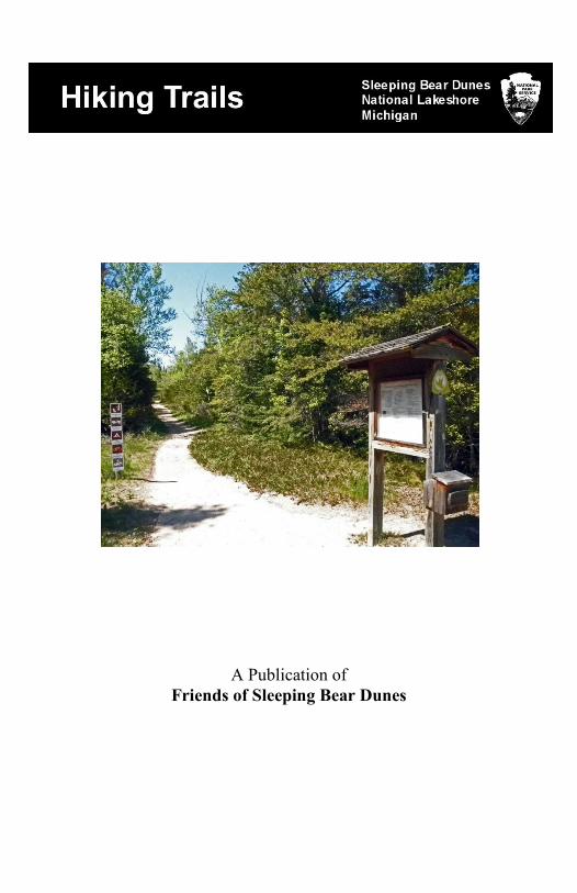
A Publication of
Friends of Sleeping Bear Dunes

2
© 2018, Friends of Sleeping Bear Dunes, P.O. Box 545, Empire, MI 49630 www.friendsofsleepingbear.org [email protected] Learn more about the Friends of Sleeping Bear Dunes, our mission, projects, and accomplishments on our web site. Support our efforts to keep Sleeping Bear Dunes National Lakeshore a wonderful natural and historic place by becoming a member or volunteering for a project that can put your skills to work in the park. This booklet was compiled by Kerry Kelly, Friends of Sleeping Bear Dunes. Maps are from Sleeping Bear Dunes National Lakeshore and Friends of Sleeping Bear Dunes. Photos by Kerry Kelly

3
Sleeping Bear Dunes National Lakeshore maintains about 85 miles of official
hiking trails on the mainland, about 12 miles of trails on South Manitou Island
and over 20 miles of trails on North Manitou Island. In addition, there are many
unofficial social trails within the National Lakeshore. This book describes the 14
official trails on the mainland and the trails on the two islands.
Each trail on the mainland has its own trailhead and parking area which can be
located on the map of the Lakeshore on page 5. Each trail has its own unique
beauty and challenges. Some have beautiful views from high vistas overlooking
lakes, hills, or dunes. Others take you through fields of wildflowers with views
of lakes or forest in the background. Our trails allow you to explore all of the
various habitats within the National Lakeshore. Use the table on page 4 to
compare the trails and choose the trail that’s right for you today. Each trail is
described on a page which includes a brief description of the trail, how to find
the trailhead, and a trail map.
Trail Rules
Get a Park Pass. Either an annual or weekly pass to Sleeping Bear
Dunes National Lakeshore or National Parks Pass is required for using
the trails. Passes are available at the Visitor Center, Dune Climb, Pierce
Stocking Scenic Drive, Glen Haven General Store, and campground
offices. There are also self-serve locations at some beaches.
Plan ahead. Prepare for extreme weather and emergencies. Bring food
and water. Always tell someone where you will be hiking and when
you will return.
Stay on established trails.
Dispose of waste properly. Pack it in – Pack it out!
Leave what you find. Preserve the past and leave rocks, plants, and
other items as you find them for others to discover.
If camping in the backcountry, build fires only in established fire rings.
Put out fires completely.
Respect wildlife. Observe wildlife from a distance. Never feed animals.
Store food properly.
Respect other visitors and protect the quality of their experience. Let
nature’s sounds prevail.
Pet Rules
Pets are allowed on all trails except at the Dune Climb. Pets are also not
allowed on ski trails (#1, 2, 4, 5, 10, 11, 13, 16) Dec 1 – March 31.
Pets must be on a 6’ leash.
Do not leave pets unattended or tied to an object.
Do not allow your pet to make unreasonable noise.
Clean-up after your pet and dispose of waste in a trash receptacle.
Keep your pet from interacting with wildlife.

4
# Name Distance Difficulty Features 1 Old Indian 2.5 mi
2 loops
One Easy
Loop, One
Moderate
Woods, access to
Lake MI
2 Platte Plains
Bass Lake Loop
3.5 mi loop Easy Woods, Bass Lake
2 Platte Plains
Otter Creek Loop
4.6 mi loop Easy Woods, Otter Creek,
Otter Lake
2 Platte Plains
Lasso Loop
6.3 mi loop Moderate Woods, access to
Lake MI
3 Empire Bluff 1.5 mi round
trip out & back
Moderate Woods, vista of
Lake MI
4 Windy Moraine 1.5 mi loop Moderate to
Advanced
Woods, vista of
Glen Lake
5a Shauger Hill 2.4 mi loop Moderate to
Advanced
Woods
5b Scenic Drive Ski Trail 8 mi – several
loops
Easy to
Moderate
Ski only on the
Scenic Drive Road
6 Cottonwood 1.5 mi loop Moderate Dunes, vista of Glen
LK, Lake MI
7 Dunes 3.5 mi round
trip to Lake MI
and back
Strenuous Dunes, vista of Glen
Lake, Lake MI
8 Duneside Accessible 0.9 mi round
trip along dune
Wheelchair
Accessible
Quiet, interpretive
signs
9 Sleeping Bear Pt 2.8 mi loop Strenuous Dunes, vista of Lake
MI
10 Alligator Hill Loop 1 – 3 mi
Loop 2 – 4.6 mi
Loop 3 – 4.7 mi
Moderate Woods, vista of
Lake MI and vista
of Glen Lake
11 Bay View 2 Loops
Farm – 2.4 mi
Ridge– 4 mi
Easy to
Moderate
Woods, meadows
12 Pyramid Point Overlook &
back – 1.2 mi
Loop – 2.7 mi
Moderate Woods, vista of
Lake MI, Manitou
Islands
13 Good Harbor Bay 2.8 mi loop Easy Woods, wetlands
14 South Manitou Island Various loops Easy Woods, fields
15 North Manitou Island Various loops Easy, but
long loops
Woods
16 Sleeping Bear
Heritage Trail (SBHT)
22 mi one way
From Empire to
Bohemian Rd
(CR-669)
Hard Surface
–Easy except
from Empire
to Greenan
Rd. which is
moderate.
Woods, dunes.
Steep hills from
Empire to Greenan
Road.
On-road through
Glen Arbor.

5
Want a Challenge?
For hikers who want a challenge, a new program has been developed by two
students at Glen Lake Schools that gives prizes and recognition to those who
hike all 14 mainland trails in one year. The Trail Trekker Challenge provides a
record book, so you can keep track of your hikes. Pick it up at the Sleeping Bear
Dunes National Lakeshore Visitor Center in Empire. When you have hiked all
of the trails, bring your completed record book back to the Visitor Center to
receive your prize and get your name on the Park web site!
For extra credit, visit North and South Manitou Island and hike the trails there to
be able to say that you’ve hiked all the official trails at Sleeping Bear Dunes.

6
#1 Old Indian Hiking and Ski Trail
Location: On M-22 north of Sutter Rd. in the southern part of the park
Distance: 2 loops of 2.3 miles each
Terrain: Relatively flat hardwoods and evergreen forest with a spur through
low dunes to Lake Michigan. The Black Arrow Loop has some areas of steeper
hills and sharp corners.
Difficulty: Soft-surface foot path. Green Arrow Loop is easy hiking and skiing.
Black Arrow Loop is moderate hiking and advanced skiing.
Comments: The spur to Lake Michigan provides access to a remote beach,
where you can often have the whole beach to yourself. Because of its relatively
easy terrain, it is popular with cross country skiers.

7
#2 Platte Plains Hiking and Ski Trail
Location: There are several trailheads for this large trail system: on the gravel
road near the end of Esch Road, the end of Trail’s End Road, and Platte River
Campground. In the winter, a trailhead on M-22 for skiers is open.
Distance: Three loops:
Otter Creek Loop – 4.6 miles around Otter Creek and Otter Lake
Bass Lake Loop – 3.5 miles near Bass and Deer Lakes
Lasso Loop – 6.3 miles with several access points to Lake Michigan
Terrain: Mostly flat, with some moderate hills in a few areas of the Lasso Loop
Difficulty: Soft-surface foot path. Easy hiking and skiing.
Comments: The relatively flat terrain and proximity to lakes and streams makes
this one of the most popular hikes for nature-lovers. Wildflowers and birds are
plentiful and the walking is relatively easy. Most of this trail is good for
beginners, but the 16-17 section is intermediate – not suitable for beginners.

8
#3 Empire Bluff Hiking Trail
Location: The trailhead is located on Wilco Rd. off of M-22 south of Empire.
Distance: 1.5 miles round trip from the trailhead to the overlook deck.
Terrain: Moderate hike with some hills through beech-maple forest to an
observation deck on Empire Bluffs about 450 feet above Lake Michigan.
Difficulty: Soft-surface foot path. Moderate hiking. Some steep slopes & steps.
Comments: This is one of the most
popular trails in the Park because of
the outstanding vistas of Lake
Michigan, South Bar Lake, Empire,
and Sleeping Bear Dunes. You will
find many spring flowers on this
trail. Photographs of the view from
the end of this trail are often used
when describing Sleeping Bear
Dunes National Lakeshore. If you
only have time for one hike, this
might be the one for you!

9
#4 Windy Moraine Hiking and Ski Trail
Location: The trailhead is on Welch Rd. just east of M-109 near the entrance to
Pierce Stocking Scenic Drive.
Distance: 1.5 mile loop
Terrain: The loop takes you through farm fields and after entering the woods, it
goes up a gradual hill until you get a great view of Glen Lake (best in the winter
when the leaves don’t block the view). Then it’s a relatively steep downhill
walk, which can be challenging if you’re on skis.
Difficulty: Soft-surface foot path. Moderate hiking and advanced skiing.
Comments: This trail is built on moraine – the remnant of the last glacier which
deposited rocks, gravel, and sand to form this hill. This is a quiet trail with a
nice view of Glen Lake. An interpretive display about soils is along the trail.

10
#5a Shauger Hill Hiking and Ski Trail
Location: The trailhead is in the parking lot at the entrance to Pierce Stocking
Scenic Drive on M-109.
Distance: 2.4 mile loop
Terrain: This loop is through beech-maple forest over steep hills crossing
Pierce Stocking Scenic Drive in two places. Watch for traffic at crossings.
Difficulty: Soft-surface foot path. Moderate hiking and advanced skiing.
Comments: You’ll get a good workout on this trail, and if you’re a cross
country skier or like to snowshoe, this is an advanced trail.

11
#5b Scenic Drive Ski Trail – Winter Skiing Only
Location: Pierce Stocking Scenic Drive on M-109. Park in the parking lot at the
entrance to the Scenic Drive.
Distance: Loops totaling 8 miles of trail. The trail intersects with Shauger Hill
Trail with an additional 2.4 miles of trail.
Terrain: Skiers will be on or alongside the pavement of the Scenic Drive
through rolling hills. There are some long uphill grades and gentle downhills.
Difficulty: Easy to Difficult skiing.
Comments: Because the trail is on the paved roadway, it is very open with few
obstacles making it easier for beginners. Some of the uphill sections can be very
challenging. Seeing the overlooks in winter is spectacular.

12
#6 Cottonwood Hiking Trail
Location: Stop #4 on the Pierce Stocking Scenic Drive on M-109.
Distance: 1.5 mile loop
Terrain: The trail goes through sandy soil of the perched dunes, which makes
walking difficult. There is no shade, so wear sun block and bring water.
Difficulty: Sandy trail. Moderately difficult hiking.
Comments: This hike takes you through the native plants of the Sleeping Bear
Dunes. You will find a variety of hardy wildflowers, grasses and shrubs. It
offers great views of the dunes, Dune Climb, Glen Lake, and Lake Michigan.
#7 Dunes Hiking Trail
Location: The Dune Climb on M-109.
Distance: 3.5 miles round trip from the Dune Climb to Lake Michigan.
Terrain: The trail goes through sandy soil of the perched dunes, which makes
walking difficult. There is no shade, so wear sun block and bring water.
Difficulty: Sandy trail. Strenuous hiking.
Comments: This hike takes you through the native plants of the Sleeping Bear
Dunes to Lake Michigan. As you hike this trail, you will find that it takes a lot
longer to arrive at Lake Michigan than you expect. Wearing shoes, hat, and sun
block is highly recommended. The sand in
the summer sun is very hot on the feet and
some of the plants that live in the dunes
have sharp thorns or stems that can hurt
your feet. When you arrive at Lake
Michigan, you will find a large wooden
shipwreck about ¼ mile north of where the
trail comes out. This washed up on the
shore in October, 2010. Another shipwreck
is located about ¼ mile south.
#8 Duneside Accessible Trail
This trail has been replaced by #16 Sleeping Bear Heritage Trail.
Location: The trailhead is on the north side of the parking lot at the Dune Climb
on M-109.
Distance: 2 miles to Glen Haven and 2 miles further to Glen Arbor.
Terrain: The trail is flat, paved asphalt and goes along the front edge of the
dune through the woods to a wetland observation deck and on to Glen Haven.
Difficulty: Easy, wheelchair accessible.
13
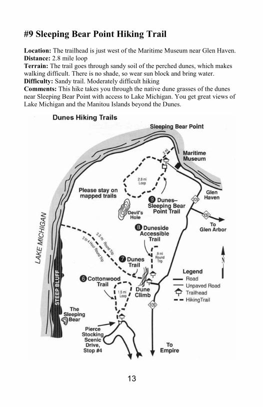
#9 Sleeping Bear Point Hiking Trail
Location: The trailhead is just west of the Maritime Museum near Glen Haven.
Distance: 2.8 mile loop
Terrain: The trail goes through sandy soil of the perched dunes, which makes
walking difficult. There is no shade, so wear sun block and bring water.
Difficulty: Sandy trail. Moderately difficult hiking
Comments: This hike takes you through the native dune grasses of the dunes
near Sleeping Bear Point with access to Lake Michigan. You get great views of
Lake Michigan and the Manitou Islands beyond the Dunes.

14
#10 Alligator Hill Hiking and Ski Trail
Location: The trailhead is east of the DH Day Campground off Stocking Road.
Distance: 8 miles total in 3 loops. Each loop is 3-4.6 miles long.
Terrain: Long gradual hills through beech-maple forest.
Difficulty: Soft-surface foot path. Moderately difficult hiking and skiing.
Comments: There is a bench with a great view of the Manitou Islands at the top
of Alligator Hill. You can often watch
Great Lakes freighters travel through
the Manitou Passage from here. A 1.6
mile spur along the ridge takes you to
a view of Glen Lake. This was once a
golf course – part of a planned resort.
Can you see the fairways or greens?
Alligator Hill was hit hard by a severe
windstorm in August of 2015.

15
#11 Bay View Hiking and Ski Trail
Location: The trailhead is on Thoreson Road near M-22.
Distance: 7.5 miles total in 2 loops. Farm Loop: 2.4 mi, Ridge Loop: 4 mi.
Terrain: Meadows, fields, edge of Beech-Maple forest, Farms of Port Oneida
Rural Historic District. Mostly flat along meadows and fields and along the
ridge. Steep hills on trail connectors between upper and lower segments.
Difficulty: Soft-surface foot path. Easy to Moderately difficult.
Comments: There is a bench with a great view of the Manitou Islands on the
Ridge trail. Nice views of Lake Michigan and Sleeping Bear Point at #5. Good
trail to see striped maple (moosewood) trees.

16
#12 Pyramid Point Hiking Trail
Location: The trailhead is on Basch Rd. Take Port Oneida Rd north from M-22.
Distance: 1.2 miles round trip from the trailhead to the overlook. The whole
loop trail is 2.7 miles and the last part of the loop is on Basch Rd.
Terrain: You will be climbing a steep hill through Beech-Maple forest to the
bluff that overlooks Lake Michigan
and the Manitou Islands. The loop
goes down from the hill into a deep
valley and back up to Basch Rd.
Difficulty: Soft-surface foot path;
some water bar steps. Moderate hiking
Comments: For your safety and to
prevent erosion, please do not descend
the bluff to Lake Michigan.

17
#13 Good Harbor Hiking and Ski Trail
Location: The trailhead is on Lake Michigan Road. Take County Road 669
north from M-22 toward Lake Michigan and turn east (right) on Lake MI Rd.
Distance: 2.8 mile loop
Terrain: Flat loop through woods and wetlands.
Difficulty: Soft-surface foot path. Easy hiking and skiing. Some areas in
wetlands have narrow boardwalks.
Comments: This is a good trail for beginner skiers.

18
#14 South Manitou Island Trails
Location: Take the passenger ferry from the Fishtown dock in Leland. Make
reservations with the Manitou Transit. www.manitoutransit.com 231-256-9061
Distance: About 10 miles of trails.
Terrain: Mostly flat trails along old county roads.
Difficulty: Soft-surface foot path, easy hiking. Boarding the ferry may require
extra planning for those in a wheelchair.
Comments: A trip to South Manitou Island will be the highlight of your visit to
Sleeping Bear Dunes National Lakeshore. You can visit the village, climb the
lighthouse, and get up close to a shipwreck. Day trips are available in the
summer and camping overnight in designated backcountry campgrounds is
available for multiple day trips.

19
#15 North Manitou Island Trails
Location: Take the passenger ferry from the Fishtown dock in Leland. Make
reservations with the Manitou Transit. www.manitoutransit.com 231-256-9061
Distance: About 20 miles of trails
Terrain: Mostly flat trails along old county roads.
Difficulty: Soft-surface foot path, easy hiking. Boarding the ferry may require
extra planning for those in a wheelchair.
Comments: North Manitou Island is managed as wilderness. Backcountry
camping for several days is required since the ferry does not stay at the island
and does not run every day. This is a wonderful place to experience wilderness.

20
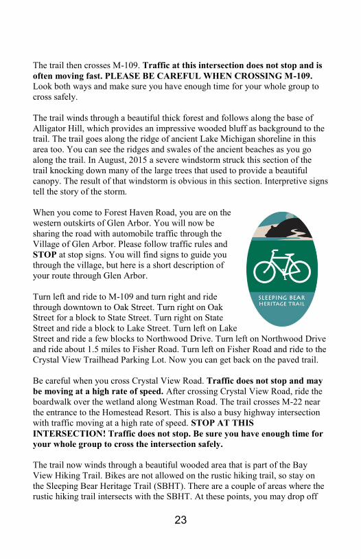
#16 Sleeping Bear Heritage Trail (SBHT) This trail is a hard-surface, multi-
use trail, which runs about 22 miles
from Empire through Glen Haven
and Glen Arbor to Bohemian Road.
It is perfect for walking, biking, and
cross-country skiing. The trail
section from Empire to Glen Arbor
is groomed for skiing in the winter.
The trail is generally asphalt, but in
some areas you will find boardwalk
over wetland areas and in the Port
Oneida Rural Historic District, it is packed, crushed stone. Most of the trail is
accessible and suitable for wheelchair use. Eventually, the trail will be extend to
CR-651 on the north and from Empire to Manning Road on the south.
Download a detailed Interactive Map of the SBHT - go to the trail web site
www.SBHTmap.org.
Details for SBHT – Empire through Glen Arbor to Bohemian Road
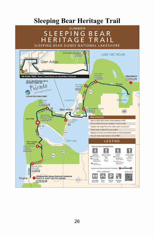
Location: You can get on the trail at several points:
Bar Lake Road Trailhead at the corner of Voice and Bar Lake Roads –
just north of the Village of Empire
Pierce Stocking Scenic Drive – Lower Parking Lot
Dune Climb parking lot – The main Sleeping Bear Heritage Trailhead
is located on the north side of the parking lot
Glen Haven Village
DH Day Campground
Forest Haven Road in Glen Arbor
Glen Arbor – street parking
Glen Arbor – Crystal River Trailhead/Put-In Parking Lot
Bay View Trailhead on Thoreson Road
Port Oneida Road – Kelderhouse Parking Area
Bohemian Road – CR-669 at the beach parking lot
Distance: 22 miles one-way from Empire through Glen Arbor to Bohemian
Road (CR-669) in the Port Oneida Rural Historic District.
Terrain: The trail goes through wooded areas and a short area through dunes
between Glen Haven and the Dune Climb. The trail also goes through Glen
Arbor on streets. There are two sections of boardwalk north of Glen Arbor and
areas where the trail goes along the edge of historic farm fields.

21
Difficulty: The section between Empire and Greenan Rd and has several steep
slopes and hills and may be challenging. The paved asphalt trail is gentle and
rolling with only a few moderate grades between Greenan Rd and Glen Arbor.
The section through Glen Arbor is on streets, so be careful of traffic and
pedestrians. From the Crystal View Trailhead to Bohemian Rd is generally flat
and gently rolling hills. There are a few moderate hills in this section but
nothing challenging. This section has a boardwalk over wetlands near Westman
Road and along the edge of Narada Lake. Most of this section is asphalt, but
once the trail enters the Port Oneida Rural Historic District, the trail surface
changes to packed crushed stone. A few hills in this area can have erosion
problems which can cause small wash-outs and loose stones. BE CAREFUL.
Comments: There is a new trailhead parking lot and vault toilet located near the
corner of Voice Road and Bar Lake Road just north of Empire. A spur trail leads
south from the parking lot to Lacore Road, which goes south into the village of
Empire. Heading north from the parking lot, you will enter deciduous forest and
some challenging hills as you climb toward the Pierce Stocking Scenic Drive.
While there is a bike lane on the Scenic Drive, we do not recommend riding here
because the Scenic Drive is winding and has some very steep slopes. It also has
a lot of automobile traffic during the summer. There is a spur trail that leads to
the lower parking lot at the Scenic Drive, where there is a vault toilet.
Heading north from Pierce Stocking Scenic Drive, the trail goes down a steep,
long hill to Greenan Road (We call it “The Bear”. You’ll understand when you
ride your bike back up!). Be prepared to use your brakes going down this hill
because there is a STOP sign at the bottom! And remember this hill for your
return trip, because it is quite a challenge riding south! Save your energy. There
are several resting areas on the side of the trail where you can catch your breath.
The trail from Greenan Road to the Dune
Climb follows M-109 closely and is
generally easy with just a few rolling hills.
There are several driveways on this
section, so be on the lookout for vehicles
in the driveways. When you arrive at the
Dune Climb, you can find modern
restrooms at the southern end of the
parking lot near the Dune Center. Picnic
tables are located at the foot of the Dune Climb and benches are located at the
main SBHT Trailhead near the northern end of the parking lot. Browse the
donor recognition panels and see who has contributed to building this fabulous
trail. If you have the energy, take off your shoes and climb the dunes for an
awesome view of Glen Lake!

22
Riding north from the Dune Climb takes you into deciduous forest for a couple
of miles on relatively flat terrain. When you see the trail straighten out, you will
be riding on the roadbed of the historic narrow gauge railroad that carried
lumber from the DH Day sawmill on
Glen Lake to the dock in Glen Haven.
You will also see some open dunes in
this stretch of trail.
The trail enters the village of Glen
Haven and crosses Main Street at the
Sleeping Bear Inn, General Store, and
modern restrooms.
This road is heavily used in the summer, so beware of cross traffic that does
not stop!
Glen Haven is a historic logging
village and is home to a working
blacksmith shop, General Store, and
Cannery Boat Museum. Just down the
road to the west about half mile is the
old US Coast Guard Station, which is
now the Maritime Museum. Glen
Haven beach access is next to the
Cannery. This is a perfect place to stop
on your journey, learn a little history,
and get your feet wet in Lake Michigan!
The trail continues from Glen Haven about ¼ mile to the DH Day Campground.
As you ride through the campground be aware of pedestrians and campground
traffic! Especially in the summer, campers are walking the campground loops,
going to the beach, restrooms, or interpretive programs in the campground. As
you ride through the campground, look to
your left and you will see the DH Day
Log Cabin. This is a historic landmark
from when the campground was the first
State Park in Michigan. DH Day was the
first Michigan State Park Commissioner,
and he donated the land and built the
cabin for use in the park. As you leave the
campground, the trail turns right onto DH
Day Main Road, a seasonal county road,
which has very little traffic, but cars are
allowed on this part of the trail.
23
The trail then crosses M-109. Traffic at this intersection does not stop and is
often moving fast. PLEASE BE CAREFUL WHEN CROSSING M-109.
Look both ways and make sure you have enough time for your whole group to
cross safely.
The trail winds through a beautiful thick forest and follows along the base of
Alligator Hill, which provides an impressive wooded bluff as background to the
trail. The trail goes along the ridge of ancient Lake Michigan shoreline in this
area too. You can see the ridges and swales of the ancient beaches as you go
along the trail. In August, 2015 a severe windstorm struck this section of the
trail knocking down many of the large trees that used to provide a beautiful
canopy. The result of that windstorm is obvious in this section. Interpretive signs
tell the story of the storm.
When you come to Forest Haven Road, you are on the
western outskirts of Glen Arbor. You will now be
sharing the road with automobile traffic through the
Village of Glen Arbor. Please follow traffic rules and
STOP at stop signs. You will find signs to guide you
through the village, but here is a short description of
your route through Glen Arbor.
Turn left and ride to M-109 and turn right and ride
through downtown to Oak Street. Turn right on Oak
Street for a block to State Street. Turn right on State
Street and ride a block to Lake Street. Turn left on Lake
Street and ride a few blocks to Northwood Drive. Turn left on Northwood Drive
and ride about 1.5 miles to Fisher Road. Turn left on Fisher Road and ride to the
Crystal View Trailhead Parking Lot. Now you can get back on the paved trail.
Be careful when you cross Crystal View Road. Traffic does not stop and may
be moving at a high rate of speed. After crossing Crystal View Road, ride the
boardwalk over the wetland along Westman Road. The trail crosses M-22 near
the entrance to the Homestead Resort. This is also a busy highway intersection
with traffic moving at a high rate of speed. STOP AT THIS
INTERSECTION! Traffic does not stop. Be sure you have enough time for
your whole group to cross the intersection safely.
The trail now winds through a beautiful wooded area that is part of the Bay
View Hiking Trail. Bikes are not allowed on the rustic hiking trail, so stay on
the Sleeping Bear Heritage Trail (SBHT). There are a couple of areas where the
rustic hiking trail intersects with the SBHT. At these points, you may drop off

24
your bike and walk up the hiking trail for
a view of Sleeping Bear Bay, South
Manitou Island, and Sleeping Bear Point.
About a mile after crossing M-22, the trail
surface turns from asphalt to packed
crushed stone. The trail is now entering
the Port Oneida Rural Historic District.
Because of the historic nature of this
district, asphalt surface was not
appropriate to the historic viewscape. Be careful when the surface changes. The
crushed stone can be loose in spots and riders must exercise more caution to
avoid slipping.
A spur in the trail goes to the Bay View Trailhead Parking Lot on Thoreson
Road. Going along the trail north of Thoreson Road, you will ride along historic
farm fields at the edge of the forest. Imagine watching the farmers working his
fields with a team of horses or an old tractor. The trail will approach the Charles
Olsen Farm, which is the headquarters of Preserve Historic Sleeping Bear, a
non-profit organization dedicated to restoring historic structures and landscapes
in Sleeping Bear Dunes National Lakeshore. They have an exhibit of the Port
Oneida Rural Historic District in the house. Stop by, take a break, and visit with
their knowledgeable volunteers as you browse through their exhibit.
The trail continues about ½ mile to Port Oneida Road and the Kelderhouse
Farm. There is a parking lot, vault toilet, and picnic tables at this stop. Take time
to explore the Port Oneida School across the road and the Kelderhouse
Cemetery.
The trail continues near M-22 but winding through the edge of the forest. It
crosses in front of the historic Lawr Farm and then crosses Basch Rd. About half
mile further and the trail comes to an old log cabin and a boardwalk that crosses
over the edge of Narada Lake. The boardwalk offers a great place to observe
wildlife: beaver, otter, and a wide variety of birds. The old log cabin is the North
Unity School. It was a one-room school built about 1878 to educate the children
of the bohemian farm families that settled in this area.
The trail surface changes back to asphalt just past Narada Lake and continues
along M-22 until reaching Bohemian Road (CR-669). The trail ends at that point
but bikers can ride about 0.75 miles north to the Lake Michigan beach at Good
Harbor, where there is a drinking fountain, vault toilet and picnic tables.

25
Skiing and Snowshoeing
The trail is groomed for cross-country
skiing from Empire to Glen Arbor
during the winter. During this time of
year, from December through March,
pets are not allowed on the trail.
Snowshoers, please stay in the middle
of the trail to avoid the classic ski
tracks. Contact us to be on our e-mail
ski report, which will let you know
when the trail is freshly groomed.
See the Sleeping Bear Heritage Trail map on the next 2 pages.
26
Sleeping Bear Heritage Trail

27