a working landscape - wur
TRANSCRIPT

1
ECLAS 2010 ISTANBUL
A WORKING LANDSCAPE
FOR NEW ORLEANS:
‘WATER AS AN AMENITY’
AS STRATEGY FOR A
DELTA CITY THAT
SUFFERS FROM
STORMWATER
FLOODING
Peter Hermens
Jaap van der Salm
Chris van der Zwet
Rudi van Etteger
Ingrid Duchhart
Wageningen University (The Netherlands)
Keywords: Working landscape, New Orleans, deltas, landscape architecture, water management, storm water
flooding, water storage, water retention
Abstract
This paper studies how strategies aiming at working landscapes can simultaneously improve stormwater resiliency and
spatial quality in two suburban neighbourhoods in New Orleans that were hard hit by hurricane Katrina in 2005. A
spatial strategy mitigates stormwater flooding problems during a 1/10-year storm event and explores the potential of
water as an amenity in the city.
The paper identifies the need for a new approach by quantifying problems concerning (1) hydrology, (2) vegetation and
(3) vacancy. Based on topography, subsidence rate, problems with rain flooding and the original appearance of the
landscape, 4 landscape zones are distinguished that provide basic concepts for interventions on all scale levels,
addressing the 3 problems stated above. A new water plan for the area based on retain-store-discharge principles and
a robust network of native vegetation form a new landscape framework. By utilising the empty space(s) due to vacancy
following the hurricane to serve as water storage, this problem turns into an opportunity to re-create attractive
residential areas with high quality of life.
The results of this study illustrate how preparation for the future and a changing climate poses challenges, but also
offers opportunities for the creation of attractive delta cities.
Introduction
Deltas are highly dynamic landscapes, and subject to constant change. As a result, human intervention and innovation
has always been necessary to safely live and work in deltas. The location of an urban region in a delta brings
prosperity and economic wealth, but at the same time there are disadvantages and challenges to overcome. Being
low-lying areas, deltas are prone to flooding by the rivers that form them, large volumes of rainfall - typical of coastal
climates -, and storm surges from the adjoining seas. The rapid urbanization of the world’s deltas puts natural
resources at risk and amplifies possible consequence, both economical and psychological, in case of disaster
(McGranahan et al., 2007). The recent concerns about climate change and socio-economic trends of progressing
urbanisation and continuing investment make life in the urban delta even more complex, and a sustainable strategy for
dealing with water in urban deltas all the more relevant.
New Orleans, located at the mouth of the Mississippi river is a typical urban delta city. Like many delta cities around
the world, historically the city has a two-fold relationship with water as both resource and threat. Since Hurricane
Katrina devastated the city in 2005 the Dutch Dialogue workshops – initiated by local architect David Waggonner and
the Royal Dutch Embassy - US and Dutch professionals have engaged in a knowledge exchange aiming for new
harmony in the landscape, equally inspired by Dutch water cities and love for ‘the big easy’. Continuing on Dutch
Dialogues II (please refer to Meyer et al., 2008) and providing input for Dutch Dialogues III (April 2010), this paper

2
explores how a transformation of the New Orleans’ storm water system can increase stormwater resiliency, provide a
climate-adapted future, and at the same time contribute to the revival of the city.
Today’s State Of Affairs In New Orleans
It has now been well over 4 years since Katrina struck the South Louisiana coastline near New Orleans, flooding 80%
of the city up to 3m (Campanella, 2008), and forcing virtually all citizens to evacuate. Since 2005, 15 billion dollar has
been invested in a hurricane risk reduction system on the perimeter of the city, built by the U.S. Army Corps of
Engineers. Once completed in 2011 it will provide protection against 1/100-year storm events, and is designed to
withstand a 1/500 year storm event without catastrophic failure (USACE, 2008); a better than ever before safety from
hurricane threats. These considerable investments however, do little to improve the day-to-day quality of the living
environment for the residents of New Orleans, which varies greatly related to topography. Behind the dikes a two faced
city can now be observed: The historical parts of the city, located on higher grounds, again do well. Flood elevation lev-
els were low here and population reaches close to pre-Katrina levels. Again the same lively, festive and easy-going
atmosphere is buzzing through the streets. These neighbourhoods provide the lush greenery, rich experiences,
colonial architecture and bustling nightlife; all that New Orleans is famous for. However elsewhere large parts of the
city are by all means still severely damaged and lack landscape quality. It is in the low-lying suburbs, the former back
swamp of New Orleans, that the city’s problems concentrate, the lack of landscape quality is most manifest and
interventions are most needed. The Gentilly and Lakeview neighbourhoods are typical examples of such low-lying
areas and form the focus area of this study (see fig. 1).
Figure 1. Perforated urban fabric and topography of New Orleans with outlined study area Gentilly Lakeview
3
Being landscape architects we have tried to tackle four main problems in these areas, which together determine this
landscape quality: rainflood events (1), subsidence (2), the permanent consequence of vegetation loss (3), vacancy,
and its resulting changes in atmosphere of the neighbourhoods (4). In New Orleans extreme precipitation events - with interior floods as a consequence - have occurred frequently in the
past decades (Faiers et al., 1997; NASA Earth Observatory, 2007). The city has a sub-tropical climate; average
monthly temperatures in the city range from 12 to 28 °C and average annual precipitation is approximately 1572 mm
(1961-1990). Rainfall is extremely intensive; rainfall in excess of 75 mm in 24 hours, or 100 mm in 48 hours is an al-
most annual event in the city (Stuurman in: Meyer et al., 2009). The effects of climate change mean that New Orleans
has to prepare itself for even more intense rainfall events - based on in situ observations Groisman et al. (2004)
observe a linear trend of an increase of 26% during heavy precipitation events – which are predicted to be separated
by longer periods of drought (Boesch, 2002).
Already today, the large volumes of rain in short time periods often exceed the capacity of the outdated and broken
storm water system in the city, inflicting large amounts of property damage, and sometimes even casualties (US Army
Corps of Engineers, 2009, NWSFO, 1997)
Fig. 2 shows the floodwaters during a 1/ 10-year storm event which can rise up to 60 cm in the study area (BCG
Engineering, 2003).

4

5
Figure 2. New Orleans’ low lying neighbourhoods lack landscape quality
2) With an at-the-time world-class drainage system the swamps and marshes at the fringe of the city were drained at
the beginning of the 20th century. Since then, fast discharge, a deep drainage regime and only small amounts of open
water result in a low groundwater table, dry soils and consequently subsidence of these now urbanised, former
‘backswamp’ lands (USACE, 2006). Originally slightly above sea level these lands have fallen up to 3m below sea
level, causing them to suffer the worst from Katrina’s floodwaters (Campanella, 2008). The subsidence resulting from
soil settlement complicates the draining of the city and worsens existing water problems by shifting subsurface drains
and canals, loosening joints and causing leaks, breaks, and bottlenecks in the system. Also subsidence causes
substantial damage on roads and sidewalks.
3) Both the strong winds and the brackish flood waters of Katrina destroyed 70% of the urban canopy, an estimated
total amount of 100.000 trees (Ierardi, 2008; HikeforkaTREEna, 2009). The loss of the urban canopy leaves the city far
more susceptible to storm water and wind damage during future storms, and negatively impacts the microclimate
through a lack of shade during hot summers. The remaining fragmented green structure (see fig. 2) and barren and
deserted looking suburban landscape offers little to no opportunities for local fauna. Additionally the hurricane
decimated the tree stock and nurseries in all of South-Louisiana, hampering recovery (Ierardi, 2008).
4) Heavy emotions after Katrina and unsupported plans for urban renewal led to a ‘laissez-fair’ policy following the
storm; a strategy focussed on short-term recovery. Today, 20% of the New Orleanians have not returned (Times-
Picayune, 2009) and it is questionable whether they ever will, as people have rebuild there lives elsewhere in the U.S.,
leaving their lots empty, overgrown or in ruins in what were once thriving middle class suburbs. The resulting striking
image of a perforated urban tissue with closed schools, unreturned grocery stores, and scattered inhospitable
structures has a detrimental effect on aesthetics. Large numbers of inactive plots give parts of the area a feeling of
neglect and desertedness. In this condition the poor urban environment not only provides limited possibilities for
natural life, but also fails to inspire humans, and does not offer reason to pass time in the public space. As vacancy is
strongly related to topography it is most significant in the lowest area’s which sustained the most damage during the
storm. In Lakeview and Gentilly over 30% of the residential plots are currently unoccupied (see fig. 2), with some
neighbourhoods close to a 50% loss of inhabitants (GNOCDC, 2009).
It is important to realise that the situation New Orleans faces today are ‘New Normal’ conditions, no longer solely
related to the recovery from Katrina (Campanella, 2008; GNOCDC, 2009). Stagnating rates of return (Campanella,
2008) imply the perforated tissue will not heal on its own accord and needs a structural rethinking. At the same time
they also offer opportunities for changes in water management.
21st Century Urban Water Management A paradigm shift can be observed regarding the way we relate to water. Since the 80’s and 90’s of the 20th century
new developments regarding ecology, global climate change, and risk management have created a shifting approach
towards water management. While traditional water management focused purely on safety through technical
interventions, a much broader approach that incorporates ecology and spatial planning has become dominant. In this
‘21st century water policy’ it is increasingly recognised that an integrated approach towards the disciplines of water
management and spatial design together can address water-related problems more adequate and at the same time
enhance spatial quality. Instead of seeing water solely as threat, the potential of water as a tool to create a sustainable
environment with high spatial quality is acknowledged (Commissie waterbeheer 21e eeuw, 2000).
Next to integration in spatial planning, challenges associated with a changing climate require 21st century water
management to be flexible in order to withstand unexpected events in the future. Therefore the aim is to reserve
enough space for water, maintain sweet water reservoirs and oppose drought through working with what nature has to
offer. Inclusion of ecological processes is strived for, and technical interventions are proposed only when ‘soft
solutions’ are not adequate or possible’ (Commissie waterbeheer 21e eeuw, 2000). One of the ways this paradigm
articulates itself in relation to storm water is the ‘three-stage-strategy’:

6
1) Retain stormwater as close to the source as possible. This relieves area’s elsewhere and opposes water shortages
in dry periods,
2) Store water that cannot be retained in retention area’s such as ponds, swales, wetlands or other water bodies,
where it has additional purpose,
3) Only when retaining and storing capacities are no longer adequate the water should be discharged from a local
water system into a regional water system.
Instead of a static system which confines water to be removed quickly from the city, these principles illustrate a
dynamic strategy and physical environment in which there is more room for water to move, and water levels are
allowed to fluctuate. Water is guided to where we want it to have additional purpose. One of the best examples of such
an approach is the Waterplan 2 for the city of Rotterdam (Municipality Rotterdam et al., 2007). The document
combines possible solutions for Rotterdam’s water challenges for both for short-term problems, and the adaptation on
the long run to the consequences of climate change, with the ambition to make Rotterdam a more attractive place to
live. The city brands itself as a delta city in which the water is part of a (renewed) identity. People feel more
comfortable in an identifiable environment with a sense of place to which they can relate (Norberg-Schulz, 1980).
Additionally, such readable landscapes engage people with the landscape and its issues, and the processes and
systems shaping it. By bringing people in close contact with their natural environment, public awareness and
community support can be created for the substantial transformations our cities will have to undergo in order to adapt
to complex environmental issues such as climate change. Nassauer (1995) and Saito (2007) among others, therefore
plead for the uncovering of invisible ecological processes in an active representation for human experience. Landscape
is a tool to achieve such social engineering and this is another reason for delta cities to combine the benefit of open
water with the necessity to provide more room for stormwater in the city’s fabric.
Water Management In New Orleans
Compared with an average store/discharge ratio of 9:1 in the Netherlands (Hooijmeyer et al., 2005) the drainage
system in New Orleans - with a 1:1 ratio (USACE, 2009) - is highly dependent on discharge.
The frequent rain flood events prove that the strategy based on discharge is unsuccessful. In this sense the
technocratic system not only functions inadequately, but is also conceptually outdated for it relies on fast discharge and
hard tech civil engineering alone. Measures aimed at retention and storage of water, combined with an ecological
approach to water management, do currently not play a part in the technocratic system of New Orleans (see fig. 3).
Practice in New Orleans today is thus noted to be different from the trend in contemporary water management as
outlined above. It belongs to a paradigm characterized by a fight against the water and nature in general, this in
contrast to contemporary thinking which is increasingly common in the Netherlands and abroad, and seeks to work
with nature, aiming at mutual benefit and to profit from open water as quality in the city’s public space (Commissie
waterbeheer 21e eeuw, 2000).
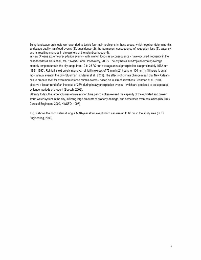
Figure 3.
7
Figure 3. Technocratic water management: subsurface drains, deep drainage regime, discharge dependent
system, floodwalls.
Because virtually all drainage infrastructures in the main metro polder of New Orleans are submerged, covered, or
hidden by floodwalls, water is barely visible to residents. Large parts of the city can be characterized as consisting of
nearly 0% open water, providing little to no resemblance to the native habitats of a delta city. This in contrast to Dutch
delta cities where discharge/storage proportions mean that by law up to 11% of the land can be required to be open
water (Hooijmeyer et al., 2005). With few or no links to their natural environment, citizens in New Orleans become
detached and unaware of the landscape they live in.
Future Perspectives – A Working Landscape
Four and a half years after the storm the unique situation in New Orleans means that it is now time for a long term and
integrated strategy for the revival of the city. Major disasters cause devastation on one hand, but create opportunities
on the other. Hurricane Katrina in this sense was also an eye-opener. The reconstruction of the resulting perforated
urban fabric now makes it possible to structurally transform the New Orleans water system. While flooding problems
are far from uncommon in delta cities, the unique situation in New Orleans represents a chance to structurally improve
the city’s storm water resiliency and at the same time contribute to its revival.
To this end the huge amount of space left vacant after hurricane Katrina should be considered both a necessity and a
chance to introduce extensive surface water and green structures of native and storm proof vegetation in the Lakeview
and Gentilly neighbourhoods. By creating more room for water and reforesting the city, both the city’ water problems
can be addressed and its living environments—and thus attractiveness for residents—can be improved. This paper
proposes a transformation process aimed at a working landscape with as its backbone a re-envisioned storm water
system based on contemporary 21st century water management (Commisie waterbeheer 21e eeuw, 2000). Such a
working landscape works two-fold:
Perform: In working landscapes, the aim should be on the inclusion of landscape processes, with as target a healthy
and vital system that prevents nuisances and is productive. This means the cooperation with and use of these
processes in a symbiosis, without the blocking or frustrating of them, with environmental problems as a result.
Inform: A working landscape should engage in interaction with the human perceiver, and trigger the human imagination
and creativity. A design must not only be beautiful in aesthetic sense, but also enrich people with facts, stories and
thoughts, by revealing richness and dynamics in the landscape. As such landscape is a tool to create a sense of
belonging and identity.

8
A working landscape in this way may turn these low-lying areas into attractive and distinctive suburbs that New
Orleans and its inhabitants so rightly deserve.
Research By Design
The landscape architectural design forms an important part of this research, for only the creation of a design allows for
conclusions whether the introduction of surface water in the perforated urban fabric is both possible and sensible, and
thus is a valid concept.
The proposed strategy for New Orleans finds its inspiration in the richness of the surrounding original landscapes of
the Mississippi delta, which are structured by a topographical gradient. Hardwood forest is found along the higher
grounds of (former) riverbanks, followed by brackish bald cypress and tupelo swamp forests with saline marshlands
closest to the sea. In the suburban area of Gentilly and Lakeview four landscape zones are revealed that refer to those
original landscapes, and are further based on topography, subsidence rate, and problems with rain flooding. A fourth
zone consists of a manmade landfill in the north of the study area. The zones provide basic concepts for interventions
on all scale levels, addressing the problems stated above. Each landscape zone has its own strategy regarding
hydrology and vegetation. In the lowest area’s more space is reserved for open water in large surfaces and branching
networks, while at the higher grounds infiltration in wadi’s (swales) and a higher building density are the main
principles. An integral approach towards spatial development ensures that investments work towards more than one
end at the same time.
A vital part of the transformation is a new strategy regarding water management, advocating an interconnected surface
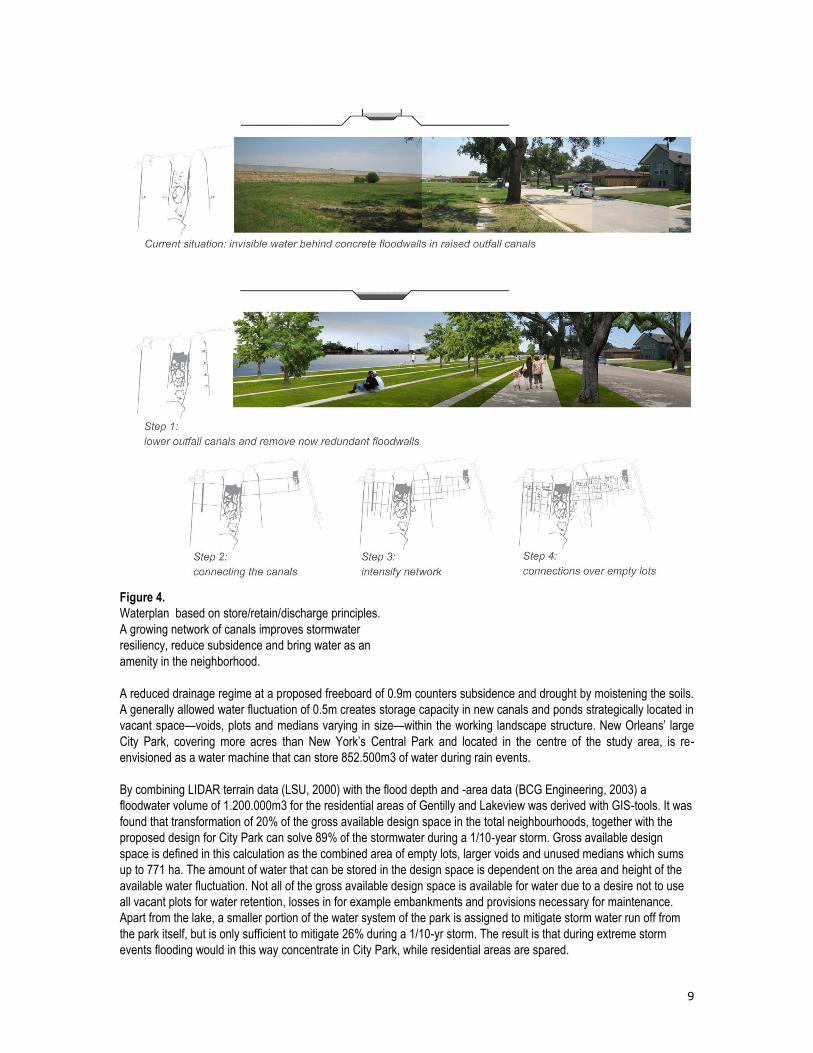
water system based on the three-stage-strategy’s: store-retain-discharge principle, as illustrated in fig. 4. The ratio
between storage and discharge of a drainage system is a choice. New Orleans needs either a higher discharge
capacity or a higher storage capacity to oppose its rain flood problems. As discussed above, for this design the retain-
store discharge principle is favoured over the fast-discharge principle that is currently applied since it is more flexible
and resilient towards the future. Additionally it offers possibilities for water to serve as an amenity in the city and
opposes subsidence by creating a higher ground water level.
9
Figure 4.
Waterplan based on store/retain/discharge principles.
A growing network of canals improves stormwater
resiliency, reduce subsidence and bring water as an
amenity in the neighborhood.
A reduced drainage regime at a proposed freeboard of 0.9m counters subsidence and drought by moistening the soils.
A generally allowed water fluctuation of 0.5m creates storage capacity in new canals and ponds strategically located in
vacant space—voids, plots and medians varying in size—within the working landscape structure. New Orleans’ large
City Park, covering more acres than New York’s Central Park and located in the centre of the study area, is re-
envisioned as a water machine that can store 852.500m3 of water during rain events.
By combining LIDAR terrain data (LSU, 2000) with the flood depth and -area data (BCG Engineering, 2003) a
floodwater volume of 1.200.000m3 for the residential areas of Gentilly and Lakeview was derived with GIS-tools. It was
found that transformation of 20% of the gross available design space in the total neighbourhoods, together with the
proposed design for City Park can solve 89% of the stormwater during a 1/10-year storm. Gross available design
space is defined in this calculation as the combined area of empty lots, larger voids and unused medians which sums
up to 771 ha. The amount of water that can be stored in the design space is dependent on the area and height of the
available water fluctuation. Not all of the gross available design space is available for water due to a desire not to use
all vacant plots for water retention, losses in for example embankments and provisions necessary for maintenance.
Apart from the lake, a smaller portion of the water system of the park is assigned to mitigate storm water run off from
the park itself, but is only sufficient to mitigate 26% during a 1/10-yr storm. The result is that during extreme storm
events flooding would in this way concentrate in City Park, while residential areas are spared.

10
The park will function as an anchor point and showcase for the new landscape structure in the neighbourhoods and
demonstrates how an interpretation of the former appearance of the landscape can provide a connection with place
and nature, and enrich the character and identity of the city.
Starting point of the design in residential context should be a pattern analysis of the urban fabric, by which
opportunities for water storage and urban design can be discovered. The open surface water can offer multiple living
environments related to water, and contribute significantly to the storage assignment. Figure 5 shows the potential of
currently unused medians. The exact scale of the transformation depends on the results of this analysis as well as the
ambition level and priorities of the city. Hazards regarding health issues and water quality can be counteracted by
critically designing slopes and borders according to technical design principles which include the prevention of
stagnant water through guaranteed flow and ecological mosquito management (Metzger, 2004; Norris, 2004; Walton,
2003).
Figure 5.
Figure 5. Water as an amenity in New Orleans
Typical native plant and tree species associated with the ecosystems in each landscape zone form the main character
within the landscape framework, while accent species bring identity in different neighbourhoods within those zones.
Native species ensure robustness to local climate (extreme winds and downpours) and additionally provide habitat to
local fauna. The trees introduce shade in the public space and therefore positively influence the microclimate of the city
during Louisiana’s hot summers. Temporal functions reserve space awaiting development. Tree nurseries can be one
of those functions, fulfilling the need for seedlings to reforest the city on-the-spot, as well as occupying and bringing
meaning to neglected land. In a future stage these functions can give way for water bodies that will act as buffer zones
and are designed as beautiful amenities within the neighbourhoods.
The flow and dynamic of water are the life that runs through the city’s new veins. The prominently visible open water
system educates residents about the fact that they live in a delta city where they have to live with water, which can act
both as a resource and a threat. People have to realize that also initiatives on their private property (rain barrels, native
vegetation, permeable materials) are needed to cope with the rainwater problem in the future. Through incentive
planning, the community can and should be engaged with such interventions on plot level. All together this study
shows how canals, grass lined swales, nurseries and retention ponds can be developed in order to not only function
well but also look good; truly water as an amenity for the great city of New Orleans.

11
Conclusion
Preparation for the future and a changing climate poses challenges, but also offers opportunities for the creation of
attractive delta cities. Four and a half years after the storm the unique situation in New Orleans means that it is now
time for a long term and integrated strategy for the revival of the city. The strategy based on 21st century water
management proposed in this paper mitigates rain flood events by reducing peak discharge, offers conditions for
native, sustainable vegetation and provides attractive public space.
The results of this research indicate that strategies aiming at attractive working landscapes have much potential to
offer a soft and sensible solution to the water challenges in New Orleans, and at the same time improve landscape
quality.
Landscape architecture, contemporary water management and urban planning together can build a city that learnt from
its past and will be more resilient and climate adapted in the future. A city with a vibrant and truly unique atmosphere
that can have an exemplary function for other delta cities in the world in terms of approach to storm water system
adaptation. Also by revealing landscape processes to the residents they will be more engaged with landscape issues,
generating increased awareness and support. Let us not wait for another disaster to trigger such a relation with water
and landscape, but let us start today with the creation of climate adapted and attractive delta cities in the world.
References
BCG Engineering & Consultants, inc., 2003. 1/10-year overflow: model results vs. actual field data [Map and tabular
data] Commissioned by US army corps of engineers, New Orleans: BCG Engineering & Consultants, inc.
Boesch, D.F., 2002. Consequences of Climate Change in Louisiana. Reilly Center Public Policy Fellow, March 18-20.
Louisiana State University.
Campanella, R., 2008. Bienville’s dilemma: a historical geography of New Orleans. Lafayette: Center for Louisiana
studies.
Commissie waterbeheer 21e eeuw, 2000. Waterbeleid voor de 21e eeuw. Den Haag: Kwak & Van Daalen & Ronday.
Faiers, G.E., Keim, B.D. & Muller, R.A., 1997. Rainfall Frequency/Magnitude Atlas for the South Central United
States. SRCC Technical Report: 97-1. Baton Rouge: LA, Department of Geography and Anthropology Louisiana State
University.
Greater New Orleans Community Data Centre, 2009. Redevelopment now a major driver in neighborhood population
shifts [Online] available at: http://www.gnocdc.org/RecoveryByNeighborhood/index.html [Accessed 27 November
2009].
Groisman, P.Y., et al., 2004. Contemporary Changes of the Hydrological Cycle over the Contiguous United States:
Trends Derived from In Situ Observations. Journal of Hydrometeorology (5) p.64-85.
HikeforkaTREEna, 2009. Hike for KaTREEna; Replanting New Orleans 4,980 trees and counting [Online] Available at:
www.hikeforkatreena.com [Accessed 21 August 2009].
Ierardi, K. 2008 Beyond receding waters: devastated by Hurricanes Katrina and Rita, the Gulf Coast finally grows
green again. The Free Library [Online] 22 September Available at: www.thefreelibrary.com/Beyond receding waters:
devastated by Hurricanes Katrina and Rita,...-a0187926856 [accessed November 19 2009].
Louisiana State University, 2000. LIDAR GIS map [Online] Available at: atlas.lsu.edu/rasterdown.htm [Accessed 29
October 2009].
McGranahan, G., Balk, D. & Anderson, B., 2007. The rising tide: assessing the risks of climate change and human
settlements in low elevation coastal zones. Environment and Urbanization, 19(17).

12
Metzger, M. E., 2004. Managing mosquitoes in stormwater treatment devices. Oakland: University of California [Online]
Available at: www.ucmrp.ucdavis.edu/publications/managingmosquitoesstormwater8125.pdf [Accessed 18 November
2009].
Meyer, H., Morris, D. & Waggonner, D., 2009. Dutch dialogues: New Orleans, Netherlands, common challenges in
urbanized delta. Amsterdam: SUN.
Municipality of Rotterdam et al., 2007. Waterplan Rotterdam2: Werken aan water voor een aantrekkelijke stad. 2nd ed.
Rotterdam: Episode Publishers.
Nassauer, J. I., 1995. Messy ecosystems, orderly frames. Landscape Journal, 14, p.161-169.
NASA Earth Observatory, 2007. Rain Floods New Orleans [Online] Available at: earthob-
servatory.nasa.gov/NaturalHazards/view.php?id=19258 [Accessed 02 July 2009].
Norberg-Schulz, C., 1980. Genius Loci. London: Academy Editions.
Norris, D. E., 2004. Mosquito-borne diseases as a consequence of land use change. EcoHealth, 04(1), p.19-24.
Saito, Y., 2007. Everyday aesthetics. New York: Oxford University Press.
Stuurman, R., 2009. Subsurface conditions for the reconstruction of New Orleans. In: Meyer, H., Morris, D. &
Waggonner, D., 2009. Dutch dialogues: New Orleans, Netherlands, common challenges in urbanized delta.
Amsterdam: SUN.
National Weather Service Forecast Office, 1997. The Historic Southeast Louisiana and Southern
Mississippi Flood of May 8-10, 1995. NOAA Technical Memorandum NWS SR-183. New Orleans: Louisiana.
Times Picayune, 2009. Recovery by the Numbers, 2009 [Online] Available at:
blog.nola.com/news_impact/2009/08/katrina-recovery-year4.pdf [Accessed 22 October 2009].
US Army Corps of Engineers, 2008. Greater New Orleans hurricane and storm risk reduction system [map], New
Orleans: US Army Corps of Engineers.
US Army Corps of Engineers, 2009. Draft Individual Environmental Report: Permanent Protection System For The
Outfall Canals Project on 17th Street, Orleans Avenue, and London Avenue Canals. May 2009, IER #5. Jefferson and
Orleans Parishes, Louisiana.
Walton, W. E., 2003. Managing mosquitoes in surface-flow constructed treatment wetlands. Oakland: University of
California; Division of Agriculture and Natural Resources.