a303/a30/a358 corridor feasibility study...stage 2 report a303/a30/a358 corridor feasibility study...
TRANSCRIPT

S t age 2 Repo r t
A303/A30/A358 Corridor Feasibility Study
Prepared for
The Highways Agency
February 2015
43 Brook Green
London, W6 7EF


Contents Section Page
Acronyms and Abbreviations .............................................................................................................. iv
Introduction ......................................................................................................................... 1-1 1.1 Introduction ..................................................................................................................... 1-1 1.2 Study Purpose and Objectives ......................................................................................... 1-1 1.3 Study Stages ..................................................................................................................... 1-1 1.4 Stage Objectives ............................................................................................................... 1-3
1.4.1 Stage 1 Objectives ............................................................................................... 1-3 1.4.2 Stage 2 Objectives ............................................................................................... 1-3
Summary of Stage 1 Report .................................................................................................. 2-4 2.1 Stage 1 Report Summary ................................................................................................. 2-4
2.1.1 Route Context ..................................................................................................... 2-4 2.1.2 Study Context ...................................................................................................... 2-4 2.1.3 Current Transport Issues and Challenges ........................................................... 2-4 2.1.4 Impact of Growth ................................................................................................ 2-5 2.1.5 Need for Intervention ......................................................................................... 2-6 2.1.6 Objectives ........................................................................................................... 2-7
Stage 2 Methodology ............................................................................................................ 3-8 3.1 Study Objectives .............................................................................................................. 3-8 3.2 Option Determination ...................................................................................................... 3-8
3.2.1 Option Generation .............................................................................................. 3-8 3.2.2 Option Sifting ...................................................................................................... 3-8 3.2.3 Option Assessment ............................................................................................. 3-9
A303 Amesbury to Berwick Down ....................................................................................... 4-11 4.1 Context ........................................................................................................................... 4-11
4.1.1 Overview ........................................................................................................... 4-11 4.1.2 Existing Issues and Challenges .......................................................................... 4-11
4.2 Option Determination .................................................................................................... 4-12 4.2.1 Option Generation ............................................................................................ 4-12 4.2.2 Option Sifting .................................................................................................... 4-15 4.2.3 Option Assessment ........................................................................................... 4-16
A303 Chicklade Bottom to Mere ........................................................................................... 5-1 5.1 Context ............................................................................................................................. 5-1
5.1.1 Overview ............................................................................................................. 5-1 5.1.2 Existing Issues and Challenges ............................................................................ 5-1
5.2 Option Determination ...................................................................................................... 5-2 5.2.1 Option Generation .............................................................................................. 5-2 5.2.2 Option Sifting ...................................................................................................... 5-3 5.2.3 Option Assessment ............................................................................................. 5-4
A303 Sparkford to Ilchester .................................................................................................. 6-1 6.1 Context ............................................................................................................................. 6-1
6.1.1 Overview ............................................................................................................. 6-1 6.1.2 Existing Issues and Challenges ............................................................................ 6-1
6.2 Option Determination ...................................................................................................... 6-2 6.2.1 Option Generation .............................................................................................. 6-2 6.2.2 Option Sifting ...................................................................................................... 6-3 6.2.3 Option Assessment ............................................................................................. 6-3
A303 A30 A358 STAGE 2 REPORT I

ACRONYMS AND ABBREVIATIONS
A303 South Petherton to Southfields .................................................................................... 7-1 7.1 Context ............................................................................................................................. 7-1
7.1.1 Overview ............................................................................................................. 7-1 7.1.2 Existing Issues and Challenges ............................................................................ 7-1
7.2 Option Determination ...................................................................................................... 7-2 7.2.1 Option Generation .............................................................................................. 7-2 7.2.2 Option Sifting ...................................................................................................... 7-3 7.2.3 Option Assessment ............................................................................................. 7-3
A303 Southfields to Honiton ................................................................................................. 8-1 8.1 Context ............................................................................................................................. 8-1
8.1.1 Overview ............................................................................................................. 8-1 8.1.2 Existing Issues and Challenges ............................................................................ 8-1
8.2 Option Determination ...................................................................................................... 8-2 8.2.1 Option Generation .............................................................................................. 8-2 8.2.2 Option Sifting ...................................................................................................... 8-5 8.2.3 Option Assessment ............................................................................................. 8-5
Whole Route ........................................................................................................................ 9-1 9.1 Context ............................................................................................................................. 9-1
9.1.1 Overview ............................................................................................................. 9-1 9.1.2 Existing Issues and Challenges ............................................................................ 9-1
9.2 Option Determination ...................................................................................................... 9-1 9.2.1 Option Generation .............................................................................................. 9-1 9.2.2 Option Sifting ...................................................................................................... 9-2 9.2.3 Option Assessment ............................................................................................. 9-2
Conclusion s & Recommendations ...................................................................................... 10-1 10.1 Conclusions .................................................................................................................... 10-1 10.1 Recommendation........................................................................................................... 10-3
Tables
Table 2-1: Committed Schemes relevant to the A303 Corridor ................................................................ 2-6 Table 2-2: Stage 1 Section Summary ......................................................................................................... 2-6 Table 2-3: Overarching Study Objectives ................................................................................................... 2-7 Table 3-1: EAST Scoring Categorisation ..................................................................................................... 3-9 Table 3-2: Option Assessment Scoring ...................................................................................................... 3-9 Table 4-1: Summary of Options for Amesbury to Berwick Down ............................................................ 4-13 Table 4-2: Amesbury to Berwick Down EAST Assessment ....................................................................... 4-15 Table 4-3: Amesbury to Berwick Down Option Assessment - Option A3 Part online /part Off-line Dual Carriageway with Tunnel ........................................................................................................................... 4-5 Table 4-4: Amesbury to Berwick Down Option Assessment - Option A4 Offline Dual Carriageway to the North ........................................................................................................................................................ 4-11 Table 5-1: Summary of Options for Chicklade Bottom to Mere ................................................................ 5-2 Table 5-2: Chicklade Bottom to Mere EAST assessment ........................................................................... 5-3 Table 5-3: Chicklade Bottom to Mere Option Assessment – On-line and Off-line Widening .................. 5-11 Table 6-1: Summary of Options for Sparkford to Ilchester ........................................................................ 6-2 Table 6-2: Sparkford to Ilchester EAST assessment ................................................................................... 6-3 Table 6-3: Sparkford to Ilchester Option Assessment – Combination of On-line and Off-line Widening 6-10 Table 7-1: Summary of Options for South Petherton to Southfields ......................................................... 7-2 Table 7-2: South Petherton to Southfields EAST Assessment ................................................................... 7-3 Table 7-3: South Petherton to Southfields Option Assessment - Online Dualling between Southfields and Hayes End Roundabouts ............................................................................................................................ 7-9 Table 8-1: Option Summary for Southfields to Honiton ............................................................................ 8-3 Table 8-2: Southfields to Honiton EAST Assessment ................................................................................. 8-5
ACRONYMS AND ABBREVIATIONS
Table 8-3: Southfields to Honiton Option Assessment – A30/A303 Improvements ............................... 8-13 Table 8-4: Southfields to Honiton Option Assessment – A358 Dualling .................................................. 8-20 Table 9-1: Whole Route Option Assessment ............................................................................................. 9-8 Table 10-1: Web TAG Five Case Model Summary.................................................................................... 10-3
Figures
1.1 Steps in the Option Development Process ................................................................................... 1-2 4.1 Amesbury to Berwick Down section ............................................................................................. 4-1 5.1 Chicklade Bottom to Mere section ............................................................................................... 5-1 5.2 Chicklade Bottom to Mere Online and Offline widening scheme ................................................ 5-3 6.1 Sparkford to Ilchester section ....................................................................................................... 6-1 7.1 South Petherton to Southfields section ........................................................................................ 7-1 8.1 Southfields to Honiton section ..................................................................................................... 8-1
ANC/A303 A30 A358 STAGE 2 REPORT III COPYRIGHT 2015 BY CH2M HILL, INC. • COMPANY CONFIDENTIAL

ACRONYMS AND ABBREVIATIONS
Acronyms and Abbreviations AADT Annual Average Daily Traffic ADT Average Daily Traffic ARCADY Assessment of Roundabout Capacity And DelaY
A software tool to analyse roundabout capacity and delay. AQMA Air Quality Management Area AONB Area of Outstanding Natural Beauty ASC Asset Support Contract ASR Appraisal Specification Report AWT Average Weekly Traffic BCR Benefit Cost Ratio BIS Department for Business, Innovation & Skills CC County Council CCTV Closed-Circuit Television CRF Congestion Reference Flow DCLG Department of Communities and Local Government Defra Department for Environment, Food and Rural Affairs DfT Department for Transport DMRB Design Manual for Roads and Bridges D2 Two-Lane Dual Carriageway EA Environment Agency FEMA Functional Economic Market Area FPL First Priority Location GVA Gross Value Added HA Highways Agency HGV Heavy Goods Vehicle HM Her Majesty’s HOSW Heart of the South West IMD Index of Multiple Deprivation KSI Killed or Seriously Injured LEP Local Enterprise Partnership LNR Local Nature Reserve LSOA Lower Super Output Area MAGIC Multi-Agency Geographic Information for the Countryside MP Member of Parliament NNR National Nature Reserve NPPF National Planning Policy Framework NO2 Nitrogen Dioxide NTM National Trip End Model ONS Office for National Statistics OTRM On Time Reliability Measure
Monitors the reliability of journeys made on the Highways Agency’s motorway and ‘A’ road network. Measured by the percentage of ‘journeys’ on the network that are ‘on time’.
OUV Outstanding Universal Value PCF Project Control Framework PIA Personal Injury Accident PICADY Priority Intersection Capacity and Delay
A software tool to analyse priority junction capacity and delay. PPP Pinch Point Programme

ACRONYMS AND ABBREVIATIONS
Q1, Q2, … Quarter 1, Quarter 2, … RBS Route-Based Strategy RCC Regional Control Centre RDA Regional Development Agency RES Regional Economic Strategy RSI Road-side Interview SAC Special Area of Conservation SATURN Simulation and Assignment of Traffic to Urban Road Networks
A suite of highway network assignment and analysis programs. SEIP Stonehenge Environmental Improvements Programme SEP Strategic Economic Plan SME Small and Medium sized Enterprise SPA Special Protection Area SSSI Site of Special Scientific Interest SOUV Statement of Outstanding Universal Value STAG Stonehenge Traffic Action Group SWARMMS London to South West and South Wales Multi-Modal Study SWO South West Observatory SWP South West Peninsula S2 Two-Lane Single Carriageway S3 Three-Lane Single Carriageway TAME The HA’s Traffic Appraisal, Modelling and Economics team TASM The DfT’s Transport Appraisal and Strategic Modelling division TEN-T Trans-European Transport Networks TEMPRO Trip End Model Presentation Program
A database of population, employment, households by car ownership, trip ends and traffic growth forecasts based on data from the National Transport Model (NTM).
TOS Traffic Officer Service TRADS Traffic Flow Database System TRL Transport Research Laboratory VMS Variable Message Sign WebTAG Web Transport Analysis Guidance WHS World Heritage Site
ANC/A303 A30 A358 STAGE 2 REPORT V COPYRIGHT 2015 BY CH2M HILL, INC. • COMPANY CONFIDENTIAL


SECTION 1
Introduction
1.1 Introduction CH2M Hill has been commissioned by the Highways Agency (the Agency) to undertake a feasibility study of the A303/A30/A358 corridor in the south west of England; comprising:
• the A303 between the M3 and the A30; • the A30 between the A303 and the M5, and; • the A358 between the A303 and the M5.
The A303/A30 is part of the Strategic Road Network (SRN) and together with the A358 forms a key strategic link between the far South West Peninsula connecting Cornwall and Devon with Dorset, Somerset and Wiltshire with the rest of the south, south east, and London. The route is also on the Trans-European Network-Transport (TEN-T) comprehensive network. In conjunction with the A358 the corridor covers approximately 195Km. The study forms part of the Governments road investment programme; which is identifying and funding solutions through feasibility studies such as this at some of the most notorious and long standing road hot spots in England. This work is being progressed alongside the Agency’s Route Strategy programme which will which will set out the Agency’s future investment programme. This Stage 2 report details the solution options developed and that may be taken forward in further detail; essentially acting as an Option Assessment Report (OAR) and an Appraisal Specification Report (ASR).
1.2 Study Purpose and Objectives The aim of this study is to identify the opportunities and understand the case for future investment solutions on the A303/A30/A358 corridor that are deliverable, affordable and offer value for money. The specific objectives of the study are to:
• identify and assess the benefits, deliverability and timing of specific infrastructure investments that address the existing problems along the A303 corridor;
• understand the balance of benefits and impacts from potential individual investment proposals and any additional benefits or impacts from an investment on a corridor basis;
• evidence where possible, the wider economic benefits from the transport investment in the corridor;
• understand the balance and impacts from potential investment in the A303 corridor compared to the performance and investment in other road transport corridors to the South West region; and
• understand the impacts on the resilience of the road transport network from the proposed investment in the A303 corridor.
1.3 Study Stages A Stage 1 report (following the WebTAG Transport Appraisal Process) which comprehensively reviewed existing evidence to identify the key transport issues and challenges, the objectives for the study and an examination of options already proposed from previous work on the corridor. A summary of the conclusions from the Stage 1 report are given in Section 2 of this report. The study is split into three stages, the second of which is reported here. The Stages are:
• Stage 1: Review of evidence and identification of problems and issues; • Stage 2: Finalise the range of proposals that could address problems and issues, and; • Stage 3: Assess the affordability, value for money and deliverability of the proposals.
A303 A30 A358 STAGE 2 REPORT 1-1

SECTION 1 INTRODUCTION
The three stages encompass the steps of the Transport Appraisal Process (TAP), contained within the Department for Transport’s Transport Appraisal Guidance (TAG) as follows:
• Stage 1: TAG steps 1-4 • Stage 2: TAG steps 5-9 (Produce Option Assessment Report) • Stage 3: Produce Strategic Outline Business Case (SOBC)
It is noted that the definition of the stages for this study differs from the Stages as described in TAP, as shown in Figure 1.1.
Figure 1.1: Steps in the Option development process (Source: Transport Appraisal Process, DfT Transport Appraisal Guidance)
1-2 A303 A30 A358 STAGE 2 REPORT

SECTION 1 INTRODUCTION
1.4 Stage Objectives 1.4.1 Stage 1 Objectives The purpose of Stage 1 of the study was to review the evidence and identify problems within the study area. In particular Stage 1 covered:
• reviewing any relevant evidence gathered as part of the development and completion of the South West Peninsula Route Strategy;
• gathering and reviewing any other related work from other study work and analysis and forming a view as to the nature and scale of current and future performance along the A303, A358 and A30;
• setting out details of previous historical work and decisions taken in terms of the approach to investment or management of the A303, A358 and A30 with the aim of reaching agreement on the historical position in relation to previous investment proposals.
• establishing both the availability of transport modelling and the need to undertake specific transport modelling necessary to provide analysis that would be needed to evidence answers to some of the questions to be addressed in the study; and
• presenting findings for consideration by the Project Board and the A303 Reference Group where appropriate.
Chapter 2 of this OAR is a summary of what is included in the Stage 1 Report (for more details refer to the A303/A30/A358 Corridor Feasibility Study - Stage 1 Report).
1.4.2 Stage 2 Objectives The purpose of Stage 2 of the study is to identify and sift interventions that tackle the issues identified in Stage 1 whilst meeting the study objectives. The following steps are involved:
• Identification of interventions
• Sifting process to determine potential options using EAST
• Potential options to be subjected to a more detailed appraisal using the Option Assessment Framework (OAF)
• Production of OAR with recommendations for options to be taken forward to Stage 3: SOBC.
A303 A30 A358 STAGE 2 REPORT 1-3

SECTION 2 SUMMARY OF STAGE 1 REPORT
Summary of Stage 1 Report
2.1 Stage 1 Report Summary The following section provides a summary from the Stage 1 report.
2.1.1 Route Context The study route comprises around 195km of road network; which together form a strategic link between the South West, South East and London.
The route also serves a more local function, facilitating shorter distance journeys between centres such as Andover, Amesbury, Shaftesbury, Yeovil, Honiton and Exeter.
Much of the route is dualled (63%), although several sections remain single carriageway; causing congestion especially during summer weekends when traffic flows are higher. The route is also characterised by varying speed limits, differing junction types and direct accesses; all of which can have detrimental effects on its operation.
2.1.2 Study Context Proposals to complete the dualling of this route corridor have existed for over 10 years; being announced in the 2002 London to South West and South Wales Multi Modal Study (SWARMMS). If built a “second strategic route” (the M5 being the first) would have been created into the South West; but the project was cancelled in 2007.
In 2013, HM Treasury produced the “Investing in Britain’s Future” document, setting out a programme for infrastructure investment, including a tripling in spending on the SRN. This money will be allocated following the completion of a number of feasibility studies; this being one.
2.1.3 Current Transport Issues and Challenges 2.1.3.1 Flows and Capacity Flows along the corridor are comprised of different types and purposes. Traffic flows are highest in the east (east of the A342) and also in the far west around Exeter. Flows vary on the remainder of the corridor, dropping to a low over the Blackdown Hills. HGV’s comprise around 10% of traffic.
Examination of the route under these “normal” conditions shows that the stress factor (AADT:CRF) already exceeds 100% on three sections of the route:
• Amesbury to Berwick Down; • Sparkford to Ilchester; • South Petherton to Southfields.
As mentioned in Section 2.1.1; flows increase on the route in summer; with traffic increasing by as much as 50% on some sections. This increase in traffic results in another three sections either exceeding or being very close to 100%:
• Wyle to Stockton Wood; • Chicklade Bottom to Mere and; • A358 (northern end).
2.1.3.2 Travel Times Evidence from the Agency’s Route Strategy work for the South West Peninsula has also identified three sections which have poor journey time reliability. These are:
• A303 in the vicinity of Andover; • A303 in the vicinity of Sparkford, and; • A30 between Honiton and the M5.
2-4 A303 A30 A358 STAGE 2 REPORT
SECTION 2 SUMMARY OF STAGE 1 REPORT
Examination of 2013 data by CH2M HILL resulted in the same conclusions being reached; with the worst performing section being around Stonehenge, where reliability is only 55%. Many sections operate between 70 and 80%.
2.1.3.3 Safety On the A303/A30, 160 accidents/year were recorded between 2008 and 2012and 83/year were recorded on the A358 between 2009 and 2013. Of these 67% of the fatal accidents and 47% of all accidents occurred on single carriageway sections. The poorest performing sections in terms of fatal accidents are:
• Amesbury to Berwick Down (4 fatal accidents (11%)); • Chicklade Bottom to Mere (5 fatal accidents (14%)), and; • Southfields to Honiton (10 fatal accidents (28%)).
2.1.3.4 Environmental The route passes through a wide variety of landscapes. Most significantly, the route passes very close to Stonehenge (a World Heritage Site), but there are Grade 1 listed buildings and SSSI sites adjacent to much of the single carriageway sections of the route.
In addition, three sections of the route ((Wylye to Stockton Wood, Chicklade Bottom to Mere and Southfields to Honiton)) are located within Areas of Outstanding Natural Beauty. The AONB’s are Cranborne Chase and West Wiltshire Downs and the Blackdown Hills.
2.1.3.5 Current Issues and Priorities In summary, the existing issues and priorities can be summarised as:
• Peak congestion and delay which is further exacerbated in summer • Poor journey time reliability related to single carriageway sections • Poor route resilience. • Significant environmental constraints.
2.1.4 Impact of Growth Growth resulting from both specific development proposals and that as a result of changing social, demographic and economic factors will result in increased pressures on the SRN; again particularly in summer. This will have the effect of raising stress levels above 100% for the majority of the single carriageway sections (the remaining two are above 85%).
Specific growth proposals which may impact on the corridor relate (but not exclusively) to the Exeter area, Yeovil Western corridor, M5 J25m Hinckley Point C, Stonehenge Visitor Centre, Solstice Park in Amesbury and growth in Andover. Collectively, growth up to 2031 could amount to 242,000 dwellings and 150,000 jobs which together could result in a 20% increase in traffic flows by 2021 and 30% by 2031.
At the time of completion of the Stage 1 report, there were a number of schemes which were committed to be delivered; these are indicated within Table 2.1.
A303 A30 A358 STAGE 2 REPORT 2-5

SECTION 2 SUMMARY OF STAGE 1 REPORT
Location Scheme Type Completion Year Anticipated Benefits
A36 Salisbury Roundabout Road Scheme 2014 Reduced congestion through lining and signing
improvements A303 Cartgate Road Scheme 2015 Reduced congestion through approach widening M5 Jct 30 Road Scheme 2015 Reduced congestion through off-slip widening
M3 Jct 6 Road Scheme 2015 Reduced congestion and improved safety through upgrade of Black Dam roundabout to a hamburger.
M3 Jct 2-4a Road Scheme TBC Reduced congestion through the installation of Smart Motorways.
Exeter Principal Urban Area scheme
Public Transport Scheme 2013
Improved congestion by the removal of traffic bottlenecks, construction of bus lanes and a new Park and Ride facility, close to M5 J30.
Bullington Cross Road Scheme Unknown Improvement of access from A34/A30 on slip road A303 West at Bullington Cross to reduce dangerous back-up of traffic, particularly at peak time.
East Anton Developer Contribution Unknown
A303/A3093 interchange at East Anton - Improved merge arrangements at the on-slip to increase capacity.
Table 2-1: Committed Schemes relevant to the A303 Corridor
2.1.5 Need for Intervention It is clear that intervention is needed. This has been summarised by section and a table from the Stage 1 report is reproduced below. These issues are believed by many to adversely affect economic prosperity in the region; supported by lower GVA figures and a falling volume of foreign trade.
Section Congestion/ Stress (2013
Neutral)
Safety (A303/A30 (2008-12))
A358 (2009-13) Journey Time
reliability Environmental
Fatal PIA/km
Amesbury to Berwick Down 1.06 4 6.23 X Stonehenge WHS
Wyle to Stockton Wood 0.86 1 3.85 X
Cranborne Chase and West
Wiltshire Downs
Chicklade Bottom to Mere 0.89 5 4.67
Cranborne Chase and West
Wiltshire Downs
Sparkford to Ilchester 0.99 1 4.55 X
Podimore Roundabout 0.99 0 33.33
Cartgate Roundabout 0.29 0 56.67
South Petherton to Southfields 1.03 2 4.6
Southfields to M5 J25 0.94 1 5.36 N/A
Southfields to Honiton 0.69 10 4.91 X Blackdown Hills
AONB
Table 2-2: Stage 1 Section Summary
This table illustrates that as a result of population density, employment, urban concentrations and tourist attraction of the South West the corridor experiences a range of traffic flows which lead to severe and
2-6 A303 A30 A358 STAGE 2 REPORT

SECTION 2 SUMMARY OF STAGE 1 REPORT
regularly occurring congestion and delay; even outside the peak periods on some sections. This leads to journey time unpredictability and the additional impacts of further traffic from development, both on and off the corridor will increase the pressure on the route, exacerbating the existing situation further. This will result in further social, economic and environmental issues being experienced through the region; which is already seen by many as adversely affecting the economic prosperity of the region.
As such, the following sections were considered as suitable for further assessment in Stage 2:
• Amesbury to Berwick Down; • Chicklade Bottom to Mere; • Sparkford to Ilchester; • South Petherton to Southfields; • Southfields to Honiton.
It was also recommended that a strategic transport model be developed to enable a consistent and region based assessment of any improvement options. The model was to be developed in line with current guidance and in close cooperation with DfT TASM and HA TAME.
2.1.6 Objectives The Stage 1 study identified sections of the route that experience significant problems throughout the year. These sections (as listed in Section 2.1.5) have been brought forward to this Stage 2 report for option identification. These options will be investigated and sifted according to the overarching objectives of the study which are shown in Table 2.2 below.
Strategic Objectives Support Economic Growth
Facilitate growth in employment at key centres and locations along the A303/A358/A30 corridor
Facilitate growth in housing a key development hotspots along the corridor
Operational Objectives
Capacity Reduce delay and queues that occur during peak hours and seasonal times of the year
Resilience Improve the resilience of the route such that the number of incidents and the effect of accidents is reduced
Safety Reduce the number of collisions on the A303/A358/A30 corridor
Connectivity Improve the connectivity of the South West to the rest of the UK, to reduce peripherality and improve business and growth prospects.
Environmental
Avoid unacceptable impacts on the surrounding natural environment and landscape and optimise the environmental opportunities and mitigation that the intervention could bring.
Table 2-3: Overarching Study Objectives
A303 A30 A358 STAGE 2 REPORT 2-7

SECTION 3 STAGE 2 METHODOLOGY
Stage 2 Methodology In this Stage 2 report, analysis of each section will be undertaken in a consistent basis to ensure the consistent appraisal of the options under consideration.
3.1 Study Objectives As detailed earlier (Table 2.3: Overarching Study Objectives), the Stage 1 report set out a number of objectives for our work on the A303. These objectives are common to each section of the route and are:
• Strategic Objectives: o Support Economic Growth.
• Operational Objectives: o Capacity; o Resilience; o Safety; o Connectivity o Environmental.
3.2 Option Determination 3.2.1 Option Generation Using the information gathered from the Stage 1 report, studies already completed on behalf of the Highways Agency, local highway authorities and local authorities, and using our engineering judgement, a number options have been generated for each section of the route considered in this Stage 2 report.
Options have been generated in order to satisfy the objectives, both strategic and operational, that were identified in Stage 1 (and are repeated in Section 3.2 above). A range of schemes have been generated, some are of a small scale within the highway boundary, whilst others are major off-line schemes involving new structures both above and underground.
Within the report a brief outline of the potential options is provided for each options within each section in order to provide an understanding of what is proposed.
3.2.2 Option Sifting In order to reduce the number of options to be assessed, we have utilised the Department for Transport’s (DfT) Early Assessment and Sifting Tool (EAST) to comparatively examine the options generated.
EAST is a decision support tool that has been developed to quickly summarise and present evidence on options in a clear and consistent format using a spreadsheet. Detailed evidence often required to support funding applications is not needed; EAST allows a view to be taken on the best evidence available whilst remaining consistent with Transport Business Case principles.
Where possible, we have used available information gathered during Stage 1 of this study and also from previous studies on the corridor, although for some criteria data is not yet available and as such we have utilised our engineering judgement to derive a score. Other criteria have required assumptions to be made; as it has not been possible to apply previous experience.
Each section of route has been assessed independently against the particular issues and challenges present in each section; so the scoring across the schemes cannot be directly compared as each section starts from a different base.
The results from the EAST assessment are presented in a tabular format for each section of route. EAST does not provide a means for obtaining an overall score for an intervention and therefore doesn’t provide a means of directly ranking them.
A key to the categorisation is depicted in Table 3.1 below:
3-8 A303 A30 A358 STAGE 2 REPORT

SECTION 3 STAGE 2 METHODOLOGY Cr
iteria
Strategic Economic Managerial Financial Commercial Sc
ale
of
Impa
ct
Fit w
ith w
ider
ob
ject
ives
Fit w
ith o
ther
ob
ject
ives
Degr
ee o
f Co
nsen
sus
Econ
omic
Gr
owth
Carb
on
Emiss
ions
SDI &
The
Re
gion
s
Loca
l Env
Wel
l Bei
ng
Expe
cted
Vf
M C
ateg
ory
Impl
emen
tati
on T
imet
able
Publ
ic
Acce
ptab
ility
Prac
tical
Fe
asib
ility
Qua
lity
of
Evid
ence
Capi
tal C
osts
(£
m)
Reve
nue
Cost
(£
m)
Cost
Risk
Flex
ibili
ty o
f O
ptio
n
Cate
goris
atio
n
1: Low 1: V High >4
1: 0-1 mths 1: Low 2: 0-5 1:
None
1: High Risk
1: Static
2 2:
High 2-4
2: 1-6 mths 2 3: 5-10 2: 0-5 2 2
3 3:
Med 1.5-2
3: 6-12
mths 3 4: 10-
25 3: 5-10 3 3
4 4:
Low 1-1.5
4: 1-2 yrs 4 5: 25-
50 4: 10-
25 4 4
5: High 5:
Poor <1
5: 2-5 yrs 5: High 6: 50-
100 5: 25-
50
5: Low Risk
5: Dynamic
6: 5-10 yrs
7: 100-250
7: 10+
yrs 8: 250 -500
Table 3-1: EAST Scoring Categorisation
3.2.3 Option Assessment For each section of the corridor, sifting using EAST is expected to result in one or two options being identified as better performing and included for further assessment. The ‘Transport Appraisal Process’ TAG Unit states that these potential options should be assessed against the Transport Business Case criteria using the Option Assessment Framework, provided within the TAG Unit
As such tables within each section appraisal will be provided following the assessment areas outlined in the Framework, namely:
• Strategic Fit; • Value for Money, including:
- Impact on the Economy; - Impact on the Environment; - Impact on Society; - Public Accounts; - Distributional impacts; and - Indicative Benefit Cost Ratio (BCR).
• Financial Case; • Delivery Case; and • Commercial Case.
In line with TAG, the appraisals have used a 7 point scale of impacts in providing a (largely) qualitative assessment of the scale of impacts. The scale is as indicated in Table 3.2.
1 = Large Adverse
2 = Moderate Adverse
3 = Slight Adverse
4 = Neutral
5 = Slight Beneficial
6 = Moderate Beneficial
7 = Large Beneficial
Table 3-2: Option Assessment Scoring
A303 A30 A358 STAGE 2 REPORT 3-9

SECTION 3 STAGE 2 METHODOLOGY
The remainder of the report details each section of the corridor identified as a priority in stage 1 of the feasibility study and considers each aspect of the Option Assessment Framework assessment areas in appraising the option identified.
The two principal methods for appraisal within each assessment are as follows:
• Qualitative Assessment: a descriptive analysis of the likely impacts of the intervention in the area based upon available evidence. Includes scoring the level of impact using a seven point scale.
• Quantitative Assessment: using various appraisal tools to quantify the level of impact in the assessment area and then monetising this impact using values provided by WebTAG guidance.
Following this assessment the report concludes which sections and schemes will be taken through to Stage 3 with additional impacts being quantified as part of the development of the SOBC’s for the chosen options.
3-10 A303 A30 A358 STAGE 2 REPORT

SECTION 4 A303 AMESBURY TO BERWICK DOWN
A303 Amesbury to Berwick Down
4.1 Context 4.1.1 Overview The section passes through the Stonehenge World Heritage Site (WHS) and is the first single carriageway section that drivers encounter after leaving London and travelling towards the South West; Countess Roundabout (the junction with the A345 at Amesbury) is the first at-grade, non-priority junction encountered. The existing dual carriageway from London extends beyond Countess Roundabout westwards towards Stonehenge and reduces to a single carriageway at King Barrow Ridge about 1km to the east of the historic Stones. The A303 then continues westwards as a single carriageway for another 9km before reverting to a dual carriageway at Berwick Down. The current line of the A303 passes only 165m to the south of the Stones, so the monument was set within the wedge of land formed between the two roads.
Continuing westwards, the A303 runs to Longbarrow Crossroads where there is a roundabout junction with the A360. The A345 Countess Road (North) at Amesbury and the A360 form the eastern and western boundaries respectively of the Stonehenge World Heritage Site (WHS), and the A303 lies within the WHS throughout this section.
West of Longbarrow Crossroads, the A303 descends from the chalk downland of Salisbury Plain into the valley of the River Till. The village of Winterbourne Stoke, much of which is a Conservation Area, is located on the Till and the A303 passes through the northern part of the village, crossing the valley floor on a shallow causeway. There is frontage development on both sides of the A303, with accesses directly onto the trunk road, and there are T-junctions with local roads in the village.
Figure 4.1: Amesbury to Berwick Down section
4.1.2 Existing Issues and Challenges Heritage
The A303 is in particularly close to the historical Stones and it is felt by many that this proximity is affecting the stones and the experience of visitors to the site.
The first Stonehenge WHS Management Plan was published by English Heritage in 2000, meeting the Government’s responsibilities to have such plans in place for its WHSs. An updated plan was published in 2009 which builds upon the original document. The Plan has been commended by UNESCO’s World Heritage Committee (the body responsible for overseeing WHSs around the world) and was adopted in 2000 by Salisbury District Council as Supplementary Planning Guidance. A further revision to the plan is planned to be issued in 2015.
Traffic
The main problems with this section of the A303 are safety and congestion. Traffic flow varies throughout but is around 24,000 (AADT) and peaks in the summer months and at holiday weekends. This is significantly above the maximum 13,000 recommended by current Highways Agency guidance for a single
A303 A30 A358 STAGE 2 REPORT 4-11

SECTION 4 A303 AMESBURY TO BERWICK DOWN
two-lane road and as a result congestion occurs where the two-lane sections reduce to one lane. Peak time queuing frequently occurs at the two roundabouts.
In conjunction with the areas of congestion, accidents are most prevalent at the two roundabouts and mainly comprise shunt type accidents on the approaches and the circulatory carriageways. Accidents elsewhere along this section could be the result of a number of contributory factors such as poor alignment, lack of street lighting, slow moving vehicles and right turn movements into and out of side roads, lay-bys, private accesses, etc. The average overall ratio of road users Killed or Seriously Injured (KSI) on this section of the route is approximately 21.2% (2007-2012 data) compared to the national average of approximately 19.1% for the same period on rural A-roads.
The A303 severs Winterbourne Stoke resulting in noise problems for residents and impeding pedestrian movements through the village. Several non-motorised user (NMU) routes intersect the A303 along this section of the road although no particular issues or concerns have been identified.
4.2 Option Determination 4.2.1 Option Generation This section has been extensively examined on a number of previous occasions, includingthe option to place the A303 into a 2.1km tunnel and to build a bypass around Winterbourne Stoke. Many other options have been examined at some length; many of these have been discounted for a wide variety of reasons.
A range of options have been examined as part of this study to address the objectives set out in Table 2.3. These are detailed below, but are summarised in the table below:
Option Brief Description Impacts A1 Minor
Improvements a. Limited due to the fact that many such changes have already
been implemented and benefits realised. A2 Partial Solution
(Winterbourne Stoke Bypass)
a. Increase capacity – reduce congestion. b. Provide overtaking opportunities – improved vehicular
throughput. c. Improvement in journey time reliability. d. Construction to current standards – improved safety. e. Removal of conflict with NMU’s. f. Removal of local traffic – increased capacity on A303. g. Minimal impact on WHS. h. Removal of severance within Winterbourne Stoke.
A3 Part on-line/part off-line dual carriageway with tunnel
a. Increase capacity – reduce congestion. b. Provide overtaking opportunities – improved vehicular
throughput. c. Improvement in journey time reliability. d. Construction to current standards. e. Removal of conflict with NMU’s. f. Removal of local traffic -
• increased capacity on A303. • current conflict with peak time Visitor Centre traffic queuing
back to Longbarrow Crossroads. g. Traffic removed from sight at Stonehenge. h. Minimises environmental impacts on wider extents of WHS. i. Will partially address the identified accident issues
4-12 A303 A30 A358 STAGE 2 REPORT

SECTION 4 A303 AMESBURY TO BERWICK DOWN
Option Brief Description Impacts A4 Off-line Dualling
(Northern Route) a. Increase capacity – reduce congestion. b. Provide overtaking opportunities – improved vehicular
throughput. c. Improvement in journey time reliability. d. Construction to current standards e. Removal of conflict with NMU’s. f. Removal of local traffic – increased capacity on A303. g. Reduce traffic impacts from proposed Larkhill development. h. Reduces environmental impacts on wider extents of WHS. i. Will address identified accident issues.
A5 Off-line Dualling (Southern Route)
a. Increase capacity – reduced congestion. b. Provide overtaking opportunities – improved vehicular
throughput. c. Improvement in journey time reliability. d. Construction to current standards. e. Removal of conflict with NMU’s. f. Removal of local traffic – increased capacity on A303. g. Reduces environmental impacts on wider extents of WHS. h. Will address identified accident issues.
Table 4-1: Summary of Options for Amesbury to Berwick Down
4.2.1.1 Minor Improvements (Option A1) The A303/A30 Corridor Management Study Solutions Report1 suggested a number of small scale additional improvements that could help to reduce the congestion and safety issues at specific locations along the route. The following options are based on that study:
Winterbourne Stoke • Measures such as ‘No right turn’ signs at lay-bys, installation of Vehicle Activated Signs (VAS) and
improvements to the village gateway features. • Closure of the lay-by west of the village. • Construction of right turning lanes. • Extension of the 40mph speed limit and implementation of 50mph buffer zones in advance. • Improve signing for motorists and non-motorised users. • Signalise the B3083 junction (peak flow operation only). • Improve road markings such as box markings or ‘Keep clear’ opposite side road junctions. • Construct a footbridge. • Close access opposite Church Street. • Increase the carriageway width at the River Till bridge.
Longbarrow Roundabout and Countess Roundabout.
• Linked traffic signals on approaches to both roundabouts (to stack vehicles and reduce queuing past Stonehenge).
• Increase merge length on Longbarrow Roundabout exit.
Remaining Sections of A303 between Berwick Down and Countess Roundabout
• Widen carriageway and install 1.0m hardstrips.
1 A303/A30 Corridor Management Study, Highways Agency, February 2010
A303 A30 A358 STAGE 2 REPORT 4-13

SECTION 4 A303 AMESBURY TO BERWICK DOWN
• Install active road studs. • Extend existing double-white lines and introduce additional ‘no overtaking’ sections. • Improve signing including VAS in advance of Longbarrow and Countess Roundabouts. • Reduce speed limit to 50mph. • Relocate signs (increase set-back from carriageway). • Install Managed Merge Control. • Relocate the westbound merge (from two lanes to one) in advance of Stonehenge Road. • Close the junction with Stonehenge Road. • Ramp metering for traffic joining from Stonehenge Road.
4.2.1.2 Partial Solution (Option A2) The 2006 Scheme Review included a partial solution which incorporated an off-line bypass to the north of Winterbourne Stoke and four alternative tie-in arrangements to the existing A303 and A360 in the vicinity of Longbarrow Crossroad’s roundabout. This option was calculated to achieve a Benefit Cost Ratio (BCR) of 1.9 to 3.8 and would address the problems identified at the western end of this section including Winterbourne Stoke. Traffic would, however, remain visible from Stonehenge and congestion would continue to occur through the WHS. Also, if implemented, this option would preclude any routes to the north for resolving the remaining issues along this section of the A303.
4.2.1.3 ‘2003’ Published Scheme (Option A3) The 2003 Published Scheme which was also part of the 2006 Scheme Review also incorporated an off-line bypass to the north of Winterbourne Stoke and new grade separated junctions with the A360 and A345 at Countess Roundabout. Through the WHS the proposed route would closely follow the line of the existing but be in tunnel for approximately 2.1km past Stonehenge and the immediate surrounding area. At the time the review was undertaken the Published Scheme was calculated to provide a BCR of 1.0 to 1.7 mainly due to cost. A variation of the Published Scheme incorporating a cut and cover tunnel as an alternative to bored tunnel construction would increase the BCR by a factor of 1.5 but would result in a visually intrusive embankment at Stonehenge Bottom. The Published Scheme (or variations of it including various tunnel scenarios) remains the most acceptable solution to all key stakeholders including English Heritage who manage the WHS and the National Trust who own a significant proportion of the land within it. Since it was reviewed in 2006 there have been changes in national policy and guidance, management policies for this WHS, the understanding of the archaeological significance of the WHS and articulation of its Outstanding Universal Value (OUV) as agreed by the United Nations Educational, Scientific and Cultural Organization (UNESCO) World Heritage Committee. To better appreciate the impact that these changes may have on a bored tunnel solution English Heritage have commissioned an outline assessment on the three following alternatives:
• Option D3.1 - the 2.1km tunnel as per the Published Scheme • Option D3.2 - a 2.5km tunnel along the same line as the Published Scheme but with both portals
relocated slightly further east and west. • Option D3.3 – a 2.9km tunnel with the eastern portal located as in Option 5.2 above but an off-
line western portal positioned to the south of the existing road.
4.2.1.4 Northern Bypass (Option A4) This 14.9km route incorporates an off-line bypass to the north of Winterbourne Stoke and historical Stones and the grade separation of Countess Roundabout. To the north east of Winterbourne Stoke, the route would deviate further to the north and form a grade separated junction with the A360 to the west of the new Stonehenge Visitor Centre before heading in an easterly direction and to the south of Larkhill village. Through the WHS the route would be between 1.2km and 1.7km to the north of the existing A303 except where it ties back into the existing A303 dualled section to the west of Countess Roundabout. At the time the 2006 review was undertaken this option was calculated to provide a BCR of 2.1 to 4.0. This was prior to the announcement of the proposed development at Larkhill for which this route is likely to
4-14 A303 A30 A358 STAGE 2 REPORT

SECTION 4 A303 AMESBURY TO BERWICK DOWN
provide additional benefits through the offer of improved access to the highway network and in particular the SRN. In general this option divides Stonehenge from other significant monuments and have potentially adverse effects at Larkhill. Traffic would also still be visible from Stonehenge. 4.2.1.5 Southern Bypass (Option A5) This 13km route incorporates an off-line bypass to the north of Winterbourne Stoke and the grade separation of Countess Roundabout. A grade separated junction would also be provided where the route intersects the A360 to the south of the existing Longbarrow Crossroads roundabout. Between Longbarrow Crossroads and the existing dualled section west of Countess Roundabout the road would deviate south from the line of the existing A303 by up to 1km.
At the time the 2006 review was undertaken this option was calculated to provide a BCR of 2.7 to 5.0 and would almost entirely remove traffic from sight at Stonehenge. It would, however, result in a surface route through the WHS with potential negative effects on outlying monuments.
4.2.2 Option Sifting As detailed, the options described above have been run through EAST. A summary of the results for the options under consideration in this section are summarised in the table below. A key to the numbers and colour designation used is provided in Section 3.2.2.
Opt
ion
Strategic Economic Managerial Financial Commercial
Scal
e of
Im
pact
Fit w
ith w
ider
ob
ject
ives
Fit w
ith o
ther
ob
ject
ives
Degr
ee o
f Co
nsen
sus
Econ
omic
Gr
owth
Carb
on
Emiss
ions
SDI &
The
Re
gion
s
Loca
l Env
Wel
l Bei
ng
Expe
cted
Vf
M C
ateg
ory
Impl
emen
tati
on T
imet
able
Publ
ic
Acce
ptab
ility
Prac
tical
Fe
asib
ility
Qua
lity
of
Evid
ence
Capi
tal C
osts
(£
m)
Cost
Risk
Flex
ibili
ty o
f O
ptio
n
A1 1 4 4 2 2 5 - 5 3 3 3 3 5 4 3 3 3
A2 3 4 4 2 3 4 - 3 4 4 4 3 4 4 5 3 3
A3 5 4 4 2 5 4 - 3 4 5 5 4 3 5 8 2 2
A4 5 4 4 2 5 3 - 3 3 5 5 3 3 5 8 2 2
A5 5 4 4 2 5 3 - 3 4 5 5 3 3 5 8 2 2
Table 4-2: Amesbury to Berwick Down EAST Assessment
The above EAST assessment identifies that Options A1 and A2 do not have a sufficient impact on the issues on this corridor to be considered further. However, there is little to choose based on the EAST assessment between options A3, A4 and A5; all of which comprise major intervention on and around the corridor. In addition, they also contain several common components, such as a bypass of Winterbourne Stoke and grade separation of junctions.
However, Option A3 scores slightly better than the other options considered for this section. As such, Option A3 has subsequently assessed in the following Option Assessment section. Given the number of common elements between options A3, A4 and A5 many parts of the assessment would be similar across the schemes.
In addition to Option A3, it has been determined that due to the significance of this section, both locally, regionally and nationally, a further option should be assessed in further detail although it is recognised that A3 holds widespread consensus. Option A4, the northern bypass of the WHS has been chosen for this purpose as a suitable alternative alignment.
A303 A30 A358 STAGE 2 REPORT 4-15

SECTION 4 A303 AMESBURY TO BERWICK DOWN
4.2.3 Option Assessment As described in paragraph 3.2.3 the better performing options (A3 and A4) have been assessed against the Transport Business Case criteria using the Option Assessment Framework, provided within the TAG Unit. Tables 4.3 and 4.4 following detail the appraisal of the areas outlined in the framework, including:
• Strategic Fit; • Value for Money, • Financial Case; • Delivery Case; and • Commercial Case.
In line with TAG, the appraisals have used a 7 point scale of impacts in providing a (largely) qualitative assessment of the scale of impacts with a value of 1 being large adverse and 7 large beneficial (as shown in Table 3.2).
4-16 A303 A30 A358 STAGE 2 REPORT


SECTION 4
Option Assessment Framework (Strategic Fit)
Option A3: Part on-line/part off-line Dual Carriageway with Tunnel
Assessment Area Category Objective Qualitative Impacts Qualitative
Score
Regional Transport and Spatial Strategy
Regional / Local Policy Alignment
Promote Economic Growth Will promote growth to the wider south west region as a result of the improved D2AP carriageway. It will also improve the setting of Stonehenge which may enhance visitor numbers.
6
Maintain and improve accessibility to jobs, housing, tourist destinations and key services
The scheme improves access to the wider South West region, but also enhances accessibility to Stonehenge and local accessibility Winterbourne Stoke.
7
Reduction in journey time variability
The scheme will reduce delays and incidents impacting on reliability by providing a consistent D2AP standard across the length of this section and through the grade separation of junctions.
7
Reduction in collisions. Accidents predominately occur at the junctions in this section; the section has an accident rate higher than the national average for the type of road. The scheme will increase capacity and in particular improve junction operation; thereby reducing accident potential
6
Meeting Intervention Objectives
Scheme Objectives Fit
Economic Growth The scheme reduces delays and incidents impacting on reliability. Improves access to the south west region and in particular Stonehenge, a major tourist destination.
7
Connectivity The scheme will improve accessibility within Winterbourne Stoke and at the WHS of Stonehenge.
7
Capacity The increase in capacity will reduce the number of incidents and delays which will lead to an improvement in journey times particularly during peak times and busy off-peak times during the summer.
7
Safety Accidents predominately occur at junctions on this section and this scheme; these will either be grade separated, bypassed or removed (as a result of the tunnel).
7
A303 A30 A358 STAGE 2 REPORT 4-0

SECTION 4 A303 AMESBURY TO BERWICK DOWN
Option Assessment Framework (Strategic Fit)
Option A3: Part on-line/part off-line Dual Carriageway with Tunnel
Assessment Area Category Objective Qualitative Impacts Qualitative
Score
Resilience The increase in capacity is likely to lead to a reduction in accidents, improvements to journey times and reliability. The provision of additional lanes improves resilience of the network when incidents do occur.
6
Environmental Overall this Option for the Amesbury to Berwick Down section is considered to have a Large Beneficial impact on the environment. Although there will be negative effects where the scheme goes offline, potentially as a result of the tunnelling and in an increase in greenhouse gas emissions, these will be balanced and outweighed by the positive impacts on air quality, landscape and the historic environment
6
Option Assessment Framework (Value for Money)
Option A3: Part on-line/part off-line Dual Carriageway with Tunnel
Objective Sub-Objective Qualitative Impacts Quantitative Measures Qualitative
Score
Economy Business Users & Transport Providers
Journey times will improve and vehicle operating costs will be reduced due to higher travel speeds for users travelling at congested times. The increase in capacity will also reduce delays which will improve reliability. Increasing the capacity on this section of the A303 will also lead to connectivity benefits for business users and freight through the improvement in linkages between locations of economic importance in the region.
To be quantified in Stage 3. 7
Reliability Reduces delays and incidents impacting on reliability particularly at peak times and during the busier summer months
None. 6
Regeneration Improves access to the south west region and also to Stonehenge WHS. None. 6
Environment Noise It is anticipated that the tunnelling of the A303 will reduce noise pollution in the vicinity of the WHS and that the bypass of Winterbourne Stoke will have a similar effect on residents living there.
None 5
A303 A30 A358 STAGE 2 REPORT 4-1

SECTION 4 A303 AMESBURY TO BERWICK DOWN
Option Assessment Framework (Value for Money)
Option A3: Part on-line/part off-line Dual Carriageway with Tunnel
Objective Sub-Objective Qualitative Impacts Quantitative Measures Qualitative
Score
Air Quality Given that the proposed interventions are aimed at reducing congestion and encouraging the free flow of traffic, both of which will benefit local air quality, the overall the effects of the scheme are considered to be positive in terms of air quality.
The above does not take into account any redistribution effects which may occur as a result of the proposed interventions.
None 5
Greenhouse Gases
Lane widening will result in an increase in traffic, which may be partially offset by reduced emissions from free flowing traffic at 60-70mph
None 3
Landscape In broad terms the landscape character of the area is largely rural with large field patterns and intermitted individual properties. An urban area of residential properties lies to the north at Larkhill, to the west at Winterbourne Stoke and the east at Amesbury.
The tunnel option will reunite large parts of the WHS enabling the creation of a permeable landscape for exploration of the archaeological and natural features. It will enable the reconnection of 24km of footpaths and enable enhanced access between the southern section of the WHS and Salisbury Plain.
7
Townscape This section is mainly rural, although the village of Larkhill lies to the north of Stonehenge and the hamlet of Winterbourne Stoke to the west. The scheme bypasses the latter.
The scheme is considered to have a beneficial impact on
townscape.
6
Historic Environment
This section of road includes Stonehenge; a World Heritage Site. This option removes the A303 from its existing close proximity to the site; although there is concern that the tunnel is of insufficient length to fully safeguard the setting of the WHS.
This option is likely to have a beneficial impact upon the
setting of the WHS
7
4-2 A303 A30 A358 STAGE 2 REPORT

SECTION 4 A303 AMESBURY TO BERWICK DOWN
Option Assessment Framework (Value for Money)
Option A3: Part on-line/part off-line Dual Carriageway with Tunnel
Objective Sub-Objective Qualitative Impacts Quantitative Measures Qualitative
Score
Biodiversity This section of the A303 runs through an AONB and contains a National Nature Reserve Special Area of Conservation, Special Area of Conservation for Bats.
A tunnel option would remove the barrier for mammals, invertebrates and flora to move across the landscape. Bat migration patterns maybe enhanced as they would be undeterred by vehicles and lights. The tunnel option would have a positive impact on ecology as habitats would be re connected and the existing corridor reverted to high value chalk downland and a positive gain for wildlife.
This option is expected to have a neutral impact on
biodiversity given the predominately online nature
of the scheme.
4
Water Environment
This section has land which falls into Flood Zones 1 and 2. None 4
Society Impact
Non-business users
Journey times will improve and vehicle operating costs will be reduced for users travelling at congested times. The increase in capacity should reduce the number of incidents and delays and lead to an increase in reliability. There will be some connectivity benefits but not as great as for business users as leisure trips are more likely to be undertaken at less congested times.
To be quantified in Stage 3. 6
Physical Activity
It is thought to be unlikely that the scheme will significantly impact on the number of walking and cycling trips.
None. 4
Journey Quality
There may be a small reduction in traveller stress due to fewer delays which may reduce frustration and the fear of being involved in an accident may also be reduced.
None. 5
Accidents The scheme will help reduce the accident potential as a result of grade separating junctions. To be quantified in Stage 3. 6
Security The scheme is unlikely to have any impact on the risk of crime. None. 4
Access to Services
There will enhanced access to the World Heritage site. None. 5
Affordability Will result in a reduction in vehicle operating cost (VOC) as a result of reduced queuing. None. 5
Severance The scheme will have no impact on the routes used by pedestrians, cyclists and equestrians. None. 4
A303 A30 A358 STAGE 2 REPORT 4-3

SECTION 4 A303 AMESBURY TO BERWICK DOWN
Option Assessment Framework (Value for Money)
Option A3: Part on-line/part off-line Dual Carriageway with Tunnel
Objective Sub-Objective Qualitative Impacts Quantitative Measures Qualitative
Score
Option Values
There is unlikely to be any impact on option values as a result of the scheme. None. 4
Public Accounts
Cost to Transport Budget
To be provided in Stage 3 None. N/A
Indirect Tax Revenues
There may be a small reduction in indirect tax revenue due to the increased capacity which may lead to less start-stopping and therefore reduce fuel consumption.
None. 3
Indicative Benefit Cost Ratio
Cost to Private Sector
Zero. Zero. N/A
Indicative Net Present Value
Not calculated at this stage. To be quantified in Stage 3. N/A
Indicative BCR
Not calculated at this stage. Anticipated capital cost and disruption commentary to be added. To be quantified in Stage 3. TBC
Option Assessment Framework (Financial Case)
Option A3: Part on-line/part off-line Dual Carriageway with Tunnel
Assessment Area Category Qualitative Impacts Quantitative Measures Qualitative
Score
Capital and Revenue Costs
Outturn cost to implement
To be provided in Stage 3 N/A N/A
4-4 A303 A30 A358 STAGE 2 REPORT

SECTION 4 A303 AMESBURY TO BERWICK DOWN
Option Assessment Framework (Financial Case)
Option A3: Part on-line/part off-line Dual Carriageway with Tunnel
Assessment Area Category Qualitative Impacts Quantitative Measures Qualitative
Score
Operating and Maintenance Costs
To be provided in Stage 3 N/A N/A
Funding Assumptions
Funding Allocation
The scheme would be funded by Central Government. None. N/A
Option Assessment Framework (Delivery Case)
Option A3: Part on-line/part off-line Dual Carriageway with Tunnel
Assessment Area Qualitative Impacts Quantitative Measures
Qualitative Score
Likely Delivery Agents Highways Agency will be the delivery agents. None 5
Stakeholder Acceptability TBC at a later stage None
Public Acceptability / Interest
TBC at a later stage None
Option Assessment Framework (Commercial Case)
Option A3: Part on-line/part off-line Dual Carriageway with Tunnel
Assessment Area Qualitative Impacts Quantitative Measures
Qualitative Score
Route to Market Scheme to be financed by Central Government. Construction of tunnel likely to be highest risk element of scheme None 4
Table 4-3: Amesbury to Berwick Down Option Assessment - Option A3 Part online /part Off-line Dual Carriageway with Tunnel
A303 A30 A358 STAGE 2 REPORT 4-5
SECTION 4 A303 AMESBURY TO BERWICK DOWN
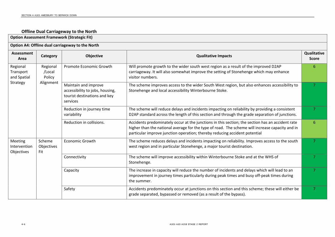
Offline Dual Carriageway to the North Option Assessment Framework (Strategic Fit)
Option A4: Offline dual carriageway to the North
Assessment Area Category Objective Qualitative Impacts Qualitative
Score
Regional Transport and Spatial Strategy
Regional /Local Policy
Alignment
Promote Economic Growth Will promote growth to the wider south west region as a result of the improved D2AP carriageway. It will also somewhat improve the setting of Stonehenge which may enhance visitor numbers.
6
Maintain and improve accessibility to jobs, housing, tourist destinations and key services
The scheme improves access to the wider South West region, but also enhances accessibility to Stonehenge and local accessibility Winterbourne Stoke.
7
Reduction in journey time variability
The scheme will reduce delays and incidents impacting on reliability by providing a consistent D2AP standard across the length of this section and through the grade separation of junctions.
7
Reduction in collisions. Accidents predominately occur at the junctions in this section; the section has an accident rate higher than the national average for the type of road. The scheme will increase capacity and in particular improve junction operation; thereby reducing accident potential
6
Meeting Intervention Objectives
Scheme Objectives Fit
Economic Growth The scheme reduces delays and incidents impacting on reliability. Improves access to the south west region and in particular Stonehenge, a major tourist destination.
7
Connectivity The scheme will improve accessibility within Winterbourne Stoke and at the WHS of Stonehenge.
7
Capacity The increase in capacity will reduce the number of incidents and delays which will lead to an improvement in journey times particularly during peak times and busy off-peak times during the summer.
7
Safety Accidents predominately occur at junctions on this section and this scheme; these will either be grade separated, bypassed or removed (as a result of the bypass).
7
4-6 A303 A30 A358 STAGE 2 REPORT

SECTION 4 A303 AMESBURY TO BERWICK DOWN
Option Assessment Framework (Strategic Fit)
Option A4: Offline dual carriageway to the North
Assessment Area Category Objective Qualitative Impacts Qualitative
Score
Resilience The increase in capacity is likely to lead to a reduction in accidents, improvements to journey times and reliability. The provision of additional lanes improves resilience of the network when incidents do occur.
6
Environmental This option harms the setting of key monuments in the WHS, severs the northern part of the WHS and Larkhill, increases noise in Larkhill and provides a larger barrier to biodiversity. Accidents will be reduced.
2
Option Assessment Framework (Value for Money)
Option A4: Offline dual carriageway to the North
Objective Sub-Objective Qualitative Impacts Quantitative Measures Qualitative
Score
Economy Business Users & Transport Providers
Journey times will improve and vehicle operating costs will be reduced due to higher travel speeds for users travelling at congested times. The increase in capacity will also reduce delays which will improve reliability. Increasing the capacity on this section of the A303 will also lead to connectivity benefits for business users and freight through the improvement in linkages between locations of economic importance in the region.
To be quantified in Stage 3. 7
Reliability Reduces delays and incidents impacting on reliability particularly at peak times and during the busier summer months
None. 6
Regeneration Improves access to the south west region and also to Stonehenge WHS. None. 6
Environment Noise It is anticipated that the tunnelling of the A303 will reduce noise pollution in the vicinity of the WHS and that the bypass of Winterbourne Stoke will have a similar effect on residents living there. The road does come close to Larkhill however, and there will be negative impacts here as a result.
None 3
A303 A30 A358 STAGE 2 REPORT 4-7

SECTION 4 A303 AMESBURY TO BERWICK DOWN
Option Assessment Framework (Value for Money)
Option A4: Offline dual carriageway to the North
Objective Sub-Objective Qualitative Impacts Quantitative Measures Qualitative
Score
Air Quality Given that the proposed interventions are aimed at reducing congestion and encouraging the free flow of traffic, both of which will benefit local air quality, the overall the effects of the scheme are considered to be positive in terms of air quality.
The above does not take into account any redistribution effects which may occur as a result of the proposed interventions.
None 5
Greenhouse Gases
Lane widening will result in an increase in traffic, which may be partially offset by reduced emissions from free flowing traffic at 60-70mph
None 3
Landscape In broad terms the landscape character of the area is largely rural with large field patterns and intermitted individual properties. An urban area of residential properties lies to the north at Larkhill, to the west at Winterbourne Stoke and the east at Amesbury.
Overall this option will have a larger impact on the wider landscape character where the scheme goes off line.
This will have a large adverse impact on landscape
1
Townscape This section is mainly rural, although the village of Larkhill lies to the north of Stonehenge and the hamlet of Winterbourne Stoke to the west. The scheme bypasses the latter and will come close to the former; although will provide better access which will help serve the proposed new dwellings.
The scheme is considered to have a beneficial impact on
townscape.
5
Historic Environment
This section of road includes Stonehenge; a World Heritage Site. This option removes the A303 from its existing close proximity to the site; although the realigned road will split Stonehenge from other monuments and in addition the road will still be visible from the WHS.
This option is likely to have a large adverse impact upon
the setting of the WHS
1
Biodiversity This section of the A303 runs through an Area of Outstanding Natural Beauty, and also contains a National Nature Reserve, Special Area of Conservation, Special Area of Conservation for Bats and a Special Protection Area.
This option is expected to have a large adverse impact
on biodiversity given the predominately surface nature of the scheme.
1
4-8 A303 A30 A358 STAGE 2 REPORT

SECTION 4 A303 AMESBURY TO BERWICK DOWN
Option Assessment Framework (Value for Money)
Option A4: Offline dual carriageway to the North
Objective Sub-Objective Qualitative Impacts Quantitative Measures Qualitative
Score
Water Environment
This section has land which falls into Flood Zones 1 and 2. None 4
Society Impact
Non-business users
Journey times will improve and vehicle operating costs will be reduced for users travelling at congested times. The increase in capacity should reduce the number of incidents and delays and lead to an increase in reliability. There will be some connectivity benefits but not as great as for business users as leisure trips are more likely to be undertaken at less congested times.
To be quantified in Stage 3. 6
Physical Activity
It is thought to be unlikely that the scheme will significantly impact on the number of walking and cycling trips.
None. 4
Journey Quality
There may be a small reduction in traveller stress due to fewer delays which may reduce frustration and the fear of being involved in an accident may also be reduced.
None. 5
Accidents The scheme will help reduce the accident potential as a result of grade separating junctions. To be quantified in Stage 3. 6
Security The scheme is unlikely to have any impact on the risk of crime. None. 4
Access to Services
There will enhanced access to the World Heritage site. None. 5
Affordability Will result in a reduction in vehicle operating cost (VOC) as a result of reduced queuing. None. 5
Severance The scheme will have no impact on the routes used by pedestrians, cyclists and equestrians. None. 4
Option Values
There is unlikely to be any impact on option values as a result of the scheme. None. 4
Public Accounts
Cost to Transport Budget
To be provided in Stage 3 None. N/A
Indirect Tax Revenues
There may be a small reduction in indirect tax revenue due to the increased capacity which may lead to less start-stopping and therefore reduce fuel consumption.
None. 3
A303 A30 A358 STAGE 2 REPORT 4-9

SECTION 4 A303 AMESBURY TO BERWICK DOWN
Option Assessment Framework (Value for Money)
Option A4: Offline dual carriageway to the North
Objective Sub-Objective Qualitative Impacts Quantitative Measures Qualitative
Score
Indicative Benefit Cost Ratio
Cost to Private Sector
Zero. Zero. N/A
Indicative Net Present Value
Not calculated at this stage. To be quantified in Stage 3. N/A
Indicative BCR
Not calculated at this stage. To be quantified in Stage 3. N/A
Option Assessment Framework (Financial Case)
Option A4: Offline dual carriageway to the North
Assessment Area Category Qualitative Impacts Quantitative Measures Qualitative
Score
Capital and Revenue Costs
Outturn cost to implement
To be provided in Stage 3 N/A N/A
Operating and Maintenance Costs
To be provided in Stage 3 N/A N/A
Funding Assumptions
Funding Allocation
The scheme would be funded by Central Government. None. N/A
4-10 A303 A30 A358 STAGE 2 REPORT

SECTION 4 A303 AMESBURY TO BERWICK DOWN
Option Assessment Framework (Delivery Case)
Option A4: Offline dual carriageway to the North
Assessment Area Qualitative Impacts Quantitative Measures
Qualitative Score
Likely Delivery Agents Highways Agency will be the delivery agents. None 5
Stakeholder Acceptability TBC at a later stage None
Public Acceptability / Interest
TBC at a later stage None
Option Assessment Framework (Commercial Case)
Option A4: Offline dual carriageway to the North
Assessment Area Qualitative Impacts Quantitative Measures
Qualitative Score
Route to Market Scheme to be financed by Central Government. Construction of tunnel likely to be highest risk element of scheme None 4
Table 4-4: Amesbury to Berwick Down Option Assessment - Option A4 Offline Dual Carriageway to the North
A303 A30 A358 STAGE 2 REPORT 4-11


SECTION 5
A303 Chicklade Bottom to Mere
5.1 Context 5.1.1 Overview The Chicklade Bottom to Mere section of the A303 is located approximately 25km west of Stonehenge and 11km south of Warminster. It is approximately 12km in length and predominantly of single two-lane standard with two single three-lane (2+1) sections (approx. 500m and 1000m long) at the steepest locations. It is intersected by a number of side roads of varying classification all of which form at-grade junctions with the A303 except for the A350 which is grade-separated. The road severs the village of Chicklade (where the speed limit is restricted to 50mph) and incorporates various private means of access, lay-bys, service areas, etc. throughout, which are accessed directly from the A303. No lighting is provided along the length of this section.
Figure 5.1: Chicklade Bottom to Mere section
5.1.2 Existing Issues and Challenges On this section of the A303, the existing issues are congestion and safety. The 2010 Annual Average Daily Traffic flow was around 19,000 which is significantly above the maximum 13,000 recommended by current Highways Agency guidance for this standard of road. At peak times traffic tends to move slowly with very long queues. Queues also occur at the end of the dual carriageway sections approach the single carriageway section, as traffic merges from two lanes into one. The ratio of road users Killed or Seriously Injured (KSI) is around 24.5% (2007-2012 data) compared to the national average of approximately 19.1% for the same period on rural A-roads. Accident clusters have been recorded at the junction with the A350 and on Chaddenwick Hill. The junction with Fonthill Bishop Road located approximately 400m east of the start of the single carriageway section (2.7km east of Chicklade) is also a site of concern regarding accidents. Several non-motorised user (NMU) routes intersect the A303 along this section including the Ox Drove track and the Wessex Ridgeway. Issues with NMU facilities have also been identified to the east of Mere bypass, at crossings to the west of The Cleave and on Chaddenwick Hill. The A303 through Chicklade has also been identified (by the Department for Food & Rural Affairs (Defra)) as an ‘important area’ for noise pollution, i.e. within the top one percent of noisiest locations adjacent to major roads in the UK.
A303 A30 A358 STAGE 2 REPORT 5-1

SECTION 5 A303 CHICKLADE BOTTOM TO MERE
The entirety of this section is located within or directly adjacent to the Cranborne Chase and West Wiltshire Downs Area of Outstanding Natural Beauty (AONB), the Sites of Special Scientific Interest (SSSI) impact risk zones of Whitesheet Hill, Hang Wood, Fonthill Grottoes and Charnage Down Chalk Pit, and the South Wessex Downs Environmentally Sensitive Area. The area is also sensitive in terms of archaeology and includes numerous Scheduled Monuments (such as the Medieval Field System to the northeast of Mere) within close proximity of the existing road. Any scheme to upgrade the A303 would inevitably result in some disruption to the historic landscape in the area, including potential impact on the Ox Drove track. Therefore off-line proposals around the Chicklade area would be likely to generate significant landscape and visual impacts. Moreover, they would result in the loss of nationally important Calcareous Grassland and may have indirect impacts on specially designated areas of ecological and geological merit.
5.2 Option Determination 5.2.1 Option Generation A range of options have been examined for this section to address the objectives set out in Table 2.3. These are given in some detail below but are summarised in the table below:
Option Brief Description Impacts B1 Speed Limit
Reduction a. Minor improvement in journey time reliability. b. Minor increase in capacity.
B2 Right Turn Provision
a. Reduction in conflicting traffic movements – improved safety. b. Limited increased capacity – reduce congestion c. Minor improvement in journey time reliability
B3 Grade separated Interchange and Junction Improvements
a. Increased capacity – reduce congestion. b. Reduction in conflicting traffic movements c. Minor improvement in journey time reliability.
Partially addresses identified safety issues. B4 On-line and Off-
line widening a. Increase capacity – reduce congestion. b. Provide overtaking opportunities – improved vehicular throughput. c. Improvement in journey time reliability. d. Construction to current standards. e. Removal of conflict with NMU’s. f. Addresses identified safety issues
B5 Offline widening a. Increase capacity – reduce congestion. b. Provide overtaking opportunities – improved vehicular throughput. c. Improvement in journey time reliability. d. Construction to current standards e. Removal of conflict with NMU’s. f. Removal of local traffic – increased capacity on A303. g. Addresses identified safety issues.
Table 5-1: Summary of Options for Chicklade Bottom to Mere
5.2.1.1 Speed Limit Reduction (Option B1) This option makes no physical changes to the A303 in this section, but reduces the speed limit to 50mph for its duration in both directions.
5.2.1.2 Right Turn Provision (Option B2) This option would maintain the existing alignment and number of lanes on the A303, but would provide improvements at junctions for right turners through the introduction of features such as right turning lanes, ghost islands and hatched centre markings.
5-2 A303 A30 A358 STAGE 2 REPORT
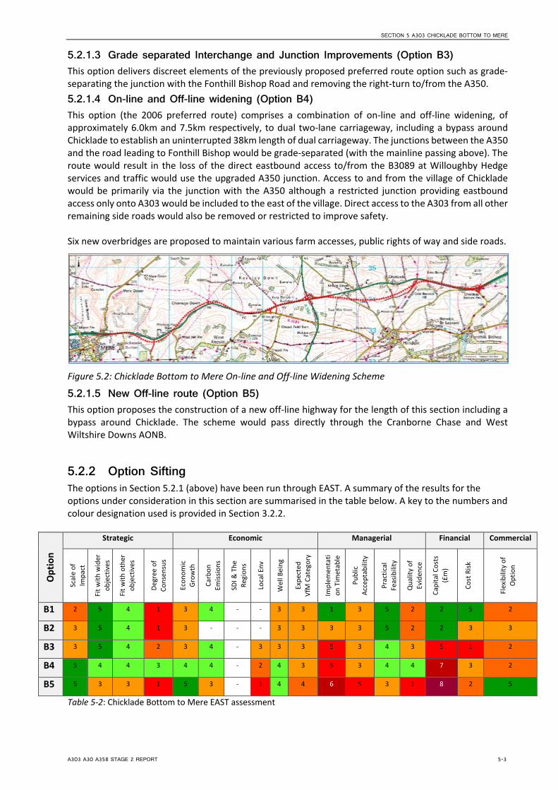
SECTION 5 A303 CHICKLADE BOTTOM TO MERE
5.2.1.3 Grade separated Interchange and Junction Improvements (Option B3) This option delivers discreet elements of the previously proposed preferred route option such as grade-separating the junction with the Fonthill Bishop Road and removing the right-turn to/from the A350. 5.2.1.4 On-line and Off-line widening (Option B4) This option (the 2006 preferred route) comprises a combination of on-line and off-line widening, of approximately 6.0km and 7.5km respectively, to dual two-lane carriageway, including a bypass around Chicklade to establish an uninterrupted 38km length of dual carriageway. The junctions between the A350 and the road leading to Fonthill Bishop would be grade-separated (with the mainline passing above). The route would result in the loss of the direct eastbound access to/from the B3089 at Willoughby Hedge services and traffic would use the upgraded A350 junction. Access to and from the village of Chicklade would be primarily via the junction with the A350 although a restricted junction providing eastbound access only onto A303 would be included to the east of the village. Direct access to the A303 from all other remaining side roads would also be removed or restricted to improve safety. Six new overbridges are proposed to maintain various farm accesses, public rights of way and side roads.
Figure 5.2: Chicklade Bottom to Mere On-line and Off-line Widening Scheme
5.2.1.5 New Off-line route (Option B5) This option proposes the construction of a new off-line highway for the length of this section including a bypass around Chicklade. The scheme would pass directly through the Cranborne Chase and West Wiltshire Downs AONB.
5.2.2 Option Sifting The options in Section 5.2.1 (above) have been run through EAST. A summary of the results for the options under consideration in this section are summarised in the table below. A key to the numbers and colour designation used is provided in Section 3.2.2.
Opt
ion
Strategic Economic Managerial Financial Commercial
Scal
e of
Im
pact
Fit w
ith w
ider
ob
ject
ives
Fit w
ith o
ther
ob
ject
ives
Degr
ee o
f Co
nsen
sus
Econ
omic
Gr
owth
Carb
on
Emiss
ions
SDI &
The
Re
gion
s
Loca
l Env
Wel
l Bei
ng
Expe
cted
Vf
M C
ateg
ory
Impl
emen
tati
on T
imet
able
Publ
ic
Acce
ptab
ility
Prac
tical
Fe
asib
ility
Qua
lity
of
Evid
ence
Capi
tal C
osts
(£
m)
Cost
Risk
Flex
ibili
ty o
f O
ptio
n
B1 2 5 4 1 3 4 - - 3 3 1 3 5 2 2 5 2
B2 3 5 4 1 3 - - - 3 3 3 3 5 2 2 3 3
B3 3 5 4 2 3 4 - 3 3 3 5 3 4 3 5 1 2
B4 5 4 4 3 4 4 - 2 4 3 5 3 4 4 7 3 2
B5 5 3 3 1 5 3 - 1 4 4 6 5 3 1 8 2 5
Table 5-2: Chicklade Bottom to Mere EAST assessment
A303 A30 A358 STAGE 2 REPORT 5-3

SECTION 5 A303 CHICKLADE BOTTOM TO MERE
The EAST assessment above identifies that Options B1, B2 and B3 are not of a sufficient scale to provide sufficient resolution to the issues along this stretch of the A303 and in addition no consultation has taken place to understand what level of support these schemes would gain. Whilst Option B5 enables full resolution of the issues along the corridor, it scores poorly in relation to the local environment given its complete offline nature and that it passes through the AONB. In addition, this option would be expensive, take more time to construct and is likely to be unpopular with the public. This option has therefore also been discounted. Option B4 meanwhile scores well on a number of categories, although it is noted that there will be environmental impacts, especially where the route goes offline. As it scores better than the other options considered for this section Option B4 has subsequently been considered further in the following Option Assessment section.
5.2.3 Option Assessment As described in paragraph 3.2.3 the better performing option (B4) has been assessed against the Transport Business Case criteria using the Option Assessment Framework, provided within the TAG Unit. Table 5.3 following detail the appraisal of the areas outlined in the framework, including:
• Strategic Fit; • Value for Money, • Financial Case; • Delivery Case; and • Commercial Case.
In line with TAG, the appraisals have used a 7 point scale of impacts in providing a (largely) qualitative assessment of the scale of impacts with a value of 1 being large adverse and 7 large beneficial (as shown in Table 3.2).
5-4 A303 A30 A358 STAGE 2 REPORT

SECTION 5
Online and Offline Widening Option Assessment Framework (Strategic Fit)
Option B4: Online and Offline Widening
Assessment Area Category Objective Qualitative Impacts Qualitative
Score
Regional Transport and Spatial Strategy
Regional / Local Policy Alignment
Promote Economic Growth Promotes economic growth through the provision of a route constructed to a higher standard and one that better facilitates cross movements.
6
Improve accessibility to jobs, housing, tourist destinations and key services
Accessibility both along and across this section of the corridor will be improved through both links and junctions with higher levels of capacity thus able to provide better accessibility for all modes.
7
Reduction in journey time variability
The scheme will reduce delays and incidents impacting on reliability by providing a consistent standard of carriageway along its length and grade separating junctions.
7
Reduction in collisions. Accidents currently occur at a number of junction hotspots and on both existing and dualled sections of carriageway. The scheme will increase capacity and thereby reduce delays, and the impact of safety issues and merging. Upgrades to existing NMU facilities will be provided; including those as already flagged as inadequate.
6
Meeting Intervention Objectives
Scheme Objectives Fit
Economic Growth The scheme reduces delays and incidents impacting on reliability. Improves access to the South West and provides a second strategic corridor.
6
Connectivity The scheme will improve accessibility to the South West region. 6
Capacity The increase in capacity will reduce the number of incidents and delays which will lead to an improvement in journey times particularly during peak times and off peak during the summer when flows are higher.
7
Safety Section currently experiences high flows accidents at a number of clusters as well as on single and dualled link sections. Scheme is designed to increase capacity and thereby reduce delays, impact of safety issues.
6
A303 A30 A358 STAGE 2 REPORT 5-5

SECTION 5 A303 CHICKLADE BOTTOM TO MERE
Option Assessment Framework (Strategic Fit)
Option B4: Online and Offline Widening
Assessment Area Category Objective Qualitative Impacts Qualitative
Score
Resilience The increase in capacity is likely to lead to a reduction in accidents, improvements to journey times and reliability. The provision of additional lanes improves resilience of the network when incidents do occur.
6
Environmental The scheme will affect the local environment, especially where it goes offline. It will however remove traffic from Chicklade and will increase the free-flow of traffic which will reduce emissions but will increase noise. There will be potential effects on the Calcareous Grassland and AONB.
2
Option Assessment Framework (Value for Money)
Option B4: Online and Offline Widening
Objective Sub-Objective Qualitative Impacts Quantitative Measures Qualitative
Score
Economy Business Users & Transport Providers
Journey times will improve and vehicle operating costs will be reduced due to higher travel speeds for users travelling at congested times. The increase in capacity will also reduce delays which will improve reliability. Increasing the capacity on this section of the A303 will also lead to connectivity benefits for business users and freight through the improvement in linkages between locations of economic importance in the region.
To be quantified in Stage 3. 7
Reliability Reduces delays and incidents impacting on reliability particularly at peak times. None. 6
Regeneration Improves access to the south west region. None. 6
Environment Noise Off-line widening is likely to increase overall noise emissions due to decreasing congestion (free flowing traffic generally produces more noise), and likely marginal increase in road users on this section.
None 3
5-6 A303 A30 A358 STAGE 2 REPORT

SECTION 5 A303 CHICKLADE BOTTOM TO MERE
Option Assessment Framework (Value for Money)
Option B4: Online and Offline Widening
Objective Sub-Objective Qualitative Impacts Quantitative Measures Qualitative
Score
The spatial effects of widening (i.e. carriageway approaches closer to receptors) are likely to be negligible, except for properties located very close to the existing carriageway (i.e. within 7-8m).
Removal of the A303 from Chicklade will benefit properties within the village; the road through this village is currently classed within the top1% of locations close to a major route in the UK.
Air Quality The Off-line widening would result in a limited number of properties being located closer to the carriageway. Similarly, the on-line widening element would result in existing sensitive receptors (e.g. residential dwellings) being located closer to the existing carriageway. These properties may experience a slight worsening in air quality as a result of the proposed interventions.
These effects will be partially offset by the increased distance between properties in Chicklade and associated improvement in air quality.
Notwithstanding the above, given that the proposed interventions are aimed at reducing congestion and encouraging the free flow of traffic, both of which will benefit local air quality, the overall effects of the scheme are considered to be positive in terms of air quality.
The above does not take into account any redistribution effects which may occur as a result of the proposed interventions.
None 4
Greenhouse Gases
Lane widening will result in an increase in traffic, which may be partially offset by reduced emissions from free flowing traffic at 60-70mph
None 3
Landscape In broad terms the landscape character of the area is largely rural with large field patterns and intermitted individual properties. A small urban area of residential properties lie in the villages of Chicklade and Mere.
Cranborne Chase and West Wiltshire Downs AONB and 4 Sites of Special Scientific Interest (SSSI) lie either within or adjacent to this section of the route
There is also a nationally important area of Calcareous Grassland which will be affected by the scheme.
Large impact where scheme is off-line
2
A303 A30 A358 STAGE 2 REPORT 5-7

SECTION 5 A303 CHICKLADE BOTTOM TO MERE
Option Assessment Framework (Value for Money)
Option B4: Online and Offline Widening
Objective Sub-Objective Qualitative Impacts Quantitative Measures Qualitative
Score
Overall this option will have a larger impact on the wider landscape character where the scheme goes off line. The on-line widening through this section may have a short to medium term moderate potential impact on the rural character due to vegetation removal.
Townscape This section is of the route is in a predominantly rural area with a limited number of dwellings in Chicklade and a larger number within the village of Mere.
Expected to have a minimal effect on Townscape.
3
Historic Environment
There are a number of scheduled monuments in this section including a medieval field system and the Ox Drove track. Off-line works within this section are likely to cause harm to this section
This option is likely to have an impact upon scheduled
monuments within the section
2
Biodiversity This section is within an AONB and close to 4 SSSIs. The scheme will also affect an area of Calcareous Grassland.
This section is also designated as a Special Area of Conservation for Bats.
This option is expected to have a neutral impact on
biodiversity given the predominately online nature
of the scheme.
2
Water Environment
This section of the A303 has elements which fall into Flood Risk categories 1 and 2. None. 4
Society Impact
Non-business users
Journey times will improve and vehicle operating costs will be reduced for users travelling at congested times. The increase in capacity should reduce the number of incidents and delays and lead to an increase in reliability. There will be some connectivity benefits but not as great as for business users as leisure trips are more likely to be undertaken at less congested times although benefit will be felt during the busier summer months when there are increased numbers of non-business users on the corridor
To be quantified in Stage 3. 6
Physical Activity
It is thought to be unlikely that the scheme will significantly impact on the number of walking and cycling trips.
None. 4
5-8 A303 A30 A358 STAGE 2 REPORT
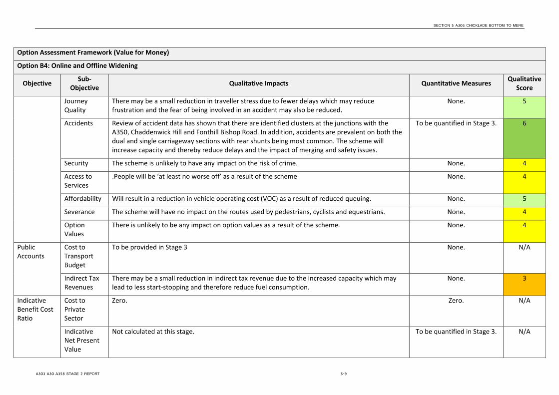
SECTION 5 A303 CHICKLADE BOTTOM TO MERE
Option Assessment Framework (Value for Money)
Option B4: Online and Offline Widening
Objective Sub-Objective Qualitative Impacts Quantitative Measures Qualitative
Score
Journey Quality
There may be a small reduction in traveller stress due to fewer delays which may reduce frustration and the fear of being involved in an accident may also be reduced.
None. 5
Accidents Review of accident data has shown that there are identified clusters at the junctions with the A350, Chaddenwick Hill and Fonthill Bishop Road. In addition, accidents are prevalent on both the dual and single carriageway sections with rear shunts being most common. The scheme will increase capacity and thereby reduce delays and the impact of merging and safety issues.
To be quantified in Stage 3. 6
Security The scheme is unlikely to have any impact on the risk of crime. None. 4
Access to Services
.People will be ‘at least no worse off’ as a result of the scheme None. 4
Affordability Will result in a reduction in vehicle operating cost (VOC) as a result of reduced queuing. None. 5
Severance The scheme will have no impact on the routes used by pedestrians, cyclists and equestrians. None. 4
Option Values
There is unlikely to be any impact on option values as a result of the scheme. None. 4
Public Accounts
Cost to Transport Budget
To be provided in Stage 3 None. N/A
Indirect Tax Revenues
There may be a small reduction in indirect tax revenue due to the increased capacity which may lead to less start-stopping and therefore reduce fuel consumption.
None. 3
Indicative Benefit Cost Ratio
Cost to Private Sector
Zero. Zero. N/A
Indicative Net Present Value
Not calculated at this stage. To be quantified in Stage 3. N/A
A303 A30 A358 STAGE 2 REPORT 5-9
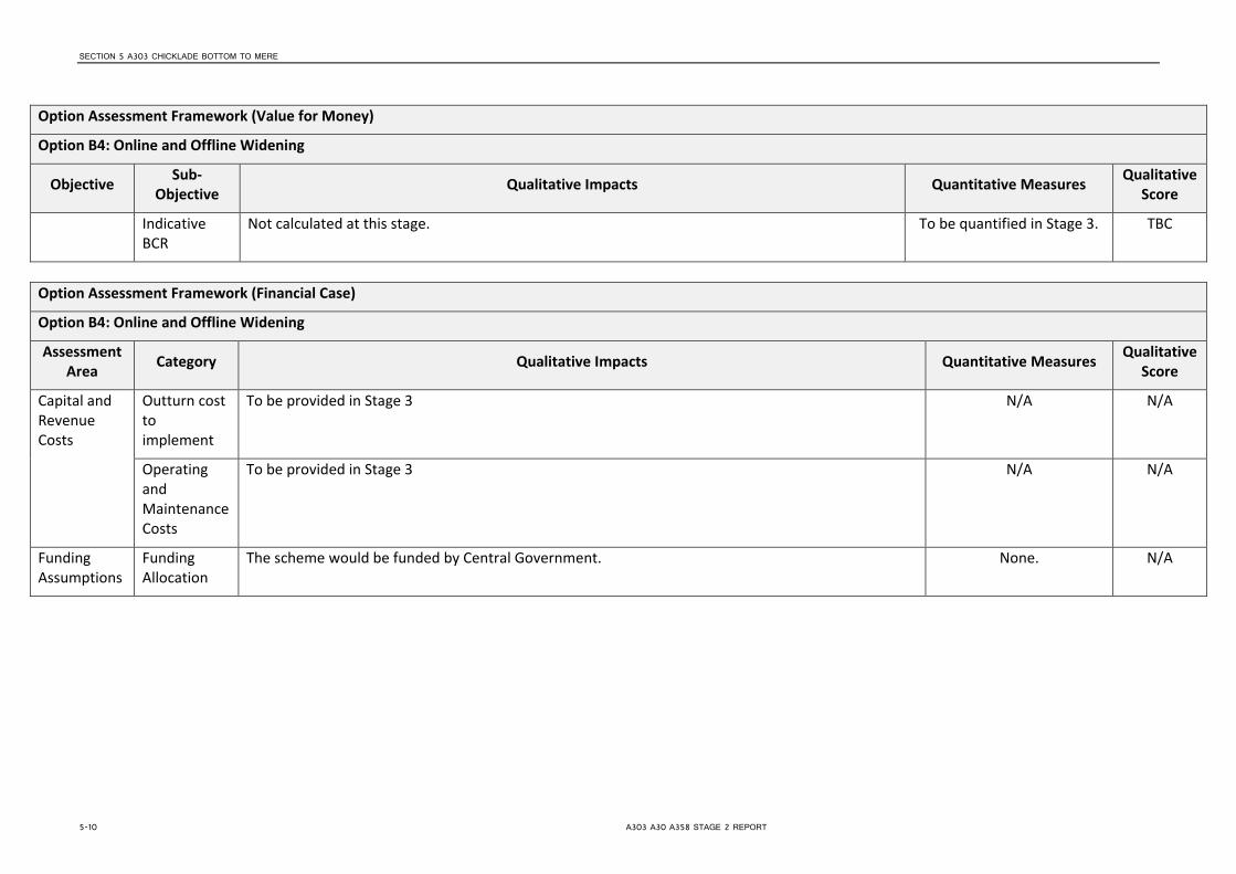
SECTION 5 A303 CHICKLADE BOTTOM TO MERE
Option Assessment Framework (Value for Money)
Option B4: Online and Offline Widening
Objective Sub-Objective Qualitative Impacts Quantitative Measures Qualitative
Score
Indicative BCR
Not calculated at this stage. To be quantified in Stage 3. TBC
Option Assessment Framework (Financial Case)
Option B4: Online and Offline Widening
Assessment Area Category Qualitative Impacts Quantitative Measures Qualitative
Score
Capital and Revenue Costs
Outturn cost to implement
To be provided in Stage 3 N/A N/A
Operating and Maintenance Costs
To be provided in Stage 3 N/A N/A
Funding Assumptions
Funding Allocation
The scheme would be funded by Central Government. None. N/A
5-10 A303 A30 A358 STAGE 2 REPORT

SECTION 5 A303 CHICKLADE BOTTOM TO MERE
Option Assessment Framework (Delivery Case)
Option B4: Online and Offline Widening
Assessment Area Qualitative Impacts Quantitative Measures
Qualitative Score
Likely Delivery Agents There are some issues regarding the deliverability of scheme, especially construction of offline section. Highways Agency will be the delivery agents.
None 5
Stakeholder Acceptability TBC at a later stage None -
Public Acceptability / Interest
TBC at a later stage None -
Option Assessment Framework (Commercial Case)
Option A4: Online and Offline Widening
Assessment Area Qualitative Impacts Quantitative Measures
Qualitative Score
Route to Market Scheme to be financed by Central Government. Construction of new bridge likely to be highest risk element of scheme None 4
Table 5-3: Chicklade Bottom to Mere Option Assessment – On-line and Off-line Widening
A303 A30 A358 STAGE 2 REPORT 5-11


SECTION 6
A303 Sparkford to Ilchester
6.1 Context 6.1.1 Overview This section of the A303 is located approximately 30km east of the M5 motorway and 10km north of Yeovil. It is approximately 5.5km in length and predominantly of single two-lane standard with a short (350m) single three-lane section immediately west of the A359 roundabout at Sparkford. There are numerous side road junctions providing access to surrounding villages, service areas and directly to individual properties. A 50mph speed limit applies throughout this section of the road and there are limited overtaking opportunities. No street lighting is provided along the entire section except for the roundabout with the A359 and its immediate approaches. An improvement to this section of road has been considered previously during the 1990s and went to Public Inquiry in 1994. Orders (except CPOs) were made in 1995 and then revived in 2001 at the same time as the South West Area Multi Modal Study (SWARMMS) was being undertaken. That report recommended that the scheme should be taken forward with a number of specific elements identified for review, particularly at the eastern end of the scheme In October 2003, following further development of the scheme, a Public Exhibition was held. The revised scheme incorporated some changes to the original along with revisions to design standards. A Public Inquiry based on the revised scheme was not undertaken and subsequently no new Orders were made. Further scheme development was stopped in 2005.
Figure 6.1: Sparkford to Ilchester section
6.1.2 Existing Issues and Challenges
The main issues with this section of the A303 are safety and congestion. Traffic flows is around 22,000 (2002 AADT) and significantly above the maximum 13,000 recommended by current Highways Agency guidance for the existing standard of road. The ratio of road users Killed or Seriously Injured (KSI) is approximately 13.4% (2007-2012 data) compared to the national average of approximately 19.1% for the same period on rural A-roads. Accident clusters have been identified at Hazelgrove Roundabout (A359 junction) but there are no other specific sites of concern along the remainder of the section.
A303 A30 A358 STAGE 2 REPORT 6-1

SECTION 6 A303 SPARKFORD TO ILCHESTER
Several non-motorised user (NMU) routes intersect the A303 along this section of the road with particular issues identified at the junction with the B3151, Gason Lane and west of Sparkford Roundabout.
6.2 Option Determination 6.2.1 Option Generation A range of options have been examined for this section to address the objectives set out in Table 2.3. These are presented in some detail below but are summarised in the table below:
Option Brief Description Impacts C1 Minor
Improvements (signs & lining)
a. Limited due to the fact that many such changes have already been implemented and benefits realised.
b. May partially address identified safety issues C2 Targeted Junction
Improvements a. Reduction in conflicting traffic movements
Addressess identified safety issues. C3 On-line Widening a. Increased capacity – reduce congestion.
b. Provide overtaking opportunities – improved vehicular throughput. c. Minor improvement in journey time reliability. d. Addresses identified safety issues.
C4 Combination of on-line and off-line widening
a. Increase capacity – reduce congestion. b. Provide overtaking opportunities – improved vehicular throughput. c. Improvement in journey time reliability. d. Construction to current standards. e. Removal of conflict with NMU’s. f. Removal of local traffic – increased capacity on A303. g. Addresses identified safety issues.
Table 6-1: Summary of Options for Sparkford to Ilchester
6.2.1.1 Minor Improvements (Option C1) The A303/A30 Corridor Management Study Solutions Report2 identified the following additional improvements that could potentially be implemented to address some of the issues identified above: Hazelgrove Roundabout
• Closing the A359 to Sparkford (provide a new westbound junction with the A303 to the east of the village);
• Spiral road markings; • Dedicated left turn (from the westbound A303 onto the A359); • Traffic signals.
Eastbound Dual to Single Lane Merge (East of Podimore) • Introduce a 50mph speed limit in advance of the merge; • Install Managed Merge Control; • Reduce eastbound carriageway to one lane (from Podimore Roundabout).
6.2.1.2 Targeted Junction Improvements (Option C2) Delivering the discreet elements of the scheme proposed at the 2003 Public Exhibition, such as grade-separating the Camel Cross junction and Hazelgrove Roundabout as well as removing the junction at Conegore Corner, would improve safety but is unlikely to result in significant benefits or a positive BCR without the increase in mainline capacity. Such improvements would also require greater land acquisition
2 A303/A30 Corridor Management Study, Highways Agency, February 2010
6-2 A303 A30 A358 STAGE 2 REPORT

SECTION 6 A303 SPARKFORD TO ILCHESTER
and result in greater environmental impact which may not be acceptable if the objectives are only partially addressed. 6.2.1.3 On-line widening to Single Three Lane Carriageway (Option C3) Widening the existing carriageway to three lanes and alternating the two lane provision in each direction would help to improve performance by increasing capacity and providing suitable overtaking opportunities. Consequently, however, safety at side road junctions would be compromised where traffic has to cross multiple lanes when turning right. There would also be limited opportunity to address any substandard alignment and non-motorised user issues. Such a scheme would, however, require less land acquisition when compared to a fully dualled option and therefore also have less environmental impact. 6.2.1.4 Combination of On-line and off-line Widening (Option C4) The Preferred Route presented at the 2003 Public Exhibition comprised a combination of on-line and off-line widening, of approximately 1.5km and 4.0km respectively, to dual two-lane carriageway establishing an uninterrupted dual carriageway of some 49km in length. The westbound slip road into Podimore would be closed and the road through Podimore linked to the B3131. The junctions with the B3151 and Plowage Lane at Camel Cross/Plowage would be combined and grade-separated with the mainline passing below in cutting. The route would result in the loss of direct access to/from both Steart Hill and Howell Hill (at Conegore Corner) which would be linked to the new junction at Camel Cross via the existing A303. Direct access to Traits Lane and Gason Lane would also be lost but would be linked to the grade-separated junction proposed at Hazelgrove Roundabout via a new underpass at Camel Hill and link road running adjacent to the proposed A303. Four new bridges would be required (two over and two under the mainline).
6.2.2 Option Sifting As detailed, the options described above have been run through EAST. A summary of the results for the options under consideration in this section are summarised in the table below. A key to the numbers and colour designation used is provided in Section 3.2.2.
Opt
ion
Strategic Economic Managerial Financial Commercial
Scal
e of
Im
pact
Fit w
ith w
ider
ob
ject
ives
Fit w
ith o
ther
ob
ject
ives
Degr
ee o
f Co
nsen
sus
Econ
omic
Gr
owth
Carb
on
Emiss
ions
SDI &
The
Re
gion
s
Loca
l Env
Wel
l Bei
ng
Expe
cted
Vf
M C
ateg
ory
Impl
emen
tati
on T
imet
able
Publ
ic
Acce
ptab
ility
Prac
tical
Fe
asib
ility
Qua
lity
of
Evid
ence
Capi
tal C
osts
(£
m)
Cost
Risk
Flex
ibili
ty o
f O
ptio
n
C1 1 3 4 3 2 4 2 5 3 3 3 3 5 3 3 3 3
C2 2 5 4 3 3 4 3 4 3 3 5 3 5 3 5 1 3
C3 3 5 4 1 4 4 4 3 3 3 5 3 4 3 4 3 3
C4 5 4 4 4 5 4 4 3 5 3 5 4 3 5 5 3 2
Table 6-2: Sparkford to Ilchester EAST assessment
The EAST assessment above identifies that Options C1, C2 and C3 are unlikely to offer sufficient resolution to the issues noted on this section of corridor. In addition, there is little degree of consensus over the schemes, particularly Option C3. Option C4 scores better than the other options over a number of categories and has subsequently assessed in the following Option Assessment section.
6.2.3 Option Assessment As described in paragraph 3.2.3 the better performing option (C4) has been assessed against the Transport Business Case criteria using the Option Assessment Framework, provided within the TAG Unit. Table 6.3 following detail the appraisal of the areas outlined in the framework, including:
A303 A30 A358 STAGE 2 REPORT 6-3

SECTION 6 A303 SPARKFORD TO ILCHESTER
• Strategic Fit; • Value for Money, • Financial Case; • Delivery Case; and • Commercial Case.
In line with TAG, the appraisals have used a 7 point scale of impacts in providing a (largely) qualitative assessment of the scale of impacts with a value of 1 being large adverse and 7 large beneficial (as shown in Table 3.2).
6-4 A303 A30 A358 STAGE 2 REPORT

SECTION 6
Option C4: Combination of On-line and Off-line Widening
Option Assessment Framework (Strategic Fit)
Option C4: Combination of On-line and Off-line Widening
Assessment Area Category Objective Qualitative Impacts Qualitative
Score
Regional Transport and Spatial Strategy
Regional / Local Policy Alignment
Promote Economic Growth Provides improved access along and across the corridor to enable improved economic activity. 6
Improve accessibility to jobs, housing tourist destinations and key services
Accessibility for all modes is enhanced by this schme for journeys both along and across the corridor.
7
Reduction in journey time variability
The scheme should reduce delays and incidents impacting on reliability through the provision of a consistent D2AP standard along its length and the closure or grade separation of a number of junctions, including the Hazelgrove roundabout at Sparkford which is an accident cluster.
7
Reduction in collisions. Accidents are lower than the national average for the type of road; although there is a cluster at the A359 Hazelgrove roundabout, which this scheme improves through grade separation.
5
Meeting Intervention Objectives
Scheme Objectives Fit
Economic Growth The scheme reduces delays and incidents impacting on reliability. Improves access to the South West.
6
Connectivity The scheme will improve connectivity to the South West region. 6
Capacity The increase in capacity will reduce the number of incidents and delays which will lead to an improvement in journey times particularly during peak times and the busier summer months.
7
Safety Accident issues on this section of corridor are lower than the national average for the type of road; however this is not reflected in the data utilised in SWARMMS; and further investigation is to be undertaken in Stage 3. However, the scheme is designed to increase capacity and thereby reduce delays and safety issues.
5
Resilience The increase in capacity is likely to lead to a reduction in accidents, improvements to journey times and reliability. The provision of additional lanes improves resilience of the network when incidents do occur.
6
A303 A30 A358 STAGE 2 REPORT 6-5

SECTION 6 A303 SPARKFORD TO ILCHESTER
Option Assessment Framework (Strategic Fit)
Option C4: Combination of On-line and Off-line Widening
Assessment Area Category Objective Qualitative Impacts Qualitative
Score
Environmental The impact of the scheme will be greatest where it goes offline. There will be an increase in noise due to the increase in free flowing traffic, but an expected decrease in emissions for the same reason. Overall it is expected that the environmental effect of the scheme will be slightly adverse.
3
Option Assessment Framework (Value for Money)
Option C4: Combination of On-line and Off-line Widening
Objective Sub-Objective Qualitative Impacts Quantitative Measures Qualitative
Score
Economy Business Users & Transport Providers
Journey times will improve and vehicle operating costs will be reduced due to higher travel speeds for users travelling at congested times. The increase in capacity will also reduce delays which will improve reliability. Increasing the capacity on this section of the A303 will also lead to connectivity benefits for business users and freight through the improvement in linkages between locations of economic importance in the region.
To be quantified in Stage 3. 7
Reliability Reduces delays and incidents impacting on reliability particularly at peak times. None. 6
Regeneration Improves access to the South West. None. 6
Environment Noise Off-line widening is likely to increase overall noise emissions due to decreasing congestion (free flowing traffic generally produces more noise), and likely marginal increase in road users on this segment.
The spatial effects of widening (i.e. carriageway approaches closer to receptors) are likely to be negligible, except for properties located very close to the existing carriageway (i.e. within 7-8m).
This section has a First Priority Location (as defined by Department for Environment Food and Rural Affairs (Defra)) within 1km of the scheme area.
None 3
6-6 A303 A30 A358 STAGE 2 REPORT

SECTION 6 A303 SPARKFORD TO ILCHESTER
Option Assessment Framework (Value for Money)
Option C4: Combination of On-line and Off-line Widening
Objective Sub-Objective Qualitative Impacts Quantitative Measures Qualitative
Score
Air Quality The proposed interventions are aimed at reducing congestion and encouraging the free flow of traffic, both of which will benefit local air quality, the overall the effects of the Scheme are considered to be positive in terms of air quality.
The above does not take into account any redistribution effects which may occur as a result of the proposed interventions.
None 5
Greenhouse Gases
Lane widening will result in an increase in traffic, which may be partially offset by reduced emissions from free flowing traffic at 60-70mph
None 3
Landscape In broad terms the landscape character of this section largely rural with large field patterns and intermitted individual properties. Urban areas of residential properties lie to the south at West Camel and Queen Camel.
Overall this option will have a larger impact on the wider landscape character where the scheme goes off line. The online widening through this section may have a short to medium term moderate potential impact on the rural character due to vegetation removal.
None 3
Townscape This section is mainly rural with urban areas limited to the south at West Camel and Queen Camel. None 4
Historic Environment
There is a Grade 1 listed building within this section. None 4
Biodiversity There is a SSSI within this section.
There is a Bat SAC within this section.
None 3
Water Environment
This section has areas within flood zones 1, 2 and 3.
TBC
None. 4
Society Impact
Non-business users
Journey times will improve and vehicle operating costs will be reduced for users travelling at congested times. The increase in capacity should reduce the number of incidents and delays and lead to an increase in reliability. There will be some connectivity benefits but not as great as for
To be quantified in Stage 3. 6
A303 A30 A358 STAGE 2 REPORT 6-7

SECTION 6 A303 SPARKFORD TO ILCHESTER
Option Assessment Framework (Value for Money)
Option C4: Combination of On-line and Off-line Widening
Objective Sub-Objective Qualitative Impacts Quantitative Measures Qualitative
Score
business users as leisure trips are more likely to be undertaken at less congested times; although it will benefit non business users during the busier summer months.
Physical Activity
It is thought to be unlikely that the scheme will significantly impact on the number of walking and cycling trips.
None. 4
Journey Quality
There may be a small reduction in traveller stress due to fewer delays which may reduce frustration and the fear of being involved in an accident may also be reduced.
None. 5
Accidents Accident statistics for the corridor are beneath the national average for the type of road; although a cluster has been noted at the A359 Hazelgrove roundabout.
To be quantified in Stage 3. 6
Security The scheme is unlikely to have any impact on the risk of crime. None. 4
Access to Services
People will be “at least no worse off” as a result of the scheme. None. 4
Affordability Will result in a reduction in vehicle operating cost (VOC) as a result of reduced queuing. None. 5
Severance The scheme will have no impact on the routes used by pedestrians, cyclists and equestrians. None. 4
Option Values
There is unlikely to be any impact on option values as a result of the scheme. None. 4
Public Accounts
Cost to Transport Budget
To be provided in Stage 3 None. N/A
Indirect Tax Revenues
There may be a small reduction in indirect tax revenue due to the increased capacity which may lead to less start-stopping and therefore reduce fuel consumption.
None. 3
Indicative Benefit Cost Ratio
Cost to Private Sector
Zero. Zero. N/A
6-8 A303 A30 A358 STAGE 2 REPORT

SECTION 6 A303 SPARKFORD TO ILCHESTER
Option Assessment Framework (Value for Money)
Option C4: Combination of On-line and Off-line Widening
Objective Sub-Objective Qualitative Impacts Quantitative Measures Qualitative
Score
Indicative Net Present Value
Not calculated at this stage. To be quantified in Stage 3. N/A
Indicative BCR
Not calculated at this stage. Anticipated capital cost likely to be high but maintenance and disruption costs likely to be very high in the Do Minimum scenario.
To be quantified in Stage 3. N/A
Option Assessment Framework (Financial Case)
Option C4: Combination of On-line and Off-line Widening
Assessment Area Category Qualitative Impacts Quantitative Measures Qualitative
Score
Capital and Revenue Costs
Outturn cost to implement
To be provided in Stage 3 N/A N/A
Operating and Maintenance Costs
To be provided in Stage 3 N/A N/A
Funding Assumptions
Funding Allocation
The scheme would be funded by Central Government. None. N/A
Option Assessment Framework (Delivery Case)
Option C4: Combination of On-line and Off-line Widening
A303 A30 A358 STAGE 2 REPORT 6-9

SECTION 6 A303 SPARKFORD TO ILCHESTER
Assessment Area Qualitative Impacts Quantitative Measures
Qualitative Score
Likely Delivery Agents There are some issues regarding the deliverability of scheme, especially construction of offline section. Highways Agency will be the delivery agents.
None 5
Stakeholder Acceptability TBC at a later stage None -
Public Acceptability / Interest
TBC at a later stage None -
Option Assessment Framework (Commercial Case)
Option C4: Combination of On-line and Off-line Widening
Assessment Area Qualitative Impacts Quantitative Measures
Qualitative Score
Route to Market Scheme to be financed by Central Government. Construction of new bridge likely to be highest risk element of scheme None 4
Table 6-3: Sparkford to Ilchester Option Assessment – Combination of On-line and Off-line Widening
6-10 A303 A30 A358 STAGE 2 REPORT

SECTION 7
A303 South Petherton to Southfields
7.1 Context 7.1.1 Overview This section of the A303 is located approximately 13km from the M5 motorway and runs in a predominantly east to west direction to the north of Ilminster. It is approximately 11km in length and single three-lane standard (2+1) throughout with an at-grade roundabout at each end. Hayes End Roundabout is located in the east at South Petherton and Southfields Roundabout, at the junction with the A358, in the west at Ilminster. Between the roundabouts there are no other junctions and all side roads pass either over or under the mainline. The national speed limit applies throughout this section of the road except for a 40mph section at Hayes End Roundabout which extends approximately 275m west. No street lighting is provided along the entire section except for the two roundabouts at either end. A scheme to widen this section of the route was developed in the early 1990s and was followed by the publication of the draft Orders and Environmental Statement in 1996. In 2007, further public consultation was undertaken which included proposals for upgrading (and adding to the trunk road network) the A358 between Southfields and the M5 as well as this section of the route.
Figure 7.1: South Petherton to Southfields section
7.1.2 Existing Issues and Challenges The main issues with this section of the A303 are safety and congestion. Traffic flow is around 26,000 (2010 AADT) and peaks in the summer months and at holiday weekends. This is significantly above the maximum 13,000 recommended by current Highways Agency guidance for a single two-lane road and as a result congestion occurs where the two-lane sections reduce to one lane. Peak time queuing also occurs at the two roundabouts at either end of the link. In conjunction with the areas of congestion, accidents are most prevalent at the two roundabouts and mainly comprise shunt type accidents on the approaches and the circulatory carriageways. It is possible that a contributory factor in the cause of accident at Southfields Roundabout was driver confusion over which exit to take, exacerbated by confusing road numbering, i.e. two exits named ‘A358’. At Hayes End Roundabout the report identified various issues which contribute to this location being a known accident cluster site. These include the high number of roundabout arms, poor deflection on the westbound approach and misleading signing. Historically, accidents on the link between the Southfields and Hayes End roundabouts in particular have been associated with overtaking at bends and where the lanes merge at the end of 2 lane sections. High speeds as a result of the large width and good visibility are also identified as problematic. Overall the ratio of road users Killed or Seriously Injured (KSI) is approximately 16.2% (2007-2012 data) compared to the national average of approximately 19.1% for the same period on rural A-roads. Several non-motorised user (NMU) routes intersect the A303 along this section of the road with particular issues identified at Upton Lane and near to Boxstone Hill.
Southfields Roundabout
Hayes End Roundabout
A303 A30 A358 STAGE 2 REPORT 7-1

SECTION 7 A303 SOUTH PETHERTON TO SOUTHFIELDS
There are a number of environmental features along this section of the route including Listed Buildings at Watergrove to the south of Hayes End Roundabout, Rolands Farm and Mill and Jordans Historic Park which lie within the Conservation Area of South Petherton, Dillington Historic Park at Whitelackington, and a number of sites of County Importance such as the remains of Chard Canal. The central section falls within a locally designated Special Landscape Area and high grade agricultural land straddles the majority of the route. The western section is within the River Isle floodplain.
7.2 Option Determination 7.2.1 Option Generation A range of options have been examined for this section which address the objectives set out in Table 2.3. These are provided in some detail below, but are initially summarised in the table below:
Option Brief Description Impacts D1 Southfields
Roundabout Improvements
a. Limited due to the fact that many such changes have already been implemented and benefits realised.
b. Partially addresses the identified safety issues D2 Hayes End
Roundabout Improvements
c. Limited due to the fact that many such changes have already been implemented and benefits realised.
d. Partially addresses the identified safety issues D3 Continuous Two-
Lane + One- Lane a. Increased capacity – reduce congestion. b. Provide overtaking opportunities – improved vehicular throughput. c. Minor improvement in journey time reliability.
D4 Online Dualling a. Increase capacity – reduce congestion. b. Provide overtaking opportunities – improved vehicular throughput. c. Improvement in journey time reliability. d. Construction to current standards. e. Removal of conflict with NMU’s. f. Addresses identified safety issues.
Table 7-1: Summary of Options for South Petherton to Southfields
7.2.1.1 Southfields Roundabout Improvements (Option D1) The A303/A30 Corridor Management Study Solutions Report3 identified the following improvements of varying scale that could help to reduce the congestion and safety issues at Southfields Roundabout:
• Improve road markings; • Divert traffic from the A358 (Horton Cross) off the roundabout; • Create a free flow left turn on the A358 approach to the junction; • Amend the shape of the roundabout and introduce traffic lights; • Widen the westbound exit from the roundabout to link to existing two-lane section; • Improve direction signage/ change road number of the A358.
7.2.1.2 Hayes End Roundabout (South Petherton) Improvements (Option D2) The A303/A30 Corridor Management Study Solutions Report identified the improvements of varying scale that could help to reduce the congestion and safety issues at Southfields Roundabout:
• Change layout of roundabout to four arms. • Signalise the roundabout.
7.2.1.3 Continuous Two-Lane + One-Lane (Option D3) Two lanes would be provided in the direction with the highest peak traffic flow and therefore help reduce the congestion and safety issues caused where two-lanes merge into one where the greater lane provision switches to the opposite direction. As a consequence, however, motorists in the single-lane direction could experience reduced
3 A303/A30 Corridor Management Study, Highways Agency, February 2010
7-2 A303 A30 A358 STAGE 2 REPORT

SECTION 7 A303 SOUTH PETHERTON TO SOUTHFIELDS
journey time reliability and increased frustration at the lack of overtaking opportunities and subsequently could result in them attempting dangerous manoeuvres.
7.2.1.4 Online Dualling between Southfields and Hayes End roundabouts (Option D4) The existing Ilminster Bypass was constructed in the late 1980’s and is therefore of a high standard. It may therefore be possible to provide the majority of a new dual-carriageway on-line thus minimising land-acquisition and direct environmental impact. Two over bridges would need to be widened to accommodate the dual-carriageway.
The junction at South Petherton (Hayes End) could be grade-separated. As shown (albeit indicatively) on the March 2007 Public Consultation and Exhibition leaflet a new junction could be located to the south west of the existing roundabout. The scale of improvements at Southfields Roundabout would largely depend on the strategy to be adopted for improving the route to the south west, i.e. whether to upgrade the A303/A30 between Ilminster and Exeter and/or the A358 to the M5.
7.2.2 Option Sifting As detailed, the options described above have been run through EAST. A summary of the results for the options under consideration in this section are summarised in the table below. A key to the numbers and colour designation used is provided in Section 3.2.2.
Opt
ion
Strategic Economic Managerial Financial Commercial
Scal
e of
Im
pact
Fit w
ith w
ider
ob
ject
ives
Fit w
ith o
ther
ob
ject
ives
Degr
ee o
f Co
nsen
sus
Econ
omic
Gr
owth
Carb
on
Emiss
ions
SDI &
The
Re
gion
s
Loca
l Env
Wel
l Bei
ng
Expe
cted
Vf
M C
ateg
ory
Impl
emen
tati
on T
imet
able
Publ
ic
Acce
ptab
ility
Prac
tical
Fe
asib
ility
Qua
lity
of
Evid
ence
Capi
tal C
osts
(£
m)
Cost
Risk
Flex
ibili
ty o
f O
ptio
n
D1 1 5 4 2 2 4 3 3 4 3 3 5 5 4 3 2 3
D2 1 5 4 2 2 4 3 3 4 3 3 3 5 4 2 2 2
D3 3 4 4 2 3 4 4 3 4 3 5 2 2 1 4 1 3
D4 5 4 4 3 5 3 4 3 4 3 5 3 4 2 5 1 2
Table 7-2: South Petherton to Southfields EAST Assessment
The above EAST assessment identifies that Options D1, D2 and D3 would not provide sufficient resolution for the issues on this section of the corridor and would therefore not enable the promotion of economic growth. However, Option D4 provides a dual carriageway for the entirety of this section and therefore provides dull resolution and will enable the promotion of economic growth. Option D4 has subsequently assessed in the following Option Assessment section.
7.2.3 Option Assessment As described in paragraph 3.2.3 the better performing option (D4) has been assessed against the Transport Business Case criteria using the Option Assessment Framework, provided within the TAG Unit. Table 7.3 following detail the appraisal of the areas outlined in the framework, including:
• Strategic Fit; • Value for Money, • Financial Case; • Delivery Case; and • Commercial Case.
In line with TAG, the appraisals have used a 7 point scale of impacts in providing a (largely) qualitative assessment of the scale of impacts with a value of 1 being large adverse and 7 large beneficial (as shown in Table 3.2).
A303 A30 A358 STAGE 2 REPORT 7-3

SECTION 7
Option Assessment Framework (Strategic Fit)
Option D4: Online Dualling between Southfields and Hayes End roundabouts
Assessment Area Category Objective Qualitative Impacts Qualitative
Score
Regional Transport and Spatial Strategy
Regional / Local Policy Alignment
Promote Economic Growth Fits with wider national, regional and local policies that consider that improvements to the A303 is fundamental to the economic performance of the region.
6
Improve accessibility to jobs, housing, tourist destinations and key services
Accessibility will be enhanced for journeys both along and across the corridor for all modes as a result of the additional capacity and separation of movements.
6
Reduction in journey time variability
The scheme should reduce delays and incidents impacting on reliability as a result of providing a consistent standard across the length of the carriageway at links and at junctions (dependant on the solution chosen for the Southfields roundabout).
6
Reduction in collisions. Accidents often occur at both junctions and lead to associated reliability issues. The scheme is designed to increase capacity and thereby reduce delays and safety issues.
6
Meeting Intervention Objectives
Scheme Objectives Fit
Economic Growth The scheme reduces delays and incidents impacting on reliability. Improves access the south west in general and provides a higher quality second strategic route.
6
Connectivity The scheme will improve connectivity to the area in a general sense. 6
Capacity The increase in capacity will reduce the number of incidents and delays which will lead to an improvement in journey times particularly during peak times and the busier summer months.
7
Safety Section currently experiences high flows, delays and accidents. Accidents predominately occur at junctions and lead to associated reliability issues. Scheme is designed to increase capacity and thereby reduce delays and safety issues.
6
Resilience The increase in capacity is likely to lead to a reduction in accidents, improvements to journey times and reliability. The provision of additional lanes improves resilience of the network when incidents do occur.
6
A303 A30 A358 STAGE 2 REPORT 7-4

SECTION 7 A303 SOUTH PETHERTON TO SOUTHFIELDS
Option Assessment Framework (Strategic Fit)
Option D4: Online Dualling between Southfields and Hayes End roundabouts
Assessment Area Category Objective Qualitative Impacts Qualitative
Score
Environmental This option is expected to have a neutral impact on the environment, as although there will be an increase in noise as a result of less congestion, there will be an improvement in air quality and the option is constructed on the existing alignment.
4
Option Assessment Framework (Value for Money)
Option D4: Dualling between Southfields and Hayes End roundabouts
Objective Sub-Objective Qualitative Impacts Quantitative Measures Qualitative Score
Economy Business Users & Transport Providers
Journey times will improve and vehicle operating costs will be reduced due to higher travel speeds for users travelling at congested times. The increase in capacity will also reduce delays which will improve reliability. Increasing the capacity on this section of the A303 will also lead to connectivity benefits for business users and freight through the improvement in linkages between locations of economic importance in the region.
To be quantified in Stage 3. 7
Reliability Reduces delays and incidents impacting on reliability particularly at peak times. None. 6
Regeneration Improves access to the South West in general. None. 6
Environment Noise On-line widening likely to increase overall noise emissions due to decreasing congestion (free flowing traffic generally produces more noise), and likely marginal increase in road users on this section.
The spatial effects of widening (i.e. carriageway approaches closer to receptors) are likely to be negligible, except for properties located very close to the existing carriageway (i.e. within 7-8m).
This section has a First Priority Location within it.
None 3
Air Quality The On Line Widening would result in existing sensitive receptors (e.g. residential dwellings) being potentially located closer to the existing carriageway. These properties may experience a slight worsening in air quality as a result of the proposed interventions.
None 5
A303 A30 A358 STAGE 2 REPORT 7-5

SECTION 7 A303 SOUTH PETHERTON TO SOUTHFIELDS
Option Assessment Framework (Value for Money)
Option D4: Dualling between Southfields and Hayes End roundabouts
Objective Sub-Objective Qualitative Impacts Quantitative Measures Qualitative Score
Notwithstanding the above, given that the proposed interventions are aimed at reducing congestion and encouraging the free flow of traffic, both of which will benefit local air quality, the overall the effects of Scheme 1 are considered to be positive in terms of air quality.
The above does not take into account any redistribution effects which may occur as a result of the proposed interventions.
Greenhouse Gases
Lane widening will result in an increase in traffic, which may be partially offset by reduced emissions from free flowing traffic at 60-70mph
None 3
Landscape In broad terms the landscape character of the section is largely rural with large field patterns and intermittent individual properties.
There is high quality agricultural land on either side of the A303 throughout this section.
The online widening through this section may have a short to medium term moderate potential impact on the rural character due to vegetation removal.
This option is likely to have a short to medium term impact on landscape
character
4
Townscape This section is predominantly rural and will have no impact upon Townscape.
This option is likely to have a neutral impact upon
townscape
4
Historic Environment
There are a number of listed buildings situated close to the A303 in this section
Overall this option is likely to have little potential effect upon the listed buildings in the area due to the nature of the proposed scheme.
This option is likely to have a neutral impact upon the
Historic environment.
4
Biodiversity A SSSI exists within this section.
The overall potential impact is likely to be limited given the online nature of the scheme in this section.
This option is likely to have a neutral impact upon the
Biodiversity of this section
4
Water Environment
This section has areas within flood zones a, 2 and 3; particularly at its western end where it crosses the River Isle floodplain.
None. 4
Society Impact Non-business users
Journey times will improve and vehicle operating costs will be reduced for users travelling at congested times. The increase in capacity should reduce the number of incidents and delays and lead to an increase in reliability. There will be some connectivity benefits but not as
To be quantified in Stage 3. 6
7-6 A303 A30 A358 STAGE 2 REPORT

SECTION 7 A303 SOUTH PETHERTON TO SOUTHFIELDS
Option Assessment Framework (Value for Money)
Option D4: Dualling between Southfields and Hayes End roundabouts
Objective Sub-Objective Qualitative Impacts Quantitative Measures Qualitative Score
great as for business users as leisure trips are more likely to be undertaken at less congested times; although it is likely to assist with off peak travel during the busier summer months.
Physical Activity
It is thought to be unlikely that the scheme will significantly impact on the number of walking and cycling trips.
None. 4
Journey Quality
There may be a small reduction in traveller stress due to fewer delays which may reduce frustration and the fear of being involved in an accident may also be reduced.
None. 5
Accidents Accidents are most prevalent at the two roundabouts and mainly comprise shunt type accidents on the approaches and the circulatory carriageways. One potential issue in the cause of accident at Southfields Roundabout was driver confusion over which exit to take, exacerbated by confusing road numbering, i.e. two exits named ‘A358’. At Hayes End Roundabout the report identified various issues which contribute to this location being a known accident cluster site. These include the high number of roundabout arms, poor deflection on the westbound approach and misleading signing.
To be quantified in Stage 3. 6
Security The scheme is unlikely to have any impact on the risk of crime. None. 4
Access to Services
People will be “at least no worse off” as a result of the scheme. None. 4
Affordability Will result in a reduction in vehicle operating cost (VOC) as a result of reduced queuing. None. 5
Severance The scheme will have no impact on the routes used by pedestrians, cyclists and equestrians. None. 4
Option Values There is unlikely to be any impact on option values as a result of the scheme. None. 4
Public Accounts
Cost to Transport Budget
To be provided in Stage 3 None. N/A
Indirect Tax Revenues
There may be a small reduction in indirect tax revenue due to the increased capacity which may lead to less start-stopping and therefore reduce fuel consumption.
None. 3
Cost to Private Sector
Zero. Zero. N/A
A303 A30 A358 STAGE 2 REPORT 7-7
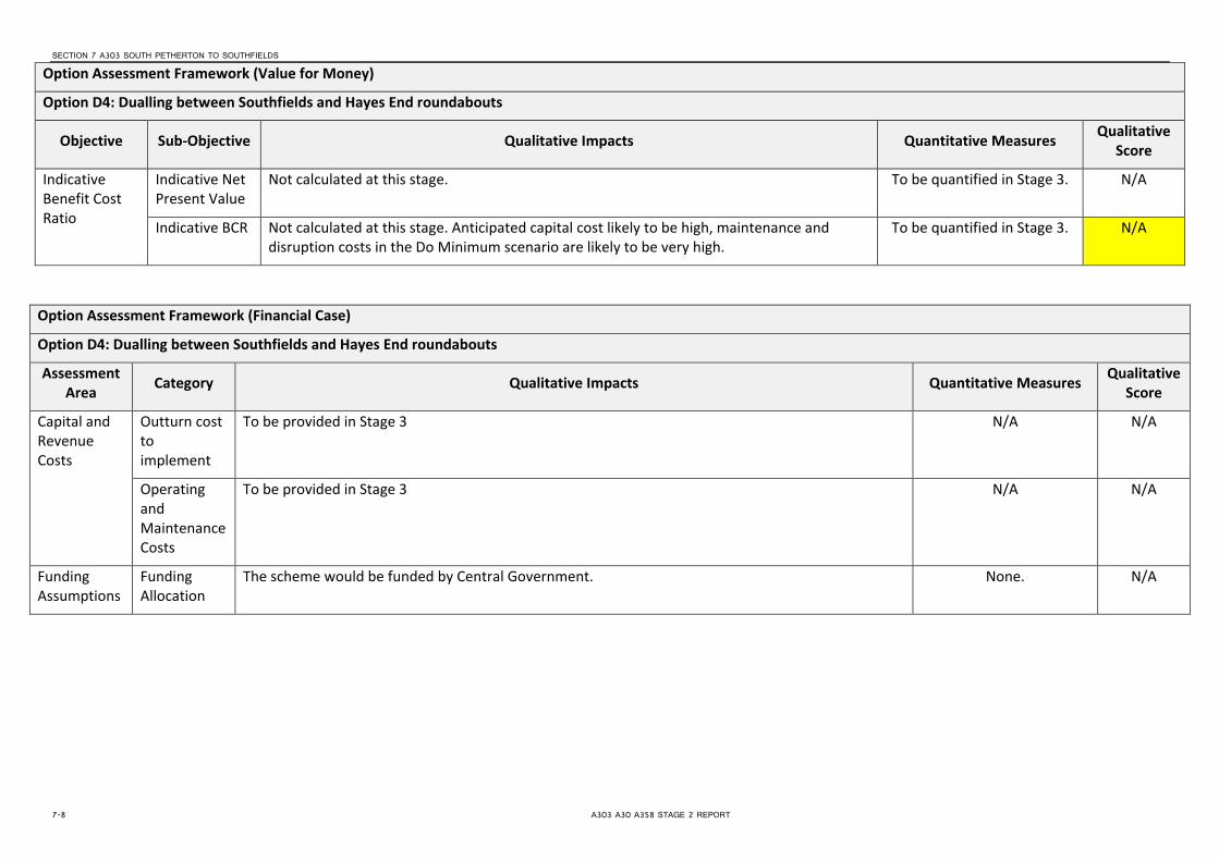
SECTION 7 A303 SOUTH PETHERTON TO SOUTHFIELDS
Option Assessment Framework (Value for Money)
Option D4: Dualling between Southfields and Hayes End roundabouts
Objective Sub-Objective Qualitative Impacts Quantitative Measures Qualitative Score
Indicative Benefit Cost Ratio
Indicative Net Present Value
Not calculated at this stage. To be quantified in Stage 3. N/A
Indicative BCR Not calculated at this stage. Anticipated capital cost likely to be high, maintenance and disruption costs in the Do Minimum scenario are likely to be very high.
To be quantified in Stage 3. N/A
Option Assessment Framework (Financial Case)
Option D4: Dualling between Southfields and Hayes End roundabouts
Assessment Area Category Qualitative Impacts Quantitative Measures Qualitative
Score
Capital and Revenue Costs
Outturn cost to implement
To be provided in Stage 3 N/A N/A
Operating and Maintenance Costs
To be provided in Stage 3 N/A N/A
Funding Assumptions
Funding Allocation
The scheme would be funded by Central Government. None. N/A
7-8 A303 A30 A358 STAGE 2 REPORT

SECTION 7 A303 SOUTH PETHERTON TO SOUTHFIELDS
Option Assessment Framework (Delivery Case)
Option C4: Dualling between Southfields and Hayes End roundabouts
Assessment Area Qualitative Impacts Quantitative Measures
Qualitative Score
Likely Delivery Agents There are some issues regarding the deliverability of scheme, especially construction of offline section. Highways Agency will be the delivery agents.
None 5
Stakeholder Acceptability TBC at a later stage None -
Public Acceptability / Interest
TBC at a later stage None -
Option Assessment Framework (Commercial Case)
Option C4: Dualling between Southfields and Hayes End roundabouts
Assessment Area Qualitative Impacts Quantitative Measures
Qualitative Score
Route to Market Scheme to be financed by Central Government. Widening of two bridges likely to be highest risk element of scheme None 4
Table 7-3: South Petherton to Southfields Option Assessment - Online Dualling between Southfields and Hayes End Roundabouts
A303 A30 A358 STAGE 2 REPORT 7-9


SECTION 8
A303 Southfields to Honiton
8.1 Context 8.1.1 Overview This section of the A303/A30 is located between Ilminster in the North East and Honiton to the South West and is almost entirely located with the Blackdown Hills Area of Outstanding Natural Beauty (AONB). It is approximately 24km in length and predominantly of single two lane standard except for 2.3km of single three-lane carriageway (comprising four sections between 300m and 1.2km long) and an 800m long dual two-lane section around the halfway point at Marsh. The speed limit is predominantly 50mph throughout except for the first 2.8km south of Southfields Roundabout and the dual two-lane section where the national speed limit applies, and an 850m long 40mph section through the village of Monkton. There are numerous side road junctions along this section of the route that provide access to surrounding villages, service areas, lay-bys and directly to private properties.
Figure 8.1: Southfields to Honiton section
8.1.2 Existing Issues and Challenges
The main issues with this section of the A303/A30 are safety and congestion caused in particular by the sub-standard alignment, cross-section and insufficient capacity. Approximately half the route has double white lines and overtaking opportunities elsewhere are limited due to reduced forward visibility. Traffic flows are approximately 13,000 (AADT); the maximum recommended by current Highways Agency guidance for a single two-lane road. As a result, congestion occurs where the three-lane sections reduce to two-lanes and where slow moving or right-turning vehicles are encountered on the single lane sections. In conjunction with the areas of congestion, accidents are most prevalent where the dual carriageway and three-lane sections merge into single two-lane sections. Accident clusters have also been identified through Monkton village, the narrow and tree lined/canopied section at Rawridge, and at the more major junctions including those with the A303/A30, the B3170, Bishopswood Crossing and the A358 Southfields Roundabout. A significant number of other accident sites of concern have also been identified where poor
A303 A30 A358 STAGE 2 REPORT 8-1
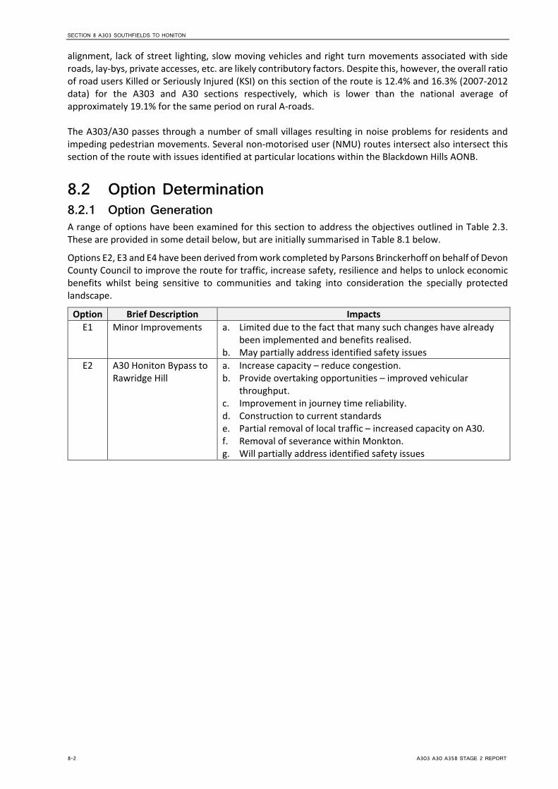
SECTION 8 A303 SOUTHFIELDS TO HONITON
alignment, lack of street lighting, slow moving vehicles and right turn movements associated with side roads, lay-bys, private accesses, etc. are likely contributory factors. Despite this, however, the overall ratio of road users Killed or Seriously Injured (KSI) on this section of the route is 12.4% and 16.3% (2007-2012 data) for the A303 and A30 sections respectively, which is lower than the national average of approximately 19.1% for the same period on rural A-roads. The A303/A30 passes through a number of small villages resulting in noise problems for residents and impeding pedestrian movements. Several non-motorised user (NMU) routes intersect also intersect this section of the route with issues identified at particular locations within the Blackdown Hills AONB.
8.2 Option Determination 8.2.1 Option Generation A range of options have been examined for this section to address the objectives outlined in Table 2.3. These are provided in some detail below, but are initially summarised in Table 8.1 below.
Options E2, E3 and E4 have been derived from work completed by Parsons Brinckerhoff on behalf of Devon County Council to improve the route for traffic, increase safety, resilience and helps to unlock economic benefits whilst being sensitive to communities and taking into consideration the specially protected landscape.
Option Brief Description Impacts E1 Minor Improvements a. Limited due to the fact that many such changes have already
been implemented and benefits realised. b. May partially address identified safety issues
E2 A30 Honiton Bypass to Rawridge Hill
a. Increase capacity – reduce congestion. b. Provide overtaking opportunities – improved vehicular
throughput. c. Improvement in journey time reliability. d. Construction to current standards e. Partial removal of local traffic – increased capacity on A30. f. Removal of severance within Monkton. g. Will partially address identified safety issues
8-2 A303 A30 A358 STAGE 2 REPORT

SECTION 8 A303 SOUTHFIELDS TO HONITON
Option Brief Description Impacts E3 A30/A303 Rawridge
Hill to Stopgate Cross junction
a. Increase capacity – reduced congestion. b. Provide overtaking opportunities – improved vehicular
throughput. c. Improvement in journey time reliability. d. Construction to current standards Partial removal of local
traffic – increased capacity on A30/A303. e. Removal of severance within Newcott. f. Will partially address identified safety issues
E4 A303 Eagle Tavern to Broadway
a. Increase capacity – reduce congestion. b. Provide overtaking opportunities – improved vehicular
throughput. c. Improvement in journey time reliability. d. Construction to current standards e. Partial removal of local traffic – increased capacity on A303. f. Will partially address identified safety issues
E5 A303 Dualling a. Increase capacity – reduce congestion. b. Provide overtaking opportunities – improved vehicular
throughput. c. Improvement in journey time reliability. d. Construction to current standards – improved safety. e. Removal of conflict with NMU’s. f. Will address identified safety issues
E6 A358 Dualling
a. Increase capacity – reduce congestion. b. Provide overtaking opportunities – improved vehicular
throughput. c. Improvement in journey time reliability. d. Construction to current standards – improved safety. e. Removal of conflict with NMU’s. f. Removal of local traffic. g. Removal of severance within Henlade. h. May partially address identified safety issues on the A303, will
address identified safety issues on A358. Table 8-1: Option Summary for Southfields to Honiton
8.2.1.1 Minor Improvements (Option E1) The A303/A30 Corridor Management Study Solutions Report4 suggested a number of additional improvements that could help to reduce the congestion and safety issues at specific locations along the route. The following options are based on that study and vary from small to medium scale: General Improvements
• Rationalisation/closure of side roads. • Carriageway widening and provision of 1.0m hardstrips. • Relocation of existing and/or provision of additional or alternative road markings. • Installation of Vehicle Activated Signs. • Provision of High Friction Surfacing. • Installation of average and/or ‘spot’ speed enforcement cameras. • Improvements in night-time conspicuity through installation of active road studs,
electroluminescent signs, etc. • Widening/realignment of specific sections of the carriageway.
4 A303/A30 Corridor Management Study, Highways Agency, February 2010
A303 A30 A358 STAGE 2 REPORT 8-3

SECTION 8 A303 SOUTHFIELDS TO HONITON
• Installation of 50mph gateways. • Reduction in speed limit to 40mph through villages. • Installation of new and extension of existing climbing lanes. • Improvements in highway drainage.
Improvements to Junctions and Private Means of Access (PMA) • Relocation of existing and/or provision of additional road markings. • Provision of High Friction Surfacing. • Replacement of existing warning and directional signs. • Improvements in junction conspicuity. • Junction improvements through the provision of merges, right-turning lanes, dedicated lanes,
etc. • Construction of alternative junction arrangements, e.g. roundabouts, staggered junctions,
grade-separation, signalisation etc. • Improvements in visibility to and from junctions and PMAs. • Relocation of PMAs • Provision of parallel service roads.
Lay-by Improvements • Advanced signing to next lay-by accessible from nearside. • Provision of no right turn signs. • Closure or relocation of lay-bys. • Provision of islands to prevent right turns. • Installation of right-turn lanes.
8.2.1.2 A30 Honiton Bypass to Rawridge Hill (Option E2) This potential scheme involves approximately 4km of improvement from the existing dual carriageway at Honiton through to the lower part of Rawridge Hill. Three lanes would be provided with eastbound overtaking for the first 1.8km switching to westbound overtaking for approximately 1.0km where the proposed road would form an off-line bypass to Monkton village. A section with eastbound overtaking would be provided before the road ties back into the existing alignment near to Yard Farm. The proposal would include improved side road junctions and accesses to adjacent private properties as well new connections to the severed sections of the existing A30. A 60mph speed limit would be applied throughout. 8.2.1.3 A303/A30 Rawridge Hill to Stopgate Cross Junction (Option E3) This scheme involves approximately 4.7km of improvement between Rawridge and the junction with the B3170 known as Stopgate Cross. Three lanes would be provided with two sections of configured for eastbound overtaking (approximately 0.6km and 0.9km in length) and one 1.2km section with westbound overtaking. The proposal would include improved side road junctions and accesses to adjacent private properties as well as a new connection to the severed section of the existing A303 at Newcott where the new road would be offline. A 60mph speed limit would be applied throughout. 8.2.1.4 A303 Eagle Tavern to Broadway (Option E4) This improvement involves 3.0km of improvement (approximately 2.0km of which would be offline) between the Eagle Cross Junction and Forest Mill Lane to the west of Broadway. Approximately 1.9km of three lane carriageway with westbound overtaking would be provided. The proposal would include improved side road junctions and accesses to adjacent private properties as well as a new connection to the severed section of the existing A303 at Ham. A 60mph speed limit would be applied throughout. 8.2.1.5 A303 Dualling between Honiton and Ilminster (Option E5) This 24.4km option would extend from the existing A30 Honiton Bypass to the Ilminster Bypass and incorporate the existing dual carriageway section at Marsh. It would be to 70mph dual two-lane carriageway standard throughout and incorporate grade separated junctions at the A30/A303 junction, the B3170 at Stopgate Cross, Marsh (existing), Eagle Cross Junction (east of Newtown) and the A358/A303
8-4 A303 A30 A358 STAGE 2 REPORT

SECTION 8 A303 SOUTHFIELDS TO HONITON
Southfields Roundabout at Ilminster. Except for the 800m long existing bypass at Marsh and for approximately 3km south of Southfields Roundabout the route would be off-line, bypassing villages along the route and avoiding the sharp bend at Knightshayne Farm. A number of side roads would be closed or realigned and linked via the existing A30/A303 and series of new bridges at Tovehayne Farm, Aplins Farm, Cotleigh Crossing, Stockland Hill Road, Knightshayne, Giant’s Grave, Raisey Lane and Sticklepath Lane. The existing bridges at Whitney Hill and Cheshay’s Hill would be widened as necessary. 8.2.1.6 A358 Southfields to M5 Junction 25 (Option E6) As an alternative to upgrading the A303 corridor across the Blackdown Hills, one other option to address the traffic problems between Ilminster and Honiton is to completely remove traffic from that section by upgrading the A358 corridor between Ilminster and the M5 at Taunton. This follows work completed by both the Highways Agency and Somerset County Council.
This option includes 16km of online and offline dualling. It runs offline but parallel to the existing carriageway for around 4.3km to the south of Henlade, re-joining at a new grade separated junction with the A378. From here, the road follows the existing alignment with new grade separated junctions at Ashill and Southfields.
8.2.2 Option Sifting As detailed, the options described above have been run through EAST. A summary of the results for the options under consideration in this section are summarised in the table below. A key to the numbers and colour designation used is provided in Section 4.3.2.
Opt
ion
Strategic Economic Managerial Financial Commercial
Scal
e of
Im
pact
Fit w
ith w
ider
ob
ject
ives
Fit w
ith o
ther
ob
ject
ives
Degr
ee o
f Co
nsen
sus
Econ
omic
Gr
owth
Carb
on
Emiss
ions
SDI &
The
Re
gion
s
Loca
l Env
Wel
l Bei
ng
Expe
cted
Vf
M C
ateg
ory
Impl
emen
tati
on T
imet
able
Publ
ic
Acce
ptab
ility
Prac
tical
Fe
asib
ility
Qua
lity
of
Evid
ence
Capi
tal C
osts
(£
m)
Cost
Risk
Flex
ibili
ty o
f O
ptio
n
E1 2 3 3 3 2 4 4 3 3 3 3 5 4 3 2 4
E2 3 4 4 2 3 3 2 3 4 4 2 3 4 5 2 3
E3 3 4 4 2 3 3 2 3 4 4 2 3 4 5 2 3
E4 3 4 4 2 3 3 2 3 4 4 2 3 4 5 2 3
E5 5 4 3 2 4 2 1 4 5 5 1 2 4 8 2 3
E6 4 5 4 4 4 2 3 4 3 5 4 4 4 7 3 2
Table 8-2: Southfields to Honiton EAST Assessment
The EAST assessment identifies that Option E6 (dualling of the A358) scores better than the options to improve the A303 directly. However, whilst improvement of the A358 are likely to enable the delivery of extra capacity; improvements to the A303 on this section are still desirable and it is unlikely that simply the selection of one option alone from those listed above will achieve all of the aims of the study. As such, in addition to Option E6, Options E2, E3 and E4 have also been taken forward into Option Assessment. Option E1 has been discounted because it does not fully resolve the identified issues on this section of the route. Option E5 has been discounted because although it would resolve the issues on the route, it would be very harmful to the Blackdown Hills AONB.
8.2.3 Option Assessment As described in paragraph 3.2.3 the better performing option (E2, E3, E4 and E6) have been assessed against the Transport Business Case criteria using the Option Assessment Framework, provided within the TAG Unit. Tables 8.3 and 8.4 following detail the appraisal of the areas outlined in the framework, including:
A303 A30 A358 STAGE 2 REPORT 8-5

SECTION 8 A303 SOUTHFIELDS TO HONITON
• Strategic Fit; • Value for Money, • Financial Case; • Delivery Case; and • Commercial Case.
In line with TAG, the appraisals have used a 7 point scale of impacts in providing a (largely) qualitative assessment of the scale of impacts with a value of 1 being large adverse and 7 large beneficial (as shown in Table 3.2).
8-6 A303 A30 A358 STAGE 2 REPORT

Option Assessment Framework (Strategic Fit)
Option E2, E3, E4: A303 Honiton Bypass to Broadway
Assessment Area Category Objective Qualitative Impacts Qualitative
Score
Regional Transport and Spatial Strategy
Regional / Local Policy Alignment
Promote Economic Growth Economic growth will be promoted in the area more generally as a result of the scheme. 6
Maintain and improve accessibility to jobs, housing, tourist destinations and key services
The scheme will improve access to the South West in general; although directly access will be most improved to destinations served by the A303 corridor..
7
Reduction in journey time variability
The scheme will reduce delays and incidents impacting on reliability by providing a route of near consistent D2AP standard and providing junction improvements and other measures to reduce the likelihood of incidents.
7
Reduction in collisions On the A303, accident hotspots have been noted through Monkton village, the narrow and tree lined/canopied section at Rawridge, and at the more major junctions including those with the A303/A30, the B3170, Bishopswood Crossing and the A358 Southfields Roundabout, although overall the rate of accidents is lower than would be expected for the type of road. This scheme will reduce the accident potential along this section of the route through a variety of measures. .
5
Meeting Intervention Objectives
Scheme Objectives Fit
Economic Growth The scheme reduces delays and the potential for incidents impacting on reliability. Improves access to the region.
6
Connectivity The scheme will improve connectivity to the South West region. 6
Capacity The increase in capacity will reduce the number of incidents and delays which will lead to an improvement in journey times particularly during peak times and during the busier summer months.
7
A303 A30 A358 STAGE 2 REPORT 8-7

SECTION 8 A303 SOUTHFIELDS TO HONITON
Option Assessment Framework (Strategic Fit)
Option E2, E3, E4: A303 Honiton Bypass to Broadway
Assessment Area Category Objective Qualitative Impacts Qualitative
Score
Safety This Scheme is designed to increase capacity by providing a dualled link on the A303, removing much of the existing single carriageway sections and improvement of at grade junctions
6
Resilience The increase in capacity on the A303 is likely to lead to a reduction in accidents, improvements to journey times and reliability. The provision of additional lanes improves resilience of the network when incidents do occur.
6
Environmental It is expected that the scheme will have an adverse impact on the environment on the A303; especially where the scheme goes offline because of the Blackdown Hills AONB. There will be an increase in noise as a result of the widening, but an improvement in air quality where congestion is removed.
2
Option Assessment Framework (Value for Money)
Option E2, E3, E4: A303 Honiton Bypass to Broadway
Objective Sub-Objective Qualitative Impacts Quantitative Measures Qualitative Score
Economy Business Users & Transport Providers
On the A303 journey times will improve and vehicle operating costs will be reduced due to higher travel speeds for users travelling at congested times. The increase in capacity will also reduce delays which will improve reliability. Increasing the capacity will also lead to connectivity benefits for business users and freight through the improvement in linkages between locations of economic importance in the region.
To be quantified in Stage 3. 6
Reliability Reduces delays and incidents impacting on reliability particularly at peak times and the busier summer months on the A303.
None. 6
Regeneration Improves access to the South West region. None. 6
8-8 A303 A30 A358 STAGE 2 REPORT

Option Assessment Framework (Value for Money)
Option E2, E3, E4: A303 Honiton Bypass to Broadway
Objective Sub-Objective Qualitative Impacts Quantitative Measures Qualitative Score
Environment Noise Widening on the A303 likely to increase overall noise emissions due to decreasing congestion (free flowing traffic generally produces more noise), and likely marginal increase in road users on this segment.
The spatial effects of widening (i.e. carriageway approaches closer to receptors) are likely to be negligible, except for properties located very close to the existing carriageway (i.e. within 7-8m).
None 4
Air Quality The Off Line Widening on the A303 would result in a small number of properties being located closer to the carriageway. Similarly, the On Line Widening may result in existing sensitive receptors (e.g. residential dwellings) being located closer to the carriageway. These properties may experience a slight worsening in air quality as a result of the proposed interventions.
These effects will be offset by the increased distance between other properties and associated improvement in air quality. These properties are currently located close to (adjacent in some cases) to the existing carriageway and with the scheme in place, will be a greater distance from the realigned road. Given that pollution concentrations decrease rapidly with distance from source, any improvements are likely to be marginal.
Notwithstanding the above, given that the proposed interventions are aimed at reducing congestion and encouraging the free flow of traffic, both of which will benefit local air quality, the overall the effects of the scheme are considered to be positive in terms of air quality.
The above does not take into account any redistribution effects which may occur as a result of the proposed interventions.
None 5
Greenhouse Gases
Widening on the A303 will result in an increase in traffic, which may be partially offset by reduced emissions from free flowing traffic at 60-70mph
None 3
A303 A30 A358 STAGE 2 REPORT 8-9

SECTION 8 A303 SOUTHFIELDS TO HONITON
Option Assessment Framework (Value for Money)
Option E2, E3, E4: A303 Honiton Bypass to Broadway
Objective Sub-Objective Qualitative Impacts Quantitative Measures Qualitative Score
Landscape In broad terms the landscape character of the area along the A303 is largely rural with some wooded areas with large field patterns and intermittent individual properties. Urban areas of residential properties lie along the corridor with settlements such as Marsh, Monkton and Newton all on the route
Overall this option will have a large impact on the wider landscape character where the scheme goes off line, given the area is designated as an AONB. The online widening through this section may have a short to medium term moderate potential impact on the rural character due to vegetation removal.
None 2
Townscape This section (the A358) is mainly rural area with urban areas limited to the settlements of Marsh, Monkton and Newton.
None 4
Historic Environment
A number of Grade 1 listed buildings are present on the route. None 4
Biodiversity This section (the A358) includes a SSSI, a National Nature Reserve and a Special Area of Conservation for Bats.
None 4
Water Environment
Neutral None 4
Society Impact
Non-business users
Journey times will improve and vehicle operating costs will be reduced for users travelling at congested times on the A303. The increase in capacity on the A303 should reduce the number of incidents and delays and lead to an increase in reliability. There will be some connectivity benefits but not as great as for business users as leisure trips are more likely to be undertaken at less congested times; although the scheme will assist with off peak travel during the busier summer months.
To be quantified in Stage 3. 6
Physical Activity
It is thought to be unlikely that the scheme will significantly impact on the number of walking and cycling trips.
None. 4
8-10 A303 A30 A358 STAGE 2 REPORT
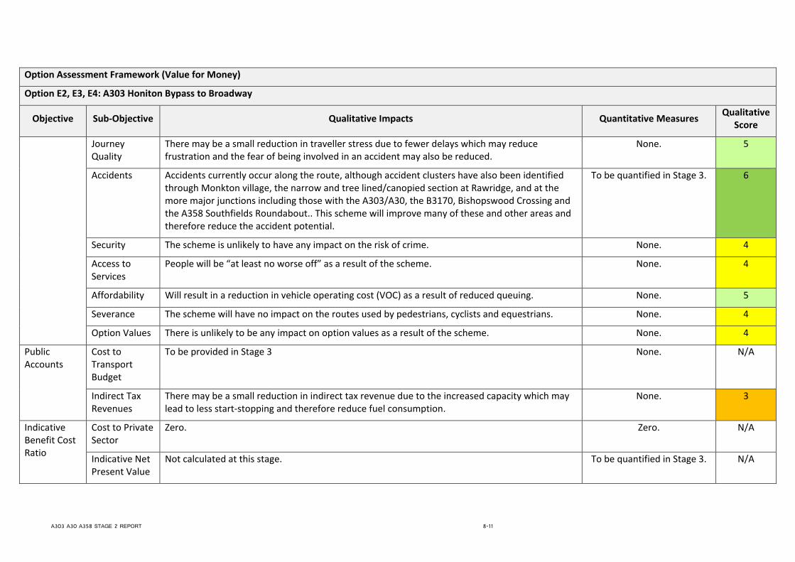
Option Assessment Framework (Value for Money)
Option E2, E3, E4: A303 Honiton Bypass to Broadway
Objective Sub-Objective Qualitative Impacts Quantitative Measures Qualitative Score
Journey Quality
There may be a small reduction in traveller stress due to fewer delays which may reduce frustration and the fear of being involved in an accident may also be reduced.
None. 5
Accidents Accidents currently occur along the route, although accident clusters have also been identified through Monkton village, the narrow and tree lined/canopied section at Rawridge, and at the more major junctions including those with the A303/A30, the B3170, Bishopswood Crossing and the A358 Southfields Roundabout.. This scheme will improve many of these and other areas and therefore reduce the accident potential.
To be quantified in Stage 3. 6
Security The scheme is unlikely to have any impact on the risk of crime. None. 4
Access to Services
People will be “at least no worse off” as a result of the scheme. None. 4
Affordability Will result in a reduction in vehicle operating cost (VOC) as a result of reduced queuing. None. 5
Severance The scheme will have no impact on the routes used by pedestrians, cyclists and equestrians. None. 4
Option Values There is unlikely to be any impact on option values as a result of the scheme. None. 4
Public Accounts
Cost to Transport Budget
To be provided in Stage 3 None. N/A
Indirect Tax Revenues
There may be a small reduction in indirect tax revenue due to the increased capacity which may lead to less start-stopping and therefore reduce fuel consumption.
None. 3
Indicative Benefit Cost Ratio
Cost to Private Sector
Zero. Zero. N/A
Indicative Net Present Value
Not calculated at this stage. To be quantified in Stage 3. N/A
A303 A30 A358 STAGE 2 REPORT 8-11
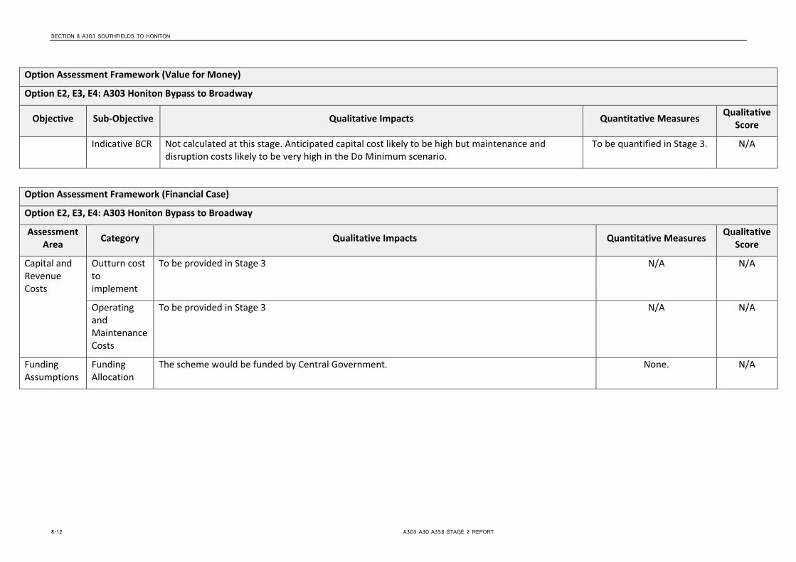
SECTION 8 A303 SOUTHFIELDS TO HONITON
Option Assessment Framework (Value for Money)
Option E2, E3, E4: A303 Honiton Bypass to Broadway
Objective Sub-Objective Qualitative Impacts Quantitative Measures Qualitative Score
Indicative BCR Not calculated at this stage. Anticipated capital cost likely to be high but maintenance and disruption costs likely to be very high in the Do Minimum scenario.
To be quantified in Stage 3. N/A
Option Assessment Framework (Financial Case)
Option E2, E3, E4: A303 Honiton Bypass to Broadway
Assessment Area Category Qualitative Impacts Quantitative Measures Qualitative
Score
Capital and Revenue Costs
Outturn cost to implement
To be provided in Stage 3 N/A N/A
Operating and Maintenance Costs
To be provided in Stage 3 N/A N/A
Funding Assumptions
Funding Allocation
The scheme would be funded by Central Government. None. N/A
8-12 A303 A30 A358 STAGE 2 REPORT

Option Assessment Framework (Delivery Case)
Option E2, E3, E4: A303 Honiton Bypass to Broadway
Assessment Area Qualitative Impacts Quantitative Measures
Qualitative Score
Likely Delivery Agents Highways Agency will be the delivery agents. None 5
Stakeholder Acceptability TBC at a later stage None -
Public Acceptability / Interest
TBC at a later stage None -
Option Assessment Framework (Commercial Case)
Option E2, E3, E4: A303 Honiton Bypass to Broadway
Assessment Area Qualitative Impacts Quantitative Measures
Qualitative Score
Route to Market Scheme to be financed by Central Government. None 4
Table 8-3: Southfields to Honiton Option Assessment – A30/A303 Improvements
A303 A30 A358 STAGE 2 REPORT 8-13

SECTION 8 A303 SOUTHFIELDS TO HONITON
Option Assessment Framework (Strategic Fit)
Option E5: A358 Southfields to M5 Jct 25
Assessment Area Category Objective Qualitative Impacts Qualitative
Score
Regional Transport and Spatial Strategy
Regional / Local Policy Alignment
Promote Economic Growth Economic growth will be promoted in the area more generally as a result of the scheme. 6
Maintain and improve accessibility to jobs, housing, tourist destinations and key services
The scheme will improve access to the South West in general; although directly access will be most improved to destinations served by the A358 corridor. The reduction in traffic on the A303 will assist with accessibility however, especially during the busier summer months.
7
Reduction in journey time variability
The scheme will reduce delays and incidents impacting on reliability by removing traffic from the A303 onto the A358, thus making the route less congested and. It will improve journey time reliability on the A358 itself by providing a route of a consistent D2AP standard.
7
Reduction in collisions Accident issues occur on both the A303 and A358. On the A358 accidents are predominantly focussed on the northern half of the corridor, where the accident rate exceeds the COBA rate for the type of road. This scheme would aim to reduce the accident potential on the A358. On the A303, accident hotspots have been noted, although the rate of accidents is lower than would be expected for the type of road. Although this improvement scheme does not directly affect the A303, it is expected that some traffic will divert off it to the improved A358 and as such the accident potential is likely to be reduced through lower traffic volumes.
6
Meeting Intervention Objectives
Scheme Objectives Fit
Economic Growth The scheme reduces delays and the potential for incidents impacting on reliability. Improves access to the region.
6
Connectivity The scheme will improve connectivity to the South West region. 6
Capacity The increase in capacity will reduce the number of incidents and delays which will lead to an improvement in journey times particularly during peak times and during the busier summer months.
7
Safety This Scheme is designed to increase capacity by providing a dualled link on the A358 between the A303 and M5, removing the existing single carriageway sections and the at grade junctions, where accident issues occur, particularly on the northern half of the route. In addition, it will
6
8-14 A303 A30 A358 STAGE 2 REPORT

Option Assessment Framework (Strategic Fit)
Option E5: A358 Southfields to M5 Jct 25
Assessment Area Category Objective Qualitative Impacts Qualitative
Score
potentially remove traffic from the A303 which has accident issues due to its substandard alignment and high flows.
Resilience The increase in capacity on the A358 is likely to lead to a reduction in accidents, improvements to journey times and reliability. The provision of additional lanes improves resilience of the network when incidents do occur.
6
Environmental It is expected that the scheme will have a slightly adverse impact on the environment on the A358; especially where the scheme goes offline. There will be an increase in noise as a result of the widening, but an improvement in air quality. There are likely to be benefits on the A303 however as a result of reduced traffic flows.
3
Option Assessment Framework (Value for Money)
Option E5: A358 Southfields to M5 Jct 25
Objective Sub-Objective Qualitative Impacts Quantitative Measures Qualitative Score
Economy Business Users & Transport Providers
On both the A303 and A358 journey times will improve and vehicle operating costs will be reduced due to higher travel speeds for users travelling at congested times. The increase in capacity will also reduce delays which will improve reliability. Increasing the capacity on this section of the A358 will also lead to connectivity benefits for business users and freight through the improvement in linkages between locations of economic importance in the region.
To be quantified in Stage 3. 6
Reliability Reduces delays and incidents impacting on reliability particularly at peak times on both the A303 (through lower traffic) and A358.
None. 6
Regeneration Improves access to the South West region. None. 6
A303 A30 A358 STAGE 2 REPORT 8-15

SECTION 8 A303 SOUTHFIELDS TO HONITON
Option Assessment Framework (Value for Money)
Option E5: A358 Southfields to M5 Jct 25
Objective Sub-Objective Qualitative Impacts Quantitative Measures Qualitative Score
Environment Noise Off-line widening to D2AP on the A358 likely to increase overall noise emissions due to decreasing congestion (free flowing traffic generally produces more noise), and likely marginal increase in road users on this segment.
The spatial effects of widening (i.e. carriageway approaches closer to receptors) are likely to be negligible, except for properties located very close to the existing carriageway (i.e. within 7-8m).
none 4
Air Quality The Off Line Widening on the A358 would result in a small number of properties in Henlade being located closer to the carriageway. Similarly, the On Line Widening may result in existing sensitive receptors (e.g. residential dwellings) being located closer to the carriageway. These properties may experience a slight worsening in air quality as a result of the proposed interventions.
These effects will be offset by the increased distance between other properties in Henlade, and associated improvement in air quality. These properties are currently located close to (adjacent in some cases) to the existing carriageway and with the scheme in place, will be greater than 200m from the realigned road. Given that pollution concentrations decrease rapidly with distance from source, any improvements are likely to be marginal.
Notwithstanding the above, given that the proposed interventions are aimed at reducing congestion and encouraging the free flow of traffic, both of which will benefit local air quality, the overall the effects of the scheme are considered to be positive in terms of air quality.
The above does not take into account any redistribution effects which may occur as a result of the proposed interventions.
None 5
Greenhouse Gases
Lane widening on the A358 will result in an increase in traffic, which may be partially offset by reduced emissions from free flowing traffic at 60-70mph
None 3
8-16 A303 A30 A358 STAGE 2 REPORT

Option Assessment Framework (Value for Money)
Option E5: A358 Southfields to M5 Jct 25
Objective Sub-Objective Qualitative Impacts Quantitative Measures Qualitative Score
Landscape In broad terms the landscape character of the area along the A358 is largely rural with large field patterns and intermittent individual properties. Urban areas of residential properties lie predominately to the northern end with settlements such as Ruishton, Thornfalcon and Henlade all close to the carriageway. Further south, the settlements of Hatch Beauchamp and Ashill lie close to the A358.
Overall this option will have a larger impact on the wider landscape character where the scheme goes off line (i.e. north of the junction with the A378). The online widening through this section may have a short to medium term moderate potential impact on the rural character due to vegetation removal.
TBC 3
Townscape This section (the A358) is mainly rural area with urban areas limited to the settlements of Ruishton, Thornfalco, Henlade, Hatch Beauchamp and Ashill.
None. 4
Historic Environment
None. 4
Biodiversity This section (the A358) includes a Ramsar site, SSSI and a Special Area of Conservation for Bats. None. 4
Water Environment
None. 4
Society Impact
Non-business users
Journey times will improve and vehicle operating costs will be reduced for users travelling at congested times on both the A303 and A358. The increase in capacity on the A358 should reduce the number of incidents and delays and lead to an increase in reliability. There will be some connectivity benefits but not as great as for business users as leisure trips are more likely to be undertaken at less congested times; although the scheme will assist with off peak travel during the busier summer months.
To be quantified in Stage 3. 6
Physical Activity
It is thought to be unlikely that the scheme will significantly impact on the number of walking and cycling trips.
None. 4
A303 A30 A358 STAGE 2 REPORT 8-17

SECTION 8 A303 SOUTHFIELDS TO HONITON
Option Assessment Framework (Value for Money)
Option E5: A358 Southfields to M5 Jct 25
Objective Sub-Objective Qualitative Impacts Quantitative Measures Qualitative Score
Journey Quality
There may be a small reduction in traveller stress due to fewer delays which may reduce frustration and the fear of being involved in an accident may also be reduced. However, the A303 route will remain as is currently, so although there may be some reduction in flow as drivers transfer to the A358, the journey quality on this route may not improve as much.
None. 5
Accidents Accidents currently occur predominately on the northern half of the A358, particularly around junctions. This scheme will remove these junctions through grade separation and should therefore reduce the accident potential.
To be quantified in Stage 3. 6
Security The scheme is unlikely to have any impact on the risk of crime. None. 4
Access to Services
People will be “at least no worse off” as a result of the scheme. None. 4
Affordability Will result in a reduction in vehicle operating cost (VOC) as a result of reduced queuing. None. 5
Severance The scheme will have no impact on the routes used by pedestrians, cyclists and equestrians. None. 4
Option Values There is unlikely to be any impact on option values as a result of the scheme. None. 4
Public Accounts
Cost to Transport Budget
To be provided in Stage 3 None. N/A
Indirect Tax Revenues
There may be a small reduction in indirect tax revenue due to the increased capacity which may lead to less start-stopping and therefore reduce fuel consumption.
None. 3
Indicative Benefit Cost Ratio
Cost to Private Sector
Zero. Zero. N/A
Indicative Net Present Value
Not calculated at this stage. To be quantified in Stage 3. N/A
8-18 A303 A30 A358 STAGE 2 REPORT

Option Assessment Framework (Value for Money)
Option E5: A358 Southfields to M5 Jct 25
Objective Sub-Objective Qualitative Impacts Quantitative Measures Qualitative Score
Indicative BCR Not calculated at this stage. Anticipated capital cost likely to be high but maintenance and disruption costs likely to be very high in the Do Minimum scenario.
To be quantified in Stage 3. N/A
Option Assessment Framework (Financial Case)
Option E5: A358 Southfields to M5 Jct 25
Assessment Area Category Qualitative Impacts Quantitative Measures Qualitative
Score
Capital and Revenue Costs
Outturn cost to implement
To be provided in Stage 3 N/A N/A
Operating and Maintenance Costs
To be provided in Stage 3 N/A N/A
Funding Assumptions
Funding Allocation
The scheme would be funded by Central Government. None. N/A
A303 A30 A358 STAGE 2 REPORT 8-19

SECTION 8 A303 SOUTHFIELDS TO HONITON
Option Assessment Framework (Delivery Case)
Option E5: A358 Southfields to M5 Jct 25
Assessment Area Qualitative Impacts Quantitative Measures
Qualitative Score
Likely Delivery Agents Highways Agency will be the delivery agents. None 5
Stakeholder Acceptability TBC at a later stage None -
Public Acceptability / Interest
TBC at a later satge None -
Option Assessment Framework (Commercial Case)
Option E5: A358 Southfields to M5 Jct 25
Assessment Area Qualitative Impacts Quantitative Measures
Qualitative Score
Route to Market Scheme to be financed by Central Government. None 4
Table 8-4: Southfields to Honiton Option Assessment – A358 Dualling
8-20 A303 A30 A358 STAGE 2 REPORT

Whole Route
9.1 Context 9.1.1 Overview In addition to examining the individual sections as outlined in the previous sections of this report, this section examines an improvement scheme for the A303/A30/A358 corridor as a whole, in line with proposals put forward previously.
These proposals have been put forward across the following nine areas:
1. A303 Amesbury to Berwick Down (Stonehenge);
2. A303 Wylye to Stockton Wood;
3. A303 Chicklade Bottom to Mere;
4. A303 Sparkford to Ilchester;
5. A303 Podimore Roundabout;
6. A303 Cartgate Roundabout;
7. A303 South Petherton to Southfields;
8. A358 Southfields to M5 Jct 25;
9. A303 Southfields to Honiton.
9.1.2 Existing Issues and Challenges The route is characterised by varying carriageway standards (63% dual carriageway, 37% single carriageway), speed limits (from 40mph to 70mh) and numerous major (at grade and grade separated) and minor junctions and accesses which together with significant seasonal traffic growth contributes to detrimental traffic congestion and delays with associated economic, environmental and social costs. Proposed housing and employment growth in and along the corridor will increase traffic locally and strategically which will only exacerbate the current problems
9.2 Option Determination 9.2.1 Option Generation Unlike the previous sections set out in this report, only one option for each section is presented here for this “whole route” option given the extensive work undertaken previously to assess and dismiss alternative schemes for reasons including deliverability, feasibility, cost and lack of benefit to road users. Some of this analysis is repeated in earlier sections of this report.
The only exception to this is for Sections 8 and 9. Section 8 is the A358 between the A303 at Southfields and M5 Jct 25 and does not form part of the Strategic Road Network. However, given that Section 9 (Southfields to Honiton) passes through the Blackdown Hills, an area of Outstanding Natural Beauty, improvements to the scale necessary are unlikely to be achievable. As such, smaller scale options for Section 9 are presented alongside dualling of Section 8.
9.2.1.1 Whole Route Option (Option F1) As such the schemes considered in this option for each section are as detailed below (using the same numbers as above):
1. 12km of dual carriageway (partially in tunnel) and junction improvements;
2. 3.9km mainly on-line dual carriageway;
3. 12km of part on-line, part off-line dual carriageway and associated junction improvements;
A303 A30 A358 STAGE 2 REPORT 9-1
SECTION 9 WHOLE ROUTE
4. 5.5km of part on-line, part off-line dual carriageway and associated junction improvements;
5. Grade Separation of Junction;
6. Grade Separation of Junction;
7. 10km of on-line dual carriageway;
8. 14km of part on-line, part off-line dual carriageway and junction improvements;
9. Combination of small sections of improvement over a distance of 23km.
9.2.2 Option Sifting Technically, other than Sections 8 and 9, there are technically no options to sift at this stage. As such, no option sifting has been undertaken for this whole route option; although many of the component parts have been assessed through EAST in earlier sections of this report. The whole route option has however been assessed against the WebTAG Transport Appraisal Guidance model in the following section.
9.2.3 Option Assessment As described in paragraph 3.2.3 the better performing option (E2, E3, E4 and E6) have been assessed against the Transport Business Case criteria using the Option Assessment Framework, provided within the TAG Unit. Table 9.1 following detail the appraisal of the areas outlined in the framework, including:
• Strategic Fit; • Value for Money, • Financial Case; • Delivery Case; and • Commercial Case.
In line with TAG, the appraisals have used a 7 point scale of impacts in providing a (largely) qualitative assessment of the scale of impacts with a value of 1 being large adverse and 7 large beneficial (as shown in Table 3.2).
9-2 A303 A30 A358 STAGE 2 REPORT
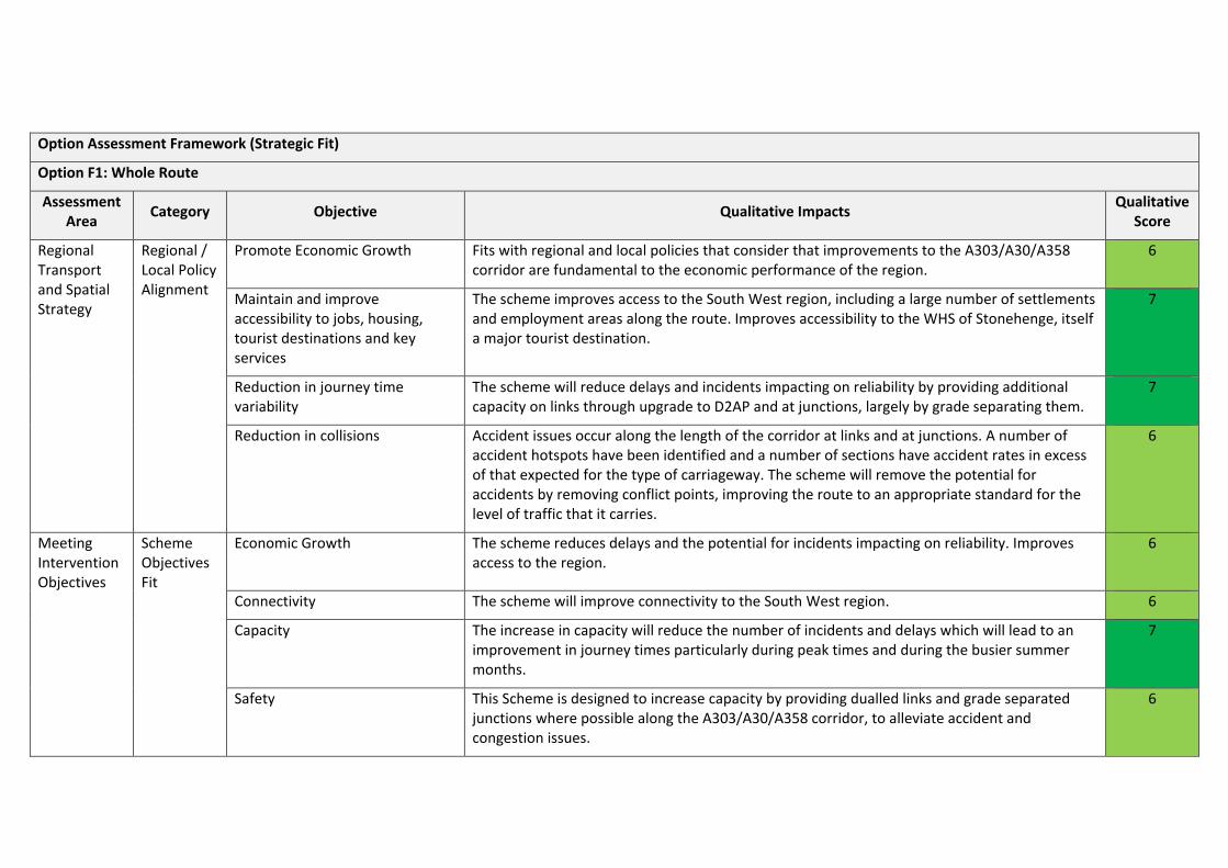
Option Assessment Framework (Strategic Fit)
Option F1: Whole Route
Assessment Area Category Objective Qualitative Impacts Qualitative
Score
Regional Transport and Spatial Strategy
Regional / Local Policy Alignment
Promote Economic Growth Fits with regional and local policies that consider that improvements to the A303/A30/A358 corridor are fundamental to the economic performance of the region.
6
Maintain and improve accessibility to jobs, housing, tourist destinations and key services
The scheme improves access to the South West region, including a large number of settlements and employment areas along the route. Improves accessibility to the WHS of Stonehenge, itself a major tourist destination.
7
Reduction in journey time variability
The scheme will reduce delays and incidents impacting on reliability by providing additional capacity on links through upgrade to D2AP and at junctions, largely by grade separating them.
7
Reduction in collisions Accident issues occur along the length of the corridor at links and at junctions. A number of accident hotspots have been identified and a number of sections have accident rates in excess of that expected for the type of carriageway. The scheme will remove the potential for accidents by removing conflict points, improving the route to an appropriate standard for the level of traffic that it carries.
6
Meeting Intervention Objectives
Scheme Objectives Fit
Economic Growth The scheme reduces delays and the potential for incidents impacting on reliability. Improves access to the region.
6
Connectivity The scheme will improve connectivity to the South West region. 6
Capacity The increase in capacity will reduce the number of incidents and delays which will lead to an improvement in journey times particularly during peak times and during the busier summer months.
7
Safety This Scheme is designed to increase capacity by providing dualled links and grade separated junctions where possible along the A303/A30/A358 corridor, to alleviate accident and congestion issues.
6

SECTION 9 WHOLE ROUTE
Option Assessment Framework (Strategic Fit)
Option F1: Whole Route
Assessment Area Category Objective Qualitative Impacts Qualitative
Score
Resilience The increase in capacity is likely to lead to a reduction in accidents, improvements to journey times and reliability. The provision of additional lanes improves resilience of the network when incidents do occur.
6
Environmental Overall, it is expected that the whole route scheme would have a slightly adverse impact on the environment. There would be benefits in some areas where traffic is removed from settlements, but negative effects in other locations where improvements would bring it closer to receptors. There is expected to be a negative effect on noise, but a positive effect on air quality; both as a result of reduced congestion. A large benefit would be experienced at the WHS of Stonehenge
3
Option Assessment Framework (Value for Money)
Option F1: Whole Route
Objective Sub-Objective Qualitative Impacts Quantitative Measures Qualitative Score
Economy Business Users & Transport Providers
Journey times will improve and vehicle operating costs will be reduced due to higher travel speeds for users travelling at congested times. The increase in capacity will also reduce delays which will improve reliability. Increasing the capacity on this section of the A358 will also lead to connectivity benefits for business users and freight through the improvement in linkages between locations of economic importance in the region.
To be quantified in Stage 3. 6
Reliability Reduces delays and incidents impacting on reliability particularly at peak times and during the busier summer months
None. 6
Regeneration Improves access to the South West region. None. 6
Environment Noise All nine sections contain First Priority Locations within 1km of the scheme location. The scheme will reduce noise in some locations as a result of bypassing communities. However, offline
TBC 4
9-4 A303 A30 A358 STAGE 2 REPORT

Option Assessment Framework (Value for Money)
Option F1: Whole Route
Objective Sub-Objective Qualitative Impacts Quantitative Measures Qualitative Score
widening in other locations will increase noise levels. Across the corridor, the impact is expected to be neutral.
Air Quality None of the sections directly contain an AQMA, but there is an AQMA within Honiton at the western end of Section 9. It is expected that as the scheme will improve capacity there will be more free-flowing traffic which will produce less emissions and in addition will bypass a number of communities, thus improving air quality. It is recognised that there will be some areas however where air quality will worsen.
None 5
Greenhouse Gases
Lane widening will result in an increase in traffic, which may be partially offset by reduced emissions from free flowing traffic at 60-70mph
None 3
Landscape Four sections of the route pass through AONB’s. Any of the schemes may affect the AONB’s, particularly where the schemes go off-line. However, there are expected to be some improvements on sections of the route where landscape is improved, such as at Stonehenge.
TBC 4
Townscape There are seven sections that contain a Grade 1 listed building. TBC 5
Historic Environment
The corridor includes a World Heritage Site at Stonehenge, whilst seven sections contain Grade 1 listed buildings.
TBC 6
Biodiversity Along the route there are two sections within a RAMSAR, three within an SPA, eight with a SSSI, two with an NNR, three with a SAC and all nine have a SAC relating to Bats.
TBC 3
Water Environment
Seven of the nine sections have areas that fall into Flood Zone 3 (High Probability/Floodplain) whilst all nine sections fall into Flood Zones 1 and 2.
There are a number of specific areas that have been identified as having a specific flood risk.
TBC 4
Society Impact
Non-business users
Journey times will improve and vehicle operating costs will be reduced for users travelling at congested times. The increase in capacity should reduce the number of incidents and delays and lead to an increase in reliability. There will be some connectivity benefits but not as great as for
To be quantified in Stage 3. 6
A303 A30 A358 STAGE 2 REPORT 9-5

SECTION 9 WHOLE ROUTE
Option Assessment Framework (Value for Money)
Option F1: Whole Route
Objective Sub-Objective Qualitative Impacts Quantitative Measures Qualitative Score
business users as leisure trips are more likely to be undertaken at less congested times; although the scheme will assist with off peak travel during the busier summer months.
Physical Activity
It is thought to be unlikely that the scheme will significantly impact on the number of walking and cycling trips.
None. 4
Journey Quality
There may be a small reduction in traveller stress due to fewer delays which may reduce frustration and the fear of being involved in an accident may also be reduced.
None. 5
Accidents Accident potential will be reduced as a result of link and junction improvements; removing conflict points along the corridor.
To be quantified in Stage 3. 6
Security The scheme is unlikely to have any impact on the risk of crime. None. 4
Access to Services
People will be “at least no worse off” as a result of the scheme. None. 4
Affordability Will result in a reduction in vehicle operating cost (VOC) as a result of reduced queuing. None. 5
Severance The scheme will have no impact on the routes used by pedestrians, cyclists and equestrians. None. 4
Option Values There is unlikely to be any impact on option values as a result of the scheme. None. 4
Public Accounts
Cost to Transport Budget
To be provided in Stage 3 None. N/A
Indirect Tax Revenues
There may be a small reduction in indirect tax revenue due to the increased capacity which may lead to less start-stopping and therefore reduce fuel consumption.
None. 3
Indicative Benefit Cost Ratio
Cost to Private Sector
Zero. Zero. N/A
Indicative Net Present Value
Not calculated at this stage. To be quantified in Stage 3. N/A
9-6 A303 A30 A358 STAGE 2 REPORT

Option Assessment Framework (Value for Money)
Option F1: Whole Route
Objective Sub-Objective Qualitative Impacts Quantitative Measures Qualitative Score
Indicative BCR Not calculated at this stage. To be quantified in Stage 3. 5
Option Assessment Framework (Financial Case)
Option F1: Whole Route
Assessment Area Category Qualitative Impacts Quantitative Measures Qualitative
Score
Capital and Revenue Costs
Outturn cost to implement
To be provided in Stage 3
N/A N/A
Operating and Maintenance Costs
To be provided in Stage 3 N/A N/A
Funding Assumptions
Funding Allocation
The scheme would be funded by Central Government. None. N/A
A303 A30 A358 STAGE 2 REPORT 9-7

SECTION 9 WHOLE ROUTE
Option Assessment Framework (Delivery Case)
Option F1: Whole Route
Assessment Area Qualitative Impacts Quantitative Measures
Qualitative Score
Likely Delivery Agents Highways Agency will be the delivery agents. None 5
Stakeholder Acceptability TBC at a later stage None -
Public Acceptability / Interest
TBC at a later stage None -
Option Assessment Framework (Commercial Case)
Option F1: Whole Route
Assessment Area Qualitative Impacts Quantitative Measures
Qualitative Score
Route to Market Scheme to be financed by Central Government. None 4
Table 9-1: Whole Route Option Assessment
9-8 A303 A30 A358 STAGE 2 REPORT

Conclusion s & Recommendations
10.1 Conclusions This report has reviewed a number of options for improvement on the A303/A30/A358 corridor in order to inform the production of Strategic Outline Business Cases which are to be completed in Stage 3 of this study. This report has built upon the work completed in the Stage 1 report where the corridor was analysed and both existing and future issues/challenges were drawn out and a number of sections were put forward for further analysis within this report. As such this report has included examination of the following sections:
• Amesbury to Berwick Down • Chicklade Bottom to Mere • Sparkford to Ilchester • South Petherton to Southfields • Southfields to Honiton (including the A358) • Whole Route (all previously identified nine sections).
Option generation for each section has been detailed within the report, together with expected benefits and impacts for each option. An initial option sift has subsequently been undertaken using the DfT EAST methodology and results from this have been tabulated for each scheme within the relevant section. The scoring from EAST has then been used to select an option to put forward for Option Assessment against the WebTAG Transport Appraisal Five case model. The results of this analysis is tabulated below. The options that have been subject to the five case assessment are:
• Section 1 (Amesbury to Berwick Down): Part on-line/part off-line dual carriageway with tunnel (A3);
• Section 1 (Amesbury to Berwick Down): Off-line dual carriageway to the North (A4); • Section 3 (Chicklade Bottom to Mere): Online and Offline widening (B4); • Section 4 (Sparkford to Ilchester): Combination of on-line and off-line widening (C4); • Section 7 (South Petherton to Southfields): Online Dualling (D4); • Section 8 (Southfields to M5 Jct 25 (the A358)): Online and Offline dualling (E6) • Section 9 (Southfields to Honiton): Online and Offline widening (E2, E3, E4); • Whole Route: Combination of previous preferred options (F1).
Case Area Objective 1 (A3)
1 (A4) 3 4 7 8 9 Whole
Route
Strategic Fit
Regional /Local
Transport and Spatial
Strategy
Promote Economic Growth
6 6 6 6 6 6 6 6
Improve Accessibility to Jobs, Housing, Tourist Dests & Services
7 7 7 7 6 7 7 7
Reduce JT variability 7 7 7 7 6 7 7 7

SECTION 10 CONCLUSION S & RECOMMENDATIONS
Case Area Objective 1 (A3)
1 (A4) 3 4 7 8 9 Whole
Route
Reduce accidents
6 6 6 5 6 6 5 6
Scheme Objectives
Fit
Economic Growth 7 7 6 6 6 6 6 6
Connectivity 7 7 6 6 6 6 6 6
Capacity 7 7 7 7 7 7 7 7
Safety 7 7 6 5 6 6 6 6
Resilience 6 6 6 6 6 6 6 6
Environmental 4 3 2 3 4 3 2 3
Value for Money
Economy
Business Users & Transport Providers
7 7 7 7 7 6 6 6
Reliability 6 6 6 6 6 6 6 6
Regeneration 6 6 6 6 6 6 6 6
Environment
Noise 3 3 3 3 3 3 3 3
Air Quality 5 5 4 5 5 5 5 5
Greenhouse Gases 3 3 3 3 3 3 3 3
Landscape 63 23 2 3 4 3 2 4
Townscape 6 6 3 4 4 5 4 6
Historic Env 6 5 2 4 4 4 4 6
Biodiversity 4 4 2 4 4 3 4 4
Water Env 4 4 4 4 4 4 4 4
Society Impact
Non-business users 6 6 6 6 6 6 6 6
Physical Activity 4 4 4 4 4 4 4 4
Journey Quality 5 5 5 5 5 5 5 5
Accidents 6 6 6 5 6 6 6 6
Security 4 4 4 4 4 4 4 4
Access to Services 5 5 4 4 4 4 4 4
Affordability 5 5 5 5 5 5 5 5
Severance 4 4 4 4 4 4 4 4
Option Values 4 4 4 4 4 4 4 4
10-2 A303 A30 A358 STAGE 2 REPORT

Case Area Objective 1 (A3)
1 (A4) 3 4 7 8 9 Whole
Route
Public Accounts
Cost to Transport Budget
- - - - - - -
Indirect Tax Revenues 3 3 3 3 3 3 3 3
Indicative BCR
Cost to Private Sector - - - - - -
Indicative NPV - - - - - -
Indicative BCR
Financial Case
Capital and Revenue
Costs
Outturn cost to implement - - - - - -
Operating and Maintenance Costs
Funding Assumptions
Funding Allocation - - - - - -
Delivery Case
Likely Delivery Agents 5 5 5 5 5 5 5 5
Stakeholder Acceptability - - - - - -
Public Acceptability / Interest - - - - - -
Commercial Case Route to Market 4 4 4 4 4 4 4 4
Table 10-1: Web TAG Five Case Model Summary
This data can be used to obtain a crude “score” by simply summing the individual scores awarded to each criteria. Higher scores indicate that overall a scheme is more beneficial than adverse, although this methodology has the potential to mask particular areas where schemes score at either end of the spectrum.
10.1 Recommendation The assessments indicate that there are substantial benefits to be gained by improving the current single carriageway sections of the route. Those benefits will be experienced by residential communities and businesses located along the A303/A30/A358 corridor as well as in the South West Peninsular as a whole.
It is recommended, therefore, that the better performing options of the following sections of the route be taken forward for further analysis and assessment in Stage 3; where Strategic Outline Business Cases (SOBC) can be completed:
• Amesbury to Berwick Down – to include the Part on-line/part off-line dual carriageway with tunnel and the Off-line dual carriageway to the North ;
• Chicklade Bottom to Mere - Online and Offline widening; • Sparkford to Ilchester - Combination of on-line and off-line widening; • South Petherton to Southfields - Online Dualling; • Southfields to Honiton - to include Online and Offline dualling of the A358 as well and the
improvements located on the A303/A30
A303 A30 A358 STAGE 2 REPORT 10-3

SECTION 10 CONCLUSION S & RECOMMENDATIONS
It is further recommended that a SOBC for the whole route corridor be produced which includes the better performing options from each of the sections indicated above as well as the additional unassessed sections i.e. Wylye to Stockton Wood, Podimore and Cartgate Roundabouts.
10-4 A303 A30 A358 STAGE 2 REPORT