acta universitatis carolinae 2010 geographica, nos… · acta universitatis carolinae 2010...
TRANSCRIPT

ACTA UNIVERSITATIS CAROLINAE2010 GEOGRAPHICA, Nos. 1–2, PAG. 3–34
Morphostratigraphy of the Sázava river terraces in the Bohemian Massif
BŘETISLAV BALATKA1, PHILIP GIBBARD2, JAN KALVODA1
1 Charles University in Prague, Faculty of Science, Department of Physical Geography and Geoecology
2 University of Cambridge, Department of Geography
Abstract
The results of geomorphological research into the Sázava river terraces are presented. This terracesystem is characteristic by its variable structure which is conditioned by specific hydrodynamicprocesses that existed during the late Cenozoic evolution of the river valley. Two levels of Neogenefluvial sediments and seven Quaternary terrace accumulations along the Sázava course aredistinguished. In the paper is also established their chronostratigraphical relation to the Vltava-Labeterrace systems.
Key words: fluvial terraces, Quaternary, Sázava river, Bohemian Massif
Introduction
River terraces originate in regions of variable tectonic uplifts combined with veryspecific climate-morphogenetic and hydrodynamic processes. Palaeogeographicalhistory of the central part of the Bohemian Massif involved several morphogeneticevents connected with significant tectonic uplifts. Strong uplift occurred during theCadomian tectogenesis, weaker uplift also occurred in the Early Ordovician and thiswas followed by a very strong uplift in the Carboniferous. These uplift episodes wereaccompanied by denudation, which was particularly severe during the Early Variscan(Hercynian). The present denudation level was reached as late in the Late Palaeozoic,i.e. in Carboniferous (Malkovský 1975, 1979). Marine transgression penetrated thearea of the future Central Bohemian Pluton during the Upper Proterozoic and theLower Palaeozoic (Fig. 1).
During the Variscan period this area was affected by strong deep magmatism whichcaused faults and overthrusts and frequent Variscan intrusions. The Moldanubic areawas dry land from Upper Permian to Lower Cretaceous and the Upper Cretaceoustransgression affected only the NE margin of this area. This period of tectonic stabilitysaw the development of planation surfaces. Lateritic and kaolinic weathering productswere developing up to the beginning of the Oligocene, under warm and in someperiods wet climate conditions. Up to the end of the Palaeogene, streams ran throughshallow, wide vale-shaped low gradient valleys.
3

The Sázava course and catchment were initiated during younger periods of theNeogene (Daneš 1913, Novák 1930, 1932). The main drives towards the Sázavadrainage reunification were arch-like epeirogenetic uplift of the present watershed areabetween the Sázava and the Labe during the Upper Miocene to Pliocene. During thePliocene, the Sázava flowed to the W, in a large vale-shaped valley deepened intoa tectonically and denudationally deformed Palaeogene planation surface, as well asinto lower Neogene planation levels. In the late Cenozoic, free bends developed duringthe strong erosion which followed after the uplift of the Bohemian Massif. During theQuaternary, deepening of the ground plan of these valley bends did not changesignificantly. The typically developed incised meanders and bends were formedmostly in the Middle Pleistocene.
In this paper, substantial methodological aspects of our morphostratigraphicalstudies of the Sázava river terraces are based on: 1. the analysis of down-valley profile of the Sázava, 2. geomorphological and geological research of significant localities of fluvial sediments, 3. reconstruction of the terrace system in the down-valley profile and to the structure
of the corresponding series of transverse profiles, and 4. cartographical processing of river terraces localities, Neogene sediments and
planation surfaces (Balatka, Kalvoda 2009). Another methodological aspect of thegeomorphological research into the Sázava river terrace system consists of qualitativechanges in current morphostratigraphical approaches to the studying of naturalphenomena during the late Cenozoic (e.g. Hughes 2007, Gibbard et al. 2009). Theresults of geomorphological research into the Sázava basin are therefore presentedboth with regard to possibility of using the main river terraces sediments forradiometric dating and in correlation with the chronostratigraphical system of theVltava and Labe terraces. The aim of the paper is presentation of the main results of morphostratigraphical
research into the Sázava river terraces. The field geomorphological analysis has enableda longitudinal profile of the fluvial terraces and Neogene sediment localities to beconstructed (Balatka, Kalvoda 2008, 2010). The reconstruction method allowed twolevels of Neogene fluvial sediments and seven Quaternary terrace accumulations (levels)along the Sázava course to be distinguished. It also allowed their chronostratigraphicalrelation to the Vltava-Labe terrace systems to be established.
Geomorphological patterns of the Sázava valley
The Sázava River rises as the Stržský potok Brook E from Nová Huť at 757 m a.s.l.This country forms part of the Žďárské vrchy Hills in the Hornosvratecká vrchovinaHighland. After its 225 km long course, the Sázava River empties into the Vltava inDavle (Fig. 1), where the water level is at 200 m (storage level of the Vrané dam),whereas the original level of the flowing river was at 196 m here. The Sázava drainsa catchment area of 4,349 km2 (Photo 1). It flows through four units of theČeskomoravská vrchovina Highland: the Hornosvratecká vrchovina Highland, theKřižanovská vrchovina Highland, the Hornosázavská pahorkatina Upland and the
4

Křemešnická vrchovina Highland (Czudek et al. 1972). With the exception of its shortsource flow, from the Velké Dářko pound to Žďár nad Sázavou, the Sázava follows ina SE direction the course of tectonic depressions in a continuation of the Železné horyfault and of the so-called Dlouhá mez. In Žďár nad Sázavou the river changes itsdirection suddenly to W to WSW (but compare Fig. 1 with Photo 1) and from here itremains in the same direction to its confluence with the Vltava.
In the segment between Světlá nad Sázavou and the eastern neighbourhood ofLedeč nad Sázavou (Fig. 1), the river follows the S off-set of the Hornosázavskápahorkatina Upland, i.e. its subunit the Světelská pahorkatina Upland. The remainingsegment of the course to Zruč nad Sázavou occurs in the Humpolecká vrchovinaHighland, which is a subunit of the Křemešnická vrchovina Highland. TheHumpolecká vrchovina Highland is dominated by the huge Mehelník horst bloc,which greatly participated in the evolution of the Sázava valley and the formation ofthe river terraces.
At Zruč nad Sázavou, the river enters the Středočeská pahorkatina Upland country,in which it remains as far as to its mouth (Sládek in Demek et al. 1987, Balatka andSládek in Demek and Mackovčin et al. 2006). At first, as far as the Sázava town, theriver crosses the marginal N-E part of the Vlašimská pahorkatina Upland unit, acrossits subunit the Mladovožická pahorkatina Upland. In this area, a longer segment of theSázava changes the direction of its flow to N-W to N (between the mouth of theBlanice and Sázava town); it follows the direction of the Blanická brázda Furrowtectonic structure and forms the most perfect valley meanders. Downstream of themouth of the Želivka as far as to the mouth of the Blanice, the Sázava river takes thedirection of the Želivka lower flow which is its major tributary. Near Sázava town, theriver suddenly changes general direction towards the W (with shorter SW deviations)and it enters the relief of the Benešovská pahorkatina Upland unit. Among the shape-distinctive lower units (districts), the Divišovská vrchovina Highland and theOndřejovská vrchovina Highland, are worthy of mention. Here the river formeda deep, closed valley, locally of trough-like character. In the segment further down toKamenný Přívoz, in the lower and flatter relief of the Konopišťská pahorkatinaUpland, the valley occurs generally less incised and frequently even has a valecharacter; locally the valley has a clear two-stage evolution. A deep erosional valleyof trough character was deepened by the river on its lowest course (between KamennýPřívoz and Pikovice) in the hard rocks of the Jílovská vrchovina Highland.
In the segment from Havlíčkův Brod to Světlá nad Sázavou (river kilometres164–145), the Sázava valley is mostly of the middle to shallowly incised into theslightly inclined denudational relief with plateaux inside the valley. It occurs ata relative height of 30–40 m above the floodplain. The highest planation surfacesoccur up to 80 m above the floodplain (Photo 2). The valley mostly follows a SE-NWdirection and, with the exception of the open valley bends between Havlíčkův Brodand Okrouhlice, its course is straight. Relatively sharp valley margins delimiting theextent of the Quaternary incision, are mostly situated at 425 m a.s.l., i.e. 20–35 mabove the modern river level.
Segment from Světlá nad Sázavou to Ledeč nad Sázavou (river kilometres 145–129is conspicuous by the valley changes its direction at first to the SW (at the mouth of the
5

Sázavka) and then to the W. Locally migmatitised (to migmatites) biotitic andsillimanite-biotic paragneisses, predominate there, e.g. near Světlá nad Sázavou. Erlans,crystalline limestones (near Ledeč nad Sázavou), vein granites, etc. are relatively rare.These smaller bodies mostly transect the Sázava valley in a SW-NE direction. In themost resistant fine-grained biotitic-muscovitic granite, a pronounced valley bend (nearlya meander) of the Sázava was formed near Bilantova Lhota. Downstream of Smrčná, onthe granites of the Melechov massif (Stvořidla), the river with a high level gradientcrosses a trough-like valley, which is deepened into the upper parts of the Melechov(709 m) and the Žebrákovský kopec Hill (601 m) by approximately 350 m or 220 m.A distinctive valley bend W of Vilémovice was probably caused by occurrence of a moreresistant vein granite and quartzite in the paragneisses. The valley has a relatively steepprofile with its edge up to 70 m above the river level and, in two stages, it was incisedsome 115–140 m into the plateaux on Miocene sediments and into the highest planationsurfaces.
The SE-NW valley segment from Ledeč nad Sázavou to Vlastějovice (riverkilometres 129–112) is characterised by distinctive valley bends to meanders (nearVlastějovice, Fig. 2), the formation of which was probably caused by quartzite andamphibolite intrusions in paragneisses. The steep erosional slopes of the valley bendsare up to 60–80 m high. The valley is deepened 110–135 m into plateaux on theMiocene sediments and 150–210 m into the highest planation surfaces. Downstreamfrom Chřenovice, localities of low terraces occur in the convex parts of bends.
In the segment from Vlastějovice to mouthing of Želivka (Fig. 1, river kilometres112–99), the generally ESE-WNW orientated valley is characterised by open bends(with the exception of a sharp meander downstream of Zruč nad Sázavou) and locallyhas a vale-like character. Here the valley incision into plateaux of Neogene sedimentsand planation surfaces is of 105–150 m. This segment represents the most remarkablepart of the Sázava valley from the point of view of its evolution, because only here arethere huge accumulations of Middle Pleistocene terraces, and also abandoned valleysegments. The largely open valley has the character of a Neogene and Early Pleistocenevalley basin.
The valley in the segment from the mouthing of the Želivka to the mouthing of theBlanice (river kilometres 99–79) follows the direction of the Želivka valley (SE-NW)and is characterized by open bends. These bends have high erosional slopes with rockoutcrops and terraces (mainly near Kácov, Fig. 3). Higher planation surfaces are up to140–183 m above the river; the present valley is mostly incised 60–80 m into plateauxsurface and relics of the Neogene vale-shaped valley.
The Sázava valley in segment from the Blanice mouth to Sázava Town (riverkilometres 79–57) follows a generally S-N direction, i.e. the direction of the Blanicevalley, so that the river adapts itself to the course of the Blanická brázda Furrow.Between the mounth of the Blanice and Sázava town, there are frequent bodies ofhomogenous and laminated amphibolites in the Moldanubic gneisses. These moreresistant rocks, mainly homogenous amphibolites, conditioned the formation of themost pronounced Sázava valley meanders. Between Rataje nad Sázavou and the townof Sázava, the most perfect incised meanders of the whole river course were formed,and with 90–140 m high rocky erosional slopes. The most pronounced meander near
6

Přívlaky has a meander neck about a 200 m wide (Pilecká 1997). The formation of thevalley meanders was probably conditioned by the frequent bodies of resistantamphibolites, into which the river was cut. With the exception of the Přívlaky meander,there are no higher river terraces. It shows that the meanders and bends were formedby rapid incision of the original free meanders during a strong erosional period in theLower and Middle Pleistocene. Here the valley has a closed transverse profile and smallrelics of low terraces. Denudational plateaux of reduced dimensions in the proximityof the valley incision are situated 80–110 m above the river, and more distantwatershed planation surfaces are situated at 150–180 m above the Sázava.
In the segment from Sázava to Týnec nad Sázavou (river kilometres 57–18, Fig. 4),the river markedly changes its valley direction from N to W (in the town of Sázava),with only the segment between Zlenice and Poříčí nad Sázavou being orientatedtowards the SW. The river here has formed open bends with a high curve radius andlow terraces within the bends (in the Sázava, near Černé Budy, Zlenice, Poříčí nadSázavou, Týnec nad Sázavou, Fig. 5). The NE neighbourhood of the town of Sázavacontains localities of late Tertiary sediments at altitudes between 387 and 403 m (101to 118 m above the river) which are situated at the margin of the right erosional slopeof the meander. The Sázava – Labe watershed near Čekanov is at a distance of lessthan 3 km from the river. The valley margin in the observed segment is situated 70 to85 m in a direct line above the river. The highest planation surfaces occur at 130 to185 m, their middle level is at 110–120 m and the lowest plateaux are 90 to 100 mabove the river. The segment between Sázava and Hvězdonice almost lacks riverterraces. Valley margins here on the few straight segments are situated 70 to 90 mabove the river.
With the exception of the lowest course downstream from Pikovice (Fig. 1), thesegment from Týnec nad Sázavou to the mouthing into the Vltava (river kilometres18–0) has a significantly increased gradient. The valley is accompanied by terraces,mainly of higher levels, formed above the valley incision and indicating a pronounceddivergence from the course. The isolated plateau localities are situated 90 to 120 mabove the river. The valley incisions below the surface of a higher Middle Pleistoceneterrace (IIIa) decline from 75 m in the confluence area to 55 m near Kamenný Újezdand to 40 m near Krhanice. Between Žampach and Pikovice in resistant rocks of theJílové belt, the Sázava is cut in a closed to gorge-shaped valley with rock walls.
The down-valley profile of the stream, as the local erosional base for thetributary-valley evolution, is used as the base for reconstruction of the course ofriver terrace localities. The upper and part of the middle course (to Smrčná),between river kilometres 208.4 and 139.5, in the length of 68.9 km, is characterisedby a gradual decrease of gradient, from 6.5‰ in Žďár nad Sázavou to 1.28‰ aboveSmrčná. The gradient curve has a markedly concave bowed shape in this section,with an anomaly beneath the confluence of the Sázavka, where a slight diminutionand consequently an increase of the level gradient are visible. The generally regularshape of this gradient curve corresponds (together with the water content of thestream) on the relatively homogenous petrographical composition of the rocksubstrate, where Moldanubic gneisses to migmatites predominate and granites ofMoldanubic pluton are scarcer.
7

Between the villages of Smrčná and Vilémovice, between river kilometres 139.5and 135.4, a prominent flexure of the gradient curve occurs, where in a segment of 4.1 km the river markedly increases its gradient of 5.72‰. This gradient step wascaused by more resistant granite of the Melechov massif. This granite massif, togetherwith neotectonic uplift, supressed a retrogressive erosion wave progressing against theflow of the Sázava. Active water erosion is also proved by erosional forms on graniteblocks in the riverbed (Balatka and Sládek 1977).
Downstream from the bend, between Vilémovice (river kilometre 135.4) andPodělusy (river kilometre 17.9), the Sázava has a remarkably regular gradient levelin a 117.5 km segment which, even after a substantial increase of discharge of themain river by the water of the Želivka and the Blanice, does not give rise to anysignificant change. It is remarkable that more resistant rocks in Moldanubicgneisses (amphibolites, hornbland, quartzites and crystallic limestones) haveinfluenced the geomorphological character and the course of the valley more thanits gradient conditions. The gradient curve is quite straight and the mean gradientin this long segment is only 0.88‰. Slight anomalies of the gradient are due toweirs which change the gradient of the course locally in short segments. Localincreases of the gradient are also seen mainly in the concave parts of valley bendsand meanders (in short segments even exceeding 3‰, and in other places only upto 0.5‰). In a longer segment downstream Ledeč nad Sázavou (4.7 km) there isonly a minor increase of the gradient (1.45‰). This long segment of the middlecourse is situated, in reference to the level of the near Vltava, in a markedlyhanging position.
The second gradient step (bend) is represented by the long-profile in the lowerSázava course between Podělusy and Pikovice. Here in a 12.9 km long segment(between river kilometres 17.9 and 5.0), the river has a mean gradient of 3.90‰. Thisgradient anomaly has been conditioned by retrogressive erosion progressing upstreamfrom the mouth to the Vltava which was retarded by resistant rocks of the Jílové beltand by granitoids of the Central Bohemian pluton. The present fluvial erosion is alsodocumented by occurrences of rock-cut basins in the riverbed near Krhanice (Balatkaand Sládek 1977).
The last segment of a different level gradient is in the lowest course in a 5.0 kmlong segment upstream the confluence with the Vltava. The major part of this reach issituated at the end of the high water level of the Vraný water basin, so that the meangradient of the river level here is only 0.35‰. The original level gradient, beforeconstruction of the waterworks was on average about 1.0‰. In its lowest course, theriver passes through less weathering resistant siltstones, slates and greywackes mainlyof the Upper Proterozoic Štěchovice group.
Tertiary sediments and Quaternary terraces of the middle and lower Sázava
Neogene sediments are preserved in two areas of the Sázava river region: (1) in theneighbourhood of Ledeč nad Sázavou and Zruč nad Sázavou, (2) near the town ofSázava. These sediments are classified as Neogene based on their relative height above
8

the valley floor and because the sediments differ in form and petrographicalcomposition from Quaternary terrace aggradations. On the Sázava-Želivka interfluve,i.e. between the NW foot of the extensive Melechov ridge (709 m) and the confluenceof both rivers, several Neogene fluvio-lacustrine sediment localities have beenpreserved. This is a lower large planation surface, the height of which is locally linkedto those of Neogene sediments. The planation surface in the watershed area slightlydecreases from SE to NW, from 470–486 m to 390–400 m at the confluence of bothrivers. The Neogene deposits are probably denuded relics of an originally largerfluvio-lacustrine basin. This system formed a shallow tectonic depression stepwiseincised into the neighbouring higher ground. The present planation surface, whichalmost lacks elevations such as knobs and outliers (an exception is Luha 498 m nearNová Ves u Dolních Kralovic), is probably of Upper Miocene age. Tertiary sedimentsare covered by up to 2 m thick sandy-clayey loams almost everywhere.
The most SE situated outlier of Neogene sediments is near Bojiště the highestsurface of which is at 486 m (135 m above the Sázava level near Ledeč nad Sázavou).The locality is aligned from SW to NE and probably represents the remnant of thefilling of the Želivka bed orientated towards the Sázava. Deposits are formed of loamyto clayey sands with gravels and gravely sands with isolated small intercalations oflight grey sandy clays. These Neogene sediments were found as the filling of a shallowbasin (bed) of a thickness of 2.2–12.4 m with their base at 471–481 m.
The locality, situated N of Kožlí, is cut in a S-N direct through the Sázava-Želivkawatershed. It is a filled by a bed 200–400 m wide with its surface at 452–466 m andwith a paragneiss bedrock at 442–451 m. The thickness of loamy and clayey sandswith gravels and clay (at the base of loamy and clayey gravels) reaches a maximum of10–14 m in borings (Král 1971). In the E neighbourhood of the locality there isa higher planation surface at 480 m. Near Přemelovsko with its surface at 448–467 mthe locality has a low stratum (1 m) of clayey-sandy loam in its basal part (Rybařík1968), but no borings were undertaken in the higher surface. Conversely, a boring thatreached the base of loamy sands and sandy clays 6.5 m thick was confirmed at theZahájí locality at the 443 m spot height (surface at 449.50 m, Rybařík 1968).
The most extensive occurrence of Neogene sediments NE of Všebořice, where thesurface at 428–452 m, was confirmed by a boring here 2.7 m thick loamy sands withquartz cobbles and underlying sandy clays resting on paragneiss eluvium at 435.3 mwas found (Rybařík 1968). A smaller locality above the left erosional slope of theSázava valley bend SW, from the Chřenovice railway station shows a 2.3 m thickcover of sandy loams with cobbles and of sandy-clayey gravels at its base at 442.2 m.An elongated narrow ridge locality near Čejtice and Onšovec is covered by only2.0–3.5 m thick sandy-clayey loams with cobbles and loamy-sandy gravels with theirbases at 433–437 m and their surface at 435.0–440.5 m.
Between Havlíčkův Brod and Světlá nad Sázavou, there several localities of sandyclays and loamy sands with quartz cobbles 1–2 m thick were distinguished andclassified as Neogene (Hrubeš 1995). They occur 70–80 m above the river. Thesedeposits are mainly the occurrences at the Vadínský kopec Hill (470 m), near Nová Vesu Světlé nad Sázavou (471 m) and S from Závidkovice (467 m), considered by Novák(1932) as river terraces.
9

Another region with relics of Neogene fluvial-lacustrine sediments is NE of Sázavain the greater area of the Sázava-Labe watershed. Here, sands and gravelly sands ofunknown thickness (probably up to 10 m) have a surface covered by loess loams,situated mostly at 397–403 m (near Radvanice, Újezdec, Chrastná), i.e. 112–118 mabove the Sázava level close by. They probably represent denudational relics ofdeposits of the so-called Nechybská řeka River which flowed in the direction of theBlanice (and the Blanická brázda Furrow) through a tectonic depression in an outcropof Upper Cretaceous sediments to the N on the Kouřimská tabule Table during theNeogene. From here it flowed to the area of the present Labe (Polabí) Basin (Daneš1913, Novák 1932). Malkovský (1975, 1979) has a different opinion on the directionof drainage. He assumes that these are sediments of a Lower Miocene north-sideaffluent of the Neogene Sázava.
The stratigraphical classification of the locality between Radvanice and Nechyba isproblematic because it is here slightly inclined to the S, i.e. to the edge of a steeperosional slope of a Sázava meander. The surface of this plateau (374–387 m a.s.l., or88–101 m above the river) is overlain by a thin stratum of subangular cobbles andquartz debris and occasionally also of granite. On the N part of the plateau, there arelocal outcrops of yellowish grey to rust-coloured clays with fragments of quartz; thisis probably a fossil (?) weathered amphibolite rock. Further to the N, the sediments areburied by a layer of loess loam of 5–6 m thick near the former Radvanice claypit.Based on its considerable relative height, the character of sediments and the positionin the longitudinal profile, this occurrence can be considered as Neogene level B.
The morphostructural depression E of the slope on the Kouřim fault with relicsof Bílá Hora and Peruc Upper Cretaceous groups of strata is inclined towards theN and crossed by the Vavřinec Brook. Fluvial sandy gravels at the N margin ofKouřim present at about 12 km from the Neogene sediments in the Sázava-Labewatershed, are classified as Middle Pleistocene on the geological map 1 : 50 000,sheet 13–31 Říčany. Further to the N, relics of older aggradations of the Kouřimkariver link to an extensive locality of the Labe terrace IIIa sediments on theKouřimská tabule Plateau. These sediments correspond stratigraphically to theMindel 1 stage of Balatka et al. (1966).
During borings and excavations made for the construction of Želivka feeder canaland of a water reservoir near Jesenice, Neogene fluvial sediments were found in the1960s in a remarkable position on the watershed between the Zahořanský potok Brookand the Botič, i.e. not far from the Sázava-Vltava watershed. Between Horní Jirčanyand Jesenice, sands and clayey sands with gravels and clay layers were found. Thesediments reached a thickness of more than 30 m and up to 450 m wide and in 40 mdeep beds (Kleček et al. 2001). The planation surface with a thick covering of loessand slope sediments is situated mostly at 350–380 m a.s.l., i.e. 145–175 m above theSázava at 11–12 km from Luka pod Medníkem.
Close to the confluence of the Sázava and the Vltava there are the classicallocalities of Central Bohemian Neogene sediments near Sloup (surface at 320 m) andnear Klínec (363 m). The sediments near Klínec at the Vltava-Berounka watershedwere assigned on the basis of palaeobotanical evidence to the Lower Miocene (Mašeket al. 1984).
10

Denudational relics of Neogene (probably mostly Miocene) sediments are found in two areas of a planation surface, i.e. in morphostructural depressions of the Sázava-Želivka interfluve and the Sázava-Labe watershed. They both represent relicsof accumulation fillings of old riverbeds and denudation relics of regional cover. Theyare fluvial to fluvial-lacustrine deposits, about 10 m thick, situated clearly above theQuaternary valley which cuts through their surface at 110–135 m above the river(prevailing level A). Their current occurrences indicate either that the Sázava drainedfrom the town of the same name to the N (according to Novák 1932b) or, according toMalkovský (1975, 1979), they represent Neogene drainage towards the W. Differentabsolute heights of Neogene localities in the Sázava-Želivka interfluve (to an extent ofabout 20 m) may show, if the sediments are of the same age, evidence of slight tectonic disruption. They are therefore of Pliocene age. According to the newchronostratigraphical scheme (Table 1), they may indeed already be already EarlyPleistocene sediments (see also Kodym et al. 1993, Müller et al. 1993). Neogenesediments near Jesenice which are near the Sázava-Vltava watershed may be relics ofthe drainage of the lower Sázava catchment to the N. Considerable uplift above theSázava level, reaching as much as 175 m, could possibly be explained by a slightanticlinal folding of the ground of the present watershed above the syncline depressionin the place of the Sázava valley.
Reconstruction of terrace localities in the long profile has enabled the determinationof the terrace system and allowed then to be equated to those of the Vltava system. TheSázava system includes seven terrace accumulations that correspond to analogous levelsof the main river, the Vltava. The reconstruction method helps recognition of a terracesystem (Table 1) comprising seven levels including, on the one hand independentterraces, and on the other hand groups of terraces. The terraces are differentiated usingRoman numerals I to VII, where level I is the oldest and the level VII the youngest.Small letters a, b express appurtenance to a group, i.e. a is higher level, b lower level ofeither independent or combined (erosion-accumulation) genesis.
Group I terraces
The eroded remnant of river gravels at Světlá nad Sázavou (near cemetery) at about420 m a.s.l. (32 m above the Sázava level, Hrubeš 1995) probably belongs to the oldestPleistocene terrace above the Smrčno trough. Isolated higher-situated localities withsubangular cobbles, together with prevailing debris are mentioned by Novák (1932) asterraces near Závidkovice and Vadín at 467–470 m (70–75 m above the river) but theyare now considered as to be of Neogene age (Hrubeš 1995). The reason for this timeclassification, besides the relative high altitude, is also the character of the sediments,which are clayey and loamy sands with quartz peebles.
Sázava terrace Ia which is overlain by accumulation cover was confirmed in severalborings on the left bank of the Sázava river near Střechov (Photo 3), e.g. in the bend ofthe D1 highway from a NE to the SE direction (Passer 1967b). The surface of clayeysands with gravels is situated at 378 m (62 m above the river level), its base (eluvium ofparagneiss) was not found even at a depth of 7 m, but is presumed to occur at 370 m a.s.l.This distinctive locality gives the highest terrace level its name, the Střechov unit (Ia).
11

Occurrences of terrace I are only preserved sporadically (Photo 3), so that the longprofile course of this terrace in the Sázava valley cannot be reliably reconstructed.Besides localities with a 5–8 m thick accumulation cover (e.g. Fig. 3), only denudationrelics with poorly rounded gravels are preserved. The occurrences at the highest level(level Ia), i.e. with their surfaces at about 60 m above the river, can be linked to theVltava Lysolaje Terrace Ia, or IA (Záruba-Pfeffermann 1943, Záruba et al. 1977).Besides this level in the Sázava valley, there are lower mainly denudation relics (at47–52 m of relative height) probably corresponding to the Suchdol Terrace of theVltava (Ib, Záruba-Pfeffermann 1943, or IB, Záruba et al. 1977).
Terrace II (Český Šternberk)
This terrace level has been preserved relatively rarely in the Sázava valley, andeven then only in limited areas. The most upstream occurrence of terrace II is a smallplateau above the railway station, SW of Vilémovice. This is an eroded relic with itssurface at about 35 m above the river level. Frequent gravels mostly to up to 10 cm indiameter descend down a mild slope to a relative height of 28–30 m above the river.The deposits are probably not thicker than 2–3 m. Another locality of terrace II isa pronounced plateau with cobbles on the right Sázava bank SE of Ledeč nad Sázavou,S from the road to Ostrov. On its surface, at 386 m a.s.l. (35 m above the Sázava level),frequently occur gravels up to 15 cm in diameter, composed of quartz, quartzites,granites and gneisses with obvious traces of aeolian corrasion.
The most important locality for terrace II is preserved within an open valley bendof the Sázava near a settlement of holiday house 1 km NE of Český Šternberk (Fig. 3).Here dark rusty brown gravelly sands, with small pebble and coarse-grained clayeysands, are chaotically deposited and strongly cemented. Besides quartzes, poorlyrounded cobbles by crystalline complex rocks (mainly paragneisses) of a relativelyfresh aspect often also occur. In the lower part of the hollow the sediments areuncemented and little weathered. A very slightly inclined small plateau with its surfaceat 338–340 m a.s.l. overlain by a thin layer of deluvial deposits is situated 37–39 mabove the Sázava level. The lowest occurrence of the terrace sediments at 323 m a.s.l.are 22 m above the river.
Terrace II has been reconstructed only in the segment between the neighbourhoodof Ledeč nad Sázavou and Hvězdonice on the basis of several localities in the Sázavavalley. The surface of the terrace parallels the river course, and occurs at relativeheights of 35 m near Vilémovice and 37–39 m near Český Šternberk. The Sázavaterrace described corresponds to the Vltava Pankrác Terrace, i.e. to level Ib (Záruba-Pfeffermann 1943), or step II (Záruba et al. 1977). Its surface in the confluence area issituated 87 m above the original (undammed) level.
Terrace group III
Based on the thickness of its sediments, terrace group III represents, in the genesisand evolution of the valley, the most important link in the Sázava terrace system(Photos 4 and 5). Its origin and structure were largely influenced by a pronounced step
12

in the river gradient in the area of the Melechov granite massif downstream of Světlánad Sázavou. This step was formed during a strong erosional event that followedaccumulation of of terrace II, when the river had deepened its bed in its middle courseby about 35 m. The front of the regressional erosion progressing upstream wasretained by the huge uplifting barrier of the granite massif mentioned above. A thickaccumulation of fluvial sediments occurred in the downstream segment of theMelechov step. After reaching the highest level of sediments of the terrace surface theriver had practically compensated for this gradient step change. Therefore, followingthe end of the accumulation stage, the river gradient again approached an equilibriumprofile. Thick accumulations of terrace III aggradation have been preserved thanks tothe fact that the river, after having reached the highest aggradation level, hadprogressively transferred its course to its present direction. This ensured that theaccumulation fillings of abandoned valleys remained unaffected by younger erosion ofthe river.
The first locality of terrace IIIa (Chabeřice) is situated on the right bank of theSázava, 2 km SE of Ledeč nad Sázavou (river kilometre 131). Here a small plateau atthe slope edge at 375–380 m a.s.l. (24–29 m above the river level) is covered bygravels up to 15 cm a diameter, mostly of quartz and quartzite, with less granite andgneiss. Here poorly rounded gravels have mainly been rounded with imperfect edgesby wind activity. In a 2.5 m deep excavation, clayey sands with tiny layers of gravel,with occasional small cobbles, were discovered.
Very thick accumulations of terrace III aggradations have been preserved in theBřezina W from Vlastějovice segment (Fig. 2) and the NW neighbourhood of theŽelivka mouth, i.e. between river kilometres 112 and 97. The plateau with quartz andgneiss gravels on the right river bank NW of Březina reaches 360.5 m (militarytopographical map 1 : 25 000), or at 363 m (basic map 1 : 10 000), i.e. 30 or 32.5 mabove the river level. A remarkable locality where sediments of terrace III occur on theriver’s left bank, E of the railway station at Horka nad Sázavou. In borings, terracesediments 15–16.5 m thick were found, the surface of which occurs at 345 m and theirbase is at 335–327 m (Rybařík 1968). These surfaces correspond to terrace III situatedat 22–17 m above the original (undammed) river level. This accumulation comprisedmedium coarsed to coarse-grained sands (slightly loamy in the upper parts) with a lowcontent of small quartz, paragneiss and granite cobbles (in the lower position wheregravel was more frequent). At its base a 1.3 m thick position of medium coarse tocoarse sandy gravels overlaid paragneiss and amphibolite (Rybařík 1968).
The thick sediments near the Horka nad Sázavou railway station filled the formerbow-shaped riverbed (furrow) reaching a width of up to 150 m. This is curved towardsthe NE. In the transverse profile, the riverbed was visibly asymmetrical, with a steepright concussion slope inclined up to 60° and with the lowest position of the base at itsfoothill. The sedimentary filling of the bed has been largely preserved, because the bedfrom the time of terrace III was separated from the younger valley (including the presentone) by a ridge partition formed of resistant amphibolite and paragneiss. This occurrenceof Pleistocene sediments represents the remnant of a thick terrace accumulation thatabuts a steep right valley slope (greater than 60°), and that in the W, in the place of theerosional slope of the former river bend orientated in a curve to the S.
13

Another locality important for the genesis and reconstruction of the terrace systemis situated on the left bank of the Sázava near the settlement of Buda (Photo 5). Thisis a very short section of abandoned valley of the Pleistocene Sázava, separated fromthe present valley by the amphibolite monadnock of Horka (363 m). A visibly loweredformer surface of fluvial sediments (344–350 m) corresponds to that of terrace III(Buda). Here the surface of the terrace sediments is mostly at 345–348 m (the lowestbeing 339 m, the highest 350.5 m), its base (on weathered paragneisses andamphibolite) is found in the lowest position at 327–330 m and in a higher level at340–344 m. The original undammed level of the Sázava is situated here at 327 m a.s.l.The terrace sediments here are formed mostly by sands (65–81%), less by gravels(16–30%), clays and silts form 3–5% of the mass of the sediment. These sands arecomposed mainly of quartz grains, rock debris, feldspar and mica. Moreover, at thebase of these sediments a position of middle coarse to coarse sandy gravel was found(Photo 5). The maximum thickness of sediments, determed from borings, was17–20.5 m.
The best recorded locality of the terrace III sediments is the abandoned valleysegment on the left riverbank S of Zruč nad Sázavou (Photo 4). Here a geomorphologicalposition of this site: a fossil depression less than 1 km long and 200–300 m wide, followsin a curved course a steep erosional slope of the Sázava valley bend. The lowestpositions of the gneiss substrate beneath the terrace sediments were discovered usingborings (Rybařík 1968) at 329.75 and 329 m (4–5 m above the Sázava level). Theseheights occur in pronounced depression 50–70 m wide and 5–7 m deep, excavated intoa higher level at 335–337 m. From the lowest places of this re-deepened bed the base ofthe terrace rises continually in the opposite direction, i.e. towards the margin of the leftslope of the Sázava valley. The surface of terrace aggradations was situated ata maximum along the 356 m contour line, and it was covered along the left slope bya slope of sandy loams up to 8 m thick. In the highest position (365.2 m) 15.8 m thicksands lay at 349.4 m a.s.l. on granite eluvium was recorded (Král 1969, Václavek 1970).They probably form relics of terrace II aggradations; at the level of the maximumaccumulation terrace, sand has reached the level of the present narrow gneiss ridge onthe left slope of the Sázava valley. Here a small valley of a right affluent of the Sázavaused to be situated, into which this river had transferred initially from the Domahořvalley (from the level of the terrace IIIa surface). Later, at the time of formation ofterrace IIIb, the Sázava left the valley near Buda.
Terrace sediments of the Domahoř valley were formed, according tosedimentological analyses, mostly by sands representing about 60–80% of the totalmass of deposits, by gravels 13%, clays and silts 7%. Medium-coarse sands (64%)predominated over the coarse-grained (10%) and fine ones (6%). They were composedmostly of quartz (44–83%), mica, feldspars and granites. The sandy gravels are mostlycomposed of quartz (38–52%) and gneisses (37–45%), granites (5–16%), feldspars(2–5%), ironstones, pegmatites and amphibolites (Rybář 1958, Král 1969, Hušner1970, Václavek 1970). The greatest thickness of the terrace deposits is 28.7 m, withtheir surface at 358.45 m and their base at 329.75 m.
Both levels of the terrace group III are preserved on the left riverbank near theeastern margin of Zruč nad Sázavou (Photo 4). These terrace sediments were
14

penetrated by numerous borings (Štěrba 1976): terrace IIIa has its maximally surfaceon the plateau at the spot height of 355 m, and its reduced surface in a built-up area inthe NW neighbourhood is situated at 340–346 m (terrace IIIb). At up to 14 m thick,mostly medium-grained sands (locally clayey) with gravel, at the bottom with coarsergravels, rest on paragneiss at a maximum height of 330–332 m.
The most extensive and geomorphologically most pronounced segment of theabandoned Sázava valley is a depression near Chabeřice, NE of the present valleybetween river kilometres 100 and 94. This depression is separated from the presentSázava valley near the mouth of the Želivka (river kilometre 98.9) by gneiss ridgeswith summits reaching 375 m and 381 m, and with steep rock slopes falling to theSázava floodplain. The abandoned valley has a significantly straighter and shortercourse (3 km long) than the present Sázava course (6 km). The valley watershed nearthe Chabeřice railway station at 347 m (28 m above the Sázava level) is situated ina slightly reduced position, against the presumed surface of a terrace IIIa. The highestrecorded position of these sediments was 350–351.5 m W of Chabeřice, and theirgreatest thickness is 25.7 m. The paragneiss substrate beneath the river deposits wasfound at 322–325 m (i.e. 3–6 m above the Sázava level, Kůta 1956), in the SE part ofthe locality between Čížov and Chabeřice. The base of sediments is asymmetrical inthe transverse profile and its lowest places follow the concave part of the re-deepeneddepression. The coarse-grained clayey sands contain layers of gravelly sands withcobbles (mostly subangular) and debris of quartz, quartzite, paragneiss, granite, apliteand pegmatite and occassionally amphibolite. The gravels are generally 4–8 cm indiameter, but reach a maximum of 12–15 cm. The large quartz and quartzite cobbleshad rounded edges.
The valley watershed NW of Čížov at 340–341 m (23–24 m above the Sázavalevel), corresponds to the surface of terrace IIIb. The transverse profile of theChabeřice valley is shaped as an open vale depression deepened 30–50 m into thelevel of pronounced plateaux (relics of valley pediment?) in the N neighbourhood(380–400 m). These plateaux are situated slightly above the presumed surface of theoldest Quaternary terrace (I) that probably originated at the end of the Pliocene, i.e.before the deepening of the Sázava valley. The undulated surface of the watershedridge is situated at 450–470 m and has partial elevations and relics of an olderplanation surface. The gneiss ridges, separating the Chabeřice valley from the presentSázava valley at 360–381 m, are situated only some 20–30 m above the abandonedvalley.
At the level of the terrace IIIa surface, fluvial sediments were found near the SWmargin of Kácov (Čihák and Šilhan 1988) where their surface was at 341 m (29 mabove the Sázava level) and their base was at 338.5 m, or lower than 336 m (Fig. 3).Additionally in the core of a huge valley meander in which the town of Sázava issituated, the river changes its direction from generally N to continuously W. Herea small locality of terrace IIIb, E of the railway station with its surface at 305–306 m(31–32 m above the river level), and its base at 297 m, was recorded. This surface iscovered by up to 8 m thick loamy sands with tiny cobbles and gneiss debris.
Sediments of terrace IIIa were found by borings on the left Sázava bank nearHvězdonice, ESE of the railway station (Passer 1967b), where their surface is at
15

306–307 m (32–33 m above the river). A reduced surface at 303–305 m, with its baseat 300 m, corresponds to terrace IIIb. Fine-grained (at the base medium-grained) sandswith gravel (2–5 cm, at the base 10–25 cm) were found in borings there. Imperfectlyrounded cobbles in this sediment were formed mostly of quartz, less of granite,pegmatite and metabasites.
Another important locality of terrace IIIa is a plateau near Kamenný Újezdec,between river kilometres 13.0 and 11.0. Here, its surface is covered by frequentgravels and it slightly rises to the NW from 274 m up to 280 m (55 m above the river).Sandy gravels overlie deluvial sandy loams at a gradient of 3–5° up to the 290 mcontour. The Kamenný Újezdec Terrace is situated above the valley cutting in thesegment where the Sázava level gradient increases.
After an interruption in the trough-shaped valley below the Medník (416 m),terrace IIIa is developed in eroded relics above the edge of the steep right bank fromPikovice down to the confluence with the Vltava. Small plateaux between gorgesabove Petrov u Prahy railway station have their surface at 275 m (74 m above theundammed level) and their sandy gravels are mostly 2–3 m thick. Only NW of therailway station do they appear at 265 m a.s.l. on the valley slope the underlain byProterozoic slates.
A markedly denuded locality of terrace gravels of terrace III about 1 km E of theSázava mouth is situated at 268–273 m and its N continuation along the road fromSázava town to Petrov has its surface at 272 m (76 m above the original undammedlevel) and its base at about 269 m. The gravels (up to 20 cm in diameter) are composedmainly of quartz, granitoids and rocks of the Jílové belt; on the surface, also frequentdebris of underlying slates locally appear. The relief above the valley edge withoccurrences of terrace IIIa is a valley pediment with a markedly concave slope below thehills W of Petrov. These localities near the Vltava of the Sázava terrace IIIa are relatedto the Kralupy Terrace (Ib, Záruba-Pfeffermann 1943, or IIIA, Záruba et al. 1977).
In the Sázava valley downstream of the Smrčno gradient step, extraordinarily thickaccumulations of sediments of terrace IIIa were formed (Chabeřice, up to 25 m). Heretheir entire thickness is preserved in shorter abandoned valley segments as a result ofrelocation of the bed in the highest level of accumulation. In aggradations of thisChabeřice Terrace, a lower or intercalated terrace IIIb (Budy) was formed, with itssurface about 8 m lower than that of the main terrace (about 30 m above the riverlevel).
In the lowermost Sázava course, a terrace III is preserved above the valley cuttingin the segment of the increased level gradient. The surface of step IIIa largely divergesdownstream from about 30 m at the beginning of the gradient step to 75 m in theconfluence area. Whereas the surface of the terrace shows a regular and slightgradient, its base at the lower course probably had an increased gradient which hasbeen progressively levelled by the accumulation progressing from the Vltava valley.Presumably the accumulation of sediments filled the pre-deepened trough to greatestthicknesses at the site of the present valley and that this filling was removed during thesubsequent erosional stage.
In the confluence area, the Sázava Terrace IIIa progressively merges into theKralupy Terrace of the Vltava (Ib, Záruba-Pfeffermann 1943 or IIIA, Záruba et al.
16

1977). The only occurrence of a Sázava terrace IIIb, with a thick cover of sedimentsat the confluence with the Vltava, is classified in the Vltava terrace system as theVinohrady Terrace (IIa, Záruba-Pfeffermann 1943 or IIIB, Záruba et al. 1977). Atseveral localities of the Vltava terrace system (including the Berounka) and the Labea unified accumulation of both these terraces has been demonstrated, i.e. similarly asin the middle Sázava course.
Terrace IV (Týnec)
Terrace IV developments in the Sázava valley cutting are distinguished in isolatedrelics in the reach between the neighbourhood of Ledeč nad Sázavou and KamennýPřívoz (between river kilometres 125 and 12). The first occurrence of this terrace isa degraded remnant of gravels in the core of a meander bend, situated 3 km WNW ofLedeč nad Sázavou. Here its surface is at about 12 m above the river level.
A marked locality of terrace IV occurs in Kácov (Fig. 3), where it forms a markedslope towards the river. This perfect terrace landform has its surface at 322–327 m(11–16 m above the river) and its base on paragneiss was encountred in numerous boringsat 314–318 m. The maximum thickness demonstrated by borings was 7 m (324–317 m,Hašlar 1959, Passer 1967b and others). In a 2m deep trench near the school (about 226 m),coarse-grained and medium coarse loamy sands, with dispersed gravels of granites andgneisses, were found in 2001. The surface of the terrace plateau merges in a concaveprofile of pediment type into a higher slope on paragneiss. The relic of deposits ofa terrace IV is also preserved in the river meander in the town of Sázava (Fig. 3), E of therailway station (river kilometre 56) where the surface of this terrace is situated at300–302 m (15–17 m above the river) and its base is at 297 m.
The geomorphologically marked plateau is covered by gravelly sands of terrace IVthat are 3–4 m thick in the inner part of a valley river bend in Týnec nad Sázavou. Thesurface at 273 m is 19 m above the river level; the granodiorite to tonalite base wasproved in borings at 269 m. In the segment of an increased river level gradientdownstream Týnec nad Sázavou, only isolated small denudation relics of sediments ofterrace IV were found.
In the reconstructed long profile, Sázava terrace IV runs roughly parallel to the presentriver level, i.e. with its surface at 15–20 m and its base mostly 10–15 m above the river.Because of its relationship to the Vltava Letná Terrace (IIb, Záruba-Pfeffermann 1943 orIV, Záruba et al. 1977), in the segment of the gradient step of the lowest course, itsreconstructed course displays a pronounced divergence (by 35 m in 20 km) in the oppositedirection. It results in the surface of the Letná Terrace being situated about 55 m abovethe undammed Vltava level. The thickness of terrace sediments in the whole segment isquite constant, i.e. about 5 m. Terrace localities are preserved almost exclusively in theconvex position of valley meanders and bends.
Terrace V (Městečko)
The Sázava terrace V (Městečko) follows the flow of the river in the regular levelgradient reach between both gradient steps, i.e. between Ledeč nad Sázavou and Týnec
17

nad Sázavou (river kilometres 127–20). The highest position of the Městečko Terraceis in a valley bend about 2 km WNW of Ledeč nad Sázavou. Its surface wasdetermined by borings at 351 m and its base at 347 m, i.e. 7 m and 3 m above the river(Dittrichová 1989). In a meander E of Budčice and NNE of Kounice, 3 to 5 m thickgravelly sands were found with their surface at about 4–5 m above the floodplain onthe terrace V level (Adler 1977). A more extensive occurrence of sediments of terraceV follows the right bank of the Sázava between Březina and the Horka nad Sázavourailway station (between river kilometres 109 and 112, Fig. 2). Terrace V is preservedhere in the neighbourhood of terrace III. Deposits eroded to the level of the bottom ofan abandoned sandpit near the railway Horka nad Sázavou station consist of light greycross-stratified and loose sands to fine gravels. Their surface at 336 m is situated 9 mabove the undammed Sázava level and the base of the deposits was found at334–327 m, i.e. the lowest position is that of the river level (Rybařík 1968).
In a deeply incised meander valley between the mouth of the Blanice and the townof Sázava, terrace V is only exceptionally preserved in the convex parts of valleybends and meanders. A pronounced plateau is, however, formed by terrace V in thevalley meander in the town of Sázava in the N neighbourhood of the railway line(between river kilometres 57 and 54). The plateau is slightly inclined towards theriver: from 293–291 m (9–7 m of relative height) to 289–287 m, where it passes intothe surface of terrace VI (Fig. 4). Several borings proved mostly 3.0 to 5.5 m(sporadically up to 8.5 m) thick sands with gravel and sandy gravels (with quartz andcrystalline rocks pebbles and cobbles of 3 to 10 cm in diameter, revealing a maximumof 30 cm). Their base mostly occurs at 287–289 m and the lowest at 282–283 m(Luštincová 1969, Čechová 1969, Dvořák 1971). The lowest position of the baseprobably developed in a shallow deepened furrow. The terrace sediments are locallycovered by up to 2.5 m thick sandy loam. The rock substrate beneath the terracedeposits is formed by weathered Moldanubic mica schist to paragneiss.
The surface of terrace V in a Sázava bend near Městečko, between river kilometres31.5 and 29.0, is covered by frequent well-rounded gravels of up to 15 cm in diameter,revealing a maximum of 20–50 cm, and situated at 274–277.5 m (11–13.5 m abovethe Sázava level). The higher level of its granodiorite base is at 274.5–275.7 m (thethickness of sands with gravels is 2–3 m), and the lower level of the base is at269.0–270.6 m (the thickness of sands with gravels is 4–5 m, Passer 1967a). Thisplateau is separated to the S from the surface of terrace VI by an indistinct step, about5 m high.
Terrace V (Městečko), preserved in a long segment of the middle course betweenboth level gradient steps, is seen downstream in a slight divergence with the Sázavalevel: surface from 7–9 m to 11–13 m and base from 2–3 m to 5–7 m. In the largerfragment near Zruč nad Sázavou, the base of terrace V is often identical with theposition of the rock underlayer of sediments of terrace III, and also in segments outsidethe abandoned valleys of the Chabeřice Terrace. It can thus be presumed that, duringthe erosional stage before the accumulation of sediments of the Městečko Terrace (V),the erosion of the stream after the end of the accumulation of the Týnec Terrace (IV)reached only the level of the base of terrace III. Gravelly sands, rarely sandy gravels,are mostly about 5 m thick and, with the exception of the town of Sázava (thickness
18

of 10.2 m) where not over 8m thickness of sediments was found by borings. TheSázava terrace V corresponds to the Vltava group of terraces IIIa and IIIb (Záruba-Pfeffermann 1943), or to the Dejvice Terrace V (Záruba et al. 1977).
Terrace VI (Poříčí)
The Sázava terrace VI (Poříčí) is preserved at several localities of mostly limitedextent (Photo 6) in an about 110 km long segment of the river’s middle course withnormal gradient. The furthest position upstream that this terrace was found was in theconvex part of a valley bend in Ledeč nad Sázavou – Podol (river kilometre 128). Herethere 4–5 m thick sands with gravels with their surface at 351–352 m, i.e. about 2 mabove the floodplain were found in borings (Marek 1980). In a meander W ofVlastějovice, between river kilometres 113 and 112 (Fig. 2), aggradations of terrace VIborder the floodplain in a relative height of about 4 m. This locality is related to anoccurrence on the right bank downstream of Březina, where a small narrow plateauoverlain by gravels is situated 2–3 m above the floodplain surface.
The principal localities verified by borings are preserved in larger areas in the townof Sázava, in Sázava – Černé Budy and in small valley basins in the neighbourhood ofČerčany, Poříčí nad Sázavou and Týnec nad Sázavou (Photo 6). The terrace VI surfacein the direction downstream diverges slightly from the present level, from 3–4 m to6–8 m. The sandy gravels and gravelly sands of this terrace are about 5 m thick, reachinga maximum of 7–8 m thick. The base of the terrace is situated approximately at the levelof the river or of the floodplain, i.e. on a level of the lowest position of the base of terraceIII upstream from Zruč nad Sázavou. This implies that during the erosional stagebetween accumulations of terrace V and terrace VI the Sázava valley was only deepenedhere to the presumed level of the terrace III base. Occurrences of the Poříčí Terrace areoften covered by deluvial deposits (Fig. 5), by material of alluvial cones of streams andalso in lower parts by Holocene flood sediments. In the Vltava terrace system the Sázavaterrace VI probably corresponds to the Veltrusy Terrace, classified as Riss 2, or Wartheby Záruba-Pfeffermann (1943) and Záruba et al. (1977).
Terrace VII (Pikovice)
The only distinctive locality of the higher level of the Sázava terrace VII occurs inthe N part of Pikovice, where its surface is at 210 m, i.e. 10 m above the undammedriver level. Terrace sediments here are covered by deposits of an alluvial cone at themouth of erosional furrows and short valleys (Figs 4 and 5). In the Vltava terracesystem, the Pikovice Terrace is related to the Maniny Terrace (VII), which accordingto the longitudinal profile by Q. Záruba (Záruba-Pfeffermann 1943), has its surface atabout 215 m here (19 m above the original – before dammed – level). This is about5–6 m higher than the presumed highest surface of the Pikovice Terrace. In his laterwork, this author classifies the valley level as terrace VII stratigraphicallycorresponding to the Würmian Stage (Záruba et al. 1977).
An accumulation plateau in the N neighbourhood of the Pikovice Terrace with itshigher surface at 204–205 m corresponds to the lower level of terrace VII and its lower
19

surface near the river at 202–203 m already belongs to the floodplain. The terrace stepVII, with its surface 4–5 m above the undammed Sázava level, has its base of 5–7 mthick coarse to bouldery gravels, on Proterozoic slates at 197 m. Sediments of terraceVII in the middle Sázava course probably form the gravelly sand and gravel infillingof the present valley floor under the Holocene floodplain sediments.
Floodplain
The modern floodplain of the Sázava river is developed as the youngest level of theterrace system continuously along the valley. Both segments of the increased levelgradient in the Melechov massif (river kilometres 140–135) and on the lowest coursedownstream from Týnec nad Sázavou (river kilometres 17–5) are exceptional, andhere the floodplain is only intermittently. The floodplain surface, formed mostly on1–3 m thick Holocene flood sediments (loams, sands, clays), is situated about 1–2 mabove the undammed river level. The floodplain locally has two levels – the lower atabout 1 m above the river and the higher, occasionally up to 2.5–3 m above the river.The latter is often accentuated by slope wash sediments or flat alluvial-cone deposits.The underlying sandy gravels of Pleistocene age (Weichselian or Eemian) are mostly3–6 m thick. The valley-bottom long profile shows a slight increase in the thicknessof the floodplain sediments between river kilometres 80 and 32, and their reductionmainly at the beginning of the increased gradient of the lower course.
The dimensions of the floodplain correspond to the prevailing erosional character ofthe Sázava valley. It is generally developed to a width of only several tens of metres(mostly 100 to 150 m). The floodplain is wider at mouths of larger tributaries, in somevalley meanders and bends or in small valley basins: near Havlíčkův Brod 200–400 m,near Světlá nad Sázavou up to 250 m, near Kácov at the mouthing of the Losinský potokBrook 150–250 m (Fig. 3), near the town of Sázava and at the mouthing of theVlkančický potok Brook 150–250 m, near Poříčí nad Sázavou (Fig. 5) and near Pikoviceup to 200 m. The floodplain in the Sázava valley nowhere exceeds 500 m wide.
Conclusions
Regarding the distribution and area expansion of the seven terrace steps of theSázava river, the following results are worthy of note: 1. The oldest, mostly higher Middle Pleistocene terraces are only preserved
sporadically in limited occurrences (Photos 2, 3 and 4), and they occur above themargin of the incised valley. Accumulation terrace covers are mostly thin, as a rulethey do not exceed 5 m, and at many localities but at mainly those at higher levels,they are denudation relics of initially thicker terrace sediments. Here they compriseplateaux with gravels mostly of minor thickness (1–2 m), which eventually becameonly dispersed cobbles, often only partially rounded. The thick accumulations ofterrace III in the middle course near Zruč nad Sázavou are exceptional.
2. The degree of rounding of the gravel clasts is mostly minor to middle. Therefore,especially at higher levels, the subangular gravels are significantly predominate over
20

the more perfectly rounded clasts. There are also, mainly in abandoned segments,frequent sharp-edged fragments and boulders, eventually slightly rounded gravelswith traces of aeolian corrasion in thicker terrace accumulations.
3. Fluvial accumulations of unusual thickness occur in the middle course of the Sázava(in the area around Zruč nad Sázavou, Photo 4). They mostly represent fillings ofabandoned valley segments preserved because of the relocation of the bed to thepresent valley. Correlation of Sázava river terraces with the Vltava-Labe terracesystems and their chronostratigraphical positions are performed in Table 1.
4. Contrary to other Czech rivers, the terrace localities of the Sázava river are mostlynot represented geomorphologically and only rarely occur in marked topographicsteps. Practically nowhere do terraces follow the Sázava river in direct segments(lateral terraces), they are often developed on the convex parts of bends andmeanders (meander terraces). In the lateral form, higher terrace levels occur mainlyin the Sázava lowest course.
Acknowledgement
This paper was elaborated within the research project of the Faculty of Science,Charles University in Prague, MSM 0021620831 “Geographical systems and riskprocesses in the context of global changes and European integration”.
References
ADLER, J. (1977): Zpráva o inženýrskogeologickém průzkumu základové půdy v prostoru letního tábora„Praga“ v Kounicích. Projekta Praha, MS Geofond V 78 312, Praha.
BALATKA, B. (2007): River terraces and the Sázava Valley evolution. In: Goudie, A. S. and Kalvoda, J. (eds.):Geomorphological Variations. Nakladatelství P3K, Prague, pp. 361–386.
BALATKA, B., KALVODA, J. (2006): Geomorfologické členění reliéfu Čech. Geomorphologicalregionalization of the relief of Bohemia. Kartografie, a. s., Praha, 79 p., 3 maps.
BALATKA, B., KALVODA, J. (2008): Evolution of Quaternary river terraces related to the uplift of thecentral part of the Bohemian Massif. Geografie – Sborník České geografické společnosti, 113, 3, Praha,pp. 205–222.
BALATKA, J., KALVODA, J. (2010): Vývoj údolí Sázavy v mladším kenozoiku. Nakladatelství Českégeografické společnosti, Praha, 198 p.
BALATKA, B., LOUČKOVÁ, J. (1992): Terasový systém a vývoj údolí Berounky. Studia geographica, 96,Geografický ústav ČSAV, Brno, 53 p.
BALATKA, B., LOUČKOVÁ, J., SLÁDEK, J. (1966): Vývoj hlavní erozní báze českých řek. RozpravyČSAV, ř. MPV, r. 76, seš. 9, Academia, Praha, 76 p.
BALATKA, B., SLÁDEK, J. (1962): Říční terasy v českých zemích. Geofond v NČSAV, Praha, 580 p.BALATKA, B., SLÁDEK, J. (1977): Evorzní tvary v Čechách a jejich geneze. Rozpravy ČSAV, ř. MPV, r. 87,
seš. 7, Academia, Praha, 98 p.BALATKA, B., ŠTĚPANČÍKOVÁ, P. (2006): Terrace system of the midle and lower Sázava River.
Geomorphologia Slovaca, 6, 1, 7 figs., Bratislava, pp. 69–81.BUDAY, T., KODYM , O. ST., MAHEĽ, M., MÁŠKA, M., MATĚJKA, A., SVOBODA, J., ZOUBEK, V.
(1961): Tektonický vývoj Československa (s tektonickou mapou 1 : 1 000 000). ÚÚG v NČSAV, Praha,254 p.
CZUDEK, T. ed. et al. (1972): Geomorfologické členění ČSR. Studia geographica 23, Geografický ústavČSAV, Brno, 137 p.
21

ČECHOVÁ, E. (1969): Závěrečná zpráva, Sázava nad Sázavou. Stavební geologie Praha, MS Geofond V 61 734, Praha.
ČIHÁK, P., ŠILHAN, L. (1988): Zpráva o geologickém průzkumu Kácov – výstavba kanalizace, ČOV,vodovodu a vodojemu. Státní ústav dopravního projektování (SVDOP) Pardubice, MS Geofond P 63 793, Praha.
DANEŠ, J. V. (1913): Morfologický vývoj středních Čech. Sborník České společnosti zeměvědné, 19,Praha, pp. 1–18, 94–108, 168–176.
DEMEK, J. ed. et al. (1987): Zeměpisný lexikon ČSR. Hory a nížiny. Academia, Praha, 584 p.DEMEK, J., MACKOVČIN, P. eds. et al. (2006): Zeměpisný lexikon ČR: Hory a nížiny. Vydání II.
Agentura ochrany přírody a krajiny ČR, Praha, 582 p.DITTRICHOVÁ, Š. (1989): Závěrečná zpráva IG průzkumu Ledeč nad Sázavou – ČOV. Geoindustria
Praha, MS Geofond P 72 614, Praha.DVOŘÁK, P. (1971): Závěrečná zpráva o inženýrskogeologickém průzkumu na staveništi bytových
jednotek v Sázavě n. Sáz. Stavební geologie Praha, Sázava nad Sázavou, MS Geofond V 65 411, Praha.ENGELMANN, R. (1938): Der Elbedurchbruch. Geomorphologische Untersuchungen im oberen
Elbgebiete. Abhandlungen der Geographischen Gesellschaft in Wien, 13, 2, Wien, 139 p.GIBBARD, P. L., BOREHAM, S., COHEN, K. M., MOSCARIELLO, A. (2004): Global
chronostratigraphical cerrelation table for the last 2.7 million years. Quaternary PalaeoenvironmentGroup, University of Cambridge, Cambridge, 2 p., 1 tab.
GIBBARD, P. L., HEAD, M. J., WALKER, M. J. C. and the Subcomission on Quaternary Stratigraphy(2009): Formal ratification of the Quaternary System/Period and the Pleistocene Series/Epoch with a baseat 2.58 Ma. Journal of Quaternary Science. (www.interscience.wiley.com) DOI: 10.1002/jqs.1338
GEOLOGICAL MAP OF THE CZECH REPUBLIC 1 : 500 000 (2007). Česká geologická služba, Praha.HAŠLAR, O. (1959): Průzkum štěrkopísků 1959 Kácov. Geologický průzkum n. p. Praha, závod
Buchlovice, Tuchlovice, MS Geofond FZ 3036, Praha.HRUBEŠ, M. (1995): Terciérní a kvartérní sedimenty na listu 23-21 Havlíčkův Brod. Zprávy
o geologických výzkumech v roce 1994, Praha, pp. 62–63.HUGHES, P. D. (2007): Allostratigraphy/Morphostratigraphy. In: Elis, S. (ed.): Quaternary Stratigraphy.
Encyclopedia of Quaternary Sciences. Elsevier, Amsterdam, pp. 2841–2846.HUŠNER, V. (1970): Závěrečná zpráva o doplňujícím inženýrsko-geologickém průzkumu ložiska písků ve
Zruči nad Sázavou (Domahoři). Stavební geologie Praha, MS Geofond P 22 099, Praha.KALVODA, J. (2007): Morphostructural evolution of the relief in the locality of the Geodynamic
Observatory at Pecný, the Ondřejovská vrchovina Highland, Czech Republic. In: Goudie, A. S.,Kalvoda, J. (eds): Geomorphological Variations. P3K Publishers, Prague, pp. 387–407.
KALVODA, J., BALATKA, B. (2006): Morfostrukturní vývoj reliéfu české části Českého masivu.Morphostructural evolution of the relief of the Bohemian part of the Český Masiv Massif. In: Balatka,B., Kalvoda, J.: Geomorfologické členění reliéfu Čech. Kartografie, a. s., Praha, pp. 5–12.
KLEČEK, M., KRÁL, J., LOCHMANN, Z. (2001): Inženýrskogeologické poměry. In: Kovanda, J.a spolupracovníci: Neživá příroda Prahy a jejího okolí. Academia, Český geologický ústav, Praha, 216 p. (kap. 14, pp. 133–148).
KLOMÍNSKÝ, J. ed. et al. (1994): Geologický atlas České republiky. Stratigrafie. Český geologický ústav,Praha, 17 listů.
KODYM, O. RED., DOMAS, J., HOLUB, V., MAŠEK, J. (1993): Geologická mapa ČR. List 13-31 Říčany.Český geologický ústav, Praha.
KRÁL, J. (1969): Dálnice D1 Praha–Brno, úsek Soutice–Píšť, pískovny: Zruč n. S., Buda. Vojenskýprojektový ústav, MS Geofond P 21 793, Praha.
KRÁL, J. (1971): Zpráva o ložiskovém průzkumu štěrkopísků Kožlí. Vojenský projektový ústav Praha, MSGeofond P 22 588, FZ 5 172, Praha.
KRÁL, J. (1973): Závěrečná zpráva Bojiště – U – 2701/30, surovina: štěrkopísek. Vojenský projektovýústav Praha, MS Geofond, FZ 5 170, Praha.
KREJČÍ, J. (1939): Profil rovnováhy jakožto základ studia říčních teras. Spisy Odboru české společnostizeměpisné v Brně, řada A, č. 5, Brno, 144 p.
KŮTA, L. (1956): Průzkum štěrkopísků v ČSR – 1956, Chabeřice. Nerudný průzkum, n. p. v Brně, MSGeofond FZ 2 314, Praha.
22
LOŽEK, V., ŽÁK, K., CÍLEK, V. (2004): Z minulosti českých řek. Vesmír 83, Praha, pp. 447–453.LUŠTINCOVÁ, L. (1969): Zpráva o výsledku inženýrskogeologického průzkumu pro výstavbu sídliště
v Sázavě n. Sáz. Stavební geologie Praha, MS Geofond V 60 590, Praha.MALKOVSKÝ, M. (1975): Paleogeography of the Miocene of the Bohemian Massif. Věstník Ústředního
ústavu geologického, 50, 1, Praha, pp. 27–31.MALKOVSKÝ, M. (1976): Saxonische Tektonik der Böhmische Masse. Geologische Rundschau, 65,
Stuttgart, pp. 127–143.MALKOVSKÝ, M. (1979): Tektogeneze platformního pokryvu Českého masívu. ÚÚG v Academii, Praha,
176 p.MAREK, V. (1980): Závěrečná zpráva o inženýrskogeologickém průzkumu projektovaných stavenišť n. p.
Kovofiniš Ledeč nad Sázavou. Stavební geologie Praha, Ledeč nad Sázavou, MS Geofond P 29 477,Praha.
MAŠEK, J. red. et al. (1984): Vysvětlivky k základní geologické mapě ČSSR 1 . 25 000, 12-423 Davle.Ústřední ústav geologický, Praha, 67 p.
MÍSAŘ, Z., DUDEK, A., HAVLENA, V., WEISS, J. (1983): Geologie ČSSR I. Český masív. Státnípedagogické nakladatelství, Praha, 336 p.
MOSCHELESOVÁ, J. (1930): Vlnité prohyby o velké amplitudě v jižních Čechách. SborníkČeskoslovenské společnosti zeměpisné, 36, Praha, pp. 155–158.
MÜLLER, V. ed. et al. (1993): Vysvětlivky k souboru geologických a ekologických účelových mappřírodních zdrojů v měřítku 1 : 50 000. List 13-31 Říčany. Český geologický ústav Praha, Praha, 32 p.
MÜLLER, V. ed., JINOCHOVÁ, J., KADLEC, J. et al. (2002): Vysvětlivky k souboru geologickýcha ekologických účelových map přírodních zdrojů v měřítku 1 : 50 000. List 13-33 Benešov. Českágeologická služba, Praha, 40 p.
NOVÁK, V. J. (1930): Příspěvky ku poznání vývoje dolní Sázavy. Sborník Československé společnostizeměpisné, 36, Praha, pp. 150–155.
NOVÁK, V. J. (1932): Vývoj úvodí a údolí řeky Sázavy. Věstník Královské České společnosti nauk, 11,Praha, 47 p.
NOVÁK, V. J. (1943): Tvářnost Českomoravské vysočiny. Rozpravy II. třídy České akademie, r. 52, č. 20,Praha, 101 p.
PASSER, M. (1967a): Závěrečná zpráva Praha–Mirošovice–Benešov. Suroviny pro stabilizaci cementem.Závěrečná zpráva pro výpočet zásob surovin pro stabilizaci cementem. Stav ke dni: 31. 12. 1966.Geologický průzkum, n. p. Praha, MS Geofond P 18 884, Praha.
PASSER, M. (1967b): Závěrečná zpráva Mirošovice–Soutice–Měřín. Surovina: cementové stabilizace.Geologický průzkum, n. p., Praha, MS Geofond P 20 266, Praha.
PILECKÁ, M. (1997): Údolní meandry, jejich geneze a morfometrické charakteristiky. Bakalářská práce,PřF UK, Praha, 35 p.
PROCHÁZKA, J., MLČOCH, B. (1998): Komplexní geologický výzkum melechovského masivu. Zprávyo geologických výzkumech v roce 1997, Praha, pp. 31–37.
PUFFER, L. (1930): Die Sazauterrassen um Pikovice – Petrov. XXXI. Jahresbericht der deutschenStaatsrealschule in Prag, pp. 6–8.
RYBÁŘ, J. (1958): Závěrečná zpráva o geologickém průzkumu ve Zruči nad Sázavou. Geologickýprůzkum, n. p., Ústav stavební geologie, MS Geofond P 12 231, Praha.
RYBAŘÍK, V. (1968): Závěrečná zpráva úkolu Mirošovice–Soutice–Měřín. Úsek Soutice–Píšť. Surovina:zeminy, etapa vyhledávací. Geoindustria, n. p., Praha, Jihlava, MS Geofond P 21 463, Praha.
SMETANA J. (1933): Podélné a příčné profily československých řek. Sešit 7. Podélný profil Sázavyv měřítku 1 : 10 000 pro délky a 1 : 200 pro výšky s význačnými příčnými profily v měřítku 1 : 400 prodélky a 1 : 200 pro výšky od Německého Brodu k ústí (km 162,940–0,000). – Státní výzkumný ústavhydrologický T. G. Masaryka v Praze, 49 p., Praha.
ŠIBRAVA, V. (1972): Zur Stellung der Tschechoslowakei im Korrelierungssystem des Pleistozäns inEuropa. Sborník geologických věd, Antropozoikum, ř. A, sv. 8, pp. 5–218.
ŠTĚPANČÍKOVÁ, P. (2003): Terasy dolní Sázavy v úseku od Vrabčího Brodu po Kamenný Přívoz.Geografie – Sborník České geografické společnosti, r. 108, č. 3, Praha, pp. 216–226.
ŠTĚRBA, J. (1976): Závěrečná zpráva inženýrskogeologického průzkumu pro PÚP Zruč nad Sázavou.Geoindustria, MS Geofond P 25 110, Praha.
23

TYRÁČEK, J. (2001): Upper Cenozoic fluvial history in the Bohemian Massif. Quaternary International,79, pp. 37–53.
TYRÁČEK, J., WESTAWAY, R., BRIDGLAND, D. (2004): River terraces of the Vltava and Labe (Elbe)system, Czech Republic, and their implications for the uplift history of the Bohemian Massif.Proceedings of the Geologists’ Association, 115, pp. 101–124.
TYRÁČEK, J., HAVLÍČEK P. (2009): The fluvial record in the Czech Republic. A review in the context ofIGCP 518. Global and Planetary Change, doi:10.1016/j.gloplacha.2009.03.007
VÁCLAVEK, V. (1970): Výpočet zásob ložiska Domahoř. Surovina: těžené kamenivo drobné, štěrkopíseka písek. MNV Zruč nad Sázavou, MS Geofond FZ 5 077, Praha.
ZÁRUBA-PFEFFERMANN, Q. (1941): Původ štěrků z terasy u Lysolej a Suchdola. Zprávy Geologickéhoústavu pro Čechy a Moravu, 17, Praha, pp. 298–308.
ZÁRUBA-PFEFFERMANN, Q. (1943): Podélný profil vltavskými terasami mezi Kamýkem a Veltrusy.Rozpravy II. tř. České akademie, r. 52, č. 9, Praha, 39 p.
ZÁRUBA, Q., BUCHA, V., LOŽEK, V. (1977): Significance of the Vltava terrace system for Quaternarychronostratigraphy. Rozpravy ČSAV, ř. MPV, r. 87, seš. 4, Academia, Praha, 90 p.
ZÁRUBA, Q., RYBÁŘ, J. (1961): Doklady pleistocenní agradace údolí Sázavy. Sborník Československéspolečnosti zeměpisné, 66, Praha, pp. 23–30.
24
Table 1 Correlation of Sázava River terraces with the Vltava-Labe terrace systems and their chrono-stratigraphical position
Regional Confluence areaComplex
stratigraphical SÁZAVA of VLTAVA of VLTAVA
division of the Balatka, and LABE VLTAVA and LABE
Quaternary Kalvoda Balatka,Záruba et al. Tyráček (2001),
(Gibbard et al. (2008, 2010) Sládek (1962),(1977) Tyráček et al.
2004, 2009) Šibrava (1972)(2004), Tyráček, Havlíček (2009)
Late Pleistocene Pikovice Hostín Maniny Maniny Terrace Weichselian Terrace Terrace Terrace (Weichselian)
(VII) (VIIa, b, c, d) (VII) Hostín 1 Terrace
Middle Pleistocene Poříčí Mlčechvosty Veltrusy Veltrusy Saalian (Warthe) Terrace Terrace Terrace Terrace
(VI) (VIa, b, c) (VI) (Warthe)
Middle Pleistocene Městečko Cítov Dejvice Dejvice 1 and 2Saalian Terrace Terrace Terrace Terrace
(Drenthe) (V) (Va, Vb) (V) (Drenthe)
Middle Pleistocene Týnec Hněvice Hill Letná Letná Terrace Saalian (Fuhne) Terrace Terrace Terrace (Fuhne)
(IV) (IV) (IV)
Middle Pleistocene Buda Terrace Vinohrady Vinohrady Elsterian (IIIb) (IIIb) Terrace Terrace
(IIIB) (Elsterian)
Middle Pleistocene Chabeřice Straškov Kralupy Kralupy Cromerian Complex Terrace Terrace Terrace Terrace
(Glacial c) (IIIa) (IIIa) (IIIA) (Cromerian C)

25
Regional Confluence areaComplex
stratigraphical SÁZAVA of VLTAVA of VLTAVA
division of the Balatka, and LABE VLTAVA and LABE
Quaternary Kalvoda Balatka,Záruba et al. Tyráček (2001),
(Gibbard et al. (2008, 2010) Sládek (1962),(1977) Tyráček et al.
2004, 2009) Šibrava (1972)(2004), Tyráček, Havlíček (2009)
Middle Pleistocene Český Šternberk Ledčice Pankrác PankrácCromerian Complex Terrace Terrace Terrace Terrace
(Glacial c) (II) (II) (II) (Cromerian C)
Middle Pleistocene Hvězdonice Suchdol SuchdolCromerian Complex Terrace Terrace Terrace
(Glacial b) (Ib) (IB) (Cromerian B)
Middle Pleistocene Střechov Krabčice Lysolaje LysolajeCromerian Complex Terrace Terrace Terrace Terrace
(Glacial a) (Ia) (I) (IA) (Cromerian A)
Early Pleistocene Rovné Rovné TerraceBavelian (Dorst) Terrace (Dorst)
Menapian Vráž Terrace (Menapian)
Early Pleistocene Niveau B Stříbrníky Zdiby Zdiby Terrace Eburonian, Radvanice Terrace Stadium (Eburonian– Menapian (Pliocene) Menapian)
Early Pleistocene Stříbrníky Terrace Tiglian (upper Tiglian)
Neogene Niveau A Klínec Kobylisy(Miocene) Bojiště Stadium Sands

26
Fig. 1 Geological sketch of the Sázava catchment and neighbouring areas (modified after Klomínský et al.1994, Geological map of the Czech Republic 2007): Key: 1 – Upper Cretaceous (Cenomanian, Turonian):claystones, siltstones and conglomerates; 2 – Permian and Carbonian (autun, stephan): mudstones,sandstones, arcoses and conglomerates; 3 – Lower Palaeozoic (Devonian, Silurian, Ordovician, Cambrian):sandstones, conglomerates, slates, siltstones, limestones, quartzites and basalts; 4 – Pre-Cambrian and (or)Palaeozoic (undistinguished): phyllites, mica shists, gneisses, migmatized gneisses, migmatites, quartzitesand erlans; 5 – Neo-Proterozoic: slates, graywackes and vulcanites, 6 – Pre-Cambrian and Palaeozoicvulcanites and meta vulcanites: rhyolites, dacites, tuffs, metarhyolites, metadacites and metatuffs, trachytesand metatrachytes, basalts, green slates and amphibolites; 8 – Pre-Variscan intrusives and intrusives ofunknown age: granites and metagranites, metagranodiorites and orthogneisses; 9 – downslip fault, oftengeomorphologically significant

27
Fig. 2 Transverse profiles of the Sázava valley with river terraces and planation surfaces in the reachbetween river kilometres 119.3 and 110.8. Key: A, B – Neogene sediments, Ia–VII – Pleistocene terraces,N – Holocene floodplain, P – planation surface, oblique lines – slope sediments. These profiles in Figs 2–5are 10 times exaggerated
Fig. 2a
Fig. 2b
Fig. 2c

28
Fig. 3 Transverse profiles of the Sázava valley in the reach between river kilometres 87.5 and 74.4.Explanations are in Fig. 2
Fig. 3a
Fig. 3b
Fig. 3c

29
Fig. 4 Transverse profiles of the Sázava valley in the reach between river kilometres 55.1 and 45.6.Explanations are in Fig. 2
Fig. 4a
Fig. 4b
Fig. 4c

30
Fig. 5 Transverse profiles of the Sázava valley in the reach between river kilometres 43.5 and 31.3.Explanations are in Fig. 2
Fig. 5a
Fig. 5b
Fig. 5c

31
Photography 1 Position of the Sázava river at a part of the map “Regni Bohemiae descriptio” (AbrahamOrtelius, Antverpy 1570). Remarkable is a lifelike sketch of main patterns of the river network in the middleBohemia. They are conspicuous errors in drawings of confluence areas of the Sázava, Vltava and Berounkarivers in the S of Prague as well as the Orlice, Labe and Chrudimka rivers between the towns of HradecKrálové and Pardubice, and also of the source region of the Sázava river. This historical map (53 cm × 46 cm)is a part of the “Teatrum orbis terrarum” by Abraham Ortelius. It is based on the Johann Criginger’s map ofBohemia (1568) (Reproduction of the original map from the archives of the Map Collection of the CharlesUniversity in Prague Cartographical sources and historical data were provided by Petr Jánský)
Photography 2 The large vale-shaped Sázava valley from the Upper Tertiary near Kácov, with pronouncedplateaux of Pliocene planation surfaces of pediment type

32
Photography 3 Plateau of the oldest Pleistocene river accumulation terrace I of the Sázava near Střechov
Photography 4 The large Sázava valley near Zruč nad Sázavou with plateaux of Middle Pleistocene terraces
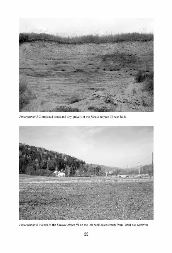
33
Photography 5 Compacted sands and tiny gravels of the Sázava terrace III near Buda
Photography 6 Plateau of the Sázava terrace VI on the left bank downstream from Poříčí nad Sázavou
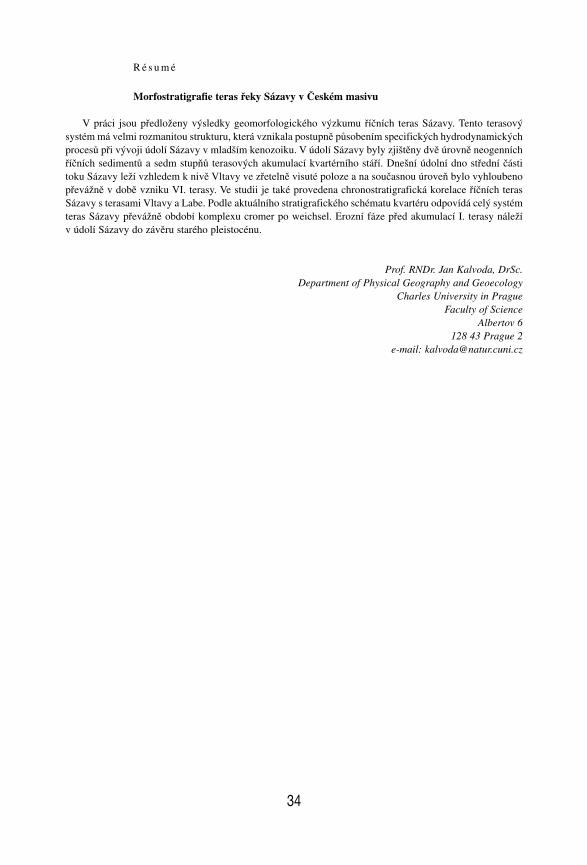
R é s u m é
Morfostratigrafie teras řeky Sázavy v Českém masivu
V práci jsou předloženy výsledky geomorfologického výzkumu říčních teras Sázavy. Tento terasovýsystém má velmi rozmanitou strukturu, která vznikala postupně působením specifických hydrodynamickýchprocesů při vývoji údolí Sázavy v mladším kenozoiku. V údolí Sázavy byly zjištěny dvě úrovně neogenníchříčních sedimentů a sedm stupňů terasových akumulací kvartérního stáří. Dnešní údolní dno střední částitoku Sázavy leží vzhledem k nivě Vltavy ve zřetelně visuté poloze a na současnou úroveň bylo vyhloubenopřevážně v době vzniku VI. terasy. Ve studii je také provedena chronostratigrafická korelace říčních terasSázavy s terasami Vltavy a Labe. Podle aktuálního stratigrafického schématu kvartéru odpovídá celý systémteras Sázavy převážně období komplexu cromer po weichsel. Erozní fáze před akumulací I. terasy náležív údolí Sázavy do závěru starého pleistocénu.
Prof. RNDr. Jan Kalvoda, DrSc.Department of Physical Geography and Geoecology
Charles University in PragueFaculty of Science
Albertov 6128 43 Prague 2
e-mail: [email protected]
34