agenda of council meeting - 18 february 2019 · web viewall noise barriers/acoustic fences to be...
TRANSCRIPT

Council MeetingNotice PaperMonday 18 February 2019 at 7pm
Council Chamber, Malvern Town Hall,(enter off Glenferrie Road, Malvern)
Vision
Stonnington will be an inclusive, healthy, creative, sustainable and smart community.
Council’s vision will be implemented through four key pillars:
Community: An inclusive City that enhances the health and wellbeing of all residents, where people can feel safe, socially connected and engaged.
Liveability: The most desirable place to live, work and visit. Environment: A cleaner, safer and better environment for current and future
generations to enjoy. Economy: A City that will grow its premier status as a vibrant, innovative and
creative business community.
These pillars reflect the shared priorities of our community and Council, and are consistent with our history and vision for a liveable future. For each pillar, there is a framework for our strategies, actions and measures which outline the key services and projects to be delivered to our community.
The Strategic Resource Plan sets out how Council will provide the resources needed to implement strategies and actions within the Council Plan.
Councillors
Cr Steven Stefanopoulos, MayorCr Glen AtwellCr John ChandlerCr Sally DavisCr Marcia GriffinCr Judy HindleCr Jami KlisarisCr Matthew KoceCr Melina Sehr
Page 2
NOTESCouncil business is conducted in accordance with Part 4 Division 3 of the Meeting Procedure section of Council’s General Local Law 2018 (No 1). Some copies are available with the agenda or you can find a copy on Council’s website www.stonnington.vic.gov.au under local laws.
Councillors carry out the functions, powers, authorities and discretions vested with them under the Local Government Act 1989, and any other relevant legislation. Councillors impartially perform the Office of Councillor duties, in the best interests of the City of Stonnington residents to the best of their skills and judgement.
Councillors must formally declare their conflicts of interest in relation to any items listed on the agenda at the start of the meeting and immediately prior to the item being considered, in accordance with Sections 77 to 79 of the Act.
READING OF THE RECONCILIATION STATEMENT
We acknowledge that we are meeting on the traditional land of the Boonwurrung and Wurundjeri people and offer our respects to the elders past and present. We recognise and respect the cultural heritage of this land.
READING OF THE AFFIRMATION STATEMENT
We are reminded that as Councillors we are bound by our Oath of Office to undertake the duties of Councillor in the best interests of the people of the City of Stonnington and to faithfully and impartially carry out the functions, powers, authorities and discretions vested in us under the Local Government Act and any other relevant Act
Page 3
Welcome
Welcome to a Stonnington City Council meeting. These meetings are an important way to ensure that your democratically elected Councillors work for you in a fair and transparent way.
About this meeting
The first page of tonight’s agenda shows the different parts to the meeting, some of these are administrative and are required by Stonnington’s Local Law.
In the agenda you will also find a list of all the items to be discussed under ‘General Business’. Each report is written by a council officer and outlines the purpose of the report, relevant information and a recommended decision for councillors.
Council will consider the report and either accept, reject or make amendments to the recommendation. Council decisions are adopted if they receive a majority vote from the Councillors present at this meeting.
Arrangements to ensure meetings are accessible to the public
Council meetings are held at the Malvern Town Hall, corner High Street and Glenferrie Road (entry via Glenferrie Road by the door closest to the Malvern Police Station).
The Malvern Town Hall has an entrance ramp and elevators to ensure that the Council Chamber is accessible to the public. Fully accessible toilet and bathroom facilities are also available.
If you require translation, interpreting services or a hearing loop set up, please contact Council’s civic support on 03 8290 1331 to make appropriate arrangements before the meeting.
To ensure that people in the chamber can follow the meetings’ proceedings, proposed alternate resolutions, also known as ‘yellows’, are displayed on a screen and microphones are used during debate.
Live webcasting
Council meetings are webcast live via Council’s website, allowing those interested to view proceedings without attending Council meetings.
This gives people who may otherwise be unable to attend access to Council decisions and debate. A recording of the meeting is available on our website after the meeting (usually within 48 hours).
Only Councillors and Council officers seated around the Council table are visible on film. People in the public gallery will not be filmed, but if you speak, you will be recorded. Visit stonnington.vic.gov.au for more information.
Page 4
Members of the galleryIf you choose to attend a council meeting as a member of the public gallery, you should note the role of the Chairperson and your responsibilities under the City of Stonnington General Local Law 2018(1).
Extracts from the Local Law:
81. Gallery to be Silent
(1) Visitors must not interject or take part in the debate.(2) The gallery must be silent at all times during any Council Meeting.(3) The ring tones of mobile telephones and other devices must be turned off by people
in the gallery at all times.
88. Recording or Filming Proceedings
(1) A person must not operate an audio tape, mobile telephone or other recording or transmitting equipment or film ('a device') at any Council Meeting without first obtaining the consent of the Chairperson.
(2) Consent given under sub-clause (1) may be revoked by the Chairperson at any time during the course of a meeting.
(3) If a device is operated, or suspected of being operated, in contravention of sub-clause (1), the Chairperson may:(a) order the person operating, or suspected of operating, the device to produce
the device to the Chairperson; and(b) arrange for any matter that has been recorded on the device in contravention of
sub-clause (1) to be deleted, erased or otherwise removed from the device.(4) Subject to sub-clause (5), the Chairperson shall return any device that has been
produced to him or her pursuant to sub-clause (3) at the conclusion of the relevant Council Meeting.
(5) If the Chairperson has been unable to arrange for the matter that has been recorded on the device in contravention of sub-clause (1) to be deleted, erased or otherwise removed from the device, the device shall be returned to the person as soon as practicable after the deletion, erasure or removal has been carried out.
84. Removal from Chamber of a Councillor or Member of the Public
The Chairperson, or Council in the case of a suspension under clause 82, may ask any Authorised Officer or member of Victoria Police to remove from the meeting (including the gallery):(1) any person who the Chairperson has ordered to be removed under clause 82(3); or(2) any Councillor who has been suspended under clause 82 and who has not
immediately left the Council Meeting.
Page 5

50. Questions to Council from Members of the Public
(1) Questions to Council from members of the public will be considered as part of the order of business of an Ordinary Meeting only when submitted in the format outlined below:(a) Questions must be in writing and lodged at the office of the Chief Executive
Officer by 12 noon on the day of the next scheduled Ordinary Meeting.(b) A limit of five (5) questions per questioner applies.(c) Questions must include the name and address of the questioner and the date of
the question. Questions by facsimile or email are acceptable.(2) Within four (4) working days of receiving a complying question to Council from a
member of the public, the Chief Executive Officer will dispatch a notice to the member of the public who submitted the question, advising that the question has been received.
(3) At a meeting at which a question is to be considered:(a) The Chairperson will acknowledge that a question or questions have been
received from a (named) person and ask if that questioner is in the gallery. (b) If the questioner is present in the gallery, a summary of the subject matter of the
question(s) will be read out by the Chairperson and the questioner advised that a written reply to the question(s) will be issued within 14 days of that meeting date.
(c) If the questioner is not in the gallery, Council will respond to the question(s) in accordance with any standard correspondence to Council.
(4) The Chairperson has the discretion to allow a question to be asked and/or answered at the meeting that is in variance with the procedure in this Local Law.
(5) The Chairperson may refuse to acknowledge a question if, in the opinion of the Chairperson, the question is, or is potentially, defamatory, indecent, offensive, abusive, objectionable in language or substance, irrelevant, trivial, aimed at embarrassing a Councillor or a member of Council staff, outside Council’s powers or functions, has been asked at a previous Council Meeting and a reply issued, or relates to matters that come under section 89(2) of the Act.
(6) Any question relating to electoral matter during an Election Period will not be considered at any Council Meeting.
(7) A copy of the questions and responses will be tabled and inserted into the minutes of the following Council Meeting.
47. Open Meetings
(1) Subject to sub-clause (2), Council Meetings must be open to members of the public pursuant to section 89(1) of the Act.
(2) Council may resolve, under section 89(2) of the Act, that a meeting be closed to members of the public if Confidential Business is to be discussed.
Your cooperation is appreciated, we hope you enjoy the meeting.
Mayor and Councillors, Stonnington City Council
Page 6
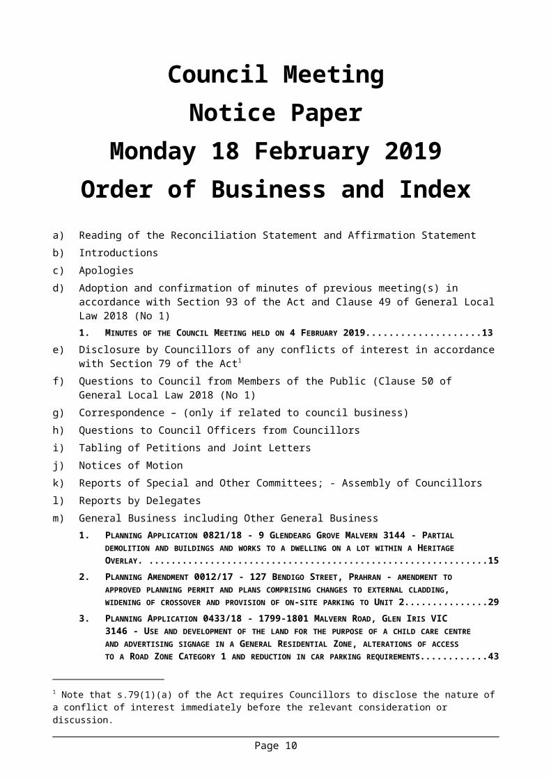
Council MeetingNotice Paper
Monday 18 February 2019Order of Business and Index
a) Reading of the Reconciliation Statement and Affirmation Statementb) Introductionsc) Apologies d) Adoption and confirmation of minutes of previous meeting(s) in accordance with Section 93
of the Act and Clause 49 of General Local Law 2018 (No 1)1. MINUTES OF THE COUNCIL MEETING HELD ON 4 FEBRUARY 2019...................................................9
e) Disclosure by Councillors of any conflicts of interest in accordance with Section 79 of the Act1
f) Questions to Council from Members of the Public (Clause 50 of General Local Law 2018 (No 1)
g) Correspondence – (only if related to council business)h) Questions to Council Officers from Councillorsi) Tabling of Petitions and Joint Lettersj) Notices of Motion k) Reports of Special and Other Committees; - Assembly of Councillors l) Reports by Delegates m) General Business including Other General Business
1. PLANNING APPLICATION 0821/18 - 9 GLENDEARG GROVE MALVERN 3144 - PARTIAL DEMOLITION AND BUILDINGS AND WORKS TO A DWELLING ON A LOT WITHIN A HERITAGE OVERLAY. ................................................................................................................................... 11
2. PLANNING AMENDMENT 0012/17 - 127 BENDIGO STREET, PRAHRAN - AMENDMENT TO APPROVED PLANNING PERMIT AND PLANS COMPRISING CHANGES TO EXTERNAL CLADDING, WIDENING OF CROSSOVER AND PROVISION OF ON-SITE PARKING TO UNIT 2....................................21
3. PLANNING APPLICATION 0433/18 - 1799-1801 MALVERN ROAD, GLEN IRIS VIC 3146 - USE AND DEVELOPMENT OF THE LAND FOR THE PURPOSE OF A CHILD CARE CENTRE AND ADVERTISING SIGNAGE IN A GENERAL RESIDENTIAL ZONE, ALTERATIONS OF ACCESS TO A ROAD ZONE CATEGORY 1 AND REDUCTION IN CAR PARKING REQUIREMENTS..................................31
4. PLANNING APPLICATION 0799/18 - 4 AND 6 HARVEY STREET, MALVERN VIC 3144 – CONSTRUCTION OF A THREE STOREY APARTMENT BUILDING COMPRISING TWO DWELLINGS AND TWO DOUBLE STOREY TOWNHOUSES OVER BASEMENT CAR PARKING..............................................59
5. PLANNING APPLICATION 0374/18 - 14 WILMOT STREET, MALVERN EAST VIC 3145 - DEMOLITION OF THE EXISTING DWELLING AND CONSTRUCTION OF TWO DWELLINGS ON A LOT IN A NEIGHBOURHOOD RESIDENTIAL ZONE AND NEIGHBOURHOOD CHARACTER OVERLAY..................81
6. PLANNING APPLICATION - 0803/18 - 349 WAVERLEY ROAD MALVERN EAST - USE OF LAND FOR A RESIDENTIAL BUILDING (ROOMING HOUSE) IN A GENERAL RESIDENTIAL ZONE.....................99
7. PLANNING APPLICATION - 0573/18 - 6-10A CHAPEL STREET WINDSOR - ERECT AND DISPLAY AN ELECTRONIC MAJOR PROMOTION SIGN IN AN ACTIVITY CENTRE ZONE......................................111
8. CATO SQUARE CAR PARK - PROPOSED PRICING STRUCTURE......................................................129
1 Note that s.79(1)(a) of the Act requires Councillors to disclose the nature of a conflict of interest immediately before the relevant consideration or discussion.
Page 7

9. EDGAR STREET, GLEN IRIS - INSTALLATION OF A SHORT TERM DISABLED PARKING SPACE ABUTTING HAROLD HOLT AQUATIC CENTRE...............................................................................141
10. ADOPTION OF THE 'TOWARDS ZERO' ROAD SAFETY STRATEGY 2018 - 2022..............................14511. FINCH STREET (HIGH STREET TO WATTLETREE ROAD), GLEN IRIS - TRAFFIC AND PARKING
INVESTIGATION........................................................................................................................... 15112. BEAVER STREET, MALVERN EAST - PROPOSAL TO INSTALL 2-HOUR PARKING RESTRICTIONS. . . .16113. COUNCIL FINANCIAL REPORT FOR THE PERIOD ENDING 31 DECEMBER 2018...............................16714. VOLUNTEERING.......................................................................................................................171
n) Urgent Businesso) Confidential Business
Page 8

ADOPTION AND CONFIRMATION OF MINUTES OF PREVIOUS MEETINGS
18 FEBRUARY 2019
RECOMMENDATION
That the Council confirms the Minutes of the Council Meeting of the Stonnington City Council held on 4 February 2019 and Minutes of the Confidential Meeting of the Stonnington City Council held on 4 February 2019 as an accurate record of the proceedings.
Page 9
GENERAL BUSINESS18 FEBRUARY 2019
m) General Business
1. PLANNING APPLICATION 0821/18 - 9 GLENDEARG GROVE MALVERN 3144 - PARTIAL DEMOLITION AND BUILDINGS AND WORKS TO A DWELLING ON A LOT WITHIN A HERITAGE OVERLAY.
Manager Statutory Planning: Alexandra Kastaniotis General Manager Planning & Amenity: Stuart Draffin
PURPOSE
For Council to consider a planning application for partial demolition, buildings and works to a dwelling on a lot within a Heritage Overlay at 9 Glendearg Grove Malvern.
This item was considered at the Council meeting of 4 February 2019. The application is now re-presented to Council for further consideration.
Executive Summary
Applicant: Contour Consultants Aust P/LWard: East WardZone: Neighbourhood Residential Zone, Schedule 2Overlay: Heritage Overlay, Schedule 156Neighbourhood Precinct: Garden Suburban 1Date lodged: 06 August 2018Statutory days: (as at council meeting date)
129 Days
Trigger for referral to Council:
More than 7 objections
Number of objections: 11 objectionsConsultative Meeting: Yes – held on 6 December 2018Officer Recommendation: Issue a Notice of Decision to Grant a Planning Permit
BACKGROUND
The Proposal
The plans that form part of the basis of Council's consideration were prepared by Davey Architecture Studio and are known as Drawing No.s: GGM D1- D3, GGM-TP01.0 – GGM TP01.6, GGM TP100- GGM TP106 dated 03 September 2018 and Council date stamped 07 September 2018.
A landscape plan prepared by Davidson Design Studio was also submitted. The landscape plan is Council date stamped 07 September 2018.
The application proposes partial demolition, buildings and works to a dwelling comprising a ground and first floor addition at the rear of the existing dwelling.
Key features of the proposal are:
Page 11
GENERAL BUSINESS18 FEBRUARY 2019
Demolition of the rear section of the existing dwelling, weatherboard outbuilding and rear fencing.
Construction of a basement/storage area comprising five car parking spaces, mudroom, lift, storeroom and stairwell. Access to the basement is proposed via a new accessway from the rear laneway.
Construction of a ground floor extension comprising a kitchen, living and dining area, play area, laundry, study , media room, lift and stairway.
Construction of a first floor extension comprising three bedrooms (each with their own ensuite), powder room, rumpus room, lounge and deck.
The construction of a paling fence, with gate and roller door along the rear boundary. Reconstruction/conservation works to the existing dwelling including repairs to the roof
and chimney and the reconstruction of verandah elements and detail. The proposed extension has a maximum height of 8.91 metres. The ground and first floor extension adopts a contemporary architectural style.
Proposed finishes and materials include charred timber cladding, zinc cladding, concrete finishes and glass balustrading.
Site and Surrounds
The site is located on the eastern side of Glendearg Grove, approximately 127 metres south of Wattletree Road. The site has the following significant characteristics:
A rectangular shaped lot with a frontage to Glendearg Grove of 15.85 metres, a depth of 35.18 metres and a total area of 1120 square metres.
A laneway is located adjacent to the rear boundary. The subject site is currently improved by a B graded single storey Victorian Dwelling. Vehicle access to the site is via an existing crossover on Glendearg Grove. A timber picket fence exists on Glendearg Grove. A street tree exists in front of the site on Glendearg Grove.
The subject site forms part of an established residential area, which generally features single storey detached dwellings. The site is located within the Claremont Precinct Heritage Overlay. The area is significant as it is an example of an area subdivided in the 1880’s as a result of improved public transport to Melbourne’s eastern suburbs. A range of valued building stock is also located within the area.
The site interfaces with adjoining properties as follows:
To the immediate north is 7 Glendearg Grove, comprising a single-storey Victorian Villa constructed of brick with a tiled roof. The property at 7 Glendearg Grove has a pool and garage located in the rear yard and is graded B within Heritage Precinct 156. Vehicle access to an open car parking space is provided with access from Glendearg Grove.
To the immediate south is 11 Glendearg Grove, comprising a single storey Victorian Villa constructed of brick with a tiled roof. The property at 11 Glendearg Grove has a pool and garage located in the rear yard and is graded B with within Heritage Precinct 156. Vehicle access to a driveway/open car parking space is provided from Glendearg Grove.
To the immediate east (rear of the site) is a bluestone laneway. The laneway provides rear vehicle access to properties in Glendearg Grove and Staniland Avenue to the east.
To the west of the subject site is Glendearg Grove, a two way street with street trees and on street parking available on both sides. On the opposite side of Glendearg Grove is 12 Glendearg Grove, comprising a single storey, B graded Victorian Villa.
Previous Planning Application(s)
Page 12
GENERAL BUSINESS18 FEBRUARY 2019
A search of Council records indicates there are no relevant planning applications.
The Title
The site is described on Certificate of Title Volume 06858 Folio 503 / Lot 1 on Title Plan 392309P and no covenants or easements affect the land.
Planning Controls
The following controls/permit triggers are considerations for this application:
Zone
Clause 32.09- Neighbourhood Residential Zone, Schedule 2.
Pursuant to Clause 32.09-5 a permit is required to construct of extend a dwelling on a lot less than 500 square metres. Given that the subject site is approximately 1120 square metres a permit is not required.
Pursuant to Clause 32.09-4 of, a lot must provide the minimum garden area for the lot size. Given the subject site has a lot size of 1120 square metres, this requires a minimum garden area of 35% of the lot (392 square metres). The proposal has a garden area of 51.9% (581 square metres) and therefore complies with the garden area requirement.
Clause 32.09-10 of the Neighbourhood Residential Zone states that a building must contain no more than 2 storeys at any point. It is noted that the proposal contains no more than 2 storeys and is therefore compliant with the maximum number of storeys under Clause 32.09-10.
Schedule 2 to the Neighbourhood Residential Zone requires that dwellings and residential buildings not exceed a height of 9m unless the slope of the natural ground level at any cross section wider than 8m of the site of the building is 2.5 degrees or more, in which case the height of the building must not exceed 10m. The proposal has a maximum height of 8.91 metres and therefore complies with the maximum height limit.
Overlay
Clause 43.01- Heritage Overlay.
Pursuant to Clause 43.01-1, a planning permit is required to demolish or remove a building, to construct a building or construct or carry out works.
Relevant Planning Policies
Clause 15 Built Environment and HeritageClause 15.03 Heritage Clause 21.06 Reference Document (Heritage Guidelines & Heritage Overlay Citations)Clause 22.04 Heritage PolicyClause 43.01 Heritage OverlayClause 65 Decision Guidelines
Advertising
Page 13
GENERAL BUSINESS18 FEBRUARY 2019
The application has been advertised pursuant to Section 52 of the Planning and Environment Act 1987 by sending notices to the owners and occupiers of adjoining land and by placing two signs on the site. The public notification of the application has been completed satisfactorily.
The site is located in East Ward and objections from 11 different properties have been received.
The objections are summarised as follows:
Heritage Site subsidence and changes to the water table. Neighbourhood Character Overshadowing Traffic issues with access proposed from the rear laneway The scale of the building is inconsistent with other buildings in the streetscape The house is excessive in size and it could be used for other uses Construction issues Errors in the planning report submitted with application.
A Consultative Meeting was held on 6 December 2018. The meeting was attended by Councillor Davis, representatives of the applicant, objectors and a Council Planning Officer. The meeting did not result in any changes to the plans, however it was agreed that another heritage advisor would be consulted about the proposal.
Referrals
Heritage
The application was reviewed by Council’s Heritage Adviser and the following comments were provided:
The proposed extent of demolition is limited to fabric that is not visible from Glendearg Grove, and therefore poses no issues from a heritage perspective.
As the bulk of the substantial upper storey addition is sited deep within the site largely behind the existing roof form, the additions to the rear can be supported in their current form.
The fact the currently unpainted chimneys are not to be painted is a positive heritage outcome. It would be ideal if all the paint could be removed from the brick and render facades using a low-abrasive method that will not damage the brickwork (such as the JOS system) as part of any redevelopment scheme for the site. Ultimately, this would also have advantages in terms of the long-term maintenance of the building.
We should ask for a detail drawing at 1:50 showing all of the proposed changes to the front verandah. This information could potentially form a condition of permit, and would include details of the basalt nosing, tessellated tiles, cast iron posts, and cast iron lacework frieze and brackets.
The proposal to repair any dislodged or damaged slate is positive from a heritage perspective. Care should be taken to ensure that any new slate is Welsh slate to match the existing.
As suggested at the consultation meeting on 6 December 2018, another heritage adviser was consulted about the proposal. The following comments were provided:
The proposed demolition is well to the rear of the property and the proposal retains 5 front rooms (encompassing some 13M) of the existing house.
Page 14
GENERAL BUSINESS18 FEBRUARY 2019
The new two storey structure is setback 12-13M from the main front of the house and given the setback of the house from the street, the addition will not be visible from Glendearg Grove. It will be visible from the rear lane and will change the views of the house from the neighbouring properties, but neither of these aspects are matters addressed by the heritage policy or guidelines.
The proposal uses distinctly modern materials and architectural forms and whilst these are different to the existing dwelling, they can be supported for providing a separate and modern approach which can be distinguished from the existing dwelling without interrupting the presentation of the property to the precinct.
The removal of paint from the existing brick and render surfaces would be a positive contribution to the presentation of the precinct.
Further documentation should be provided on the detailing of the restored verandah.
Planner response: Reflecting the comments from the Council advice, the following conditions will be included on any permit issued: a) A detail drawing at 1:50 showing all of the proposed changes to the front verandah
including details of the basalt nosing, tessellated tiles, cast iron posts, and cast iron lacework frieze and brackets
b) All the paint removed from the brick and render facades is to be done by using a low-abrasive method that will not damage the brickwork.
c) A notation confirming that any tiles to be replaced at the front of the existing dwelling are to be Welsh slate tiles.
Parks
Council’s Parks Department reviewed the plans and their comments are summarised as follows:
The application proposes the removal of one significant tree and two established trees. The significant tree proposed for removal is the Betula Pendula (Silver Birch). This tree is located within the rear setback.
There is no objection to the removal of the significant tree, subject to a suitable replacement tree installed in a minimum 100L container within the rear setback.
No canopy trees (10m +) are listed for inclusion within the new landscape design.
Planner response: A planning permit condition will be included on any permit issued requiring an amended landscape plan showing a canopy tree installed in a minimum 100L container within the rear setback.
Infrastructure
Council’s Development Engineer is supportive of the proposal subject to conditions in regards to the levels of the right of way not being altered being included on any permit issued.
Council’s Development Engineer noted the following in response to the concerns raised by residents in regards to side subsidence and changes to the water table.
Council is aware that there is a high groundwater table in this area. In theory the extent of groundwater present should not alter the way in which it is constructed, if it is not done correctly problems are likely. This is a building issue, rather than a planning issue.
Page 15

GENERAL BUSINESS18 FEBRUARY 2019
Transport
Council’s Transport and Parking Department reviewed the plans and their comments are summarised as follows:
The traffic impact of this development is anticipated to be negligible.
KEY ISSUES
Heritage
A planning permit is only required under the Heritage Overlay, therefore consideration of the application is limited to an assessment under the Heritage Overlay Provisions.
The heritage place is graded B and therefore is defined in Clause 22.04-2 as a ‘significant place’.
With respect to additions and alterations in residential areas, Clause 22.04-4 of the Council’s Heritage Policy states that the following apply to the proposed demolition of ‘significant’ buildings:
Discourage demolition of parts of significant buildings (including but not limited to significant building fabric, the primary building volume, original fences, outbuildings, gardens and other features identified in the statement of significance or heritage assessment) unless it can be demonstrated that one or more of the following apply: o The demolition is minor in scale.o The demolition will not advertised affect the significance of the heritage place. o The replacement development is sympathetic to the scale, setback and
significance of the heritage place. Require all applications for full or partial demolition to be accompanied by an
application for new development.
And new alterations and additions in all areas should:
Retain and conserve the primary building volume and significant building fabric. Are set back behind the primary building volume. Respect the built form character of the place including but not limited to scale, form,
height, street wall, siting and setbacks. Adopt a visually recessive design where the heritage place remained the dominant
visual element. Are readily identifiable as new works while respecting and having minimal impact on
the significance of the heritage place. Complement the materials, detailing and finishes and paint colours of the heritage
place. Avoid new openings in the primary building volume and significant building fabric.
As confirmed by the heritage advice, the extent of demolition is considered to be acceptable and is in accordance with Council’s Heritage Policy (Clause 22.04) as the works will not be significantly visible from Glendearg Grove, will not impact on the heritage significance of the precinct and the primary building volume is retained.
In this case, the new additions comply with the objectives of the policy as they are setback behind the principal façade and will be visually recessive from the primary street frontage
Page 16
GENERAL BUSINESS18 FEBRUARY 2019
(Glendearg Grove). More specifically, the proposed ground and first floor additions are setback approximately 14 metres from the principal façade. As the first floor is setback behind the existing roof form and is setback between 3.52 metres and 4.6 metres from the northern and southern side boundaries, this will ensure the first floor is recessed and will not dominate the existing contributory elements of the dwelling.
The existing vehicle crossing to Glendearg Grove is maintained and additional vehicle car parking is provided in a basement. Access to the basement is provided from the rear laneway which avoids the ramp being visible from the public realm. Overall, the car parking arrangement and vehicle access is acceptable and in accordance with Council’s Heritage Policy (Clause 22.02-4-10) as it is located at the rear of the site and will not be visible from the streetscape.
In regards to the additions, it is a commonly held view that new works can be supported on heritage buildings where they are sympathetically integrated to provide a clear delineation between the old and new fabric. In saying this, the proposed new additions are considered to be sympathetic and complementary to the original heritage fabric.
The use of concrete and vertically stacked brick to the ground floor maintains the character of the existing dwelling. The use of zinc cladding proposed to the first floor ensures that the first floor appears as a contemporary addition to the building and provides a clear delineation between the old and new fabric. Overall, it is considered that due to the setback and design of the additions, it will not dominate or detract from the original heritage place or the wider heritage precinct.
With regards to the restoration works proposed, the plans show that there will be local cleaning and repair of the slate roof. The applicant confirmed that this will include cleaning of the lichen roof (avoiding pressure spraying), replacement of cracked or damaged individual slates with matching natural slate and using slate hooks. To ensure that the replacement tiles are sympathetic with the original tiles a condition will be included on any permit issued requiring the replacement tiles to the existing roof to be Welsh slate, this is recommended by Council’s Heritage Advisor.
The other changes recommended by Council’s Heritage Advisor relates to a detail drawing at 1:50 showing all of the proposed changes to the front verandah including details of the basalt nosing, tessellated tiles, cast iron posts, and cast iron lacework frieze and brackets. Council’s Heritage Advisor also required that all the paint be removed from the brick and render facades using a low-abrasive method that will not damage the brickwork. The removal of the paint from the brick and render facades is consistent with Clause 22.04-4.2 of Council’s Heritage Policy. Conditions are proposed to be placed on any permit issued to show a detail drawing showing the changes to the front verandah and paint removed from the brick and render facades as per Council’s Heritage Advisor’s recommendation.
Water Sensitive Urban Design – Clause 22.18
The Water Sensitive Urban Design response submitted in response to Clause 22.18 details a storm rating of 101%
The stormwater treatment method proposed is two raingardens with a total area of 6.0m2 and a 5000L water tank. The raingarden is shown on the landscape plan adjacent to the proposed access way and the tank is shown in the basement. There is a notation on the plans stipulating that the rainwater tank will be connected to toilets for flushing and there is a section detail of the raingarden on the landscape plan. The raingarden should also be shown on the development plans, this will be requested a condition of the permit.
Page 17
GENERAL BUSINESS18 FEBRUARY 2019
This satisfactorily addresses Council’s WSUD Policy.
Objections
In response to the grounds of objection not already discussed in the report, the following comments are made:
Traffic issues with access proposed from the rear laneway- this does not form part of the assessment against heritage policy. Nonetheless Council’s Transport Department have confirmed that the traffic impact of this development is anticipated to be negligible.
Neighborhood Character- it is noted that the permit trigger relates to the Heritage Overlay. Those matters ordinarily considered via Clause 54 (ResCode) are not triggered in this instance.
Overshadowing- it is noted that the permit trigger relates to the Heritage Overlay only. Those matters ordinarily considered via Clause 54 (ResCode) such as overshadowing are not triggered in this instance. Matters such as amenity impact will be considered as part of the building permit application.
The house is excessive in size and it could be used for other uses- the applicant has not applied for a change of use, therefore an assessment of the use of the site is not a planning consideration.
Site subsidence and changes to the water table- this is a building issue that is outside the ambit of the planning regime.
Construction issues- this is a building issue that is outside the ambit of the planning regime.
Human Rights Consideration
This application has been assessed in accordance with the requirements of the Planning and Environment Act 1987 (including the Stonnington Planning Scheme), reviewed by the State Government and which complies with the Charter of Human Rights and Responsibilities Act 2006.
CONCLUSION
Having assessed the application against the relevant planning controls, it is recommended that the proposal be supported for the following reasons:
The proposed additions are sympathetic to the heritage streetscape.
ATTACHMENTS
1. PA2 - 821-18 - 9 Glendearg Grove Malvern - Attachment 1 of 1
RECOMMENDATION
Page 18
GENERAL BUSINESS18 FEBRUARY 2019
That a Notice of Decision to Grant a Planning Permit No: 821/18 for the land located at 9 Glendearg Grove Malvern be issued under the Stonnington Planning Scheme for partial demolition, buildings and works to a dwelling on a lot within a Heritage Overlay subject to the following conditions:
1. Before the commencement of the development, 1 copy of plans drawn to scale and fully dimensioned, must be submitted and approved by the Responsible Authority. The plans must be generally in accordance with the plans dated stamped 07 September 2018 but modified to show:
a) A detail drawing at 1:50 showing all of the proposed changes to the front verandah including details of the basalt nosing, tessellated tiles, cast iron posts, and cast iron lacework frieze and brackets.
b) All the paint removed from the brick and render facades is to be done by using a low-abrasive method that will not damage the brickwork.
c) A notation confirming that any tiles to be replaced at the front of the existing dwelling are Welsh slate tiles to match the existing tiles.
d) The raingarden is to be shown on the development plans.e) Any changes as required by Condition No. 3.
All to the satisfaction of the Responsible Authority.
2. The layout of the site and the size, levels, design and location of buildings and works shown on the endorsed plans must not be modified for any reason without the prior written consent of the Responsible Authority.
3. Before the development starts, a landscape plan to be prepared by a landscape architect or suitably qualified or experienced landscape designer, must be submitted to and approved by the Responsible Authority. When approved, the landscape plan will be endorsed and will then form part of the permit. The landscape plan must be in accordance with the landscape concept plan dated 07 September 2018 prepared by Davidson Design Studio , but modified to show:
a) The incorporation of at least one canopy tree within the secluded private open space of the dwelling. The canopy tree is to be installed in a minimum 100L container.
b) Additional planting of vegetation to the rear of the proposed building subject to it having no impact on the basement and it being generally in accordance with the layout and locations shown on the discussion plan (Rev B) prepared by Davey Architecture Studio, dated 05 February 2019.
4. The project must incorporate the Water Sensitive Urban Design initiatives detailed in the endorsed site plan and/or stormwater management report.
5. The existing levels of the rear right-of-way must not be lowered or altered in any way at the property line (to facilitate the basement ramp).
6. This permit will expire if one of the following circumstances applies:
a) The development is not started within two years of the date of this permit.b) The development is not completed within four years of the date of this
permit.
Page 19
GENERAL BUSINESS18 FEBRUARY 2019
In accordance with Section 69 of the Planning and Environment Act 1987, a request may be submitted to the Responsible Authority within the prescribed timeframes for an extension of the periods referred to in this condition.
NOTES
I. This permit does not constitute any authority to carry out any building works or occupy the building or part of the building unless all relevant building permits are obtained.
II. This property is located in a Heritage Overlay and planning permission may be required to demolish or otherwise externally alter any existing structures. External alterations include paint removal and any other form of decoration and works, but does not include re-painting an already painted surface.
III. This permit application was not assessed against the provisions of Clause 54 – One Dwelling on a Lot (ResCode) of the Stonnington Planning Scheme. As such, it is the responsibility of the applicant/owner to appoint a Registered Building Surveyor to determine compliance of the endorsed plans associated with the issue of this Planning Permit against Part 4 of the Building Regulations 2006. Non-compliance with any Regulation will require dispensation from Council’s Building Control Services Department.
IV. Nothing in this permit hereby issued shall be construed to allow the removal of, damage to or pruning of a significant tree (including the roots) without the further written approval of Council.
“Significant tree” means a tree:a) with a trunk circumference of 180 centimetres or greater measured at its
base; orb) with a trunk circumference of 140 centimetres or greater measured at 1.5
metres above its base; orc) listed on the Significant Tree Register.
Please contact the Council Arborists on 8290 1333 to ascertain if permission is required for tree removal or pruning or for further information and protection of trees during construction works.
V. At the permit issue date, Section 69 of the Planning and Environment Act 1987 stated that the Responsible Authority may extend the periods referred to if a request is made in writing within the following timeframes:
a) Before or within 6 months after the permit expiry date, where the development allowed by the permit has not yet started; and
b) Within 12 months after the permit expiry date, where the development allowed by the permit has lawfully started before the permit expires.
Page 20
GENERAL BUSINESS18 FEBRUARY 2019
2. PLANNING AMENDMENT 0012/17 - 127 BENDIGO STREET, PRAHRAN - AMENDMENT TO APPROVED PLANNING PERMIT AND PLANS COMPRISING CHANGES TO EXTERNAL CLADDING, WIDENING OF CROSSOVER AND PROVISION OF ON-SITE PARKING TO UNIT 2
Manager Statutory Planning: Alexandra Kastaniotis General Manager Planning & Amenity: Stuart Draffin
PURPOSE
For Council to consider a Section 72 Amendment application to approved permit and plans to allow for changes to external cladding, widening of the crossover and provision of on-site parking to Unit 2 at 127 Bendigo Street, Prahran.
This item was considered at the Council meeting of 4 February 2019. The application is now re-presented to Council for further consideration.
Executive Summary
Applicant: Sync Design Pty LtdWard: South WardZone: General Residential Zone - CL32.08 - Schedule 12 - Inner
UrbanOverlay: Special Building Overlay - CL44.05Neighbourhood Precinct: Inner Urban PrecinctDate lodged: 02 March 2018Statutory days: (as at council meeting date)
93
Trigger for referral to Council:
Councillor call up – Councillor Sehr
Number of objections: ZeroOfficer Recommendation: Issue a Notice of Refusal to Amend a Planning Permit
BACKGROUND
Permit History
Planning Permit 12/17 was issued on 19 October 2017 under delegation for the ‘construction of two dwellings on a lot in a General Residential Zone and Special Building Overlay and reduction in the car parking requirement’.
Plans were endorsed on 22 January 2018 to form part of the permit.
The endorsed plans feature the following: Two attached, three storey dwellings with a side by side layout. A single car garage with a tandem car space in the driveway for Unit 1. A single width crossover to Unit 1. No off-street parking and vehicle access for Unit 2.
Construction of the approved development has commenced and is constructed to a framing stage.
This is the first amendment request to the permit.
Page 21

GENERAL BUSINESS18 FEBRUARY 2019
The Proposal
The plans that form the basis of Council's consideration were prepared by Sync Design and are known as Drawing No's TP.01, TP.02, TP.04 and TP.05 (all Rev I) with Council date stamped 21 May 2018 and TP.03 (Rev J) with Council date stamped 23 July 2018.
Key features of the proposal are: Changes to external cladding of Modwood timber from horizontal timber (TC) to vertical
board painted in black finish. Widening of the vehicle crossover to provide vehicle access to Unit 2. Provision of an additional car parking space for Unit 2. Consequential changes to the frontage on the landscape plan. Subsequent amendment to the permit conditions to reflect the proposed amendment.
Site and Surrounds
The subject site is located on the west side of Bendigo Street, approximately 30 metres south of its intersection with Malvern Road in Prahran. The rectangular shaped allotment has a frontage to Bendigo Street measuring 10.3 metres and a maximum depth of 28 metres, equating to an overall area of 289 square metres.
The surrounding area comprises an established residential precinct predominantly characterised by a variety of low scale built form, including semi-detached and detached Victorian, post war, and modern dwellings. However, land to the north and west contains more intensive developments and is used for commercial and residential purposes.
To the south of the site is 125 Bendigo Street which is developed with a single storey Victorian dwelling. This property is constructed to the northern boundary (common boundary with the subject site) and has an area of approximately 55 square metres of secluded private open space (SPOS) located to the west of the dwelling. This dwelling has no on-site parking and vehicle access.
Directly adjoining the subject site to the north are zoned Mixed Use and occupied by five (5) two and three storey buildings fronting Malvern Road. There are several structures built abutting the common boundary with the subject site, as well as at-grade parking accessed from Bendigo Street.
To the west of the site is an accessway and at-grade car park associated with Victoria House Private Hospital. This land is within the Activity Centre Zone (ACZ1) with a preferred maximum building height of 18 metres (5 storeys). Planning Permit 388/14 issued on 3 February 2016 at the direction of VCAT allows for a 6 storey mixed use building on Malvern Road comprising a medical facility, ground floor retail floor space and 15 dwellings; a 6 storey apartment building; and 18 two and three storey townhouses at the southern end of the site. Two levels of basement provide parking for 215 vehicles and ancillary facilities. The 6 storey mixed use building is proposed to be constructed opposite the private open space of the subject site. To date, no plans have been endorsed and works have not commenced on site. An extension of time for this planning permit was recently granted and the development must commence by 3 February 2021.
In addition to the above planning permit, the land to the west of the subject site is also subject to a current VCAT proceeding. Planning application (501/18) was sought for
Page 22
GENERAL BUSINESS18 FEBRUARY 2019
construction of a 6 storey medical centre building, refurbishment of the existing central single storey hospital building and a multi-level car park at the location of the existing at-grade car park fronting Bendigo Street. The application was refused by Council on 4 September 2018 and a review against Council’s refusal has been lodged with VCAT. The VCAT proceeding will be heard on 1 April 2019.
Directly to the north-east of the site at 336 Malvern Road, Planning Permit 515/13 was issued in May 2014 for the construction of a four storey mixed use building comprising a shop and two dwellings with parking at the rear via Bendigo Street. This permit has been extended and works must commence by 12 May 2020 and be completed by 12 May 2022. This property is located approximately 10 metres from the subject site.
Previous Planning Application(s)
A search of Council records indicates that there are no other planning applications for the site other than the subject permit (0012/17).
The Title
The site is described on Certificate of Title Volume 05330 Folio 855 / Lot 1 on Title Plan 685094B. No covenants or easements affect the land.
Planning Controls
Section 73(1) of the Planning and Environment Act 1987 states that Sections 47 to 62 apply to an application to amend a permit as if the application were an application for a permit and any reference to a permit were a reference to the amendment to the permit.
Therefore, the amendments to the permit and plans are to be assessed against the relevant planning controls affecting the proposal.
The following controls/permit triggers are considerations for this amendment application:
ZoneClause 32.08 – General Residential Zone (Schedule 12)Pursuant to Clause 32.08-6, a permit is required to construct two or more dwellings on the lot. A development must meet the requirements of Clause 55.
Schedule 12 to the General Residential Zone (GRZ) requires that dwellings and residential building must not exceed 9 metres in height unless the slope of the natural ground level at any cross section wider than 8 metres of the site of the building is 2.5 metres or more, in which case the height of the building must not exceed 10 metres. The amendment does not propose to change the approved building height.
The minimum garden area requirement as specified in Clause 32.08-4 is not applicable as the subject lot has an area of less than the threshold of 400 square metres.
OverlayClause 44.05 – Special Building OverlayPursuant to Clause 44.05-2, a permit is required to construct a building or to construct or carry out works, including the construction of a deck to a dwelling with a finished floor level of not more than 800mm above ground level. An application must be referred to Melbourne Water.
Particular Provisions
Page 23
GENERAL BUSINESS18 FEBRUARY 2019
Clause 52.06 – Car ParkingThe proposed development generates a demand for 4 spaces under Clause 52.06-5.
The original approval includes 2 spaces for Unit 1 and no off-street parking for Unit 2. The permit allows for reduction in the statutory car parking requirements (2 spaces).
The amendment proposes to provide one (1) at-grade car space to Unit 2, with no change to the car parking arrangement for Unit 1. The amendment continues to require a reduction in the statutory car parking requirements for Unit 2.
Relevant Planning Policies
Clause 21.03 VisionClause 21.05 HousingClause 21.06 Built Environment and HeritageClause 21.08 InfrastructureClause 22.05 Environmentally Sustainable Development PolicyClause 22.18 Stormwater Management (Water Sensitive Urban Design) PolicyClause 22.23 Neighbourhood Character Policy
Advertising
The application to amend the permit and plans has been advertised pursuant to Section 52 of the Planning and Environment Act 1987 by sending notices to the owners and occupiers of adjoining land and by placing one (1) sign on the site. The public notification of the application has been completed satisfactorily.
No objections have been received.
Referrals
Melbourne Water
No objection to the amendment. The conditions outlined in the permit are still applicable.
Transport and Parking Unit
With respect the swept path diagrams, the following comments are provided:
The ingress swept paths show one corrective manoeuvre will be required to access either off-street parking space. Corrective manoeuvres in the public road is not appropriate. While it could be argued that some existing properties in Bendigo Street make corrective manoeuvres to access off-street spaces, these are existing conditions. This is not supported for a new design. The proposal seeks to introduce a new development, and therefore the development must not cause any delay to the public road network. Functionally, corrective manoeuvres will cause a delay to traffic on Bendigo Street. As there is only one through lane, there are no other alternatives but for traffic to wait. Also, there is a possibility for the future occupants of the development to approach Council requesting that on-street parking be removed so as to improve accessibility to the parking spaces. On-street parking is highly valued by the community, particularly in this area, and any removal is likely to be opposed. Further, Council may not look favourably on the request, which is brought about due to a poor design.
Page 24
GENERAL BUSINESS18 FEBRUARY 2019
To summarise, the ingress swept paths are not appropriate. The applicant is to revise plans to demonstrate ingress and egress in a single manoeuvre. Alternatively if this cannot occur, the applicant should reduce the intensity of the development.
Overall, the amendment is not supported by Council’s Transport and Parking Unit due to the following:
Concerns with management of the internal driveway to ensure each vehicle parks within its driveway without obstruction of access for the other space.
The swept paths are considered inappropriate and do not satisfactorily demonstrate adequate access to the off-street parking spaces due to the need of multiple manoeuvres in the public road network.
Impact on existing on-street parking. Potential request for removal of on-street parking due to difficulties of manoeuvring
within the development and accessing the site.
Infrastructure (Crossover) Unit
The proposed double crossing is to be constructed in concrete to current Stonnington Council standards including maintaining a consistent concrete kerb and channel and to the following detail:- Crossing is to be 6.2m wide starting from 2.075m from the northern building line,
not including splays.- 1.3m straight splays on both sides of the crossing, starting from the building line.- 25mm bullnose on the edge of the crossing.
Council Transport and Parking Unit to approve the setback for the property, the potential loss of street parking and assess the turning template for the proposed crossing as Bendigo Street is quite narrow.
Building and Local Laws Unit to approve the width of the proposed double crossing and the crossing taking up more than 33% of the properties frontage.
Written approval from Telstra to relocate a Telstra pit or convert pit lids to medium duty gatic or equivalent.
The above comments from Council’s Infrastructure Unit do not imply an application for a vehicle crossing permit would be supported and further assessment would be undertaken at the time of the application.
Building and Local Laws Unit
Building and Local Laws Unit cannot support this proposal as it does not comply with Council’s Vehicle Crossing Policy. The crossover would take up 60.2% of the street alignment, exceeding 33% allowed in the policy.
KEY ISSUES
The changes to the plans and permit are considered in turn below:
Changes to external cladding
It is proposed to change the external material of Modwood timber (TC) to the eastern walls at ground floor (i.e. Unit 1 garage and the front wall of Unit 2), from horizontal timber to vertical board painted in black finish.
The proposed change of material from horizontal timber to vertical board is considered minor in nature. An adequate level of articulation on the front façade would still be maintained
Page 25
GENERAL BUSINESS18 FEBRUARY 2019
through the use of various external materials between the floor levels. However, the change of colour palette from timber to black is inconsistent with the existing and preferred neighbourhood character of the surrounding area and will result in adverse impact to the streetscape. The proposed black colour is contrary to the design guidelines in Clause 22.23 for the Inner Urban precinct, in which the policy specifically seeks to avoid ‘building materials, finishes and colours that are in stark contrast with the character of the streetscape’. The existing residential developments along Bendigo Street are primarily semi-detached and detached Victorian, post war, and modern dwellings, with predominant use of traditional red or light coloured bricks, or cream or light coloured timbers. It is acknowledged that the commercial building to the north contains black coloured walls, however this could not be used as justification for the current proposal due to different site context. The two buildings are located in different zones, are subject to different zoning controls and planning policy, and are for different purposes, i.e. one for residential and one for commercial. Most notably, the Neighbourhood Character Policy at Clause 22.23 does not apply to the commercial properties to the north.
Whilst it is recognised that the development is contemporary in appearance with use of various contemporary building materials, the proposed black finish will create too much of contrast with the existing streetscape and residential character along Bendigo Street and thus is considered unacceptable. A lighter colour tone, that would complement the contemporary architectural design without creating too much of contrast with the existing traditional residential developments, is considered more appropriate.
Widening of crossover and provision of on-site parking to Unit 2
It is noted that the original application initially proposed 4 car parking spaces on site (2 spaces to each dwelling) via a new crossover with the following layout:
Figure 1 Ground floor plan extracted from the advertised material of the original application
Council’s Building and Local Laws Unit subsequently advised that a crossover would not be supported in this location and Council’s Transport and Parking Unit also raised safety concerns with the alignment. As a result, the original application was amended on 10 July 2017 under Section 57A of the Planning and Environment Act 1987 to remove the car parking spaces associated with Unit 2 and to reconfigure the crossover to the north. The amended application was re-advertised and subsequently approved with reduction in car parking requirement for Unit 2. An excerpt of the endorsed plans is shown as follows:
Page 26
GENERAL BUSINESS18 FEBRUARY 2019
Figure 2 Endorsed ground floor plan
The current amendment application proposes to widen the vehicle access from 3 metres to 6.2 metres in order to provide on-site parking (one uncovered car space) to Unit 2 and make consequential changes to the landscape plan. An excerpt of the proposed amendment is shown as follows:
Figure 3 Proposed amendment
In essence, the current amendment application, by reintroducing a double width crossover, literally reverts back to the original proposal upon which Council initially had concerns with and is seeking to win back changes made through the planning process in order to obtain the original approval. It is acknowledged that in some cases, circumstances can and do change since the issue of the original permit and may result in the need to amend the design. However, this is not the case here. The neighbourhood character, physical site context and developments nearby are similar to that when the original planning permit was granted. There are also no significant changes to the planning policy and controls since the original permit was issued. The amendment application is not supported by a change of circumstance.
The changes sought to the car parking arrangement and vehicle access have been assessed against the Neighbourhood Character Policy in Clause 22.23, the relevant standards in Clause 55, and Clause 52.06. The relevant considerations are detailed below.
Neighbourhood Character
The subject site sits within the Inner Urban Precinct at Clause 22.23 (Neighbourhood Character Policy). This precinct has a defined preferred neighbourhood character as follows:
Page 27
GENERAL BUSINESS18 FEBRUARY 2019
The Inner Urban (IU) character precinct is defined by buildings of innovative and high quality architectural styles that sit comfortably within compact streetscapes of Victorian, Edwardian and Interwar dwellings. Consistent front setbacks reinforce the building edge along the streets, and building heights and forms complement, rather than dominate, the rhythm of development. Well-designed gardens for small spaces contribute to the softening of the streetscape. Low or permeable front fences provide views of building facades and front gardens. Where present, car parking structures are located at the rear of buildings with access from rear lanes to provide continuous, uninterrupted footpaths for pedestrian friendly streets. Areas within a Residential Growth or Mixed Use Zone or within a substantial change area will accommodate more development within a more compact setting but with space for vegetation and high quality, responsive design.
The design guidelines specific to this precinct seek, amongst other things, to prevent the loss of front garden space and the dominance of car parking structures. To achieve an appropriate outcome the policy recommends that car parking structures should be located behind the front façade and hard paving for car parking should be minimised. Additional crossovers are to be avoided, along with visually dominant car parking structures and excessive areas of paving and driveways.
As proposed, the development has poor integration with the street and the existing residential properties nearby. The extent of hardstand within the front setback is considered excessive and is at odds with the existing and preferred neighbourhood character of the area sought to achieve in Clause 22.23 as outlined above. The proposed double crossover of 6.2 metres wide will occupy 60.2% of the street frontage. This is inconsistent with the pattern of developments in the surrounding residential streetscape, where there is limited provision for car parking within the front setback of existing dwellings along Bendigo Street. It is also important to note that the crossovers on the adjoining properties to the north are in different site context, where these properties are commercial buildings fronted onto Malvern Road with vehicle access located at the rear accessed off Bendigo Street, and hence do not form part of the residential streetscape of Bendigo Street. The widening of the crossover and accessway and provision of on-site parking to Unit 2 will result in visual dominance of car parking and accessway to public space, which is inconsistent with the design standard 5 at Clause 52.06-9.
The ground floor plan shows that the crossover does not align with the southern edge of the internal driveway. The widening of the internal driveway will have consequential impact to the landscaping layout and canopy tree planting along the southern edge of the internal driveway. All these consequential changes have not been correctly reflected in the landscape plan submitted with the amendment application. This raises a significant concern of whether the canopy tree planting along the internal driveway would still be achievable. Deletion of canopy tree planting, despite not being proposed, would be inconsistent with the Neighbourhood Character Policy in Clause 22.23 and Clause 21.06 (Landscape Character) which seek to repair, maintain and reinforce the garden setting.
The provision of a double width crossover exacerbates the extent of hard paving and the visual dominance of car parking within the streetscape. Given the narrow lot width of only 10.3 metres, it is considered that the approved design featuring a single width crossover has already achieved an appropriate balance of providing vehicle access on this site without adversely impacting on the streetscape and neighbourhood character of the surrounding area. Further widening the crossover and internal driveway to a double width will disrupt the rhythm of the existing development pattern along Bendigo Street and unduly impact the pedestrian amenity, streetscape and neighbourhood character of the area.
Page 28
GENERAL BUSINESS18 FEBRUARY 2019
Overall, the proposed amendment is contrary to the design objectives and responses of the Inner Urban Precinct in Clause 22.23. It will result in a poor planning outcome that will adversely impact the streetscape and the existing and preferred neighbourhood character of the area. Whilst widening the crossover will provide off-street parking to Unit 2, this would be achieved at the expense of streetscape and neighbourhood character of the wider area and thus cannot be supported.
Site Permeability
The amendment will result in a decrease of site permeability from 25.31% to 18.58%, which is below the minimum 20% as specified in Standard B9. The reduction in site permeability is considered inappropriate and fails to achieve the objectives of Standard B9.
Access
Standard B14 stipulates that accessways or car spaces should not exceed 40% of the street frontage, on lots with frontages of less than 20 metres. The amendment will increase the width of the crossover from 3 metres to 6.2 metres, which occupies 60.2% of the street frontage compared to 29.1% in the original approval. This well exceeds the recommended 40% maximum specified in Standard B14 of Clause 55. As explained above, the design of a wide crossover and internal accessway fails to adequately respond to the existing and preferred neighbourhood character of the area and will result in a poor urban design outcome.
It is important to note that the subject site originally had no crossover prior to the issue of this planning permit and the original approval has already resulted in the loss of one on-street car parking space. Further widening of the crossover to the extent as proposed could result in further loss of on-street parking due to difficulties of manoeuvring within the development and ingress and egress of the development. The proposal therefore fails to meet this aspect of Standard B14.
Overall, the proposal fails to achieve the objective of Standard B14 which seeks to ensure the number of design of vehicle crossovers respects the neighbourhood character.
Car Parking
The design of car parking spaces, internal driveway and crossover generally complies with the numeric requirements in Clause 52.06-9. However, as outlined in the referral section, Council’s Parking and Transport Unit has raised concerns with the functionality of car parking and vehicle access arrangement, inadequate swept paths, impact on existing on-site parking and potential request for removal of on-street parking (due to difficulties of manoeuvring and accessing the development). As proposed, this arrangement raises significant safety and operational concerns. As such, the amendment is considered unacceptable from traffic and safety perspectives and is not supported.
Human Rights Consideration
This application has been assessed in accordance with the requirements of the Planning and Environment Act 1987 (including the Stonnington Planning Scheme), reviewed by the State Government and which complies with the Charter of Human Rights and Responsibilities Act 2006.
Page 29
GENERAL BUSINESS18 FEBRUARY 2019
CONCLUSION
The proposed amendment fails to adequately respond to the existing streetscape, development pattern, and the existing and preferred neighbourhood character of the surrounding area. The changes to the car parking arrangement and vehicle access raise significant safety and operational concerns and are not supported by Council’s Transport and Parking Unit. It is therefore recommended that the amendment be refused.
ATTACHMENTS
1. PA - 12-17 - 127 Bendigo Street Prahran - Attachment 1 of 1 Plans
RECOMMENDATION
That a Notice of Refusal to Amend a Planning Permit No: 12/17 for the land located at 127 Bendigo Street, Prahran be issued under the Stonnington Planning Scheme for changes to external cladding, widening of crossover and provision of on-site parking to Unit 2 on the following grounds:
1. The proposed amendment, by virtue of its car parking arrangement and vehicle access, is inappropriate in the site and local context and does not adequately respond to the existing or preferred neighbourhood character of the area. It fails to meet the objectives of Clause 55.02-1 (Neighbourhood Character), Clause 55.02-5 (Integration with the street) and Clause 55.03-9 (Access), the design standard 5 at Clause 52.06-9, and Clause 22.23 (Neighbourhood Character Policy) of the Stonnington Planning Scheme.
2. The internal accessway does not align with the proposed crossover which is unacceptable. Further widening the internal accessway will adversely impact on the canopy tree planting and landscaping response.
3. The proposal does not provide functional and safe access to the development.
4. The proposal, by virtue of its low site permeability, fails to achieve the objectives of Clause 55.03-4 (Permeability and stormwater management) of Stonnington Planning Scheme.
5. The proposed change in colour to the Modwood timber (TC) does not respect the existing and preferred neighbourhood character. It fails to meet Clause 22.23 (Neighbourhood Character Policy) and the objectives of Clause 55.02-1 (Neighbourhood Character) and Clause 55.06-1 (Design Detail) of the Stonnington Planning Scheme.
Page 30
GENERAL BUSINESS18 FEBRUARY 2019
3. PLANNING APPLICATION 0433/18 - 1799-1801 MALVERN ROAD, GLEN IRIS VIC 3146 - USE AND DEVELOPMENT OF THE LAND FOR THE PURPOSE OF A CHILD CARE CENTRE AND ADVERTISING SIGNAGE IN A GENERAL RESIDENTIAL ZONE, ALTERATIONS OF ACCESS TO A ROAD ZONE CATEGORY 1 AND REDUCTION IN CAR PARKING REQUIREMENTS.
Manager Statutory Planning: Alexandra Kastaniotis General Manager Planning & Amenity: Stuart Draffin
PURPOSE
For Council to consider a planning application for the use and development of the land for the purpose of a child care centre and advertising signage in a General Residential Zone, alterations of access to a Road Zone Category 1 and reduction in car parking requirements at 1799-1801 Malvern Road, Glen Iris.
Executive Summary
Applicant: ProUrban Advisory, Planning & ManagementWard: East WardZone: General Residential Zone Schedule 7Overlay: NoNeighbourhood Precinct: Garden Suburban 4Date lodged: 30 April 2018Statutory days: (as at council meeting date)
145
Trigger for referral to Council:
Number of objections
Number of objections: 38 objections from 35 different propertiesConsultative Meeting: Yes – 4 December 2018Officer Recommendation: Notice of Decision to Grant a Planning Permit
BACKGROUND
The Proposal
The plans that form part of the basis of Council's consideration were prepared by Point Architects and are known as File No. 871, Drawing No.s: CS000, SA001, SA002, and TP101 – TP115 and Council date stamped 24 August 2018.
The application proposes to use and develop the site for a child care centre. Key features of the proposal are:
The proposed child care centre use will have a maximum of 104 children and a maximum of 19 staff members at any time. The proposed hours of operation are from 6:30am – 7:00pm Monday to Friday.
Demolition of the two single-storey dwellings on the site (no permit required).
Construction of a double-storey building on the site, with large areas of outdoor play area at both ground and first floor. The development will feature a contemporary architectural style, with various features and materials, including a combination of light
Page 31
GENERAL BUSINESS18 FEBRUARY 2019
and dark grey corrugated metal cladding, white, beige, grey and black render cladding, timber cladding and exposed brick with metal roof.
The proposed development seeks to remove the existing crossovers from the Malvern Road and Karana Place frontages of the site and the subsequent construction of a double-width crossover from Karana Place to the south of the site. The construction of the proposed crossover would require the removal of the Flowering Plum street tree along Karana Place.
A total of twenty (20) car parking spaces (including ten (10) car parking spaces for staff and one (1) accessible (disabled) car parking space) will be provided on site within the at-grade car parking area.
The maximum building height from natural ground level is 8.54 metres (RL 33.14 metres AHD).
The setbacks from Malvern Road are: 7.545 metres at ground floor; 5.916 metres to first floor outdoor play area and 13.616 metres at first floor.
The setbacks from Karana Place are: 2.504 metres to 3.9 metres at ground floor; and 3.048 at first floor with a 640mm encroachment of architectural features (box windows).
A total of 3.51 square metre of non-illuminated business identification signage along the Malvern Road (west) and Karana Place (south) frontages of the site.
The development plans submitted to Council on 24 August 2018 form the basis of this assessment. These plans supersede the originally lodged plans (Drawing No.s CS000, SA001, SA002, and TP101 – TP111 and Council date stamped 30 April 2018). The revised plans were submitted to respond to concerns raised by Council Officers and internal referral bodies within Council, and involve the following key changes:
Reduction in the total number of children from 112 to 104; Increase in setbacks from the north, east and south setbacks of the site at both ground
and first floor; and Change in materials and finishes, including change from metal louvres to
polycarbonate glazed balustrades at first floor.
In response to the concerns raised by Council Officers, internal referral bodies within Council and within objections, the Applicant has submitted the following plans Drawing No.s: CS000, SA001, SA002, and TP101 – TP115 prepared by Point Architects and Council date stamped 21 November 2018, for discussion purposes with following key changes:
Deletion of ‘Parents Room’ so that the entire setback from southern (Karana Place) boundary at ground floor is 3.9 metres;
Additional setback of 0.4 metres from the eastern boundary at ground floor; Additional landscaping, including a climbing frame along the northern boundary of the
site, reflected on TP01 – rev B Landscape Plan prepared by John Patrick Landscape Architects Pty Ltd; and
Indicative location of shade structures for out-door play areas shown on elevations and additional shade structure shown on first floor.
These plans are not lodged as amended plans and they are intended to provide additional information and illustrate possible changes to the built form. The proposed changes could be required by way of permit conditions.
Site and Surrounds
The site is located on the north-east corner of Malvern Road and Karana Place, Glen Iris. The site has the following significant characteristics:
Page 32
GENERAL BUSINESS18 FEBRUARY 2019
The subject site is predominately rectangular in shape. Has a lot frontage of 28.96 metres onto Malvern Road and a secondary frontage of 41.85 metres onto Karana Place, resulting in a site area of 1321 square metres.
There is a fall in the land from the north-west to the south-east corner of the site, with a slope of 1.98 metres. The site is currently occupied by two single-storey rendered brick dwellings. The dwellings feature a setback of approximately 9.5 metres to 10.5 metres from Malvern Road and a setback of approximately 1 metre from Karana Place.
Vehicle access for the northern-most dwelling is from the existing crossover to Malvern Road and the vehicle access to the southern-most dwelling is from the existing crossover to Karana Place.
The site features a number of trees that are technically considered ‘significant’ under the Council’s Local Law Policy given the trees are multi-stemmed trees of small stature, rather than large single feature trees. There is also established vegetation along the north and east boundaries of the site.
The surrounding area is characterised by a mixture of development, with single and double storey detached residential dwellings with street tree planting and landscaping within front and rear setbacks of lots, as well as several triple storey multi-unit developments either constructed or substantially constructed. Built form in the surrounding area features a predominately pitched roof form, however recent approved developments in the surrounding area feature a greater variety of built form and materials, including several flat roof forms. There are examples of residential developments constructed deep into the lot. Most dwellings and residential developments in the surrounding area are serviced by crossovers accessed from Malvern Road, and on-site car parking along these frontages.
The site is located within an area that has good access to services and facilities. The subject site is located within close proximity of the Glen Iris Village (Small Neighbourhood) Activity Centre. This is a commercial centre with a local role focused on accommodating uses to meet every day and specialty needs including retail uses, offices and goods and services. The subject site is within close proximity to public transport with tram and bus services operating along High Street to the south of the site and is also located within approximately 350 - 400 metres of both Glen Iris Railway Station and the Monash Freeway.
The site’s immediate abuttals are as follows:
To the north of the site is No. 1797 Malvern Road, which is occupied by a single-storey dwelling with pitched roof form. The lot features vehicle access from Malvern Road along the northern boundary, private open space to the rear (east) of the lot and no significant vegetation.
To the south is Karana Place. Beyond that is No. 2 Karana Place, which is occupied by a single-storey dwelling with a pitched roof form. The lot does not feature vehicle access and there is substantial vegetation planting within the front (west) setback of the lot.
To the east is No. 1 Karana Place, which is occupied by a single-storey dwelling with pitched roof form. The lot features vehicle access from Karana Place along the eastern boundary, private open space to the rear (north-east) of the lot and no significant vegetation on the lot.
To the west is Malvern Road. Beyond that is No. 1702-1704 Malvern Road and No. 1706-1708 Malvern Road, both of which are occupied by B graded dwellings under Heritage Overlay 351. Both lots feature vehicle access from Malvern Road and vegetation within the front (east) setbacks.
Previous Planning Application(s)
Page 33
GENERAL BUSINESS18 FEBRUARY 2019
A search of Council records indicates no relevant planning applications.
The Title
The site consists of two titles and described as: Certificate of Title Volume 04975 Folio 981 / Lot 2 on Plan of Subdivision 009229. Certificate of Title Volume 04830 Folio 830 / Lot 3 on Plan of Subdivision 009229.
No covenants are recorded on the titles and the applicant has signed a declaration to this effect. There is ‘E-1’ – drainage & sewerage easement to the east of the site, which will be unaffected by the proposal.
Planning Controls
The following controls/permit triggers are considerations for this application:
ZoneGeneral Residential Zone - Clause 32.08Pursuant to Clause 32.08-2, a permit is required to use the land as a child care centre as it is a Section 2 Use.
Pursuant to Clause 32.08-9, a permit is required to construct a building or construct or carry out works for a use in Section 2.
Pursuant to Clause 32.08-14, sign requirements are at Clause 52.05. General Residential Zone is in Category 3.
Particular ProvisionsSigns – Clause 52.05Pursuant to Clause 52.05-13, a permit is required for a business identification sign.
Car Parking – Clause 52.06 Pursuant to Clause 52.06-2 prior to a new use commencing, the car spaces required under Clause 52.06-5 must be provided on the land or as approved under Clause 52.06-3 to the satisfaction of the Responsible Authority. Pursuant to Clause 52.06-5 a child care centre requires 0.22 car parking spaces to each child. The proposed development generates a statutory requirement to provide twenty-two (22) car parking spaces. The proposed development seeks to provide twenty (20) car parking spaces. Therefore, a permit is required to reduce the number of car parking spaces required by two (2) spaces pursuant to Clause 52.06-3.
Land adjacent to Road Zone, Category 1, or a Public Acquisition Overlay for a Category 1 Road - Clause 52.29 Pursuant to Clause 52.29, the proposed alteration (removal) of access to Malvern Road requires a planning permit and must be referred to VicRoads pursuant to Section 55 of the Planning and Environment Act 1987.
Relevant Planning Policies
Clause 15 Built Environment and HeritageClause 21.03 VisionClause 21.04-4 Commercial and Community Uses in Residential Zones Clause 21.06 Built Environment and Heritage
Page 34

GENERAL BUSINESS18 FEBRUARY 2019
Clause 22.03 Advertising PolicyClause 22.05 Environmentally Sustainable DevelopmentClause 22.18 Stormwater Management (Water Sensitive Urban Design)Clause 22.23 Neighbourhood Character PolicyClause 32.08 General Residential ZoneClause 52.05 SignsClause 52.06 Car ParkingClause 52.29 Land adjacent to Road Zone, Category 1Clause 65 Decision Guidelines
Advertising
The application has been advertised pursuant to Section 52 of the Planning and Environment Act 1987 by sending notices to the owners and occupiers of adjoining land and by placing three (3) signs on the site. The public notification of the application has been completed satisfactorily.
The site is located in East Ward and thirty-eight (38) objections from thirty-five (35) different properties have been received. The objections can be summarized as follows:
Concern with the removal of existing buildings on the site, and impact on the Heritage Overlay along the western side of Malvern Road and the neighbourhood character of the area;
Inappropriate location and number of children for a residential area, including concerns about noise levels and hours of operation;
No community need for another child care centre; Traffic and parking – including: insufficient car parking spaces for the proposed use;
that access should be from Malvern Road; that a Road Safety Audit should be undertaken; and the unsafe existing conditions at the intersection of Malvern Road and Karana Place; and
Decrease in property value.
A Consultative Meeting was held on 4 December 2018. The meeting was attended by Councillors Atwell, Davis and Klisaris, representatives of the applicant, objectors and a Council planning officer. The meeting did not result in any changes to the plans.
Referrals
VicRoads
VicRoads provided no objection to the proposal subject to conditions being placed on any permit issued.
Children and Family Services
Council’s Children and Family Services Department reviewed the plans submitted to Council on 24 August 2018 and only raised concern with the lack of shade provided to the outdoor areas, especially at first floor. They confirmed that the child to staff ratio’s identified by the applicant are compliant with minimum regulations.
Planner Response: In response to concerns raised about outdoor shading, the Applicant submitted Discussion Plans to Council on 21 November 2018 that show the location of additional external shading devices (shade sails), reflected on elevation details. The Discussion Plans entail suitable shading structures. Further the proposed shading devices were also reviewed by Council’s Urban Designer, who provided verbal comment that they
Page 35
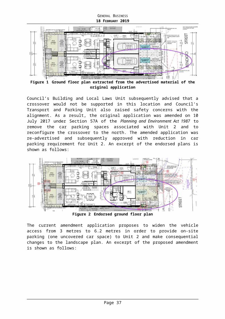
GENERAL BUSINESS18 FEBRUARY 2019
were a suitable response to the proposed development and will be formalized via condition placed on any permit issued.
Parks
Council’s Parks Department reviewed the plans submitted to Council on 30 April 2018 and made the following key comments (summarised):
No objection to the removal of the Flowering Plum street tree on the Karana Place frontage of the site to enable a new crossover construction. This tree is in decline, and a replacement tree has already been installed to the west of this tree.
Replacement planting and screening vegetation along the northern and eastern boundaries of the site are inadequate to replace existing vegetation on the site or filter views of the proposed development.
Planner Response: It is noted that the Applicant lodged revised plans with Council on 24 August 2018 and submitted further Discussion Plans with Council on 21 November 2018, which included additional setbacks from the north, east and west of the site and additional planting within the southern (Karana Place) setback of the site. However the car parking arrangement still limits any meaningful landscaping from within the northern setback of the site. This will be discussed within greater detail within the Assessment Section of this report.
Infrastructure
Council’s Infrastructure Department provided no objection to the proposal subject to conditions being placed on any permit issued and that all development be setback of the easement to the east of the site, excluding landscaping.
Transport and Parking
Council’s Transport and Parking Department reviewed the plans submitted to Council on 24 August 2018 and made the following key comments (summarised):
Concern that a parking shortfall for staff may result in staff parking on-street in residential areas, given the unrestricted car parking spaces in the surrounding area. Council’s Transport and Parking Unit would not support a commercial proposal that is likely to impact parking availability in residential streets and it may result in parking restrictions being installed. A shortfall in pick-up/drop-off parking could be considered, if the overflow parking demand is limited to the site frontage only.
The submitted Traffic Impact Report states that 75% of these 73 trips will be associated with the on-site car park and 25% associated with pick-up/drop-off directly to the Malvern Road frontage. Given that the Malvern Road frontage accommodates 3–4 parallel parking spaces and the car park accommodates 9–10 spaces for parents, it would appear that this split of traffic movements is reasonable. As the rear car park is closer to the building entry (along Karana Place), concern was raised that it is likely that motorists would prefer to park along Karana Place rather than use the Malvern Road frontage and that motorists could not be compelled to use the Malvern Road frontage.
Traffic exiting Karana Place would experience queuing associated with the additional traffic that is proposed to be generated, however the submitted SIDRA analysis indicates that the additional traffic is not expected to make a large difference to the operation of Karana Place. The average delay time in both the AM and PM peak periods is only expected to increase by a maximum of 2 seconds. This is considered relatively low.
Page 36
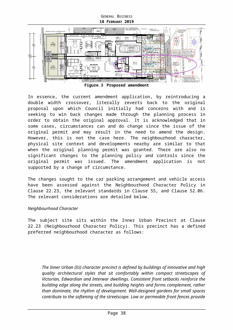
GENERAL BUSINESS18 FEBRUARY 2019
The submitted Car Park Management Plan and Traffic Impact Report still proposes that 1/4P parking restrictions could be installed on the Malvern Road frontage of the site to encourage turnover during the morning and evening peak. The installation of parking restrictions is at the discretion of Council and subject to community consultation. It is not appropriate for the applicant to expect parking restrictions to be installed to serve the development. I note that appropriate function appears to rely on these spaces. It is recommended that this be reviewed.
A child care centre use does not generate any statutory requirement for on-site bicycle parking. Notwithstanding, a car parking shortfall is proposed at the site, with the applicant stating that staff may travel to the site by bicycle. As such, it is recommended that some bicycle parking be provided, including undercover area for staff use.
The reinstatement of existing crossovers and the proposed double width crossover is considered to result in a loss of one on-street parking space. There are some concerns with this arrangement, as the site includes a shortfall in car parking provision. The applicant is to ensure that the vehicle crossing is positioned to minimise parking loss.
Concerns about blind aisles, car parking spaces adjacent landscaped areas (landscaping should be limited to a maximum height of 150mm within 300mm of the side of these spaces) and corner splay.
Waste collection arrangement is generally acceptable, as it will occur at off-peak times but swept path diagrams should be provided to demonstrate appropriate turning movements
Planner Response: The car parking arrangement and traffic generation associated with the proposed development will be discussed in greater detail within the Assessment Section of this report. With regard to the outstanding issues, the following conditions could be included:
a) Relocation of the proposed crossover 273mm to the west to ensure a minimum distance of 5.4 metres between the existing crossover located at No. 1 Karana Place or alternative to ensure the provision of one on-street car parking space between the proposed crossover and the existing crossover located at No. 1 Karana Place. This will ensure that there is no loss of on-street car parking spaces along Karana Place as a result of the proposed development.
b) A 3 metre by 3 metre splay to the south-west corner of the site (Malvern Road and Karana Place intersection).
c) Swept path diagrams demonstrating suitable waste vehicle access to the site. d) Dimensioned floor gradients within the car parking area to be a minimum gradient of 1
in 100 in accordance with the Planning Scheme and/or Australian Standards.
Local Laws
Council’s Local Laws Department reviewed the plans submitted to Council on 30 April 2018 and made the following key comments (summarised): The proposed crossover has not been dimensioned in accordance with Council’s Vehicle Crossing Policy, specifically in relation to splays; and concern about the removal of a street tree.
Planner Response: Council’s Parks Department have provided no objection to the removal of the street tree to make way for the proposed crossover. It is noted that the revised plans submitted to Council 24 August 2018 include the proposed crossover dimensioned in accordance with Council’s Vehicle Crossing Policy, including 1.3 metre wide splays. It is recommended that a condition be placed on any permit issued requiring that the proposed crossover complies with Council’s Vehicle Crossing Policy to reinforce compliance with the relevant policy.
Waste
Page 37
GENERAL BUSINESS18 FEBRUARY 2019
Council’s Waste Manage Department provided no objection to the proposal subject to conditions being placed on any permit issued.
Urban Design
Council’s Urban Designer reviewed the plans submitted to Council on 30 April 2018 and provided the following comments:
The building crowds the frontage to Karana Place and provides inadequate space for meaningful canopy-tree landscaping to this street interface.
The building also crowds the interface to the adjoining property to the East (No.1 Karana Place) and presents an unreasonable degree of visual bulk to this residential neighbour. The close proximity to the Eastern site boundary does not provide adequate space for meaningful canopy-tree landscaping to this residential interface; and the proximity of the proposed under-croft car-park to this neighbouring property is also a concern.
Due to the lack of space around the building to the South and East, and to a lesser extent to the North, the proposed Landscape Plan does not provide a satisfactory landscape response to the site or to the evolving neighbourhood. It is suggested that the building setbacks from the Southern, Eastern and Northern site boundaries be increased, to enable sufficient space for the integration of a meaningful landscape setting in the form of small- to medium-scale canopy trees.
Planner Response: In response to concerns raised by Council’s Planning Officers and Urban Designer, the Applicant formally lodged revised plans with Council on 24 August 2018, which included the following relevant amendments:
Increase in setbacks from the north, east and south setbacks of the site at both ground and first floor; and
Change in materials and finishes, including change from metal louvres to polycarbonate glazed balustrades at first floor.
The Applicant submitted further Discussion Plans with Council on 21 November 2018, which included the following suggested amendments:
Setback of 3.9 metres from southern (Karana Place) boundary at ground floor; Additional setback of 0.4 metres from the eastern boundary at ground floor; Additional landscaping, including a climbing frame along the northern boundary of the
site; and Indicative location of shade structures for out-door play areas.
The additional setbacks proposed within the revised plans submitted to Council 24 August 2018 and subsequent setbacks detailed within the discussion plans submitted to Council 21 November 2018, have been reviewed by Council’s Urban Designer and considered an acceptable response to the built form concerns previously raised and will be formalized via condition placed on any permit issued. However, it is noted that within the discussion plans submitted to Council 21 November 2018, that the setback from southern (Karana Place) boundary at ground floor has not been reflected at first floor. Given the setback is necessary to ensure the proposed development does not crowd the Karana Place frontage of the site and ensure adequate space for a meaningful tree canopy, it is recommended that a condition be placed on any permit issued requiring that the first floor be setback to reflect the ground floor setback, as proposed within the discussion plans, with the exception of a 640mm encroachment of architectural features.
Page 38

GENERAL BUSINESS18 FEBRUARY 2019
Council’s Urban Designer considered the boundary setbacks adequately respond to the built form concerns, however the car parking arrangement still limits any meaningful landscaping from occurring, especially within the northern setback of the site. This will be discussed within greater detail within the Assessment Section of this report, though Council’s Urban Designer provided comment that the proposed climbing frame was an insufficient response to the landscape character of the area.
KEY ISSUES
The proposal seeks to replace the two existing single-storey dwellings on the subject site (no permit required) with a double-storey building to be used as a child care centre for one hundred and four (104) children. A planning permit is required pursuant to Clause 32.08 (General Residential Zone), Clause 52.05 (Sign), Clause 52.06 (Car Parking) and Clause 52.29 (Land adjacent to Road Zone, Category 1). Having considered the relevant planning policies and the various referral comments, the key issues that Council have to determine can be broadly summarised into the following:
Is the proposed use appropriate in this locale? Whether the proposed development responds to the neighbourhood character? Are the off-site amenity impacts within reasonable limits? Will the proposed use result in unacceptable traffic and parking impacts? Is the proposed signage appropriate in this location?
Is the proposed use appropriate in this locale?
A number of provisions from the State Section of the Planning Scheme are relevant to the policy setting for assessment of this application. These include commentary about Settlement (Clause 11), Built Environment (Clause 15.01), Transport (Clause 18) and Infrastructure (Clause 19). At the State Policy level, these policy objectives require planning to anticipate and respond to the needs of existing and future communities. This is to be achieved through the provision of zoned and serviced land for housing, employment, recreation and open space, commercial and community facilities and infrastructure. Specific State policy recognises social needs by providing land for a range of accessible community resources, such as education, cultural, health and community support facilities at Clause 19 (Infrastructure). This includes strategies to consider existing and future demand requirements and the integration of facilities into communities in planning for the location of education and early childhood facilities (Clause 19.02-2S).
The Stonnington Strategic Framework Plan also encourages the provision of community services that are equitably accessible and flexible and can be adapted to a changing population and changing community needs. This includes the provision of an adequate level and standard of infrastructure (including community) to support the needs of the community and new development (Clause 21.03-2). The proposed child care centre is consistent with this policy direction. The policy at Clause 21.04-4 seeks to ensure that “non-residential uses do not have an adverse impact on the amenity of the surrounding residential area through noise, hours of operation, traffic or parking associated with the use”.
The General Residential Zone at Clause 32.08 contemplates a limited range of non-residential uses that serve the local community needs in appropriate locations. The proposed use of the site as a ‘child care centre’ is consistent with local policy at Clause 21.04-4 (Commercial and Community Uses in Residential Zones) which seeks to maximize the synergies of locating non-residential uses close to activity centres, public transport and other related uses.
Page 39
GENERAL BUSINESS18 FEBRUARY 2019
Child care centres are a well-established compatible use within residential areas and the proposed child care centre will serve local community needs. Some objectors are concerned that the proposed use is commercial in nature and therefore incompatible with the residential nature of this neighbourhood. Although child care centres may be commercial in one sense, they are distinguishable from traditional commercial uses, including retail premises. Child care centres have been extensively discussed within a number of VCAT decisions and are continually considered to be an appropriate use within residential areas (this includes: Lloyd v Ballarat CC [2005] VCAT 515, Hub Centre Pty Ltd v Whitehorse CC [2004] VCAT 1066, Kirby v Mitchell SC [2004] VCAT 633, Attard v Moonee Valley CC [2003] VCAT 754, National Child Care Centres Pty Ltd v Maroondah CC [2005] VCAT 1133, Minnows Child Care Centre Pty Ltd v Kingston CC [2011] VCAT 1199).
Concern has also been raised about the need for a child care centre, including objections that identified other child care centres within the surrounding area. The need/demand for a child care centre within this location will generally by dictated by a competitive market place. However, within the VCAT determination of Trustees of the Ukranian Catholic Church in Australia v Melbourne CC [2008] VCAT 2388, the Tribunal provided the following comments on the ‘community need’ for a child care centre in a residential area:
[34] The issue of local need is one which has been the subject of consideration by this Tribunal over a long period of time. The Tribunal had consistently held that non residential uses often serve a wider catchment than the immediate neighbourhood. The fulfilment of a local need test under the planning scheme does not require that every customer, patient or patron of that use, or a specified proportion of them, must reside within an area which could be defined as local.
[35] I have observed in other cases in which this issue has arisen that the degree to which local need is a relevant consideration, will vary depending on the circumstances of each case. I can, for example, envisage circumstances in which greater or lesser weight would be given to this factor depending on a proposal's location within the residential area, the character of that area and the pattern of surrounding land uses, and also depending on the nature of the use itself.
The subject site is located on the corner of Malvern Road and Karana Place, which aligns with policy direction that seeks to locate non-residential uses within residential areas on land with a frontage to a Road Zone Category 1 (Malvern Road). Further, the site is located within close proximity of the Glen Iris Village (Small Neighbourhood) Activity Centre. The site is also located approximately 600 metres north of the Darling Village (Small Neighbourhood) Activity Centre. Both Centres play a role in catering for local and everyday retail, office and service activities and needs of the surrounding area. The site is also within close proximity to public transport, including tram and bus services operating along High Street to the south of the site. Further the site is located within approximately 350 - 400 metres of both Glen Iris Railway Station and the Monash Freeway, as well as dedicated bicycle paths along the Scotchmans Creek Trail and Gardiners Creek Trail. Given the location of the site, including proximity to activity centres and transport nodes, and residential development within the surrounding area, including the multi-dwelling development approved under Planning Permit No. 1168/14 for twenty (20) dwellings currently being constructed at No. 1789 & 1791-1793 Malvern Road, it is considered that there is a clear policy direction and local need for community infrastructure (including child care centre) in this location.
The proposed child care centre will operate on weekdays only, between 6:30am and 7:00pm Monday to Friday. No late night weekday or weekend uses are proposed. These operating hours are not considered to be excessive, and will ensure that the evening and weekend amenity of the surrounding residential area will be protected. Further conditions could be placed on any permit issued requiring that the noise from the premises be in accordance with relevant Environmental Protection Agency noise regulations and the recommendations of the Acoustic Engineering Report prepared by Cogent Acoustics.
Page 40
GENERAL BUSINESS18 FEBRUARY 2019
In light of the above, the proposed use of the site as a ‘child care centre’ is generally in accordance with the relevant policies of the Stonnington Planning Scheme and could be contemplated for this location. It should be noted that policy, including policy at both Clause 21.04-4 and Clause 32.08, seeks to ensure that any development associated with the non-residential uses respects the prevailing character of the area.
Whether the proposed development responds to the neighbourhood character?
The surrounding residential area comprises a mixture of development types and architectural styles, described within the Site and Surrounds sections of the report. The built form includes single and double storey detached dwellings with a predominately pitched roof form, as well as several examples of triple storey multi-unit developments featuring predominately flat roofs and a variety of different materials and finishes. Given the mixed character and range of housing types of the area, as well as the emerging pattern of multi-unit developments within the directly surrounding area, it is considered that the subject site is capable of a contemporary development that appropriately responds to residential development within the surrounding area.
Policy at Clause 21.06 calls for new buildings to respond to the streetscape character in an innovative and contemporary manner. The proposals features a contemporary design which is considered to be an appropriate response to development within the surrounding area. Whilst the existing dwellings on the site and within the surrounding area predominately feature pitched roof forms constructed of a mixture of exposed brick, rendered brick and cement with light finishes, the emerging character of multi-unit development features a greater variety in the use of materials and finishes to provide sufficient levels of visual interest and façade articulation. As such, the proposed use of light and dark grey corrugated metal cladding, white, beige, grey and black render cladding, timber cladding and exposed brick with metal roof provides for a materiality that reflects without mimicking development within the surrounding area. Whilst the proposed development entails a flat roof form, the development incorporates architectural elements that reflect the pitched roof form of the surrounding area in a contemporary manner. Further the proposed development seeks to use large windows and balconies/outdoor play areas along the both the Malvern Road and Karana Place frontages of the site to provide for articulation and integration with both streetscapes. As such the proposal will be consistent with the emerging and preferred character of the streetscape.
The proposal has a maximum overall building height of 8.54 metres, which is lower than the 9 metres maximum building height specified in Schedule 7 of the General Residential Zone. Whilst the directly abutting lots are all single storey, recent development approvals within the surrounding area generally feature double or triple storey forms, including that at No. 1795 Malvern Road (Planning Permit No. 385/15). The proposed development also entails a lower building height (6.8 metres) with a simplified form as the proposed development abuts No. 1 Karana Place. This provides a transition in built form from Malvern Road (a main road) to Karana Place (a side street). Therefore the proposal will present to the both streetscapes as a double storey form, sitting comfortably within existing, preferred and emerging developments within the surrounding area and responding to the emerging 2-3 storey residential streetscape scale.
It is noted that the proposed development also complies with the modified Standard B17 (side and rear setbacks) under Schedule 7 of the General Residential Zone, which requires:
For a distance of at least 5 metres behind the front facade of the building fronting the street, setback new buildings (including basements) a minimum of 2 metres from at least one side boundary and at least 1 metre from the other side boundary up to 3.6 metres in height.
Page 41
GENERAL BUSINESS18 FEBRUARY 2019
Whilst the proposed development is located on the corner of Malvern Road and Karana Place, the proposed development is setback a minimum of 3 metres from the northern boundary of the site and the eastern boundary of the site. This will ensure adequate spacing from the title boundaries of the site to reinforce the built form pattern of the surrounding residential area.
The proposal entails car parking to be located at-grade, accessed from the Karana Place. The proposed accessway is considered an acceptable response given it is located to the rear (east) of the site and, subject to conditions in line with Council’s Urban Designer’s comments, there is suitable area for landscaping to the south of the at-grade car parking to soften this area. Further the Landscape Plan prepared by John Patrick Landscape Architects includes planting within the south-east and south-west corners of the site to soften the presentation of any driveway areas.
With the exception of the northern setback of the site, the proposed level of landscaping is also considered appropriate to maintain and strengthen the garden settings of buildings and landscaping of the neighbourhood, which is also identified within Clause 21.06-2 (Landscape Character) which seeks to ‘repair and reinforce the high quality landscape character of the City’. As identified by both Council’s Urban Design and Arborist, the proposed development removes the existing vegetation screening along the northern boundary of the site and the proposed car parking arrangement prevents any meaningful planting from occurring within this area. The lack of landscaping within this area fails to respond to the existing or preferred character of the area and also fails to provide any vegetative screening to soften the presentation of the proposed development as viewed from the private open space of No. 1797 Malvern Road. As such, it is recommended that a condition be placed on any permit issued to delete the tandem car parking spaces and associated turning bay within the northern setback of the site and allocate this area to suitable replacement planting. Discussed in greater detail within the Car Parking and Traffic section of this report, it is recommended that the maximum number of children within the centre be reduced to reflect the deletion of two car parking spaces.
It is considered that subject to conditions, the Landscape Plan prepared by John Patrick Landscape Architects provides for adequate opportunity for landscaping, including landscaped areas within the front, rear and side setbacks, with a minimum of seven (7) canopy trees located along both the Malvern Road and Karana Place setbacks of the site. It is noted that the discussion Landscape Plan by John Patrick Landscape Architects submitted to Council 21 November 2018 entails four additional canopy trees along the Karana Place (southern) frontage of the site, which will be formalised by way of conditions placed on any permit issued, ensures that the proposed development provides an appropriate response to landscaping character within the surrounding area.
The proposed front fences are considered to be an appropriate response to the preferred character within Clause 22.23 and ensure a balance of protection of the children to be housed on the site. The proposed front fence along Malvern Road and the western portion of Karana Place features a 1.8 metre steel picket fence with visual permeability, which reduces to a height of 1.2 metres for the remainder of the Karana Place frontage of the site. This will provide for an appropriate transition in fence heights from the main road frontage of the site (Malvern Road) to the side street frontage (Karana Place), with a level of transparency that will sit comfortably within the fence designs within the surrounding area.
Overall, it is considered that the design response, in terms of its presentation to key interfaces and incorporation of features of the surrounding area, and built form, will sit comfortably within the preferred character and emerging features of the surrounding area.
Page 42
GENERAL BUSINESS18 FEBRUARY 2019
Further, the proposal is considered to be a suitable response to the prevailing residential character of the surrounding area, as assessed against Clause 21.04-4.
Are the off-site amenity impacts within reasonable limits?
Whilst Clause 54 and 55 are not applicable to the assessment of a non-residential building, a number of the objectives and standards are considered appropriate to use as a guide in assessing the proposal and to test whether it would have an unreasonable impact on surrounding dwellings.
Side and rear setbacks
Standard B17 (side and rear setbacks) sets out numeric requirements for side and rear setbacks. The table below illustrates how the proposal meets these requirements.
North
Location Wall Height Setback Required
Setback Proposed
Complies
First Floor (Outdoor Play Area)
Max 4.8 metres
1.36 metres 2.873 to 3 metres
First Floor (Room 6) Max 6.8 metres
1.96 metres 10.49 metres
East
Location Wall Height Setback Required
Setback Proposed
Complies
First Floor Max 6.8 metres
1.96 metres 2.97 to 3.08 metres
It is noted that no walls are proposed to be constructed on or within 200mm of a side or rear boundary. Therefore, Standard B18 is not applicable.
Daylight to Existing Windows
Standard B19 sets out setback requirements to ensure existing habitable room windows would receive adequate daylight. The table below outlines how the proposal complies with the requirements of Standard B19:
Interface with No. 1797 Malvern Road, features three ground floor windows with minimum setbacks from the common boundary of 1.681 metres.
Location Wall Height Setback Required (from the habitable room window)
Setback Proposed (from the habitable room window)
Complies?
Page 43
GENERAL BUSINESS18 FEBRUARY 2019
First Floor (Outdoor Play Area)
Max 4.8 metres
2.4 metres 4.554 to 4.681 metres
First Floor (Room 6) Max 6.8 metres
3.4 metres 12.171 metres
Interface with No. 1 Karana Place, features four ground floor windows with minimum setbacks from the common boundary of 0.963 metres.
Location Wall Height Setback Required (from the habitable room window)
Setback Proposed (from the habitable room window)
Complies?
First Floor Max 6.8 metres
3.4 metres 3.933 to 4.043 metres
Overshadowing
The relevant assessment mechanism for overshadowing of neighbouring areas of private open space is the overshadowing open space objective, including Standard B21. This standard states the following:
Where sunlight to the secluded private open space of an existing dwelling is reduced, at least 75 per cent, or 40 square metres with minimum dimension of 3 metres, whichever is the lesser area, of the secluded private open space should receive a minimum of five hours of sunlight between 9 am and 3 pm on 22 September.
If existing sunlight to the secluded private open space of an existing dwelling is less than the requirements of this standard, the amount of sunlight should not be further reduced.
The objective of Clause 55.04-5 is ‘to ensure buildings do not significantly overshadow existing secluded private open space.’ Given the orientation of the site and adjoining allotments, the proposed development will not result in any additional overshadowing to any areas of adjoining lot’s private open space and therefore can be considered to meet the objectives of Clause 55.04-4 (Overshadowing) and Clause 55.03-5 (Energy Efficiency).
Overlooking
The key assessment tool to determine unreasonable overlooking is the Overlooking Objective, including Standard B22. The standard provides a 9m 45 degree angle arc that determines unreasonable overlooking, and windows or balconies that are located in such a position must be screened to a height of 1.7m above finished floor level accordingly.
None of the ground level areas are located in a position that will generate overlooking concerns given the proposed boundary fences with a minimum height of 1.8 metres along the north and east boundaries of the site which will act as a visual barrier.
At first floor, a 1.8 metre high polycarbonate glazed acoustic treatment is proposed along the north, east and west edges of the Outdoor Play Area. While the plans refer to the barriers being “Glazed Window 2 (GL2) – Tint Frosted’, there is no reference to the maximum transparency. As such it is recommended that a condition be placed on any permit requiring the north and west barriers at first floor be screened to restrict overlooking into the private open space and habitable room windows of the properties to the north and east of the subject site.
Other
Page 44
GENERAL BUSINESS18 FEBRUARY 2019
Concern has been raised with the noise emission from the proposed childcare centre. Given the proposed child care centres entails large areas of ground and first floor outdoor play areas adjacent residential dwellings, it is important to ensure noise impact of the child care centre is of an acceptable level. An Acoustic engineering Report prepared by Cogent Acoustics has been submitted by the Applicant, and includes the following key recommendations:
All noise barriers/acoustic fences to be solid barrier made of either minimum 25 mm thick timber / plywood, 9 mm thick fibre cement sheet, 10 mm thick polycarbonate, masonry or another suitable solid material with minimum surface density of 12 kg/m2.
The above recommendations are considered to be appropriate and will reduce noise levels to acceptable levels in order to protect the residential amenity of the surrounding properties. These recommendations will be included as conditions on any permit issued. Furthermore, it is recommended that conditions be placed on any permit issued to ensure that the proposed development and associated use complies with the relevant EPA regulations.
It is not expected that the proposed development will result in adverse amenity impacts through waste collection. A Waste Management Plan (WMP) was submitted to Council indicating that waste collection will be carried out by a private contractor within the title boundaries of the site. The WMP was referred to Council’s Waste Management Coordinator, who considered it to be satisfactory subject to conditions.
Will the proposed use result in unacceptable traffic and parking impacts?
Traffic
Residents have raised concerns with the potential traffic generation as a result of the proposed development, especially at the corner of Karana Place and Malvern Road. Whilst the proposed development will result in additional vehicle movements, the criteria for assessing the acceptability of the additional traffic generation is whether the anticipated new traffic levels are acceptable for the proposed development, rather than what existing traffic conditions are.
It is important to note that the proposal is for a child care centre, instead of a traditional education centre, such as a school. Child care centres operate with extended periods for drop-off and pick-up of children. These times do not necessarily coincide with commuter peaks on main roads, or drop off or pick up peaks that are often apparent with schools. As the Tribunal commented in Minnows Child Care Centre Pty Ltd v Kingston CC [2011] VCAT 1199:
[26] …The hours during which children attend classes at school are very regimented, at both ends of the day when classes start and end. It is my observation that most children are dropped off at school close to the time when classes start and picked up immediately after school ends. Schools generally have several hundred students. It is for this reasons that traffic conditions near schools are sometimes described as bedlam, albeit that they occur over a very constrained half hour period at the beginning and end of each day.
[27] Childcare centres operate in a different way. There is no set pick up or drop off time. These tend to be based around the circumstances of individual parents. For example, the drop off and pick up times will be influenced by factors such as the time the parent starts work, travel time to work and the number of hours the parents work. Accordingly, the pickup and drop off times will vary and are far less concentrated than those for a school, occurring over a period of hours rather than a shorter half hour period”.
The findings of the Tribunal are supported by the survey undertaken within the submitted Traffic Impact Report (TIR) prepared by Ratio Consultants. As per the TIR, it is anticipated that there will be an increase of 83 traffic movements during peak times and an expected to
Page 45
GENERAL BUSINESS18 FEBRUARY 2019
increase in the average delay time in both the AM and PM peak periods by a maximum of 2 seconds. It is noted that Council’s Transport Engineers have considered this to be relatively low and have not raised concern with the traffic generation. As such, it is considered that Malvern Road and Karana Place have the capacity to accommodate the additional traffic movements. There is no doubt that the proposal will generate more traffic and at times, access may be more difficult than what it is at present. However, any additional traffic generation associated with the proposed child care centre does not justify the rejection of the overall proposal on this ground alone.
Car Parking
Pursuant to Clause 52.06-5, a child care centre is required to provide 0.22 car spaces per child. The proposal includes a maximum of 104 children and is required to provide 22 car spaces. As 20 on-site car spaces will be provided, there is a shortfall of 2 spaces.
Council’s Traffic Engineers are concerned with the parking provision for staff. However, it is important to note that the parking rates for child care centres at Clause 52.06-5 are based on the number of children, not the number of staff. Prior to the amendment to Clause 52.06 in April 2013, there was no specified parking rate for child care centres. The provision of 0.16 to 0.19 spaces per child was commonly accepted by the Tribunal, with the provision of 0.22 spaces per child being at the upper end of the scale. When the car parking table at Clause 52.06-5 was updated in April 2013, a rate of 0.22 spaces per child was adopted for child care centres, which took into account the parking demand of staff. Therefore, provided the overall parking provision is acceptable, it is not considered necessary to examine how many spaces will be designated for staff members. The planning scheme contemplates some flexibility among the allocation and management of car parking for child care centres. As a result, the key consideration here is whether the shortfall of 2 spaces can be supported and whether the layout of the car park is acceptable.
With regard to the parking shortfall, it is considered that the reduction of 2 spaces will not cause undue parking impacts as the proposed child care centre is unlikely to operate at its full capacity at all times. Further it is anticipated that the proposed child care centre will be predominately utilised by local residents, some of whom would be likely to access the site by foot or bicycle. Further, given the proximity of the site to activities centres, alternate transport nodes and dedicated bicycle paths, it is likely that some staff may utilise alternative means of transport, especially if parking restrictions within the surrounding area change. In line with Council’s Transport Engineers comments, it is recommended that a condition be placed on any permit issued requiring an additional five (5) undercover bicycle parking spaces be provided to prompt the use of alternative transport.
It is also recommended that a condition be placed on any permit issued that requires the submission of an Integrated Transport and Access Plan (ITAP). The ITAP will include the details of the Car Park Management Plan prepared by Ratio Consultants but expanded to include details such as statutory considerations; traffic impacts; cycle storage; end of trip facilities and green travel initiatives.It will also provide formalised guidance on how drop-off and pick-up will be promoted to occur along the Malvern Road frontage of the site instead of the Karana Place frontage.
It should be noted that the proposed development also seeks to remove two of the existing crossovers, one along Malvern Road frontage and one along Karana Place frontage, and proposes one new crossover along the Karana Place frontage. A condition is recommended to ensure that a formal car parking space will be provided between the proposed crossover and the existing crossover at No. 1 Karana Place. This will ensure that the proposed development does not result in the loss of any on-street car parking spaces.
Page 46
GENERAL BUSINESS18 FEBRUARY 2019
While a reduction of two (2) car parking spaces on the site can be supported subject to the above conditions, a condition has been recommended to delete two (2) staff car parking spaces in order to provide additional landscaped areas. Given this will have consequential impacts on the management of the car park and the availability of staff car parking, it is recommended that the number of children allowed on the site be reduced to reflect the deletion of two (2) car parking spaces on the site. As the rate of car parking is 0.22 car spaces per child, this would require a reduction of nine (9) children. Therefore, it is recommended that the total number of children permitted on the site be reduced to ninety-five (95).
In relation to the layout of the car park, the parking bays dimensions and accessway width, the proposed development generally complies with the relevant design standards at Clause 52.06-9. Given the recommendation to delete the tandem car parking spaces and associated turning bay, the requirement to limit the height of vegetation adjacent these spaces is no longer required. However, the requirement for 1 metre blind aisles to the north of car parking spaces C.P. 09 and 12 has been recommended in accordance with Australian Standards.
In line with Council’s Transport and Parking Department’s comments, a condition is recommended to be placed on any permit issued requiring swept path diagrams that demonstrate waste vehicles can access the site in line with the proposed Waste Management Plan. Further conditions have been recommended to address splay requirement associated with the fence at the intersection of Malvern Road and Karana Place.
As such, it is considered that the proposed child care centre will not result in unacceptable traffic and parking impacts.
Crossover
Council’s Vehicle Crossing Policy states that the width of crossings for commercial uses should measure 5 metres wide with 1.3 metre wide kerb to each side. The proposal shows compliance with this Policy. However, it is noted that the location of the proposed crossover prevents a formal car parking space (requiring a minimum dimension of 5.4 metres) from being provided between the proposed crossover and the existing crossover at No. 1 Karana Place. As such, a condition has been recommended to be placed on any permit issued requiring the proposed crossover to be relocated 273 metres to the west or alternative to ensure the provision of an on-street car parking space in this location.
It is noted that the proposed crossover requires the removal of a street tree. However, Council’s Arborist has provided comment that the tree is in poor health and replacement planting has already occurred along the Karana Place nature strip. Tree protection fencing will be recommended as a condition on any permit issued to ensure the viability of all other street trees along the Karana Place frontage of the site.
Is the proposed signage appropriate in this location?
The proposal entails total of 3.51 square metre of non-illuminated business identification signage along the Malvern Road (west) and Karana Place (south) frontages of the site. Specifically the proposal entails four fence mounted signs as follows: three 1.2 metre (wide) x 0.9 metre (high) located along the Malvern Road frontage, the splay at the intersection of Malvern Road and Karana Place, and Karana Place frontage; and one 0.45 metre (wide) x 0.6 metre (high) sign located adjacent the pedestrian entryway to the proposed development along the Karana Place frontage.
Page 47

GENERAL BUSINESS18 FEBRUARY 2019
Pursuant to the General Residential Zone, the proposed signage is subject to Category 3 advertising controls as set out in Clause 52.05. Clause 52.05 calls for consideration of (amongst others) the following key issues in the assessment of proposed signage:
Whether the proposed signs are compatible with the amenity and visual appearance of an area, including the existing or desired future character.
Whether the proposed signs contribute to excessive visual clutter or visual disorder. Whether the proposed signs result in any unreasonable loss of amenity or adversely
affect the natural or built environment or the safety, appearance or efficiency of a road.
Council’s Advertising Policy at Clause 22.03 provides more specific guidance on advertising in the City of Stonnington. This policy is applied in conjunction with Clause 52.05 and applies to the consideration of all applications for advertising signs. The objectives of this policy are as follows:
To limit advertising on commercial buildings consistent with the character of the area. To generally have commercial signage located below verandah line. To minimise signage in residential areas and ensure it is consistent with the character
of the area.
Category 3 advertising controls pursuant to Clause 52.05-9 have the specific purpose of ensuring that signs in high-amenity areas are orderly, of good design and do not detract from the appearance of the subject site or surrounding area. Further policy at Clause 21.06-4 seeks to ensure management of clutter, disorder and intrusion associated with advertising. Clause 22.03 generally discourages signs other than those displaying the name and address of a building and its use in residential areas. Further the policy at Clause 22.03 recommends that signs should be fixed to a fence or façade (not freestanding) and should not exceed 0.1 square metres on a residential street or 0.5 square metres if the land has a frontage to a Road Zone Category 1, which the subject site abuts along the Malvern Road interface.
As such, it is considered that the proposed 1.2 metre (wide) x 0.9 metre (high) sign towards the eastern end of the Karana Place frontage of the site, which will have an area of 1.08 square metres, is inconsistent with both policy direction for signage within the residential areas and with the residential character along Karana Place, as such it is recommended that a condition be placed on any permit issued requiring the deletion of this sign.
The other proposed signs are considered acceptable, given the remaining sign along the Karana Place frontage is 0.27 square metres and clearly associated with the entry to the proposed non-residential use (child care centre). Further, the other two signs are separated from each other in excess of 25 metres and are directed to Malvern Road frontage where the residential character is disrupted by large road infrastructure. This ensures that the signage is directed away from the more typical residential setting within Karana Place. Therefore subject to conditions, the proposed size and location of the proposed signage on the subject site will not unreasonably impact the existing character of the surrounding area.
Given the proposed signs are substantially separated from each other and that the signs are not proposed to be illuminated, this will ensure that the proposed signage will not result in any unreasonable visual clutter or disorder. The proposed signage is also located at street level (below verandah level) and is to be adhered to the fence line, which complies with the purpose of the controls at Clause 22.03 and will ensure that the proposed signage will not be a dominate feature of the proposed development on the subject site.
Further, the proposed signage is not considered to result in any unreasonable amenity impacts due to the location of the proposed signage, the fact the signage is not proposed to
Page 48
GENERAL BUSINESS18 FEBRUARY 2019
be illuminated and distance between the proposed signage and the nearby residential buildings (separated by Malvern Road and Karana Place respectively). Further the proposed signage will not result in any unreasonable impact on the safety and operation of Malvern Road or Karana Place, which will be reinforce by way of conditional requirements being placed on any permit issued.
Sustainable Design Assessment
Pursuant to Clause 22.05 Environmentally Sustainable Development and Clause 22.18 Stormwater Management, the proposed development is required to submit a Sustainability Management Plan (SMP) and a Water Sensitive Urban Design Response (WSUDR). The Applicant has submitted Sustainability Management Plan (SMP) prepared by Sustainability House (Council date stamped 23 August 2018), which includes a BESS assessment addressing each of Council’s 10 Key sustainable Building Categories and a BESS score of 50%, where 50%+ is considered best practice. However, conditions have been recommended that reduce the built form, including catchment areas. As such, a condition will be placed on any permit issued requiring a revised SMP to address the above points.
Further as part of the SMP, including the STORM Rating Report with a STORM Rating of 103%, can be considered to comply with Clause 22.18 and Clause 55.07-5 (Integrated water and stormwater management objectives), as well as Standard W2 and W3 at Clause 53.18-5. However, the SMP does not detail the treatment of stormwater run-off during the construction stage to appropriately respond to Clause 53.18-6. As such, a condition will be placed on any permit issued requiring this to be addressed.
Objections
In response to the grounds of objection not already discussed in the report, the following comments are made:
Devaluation of property – These matters are not relevant planning considerations. Road Safety Audit – One objection has raised the requirement for a Road Safety Audit
to be undertaken at the corner of Malvern Road and Karana Place. The requirement for a Road Safety Audit has been reviewed by Council’s Transport and Parking Department, who have provided comment that the submitted SIDRA Intersection Analysis is suitable for this application and is generally consistent with information provided at the planning stage of a new development. Council’s Transport and Parking Department also noted that Road Safety Audits are generally very conservative in nature and would likely include recommendations for removal of on-street car parking spaces. Council’s Transport and Parking Department’s advice concludes that a Road Safety Audit is not necessary for this specific application.
All other grounds of objection have been discussed in the body of this report.
Human Rights Consideration
This application has been assessed in accordance with the requirements of the Planning and Environment Act 1987 (including the Stonnington Planning Scheme), reviewed by the State Government and which complies with the Charter of Human Rights and Responsibilities Act 2006.
CONCLUSION
Page 49
GENERAL BUSINESS18 FEBRUARY 2019
Having assessed the application against the relevant planning controls, it is recommended that the proposal be supported for the following reasons: The proposed use is appropriate in this locale. The proposed development, including signage, will fit into this neighbourhood and will
not cause unreasonable off-site amenity impacts. The proposed use will not result in unacceptable traffic and parking impacts.
ATTACHMENTS
1. PA - 433/18 - 1799-1801 Malvern Road Glen Iris - Attachment 1 of 1 Plans
RECOMMENDATION
That a Notice of Decision to Grant a Planning Permit No: 433/18 for the land located at 1799-1801 Malvern Road Glen Iris be issued under the Stonnington Planning Scheme for use and development of the land for the purpose of a child care centre and advertising signage in a General Residential Zone, alterations of access to a Road Zone Category 1 and reduction in car parking requirements subject to the following conditions:
1. Before the commencement of the development, one (1) electronic copy of plans drawn to scale and fully dimensioned, must be submitted to and approved by the Responsible Authority. The plans must be generally in accordance with the plans (Job No. 38046, Drawing No.s: CS000, SA001, SA002, and TP101 – TP115) Council date stamped 24 August 2018 but modified to show:
a) Increased setback at ground floor from the eastern and southern setback, as well as the indicative location of outdoor shading devices, as included within the discussion plans (Drawing No.s CS000, SA001, SA002, and TP101 – TP115) submitted to Council on 21 November 2018.
b) First floor setback increase to a minimum of 3.9 metres from the southern (Karana Place) boundary of the site, with the exception of a 640mm encroachment of architectural features, to reflect the setback of the ground floor from the southern boundary as included within the discussion plans (Drawing No.s CS000, SA001, SA002, and TP101 – TP115) submitted to Council on 21 November 2018.
c) Any changes as required to reflect the reduction of the total number of children permitted on the site by nine (9) children, in accordance with Condition 3.
d) Deletion of tandem car parking spaces (C.P. 10 and 11) and associated turning bay, and the subsequent provision of a minimum 1 metre blind aisle to the north of car parking spaces C.P. 09 and 12 in accordance with the Planning Scheme and/or Australian Standards. The remainder of the area to the north of car parking spaces C.P. 09 and 12 is to be provide for
Page 50
GENERAL BUSINESS18 FEBRUARY 2019
in-ground landscaping.
e) The provision of an additional five (5) undercover bicycle parking spaces.
f) Deletion of the 1.2 metre (wide) x 0.9 metre (high) sign along the eastern end of the Karana Place frontage of the site.
g) Glazing to the first floor north and west elevation of the Outdoor Play Area’s barriers to have a maximum transparency of 25 percent in accordance with Standard B22 of Clause 55 of the Stonnington Planning Scheme.
h) Plans to reflect all recommendations within Acoustic Engineering Report prepared by Cogent Acoustics submitted to Council on 24 August 2018, including all noise barriers/acoustic fences to be solid barrier made of either minimum 25 mm thick timber / plywood, 9 mm thick fibre cement sheet, 10 mm thick polycarbonate, masonry or another suitable solid material with minimum surface density of 12 kg/m2.
i) Relocation of the proposed crossover 273mm to the west to ensure a minimum distance of 5.4 metres between the existing crossover located at No. 1 Karana Place or alternative to ensure the provision of one on-street car parking space between the proposed crossover and the existing crossover located at No. 1 Karana Place.
j) A 3 metre by 3 metre splay to the south-west corner of the site (Malvern Road and Karana Place intersection).
k) Swept path diagrams demonstrating suitable waste vehicle access to the site.
l) Dimensioned floor gradients within the car parking area to be a minimum gradient of 1 in 100 in accordance with the Planning Scheme and/or Australian Standards.
m) The 1.8m high acoustic noise barrier to extend along the full extent of the northern boundary at the ground floor
n) Any changes as required by the Integrated Transport and Access Plan (Condition 6), Sustainability Management Plan (Condition 8), Water Sensitive Urban Design Response (Condition 10), Waste Management Plan (Condition 12) and Landscape Plan (Condition 14).
All to the satisfaction of the Responsible Authority.
2. The layout of the site and the size, levels, design and location of buildings and works shown on the endorsed plans must not be modified for any reason without the prior written consent of the Responsible Authority.
3. The use hereby permitted may only operate with up to a maximum of ninety-five (95) children at any one time to the satisfaction of the Responsible Authority.
4. The use hereby permitted may operate only between the hours of 6:30am and
Page 51
GENERAL BUSINESS18 FEBRUARY 2019
7:00pm, Monday to Friday, to the satisfaction of the Responsible Authority.
VICROADS CONDITIONS
5. Prior to the commencement of the use or occupation of the development, all disused or redundant vehicle crossings on Malvern Road must be removed and the area reinstated to the satisfaction of the Responsible Authority (RA) and at no cost to VicRoads or the RA.
END VICROADS CONDITIONS
6. Concurrent with the endorsement of plans, an Integrated Transport and Access Plan (ITAP) prepared by a traffic engineer or suitably qualified person must be submitted to and approved by the Responsible Authority. When approved, the ITAP will be endorsed to form part of the permit. The ITAP must be generally in accordance with the Car Park Management Plan prepared by Ratio Consultants (Council date stamped 24 August 2018) but expanded to include:
a) The number, location, dimensions and layout of all car parks and access ways to and from them.
b) A management plan for the operation and maintenance of the car park areas.
c) The location and dimensions of all bicycle parking and end of trip facilities.
d) A traffic management plan that details the current measures implemented by the child care centre to facilitate a quicker and more efficient pick up arrangement. The traffic management plan must also detail how the use of the drop-off and pick-up zone along Malvern Road and the access point along Karana Place will be promoted and regulated.
e) Actions and recommendations designed to reduce the use of cars and increase the use of alternative travel methods.
All to the satisfaction of the Responsible Authority.
7. Prior to the commencement of use, the car spaces hereby approved must be made available and used by customers and staff of the proposed child care centre at all times. No fees may be imposed for the use of the spaces to the satisfaction of the Responsible Authority.
8. Concurrent with the endorsement of any plans pursuant to Condition 1, a Sustainability Management Plan (SMP) must be submitted to and approved by the Responsible Authority. Upon approval the SMP will be endorsed as part of the planning permit and the development must incorporate the sustainable design initiatives outlined in the SMP to the satisfaction of the Responsible Authority. The SMP must be in accordance with SMP prepared by
Page 52
GENERAL BUSINESS18 FEBRUARY 2019
Sustainability House (Council date stamped 24 August 2018), but modified to show:
a) Any changes required by Condition 1.
b) Amended BESS Report to be in ‘Finalised/Published’ form.
All works must be undertaken in accordance with the endorsed Sustainability Management Plan to the satisfaction of the Responsible Authority. No alterations to the Sustainable Management Plan may occur without written consent of the Responsible Authority.
9. Prior to the occupation of the development approved under this permit, a report from the author of the Sustainability Management Plan, approved pursuant to this permit, or similarly qualified person or company, must be submitted to the Responsible Authority. The report must be to the satisfaction of the Responsible Authority and must confirm that all measures specified in the Sustainability Management Plan have been implemented in accordance with the approved plan.
10. Concurrent with the endorsement of plans, the applicant must provide a revised Water Sensitive Urban Design Response addressing the Application Requirements of the Water Sensitive Urban Design Policy to the satisfaction of the Responsible Authority, including any changes required by Condition 1 and how the site will be managed prior to and during the construction period in accordance with Standard W3 at Clause 53.18. All proposed treatments included within the Water Sensitive Urban Design Response must also be indicated on the plans. All to the satisfaction of the Responsible Authority.
11. The project must incorporate the Water Sensitive Urban Design initiatives detailed in the endorsed site plan and/or stormwater management report.
12. Concurrent with the endorsement of plans, a Waste Management Plan must be submitted to and approved by the Responsible Authority. The Waste Management Plan must be generally in accordance with the one prepared Ratio Consultants Pty Ltd Council date stamped 24 August 2018 but modified to include: only one bin size per waste stream to be used and flexibility for the facility owners/managers to opt for Council waste collections, in accordance with Council’s ‘City of Stonnington Residential Waste Management Guidelines’ to the satisfaction of the Responsible Authority.
When approved, the plan will be endorsed and will then form part of the permit. Waste collection from the development must be in accordance with the plan, to the satisfaction of the Responsible Authority.
13. Adequate provision must be made for the storage and collection of wastes and recyclables within the site prior to the commencement of use or occupation of the building. This area must be appropriately graded, drained and screened from public view to the satisfaction of the Responsible Authority.
14. Before the development starts, a landscape plan to be prepared by a landscape architect or suitably qualified or experienced landscape designer, must be submitted to and approved by the Responsible Authority. When approved, the landscape plan will be endorsed and will then form part of the
Page 53
GENERAL BUSINESS18 FEBRUARY 2019
permit. The landscape plan must be drawn to scale with dimensions. The landscape plan must be in accordance with the landscape plan prepared by John Patrick Landscape Architects Pty Ltd (Council date stamped 24 August 2018) but modified to show:
a) Any changes as required by Condition 1, with no reduction of number of canopy trees.
b) Four additional canopy trees along the Karana Place frontage in accordance with the Discussion Landscape Plan prepared by John Patrick Landscape Architects Pty Ltd (Council date stamped 21 November 2018).
c) Screening planting/trees along the northern (as adjacent the private open space of No. 1797 Malvern Road) and eastern boundaries of the site of a minimum mature height of 5 metres and a minimum height of 1.5 metres at the time of planting.
All to the satisfaction of the Responsible Authority.
15. Before the occupation of the building, the landscaping works as shown on the endorsed plans must be carried out and completed to the satisfaction of the Responsible Authority. Landscaping must then be maintained to the satisfaction of the Responsible Authority, including that any dead, diseased or damaged plants are to be replaced.
16. Before the development (including excavation and demolition) starts, a tree protection fence must be erected around the street trees along Malvern Road and Karana Place in front of the subject site. Fencing is to be compliant with Section 4 of AS 4970.
17. With the exception of landscaping, no development is to occur within the ‘Drainage and Sewerage Easement’ along the eastern boundary of the site.
18. Prior to a building permit being issued, a report for the legal point of discharge must be obtained from Council and a drainage design for the development must be prepared by a suitably qualified Engineer in accordance with all ‘recommendations’ and requirements contained in that report. All drainage must be by means of a gravity based system with the exception of runoff from any basement ramp and agricultural drains which may be pumped. The relevant building surveyor must check and approve the drainage design and ensure that protection of the building is provided from a 1 in 100 A.R.I. rainfall event as required by the Building Regulations.
19. Prior to an ‘Occupancy Permit’ being issued, a suitably qualified Engineer must carry out a detailed inspection of the completed stormwater drainage system and associated works including all water storage tanks and detention
Page 54
GENERAL BUSINESS18 FEBRUARY 2019
(if applicable) to ensure that all works has been constructed in accordance with the approved design and the relevant planning permit conditions. Certification of the completed drainage from the Engineer must be provided to Council prior to a ‘Statement of Compliance’ being issued for the subdivision.
20. The existing footpath levels must not be lowered or altered in any way at the property line (to facilitate the vehicular access).
21. The redundant vehicular crossing must be removed and the footpath, nature strip and kerb reinstated at the owner’s cost to the satisfaction of Council.
22. The Applicant must at their cost provide a stormwater detention system to restrict runoff from the development to no greater than the existing runoff based on a 1 in 10 A.R.I. to the satisfaction of Council’s Infrastructure Unit. Alternatively, in lieu of the stand alone detention system, the owner may provide stormwater tanks that are in total 5,000 litres greater than those tanks required to satisfy WSUD requirements for the development. Those tanks must be connected to all toilets.
23. Any poles, service pits or other structures/features on the footpath required to be relocated to facilitate the development must be done so at the cost of the applicant and subject to the relevant authority’s consent.
24. All utility services to the subject land and buildings approved as part of this permit must be provided underground to the satisfaction of the Responsible Authority by completion of the development.
25. The emission of noise or any other emission to the environment derived from activities on the site must conform to standards contained in the appropriate State Environment Protection Policy or Policies to the satisfaction of the Responsible Authority.
26. All plant and equipment (including air-conditioning units) shall be located or screened so as to minimise visibility from any of the surrounding footpaths and from overhead views and shall be baffled so as to minimise the emission of unreasonable noise to the environment in accordance with Section 48A of the Environment Protection Act 1970 to the satisfaction of the Responsible Authority.
27. The signs must be maintained to the satisfaction of the Responsible Authority.
28. The signs must not contain any flashing or moving light.
29. The signs must not be illuminated by external or internal light.
30. This permit will expire if one of the following circumstances applies:
a) The development is not started within two years of the date of this permit.
b) The development is not completed within four years of the date of this permit.
c) This permit, as it relates to signage, expires 15 years from the permit issue date.
In accordance with Section 69 of the Planning and Environment Act 1987, a request may be submitted to the Responsible Authority within the prescribed
Page 55
GENERAL BUSINESS18 FEBRUARY 2019
timeframes for an extension of the periods referred to in this condition.
NOTES:
I. This permit does not constitute any authority to carry out any building works or occupy the building or part of the building unless all relevant building permits are obtained.
II. Nothing in the permit hereby issued may be construed to allow the removal of, damage to or pruning of any street tree without the further written consent of the Stonnington City Council. Contact the Council Arborists on 8290 1333 for further information.
III. Nothing in this permit hereby issued shall be construed to allow the removal of, damage to or pruning of a significant tree (including the roots) without the further written approval of Council.
“Significant tree” means a tree:
a) with a trunk circumference of 180 centimeters or greater measured at its base; or
b) with a trunk circumference of 140 centimeters or greater measured at 1.5 metres above its base; or
c) listed on the Significant Tree Register.
Please contact the Council Arborists on 8290 1333 to ascertain if permission is required for tree removal or pruning or for further information and protection of trees during construction works.
IV.Council has adopted a zero tolerance approach in respect to the failure to implement the vegetation related requirements of Planning Permits and endorsed documentation. Any failure to fully adhere to these requirements will be cause for prosecution. This is the first and only warning which will be issued.
V.The crossover must be constructed to Council’s Standard Vehicle Crossover Guidelines unless otherwise approved by the Responsible Authority. Separate consent for crossovers is required from Council’s Building and Local Law Unit.
VI.At the permit issue date, Section 69 of the Planning and Environment Act 1987 stated that the Responsible Authority may extend the periods referred to if a request is made in writing within the following timeframes:
i. Before or within 6 months after the permit expiry date, where the development allowed by the permit has not yet started; and
ii. Within 12 months after the permit expiry date, where the development allowed by the permit has lawfully started before the permit expires.
VICROADS NOTE
VII. No work must be commenced in, on, under or over the road reserve without having first obtaining all necessary approval under the Road Management Act 2004, the Road Safety Act 1986, and any other relevant
Page 56
GENERAL BUSINESS18 FEBRUARY 2019
acts or regulations created under those Acts.
Page 57
GENERAL BUSINESS18 FEBRUARY 2019
4. PLANNING APPLICATION 0799/18 - 4 AND 6 HARVEY STREET, MALVERN VIC 3144 – CONSTRUCTION OF A THREE STOREY APARTMENT BUILDING COMPRISING TWO DWELLINGS AND TWO DOUBLE STOREY TOWNHOUSES OVER BASEMENT CAR PARKING
Manager Statutory Planning: Alexandra Kastaniotis General Manager Planning & Amenity: Stuart Draffin
PURPOSE
For Council to consider a planning application for construction of a multi-dwelling development in a General Residential Zone at 4 and 6 Harvey Street, Malvern
Executive Summary
Applicant: O'Neill ConsultingWard: South WardZone: General Residential Zone – Schedule 10Overlay: NoneNeighbourhood Precinct: Garden Suburban 1Date lodged:Date revised:
30 July 201814 January 2019
Statutory days: (as at council meeting date)
35
Trigger for referral to Council:
Seven or more objections
Number of objections: 15Consultative Meeting: Yes – held on 20 November 2018Officer Recommendation: Issue a Notice of Decision to Grant a Planning Permit
BACKGROUND
The Proposal
The plans that form part of the basis of Council's consideration were prepared by Cera Stribley and are known as Drawing No’s A_TP _1000, A_ TP _1001, A_ TP_1002, A_TP_1003, A_TP _2003_REFI-3, A_TP_2004, A_TP_3000, A_ TP_1004, A_ TP2001, A_ TP_2002, A_TP_3001 and A_ TP_3002 all Revision RFI-3 and Council date stamped 14 January 2019.
The application was revised after the consultative meeting and the advertised plans have been superseded by the plans Council date stamped 14 January 2019. In summary, the amendments to the plans have been made to facilitate greater opportunity for in-ground planting through the provision of increased setbacks adjacent the northern and southern boundaries; to reduce the overall height of the apartment building; and to provide screening to north and west-facing terraces and windows.
Key features of the proposal are:
Construct a three level apartment building (comprising two dwellings) at No.4 Harvey Street
Construct two 2 storey dwellings (townhouses) at No. 6 Harvey Street.
Page 59
GENERAL BUSINESS18 FEBRUARY 2019
Construct a basement car park accessible from Harvey Street, via two existing crossovers (modified) providing 12 car parking spaces.
The development will result in 57.4% site coverage at ground, 70% basement coverage, 36% garden area and 22% permeability.
The maximum height of the building will be 8.9m above natural ground level.
More specifically, the dwellings are arranged as follows:
Apartment 1 occupies the ground floor, comprises 3 bedrooms and is provided with 2 car parking spaces.
Apartment 2 occupies the first and second floor, comprises 4 bedroom plus a study, and is provided with 2 car parking spaces.
Townhouse 1 comprises 4 bedrooms and is provided with 4 car parking spaces. Townhouse 2 comprises 5 bedrooms and is provided with 4 car parking spaces.
Site and Surrounds
The site is located on the west side of Harvey Street, approximately midway between High Street to the north and Stanhope Street in the south. The site has the following significant characteristics:
Comprises two lots with an overall area of 1,069 square metres; Is located within a General Residential Zone and a ‘Garden Suburban 1’ Neighbourhood
Character Precinct. Has a street frontage to Harvey Street of 29.26 metres and a site depth of 36.58 metres The land falls from west to east by approximately 1.4 metres. No. 4 Harvey Street contains a double storey dwelling, with a prominent gable roof,
sited above a garage. The garage is accessed via a centrally sited driveway. No. 6 Harvey Street contains a single storey dwelling, shed and carport. A driveway
extends adjacent the southern boundary.
Harvey Street is a small street predominantly characterised by 2-storey detached and semi-detached dwellings, and some single storey dwellings. The street is lined with large London Plane street trees that add to the amenity of the area.
To the north at No. 2 Harvey Street is a contemporary double storey dwelling setback 4.7m from the street. A double car driveway and two garages occupy the majority of the frontage. The dwelling itself is set back approximately 1.3 metres from the common boundary with the subject site and extends the full length of the property. The principal area of private open space is located in the north-east corner of the site.
To the south is No. 8 Harvey Street which is set back approximately 6.1 metres from the street, behind a 1.9m high rendered plinths and iron picket fence. The double storey dwelling is setback approximately 2 metres from the common boundary with the subject site. The double storey dwelling has a number of north facing windows oriented towards the subject site. A double car garage is located on the southern side of the dwelling and extends to the southern boundary. The area of private open space is located to the rear, west of the dwelling.
There are two properties that abut the subject site to the west. No. 2 Dalny Street is a double storey dwelling that is set back by approximately 6.1 metres from the common boundary with the subject site. A number of windows face the subject site.
A 2.6m high fence extends along the boundary with the subject site. While No. 4 Dalny Street contains a contemporary double storey dwelling that is set back approximately 5.1 metres
Page 60
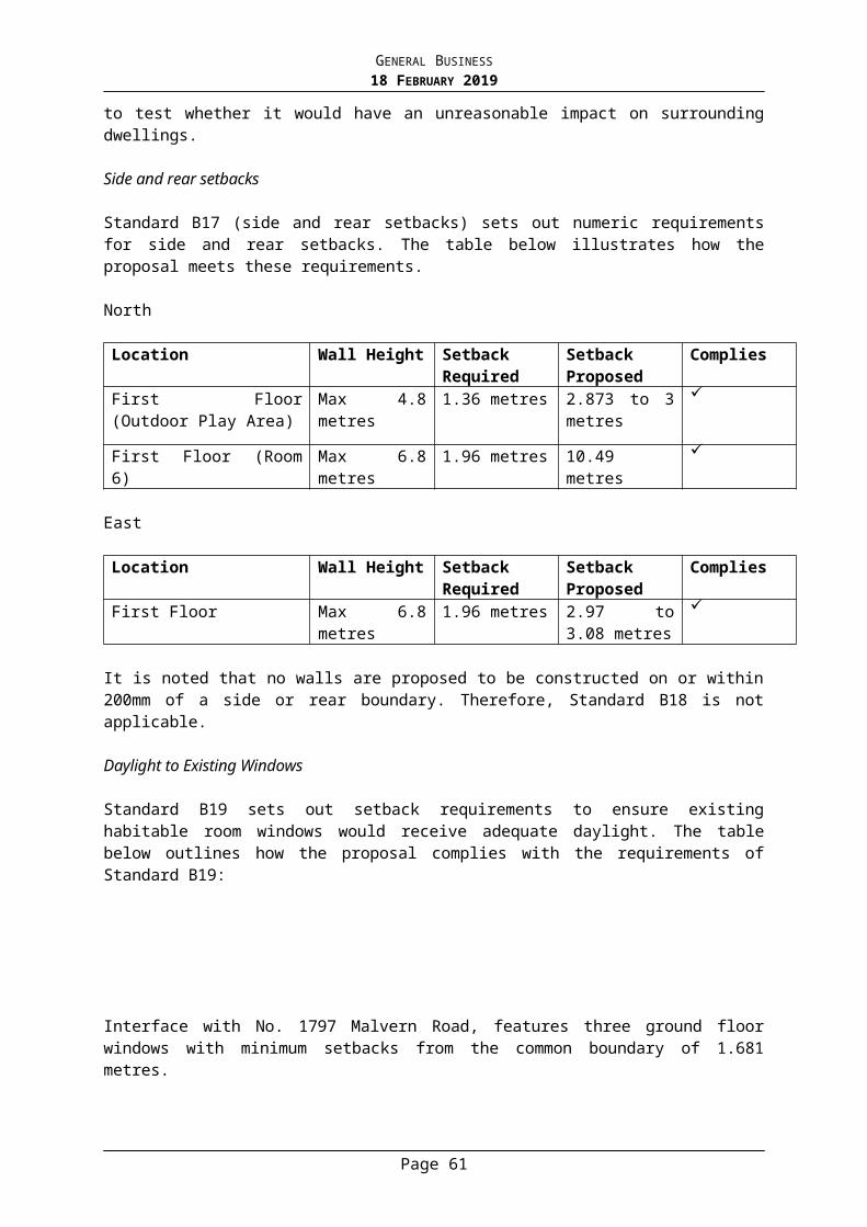
GENERAL BUSINESS18 FEBRUARY 2019
from the subject site. There is a 2.6 metre high cement sheet fence along the common boundary with the subject site.
More broadly, High Street is located 50 metres to the north of the subject site, as is Malvern Gardens. The Glenferrie Road and High Street Activity Centre is approximately 400 metres to the west of the subject site.
Previous Planning Application(s)
A search of Council records indicates that there are no recent planning applications registered to this site.
The Title
The site is described on Certificate of Title Volume 06075 Folio 915 as Lot 1 on Title Plan 598172 (4 Harvey Street) and Title Volume 05814 Folio 620 as Lot 6 Block B on Plan of Subdivision 000780 (6 Harvey Street) and no covenants affect the land. There is a drainage easement with a width of approximately 900mm that extends along the northern boundary of No. 6 Harvey Street. The applicant has advised that the easement will be dealt with via a separate planning application. This matter will be addressed through a permit condition requiring resolution of the removal and relocation of the drainage easement prior to the endorsement of plans.
Planning Controls
The following controls/permit triggers are considerations for this application:
ZoneClause 32.08 – General Residential Zone (Schedule 10) Pursuant to Clause 32.08-2 a permit is not required to use the land for dwellings.
Pursuant to Clause 32.08-6, a permit is required to construct two or more dwellings on a lot and a front fence that exceeds a height of 1.5m. A development must meet the requirements of Clause 55.
The Zone requires that an application to construct a residential building on a lot greater than 650sqm in area must provide a minimum garden area of 35% of the site. The plans confirm 36% of the site will be provided as garden area.
In addition, a residential building must not exceed a height of 9m, or 10m on a sloping site. The development as proposed has a height of 8.9m and contains 3 storeys.
Page 61
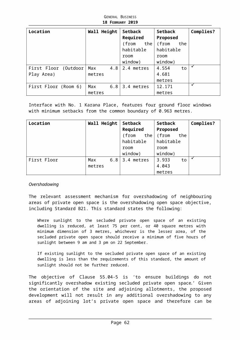
GENERAL BUSINESS18 FEBRUARY 2019
Schedule 10 varies the following ResCode Standards:
Standard RequirementSite coverage A5 and B8 Basements should not exceed 75% of the site area.Landscaping B13 In addition to the requirements of B13, at least one
canopy tree should be planted on the site.Side and rearSetbacks
A10 and B17 For a distance of at least 5 metres behind the front facade of the building fronting the street, setback new buildings (including basements) a minimum of 2 metres from at least one side boundary and at least 1 metre from the other side boundary up to 3.6 metres in height.Where no setback is specified, standard A10 or B17 applies.
Walls on boundaries
A11 and B18 Walls should not be located on side boundaries for a distance of 5 metres behind the front façade of the building fronting the street.
OverlaysNone.
Any Particular Provisions:
Clause 52.06 – Car ParkingPursuant to Clause 52.06-2, the car parking spaces required under Clause 52.06-5 must be provided on the land prior to the commencement of a new use. Pursuant to Clause 52.06-5, a dwelling requires:
1 car space to each one or two bedroom dwelling; and 2 car spaces to each three or more bedroom dwelling.
Each new dwelling contains 3 or more bedrooms and is provided between 2 and 4 car parking spaces. The 4 new dwellings are required to provide a total of 8 car spaces, 2 to each new dwelling. The proposal provides 12 car parking spaces, with 2 spaces allocated to each apartment and 4 spaces to each townhouse, exceeding the statutory requirements by 4 spaces.
Clause 55 – Two dwellings on a lot and residential buildingsA development: Must meet all of the objectives of this clause. Should meet all of the standards of this clause.
Relevant Planning Policies
Clause 9 Plan Melbourne Clause 11 Settlement Clause 15 Built Environment and Heritage Clause 16 Housing Clause 21.02 Overview Clause 21.03 Vision Clause 21.05 Housing Clause 21.06 Built Environment and Heritage Clause 22.05 Environmentally Sustainable Design Clause 22.18 Stormwater Management (Water Sensitive Urban Design)
Page 62

GENERAL BUSINESS18 FEBRUARY 2019
Clause 22.23 Neighbourhood Character Policy
Advertising
The application has been advertised pursuant to Section 52 of the Planning and Environment Act 1987 by sending notices to the owners and occupiers of adjoining land (and by placing 2 signs on the site). The public notification of the application has been completed satisfactorily.
The site is located in South Ward and objections from 15 different properties have been received. The concerns of the objectors can be summarized as follows: Three storey building / height Out of character with the street Overdevelopment / density Loss of original building / demolition Loss of privacy / overlooking Loss of natural light / overshadowing Noise to adjacent bedrooms Excessive car parking Traffic impacts Visual bulk Landscaping Inaccuracies on the plans Loss of views to the sky
A Consultative Meeting was held on 20 November 2018. The meeting was attended by Councillor Stefanopoulos, representatives of the applicant, objectors and a Council planning officer. Following the consultative meeting revised plans were submitted to Council on 14 January 2019 and showed the following changes:
Basement Reconfiguration of the basement to facilitate more efficient circulation movements of
vehicles Provision of an increased setback from the northern boundary from 1 metre to 1.55
metres Provision of an increased setback from the southern boundary from between 845mm
and 925mm to between 1.25 metres and 1.54 metres Reduction in the basement site coverage from 72% to 70%
Ground Provision of an increased setback of the living area of apartment 1 from the northern
boundary from 1.07 metres to 1.5 metres Provision of an increased setback of townhouse 2 from the southern boundary from
between 1.16 metres and 1.4 metres to 1.5 metres and 1.52 metres and removal of the door from the study
Provision of continuous planting within the increased setbacks Increase in permeability from 21% to 22%
First Floor Deletion of the planter from the northern edge adjacent the living area of Apartment 2
Page 63
GENERAL BUSINESS18 FEBRUARY 2019
Installation of screens to a height of 1.7 metres above finished floor level to the terrace of Apartment 2 and to Townhouses 1 and 2
Second Floor Installation of a screen to a height of 1.7 metres above finished floor level to the west-
facing terrace of Apartment 2
Elevations Reduction in the overall height of the apartment building from 9.4 metres to an overall
height of 8.9 metres Details of screens and fluted glass to a height of 1.7 metres at second floor level (on
the north elevation) Increased side setbacks
Sections Detail the proposed screening
Referrals
Urban Design
The advertised plans were reviewed by Council’s Urban Designer who raised concerns with the extent of basement; the proximity of building to the north and south boundaries limiting space for in-ground canopy-tree screening to the adjoining residences; and the ground floor level of the apartment building being below natural ground level.
They did note that from a design character and materiality/colour palette perspective, the proposal represents a quality response for a significant infill development in the streetscape.
It was suggested that the side setbacks be increased to enable satisfactory in-ground canopy-treed landscaped interfaces to the adjoining side properties.
In response to these comments, the revised plans have increased the side setbacks to improve the landscaping opportunities along the north and south boundaries by showing continuous planting within the increased setbacks.
Parks Department
Street Trees
A services / meters cabinet is shown on the northern boundary adjacent to where a Platanus x acerifolia (London Plane) street tree is located. A permit condition will be required to ensure service connections do not compromise the health of this street tree.
Confirmation is required if any additional services are to be connected to this development, and if so where they are located in relation to the street trees.
No change is permitted to the existing crossovers. Trees 1 & 2 – Platanus x acerifolia (London Plane) Total value = $32,469 for each tree. Total value for trees 1 & 2 = $64,938.
Landscape Plan
The landscape concept is supported.
Page 64
GENERAL BUSINESS18 FEBRUARY 2019
Permit Conditions
Protection fencing must be afforded to the three Platanus x acerifolia (London Plane) street trees at this location prior to any site works occurring. Fencing must comply with Section 4 of AS 4970 and a Tree Protection Fencing Plan must be submitted and approved by Council’s arboriculture department.
No vehicular or pedestrian access, trenching or soil excavation is to occur within the tree protection zone without the written consent of the Responsible Authority. No storage or dumping of tools, equipment or waste is to occur within the tree protection zone.
Bank guarantee is required in accordance with the values above.
Infrastructure
Prior to a building permit being issued, a report for the legal point of discharge must be obtained from Council and a drainage design for the development must be prepared by a suitably qualified Engineer in accordance with all ‘recommendations’ and requirements contained in that report. All drainage must be by means of a gravity based system with the exception of runoff from any basement ramp and agricultural drains which may be pumped. The relevant building surveyor must check and approve the drainage design and ensure that protection of the building is provided from a 1 in 100 A.R.I. rainfall event as required by the Building Regulations,. (Please do not state drainage design to satisfaction of Council, that is the responsibility of the relevant building surveyor to check and approve in accordance with the report and ‘recommendations’ for the legal point of discharge).
Prior to an ‘Occupancy Permit’ being issued, a suitably qualified Engineer must carry out a detailed inspection of the completed stormwater drainage system and associated works including all water storage tanks and detention (if applicable) to ensure that all works has been constructed in accordance with the approved design and the relevant planning permit conditions. Certification of the completed drainage from the Engineer must be provided to Council prior to a ‘Statement of Compliance’ being issued for the subdivision.
The existing footpath levels must not be lowered or altered in any way at the property line (to facilitate the basement ramp). This is required to ensure that normal overland flow from the street is not able to enter the basement due to any lowering of the footpath at the property line.
There will be significant additional stormwater runoff generated by the development and there are known drainage problems and flooding downstream of the property. The applicant must at their cost provide a stormwater detention system to restrict runoff from the development to no greater than the existing runoff based on a 1 in 10 A.R.I. to the satisfaction of Council’s Infrastructure Unit. Alternatively, in lieu of the stand alone detention system, the owner may provide stormwater tanks that are in total 2,500 litres greater than those tanks required to satisfy WSUD requirements for the development. Those tanks must be connected to all toilets.
Transport and Parking Department
The Transport and Parking Department have reviewed the plans and have raised the following concerns:
Page 65

GENERAL BUSINESS18 FEBRUARY 2019
The vehicle crossing to north is only 2.7m wide. Swept path diagrams are to be provided to show that vehicles can satisfactory enter and exit the curved driveway to and from Harvey Street.
The plans show a headroom clearance of at least 2.2m along each ramp which appears to be at the entry point. It is not clear if this dimension is at the entry point when the garage door is open, which is typically where the minimum headroom clearance occurs. This is to be shown for all doors throughout the basement.
The plans are to be revised to clearly show how the sight line requirements will be provided to the north and south. Please note that providing 50% visibility through planting would likely be difficult to be maintained, and as such cannot be considered appropriate. If planting is proposed within the required area, it must be less than 0.9m high measured from the footpath level.
The plans are to be revised to show that the garage for Apartment 2 is at least 6m long and 5.5m wide.
There are concerns with the swept path diagrams provided for the car spaces in garages for Apartment 1 and 2. There are too many movements required to be conducted within the shared aisle which not only impact access to car spaces for this dwelling but also other dwellings.
This is likely due to the narrow width of the garage for Apartment 2 and the aisle not being extended by at least 1m past the garages to assist manoeuvring. The applicant is to revise the design of the garages to improve accessibility, and submit a revised swept path diagram.
The plans do not show the gradients within the car parks. The Australian Standards requires a minimum grade of 1 in 200 (0.5%) across undercover parking areas for drainage purposes
KEY ISSUES
Strategic Context
The overarching policies and objectives at both a State and local level encourage urban consolidation in established urban areas and medium density residential development in and around neighbourhood activity centres and close to public transport. These strategies call for well-designed medium-density development that respects neighbourhood character, improves housing choice, makes better use of existing infrastructure and improves energy efficiency.
Council’s Municipal Strategic Statement (MSS) identifies the site as being within an “incremental change area”. These areas (outside of the Heritage Overlay and Neighbourhood Character Overlay), are encouraged to direct multi-unit development (2-3 storeys) to lots capable of accommodating increased density. The subject site is in excess of 1000sqm and is located within the Principal Public Transport Network Area being only 50m from High Street which is serviced by the No. 6 tram. The proximity of the site to public transport and the Glenferrie Road and High Street activity centre (approximately 400m to the west) affirms that this land is capable of accommodating increased density. Furthermore, the design represents an appropriate infill response and achieves a high degree of integration with the evolving streetscape of predominantly 2-storey dwellings.
Neighbourhood Character
The Garden Suburban 1 Neighbourhood Character Precinct comprises leafy streetscapes with a range of Victorian, Edwardian or Interwar era and contemporary buildings set in established garden surrounds. In typical streets regular front and side setbacks provide
Page 66
GENERAL BUSINESS18 FEBRUARY 2019
space around buildings and allow for small, well designed garden areas that contribute to the landscape quality of the street. New buildings or additions offer innovative and contemporary design responses while complementing the key aspects of form, general one-two storey scale and design detail of the older buildings.
The proposed development is deemed to be a high quality, contemporary response that will contribute positively to the character of the area. The two townhouses appear as more traditional houses, albeit in contemporary architectural form. Each townhouse has a separate entry directly accessible from the street, glazing to the public realm and basement garages below. Positively, the car parking has been placed underground removing the need for any visible garage structures to the street and increasing landscaping within the front setback. The apartment building has been designed with a curved edge to the north, with the upper level recessed behind the façade to reduce its dominance in the streetscape. The apartment is three storeys yet is only 1.66m higher than the adjoining double storey dwelling to the north. As noted by Council’s Urban Designer the design character and materiality/colour palette is a quality response with the development using a range of substantive materials such as brick, render, ribbed concrete style cladding and metal wall cladding to create articulation and contrast around the building. Glazing and terraces are oriented towards the street which contributes to the activation of the public realm and promotes passive surveillance. The landscaping elements have also been well integrated around the building to allow a variety of new plantings, including new canopy trees to contribute to the landscape quality of the street.
Having regard to the objectives above, the development is deemed to be compatible with the surrounding built form and meets the objectives of the Garden Suburban 1 Neighbourhood Character Precinct.
Site Layout and Building Massing
The development has been setback from the street at a minimum distance of 5.4m, which generally aligns with the adjoining setbacks and ensures limited impact on the significant London Plane street trees. Tree Protection Zones (TPZ) for the street trees will be marginally encroached by the paving / driveway works only. As the existing crossovers are to be retained there will be no change in the access to the site from Harvey Street. The applicant has sought to modify the crossings and this will not be permitted as it is likely to compromise the health of the significant trees. A condition will require that the plans be amended to show no modifications to the existing crossovers. The building, including the basement will sit outside of the TPZ of the trees. The protection of the street trees is imperative and will be enforced through a number of permit conditions, including Tree Management Plans and a bank guarantee.
At a maximum overall height of 8.9m, the building will sit below the allowable height (9m) stipulated by the Zone. Although the apartment building to the north will contain 3 storeys, it will be only 1.66m taller than the roof line of the dwelling to the north and 0.49m lower than the roof line of the dwelling to the south. As the height of the building aligns with the surrounding built form it is considered to respect the existing and preferred neighbourhood character. In addition, the third storey of the apartment building is recessed behind the façade with a setback of 8.6m from the street.
In terms of site coverage and permeability, the development complies with the relevant Standards B8 and B9 with 57.4% site coverage at ground (60% recommended) and 22% permeability (20% recommended). The basement coverage also complies with 70% of the overall site area (maximum of 75% is recommended by the Zone) and was further reduced as a result of the revised plans to incorporate greater setbacks to the side boundaries.
Page 67
GENERAL BUSINESS18 FEBRUARY 2019
The garden area (36%) exceeds the minimum area required by the Zone (35% required) and landscaping is to be provided to the front, side and rear of the building. The setbacks and building footprint will provide satisfactory opportunities for the establishment of new trees, particularly along the side and rear boundaries. It is deemed that canopy trees are required along the north and south boundaries and the landscape plan will require updating to reflect the revised plans that show the increased side setbacks.
As a result of the revisions to the plans after the consultative meeting, the landscape response is now satisfactory and will ensure the contemporary building is set amongst canopy trees and soft landscaping to buffer the building bulk and reflect the garden character of the wider neighbourhood. The London Plane street trees are highly valued in this streetscape and their significant canopies will further assist in softening the building’s appearance within the street.
Landscaping has been incorporated into the design of the front fence with planters incorporated above lower walls. Higher sections of fencing up 2m are proposed, yet these are broken up with planters, recessed entries and driveways. The front fence is deemed to be compatible with the streetscape and reflects the heights of other high fences on adjoining sites, as well as the existing high front fence on the subject site (No. 4 Harvey Street).
Amenity Impacts
Setbacks to the North
Northern setback
Minimum proposed setbacks
Setback required by Standard B17 (Side and rear setbacks)
Complies?
Ground 1.5m to 1.8m 1m Yes
First 1.5m to 1.81m 1.5m to 2.19m No
Second 3.18m to 3.21m 3.39m to 3.99m No
As a result of the revised plans lodged with Council on 14 January 2019, the setbacks to the north have been increased at ground level to 1.5m, where it was previously setback 1.07m.
The revised setback now allows increased in-ground planting along the northern interface, capable of accommodating canopy trees. This is in line with the advice of Council’s Urban Designer. The setbacks as proposed vary between 1.5m at the ground level up to 3.21m at the second floor (uppermost level). The required side and rear setbacks of ResCode (Standard B17) are listed above. There are some variations from the Standard minimally at first floor level. The non-compliance at this level occurs to the far east of the site where the new building reaches a height of 7.7m above natural ground level (stair in Apartment 2). At this point the building is located opposite the first floor level of the dwelling to the north and there are no habitable room windows orientated towards the subject site. As such there will be no unreasonable amenity impact.
At the second floor level there are also minor variations sought from the Standard. The non-compliance to the west of the site is 0.18m, while the non-compliance to the east is 0.81m. The greater non-compliance is located towards the front of the building (containing the stair and hallway in Apartment 2), opposite the first floor level of the dwelling to the north where there are no habitable room windows that face the southern boundary. Again there will be no material impact on the dwelling to the north and the overall setback between the new
Page 68
GENERAL BUSINESS18 FEBRUARY 2019
development and the dwelling to the north is 4.4m. This provides adequate separation between the buildings that reflects existing side setbacks in the street.
The non-compliance further to the west at the second floor level occurs towards the rear of the site (guest suite in Apartment 2) where the wall reaches a height of 8.31m above natural ground level and the wall is setback 3.21m from the north boundary. Standard B17 calls for a setback of 3.4m, resulting in a non-compliance of 0.09m. This degree of non-compliance is insignificant and will cause no unreasonable detriment to the adjoining dwelling. This section of the building to the rear (containing the guest suite in Apartment 2), is located opposite three ground floor level habitable room windows and two first floor level habitable room windows. These windows are south facing and are setback from the common boundary with the subject site a minimum distance of 1.2m. These windows serve a sitting room and kitchen at the ground floor level and two bedrooms at the first floor level. There are windows on the northern side of the dwelling to the north that provide natural light into the ground floor sitting area. The area of secluded private open space is also on the northern side of that dwelling and will have no direct interface with the new building on the subject site.
The setbacks are deemed to be acceptable as they comply with Standard B19 (Daylight to existing windows) and ensure that windows on the property to the north are adequately protected. As the adjoining windows are setback 1.2m from the common boundary the separation distance is adequate to allow daylight into the existing habitable room windows (refer to Table below).
Northern setback
Proposed setbacks Setback required by Standard B19 (Daylight to existing windows)
Complies?
Ground 3.1m 1.55m Yes
First 3.1m 2.7m Yes
Second 4.4m 4.4m Yes
Setbacks to the South
Southern setback
Minimum proposed setback
Setback required by Standard B17 (Side and rear setbacks)
Complies?
Ground 1.5m – 3.1m 1.03m Yes
First 3.15m to 5m 1.9m to 2.44m Yes
The southern wall of Townhouse 2 will vary in height between 6.6m and 7.35m above natural ground level. The setbacks as proposed vary between 1.5m at ground up to 5m at the first floor level. The development as it presents to the south, is 2 storeys in height. The setbacks proposed comply with Standard B17 (Side and rear setbacks objective) as shown in the table above.
The southern wall of the development is located opposite a number of north facing windows at No. 8 Harvey Street, which are setback 2m from the common boundary with the subject site. Standard B20 (North facing windows objective) calls for increased setbacks where new development is located opposite existing north facing windows. Where the new building reaches a height of 7.35m towards the front of the site (guest bedroom of Townhouse 2), the new wall is to be setback 3.4m from the boundary opposite north facing windows. The wall is setback 5m which complies. Where the wall reaches a height of 6.6m (to the rear of the site
Page 69
GENERAL BUSINESS18 FEBRUARY 2019
Bedroom 4 of Townhouse 02), a setback of 3.15m is proposed, where a setback of 2.8m is required. Again this easily complies. The development therefore fully complies with the ResCode Standards for side and rear setbacks and protection of north facing windows (Standard B20).
Setbacks to the West
Western setback
Minimum proposed setback
Setback required by Standard B17 (Side and rear setbacks)
Complies?
Ground 4.2m – 4.7m 1m Yes
First 4.4m to 4.7m 1.8m – 2.99m Yes
To the rear boundary the proposed building is setback a minimum distance of 4.2m. The proposed development will sit at between 6.3m and 7.9m above natural ground when viewed from the west, where the recommended setback would be 1.8m and 2.99m respectively. Therefore the rear setbacks comfortably comply with the side and rear setbacks Standard B17.
There are no existing habitable room windows on an adjoining site to the west within 3 metres of the common boundary with the subject site.
Overlooking
The advertised plans did not detail adequate screening measures to limit overlooking into the adjoining properties. The plans as revised now show some screening up to 1.7m with no more than 25% transparency to the terrace and windows facing north and west above ground floor.
The north and south elevations show the use of fluted glass up to 1.7m above finished floor level. While fluted glass can be accepted as an appropriate means of limiting overlooking, further details of the glass will need to be provided as a condition of approval to ensure that views are satisfactorily obscured.
There are two north facing windows associated with Apartment 2 at the first floor level that have not been screened. They are associated with a laundry and study. Although a laundry is a non-habitable room that does not require screening, a study does require screening as determined by Standard B22 as it is a habitable room. This will be addressed via a condition. A terrace also faces north and has not been screened. This will be addressed via conditions requiring that the terrace be screened or sight lines provided that demonstrate no views into a sensitive interface within 9m.
On the southern elevation, the windows associated with the rumpus room within Townhouse 2 have not been screened where they are located within 9m of habitable room windows to the south. A planter extends out from the window but will not adequately limit views and landscaping cannot be relied on to limit overlooking. A condition of approval will require that these windows be screened to limit overlooking in accordance with the overlooking objective (Standard B22).
Overshadowing
Overshadowing impacts to the private open spaces to the south and west will not result in any additional overshadowing on the Equinox (22 September) due to the side and rear setbacks proposed and the shadows cast by existing fences and buildings. As there will be
Page 70

GENERAL BUSINESS18 FEBRUARY 2019
no increased detriment beyond the existing conditions, the proposal complies with the Overshadowing Standard B21 of Clause 55 (ResCode).
Internal Amenity
The amenity of the new dwellings is deemed to be of a high standard and complies with the Objectives of Clause 55.05. As the development includes two apartments, the Apartment Development Standards at Clause 55.07 have been used to assess the internal amenity of the apartment building.
Energy efficiency in the design of the building has been considered in conjunction with Council’s Environmentally Sustainable Development Policy (Clause 22.05). The townhouses and apartments will benefit from having multiple aspects and as such will be cross ventilated. Concerns were raised by Council’s Urban Designer regarding the floor levels within Apartment 1 sitting below natural ground level. While this arrangement is not ideal it is acceptable in high quality apartments where rooms can rely on multiple other windows and aspects for natural light. This is the only dwelling within this development that will have has this arrangement. On balance, the apartment will maintain high quality internal amenity, despite being below natural ground level at the far west of the dwelling.
The sustainability assessment provided in support of this application confirms that the proposed development achieves an average 6.2 Star Rating and a BESS Rating score of 54%, which exceeds minimum best practice of 50%.
The deep soil planting requirements are achieved via the garden area and canopy tree planting around the site.
The dwelling entries are located at the front of the development with the exception of Apartment 1 which has its entrance along the north boundary via a landscaped path. The development is considered to provide safe and efficient movements for future occupants which are clearly visible from Harvey Street.
Each of the dwellings are provided ample private open space either via rear courtyard gardens or terraces above ground level. Apartments 1 and 2 are provided 97sqm and 39sqm of private open space, respectively. This provision is well in excess of the recommended 12sqm. The two townhouses each have a front and rear garden space with plunge pools to the rear. Secluded private open space for the townhouses varies between 55sqm and 86sqm, well in excess of the recommended 25sqm.
The living areas throughout the development exceed 3.6m and 12sqm in area and all bedrooms are in excess of 3 metres (width) by 3 metres (depth). Due to the size of the dwellings (between 180sqm and 369sqm), adequate storage is provided within the dwellings and garages of the townhouses. The room depths, floor to ceiling heights, location of the windows and opportunities for cross ventilation ensure that the new dwellings are provided high quality on-site amenity. Of the two apartments, both are capable of accommodating at least one accessible bathroom. The dimensions of the accessible bathroom will be required to be shown on the plans via a condition.
Overall, this proposal is considered to offer high quality apartment accommodation for future occupants.
Water Sensitive Urban Design and Stormwater Management
Page 71
GENERAL BUSINESS18 FEBRUARY 2019
In response to Council’s Storm Water Policy (Clause 22.18), the applicant has submitted a Water Sensitive Urban Design Response (WSUD). A response to the policy requirements has been provided which achieves a STORM rating of 106%
Rainwater runoff from Townhouses 1 and 2 will be collected and stored in a 3,000L rainwater tank provided for each dwelling. The rainwater tanks are shown within the basement garages. Apartments 1 and 2 will each be fitted with a rainwater tank with 2,500L capacity. Slimline rainwater tanks are again shown in the basement level. Although the collected rainwater will be used for toilet flushing in all toilets across the development and for landscape irrigation, notations confirming the connections for re-use on plans will be required via conditions.
To further address stormwater management which has been highlighted as a concern by Council’s Infrastructure Department, the applicant may choose to install rainwater tanks 2,500 litres greater than those tanks required to satisfy WSUD requirements for the development. The current rainwater tank collection of 11,000L would therefore need to be increased to 13,500L to meet the requirements, or alternatively a detention system may be installed. This is to be addressed via a condition of any approval.
Car Parking and Traffic
Car Parking Provision
Each new dwelling is provided between 2 and 4 car parking spaces within the basement level which exceeds the statutory rate. No visitor car parking is required. Residents of the development will not be able to access resident parking permits.
Traffic Generation
The applicant has provided a Traffic Impact Assessment which anticipates that the development will generate a total of 24 vehicle movements per day (6 movements per dwelling), in which 2-3 vehicle movements occur during each peak periods. This equates to 1 movement every 15 minutes during the peak hour. As confirmed by Council’s Transport and Parking Department, the additional traffic generated by the proposal will not adversely impact on the safety or operation of the road network.
A swept path will be required to show that a B99 vehicle can easily access the curved crossing (to the north) from Harvey Street in one movement. This will ensure no queuing or corrective movements are needed in the public road, reducing any potential traffic congestion. The plans must also remove any reference to any modification to the existing crossovers.
Car Park Design
As per the “Referrals” section of this report, there are some additional details required to be shown on plans to ensure the car parking layout is in accordance with Stonnington Planning Scheme requirements. These matters are not fundamental and can addressed via conditions.
With regard to the Apartment 2 garage dimensions and movements, the revised plans have increased the aisle width to 8m to improve vehicle manoeuvrability and shown the garage as having dimensions of 5.5m by 6m as required by the design standards of Clause 52.06. The changes to the garage are positive and it is likely that give the basement serves only 3 dwellings; the residents will become familiar with the parking movements required. Future
Page 72

GENERAL BUSINESS18 FEBRUARY 2019
residents of this development will not have access to resident or visitor parking permits and will be required to abide by any timed parking restrictions in the street.
Objections
Loss of original building / demolition
The subject site is not affected by a Heritage Overlay or a Neighbourhood Character Overlay and therefore a planning permit is not required to demolish the existing buildings. Council’s Heritage Advisor has confirmed that the dwellings are not significant in their own right and would not qualify for an individual heritage listing.
Loss of views to the sky
Loss of views is not a relevant planning consideration under the provisions of the Stonnington Planning Scheme. Loss of daylight to existing windows and overshadowing of private open space have been considered and there will be no unreasonable detriment as a result of the setbacks proposed.
Noise
The development is not expected to generate noise above and beyond that of a normal residential building. Any noise associated with plant equipment or mechanical services (i.e. lift overrun) will be required to be baffled via a condition of any permit that issues to comply with the relevant noise regulations of the Environmental Protection Authority (EPA).
Human Rights Consideration
This application has been assessed in accordance with the requirements of the Planning and Environment Act 1987 (including the Stonnington Planning Scheme), reviewed by the State Government and which complies with the Charter of Human Rights and Responsibilities Act 2006.
CONCLUSION
Having assessed the application against the relevant planning controls, it is recommended that the proposal be supported for the following reasons:
The proposal achieves an appropriate built form outcome and building height for an incremental change area in accordance with Council’s local policies and respects the surrounding neighbourhood character.
The proposal does not unreasonably impact on the amenity of adjacent or nearby sites. Subject to conditions, the development will not adversely impact on the significant
street trees and provides satisfactory provision for in-ground canopy tree planting around the building.
ATTACHMENTS
1. PA - 799- 18 - 4-6 Harvey Street Malvern - Attachment 1 of 1 Plans
Page 73
GENERAL BUSINESS18 FEBRUARY 2019
RECOMMENDATION
That a Notice of Decision to Grant a Planning Permit No: 799/18 for the land located at 4 and 6 Harvey Street, Malvern be issued under the Stonnington Planning Scheme for construction of a multi-dwelling development in a General Residential Zone subject to the following conditions:
1. Before the commencement of the development, 1 copy of plans drawn to scale and fully dimensioned, must be submitted to and approved by the Responsible Authority. The plans must be generally in accordance with the revised plans Drawing No’s A_TP _1000, A_ TP _1001, A_ TP_1002, A_TP_1003, A_TP _2003_REFI-3, A_TP_2004, A_TP_3000, A_ TP_1004, A_ TP2001, A_ TP_2002, A_TP_3001 and A_ TP_3002 all Revision RFI-3 and Council date stamped 14 January 2019 but modified to show:
a) Plans to confirm no change to the width of the existing crossovers on Harvey Street;
b) A swept path diagram confirming that B99 vehicles can satisfactory enter and exit the curved driveway to and from Harvey Street utilising the existing crossover;
c) Details of the fluted glass to 1.7m above finished floor level demonstrating no more than 25% transparency to the satisfaction of the Responsible Authority;
d) Windows associated with the rumpus room within Townhouse 02, study in Apartment 2 and first floor north facing terrace in Apartment 2 are to be screened to limit overlooking in accordance with the overlooking objective (Standard B22) unless sight lines can be provided that demonstrate no views into a sensitive interface within 9m;
e) Notations to confirm the rainwater tanks will be used for toilet flushing in all toilets across the development and for landscape irrigation;
f) The services / meters cabinet shown on the northern boundary is to include a notation that the service connections must not compromise the health of the Platanus x acerifolia (London Plane) street tree;
g) Confirmation of any additional services to be connected to this development, and where they are located in relation to the street trees;
h) Headroom clearance of at least 2.1m shown at the entry point when the garage door is open and confirmed for all doors throughout the basement;
i) Plans to show how the sight line requirements will be provided to the north and south of the vehicle entries. Providing 50% visibility through planting is not appropriate. If planting is proposed within the required area, it must be less than 0.9m high measured from the footpath level;
j) Notations confirming gradients within the car parks are in accordance with the Australian Standards which requires a minimum grade of 1 in 200 (0.5%) across undercover parking areas for drainage purposes;
k) Plans to confirm at least one accessible bathroom in either Apartment 1 or 2. Dimensions must meet Standard B41 (Accessibility Objective) of Clause 55;
l) Any requirements to comply with Condition 4 (Street tree bank guarantee), Condition 12 (Tree Management Plan), Condition 13
Page 74

GENERAL BUSINESS18 FEBRUARY 2019
(Landscape Plan) and Condition 21 (Stormwater management);
All to the satisfaction of the Responsible Authority.
2. The layout of the site and the size, levels, design and location of buildings and works shown on the endorsed plans must not be modified for any reason, without the prior written consent of the Responsible Authority.
3. Prior to the endorsement of plans, the permit holder must reach agreement with Council’s Infrastructure Department as to the removal and relocation of the drainage easement located at No. 6 Harvey Street.
4. Prior to the endorsement of plans and prior to any development commencing on the site (including demolition and excavation whether or not a planning permit is required), the owner/ developer must enter into a Deed with the Responsible Authority and provide it with a bank guarantee of $64,938 as security against a failure to protect the health of Trees 1 & 2 – Platanus x acerifolia (London Plane) street trees to be retained. The applicant must meet all costs associated with drafting and execution of the Deed, including those incurred by the responsible authority. Once a period of 12 months has lapsed following the completion of all works at the site the Responsible Authority may discharge the bank guarantee upon the written request of the obligor. At that time, the Responsible Authority will inspect the tree(s) and, provided they have not been detrimentally affected, the bank guarantee will be discharged.
5. Concurrent with the endorsement of plans or prior to the commencement of any works at the site (including demolition and excavation whether or not a planning permit is required), whichever occurs sooner, a letter of engagement must be provided to the Responsible Authority from the project arborist selected to oversee all relevant tree protection works. The project arborist must be an appropriately experienced and qualified professional (minimum Cert IV or equivalent in experience).
6. The project arborist must maintain a log book detailing all site visits. The log book must be made available to the Responsible Authority within 24 hours of any request.
7. Protection fencing must be afforded to the three Platanus x acerifolia (London Plane) street trees at this location prior to any site works occurring. Fencing must comply with Section 4 of AS 4970 and a Tree Protection Fencing Plan must be submitted and approved by Council’s arboriculture department.
8. Prior to the commencement of any works at the site (including demolition and excavation whether or not a planning permit is required), the project arborist must advise the Responsible Authority in writing that the Tree Protection Fences have been installed to their satisfaction.
9. No vehicular or pedestrian access, trenching or soil excavation is to occur within the tree protection zone without the written consent of the Responsible Authority. No storage or dumping of tools, equipment or waste is to occur within the tree protection zone.
10. A copy of the tree protection zones are to be included in any contract for the construction of the site or for any other works which may impact upon the
Page 75
GENERAL BUSINESS18 FEBRUARY 2019
trees.
11. The permit holder / developer must advise Council in writing that a Certificate of Occupancy has been issued in respect to the development and that the 12 month establishment period has commenced.
12. Concurrent with the endorsement of development plans a tree management plan prepared by a suitably qualified arborist must be submitted to and approved by the Responsible Authority. When approved, the tree management plan will form part of this permit and all works must be done in accordance with the tree management plan (AS 4970).
The tree management plan must detail measures to protect and ensure the viability of the Platanus x acerifolia (London Plane) street trees located adjacent to the subject site and other established trees adjacent to the boundaries.
Among other things, the tree management plan must include the following information:
a) Pre-construction (including demolition) – details to include a tree protection zone, height barrier around the tree protection zone, amount and type of mulch to be placed above the tree protection zone and method of cutting any roots or branches which extend beyond the tree protection zone.
b) During-construction – details to include watering regime during construction and method of protection of exposed roots.
c) Post-construction – details to include watering regime and time of final inspection when barrier can be removed and protection works and regime can cease.
Pre-construction works and any root cutting must be inspected and approved by the Responsible Authority's Parks Unit. Removal of protection works and cessation of the Tree Management Plan must be authorised by the Responsible Authority's Parks Unit.
13. Concurrent with the endorsement of plans, a landscape plan to be prepared by a landscape architect or suitably qualified or experienced landscape designer, must be submitted to and approved by the Responsible Authority. When approved, the landscape plan will be endorsed and will then form part of the permit. The landscape plan must be drawn to scale with dimensions. The landscape plan must be generally in accordance with the landscape concept plans known as TP01-TP08 Rev C Council date stamped 30 July 2018 prepared by Jack Merlo, but modified to show:
a) Increased landscaping provision, including new canopy trees along the north and south boundaries of the subject site within the increased side setbacks shown on the revised architectural plans received by Council 14 January 2019;
b) Details of the continuous planting within the increased side setbacks;c) Confirmation that the services / meters cabinet shown on the northern
boundary and associated service connections must not compromise the health of the Platanus x acerifolia (London Plane) street tree;
Page 76
GENERAL BUSINESS18 FEBRUARY 2019
d) Confirmation of any additional services to be connected to this development, and where they are located in relation to the street trees;
e) A Tree Protection Fencing Plan;
all to the satisfaction of the Responsible Authority.
14. Before the occupation of the development, the landscaping works as shown on the endorsed plans must be carried out and completed to the satisfaction of the Responsible Authority. Landscaping must then be maintained to the satisfaction of the Responsible Authority, including that any dead, diseased or damaged plants are to be replaced.
15. Prior to a building permit being issued, a report for the legal point of discharge must be obtained from Council and a drainage design for the development must be prepared by a suitably qualified Engineer in accordance with all ‘recommendations’ and requirements contained in that report. All drainage must be by means of a gravity based system with the exception of runoff from any basement ramp and agricultural drains which may be pumped. The relevant building surveyor must check and approve the drainage design and ensure that protection of the building is provided from a 1 in 100 A.R.I. rainfall event as required by the Building Regulations.
16. Prior to an ‘Occupancy Permit’ being issued, a suitably qualified Engineer must carry out a detailed inspection of the completed stormwater drainage system and associated works including all water storage tanks and detention (if applicable) to ensure that all works has been constructed in accordance with the approved design and the relevant planning permit conditions. Certification of the completed drainage from the Engineer must be provided to Council prior to a ‘Statement of Compliance’ being issued for the subdivision.
17. The existing footpath levels must not be lowered or altered in any way at the property line (to facilitate the basement ramp). This is required to ensure that normal overland flow from the street is not able to enter the basement due to any lowering of the footpath at the property line.
18. Any redundant vehicular crossing must be removed and the footpath, naturestrip and kerb reinstated at the owner’s cost to the satisfaction of Council.
19. Any poles, service pits or other structures/features on the footpath required to be relocated to facilitate the development must be done so at the cost of the applicant and subject to the relevant authority’s consent.
20. All utility services to the subject land and buildings approved as part of this permit must be provided underground to the satisfaction of the Responsible Authority by completion of the development, and must not impact on the health of the existing street trees.
21. The applicant must at their cost provide a stormwater detention system to restrict runoff from the development to no greater than the existing runoff based on a 1 in 10 A.R.I. to the satisfaction of Council’s Infrastructure Unit. Alternatively, in lieu of the stand alone detention system, the owner may provide stormwater tanks that are in total 2,500 litres greater than those tanks required to satisfy WSUD requirements for the development. Those tanks must be connected to all toilets.
Page 77
GENERAL BUSINESS18 FEBRUARY 2019
22. Prior to the occupation of the building, fixed privacy screens (not adhesive film) designed to limit overlooking as required by the Standard B22 of Clause 55.04-6 in accordance with the endorsed plans must be installed to the satisfaction of the Responsible Authority and maintained to the satisfaction of the Responsible Authority thereafter for the life of the building.
23. The project must incorporate the Water Sensitive Urban Design initiatives detailed in the endorsed site plan and/or stormwater management report.
24. All plant and equipment (including air-conditioning units) shall be located or screened so as to minimise visibility from any of the surrounding footpaths and from overhead views and shall be baffled so as to minimise the emission of unreasonable noise to the environment in accordance with Section 48A of the Environment Protection Act 1970 to the satisfaction of the Responsible Authority.
25. This permit will expire if one of the following circumstances applies:
d) The development is not started within two years of the date of this permit.e) The development is not completed within four years of the date of this
permit.
In accordance with Section 69 of the Planning and Environment Act 1987, a request may be submitted to the Responsible Authority within the prescribed timeframes for an extension of the periods referred to in this condition.
NOTES:
A. This permit does not constitute any authority to carry out any building works or occupy the building or part of the building unless all relevant building permits are obtained.
B. Nothing in this permit hereby issued shall be construed to allow the removal of, damage to or pruning of a significant tree (including the roots) without the further written approval of Council.
“Significant Tree” means a tree or palm:
a) with a trunk circumference of 140 cm or greater measured at 1.4 m above its base;
b) with a total circumference of all its trunks of 140 cm or greater measured at 1.4 m above its base;
c) with a trunk circumference of 180 cm or greater measured at its base; ord) with a total circumference of all its trunks of 180 cm or greater measured
at its base.
Please contact the Council Arborists on 8290 1333 to ascertain if permission is required for tree removal or pruning or for further information and protection of trees during construction works.
C. Nothing in the permit hereby issued may be construed to allow the removal of, damage to or pruning of any street tree without the further written consent of the Stonnington City Council. Contact the Council Arborists on 8290 1333 for further information.
Page 78
GENERAL BUSINESS18 FEBRUARY 2019
D. The owners and occupiers of the dwelling/s hereby approved are not eligible to receive “Resident Parking Permits”.
E. At the permit issue date, Section 69 of the Planning and Environment Act 1987 stated that the Responsible Authority may extend the periods referred to if a request is made in writing within the following timeframes:
i. Before or within 6 months after the permit expiry date, where the development allowed by the permit has not yet started; and
ii. Within 12 months after the permit expiry date, where the development allowed by the permit has lawfully started before the permit expires.
F. Council has adopted a zero tolerance approach in respect to the failure to implement the vegetation related requirements of Planning Permits and endorsed documentation. Any failure to fully adhere to these requirements will be cause for prosecution. This is the first and only warning which will be issued.
Page 79
GENERAL BUSINESS18 FEBRUARY 2019
5. PLANNING APPLICATION 0374/18 - 14 WILMOT STREET, MALVERN EAST VIC 3145 - DEMOLITION OF THE EXISTING DWELLING AND CONSTRUCTION OF TWO DWELLINGS ON A LOT IN A NEIGHBOURHOOD RESIDENTIAL ZONE AND NEIGHBOURHOOD CHARACTER OVERLAY
Manager Statutory Planning: Alexandra Kastaniotis General Manager Planning & Amenity: Stuart Draffin
PURPOSE
For Council to consider a planning application for demolition of the existing dwelling and construction of two dwellings on a lot in a Neighbourhood Residential Zone and Neighbourhood Character Overlay at 14 Wilmot Street, Malvern East.
Executive Summary
Applicant: Keen PlanningWard: East WardZone: Neighbourhood Residential ZoneOverlay: Neighbourhood Character OverlayNeighbourhood Precinct: Garden Suburban 4Date lodged: 12 April 2018Statutory days: (as at council meeting date)
85
Trigger for referral to Council:
7 or more objector properties
Number of objections: 10Consultative Meeting: Yes – held on 4 September 2018Officer Recommendation: Issue a Notice of Decision to Grant a Planning Permit
BACKGROUND
The Proposal
The plans that form part of the basis of Council's consideration were prepared by DNB Design and Drafting and are known as Project No: DP-AD28044, Drawing No: 17-032, Sheet No’s: 1 to 9, Revision E, and Landscape Plans prepared by Marnie Lewis Design known as Job No: 18004, Page No’s: TP2-001 to TP2-004, all Council date stamped 22 November 2018.
Key features of the proposal are:
Demolition of the existing dwelling and outbuildings; Construction of two double storey dwellings in a side by side configuration, each with
four bedrooms; Provision of two car parking spaces for each dwelling within a basement level,
accessed via the existing crossover towards the northern side of the frontage; Pedestrian access is via individual entries located centrally to the frontage; Each dwelling is provided with ground level secluded private open space to the east
(rear); The proposed maximum building height is 7.6 metres; The building design references the key elements of Californian bungalow style with
pitched roofing incorporating several street facing gables, generous front porches
Page 81
GENERAL BUSINESS18 FEBRUARY 2019
supported by solid pillars, and wall materials including render, face brickwork and horizontal timber-look cladding;
A 1.2 metre high front fence constructed of face brickwork piers with timber picket infill.
Site and Surrounds
The site is located on the eastern side of Wilmot Street, approximately 140 metres north of the intersection with Dandenong Road. The site has the following significant characteristics:
A frontage to Wilmot Street of 15.24 metres, a depth of 45.72 metres, with an overall site area of approximately 697 square metres.
The land is currently occupied by a single storey weatherboard dwelling with a tiled, pitched roof. The dwelling is a Californian bungalow yet is not considered to be of heritage significance. The dwelling is setback 8.6 metres from the street frontage and side setbacks range between 1.74 metres and 4.2 metres.
Vehicle access to the site is via a single width crossover located toward the northern end of the frontage, with a driveway sited along the northern side boundary accessing a garage toward the rear.
The land is relatively flat with a slight slope upwards of approximately 400mm from front to rear (west to east).
Wilmot Street forms part of a broader Significant Character Area which is defined by numerous Californian bungalows which typically have a low slung appearance and incorporate key original features including large terracotta tiled roofs with simple chimneys, stucco and timber fretwork on gable ends, decorative brickwork, bay windows and arched verandahs with large pillars. Front fences are typically timber picket or low brick to match the era and style of dwellings. This description is somewhat apt within Wilmot Street which comprises numerous original Californian bungalow dwellings, however several of these have been improved with sympathetic first floor additions, and they are interspersed with replacement dwellings of one to two storeys, including several dual occupancy developments.
The site has the following direct interfaces:
To the north the property addressed to 16 and 16A Wilmot Street comprises of two double storey, attached dwellings. The dwellings are setback 9.1 metres from the street, with the garages built to both side boundaries. Each dwelling is provided with a separate crossover accessing single car garages. The development displays masonry and weatherboard cladding with Colorbond roofing incorporating street facing gables. Secluded private open space interfaces with the subject site at the rear.
The property to the south at 12 and 12A Wilmot Street comprises of two single storey, attached dwellings. The dwellings are setback 8.77 metres from the street. Each dwelling is provided with a separate crossover accessing single car garages which are constructed to both side boundaries. The development adopts a modest contemporary style with low profile pitched roofing and a low front fence. Secluded private open space interfaces with the subject site at the rear.
To the east the property at 13 MacGregor Street contains a single storey brick dwelling with pitched tiled roof. A large area of secluded private open space interfaces with the subject site at the rear.
To the west, directly across Wilmot Street, is a dual occupancy development addressed to 13 and 13A Wilmot Street. The property is improved with two single storey attached dwellings constructed to both side boundaries, each accessed via separate crossovers.
Previous Planning Application(s)
Page 82
GENERAL BUSINESS18 FEBRUARY 2019
A search of Council records indicates that there is no permit history on the subject site.
The following planning applications on adjoining properties are considered to be of relevance:
Planning Permit 449/06 at 16 Wilmot Street, Malvern issued by VCAT on 18 January 2007 allowing construction of two double storey attached dwellings. The development has been constructed.
Planning Permit 814/04 at 12 Wilmot Street, Malvern issued under delegation on 10 March 2005 allowing construction of two single storey attached dwellings. The development has been constructed.
The Title
The site is described on Certificate of Title Volume 4793 Folio 537 as Lot 45 on Plan of Subdivision 7579 and no covenants or easements affect the land.
Planning Controls
The following controls/permit triggers are considerations for this application:
ZoneClause 32.09 Neighbourhood Residential Zone (Schedule 4)Pursuant to Clause 32.09-6 a permit is required to construct two or more dwellings on a lot. A development must meet the requirements of Clause 55.
Pursuant to Clause 32.09-4, a minimum garden area of 35% is required to be provided at ground level. The development provides a minimum garden area of approximately 38% in compliance with this mandatory requirement.
Pursuant to Clause 32.09-10, the maximum height of a building for use as a dwelling must not exceed a height of 9 metres and must not contain more than two storeys. The proposed two storey development has a maximum height of 7.6 metres in compliance with this mandatory requirement.
OverlayNeighbourhood Character Overlay (Schedule 7)Clause 43.05Pursuant to Clause 43.05-2 a permit is required to construct a building or construct or carry out works. A permit is also required to demolish or remove a building and construct an outbuilding pursuant to Schedule 7 of the overlay.
Schedule 7 of the Neighbourhood Character Overlay modifies standards B6 (Street setback), B18 (Walls on boundaries) and B31 (Design detail). Refer to the assessment under Key Issues for specific details.
Particular ProvisionsClause 52.06 - Car ParkingPursuant to Table 1 at Clause 52.06-5 two car parking spaces are required for each three or more bedroom dwelling, and at least one space is to be under cover. As the development proposes two dwellings each with four bedrooms, a total of 4 car parking spaces are required. There is no requirement for visitor car parking.
Each dwelling is provided with two car parking spaces within a basement level. Accordingly, the requirements of Clause 52.06-5 are satisfied and a permit is not required in this regard.
Page 83

GENERAL BUSINESS18 FEBRUARY 2019
Relevant Planning Policies
Clause 16.01 - Residential DevelopmentClause 21.03 - VisionClause 21.05 - HousingClause 21.06 - Built Environment and HeritageClause 22.05 - Environmentally Sustainable DevelopmentClause 22.18 - Stormwater ManagementClause 22.23 - Neighbourhood Character PolicyClause 32.09 - Neighbourhood Residential ZoneClause 43.05 - Neighbourhood Character OverlayClause 55 - Two or more dwellings on a lot (ResCode)Clause 65 - Decision Guidelines
Advertising
The original application plans (Council date stamped 9 July 2018) were advertised pursuant to Section 52 of the Planning and Environment Act 1987 by sending notices to the owners and occupiers of adjoining land and by placing one sign on the site. The public notification of the application was completed satisfactorily.
The site is located in East Ward and objections from ten different properties have been received which can be summarised as follows:
neighbourhood character; overdevelopment; visual bulk, scale and mass; basement car park is out of character; centrally located basement access; lack of landscaping opportunities in front setback; pedestrian safety; increased traffic; lack of car parking; extent of basement and impact of excavation; inadequate side setbacks; equitable development opportunities limited; overlooking; overshadowing; loss of outlook and daylight to existing windows; inadequate materials information; reduced garden space and loss of trees; proposed tree species and climbers are inappropriate; increased potential for flooding; devaluation of properties; increased crime.
A Consultative Meeting was held on 4 September 2018. The meeting was attended by Councillors Klisaris, Atwell and Davis, representatives of the applicant, objectors and a Council planning officer. Subsequent to the consultation meeting, the application was formally amended with revised plans received by Council on 22 November 2018. The amended plans included the following key changes:
Page 84
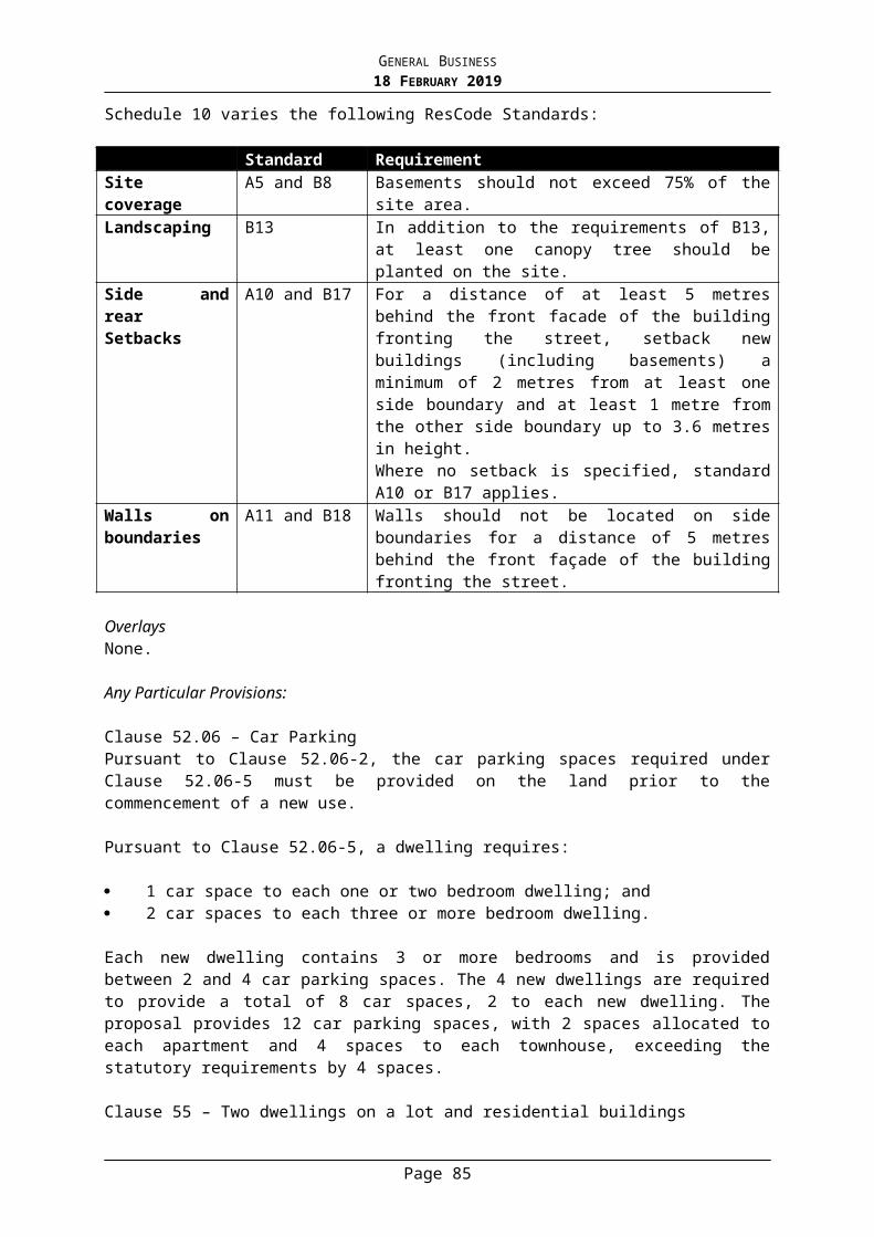
GENERAL BUSINESS18 FEBRUARY 2019
Relocation of the basement accessway from the centre of the frontage to the northern end of the frontage, utilising the existing vehicle crossover for access, and associated revisions to landscaping and front fencing;
Alterations to the basement layout to facilitate the new driveway location; Staggering the front façade presentation resulting in the northern dwelling being
setback approximately 1 metre behind the façade of the southern dwelling, and associated change to the rear setback;
The amended plans were re-advertised by sending notices to the owners and occupiers of adjoining land and all objectors. One objection was received from a previous objector who raised additional issues and reiterated concerns, summarised as follows:
lack of provision for canopy tree planting within frontage to soften visual impact; inappropriate tree species; overdevelopment; increased visual bulk impacts from existing windows due to Dwelling 1 being setback
further into site; overlooking; colour of roof cladding is not specified.
Referrals
Urban Design (comments based on original plans, dated 9 July 2018)
To moderate the bulk of the building and improve the presentation to the streetscape the following is suggested: Relocate the basement access ramp towards the northern site boundary, leaving
space for landscaping between the driveway and the boundary; Stagger the siting of the two dwellings, ie. set back the northern dwelling, and
eliminate the projecting central party wall; In the staggering of the two dwellings the extent of ground floor may require some
reduction in area which would assist in the reduction of the overall building bulk and would also enable an improved landscape setting for the development.
The proposed first-floor setbacks appear to be reasonable.
Planner response: The amended plans address the suggestions to relocate the basement access ramp and provide a staggered front facade, however a condition of permit will require the projecting central party wall to be deleted. Subject to this change, the Urban Designer has noted that the revised plans are acceptable.
Parks
There is no objection to the proposed tree removal within the site, including two significant trees (a Canary Island Date Palm and a WA Willow Myrtle) which will require further permission from Local Laws to be removed.
When considering the level of tree removal within the rear setback of the site and the increased height in built form for this proposal, larger trees should be installed along the eastern boundary than the proposed Malus 'Sutyzam' (Sugar Thyme Crabapple).
Planner response: A condition of permit will require an amended landscape plan to be submitted with a revised tree species along the rear boundary. All proposed species must be to Council’s satisfaction. With regard to the removal of significant trees the following is noted: The Canary Island Date Palm is located centrally along the northern boundary of the
site. It is 3.5 metres in height and only meets the definition of a significant tree due to
Page 85
GENERAL BUSINESS18 FEBRUARY 2019
its wide base. Council’s arborist has confirmed that it makes no contribution to the surrounding landscape.
The WA Willow Myrtle is located within the front setback and will not be impacted by the proposed building footprint. However the tree is in fair-poor health and Council’s arborist is supportive of its removal as it has a very thin canopy and is most likely approaching the end of its useful life expectancy. The preferred planning outcome is for this tree to be replaced with a healthier canopy tree, as demonstrated within the landscape plan.
Infrastructure
Permit conditions are recommended to address drainage design and stormwater runoff.
Transport and Parking
The parking provision meets the requirements of the Planning Scheme. The development is not anticipated to generate significant traffic volumes or to impact
the surrounding road network. A 3.2 metre wide access ramp with extension of kerbs on either side is satisfactory for
two dwellings. A minimum height clearance of 2.2 metres is required above the access ramp. Pedestrian sight triangles either side of access ramp are to be dimensioned, and any
fencing and landscaping within splays should not exceed 0.9 metres in height. The width and length of car parking garages within the basement are satisfactory. If proposed, garage doors should be a minimum width of 4.8 metres. Manoeuvrability within the basement is acceptable. Basement access grades are acceptable. The plans should detail floor gradients within
the basement (minimum 1:200). Any new vehicle crossover should meet the requirements of Council’s policy.
Planner response: These matters will be addressed via permit conditions.
KEY ISSUES
Strategic Context
The overarching policies and objectives at both a State and Local level encourage urban consolidation in established urban areas and residential development in and around neighbourhood activity centres and close to public transport. These strategies call for well-designed medium-density development that respects neighbourhood character, improves housing choice, makes better use of existing infrastructure and improves energy efficiency.
Council's Strategic Framework defines the site as being within a "minimal change area" as it falls within a Neighbourhood Character Overlay. Medium density development is accepted in the residential hinterland, provided it is in accordance with the requirements of the relevant overlay and other local planning policies.
The site is located in close proximity to tram routes along Dandenong Road and Waverley Road, and is within walking distance of two local Neighbourhood Activity Centres on Waverley Road, as well as the Carnegie Major Activity Centre to the south-east, thus it is suitably located to support the modest increase in density proposed in line with these policy expectations.
Neighbourhood Character
Page 86
GENERAL BUSINESS18 FEBRUARY 2019
The objectives of Council’s Neighbourhood Character Policy, at Clause 22.23-2, seek to ensure that developments contribute to the preferred character of the area and reflect the intention of the statement of preferred neighbourhood character and associated design guidelines for each precinct. The relevant statement of preferred neighbourhood character is:
The Garden Suburban 4 (GS4) precinct comprises spacious and leafy streetscapes with Edwardian, Interwar or Post-war era and new buildings set in established garden surrounds. Regular front and side setbacks provide space around buildings and allow for canopy trees. New buildings or additions offer innovative and contemporary design responses while complementing the key aspects of building form, scale and design detail of the older dwellings in the precinct. Low or permeable front fences retain views to gardens and buildings from the street. Areas within a Residential Growth or Mixed Use Zone or within a substantial change area will accommodate more development with a more compact setting but with space for canopy trees and other vegetation and high quality, responsive design.
A neighbourhood character response is required against the design guidelines for the Garden Suburban 4 Precinct and the objectives of the Neighbourhood Character Overlay at Clause 43.05. Essentially a development is required to complement the identified character elements of the area. Schedule 7 to the Neighbourhood Character Overlay provides the following direction for the preferred neighbourhood character of this area:
The preferred neighbourhood character for these areas is defined by the continued presence of Californian bungalows and new dwellings that reflect the key characteristics of the streetscapes which comprise:
Single storey building scale with second storeys recessed behind the front façade.
Simple floor plans with projecting front room and porch or verandah. Orientation of buildings to the street according to lot orientation. Consistent front and side setbacks. Established planting, including canopy trees, in the front, side and rear setbacks. Use of weatherboard, brick or brick and render. Dark terracotta tiled, pitched roofs. Car parking and car parking structures located behind the dwelling with side
driveway access. Low brick or timber picket front fences.
The neighbourhood character objectives of the overlay are:
To ensure that new buildings and works contribute to the preferred neighbourhood character of the area.
To encourage the retention of intact, original dwellings that contribute to the preferred neighbourhood character of the area.
To maintain the established pattern of front and side setbacks in the street.
Page 87
GENERAL BUSINESS18 FEBRUARY 2019
To ensure that new dwellings…respect the dominant building height, form, façade articulation, materials and roof forms of the streetscape.
To ensure that the use of design detail in new buildings complements, rather than mimics, that of the predominant building styles in the street.
To minimise the loss of front garden space due to car parking and driveways, and minimise the dominance of car parking structures in the streetscape.
To ensure space is available for the planting of trees and gardens.
Whilst retention of original Californian bungalows is encouraged in this location, demolition may be supported provided the replacement building suitably reflects the key characteristics of the precinct. The context of the broader streetscape character should be considered, rather than just the character elements of the existing dwelling which is not subject to heritage protection. As indicated within the above objectives, neighbourhood character is predominantly defined by the pattern of front and side setbacks, building height, form and design detailing, the siting of car parking and accessways, and the provision of adequate landscaped areas reflective of the garden character. A new building should not detract from the neighbourhood character, but rather it should fit in by respecting the streetscape and reflecting the key characteristics of the preferred character.
The proposal responds to the relevant key characteristics and the design guidelines of the preferred neighbourhood character in the following manner:
The streetscape character is mixed with several infill dwellings and side by side dual occupancy developments. The contribution that the existing dwelling makes to the streetscape is somewhat reduced by the presence of medium density developments on both adjoining lots which are constructed to the common boundaries.
The generous front setbacks to the new development are greater than 11 metres which exceeds both of the neighbouring properties and is consistent with the broader streetscape.
The upper level of the development is well setback approximately 8 metres behind the front façade, ensuring it is a recessive element with a predominantly low scale single storey presentation maintained to the streetscape. In contrast, the adjacent development to the north is provided with minimal first floor setbacks from the façade and thus has a more prominent presence within the street.
The side setbacks range between 1.2 metres to 1.8 metres at ground floor, and from 1.8 metres to 3.19 metres at first floor, which provides adequate space around the building to maintain the rhythm of this streetscape in which side setbacks are typically minimal.
The two storey development proposes a relatively modest height of 7.6 metres and does not exceed the scale of development in the street in which numerous two storey dwellings exist. The height is generally consistent with the adjacent development to the north.
The design detailing of the development seeks to reference the key characteristics of the Californian bungalow style without strictly mimicking it. The proposal includes a well-articulated façade with projecting verandahs and first floor bay windows, gable roof ends, use of eaves, substantial front verandahs and traditional window styles.
The Colorbond roof sheeting is compatible with the streetscape in which several dwellings, including Californian bungalows, employ this material. Other materials comprising rendered finishes, face brickwork and horizontal timber-look cladding also complement the predominant material palette of the neighbourhood. A materials schedule incorporating proposed colours will be required via permit condition.
The vehicle access is provided to the side of the frontage which is consistent with the streetscape and provides for a landscaped front garden. The provision of a basement ensures that car parking structures do not dominate the streetscape.
Page 88
GENERAL BUSINESS18 FEBRUARY 2019
There is adequate space around the development to accommodate meaningful landscaping including the provision of canopy trees to the front and rear and screen planting to the side setbacks. Whilst the basement level is constructed partially to both side boundaries, the above areas at ground level will be used as walkways to access the sides and rear of the property, thus they would not be suitable for large canopy trees which would reduce the functionality of the spaces. Furthermore, the basement walls on the boundary generally abut boundary walls on adjoining lots, therefore the ability to plant canopy trees in these locations is already limited. The existing vegetation proposed to be removed is not significant to the character of the area and removal is supported by Council’s arborist.
The proposed front fence is a modest height of 1.2 metres and will be constructed in a style to complement the more traditional fencing within the streetscape with the use of brick piers and timber picket infill panels. The visually permeable fence will allow views to the front garden and dwellings beyond.
On balance, the proposed demolition and replacement building are considered to represent an appropriate design response to the preferred neighbourhood character outcomes for the area.
Built Form
The provisions of the Neighbourhood Residential Zone require that the proposal for two dwellings be assessed against the objectives and standards of Clause 55 (ResCode) as well as the modified standards specified in Schedule 7 to the Neighbourhood Character Overlay. A full assessment against the applicable objectives and standards has been carried out and the development is generally compliant. The following relevant standards are highlighted and discussed:
Street Setback
Schedule 7 to the Neighbourhood Character Overlay modifies Standard B6 and states that the minimum street setback should be equal to the prevailing setback of dwellings on the same side of the street in the same Overlay area.
The development proposes a street setback of between 11.17 metres to 12.25 metres, with verandahs projecting 1.68 metres into the front setback. The setbacks are greater than the prevailing setbacks on the eastern side of Wilmot Street which generally range between 8.5 metres to 10 metres. The development will also be further setback from the street than the adjacent dual occupancy developments on either side of the subject site.
Building Height
The proposal has a maximum building height of 7.6 metres above natural ground level. This complies with the maximum 9 metre height limit permitted by the Neighbourhood Residential Zone.
Site Coverage and Permeability
The development represents site coverage of approximately 55% which is less than the 60% permitted by Standard B8.
The development provides on-site permeability of approximately 38.5% which is well in excess of the 20% minimum required by Standard B9.
Page 89

GENERAL BUSINESS18 FEBRUARY 2019
Design Detail
Schedule 7 to the Neighbourhood Character Overlay modifies Standard B31 and calls for developments to specifically respond to the following character elements of the neighbourhood:
Scale and form, Roof form, pitch and eaves, Number of storeys, Materials and finishes, Façade articulation, Building siting, and Siting and design of vehicle access and car parking structures.
As outlined in the neighbourhood character assessment above, the proposed design complements the detailed features of the original Californian bungalow dwellings that contribute to the neighbourhood character in terms of the above elements. With deletion of the central party wall between the dwellings as previously recommended, the attached pair will essentially present to the street as a substantial single dwelling with an asymmetrical façade and detailed roof forms, which is characteristic of the original dwellings in the street.
The modified standard requires the first floor to be sited 8 metres behind the ground floor façade, in order to ensure the single storey part of the building, including its roof form, is the dominant visual element when viewed from the street. This has generally been achieved in the proposed development, with the first floor walls (not including projecting bay windows) setback 8 metres behind the front verandahs which are beneath the prominent roof gables of the ground floor.
In compliance with the modified standard, provision of a basement ensures that there are no car parking structures to visually dominate the frontage, and hard paving within the front setback is minimised by utilising a shared driveway. This is an improved outcome on other attached developments within the street which provide two driveways which consequently reduces space for landscaping.
Amenity Impacts
Side and Rear Boundary Setbacks
The dwellings are setback from both side boundaries, with increased setbacks at first floor level. The following table demonstrates full compliance against the side setback requirements of Standard B17:
Ground FloorLocation Wall height B17 Setback
requiredSetback proposed
Complies?
North-west corner 3.33 metres 1.0 metre 1.2 metres YesNorth-east corner 3.12 metres 1.0 metre 1.8 metres Yes
Page 90
GENERAL BUSINESS18 FEBRUARY 2019
South-west corner 3.42 metres 1.0 metre 1.2 metres YesSouth-east corner 3.16 metres 1.0 metre 1.8 metres YesFirst FloorLocation Wall height B17 Setback
requiredSetback proposed
Complies?
North-west corner 6.23 metres 1.789 metres 1.8-2.8 metres YesNorth-east corner 6.13 metres 1.759 metres 1.8-3.2 metres YesSouth-west corner 6.25 metres 1.795 metres 1.8-2.8 metres YesSouth-east corner 6.15 metres 1.765 metres 1.8-3.2 metres Yes
There are no boundary walls proposed as the basement floor is constructed below natural ground level, therefore Standard B18 as modified in Schedule 7 to the Neighbourhood Character Overlay is not applicable.
Rear setbacks range between 6.69 metres to 7.76 metres at ground floor, and between 12.26 metres and 12.31 metres at first floor. The ground level deck areas are covered with open pergola structures which are setback between 3.69 metres and 4.76 metres from the rear boundary. The setbacks well exceed the minimum setback requirement of 1.765 metres for a wall height of 6.15 metres and provide generous space for meaningful landscaping to complement the open garden character toward the rear of properties along Wilmot Street and MacGregor Street.
Overshadowing
The submitted shadow diagrams demonstrate that the proposal will not result in unreasonable overshadowing of the primary area of secluded private open space at the rear of the neighbouring property to the south at 12A Wilmot Street. This is primarily due to the generous setbacks and the siting of the proposed first floor which does not extend beyond the built form of the adjoining dwelling. The shadow cast by the proposed development will be predominantly contained within the shadow line of the existing fence on the common boundary, with only a small increased area affected at 3pm on 22 September (the equinox).
A courtyard which is centrally located to the side of the neighbouring dwelling to the south will be impacted by additional shadows, however this is a narrow space and is not the primary area of secluded private open space which is located to the rear. The impact is not significant as the dwelling will retain a substantial area of secluded private open space which remains unaffected by shadows cast from the development. The development complies with overshadowing Standard B21 of ResCode.
Daylight to neighbouring windows
The proposed setbacks, combined with the setbacks of neighbouring dwellings, are more than adequate to ensure that all habitable room windows with a direct outlook to the subject site will receive sufficient daylight access in compliance with Standard B19.
There is one north-facing widow which is setback 3.54 metres from the common boundary. As the setback is greater than 3 metres, adequate solar access to the room will be maintained in accordance with Standard B20. Furthermore, the associated room is an open plan living area with additional dual aspect windows to the east and west.
Overlooking
Overlooking from all ground floor windows will be adequately limited by 2 metre high boundary fencing. All first floor habitable room windows on the side elevations are screened
Page 91
GENERAL BUSINESS18 FEBRUARY 2019
with either obscure glazing or sill heights to 1.8 metres above floor level, in compliance with Standard B22. The first floor rear (east) facing windows are in excess of 9 metres from the rear boundary and thus are not required to be screened.
However, the projecting bay window to the first floor façade of Dwelling 1 is within 9 metres of adjacent habitable room windows to the north. Thus it is considered appropriate to require that the northern side of the window be screened to limit unreasonable overlooking of the neighbouring dwelling. This can be addressed via permit condition.
Landscaping
The layout of the development will allow adequate opportunities for sufficient landscaping throughout the site. The submitted landscape plan includes provision for three canopy trees and shrubbery within the front setback which is consistent with the character of the streetscape and will assist to soften the built form presentation to the street. Additional vegetation is proposed throughout the site including a row of hedging trees along the rear boundary. Council’s arborist has confirmed that the proposed landscape design is an appropriate response in this context, although the suggestion to provide larger canopy trees along the rear boundary will be addressed via permit condition.
The development will not unreasonably impact on any neighbouring trees.
Internal Amenity
Each dwelling is provided with separate entries defined by pedestrian pathways from the street.
Provision of a lift from the basement to all floors within each dwelling increases the accessibility of the development to people with limited mobility.
The dwellings will each receive good access to daylight via windows facing outdoor spaces clear to the sky, and solar access is provided to secluded private open spaces which have a north-easterly aspect and convenient access from a living room.
Secluded private open space areas comprise of 51 square metres and 59 square metres respectively and the spaces are not encumbered by service areas and storage facilities which are provided elsewhere within the development. The spaces are considered functional and adequate to meet the recreational needs of future residents.
Generous storage facilities including a store room, cellar and bin storage are provided within the basement level for each dwelling.
Car Parking and Traffic
The proposal satisfies the car parking requirement under Clause 52.06 with two car spaces provided for each dwelling.
The access and layout of the basement meet the applicable Design Standards of Clause 52.06 and are therefore acceptable. As previously indicated, permit conditions will be imposed in line with Council’s Traffic Engineer’s recommendations to improve the level of detail on the plans.
Pedestrian sight triangles have been provided to both sides of the accessway and are considered adequate to maintain pedestrian safety, particularly given all vehicles will be exiting the site in a forwards direction and front fencing is visually permeable.
Page 92
GENERAL BUSINESS18 FEBRUARY 2019
Environmentally Sustainable Development (ESD)
A Sustainable Design Assessment (SDA) was submitted with the application as required by Clause 22.05.
The proposed development seeks to incorporate several ESD initiatives to ensure the development achieves a BESS score of 52%, which is considered to meet best practice and is satisfactory. The plans are required to be annotated to clearly show the proposed ESD initiatives in accordance with the SDA.
A Water Sensitive Urban Design Response was also submitted with the application. The report includes a STORM Rating Report with a rating of 101% which is achieved by the provision of 4000 litre rainwater tanks for each dwelling along with a 100mm raingarden. The plans indicate a 3000 litre underground tank for each dwelling beneath the basement and the location of rain garden has not been specified. A permit condition will require the plans to demonstrate compliance with the proposed treatment measures, in order to meet the requirements of Clause 22.18.
Objections
In response to the grounds of objection not already discussed in the report, the following comments are made:
Reduction in property values is not a relevant planning consideration and does not form part of the assessment.
Increased crime is not a relevant planning consideration for a development of this nature.
Human Rights Consideration
This application has been assessed in accordance with the requirements of the Planning and Environment Act 1987 (including the Stonnington Planning Scheme), reviewed by the State Government and which complies with the Charter of Human Rights and Responsibilities Act 2006.
ATTACHMENTS
1. PA - 374-18 - 14 Wilmot Street Malvern East - Attachment 1 of 1 Plans
RECOMMENDATION
That a Notice of Decision to Grant a Planning Permit No: 374/18 for the land located
Page 93
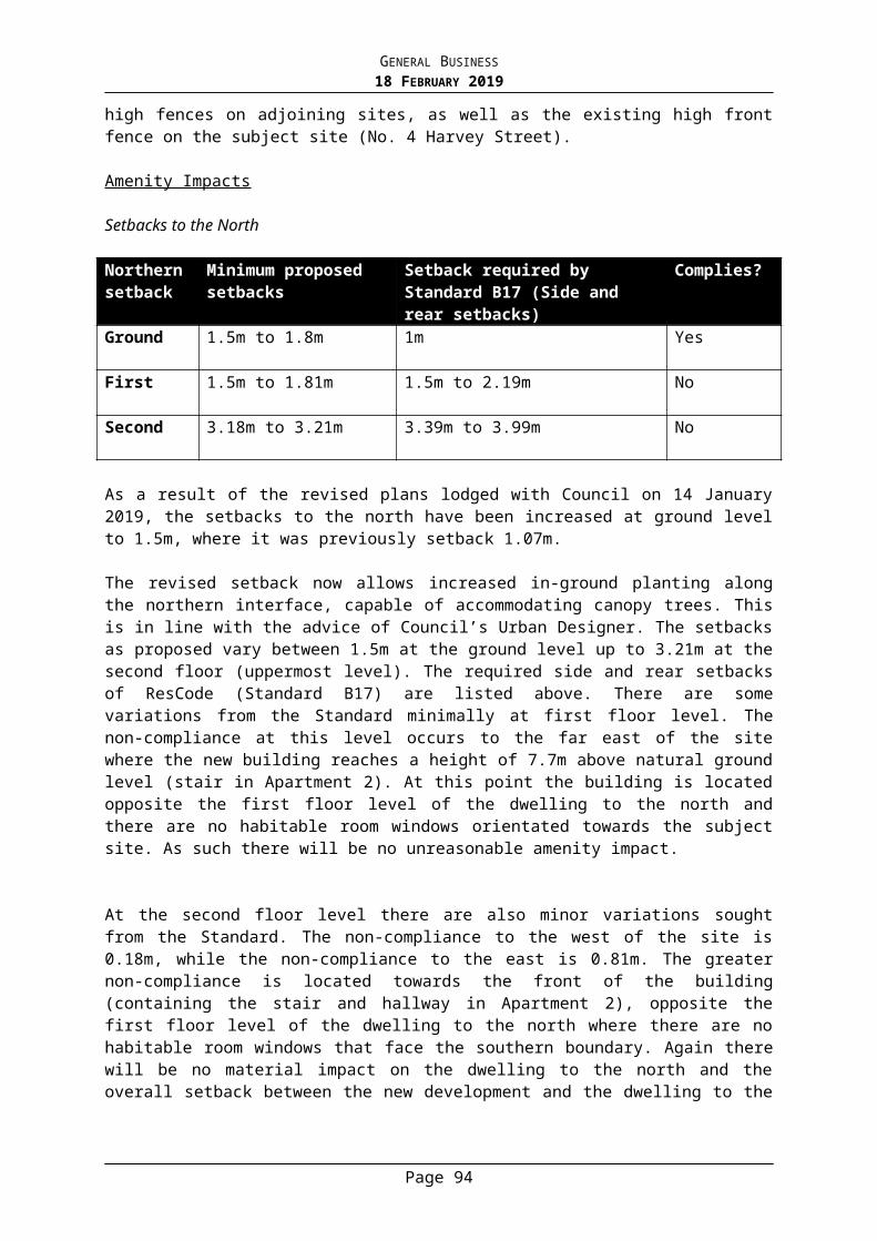
GENERAL BUSINESS18 FEBRUARY 2019
at 14 Wilmot Street, Malvern East be issued under the Stonnington Planning Scheme for demolition of the dwelling and construction of two new dwellings on a lot in a Neighbourhood Residential Zone and Neighbourhood Character Overlay subject to the following conditions:
1. Before the commencement of the development, including demolition, 1 copy of plans drawn to scale and fully dimensioned must be submitted to and approved by the Responsible Authority. The plans must be generally in accordance with amended plans prepared by DNB Design and advertised in November 2018, but modified to show:
a) Deletion or the central party wall projection to the front façade to the satisfaction of the Responsible Authority.
b) A materials and colours schedule in accordance with Condition 3.c) Fixed obscure glazing to a minimum height of 1.7 metres above finished
floor level provided to the northern side of the bay window to the first floor façade of Dwelling 1, in accordance with Clause 55.04-6 (Overlooking standard).
d) Pedestrian sight triangles on either side of the accessway to be fully dimensioned and annotated to state that that the corner splays will be at least 50 per cent clear of visual obstructions and landscaping must not exceed 900mm in height.
e) The width of basement access ramp to be fully dimensioned.f) A minimum headroom clearance of 2.2 metres above the access ramp
and within the basement.g) A minimum floor gradient of 1:200 (0.5%) within the basement.h) Garage doors within the basement, if proposed, dimensioned to be at
least 4.8 metres in width.i) An amended landscape plan in accordance with Condition 4.j) Notations to demonstrate compliance with the proposed ESD initiatives
as detailed in the Sustainable Design Assessment prepared by EcoResults, including all stormwater treatment measures in accordance with the STORM Rating Report.
2. The layout of the site and the size, levels, design and location of buildings and works shown on the endorsed plans must not be modified for any reason, without the prior written consent of the Responsible Authority.
3. Before the development starts, a schedule of construction materials, external finishes and colours to the satisfaction of the Responsible Authority must be submitted and approved. When approved, the schedule will be endorsed and will form part of the permit.
4. Before the development starts an amended landscape plan must be submitted to and approved by the Responsible Authority. When approved, the landscape plan will be endorsed and will then form part of the permit. The landscape plan must be drawn to scale with dimensions. The landscape plan must be generally in accordance with the plan advertised in November 2018, prepared by Marnie Lewis Design, but modified to show:
Page 94
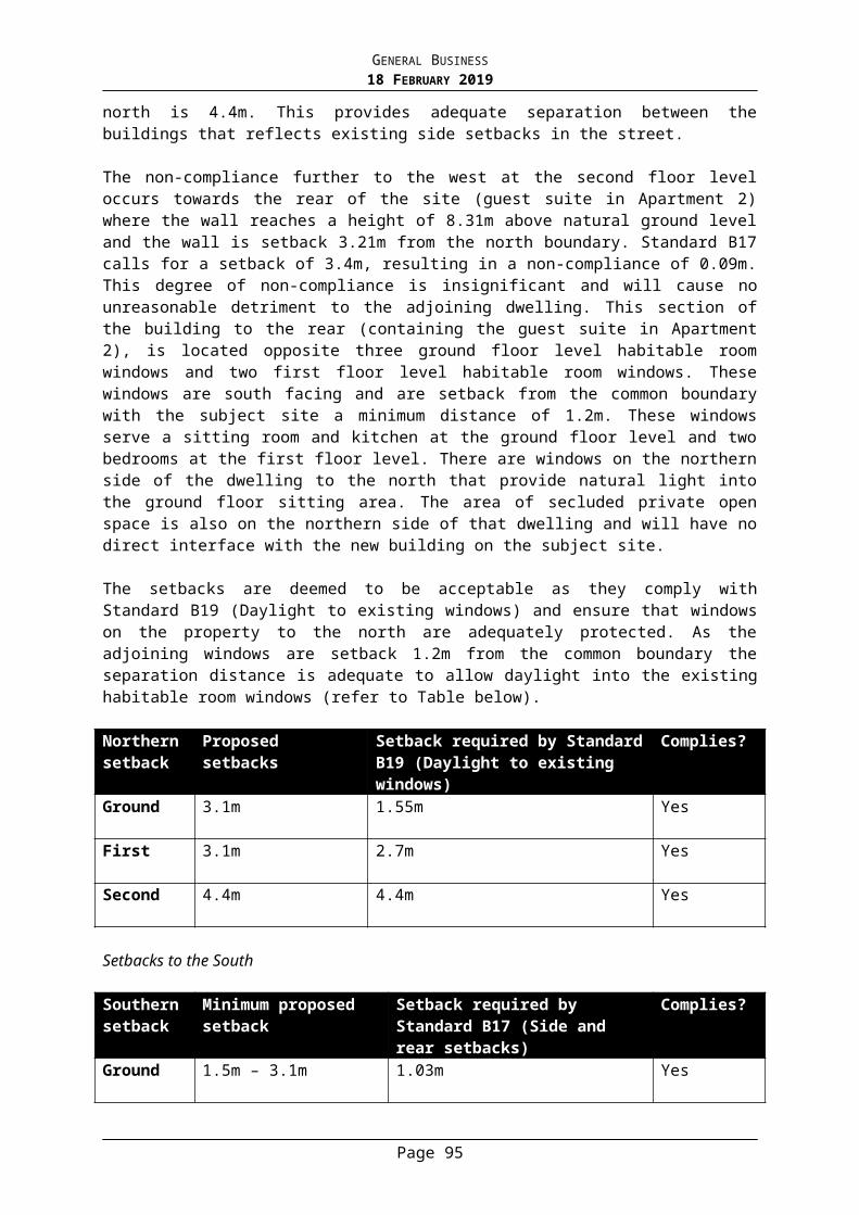
GENERAL BUSINESS18 FEBRUARY 2019
a) The Malus 'Sutyzam' (Sugar Thyme Crabapple) proposed along the eastern (rear) boundary to be replaced with a larger tree species to the satisfaction of the Responsible Authority.
5. Before the occupation of the development, the landscaping works as shown on the endorsed plans must be carried out and completed to the satisfaction of the Responsible Authority. Landscaping must then be maintained to the satisfaction of the Responsible Authority, including that any dead, diseased or damaged plants are to be replaced.
6. Prior to the occupation of the building, fixed privacy screens (not adhesive film or timber screens) designed to limit overlooking as required by Standard B22 of Clause 55.04-6 in accordance with the endorsed plans must be installed to the satisfaction of the Responsible Authority and maintained to the satisfaction of the Responsible Authority thereafter for the life of the building.
7. All plant and equipment (including air-conditioning units) shall be located or screened so as to minimise visibility from any of the surrounding footpaths and from overhead views and shall be baffled so as to minimise the emission of unreasonable noise to the environment in accordance with Section 48A of the Environment Protection Act 1970 to the satisfaction of the Responsible Authority.
8. All utility services to the subject land and buildings approved as part of this permit must be provided underground to the satisfaction of the Responsible Authority by completion of the development.
9. Any poles, service pits or other structures/features on the footpath required to be relocated to facilitate the development must be done so at the cost of the applicant and subject to the relevant authority’s consent.
10. Prior to the commencement of the development hereby approved, the permit holder must obtain approval from Council’s Building and Local Laws Department to construct or modify any vehicle crossovers providing access to the subject site. The issue of a planning permit does not provide approval for vehicular crossovers which are outside of the title boundary.
11. Prior to a building permit being issued, a report for the legal point of discharge must be obtained from Council and a drainage design for the development must be prepared by a suitably qualified Engineer in accordance with all ‘recommendations’ and requirements contained in that report. All drainage must be by means of a gravity based system with the exception of runoff from any basement ramp and agricultural drains which may be pumped. As required by the Building Regulations, the relevant building surveyor must check and approve the drainage design and ensure that protection of the building is provided from a 1 in 100 A.R.I. rainfall event.
12. The existing footpath levels must not be lowered or altered in any way at the property line (to facilitate the basement ramp).
13. The project must incorporate the Water Sensitive Urban Design initiatives detailed in the endorsed site plan and/or stormwater management report.
14. The applicant must at their cost provide a stormwater detention system to
Page 95
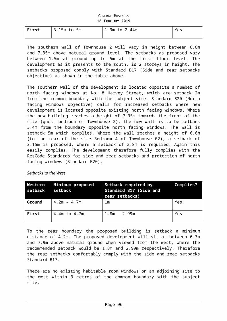
GENERAL BUSINESS18 FEBRUARY 2019
restrict runoff from the development to no greater than the existing runoff based on a 1 in 10 A.R.I. to the satisfaction of Council’s Infrastructure Unit. Alternatively, in lieu of the stand alone detention system, the owner may provide stormwater tanks that are in total 2,500 litres greater than those tanks required to satisfy WSUD requirements for the development. Those tanks must be connected to all toilets.
15. This permit will expire if one of the following circumstances applies:
a) The development is not started within two years of the date of this permit.b) The development is not completed within four years of the date of this
permit.
In accordance with Section 69 of the Planning and Environment Act 1987, a request may be submitted to the Responsible Authority within the prescribed timeframes for an extension of the periods referred to in this condition.
NOTES:
I. This permit does not constitute any authority to carry out any building works or occupy the building or part of the building unless all relevant building permits are obtained.
II. Nothing in this permit hereby issued shall be construed to allow the removal of, damage to or pruning of a significant tree (including the roots) without the further written approval of Council.
“Significant tree” means a tree:i. with a trunk circumference of 180 centimetres or greater measured at its base; orii. with a trunk circumference of 140 centimetres or greater measured at 1.5
metres above its base; oriii. listed on the Significant Tree Register.
Please contact the Council Arborists on 8290 1333 to ascertain if permission is required for tree removal or pruning or for further information and protection of trees during construction works.
III. Nothing in the permit hereby issued may be construed to allow the removal of, damage to or pruning of any street tree without the further written consent of the Stonnington City Council. Contact the Council Arborists on 8290 1333 for further information.
VI. At the permit issue date, Section 69 of the Planning and Environment Act 1987 stated that the Responsible Authority may extend the periods referred to if a request is made in writing within the following timeframes:
i. Before or within 6 months after the permit expiry date, where the development allowed by the permit has not yet started; and
ii. Within 12 months after the permit expiry date, where the development allowed by the permit has lawfully started before the permit expires.
Page 96
GENERAL BUSINESS18 FEBRUARY 2019
Page 97

GENERAL BUSINESS18 FEBRUARY 2019
6. PLANNING APPLICATION - 0803/18 - 349 WAVERLEY ROAD MALVERN EAST - USE OF LAND FOR A RESIDENTIAL BUILDING (ROOMING HOUSE) IN A GENERAL RESIDENTIAL ZONE
Manager Statutory Planning: Alexandra Kastaniotis General Manager Planning & Amenity: Stuart Draffin
PURPOSE
For Council to consider a planning application for use of land for a Residential Building (Rooming House) in a General Residential Zone at 349 Waverley Road, Malvern East.
Executive Summary
Applicant: Nick HaoWard: EastZone: General Residential Zone Schedule 7Overlay: NilNeighbourhood Precinct: Garden Suburban 4Date lodged: 1 August 2018Statutory days: 128Trigger for referral to Council: Greater than seven objectionsNumber of objections: Ten objections from nine propertiesConsultative Meeting: Yes held on 6 December 2018Officer Recommendation: Notice of Decision to Grant a Planning Permit
BACKGROUND
The Proposal
The plans that form part of the basis of Council's consideration were prepared by Shaw 4 Design and are known as Drawing No.s: TP01 & TP02 Council date stamped 19 October 2018, TP03-TP06 Council date stamped 13 September 2018 and TP07 Council date stamped 19 September 2018.
Key features of the proposal are:
Construction of two internal walls (buildings and works exempt from permit requirement pursuant to Clause 62 of the Planning Scheme), to create two additional bedrooms within an existing Rooming House. As the total number of bedrooms exceeds nine (total ten proposed), the use of the land for a Rooming House now requires a planning permit.
The proposed two new bedrooms have been created by dividing two existing bedrooms in half. Each of the four rooms have individual access from within the existing building.
The existing Rooming House has eight bedrooms. This application proposes two additional bedrooms, to increase the total number of bedrooms to ten.
The existing number of persons accommodated on site is ten, this is not proposed to increase.
No external buildings and works are proposed.
Site and Surrounds
Page 99
GENERAL BUSINESS18 FEBRUARY 2019
The site is located to the north-west of the intersection of Waverley Road and Lewes Drive in Malvern East. The site has the following significant characteristics:
The land has a frontage to Waverley Road (Category 1 Road Zone) of 17.7 metres and a frontage to Lewes Drive of 44.5 metres, yielding a total site area of approximately 787 square metres.
The existing building located on the land is described as a double storey, rendered brick dwelling with a pitched, tiled roof.
The front setback to Waverley Road comprises an open, landscaped yard, with the building setback 9.0 metres from the title boundary. A projecting bay window is positioned on the façade wall of the dwelling to Waverley Road.
The secondary frontage to Lewes Drive includes a setback from the dwelling to the title boundary of between 3.4-5.2 metres, with an entry porch projecting into the setback. The setback comprises further landscaped, open areas.
Secluded private open space in the order of 197 square metres is provided to the north and west of the existing building.
Vehicle access to the site is gained via an existing single width crossover to Lewes Drive, providing access to a double car carport, positioned to the north-west boundaries of the site.
Bicycle parking for a total of ten bicycles is provided to the south of the carport, abutting the western title boundary.
The site and existing building is currently used as a Rooming House with eight bedrooms and currently accommodates ten people on site.
Previous Planning Application(s)
A search of Council records indicates no previous planning history registered to the site.
The Title
The site is described on Certificate of Title 05563 Folio 563, as Lot 1 on Title Plan 684589C contains Covenant 1520598, described as follows:
‘…will not any anytime hereafter excavate, carry away or remove or permit to be excavated, carried away or removed any sand, clay, earth from the said land except for the purpose of excavating for the foundations of any building to be erected thereon and further, shall not erect more than one dwelling house upon the said land’
The proposal does not seek to undertake excavation works to remove the above-listed materials/resources from the site and does not seek to construct more than one dwelling on the land. As such, the proposal is not in breach of the listed covenant.
Planning Controls
The following controls/permit triggers are considerations for this application:
ZoneClause 32.08 - General Residential Zone Schedule 7Pursuant to Clause 32.08-02 a permit is required to use the land for the purpose of a Rooming House, which does not meet all the requirements of Clause 52.23-2 (Rooming House).
Particular ProvisionsClause 52.23 – Rooming House
Page 100
GENERAL BUSINESS18 FEBRUARY 2019
Pursuant to Clause 52.23-2 a permit is required as the proposal seeks to increase the total number of bedrooms from eight (8) to ten (10). The provisions of Clause 52.23 require a planning permit to use a site for the purpose of a Rooming House when the number of bedrooms exceeds nine (9).
Clause 52.06 – Car ParkingPursuant to Clause 52.06, the use of the land as a Rooming House attracts a car parking rate of one space, for every four bedrooms. As ten bedrooms are proposed, two car spaces are required. A total of two on-site car parking spaces are currently provided in the form of a carport and are proposed to be retained, therefore the provisions of Clause 52.06 are satisfactorily met.
Clause 52.32 – Bicycle FacilitiesIt is noted that the provisions of Clause 52.34 (Bicycle Facilities) do not provide an applicable rate for use of the land as a Rooming House. Notwithstanding this, ten spaces are provided on site.
Clause 62.02 – Buildings and works not requiring a permit unless specifically required by the Planning Scheme. Pursuant to Clause 62.02, the construction of internal walls within the existing building does not require a planning permit.
Relevant Planning Policies
Clause 11 SettlementClause 15 Built Environment and HeritageClause 16.01 Integrated HousingClause 16.01-3 Housing DiversityClause 21 Municipal strategic StatementClause 32.08 General Residential ZoneClause 52.23 Rooming HouseClause 65 Decision Guidelines
Advertising
The application has been advertised pursuant to Section 52 of the Planning and Environment Act 1987 by sending notices to the owners and occupiers of adjoining land and by placing signs on the site. The public notification of the application has been completed satisfactorily.
The site is located in East Ward and ten objections from nine different properties have been received, summarised as follows:
There is inadequate car parking in the street (Lewes Drive) and the proposal will exacerbate existing problems/Increased traffic and noise, blocking of driveways etc.
Overlooking and impact on privacy. Council should not be allowed to permit such intensification of the use, the building
cannot easily accommodate the number of occupants proposed and will create overcrowding.
Night-time noise and disturbance from residents, visitors etc. Increasing the number of bedrooms of the existing use will exacerbate the problems
already experienced. The property and its gardens have been neglected and run down over the last few
years, rubbish is left out etc. There is enough student housing in the area. There is no information that the building complies with fire and safety standards. No ResCode assessment has been submitted.
Page 101
GENERAL BUSINESS18 FEBRUARY 2019
The applicant is seeking to maximise commercial gain from the property. The title has a single dwelling covenant
A Consultative Meeting was held on 6 December 2018. The meeting was attended by Councillor Davis, representatives of the applicant, objectors and a Council planning officer. The meeting did not result in any changes to the proposal. A detailed response to each of the above grounds of objection is provided in the body of this report.
Referrals
Whilst it is noted that compliance with Clause 52.06 (Car Parking) of the Stonnington Planning Scheme has been achieved, the application was referred to Council’s Transport for comment due to concerns raised in objections. Comments received are summarised as follows:
Based on the requirements of the Planning Scheme, the proposal would generate a provision for two parking spaces. Two parking spaces are already provided on site and are proposed to remain which would meet this requirement.
Although the number of bedrooms is increasing, the number of persons on-site is to remain the same. As such, it would be difficult to argue against the existing conditions of the site and its parking generation as the number of residents is not proposed to change.
The above comments are noted.
KEY ISSUES
The proposal poses the following questions which are relevant to the assessment of the Rooming House:
What is the existing use of the land/building? Is the proposed internal amenity of the altered bedrooms acceptable? Will the proposal result in any unreasonable off-site amenity impacts? Does the proposal provide adequate car and bicycle parking facilities?
Each of the above key questions are considered in turn below, with reference to relevant planning policy where applicable.
What is the existing use of the land/building?
The existing building on the land is used as a Rooming House, with a total of eight bedrooms provided. Pursuant to Clause 32.08 (General Residential Zone), a permit is required to use land for the purpose of a Rooming House, if it does not meet all the requirements of Clause 52.23 (Rooming House).
The triggers for the requirement of a planning permit in accordance with Clause 52.23 (Rooming House) of the Stonnington Planning Scheme are:
Any requirement in the General Residential Zone to obtain a permit to use the land for a rooming house does not apply if all of the following relevant requirements are met:
The total floor area of all buildings on the land does not exceed 300 square metres, excluding outbuildings.
Page 102
GENERAL BUSINESS18 FEBRUARY 2019
No more than 12 persons are accommodated No more than 9 bedrooms are provided.
In accordance with the above, the use of the land as a Rooming House as it exists on the land does not require a permit, as it provides a maximum of eight bedrooms and has capacity to accommodate a maximum of ten people. In addition, the total floor area of the building does not exceed 300 square metres (approximately 243 square metres).
It is important to highlight that the existing conditions on site provide accommodation for ten people, within eight rooms. The proposal seeks to divide two rooms into two, with no provision for additional people to be accommodated.
It is noted that the provisions of Neighbourhood Character (which relate to built form) do not apply as the proposed works are internal and are exempt from requiring a planning permit pursuant to Clause 62.02.
As noted above, the proposal seeks to formally divide two of the existing bedrooms, each of which currently accommodate two people. As such, the proposal does not seek to increase the intensity of the existing use and a permit is only required due to the number of bedrooms proposed. On this basis, it is considered that the increase in the number of bedrooms provided will not result in an increase in the intensity of the use from what is currently in existence.
Is the proposed internal amenity of the altered bedrooms acceptable?
The proposal seeks to divide existing bedrooms 1 and 2 as identified on the existing conditions plan. These rooms are both currently larger rooms, with two people in each. The proposed divided rooms will comprise the following dimensions:
(Previously Bedroom 1)Proposed Bedrooms 1 and 2 – 2.4 x 4.3 metres = 10.3 square metres
(Previously Bedroom 2)Proposed Bedrooms 6 and 7 – 2.2 x 4.8 metres = 10.5 square metres
It is noted that there are no specific requirements regarding internal amenity included in the Scheme or the Residential Tenancies Act 1997, which are applicable to a Rooming House. However, it is considered that the nature of the use is to provide basic but comfortable temporary accommodation.
Notwithstanding the above, each of the proposed new bedrooms are provided with individual access from within the main internal hallway of the building. In addition, each of the divided rooms are provided with an external window clear to the sky, which allows each room to gain appropriate solar access.
The proposed room sizes are capable of accommodating a single bed (standard dimensions approximately 0.9 x 1.8 metres), with additional space for storage.
The subject site also provides an area of secluded private open space to the north and west of the dwelling, with an area of 197 square metres. This area enhances the on-site amenity of the occupants of the Rooming House. It is further noted that the existing building includes a generously sized, open plan kitchen/communal area for the use of all dwelling occupants.
Page 103
GENERAL BUSINESS18 FEBRUARY 2019
Whilst not considered during the Planning process, it is noted that the Building Regulations include provisions regarding internal amenity, which will be applicable to the proposed works to the subject site. The Regulations require the following:
Minimum natural light (window area) for each bedroom must be not less than 10% of the bedroom floor area.
Proposed Bedrooms 1 and 2 each have an area of 10.3sqm, with a window area to each room of 1.5sqm, which is greater than the required 10%. Proposed Bedrooms 6 and 7 each have an area of 10.5sqm, with a window area to each room of 175sqm, which is greater than the required 10%.
On the basis of the above, it is considered that the proposed on-site and internal amenity is acceptable.
Will the proposal result in any unreasonable off-site amenity impacts?
As previously discussed, the proposal seeks to create two additional rooms by dividing two larger rooms, with no change to the total number of people to be accommodated (currently ten). The proposed works are internal and will not be visible from the exterior of the building.
When considering adjoining sensitive interfaces, the subject site shares a boundary with 347 Waverley Road (west) and 1 Lewes Drive (north). Each of these properties is used and developed for residential purposes.
As the proposal seeks to alter internal conditions (works exempt from Planning requirements) and does not seek to intensify the use on site via increased occupants, the additional off-site amenity impacts are considered acceptable.
It is noted that objections raised concerns with regard to the unsightly nature of the exterior/gardens of the building. In accordance with Council’s Local Law 150, an unsightly premises is defined as follows:
Unsightly Premises
(1) For the purpose of this section the word ‘land’ includes any nature strip.
(2) The owner and occupier of land must not cause or allow the land to be kept in a condition that is unsightly or detrimental to the amenity of the area.
(3) The owner and occupier of land must ensure that:(a) all necessary steps are taken to prevent Fire on that land and minimise the
possibility of the spread of Fire from that land; and (b) the land is kept free of undergrowth, scrub bracken, ferns, weeds, stubble
or grass (whether alive or dead exceeding 30 cm in height and whether standing or not standing) and any other material or substance likely to assist in the spread of Fire.
(4) Without affecting the operation of Clause 11, where Council is of the opinion that any land contains:(a) unconstrained rubbish; (b) an excavation that is not part of current works; (c) waste material; or(d) any material or substance on premises that constitutes or is likely to
constitute a Fire hazard,
Page 104
GENERAL BUSINESS18 FEBRUARY 2019
the Council may serve a Notice to Comply on the owner and occupier of the land for the cleaning up, screening, removal or disposal of any material or substance on that land.
An Officer of Council’s Local Laws department inspected the site in February 2019 following receipt of the complaint and reported that the exterior of the building and its yard/gardens are not unsightly (in accordance with the above definition), with no action required to be undertaken.
Does the proposal provide adequate car and bicycle parking facilities?
Clause 52.06 (Car Parking) of the Stonnington Planning Scheme provides that for use of the land as a Rooming House, 1 space should be provided to every 4 bedrooms to the building. The proposal seeks a total of 10 bedrooms, therefore the applicable on-site car parking rate is 2.5 spaces. It is noted that Clause 52.06 (Car Parking) of the Stonnington Planning Scheme states that ‘if in calculating the number of car parking spaces the result is not a whole number, the required number of car parking spaces is to be rounded down to the nearest whole number.’ As such, the applicable car parking rate is 2 spaces.
The existing land use includes the provision of 2 car parking spaces in the form of a double car carport, in the north-west corner of the site, accessed from Lewes Drive. Information submitted with the application clarifies that the on-site car spaces are provided on a ‘first come, first served’ basis for any/all of the occupants of the Rooming House.
Based on the above, no car parking dispensation is required. Council’s Transport and Parking department have reviewed the application has have raised no concerns with parking provision or traffic generation.
It is noted that within 100 metres of the subject site in both east and west directions along Waverley Road, no parking restrictions apply with the exception of ‘no standing’ signs positioned within 9.0 metres of the intersection of Waverley Road and Lewes Drive, Albert Street, Chaucer Avenue and Serrell Street. It is noted that these restrictions are in place to avoid traffic conflicts when entering/existing streets intersecting with Waverley Road.
Furthermore, Lewes Drive is free from restricted parking, with the exception of the northern end of Lewes Drive which is a ‘no through road’ with a cul de sac containing a roundabout and ‘no standing’ signs which maintain clearance of the roundabout. Appendix B to this report contains an image depiction of the above parking provisions.
A Rooming House does not trigger the requirement for bicycle parking, pursuant to Clause 52.34 (Bicycle Facilities) of the Stonnington Planning Scheme. Nonetheless, the existing conditions on site include the provision of ten bicycle spaces, to the south of the car port. This is considered to be a positive outcome, as the nature of the use requires minimal on-site car parking provision and the provision of bicycle parking encourages this mode of transportation.
As such, it is considered that the proposal provides adequate on-site parking provision of cars and bicycles.
Objections
In response to the grounds of objection not already discussed in the report, the following comments are made:
Page 105
GENERAL BUSINESS18 FEBRUARY 2019
There is inadequate car parking in the street (Lewes Drive) and the proposal will exacerbate existing problems. Increased traffic and noise, blocking of driveways etc. As noted in the above assessment against Clause 52.06 (Car Parking) the proposal
for a Rooming House comprising ten bedrooms requires the provision of two car parking spaces on site. As the proposal seeks to provide a total of two car spaces in the form of the existing car port, the relevant Planning Scheme requirement has been satisfied. Should illegal parking be witnessed at any time, Councils’ Transport and Parking team can be contacted to address the matter.
Overlooking and impact on privacy.
The proposal does not seek to construct any new windows, with all works being confined within the building and exempt from planning provisions.
Council should not be allowed to permit such intensification of the use, the building cannot easily accommodate the number of occupants proposed and will create overcrowding. Increasing the number of bedrooms of the existing use will exacerbate the problems already experienced.
As discussed within the Proposal section of this report, the current proposal does not seek to introduce additional capacity within the existing Rooming House. The application proposes to divide two existing larger bedrooms, into four single bedrooms. As such, the intensity of the use will remain the same as what currently exists on site, with the technical trigger being the number of bedrooms, not the number of occupants.
Night-time noise and disturbance from residents, visitors etc. The property and its gardens have been neglected and run down over the last few years, rubbish is left out etc.
There are mechanisms provided by Council’s Local Laws, which allow for the management of noise and unsightly gardens. Should an issue regarding unkempt and unsafe gardens remain/arise, Council’s Local Laws Department can be contacted for action where appropriate. As previously noted, Council’s Local Laws department have inspected the property and have indicated that the grounds are not in an unsightly condition.
With regard to the storage of waste facilities, a permit condition will be included, to require that waste bins be kept in the designated storage area at all times, with the exception of collection day.
There is enough student housing in the area.
Council policy does not provide a threshold which governs the maximum provision of student housing for an area, or the wider municipality, with each application assessed on its individual merits. The subject site is within close proximity (approximately 1.6 kilometres) from the Caulfield Monash University campus, which results in an on-going demand for conveniently located student accommodation. Irrespective of this, the application is for a Rooming House, not Student Accommodation. The
Page 106
GENERAL BUSINESS18 FEBRUARY 2019
Stonnington Planning Scheme defines use of the land as a Rooming House as follows:
“Land used for a rooming house as defined in the Residential Tenancies Act 1997”
Section 3 (1) of the Residential Tenancies Act 1997 provides the following definition of a Rooming House:
‘”Rooming house’ means a building in which there is one or more rooms available for occupancy on payment of rent – in which the total number of people who may occupy those rooms in not less than four”
Council’s Local Policy at Clause 22.08 (Student Housing Policy) provides the following definition for Student Housing:
Student housing is the use or development of land for: - Accommodation, whether it be dormitory, hostel or apartment, that is purpose
built to accommodate bona fide students while studying at tertiary institutions; or - Accommodation that is modified or converted (for ten or more habitable rooms) to
accommodate bona fide students while studying at tertiary institutions. This would include accommodation that was used in the past as a dwelling.
It is acknowledged that whilst students may occupy some/all of the available rooms at any one time, the use of the building on the subject site is not expressly limited to students and is not a purpose built facility in accordance with the above. Therefore, the use of the land is classified as a Rooming House, not Student Accommodation.
There is no information that the building complies with fire and safety standards.
It is noted that fire rating and safety standards are applicable to the Building Regulations and do not form a relevant part of the Statutory Planning Assessment.
Council’s Building department have confirmed that the following regulations will apply to the Rooming House at it currently exists and how it is proposed to be modified:
Smoke Alarms (BCA 3.7.2.4)Smoke alarms must be installed on or near the ceiling:-
1) In each bedroom;2) In every corridor or hallway associated with each bedroom or where there is
no corridor or hallway, between the bedrooms and the rest of the building; and
3) On each storey of the building.
Lighting to Assist Evacuation (BCA 3.7.2.5)A system of lighting must be installed to assist in the evacuation of occupants in the event of a fire and be activated by the smoke alarm and consist of:-
1) A light incorporated within the smoke alarm; or2) The lighting located in the corridor, hallway or area served by the smoke alarm.
Page 107
GENERAL BUSINESS18 FEBRUARY 2019
As such, the relevant considerations to fire and safety as they apply under the relevant Regulations, will be made at the Building approval stage.
No ResCode assessment has been submitted.
The subject site exceeds 500 square metres in site area, therefore the provisions of Clause 54 (One Dwelling on a Lot) are not applicable. Furthermore, the application does not seek to construct two or more dwellings on the lot, therefore the provisions of Clause 55 (Two or More Dwellings on a Lot) are not applicable. On this basis, an assessment of the proposal against the provisions of ResCode is not relevant.
The applicant is seeking to maximise commercial gain from the property.
This is not a relevant Planning consideration.The title has a single dwelling covenant
The proposed use does not seek to construct more than one dwelling on the land, in accordance with the requirements of Covenant 1520598 registered on title. The Stonnington Planning Scheme defines a ‘dwelling’ as follows:
A building used as a self-contained residence which must include:- A kitchen sink- Food preparation facilities- A bath or shower- A closet pan and wash basinIt includes out-buildings and works normal to a dwelling.
Based on the above, it is considered that the covenant is not being breached.
Human Rights Consideration
This application has been assessed in accordance with the requirements of the Planning and Environment Act 1987 (including the Stonnington Planning Scheme), reviewed by the State Government and which complies with the Charter of Human Rights and Responsibilities Act 2006.
CONCLUSION
Having assessed the application against the relevant planning controls, it is recommended that the proposal be supported for the following reasons:
The proposal does not result in an intensification of the use, as the number of occupants is to remain the same.
No unreasonable off-site amenity impacts will be imposed as a direct result of conversion of two larger bedrooms, to four single bedrooms.
The proposal demonstrates adequate on-site internal amenity. The number of occupants is less than the triggered permit requirement prescribed by
Clause 52.23 (Rooming House) of the Stonnington Planning Scheme (ten proposed, twelve being the permit trigger).
The number of on-site car parking spaces achieved compliance with Clause 52.06 (Car Parking) of the Stonnington Planning Scheme.
ATTACHMENTS
1. PA - 803/18 - 349 Waverley Road Malvern East - Attachment 1 of 1 Plans
Page 108
GENERAL BUSINESS18 FEBRUARY 2019
RECOMMENDATION
That Notice of Decision to Grant Planning Permit No: 803/18 for the land located at 349 Waverley Road Malvern East be issued under the Stonnington Planning Scheme for use of the land for a Residential Building (Rooming House) in a General Residential Zone subject to the following conditions:
1. The plans endorsed to accompany the permit must not be amended without the written consent of the Responsible Authority.
2. A maximum number of ten (10) persons may be housed on the premises at any one time to the satisfaction of the Responsible Authority.
3. A maximum number of ten (10) bedrooms may be provided within the Rooming House at any one time to the satisfaction of the Responsible Authority.
4. All waste bins are to be stored in the designated storage area at all times, with the exception of waste collection day to the satisfaction of the Responsible Authority.
5. No fewer than two (2) car spaces must be provided on the land associated with the Rooming House to the satisfaction of the Responsible Authority.
6. This permit will expire if one of the following circumstances applies:
a) The use is not started within two years from the date of this permit.b) The use is discontinued for a period of two years or more.
In accordance with Section 69 of the Planning and Environment Act 1987, the Responsible Authority may extend the periods referred to if a request is made in writing within the prescribed timeframes, where the use allowed by the permit has not yet started.
NOTES:
This permit does not constitute any authority to carry out any building works or occupy the building or part of the building unless all relevant building permits are obtained.
At the permit issue date, Section 69 of the Planning and Environment Act 1987 stated that the Responsible Authority may extend the periods referred to if a request is made in writing within the following timeframes:
Page 109
GENERAL BUSINESS18 FEBRUARY 2019
i. Before or within 6 months after the permit expiry date, where the development allowed by the permit has not yet started; and
ii. Within 12 months after the permit expiry date, where the development allowed by the permit has lawfully started before the permit expires.
Page 110
GENERAL BUSINESS18 FEBRUARY 2019
7. PLANNING APPLICATION - 0573/18 - 6-10A CHAPEL STREET WINDSOR - ERECT AND DISPLAY AN ELECTRONIC MAJOR PROMOTION SIGN IN AN ACTIVITY CENTRE ZONE
Manager Statutory Planning: Alexandra Kastaniotis General Manager Planning & Amenity: Stuart Draffin
PURPOSEFor Council to consider a planning application to erect and display an electronic major promotion sign in an Activity Centre Zone at 6-10A Chapel Street, Windsor.
Executive Summary
Applicant: Twenty Four Outdoor Australia Pty Ltd c/- Jewell Partnership Pty Ltd
Ward: SouthZone: Activity Centre Zone-Schedule 1Overlay: Incorporated Plan Overlay-Schedule 3Neighbourhood Precinct:
Chapel Street - Windsor (WV-7)
Date lodged: 05 June 2018Statutory days: (as at council meeting date)
251
Trigger for referral to Council:
More than seven (7) objections
Number of objections: Eight (8)Consultative Meeting: Yes – held on 5 December 2018Officer Recommendation:
Issue a Notice of Decision to Grant a Planning Permit
BACKGROUND
The Proposal
The plans that form part of the basis of Council's consideration were prepared by Outdoor Elements and are known as Drawing No’s: 01 and 02 and Council date stamped 5 June 2018.
A Lighting Impact Assessment prepared by Electrolight Australia dated 1 June 2018 and Traffic Engineering Assessment prepared by TraffixGroup dated 18 May 2018 have also been submitted as part of the proposal.
Key features of the proposal are:
● The ‘host’ site contains a three storey commercial building on the north east corner of Chapel Street and Dandenong Road. It is proposed to erect and display a major promotion sign on the eastern facade of the building.
● The base of the sign will be a maximum of 10.35m above ground level.
● The sign will have a maximum height of 4 metres (and sit 2m above the building parapet) and the sign will have a depth of 1.1 metres.
Page 111
GENERAL BUSINESS18 FEBRUARY 2019
● The sign is offset 1m from the southern edge of the building.
● The bottom edge of the sign will sit at the same level as the top of the windows along the east facade. The sign will not cover these windows.
● The main LED display will be 12m x 4m (display area 48 square metres). There will be four smaller LED panels leading from the right (north) which seek to play on the main screen. Each of the panels has a 1m width.
● The two southern panels will have a height of 4m, the third panel will have a height of 3m and the northern panel will have a height of 2m. The panels collectively have an area of 13 square metres.
● The total display area is 61 square metres.
● The top, bottom, sides and rear of the sign will be perforated metal.
● The proposed digital screen is to operate 24 hours a day with an instantaneous change between each advertisement of a 30 second (dwell time) at varying luminance levels for the electronic advertisements displayed. The application does not propose any animated images (i.e. moving images).
● There are no changes required to the building fabric to install the sign.
Proposed sign looking north-west from Dandenong Road
Site and Surrounds
The subject land is located adjacent the north-east corner of the intersection of Chapel Street and Dandenong Road in Windsor. The site is irregular in shape with a 20m frontage to Chapel Street and a southern boundary of 26m resulting in an overall site area of approximately 585 square metres. Dandenong Road is designated a Category 1 Road.
The subject land is developed with a three storey commercial building which is 11.9 metres above ground level. The building is built to the side boundaries and incorporates a number of both medical and office uses. The building has its primary orientation to the west (Chapel
Page 112
GENERAL BUSINESS18 FEBRUARY 2019
Street) and south (Dandenong Road). There is a row of five small windows along the eastern façade at the upper most level.
The building has a range of advertising signage on the western and southern facades.
Of note is the extensive telecommunications equipment installed on the roof. The Telstra exchange building which is in alignment with the host building, provides a ‘backdrop’.
Strong built form character occurs along Chapel Street. Chapel Street has a finer grain building topology whereas Dandenong Road has a large road reserve which isolates the respective corners of the intersection.
Features of adjoining land and properties nearby are as follows:
North
Directly abutting the subject site to the north is an optometrist located within a one-storey retail building. One and two storey retail stores extend northward along Chapel Street past the Railway line. Approximately 70m north-east is residential land.
South
To the south lies Dandenong Road which comprises of eight lanes of traffic and a median strip containing tram tracks. Dandenong Road is a major arterial road designated as a Category 1 Road. On the south side of Dandenong Road is parkland including Alma Park and the Red Stitch Theatre.
East
To the east is single storey Shell service station. Further to the east is a sunken railway cutting which lies adjacent to Presentation College. Further east are residential dwellings, approximately 100 metres from the subject site.
West
To the west side of Chapel Street is a mix of single and two storey retail stores and commercial buildings affected by a Heritage Overlay. A number of these buildings display internally illuminated business identification signage. Diagonally to the south west is the Astor Theatre.
Previous Planning Application
The site has previously been the subject of a planning application for a major promotion sign (Application No. reference 215/05). Council refused the application on 17 June 2005 based on the following refusal grounds:
1. The size and location of the promotional sky sign is inappropriate in this location and would be inconsistent with the orderly and proper planning of the area, contributing to visual clutter.
2. A sign of the size and height proposed would be detrimental to the existing character and amenity of the area.
Page 113
GENERAL BUSINESS18 FEBRUARY 2019
3. The proposed development is contrary to the objectives of Councils Municipal StrategicStatement and Local Planning Policy Framework and in particular Clauses 21.05 and 22.03 and of the Stonnington Planning Scheme.
4. The proposed sign is inconsistent with the decision guidelines under Clause 52.05-5 (Major Promotion Sing) of the Stonnington Planning Scheme, on the basis that the siting and scale of the sign will form an excessively dominant element in the streetscape and surrounds.
The sign had the following features:
● Construction of a major promotion sky sign which measured 18.99m x 4.5m (total display area 86m2);
● The base of the sign was 9.6m above ground level;
● The sign had maximum height of 4.5 metres with a 4 metre ‘skirt’ which ran underneath the full length of the sign;
● The sign had an overall height of 8.5 metres above the roof of the building.
● The sign was orientated towards the south east (i.e. diagonally across the roof); and
● The sign was to be illuminated by six protruding floodlights.
Page 114
GENERAL BUSINESS18 FEBRUARY 2019
Plans considered under application No.215/05
The Delegates report in assessing the application commented:
‘ ….it is considered that the sign will adversely affect the southern gateway entrance to the municipality. The structure will be a dominant visual element in the streetscape and gateway into the Windsor Heritage precinct. With regard its location, it is acknowledged that these signs are encouraged in commercial areas. However, the proposed sign will not enhance the character of the area by virtue of it forming a dominant visual element erected on a roof of an existing building within an area that is largely not characterised by advertising signage.’
This application went before VCAT in the matter Adspace Pty Ltd v Stonnington City Council [2005] VCAT 2034 (’Adspace’). VCAT affirmed the decision of Council, and accordingly directed that no permit to issue.
The Tribunal made the following relevant observations and set out changes that if adopted may make a future application appropriate:
• In the present case, the proposed sign is more than half the height of the host building. The host building is a substantial building in its immediate context, I do not think one can reasonably conclude that the proposed sign will not dominate the streetscape or the host building in its immediate environs.
• This is not to say that I am of the view that there cannot be new promotional signs at this intersection. For example, if it wasn’t for the fact that the eastern wall of the host building contained some windows, an east facing promotional sign on this wall located within the mass of the building and setback from the external edges of the building, would quite possibly be an acceptable addition to the streetscape of the locality.
The implications of the previous decision made by the Tribunal will be discussed further in the assessment of the proposal.
The Title
The site is described on Certificate of Title Volume 10161 Folio 412 and no covenants or easements affect the land.
Planning Controls
The following controls/permit triggers are considerations for this application:
Zone
Activity Centre Zone Schedule 1
Pursuant to Clause 37.08-10, advertising sign requirements are at Clause 52.05. Pursuant to Schedule 1 of the Activity Centre Zone, land designated for Main Streets Use is in Category 1. It is noted that the site is located on land designated for Main Streets Use located within WV-7, pursuant to the Precinct Map at 5.2-1 of Schedule 1.
Overlay
Incorporated Plan Overlay - Schedule 3 (IPO3)
Page 115
GENERAL BUSINESS18 FEBRUARY 2019
This Overlay relates to ‘Late Night Liquor Licence Trading in the Chapel Street precinct: Measuring the Saturation Levels’. The IPO3 has no specific measures relating to signage and there is no permit trigger under this control relating to signage.
Particular Provisions
Advertising signs
Pursuant to Clause 52.05-7, a permit is required for any sign not specified in Section 1 of Clause 52.05-7. An electronic promotion sign is not specified in Section 1 and therefore a permit is required pursuant to Clause 52.05-7.
A permit for a major promotion sign must include conditions that specify:
That the sign must not:
● Dazzle or distract drivers due to its colouring.
● Be able to be mistaken for a traffic signal because it has, for example, red circles, octagons, crosses or triangles.
● Be able to be mistaken as an instruction to drivers.
● An expiry date which is 15 years from the date the permit is issued unless otherwise specified in this clause. This does not apply to a permit for major promotion sign for a special event or temporary building shrouding.
Alternative expiry date condition
Pursuant to Clause 52.05-4 a permit for a sign other than a major promotion sign expires on the date specified in the permit. If no date is specified, the expiry date is 15 years from the date of issue of the permit. Pursuant to Clause 52.05-9 a permit for a major promotion sign may specify an expiry date other than 15 years, but the date must not be less than 10 years or more than 25 years from the date the permit is issued. Decision guidelines are found at Clause 52.05-8.
Relevant Planning Policies
Clause 11-03-01S Activity Centres Clause 15 Built Environment and Heritage Clause 17 Economic Development Clause 21 Municipal Strategic Statement Clause 21.04 Economic Development Clause 21.06 Built Environment and Heritage Clause 22.03 Advertising Policy Clause 37.08 Activity Centre Zone Clause 52.05 Signs Clause 65 Decision Guidelines
Advertising
The application has been advertised pursuant to Section 52 of the Planning and Environment Act 1987 by sending notices to the owners and occupiers of adjoining land (and by placing one sign along the Chapel Street frontage and one sign along the southern frontage of the building facing Dandenong Road). The public notification of the application has been completed satisfactorily.
Page 116
GENERAL BUSINESS18 FEBRUARY 2019
The site is located in South Ward and objections from eight (8) different properties have been received and they can be summarised as follows:
Brightness of screen/influence on natural light Electrical emission/radiation effects Potential for adverse signage to be displayed Sign will devalue the branding of the medical centre Road safety Loss of ventilation and natural lighting to both level 1 and level 2 of the host building
(medical centre) Impact views from Alma Park Flashing lights
A Consultative Meeting was held on 5 December 2018. The meeting was attended by Councillor Sehr, representatives of the applicant, objectors and a Council planning officer. The meeting did not result in any changes to the plans.
Referrals
Pursuant to Clause 52.05-3 an application to display an animated or electronic sign within 60 metres of a freeway or arterial road declared under the Road Management Act 2004 must be referred in accordance with Section 55 of the Planning and Environment Act 1987 to the referral authority specified in Clause 66.03 or a schedule to that clause:
The application was referred to VicRoads who responded as follows:
● The location of the proposed electronic sign will present to 33,000 westbound vehicles daily on the approach to the signalised intersection of Chapel Street, and a pedestrian and cycling priority road. It is reasonable that the display of electronic signage duly considers all forms of pedestrian and road user safety. VicRoads considers that electronic signage displaying static content can be accommodated in this location with appropriate conditions.
● Accordingly, if Council regards the proposed development favourably, VicRoads would require that the following conditions be included in any Notice of Decision to issue a Planning Permit or Planning Permit:1. In relation to the electronic (LED) sign:
a. No advertisement may be displayed for less than 30 seconds.b. The transition from one advertisement to another must be instantaneous.c. All screens must operate as one whole sign with:
i. All screens changing simultaneously and in sync,ii. Images, designs, colours and patterns generally continuing across all
screens.d. In relation to the images displayed on the sign:
i. Scrolling text, videos and sequences of images giving the illusion of continuous movement must not be displayed.
ii. Images capable of being mistaken for traffic signals or traffic control devices because they, for example, contain red, amber or green circles, octagons, crosses or triangles must not be displayed.
iii. Images or text capable of being mistaken as an instruction to a road user must not be displayed.
iv. Flashing background, flashing text or flashing images must not be displayed.
Page 117
GENERAL BUSINESS18 FEBRUARY 2019
v. Text height should be appropriate for legibility against the speed of the road, and scripts etc. should be avoided, and the use of logos 'limited' to 'easy to interpret' or easily recognisable (i.e. NIKE or ADIDAS etc.) and there should be no more than 6-8 words.
e. The sign must not dazzle or distract road users due to its colouring.f. The luminance of the advertising sign must be such that it does not give a
veiling luminance to the driver, of greater than 0.25 cd/m², throughout the driver’s approach to the advertising sign.
g. In the event of an attack by a computer hacker or similar resulting in unauthorised display of visual images or any other display malfunction, the electronic sign is to shut down and cease any form of visual output until the malfunction is repaired.
h. The use of 'sound or motion' to activate the sign, is not permitted.i. The use of sound to interact with any road user is not permitted.j. The sign and any displayed advertisement must not include ancillary
extension, embellishment or accessorisation, 'outside of the advertising area'.
k. Advertisements that contain or consist of present time or other contemporary update information, such as time/weather or news, is not permitted.
l. The display of phone numbers, pricing or email addresses, must not be displayed.
m. The advertising area must not be split into multiple screens (horizontally, vertically, diagonally or any other variation) with different messages.
Transport and Parking
● As the sign will be near a VicRoads road, and will be viewed by traffic on a VicRoads road (Dandenong Road travelling westbound), we defer to their position on particular dot points.
● The submitted material and Traffic Engineering Assessment indicates that the sign screen will comprise 1 large 4m high x 12m wide screen, along with 4 smaller screens all 1m wide, and varying between 2m and 4m high. The Traffic Engineering Assessment also indicates all screens will form to display a single image, rather than 5 separate images. Traffic Engineering Assessment material also indicates the image displayed will not be reflective, animated or flashing, and will have a dwell time of 30 seconds per advertisement. The material is silent on whether the images will be displayed during the evenings. However given that VicRoads does not consider this a concern, it could be considered reasonable.
● The sign is to be viewed by motorists travelling westbound along Dandenong Road, approaching the Chapel Street signalised intersection. The TEA indicates the sign can be viewed within 150m of the intersection. It is anticipated that this distance would enable a motorist to view the advertisement, process the stationary image, and then revert back to viewing the road.
● The material’s design concepts do not appear to suggest close study would be required. Therefore, it is not anticipated that vehicles would stop in moving traffic to view the sign (excluding when vehicles are waiting at the signalised intersection). The Transport and Parking Unit agrees with VicRoads conditions 1k and 1l, that no “information” is displayed.
Page 118
GENERAL BUSINESS18 FEBRUARY 2019
KEY ISSUES
Assessment
While an electronic promotion sign can be contemplated within a commercial area, the fact that it is a section 2 (permit required) sign indicates a careful assessment is needed to ensure it will not cause unreasonable impact on the area or the surrounding properties.
The application needs to be assessed against relevant state and local policies, including the provisions of Clause 15.01, 22.03 and 52.05. The key issues of consideration are:
● Strategic justification
● Appropriateness of the new sign with regard to road safety
● Visual impact of the sign on the streetscape and overall integration with the host building
● Amenity Impacts
Strategic justification
The State Planning Policy Framework provides little guidance to assist in the assessment of applications for the display of advertising signs. Notably, the strategies and design principles of Clause 15.01-1 seek to create good quality urban environments.
At the local level, the Municipal Strategic Statement includes a strategy of encouraging advertising signs that are compatible with the locality and the building, and which preserve existing views and vistas.
The sign forming this application is considered to be compatible with the strategic aspirations for the Chapel Street precinct. The sign has been designed to generally integrate within the existing building; is located in a Principal Activity Centre; will enhance the vitality of the area; and will not interfere with the function of the road network.
Appropriateness of the new sign with regard to road safety
The sign is proposed on the eastern façade of the subject building. The proposed sign is digital and it will change its imagery electronically.
The sign has been referred to VicRoads as it is located within 60 metres of an arterial road. VicRoads have advised that they have no objection to the sign subject to numerous conditions relating to road safety. These include such things as, restricting colours and imagery, flashing or flickering light, the speed at which images change, and luminance levels.
In terms of pedestrian safety, given the location at a major intersection, Council’s Traffic Engineers have reviewed the proposal and are satisfied that concerns regarding colours, shapes, luminance levels and information being displayed on the proposed signage are addressed by the conditions imposed by VicRoads which forms part of the VicRoads approval.
Page 119
GENERAL BUSINESS18 FEBRUARY 2019
The conditions imposed by VicRoads; while not restricting the actual content; will restrict the colours, symbols and lighting to ensure that the sign does not pose an unreasonable risk to traffic and pedestrian safety.
The following extract from Clause 52.05-8 highlights where signs are likely to cause traffic hazards.
A sign is a safety hazard if the sign:
● Obstructs a driver’s line of sight at an intersection, curve or point of egress from an adjacent property.
● Obstructs a driver’s view of a traffic control device, or is likely to create a confusing or dominating background which might reduce the clarity or effectiveness of a traffic control device.
● Could dazzle or create a confusing or dominating background or colouring, or it being illuminated, reflective, animated or flashing.
● Is at a location where particular concentration is required, such as a high pedestrian volume intersection.
● Is likely to be mistaken for a traffic control device, because it contains red, green or yellow lighting, or has red circles, octagons, crosses, triangles or arrows.
● Requires close study from a moving or stationary vehicle in a location where the vehicle would be unprotected from passing traffic.
● Invites drivers to turn where there is fast moving traffic or the sign is so close to the turning point that there is no time to signal and turn safely.
● Is within 100 metres of a rural railway crossing.
● Has insufficient clearance from vehicles on the carriageway.
● Could mislead drivers or be mistaken as an instruction to drivers.
The underside of the sign will be 9.9m- 10.35m above ground level and the maximum height of the sign will be 4 metres and will not obstruct views of any traffic lights at this intersection.
Given that the sign is to sit well above the existing signage in the area and well above and to the side of the Dandenong Road and Chapel Street, the proposed sign will not add to the visual clutter of signage and clear sight lines are maintained along the each of the roads. The design of the sign consists of five elements; one large main panel as well as four smaller panels. As such, there is concern the sign in its proposed location may not be read as a single sign on the building for motorists travelling west along Dandenong Road, and the design of the sign consisting of separate individual panels may create a confusing and dominating background and cause driver distraction. As such, permit conditions will require the sign to be reduced to a single advertising panel, through the deletion of the four smaller panels to ensure the sign is truly read a single sign as to not adversely impact the safety of pedestrians, residents or vehicular traffic.
The proposed sign is to be used for general advertising only and will not specifically be advertising its location (i.e. not used for directional purposes). Static images will be displayed
Page 120

GENERAL BUSINESS18 FEBRUARY 2019
which will not be reflective, animated or flashing. The sign proposes a dwell time of 30 seconds per advertisement and an instantaneous transition time.
As per the advice of VicRoads, sequences of images giving the illusion of continuous movement must not be displayed. This along with several other restrictions on light, colour, symbols and movement will form conditions of any approval granted.
With regard to levels of luminance of the sign, the application was accompanied by a Lighting Impact Assessment prepared by Electrolight Australia dated 1 June 2018. The report calculates the threshold increment for the westbound traffic on Dandenong Road, the U-turn on Dandenong Road, the westbound tram line on Dandenong Road, and the north and south direction of travel on Windsor railway line. The calculation was based on a viewing distance of between 10 m to 200 m from the sign. The calculation results of the model show that the veiling luminance (which relates to the glare that impacts on our contrast between the task and the background) from the signage does not exceed 0.016 cd/m2. The proposed digital signage therefore complies with the maximum veiling luminance of 0.25 cd/m2 as described in VicRoads Advertising Policy for Advertising On, Over and Adjacent to VicRoads declared Road Reserves.
It is important to note that the luminous intensity limits nominated in the standard are only applicable to high intensity point sources such as floodlights and are therefore not relevant for illuminated signage. Nonetheless, the maximum luminous intensity of the proposed signage does comply with the limits of Australian Standard AS4282.
In complying with the above requirements, the proposed signage should not result in unacceptable glare nor should it adversely impact the safety of pedestrians, residents or vehicular traffic.
Subject to a condition requiring the four smaller panels of the sign to be deleted, it is deemed that the proposal satisfactorily achieves the requirements of Clause 52.05-8 and will not unreasonably affect road safety. This will also be ensured through conditions of any approval which will regulate the operation and appearance of the sign.
Visual impact of the sign on the streetscape and overall integration with the host building
The zoning of the land is significant for determining which category the signage falls within. There are four different categories of signage starting from ‘Minimum limitation’ (Category 1) through to ‘Maximum limitation’ (Category 4). Under the Activity Centre Zone - Schedule 1 provision, advertising signs are placed in Category 1 of Clause 52.05-7 ‘Minimum limitation’. The Purpose of this control is:
‘To provide for identification and promotion signs and signs that add vitality and colour to commercial areas.’
The precinct objectives outlined in section 5.4-2 of Schedule 1 to the Activity Centre Zone also include:
‘To demarcate the southern entry to the Activity Centre and Windsor Village Precinct with a higher built form than the rest of the Precinct at the north-east corner of Chapel Street and Dandenong Road, and improve connectivity from Dandenong Road to Chapel Street’.
It is deemed that the proposed sign is well integrated into the host building and will add a dynamic element to the streetscape, thereby promoting vitality within the Principal Activity Centre.
Page 121
GENERAL BUSINESS18 FEBRUARY 2019
Decision guidelines at Clause 52.05-8 require that the sign will not obstruct or compromise views from the public realm or dominate the skyline. The subject sites location is one where such signs are encouraged, subject to parameters where it would complement or enhance the character. It is important to note that the sign is not directed towards northbound traffic entering the southern gateway of the Chapel Street precinct, which was the key concern of the previous proposal. As the sign will face east and is setback within the edges of the building, it will not form a visually dominant element along Chapel Street and the primary viewing audience for the sign will be motorists travelling west along Dandenong Road. As such, it is considered that the proposed sign will not prejudice the achievement of the outcomes contained within the precinct controls.
It is considered the proposed sign will complement the existing built form in the surrounding area, albeit it will be sited 2 metres higher than the parapet of the host building. The Activity Centre Zone envisages development of up to 39 metres in height in this area, which is substantially higher than the maximum height of the proposed sign. This provides some guidance as to what intensity of development might be expected in the future. The proposed sign, in terms of its height, is not discordant with this.
The host building sits within diverse streetscapes and adjacent a broad intersection. The viewing area from where the sign will be visible (motorists travelling west) has a solid backdrop including the Telstra exchange in a direct line of sight. The sign has been designed to complement the form of the existing building through whilst offering some screening to the rooftop telecommunications equipment and without compromising the utility of the windows below. It is noted the eastern facade of the building has minimal outlook and the sign will not cover the row of small service windows on this facade, being sited just above the top of these windows.
The proposed sign will add some level of vitality and colour to this commercial area. Its size relates to the host building and is well located so that there will be clear legibility. The digital technology will provide for attractive and creative graphics.
The sign is proposed to be mounted on the eastern wall. The eastern wall of the building currently offers no visual interest or vitality and the proposed sign is considered to enliven this space. This is a key difference from the previous proposal, in which the sign was previously orientated south-east and diagonally across the roof of the building.
The new sign is to be constructed using a digital screen technology which will ensure that all structures, supports and associated cabling and equipment are fully integrated with the building. This will also be ensured through conditions of approval.
Amenity Impacts
Consideration of potential amenity impacts of the proposed sign as determined by Clause 52.05-8 relates to the extent of illumination and its output on any surrounding residential properties, and the potential for signage to obscure or compromise important views from the public realm.
The acceptability of the sign must be considered in the context of its location within a Principal Activity Centre proximate to a main road and the permissible operation of the sign must be weighed against amenity considerations of existing and future residents sharing this environment.
As the sign is located on the east side of the host building, the nearest residential zone directly to the east is over 100 metres away (at No.187 Dandenong Road). The nearest
Page 122
GENERAL BUSINESS18 FEBRUARY 2019
residential zone to the north-east, in which the sign will present in oblique rather than direct views, is located approximately 70 metres away (No.20 Elm Place).
It is noted that the vegetation along the railway line provides screening of the host building from certain vantage points.
One upper level window is located at No.187 Dandenong Road. This window has a shutter and is located ‘forward' of the sign location relative to Dandenong Road. Furthermore, the dwelling is located more than 100 metres away and the vegetation adjacent the railway line provides for filtered views to the host building.
The side by side dwellings at No. 18 - 20 Elm Place (located approximately 70 metres north-east from the host building) have rear facing upper level windows. The view from these windows are at an approximate 45 degree angle to the proposed signage, and as such, will have some oblique view rather than a direct view of the proposed signage. It is worth noting that the large car park site directly to the rear of these dwellings is lit at night. The railway trees offers some screening of these views to a degree. The remaining dwellings at the southern end of Elm Place are single storey in height and the school contains a high fence running along its northern boundary which also blocks views towards the subject site.
The sign will be visible and prominent from Dandenong Road, and inherently, major promotion signs need to be prominent to serve their purpose. While the proposed sign will have some visibility from properties, it is considered that mere visibility is not necessarily unacceptable.
The distance from the sign to the closest residential property is approximately 70 metres. It is not considered that this visibility which is from a distance and an angle is detrimental to the character of the area. The proximity of dwellings to the activity centre results in some level of expectation that outlook from these properties will be different than if they were opposite other, residential areas. Whilst the sign can be seen from some residential properties, these residential properties already look onto the side or rear of generally taller buildings that have frontages to the commercial strip of Chapel Street/Dandenong Road.
With regard to illumination of the sign and its output on surrounding residential properties, a Lighting Impact Assessment prepared by Electrolight Australia dated 1 June 2018, provides an assessment with regard to luminance levels of the sign adjacent to residential properties.
Given the signage is located in a mixed residential and commercial area, the maximum illuminance in the vertical plane of habitable rooms for adjacent residential properties is limited to 4 lx (as outlined in Table 2.1 of AS4282 for curfewed operation). Under the standard, a value of less than 4 lx is deemed to not affect the visual amenity of local residents. The nearest buildings with habitable windows are 16, 18, 20 & 25 Elm Place, 187 Dandenong Road, 17 Somerset Place and the Presentation College site.
The lighting of the proposed signage (and surrounding environment) was calculated through a lighting model to determine the effect of the light spill from the proposed signage. It is noted that the lighting was modelled on the assumption that there was no fence or vegetation present, however some of the houses are shielded by a full block out fence and mature vegetation, which effectively obstructs the light spill from the signage.
Results from the lighting model show that the maximum vertical illuminance on habitable windows is 2.0 lux at 20 Elm Street (closest residential property), which is below the allowable maximum of 4.0 lux. While this is below the standard requirements, as noted above, there are upper level residential windows located 70-100 metres away. Although shrubs/ trees associated with the railway are within these view lines, vegetation is not a static
Page 123
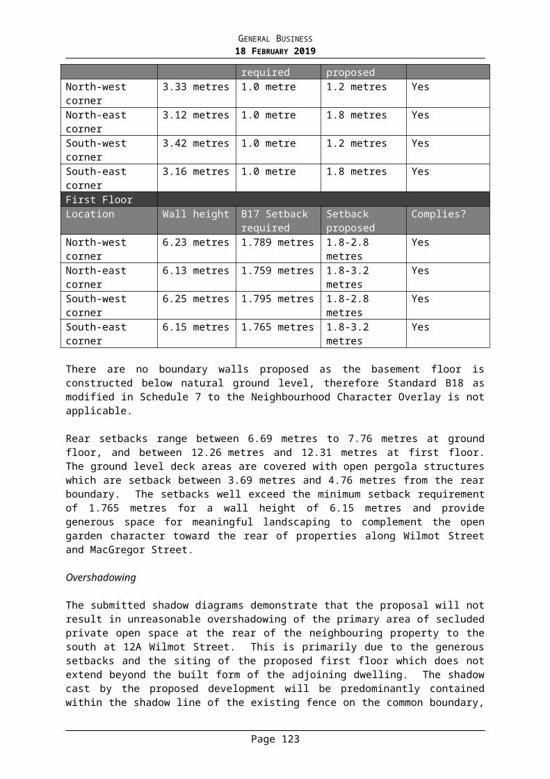
GENERAL BUSINESS18 FEBRUARY 2019
feature and cannot be relied upon as a screening mechanism to mitigate the potential obtrusive impacts of the sign.
Given there are upper level windows proximate to the sign, the sign could result in sleep disturbance of the residents of these dwellings which is an unacceptable outcome. While higher luminance levels may be appropriate during the day, as it becomes night a number of the commercial uses close and the car, tram, train, bicycle and pedestrian movements slow. It is considered the continued operation of the sign into the early evening is commensurate with the uses and surrounding level of activity in the environment and as such can be conditionally supported.
While the western side of the building along Chapel Street is in a very busy setting, where it competes with numerous internally illuminated signs and a high level of street based activity, the context relative to the eastern facade of the building differs, where the sign will be the only large billboard in the vicinity and will be sited amongst residential dwellings as well as parkland.
Later in the evening external lighting is significantly reduced, apart from street lights. It is at this time that the proposed operation of the sign is considered out of character with the area and given the visibility from surrounding residential windows it is considered the sign may have an impact on the amenity of the residents through a dominant visual element, light emission and constantly changing images.
Accordingly it is considered that the sign should be switched off during more sensitive hours of 12 midnight to 6am, and luminance levels of the signage should be limited from 10pm-12 midnight. It is considered these measures are sufficient to address any potential amenity impacts that might be experienced by residents. Accordingly it is recommended that conditions be imposed requiring the digital sign to be turned off between the hours of 12 midnight and 6am, and the maximum permissible luminance of the electronic sign between 10pm and 12 midnight must not exceed 174 cd/m2 (currently 350cd/m2 is proposed for the evening hours). As discussed above, permit conditions will also require the sign to be reduced to a single advertising panel, through the deletion of the four smaller panels which will effectively reduce the distance of the sign from the north-east residential properties by an additional 5.3 metres.
Subject to conditions, the light spill would not be unacceptable to nearby residential properties, given the adjustability of the luminance of the sign and the distance, orientation and other intervening features, such as vegetation and high fences, between nearby dwellings and the proposed sign.
Previous VCAT decision and implications
As discussed above, the site has previously been the subject of a planning application for a major promotion sign (Application No. reference 215/05). Council refused the application on 17 June 2005.
This application went before VCAT in the matter Adspace Pty Ltd v Stonnington City Council [2005] VCAT 2034 (’Adspace’). VCAT affirmed the decision of Council, and accordingly directed no permit to issue.
When having regard to the previous findings of the Tribunal, and in addition the reasons outlined above, the current application is considered appropriate for the following reasons:
Page 124
GENERAL BUSINESS18 FEBRUARY 2019
● Strong built form character referred to by the Tribunal applies to the Chapel Street entrance (referenced as the southern gateway) rather than the approach from the east along Dandenong Road. The key difference from the previous proposal is the current proposal is not roof mounted and does not face traffic entering Chapel Street, and therefore does not impact on the Chapel Street gateway.
● The current proposal is for a wall sign, with half of the sign located within the mass of the building and positioned just above the row of windows on the eastern facade. It can have no impact on the southern entrance to Chapel Street and is setback from the edges of the building.
● The new proposal has significantly reduced the overall height of the sign given half the sign is absorbed within the building mass and the sign will not be lit by any external lighting.
● The overall size of the sign has been reduced from 86 square metres to 61 square metres, noting that permit conditions requiring the four smaller sign panels to be deleted will further reduce the overall area of the proposed sign.
● There has been minimal change to the surrounding conditions since 2005. Changes to the planning policies and controls have been relatively neutral.
Objections
In response to the grounds of objection not already discussed in the report, the following comments are made:
● Electrical emission/radiation effects
A number of the objectors’ raise issues about the potential radiation effects of the sign. The potential health impacts of the proposed sign is not a planning ground that can be substantiated.
● Potential for adverse signage to be displayed/sign will devalue the branding of the medical centre
The issue regarding the content of signage displayed has been considered by the Tribunal. The Tribunal has held on other occasions that the content and moral standards of displayed advertising signage is not a relevant matter for Council or the Tribunal, Marwick v Glen Eira CC, VCAT 1865 93 November 1999), para 26.
The potential for adverse signage to ‘devalue’ the medical centre is not a planning ground that could be substantiated. Nonetheless, it is noted that the proposed sign is displayed on the eastern façade of the building, away from the medical centre signage/branding located on the west and south sides of the building. It is considered the location of the proposed sign as such ‘disassociates’ itself with the medical uses contained within the building. Additionally, permit conditions will require that the display of phone numbers, pricing or email addresses, must not be displayed.
● Loss of ventilation and natural lighting to both level 1 and level 2 of the host building (medical centre)
Page 125
GENERAL BUSINESS18 FEBRUARY 2019
The sign is not proposed to be located over these windows. Permit conditions will require that no part of the sign is to be constructed over any existing windows located on the host building.
Human Rights Consideration
This application has been assessed in accordance with the requirements of the Planning and Environment Act 1987 (including the Stonnington Planning Scheme), reviewed by the State Government and which complies with the Charter of Human Rights and Responsibilities Act 2006.
CONCLUSIONHaving assessed the application against the relevant planning controls, it is recommended that the proposal be supported for the following reasons:
● The sign is considered to be compatible with the strategic aspirations for the Chapel Street precinct and will add some level of vitality and colour to this commercial area.
● The sign is considered to be located a sufficient distance from any residential properties to not have an unreasonable impact with regard to light spill and glare.
● The sign is considered to be proportionate to the facade of the host building and will not result in visual clutter.
● The proposed sign will not result in unacceptable glare nor should it adversely impact the safety of pedestrians, residents or vehicular traffic.
ATTACHMENTS
1. PA - 573-18 - 6-10A Chapel Street Windsor - Attachment 1 of 1 Plans
RECOMMENDATIONThat a Notice of Decision to Grant a Planning Permit No: 573/18 for the land located at 6-10A Chapel Street, Windsor be issued under the Stonnington Planning Scheme to erect and display an electronic major promotion sign in an Activity Centre Zone subject to the following conditions:
1. Before the commencement of the development, 1 copy of plans drawn to scale and fully dimensioned, must be submitted to and approved by the Responsible Authority. The plans must be generally in accordance with the plans prepared by Outdoor Elements Drawing No’s: 01 and 02 and Council date stamped 5 June 2018 but modified to show:
a) Deletion of the four smaller LED panels of the sign.
2. The location and details of the sign, including those of the supporting structures, must be in accordance with the endorsed plans, unless otherwise agreed in writing by the Responsible Authority.
3. The sign must be maintained to the satisfaction of the Responsible Authority.4. The sign must not display intermittent light(s), advertising or messages which
contain any repeated directional motion, flicker or flashing content.5. The sign must be fitted with automatic ambient light conditions sensors to
Page 126
GENERAL BUSINESS18 FEBRUARY 2019
control light intensity output/luminance, to the satisfaction of the Responsible Authority.
6. The sign must only display static content and must not display any animated images (i.e. moving images).
7. No part of the sign is to be constructed over any existing windows located on the host building.
8. The intensity of the light in the sign must be limited so as to not cause glare or distraction to motorists or other persons or loss of amenity in the surrounding area to the satisfaction of theResponsible Authority.
9. The sign must not:a) Dazzle or distract drivers due to its colouring.b) Be able to be mistaken for a traffic signal because it has, for example, red
circles, octagons, crosses or triangles.c) Be able to be mistaken as an instruction to drivers.
VicRoads’ conditions10. In relation to the electronic (LED) sign:
a) No advertisement may be displayed for less than 30 seconds.b) The transition from one advertisement to another must be instantaneous.c) All screens must operate as one whole sign with:
i. All screens changing simultaneously and in sync,ii. Images, designs, colours and patterns generally continuing across
all screens.d) In relation to the images displayed on the sign:
i. Scrolling text, videos and sequences of images giving the illusion of continuous movement must not be displayed.
ii. Images capable of being mistaken for traffic signals or traffic control devices because they, for example, contain red, amber or green circles, octagons, crosses or triangles must not be displayed.
iii. Images or text capable of being mistaken as an instruction to a road user must not be displayed.
iv. Flashing background, flashing text or flashing images must not be displayed.
v. Text height should be appropriate for legibility against the speed of the road, and scripts etc. should be avoided, and the use of logos 'limited' to 'easy to interpret' or easily recognisable (i.e. NIKE or ADIDAS etc.) and there should be no more than 6-8 words.
e) The sign must not dazzle or distract road users due to its colouring.f) The luminance of the advertising sign must be such that it does not give
a veiling luminance to the driver, of greater than 0.25 cd/m², throughout the driver’s approach to the advertising sign.
g) In the event of an attack by a computer hacker or similar resulting in unauthorised display of visual images or any other display malfunction, the electronic sign is to shut down and cease any form of visual output until the malfunction is repaired.
h) The use of 'sound or motion' to activate the sign, is not permitted.i) The use of sound to interact with any road user is not permitted.j) The sign and any displayed advertisement must not include ancillary
extension, embellishment or accessorisation, 'outside of the advertising
Page 127
GENERAL BUSINESS18 FEBRUARY 2019
area'.
k) Advertisements that contain or consist of present time or other contemporary update information, such as time/weather or news, is not permitted.
l) The display of phone numbers, pricing or email addresses, must not be displayed.
m) The advertising area must not be split into multiple screens (horizontally, vertically, diagonally or any other variation) with different messages.
End of VicRoads’ conditions11. The luminance of the sign must be in accordance with the Lighting Impact
Assessment prepared by Electrolight Australia dated 1 June 2018 at all times to the satisfaction of the responsible authority except that between 10pm and 12 midnight maximum permissible luminance must not exceed 175 cd/m2.
12. The sign must be turned off between 12 midnight and 6am to the satisfaction of the responsible authority.
13. This permit expires 15 years from the date of issue. By a date no less than two months before the permit expires, the owner of the land or sign or occupier of the land may apply to the Responsible Authority and VicRoads to extend this expiry date. If the Responsible Authority and VicRoads both agree to extend the expiry date, the permit will expire on the extended date or, if the extended dates are different, the earlier of the extended dates. If either the Responsible Authority or VicRoads do not agree to extend this expiry date, the permit is not extended. From the date the permit expires, no advertisement may be displayed and the sign and all supporting structures must be removed and the site made good to the satisfaction of the Responsible Authority.
14. This permit will expire if the sign is not erected within 2 years of the date of this permit. The Responsible Authority may extend the periods if a request is made in writing before the permit expires or within the timeframe specified in Section 69 of the Planning and Environment Act 1987.
Page 128
GENERAL BUSINESS18 FEBRUARY 2019
8. CATO SQUARE CAR PARK - PROPOSED PRICING STRUCTURE
Traffic Engineer: Umesh Jegarajan Manager Transport & Parking: Ian McLauchlanGeneral Manager Assets & Services: Simon Thomas
PURPOSE
To consider an appropriate pricing structure for the Cato Square car park when it re-opens in mid-2019.
BACKGROUND
In 1966, Council purchased the site bounded by Cato Street, Chatham Street, Izett Street and Wattle Street (approximately 9,000 m2) to use as an at-grade car park. The purchase was funded by a separate scheme, and provided an at-grade car park with approximately 422 parking bays.
In 1997, Council as part of a broader parking management strategy for the area, resolved to introduce paid parking at the Cato Street and Elizabeth Street car parks in conjunction with the construction of the Elizabeth Street car park effective 1 August 1997.
The former at-grade car park had approximately 422 parking bays, with paid parking applied to approximately 275 parking bays. Of the remaining bays, 38 parking bays were subject to ½-HOUR restrictions operating 9am to 6pm with 1-HOUR restrictions operating at all other times, 99 parking bays were subject to 1-HOUR restrictions operating at all times, the balance were either disabled parking bays or Car Share bays. The free parking bays were to cater for short-term convenience customers and were located along the east (Cato Street) and north (Wattle Street) sides of the car park.
The Cato Street Car Park Redevelopment Project is situated in a strategically significant location in close proximity to the Chapel Street and Commercial Road retail precincts, close to public transport, and will provide a strategic open space link between Grattan Gardens and Princes Gardens.
In broad terms, the project involves removing the existing car park at ground level to provide a new civic precinct and open space, with car parking over two underground levels. When completed in 2019, Cato Square will provide urgently needed open space and will provide approximately 20 per cent more car spaces for shoppers and retailers.
Surrounding Car Parks
The precinct has a number of off-street car parks, both Council and privately-owned. The major car parks include the Elizabeth Street car park (Council), King Street car park (Council), Woolworths car park (Private), and Jam Factory car park (Private), and are all within an 800m radius. A locality map is provided below.
Page 129

GENERAL BUSINESS18 FEBRUARY 2019
The fees at the Council operated car parks vary to encourage different parking behaviours e.g. long stay parking is encouraged at King Street in preference to Elizabeth Street.
DISCUSSION
IntroductionThis report considers the estimated operating costs (cost base) for the new car park and open space area, and potential operating income including different options for implementing car parking fees. The report also considers and responds to requests from both the Chapel Street Precinct Association (CSPA), and Coles Supermarket.
Having considered these matters, the report recommends a short term fee structure to re-establish parking patterns in the new car park, and a longer term fee structure which seeks to offset the ongoing operating and maintenance costs for the whole facility.
Operating and Maintenance Costs
For the purposes of estimating the total net cost to Council, a service model has been developed and costed for operation and maintenance of both the carpark and the surface park. These costs have been incorporated in the 2019/20 operating budget. The detailed service model is set out in Attachment 1. The service model makes allowances for cleaning, graffiti removal, litter and waste collection, building maintenance (including all services, lifts and travellators), parking system hardware and software maintenance, security (including security patrols and CCTV maintenance), and horticultural services (turf, tree, garden bed maintenance). The cost for each service has been estimated based on existing contract rates.
Page 130
GENERAL BUSINESS18 FEBRUARY 2019
For security reasons it is proposed to relocate the 24hr/7day ‘on site’ management from the Elizabeth Street car park to the new Cato Street facility. As a result there will be a net reduction in the operating costs for Elizabeth Street, which has also been included in the 2019/20 budget.
Operating Income
Fee Paying Options
For the Cato Square car park, 3 potential fee structures have been considered:
Option 1 - Free parking at all times;
Option 2 - Part free parking, part paid parking; or
Option 3 - Paid parking at all times.
For the purposes of estimating the income for options 2&3, car park length of stay from the Elizabeth Street car park has been used in the modelling, Table 1 below.
0-0.5 hrs 28.16%
0.5-1 hrs 26.29%
1-2 hrs 23.90%
2-3 hrs 10.44%
3-4 hrs 4.22%
4-5 hrs 2.23%
5-6 hrs 1.31%
6-7 hrs (Maximum) 3.45%
The above occupancy data indicates that 54.45% of patrons will stay for 1 hour or less, and that 78.35% of patrons will stay for 2 hours or less. The above only considers general patronage of the car park, and any event parking is not reflected above (as this cannot be accurately estimated). However, for the purposes of general car park operation, the above assumptions are considered appropriate.
Option 1 – Free Parking
Council could consider operating the car park at no cost to patrons. In this arrangement spaces would be subject to restrictions and enforced like any other time limited parking in the municipality. If Council were to offer free parking at this site there would be a flow on effect to other paid car parks in the area, and the fee structure at those facilities would need to be reviewed accordingly.
(It should be noted that previous experience suggests that the personal security risk for enforcement staff is greater in contained spaces such as an underground car park. In this environment, the number of enforcement staff would be increased and therefore the enforcement costs would be higher).
Page 131

GENERAL BUSINESS18 FEBRUARY 2019
Option 2 - Part Free, Part Paid Parking
This arrangement would be similar to the former charging arrangements for the ‘at grade’ carpark.
The car park management system relies on licence plate recognition, i.e. on entry the licence plate is recorded, and a ticket issued. When leaving the driver pays at an automated pay station according to the length of stay, the ticket is scanned on departure and provided the appropriate fee is paid the vehicle is allowed to depart the car park. The car park management system does not allow for differential parking fees to apply in different areas of the car park.
If part free parking was to be provided it would apply to the whole carpark for short duration parking. Any such arrangement could have a detrimental effect on parking behaviour. For example, a scheme with the first 30 minutes free would encourage short stay parking behaviour and increasing traffic entering/exiting the car park. Further, to recover the operating costs as a minimum the loss of revenue would need to be recovered through the longer stay rates.
Previous Council experience at the Elizabeth Street car park would not support the introduction of short stay free parking. Half hour free parking was introduced in 2001 with the cost for 1 hour set at $1. This encouraged short stay parking behaviour, and impacted on operating revenue. Subsequently in 2004 Council having regard to the parking behaviour and operating revenue resolved to remove the free parking and retained the $1 fee for the first hour.
It is assumed that the broader trader community in the precinct would have a desire for longer stay parking behaviour (longer stay can equal more spending). Part free parking may also encourage some motorists to leave the car park within the first half hour/hour and return straight away to qualify for the free period again. This would impact on both behaviour and revenue.
It seems from the Elizabeth Street experience that a lower rate for the first hour is preferable to a free parking option for half an hour. If a free parking period was considered it would likely need to be a minimum of 1 hour so as not to encourage the short stay behaviour outlined above (which would have a significant impact on revenue – based on the Elizabeth Street length of stay figures, over 50% of car park patrons stay for 1 hour or less). If this option were to be considered, some level of consistency may need to be introduced at the other car parks which would compound the impact on income.
Option 3 - All Paid Parking
All paid parking applies a parking rate to all parkers no matter the length of stay (the one exception being the 15 minutes free grace period offered to all parkers).
This is the current practice at all Council multi-deck car parks and was the past practice at the at-grade Cato Street car park (with the exception of some bays that were time restricted).
In terms of revenue, this would achieve the best return and would offset the operational costs. All paid parking also allows Council to adjust fee scales to manage parking demand between carparks.
The concern regarding vehicle exit and re-entry is unlikely to be an issue under this fee scenario, given there is little advantage of leaving the car park, and re-entering on a new ticket. The motorist determines the length of stay to meet their own requirement, rather than being influenced by any free parking component.
Under this arrangement the fees for the shorter 1- 2 hour stays would be relatively low, with fees escalating to discourage longer stay behaviour.
Page 132
GENERAL BUSINESS18 FEBRUARY 2019
Cost Model
Income for the new underground car park has been estimated based on the above occupancy rates. For the purpose of the analysis, the parking rates at the Elizabeth Street car park (as of 2017) were used in the calculation as detailed in the following table:
CASUAL FEES(Inclusive of GST)
15 mins - 30 mins $ 1.40
30 min - 1 hour $ 2.90
1-2 hours $ 3.90
2-3 hours $ 6.30
3-4 hours $ 8.50
4-5 hours $ 11.10
5-6 hours $ 13.20
6-7 hours (Max) $ 17.80
The costs for maintenance and operation of the new facility including the carpark and the open space have been offset against the anticipated operating revenue (from both parking fees and the retail tenancies) in order to calculate the average anticipated net cost to Council – outlined in the following table.
Option Average anticipated net
costFree ($1.0m +)Option 2a) - First 2 hrs Free ($600k)Option 2b) - First Hour Free
($400k)
Option 3 - All Paid Parking
$250k
As can be seen the estimated income range for each option varies considerably. Based on the financial modelling the all paid parking option will recover the operating and maintenance costs (with a potential minor surplus), whereas there is a higher risk with both options 2a) and 2b) – part free parking, that the income will not cover those costs.
Page 133

GENERAL BUSINESS18 FEBRUARY 2019
Request from the Chapel Street Precinct Association (CSPA)On 20 June 2018, the Chapel Street Precinct Association (CSPA) wrote to Council regarding the proposed parking fees for Cato Square.
In their correspondence CSPA are requesting 2 hour free parking from when the car park opens until the civic plaza is complete at ground level. Due to the construction, they feel “that in order to draw the crowds back to Prahran it is essential that generous free parking is offered”. They further propose to consider a car park user competition with a cash prize which could be spent within the Chapel Street precinct, if this were to occur.
CSPA would then like to extend the 2 hour free parking to the first three months after the civic plaza is open and in operation.
CSPA are also requesting 1 hour free parking moving forward for the car park. The rationale behind this request is the Chapel Street precinct is competing against shopping centres such as Chadstone, among others, that offer free parking. Further, CSPA make reference to a former special rate levied on surrounding businesses in order to provide parking for their customers. Legal advice has been received on the obligations arising from the former scheme which is discussed under Legal Advice & Implications below.
Response
The CSPA’s request for 2 hour free parking for the first three months is noted. The rationale behind the request is to “claw back those regular shoppers which were lost during the construction phase”.
At this stage the carpark is due for completion at the end of June 2019, with the surface work (park) due for completion in August 2019.
Council could consider operating the carpark with the first 2 hours free (with longer stays charged at the Elizabeth St car park rates) until the surface park is opened e.g. for 3 months, this could be extended to the end of the calendar year. All paid parking would then apply from 1 January 2020.
The offer of free parking would assist in returning patrons to Cato Street. One downside risk is that demand may quickly exceed the capacity of the carpark, a further more significant risk is that this would embed an expectation of free parking in the long term, which would hamper Council’s ability to operate the carpark and plaza on a cost neutral basis. This would also create an expectation to replicate the same arrangement for other Council operated paid carparks.
The CSPA also makes reference to a special levied rate, which will be discussed Legal Advice & Implications below.
Coles Supermarket RequestIn August 2018, Coles Supermarkets contacted Council, requesting that shopper dockets be utilised in the Cato Square car park.
To summarise, a shopper docket (in the context of car parking fees) is a barcode at the bottom of a receipt, which can be used at an automated pay station to obtain a discount on parking (the barcode is not unique to the receipt and can be reused). These are generally linked to large supermarkets, such as Coles.
In this scenario, Coles has requested 90 minutes of free parking after spending $20 at the Prahran Coles supermarket. Their request states “Coles has suffered a considerable reduction in sales and earnings during the car park closure, and due to the fact that the prior Cato St car park allowed for a number of free car parks, we believe these should be reinstated/replicated once the new car park becomes operational, through the use of a dollar
Page 134
GENERAL BUSINESS18 FEBRUARY 2019
spend at Coles”. The request also makes reference to a similar arrangement at Woolworths, with the Woolworths car park.
Response
Shopper dockets could be considered as a system whereby Coles pays for parking consumed by the customer. That is the customer uses the docket to exit the carpark, Council then recovers the cost of parking from Coles retrospectively.
The issue with the use of shopper dockets is the potential revenue loss. There is no way to automatically charge the retailer for the number of shopper dockets used. The equipment supplier advises that the shopper dockets would be registered in the management system, and can be tracked via reports. This means that the parking revenue could theoretically be recovered. However, this puts the administrative burden on Council’s contractors. The car park consultant must collate the dockets used in a month, and the car park operator must generate an invoice for Coles to pay, and follow up payment.
The preferred way to offer the parking discount for Coles customers is through the trader dockets system as outlined below.
Trader Dockets
Trader dockets is an option whereby retailers are able to offer their customers a period of free parking by paying the parking rate on their behalf.
An example of this is ALDI at the Elizabeth Street car park, where ALDI purchases “1 hour free” parking vouchers to distribute to their customers. ALDI pays for the first hour and the customer pays for any parking in excess of 1 hour. Trader dockets are also used by Fuji Mart.
This can be extended to any number of traders in the area, and is fully managed by Council’s car park operator (Care Park Pty Ltd). Once the dockets are distributed to each trader who places an order, the trader then manages the dockets. They can set the minimum spend in their shop to give the customer the docket, and can order how many dockets they require.
Coles may argue that this puts the administrative burden on them (by having to hand out vouchers), however this arrangement works successfully at the Elizabeth St carpark with ALDI (where ALDI staff distribute trader dockets to customers).
It is recommended that a shopper docket system similar to that operating at the Elizabeth Street carpark also be developed for Traders in the area.
SummaryThere are a number of shopping centres which offer part free, part paid parking. Two recent examples, The Glen Shopping Centre, and Southland Shopping Centre, offer free parking for up to 3 hours for customers, but then charge beyond that time. It is understood that this is to discourage long stay car parking behaviour such as commuter parking (The Glen being near Glen Waverley station, and Southland being near Southland station).
Some car parks also offer free parking as the lease agreements between the centre and retailer requires this. An example is Victoria Gardens, where the lease agreement requires free parking for nominated periods for Coles, Ikea etc.
As there are no lease arrangements for Cato Square (as the car park site is separated from retail tenancies), there is no obligation for Council to consider 1 hour free parking as a permanent pricing method. The arguments against half hour/one hour parking arrangements have been outlined above in terms of driver behaviour.
Page 135
GENERAL BUSINESS18 FEBRUARY 2019
In light of the above, it is recommended that Council adopt Option 3, which is all paid parking in the Cato Square car park. It is further recommended that the fee scale be lower for the first 1-2 hours, increasing thereafter to discourage long stay parking similar to other Council operated paid carparks.
Council could consider providing periods of free parking in the short term as outlined in response to the CSPA request. However given the difficulty experienced when converting from short term free to ‘all paid’ at the Elizabeth St carpark it is considered that it would be better to commence operation of the carpark with ‘all paid’, but in response to the request Council could implement a very low fee say $1 for the first 2 hours. This would establish the pay parking behaviour for patrons, and would give Council the discretionary ability to change the fees at a future date.
It is proposed that having regard to the CSPA request, and in order to re-establish parking patterns, Council introduce a fee scale from the commencement of the operation of the carpark (June 2019) to January 2020 which provides to first 2 hrs of parking at the nominal fee of $1. Fees for longer stay parking would be the same as the fee structure for the Elizabeth St carpark. It is proposed that the first 2 hr fee of $1 could be changed in January 2020 to match the Elizabeth Street rates.
The following table briefly summarises the advantages and disadvantages of each option.
Scenario Advantages Disadvantages
Free parking (with time restrictions)
Advantageous to retailers
May encourage more carpark use/customers
Loss of car park revenue
Not consistent with pricing methodology for other Council multi-deck car parks
Difficulty to introduce paid parking in future
Higher enforcement costs associated with protecting the personal security of enforcement staff
Part free, part paid parking
Advantageous to retailers
May encourage more carpark use/customers
Loss of car park revenue
Not consistent with pricing methodology for other Council multi-deck car parks
Difficulty to introduce paid parking in future
Increased vehicle movements
Customers may want to leave the precinct earlier
Page 136
GENERAL BUSINESS18 FEBRUARY 2019
All paid parking
Maintain revenue base to offset operating costs
Consistent with other Council operated paid car parks
Less customer friendly than free parking
Short Term Impact on Operating CostsIt should be noted that for the first 12 months of operation some infrastructure maintenance will be provided as part of the defect liability period provided under the contract, as a result the maintenance costs for the first year of operation will be lower than for subsequent years.
It should also be noted that the first year income will be less than outlined above as the Chatham Street commercial tenancies will be occupied by the Prahran Library, and Prahran customer service centre ‘pop up’ while the Prahran Town Hall is redeveloped (approximately 18 months). The above income model is predicated on implementation of the fee scale for the Elizabeth St carpark. If Council adopts the proposal to apply a fee of $1 for the first 2hrs until the end of the calendar year this will significantly reduce income for the period (difficult to estimate the impact).
In overall terms for the first 12 – 18 months both the maintenance costs and income levels will be lower which will impact on the net cost to Council.
External Factor - Congestion Levy
As advised at the Council Meeting on 20 August 2018, the State Government is considering expanding the existing congestion levy. If this levy is expanded as proposed it would apply to paid carparks. Preliminary estimates suggest the levy would impose a further cost of $1000 per parking bay per annum, which would then need to be recovered through parking fees.
If introduced the congestion levy would be in addition to operating expenses. Clearly if the parking charges allowed a period of free parking, the levy would need to be recovered from the longer stay rates putting a further burden on those rates. Consideration would need to be given to the possible impact of the congestion levy particularly if Council was to consider part free parking as outlined above.
POLICY IMPLICATIONS
The Cato Street car park redevelopment is aligned with the Public Realm Strategy 2010, and Strategies for Creating Open Space 2013. It is also consistent with the actions of the Chapel Street Master Plan.
FINANCIAL AND RESOURCES IMPLICATIONS
The revenue of the car park is primarily dependent on the patronage. The operational expenses will generally be constant, so car park patronage will determine the amount of revenue generated.
As outlined above the all paid option 3 will provide sufficient income to fully offset the operating and maintenance costs. As mentioned earlier, in recognition of the disruption to the precinct (during the works) and in order to re-establish parking patterns
Page 137

GENERAL BUSINESS18 FEBRUARY 2019
Council could operate the carpark at a nominal cost of $1 for the first 2 hours to the end of the calendar year, with the parking rates for the Elizabeth St carpark applied for longer stays. The Elizabeth Street parking rates could then be introduced from 1 January 2020.
Given the revenue estimates above, it is recommended that no permanent parking, early bird parking, or event parking rates be considered until parking patterns have established.
It should be noted that if the congestion levy is introduced by the State Government it would apply to this carpark, and that the hourly rates would need to increase accordingly (as with other paid carparks in the levy area).
LEGAL ADVICE & IMPLICATIONS
As mentioned earlier, CSPA made reference to a special rate levied on surrounding businesses in order to provide parking for their customers. CSPA is of the opinion that these levies paid should be considered when determining the period of free parking.
Advice was received from Maddocks Lawyers in May 2009 regarding; what restrictions Council would face in pursuing the possible sale, lease or licence of the Cato Street Car Park (the Carpark), having regard to the fact that the Carpark was purchased by Council pursuant to a separate rate scheme for off-street carparking purposes.
Essentially their advice is that Council could dispose of, lease or licence the land provided there is due weight given to the purposes for which the land was purchased, they go on to advise ‘that to the extent that Council (as distinct from a third party purchaser, lessee or licensee) proposes to use the Carpark for a purpose different to the purpose for which it was first acquired by Council, Council would need to comply with sections 192 and 223 of the Act. Section 192 relates to a change in use of land by the Council, not a change in use by a third party’.
Further clarification was sought from Maddocks in July 2017, they confirmed their earlier advice and provided the following summary statement in reference to the proposed Cato Square project;‘In summary, we consider that there is little legal risk arising from Council’s proposed action. Even if a court held that the Carpark was impressed with a public purpose trust, Council is not ceasing to use the land for public carparking but, rather, in relocating the car parking spaces underground, is expanding the number of carparking spaces available to the public. While the trust may be said to be continuing, Council’s actions are not in contravention of its obligations under the trust.’
Further recent advice from Councils Corporate Counsel (2018) in referring to an extract from the relevant Council minutes in 1966 is that ‘money raised from the scheme for the duration of the period for which the scheme operated – namely 15 years – was used to reimburse Council the funds already utilised in the land acquisition and construction of the carpark…..Council has therefore fully discharged its responsibilities associated with the implementation of the special rate scheme for this site. That being the case, Council has no further obligation to those parties or properties which were subject to the special rate scheme’.
None of the above has any bearing on the ability for Council to impose a scale of fees for parking on the site.
Page 138

GENERAL BUSINESS18 FEBRUARY 2019
CONCLUSION
In light of the above, it is recommended that Council adopt Option 3 - ‘all paid’ parking for the Cato Square car park. It is further recommended that the fee scale be lower for the first 1-2 hours, increasing to discourage long stay parking similar to other Council operated paid carparks.
It is proposed that in order to re-establish parking patterns, Council introduce a fee scale from the commencement of the operation of the carpark (June 2019) to January 2020 which provides the first 2 hrs of parking at the nominal fee of $1. Fees for longer stay parking would be the same as the fee structure for the Elizabeth St carpark (to manage long stay parking).
It is further proposed that Council review the charges following the first 6 months of operation e.g. once parking patterns have re-established. It is recommended permanent, early bird, or event parking rates not be considered until parking patterns have been established.
It is also proposed that a ‘Trader Docket Scheme’ be implemented as soon as practicable following the opening of the carpark.
HUMAN RIGHTS CONSIDERATION
This recommendation complies with the Charter of Human Rights and Responsibilities Act 2006.
ATTACHMENTS
1. Cato St Car Park - Attachment 1 Excluded
RECOMMENDATIONThat:1. Council note the new Cato Street carpark is due to open for public use in late
June/July 2019.2. The parking fees for the new carpark be the same as those for the Elizabeth St
car park, except that the fees for the first 2 hrs be set at the nominal charge of $1 to allow car parking patterns to establish.
3. Early bird, permanent, or event parking rates not be considered until the parking patterns have established.
4. A further report be prepared after 6 months of operation of the new carpark considering how parking patterns have established, and reconsidering the fees for the carpark as appropriate.
5. A ‘Trader Docket Scheme’ be introduced as soon as practicable after the carpark commences operation.
6. A response be provided to the Chapel Street Precinct Association (CSPA), and Coles Supermarkets accordingly.
Page 139
GENERAL BUSINESS18 FEBRUARY 2019
9. EDGAR STREET, GLEN IRIS - INSTALLATION OF A SHORT TERM DISABLED PARKING SPACE ABUTTING HAROLD HOLT AQUATIC CENTRE
Traffic Engineer: Umesh Jegarajan Manager Transport & Parking: Ian McLauchlanGeneral Manager Assets & Services: Simon Thomas
PURPOSE
To advise Council of a proposal to install a short term disabled parking space abutting Harold Holt Aquatic Centre (HHAC) on Edgar Street, Glen Iris.
BACKGROUND
At the Council Meeting on 17 September 2018, correspondence was tabled from a resident who raised concerns with the existing disabled parking bays abutting HHAC. The resident stated she was unable to drop off her daughter due to the disabled parking spaces being occupied. The request is for a disabled parking space with a short duration time limit.
A council report was requested on the matter.
DISCUSSION
There are a number of parking restrictions abutting HHAC on the Edgar Street frontage, and these are indicated in Attachment A. The parking restrictions were developed in conjunction with Centre management to meet the various needs of the Centre, and were most recently amended in 2014.
Among these restrictions, there are 5 disabled parking spaces. There are no time restrictions that apply to these spaces, however the motorist must display a valid disabled parking permit.
In the past, there are have been requests for additional disabled parking spaces near HHAC (although not specifically for drop-off/pick-up).
The provision of disabled parking spaces for different land use types is specified in the Building Code of Australia (BCA). This is generally expressed as a function of the number of car parking spaces provided. HHAC relies on a combination of on-street car parking and off-street parking in nearby lots. Adopting the rate of 1 disabled space per 50 spaces (which is the rate applied to a place of assembly, the best fit available for a public pool/fitness centre), the provision of 5 disabled spaces on Edgar Street near the pool entrance would be sufficient for a car park of up to 250 spaces (which is more than the number of existing on street/off street spaces). Therefore the provision of disabled spaces exceeds the BCA requirements.
In order to accommodate the request for a short duration time limit disabled parking space, either an existing disabled space would need to be converted to include a time limit, or a new space be created.
It is understood the preference is to create a new space, retaining the existing 5 disabled spaces unchanged.
Proposed Location
Page 141
GENERAL BUSINESS18 FEBRUARY 2019
As shown in Attachment A, the first area north of the existing disabled spaces is subject to a NO STOPPING restriction with an exemption for ambulances (this is in case of a medical emergency). Officers investigated the conditions on-site to determine whether this area would be suitable for a short term disabled space. As there is already a kerb ramp to the footpath, and the space is shielded by the kerb outstand, this appeared to be most suitable for a short term disabled space (no civil works would be required).
The proposal would require the existing NO STOPPING restriction with exceptions for ambulances to be removed. While this could be of concern, Centre management have indicated that if an ambulance is called, staff will ensure the short term disabled space will be kept vacant for the ambulance. The short term nature of the disabled space is likely to ensure the driver of the vehicle is nearby, to facilitate access for the ambulance.
Due to the restriction being in place for some time, officers have notified Ambulance Victoria that Council intends on changing the restriction, and provided an opportunity to comment. They were also advised that staff will ensure the space is vacant when an ambulance is required. They were supportive of the proposed change.
Proposed Restriction and Layout
Typically when a short term restriction is considered (particularly for drop-off and pick-up), it is limited to 5 or 10 minutes. Advice is that a 10 minute time limit would be preferred, to allow sufficient time for carers to unload/load a person with complex needs. As such, it is proposed to replace the existing NO STOPPING restriction with exemption for ambulances with a P 10-MIN DISABLED ONLY restriction. This can be installed, and if feedback is that users require a longer time, the matter can be revisited.
The Australian Standards require disabled parking spaces to have a shared area adjacent, which allows for loading/unloading. It is proposed to have the shared area on the south and disabled space on the north, per Attachment B. As the kerb ramp is located on the south side, having the shared area on the same side will assist with access to and from the footpath.
To ensure motorists are aware of the 10-MINUTE time limit, it is proposed to have a supplementary plate below the parking signage with the wording “DROP-OFF/PICK-UP ONLY”. This cannot be installed on the actual parking sign panel, as this would be non-compliant, and thus not enforceable.
Page 142

GENERAL BUSINESS18 FEBRUARY 2019
POLICY IMPLICATIONS
Council, as part of its Access and Inclusion Plan, has set out objectives to improve accessibility and services for people with a disability who live in or visit the municipality. The purpose of this Plan is to continue to facilitate and provide an accessible range of community services and facilities in partnership with the community and other agencies to promote wellbeing, safety, social independence and inclusion in the community.
By providing this short term disabled parking space, it would align with Council’s Access and Inclusion Plan.
FINANCIAL AND RESOURCES IMPLICATIONS
There are no civil works required. The only works to be carried out are line marking, signage, and the installation of a bollard for the shared area. Based on previous disabled spaces, the cost is largely the line marking component, and is anticipated to cost $7,000 ex GST. The signage and bollard will be approximately $300 ex GST. The costs can be funded from existing budgets.
CONCLUSION
In order to improve access to Harold Holt Aquatic Centre for people with a disability, it is proposed to replace the existing NO STOPPING restriction with ambulance exemption, with a 10-MINUTE DISABLED ONLY parking restriction including a supplementary plate, to allow for drop-off and pick-up.
HUMAN RIGHTS CONSIDERATION
This recommendation complies with the Charter of Human Rights and Responsibilities Act 2006.
ATTACHMENTS
1. Attachment A - Parking Restrictions abutting Harold Holt Aquatic Centre Excluded
2. Attachment B - Plan of Disabled Parking Space Excluded
RECOMMENDATIONThat;The proposal to change existing parking restrictions in Edgar St, adjacent to the HHAC (west side of Edgar Street approximately 80m north of High Street), from NO STOPPING AMBULANCES EXCEPTED to P 10-MINUTE DISABLED ONLY be approved.
Page 143
GENERAL BUSINESS18 FEBRUARY 2019
10. ADOPTION OF THE 'TOWARDS ZERO' ROAD SAFETY STRATEGY 2018 - 2022
Road User Behaviour Officer - Transport & Parking: Penne Mithen General Manager Assets & Services: Simon Thomas
PURPOSE
To advise Council of the results of the community consultation undertaken for the “Towards Zero’ Road Safety Strategy 2018 – 2022; and to seek adoption of the Strategy.
BACKGROUND
Council is committed to creating an inclusive, healthy, creative, sustainable and smart community. Encompassed within this vision is Council’s continuous commitment to provide safe travel for all road users within Stonnington. Over the past decade this commitment has been achieved through the Road Safety Policy 2008 – 2017.
The Strategy has been revised (‘Towards Zero’ Road Safety Strategy - 2018-2022; TZRSS) to guide and implement the vision for road safety over the next five years. The shift from a policy to Strategy allows for a more targeted response to an increasing population and heightened community expectations.
Closely aligned with the Victorian Government’s road safety strategy ‘Towards Zero 2016-2020’, the aim of the TZRSS is to promote safe road-based travel by reducing fatalities and serious injuries on Stonnington’s roads. This aim is achieved through the continued implementation of evidence-based infrastructure, behavioural and educational strategies using the Safe Systems (SS) principles outlined in the previous Council report (Attachment 1).
With Stonnington’s population forecast to grow to 143,257 by 2036 (an increase of 23 per cent) there will be even greater demand on the local traffic network. Road space availability at present is limited, with little capacity to be extended to any significant degree. Therefore, in alignment with Council’s vision and current plans for enhancing urban liveability and the well-being of residents, the challenge is to cater for increased trips by all transport modes while improving the safety of all road users.
In summary, the Strategy’s key strategic directions are focused around:
Behaviour change and educational initiatives for road users;
Targeting speed reduction measures;
Infrastructure measures to improve safety for vulnerable road users, and road users as a whole;
Advocacy and partnering with State Agencies in the area of road safety; and
Ensure Safe System thinking is included in Stonnington’s policies and strategies.
Further, the Strategy included a five year implementation plan summarised as follows:
Identify and support cycle links between principal bike routes;
Support low risk walking and cycling by reviewing the designs of existing roundabouts within the municipality for the potential to retro-fit raised pedestrian crossings (as used successfully in the City Port Phillip) and identify opportunities to build new roundabouts with this safety feature;
Investigate, scope and develop pedestrian priority treatments at T-intersections;
Page 145
GENERAL BUSINESS18 FEBRUARY 2019
Trial left-in/left-out management of traffic at intersections on a designated arterial road segment in partnership with VicRoads. Intersections on routes with 60 km/h or higher speed limits and low-risk turning provisions would be candidates for a trial;
In partnership with VicRoads, encourage the implementation at major intersections of advance profile treatments, fully controlled right turn signals and dwell-on-red functionality;
Continue to roll out 40 km/h in local streets and, in partnership with VicRoads, identify and implement 40 km/h speed limits around public transport hubs to support safe travel; support with community education and traffic-calming, where appropriate. Where communities are supportive, lower limits should be introduced to make further substantial reductions in the risk of injury to our most vulnerable road users;
Continue productive dialogue and building relationship with the Safe System Road Infrastructure Team (SSRIP), given the Team’s aim of helping to transform Victoria’s road network to a vastly safer form, as well as its role as a funding agent; and
With the SSRIP Team support, develop innovative treatments and further explore the possibility of reducing speeds on approaches of roads intercepting 40km/h arterials.
Community Consultation
In July 2018, Council approved the following community consultation plan for the draft Strategy to be publically exhibited over a period of four weeks (17 July – 14 August, 2018).
The approved communications plan was implemented as follows:
Published 17 July 2018 (launch date) Stonnington Connect website (connectstonnington.vic.gov.au/roadsafety) Advertisement in Stonnington Leader (full colour, 144x129, early in general news) Media release Stonnington website news item Stonnington intranet news item Week one of social media advertising plan
Published within first week of consultation period: Staff electronic newsletter (20 July 2018 edition)
Published during consultation period: Public Notice in the Stonnington Leader (31 July 2018 edition) Advertorial in the Stonnington Leader (7 August 2018 edition) Weeks two, three and four of social media advertising plan
DISCUSSION
The following section provides a summary of the key themes derived from the community’s responses and outlines amendments made to the Strategy. A table displaying the submission feedback analysis can be found in Attachment 3.
Community Responses
A total of 12 responses were received within the consultation period. A further 17 late submissions were received after the deadline.
Full community consultation feedback responses have been documented in Attachment 2. A separate submission summary analysis can be found in Attachment 3.
Page 146

GENERAL BUSINESS18 FEBRUARY 2019
Summary of Key Themes
The main themes raised by the Stonnington community were:
1. The safety of pedestrians, cyclists and the elderly;
2. General support for a speed limit of 40 km/h in residential streets;
3. Some support for speed limits of less than 40 km/h, mostly by cyclists;
4. Opposition to the proposed trial of lower speed zones (20 km/h and 30 km/h) in specific locations, mostly by motorists; and
5. A variety of other unrelated issues (e.g., waste collection, VCAT, builders’ trucks, etc.).
Amendments to TZRSS
The majority of the community feedback received during the consultation process was already addressed within the Strategy; therefore, no substantive amendments were made to the key strategic directions or the implementation action plan. However, in response to the feedback some amendments have been made to the wording, terminology, definitions and structure of the document.
Within the summary of the key themes stated above, there seemed to be confusion around the context and justification for the lower speed zone trial recommendation. The implementation plan clearly indicates that such measures would be subject to a trial and only undertaken where there is community support in a suitable local traffic area. Therefore, no changes were made to this recommendation in the implementation action plan.
Councillors should note lower speed zones have been installed, for example in the shared zone as part of the recent works in Greville Street, and will be installed in Cato Street as part of the Cato Square development. These works were developed after an extensive design process, in consultation with the affected community and appropriate agency approvals as required. The same extensive engagement with stakeholders would occur with any future speed limit reductions proposed.
Aside from these concerns, the overall feedback was generally supportive of the Strategy’s directions and actions.
Next Steps
After endorsement of the Strategy, an officer and Victoria Police Reference Group (as outlined in the implementation plan) will begin to prioritise and implement actions from the five-year implementation plan. The first priority is to design and implement an anti-distraction campaign (e.g., mobile phones) with the aim to reduce the serious injuries that occur as a result of distracted behaviour. To help achieve this, an application is currently in progress for the VicRoads ‘Towards Zero Challenge – Distraction and Drowsiness’ community grant. Upon a successful outcome, grant funds will be used to design and implement an anti-distraction campaign in partnership with Victoria Police in an agreed target area. This campaign will be aimed at all Stonnington road users.
POLICY IMPLICATIONS
Page 147
GENERAL BUSINESS18 FEBRUARY 2019
The TZRSS aligns with Stonnington’s vision and numerous plans for enhancing city life by supporting the Stonnington Health and Wellbeing Plan 2017 - 2021; Sustainable Transport Policy; Cycling Strategy 2013 – 2018; Children, Youth and Family Strategy 2018 – 2028; Chapel Street Masterplan 2013; Council Plan 2017 – 2021; Access and Inclusion Plan 2014 – 2017; Cultural Diversity Policy 2015 – 2019; Sustainable Environment Strategy 2018 - 2022; Older Persons’ Strategy 2008 – 2012; and the Open Space Strategy. This support is demonstrated through the promotion and facilitation of active trips through increased walking, cycling and use of public transport options, while enhancing the safety of Stonnington’s most vulnerable road users.
FINANCIAL AND RESOURCES IMPLICATIONS
The TZRSS falls within the Transport and Parking budget allocations for the purpose of community consultation and review. A Transport Accident Commission (TAC) grant for the amount of $25,000 + GST was awarded to Council to align the proposed Strategy with Victoria’s RSS ‘Towards Zero 2016 // 2020’. Existing Council budgets were used to fund the balance.
Initial funding can be sourced from proposed allocations for Road Safety Works included in the draft 2019 – 2020 Capital Works budget. Further funding will be sought through external sources (e.g., through the Transport Accident Commission and VicRoads joint Safe Systems Infrastructure Program).
CONCLUSION
Council has an important role within the area of road safety. Through the implementation of evidence-based infrastructure, behavioural and educational strategies, Council’s focused and leading approach to road safety will continue to assist with the prevention of fatalities and serious injuries within the municipality.
Community consultation was undertaken and completed for the ‘Towards Zero’ Road Safety Strategy 2018 – 2022. The community consultation process proved to be a valuable step towards ensuring the development of the most effective and targeted road safety Strategy to further assist in protecting our community through the reduction of fatalities and serious injuries on the roads.
The process highlighted some alignment of priorities between Council and the community, primarily in the area of pedestrian and cyclist safety. Recommendations on how to improve safety in this area were addressed in the Strategy and the five-year implementation plan.
Almost all of the community feedback received during the consultation process was already addressed within the Strategy; therefore, no substantive amendments were made to the key strategic directions or implementation action plan. However, some amendments have been made to the wording, terminology, definitions and structure of the document in response to the feedback.
The amended TZRSS (Attachment 4) is presented to Council for consideration and endorsement.
HUMAN RIGHTS CONSIDERATION
Page 148
GENERAL BUSINESS18 FEBRUARY 2019
This recommendation complies with the Charter of Human Rights and Responsibilities Act 2006.
ATTACHMENTS
1. Previous Council Report - Community Consultation - RSS Attachment 1 Excluded
2. Community Consultation Feedback - RSS Attachment 2 Excluded
3. RSS Submission Analysis Table - Attachment 3 Excluded
4. Amended TZRSS 2018 - 2022 - Attachment 4 Excluded
5. Implementation Plan - Attachment 5 Excluded
RECOMMENDATIONThat:
1. The ‘Towards Zero’ Road Safety Strategy 2018 – 2022 be adopted.
2. Submitters be thanked for their feedback on the draft Strategy be advised of the decision.
3. The actions identified in the ‘Towards Zero’ Road Safety Strategy 2018 – 2022 implementation plan be referred for consideration in the preparation of future budgets.
Page 149
GENERAL BUSINESS18 FEBRUARY 2019
11. FINCH STREET (HIGH STREET TO WATTLETREE ROAD), GLEN IRIS - TRAFFIC AND PARKING INVESTIGATION
Traffic and Parking Coordinator: Peter Kyrkylis Manager Transport & Parking: Ian McLauchlanGeneral Manager Assets & Services: Simon Thomas
PURPOSE
To advise Council of the survey results obtained to assist with consideration of traffic and parking issues along Finch Street, Glen Iris including at the Wattletree Road/Finch Street and High Street/Finch Street intersections.
BACKGROUND
At the Council Meeting held 4 June 2018, a multi-signature letter was tabled from nine (9) properties of Finch Street, Malvern East asking that “Council consider the introduction of restricted parking (Between High Street and Wattletree Road) from house property number 170 on the west down to High Street. The restriction should take the form of resident parking only on one side (side to be advised) and 2-hour restrictions on the other side 9am to 6pm, Monday to Friday (Residents excepted).”
In addition to this, an email was also received by another East Ward Councillor on the 25 May 2018 from a different resident concerned about the traffic volumes, flows, and speed of vehicles along Finch Street including parking. This email followed an on-site meeting with residents on the 23 May 2018.
Following the concerns received from some Finch Street residents, Ward Councillors requested a traffic and parking investigation. Following receipt of the request, traffic consultants were engaged to undertake appropriate surveys. The results of the surveys are discussed further into the report.
Ward Councillors requested a report to Council on the matter.
Finch Street is located between High Street and Wattletree Road near the Harold Holt Pool. Council records indicate that traffic has been investigated (and only traffic) a number of times over the years (2008, 2009, 2011, 2012, 2015, 2017) with no issues identified.
On the basis of community feedback it is evident that the main resident concerns are; parking, increased number of vehicles using Finch Street, congestion (in other words delays at both intersections for right turning vehicles); safety concerns (speed of vehicles) and through (non-local area) traffic during peak periods.
DISCUSSION
Parking data – Occupancy Survey An external contractor conducted a parking survey on Thursday 9 August 2018 between 6am and 11pm. A summary of the results is shown below.
It has been assumed that residents in Finch Street would mostly not have residential permits as there are currently no parking restrictions installed.
Therefore, any vehicles that were parked at 6am were assumed to be a resident (shown in green on the chart below). The remaining vehicles were deemed to be non-residents based
Page 151
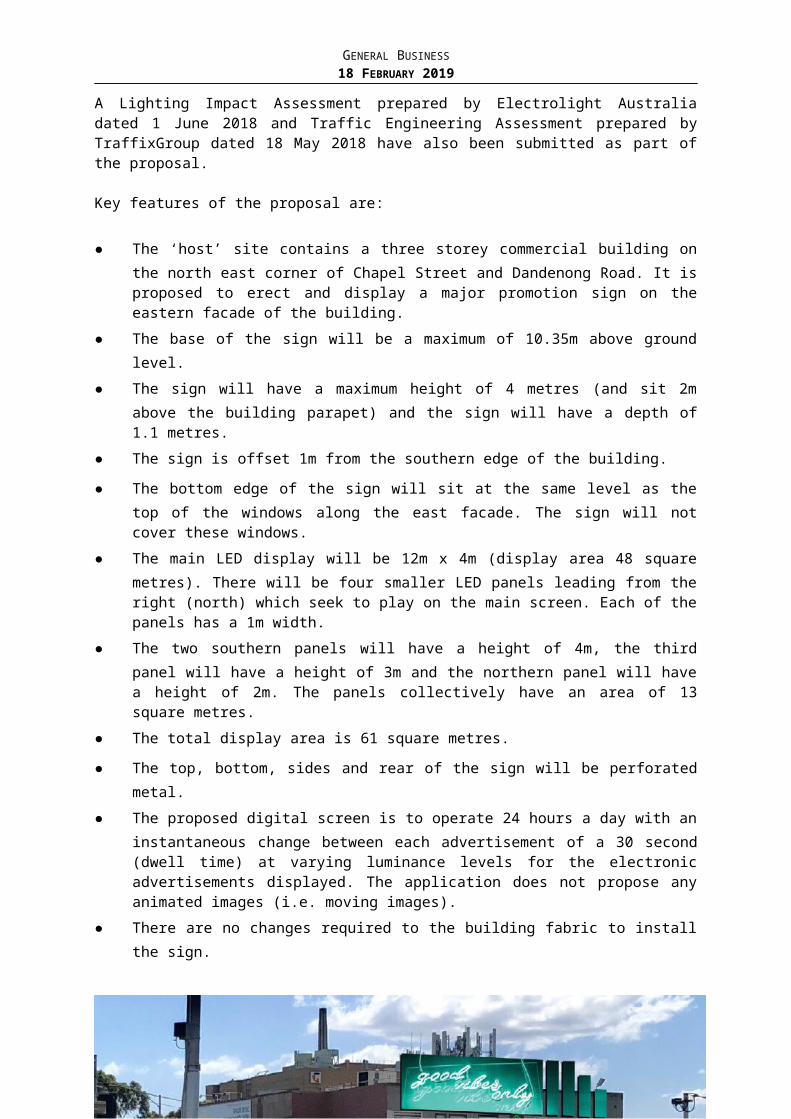
GENERAL BUSINESS18 FEBRUARY 2019
on either their short stays or when they arrived in the street. This allowed for Council to be able to track how long vehicles stayed in the street and when others arrived.
There are approximately 122 on-street parking spaces along Finch Street between High Street and Wattletree Road, with 64 spaces on the east side and 58 spaces on the west side. The maximum number of vehicles observed parked in Finch Street during the survey was 47 vehicles (occupancy rate 39% at 10pm). This occurred for one hour only. This also demonstrated that at the worst time of the entirety of the survey, 75 vacant car spaces were available throughout this section of Finch Street and this happened late in the evening not during business hours. Between 9am and 6pm the average occupancy was 26% (32 out of 122 spaces occupied). On average this equates to 90 vacant spaces available for residents to park.
Restrictions are typically considered in streets without existing restrictions where any of the following criteria are met: the average parking occupancy between 9am and 6pm exceeds 67% occupancy (2/3 occupied); or the average parking occupancy in any 4 hour period exceeds 90. As stated above, the occupancy during business hours is well below 26%, and restrictions would not be considered based on these results.
The occupancy survey indicates there is capacity for residents to park on-street. Given the parking occupancy it is reasonable to assume that there are sufficient passing opportunities for vehicles travelling in opposite directions.
Traffic Surveys (Speed and Volume)
Page 152
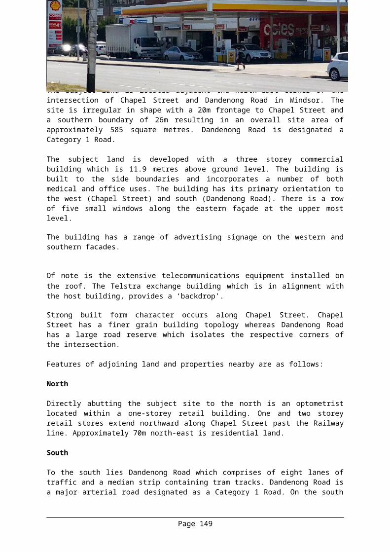
GENERAL BUSINESS18 FEBRUARY 2019
Speed and volume counts were also conducted outside properties #131 and #161 in the period 28 April 2018 to 11 May 2018. The results are as follows:
@ #131 Finch Street @ #161 Finch Street
85th Percentile Speed (km/h) 49 52
Average Speed (km/h) 42 42
Average Traffic Volume (veh/day) 1,522 1,562
The 85th percentile speed (speed at which 85 percent of vehicles surveyed travelled at or below) is usually used to determine whether traffic management devices are necessary. At sites where the 85th percentile speed of vehicles surveyed is greater than 55 km/h (along a street with the default 50km/h speed limit), a further investigation of traffic management works to reduce speeds may be warranted. In situations where the 85 th percentile speed of vehicles surveyed travelled at a speed greater than 50km/h but less than 55km/h (basically 10% tolerance of the speed limit), a speed trailer would typically be deployed to encourage slower traffic speeds by making drivers aware of their speed. This acknowledges that traffic speed is on the high side, but not so high that permanent measures are needed. In this instance the majority of vehicles travelling past property #161 were travelling at or below 52 km/h and it can be considered the majority of vehicles were travelling at the 50 km/h speed limit.
When Council installs traffic management devices to reduce speed in a street, its objective is to encourage the majority of motorists to travel at or below the speed limit. Absolute compliance is not a realistic objective.
The results of the survey also indicate that Finch Street carried on average 1,562 vehicles per day at #161 Finch Street. This was the highest volume recorded and is generally acceptable for a local street.
Peak Traffic Flow along Finch StreetThe traffic survey indicated that the morning peak hour volume was approximately 188 vehicles per hour, which occurred between 8am to 9am. The afternoon peak hour volume was 170 vehicles per hour, which occurred between 5pm to 6pm. Generally, in the peak periods a local access road would be expected to carry approximately 10-15% of the average daily volume, which is the case in this instance.
Intersection Performance (Queue Length Surveys)
Page 153
GENERAL BUSINESS18 FEBRUARY 2019
Existing Conditions – High Street/Finch Street intersection
Figure 1 provides an aerial photo of the High Street/Finch intersection
The intersection has not been treated with kerb outstands or a splitter island and does not provide separate exit turn lanes for right turn and left turn traffic and only provides enough width for one vehicle to turn when exiting on High Street.
This arrangement may cause delays to turning traffic especially during peak periods. This arrangement may discourage through traffic by limiting the capacity of traffic to leave the local street. In other words the delay may act as a deterrent for non-local traffic accessing the street.
Below are the results of a queue length survey at the intersection of High Street/Finch Street (2 August 2018, 7am to 9am and 3:30pm to 6pm).
AM Period (7am to 9am) No. of Vehicles
Distance in Metres
Duration of queue to clear from intersection
Maximum Queue Length 7 35 1 min and 3 seconds
Minimum Queue Length 3 15 12 seconds
Average Queue Length 4 19 31 seconds
PM Period (3:30pm to 6pm) No. of Vehicles
Distance in Metres
Duration of queue to clear from intersection
Maximum Queue Length 4 20 40 seconds
Minimum Queue Length 3 15 6 seconds
Average Queue Length 3 17 25 seconds
Page 154
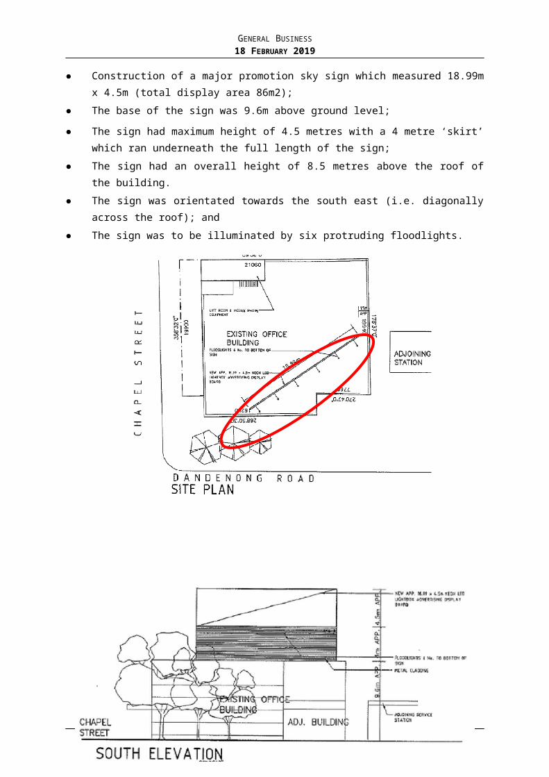
GENERAL BUSINESS18 FEBRUARY 2019
The queue length survey results indicate that a vehicle was stationary at the intersection (in both a queue and at the stop line) on average up to 31 seconds at the Finch Street Street/High Street intersection during the AM peak and up to 25 seconds in the PM peak times. This is considered acceptable and not excessive.
The longest delay during the survey was 1 minutes and 3 seconds.
The 95th percentile queue length which is the queue length (in vehicles) that has only a 5-percent probability of being exceeded during the analysis time period (peak periods in other words) is 7 vehicles in the AM peak and 4 vehicle in the PM peak.
Existing Conditions – Wattletree Road/Finch Street intersection
Figure 2 provides an aerial photo of the Wattletree Road/Finch Street intersection.
The intersection has not been treated with kerb outstands or a physical splitter island. Only a painted narrow median. It does not provide separate exit turn lanes for right turn and left turn traffic and only provides enough width for one vehicle to turn when exiting on Wattletree Road.
As the arrangement at the High Street/Finch Street end, this arrangement may cause delays to turning traffic especially during peak periods. This arrangement may discourage through traffic by limiting the capacity of traffic to leave the local street.
Page 155
GENERAL BUSINESS18 FEBRUARY 2019
Below are the results of a queue length survey at the intersection of Finch Street/Wattletree Road (2 August 2018, 7am to 9am and 3:30pm to 6pm)
AM Period (7am to 9am) No. of Vehicles Distance in Metres
Duration of queue to clear from intersection
Maximum Queue Length 5 25 2 min and 30 seconds
Minimum Queue Length 3 15 22 seconds
Average Queue Length 4 20 1 min and 29 seconds
PM Period (7am to 9am) No. of Vehicles Distance in Metres
Duration of queue to clear from intersection
Maximum Queue Length 7 35 1 min and 47 seconds
Minimum Queue Length 3 15 15 seconds
Average Queue Length 4 19 41 seconds
The queue length survey results at Finch Street/Wattletree Road indicate that a vehicle was stationary at the intersection (in both a queue and at the stop line) on average up to 1 min and 29 seconds during the AM peak and up to 41 seconds in the PM peak times. This is considered acceptable for an unsignalised intersection between a local road and a major arterial.
The longest delay was 2 minutes and 30 seconds which occurred in the AM peak.
The 95th percentile queue length is 5 vehicles in the AM peak and 6 in the PM peak.
Crash History – Finch Street
Further, there has been no casualty crashes recorded in the last five (5) years along Finch Street that required police or emergency service attendance. Based on this there doesn’t appear to be crash trend or history.
Sufficient sight distance is available to see approaching vehicles on at both intersections.
Treatment Options – Advantages and Disadvantages40 km/h speed limit – (suggestion made by resident to Cr Davis via email sent 23 May 2018)
VicRoads is the responsible authority for approving speed limit changes regardless if it’s a local road managed by Council. If Council wishes to set a lower speed limit, a case must be made to VicRoads for this to occur. VicRoads would ask Council to demonstrate that measures have been implemented to reduce speed as lower speed limits with no other speed attenuation devices have been shown over time to have a limited effect on the speed of traffic. In local streets in particular, where enforcement activity is lower, physical measures such as speed humps are generally more effective, particularly in the shorter term.
Typically, 40km/h speed limits are generally limited to a single street in locations with schools, or in activity areas. Council’s 40 km/h speed limits in local streets are currently
Page 156
GENERAL BUSINESS18 FEBRUARY 2019
applied area-wide (preferred) and at the western end of the municipality where the roads are typically narrower, and the speed of traffic on local roads is generally lower.
Residents Only Signage - (suggestion by resident to Cr Davis via email sent 23 May 2018)
Generally, any legally dimensioned vehicle that is registered is permitted to use the road system unless traffic restrictions or controls displayed indicate otherwise. Council generally has three opportunities to restrict access from using local streets either by No Entry restrictions (by use of signs), turn ban restrictions (by use of signs) and physically prohibiting vehicle traffic at a location in the street.
Finch is a public road that is available for the use by the general public.
Residents Only Signage Signs (aka Local Traffic Only signs) were typically installed in the 1980’s as supplementary signage to Local Area Traffic Schemes. Council no longer installs “Local Traffic Only’ signs as they are only an advisory sign which is unlikely to have an effect upon traffic volumes in the street.
Speed Restriction Treatements – (either Horizontal or lateral deflection)
Physical treatments are effective at encouraging motorists to travel at an appropriate speed. Non-invasive types of speed control such as enforcement or advisory signs have generally been found to be unsuccessful.
It should be noted that in the past regular enforcement of the 50 km/h speed limit along Hopetoun Road did not result in a reduction in traffic speed. Records indicated that a similar number of motorists were continually being caught speeding.
While raised pavements or angle slow points are effective at reducing vehicle speed, the placement of road humps/speed cushions and angle slow points are typically the most contentious issue regarding implementation of these types of treatments due to potential noise impacts and parking losses, and proposals can be abandoned if there is low community support as such an indication of community support is required.
Time Based Right Turn Ban (Using signage only)
Time based Turn ban restrictions are primarily used to maintain uniform traffic flow along main arterial roads during peak periods. They are also used to restrict entry to through traffic into a local traffic area, however they are difficult to enforce.
Although they are a cost effective way of reducing traffic movements, they are less effective (over time) as they are also difficult to enforce as they are dependent on Police resources available. Furthermore, it would also make it difficult for residents to exit the area as they would not be exempt from the restriction.
Turn bans may also simply relocate traffic into neighbouring local streets.
A time based restriction would mean that motorists would be able to turn right outside peak periods.
Traffic signals – Both Intersections
Page 157
GENERAL BUSINESS18 FEBRUARY 2019
Installing traffic signals may improve safety and access for the residents, it will likely result in an increase of traffic volume along Finch Street as non-local motorists may find it a more desirable north-south link as delays reduce and impact the residents’ amenity. VicRoads generally does not support signalising local streets with arterial roads for this reason.
Given the delay to High Street and Wattletree Road, specifically for trams, VicRoads have indicated that they will not support signalisation at other similar intersections.
Overall Treatment ConsiderationAlthough some in the community have expressed concern with parking, road safety and delays at both intersections for right turning vehicles; and through (non-local) traffic during peak periods, the data collected for Finch Street showed that there are:
no significant delays experienced at either intersection;
no serious safety issue along Finch or at either intersection;
The volume of traffic is within an acceptable limit for this type of road;
The 85th percentile speed is within range of the prevailing speed limit; and
There are sufficient parking opportunities available throughout the day
Based on the investigation, there is not sufficient evidence to support further traffic management attenuation or parking restrictions at this time.
However, if Council would like to consider traffic management to improve safety at the intersection and reduce through traffic one approach could be to restrict access at the two main access points by installing time based Right Turn Ban Restrictions into Finch Street and/or traffic management devices such road humps or mid-block angle slow points along street. Speed restriction treatments can delay motorists and discourage through traffic by impeding the flow, but this depends on the delay occurring on the alternative route as well.
The above treatments may impact some local residents, so residents would need to demonstrate a desire to have these devices installed outside their property. If there is some support Council could consult the Finch Street residents on a proposal to see if there is any appetite for traffic management.
POLICY IMPLICATIONS
This work formed the base line data to assist Council officers when evaluating the traffic and parking data for Finch Street. This complies with Council’s Road Safety Policy.
FINANCIAL AND RESOURCES IMPLICATIONS
The cost to complete the traffic and parking investigation along Finch Street was $4,200 excluding GST, and was funded from the 2017/18 Financial Year budget.
CONCLUSION
An item was raised at the Council Meeting held 4 June 2018.. A subsequent email was also received from a different resident raising similar concerns. Councillors requested further investigation and a report back to Council of traffic and parking issues along Finch Street and at the Wattletree Road/High Street intersections, Malvern.
Page 158
GENERAL BUSINESS18 FEBRUARY 2019
Traffic and parking surveys were undertaken to inform an understanding of traffic and parking issues along Finch Street between Wattletree Road and High Street.
The parking survey data indicates that there are sufficient parking opportunities available for residents to utilise and no further action is warranted.
The traffic surveys also demonstrated that speed and volume data were within acceptable limits and no further action is warranted.
Intersection counts indicate the average delay at the High Street/Finch Street intersection 31 seconds during the AM peak and 25 seconds in the PM peak times. It should be noted that the longest delay was 1 minutes and 3 seconds. This is considered acceptable and not excessive.
The average delay at the Wattletree Road/Finch Street intersection on average of 1 minute and 29 seconds during the AM peak and 41 seconds in the PM peak times. The longest delay was 2 minutes and 30 seconds and this occurred twice. This is considered acceptable.
HUMAN RIGHTS CONSIDERATION
This recommendation complies with the Charter of Human Rights and Responsibilities Act 2006.
RECOMMENDATIONThat:1. Council notes the results of the traffic investigation and assessment of the
various traffic management options.2. Based on the results of the various traffic and parking studies no further traffic
management attenuation or parking restrictions be implemented at this time.3. Residents requesting traffic and parking management be advised of the outcome
of the investigations and Council’s determination accordingly.
Page 159
GENERAL BUSINESS18 FEBRUARY 2019
12. BEAVER STREET, MALVERN EAST - PROPOSAL TO INSTALL 2-HOUR PARKING RESTRICTIONS
Traffic Engineer: David Ventura Manager Transport & Parking: Ian McLauchlanGeneral Manager Assets & Services: Simon Thomas
PURPOSE
To seek approval to install 2-HOUR parking restrictions operating between 9am to 6pm Monday to Friday, on the north side of Beaver Street, Malvern East (between Tooronga Road and Finch Street).
To seek approval to retain the 2-HOUR parking restrictions currently installed on the north side of Beaver Street (between Finch Street and Burke Road).
Council at its meeting of 24 July, 2017 requested this item come back to Council for consideration after consulting Beaver Street residents.
BACKGROUND
Beaver Street is a local road that runs east-west, between Tooronga Road and Burke Road.
Following receipt of a petition, signed by 11 residents, parking surveys were undertaken in November 2016 as an hourly survey between 7am and 9pm. The surveys indicated the installation of parking restrictions was not warranted. The lead signatory was advised of the results and that no changes were warranted.
In March 2017, three requests for parking restrictions were received from individuals (including the lead signatory from the original request) in the section between Finch Street and Burke Road. On that basis, it was considered warranted to review the parking occupancy in the street to compare with the previously collected data.
On that basis, it was considered warranted to review the parking occupancy in the street to compare with the previously collected November 2016 data. Further investigation was undertaken in March 2017
The follow-up survey indicated that parking occupancy was significantly higher than during the previously conducted surveys, with an average occupancy of 90% between Finch Street and George Street, and 81% between George Street and Burke Road. The surveys also showed approximately 30% of vehicles parked in the street displayed a P plate. Whilst not conclusive, it is likely that many drivers of these vehicles are associated with students at Monash University as they are younger drivers.
Given the high occupancy in the street, it was considered warranted to consult residents on a parking proposal such as 2-HOUR parking restrictions along the entirety of the north side of Beaver Street between Tooronga Road and Burke Road, to discourage all day parking and provide parking opportunities for residents during the day.
Therefore, a circular letter was distributed to residents in Beaver Street on May 2017 with a proposal to:
Install 2-HOUR parking restrictions, operating between 9am and 6pm, Monday to Friday on the north side of Beaver Street.
A report was submitted to the Council Meeting 24 July 2017, summarising the issue and the results of the circular. This report (Attachment A) highlights the reasoning behind the decision. To summarise, the decision was made to only install the proposal in the section of
Page 161
GENERAL BUSINESS18 FEBRUARY 2019
Beaver Street between Finch Street and Burke Road based on a mixed community response between the two sections of Beaver Street (Tooronga Road to Finch Street and Finch Street to Burke Road). Those previously consulted were notified of this decision on 7 August 2017. Council also committed to consult the Beaver Street residents in 12 months’ time to assess the appropriateness of the parking restrictions and the residents were advised accordingly.
Following the Council decision on 24 July 2017, 2-HOUR parking restrictions were installed on the north side of Beaver Street operating between 9am to 6pm Monday to Friday between Finch Street and Burke Road. The remainder of Beaver Street currently remains unrestricted. The below image highlights the existing conditions in the street.
Image 1: Community Result– Beaver Street, between Tooronga Road and Finch Street
In accordance with this Council resolution, a circular letter was sent to the residents of Beaver Street on 31 August 2018. In order to determine the appropriateness of the parking restrictions two circular letters were prepared. The residents of Beaver Street in the section between Tooronga Road and Finch Street were distributed a letter asking whether they wanted the street to remain unrestricted or for the 2-HOUR proposal on the north side to proceed based on their views on the changed parking behaviour in the area. The residents of Beaver Street in the section between Finch Street and Burke Road were asked whether they would like the current 2-HOUR restrictions to be retained or removed.
No further parking surveys have been undertaken at this stage as the March 2017 surveys already indicated parking restrictions for the entirety of the north side of Beaver Street were warranted. In addition, the Council decision was to consult with the residents on the appropriateness of the restrictions.
DISCUSSION
Consultation Result
A total of 45 properties along Beaver Street (between Tooronga Road and Finch Street) were distributed the circular with 31 responses received, equating to a 69% response rate. The responses received are shown in Image 2 and Table 1 below.
Page 162
GENERAL BUSINESS18 FEBRUARY 2019
Image 2: Community Result – Beaver Street, between Tooronga Road and Finch Street
Table 1: Community Result – Beaver Street, between Tooronga Road and Finch Street
Proposal Retain Unrestricted
Install 2-HOUR
Not Stated No Response
Install 2-HOUR Restrictions
12(27%)
19(42%)
0(0%)
14(31%)
A total of 56 properties along Beaver Street (between Finch Street and Burke Road) were distributed a different circular with 30 responses received, equating to a 54% response rate. The responses received are shown in Image 3 and Table 2 below.
Page 163

GENERAL BUSINESS18 FEBRUARY 2019
Image 3: Community Result – Beaver Street, between Finch Street and Burke Road
Table 2: Community Opinion – Beaver Street, between Finch Street and Burke Road
Proposal Retain Remove Not Stated No Response
Retain 2-HOUR Restrictions
26(47%)
4(7%)
0(0%)
26(46%)
A table of respondent’s comments and officer responses to each circular has been included as Attachment B.
Consultation Analysis
For each of the circulars, the majority of the respondents were in favour of the parking restriction option. Between Finch Street and Burke Road the responses received highlighted that the residents in this section of Beaver Street are happy to retain the restrictions which would suggest that the restrictions are working well.
Between Tooronga Road and Finch Street, the majority of the respondents were in favour of introducing 2-HOUR parking restrictions on the north side. This is a significant change from the previous proposal where the majority of residents in this section preferred that the section remain unchanged. With restrictions installed in the Finch Street to Burke Road section of Beaver Street, it is considered that that the parking behaviour in this section of Beaver Street would have changed over the past year. This would explain the different opinion witnessed from the most recent circular where the majority view was for parking restrictions to be installed.
Page 164
GENERAL BUSINESS18 FEBRUARY 2019
Some respondents were against the installation of restrictions as only one side is proposed. This is a usual objection for parking proposals, however the previous analysis indicated parking on one side only was appropriate in the first instance as the resident daytime demand for parking surveyed could be accommodated on one side of the street. Installing restrictions on both sides may also likely transfer parking to other streets, such as Kerferd Street.
The overall response from residents in Beaver Street was in favour of the 2-HOUR parking restrictions.
Officer Assessment
Considering the community feedback discussed above, the majority of residents for the entirety of Beaver Street are now supportive of parking restrictions since the previous proposal. The original consultation highlighted that the residents in the section of Beaver Street between Tooronga Road and Finch Street were not supportive of parking restrictions. A year after the original consultation it would appear that due to the altered parking behaviour this has changed as the majority view from the respondents was for restrictions to be installed. On balance it is recommended that the proposal proceed as presented in the section of Beaver Street between Tooronga Road and Finch Street and that the current restrictions be retained in the section between Finch Street and Burke Road.
CONCLUSION
As required by the Council resolution on 24 July 2017, the residents of Beaver Street were re-consulted on the appropriateness of the parking restrictions installed in the section of Beaver Street between Finch Street and Burke Road. These residents were asked whether they would like the restrictions to be retained or removed. The residents in the section of Beaver Street between Tooronga Road and Finch Street were consulted on a proposal to install 2-HOUR parking restrictions based on the altered parking behaviour. For both circulars the majority response was in favour of parking restrictions based upon the altered parking behaviour witnessed by the residents in the street. Due to this response, it is considered reasonable to retain the existing 2-HOUR parking restrictions between Finch Street and Burke Road and install 2-HOUR restrictions between Tooronga Road and Finch Street proceed.
HUMAN RIGHTS CONSIDERATION
This recommendation complies with the Charter of Human Rights and Responsibilities Act 2006.
ATTACHMENTS
1. Attachment A - Beaver Street, Malvern East - Proposal to Install 2-HOUR Restrictions - Council Report 24 July 2017
Excluded
2. Respondents Comments and Officer Response - Beaver Street, Malvern East - Attachment B CONFIDENTIAL
Excluded
Page 165
GENERAL BUSINESS18 FEBRUARY 2019
RECOMMENDATIONThat Council:1. Installs 2-HOUR parking restrictions operating between 9am to 6pm Monday to
Friday on the north side of Beaver Street from 10m east of Tooronga Road to 10m west of Finch Street;
2. Retains the existing 2-HOUR parking restrictions on the north side of Beaver Street between Finch Street and Burke Road;
3. Notifies those previously consulted on the decision.
Page 166
GENERAL BUSINESS18 FEBRUARY 2019
13. COUNCIL FINANCIAL REPORT FOR THE PERIOD ENDING 31 DECEMBER 2018
Accounting Services Coordinator: Jaime Loh Manager Finance: Jon GorstGeneral Manager Corporate Services: Geoff Cockram
PURPOSE
To provide Council with an update on Stonnington City Council’s financial performance for the period ending 31 December 2018.
BACKGROUND
Section 138 of the Local Government Act requires the provision of a quarterly financial report to an open Council meeting comparing the budgeted revenue and expenditure for the financial year with the actual revenue and expenditure to date.
DISCUSSION
Executive SummaryThe year to date surplus including open space contributions at 31 December 2018 was $83.0M against a budget of $75.5M, a favourable / positive variance of $7.5M.
The year to date surplus excluding open space contributions at 31 December 2018 was $73.2M against a budget of $70.5M, a favourable variance of $2.7M.
The operating surplus is expected to be $45.1M by 30 June 2019, resulting in a forecasted favourable full year variance to budget of $7.3M.
The operating surplus excluding open space contributions is expected to be $30.1M by 30 June 2019, a favourable full year variance to budget of $2.3M.
The year to date surplus is $7.5M greater than the year to date budgeted surplus and is mainly due to:
Higher than budgeted operating income of $5.6M, particularly earlier than budgeted monetary contributions $4.9M, user fees being higher than budgeted by $422K, operating grants income $603K higher than budgeted due to increased grant funding, capital grants income favourable by $260K (unbudgeted grants) and other income being $254K favourable (predominantly unbudgeted cost recoveries). These are partially offset by lower than budgeted rates income ($392K) due to lower Supplementary Rate income and lower than budgeted Statutory Fees & Fines ($442K) due to delays in receiving infringement income from Fines Victoria.
Operating expenditure is $1.9M less than the year to date budget. This is primarily due to the timing of materials and services expenditure $1.2M, borrowing costs being $381K favourable due to budgeted loan borrowings being undertaken in December 2018 (was originally budgeted for July 2018), depreciation being lower than budgeted by $257K (due to delays in the completion and capitalisation of the capital works program) and operating initiatives expenditure being $374K favourable (timing).
As at 31 December 2018, Council held $106.3M in cash and investments. Council achieved a year to date working capital ratio of 3.77, indicating a continued strong ability to meet its current financial commitments. Net assets were $3.1B at 31 December 2018.
Page 167
GENERAL BUSINESS18 FEBRUARY 2019
Operating Result – Full Year ForecastThe full year forecast surplus compared to the full year original budget surplus is expected to be $7.3M favourable.
Operating IncomeFull year income is forecast to be $5.8M favourable as a result of:
$563K higher than budgeted statutory fees and fines, mainly due to higher applications for building certificates and regulatory fees and permit fees income and higher than anticipated infringement income of $421K. The lower year to date statutory fees and fines income at 31 December 2018 when compared to the year to date budget are as a result of issues with Fines Victoria’s (State Government entity) implementation of a new IT system leading to delays in infringement income being passed on to Council.
$255K higher than budgeted user fees, predominantly due to increased demand for the Learn to Swim program $255K, higher than anticipated patronage at the transfer station $100K and higher than budgeted building permit applications due to increased development $221K. These are offset by lower than budgeted utilisation for child care services ($403K).
$4.9M higher than budgeted monetary contributions. The timing of the receipt of contributions can vary depending on the level of development activity.
$325K higher than budgeted capital grants, predominantly due to unbudgeted grants received for the development of female friendly change rooms at Bert Healey Pavilion $180K and Roads to Recovery funding $233K.
$246K higher than budgeted other income, due to unbudgeted recycling funding received from State Government $95K, unbudgeted legal case settlement $140K, State Government cost recoveries for the Valuations function $62K, six months rental income unbudgeted from a property acquisition $66K, and other unbudgeted cost recovery from the Victorian Building Authority for cladding inspections $140K. These are offset by lower than budgeted rental income ($147K) and lower than budgeted interest income on cash and investments ($97K) due to the deferral of the draw down of $20 million loan borrowings to December 2018 (was originally budgeted for July 2018).
These favourable income variances are partially offset by:
$398K lower than budgeted rates income, predominantly due to supplementary rates being lower than anticipated.
$100K lower than budgeted operating grants, predominantly due to the cessation of the Adult Day Activities program due to an end in funding from the Department of Health and Human Services.
Operating ExpenditureFull year operating expenditure is forecast to be $1.5M favourable as a result of:
Employee costs are forecast to be $674K less than budget due to vacancies across the organisation. Where required contractors are engaged to backfill while recruitment is undertaken to ensure continuity of service delivery.
$478K lower than budgeted borrowing costs (interest expense), as a result of planned loan borrowings being undertaken in December 2018 (was originally budgeted for July 2018).
Page 168

GENERAL BUSINESS18 FEBRUARY 2019
$96K lower than budgeted depreciation, due to the timing of the completion and capitalisation of the capital works program.
$161K lower than budgeted other expenses, predominantly as a result of rental expense savings in the Maternal Health and Child Health unit due to alternative accommodation arrangements.
$65K lower than budgeted operating initiatives, mainly due to anticipated savings.
Capital Works Expenditure – Full Year ForecastThe full year forecast net Capital Works expenditure excluding Operating Initiatives at 31 December 2018 is $88.0M. This includes the following key projects:
Toorak/South Yarra Library Air Conditioner Plant and refurbishment $1.6M,
Prahran Market – North East Corner Development $1.0M,
Local Road refurbishment and resurfacing $3.9M,
Yarra River Biodiversity Project $1.5M,
Drainage renewals $1.4M,
Cato Square development $42.4M,
Gardiner Park redevelopment $2.9M,
Stonnington Indoor Sports Stadium $790K,
Prahran Town Hall Masterplan implementation $1.0M,
Princess Gardens Masterplan implementation $1.1M,
Pavilion Redevelopment – Dunlop Pavilion $2.5M,
Strategic property purchases for open space $5.0M,
Toorak Park Masterplan Implementation $1.0M.
The year to date capital expenditure is $44.9M. This equates to 51% of the full year forecast.
Full year net capital expenditure (excluding Operating Initiatives) is forecast to be $88.0M compared to the net original budget of $101.0M. Capital works carry-overs and deferrals to 2019/20 are currently estimated at $14.2M (including the Cato Square project $5.7M; Prahran Town Hall Masterplan development $4.4M; Stonnington Indoor Sports Stadium $1.2M; Harold Holt Swim Centre Masterplan $2.9M and the Art acquisition program $77K).
Cash FlowTotal cash and investments are $106.3M at 31 December 2018. The cash and investments balance is forecast to be $90.7M at 30 June 2019 which is $10.1M greater than budgeted.
The attachment provides Council with the following: Income Statement to 31 December 2018 Full Year Forecast Major Variance Analysis as at 31 December 2018 Balance Sheet as at 31 December 2018 Cash Flow Statement as at 31 December 2018 Financial Performance Indicators to 31 December 2018 Capital Works Expenditure Report as at 31 December 2018.
HUMAN RIGHTS CONSIDERATION
Page 169
GENERAL BUSINESS18 FEBRUARY 2019
This recommendation complies with the Charter of Human Rights and Responsibilities Act 2006.
ATTACHMENTS
1. Council Financial Report for the Period Ending 31 December 2018 Excluded
RECOMMENDATIONThat Council receives and notes the Financial Report for Stonnington City Council for the period ending 31 December 2018.
Page 170
GENERAL BUSINESS18 FEBRUARY 2019
14. VOLUNTEERING
Manager Community Services: Penny Pavlou General Manager Community & Culture: Cath Harrod
PURPOSE
The purpose of this report is to brief Council about the current status and future options for the managing volunteer opportunities in Stonnington.
BACKGROUND
This matter was initially brought to the Councillor Briefing on 12 November 2018 and deferred following discussion. Councillors have requested further information regarding the proposed Volunteer Strategy including timelines for development, resource implications and its proposed application.
The benefits of volunteerism to both individuals and the community as a whole are widely known. The 2016 Census revealed that formal volunteerism in Australia rose by 1.6% from 2011, with 3.6 million people over the age of 15 reporting to be engaged in formal volunteer work through an organisation or group. In addition to this, a 2016 report by Volunteering Victoria estimated that formal volunteering (excluding travel) was worth $29.3 billion to the Australian annual economy. Many not-for-profit organisations and most community organisations rely heavily on volunteer support to operate.
Historically, Stonnington has had an informal and decentralised approach to managing enquiries about volunteerism largely due to resourcing limitations. Prospective volunteers for Council programs or services have either contacted individual departments or have been retained as past program participants in service areas. Limited information about internal and community-based volunteering opportunities exist on Council’s website.
A recent review of volunteerism within Council services revealed the following utilisation of volunteers by Council service units:
Use of volunteers in direct delivery of Council services or programs. Library and Information Services have volunteers working in the home library service and History Centre with plans to expand. Economic Development and Tourism have volunteers assisting on the Arts Acquisition Panel, Fashion Hall of Fame Selection Committee and the Liquor Accord Committee.
Indirect utilisation of volunteers. Service units such as Aquatic Services, Recreation Services and Youth Services utilise volunteers indirectly by outsourcing programs to operators who engage volunteers.
Most service units report difficulties in recruitment and management as being key constraints to utilising volunteers within Council services and programs.
Through the Community Grants Program, Council also supports groups and organisations who provide opportunities and training for volunteers such as Inclusion Melbourne, Sacred Heart Mission, St Joseph’s Outreach Services, Helping Hoops, Stonnington Toy Library, Prahran Citizens Advice Bureau, Uniting and the Malvern Historical Society.
The recently adopted Positive Ageing Strategy 2018-2021 identifies volunteering as a key priority area based on the needs, concerns and aspirations of older residents of Stonnington. Specifically, the Strategy states that Council will explore ways to promote and facilitate a more active engagement in civic life, by promoting the advantages of volunteering to the community.
DISCUSSION
Page 171

GENERAL BUSINESS18 FEBRUARY 2019
Through its website, Stonnington currently directs enquires about volunteerism to either the Stonnington Community Directory or to an external website containing a national database called Go Volunteer that aims to link interested people with volunteering opportunities in the broader community. This database relies on individuals to register their interests and skills as well as organisations to regularly update and advertise their volunteering opportunities. A test of the database reveals few listings for opportunities in the Stonnington area which indicates that the application is not widely used by local organisations seeking volunteers.
Officers recently reviewed a sample of 15 Councils across Melbourne to benchmark volunteer enquiry and management options. The review highlighted that there are a number of varying approaches that other Councils have taken in this area, with some focusing on internal opportunities within Council services and others taking a whole community approach.
Most Councils are working within one of the following models:
1. Internal focus: Website advertising and/or use of employee recruitment platform for internal Council opportunities only. With or without providing links to Go Volunteer or Seek Volunteer for wider community options.
2. Volunteer portal: Directly managing and resourcing an internal portal with a database to link people with volunteering opportunities both within Council and in the wider community
3. Partnership: Partnering or supporting a Victorian Volunteer Support Agency to manage all aspects of volunteerism in the local community.
4. Direct management: Directly managing a Victorian Volunteer Support Agency to manage all aspects of volunteerism in the local community
While most Councils had internal possibilities or links to agencies on their Council website, Kingston, Bayside and Port Phillip have established dedicated volunteer enquiry and resource portals with databases. These portals are supported and resourced directly by Council and provide opportunities for both individuals to register their interest and organisations/groups to advertise opportunities. Most portals also provide resources to support organisations in the management of volunteers and some provide other community service information.
Other Councils including Monash, Manningham, Frankston and Glen Eira provide varying levels of financial support to local not-for-profit Victorian Volunteer Support Agencies to provide a comprehensive volunteer management service within their local areas. These agencies also receive funding from the Department of Social Support (DSS) and work collaboratively to match volunteers with opportunities and assist to recruit and train volunteers. Some agencies also supply other Home and Community Care services and receive federal funding for this. Council affiliation and support of Volunteer Support Agencies seems to be dependent on the existence of an organisation within the municipality or surrounding area. The closest agencies to Stonnington are Volunteering Glen Eira and the Boroondara Volunteer Resource Centre, however there is not an agency working directly within Stonnington.
Boroondara City Council is one of the few Victorian Councils directly operating a Victorian Volunteer Support Agency at the Boroondara Volunteer Resource Centre (BVRC). Originally formed as an independent not-for-profit agency, Boroondara City Council took over management of the service a number of years ago to actively support and encourage volunteering in the community. Operating out of the Council’s Civic Centre in Camberwell, the Resource Centre provides a wide range of services to volunteers and organisations and runs a large annual expo and regular events to promote volunteerism. The Centre is staffed by two full-time and two part-time Council employees as well as volunteers.
The Centre refers over 1,000 prospective volunteers to community organisations per year and does see a number of Stonnington residents utilise its service.
Page 172

GENERAL BUSINESS18 FEBRUARY 2019
Stonnington has an opportunity to better encourage and facilitate volunteerism in the community by implementing a new approach to volunteer enquiry and management.
The development of a Volunteer Strategy will enable improved coordination and management of volunteers and volunteer opportunities by Council. It is proposed that the development of such a strategy will include:
further investigation of the potential options for volunteer management by Council, including their resource implications, feasibility and expected benefit
a review of volunteering programs, services and opportunities available across the municipality
a review of relevant Council strategies (e.g. Positive Ageing Strategy, Access and Inclusion Plan, Children Youth and Family Strategy) to determine links
analysis of Council’s role in supporting, promoting or directly providing volunteer opportunities
consultation with the community and agencies to determine priorities.
This work is expected to commence in February 2019. Outcomes from planning and community consultation will be brought to Council once completed along with a draft Volunteer Strategy for consideration.
POLICY IMPLICATIONS
The review of volunteering and development of a Volunteer Strategy will address the following objective outlined in the Positive Ageing Strategy 2018-2021: “Explore ways to promote and facilitate a more active engagement in civic life… by promoting the advantages of volunteering to the community.” However it should be noted that the Volunteer Strategy will have a universal application.
The development of a Volunteer Strategy also aligns closely with the ‘Community’ pillar of the Council Plan 2017-2021.
FINANCIAL AND RESOURCES IMPLICATIONS
Funding associated with the development of a Volunteer Strategy will be accommodated within Council’s 2018/19 and 2019/20 operating budgets.
CONCLUSION
Volunteerism provides many important social and economic benefits to the community and local organisations. Historically, Stonnington has had an informal and decentralised approach to managing enquiries about volunteerism largely due to resourcing limitations. Stonnington has an opportunity to better encourage and facilitate volunteerism in the community by implementing a new approach to volunteer enquiry and management. The development of a Volunteer Strategy will enable improved coordination and management of volunteers and volunteer opportunities by Council.
HUMAN RIGHTS CONSIDERATION
This recommendation complies with the Charter of Human Rights and Responsibilities Act 2006.
RECOMMENDATIONThat Council approves the development of a Volunteer Strategy including:
Page 173

GENERAL BUSINESS18 FEBRUARY 2019
further investigation of the potential options for volunteer management by Council, including their resource implications, feasibility and expected benefit
a review of volunteering programs, services and opportunities available across the municipality
a review of relevant Council strategies to determine links analysis of Council’s role in supporting, promoting or directly providing
volunteer opportunities consultation with the community and agencies to determine priorities.
Page 174