agenda siloam springs board of directors
TRANSCRIPT

AGENDA
SILOAM SPRINGS BOARD OF DIRECTORS AUGUST 4, 2020
BOARD MEETING / 6:30 PM
Regular Board of Directors Meeting: Opening of Regularly Scheduled Meeting
Call to Order Roll Call Prayer Pledge of Allegiance Public Input
The public may address the Board of Directors regarding any item on the consent agenda or any city business not listed on the Board’s regular agenda.
I. Consent Agenda A. Regular Meeting Minutes, July 21, 2020 B. Memorandum of Understanding / Siloam Springs School District / School Resource Officers /
Police Department / $165,862.15 C. Dedication of Utility Easements / 1000 Block of S. Washington Street & 600 Block of E.
Kenwood Street D. Arkansas Department of Aeronautics Grant Application and Garver Engineering Work Order #05
/ Airport / Pavement Marking Rehabilitation Project E. Contract Amendment / Public Works Department / Water Division / Design-Build Services /
Water Treatment Plant Upgrade / Burns & McDonnell Engineers
II. Regularly Scheduled Items Ordinances F. Ordinance 20-18 / 3rd Reading / Amending Section 102-21 of the City Municipal Code / Rezoning
from R-2 to P-D / 700 to 1000 Block of Hwy. 16 South G. Ordinance 20-19 / 3rd Reading / Annexation of 53.63 acres / 23000 Block of Lawlis Road H. Ordinance 20-25 / 1st Reading / Amending Section 102-21 of the City Municipal Code / Rezoning
from I-1 to C-2 / 4650 Hwy. 412 East Resolutions I. Resolution 39-20 / Preliminary Plat Development Permit / Fox Tail Addition South / 2000 to
2500 Block of E. Kenwood Street Staff Reports J. June Financials K. Administrator’s Report
III. Directors Reports
IV. Adjournment

MINUTES OF THE REGULAR MEETING OF THE BOARD OF DIRECTORS OF THE
CITY OF SILOAM SPRINGS, BENTON COUNTY, ARKANSAS, HELD JULY 21, 2020
The City of Siloam Springs, Arkansas, met in regular session at the City of Siloam Springs Administration Building on July 21, 2020. The meeting was called to order by Mayor John Turner. Roll Call: Sappington, Smiley, Burns, Rissler, Hunt, Carroll, Coleman – Present. City Representatives Present: Phillip Patterson, City Administrator; Renea Ellis, City Clerk; Adam Rusk, “C” Platoon Battalion Chief; Justin Bland, City Engineer; Ben Rhoads, Sr. City Planner; Phil Stokes, Electric Director; Jay Williams, City Attorney; and Police Chief Allan Gilbert. Opening prayer was led by Director Coleman. Public Input: Larry Kenemore, 207 Western Hills Drive, asked why phasing out the city’s early warning system was being considered and if the public had been asked their thoughts. Blake Jones, 2007 N. Carl, spoke about a previous lawsuit filed against the city; personal experiences and alleged wrong doings by the Police Department against him. Consent Agenda: A. Workshop Minutes, July 7, 2020 B. Regular Meeting Minutes, July 7, 2020 C. Mutual Aid Agreement / Electric / Grand River Dam Authority (GRDA) D. Amendment / Administration / Chamber of Commerce Makerspace Agreement E. Resolution 37-20 / Setting Hearing Date for Annexation of City Enclaves / August 18,
2020 F. Resolution 38-20 / Final Plat Development Permit / Ashley’s Park Addition / 2200 Block
of N. Hico Street The Mayor announced that a scrivener’s error in the minutes of the July 7th regular meeting at Resolution 36-20 which identified Ben Rhoads as briefing the item. It was corrected to reflect Phillip Patterson briefed the item. A motion was made by Coleman and seconded by Smiley to approve the consent items. Turner called for a roll call vote. Motion passed unanimously. Item G: Ordinance 20-18 / 2nd Reading / Amending Section 102-21 of the City Municipal Code / Rezoning from R-2 to P-D / 700 to 1000 Block of Hwy. 16 South. Ben Rhoads briefed the item. A motion was made by Carroll and seconded by Coleman to place Ordinance 20-18 on its second reading, suspending the rules and reading title only. Motion passed unanimously.

Board of Directors Meeting Minutes Page | 2 July 21, 2020 An ordinance entitled: An Ordinance Amending Section 102-21 of the Siloam Springs Municipal Code (city zoning map); Rezoning (from R-2 to P-D) the property located at the 700 to 1000 Block of Highway 16 South; was read on its second reading. Item H: Ordinance 20-19 / 2nd Reading / Annexation of 53.63 acres / 23000 Block of Lawlis Road. Ben Rhoads briefed the item. Larry McCredy with RMP, LLC, announced he was present on behalf of the applicant and available for questions. A motion was made by Smiley and seconded by Burns to place Ordinance 20-19 on its second reading, suspending the rules and reading title only. Motion passed unanimously. An ordinance entitled: An Ordinance accepting the annexation of certain territory to the city of Siloam Springs, Arkansas and assigning same to a Ward; was read on its second reading.
Item I: Ordinance Introduction / Annexation of Enclave “A” thru “E” / (A) W. Villa View Dr. & S. Hwy 43 / (B) 15589 Stephens Rd. / (C) S. Hwy. 16 & 3402 Hwy. 412 E. / (D) 3000 Block of Hwy. 412 E. / (E) 3870 Hwy. 412 E. Phillip Patterson gave a background on the issue of annexing enclaves. Ben Rhoads briefed the items. Questions from Burns were addressed by Patterson. Administrator’s Report: Patterson reported an expenditure in the Electric Department for inventory for forty (40) 30-foot light poles with 6-foot arms in the amount of $32,360.00; pointed out Governor Hutchinson’s Executive Order 20-43 mandating the wearing of face coverings became effective July 20; that the Covid-19 case number were now available on the Arkansas Center for Health Improvement website and provided a link; announced the Kayak Park has been closed until further notice; the Dogwood Festival was cancelled as well as Memorial Park programming; and that June sales tax receipts were up for the city 7.6% and for the year 11.9%; and down for the county 11%, but up 7.7% for the year; and that early voting is August 4 – 10 with the primary election being held on August 11th. He also announced that all registered voters within the city limits could vote for all three at-large positions as well as for the mayor. Directors Reports: Burns stated the “Main Event” was this Friday and virtual this year. He pointed out that citizens were spreading misinformation on social media; stated that cities spend money, that Siloam was fiscally sound; that a workshop had been held on the Early Warning System the city has and said the systems were just not effective; asked citizens to stop living in the past; stated lessons had been learned; that the city’s current noise ordinance would be reviewed, and apologized for those citizens spreading misinformation. Sappington thanked Burns for his comments; said she had learned a lot during her time on the board; pointed out there are restrains and limitations that have to be followed before passing items; stated the Manna Center was in need of volunteers and canned goods; and that she was blessed to live in Siloam. Rissler thanked everyone who had reached out to her family
Board of Directors Meeting Minutes Page | 3 July 21, 2020 regarding the loss of her grandfather; said he and his wife were the reasons her family was in Siloam and that she was raised here. Carroll said he was proud of our city; and urged the audience to exercise their right to vote on August 11. Smiley extended condolences to Rissler and the family of Dale Willis; thanked Burns for his comments and cautioned the audience not to believe the scare tactics they see on social media; gave facts about the numbers with regard to the early warning system, including the cost of upgrading, maintaining, and/or replacing the system. Coleman said he was pleased with the sales tax numbers; gave kudos to everyone for patronizing local establishments through this crisis; and repeated the need for “builders” not “wreckers.” Colman made a motion to convene into executive session to discuss the employment of the city administrator, which was seconded by Burns. The motion passed unanimously. The board went into executive session at 7:23p. The board reconvened at 7:53p. Coleman made a motion to amend the city administrator’s contract to reflect, if he is terminated without cause, his severance will be for 12 months. Motion passed unanimously. With no further business, a Motion to adjourn was made by Hunt and seconded by Burns. A voice vote was called. Motion passed unanimously. Meeting adjourned. APPROVED: ATTEST: _________________________________ John Mark Turner, Mayor ______________________________ Renea Ellis, City Clerk {seal}

STAFF REPORT
TO: Phillip Patterson, City Administrator FROM: Allan Gilbert, Police Chief DATE: July 17th, 2020 RE: Memorandum of Understanding / Siloam Springs School District / School Resource Officers
/ Police Department / $165,862.15 Recommendation: Approve the Memorandum of Understanding between the Siloam Springs School District and the City of Siloam Springs for School Resource Officers in the 2020-2021 school year. Background: The City of Siloam Springs and the Siloam Springs School District are committed to maintaining an effective School Resource program. This commitment is strengthened through clear statements regarding the authority exercised by School Resource Officers (SRO), their duties and training and the cost sharing between City and the District. The current agreement was approved by the Board of Directors on August 6, 2019 and covered the 2019-2020 school year. The agreement for 2020-2021 was signed by the Siloam Springs School District on July 15, 2020. The agreement is approved on an annual basis to maintain School Resource Officers in the schools. The 2020-2021 memorandum retains the number of SRO positions at five (5) officers; maintains current purpose and terms; memorializes the obligations of both parties and provides for the District’s involvement in the selection, transfer and removal of SRO’s. This memorandum also articulates the responsibilities of SRO’s, clearly outlines the cost sharing agreement between the City and the District, defines the times and places SRO’s will be engaged in District activities, and provides for the amicable resolution of events. Fiscal Impact: The District will reimburse the City for one-half of the annual salaries, payroll taxes, and retirement for the officers involved in the SRO Program. The District also agrees to compensate the City $4000 per SRO position for vehicle maintenance and officer equipment, and to pay 100% of the officers’ school-related overtime. The City will bill the District on a monthly basis for overtime. Anticipated revenue to the city is estimated to be $165,862.15. Attachments: None

STAFF REPORT
TO: Phillip Patterson, City Administrator FROM: Justin Bland, PE, City Engineer Ben Rhoads, AICP, Senior Planner Cc: Don Clark, Community Development Director DATE: July 21, 2020 RE: Dedication of Utility Easements / 1000 Block of S. Washington Street & 600 Block of E.
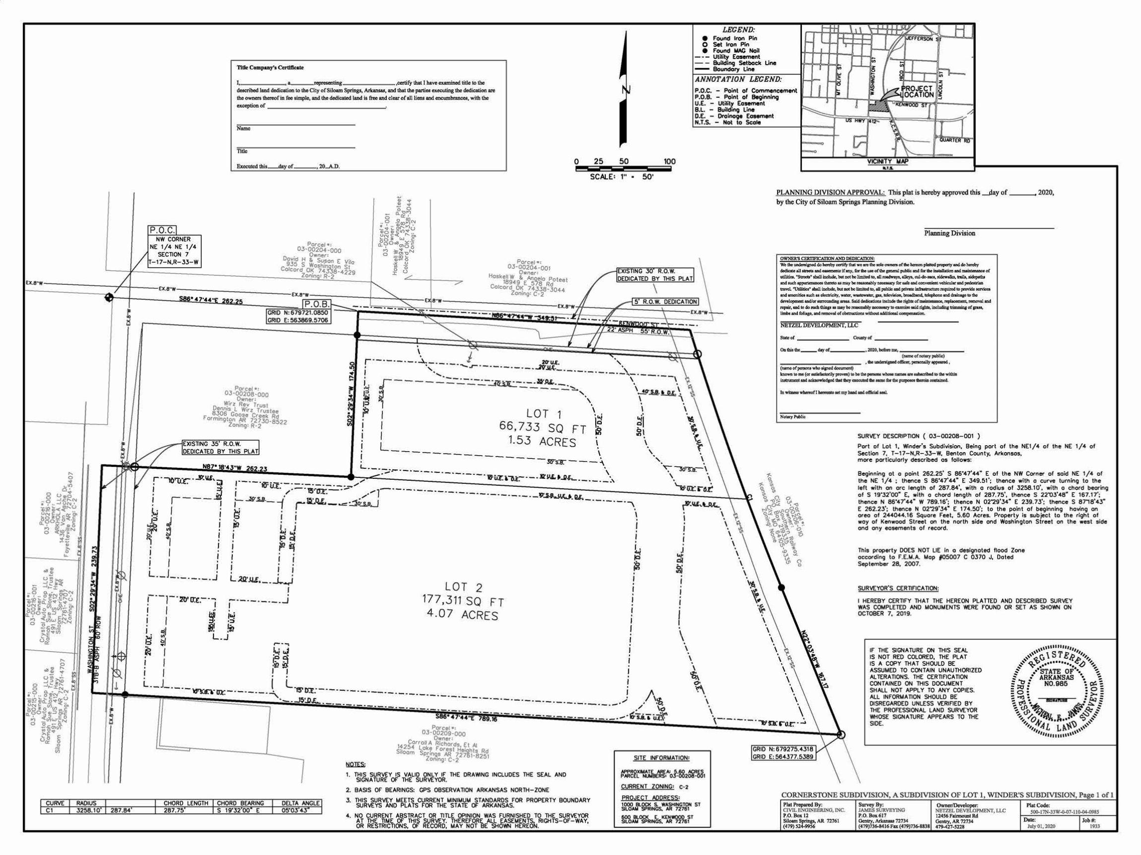
Kenwood Street Recommendation: Approve the dedication of utility easements in the 1000 Block of S. Washington Street & the 600 Block of E. Kenwood Street.
Background: The applicant, Netzel Development, LLC, requested a lot split permit to split the subject property into two lots, creating the Cornerstone Subdivision. Following City policy, the proposed easements for dedication are presented to the Board for approval. The easements will primarily be used for City and franchise utilities per the dedication language shown on the attached plat. City staff will approve the plat pending authorization from the Board to accept the easements, as shown. Fiscal Impact: Staff is not aware of any fiscal impact associated with accepting the dedication of the shown utility easements. Attachments: Lot Split Plat
l
; w
CURVE RADIUS Cl 3258.10 287.84
Tiiie Compuy'1 Cutlllcatc
LEGEND: e Found Iron Pin 0 Set Iron Pin • Found MAG Non
- - - utmty Easement - - BuilcliRCJ Setback Une - Boundary LIM
.,__ _____ a_repmeo1ing ,certify that I haveeumined utle to the ANNOTATION LEGEND: dacnl>ed J1111d dedie1tioo to lhe City of Siloam Springs, Arlamsu, and lhlt lhe poniea executiog the dedicatioo ..e lh<oownen-fin feesin>p~ lndlhededicated Wid is free Ind clear of all limuod eocwnbnncea, wilh lhe e~onor _____________ ~
P.O.C. NW CORNER
NE 1/4 NE 1/4 SECTION 7
-17- N,R- 33- W
Name
Titlc
,20..A.D.
PClfcet •= 03-00204-000
D . Owner:
ov1d H g, Susan E v~ 935 S Woshil]llton St
0
Colcord 015 74.Y.58-4229
Porcel • : 03·00208·000
• Owner: ~1rz Rey Trust
Dennis l W1r z Trustee 8~06 Goose Creek Rd
f'ormlllgton ~ 72730-8522 Zoning: R-2
Zon1n : R-2
EXISTING 35 R.O.W. DEOICA TED BY THIS PLAT
: · 10'Tl:c · '-""· iJ
r· . I . •'"!
~ p
.
Porcel •: 03-00204-001
Owner: Haskell W g, Angelo Pote t
18949 E 578 Rd e Colcord O~ 7 4335. 3044
Zoning: C·2
0 25 50 100 - - -- - ---SCALE: 1" • 50'
EXISTING 30 .O.W. DEDICATED BY THIS PLAT
\
\
-~------ J 20'1/.£. · , ·, "'"-..r- · ----------JV'..11.(. • ........ -·- .. ---·-·-·-'-·-----
.r---- -::.-:.:...-:.:...-:.:...~ul::..--- -»·.o.r...__ '. \ ~ ~ - - - - - -:::,...'·, '~.a..t_u, \ *' r . . I LOT 1 \ . I \
I 66, 733 SQ FT l~ ~j .\ I ~ ~~ ~ L 1.53 ACRES \ , l----------- \ \ .
L----·1-·-· -------ws:ir.---:._ ·, \
·~J<>'T.Q-. \ \ . \ . \
·-·-- 'If ur. r oi. I ,---~ . I J..; I rir.""' '-.P.<..., . .i? i ""° 71"' ~ 1
I . I
. I I I I . . I
I . I . I .
'. ~ \ ~
\ .. . \
.I .... c:iJ
\ . \ .
VICIN TY .... .. PLANNING DNISION APPROVAL: This plat is hereby approved this ......day of ___ 2020, by the City of Siloam Springs Planning Division.
Planning Division
OWNBR'S CERTlPJCAITON AND D£DJCAJ10": We tho ~sncd 4o llcftoby oertify U ~ arc the IOlo ownc:r.. of die hcrcoa pkfticid pqlCl1y uid do bcftby
dodic:lic &ll ArocU ttd wr.t IC lllY· b lb.'* otl.M pw:ral pAiHe: aid rot dw ~and m1&.t-aeco or llll'Utb.. "Suma• tha1l ~bat flOl be Jimhocl co, ID toeehtays. &lltyl, c:ul-do-.a. t!dcwalb. ~ lidcpltht md. sucli appurlalaDoa& ~ at may be reuan.bly t)COeMary ror ute and eoaVU1iant. vdtiait:ar and pedeslriaD
u:a'YCI. ~ llhall ~Wt DOC bo limited to. d public IDd priVllDC idulil QCt:Qlc tcqubd IO pn:widc la'Yiocl aod ~tudi. u doccricity. Wft:I', ~ICr. pa. idtrilion. broedbeod, ldcphoao lad dniclp to the development wV« lllmJaDdia& arw. Sa!d ~ 1 lli dnn• l:Dctodo the dsbll of awio , ""' ' W'r'l1 ~ rcp;ir, ao4 to 4oJlllCla dliop • •Y bo~ llOOCN&rY to czercilO Mid.Qabtl, ~trimminf of p-. limbf ar.:I ~.,.;I l1:Q'IOVll of~ wf(bogt tdditional ~(1111,.
NETZEL DEVELOPMENT, U.C
S!Jdeot ------ c-yot ------O.Cbittbc __ <klyof ____ , 2020, bcfino::ll. _______ _
(riuneof.riowy public)
---------- .... -·-·--· c-or_. ... """4"""""""> knowo 10 me (or utif£ietorily }X'O'tell) llO bo ibe penOllJ wbote Ml* .,.. Mlb9cn1*1 llO die within f:nJuumcnt &Dd acbolrlcdgtd !hit Ibey C1CCOJtCc1 tle MDC for Cbc pnrpolCt 1bcrciai OOGt&iricd.
SURVEY DESCRIPTION ( 03-00208-001 )
Port of lot 1, Winder's Subdivision, Being port of the NE1/4 of the NE 1/4 of Section 7, T- 17- N,R- 33- W, Benton Covnty, Arkonsos, more porticulorly described os follows:
Beginning ot o point 262.25' S 86'47'44" E of tho NW Corner of soid NE 1/4 of the NE 1/4 : thence S 86'47'44• E 349.51'; thence with o curve turning to the left with on ore length of 287.84', with o radius of 3258.10'. with o chord beoring of s 19·32'00· E, with o chOf'd length of 287.75', thence s 22'03'48" E 167.17'; thence N 86'47'44• W 789.16'; thence N 02'29'34• E 239.73'; thence S 8718'43" E 262.23'; thence N 02'29'34" E 174.50'; to tho point of beginning having on oreo of 244044.16 Square Feet, 5.60 Acres. Property is subject to the right of woy of Kenwood Street on the north side ond Washington Street on tho west sido ond any easements of recOf'd.
This property DOES NOT LIE in o designated flood Zone occOf'ding to f.E.M.A. Mop f05007 C 0370 J, Doted September 28, 2007.
L._J ________ j j I 1
. I I L~·.c.u. __ _L__i
L JO ·o Jiil • ~ . \
I '.---1--2tl' [J:<",-- ~, .J.
<. ,----------
' I !:§ ii.! i I ~ ·:::. • "" 1-1 ai) :!1: ,:!? ~ fJ L.J
~ I . I I I
,.... . .., Ii.; tJ ~~ ·~~ ! !
LOT 2 177,311 SQ FT 4.07 ACRES
j_ __ J __ _ ·-mn-or. I L.15' "--'\. Ir.!:--------------·--
. - - J~:.0.£.. ---- ..
CHORD LENGTH CHORD BEARING DELTA ANGLE 287.75 S 19'32 00 E 05'03 43
Porcet •: 03-00209-000
Ovrner: 14 CorroU A Richerds Et Al S"l254 Lok\! forest Hojghts Rd •com Sprrnqs AR 72761-8251
Zoning: C-2
1. THIS SURVEY IS VALID ONLY If" THE DRAWING INCLUDES THE SEAL AND SIGNATURE Of THE SURVEYOR.
2. BASIS Of BEARINGS: GPS OBSERVATION ARKANSAS NORTH- ZONE
3. THIS SURVEY MEETS CURRENT MINIMUM STANDARDS FOR PROPERTY BOUNDARY SURVEYS AND PLATS FOR THE STA TE Of ARKANSAS.
4. NO CURRENT ABSTRACT OR TITLE OPINION WAS FURNISHED TO THE SURVEYOR AT THE TIME Of THIS SURVEY. THEREFORE ALL EASEMENTS. RIGHTS-Of-WAY, OR RESTRICTIONS, Of RECORD. MAY NOT BE SHOWN HEREON.
I . I . I
. I I
. I
I
I
. I \ .
\ . \
\ 'ti, o• ".'\ .1\t.. .
/ \o ,.,, --- '\'\ ·-----·1rs.a. , U:V:·
SITE INFORMATION:
~W:~~·"'o.!:882~661 CURRENT ZONING: C·2
PROJECT AQQRESS: 1000 lll.00< S. WASHiNCTOlt ST SILOAM SPRINGS. AR 72761
600 !LOO< E. KENWOOD ST Sll.OAM SPRINGS. AR 72761
\ . \ \--
. \~
·~-·~ ~.
\ . \ .
\ • \ ~ \ ·~ . ~
\ • \ .
\ • \
GRID N: 679275.4318 GRID E: 564377.5389
SURVEYOR'S CERTIFICATION:
I HEREBY CERTIFY THAT THE HEREON PLATTED AND DESCRIBED SURVEY WAS COMPLETED AND MONUMENTS WERE FOUND OR SET AS SHO'Mj ON OCTOBER 7, 2019.
If THE SfGNA TURE ON THIS SEAL IS NOT RED COLORED, THE PLAT IS A COPY THAT SHOULD BE ASSUMED TO CONTAIN UNAUTHORIZED Al TERA TIONS. THE CERTIFICATION CONTAINED ON THIS DOCUMENT SHALL NOT APPLY TO ANY COPIES. All INFORMATION SHOULD BE DISREGARDED UNLESS VERIFIED BY THE PROFESSIONAL LAND SURVEYOR WHOSE SIGNATURE APPEARS TO THE SIDE.
\,,, ...... ,,,, ,, ,,
,,,, ,. \ S Te b ,,,, ,, <H> <( b ''
,, a__V • • • • • • • • -C . .A ,, ... " - ••• • • <./ , ~ •'STATE OF'• ', ~ . .. ~
: "t1 / ARKANSAS •,. ~ : - : N0.985 ~ ¢.: - ~ . • 0 -- 0 . • -- . . ~ -- "'s:\. • -:. ~ • dlli+o& : ~ :
\~·~~ \~~&i .:,.~ ~·~.:,, OJ,. .i .•• ~ ...... ,, ,,,. .. ,... ,, ,,,, 'IL Lf..r<Y ,,,, ,,, ,,, ,,,,.,,.,,,,
CORNERSTONE SUBDIVISION, A SUBDMSION OF LOT 1, WINDER'S SUBDMSION, P11ge 1 of 1 PW Pn:pan:d By: CIVIL ENOtNEBRJNO, INC. P.O.Box 12 Sil- Sprioas. AR 72761 (479) $24-99~
Survey By: JAMES SURVEYING P.O.Box617 Ocolty, ""'- 727:M (479)736-$416 FIX (479)736-8838
Owncr/Dcvoloper: NllTZBL Ol!VEWPMENT, LLC 124$6 Ft.itl:ocru:Dt :Rd Gcmry, AR 72734 479-427-$228
Pla1Code: 5()().17N-33W.o-07-l l 0-04-0985
Date: Job#; loly OJ, 2020 1933
STAFF REPORT
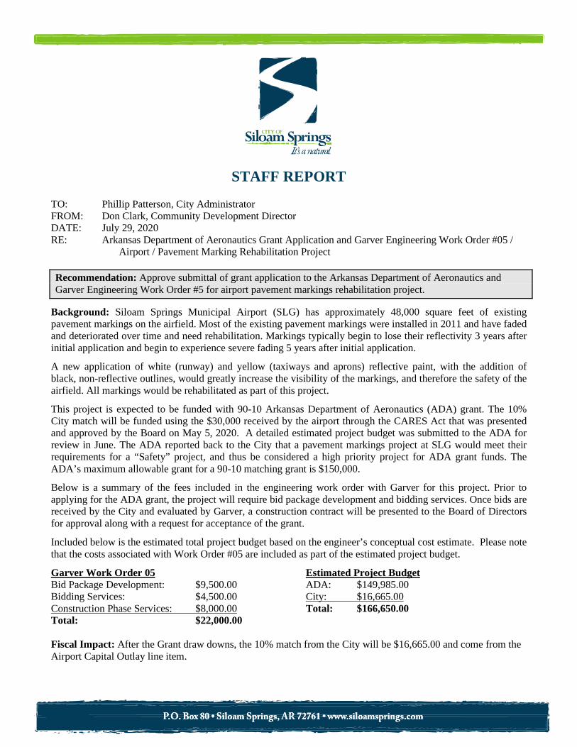
TO: Phillip Patterson, City Administrator FROM: Don Clark, Community Development Director DATE: July 29, 2020 RE: Arkansas Department of Aeronautics Grant Application and Garver Engineering Work Order #05 /
Airport / Pavement Marking Rehabilitation Project Recommendation: Approve submittal of grant application to the Arkansas Department of Aeronautics and Garver Engineering Work Order #5 for airport pavement markings rehabilitation project.
Background: Siloam Springs Municipal Airport (SLG) has approximately 48,000 square feet of existing pavement markings on the airfield. Most of the existing pavement markings were installed in 2011 and have faded and deteriorated over time and need rehabilitation. Markings typically begin to lose their reflectivity 3 years after initial application and begin to experience severe fading 5 years after initial application.
A new application of white (runway) and yellow (taxiways and aprons) reflective paint, with the addition of black, non-reflective outlines, would greatly increase the visibility of the markings, and therefore the safety of the airfield. All markings would be rehabilitated as part of this project.
This project is expected to be funded with 90-10 Arkansas Department of Aeronautics (ADA) grant. The 10% City match will be funded using the $30,000 received by the airport through the CARES Act that was presented and approved by the Board on May 5, 2020. A detailed estimated project budget was submitted to the ADA for review in June. The ADA reported back to the City that a pavement markings project at SLG would meet their requirements for a “Safety” project, and thus be considered a high priority project for ADA grant funds. The ADA’s maximum allowable grant for a 90-10 matching grant is $150,000.
Below is a summary of the fees included in the engineering work order with Garver for this project. Prior to applying for the ADA grant, the project will require bid package development and bidding services. Once bids are received by the City and evaluated by Garver, a construction contract will be presented to the Board of Directors for approval along with a request for acceptance of the grant.
Included below is the estimated total project budget based on the engineer’s conceptual cost estimate. Please note that the costs associated with Work Order #05 are included as part of the estimated project budget.
Garver Work Order 05 Estimated Project Budget Bid Package Development: $9,500.00 ADA: $149,985.00 Bidding Services: $4,500.00 City: $16,665.00 Construction Phase Services: $8,000.00 Total: $166,650.00 Total: $22,000.00 Fiscal Impact: After the Grant draw downs, the 10% match from the City will be $16,665.00 and come from the Airport Capital Outlay line item.

STAFF REPORT
TO: Phillip Patterson, City Administrator FROM: Steve Gorszczyk, Public Works Director DATE: July 27, 2020 RE: Contract Amendment / Public Works Department / Water Division / Design-Build Services /
Water Treatment Plant Upgrade / Burns & McDonnell Engineers Recommendation: Approve contract amendment for design-build services with Burns and McDonnell Engineers for the design and construction of the water treatment plant upgrade. Background: The contract for design-build services with Burns & McDonnell Engineers was approved by the Board on January 21, 2020. The contract put Burns & McDonnell in the role of both the engineer and general contractor. As a result, the Arkansas Natural Resources Commission (ANRC) is asking for an amendment to Exhibit D of the contract, the design-builder’s scope of services. The amendment being requested by ANRC adds language that is required by the Environmental Protection Agency (EPA) for federally funded loans. Some of the requirements are using American made steel products; provide participation by Minority Business Enterprises (MBE), Women’s Business Enterprises (WBE), and Disadvantaged Business Enterprises (DBE); Equal Opportunity employment of sub-contractors; and providing prevailing wages to laborers, otherwise known as Davis-Bacon Wage Requirements, to name a few. If we had selected the design-bid-build option, there would be a separate contract for the engineer and the general contractor, and the general contractor would have been required to comply with the EPA requirements. With the engineer also serving as the general contractor, all that is required is an amendment to one contract. The contract amendment was reviewed by our City Attorney, who approved without revisions. The amendment was also reviewed by ANRC and approval was given. Fiscal Impact: The contract amendment will satisfy EPA requirements for documentation needed for loan closing. Attachments: None

STAFF REPORT
TO: Phillip Patterson, City Administrator FROM: Ben Rhoads, AICP, Senior Planner Cc: Don Clark, Community Development Director DATE: June 10, 2020 RE: Ordinance 20-18 / Amending Section 102-21 of the City Municipal Code / Rezoning from R-2 to
P-D / 700 to 1000 Block of Hwy. 16 South. Recommendation: Place Ordinance No. 20-18 on its _____ (1st, 2nd or 3rd) reading, suspending the rules and reading by title only.
Background: The applicant, Roderick and Teresa Allen, desires to rezone the 700 to 1000 Block of Hwy. 16 South, consisting of 29 acres, from R-2 District (Residential, medium) to P-D District (Planned Development). The Planning Commission reviewed the rezoning development permit application at the June 9, 2020 regular meeting. There were no comments from the public. The Commission recommended approval of the rezoning permit by a 7-0 vote, with no abstentions. According to the Land Use Code, a rezoning development permit shall only be authorized when the applicant has convincingly demonstrated that the proposed zoning:
(a) Will not substantially interfere with other owners’ reasonable peace and enjoyment of their neighboring properties;
(b) Will not substantially damage any property value in the neighborhood; (c) Will be compatible with and respect the context of its location and the character of the
surrounding existing neighborhoods; (d) Will not, whether by the nature of the allowed uses in the proposed zone, or by the allowed
siting, height, or design of structures or landscaping in the proposed zone, tend to burden the present or future use of neighboring properties in accordance with current zoning standards;
(e) Is adequately supported by infrastructure, including without limitation, streets and parking; and
(f) Compared to present zoning of the property, is equally or more consistent with: 1. Sound planning of the city’s growth; and with 2. Public health, safety, and convenience within the neighborhood:
Please consult staff’s memo to the Planning Commission for the analysis and findings on these criteria. Fiscal Impact: Staff does not anticipate any fiscal impacts at this time. Attachments:
Staff report to the Planning Commission Ordinance No. 20-18

PLANNING COMMISSION STAFF REPORT
TO: Planning Commission FROM: Ben Rhoads, AICP, Senior Planner Cc: Don Clark, Community Development Director DATE: May 29, 2020 RE: Rezoning Development Permit, RZ20-04 / Rezone from R-2 to P-D / 700 to 1000
Block of Hwy. 16 South Recommendation: Motion to approve RZ20-04 (Rezone Development Permit). Section A: Background: A-1) APPLICATION REVIEW DATES
Planning Commission review: June 9, 2020 Board of Directors review: July 7, 2020
A-2) APPLICANT AND AGENT
Applicant/Owner: Roderick and Teresa Allen Agent: Crafton Tull and Associates – Jesse Fulcher, AICP
A-3) SUBJECT PROPERTY ADDRESS
700 to 1000 Block of Hwy. 16 South A-4) PROJECT INTENT
The applicant desires to rezone metes and bounds property, consisting of 29 acres, from and R-2 District (Residential, medium) to P-D District (Planned Development). Note: This is a resubmission of a nearly identical rezoning request reviewed by the Planning Commission on February 11, 2020. That application was withdrawn by the applicant on March 5, 2020 due to legal ownership issues with part of the subject property. These issues are fully resolved, allowing the applicant to resubmit this rezoning application.
A-4) LEGAL NOTICE Site posted: May 4, 2020. Newspaper legal notification: May 17, 2020 (Herald-Leader). Letter legal notification: May 12, 2020. Staff received no phone calls or correspondence.

6/3/20 P.N. 03-00108-000; RZ20-04 2
A-6 EXISTING LAND USES AND ZONING
EXISTING LAND USE EXISTING ZONING Vacant R-2 District (Residential, medium)
PROPOSED LAND USE PROPSOED ZONING Single-family (Use Unit 3) – Area 1 Two-Family (Use Unit 4) – Area 2 Multifamily (Use Unit 5) – Area 2 Small institution (Use Unit 12) – Area 2 Parks (Use Unit 2) – Area 2
P-D District (Planned Development)
SURROUNDING LAND USE SURROUNDING ZONING North: Residential, multifamily /
Commercial – Auto, Retail, & Restaurant
North: R-4 District (Residential, multifamily) / C-1 District (General Commercial) / C-2 District (Roadway Commercial)
South: Single-family residential / Residential, multifamily / Vacant
South: R-2 District (Residential, single-family) / R-4 District (Residential, multifamily)
East: Single-family residential / Residential, multifamily / Vacant / Agricultural
East: R-2 District (Residential, single-family) / R-4 District (Residential, multifamily)
West: Single-family residential / Commercial – Retail & Restaurant / Residential, multifamily
West: R-2 District (Residential, single-family) / C-2 District (Roadway Commercial) / R-4 District (Residential, multifamily)
Figure A-6 (1): General Area Map

6/3/20 P.N. 03-00108-000; RZ20-04 3
Figure A-6 (2): Site View
Section B: Site Analysis B-1) PROJECT ANALYSIS AND APPROVAL CRITERIA
The following criteria are shown to indicate if this proposal meets the minimum criteria for approval. Criteria I-II is a subsection of Sec. 102-56 of the Municipal Code; Criteria III is Sec. 54-37.
I. ZONING USE UNIT CONSISTENCY: P-D (Planned Development)
(a) Purpose The district is established to provide for coordinated development of mixed uses of land on a suggested minimum of one acre, which uses are mutually compatible and can benefit from close proximity, and to provide flexible zoning standards for beneficial developments having special design requirements, particularly suited for pocket neighborhoods or mixed-use master planned communities. All departures of the established zoning standards must be approved by the Board of Directors through a significant development permit or re-zoning development permit provided for in Chapter 54 of this Code. For re-zoning development permits, said Code departures shall be included in the re-zoning ordinance. (b) Planned uses Use Units 2 (Parks), 3 (Single-family dwelling), 4 (Two-family dwelling), 5 (Multiple-family dwelling), and 12 (Small institution). The proposed zone sets these use units as the allowed land uses. Note: At the request of the applicant, the proposed zone has abbreviated the use units from what is permitted in the P-D zone by right, see tables on pages 5-7 of this report.
(c) Special uses The proposed use is a planned use, the following are the special uses: Use Units 13 (Utilities), 14 (Large institution), and 15 (Medium impact commercial or office facility, retail beverages).
North
6/3/20 P.N. 03-00108-000; RZ20-04 4
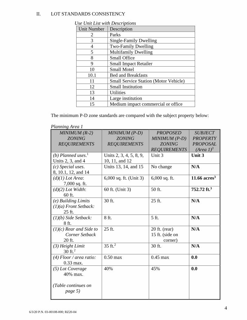
II. LOT STANDARDS CONSISTENCY
Use Unit List with Descriptions
Unit Number Description 2 Parks 3 Single-Family Dwelling 4 Two-Family Dwelling 5 Multifamily Dwelling 8 Small Office 9 Small Impact Retailer 10 Small Motel
10.1 Bed and Breakfasts 11 Small Service Station (Motor Vehicle) 12 Small Institution 13 Utilities 14 Large institution 15 Medium impact commercial or office
The minimum P-D zone standards are compared with the subject property below: Planning Area 1
MINIMUM (R-2) ZONING
REQUIREMENTS
MINIMUM (P-D) ZONING
REQUIREMENTS
PROPOSED MINIMUM (P-D)
ZONING REQUIREMENTS
SUBJECT PROPERTY PROPOSAL
(Area 1)3 (b) Planned uses.1 Units 2, 3, and 4
Units 2, 3, 4, 5, 8, 9, 10, 11, and 12
Unit 3 Unit 3
(c) Special uses. 8, 10.1, 12, and 14
Units 13, 14, and 15 No change N/A
(d)(1) Lot Area: 7,000 sq. ft.
6,000 sq. ft. (Unit 3) 6,000 sq. ft. 11.66 acres3
(d)(2) Lot Width: 60 ft.
60 ft. (Unit 3) 50 ft. 752.72 ft.3
(e) Building Limits (1)(a) Front Setback:
25 ft.
30 ft. 25 ft. N/A
(1)(b) Side Setback: 8 ft.
8 ft. 5 ft. N/A
(1)(c) Rear and Side to Corner Setback
20 ft.
25 ft. 20 ft. (rear) 15 ft. (side on
corner)
N/A
(3) Height Limit 30 ft.2
35 ft.2 30 ft. N/A
(4) Floor / area ratio: 0.33 max.
0.50 max 0.45 max 0.0
(5) Lot Coverage 40% max.
(Table continues on
page 5)
40% 45% 0.0

6/3/20 P.N. 03-00108-000; RZ20-04 5
MINIMUM (R-2) ZONING
REQUIREMENTS
MINIMUM (P-D) ZONING
REQUIREMENTS
PROPOSED MINIMUM (P-D)
ZONING REQUIREMENTS
SUBJECT PROPERTY PROPOSAL
(Area 1)3 (Table continued from
page 4) (6) Density
6 units / acre
16 units / acre
6 units / acre max
0
(f) Open Space4 (1) Landscape Buffer
n/a
10 ft. 5 ft. N/A
1See the table on page 7 of this report for a full description of each shown use unit. 2The height limit may be increased to 40 feet if the building is set back further than required. 3Figures are based on the land area proposed for rezoning, not a future proposed plat. The lot sizes and dimensions will be disclosed once the preliminary plat application is received.
4Part (2) and (3) of this code is not directly applicable to the proposed project, so it is not shown. Planning Area 2
MINIMUM (R-2) ZONING
REQUIREMENTS
MINIMUM (P-D) ZONING
REQUIREMENTS
PROPOSED MINIMUM (P-D)
ZONING REQUIREMENTS
SUBJECT PROPERTY PROPOSAL
(Area 2) (b) Planned uses.1 Units 2, 3, and 4
Units 2, 3, 4, 5, 8, 9, 10, 11, and 12
Unit 2, 3, 4, 5, and 12
Units 2 and 5
(c) Special uses. 8, 10.1, 12, and 14
Units 13, 14, and 15 No change N/A
(d)(1) Lot Area: 7,000 sq. ft.
6,000 sq. ft. (Unit 3) 6,000 sq. ft. (Unit 3) 2,700 sq. ft. / dwelling unit for other lots
17.1 acres3
(d)(2) Lot Width: 60 ft.
60 ft. (Unit 3) 70 ft. (Units 3 or 4)
60 ft. (Unit 3) 70 ft. other lots
625.56 ft.3
(e) Building Limits (1)(a) Front Setback:
25 ft.
30 ft. 30 ft. N/A
(1)(b) Side Setback: 8 ft.
8 ft. 10 ft. N/A
(1)(c) Rear and Side to Corner Setback
20 ft.
25 ft. 20 ft. (rear) 25 ft. (side on
corner)
N/A
(3) Height Limit 30 ft.2
35 ft.2 35 ft. N/A
(4) Floor / area ratio: 0.33 max.
0.50 max 0.65 max 0.0
(5) Lot Coverage 40% max.
40% 65% 0.0
(6) Density 6 units / acre
16 units / acre 16 units / acre max 0
(f) Open Space4 (1) Landscape Buffer
n/a
10 ft. 10 ft. N/A
1See the table on page 7 of this report for a full description of each shown use unit.

6/3/20 P.N. 03-00108-000; RZ20-04 6
Footnotes continued for Table from Page 5
2The height limit may be increased to 40 feet if the building is set back further than required. 3Figures are based off the land area proposed for rezoning, not a future proposed plat. The lot sizes and dimensions will be disclosed once the preliminary plat application is received.
4Part (2) and (3) of this code is not directly applicable to the proposed project, so it is not shown. Additional lot information will be provided once the preliminary plat application is filed with the City.
Figure B-1: Proposed Planning Areas
Note: The original plan had an Area 3, this has now merged with Area 2. There will be no provisions for a separate Area 3.
Area 2
Area 1

6/3/20 P.N. 03-00108-000; RZ20-04 7
III. LAND USE CODE REQUIREMENTS
According to the Land Use Code, a rezoning development permit shall only be authorized when the applicant has convincingly demonstrated that the proposed zoning: (a) Will not substantially interfere with other owners’ reasonable peace and
enjoyment of their neighboring properties:
(b) Will not substantially damage any property value in the neighborhood:
(c) Will be compatible with and respect the context of its location and the character
of the surrounding existing neighborhoods:
(d) Will not, whether by the nature of the allowed uses in the proposed zone, or by the allowed siting, height, or design of structures or landscaping in the proposed zone, tend to burden the present or future use of neighboring properties in accordance with current zoning standards:
Residential uses in this area are not anticipated to impact property values due to the existing land use established north and west of the subject property.
City staff is aware of no evidence that the proposed rezoning to a planned development consisting of single-family, multifamily, and a park will cause a consistent disturbance to the peace and enjoyment of the neighboring properties. The neighboring properties are generally either unoccupied or are residential, commercial, or agricultural in nature and are generally considered equal or greater intensity of land use from the proposal. Enforcement of the City Code’s nuisance chapter ensures excessive noise, unsightly debris, etc. will not decrease the quality of life standards in place throughout the City.
The proposed zoning is of similar use classes and is generally compatible with the commercial and residential uses in the neighborhood.
Residential uses in this area are not anticipated to burden the present or future uses of neighboring properties due to the proposed use being equal or lesser intensity than the land uses abutting the subject property, or the abutting land uses are presently unoccupied.

6/3/20 P.N. 03-00108-000; RZ20-04 8
(e) Is adequately supported by infrastructure, including without limitation, streets and parking:
(f) Compared to present zoning of the property, is equally or more consistent with: 1. Sound planning of the city’s growth; and with 2. Public health, safety, and convenience within the neighborhood:
B-2) COMPREHENSIVE PLAN CONSISTENCY
The 2030 future land use map describes the subject property as Medium (3-10 dwellings/acre) and High Density Family (11-30 dwellings/acre). In addition, the northwestern corner of the site is shown to be commercial. Although no commercial is proposed, staff believes the proposed P-D zone is generally consistent with the designation.
Water System There is an existing 6” water main that runs on the east side of the property along Hwy. 16 and an additional 6” water main on the west side of the property within the Eastgate Subdivision. Staff finds this existing infrastructure to be adequate for fire and projected water needs.
Sanitary Sewer System There is an existing 8” sewer main that runs on the west side of the property, along Hwy. 412, a utility easement will be needed to extend sewer to the subject property. Staff finds this existing infrastructure to be adequate for wastewater needs.
Storm Sewer System A detention basin is shown to be in the northwest corner of the property, more refinement of this system will be reviewed at the preliminary plat stage.
The proposed development does not markedly inhibit sound planning of the City’s growth. Nothing in the proposal will consistently inhibit or harm the general public health, safety, and convenience within the neighborhood. The demand for new housing types continues to be robust. This proposal is positioned in a location to be effective for this needed land use.

6/3/20 P.N. 03-00108-000; RZ20-04 9
Figure B-2 (1) Future Land Use Map
B-3) STAFF DISCUSSION General Summary The applicant is requesting to rezone a 29-acre subsection of a larger parcel to the P-D
zone. Unlike past re-zonings to P-D, the applicant is establishing their customized zoning
standards in three distinct planning areas: Area 1 and Area 2. See Figure B-1. Area 1 consists of a slightly denser version of
R-2 and will contain only single-family housing.
Area 2 will be multifamily housing in a similar arrangement as what is seen in Spring Valley apartments, located east of the site.
Area 2 will also contain an open space park called “The Great Lawn” with active recreational activities. The park serves as a buffer between the multifamily and single-family uses.
Existing and Future Land Uses The neighborhood consists of the same land
uses as are proposed. Multifamily exists to the north and south, and single-family exists to the southwest.
The future land use map assumes multifamily and single-family of medium to high density. The proposal fulfills this, however in a slightly altered configuration with the
Key Points: • PD zone consists of two
distinct areas with a park between both
• Prime use will be single-family and multifamily housing
• Contributes a variety of housing densities
• The proposed park will be maintained by the POA
• Side path will connect the project to the north.
• Additional reviews needed for project design.

6/3/20 P.N. 03-00108-000; RZ20-04 10
bulk of the multifamily on the northern half of the property, with the single-family kept to the southern half.
Staff concurs with this configuration as it is putting the proposed land uses with like uses. Neighborhood Context and Compatibility Staff believes this proposal is compatible with the existing built environment. The
proposed single-family section (Area 1) will tie directly in with the Eastgate Addition, which was always the intent as evidenced by a stub-out street.
A park provides a valuable recreational amenity to future residents. This includes a walking trail, playground, and ample open areas for a variety of recreational uses.
A proposed side-path will be constructed along Hwy. 16 that will connect future residents to the retail uses to the north as well as the high school and hospital.
Conditions and Staff Conclusions The proposed rezoning should only be considered for its land use component and the
general concept as presented. Future development plans are required in the form of a preliminary plat permit and a
significant development permit. These permits will better define the future lot, building configurations, and street layouts.
Staff asked that the developer keep to the general layout as shown with the rezoning request, he has agreed to do so.
On concept, staff is supportive of this request as it provide a unique blending of multifamily and single-family uses in the areas where they make sense and these housing types are separated by a community park.
Fiscal Impact: Staff is not aware of any fiscal impact at this time. The street impact fee will be assessed with the single-family and multifamily building permits. Attachments:
Zoning Plan for Foxtail: A Planned Development Foxtail Concept Site Plan

RZ20-04 (Foxtail) 1st Submittal
FFOOXXTTAAIILL AA PPLLAANNNNEEDD DDEEVVEELLOOPPMMEENNTT
Applicant:
Rausch Coleman Homes
4058 N. College Avenue
Fayetteville, AR 72701
Engineer:
Crafton Tull
901 N. 47th Street, Suite 200
Rogers, AR 72756

FOXTAIL – A PLANNED DEVELOPMENT 2 of 8
Table of Contents
Property Description ..................................................................................................................................................3
Property Location………………………………………………………………………………………………………………………………………………………..4
Scope & Concept ........................................................................................................................................................5
Master Development Plan ..........................................................................................................................................5
Streets…………………………………………………………………………………………………………………………………………………………………………5
Development Standards .............................................................................................................................................6
Development Area “1” ...............................................................................................................................................6
Development Area “2” ...............................................................................................................................................6
Development Area “3” ...............................................................................................................................................7
Open Space & Landscaping .........................................................................................................................................7
Parking Area Design Standards ...................................................................................................................................7
Platting ......................................................................................................................................................................7
Signs ..........................................................................................................................................................................8
Restrictive Covenants .................................................................................................................................................8
Developmeng Time Line .............................................................................................................................................8

FOXTAIL – A PLANNED DEVELOPMENT 3 of 8
Property Description
LEGAL DESCRIPTION OF A PORTION OF THE LAND
[TRACT 8]
PART OF THE NE 1/4 OF THE SE 1/4 OF SECTION 5, TOWNSHIP 17 NORTH, RANGE 33 WEST, BENTON
COUNTY, ARKANSAS, DESCRIBED AS:
BEGINNING AT THE SW CORNER OF THE SAID NE 1/4 OF THE SE 1/4;
THENCE NORTH 00° 46' 31" EAST 461.50 FEET;
THENCE SOUTH 89° 24' 23" EAST 373.06 FEET;
THENCE NORTH 00° 46' 31" EAST 224.00 FEET;
THENCE SOUTH 89° 24' 23" EAST 480 FEET;
THENCE SOUTH 00° 23' 00" WEST 200 FEET;
THENCE NORTH 87° 17' 00" EAST 457.37 FEET TO THE CENTERLINE OF ARKANSAS STATE HIGHWAY #16;
THENCE SOUTH 00° 23' 00" EAST 511.98 FEET ALONG SAID CENTERLINE;
THENCE NORTH 89° 24' 23" WEST 1321.30 FEET TO THE POINT OF BEGINNING.
-AND-
THE EAST ONE-HALF OF THE SE 1/4 OF THE SE 1/4 OF SECTION 5, TOWNSHIP 17 NORTH, RANGE 33 WEST, BENTON
COUNTY ARKANSAS.
LESS AND EXCEPT: PART OF THE SE 1/4 OF THE SE 1/4 OF SECTION 5, TOWNSHIP 17 NORTH, RANGE 33
WEST, BENTON COUNTY, ARKANSAS, BEING MORE PARTICULARLY DESCRIBED AS FOLLOWS:
COMMENCING AT THE SE CORNER OF SAID SE l/4 OF THE SE 1/4;
THENCE NORTH 01° 53' 18" EAST 25.31 FEET;
THENCE NORTH 87° 19' 42" WEST 510.50 FEET TO THE POINT OF BEGINNING;
THENCE NORTH 02° 34' 00" EAST 523.00 FEET;
THENCE NORTH 87° 19' 42" WEST 250.00 FEET;
THENCE SOUTH 02° 34' 00" WEST 523.00 FEET;
THENCE SOUTH 87° 19' 42" EAST 250.00 FEET, TO THE POINT OF BEGINNING, CONTAINING
3.00 ACRES.
LESS AND EXCEPT:
"LESS AND EXCEPT FROM HEREINABOVE DESCRIBED LAND IS A 5 ACRE, MORE OR LESS, PIECE OR PARCEL OF LAND OFF
OF THE SOUTH SIDE THEREOF. SAID PIECE OR PARCEL OF LAND TO BE HEREAFTER RESERVED FOR SEPARATE ZONING
DISTINCTION.”
FOXTAIL – A PLANNED DEVELOPMENT 4 of 8

FOXTAIL – A PLANNED DEVELOPMENT 5 of 8
Scope & Concept
Foxtail will be a mixed-use neighborhood located northwest of Kenwood Street and Hwy 16. The development will
consist of two distinct development areas that will surround a great lawn that will serve as a neighborhood park.
Planning Area 1 will consist of approximately 56 single-family lots that will access Hwy 16 and connect to an existing
street stub-out in the Eastgate Subdivision to the west. Planning Area 2 will consist of approximately 16-20 multi-family
buildings that are intended to serve as a transition from the commercial and multi-family uses already developed north
and west of the property. Planning Area 2 will also contain the park, which will be developed concurrently with the
multi-family buildings.
The purpose of a Planned Unit Development and what is being accomplished in this concept plan, is to allow flexibility in
zoning standards to produce a development that is compatible with surrounding land uses and provides meaningful
open spaces for the residents and community. The subject development places single-family homes adjacent to an
existing neighborhood. The lots on the exterior (Lots 1-16) are all 60-foot wide and 7,000 square feet, which is compliant
with the underlying zoning of R-2. Interior lots are intended to be 50-feet wide and 6,000 square feet. The multi-family
section of the development is separated from the single-family neighborhoods by the park and provides a necessary
transition from apartments and commercially developed property to the northwest, north and east.
Master Development Plan
Streets
Streets within Planning Area 1 will be constructed as public streets in accordance with City ordinance and dedicated at
the time of final plat. The driveways and parking lots within Planning Area 2 will be constructed as private drives in
accordance with City ordinance and will be maintained by the Property Owner.

FOXTAIL – A PLANNED DEVELOPMENT 6 of 8
Development Standards
This PUD shall be governed by the use and development regulations of Siloam Springs Zoning Code except as
provided as follows:
Planning Area 1 Gross Land Area 11.6 Acres
(b) Planned Uses Single-Family Homes (Unit 3)
(d) Lot Dimensions
(1) Minimum Lot Surface Area 6,000 Square Feet
(2) Minimum Lot Width 50 Feet
(3) Maximum Lot Coverage 45%
(e) Building Limits
(1) Setback Required:
(a) Front Yard Setback 25 Feet
(b) Sides (Except on Corner) 5 Feet
(c) Side on Corner 15 Feet
(d) Rear Yard 20 Feet
(3) Height Limited
(a) No Building Shall Exceed 30 Feet in Height
(4) Floor/Area Ratio .45 (maximum)
(5) Density Not to Exceed 6 Dwellings Units Per Acre
Sec. 102-56(f)(1) Landscape buffer of 5 feet along all property lines
Planning Area 2 Gross Land Area 17.1 Acres
(b) Planned Uses 2, 3, 4, 5, and 12. The private park will be developed
simultaneously with the multi-family project.
(d) Lot Dimensions
(1) Minimum Lot Surface Area
(a) 6,000 Sq. Ft. for Lots Containing a Single-Family Dwelling
(b) 2,700 Sq. Ft. Per Dwelling Unit for All Other Lots
(2) Minimum Lot Width

FOXTAIL – A PLANNED DEVELOPMENT 7 of 8
(a) 60 Feet for Lots Containing a Single-Family Dwelling
(b) 70 Feet for All Other Lots
(3) Maximum Lot Coverage 65%
(e) Building Limits
(1) Setback Required:
(a) Front Yard Setback 30 Feet
(b) Sides (Except on Corner) 10 Feet
(c) Side on Corner 25 Feet
(d) Rear Yard 20 Feet
(2) Height Limited
(b) No Building Shall Exceed 35 Feet in Height
(3) Floor/Area Ratio .65 (maximum)
(4) Density Not to Exceed 16 Dwellings Units Per Acre
Open Space & Landscaping The Great Lawn will be the centerpiece of the Foxtail community. The approximately 4-acre park will provide
opportunities for community gatherings, tree preservation, or even a pick-up game of football. An 8-foot
walking trail will be construct in a circuitous path, providing access to residents in the single-family subdivision
and the multi-family area. A play area will also be constructed near the center of the green, at the intersection
of several trail sections. The park will be developed concurrently with the multi-family project.
A 20-foot wide buffer will be provided on the west, north and east sides of Planning Area 2. Also, within
Planning Area 2, a wrought-iron style fence will be constructed along Hwy 16. Street trees will be planted
along all Hwy 16 frontage with a maximum spacing of 30 feet. All common areas will be owned and
maintained by the POA. A trail connection will also be made at the northeast corner of the property and will
continue southward along Hwy 16.
Parking Area Design Standards In accordance with City code, all parking areas within Planning Area 2 will be continuously lighted at night.
Lighting shall be full cut-off fixtures. Parking lot landscaping shall exceed the 10% requirement included in the
code.
Platting No building permit shall be issued until a subdivision plat and/or large scape development has been approved
by the City of Siloam Springs, in compliance with the Planned Development concept and development
standards. A subdivision plat will be submitted to the City of Siloam Springs after approval of the PD.
Covenants shall be established for all platted areas to ensure consistency in development and to provide POA
maintenance responsibilities for any common areas.

FOXTAIL – A PLANNED DEVELOPMENT 8 of 8
Signs Residential subdivision entrance signs will be installed along Hwy 16 for both planning areas. These signs will
be similar in appearance to the signs shown below.
Restrictive Covenants Restrictive covenants shall be adopted and recorded for the PUD with the subdivision plat. The maintenance
of all common areas shall be the responsibility of the Property Owners Association.
Development Time Line Development will commence upon approval of the PD, preliminary plat, large scale development and
construction plans, in accordance with City regulations. The single-family portion of the project will be
constructed first, followed by the multi-family development area. Construction of the single-family area is
anticipated to commence in 2021.
FOXTAIL – A PLANNED DEVELOPMENT
(4!SUR>M!IONOfNS!!Y ) __ .. _ ... _
( . .................... ) I!<"=< ""'""=' (. '""'"" "°"'"'""') ~•On-
- ·_ ,IU> ... II"..'~ . .. .....,_ -:o-.,, .... 0.11 . .. , _,
•
1
• • • I
·- ·
···-· --
...... __ 0. £!.<:!~!ii ··--..::::::
~ ..,.....,,.~,., l • f"n
• 1 *
CONCEPl.S .. _ ......
=:::::--=~"'=~ -·-··-.. - .... ::=:,;,.~c:':...~-
• . v
. -~·-

Ordinance 20-18 Page 1 of 3
ORDINANCE NO. 20-18
AN ORDINANCE AMENDING SECTION 102-21 OF THE SILOAM SPRINGS MUNICIPAL CODE (CITY ZONING MAP); REZONING (FROM R-2 TO P-D) THE PROPERTY LOCATED
AT THE 700 TO 1000 BLOCK OF HIGHWAY 16 SOUTH
Whereas, the landowner, Roderic Allen, has requested that the below-described land be changed from the present zoning district of R-2 (Residential, medium) to P-D (Planned Development); and Whereas, a public hearing on the proposed change was held on the 11th day of February 2020, before the City of Siloam Springs Planning Commission, after proper notice required by law; and Whereas, after receiving and considering a staff report, a motion recommending approval of the rezone was passed by the Planning Commission; and Whereas, the proposal is generally consistent with the City’s comprehensive land use plan; and Whereas, upon review and deliberation it appears that the zoning change is in the best interest of the public and City of Siloam Springs; Now Therefore: Be It Enacted, by the Siloam Springs Board of Directors, as follows:
SECTION I. The zoning map of the City (Municipal Code Section 102-21) is hereby amended to include within the P-D zoning district the property located at the 700 to 1000 Block of Hwy. 16 South and described as follows:
AREA 1
Part of the SE 1/4 of the SE 1/4 of Section 5, Township 17 North, Range 33 West, described as Commencing at the NW corner of said SE 1/4 of the SE 1/4, thence South 86°59'19" East 560.00 feet; thence South 02°39’36” West 121.05 feet to the Point of Beginning; thence South 87°14’32” East 19.72 feet; thence 26.07 feet along a curve, said curve having a radius of 125.00 feet and a long chord of North 86°47’00” East, 26.02 feet; thence North 80°48’37” East 103.38 feet; thence 35.61 feet along a curve, said curve having a radius of 175.00 feet and a long chord of South 86°55’41” West 35.55 feet; thence South 87°14’32” East 578.68 feet; thence South 02°37’12” West 763.93 feet; Thence North 87°14’32” West 511.16 feet; thence North 02°30’55” East a distance of 89.54 feet; thence North 87°23’13” West 249.99 feet; thence North 02°39’36” East 647.30 feet to the Point of Beginning.

Ordinance 20-18 Page 2 of 3
SECTION II. Proposed Zoning Standards for Area 1. The zoning standards for Area 1, as described in Section I of this ordinance, shall be as set forth in Section 102-56 of the Siloam Springs Municipal code, except as follows:
(b) Planned Uses Single-Family Homes (Unit 3) (d) Lot Dimensions (1) Minimum Lot Surface Area 6,000 Square Feet (2) Minimum Lot Width 50 Feet (3) Maximum Lot Coverage 45% (e) Building Limits (1) Setback Required:
(a) Front Yard Setback 25 Feet (b) Sides (Except on Corner) 5 Feet (c) Side on Corner 15 Feet (d) Rear Yard 20 Feet
(3) Height Limited No Building Shall Exceed 30 Feet in Height (4) Floor/Area Ratio 0.45 (maximum) (5) Density Not to Exceed 6 Dwellings Units Per Acre (f)(1) Landscape Buffer Landscape buffer of 5 feet along all property lines
SECTION III. The zoning map of the City (Municipal Code Section 102-21) is hereby amended to include within the P-D zoning district the property located 700 to 1000 Block of Hwy. 16 S. and described as follows:
AREA 2
Part of the E 1/2 of the SE 1/4 of Section 5, Township 17 North, Range 33 West, described as Beginning at the SW corner of the NE 1/4 of the SE1/4, thence North 03°52'54" East 454.21 feet; thence South 87°56’48" East 373.06 feet; thence North 02°19'20" East 224.00 feet; thence South 86°48'47" East 479.94 feet; thence South 02°58'04" West 199.89 feet; thence North 89°55'39" East 457.24 feet to the centerline of Arkansas State Highway #16; thence South 01°42'52" West 507.73 feet along said centerline; thence North 87°18’31” West 4.59 feet; thence South 02°37’12” West a distance of 89.97 feet; thence North 87°14’32” West 578.68 feet; thence 35.61 feet along a curve, said curve having a radius of 175.00 feet and a long chord of South 86°55’41” West, 35.55 feet; thence South 80°48’37” West 103.38 feet; thence 26.07 feet along a curve, said curve having a radius of 125.00 feet and a long chord of South 86°47’00” West 26.02 feet; thence North 87°14’32” West 19.72 feet; thence North 02°39’36” East 121.05 feet; thence North 86°59’19” West 560.00 feet to the Point of Beginning.
SECTION IV. Proposed Zoning Standards for Area 2. The zoning standards for Area 2, as described in Section III of this ordinance, shall be as set forth in Section 102-56 of the Siloam Springs Municipal code, except as follows:
Ordinance 20-18 Page 3 of 3
(b) Planned Uses Use Units 2, 3, 4, 5, and 12 (d) Lot Dimensions (1) Minimum Lot Surface Area
(a) 6,000 Sq. Ft. for Lots Containing a Single-Family Dwelling
(b) 2,700 Sq. Ft. Per Dwelling Unit for All Other Lots
(2) Minimum Lot Width (a) 60 Feet for Lots Containing a Single-Family
Dwelling (b) 70 Feet for All Other Lots
(3) Maximum Lot Coverage 65% (e) Building Limits (1) Setback Required:
(a) Front Yard Setback 30 Feet (b) Sides (Except on Corner) 10 Feet (c) Side on Corner 25 Feet (d) Rear Yard 20 Feet
(2) Height Limited No Building Shall Exceed 35 Feet in Height (3) Floor/Area Ratio 0.65 (maximum) (4) Density Not to Exceed 16 Dwelling Units Per Acre
Ordained and Enacted this day of 2020.
ATTEST: APPROVED: Renea Ellis, City Clerk John Mark Turner, Mayor
(SEAL)

6/30/20
STAFF REPORT TO: Phillip Patterson, City Administrator FROM: Ben Rhoads, AICP, Senior Planner Cc: Don Clark, Community Development Director DATE: June 9, 2020 RE: Ordinance 20-19 / Annexation of 53.63 acres / 23000 Block of Lawlis Road Recommendation: Place Ordinance No. 20-19 on its _____ (1st, 2nd or 3rd) reading, suspending the rules and reading by title only.
Background: The petitioners desire to annex property abutting the City Limits consisting of 53.63 acres, this includes all of Lawlis Ranch, phase 1, the recently approved Carley Crossing Addition, and two lots in Heritage Ranch, phase 1. The annexation meets the legal requirements set forth by the State and Benton County. The Benton County Court approved the annexation in the attached order filed on May 27, 2020. The petition (attached) was signed by 30 of the 36 property landholders in the proposed territory, representing 83.33 percent of the real estate owners. Staff has mailed letters to everyone who did not sign the petition informing them of this annexation. The services for the annexed territory shall be as follows: Fire Protection – immediately; Police Protection – immediately; Water and Wastewater – immediately; and Zoning and Code Enforcement – immediately. Water and Wastewater services are already in this area. The proposed City ward is Ward 1; the proposed zoning is R-1 (Residential, large), for the lots along Lawlis Road and in Heritage Ranch, R-2 (Residential, medium) & R-3 (Residential, two-family) for the lots interior to the approved Carley Crossing Addition, and R-3 for Lawlis Ranch. These zones are selected at the developer’s request or by the zone that best matches the existing lots. The Planning Commission does not review annexations; they go directly to the Board of Directors through the City Clerk’s office. Fiscal Impact: Minimal fiscal impact is expected. The developer will extend services to the property upon development. Attachments:
Annexation Zoning Map County Clerk Annexation Verification Letter County Judge’s Order of Annexation Annexation Petition Exhibit A: Legal Description Exhibit B: Signature of Petitioners Exhibit C: Property Owners
Exhibit D: Engineer’s Verification Letter Exhibit E: Vicinity Map - Annexation Exhibit F: State GIS Verification Letter Ordinance No. 20-19

17 16 15
,
41 21
42 43
22
40 39 38
23
r
I") .... 38 66 87 68
>-~
PARCEL " :r 18 ·15853· 000 0
I
85 64 83 ..... ,_ ;! VI
~ '" ~ ~ 39 -
DETENTION BASIN
40 41 42
50.00' (R/W)
14
44
37
69
62
43
Parcel • : 18·15833-000
13 12
45 46
36 35
70 71
81 60
45
11
" 8
7
8
72 73 74
59 58 57
STREET 'A'
47 48
75
47 DETENTION
BASIN
5 4
76 77
56 55
49 50
PARCEL • : 18-15961·000
" 78 79
54 53
51 52
20
19
18
17
16
15
>,_ u
PorceJ • : 18-14080·000
PARCEL " 15 ·15358· 000
14
8
,
7 6
z
10
79
I
31
32
5
78
HAT CREEK LN C50'ROW>
33
COUNT CITY
4
77
34
'
3 2
76
75
35 74
36 73
0 50 100 200 - - --- - -
Port of the SW 1/4 of the SW 1/4 of Section 30, T-1e-N, R-33-W ond Port of the NE 114 of the SE 114 of Section 25, T-18-N, R-34-W, Benton County, Arkansas. Being More particularly described os follows:
Beginning ot a the SE Corner of the NE 1/ 4 of the SE 1/ 4 of said Section 25; thence N e7° OS'5e" W 1321.74': thence N 02° 5S'07" E 175.21': thence S 87° 02'41" E 1321.80': thence S 02° 5 7'19" W 105.02': thence S 8S0 52'41" E 111.Se': thence S 03° 07 '19" W 363.41' ; thence S e2° 11'54" W 49.31': thence S 49° 09'1S" E 2S3.SO': thence S 40° 50'44" W 85.00': thence N 49° 09'1S" W 275.88': thence N 02° 54'40" E 3S3.93' to the point of beginning and containing 6.e1 ocres.
LEGAL DESCRIPTION FOR R- 2 ZONING
Port of the NE 114 of the SE 114 of Section 25, T-18-N, R-34-W, Benton County, Arkansas. Being More particularly described os follows:
Beginning ot o point 17 3.56' N 02° 5 7'19" E of the SE Corner o f the NE 1/ 4 of the SE 1/ 4 of said Section 25; thence N 87° 02'41" W 1321.eO': thence N 02° 5S'07" E 1147.20': thence S es• 43 '57" E 1052.22': thence S 02° 57'19" W 581.4 7'; thence S 87° 02'4 1" E 104.22'> thence S e3°18'23" E 70.94'> thence S 81° OS'08" E 95.50'> thence S 02° 5 7'19" W 545.49': to the point of beginning and containing 31.08 acres.
LEGAL DESCRIPTION FOR R- 3 ZONING
Port of the N 1/2 of the SW 1/4 of Section 30 , T-18-N, R-33-W, Benton County, Arkansas and Port of the NE 1/4 of the SE 114 of Section 25, T-18-N, R-34 - W, Benton County, Arkansas, more particularly described os follows:
Beginning ot a point 275.00' N 02° 5 7'19" E of the SW corner of soid N 112 of the SW 114• thence N 02° 57'19" E 37S.46 ': thence N e1° OS'08" W 95.50' : thence N 83° 18'23" W 70.94': thence N 87° 02'41" W 104.22'> thence N 02° 5 7'19" E 581.4 7': thence S 86° 43'57" E 270.00': thence N 02° 57'22" E 72.39': thence S e7° 00'05" E 304.24'; thence S 03° 00'05" W 374.03'; thence S 8S 0 52'30" E 341.97'> thence S 03° 07'30" W 142.50': thence S 8S 0 52'30" E 14.41': to o tangent curve concave to the Northwest and having o radius of 175.00'> thence along said curve with on or e distance of 35.08' ond o chord of N 87° 22'57" E 35.02': thence leaving said curve S 08° 21'37" E 200.01': thence S es• 52'30" E S5.99'> thence S 03° 07'30" W 192.50'> thence N 8S0 52'30" W 2.00'> to a tangent curve concave to the Southeast and having o radius o f 15.00'> thence along said curve with on ore dis tance of 23.56' and o chord of S 4e0 07'30" W 21.21'> thence leaving said curve S 03° 07'30" W 127 .50'> thence S02° 5 7'19"W 250.00'> thence N8S0 52'30"W 50.00'> thence N02° 57'19"E 250.00'; thence N es· 52 '30" w 732.00' lo the point of beginning, having on area of 17 .e9 Acres.
ANNEXATION ZONING EXHIBIT Plat Prepared By: CML ENGINEERING, INC. P.O. Box 12 Siloam Springs, AR 72761 (479) 524-9956
Survey By: JAMES SURVEYING P.0.Box617 Gentry, Arkansas 72734 (479) 736-8416
Developer: Riggins Com. Const & Dev. Inc. 1204 E Joyce Blvd, Ste I 02 Fayetteville, AR 72703 479 582-9597
Date: June 18, 2020
Job#: 1936

--STATE OF ARKANSAS--
COUNTY CLERK & VOTER REGISTRAR 215 EASTCEITTRAL. SUITE 217 BEl'fTOt<Vlu..E, AR 72712-5373
479-271-1013 Fax: 479-271-1019
City Clerkffreasurer Renea Ellis City of Siloam Springs P OBox 80 Siloam Springs, AR 72761
BETSY HARRELL
May28, 2020
RE: City of Siloam Springs Annexation Riggins Properties, ct al County Court Case No. CC 2020-04
Dear Ms. Ellis:
PROBATE COURT CLERK
COURTIIOt:SE,102 N.E. "A" STREET BENTONVIU.E,AR 72712-5350
479-271-5727 FAx: 479-271-1712
I am enclosing herein a certified copy of the Order of Annexation entered by the County Court of Benton County on May 27, 2020.
After thirty days have passed from that date and no contest to the annexation is made, please send me certified copies of the following items so that l can send those on to the Secretary of State required by the statute:
• Ordinance or resolution approving the annexation • Plat of the annexed property
If you have any questions regarding this matter, please let me know.
BH/tku
ROGERS OFFICE 2111 W. WALNlTf (479) 636-3727
FAx (479) 636-4922 •
Sincerely,
Roow ARCHIVES
2111 w. WAl.lllTf (479) 636-1037
FAX (479) 636-1053 •
SILOAM SPRINOS OF!'ICE
7(11 S. LINCOl.ll 479-271-1013
FAX (479) 524-8534
FILED 20201fAY 27 PH 1:·10
J: BETSY HARRELL ·, CO & PROBATE CLERK
BENTON cov:ny. /l.f1
IN THE COUNTY COURT OF BENTON COUNTY, ARKANSAS
IN THE MA TIER OF ANNEXING INTO THE CITY OF SILOAM SPRINGS, ARKANSAS, CERT AlN CONTIGUOUS LAND
ORDER OF ANNEXAT ION
Case No. 2020-04
COMES NOW on this 20111 day of May, 2020, before the Court for consideration of the
Petition for Annexation filed herein by petitioners (collectively, the "Petitioners") seeking to
have certain real property annexed into the City of Siloam Springs, Arkansas (the "City").
Petitioners appeared by and through their counsel, Larry McCredy. Based on the Petition aod
other things before it, the Court finds and orders as follows:
l. This Court is the proper forum for this Petition; venue is proper and the Court has
jurisdiction over the subject matter of the Petition.
2. The Petition herein was filed more than thirty (30) days prior to the date of this
hearing. Darin Riggins was selected to act of behalf of the Petitioners in presenting this Petition.
3. The Petitioners are property owners of certain real property (the "Property") for
which they are petitioning the Court for annexation into the City of Siloam Springs, Arkansas.
The Property is more specifically as follows:
Benton County Tax Parcels 18-15853-002, 15-17126-000, 15-17129-000, 15-18804-000 through 15-18816-000, 15-18816-001, & 15-18817-000 through 15-18835-000, which is more particularly described as:
NE Y. of the SE ·Y. of Section 25, Township 18 North, Range 34 West, Benton County, Arkansas; and
I 2020 2172.

FILED 20201fAY21 PH f! 10
: BETSY HARRELL -1 f:O & PRO~Mii!i>VH~lefthe SW V. of Section 30, Township 18 North, Range 33 West, BtllT lit; im\rOb 'C6Uhty, Arkansas, which includes Lots I through 32 and the street right
of ways ofLawlis Ranch Subdivision Phase l; and
Part of the SW V. of the SW V. of Section 30, Township 18 North, Range 33 West, Benton County, Arkansas which includes Lots 9 and 12 of Heritage Ranch Subdivision Phase L
Total Acres: 55.63
4. The Petitioners are a majority of real estate owners of the Property as defined in
Ark. Code Ann. § 14-40-60 I (b ), each of whom signed the Petition under oath. Petitioners own
more than one-half of the total acreage affected by the Petition. The Court finds that Petitioners
have complied with the signature requirements of Ark. Code. Ann. § 14-40-60 I.
5. The Property was accurately described in the Petition and such Property is
contiguous to and adjoining the present city limits of the City of Siloam Springs, Arkansas.
Attached to and made a part of the Petition is an accurate map of the Property sought to be
annexed into the City of Siloam Springs.
6. The Property meets at least one of the statutory criteria making it suitable for
annexation.
7. The Court had previously scheduled a hearing for this Petition on April 8, 2020.
Notice of this first hearing was published on March 13, 20 & 27, 2020 in the Northwest
Arkansas Democrat Gazette.
8. Because of the COVTD-19 pandemic, the hearing on the Petition was rescheduled
for May 20, 2020. Notice of this second hearing was published on April 24, May 1 & 8, 2020 in
the Northwest Arkansas Democrat Gazette.
I"\ "". \. ~ ' ' .~ ... ... J .... , n ,...) ~ . A· .. ... -
20 2(} '~ .; t- 1 .. \
4 J . " ' )
2

FILED
,; li" BETSY HARRELL
9. Because Petitioners have met the requirement of Ark. Cc>dC~&iP~OS~~l!.~K · BENTOt.' COlJ~TY. A!?
seq., the Petition is granted and the Property described herein is annexed into the City of Siloam
Springs, Arkansas.
10. The original papers in this matter shall be delivered to the County Clerk of Benton
County, same to be properly recorded upon the records of Benton County, Arkansas, and the
County Clerk shall, after properly recording and filing the original papers, prepare transcripts of
the same and del iver one of the certified transcripts to the City of Siloam Springs, Arkansas, one
copy to the Secretary of State, and one copy to the Director of the Tax Division of the Arkansas
Public Service Commission. Provided, however, pursuant to Ark. Code Ann.§ 14-40-604, no
further action may be taken on the Petition for thirty (30) days after entry of this Order with the
County Clerk in order to give any interested party the opportunity to obtain review of this action
by the Circuit Court.
IT IS SO ORDERED.
1G, Benton County Judge
Date: 6. J.."1 · ~W
3

{
l""' ' j • w ; ' ,- 1 i i·· ' ; ii t·- -... ... . ·
2020 KAR - 2 P11 2: 13 f!.i:-" '{ . - -· .•
,,,. l·~ : '-:. ,:. ·"~·~· .; ; ••••
IN TIIECOUNTY COURT OF BENTON COUNTY,ARki~~As,:",:~:.,.\'\ : · .. _ • •• , ...... .. _.11 , ... .
IN THE MA TIER OF ANNEXING INTO THE CITY OF SILOAM SPRINGS, ARKANSAS, CERTAIN CONTIGUOUS LAND Case No. _..Q.""ffiJ_...Q-......__.6:\...._.. __ _
PETITION FOR ANNEXAIION
COMES NOW the petitioners (collectively, the "Petitioners"). by and through counsel, and
for their Petition for Annexation seeking to have certain real property annexed into the City of
Siloam Springs, Arkansas (the "City"), state as follows:
l. The Petitioners are property owners of certain real property (the "Property") for
which they are petitioning the Court for annexation into the City of Siloam Springs, Arkansas. The
Property is described on Exhibit A, which is attached hereto and incorporated herein by reference.
2. The Petitioners are a majority of real estate owners of the Property as defined in
Ark. Code Ann. § 14-40-60l(b). Petitioners names and attestations are attached hereto as Exhibit
B and incorporated herein by reference.
3. A list all property owners who own property affected by this annexation petition,
as well as the acreage that each owns, is attached hereto as Exhibit C and incorporated herein by
reference.
I

C.
4. The Property is contiguous to and adjoining the present city linrijalef~h~C~ <JfM 2: 13
Siloam Springs, AJ"kansas. Please see the certification of Ron Homeyer, P.E., Presidei:if of Civil3'..L L {;J ~~ f :· .. ~ . .\\ :: ~i.( .~ :\
. . . . . . . . :---t;° ,i~T ~·~ C:..'.t;,~ T ~'. ),_,i Engmeenng, Inc., which 1s attached hereto as E.xltib1t D and incorporated herein l>Y'reference.
5. An accurate map of the Property for which annexation is sought showing its
location is attached hereto as Exhibit E and incorporated herein by reference.
6. Petitioners have coordinated their annexation request with the Arkansas GIS
Office. A letter confirming said coordination with the Arkansas GIS Office is attached hereto as
Exhibit P and is incorporated herein by reference.
7. Pursuant to Ark. Code Ann.~ 14·40·601, Petitioners appoint Darin Riggins as the
person to act Petitioners' behalf.
8. Petitioners request that the Court set a date for the hearing on this matter and that
upon final hearing. the Court enter an Order granting this Petition and annexing the Property into
the City of Siloam Springs.
By:
2
Respectfully submitted,
~6!!,,<4 RMPLLP P.O. Box I 788 Fayetteville, AR 72703 Tel: (479) 443-2705
Fax: (479) 443-2718 lmccredy@rmp !ayt
Attorneys for Petitioners

(
FYhibitA (Legal Description)
2020 liA~ -2 PH 2: 13
~::: :,' ~; .. .. ~-.~ll {'f) t i)~ .. Z' ''l't;' I I:' • ,.., ~ ~- .. l . .• ' i.;. ~;. .•• • • • E"l." ... . . , ". ' '
: . fl', \)~ L~ ··J . ~ t 1 • • . ,
Benton County Tax Parcels 18-15853-002, 15-17126-000, 15-17129-000, 15-18804-000 through 15-18816-000, 15-18816-001, & 15-18817-000 through 15-18835·000, which is more particularly described as:
NE l4 of the SE l4 of Section 25, T· l8-N, R-34-W, Part of N !I.I of the SW l4 of Section 30, T-18-N, R-33· W which includes Lots 1 through 32 and the street right of ways of Lawlis Ranch Subdivision Phase I, Part of the SW l4 of the SW l4 of Section 30, T- 18-N, R-33-W which includes Lots 9 and 12 of Heritage Ranch Subd.ivision Phase I
Total Acres: 55.63
3

(
ExhjbitB
(Signatures of Petitioners)
4
(
Fil I·- .... ' ·• i I .... _ _ .... l. 1
2GW MAR -2 PH 2: 13 .a:...-- .. . ·~- • -I • .. , .............. : .. .
I.-.__ o • i I o .. o '• \.·l, ! • .. ,- llf:1,I ... ,,, ,,••-.• 1 . _,. '" .. ..,., ... .... .

( (
EXHIBITB
Keith Gardner Jr. and Marjorie Denise Gardner, as Co-Trustees of the Ke;m£VP111Wi:ri;>Jr.PM 2: I 3 & Marjorie Denise Gardner Revocable Trust, dated the 10 .. day of February, 2012 (the "Ti:Ust). is
the owner of parcel number lS-15853-002, containing 39.45 acres, located on ~i#(~13i'.~; · .:::..1. .... Siloam Springs, Aibnsas. The Trust confirms its desire that the aforementibne.!'·.p· ·~' t: l L.t' 1
!(jl_f~ · r , .,,... ' ~
included in a petition to annex property, be annexed into the City of Siloam Sprln~~L ~' l}•; " .;:~: Y. r .• ,
THE KEITH GARDNER. JR. 8c MARJORIE DENISE GARDNER REVOCABLE TRUST
a~~. Keith Gardner, Jr~ Co-Trustee
&-r'~
iV{o~& ·,_ ~L /Ja11dtimJ Marjorie ~nise Gardner, Co-Trustee
ACKNQW].F.QGEMENT
County of d !Ahran"k
) ) )
On this ~"<lay of February, 2020, before me the undersigned Notary Public, personally appeared Keith Gardner, Jr. known personally to me (or sufficiently proven) to be Co-Trustee of the Keith Gardner, Jr. & Marjorie Denise Gardner Revocable Trust, and acknowledged that he, as an agent being authorized so to do, executed the foregoing instrument for the purposes therein contained..
IN WITNESS WHEREOF I have hereunto set my hand and official seal.
My Commission Expires:
/0. :22 -.202/
5
Exh.B - 1

(
State of./ukansas 01:.io~a.
Countyof ~~a.
ACKNQWLEDGEMEN'[
) ) )
,...... 1 ~ ..... •
1-n i-·11 c t t:..- L. .. • ,,.
ZOZO KAR - 2 Pl': 2: 13 --·~: \, i~ . J C- ...•• I .••• • · ... :..1
" .. ::.~"J: f'.(.·~J.\1t r.!.l ~;~ .;~ ··r1)',I' (·'"'"~",\Y'-(. ', , \. f I \,; l 'J · • • , I I ,.-., l
,a... On this 28 day of February, 2020, before me the undersigned Notary Public, personally
appeared Marjorie Denise Gardner. known personally to me (or sufficiently proven) to be CoTrustee of the Keith Gardner, Jr. & Marjorie Denise Gardner Revocable Trust, and aclcnowledged that she, as an agent being authorized so to do, executed the foregoing instrument for the pwposes therein contained..
IN W1TN1lSS WHEREOF I have hereunto set my band and o£ficial seal
My Commission Expires:
JD · 2-Z ·:u>2.1
6
Exh. B · 2

( (
I (• c ") h 2070 llf.R -? PM 2: 13 Riggins Commercial Construction &Deve opment, Inc. R D ist eowneroiparcelsoT property located in Siloam Springs, Arkansas. RCD confirms its desire that these P.)'ill1ttl.ie~; , ·; : : included in a petition to annex property, be annexed into the City of Siloam Springs.:'~ .i:; f'; .a~ .:1: C c,:j' :: .. '.
f•C t,"' "\"~i'tk . ~.,. l.,. ,.;1.,11 l l,..'-: . ..,,;.~. I (. ; ... -~
These parcels include the following:
Parcel Number 15-18816-000 15-18816-001
15-18827-000 15-18835-000
Acreage 1.22 1.53 0.32
2.56
Location N. Teresa Drive N. Teresa Drive 231 11 A&B W. Loren Drive N. Juanita Drive
ERCIAL CONSTRUCTION &
Darin Riggins, Secretary
ACKNOWLEDGEMENT
State of Arkansas
County of \,ili... ) )
)
On this~ day of February, 2020, before me the undersigned Notary Public, personally appeared Darin Riggins, known personally to me (or sufficiently proven) to be Secretary of Riggins Commercial Construction & Development, Inc. and acknowledged that he, as an agent being authorized so to do, executed the foregoing instrument for the purposes therein contained.
IN WITNESS WH EREOF I have hereunto set my hand and official seal.
My Commission Expires:
OFFICIAL SEAL LESA RENEE' O'KELLEY Notary Public Arkansas
Washington County Commission# 12700085
Commlaalon Exp. 0112712027
NOTARY rusuc \
7
Exh. B - 3

( r
F' i l"'··, f •. .. r: LI
2020 l!AR - 2 PM 2: 14 Riggins Construction of NW A, Inc. ("Riggins NW A") is the owner of parcels of property
locat«I in Siloam Springs. Arkansas. Riggins NWA confirms its desire that thesefpi'd'P."~i~s;, :: .•. :. , :. included in a petition to annex property, be annexed into the City of Siloam Spring~~ f.: f- t 'K, .~ "? ·- CU:.''·\
ut NH:«: C"" ·•T v .... <u t}', .., I I ~ 1'-••
These parcels include the following:
Parcel Number Acreage Location 15-18804-000 .32 15-18806-000 .28 15-18808-000 .28
15-18812-000 .28 15-18814-000 .32 15-18818-000 .28 15-18820-000 .28 15-18822-000 .29 15-18824-000 .28 15-18826-000 .28
15-18832-000 .28 15-18834-000 .28
23051 A&B W. Christopher Drive
23075 A&B W. Christopher Drive 23099 A&B W . Christopher Drive
14937 A&B N. Teresa Drive 1491 3 A&B N. Teresa Drive 23098 A&B W . Loren Drive
23074 A&B W. Loren Drive 23051 A&B W . Loren Drive 23075 A&B W. Loren Drive
23099 A&B W. Loren Drive
23062 A&B W. Christopher Drive 23038 A&B W. Christopher Drive
RIGGINS CONSTRUCTION OF NWA, INC.
Kevin Riggins. PT!sident
8
Exh. B -4

(
State of Arkansas
County of \,00 S~ i 0@0m
ACKNOWLEDGEMENT
) ) )
(
ZfJ?O MAR -2 P/1 2: 14
On this~ day of February 2020, before me the undersigned Notary Public, personally appeared Kevin Riggins, known personally to me (or sufficiently proven) to be President of Riggins Construction ofNWA, Inc. and acknowledged that he, as an agent being authorized so to do, executed the foregoing instrument for the purposes therein contained.
IN WITNESS WHEREOF I have hereunto set my hand and official seal.
My Commission Expires:
\ (
OFFICIAL SEAL LESA RENEE' O'KELLEY Notary Publle Arlcansas
Washington County Commfaslont 12700085
Commission Exp. 011Z7f20Z7
9
Exh. B - 5

( (
2020 ilAR - 2 P11 2: I 4 Riggins Propenies, Inc. ("RPI") is the owner of parcels located in Siloam SRrinj:S, A~kan?S. •
RPI confirms its desire that these properties, included in a petition to annex p~o#f;-t-·t.,~.~~ .-:: i, . · h c· fs·1 s · · · C::'Pr':.J6...11'" ,,, .... ~ • into t e 1ty o 1 oam pnngs. " "I•' u~· •·r 1c:,• -1 · · ,·1: ·
' · '- • if, ~v 1~, T, t\."
These parcels include the following:
Parcel Number Acreage 15-18805-000 .28 15-18807-000 .28 15-18809-000 .28 15-18811-000 .43 15-18813-000 .28 15-18815·000 .32 15-18817-000 .37 15·18819· 000 .28 15-18821-000 .28 15-18823-000 .28 15-18825-000 .28 15-18831-000 .28 15-18833-000 .28
10
Location 23063 A&B W. Christopher Drive 23087 A&B W. Christopher Drive 23111 A&B W. Christopher Drive
14949 A&B N. Teresa Drive
14925 A&B N. Teresa Drive 14901 A&B N. Teresa Drive
23 I I 0 A&B W. Loren Drive 23-086 A&B W. Loren Drive
23062 A&B W. Loren Drive 23063 A&B W. Loren Drive
23087 A&B W. Loren Drive 23074 A&B W. Christopher Drive 23050 A&B W. Christopher Drive
Exh. B · 6

(
State of Arkansas
County of \µ0,.4N,i~k
ACKNOW LEDGEMENT
)
) )
Z020 K~R -2 PH 2: I Ii
On this~ day of February, 2020, before me the undersigned Notary Public, personally appeared Darin Riggins, known personally to me (or sufficiently proven) to be President of Riggins Properties, Inc. and acknowledged that he, as an agent being authorized so to do, executed the foregoing instrument for the purposes therein contained.
IN WITNESS WHEREOF 1 have hereunto set my hand and official seal.
My Comm ission Expires:
OFFICIAL SEAL LESA RENEE' O'KELLEY Notary Public Ar1a!nsas
Washington County ,. Commission# 1270008S -ornmlsslon Exp. OlfZ7/2QZ1
11
Ex.h. B - 7

Exhibit c (Property Owners)
12
<.
2020 KAI\ -2 PH 2: 14
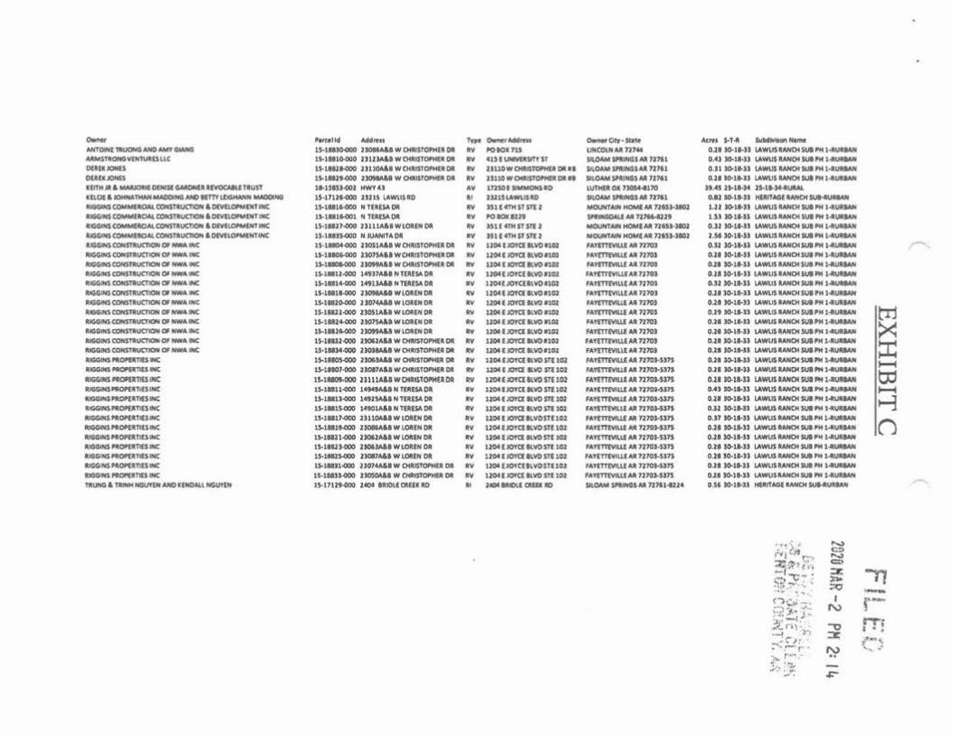
..._ ~II· -~· -O..WrAlklnu 0....... Ott• Stl'lot Ac!fi ,., .. iuMltlllHft HllN
AHTOIN:l l"llUOf"O AHO M.ttt o.WIO lS-lll»<IOO J)OMAU W ~TC»Hfl Ol .., l'Otoll 11S UHCOUIAA 7J1M QJ.1 JO·ll-Jl lAWU$1AHOtsutf'M l·llVllMN NIMSTillOHOV(HTUltUUC 1'°11110-000 IJU1AUWOWSTOf'IMU Cit .., 41)1 UNl'V'OtSITT SJ M.Oo\MSlalNGSM 117'1 OAl to-1.W.S lAWUS~SUl,..1«WIMH Ol•PtONIS 15-llNt-000 1ttlOAAIWOcUS'fOf'HUOA .. 1S110WO«ISTWHll Dlt •I Sll OAA&WIHGSAA 11161 0.Jt»l•JJ V.WUSAAHC>tSIJllMl·l""'...,, OUUJONES 1S.1D.Jf.OOO JJOllM.lol w OltllTI»'HfA Dtl IV JlllOWOtll$Tontfa~ II 5UOAM$1llNCUM 7.1:161 o..ll I0-1 .. ll l4WUS RANOISUI PH141UllAN
llfTH • & IAAU)llC DIN1$1 GM:Ofrtll lllVOCMlfiTl\tSl t•UISJ..OOJ MWT 4J AY tnSOlSIMMONSllO lUTHll Ol 7>0S44.l 10 ,, .... , lS-1 ..... JS-11-)4.tUIW. lllQt& JQMNAnwfMAODING ANO MTTY~N W1DCtHG lS.171JMIOO lHH tAW\.lS-0 •• llJ:lJLAWUSllO SIWAM Sllll~OSM 7l1tl UJ J0.1 .. U HElln'AGl IWKM R.IMIUUAH 1UGG1HS COMMOICW. CONST11UC'hON & O(\l(u»'MlJCf llC 1So1.U.l6"000 N nllSADlt llY lU(4THSTSTl1 MOUHTMH HOMllNI nm-lll» I.JI »t•» \AWW llAHOtSUIPH l •ll\MIAN ~ COM!Mll<Ml OONSTltUCTIOlll & O(Yll(W'M(NT INC 1>-t•t.ocn N TU.DA Oil •• POIC*ll.lt SPR•GDM.l M nJM.ollJt l..S) »t•SJ U.WUSllAHOtlUllMl~ llGIJIMS CCIMM(ACJM. COHSTitucnoH t. DlVlt.oPM(HT NK 15-1'1J7.GXI JJUlAAIWlOUHDll .. lJtlmtSTsrtJ M(JAJHTMt HOMEU. llQS.llOl o.Jl JO.lWS V.WUSIANCM SUI il'N 1-«UlllAN lllGGl'llS ~UIOAI. CCHSTIUJC'IKIH & DIYtl~IH( U-1..lllHoOOO N JUAHl'fAOI .., Ult4'fMnSflJ MOUN'fMf MC»rol( All 1J6SJoJIOl: 2..M »11-)) tAWUSAAHCNllA"" l..JIUll:INI ~ COHSnU,l('flOH °' fNIA INC: lf.1~ JIOJSM.IWOllUSfMttlDI' "" llOl t JoYCl ll\iO •UU: IAl'llTIVll.LI M n'JOJ CUJ »t•l> U.WU$Ufrl04IUll'M 1-«UltlAH llllGGINS c:oHstRUCTIOH Of HWA INC l,_!lll)f.000 JI01)A&I WCHltSlOft4llDI .. 1204flO'fClk'flO•W IAVintVIUI AA 1J10J 0.21 lo.1.Wl tAWUS UNCH SUI '" 1.-uatAH -.GMCIOHS'f~ OI HW-. WC 1~1.......000 JJOIMlA&I WOIAIST°"411a Ol .. UOI [JOYatl.'40#102 1-.Trntw.lf Al ?HOS IUI JO.it-» \AM.IS UMOI SUI'" J4~1Wf ltlGGIHS CONS'fltUCflON OI HWA INC 15-l•U.OCO 1Atl7All N'f[U'°'Oll .. IJ'IM t IOTC( llW 1 IOJ F-.TmtVILLfU 7J70l O.Jt )0.1 .. JJ l.A.WUSIANCH $U1 "4 1""'11tlAH ltlGGIHS COlf$TltU(TION OI HWA H; lS-l•tt-000 1 .. llA&eHTU!SAOI .. 12CH( .IO'f((l\Wt102 f-.TITTtYllU,,. 12101 O.ll »11-» 1.AWUSJ.AH04 M.11"4 1 ...... IAN ~IHSCOH:STiltUC'llOH Of HWA WC: lS·l•ll-OCO J IOIMll W lOlfN Olfl .. U 04 l IO'l'a ll YO t102 'Attntvl~U .U 1J10J o.J.I J0-11-lJ U.W\IS lAHOI SUI'" 1.aUUAN llGGIHS CONSTlt.ICTIOH Of HWA INC lWtllO.OOO JJONAleWlCMtNOilt IY 1.204 t JOtCl lt'WO .,,,, IA1"{nlW.ll Alt nm 0.21 »t•» lAWUS llNIOl IUt'" t•UlMH ltalNS <OfrfSTiltucntlN OI HWA IH( lS•ll&Jl-000 2)0SJA&I W lCM(N 01t IY 1!04 f JOKI ll'IOllOl IAYrmW.11AA11701 O.Jt 90-t•n V.W\ISiltANCMS4Jlf'Nl.....,. t'l1 i1t1GGWS COHSTAUc:flON Of HWA WC: lS-11'14-<:CIO JJl»$4&.IWLOl(ltl)lt .. tl04llO'rallVO•UU IA'f'tTTIWJ,.IAiltll~ O.:ta »11.sJ l.A.WU$iltA.HOt SUI'" t•l.MIAH >:: ll&NINS COfrlSTiltUCrlON OI HW .. lfrfC tS-t•H-000 2J091.\&I W LOltN Dill:. .. UOttJO'l'aaw1n01 FA't(TlfWLU AA 11101 0.21 J0.11.Jl V.WUS UNCH SUI l'H 1411_.MH llllGOlfd,COHSTilurncJaf Of HW" INI: IS-llUJ.000 2»062AU W 04MSTOl'Mlll°" .. U04 t JOTQ kVO 1102 , .. .,mrwu.£.U.J210l O.JIJ0.11·U l.A\llW\JllWIOtSlJlf'H1·1tUUM ::c: MGGINS CONSTINCTOI OI NWA 1HC U•lltM.000 J)OJM&I WCHlttST0"4l• Olll llY U04t:JO'l'a•vo•101 fAT{T'f(YlllU .. ll n'JOl 0.11 .0.11-J) V.W\JS ilt.AH04 JUI f'H t«IMMN
•IGGINS "'ommrs INC t~tMOWOO Jla.U.U w ~f0f'4PI Olll •• 1204(JOTct•vosf( lOJ MT'ITTIVUl:Al n101-sm O.JI IOolWJ lAW\JSMNOISWJ'Mt.tu..,_,. -ilt.IGGINS NOf'Dtnt:S INC t).ltlOJ-000 Jtol'A&IWCHltlSID'Mf•Oilt. .. 1104 I IO'l'Q &YO STI 102 M'l'IT'tfYIW M '1101•).)1$ 0.11 JO.ll•» lAWUSUHOCSUllMl•UlllAN
to lllGGINS PltOf'PTIU INC lS.lllOt-000 JllllA&.I WOOU.TOl'Ht:lOll •• 120-tlJCHQllYDSTl IOJ MYlnMU .U n10J.Sl'1$ 0.21 J0.11-JJ LAWUS U#Ot SUI "'4 1 ... UUAN lllGGfNSPlONlll'fllSIHC IS-1Dll.000 '"""°"'Nftlt(SADa .. 12041 IOYQ ll'IO S'fl 102 IATtm'VIUI Al '1101•»1' OAJ Jo.J.Jl tA't'fllSlAHCH !IUI l'H lo411lMIAN -•IOG.,.l '10H•'flfS INC U.t•ll«IO 14'1NIH10tSAOlll: .. UCMtlOfct llVOnt tOl , .. ,,nt\'IU( Al 1170)-»n o.JI J0.11-JJ l.AW\llUH04 SUI l"M l-l\.lill:MN i-j •IGGIH$ "'°"llTltS IN( U-t•lJ.400 14'01AJINT1ll$AOI .. U(M I IO¥Cl II.YO Sll 102 JA\'fTfl\llLll All n10MPS o.u J0.1.14J tAWUJ UHCM SUI PM 1.-ullUM ~$ .. Of'lll'fllSIHC U.1•11.<JOO J)l 1.01141 w t.OlltH Dill:. .. \JOI l IOY<ll~VOSTl102 IA'l'lTT'f\111.Ll All 1J10J;-SJJS O.Jl tc).11.JJ lAWUllAHCMSUlf'H 141\MINf n -.OOIH$ N.OHilt'f1tS INC tW•IMIOO J.MllMIWLOltN Oft .., tJOAIJOYallYOS1t lOl Ml'lTfMW All JJJOl.Ql'S 0.21 »t•» l.AWUSIWIOtSUlf'H l-".VQAll ilt.IGISIHS f'ttQf't:fl;'f1U INC IJ.11111.COO JJ0t.1461W~NOI .. UOil t iO'f'a ll'IOSTf >Ct '"l'flTMU.l All 1210J.Sl1S 0.21)0.1.JI lAWUSltAHOISUl .. Hloll'UllMN lllOOINS~IHC 11-llUMOO 2MXWIWLOUHOJI .. l2CH ( J0Ta ILVDm ltU H.TlTTtV!Uf All 7210J•Sl7' 0.lll0-11-U lAWUSIWIOtlUl""l"""'IAH lllGGIMS "'O'tltTIU INC 15-UIJJ.OCIO J:D7.\&.J WLCM(H OJI .. 1l'c>l l IO¥ClllYO STl 10l MY'(Tf'(Vlll( All 1110,.5)75 O.Jt J0.1.1-l.l tAWUSAANOf5UIPM 14WlllNf ll1GGIH$ PllOf'UllU 1NC 1S-lUl1400 JJ014A&IWOWSTOf'HUOll •• UOA lJO'l'ctllVOSff 101 IATtTTMUE AA 1l'70t•Sl7S 0.J.I JI0-1.)) l.AW\JSM!flCM IUI PM 1.&\lill:MH llOOINS PllOP(iltfWS INC lf•l.NJJ.000 JIOSOf.U W 01ltdTOPHllt Dfl .. tJOI ( JOftt llYO m 11» M'l'tTTtWl.rM 7170WJ7S OJ.I JO-t•U LAWUSUHCN5UI PM 1-WltMN TltUNO & TAINH Nl$VYIN AHO ltHOA.U NGU'YlH t).17Uf.OOO J«>e llo.tOUll ttO .. J«)I W.IOt.I. CMU lllO SIU)tM W.1HG$ M 121'14U4 O.S, Dl•<ll HlltlflloGI IANCH SUMIU.llAN
·1 .. '" ....,
"'i <'.it(:"> = ...., :i;,-,,:.1 = ;:!-c· : :x -n ,.,. ::~-~··:: ;:Q --~ .... C")V,. ..-. I r-~'",$• ~1w N :·:-t ... ~ .. ,..,.., ~ ri,.;.; ....,
:x .. .:~ 1: . e~~ :"'-> - r·· ~ ' . ~ :· .. ·.-, .. ':,.. .,,,,_. :.."': ..,..

(
Exhibit D
(Engjnecrs Certification)
13
202a HAR -2 PM 2: Ii.

(
EXHIBITD A
701 South Mount Olive Street /~1¥.1~"-. P.O. Box 12 "'"'" -Siioam Springs, AR 72761 ENGINEf,;RING ------ ""·i-~c/
v
February 22, 2020
To Whom It May Concern:
(
F ILE i.°.' voice (47.lU,~:\1195§
tax (4$Ylffl'N PH 2: 14 mallOcMlengln8j!JI~'!'. • . ,
- I•• I
~ ..... -;,~; r.;·} ·.:~· ;:,··,;,~ ... .. , fJC C: i,,.~t:,. ':! ,,. ...... '· . ~
. -~'T'"" r"1 ·1·y· .,r... .. t~ ! l 1J~ 1 .~ .. ~
RE: Benion County Tax Parcels 18-15853--002. 15-17126--000, 15-17129-000, 15· 18804·000 through 15· 18816-000, 15-18816-00L & 15-18817·000 through 15-18835-000
NEV. of the SE V. of Section 25, T-18-N, R-34-W, Part ofN ~of the SW V. of Section 30. T-18-N, R-33-W which includes Lots I through 32 and the strcel right of ways of Lawlis Ranch Subdivision Phase I, Part of the SW V. of the SW V. of Section 30, T-18-N. R-33-W which includes Lots 9 and 12 of Heritage Ranch Subdivision Phuse I
Total Acres: 55.63
Owners: Antoine Truong and Amy Giang; Armstrong Ventures, LLC; Derck Jones; Keith Jr & Marjorie Denise Gardner Revocable Trust; Kelcie & Johnathan Madding and Betty Leighann Madding; Riggins Commercial Conslruclion &. Development, Inc.; Riggins Conslruclion of NW A, Inc.; Riggins Properties, Inc.; Trung & Trinh Nguyen and Kendall NGuyc'll
Dear Sirs:
I, Ron Homeyer, Arkansas Professional Engineer Number 7731 , do hereby certify and confinn thal
lhe above referenced 55.63-acre annexation, localed in Section 30. Township 18 North, Range 33 West and
Section 25, Township 18 North, Range 34 West, identified as lhe above listed Benton County Tax Parcel
numbers, owned by !he above referenced property owners, is contiguous to and adjoining !he Ciiy Limits of
!he Cily of Siloam Springs. I also certify and confinn 1ha1 the annexation oflhc said 55.63-acre tracl will no!
create an enclave.
Sincerely,
Ron Homeyer, P.E. President
Residential ~Commercial ~ Municipal Designs

(
Exhibit E (Vicinity Map - Annexation)
14
Ff I F. --. - · -· l;
2020 MAR - 2 PH 2: I It ' ... _4 • ' I '
.:,.f-:, t .}l ;-,_, ·-••: L ,.. # p·'C\"' .. , ,. ---
,,_ t't- C'\-t;:'Q ... , • • ~~ i. ~,< 1<>·'1T""'' I '.1~-.,; • - ' l>, . "' • . J., ..

Vicinity Map - Annexation I : : • = • ,
~~r---------:--ir------t--r------
Febtuary 22, 2020 - 00- --Olllot 0 oo-. - - -- 0 - --
llENTOM/l.l.E CEHTERTOH l<VOCA
BEll<EL HEIGlfTS DECATUR BELLI< \'ISTI<
Cl<VE SPRINGS EUISPRlNGS
0 004
0 007
1:5,453 o.oe
o.•a
-

(
E.ghibit F
(AR GIS Letter)
15
2020 1!AR -2 PH 2: 11+

l (
EXHIBITF FIL. E [1
ARKANSAS GIS OFFICE
Department of Transformatlon and Stifflll ~!)(le~ P" 2 4 Governor AIU.:'llilll~ n : I Secretary Amy Fecher
Director Shel!!9~~ll'\S'!'i.L:r ,: " :_ ;;': t Pe.t•<-: 1( CU.l".X ~1'. l :~ Ci.J .. ~~i-·v. >.'!'
February 25, 2020
Mr. Ron Homeyer, P.E. Civil Engineering, Inc. 701 S Mt Olive Street Siloam Springs, AR 72761
RE: City of Siioam Springs Annexation Coordination Requirement
Mr. Homeyer,
Thank you for coordinating with our office as you seek to annex property into the City of Siloam Springs, AR located in Section 25, Township 18 North, Range 34 West and Section 30, Township 18 North, Range 33 West. This letter represents confirmation that you have properly coordinated with our office (Arkansas GlS Office) as specified In § 14-40-lOl (Act 914 of 2015) of the 90"' General Assembly.
Our office will wait completion of any additional steps necessary for the proposed boundary change, which normally comes from the Arkansas Secretary of State Elections Division after any appropriate filing by your County Clerk.
Thank you,
Jennifer Wheeler, GIS Analyst
Attachments: GIS Office Map of Proposed Annexation Legal Description Secretary of State Municipal Change Cheddlst
H:\Oty_Anne)(at1on.s\Qt1es\S11oam_.Sorlngs\2020022S\Doc\2020022S_s11oam Spring;s...Annexac:ton_Coor61nabOn_1.tttcr.docX
ARKANSAS GIS OFFICE 1 Cap~ol Mall. Suite 6D • little Rod<. AR 72201 • 501 .682.2767
gis.arl<ansas.gov • transform.ar.gov '"

Ordinance 20-19 Page 1 of 4
ORDINANCE NO. 20-19
AN ORDINANCE ACCEPTING THE ANNEXATION OF CERTAIN TERRITORY TO THE CITY OF SILOAM SPRINGS,
ARKANSAS AND ASSIGNING SAME TO A WARD.
WHEREAS, a petition was filed with the County Clerk of Benton County, Arkansas, by the owner of the hereinafter described territory praying that said territory be annexed to, and made a part of the City of Siloam Springs, Arkansas; and,
WHEREAS, on May 27, 2020, the County Court of Benton County, Arkansas, found that the petition was signed by a majority of the real estate owners in said territory; that the petitioners own more than one-half of the total acreage affected by the petition, that said territory was contiguous and adjoining the present corporate limits of the City of Siloam Springs, Arkansas; that an accurate plat or map of said territory had been filed with and made a part of said petition, and that no enclaves will be created if the petition is accepted by the City of Siloam Springs; and,
WHEREAS, the annexed parcel of real property is contiguous and adjacent to the other lands in Siloam Springs, Arkansas, which are located in Ward 1.
NOW, THEREFORE, BE IT ORDAINED BY THE City Board of Directors of the City of Siloam Springs, Arkansas:
Section 1. That the following described lands and contiguous territory adjoining the City of Siloam Springs, Arkansas, (and as shown on Attachment 1), be and the same is hereby accepted as part of and annexed to and made a part of the City of Siloam Springs, Arkansas:
Benton County Tax Parcels 18-15853-002, 15-17126-000, 15-17129-000, 15-18804-000 through 15-18816-000, 15-18816-001, & 15-18817-000 through 15-18835-000, which is more particularly described as:
NE 14 of the SE 14 of Section 25, T-18-N, R-34-W, Part of N ½ of the SW ¼ of Section 30, T-18-N, R-33-W which includes Lots 1 through 32 and the street right of ways of Lawlis Ranch Subdivision Phase 1, Part of the SW ¼ of the SW ¼ of Section 30, T-18-N, R-33-W which includes Lots 9 and 12 of Heritage Ranch Subdivision· Phase 1
Total Acres: 55.63

Ordinance 20-19 Page 2 of 4
Section 2. That the above-described territory shall be annexed to and made a part of Ward 1 of the City of Siloam Springs, Arkansas, and the same shall be a part of said ward as fully as existing parts of said ward.
Section 3. That the zoning map of the City (Municipal Code Section 102-21) is hereby amended to include within the R-1 zoning district the described territory as follows:
Part of the SW ¼ of the SW ¼ of Section 30, T-18-N, R-33-W and Part of the NE ¼ of the SE ¼ of Section 25, T-18-N, R-34-W, Benton County, Arkansas. Being More particularly described as follows:
Beginning at a the SE Corner of the NE 1/4 of the SE 1/4 of said Section 25; thence N 87°06'58" W 1321.74'; thence N 02°56'07" E 175.21'; thence S 87°02'41" E 1321.80'; thence S 02°57'19" W 105.02'; thence S 86°52’41” E 111.68’; thence S 03°07’19” W 363.41’; thence S 82°11’54” W 49.31’; thence S 49°09’16” E 263.60’; thence S 40°50’44” W 85.00’; thence N 49°09’16” W 275.88’; thence N 02°54’40” E 363.93’ to the point of beginning and containing 6.81 acres.
Section 4. That the zoning map of the City (Municipal Code Section 102-21) is hereby amended to include within the R-2 zoning district the described territory as follows.
Part of the NE 1/4 of the SE 1/4 of Section 25, T-18-N, R-34-W, Benton County, Arkansas. Being More particularly described as follows:
Beginning at a point 173.56' N 02°57'19" E of the SE Corner of the NE 1/4 of the SE 1/4 of said Section 25; thence N 87°02'41" W 1321.80'; thence N 02°56'07" E 1147.20'; thence S 86°43'57" E 1052.22'; thence S 02°57'19" W 581.47'; thence S 87°02'41" E 104.22'; thence S 83°18'23" E 70.94'; thence S 81°06'08" E 95.50'; thence S 02°57'19" W 545.49'; to the point of beginning and containing 31.08 acres.
Section 5. That the zoning map of the City (Municipal Code Section 102-21) is hereby amended to include within the R-3 zoning district the described territory as follows.
Part of the N 1/2 of the SW 1/4 of Section 30 , T-18-N, R-33-W, Benton County, Arkansas and Part of the NE 1/4 of the SE 1/4 of Section 25, T-18-N, R-34-W, Benton County, Arkansas, more particularly described as follows:
Beginning at a point 275.00' N 02°57'19" E of the SW corner of said N 1/2 of the SW 1/4; thence N 02°57'19" E 376.46'; thence N 81°06'08" W 95.50'; thence N 83°18'23" W 70.94'; thence N 87°02'41" W 104.22'; thence N 02°57'19" E 581.47'; thence S 86°43'57" E 270.00'; thence N 02°57'22" E 72.39'; thence S 87°00'05" E 304.24'; thence S 03°00'05" W 374.03'; thence S 86°52'30" E 341.97'; thence S 03°07'30" W 142.50'; thence S 86°52'30" E 14.41'; to a tangent curve concave to the Northwest and having a radius of 175.00'; thence along said curve with an arc distance of 35.08' and a chord of N 87°22'57" E 35.02'; thence leaving said curve S 08°21'37" E 200.01'; thence S 86°52'30" E 65.99'; thence S 03°07'30" W 192.50'; thence N 86°52'30" W 2.00'; to a tangent curve concave to the Southeast and having a radius of 15.00'; thence along said curve with an arc distance of 23.56' and a chord of S 48°07'30" W 21.21'; thence leaving said curve S 03°07'30" W 127.50'; thence S02°57'19"W 250.00'; thence N86°52'30"W 50.00'; thence N02°57'19"E 250.00';

Ordinance 20-19 Page 3 of 4
thence N 86°52'30" W 732.00' to the point of beginning, having an area of 17.89 Acres.
ORDAINED AND ENACTED this ______ day of __________________ 2020.
APPROVED:
ATTEST: __________________________ John Mark Turner, Mayor
Renea Ellis, City Clerk
(SEAL)

Ordinance 20-19 Page 4 of 4

STAFF REPORT
TO: Phillip Patterson, City Administrator FROM: Ben Rhoads, AICP, Senior Planner Cc: Don Clark, Community Development Director DATE: July 21, 2020 RE: Ordinance 20-25 / Amending Section 102-21 of the City Municipal Code / Rezoning from I-
1 to C-2 / 4650 Hwy. 412 East Recommendation: Place Ordinance No. 20-25 on its _____ (1st, 2nd or 3rd) reading, suspending the rules and reading by title only.
Background: The applicant, Butler Revocable Trust, desires to rezone 4650 Hwy. 412 East, consisting of 3.80 acres, from I-1 District (Industrial) to C-2 District (Roadway Commercial). The Planning Commission reviewed the rezoning application at the July 14, 2020 regular meeting. There were no comments from the public. The Commission recommended approval of the rezoning permit by a 7-0 vote, with no abstentions. According to the Land Use Code, a rezoning development permit shall only be authorized when the applicant has convincingly demonstrated that the proposed zoning:
(a) Will not substantially interfere with other owners’ reasonable peace and enjoyment of their neighboring properties;
(b) Will not substantially damage any property value in the neighborhood; (c) Will be compatible with and respect the context of its location and the character of the
surrounding existing neighborhoods; (d) Will not, whether by the nature of the allowed uses in the proposed zone, or by the
allowed siting, height, or design of structures or landscaping in the proposed zone, tend to burden the present or future use of neighboring properties in accordance with current zoning standards;
(e) Is adequately supported by infrastructure, including without limitation, streets and parking; and
(f) Compared to present zoning of the property, is equally or more consistent with: 1. Sound planning of the city’s growth; and with 2. Public health, safety, and convenience within the neighborhood:
Please consult staff’s memo to the Planning Commission for the analysis and findings on these criteria. Fiscal Impact: No fiscal impact is anticipated. Attachments:
Staff report to Planning Commission Ordinance No. 20-25

PLANNING COMMISSION STAFF REPORT
TO: Planning Commission FROM: Ben Rhoads, AICP, Senior Planner Cc: Don Clark, Community Development Director DATE: July 7, 2020 RE: Rezoning Development Permit, RZ20-05 / Rezone from I-1 to C-2 / 4650 Hwy.
412 East Recommendation: Motion to approve RZ20-05 (Rezone Development Permit). Section A: Background: A-1) APPLICATION REVIEW DATES
Planning Commission review: July 14, 2020 Board of Directors review: August 04, 2020
A-2) APPLICANT AND AGENT
Applicant/Owner: Butler Revocable Trust Agent: Ben Jones
A-3) SUBJECT PROPERTY ADDRESS
4650 Hwy. 412 E. A-4) PROJECT SUMMARY
The applicant desires to rezone metes and bounds property, consisting of 3.80 acres, from and I-1 District (Industrial) to C-2 District (Roadway Commercial).
A-5) LEGAL NOTICE
Site posted: June 5, 2020 (late application). Newspaper legal notification: June 24, 2020 (Herald Leader). Letter legal notification: June 15, 2020; resent on June 19, 2020 due to a typographical
error on the June 15th letters. Staff received one phone call of a questioning nature and no correspondence on the
request.

7/7/20 P.N. 03-04279-001; RZ20-05 2
A-6 EXISTING LAND USES AND ZONING
EXISTING LAND USE EXISTING ZONING Vacant – former card warehouse outlet 1-1 District (Industrial)
PROPOSED LAND USE PROPSOED ZONING Large Impact Commercial (Use Unit 16)1 C-2 District (Roadway Commercial)
SURROUNDING LAND USE SURROUNDING ZONING North: Industrial – parking lot for Cobb North: I-1 District (Industrial) South: Vacant / Agricultural South: Benton County – No Zoning East: Commercial – veterinarian office /
Institutional – Place of worship East: C-2 District (Roadway Commercial)
West: Vacant – former manufacturing West: I-1 District (Industrial) 1The applicant indicated that he would like to develop the whole property for a dance school and retail/self-storage space.
Figure A-6 (1): General Area Map

7/7/20 P.N. 03-04279-001; RZ20-05 3
Figure A-6 (2): Site Views
South (front of building)
North

7/7/20 P.N. 03-04279-001; RZ20-05 4
Section B: Site Analysis B-1) PROJECT ANALYSIS AND APPROVAL CRITERIA
I. The following criteria are shown to indicate if this proposal meets the minimum criteria for approval. Criteria I-II is a subsection of Sec. 102-53 of the Municipal Code; Criteria III & IV are not directly applicable to the Zoning Code; and Criterion V is Sec. 54-37 of the Land Use Code.
II. ZONING USE UNIT CONSISTENCY: C-2 (Roadway commercial) (a) Purpose The district is established to protect the accessibility, efficiency, utility and value of intensive commercial enterprises located on major thoroughfares and patronized by businesses or by the general public. (b) Planned uses This property will be used as a commercial business. The proposed businesses fitting on the existing lot best fall under Use Unit 16 (Large impact commercial or office facility) and Use Unit 12. Use Units 12 and 16 are permitted in the proposed C-2 District.
The C-2 zoning district allows Use Units 2, 8, 9, 10, 11, 12, 14, 15, 16, 17, and 18 by right. These use units permit such uses as, but not limited to, parks, small to large office, small to large retailer and/ or commercial facility, small motel, small motor vehicle service station, small to large institution, recreational vehicle park, and a commercial parking lot.
(c) Special uses Special use for the proposed zone includes Use Unit 13 (Utilities), Use Unit 19 (Antenna Tower or Mast), Use Unit 20 (Light Industry), and Use Unit 21 (General Industry).
II. LOT STANDARDS CONSISTENCY
The minimum C-2 zone standards are compared with the subject property below.
MINIMUM (C-2) ZONING REQUIREMENTS
SUBJECT PROPERTY PROPOSAL
Lot Area: 8,000 sq. ft. 165,528 sq. ft. or 3.80 acres Lot Width: 80 ft. 275 ft. Maximum Lot Coverage: 80% Approx. 33% Maximum Floor to Area Ratio: 0.6 (60%) 0.12 or 12.1%
III. LAND USE CODE REQUIREMENTS
According to the Land Use Code, a rezoning development permit shall only be authorized when the applicant has convincingly demonstrated that the proposed zoning: (a) Will not substantially interfere with other owners’ reasonable peace and
enjoyment of their neighboring properties:

7/7/20 P.N. 03-04279-001; RZ20-05 5
(b) Will not substantially damage any property value in the neighborhood:
(c) Will be compatible with and respect the context of its location and the character of the surrounding existing neighborhoods:
(d) Will not, whether by the nature of the allowed uses in the proposed zone, or by the allowed siting, height, or design of structures or landscaping in the proposed zone, tend to burden the present or future use of neighboring properties in accordance with current zoning standards:
(e) Is adequately supported by infrastructure, including without limitation, streets and
parking:
City staff is aware of no evidence that the proposed rezoning for commercial use will cause a disturbance to the peace and enjoyment of the neighboring properties. The neighboring properties are generally either unoccupied or are industrial/commercial in nature and are generally considered equal or greater intensity of land use from the proposal. Enforcement of the City Code’s nuisance chapter ensures quality of life impacts are mitigated.
The proposed zoning is of similar use class and it is generally compatible with the industrial, commercial, and institutional uses in the neighborhood.
Water System There is an existing 6” water main that runs on the north side of the property. Staff finds this existing infrastructure to be adequate for fire and projected water needs.
Sanitary Sewer System There is an existing 8” sewer main that runs on the north side of the property. Staff finds this existing infrastructure to be adequate for wastewater needs.
Storm Sewer System The property is already developed. On site storm water detention will be evaluated upon the submission of a redevelopment proposal.
Commercial uses in this area are not anticipated to impact property values due to the existing commercial land use to the east, abutting the subject property. Other adjoining land uses are of a greater industrial intensity or are undeveloped.
Commercial uses in this area are not anticipated to burden the present or future uses of neighboring properties due to the proposed use being equal or lesser intensity than the land uses abutting the subject property, or the abutting land uses are presently unoccupied.

7/7/20 P.N. 03-04279-001; RZ20-05 6
(f) Compared to present zoning of the property, is equally or more consistent with: 1. Sound planning of the city’s growth; and with 2. Public health, safety, and convenience within the neighborhood:
B-2) COMPREHENSIVE PLAN CONSISTENCY The 2030 future land use map describes this area as commercial. The following zone(s) are appropriate according to the designation: C-1, C-1A, C-2. The proposed C-2 zone is compliant with all existing and future land uses.
Figure B-2 (1) Future Land Use Map
B-3) STAFF DISCUSSION General Summary The applicant is requesting to rezone 4650 Hwy.
412 from I-1 to C-2, the site of a vacant facility formerly the DaySpring Cards Warehouse Outlet facility. The rezoning was prompted by the applicant’s request to reoccupy the building for retail and a private dance studio/ school.
The proposed rezoning meets the minimum lot requirements (see above). The future land use map calls for office and commercial uses in this area. This land use complies with the proposed C-2 zone.
Key Points: • Lot Comply with Zoning • Consistent with the land
use plan and area land uses.
• Existing building meets C-2 Code requirements
The proposed rezoning will not inhibit sound planning of the City’s growth. The proposed commercial zone will not consistently inhibit or harm the general public health, safety, and convenience within the neighborhood. The property has been used for quasi-commercial applications in the past, so the rezoning appears to not be out of character with the history of the building.

7/7/20 P.N. 03-04279-001; RZ20-05 7
Existing and Future Land Uses The property is best described as a vacant building with a sizable undeveloped area
behind. The building has an improved parking area consisting of approximately 50 parking stalls.
The proposed zoning will transition the building from being primarily an industrial/ warehouse application to general retail use.
The applicant has applied for a building permit to finish out the interior of the structure into three suites, the first will be a retail self-storage space, the second will be general retail for a bike shop, and the final space will be a dance school.
Staff confirmed that adequate parking exists on the site to accommodate these uses, although the applicant has been asked to re-stripe the lot.
Neighborhood Context and Compatibility Office uses exist to the immediate east of the facility and the corporate offices for an
industrial user exists to the north of the facility. Staff finds that the conversion to commercial is generally consistent with the overall built environment in this area.
Conditions and Staff Conclusions Staff is supportive of this request and recommends approval with no needed conditions.
Fiscal Impact: Streets fees in the amount of will be assessed upon business license issuance. This is not done as part of the tenant finish out building permit in the unlikely event the end users change. Attachments:
Site Plan

-l<6'0 1-1~ 412 &)
$',~ ~r·.,~~.A '2 ~1i.1

Ordinance 20-25 Page 1 of 1
ORDINANCE NO. 20-25
AN ORDINANCE AMENDING SECTION 102-21 OF THE SILOAM SPRINGS MUNICIPAL CODE (CITY ZONING MAP); REZONING (FROM I-1 TO C-2)
THE PROPERTY LOCATED AT 4650 U.S. HIGHWAY 412 EAST
Whereas, the landowner, Butler Revocable Trust, has requested that the below-described land be changed from the present zoning district of I-1 (Industrial) to C-2 (Roadway Commercial); and Whereas, a public hearing on the proposed change was held on the 14th day of July 2020, before the City of Siloam Springs Planning Commission, after proper notice required by law; and Whereas, after receiving and considering a staff report and public comments, a motion recommending approval of the rezone was passed by the Planning Commission; and
Whereas, upon review and deliberation it appears that the zoning change is in the best interest of the City of Siloam Springs; Now Therefore: Be It Enacted, by the Siloam Springs Board of Directors, as follows:
The zoning map of the City (Municipal Code Section 102-21) is hereby amended to include within the C-2 zoning district the property located at the 4650 Hwy. 412 E. described as follows:
PART OF THE NW ¼ OF THE SW ¼ OF SECTION 3, TOWNSHIP 17 NORTH, RANGE 33 WEST, AND MORE PARTICULARLY DESCRIBED AS BEGINNING SOUTH 00 DEGREES 01 MINUTES 06 SECONDS EAST 40 FEET AND SOUTH 89 DEGREES 51 MINUTES 25 SECONDS WEST 342.46 FEET AND SOUTH 00 DEGREES 00 MINUTES 00 SECONDS EAST 30.00 FEET FROM THE NE CORNER OF SAID NW ¼ OF THE SW ¼; THENCE SOUTH 589.80 FEET, THENC SOUTH 89 DEGREES 49 MINUTES 19 SECONDS WEST 280.32 FEET; THENCE NORTH 589.97 FEET; THENCE NORTH 89 DEGREES 51 MINUTES 25 SECONDS EAST 280.32 FEET TO THE POINT OF BEGINNING.
Ordained and Enacted this day of 2020.
ATTEST: APPROVED: Renea Ellis, City Clerk John Mark Turner, Mayor
(SEAL)

STAFF REPORT
TO: Phillip Patterson, City Administrator FROM: Ben Rhoads AICP, Senior Planner Cc: Don Clark, Community Development Director DATE: July 21, 2020 RE: Resolution 39-20 / Preliminary Plat Development Permit / Fox Tail Addition South / 2000 to
2500 Block of E. Kenwood Street Recommendation: Approve Resolution No. 39-20, authorizing a preliminary plat development permit for the 2000 to 2500 Block of E. Kenwood St. Background: The applicant, Roderick Allen, in collaboration with NWA LD, LLC, requests to establish a preliminary plat for the Fox Tail Subdivision, Phases 1 and 2. The proposal is situated on 59.04 acres and contains 167 two-family zoned lots, although the applicant has indicated that they only desire to construct single-family housing. The Planning Commission reviewed the preliminary plat application at the July 14 regular meeting. There were multiple comments from a member of the public with regards to stormwater drainage on Quarter Rd and Hwy. 16, the access road from Hwy. 16, and the type of dwellings proposed, i.e. starter homes, etc., and if there will be a POA. These comments were addressed by the applicant and staff. Drainage east of Hwy. 16 will not be impacted, the access road will connect with Keck Rd., the houses—due to the lot sizes—will be starter homes, and there will be a POA established. The Commission recommended approval of the preliminary plat permit by a 7-0 vote, with no abstentions. Fiscal Impact: Street impacts fees are projected to be $40,976.79 collected upon building permit issuance. Attachments: Staff report to Planning Commission Resolution No. 39-20

PLANNING COMMISSION STAFF REPORT
TO: Planning Commission FROM: Ben Rhoads, AICP, Senior Planner Justin Bland, PE, City Engineer Cc: Don Clark, Community Development Director DATE: July 7, 2020 RE: Preliminary Plat Development Permit, PP20-04 / 2000 to 2500 Block of E.
Kenwood Street Recommendation: Motion to approve PP20-04 (Preliminary Plat Development Permit)
Section A: Background: A-1) APPLICATION REVIEW DATES
Planning Commission review: July 14, 2020 Board of Directors review: August 04, 2020
A-2) APPLICANT AND AGENT
Applicant/Owners: Roderick Allen Future Owner/Developer: NWA LD, LLC Agent: Crafton Tull - Taylor Lindley, P.E.
A-3) SUBJECT PROPERTY ADDRESS 2000 to 2500 Block of E. Kenwood St.
A-4) PROJECT SUMMARY
The applicant wishes to establish a preliminary plat called the Fox Tail Subdivision. The two-phase development is for 167 two-family residential lots on 59.04 acres, which includes two detention areas separated by a proposed roadway. The lots are sized appropriately for single-family housing, which is allowed in the R-3 zone.
A-5) LEGAL NOTICE
Site posted: June 12, 2020. Newspaper legal notification: June 17, 2020 (Herald Leader). Letter legal notification: June 16, 2020. Staff received three phone calls of a questioning nature and no correspondence on the
request. The calls were with regards to the general design/location, drainage impacts, and future City services available in the area.

2 7/7/2020 P.N. 03-00331-000, PP20-04
A-6) EXISTING LAND USES AND ZONING EXISTING LAND USE EXISTING ZONING Vacant R-3 District (Residential, two-family) PROPOSED LAND USE PROPOSED ZONING Single family dwelling (Use Unit 3) / Two-family dwelling (Use Unit 4)1
No zoning change is proposed
SURROUNDING LAND USE SURROUNDING ZONING North: Office Commercial / Residential,
Single-Family / Residential, Multifamily / Vacant
North: C-2 District (Roadway commercial) / R-2 District (Residential, medium) / R-4 District (Residential, multifamily)
South: Industrial Warehouses / Vacant South: 1-1 District (Industrial) / Benton County – No Zoning
East: Residential, Single-Family East: C-1A District (Light Commercial) / R-2 District (Residential, medium)
West: Institutional – Place of Worship / Infrastructure – Natural Gas Facility
West: I-1 District (Industrial) / C-2 District (Roadway commercial)
1The developer indicated that the lots will be developed with single-family housing, however this is shown due to the vested right to develop two-family upon future redevelopment.
Figure A-6(1): General Area Map

3 7/7/2020 P.N. 03-00331-000, PP20-04
Figure A-6 (2): Site View
Section B: Site Analysis B-1) PROJECT ANALYSIS AND APPROVAL CRITERIA
The following is a detailed expansion of the project review criteria and staff’s findings for the proposal. Criterion I and II is a subsections of Sec. 102-46 of the Zoning Code; Criterion III is a subsection of Sec. 54-33 of the Land Use Code.
I. ZONING USE UNIT CONSISTENCY
R-3 District (Residential, two-family)
Planned uses Single-Family residential uses fall within Use Unit 3 (Single-Family) and two-family residential uses falls within Use Unit 4 (Two-family dwelling). Use Units 3 and 4 are permitted in the R-3 District.
Special uses This does not apply to this project, as the proposed use is a planned use.
II. LOT STANDARDS CONSISTENCY
The minimum R-3 zone standards are compared with the subject property below.
MINIMUM (R-3) ZONING REQUIREMENTS
SUBJECT PROPERTY PROPOSAL
Lot Area: 7,000 sq. ft. or 3,500 sq. ft. per unit.
7,200 sq. ft. and higher
Lot Width: 60 ft. 60 ft. and over Average Lot Size (all lots): 15,399 sq. ft. Average Residential Lot Size: 10,096 sq. ft.
North

4 7/7/2020 P.N. 03-00331-000, PP20-04
III. LAND USE CODE REQUIREMENTS According to the Land Use Code, a preliminary plat development permit shall only be authorized when the applicant has convincingly demonstrated the following: (b) Standards. A preliminary plat and final plat development permit shall be authorized only when the applicant has convincingly demonstrated that the proposed plat: (1) Will not interfere with other owners' reasonable peace and enjoyment of their
neighboring properties:
(2) Will be compatible with and respect the context of its location and the character of the surrounding existing, or planned, neighborhoods:
(3) Will not, whether by the nature of the use, or by the siting, or design of streets or landscaping, tend to burden the present or future use of neighboring properties in accordance with current zoning standards and the subdivision regulations in section 87 of this Code:
City staff is aware of no evidence that the proposed platting for single-family, or potential two-family, residential will cause a consistent disturbance to the peace and enjoyment of the neighboring properties. Most of the lots are not sized to permit two-family housing. The neighboring properties are either the same land use, industrial, or are unoccupied agricultural. Enforcement of the City Code’s nuisance chapter ensures that the proposal will not inherently decrease the quality of life standards already in place in the area.
The proposal appears to be compatible and respect the existing neighborhood context and character. There are single-family residential uses to the north and northeast of the site. The lot sizes are comparable to the lots in the Eastgate and East Kenwood Additions.
Single-family residential uses in this area are not anticipated to burden present or future neighboring properties beyond what is intended and designed through the current zoning and subdivision regulations. Traffic will increase, but not beyond the functional capacity of the streets in the area.

5 7/7/2020 P.N. 03-00331-000, PP20-04
(4) Is adequately supported by infrastructure, including without limitation, water and sewage systems, streets, and drainage:
(5) Is consistent with sound planning of the city's growth in terms of health, safety, and
convenience within the neighborhood and any affected vicinity:
(6) Promotes favorable economic conditions or public welfare within the city:
(7) Is described in a survey showing all lots subdivided, lot boundaries, existing buildings, existing and proposed streets, alleys, drainage structures, easements and other requirements provided to the administrator:
(8) Consists of lots and streets that conform with this Municipal Code; and
Water System There is an existing 18” water main that runs south of the property, an 8” line west of the property and a 6” line running north of the property. The development will ultimately tie to all of these lines to create a looped access for the project. Staff finds this adequate for domestic and fire flow needs.
Sanitary Sewer System There is an existing 12” sewer main that runs on the southwest of the property along E. Quarter Rd. and proceeding south along Waukesha Rd. The southern portion of the development will be able tie to this with gravity sewer lines, whereas the northern portion of the project will require a lift station to pump to this line. Staff finds this sewer capacity adequate for the project’s anticipated wastewater needs.
The proposed development does not markedly inhibit sound planning of the City’s growth. Nothing in the proposal will consistently inhibit or harm the public health, safety, and convenience within the neighborhood. The street layout is designed to allow for multiple points of ingress/egress on three collector streets, this will prevent potential bottlenecks and will evenly distribute the anticipated traffic generation to the abutting streets.
The City continues to have a robust demand for housing, the proposal helps to alleviate the Citywide demand and will allow for affordable housing options for those seeking single-family (or two-family) housing. The lot sizes are indicative of starter, first time home buyer, housing.
The required items are shown on the preliminary survey plat.
See criterion (II) in this report for finding on the lot configuration. The proposed street meets the minimum street standards set forth in the Master Street Plan and Subdivision Regulations.

6 7/7/2020 P.N. 03-00331-000, PP20-04
(9) Consists of buildable lots that: a. Abut a public street; or b. By permanent easement of record, which easement shall run with the burdened
and benefited land, and by construction approved by the administrator, provide full access to a public street, for free occupancy by public utilities and for free transit by public safety equipment; and
c. Will have all infrastructure required by law: B-2) COMPREHENSIVE PLAN CONSISTENCY
The future land use map describes this site as Industrial for the southern two-thirds and high density residential for the northern one-third. The Industrial designation is appropriate for any industrial uses and the High Density Residential designation is designed to provide appropriate locations for single-family, two-family, manufactured, or multifamily residential housing of 11-30 dwelling units per acre. The subject proposal is 8.37 units per acre within the area of the map designated for housing. While this falls short of the minimum proposed density, the R-3 zoning permits an additional dwellings on lots 7,000 sq. ft. or larger, which will increase the overall density. In terms of the industrial areas, land use is controlled by the zoning designation. Because this property is not seeking a rezoning request at this time, the R-3 zone stands for the entire property which can permit residential uses.
B-3) TRAFFIC IMPACT The proposed development will increase traffic in the area. The Institute of Transportation Engineer’s Trip Generation Manual was utilized to calculate the volume and rate of traffic increase for the site. Per this manual, each of the 167 single family lots will create an additional 9.57 trips for a total of 1598 additional trips per day which is a significant amount of traffic. However, with a connection to state highways on the north and east side, a connection to an existing collector street on the west side and a connection to a future collector street on the south side, the street layout is ideal for dispersing traffic to multiple points.
B-4) UTILITY DESIGN
Water The subdivision proposes an 8” water line that will loop into existing water lines on the south, north and west side of the property. Staff finds this proposal to be adequate for fire and domestic water needs. Sanitary Sewer The subdivision proposes an 8” sanitary sewer line that will tie into an existing 12” PVC sewer line on the southwest corner of the subject property, between lots 26 & 27. The proposed sewer line will provide adequate pipe capacity for the proposed development. The southern portion of the development will gravity flow into the existing sewer. Whereas the northern portion of the development will drain to a lift station in Area 1, adjacent to Lot 40 and south of Lot 37 and then be pumped to the existing sewer line in the southwestern corner of the site.
The proposal abuts three public rights-of-way that will provide convenient and safe access for all shown lots in the proposed development. A fourth public right-of-way is planned to abut the southern edge of the proposal.

7 7/7/2020 P.N. 03-00331-000, PP20-04
Storm Sewer/Drainage There is an existing drainage issue on the northwest corner of this property that is caused by the flat grades of this part of town and undersized storm pipes underneath Kenwood and Hwy. 412. This issue has caused periodic flooding of a building on the north side of Kenwood on the Hilburn Builders site. This is not a new issue. It has been happening for at least 10 years. The city has tried to help in the past by cleaning out ditches and even re-routing some of the storm water runoff on the north side of the Hilburn Builders site to the west. However the ultimate fix lies in correcting the storm sewer system within the Kenwood and Hwy. 412 right of way. Since both of these roads are operated/maintained by ArDOT, the city has very limited options in assisting with this. However, ArDOT has initiated a hydraulic study of this area which will hopefully lead to some improvements in the future. With this issue in mind, staff was very wary of such a large development upstream of this issue. At the very least, the developer would need to avoid an increase in the peak runoff rates exiting the site before the development. However, the engineer for this development was prepared for this issue and presented a design the substantially exceeds the drainage manual requirements. For example, the pre-development 100-year peak flow leaving the site was 284.03 cfs. With the proposed design, the post-development 100-year peak flow would be 194.27 cfs. The result is that the peak flows will be reduced by approximately 30% rather than only maintaining pre-development flows. This is accomplished with the construction of the proposed detention basin noted as Area 1. This basin is much larger than what would typically be required for a development of this size. With this detention basin and the associated reduction in peak flows, the engineer has calculated that the water levels in the Kenwood St. right of way would be reduced by 2-3” after the development is constructed. Staff finds that this exceeds the requirements of the drainage manual.
B-5) STAFF ANALYSIS General Summary The proposal is a 167-lot preliminary plat is for Phase 1 and 2 of the Fox Tail
Subdivision. The proposal is to develop single-family housing, although the zoning does permit two-family housing if the lot size is larger enough to accommodate the additional dwelling unit.
To avoid confusion with a similar development to the north, also owned by the developer, staff is referring to this project as “Fox Tail South”.
The original “Fox Tail” Addition is a Planned Unit Development (PUD) seeking to rezone to P-D as of the writing of this report. It is anticipated that the developer will return to the City with a separate preliminary plat application for the PUD development. Because this is the first of the two to be platted, it will retain the name Fox Tail and the addition to the north will likely be called Fox Tail North, or a similar variant.
The subject property is not seeking to rezone, the 59.04 acres will be developed using the existing R-3 (Residential, two-family) zoning.
A sizable chunk, amounting to approximately 12.44 acres, is set aside for drainage, which is considerably larger than most residential drainage areas.
The subdivision is broken into two phases, the first (depicted in orange in the attached plans) contains 82 lots on the southern end of the addition, the second phase (in purple) completes the addition with 85 lots.

8 7/7/2020 P.N. 03-00331-000, PP20-04
Street Layout and Traffic flow The street layout is a traditional grid pattern with four north south streets connected to two
east/west streets. Both east/west streets tie into existing collectors that encompass three of the four sides of
the site. The on the southern side, plans exist to extend E. Quarter Rd./Keck Rd. from Waukesha
Rd. to Hwy. 16. Sufficient right-of-way will be dedicated on the south side of the addition for this street expansion. This dedication will occur with the final plat. This is shown on the Master Street Plan as a future collector street.
The applicant is showing two future connections to the proposed street, however the street itself is not part of the proposed development.
Additional right-of-way will be required for the future extension of E. Quarter Rd. from the adjacent properties (Zoned I-1) facing Lots 26-33 and Area 2.
In a similar fashion, the applicant proposed an improved street alignment for E. Quarter Rd. and Waukesha Rd., however this is not proposed for construction, only right-of-way will be dedicated for this on the final plat.
The phasing is designed so that no part of the addition will be considered a “no outlet” street. See the attached phasing plan for the street connectivity.
Per the new Master Street Plan requirements, the developer will be required to construct half-street improvements to the portion of Waukesha Rd. that is adjacent to the property. These improvements will be on the east side of Waukesha Rd. and will be built to Collector St. standards.
Lot and Block Configuration All lots are sized appropriately for single-family or two-family uses and meets the R-3
zone’s minimum standards. Attention was given to ensure the proposed streets do not exceed the maximum block
length of 1,200 feet. A slight design change was made to “Street A”, connecting with Waukesha Rd., so the proposed street meets the maximum block length requirements.
Most lots are set at 60 feet wide, the minimum permitted in the R-3 zone. Due to this narrow lot widths, it is unlikely that these lots will be developed for 2-family housing due to the need for additional lot width to accommodate two dwellings in a duplex. The applicant has confirmed that they do not plan on building two-family housing at this time.
Plat notes will be included to prohibit rear entry garages on all lots that back onto either Hwy. 16 or E. Kenwood St. This is needed for access management practices on collector streets where the aim is limiting driveways where possible. The house designs are planned to face the interior of the subdivision and will likely be fenced at the rear, where abutting the highway. An example of this treatment is Deerfield Meadows Addition where the subdivision lots back onto Hwy. 43.
Existing Built Environment and Neighborhood Context The area is considered a transitional zone from the predominant industrial uses to the
southwest, along Waukesha Rd., to residential uses ranging from single-family to multifamily to the north and to commercial uses to the northwest.
The City is experiencing rapid development pressure along E. Kenwood St., this proposal is a continuation of this development trend. The proposal further advances the residential growth pattern southeast of the City’s core.
Key Points: • Meets Zoning • Consistent with the land
use plan • Assists with housing needs • Will not negatively impact
streets, there are three street connections.
• Large drainage area.

9 7/7/2020 P.N. 03-00331-000, PP20-04
The portion of E. Kenwood St., also signed as AR Hwy. 16 Spur, is generally improved with wide shoulders on either side of the roadway.
Nothing in the proposal appears out of place with the existing land use development patterns.
Staff requested that as many trees as possible be saved from the thickly wooded area on the southeast corner of the subject property.
Pedestrian Amenities The addition will include perimeter sidewalks and sidewalks interior to the development. A perimeter sidewalk is proposed along the west side of Hwy. 16 from E. Kenwood to
Keck Rd. Side paths are also proposed along E. Kenwood St. (Hwy. 16 Spur) and along the northern
two-thirds of Waukesha Rd. The side paths do not continue all the way to E. Quarter Rd. because the applicant is only proposing a curb and gutter treatment on the section of the development that abuts Lots 1, 18-20 and Area 1. This is because the City will eventually upgrade the segment of Waukesha Rd., as denoted on the future right-of-way dedication, to improve the intersection alignment with E. Quarter Rd. The side path will be continued as part of that future street improvement. The other roads proposed for side paths or sidewalks are State maintained, so no curb/gutter improvements are required.
Conditions and Staff Conclusions. As shown on page 1 of this report, staff is recommending approval with no conditions.
Section C: Fiscal Impact The street Impact Fee is projected to be $40,976.79 collected upon building permit issuance. This fee is assuming single-family housing for the entire addition, if two-family is permitted, then the fee will be slightly higher. Attachment:
Site Proposal

RESOLUTION NO. 39-20
A RESOLUTION AUTHORIZING A PRELIMINARY PLAT DEVELOPMENT PERMIT FOR PROPERTY LOCATED AT THE 2000 TO 2500 BLOCK OF EAST KENWOOD STREET
Whereas, a public hearing on the proposed preliminary plat development permit was held on the 14th day of July 2020, before the City of Siloam Springs Planning Commission, after proper notice required by law; and Whereas, after receiving a staff report and public comments, and due consideration thereof, a motion recommending issuance of said permit was approved by the Planning Commission; and Whereas, the proposed preliminary plat is generally consistent with the future land use map set forth in the City’s Comprehensive Plan, and Whereas, the preliminary plat development permit is generally consistent with the prevailing development pattern in the area; and Whereas, it appears that the preliminary plat development permit is in the public interest. Now Therefore:
Be It Resolved by the Siloam Springs Board of Directors, as follows:
A preliminary plat development permit for property located at the 2000 to 2500 block of East Kenwood St., as set forth on Exhibit “A” attached hereto, is hereby granted.
Done and Resolved this day of 2020. ATTEST: APPROVED: Renea Ellis, City Clerk John Mark Turner, Mayor (SEAL)

C-101
OVERALL PRELIMINARY PLAT
Crafton Tullwww.craftontull.com
architecture|engineering|surveying
CERTIFICATE OF AUTHORIZATION:
479.636.4838 t 479.631.6224 f
Rogers, Arkansas 72756901 N. 47th St., Suite 200
CERT
I FIC
AT E OF AU THORI ZATION
AR KANS AS ENGI NE ER
R
PROJECT NO:
ISSUE DATE:
CONTACT:
CHECKED BY:
This document, and the ideas and designs incorporatedherein, as an instrument of professional service, is theproperty of Crafton, Tull & Associates, Inc., and is not to beused, in whole or in part, for any other project, without thewritten authorization of Crafton, Tull & Associates, Inc.
Key Plan
No. Description Date
© 2020 Crafton, Tull & Associates, Inc.
DRA
WIN
G: G
:\20
1034
00_F
OXT
AIL
SUB\
INFR
AST
RUC
TURE
\CIV
IL\D
WG
\!O
VER
ALL
PRE
LIM
INA
RY P
LAT.
DW
GLA
YOUT
: LA
YOUT
1 , L
AST
SA
VED
: AI1
92, 7
/6/2
020
8:11
:40
AM
LAST
PLO
TTED
BY:
ALL
ISO
N L
AN
EY, 7
/6/2
020
8:11
:52
AM
("PL
OTT
ED B
Y:" V
ALI
D O
N H
ARD
CO
PY O
NLY
)
CRAFTON, TULL &ASSOCIATES, INC.
No. 109
T. LINDLEY05/01/202020103400
FOX TAIL SUBDIVISIONSILOAM SPRINGS, AR
PRELIMINARYPLANS ENGINEER
PROFESSIONALREGISTERED
ARKANSAS
No. 19309
STATE OF
EDNIL.AROLYAT LL Y
RLEGEND (CONSTRUCT)
RLEGEND (EXISTING)
RPROJECT INFORMATION
RPROPERTY DESCRIPTION
RSITE NOTES
7.6.2020
Exhibit "A" to Resolution 39-20, pg. 1 of 4

C-102
PARCEL TABLES
Crafton Tullwww.craftontull.com
architecture|engineering|surveying
CERTIFICATE OF AUTHORIZATION:
479.636.4838 t 479.631.6224 f
Rogers, Arkansas 72756901 N. 47th St., Suite 200
CERT
I FIC
AT E OF AU THORI ZATION
AR KANS AS ENGI NE ER
R
PROJECT NO:
ISSUE DATE:
CONTACT:
CHECKED BY:
This document, and the ideas and designs incorporatedherein, as an instrument of professional service, is theproperty of Crafton, Tull & Associates, Inc., and is not to beused, in whole or in part, for any other project, without thewritten authorization of Crafton, Tull & Associates, Inc.
Key Plan
No. Description Date
© 2020 Crafton, Tull & Associates, Inc.
DRA
WIN
G: G
:\20
1034
00_F
OXT
AIL
SUB\
INFR
AST
RUC
TURE
\CIV
IL\D
WG
\!O
VER
ALL
PRE
LIM
INA
RY P
LAT.
DW
GLA
YOUT
: LA
YOUT
1 (2
) , L
AST
SA
VED
: AI1
92, 7
/6/2
020
8:11
:40
AM
LAST
PLO
TTED
BY:
ALL
ISO
N L
AN
EY, 7
/6/2
020
8:14
:15
AM
("PL
OTT
ED B
Y:" V
ALI
D O
N H
ARD
CO
PY O
NLY
)
CRAFTON, TULL &ASSOCIATES, INC.
No. 109
T. LINDLEY05/01/202020103400
FOX TAIL SUBDIVISIONSILOAM SPRINGS, AR
PRELIMINARYPLANS ENGINEER
PROFESSIONALREGISTERED
ARKANSAS
No. 19309
STATE OF
EDNIL.AROLYAT LL Y
7.6.2020
Exhibit "A" to Resolution 39-20, pg. 2 of 4
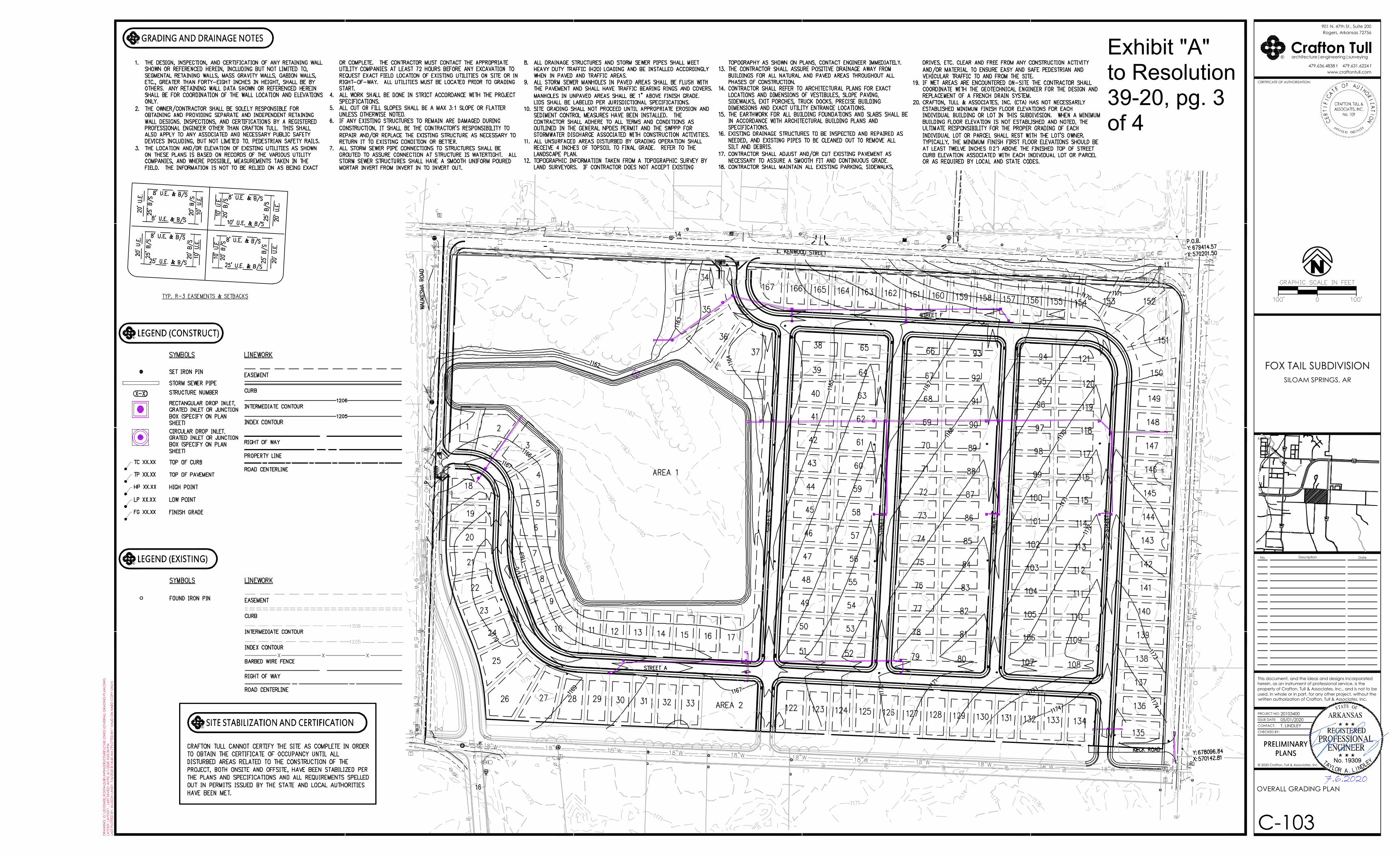
C-103
OVERALL GRADING PLAN
Crafton Tullwww.craftontull.com
architecture|engineering|surveying
CERTIFICATE OF AUTHORIZATION:
479.636.4838 t 479.631.6224 f
Rogers, Arkansas 72756901 N. 47th St., Suite 200
CERT
I FIC
AT E OF AU THORI ZATION
AR KANS AS ENGI NE ER
R
PROJECT NO:
ISSUE DATE:
CONTACT:
CHECKED BY:
This document, and the ideas and designs incorporatedherein, as an instrument of professional service, is theproperty of Crafton, Tull & Associates, Inc., and is not to beused, in whole or in part, for any other project, without thewritten authorization of Crafton, Tull & Associates, Inc.
Key Plan
No. Description Date
© 2020 Crafton, Tull & Associates, Inc.
DRA
WIN
G: G
:\20
1034
00_F
OXT
AIL
SUB\
INFR
AST
RUC
TURE
\CIV
IL\D
WG
\!O
VER
ALL
GRA
DIN
G P
LAN
.DW
GLA
YOUT
: LA
YOUT
1 , L
AST
SA
VED
: AI1
92, 6
/1/2
020
4:05
:30
PMLA
ST P
LOTT
ED B
Y: A
LLIS
ON
LA
NEY
, 7/6
/202
0 8:
14:4
3 A
M ("
PLO
TTED
BY:
" VA
LID
ON
HA
RD C
OPY
ON
LY)
CRAFTON, TULL &ASSOCIATES, INC.
No. 109
T. LINDLEY05/01/202020103400
FOX TAIL SUBDIVISIONSILOAM SPRINGS, AR
PRELIMINARYPLANS ENGINEER
PROFESSIONALREGISTERED
ARKANSAS
No. 19309
STATE OF
EDNIL.AROLYAT LL Y
”
RGRADING AND DRAINAGE NOTES
RLEGEND (EXISTING)
RLEGEND (CONSTRUCT)
RSITE STABILIZATION AND CERTIFICATION
7.6.2020
Exhibit "A" to Resolution 39-20, pg. 3 of 4

C-104
PHASING PLAN (COLOR)
Crafton Tullwww.craftontull.com
architecture|engineering|surveying
CERTIFICATE OF AUTHORIZATION:
479.636.4838 t 479.631.6224 f
Rogers, Arkansas 72756901 N. 47th St., Suite 200
CERT
I FIC
AT E OF AU THORI ZATION
AR KANS AS ENGI NE ER
R
PROJECT NO:
ISSUE DATE:
CONTACT:
CHECKED BY:
This document, and the ideas and designs incorporatedherein, as an instrument of professional service, is theproperty of Crafton, Tull & Associates, Inc., and is not to beused, in whole or in part, for any other project, without thewritten authorization of Crafton, Tull & Associates, Inc.
Key Plan
No. Description Date
© 2020 Crafton, Tull & Associates, Inc.
DRA
WIN
G: G
:\20
1034
00_F
OXT
AIL
SUB\
INFR
AST
RUC
TURE
\CIV
IL\D
WG
\!PH
ASI
NG
PLA
N.D
WG
LAYO
UT: L
AYO
UT1
, LA
ST S
AV
ED: A
I192
, 7/6
/202
0 9:
39:0
0 A
MLA
ST P
LOTT
ED B
Y: A
LLIS
ON
LA
NEY
, 7/6
/202
0 9:
39:0
9 A
M ("
PLO
TTED
BY:
" VA
LID
ON
HA
RD C
OPY
ON
LY)
CRAFTON, TULL &ASSOCIATES, INC.
No. 109
T. LINDLEY05/01/202020103400
FOX TAIL SUBDIVISIONSILOAM SPRINGS, AR
PRELIMINARYPLANS ENGINEER
PROFESSIONALREGISTERED
ARKANSAS
No. 19309
STATE OF
EDNIL.AROLYAT LL Y
RPHASE LEGEND
7.6.2020
Exhibit "A" to Resolution 39-20, pg. 4 of 4