agenda - tuesday, january 31, 2017 - deschutes county, or
TRANSCRIPT

AGENDA DESCHUTES COUNTY HEARINGS OFFICER
JANUARY 31, 2017, 6:00 PM BARNES AND SAWYER ROOMS DESCHUTES SERVICES CENTER
1300 NW WALL STREET BEND, OR, 97703
Additional meeting dates available at www.deschutes.org/meetingcalendar
Deschutes County encourages persons with disabilities to participate in all programs and activities. This event/location is accessible to people with disabilities. If you need accommodations to make participation possible, please
call the ADA Coordinator at (541) 617-4747.
Public Hearing
I. Hearings Officer Hearings
FILE NUMBERS: 247-16-000674-CU / 675-SP / 673-LR / 676-LM
OWNER/APPLICANT: Heimbichner & Pandian / Bear Creek Solar Center, LLC
REQUEST: An application for a Conditional Use Permit, a Site Plan Review, a Landscape Management Review, and a Lot of Record Verification for a photovoltaic solar power generation facility in the Exclusive Farm Use zone (EFU-TRB). The subject properties are also within the Airport Safety (AS) and Landscape Management (LM) combining zones.
LOCATION: Assessor’s Map 17-12-36 as Tax Lots 500 and 700
STAFF CONTACT: Jacob Ripper, Associate Planner

STAFF REPORT FILE NUMBERS: 247-16-000673-LR, 247-16-000674-CU, 247-16-000675-SP, and 247-16-000676-LM HEARING DATE: January 31, 2017, 6:00 p.m. Barnes & Sawyer Rooms Deschutes Services Center 1300 NW Wall Street Bend, OR 97701 APPLICANT: Bear Creek Solar Center, LLC c/o Coronal Energy 321 E. Main St., Ste. 300 Charlottesville, VA 22902 OWNER: Jane Heimbichner (Tax Lot 500) 4177 Stowe Way Sacramento, CA 95864 OWNER: V. Pandian Living Trust (Tax Lot 700) P.O. Box 12888 Salem, OR 97309 ATTORNEY FOR Liz Fancher APPLICANT: 644 NW Broadway St. Bend, OR 97703 PROPOSAL: An application for a Conditional Use Permit, a Site Plan Review, a
Landscape Management Review, and a Lot of Record Verification for a photovoltaic solar power generation facility in the Exclusive Farm Use zone (EFU-TRB). The subject properties are also within the Airport Safety (AS) and Landscape Management (LM) combining zones.
STAFF REVIEWER: Jacob Ripper, Associate Planner
1.1.a
Packet Pg. 2
Att
ach
men
t: 1
6-67
3-L
R 6
74-C
U 6
75-S
P 6
76-L
M S
taff
Rep
ort
w A
ttac
hm
ts (
1226
: 2
47-1
6-00
0674
-CU
/ 67
5-S
P /
673-
LR
/ 67
6-L
M)
Files: 247-16-000673-LR, 674-CU, 675-SP, 676-LM 2
I. STANDARDS AND APPLICABLE CRITERIA: Title 18, Deschutes County Zoning Ordinance Chapter 18.04, Section 18.01.030, Definitions
Chapter 18.16, Exclusive Farm Use Zones Chapter 18.80, Airport Safety Combining Zone - AS Chapter 18.84, Landscape Management Combining Zone - LM Chapter 18.116, Supplementary Provisions Chapter 18.124, Site Plan Review Chapter 18.128, Conditional Use
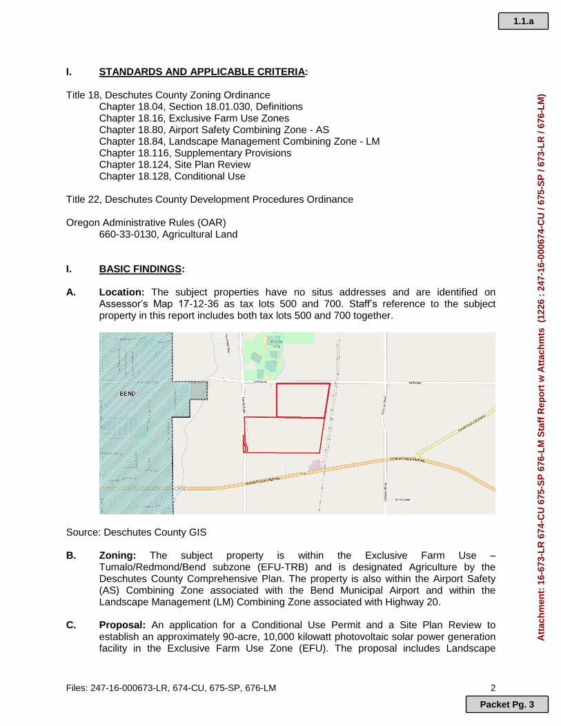
Title 22, Deschutes County Development Procedures Ordinance Oregon Administrative Rules (OAR) 660-33-0130, Agricultural Land I. BASIC FINDINGS: A. Location: The subject properties have no situs addresses and are identified on
Assessor’s Map 17-12-36 as tax lots 500 and 700. Staff’s reference to the subject property in this report includes both tax lots 500 and 700 together.
Source: Deschutes County GIS
B. Zoning: The subject property is within the Exclusive Farm Use –
Tumalo/Redmond/Bend subzone (EFU-TRB) and is designated Agriculture by the Deschutes County Comprehensive Plan. The property is also within the Airport Safety (AS) Combining Zone associated with the Bend Municipal Airport and within the Landscape Management (LM) Combining Zone associated with Highway 20.
C. Proposal: An application for a Conditional Use Permit and a Site Plan Review to
establish an approximately 90-acre, 10,000 kilowatt photovoltaic solar power generation facility in the Exclusive Farm Use Zone (EFU). The proposal includes Landscape
1.1.a
Packet Pg. 3
Att
ach
men
t: 1
6-67
3-L
R 6
74-C
U 6
75-S
P 6
76-L
M S
taff
Rep
ort
w A
ttac
hm
ts (
1226
: 2
47-1
6-00
0674
-CU
/ 67
5-S
P /
673-
LR
/ 67
6-L
M)

Files: 247-16-000673-LR, 674-CU, 675-SP, 676-LM 3
Management (LM) Site Plan Review as a portion of the subject property is within the Landscape Management Combining Zone, and a Lot of Record Verification for tax lot 500. The applicant has submitted all required application forms, a burden of proof, and supplemental materials, which are incorporated herein by reference.
D. Site Description: The subject property consists of two lots identified on Assessor’s Map
17-12-36 as tax lots 500 and 700. The subject tax lot 500 is approximately 51.57 acres in size, is currently vacant and is relatively flat with areas of rocky outcroppings and some short rocky hills concentrated towards the northern portion of the lot. The subject tax lot 700 is approximately 83.40 acres in size, is currently vacant and is relatively flat with areas of rocky outcroppings. The subject property is bounded by Neff Road to the north and Hamby Road to the west. The property is located approximately 0.29 miles east of the Bend City Limits Boundary and approximately 0.39 miles from the Bend Urban Growth Boundary (UGB). The property supports a native vegetative cover consisting primarily of juniper trees, sage brush, bunch grass and other native shrubs and grasses. Electric power transmission lines are adjacent to the east of the property in a roughly north-south direction and a gas pipeline easement crosses the southeastern portion of tax lot 700. The applicant’s agent states there are overhead electrical power transmission lines along both the northern and southern property lines, which staff confirmed during a site visit on December 30, 2016. An irrigation canal crosses the northwestern portion of tax lot 700. The proposal’s footprint is generally located in the northern two-thirds of tax lot 700 and covers the majority of tax lot 500.
E. Surrounding Zoning and Land Uses: The subject property is adjacent to lands zoned
EFU-TRB on all sides. Uses in the greater area surrounding the subject site consist of a mixture of small-scale and hobby farming, nonfarm dwellings, developed rural residential lots, electric substations, a sports park, and churches.
North: To the northwest of and adjacent to the subject property are tax lots 17-12-36-
600 and 17-12-36-601, which are both developed with nonfarm dwellings and approximately 18.78 acres and 19.29 acres in size, respectively. To the northwest of and across Neff Road are tax lots 17-12-25-200 and 17-12-25-203, which are developed with the Bend Park & Recreation District’s Big Sky Park & Sports Complex and the Bend Fire Department’s Station 304, respectively. To the north of the Sports Complex is tax lot 17-12-25-201, which is developed with Bend-La Pine School District’s Buckingham Elementary School. To the north of and directly across Neff Road from the subject property are tax lots 17-12-25-401 and 17-12-25-400, which are both developed with nonfarm dwellings and are 19.28 acres and 19.57 acres in size, respectively. Tax lot 17-12-25-400 has received conditional approval to establish a horse and dog training and testing facility. To the northeast of and across Neff Road is tax lot 17-12-25-501, which is residentially developed and has been conditionally approved for a photovoltaic solar power generation facility under files 247-15-000168-CU, 247-15-000169-SP, and 247-16-000225-MC. The approved solar power facility is currently under construction.
East: To the east of and adjacent to the subject property is a tract of land comprised of
tax lots 17-12-36-100, 17-12-36-300, and 17-12-36-400, which have been conditionally approved for a photovoltaic solar power generation facility under files 247-15-000170-CU, 247-15-000171-SP, 247-15-000172-LM, and 247-16-000224-MC. Additionally, property line adjustments were authorized under file
1.1.a
Packet Pg. 4
Att
ach
men
t: 1
6-67
3-L
R 6
74-C
U 6
75-S
P 6
76-L
M S
taff
Rep
ort
w A
ttac
hm
ts (
1226
: 2
47-1
6-00
0674
-CU
/ 67
5-S
P /
673-
LR
/ 67
6-L
M)

Files: 247-16-000673-LR, 674-CU, 675-SP, 676-LM 4
247-16-000311-LL and 247-16-000312-LL to reconfigure the legal lots of record into a more practicable configuration to accommodate the development. The approved solar power facility is currently under construction. Further east and across Erickson Road are lands zoned Multiple Use Agriculture (MUA-10), most of which are residentially developed, many contain small scale or hobby farms, and most lots are sized between five (5) and twenty (20) acres. At the southeast corner of Neff and Erickson Roads is tax lot 17-13-31-501, which is developed with an electrical power substation.
South: To the south of and adjacent to the subject property are several tax lots zoned
EFU but not currently engaged in farm use. Tax lot 17-12-36-101 is developed with an electrical substation. Tax lot 17-12-36-801 is developed with a church, the Christian Life Center. Tax lot 17-12-36-200 is developed with a church, the Grace Community Presbyterian Church.
West: To the west of and across Hamby Road is a vacant tax lot not currently engaged
in farm use, four residentially developed tax lots not currently engaged in farm use, and one tax lot (17-12-35-1300) that appears to be irrigated and currently engaged in farm use. Further to the west are lands zoned Urban Area Reserve (UAR-10), Bend’s Urban Growth Boundary (UGB), and the city limits of Bend.
Source: Deschutes County GIS
F. Public Agency Comments: The Planning Division mailed a Notice of Application on
November 18, 2016, and received comments from the following agencies: Bend Fire Department: Jeff Bond, Bend Fire Department FIRE APPARATUS ACCESS ROADS:
Approved fire apparatus access roads shall be provided for every facility, building or portion of a building hereafter constructed or moved into or within the jurisdiction. The fire apparatus access road shall comply with the requirements of this section and shall extend to within 150 feet of all portions of the facility and all portions of the exterior walls of the first story of the building as measured by
1.1.a
Packet Pg. 5
Att
ach
men
t: 1
6-67
3-L
R 6
74-C
U 6
75-S
P 6
76-L
M S
taff
Rep
ort
w A
ttac
hm
ts (
1226
: 2
47-1
6-00
0674
-CU
/ 67
5-S
P /
673-
LR
/ 67
6-L
M)

Files: 247-16-000673-LR, 674-CU, 675-SP, 676-LM 5
an approved route around the exterior of the building or facility. 2014 OFC 503.1.1
Fire apparatus roads shall have an unobstructed width of not less than 20 feet, exclusive of shoulders, except for approved security gates in accordance with Section 503.6, and an unobstructed vertical clearance of not less than 13 feet 6 inches. Where a fire hydrant is located on a fire apparatus road, the minimum width shall be 26 feet, exclusive of shoulders. Traffic calming along a fire apparatus road shall be approved by the fire code official. Approved signs or other approved notices or markings that include the words NO PARKING-FIRE LANE shall be provided for fire apparatus roads to prohibit parking on both sides of fire lanes 20 to 26 feet wide and on one side of fire lanes more than 26 feet to 32 feet wide. 2014 OFC 503.2.1, D103.1, 503.4.1, 503.3
Fire apparatus access roads shall be designed and maintained to support the imposed loads of fire apparatus (60,000 pounds GVW) and shall be surfaced (asphalt, concrete or other approved driving surface) as to provide all weather driving capabilities. Inside and outside turning radius shall be approved by the fire department. All dead-end turnarounds shall be of an approved design. Bridges and elevated surfaces shall be constructed in accordance with AASHTO HB-17. The maximum grade of fire apparatus access roads shall not exceed 10 percent. Fire apparatus access road gates with electric gate operators shall be listed in accordance with UL325. Gates intended for automatic operation shall be designed, constructed and installed to comply with the requirements of ASTM F 2200. A Knox® Key Switch shall be installed at all electronic gates. 2014 OFC D102.1, 503.2.4
BUILDING SERVICES AND SYSTEMS:
Ground-mounted photovoltaic arrays. Ground-mounted photovoltaic arrays shall comply with sections 2014 OFC Sections 605.11 and 605.12. o Clearances. A clear, brush free area of 10-feet shall be required for
ground mounted photovoltaic arrays. 2014 OFC 605.12.1 o Noncombustible base. A gravel base or other non-combustible base
acceptable to the fire code official shall installed and maintained under and around the installation. 2014 OFC 605.12.2
o Security barriers. Fencing, skirting, or other suitable security barriers shall be installed when required by the fire code official. 2014 OFC 605.12.3
OTHER FIRE SERVICE FEATURES:
A KNOX-BOX® key vault is required for all newly constructed commercial buildings, facilities or premises to allow for rapid entry for emergency crews. A KNOX® Key Switch shall be provided for all electrically operated gates restricting entry on a fire apparatus access road. A KNOX® Padlock shall be provided for all manually operated gates restricting entry on a fire apparatus road and security gates restricting access to buildings. 2014 OFC 506.1
Central Electric Cooperative, Inc.: Parneli Perkns, Lands Specialist On November 29, 2016: A portion of the proposed development falls into Exclusive CEC Territory as defined by the Oregon Public Utility Commission. CEC requests the owner/developer contact; CEC at 541-548-2144 and apply for any service loads that fall in exclusive CEC Territory. On January 5, 2016: The proposed site (Tax Lot 500) is within exclusive Central Electric Cooperative service area set forth by the Oregon Public Utility Commission. Central
1.1.a
Packet Pg. 6
Att
ach
men
t: 1
6-67
3-L
R 6
74-C
U 6
75-S
P 6
76-L
M S
taff
Rep
ort
w A
ttac
hm
ts (
1226
: 2
47-1
6-00
0674
-CU
/ 67
5-S
P /
673-
LR
/ 67
6-L
M)

Files: 247-16-000673-LR, 674-CU, 675-SP, 676-LM 6
Electric Cooperative must serve all native loads generated by the development. Central Electric Cooperative requests the owner contact Central Electric Cooperative at 541-548-2144 and request station service. Deschutes County Building Division: The Deschutes County Building Safety Divisions code required Access, Egress, Setback, Fire & Life Safety Fire Fighting Water Supplies, etc. will be specifically addressed during the plan review process for any proposed structures and occupancies. All Building Code required items will be addressed, when a specific structure, occupancy, and type of construction is proposed and submitted for plan review. Deschutes County Property Address Coordinator: Addresses for both parcels will be assigned when access points for each lot are determined. Deschutes County Road Department: George Kolb, County Engineer
Access onto Hamby Road will have to meet AASHTO sight distance requirements for 55 mph.
Access approach into the property will be paved to a length of 25 feet from [the] edge of pavement on Hamby Road with a width of 20 feet and 20 foot radius’s [sic].
Deschutes County Senior Transportation Planner: Peter Russell I have reviewed the transmittal materials for 247-16-000673-LR/674-CU/675-SP/676-LM to develop a solar voltaic array (solar farm) in Exclusive Farm Use (EFU) zone near the corner of Hamby and Neff on a property with no assigned addressed but described as 17-12-36, Tax Lots 500 and 700. The Institute of Traffic Engineers (ITE) Trip Generation does not have a category for solar farm. However, based on the application materials, it is obvious that the site will not generate more than 50 new weekday trips and thus the site will not meet the County’s minimum threshold of 50 new weekday trips as set by DCC 18.116.310(C)(3). No traffic analysis is required. As no new trips will be generated, under BOCC Resolution 2013-020, no transportation system development charges (SDCs) will be assessed, either, as the proposed land use will not consume any road capacity. Oregon Department of Aviation: Jeff Caines, AICP, Aviation Planner On December 9, 2016: Thank you for allowing ODA to comment on the proposed photovoltaic solar facility (File # 247-16-00673-LR / 674-CU / 675-SP / 676-LM). The site is approximately 2.5 miles SW of Bend Municipal airport. The estimated elevation is approximately 3590 feet AMSL and the Bend Airport is listed at 3460 feet AMSL. In most solar development the structures are not over 20-feet above the ground. So based on the distance and likely structure height, ODA finds that this development will not pose a hazard to air navigation.
1.1.a
Packet Pg. 7
Att
ach
men
t: 1
6-67
3-L
R 6
74-C
U 6
75-S
P 6
76-L
M S
taff
Rep
ort
w A
ttac
hm
ts (
1226
: 2
47-1
6-00
0674
-CU
/ 67
5-S
P /
673-
LR
/ 67
6-L
M)

Files: 247-16-000673-LR, 674-CU, 675-SP, 676-LM 7
On January 18, 2017: Thank you for allowing ODA to comment on the proposed solar power generation facility located off of Neff Road (Tax Map 17-12-36 Lot 500 & 700). ODA has reviewed the proposal and have the following comments: The project location is approximately 2.45 miles SW of the Bend airport. If the structures associated with the projects are less than 30 feet in height, ODA will not request a FAA form 7460-1 from the applicant. If the solar cells are higher than 30-feet in height, please have the applicant contact this agency to get further details on the project. Oregon Parks and Recreation Department: Jean Jancaitis, Natural Resource Specialist Thanks for the notification on the proposed solar project. The site is not within a State Scenic Waterway; therefore, no future action is required. No responses were received from: Avion Water Company, Bend Planning Department, Bend Metro Parks and Recreation, Bend Municipal Airport Manager, Central Oregon Irrigation District, Department of Environmental Quality, Deschutes County Assessor, Deschutes County Code Enforcement, Deschutes County Environmental Soils Division, Oregon Department of Agriculture, Oregon Department of Fish and Wildlife, U.S Fish and Wildlife Service, and Watermaster - District 11.
G. Public Comments: The Planning Division mailed a Notice of Application on November 18, 2016 to all property owners within 750 feet of the subject property. Dozens of letters and emails were received, mostly in opposition to the proposed request, with some not opposed but desiring a greater setback and buffer from property lines. Following the comment period, staff decided to send the matter to a Deschutes County Hearings Officer for a decision.
Staff notes that comments from neighbors and concerned parties suggest the mass and scale of the proposed solar array to be inappropriate for the area considering proximity to residential development and the approximate 150-acres of previously approved solar power generation facility development to the east. The most common requests were for increased setbacks from property lines and greater screening in the form of taller fences and more vegetation. In summary, staff has attempted to capture most impacts, comments, requests, and concerns identified by the public in comments submitted prior to the date of this Staff Report. Staff has grouped comments by theme, and comments are listed here in no particular order. Location:
Lack of harmony with the natural environment and surrounding community character and existing development
Proximity is too close to residences, churches, parks, a school, Bend city limits, shopping centers, etc.
Relocate facilities further away from city limits
Proximity to Bend Urban Growth Boundary (UGB) and increased residential densities surrounding the project in the future as the UGB expands
1.1.a
Packet Pg. 8
Att
ach
men
t: 1
6-67
3-L
R 6
74-C
U 6
75-S
P 6
76-L
M S
taff
Rep
ort
w A
ttac
hm
ts (
1226
: 2
47-1
6-00
0674
-CU
/ 67
5-S
P /
673-
LR
/ 67
6-L
M)

Files: 247-16-000673-LR, 674-CU, 675-SP, 676-LM 8
Screening/Buffer:
Negative visual impacts due to materials, mass and scale, height, color
Setbacks of 100 to 200 feet from all perimeter property lines
Setbacks specifically from residential structures
Taller fences and additional landscaping to buffer visual impacts
Glare from solar panels interfering with motorist’s vision
Require screening/buffer to be installed prior to commencement of construction Noise/Dust/Construction:
Noise generated from inverters, motors, and other equipment
Noise generated from construction practices outside of allowable hours
Dust generation and proposed method of dust control during and after construction
Damage to private property from water trucks
Establish temporary traffic control for construction vehicles entering and exiting Hamby Road
Construction vehicle and employee parking outside of road rights-of-way and vegetated buffer areas
Traffic hazards created by construction vehicles Natural environment, restoration, and health:
Provisions and plans for restoration/reclamation bond and removal of all structures related to solar array upon termination of use
Ability for reclamation bonds to be perfected and tacked if the facility is assigned, sold, or leased
Presence of and impact to underground lava caves
Health risks and health impacts associated with power generating facilities
Negative impacts on wildlife habitat and native vegetation Compliance:
Unauthorized blasting and grading to level the site and compact soils
Adherence to vegetation retention requirements
Adherence to a construction plan to minimize negative impacts from construction (hours, noise, dust, etc.)
Ability for the CDD Code Enforcement Division to enforce conditions of approval
Bond payable to neighboring property owners for construction and operation noncompliance
Other:
Decreased property values
Suggestion to rezone the area to a residential designation
Request a moratorium on solar power facilities to allow time for LCDC/DLCD and/or Deschutes County to perform an impact, process, and strategic analysis of solar power facilities
Impacts associated with loss of federal tax incentives for solar power facilities
Posted land use action sign not displayed properly/long enough
Request for hearings officer to perform a sight visit
Where will water come from to irrigate screening vegetation, for dust control, etc.
Increased cost of electricity
1.1.a
Packet Pg. 9
Att
ach
men
t: 1
6-67
3-L
R 6
74-C
U 6
75-S
P 6
76-L
M S
taff
Rep
ort
w A
ttac
hm
ts (
1226
: 2
47-1
6-00
0674
-CU
/ 67
5-S
P /
673-
LR
/ 67
6-L
M)

Files: 247-16-000673-LR, 674-CU, 675-SP, 676-LM 9
STAFF NOTE: In response to public comments, the applicant submitted supplemental findings and exhibits on January 18, 2017, to rebut or address specifically the questions and concerns raised by the public. These materials have been included in the record but have not been addressed in this report because of the late date of submittal by the applicant.
H. Notice Requirement: The applicant complied with the posted notice requirements of
Section 22.23.030(B) of Deschutes County Code (DCC) Title 22. The applicant submitted a Land Use Action Sign Affidavit, dated November 23, 2016, indicating the applicant posted notice of the land use action on the property on November 23, 2016. A neighbor notified the Planning Division that the sign had fallen down on November 23, 2016, and staff contacted the applicant’s attorney to ensure the sign was posted properly for the required amount of time. A Notice of Public Hearing was mailed to all property owners within 750 of the subject property on December 29, 2016. The Notice of Public Hearing was published in the Bend Bulletin on Sunday, January 1, 2017.
I. Review Period: The lot of record verification, conditional use, site plan review, and
landscape management review applications were submitted on November 11, 2016. The applications were accepted and deemed complete on December 7, 2016. The applicant requested to put the application on hold for two weeks for the dates of January 10 to January 24, 2017, due to public hearing scheduling conflicts. The 150th day (in consideration of 14 days of hold time) on which the county must take final action on this application is May 20, 2017.
J. Lot of Record: The subject property consists of two legal lots of record. The Lot of
Record Verification file LR-14-3 determined that tax lot 17-12-36-700 was a legal lot of record because it was created by conveyance prior to countywide zoning and partition regulations. Tax lot 700 was first described in the Warranty Deed executed on April 19, 1966 and recorded in Vol. 148, Page 221 of the Deschutes County Official Records. A corrected description of the property was executed on July 20, 1966 and recorded in Vol. 149, Page 619 of the Deschutes County Official Records.
Tax lot 17-12-36-500 is a legal lot of record because it was created by conveyance prior to countywide zoning and partition regulations. Tax lot 500 was first described in the Warranty Deed executed on April 19, 1966 and recorded in Vol. 148, Page 219 of the Deschutes County Official Records. This description included what is now tax lot 17-12-36-300, a non-contiguous unit of land. Tax lot 300 was conveyed with what are now tax lots 100, 101, 400, and 1100 in the recorded Warranty Deed Vol. 314 Page 119, executed November 30, 1977. See Figure 1 below.
1.1.a
Packet Pg. 10
Att
ach
men
t: 1
6-67
3-L
R 6
74-C
U 6
75-S
P 6
76-L
M S
taff
Rep
ort
w A
ttac
hm
ts (
1226
: 2
47-1
6-00
0674
-CU
/ 67
5-S
P /
673-
LR
/ 67
6-L
M)

Files: 247-16-000673-LR, 674-CU, 675-SP, 676-LM 10
Figure 1 1
K. Previous Land Use History: Tax lot 500: None. Tax lot 700: Lot of Record Verification,
file number LR-14-3. III. CONCLUSIONARY FINDINGS: Title 18, Deschutes County Zoning Ordinance A. CHAPTER 18.16, Exclusive Farm Use Zone
1. Section 18.16.030. Conditional Uses Permitted.
18.16.030. Conditional Uses Permitted -High Value and Non-high Value Farmland. The following uses may be allowed in the Exclusive Farm Use zones on either high value farmland or nonhigh value farmland subject to applicable provisions of the Comprehensive Plan, DCC 18.16.040 and 18.16.050, and other applicable sections of DCC Title 18. … DD. Photovoltaic solar power generation facilities as commercial utility
facilities for the purpose of generating power for public use by sale, subject to OAR 660-033-0130.
FINDING: The subject property proposed for a solar power facility is zoned Exclusive Farm Use. The proposed use is a conditional use, and therefore is subject to a conditional use permit. Compliance with the applicable conditional use criteria is addressed below. Subsection (DD) above, references Oregon Administrative Rule (OAR) 660-033-0130. Relevant provisions of the OAR are reviewed in detail below.
1 Source: Provided by staff
1.1.a
Packet Pg. 11
Att
ach
men
t: 1
6-67
3-L
R 6
74-C
U 6
75-S
P 6
76-L
M S
taff
Rep
ort
w A
ttac
hm
ts (
1226
: 2
47-1
6-00
0674
-CU
/ 67
5-S
P /
673-
LR
/ 67
6-L
M)

Files: 247-16-000673-LR, 674-CU, 675-SP, 676-LM 11
18.16.040. Limitations on Conditional Uses. A. Conditional uses permitted by DCC 18.16.030 may be established subject
to ORS 215.296 and applicable provisions in DCC 18.128 and upon a finding by the Planning Director or Hearings Body that the proposed use: 1. Will not force a significant change in accepted farm or forest
practices as defined in ORS 215.203(2)(c) on surrounding lands devoted to farm or forest uses; and
2. Will not significantly increase the cost of accepted farm or forest practices on surrounding lands devoted to farm or forest use; and
FINDING: In response to the above criteria, the applicant’s burden of proof statement provides the following response:
The requirements of subsections (1) and (2) have been addressed in our discussion of the same requirement imposed by the State’s administrative rule.
Staff understands the above statement by the applicant points to findings under the Oregon Administrative Rules (OAR) 660-33-0130 Section (5). Under that section, the applicant states:
The Pandian property [tax lot 700] is approximately 83.4 acres in size and is vacant. The Heimbichner property [tax lot 500] is approximately 51.57 acres in size and is vacant. Neither property is currently engaged in farm use. The majority of the EFU-zoned parcels within a one-mile radius of the subject property are located a significant distance to the east and south of the subject property and will not be impacted by the proposed solar array. Farming in the area is limited by the size of the parcels and the high percentage of poor soil. The greater area surrounding the subject property includes three different rural zoning districts including EFU-TRB, MUA10, and UAR-10. The subject property adjoins Neff Road to the north and Hamby Road to the west. Both roads are rural arterial streets. The primary soil mapping unit in the surrounding area is 58C, a mapping unit that is predominantly comprised of Class VII and VIII nonagricultural soils. There are pockets of better soils as one moves south of Highway 20 and northeast and east of the Collier property that adjoins the subject property and that has received approval to be developed with a solar farm. To the west of the subject property, the hobby farm uses occurring on Tax Lots 1300 and 1301 are the only readily observable farm uses occurring in the EFU-zoned area north of Highway 20, south of Neff Road and east of the City of Bend. This entire area is comprised of 58C nonagricultural soils. These hobby farms have irrigated fields that can be used as pasture for grazing livestock or to grow hay. The field of the larger of the two properties is currently being grazed by cattle. Information from the Oregon State University Extension Service, Exhibit K, lists accepted farm uses conducted in Deschutes County. The list describes the attributes of accepted farming practices that can impact residential development. The list provides information about permanent pasture and livestock operations. It does not list hay production but its impacts are similar to those of permanent pasture. Grazing livestock can generate dust, manure odor, possible interference with vehicular traffic, and property damage if livestock escape. Pasture use can create conflicts due to the drift of herbicides, vehicle noise, and water run-off.
1.1.a
Packet Pg. 12
Att
ach
men
t: 1
6-67
3-L
R 6
74-C
U 6
75-S
P 6
76-L
M S
taff
Rep
ort
w A
ttac
hm
ts (
1226
: 2
47-1
6-00
0674
-CU
/ 67
5-S
P /
673-
LR
/ 67
6-L
M)

Files: 247-16-000673-LR, 674-CU, 675-SP, 676-LM 12
None of these farm-related impacts will adversely impact the proposed solar farm and the solar farm will not result in any negative impacts to the existing farm uses. None of the properties adjoining the north side of Neff Road directly across from the subject property are engaged in farm use. The same is true of lands due north of these properties to a distance of almost one mile from the subject property. There is an area of good soils northeast of the subject property, along Erickson Road and east of Dickey Road that has been divided into small parcels. Much of the land in this area is zoned MUA-10. The closest farm property in this area is about .35 mile from the subject property. This property is located on the far side of the Hafter property that is being developed as a solar farm. The approval of a solar farm on the subject property will cause no additional or different impacts on this farm property or to other farm properties in the same area (northeast area). The nearest properties east of the subject property engaged in farm use are about a half a mile away and are separated from the subject property by the Collier properties that have been approved for development as a solar farm and by a power substation at the southeast corner of the intersection of Neff Road and Erickson Road. In the Collier decision, the hearings officer found that there are some farm uses occurring in the area but concluded that the solar farm would not force a significant change in accepted farm practices nor would it significantly increase farm costs. See, Exhibit H. The hearings officer noted that the solar farm would not draw vehicle traffic, after construction, other than from an occasional maintenance vehicle. He also found that no odors would be generated and that noise, based on expert testimony, would be minimal. Dust from farm uses, also, is not a hindrance to operation of a solar farm. Panels will be cleaned periodically (typically once a year). The applicant will also be required to sign a waiver of objection to customary farm practices as a condition of approval. The properties south of the subject property and north of Highway 20 are not engaged in farm use. Most of the land on the south side of the highway is vacant. A part of the area, however, is developed with small farm and nonfarm parcels developed with single-family homes. The farm use in this area is very limited due to soils and the very small size of the developed parcels. There are no observable forest practices occurring within the study area. In addition, the area contains few, if any, trees with the prevalent species being Western juniper. Juniper trees are not considered a merchantable timber species. Consequently, the proposed solar facility will have no impact on any forest uses in the area. The above findings demonstrate that the proposed solar photovoltaic energy project will have no impact on any farm or forest uses in the surrounding area nor will it cause a significant change in or significant increase in the cost of accepted farming or forest activities.
According to staff’s research and a site visit conducted on December 30, 2016, there appears to be limited farm uses occurring in the general area. The only farm use observed was to the west of the subject property across Hamby Road. It does not appear that any forest uses occur in the surrounding area. Staff finds that impacts to farm uses from the proposed use, if any, are extremely limited, as they pertain to farm or forest uses on surrounding lands. The proposed use is one that, following the construction phase, would presumably not generate dust, noise or
1.1.a
Packet Pg. 13
Att
ach
men
t: 1
6-67
3-L
R 6
74-C
U 6
75-S
P 6
76-L
M S
taff
Rep
ort
w A
ttac
hm
ts (
1226
: 2
47-1
6-00
0674
-CU
/ 67
5-S
P /
673-
LR
/ 67
6-L
M)

Files: 247-16-000673-LR, 674-CU, 675-SP, 676-LM 13
odors, nor would it increase traffic in the area. Staff finds the proposed solar power facility will not force significant changes in or significantly increase the costs of farming and/or forestry in the surrounding lands devoted to those uses. Therefore, staff believes that criteria (1) and (2) above are satisfied by the proposal.
3. That the actual site on which the use is to be located is the least suitable for the production of farm crops or livestock.
FINDING: According to Deschutes County GIS, the subject property is predominately composed of soil map unit 58C, Gosney-Rock outcrop-Deskamp complex, with 0 to 15 percent slopes. Soil map unit 58C is class 6 to 8 if not irrigated (depending on location within the map unit), and class 4 to 7 when irrigated. There appears to be no irrigation rights on the subject property. Soil map unit 58C is not considered high-value farmland. Approximately 0.41 acres of tax lot 700 (<0.5%) are soil map unit 36A, Deskamp loamy sand, which is class 6 if not irrigated and class 3 if irrigated. Soil map unit 36A is not considered high-value farmland. All proposed development is located on soil map unit 58C soils, and because of this, staff finds the above criterion can be met. 2. Section 18.16.060, Dimensional Standards.
… D. Building Height. No building or structure shall be erected or enlarged to
exceed 30 feet, except as allowed in DCC 18.120.040. FINDING: The applicant did not directly address this standard. There were no elevation drawings in the submitted materials. In response to Airport Safety Combining Zone requirements, the applicant states, “The maximum height of the tallest structures, the power poles, is 30 feet”. Staff recommends the Hearings Officer impose a condition of approval limiting height of all structures, including poles, to 30 feet in height. Suggested Condition of Approval: Height: The maximum height of the proposed development, including power poles, shall be 30 feet. 3. Section 18.16.070, Yards.
A. The front yard shall be a minimum of: 40 feet from a property line fronting on a local street, 60 feet from a property line fronting on a collector street, and 100 feet from a property line fronting on an arterial street.
FINDING: The property has two front yards as it abuts Neff Road to the north and Hamby Road to the west. Neff Road and Hamby Road are classified as Rural Arterial streets on the County’s Transportation System Plan (TSP), thus, require a setback of 100 from property lines fronting on Neff Road and Hamby Road. The applicant states, “The applicant’s site plan provides a setback of at least 100 feet on Hamby Road and a setback of at least 100 feet on Neff Road”, however staff cannot confirm this as the submitted site plan in not to scale, and setbacks are only identified in a footnote. Furthermore, staff notes that the location of the western property lines of tax lot 700 are irregularly shaped, and Hamby Road appears to travel outside of the mapped right-of-way in the southwestern portion of the property. See Figure 2 below. It is unclear from the submitted materials if the
1.1.a
Packet Pg. 14
Att
ach
men
t: 1
6-67
3-L
R 6
74-C
U 6
75-S
P 6
76-L
M S
taff
Rep
ort
w A
ttac
hm
ts (
1226
: 2
47-1
6-00
0674
-CU
/ 67
5-S
P /
673-
LR
/ 67
6-L
M)

Files: 247-16-000673-LR, 674-CU, 675-SP, 676-LM 14
applicant measures the front yard setback from the road or one of the western property lines. Staff recommends the Hearings Officer request additional information on this topic.
Figure 2 2
B. Each side yard shall be a minimum of 25 feet, except that for a nonfarm dwelling proposed on property with side yards adjacent to property currently employed in farm use, and receiving special assessment for farm use, the side yard shall be a minimum of 100 feet.
C. Rear yards shall be a minimum of 25 feet, except that for a nonfarm dwelling proposed on property with a rear yard adjacent to property currently employed in farm use, and receiving special assessment for farm use, the rear yard shall be a minimum of 100 feet. Chapter 18.16 32 ( 04/2014)
D. In addition to the setbacks set forth herein, any greater setbacks required by applicable building or structural codes adopted by the State of Oregon and/or the County under DCC 15.04 shall be met.
FINDING: The applicant states, “The other yards are rear or side yards and all are at least 25 feet deep”. Staff cannot confirm this as the submitted site plan is not to scale, and setbacks are only identified in a footnote. Furthermore, the subject property consists of two legal lots of record. The common tax lot line between tax lots 500 and 700 is a property line (a rear property line for tax lot 500 and a side property line for tax lot 700), the applicable setbacks need to be observed, including the solar setback from the north property line of tax lot 700. Staff recommends the Hearings Officer request additional information on this topic. Any greater setbacks required by applicable building or structural codes will be addressed during building permit review.
2 Source: Deschutes County GIS
1.1.a
Packet Pg. 15
Att
ach
men
t: 1
6-67
3-L
R 6
74-C
U 6
75-S
P 6
76-L
M S
taff
Rep
ort
w A
ttac
hm
ts (
1226
: 2
47-1
6-00
0674
-CU
/ 67
5-S
P /
673-
LR
/ 67
6-L
M)

Files: 247-16-000673-LR, 674-CU, 675-SP, 676-LM 15
Chapter 18.116, Supplementary Provisions 1. 18.116.030 Off Street Parking and Loading.
A. Compliance. No building or other permit shall be issued until plans and evidence are presented to show how the off street parking and loading requirements are to be met and that property is and will be available for exclusive use as off-street parking and loading. The subsequent use of the property for which the permit is issued shall be conditional upon the unqualified continuance and availability of the amount of parking and loading space required by DCC Title 18.
FINDING: A previous County decision for an adjacent photovoltaic solar power production facility found that the unmanned facility will not require a developed parking area and is not subject to the requirements of this section. The proposal does not include buildings for employees and only involves occasional vehicle access for maintenance and service technicians. B. Chapter 18.124, Site Plan Review 1. Section 18.124.010. Purpose
DCC 18.124.010 provides for administrative review of the design of certain developments and improvements in order to facilitate safe, innovative and attractive site development compatible with the natural and man-made environment.
2. Section 18.124.020. Elements of Site Plan
The elements of a site plan are: The layout and design of all existing and proposed improvements, including, but not limited to, buildings, structures, parking, circulation areas, outdoor storage areas, bicycle parking, landscape areas, service and delivery areas, outdoor recreation areas, retaining walls, signs and graphics, cut and fill sections, accessways, pedestrian walkways, buffering and screening measures and street furniture.
FINDING: Staff finds that the site plan did not address all of the listed improvements above. Specifically, parking, circulation, landscaping, vegetation, cut and fill sections, access ways, and buffering and screening where not adequately addressed. Staff accepts that although the submitted site plan is severely deficient in detail, it is adequate to proceed with the site plan review. If the Hearings Officer determines a review is not possible with the submitted site plan, the Hearings Officer may require the applicant to submit a Modification of Application to provide a revised, to-scale site plan that clearly identifies all structures, identifies all setback distances from structures to property lines, and includes each applicable site plan feature listed in DCC 18.124.040(D) and (E). Staff defers to the Hearings Officer for a determination as to whether submittal of supplemental findings and evidence by the applicant, and the scaled plans and elevation drawings, can be submitted without a modification of application under DCC 22.20.055.
1.1.a
Packet Pg. 16
Att
ach
men
t: 1
6-67
3-L
R 6
74-C
U 6
75-S
P 6
76-L
M S
taff
Rep
ort
w A
ttac
hm
ts (
1226
: 2
47-1
6-00
0674
-CU
/ 67
5-S
P /
673-
LR
/ 67
6-L
M)

Files: 247-16-000673-LR, 674-CU, 675-SP, 676-LM 16
3. Section 18.124.030, Approval Required
A. No building, grading, parking, land use, sign or other required permit shall be issued for a use subject to DCC 18.124.030, nor shall such a use be commenced, enlarged, altered or changed until a final site plan is approved according to DCC Title 22, the Uniform Development Procedures Ordinance.
B. The provisions of DCC 18.124.030 shall apply to the following:
1. All conditional use permits where a site plan is a condition of
approval; 2. Multiple-family dwellings with more than three units; 3. All commercial uses that require parking facilities; 4. All industrial uses; 5. All other uses that serve the general public or that otherwise require
parking facilities, including, but not limited to, landfills, schools, utility facilities, churches, community buildings, cemeteries, mausoleums, crematories, airports, parks and recreation facilities and livestock sales yards; and
6. As specified for Flood Plain Zones (FP) and Surface Mining Impact Area Combining Zones (SMIA).
… D. Noncompliance with a final approved site plan shall be a zoning ordinance
violation. E. As a condition of approval of any action not included in DCC 18.124.030(B),
the Planning Director or Hearings Body may require site plan approval prior to issuance of any permits.
FINDING: The proposed use is a photovoltaic solar power generation facility, as a commercial utility facility, for the purpose of generating power for public use and as such requires a land use permit. Therefore, site plan review is required under B(5) above.
4. 18.124.040, Contents and Procedure:
D. The site plan shall indicate the following:
1. Access to site from adjacent rights of way, streets and arterial. 2. Parking and circulation areas. 3. Location, dimensions (height and bulk) and design of buildings and
signs. 4. Orientation of windows and doors. 5. Entrances and exits. 6. Private and shared outdoor recreation spaces. 7. Pedestrian circulation. 8. Public play areas. 9. Service areas for uses such as mail delivery, trash disposal, above
ground utilities, loading and delivery. 10. Areas to be landscaped. 11. Exterior lighting. 12. Special provisions for disabled persons.
1.1.a
Packet Pg. 17
Att
ach
men
t: 1
6-67
3-L
R 6
74-C
U 6
75-S
P 6
76-L
M S
taff
Rep
ort
w A
ttac
hm
ts (
1226
: 2
47-1
6-00
0674
-CU
/ 67
5-S
P /
673-
LR
/ 67
6-L
M)
Files: 247-16-000673-LR, 674-CU, 675-SP, 676-LM 17
13. Existing topography of the site at intervals appropriate to the site, but in no case having a contour interval greater than 10 feet.
14. Signs. 15. Public improvements. 16. Drainfield locations. 17. Bicycle parking facilities, with location of racks, signage, lighting,
and showing the design of the shelter for long term parking facilities.
18. Any required bicycle commuter facilities. 19. Other site elements and information which will assist in the
evaluation of site development. E. The landscape plan shall indicate:
1. The size, species and approximate locations of existing natural plant materials proposed to be retained and new plant materials proposed to be placed on site.
2. Proposed site contouring. 3. An explanation of how drainage and soil erosion is to be dealt with
during and after construction.
FINDING: Staff finds that the site plan did not address all of the listed improvements above. If the Hearings Officer determines a review is not possible with the submitted site plan, the Hearings Officer may require the applicant to submit a Modification of Application to provide a revised, to-scale site plan that clearly identifies all structures, identifies all setback distances from structures to property lines, and includes each applicable site plan feature listed in DCC 18.124.040(D) and (E). Staff defers to the Hearings Officer for a determination as to whether submittal of supplemental findings and evidence by the applicant, and the scaled plans and elevation drawings, can be submitted without a modification of application under DCC 22.20.055.
5. Section 18.124.060, Approval Criteria
Approval of a site plan shall be based on the following criteria: A. The proposed development shall relate harmoniously to the natural
environment and existing development, minimizing visual impacts and preserving natural features including views and topographical features.
FINDING: The property supports a native vegetative cover consisting primarily of juniper trees, sage brush, bunch grass and other native shrubs and grasses and contains several areas of rocky outcroppings. The subject property is currently vacant. As discussed in the Basic Findings above, the subject property is adjacent to lands zoned EFU-TRB on all sides. Uses in the greater area surrounding the subject site consist of a mixture of small-scale and hobby farming, nonfarm dwellings, developed rural residential lots, electric substations, a sports park, and churches.
North: To the northwest of and adjacent to the subject property are tax lots 17-12-36-600 and 17-12-36-601, which are both developed with nonfarm dwellings and approximately 18.78 acres and 19.29 acres in size, respectively. To the northwest of and across Neff Road are tax lots 17-12-25-200 and 17-12-25-203, which are developed with the Bend Park & Recreation District’s Big Sky Park & Sports Complex and the Bend Fire Department’s Station 304, respectively. To the north of the Sports Complex is tax lot 17-12-25-201, which is developed with
1.1.a
Packet Pg. 18
Att
ach
men
t: 1
6-67
3-L
R 6
74-C
U 6
75-S
P 6
76-L
M S
taff
Rep
ort
w A
ttac
hm
ts (
1226
: 2
47-1
6-00
0674
-CU
/ 67
5-S
P /
673-
LR
/ 67
6-L
M)

Files: 247-16-000673-LR, 674-CU, 675-SP, 676-LM 18
Bend-La Pine School District’s Buckingham Elementary School. To the north of and directly across Neff Road from the subject property are tax lots 17-12-25-401 and 17-12-25-400, which are both developed with nonfarm dwellings and are 19.28 acres and 19.57 acres in size, respectively. Tax lot 17-12-25-400 has received conditional approval to establish a horse and dog training and testing facility. To the northeast of and across Neff Road is tax lot 17-12-25-501, which is residentially developed and has been conditionally approved for a photovoltaic solar power generation facility under files 247-15-000168-CU, 247-15-000169-SP, and 247-16-000225-MC. The approved solar power facility is currently under construction.
East: To the east of and adjacent to the subject property is a tract of land comprised of
tax lots 17-12-36-100, 17-12-36-300, and 17-12-36-400, which have been conditionally approved for a photovoltaic solar power generation facility under files 247-15-000170-CU, 247-15-000171-SP, 247-15-000172-LM, and 247-16-000224-MC. The approved solar power facility is currently under construction. Further east and across Erickson Road are lands zoned Multiple Use Agriculture (MUA-10), most of which are residentially developed, many contain small scale or hobby farms, and most lots are sized between five (5) and twenty (20) acres. At the southeast corner of Neff and Erickson Roads is tax lot 17-13-31-501, which is developed with an electrical power substation.
South: To the south of and adjacent to the subject property are several lots zoned EFU
but not currently engaged in farm use. Tax lot 17-12-36-101 is developed with an electrical substation. Tax lot 17-12-36-801 is developed with a church, the Christian Life Center. Tax lot 17-12-36-200 is developed with a church, the Grace Community Presbyterian Church.
West: To the west of and across Hamby Road are one vacant lot not currently engaged
in farm use, four residentially developed lots not currently engaged in farm use, and one lot (17-12-35-1300) that appears to be irrigated and currently engaged in farm use. Further to the west are lands zoned Urban Area Reserve (UAR-10), Bend’s Urban Growth Boundary (UGB), and the city limits of Bend.
In response to the above criteria, the applicant’s burden of proof statement provides the following response:
The existing development in the area includes two power substations and two photovoltaic power generation facilities (under construction), the BPA power transmission lines and major power lines that bring power into the City of Bend. In the immediate area to the north and northwest (east of Neff Road) there are four non farm dwellings on parcels that are around 20-acres in size. Development on these parcels is set back from the road. There are also two homes west of the Pandian property on rural acreage tracts, across Hamby Road, that are setback a considerable distance from the road. There are also some homes northeast of the Pandian property on Hamby Road. The Applicant is proposing to retain the current vegetation outside of the area proposed for development of the solar project to minimize visual impacts. Natural features will also be preserved in undeveloped areas.
1.1.a
Packet Pg. 19
Att
ach
men
t: 1
6-67
3-L
R 6
74-C
U 6
75-S
P 6
76-L
M S
taff
Rep
ort
w A
ttac
hm
ts (
1226
: 2
47-1
6-00
0674
-CU
/ 67
5-S
P /
673-
LR
/ 67
6-L
M)

Files: 247-16-000673-LR, 674-CU, 675-SP, 676-LM 19
In a supplemental statement submitted on December 12, 20163, the applicant states: The County’s conditional use criteria apply to determine whether the proposed use is allowed on the subject property. This criterion is a site plan criterion that applies to uses permitted outright and conditionally. This means it is not designed to be used to determine whether a use is allowed. Instead, it is used to require that a use is developed in a way that minimizes impacts and, to the extent possible given the nature of the allowed use, relate harmoniously with the natural and built environment. Neighbors who live on adjoining nonfarm properties have claimed that the solar facility use is industrial and, therefore, should not be allowed on land zoned EFU. The use, however, is allowed – whether industrial in nature or not – as it meets conditional use criteria and is a use that can be approved in the EFU zoning district. The existing development in the area is defined, in large part, by two power substations, two photovoltaic power generation facilities (under construction), the BPA power transmission lines and major power lines that bring power into the City of Bend. This existing infrastructure is similar to or, in the case of the unscreened power substation, more impactful than the development proposed by the applicant. A photograph of the Pacific Power substation obtained from Google Earth is enclosed with this revised finding for reference in understanding appearance of existing development on adjoining properties. [Staff Comment: The submitted photo mentioned above has been included in the record.] The proposed project is clustered adjacent to the Collier (east boundary) and Hafter (north boundary across Neff Road) solar farms, the BPA power line (east boundary on Collier property) and the Pacific Power substation (south boundary) and the major, tall (about 70’) power lines that transmit power from the substation to the City of Bend. This clustering of uses reduces their impacts on existing development. The subject property is a logical location for the solar facility that minimizes visual impacts on the community to the extent practicable given the nature of the use. The project minimizes its visual impact by choosing a location as close to the Pacific Power substation as possible without proposing development in the LM overlay zone that applies to a part of the Pandian property. In this location, the length and visual impact of the power line needed to transmit power to the substation is minimized. All power generation facilities are proposed to be located outside of the LM zone to minimize visual impacts protected by the zone. All properties that adjoin the subject property have been or are being developed with power generation facilities, the BPA power line, power substations, solar facilities and nonfarm dwelling. No adjoining property is retained in its natural state – all contain existing development. Where adjoining properties have not been fully developed, most support a native vegetative cover consisting primarily of juniper trees, sage brush, bunch grass and other native shrubs and grasses similar to that found on the subject property.
3 The supplemental statements are included in record.
1.1.a
Packet Pg. 20
Att
ach
men
t: 1
6-67
3-L
R 6
74-C
U 6
75-S
P 6
76-L
M S
taff
Rep
ort
w A
ttac
hm
ts (
1226
: 2
47-1
6-00
0674
-CU
/ 67
5-S
P /
673-
LR
/ 67
6-L
M)

Files: 247-16-000673-LR, 674-CU, 675-SP, 676-LM 20
In the immediate area to the north and west there are four nonfarm dwellings on parcels that are around 20-acres in size and that are generally unsuited for farm use. The homes on these parcels are a substantial distance away from the area proposed for development by this application.
The above reference supplemental statement also contains a narrative of measurement estimates from the proposed development to surrounding uses. In summary, the applicant’s statement identifies the closest residential use as being the dwelling on tax lot 17-12-36-600, and measures the dwelling as being approximately 376 feet from the closest property line shared with the subject property and over 400 feet from the proposed development. All other mentioned uses are further from the proposed development than the dwelling on tax lot 17-12-36-600.
Numerous submitted public comments state how they believe the proposed use will be unsightly, adversely affecting their livability, and drastically changing the character of the neighborhood and surrounding area. Other comments from the public express concern for potential adverse impacts to wildlife in the area. The subject property is not within the Wildlife Area, Greater Sage-Grouse Area, or the Sensitive Bird and Mammal Habitat Combining Zones. The Oregon Department of Fish and Wildlife did not respond to the Notice of Application. As staff understands, the applicant has expressed an opinion that because all lots nearby contain some level of development, that there is no natural environment remaining in the surrounding area. Staff disagrees with this based on aerial photography and a site visit to the surrounding areas, which demonstrate large areas of undeveloped portions of properties in the surrounding area. Staff also emphasizes that the criteria of subsection (A) above states, “The proposed development shall relate harmoniously to the natural environment and existing development” (emphasis added). Staff comprehends how a solar power facility relates to existing power facilities and associated uses such as the existing tall overhead power transmission lines and the substation adjacent to Highway 20, but it is not clear in the submitted site plan or the applicant’s findings how a solar power facility relates to the existing dwellings, the sports park, churches, and other uses in the surrounding area. The applicant’s response speaks to retaining vegetation, but does not discuss plans on restoring vegetation damaged or removed during construction, or supplementing existing vegetation where there may be more open spaces that would not adequately obscure the proposed development for public rights-of-way and neighboring properties. There is a note on the site plan that states, “landscaping will be planted wherever existing vegetation is not sufficient” (see Figure 3 below).
1.1.a
Packet Pg. 21
Att
ach
men
t: 1
6-67
3-L
R 6
74-C
U 6
75-S
P 6
76-L
M S
taff
Rep
ort
w A
ttac
hm
ts (
1226
: 2
47-1
6-00
0674
-CU
/ 67
5-S
P /
673-
LR
/ 67
6-L
M)

Files: 247-16-000673-LR, 674-CU, 675-SP, 676-LM 21
Figure 3 4
The applicant should clarify for the Hearings Officer where existing vegetation has been identified as sufficient and insufficient in terms of vegetative screening. The applicant has proposed measures to reduce visual impacts by the installation of a seven (7) foot tall chain-link fence with earth tone slats along Neff Road and Hamby Road5, retaining existing vegetation (especially in the southern and eastern portions of the property where no development is proposed), and proposing the majority of development outside of the mapped Landscape Management Combining Zone (see attached site plan). Based on submitted application materials, it does not appear to staff that the proposed facility would hinder views of the Cascade Mountain range and other natural features as seen from properties east of the site. The applicant indicates the tallest structure will be the power poles at 30 feet in height, but has not indicated where these will be placed or how the development minimizes visual impacts. Staff believes that this criterion would not be met where a proposal did not minimize visual impacts, preserve views, or relate harmoniously to the natural environment and existing development. Staff also believes that the proposed use would not relate harmoniously to the natural environment and existing development where a use adversely impacts nearby natural features including views and topographical features. Staff requests that the Hearings Officer evaluate and determine whether this proposal minimizes visual impacts and relates harmoniously to the natural environment and existing development. Because it is unclear as to the height of the solar panels and related equipment, as well as the specific location of related equipment and poles, staff believes submittal of a scaled plot plan,
4 Source: Applicant’s submitted “Exhibit J”
5 Staff notes the submitted site plan identifies the seven-foot tall fence completely surrounding the panel
areas and related facilities, not along the stated roads.
1.1.a
Packet Pg. 22
Att
ach
men
t: 1
6-67
3-L
R 6
74-C
U 6
75-S
P 6
76-L
M S
taff
Rep
ort
w A
ttac
hm
ts (
1226
: 2
47-1
6-00
0674
-CU
/ 67
5-S
P /
673-
LR
/ 67
6-L
M)

Files: 247-16-000673-LR, 674-CU, 675-SP, 676-LM 22
landscape plan and elevation drawings, containing all of the essential elements under DCC 18.124.040, is necessary to determine compliance with this criterion. Staff defers to the Hearings Officer for a determination as to whether submittal of such scaled plans and elevation drawings, can be submitted without a modification of application under DCC 22.20.055. To the extent the Hearings Officer finds compliance with this criterion can be met by the applicant l, staff recommends the Hearings Officer condition any approval on the installation and perpetual maintenance of required screening and plantings. Suggested Condition of Approval: Screening Maintenance: All required screening shall be continuously maintained and all required vegetative screening shall be kept alive and attractive. Fencing shall be earth toned and maintained in good condition. The applicant shall replace all dead, dying, or diseased screening vegetation and repair or replace all damaged fencing within 90 days.
B. The landscape and existing topography shall be preserved to the greatest extent possible, considering development constraints and suitability of the landscape and topography. Preserved trees and shrubs shall be protected.
FINDING: In response to the above criteria, the applicant’s burden of proof statement provides the following response:
The applicant proposes to retain natural vegetation and existing topography to the greatest extent possible by leaving areas not used for the solar farm in a natural condition.
The applicant proposes to retain vegetation where there will be no development, which includes a substantial portion in the southern and eastern region of tax lot 700. The applicant does not elaborate on where retention of vegetation and topography will specifically occur so staff assumes all areas inside the identified fenced area will be have no natural vegetation or topography retained. Staff understands this criterion to require preservation of existing landscaping and topography where possible and still allow certain permitted and conditional uses to occur. Trees and vegetation that do not need to be removed to accommodate the proposed use should be retained. Likewise, topography of the property that does not need to be graded to accommodate the use should be retained. In the Soil and Erosion Control Plan prepared by PBS Engineering & Environmental6, the report states, “The project site will require little to no grading, and it is expected that minimal disturbed areas and exposed soils will be present during or after construction.” Staff suggests that, if the applicant’s request is approved, a condition of approval be imposed to ensure compliance with this criterion.
6 Submitted as “Exhibit N” in the applicant’s burden of proof statement.
1.1.a
Packet Pg. 23
Att
ach
men
t: 1
6-67
3-L
R 6
74-C
U 6
75-S
P 6
76-L
M S
taff
Rep
ort
w A
ttac
hm
ts (
1226
: 2
47-1
6-00
0674
-CU
/ 67
5-S
P /
673-
LR
/ 67
6-L
M)

Files: 247-16-000673-LR, 674-CU, 675-SP, 676-LM 23
Suggested Conditions of Approval: Vegetation & Topography Retention: Existing vegetation and topography shall be preserved in all areas outside of the fenced developed area. In consideration of development constraints and suitability of the landscape and topography, any and all existing topography shall be retained and little to no grading shall occur. Preserved trees and shrubs, located outside of the development footprint, shall be protected. Landscaping Maintenance: Any new required plantings shall be regularly watered and otherwise cared for until fully established. Dead, dying, or diseased vegetation in the landscaped areas shall be replaced within 90 days of being discovered and properly tended until established. In the Hearings Officer’s decision for files 247-15-000168-CU / 169-SP, the Hearings Officer required a condition similar to the one above and recognized a condition such as this is, “somewhat ambiguous”, but that he, “anticipated that the applicant and County staff can work in good faith to comply with the intent”. Staff notes that although the County always strives to work in good faith with applicants to comply with requirements, it becomes a challenge for the Community Development Department to enforce ambiguous conditions of approval. Staff suggests that the Hearings Officer attempt to remove any ambiguous or subjective language in conditions of approval if details emerge in the record or the public hearing that would allow so to happen.
C. The site plan shall be designed to provide a safe environment, while offering appropriate opportunities for privacy and transition from public to private spaces.
APPLICANT’S RESPONSE: The site will be designed utilizing the National Electrical Safety Code (NESC) standards and will be entirely fenced with a locked gate to prevent people or wildlife from entering the facility. Access to the solar facility will be limited to maintenance employees. It will not be a public space. There is no need for a transition from public to private spaces for this limited access use. FINDING: The design of the proposed facility appears to provide a safe environment. The applicant proposes a permanent 7-foot high fence and locked gate. Although the applicant states there is no need for a transition space from public to private space, it is plainly a mandatory requirement in the above subsection by the use of the word “shall”. Regardless of whether the applicant believes a transition space is necessary or not, staff believes a transitionary space will be provided by the required setbacks and vegetative screening. The applicant also proposes to retain natural vegetation in the surrounding areas not occupied by the footprint of the solar power facility, as well as in areas of the site between the facility and abutting roads. The project site will not be staffed and will not be open to the public. Access to the site is limited to periodic visits by employees for monitoring and maintenance of the facility. Staff believes this criterion is met.
D. When appropriate, the site plan shall provide for the special needs of disabled persons, such as ramps for wheelchairs and Braille signs.
FINDING: There is no need for people, other than an occasional maintenance person, to access the site. The proposed use is one that is not open to the general public, thus staff does not believe that this criterion is applicable to the proposed use. However, the Building Division
1.1.a
Packet Pg. 24
Att
ach
men
t: 1
6-67
3-L
R 6
74-C
U 6
75-S
P 6
76-L
M S
taff
Rep
ort
w A
ttac
hm
ts (
1226
: 2
47-1
6-00
0674
-CU
/ 67
5-S
P /
673-
LR
/ 67
6-L
M)

Files: 247-16-000673-LR, 674-CU, 675-SP, 676-LM 24
will review all plans for conformance with ADA standards when building permits are submitted. For these reasons, staff believes that if applicable, this criterion can be satisfied.
E. The location and number of points of access to the site, interior circulation patterns, separations between pedestrians and moving and parked vehicles, and the arrangement of parking areas in relation to buildings and structures shall be harmonious with proposed and neighboring buildings and structures.
APPLICANT’S RESPONSE: The subject property will be accessed from a new driveway on the Pandian property on the east side of Hamby Road. The new point of access will not interfere with other existing access points on Hamby Road as is evident from a review of the submitted site plan. No parking areas are proposed and none are required.
FINDING: The submitted site plan does not identify other access points on Hamby Road that the applicant references above. Staff can locate driveways on Hamby Road between Neff Road and Highway 20. There appears to be a minimum of 10 driveway approaches on this section of Hamby Road. With infrequent usage of the internal roads, occurring only while performing maintenance, one point of access to the facility on the west side of the property off of Hamby Road coupled with vegetative screening and fencing, staff believes this criterion can be met. One of the numerous concerns submitted by neighbors was parking and traffic impacts during construction. A designated temporary parking area adjacent to the proposed road access for construction vehicles and construction employee’s personal vehicles to safely enter and exit the property and provide a parking area that is not on the road shoulder or in a required vegetative screening area could lessen traffic, circulation, and parking impacts. Staff requests the Hearings Officer to make a determination if this public request is warranted.
F. Surface drainage systems shall be designed to prevent adverse impacts on neighboring properties, streets, or surface and subsurface water quality.
APPLICANT’S RESPONSE: Land between the project and area streets and adjoining properties will be retained in a natural condition to allow for natural drainage to occur on the porous soils found between the project and the street. Surface drainage control measures set out in the Soil and Erosion Control Plan prepared by PBS Engineering & Environmental, Exhibit N, will also prevent adverse impacts on neighboring properties or streets from surface drainage as well as protect surface and subsurface water quality. FINDING: The submitted materials do not identify a surface drainage system design, but the referenced Soil and Erosion Control Plan does identify several best management practices (BMP) proposed to prevent erosion during construction. The referenced plan states:
Best Management Practices for Sediment and Erosion Control during Construction The project site consists of relatively flat open fields, with sparse vegetation typical of the high desert region of eastern Oregon. The project site will require little to no grading, and it is expected that minimal disturbed areas and exposed soils will be present during or after construction. Due to the flat topography and limited soil disturbance, the erosion hazard for the project is none to slight. The following best management practices will be implemented as needed during the construction phase:
1.1.a
Packet Pg. 25
Att
ach
men
t: 1
6-67
3-L
R 6
74-C
U 6
75-S
P 6
76-L
M S
taff
Rep
ort
w A
ttac
hm
ts (
1226
: 2
47-1
6-00
0674
-CU
/ 67
5-S
P /
673-
LR
/ 67
6-L
M)
Files: 247-16-000673-LR, 674-CU, 675-SP, 676-LM 25
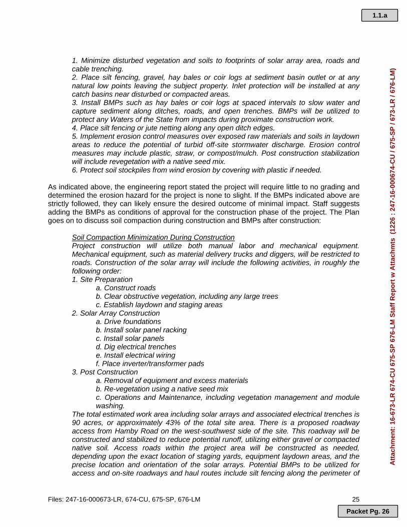
1. Minimize disturbed vegetation and soils to footprints of solar array area, roads and cable trenching. 2. Place silt fencing, gravel, hay bales or coir logs at sediment basin outlet or at any natural low points leaving the subject property. Inlet protection will be installed at any catch basins near disturbed or compacted areas. 3. Install BMPs such as hay bales or coir logs at spaced intervals to slow water and capture sediment along ditches, roads, and open trenches. BMPs will be utilized to protect any Waters of the State from impacts during proximate construction work. 4. Place silt fencing or jute netting along any open ditch edges. 5. Implement erosion control measures over exposed raw materials and soils in laydown areas to reduce the potential of turbid off-site stormwater discharge. Erosion control measures may include plastic, straw, or compost/mulch. Post construction stabilization will include revegetation with a native seed mix. 6. Protect soil stockpiles from wind erosion by covering with plastic if needed.
As indicated above, the engineering report stated the project will require little to no grading and determined the erosion hazard for the project is none to slight. If the BMPs indicated above are strictly followed, they can likely ensure the desired outcome of minimal impact. Staff suggests adding the BMPs as conditions of approval for the construction phase of the project. The Plan goes on to discuss soil compaction during construction and BMPs after construction:
Soil Compaction Minimization During Construction Project construction will utilize both manual labor and mechanical equipment. Mechanical equipment, such as material delivery trucks and diggers, will be restricted to roads. Construction of the solar array will include the following activities, in roughly the following order: 1. Site Preparation
a. Construct roads b. Clear obstructive vegetation, including any large trees c. Establish laydown and staging areas
2. Solar Array Construction a. Drive foundations b. Install solar panel racking c. Install solar panels d. Dig electrical trenches e. Install electrical wiring f. Place inverter/transformer pads
3. Post Construction a. Removal of equipment and excess materials b. Re-vegetation using a native seed mix c. Operations and Maintenance, including vegetation management and module washing.
The total estimated work area including solar arrays and associated electrical trenches is 90 acres, or approximately 43% of the total site area. There is a proposed roadway access from Hamby Road on the west-southwest side of the site. This roadway will be constructed and stabilized to reduce potential runoff, utilizing either gravel or compacted native soil. Access roads within the project area will be constructed as needed, depending upon the exact location of staging yards, equipment laydown areas, and the precise location and orientation of the solar arrays. Potential BMPs to be utilized for access and on-site roadways and haul routes include silt fencing along the perimeter of
1.1.a
Packet Pg. 26
Att
ach
men
t: 1
6-67
3-L
R 6
74-C
U 6
75-S
P 6
76-L
M S
taff
Rep
ort
w A
ttac
hm
ts (
1226
: 2
47-1
6-00
0674
-CU
/ 67
5-S
P /
673-
LR
/ 67
6-L
M)

Files: 247-16-000673-LR, 674-CU, 675-SP, 676-LM 26
the roadway to control potential soil erosion. The electrical trenches will be backfilled with native material at the same compaction level as the native surface, thus significantly reducing the potential for the electrical trench footprints from long-term compaction issues. Areas that may become compacted outside of the roads due to distribution of materials and/or off-road haul routes within the project site will be de-compacted and revegeted [sic] with a native grasses. There will be very minimal need for off-road driving so these areas of compaction should be very limited in area, but if they do occur they will be addressed as needed.
Staff believes that this criterion can be met. No comments were received from Oregon Department of Environmental Quality (DEQ) in response to this proposal, however, the applicant’s Soil and Erosion Control Plan states that the applicant is required to mitigate point source discharges of water-born pollutants by the standards set forth by the State of Oregon Department of Environmental Quality. Staff understand that a DEQ National Pollutant Discharge Elimination System (NPDES) Permit is required prior to initiating the use. Staff finds that this permitting process will ensure that surface and subsurface water quality will not be adversely impacted and recommends the Hearings Officer condition any approval of this application on the applicant obtaining this permit. Suggested Conditions of Approval: DEQ Permits: Prior to initiation of the use, the applicant shall provide evidence of a DEQ National Pollutant Discharge Elimination System (NPDES) Permit approval for the proposed use to the Planning Division. Drainage & Water Quality: During construction the applicant shall: 1. Limit disturbed vegetation and soils to those within the footprints of the solar array,
roads, and cable trenching areas. 2. Install silt fencing, gravel, hay bales or coir logs at sediment basin outlets or at any
natural low points leaving the subject property. Inlet protection shall be installed at any catch basins near disturbed or compacted areas.
3. Install silt fencing along perimeter of access way, on-site roadways, and haul routes. 4. Install hay bales or coir logs at spaced intervals to slow water and capture sediment
along ditches, roads, and open trenches. Hay bales or coir logs will be utilized to protect any Waters of the State from impacts during proximate construction work.
5. Place silt fencing or jute netting along all open ditch edges. 6. Implement erosion control measures over exposed raw materials and soils in laydown
areas to reduce the potential of turbid off-site storm water discharge. Erosion control measures may include plastic, straw, or compost/mulch.
7. Protect soil stockpiles from wind erosion by covering with plastic if needed. Post Construction the applicant shall:
8. Revegetate disturbed areas with a native seed mix. Areas that become compacted outside of the roads due to distribution of materials and/or off-road haul routes within the project site will be de-compacted and revegetated with native grasses.
9. Remove construction equipment and excess materials. 10. Backfill electrical trenches with native material at the same compaction level as the
native surface.
G. Areas, structures and facilities for storage, machinery and equipment, services (mail, refuse, utility wires, and the like), loading and parking and
1.1.a
Packet Pg. 27
Att
ach
men
t: 1
6-67
3-L
R 6
74-C
U 6
75-S
P 6
76-L
M S
taff
Rep
ort
w A
ttac
hm
ts (
1226
: 2
47-1
6-00
0674
-CU
/ 67
5-S
P /
673-
LR
/ 67
6-L
M)

Files: 247-16-000673-LR, 674-CU, 675-SP, 676-LM 27
similar accessory areas and structures shall be designed, located and buffered or screened to minimize adverse impacts on the site and neighboring properties.
APPLICANT’S RESPONSE: The site plan has been designed to locate the solar facility and its poles where its impacts will be minimized. The solar arrays are all located outside of the landscape management zone and a considerable distance from the two churches located to the south of the subject property. A reasonable buffer has also been provided between the project and the two nonfarm dwelling parcels to the west. Existing vegetation will be retained as screening. FINDING: Staff believes that the majority of the facility falls under the categories described in this criterion (Areas, structures and facilities for storage, machinery and equipment, services [mail, refuse, utility wires, and the like], loading and parking and similar accessory areas and structures) and that the facility must be designed, located and buffered or screened to minimize adverse impacts on neighboring properties. The applicant’s statement above has proposed to screen the facility with existing vegetation only. The submitted site plan states additional vegetation will be planted where existing vegetation is not sufficient. The applicant should clarify the level and extent of proposed screening for the Hearings Officer. Staff notes the setbacks proposed by the applicant are the minimum required setbacks of 100 feet from front property lines and 25 feet from side property lines, including the property lines abutting the two parcels containing nonfarm dwellings to the northwest of the subject property. The setbacks from the church property to the south, the Pacific Power substation to the southeast, and the solar power facility currently under construction to the east exceed the minimum setbacks by a great distance. Staff suggests the applicant be required to fence the developed area with a seven (7) foot fence with earth tone slats or earth tone mesh covering. Staff suggests the Hearings Officer request the applicant revise the site plan to reflect a general reconfiguration of development to place solar panels further to the east to provide greater buffering along Hamby Road and the residentially developed properties to the northwest of the subject property. This reconfiguration of the site would cluster solar power facility equipment closer to existing solar power facilities where there would be less adverse impact between adjacent incompatible uses. Staff suggests greater vegetative screening requirements along the proposed fence, including an objective standard for vegetation spacing so as to illuminate the subjective nature of identifying “sufficient” and “insufficient” existing vegetative screening. The areas along the southern and eastern portions of the proposed development have less need for screening because of the distance to adjacent uses and the nature of those uses. Staff suggests that if approved, the following conditions of approval be imposed: Suggested Conditions of Approval: Screening. Prior to the initiation of the use, the applicant shall complete the following: 1. Install a seven (7) foot chain link fence with earth toned slat screening. 2. Retain all existing native vegetation in setback yard areas and outside of the fenced
developed area. This condition does not prohibit removal of dead, diseased or hazardous vegetation. Removal of dead, diseased or hazardous vegetation shall be replaced with a native species within 90 days.
3. A landscaped buffer of at least 10 feet in width adjacent to the required fencing and located on the side of the fence which faces a public right-of-way or adjacent property shall contain:
1.1.a
Packet Pg. 28
Att
ach
men
t: 1
6-67
3-L
R 6
74-C
U 6
75-S
P 6
76-L
M S
taff
Rep
ort
w A
ttac
hm
ts (
1226
: 2
47-1
6-00
0674
-CU
/ 67
5-S
P /
673-
LR
/ 67
6-L
M)

Files: 247-16-000673-LR, 674-CU, 675-SP, 676-LM 28
a. Trees of a minimum height of six (6) feet, spaced not to exceed 16 feet apart on the average.
b. Shrubs of a minimum height of three (3) feet, spaced no more than eight feet apart on the average.
c. Native vegetative ground cover. d. Existing trees and shrubs that meet the dimensional requirements of (a), (b), and
(c) above may be counted towards the landscaped buffer requirements. e. The landscaped buffer shall not be required on the southern, southeastern, and
eastern boundaries of the proposed developed area.
H. All above-ground utility installations shall be located to minimize adverse visual impacts on the site and neighboring properties.
APPLICANT’S RESPONSE: The proposed solar project is located a significant distance from development on adjoining properties in an area that is already committed to power transmission and generation uses. The applicant will provide chain link fencing with privacy slats in muted earth tones to minimize visual impacts on the site or neighboring properties. The applicant will also retain existing vegetation as a visual buffer. Prior findings regarding compliance with conditional use approval criteria also demonstrate compliance with this code criterion. FINDING: Staff finds the criterion above relates to the previous criterion (G) as nearly the entire proposal consists of utility installations. Where the Hearings Officer finds that the proposal can be approved, Staff suggest the previous screening conditions of approval for subsection (G) be imposed.
I. Specific criteria are outlined for each zone and shall be a required part of the site plan (e.g. lot setbacks, etc.).
FINDING: The applicable criteria in the EFU zone have been addressed above.
J. All exterior lighting shall be shielded so that direct light does not project
off-site.
FINDING: The applicant indicates that no new exterior lighting is proposed. Staff understands the property to be vacant, with no existing exterior lighting, therefore no exterior lighting is approved.
K. Transportation access to the site shall be adequate for the use. 1. Where applicable, issues including, but not limited to, sight
distance, turn and acceleration/deceleration lanes, right-of-way, roadway surfacing and widening, and bicycle and pedestrian connections, shall be identified.
2. Mitigation for transportation-related impacts shall be required. 3. Mitigation shall meet applicable County standards in DCC 17.16 and
DCC 17.48, applicable Oregon Department of Transportation (ODOT) mobility and access standards, and applicable American Association of State Highway and Transportation Officials (AASHTO) standards.
APPLICANT’S RESPONSE: The applicant’s burden of proof statement provides the following in response to this criterion:
1.1.a
Packet Pg. 29
Att
ach
men
t: 1
6-67
3-L
R 6
74-C
U 6
75-S
P 6
76-L
M S
taff
Rep
ort
w A
ttac
hm
ts (
1226
: 2
47-1
6-00
0674
-CU
/ 67
5-S
P /
673-
LR
/ 67
6-L
M)

Files: 247-16-000673-LR, 674-CU, 675-SP, 676-LM 29
The project will be accessed by a driveway from Hamby Road. Hamby Road is a Rural Arterial street use that provides adequate access to the site for maintenance workers who will maintenance purposes. This use will be occasional and when they occur they should generate about 2 vehicle trips (one trip to and one trip from the property). Given the low number of vehicle trips, the use is not subject to transportation analysis and mitigation requirements.
FINDING: The applicant’s site plan depicts one proposed access road onto the site from Hamby Road, a County-maintained arterial road. The County Road Department provided a response of, “Access onto Hamby Road will have to meet AASHTO sight distance requirements for 55 mph. Access approach into the property will be paved to a length of 25 feet from [the] edge of pavement on Hamby Road with a width of 20 feet and 20 foot radius’s [sic]”. The County Transportation Planner provided comments that the use will result in less than 50 new weekday trips and, thus, no traffic analysis is required. Additionally, the County Transportation Planner also indicates that SDCs are not required for the use. For these reasons, staff believes that access can be adequate for the use. Staff suggests that if approved, the following condition of approval be imposed: Suggested Condition of Approval: Road Access: Prior to initiation of the use, the applicant shall meet all requirements of the Deschutes County Road Department. 6. Section 18.124.070, Required Minimum Standards
B. Required Landscaped Areas
1. The following landscape requirements are established for multi-family, commercial and industrial developments, subject to site plan approval: …
FINDING: It is staff’s opinion that these criteria do not apply because the proposed use is not a multi-family, commercial, or industrial development. This is consistent with the Hearings Officer’s decisions for other solar power facilities.
C. Nonmotorized Access.
1. Bicycle Parking. The development shall provide the number and
type of bicycle parking facilities as required in DCC 18.116.031 and 18.116.035. The location and design of bicycle parking facilities shall be indicated on the site plan.
FINDING: Staff finds that bicycle parking is only required under DCC 18.116.031 and 18.116.035 where vehicular parking is required. Since no permanent vehicular parking spaces are required, no bicycle parking spaces are required.
1.1.a
Packet Pg. 30
Att
ach
men
t: 1
6-67
3-L
R 6
74-C
U 6
75-S
P 6
76-L
M S
taff
Rep
ort
w A
ttac
hm
ts (
1226
: 2
47-1
6-00
0674
-CU
/ 67
5-S
P /
673-
LR
/ 67
6-L
M)

Files: 247-16-000673-LR, 674-CU, 675-SP, 676-LM 30
2. Pedestrian Access and Circulation a. Internal pedestrian circulation shall be provided in new
commercial, office and multi-family residential developments through the clustering of buildings, construction of hard surface pedestrian walkways, and similar techniques.
b. Pedestrian walkways shall connect building entrances to one another and from building entrances to public streets and existing or planned transit facilities. On-site walkways shall connect with walkways, sidewalks, bikeways, and other pedestrian or bicycle connections on adjacent properties planned or used for commercial, multi-family, public or park use.
c. Walkways shall be at least five feet in paved unobstructed width. Walkways which border parking spaces shall be at least seven feet wide unless concrete bumpers or curbing and landscaping or other similar improvements are provided which prevent parked vehicles from obstructing the walkway. Walkways shall be as direct as possible.
d. Driveway crossings by walkways shall be minimized. Where the walkway system crosses driveways, parking areas and loading areas, the walkway must be clearly identifiable through the use of elevation changes, speed bumps, a different paving material or other similar method.
e. To comply with the Americans with Disabilities Act, the primary building entrance and any walkway that connects a transit stop to building entrances shall have a maximum slope of five percent. Walkways up to eight percent are permitted, but are treated as ramps with special standards for railings and landings.
FINDING: It is staff’s opinion that this section does not apply because the project is not a commercial, office or multi-family residential use and there are no buildings to connect with walkways. C. CHAPTER 18.128, CONDITIONAL USE 1. Section 18.128.015, General Standards Governing Conditional Uses
Except for those conditional uses permitting individual single-family dwellings, conditional uses shall comply with the following standards in addition to the standards of the zone in which the conditional use is located and any other applicable standards of the chapter: A. The site under consideration shall be determined to be suitable for the
proposed use based on the following factors: 1. Site, design and operating characteristics of the use; 2. Adequacy of transportation access to the site; and 3. The natural and physical features of the site, including, but not
limited to, general topography, natural hazards and natural resource values.
1.1.a
Packet Pg. 31
Att
ach
men
t: 1
6-67
3-L
R 6
74-C
U 6
75-S
P 6
76-L
M S
taff
Rep
ort
w A
ttac
hm
ts (
1226
: 2
47-1
6-00
0674
-CU
/ 67
5-S
P /
673-
LR
/ 67
6-L
M)

Files: 247-16-000673-LR, 674-CU, 675-SP, 676-LM 31
APPLICANT’S RESPONSE: The site is suitable for the use proposed. It is located adjacent to Pacific Power's electrical transmission facilities that will be used to transmit the power to customers. The site is relatively open so that it will have access to solar light from the sky. Excellent access is provided to the site by an arterial street that is in close proximity to a State highway. The site contains existing, established native vegetation that will be retained in undeveloped areas to buffer the use from area properties. The natural and physical features of the site are similar to the features on the Hafter and Collier properties. The fact that both are currently being developed with solar farm projects demonstrates that the area and the subject property are also suitable. FINDING: (A)(1): The applicant’s statements in response to this criteria and site plan review criteria support a finding that the site, design, and operating characteristics are suitable for the proposal. In the site plan review criteria above, staff suggests that the design and aesthetic features for the buffered area be increased and improved. (A)(2): As the applicant states, the subject property and the proposed access location are located nearby Highway 20. The site is located just east of the city limits of Bend and can take advantage of the urbanized area’s transportation features. In the site plan review criteria above, staff suggests that a temporary parking area be required to alleviate parking on the shoulder of Hamby Road during construction. Staff also recommended a condition that the applicant shall meet all standards and obtain any permits required by the Deschutes County Road Department. (A)(3): The applicant’s statements in response to this criteria and site plan review criteria support findings that the natural and physical features of the site are suitable for the proposal. The applicant’s submitted Soil and Erosion Control Plan states the project will require little to no grading and determined the erosion hazard for the project is none to slight. As evidenced from the submitted topographical surveys and a site visit by staff, there are areas of raised rocky outcroppings, but generally the site is relatively flat with a slightly eastern facing slope. Staff was unable to locate any information identifying the history of natural hazards occurring on the subject property. The property is not likely to be subject to an increased chance of occurrence of a natural hazard due to the presence of the proposed use. The natural resource value of EFU zoned land is closely tied to the predominate soil class. As discussed above, the poor soils present on the subject property and the lack of irrigation pose significant challenges to viable farm uses. The subject property is not identified as being located within a Wildlife Area Combining zone and is not within a Sensitive Bird and Mammal Habitat Combining Zone. Several public comments received raised concerns about the impacts the proposed use may have on wildlife. Staff noticed the Oregon Department of Fish and Wildlife and the U.S. Fish and Wildlife Service. No response was received from either organization, indicating they have no concerns in regards to the proposal’s impact to wildlife. Staff finds that the applicant can meet the above criteria through the imposition of conditions of approval recommended in the site plan review section of this Staff Report, as deemed appropriate by the Hearings Officer.
B. The proposed use shall be compatible with existing and projected uses on surrounding properties based on the factors listed in DCC 18.128.015(A).
FINDING: As discussed in the Basic Findings above, the subject property is adjacent to lands zoned EFU-TRB on all sides. Uses in the greater area surrounding the subject site consist of a
1.1.a
Packet Pg. 32
Att
ach
men
t: 1
6-67
3-L
R 6
74-C
U 6
75-S
P 6
76-L
M S
taff
Rep
ort
w A
ttac
hm
ts (
1226
: 2
47-1
6-00
0674
-CU
/ 67
5-S
P /
673-
LR
/ 67
6-L
M)

Files: 247-16-000673-LR, 674-CU, 675-SP, 676-LM 32
mixture of small-scale and hobby farming, nonfarm dwellings, developed rural residential lots, electric substations, a sports park, and churches.
North: To the northwest of and adjacent to the subject property are tax lots 17-12-36-600 and 17-12-36-601, which are both developed with nonfarm dwellings and approximately 18.78 acres and 19.29 acres in size, respectively. To the northwest of and across Neff Road are tax lots 17-12-25-200 and 17-12-25-203, which are developed with the Bend Park & Recreation District’s Big Sky Park & Sports Complex and the Bend Fire Department’s Station 304, respectively. To the north of the Sports Complex is tax lot 17-12-25-201, which is developed with Bend-La Pine School District’s Buckingham Elementary School. To the north of and directly across Neff Road from the subject property are tax lots 17-12-25-401 and 17-12-25-400, which are both developed with nonfarm dwellings and are 19.28 acres and 19.57 acres in size, respectively. Tax lot 17-12-25-400 has received conditional approval to establish a horse and dog training and testing facility. To the northeast of and across Neff Road is tax lot 17-12-25-501, which is residentially developed and has been conditionally approved for a photovoltaic solar power generation facility under files 247-15-000168-CU, 247-15-000169-SP, and 247-16-000225-MC. The approved solar power facility is currently under construction.
East: To the east of and adjacent to the subject property is a tract of land comprised of
tax lots 17-12-36-100, 17-12-36-300, and 17-12-36-400, which have been conditionally approved for a photovoltaic solar power generation facility under files 247-15-000170-CU, 247-15-000171-SP, 247-15-000172-LM, and 247-16-000224-MC. The approved solar power facility is currently under construction. Further east and across Erickson Road are lands zoned Multiple Use Agriculture (MUA-10), most of which are residentially developed, many contain small scale or hobby farms, and most lots are sized between five (5) and twenty (20) acres. At the southeast corner of Neff and Erickson Roads is tax lot 17-13-31-501, which is developed with an electrical power substation.
South: To the south of and adjacent to the subject property are several lots zoned EFU
but not currently engaged in farm use. Tax lot 17-12-36-101 is developed with an electrical substation. Tax lot 17-12-36-801 is developed with a church, the Christian Life Center. Tax lot 17-12-36-200 is developed with a church, the Grace Community Presbyterian Church.
West: To the west of and across Hamby Road are one vacant lot not currently engaged
in farm use, four residentially developed lots not currently engaged in farm use, and one lot (17-12-35-1300) that appears to be irrigated and currently engaged in farm use. Further to the west are lands zoned Urban Area Reserve (UAR-10), Bend’s Urban Growth Boundary (UGB), and the city limits of Bend.
In response to the above criteria, the applicant’s burden of proof statement provides the following response:
Surrounding properties are all developed. Lands are developed with low-density residential developments, hobby farms, a church, a power substation and two large solar farm projects. The proposed use will be compatible with these existing uses based on site plan factors. It will generate extremely low levels of traffic. The site plan will retain
1.1.a
Packet Pg. 33
Att
ach
men
t: 1
6-67
3-L
R 6
74-C
U 6
75-S
P 6
76-L
M S
taff
Rep
ort
w A
ttac
hm
ts (
1226
: 2
47-1
6-00
0674
-CU
/ 67
5-S
P /
673-
LR
/ 67
6-L
M)
Files: 247-16-000673-LR, 674-CU, 675-SP, 676-LM 33
undeveloped parts of the site in a natural condition consistent with the conditions found on adjoining properties. No new or different uses are projected in this area.
As previously mentioned, numerous submitted public comments state how they believe the proposed use will be unsightly, adversely affecting their livability, and drastically changing the character of the neighborhood and surrounding area. Other comments from the public express concern for potential adverse impacts to wildlife in the area and a negative impact to neighbor property values. The applicant has expressed an opinion that because all nearby properties contain some level of development, that the proposed site plan will be compatible with surrounding uses because the proposed use will generate low levels of traffic and the site plan calls to retain vegetation in undeveloped portions of the property. Staff finds the applicant’s findings are lacking in detail and explanation as to how the proposal will be compatible with existing and projected uses on surrounding properties based on the factors listed in DCC 18.128.015(A):
1. Site, design and operating characteristics of the use; 2. Adequacy of transportation access to the site; and 3. The natural and physical features of the site, including, but not limited to,
general topography, natural hazards and natural resource values. Public comments have identified potential adverse impacts to residential and recreational use. Identified potential impacts to surrounding residential use include noise and visual impacts, and decreases in property value. If the applicant is relying on the proposed screening fence and simply the retention of existing vegetation without supplementation of additional vegetation to mitigate visual impacts, the Hearings Officer will need to determine if the proposed screening measures are sufficient to prevent significant adverse impacts to the residential use of surrounding properties. Several comments received from neighbors express concern for potential decreases in property values resulting from the solar facility. Although the effect a use has upon property values in the area is not a specifically stated criterion of review, staff notes this is a legitimate concern to neighbors in regards to the proposed project. Regarding potential decreases in property values, staff notes that prior decisions by Hearings Officers have found that potential property value impacts must be substantiated with evidence in the record in order to be considered. Additionally, staff is uncertain if potential property value impacts would adversely impact the site, design or operating characteristics or nearby residential uses under this criterion. Staff recognizes that the majority of conditional uses can impact property values, and often in a negative way for the property owner. If the Hearings Officer believes that the potential for decreased property values should be considered in evaluating compliance with the criteria above or for that matter in compliance with the site plan review criteria of DCC 18.124.060, perhaps the submittal of expert testimony from a licensed real estate appraiser can be provided by the applicant and/or interested parties for consideration and review. Staff requests that the Hearings Officer evaluate and determine if this proposal is compatible with existing and projected uses on surrounding properties based on the factors listed in DCC 18.128.015(A). Staff believes that these criteria would not be met where the proposal is found by the Hearings Officer to be incompatible with existing and projected uses on surrounding properties based on the factors listed in DCC 18.128.015(A).
1.1.a
Packet Pg. 34
Att
ach
men
t: 1
6-67
3-L
R 6
74-C
U 6
75-S
P 6
76-L
M S
taff
Rep
ort
w A
ttac
hm
ts (
1226
: 2
47-1
6-00
0674
-CU
/ 67
5-S
P /
673-
LR
/ 67
6-L
M)
Files: 247-16-000673-LR, 674-CU, 675-SP, 676-LM 34
Further, as previously addressed under 18.124.060 (A), staff believes submittal of a scaled plot plan, landscape plan and elevation drawings, containing all of the essential elements under DCC 18.124.040, is also necessary to determine compliance with this criterion. Staff defers to the Hearings Officer for a determination as to whether submittal of supplemental findings and evidence by the applicant, and the scaled plans and elevation drawings, can be submitted without a modification of application under DCC 22.20.055.
C. These standards and any other standards of DCC 18.128 may be met by the imposition of conditions calculated to insure that the standard will be met.
FINDING: To the extent the Hearings Officer finds that compliance with the criterion of DCC 18.128 is met by the applicant’s proposal, staff recommends the Hearings Officer condition any approval as the Hearings Officer deems appropriate. Section 18.128.020 of the DCC states:
In addition to the standards and conditions set forth in a specific zone or in DCC 18.124, the Planning Director or the Hearings Body may impose the following conditions upon a finding that additional restrictions are warranted. A. Require a limitation on manner in which the use is conducted, including
restriction of hours of operation and restraints to minimize environmental effects such as noise, vibrations, air pollution, glare or odor.
B. Require a special yard or other open space or a change in lot area or lot dimension.
C. Require a limitation on the height, size or location of a structure. D. Specify the size, number, location and nature of vehicle access points. E. Increase the required street dedication, roadway width or require additional
improvements within the street right of way. F. Designate the size, location, screening, drainage, surfacing or other
improvement of a parking or loading area. G. Limit or specify the number, size, location, height and lighting of signs. H. Limit the location and intensity of outdoor lighting and require shielding. I. Specify requirements for diking, screening, landscaping or other methods
to protect adjacent or nearby property and specify standards for installation and maintenance.
J. Specify the size, height and location of any materials to be used for fencing.
K. Require protection and preservation of existing trees, vegetation, water resources, wildlife habitat or other significant natural resources.
L. Require that a site plan be prepared in conformance with DCC 18.124. 3. Section 18.128.030. Performance Bond.
The Planning Director or Hearings Body may require the applicant to furnish the County with a performance bond or other adequate form of assurance to guarantee development in accordance with the standards and conditions attached in granting a conditional use permit.
FINDING: Staff recommends the Hearings Officer determine if a performance bond or other adequate form of assurance to guarantee development in accordance with the standards and
1.1.a
Packet Pg. 35
Att
ach
men
t: 1
6-67
3-L
R 6
74-C
U 6
75-S
P 6
76-L
M S
taff
Rep
ort
w A
ttac
hm
ts (
1226
: 2
47-1
6-00
0674
-CU
/ 67
5-S
P /
673-
LR
/ 67
6-L
M)

Files: 247-16-000673-LR, 674-CU, 675-SP, 676-LM 35
conditions attached in granting a conditional use permit in required. Bonding requirements for site restoration are discussed below in relation to OAR 660-033-0130(38)(j). 4. Section 18.128.040, Specific Use Standards
A conditional use shall comply with the standards of the zone in which it is located and with the standards and conditions set forth in DCC 18.128.045 through 18.128.370.
FINDING: Staff believes that the proposed solar power facility is subject to the standards addressed in this staff report. Deschutes County Code (DCC) 18.128.045 through DCC 18.128.370 are not relevant as those sections address uses unrelated to the proposed use. 5. Section 18.128.380. Procedure for Taking Action on Conditional Use Application
The procedure for taking action on a conditional use application shall be as follows: A. A property owner may initiate a request for a conditional use by filing an
application on forms provided by the Planning Department. B. Review of the application shall be conducted according to the terms of
DCC Title 22, the Uniform Development Procedures Ordinance. FINDING: The applicant has submitted the required application form for a conditional use permit. The conditional use permit application is being processed in accordance with DCC Title 22. D. CHAPTER 18.80, AIRPORT SAFETY COMBINING ZONE 1. Section 18.80.028, Height Limitations All uses permitted by the underlying zone shall comply with the height limitation in DCC 18.80.028. When height limitations of the underlying zone are more restrictive than those of this overlay zone, the underlying zone height limitations shall control.
A. Except as provided in DCC 18.80.028(B) and (C), no structure or tree, plan or other object of natural growth shall penetrate an airport imaginary surface.
B. For areas within airport imaginary surfaces but outside the approach and transition surfaces, where the terrain is at higher elevations than the airport runway surfaces such that existing structure and permitted development penetrate or would penetrate the airport imaginary surfaces, a local government may authorize structures of up to 35 feet in height. ….
FINDING: The property is within the Airport Safety (AS) Combining Zone of the Bend Municipal Airport and is sited approximately two miles from the airport runway. The property is outside the approach and transition surfaces and is within the conical surface of the Bend Municipal Airport. Tax lot 500 is wholly within the conical surface and tax lot 700 is partially within the conical surface (see Figure 4 below).
1.1.a
Packet Pg. 36
Att
ach
men
t: 1
6-67
3-L
R 6
74-C
U 6
75-S
P 6
76-L
M S
taff
Rep
ort
w A
ttac
hm
ts (
1226
: 2
47-1
6-00
0674
-CU
/ 67
5-S
P /
673-
LR
/ 67
6-L
M)
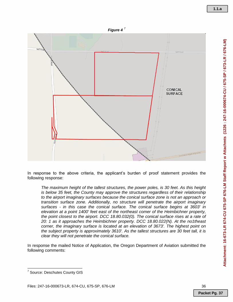
Files: 247-16-000673-LR, 674-CU, 675-SP, 676-LM 36
Figure 4 7
In response to the above criteria, the applicant’s burden of proof statement provides the following response:
The maximum height of the tallest structures, the power poles, is 30 feet. As this height is below 35 feet, the County may approve the structures regardless of their relationship to the airport imaginary surfaces because the conical surface zone is not an approach or transition surface zone. Additionally, no structure will penetrate the airport imaginary surfaces - in this case the conical surface. The conical surface begins at 3603' in elevation at a point 1400' feet east of the northeast comer of the Heimbichner property, the point closest to the airport. DCC 18.80.032(0). The conical surface rises at a rate of 20: 1 as it approaches the Heimbichner property. DCC 18.80.022(N). At the no1theast corner, the imaginary surface is located at an elevation of 3673'. The highest point on the subject property is approximately 3610'. As the tallest structures are 30 feet tall, it is clear they will not penetrate the conical surface.
In response the mailed Notice of Application, the Oregon Department of Aviation submitted the following comments:
7 Source: Deschutes County GIS
1.1.a
Packet Pg. 37
Att
ach
men
t: 1
6-67
3-L
R 6
74-C
U 6
75-S
P 6
76-L
M S
taff
Rep
ort
w A
ttac
hm
ts (
1226
: 2
47-1
6-00
0674
-CU
/ 67
5-S
P /
673-
LR
/ 67
6-L
M)

Files: 247-16-000673-LR, 674-CU, 675-SP, 676-LM 37
On December 9, 2016:
The site is approximately 2.5 miles SW of Bend Municipal airport. The estimated elevation is approximately 3590 feet AMSL and the Bend Airport is listed at 3460 feet AMSL. In most solar development the structures are not over 20-feet above the ground. So based in the distance and likely structure height, ODA finds that this development will not pose a hazard to air navigation.
On January 18, 2017:
The project location is approximately 2.45 miles SW of the Bend airport. If the structures associated with the projects are less than 30 feet in height, ODA will not request a FAA form 7460-1 from the applicant. If the solar cells are higher than 30-feet in height, please have the applicant contact this agency to get further details on the project.
The tallest feature of the proposed solar power facility are the power poles. At a proposed maximum height of 30 feet, staff finds the development will not penetrate the airport’s conical surface. Based on ODA’s comment letters, it appears the proposal will not pose a hazard to air navigation. If approved, Staff recommends the following condition of approval. Suggested Condition of Approval: Height: The maximum height of the proposed development, including power poles, shall be 30 feet.
2. 18.80.044, Land Use Compatibility. Applications for land use or building permits for properties within the boundaries of this overlay zone shall comply with the requirements of DCC 18.80 as provided herein. When compatibility issues arise, the Planning Director or Hearings Body is required to take actions that eliminate or minimize the incompatibility by choosing the most compatible location or design for the boundary or use. Where compatibility issues persist, despite actions or conditions intended to eliminate or minimize the incompatibility, the Planning Director or Hearings Body may disallow the use or expansion, except where the action results in loss of current operational levels and/or the ability of the airport to grow to meet future community needs. Reasonable conditions to protect the public safety may be imposed by the Planning Director or Hearings Body. A. Noise. Within airport noise impact boundaries, land uses shall be
established consistent with the levels identified in OAR 660, Division 13, Exhibit 5 (Table 2 of DCC 18.80). Applicants for any subdivision or partition approval or other land use approval or building permit affecting land within airport noise impact boundaries, shall sign and record in the Deschutes County Book of Records, a Declaration of Anticipated Noise declaring that the applicant and his successors will not now, or in the future complain about the allowed airport activities at the adjacent airport. In areas where the noise level is anticipated to be at or above 55 Ldn, prior to issuance of a building permit for construction of a noise sensitive land use (real property normally used for sleeping or as a school, church,
1.1.a
Packet Pg. 38
Att
ach
men
t: 1
6-67
3-L
R 6
74-C
U 6
75-S
P 6
76-L
M S
taff
Rep
ort
w A
ttac
hm
ts (
1226
: 2
47-1
6-00
0674
-CU
/ 67
5-S
P /
673-
LR
/ 67
6-L
M)
Files: 247-16-000673-LR, 674-CU, 675-SP, 676-LM 38
hospital, public library or similar use), the permit applicant shall be required to demonstrate that a noise abatement strategy will be incorporated into the building design that will achieve an indoor noise level equal to or less than 55 Ldn. [NOTE: FAA Order 5100.38A, Chapter 7 provides that interior noise levels should not exceed 45 decibels in all habitable zones.]
FINDING: The proposed use is not one that is noise-sensitive and is not located within the noise impact boundary associated with the Bend Airport.
B. Outdoor lighting. No new or expanded industrial, commercial or recreational use shall project lighting directly onto an existing runway or taxiway or into existing airport approach surfaces except where necessary for safe and convenient air travel. Lighting for these uses shall incorporate shielding in their designs to reflect light away from airport approach surfaces. No use shall imitate airport lighting or impede the ability of pilots to distinguish between airport lighting and other lighting.
FINDING: The applicant indicates that exterior lighting not proposed.
C. Glare. No glare producing material, including but not limited to unpainted metal or reflective glass, shall be used on the exterior of structures located within an approach surface or on nearby lands where glare could impede a pilot's vision.
APPLICANT’S RESPONSE: The subject property is outside of and approximately 1.25 miles west of the outer edge of the approach surface area of the Bend Municipal Airport that is the closest to the subject property. In this location, the subject property is not nearby lands where glare could impede a pilot's vision. Furthermore, the materials proposed for the subject property will be non- reflective materials - not unpainted metal or reflective glass. The solar panels are made of materials designed to absorb rather than reflect light.
Additionally, the applicant relies on the County's decision and findings on pages 33-34 of Exhibit H of the decision approving a solar farm for File Nos. 247-[15-]000170-CU/171-SP/172-LM on property owned by Thomas Collier. The Collier property is located closer to the Bend Municipal Airport and between the subject property and the airport. Nothing about the more distant location of the subject property presents conditions that will produce more glare than might be produced by the solar farm approved for the Collier property. FINDING: The applicant references findings in a previous decision. Those relevant findings, as staff understands the applicant is referencing, are summarized below:
FINDING: […] The applicant contends that the solar panels used for the project will not produce significant reflection or glare as it will utilize photovoltaic (PV) modules using “non-reflective” glass. The applicant refers to the photos in Exhibit C of the supplemental burden of proof as visual evidence to verify that the surface material of the solar panels is not reflective. Additionally, the applicant also refers to the FAA Technical Guidance for Evaluating Selected Solar Technologies on Airports for evidence that the proposed panels are designed to absorb rather than reflect light and that the reflectivity of the panels is significantly lower than that of bare soil or vegetation.
1.1.a
Packet Pg. 39
Att
ach
men
t: 1
6-67
3-L
R 6
74-C
U 6
75-S
P 6
76-L
M S
taff
Rep
ort
w A
ttac
hm
ts (
1226
: 2
47-1
6-00
0674
-CU
/ 67
5-S
P /
673-
LR
/ 67
6-L
M)

Files: 247-16-000673-LR, 674-CU, 675-SP, 676-LM 39
The applicant also references the Study of the Hazardous Glare Potential to Aviators from Utility-Scale Flat-Plate Photovoltaic Systems, published by the International Scholarly Research Network (ISRN) and included as Exhibit D to the applicant’s supplemental burden of proof statement. The applicant provides a quote from this ISRN paper concluding that “the potential for hazardous glare from flat-plate PV systems is similar to that of smooth water and not expected to be a hazard to air navigation”. … Hearings Officer: At the hearing, there was much debate about the potential for glare or similar impacts on aviation. Much of this was generalized. The most compelling evidence came from Gary E. Miller, President of the Central Oregon Chapter of the Oregon Pilot’s Association and a member of other pilot associations and clubs. He indicated significant initial skepticism and concerns on his part and that of other pilots. He supplemented his testimony with a July 1, 2015 email, concluding that, “if the projects are built as currently specified, with a requirement to mitigate unforeseen glare with programming, the CO-OPA and the OPA have no objection…” In particular, his analysis concluded that any noticeable “uplift” will be outside the normal airport traffic area. As regards glare, he reran the SGHAT with “more accurate data” that any potential glare would be south of the FAA recommended air traffic pattern and of a lesser intensity” than anticipated and, therefore, not a significant concern. To a certain extent this contradicts the applicant’s assertion that there effectively is no glare, but the convincing evidence is that any glare is minimal and not a hazard. Note, however, that this is dependent on proper programming of the panels and unforeseen glare issues could arise. The applicant committed to working with aviation interests to resolve any issues. I find that a condition of approval to that effect is necessary to ensure on-going compliance. See condition No. 10. …
Page 56 of the Hearings Officer’s decision for files 247-15-000170-CU / 171-SP / 172-LM, condition 10 states:
Prior to initiation of the use the applicant shall establish a hotline available 7 days a week during daylight hours through which a supervisory employee may be contacted to receive and promptly address to reports of glare or other conditions causing interference or potential dangerous circumstances for aircraft. This number shall be provided to the appropriate personnel at the Bend and Redmond airports, Deschutes County planning, and Deschutes County Sheriff. It also shall be made available to any aviation company, pilot organization or similar group that may reasonably be considered to be in a position to responsibly report dangerous conditions. The applicant shall modify its operations or take such other steps as are necessary to promptly eliminate glare or other bonafide aviation risks.
It is unclear to staff that the proposed panels would consist of a material that would not produce glare “on nearby lands where glare could impede a pilot's vision”. The applicant states they rely on the previous Hearings Officer’s decision for the referenced files, but has provided no evidence that the materials of the panels, the location of equipment, the programming of the equipment, and all other related details of the site and use are identical to those in the referenced approval. As such, staff finds this criterion is not satisfied. Staff does not possess the expertise to effectively evaluate and assess the reflective qualities or glare potential of the proposed solar panels and the applicant has not provided sufficient information to demonstrate compliance. Unless the Hearings Officer is comfortable reviewing and interpreting the submitted materials, Staff suggests that the Hearings Officer request the applicant to provide written expert testimony, to effectively evaluate the effect of glare and reflectivity of the specific solar
1.1.a
Packet Pg. 40
Att
ach
men
t: 1
6-67
3-L
R 6
74-C
U 6
75-S
P 6
76-L
M S
taff
Rep
ort
w A
ttac
hm
ts (
1226
: 2
47-1
6-00
0674
-CU
/ 67
5-S
P /
673-
LR
/ 67
6-L
M)

Files: 247-16-000673-LR, 674-CU, 675-SP, 676-LM 40
panels on aircraft and pilots. If the Hearings Officer finds the proposal can be approved without additional information, staff suggests the following modified condition of approval, adapted from the quoted decision above: Suggested Condition of Approval: Aviation Hotline: Prior to initiation of the use the applicant shall establish a hotline available 7 days per week during daylight hours through which a supervisory employee may be contacted to receive and promptly address to reports of glare or other conditions causing interference or potential dangerous circumstances for aircraft. This number shall be provided to the appropriate personnel at the Bend and Redmond airports, the Deschutes County Code Enforcement Division, the Deschutes County Planning Division, and the Deschutes County Sheriff. It also shall be made available to any aviation company, pilot organization or similar group that may reasonably be considered to be in a position to responsibly report dangerous conditions. The applicant shall modify its operations or take such other steps as are necessary to promptly eliminate glare or other genuine aviation risks.
D. Industrial emissions. No new industrial, mining or similar use, or expansion of an existing industrial, mining or similar use, shall, as part of its regular operations, cause emissions of smoke, dust or steam that could obscure visibility within airport approach surfaces, except upon demonstration, supported by substantial evidence, that mitigation measures imposed as approval conditions will reduce the potential for safety risk or incompatibility with airport operations to an insignificant level. The review authority shall impose such conditions as necessary to ensure that the use does not obscure visibility.
FINDING: The proposed use will not generate any emissions of smoke, dust or steam.
E. Communications Facilities and Electrical Interference. No use shall cause or create electrical interference with navigational signals or radio communications between an airport and aircraft. Proposals for the location of new or expanded radio, radiotelephone, and television transmission facilities and electrical transmission lines within this overlay zone shall be coordinated with the Department of Aviation and the FAA prior to approval. Approval of cellular and other telephone or radio communication towers on leased property located within airport imaginary surfaces shall be conditioned to require their removal within 90 days following the expiration of the lease agreement. A bond or other security shall be required to ensure this result.
FINDING: The propose use is not expected cause or create any electrical interference with navigational signals or radio communications between the Bend airport and aircraft.
F. Limitations and Restrictions on Allowed Uses in the RPZ, Approach Surface, and Airport Direct and Secondary Impact Areas. For the Redmond, Bend, Sunriver, and Sisters airports, the land uses identified in DCC 18.80 Table l, and their accessory uses, are permitted, permitted under limited circumstances, or prohibited in the manner therein described. In the event of conflict with the underlying zone, the more restrictive provisions shall control. As used in DCC 18.80.044, a limited use
1.1.a
Packet Pg. 41
Att
ach
men
t: 1
6-67
3-L
R 6
74-C
U 6
75-S
P 6
76-L
M S
taff
Rep
ort
w A
ttac
hm
ts (
1226
: 2
47-1
6-00
0674
-CU
/ 67
5-S
P /
673-
LR
/ 67
6-L
M)

Files: 247-16-000673-LR, 674-CU, 675-SP, 676-LM 41
means a use that is allowed subject to special standards specific to that use.
APPLICANT’S RESPONSE: Table 1 lists utilities as L5 uses. The table states that the height of utilities shall be coordinated with the airport sponsor and the Department of Aviation. The applicant has coordinated with the Department of Aviation on this project and Gary Judd, Bend Airport Manager has been included in the correspondence. See, Exhibit Q. Furthermore, the applicant is proposing structure heights that are allowed outright by the County's AS zoning district. It is also expected that the airport sponsor and the Department of Aviation will be provided notice of this application and will participate in the review, if they decide that their participation is merited. FINDING: The proposed use is listed as “Utility” in DCC 18.80 Table 1. The subject property is located in a secondary impact area where note L(5) specifies, “the proposed height of utilities shall be coordinated with the airport sponsor and the Department of Aviation.” A Notice of Application was sent to the Bend Municipal Airport Manager, who did not respond to the notice. A Notice of Application was sent to the Oregon Department of Aviation, who responded and did not raise concerns based on the maximum height of the proposal being 30 feet. Staff finds this criterion is met based on the statements and reference above. 2. Section 18.80.054, Conditional Uses.
Uses permitted conditionally shall be those identified as conditional uses in the underlying zone with which the AS Zone is combined, and shall be subject to all conditions of the underlying zone except as provided in DCC 18.80.044.
FINDING: The proposed use is permitted conditionally in the underlying zone, which is Exclusive Farm Use. 3. Section 18.80.064, Procedures
An applicant seeking a land use or limited land use approval in an area within this overlay zone shall provide the following information in addition to any other information required in the permit application: A map or drawing showing the location of the property in relation to the airport imaginary surfaces. The Community Development Department shall provide the applicant with appropriate base maps upon which to locate the property. Elevation profiles and a site plan, both drawn to scale, including the location and height of all existing and proposed structures, measured in feet above mean sea level. ….
APPLICANT’S RESPONSE: The applicant has provided a map obtained from the County's DIAL system that shows the location of the property in relation to the airport imaginary surfaces. It is Exhibit T of this application. The applicant has also included the relevant pages of ALTA surveys, Exhibits U and V, for the Heimbichner and Pandian properties. The surveys show the elevation of the subject property. The site plan shows the locations of proposed structures on the subject property. The tallest structures will be the power poles which will be 30' tall. FINDING: Staff notes the submitted site plan is not to scale. No elevation drawings were submitted. The location of the tallest structures, the power poles, were not clearly identified on
1.1.a
Packet Pg. 42
Att
ach
men
t: 1
6-67
3-L
R 6
74-C
U 6
75-S
P 6
76-L
M S
taff
Rep
ort
w A
ttac
hm
ts (
1226
: 2
47-1
6-00
0674
-CU
/ 67
5-S
P /
673-
LR
/ 67
6-L
M)

Files: 247-16-000673-LR, 674-CU, 675-SP, 676-LM 42
the submitted site plan. However, staff was able to perform the review without these materials, and instead relied on the County’s GIS and maps, agency comments, and the applicant’s written statements and submitted exhibits. 5. Section 18.80.078, FAA Notification (Form 7460-1).
A. Federal and State Notice.
Federal Aviation Regulation (FAR) Part 77 requires that anyone proposing to construct anything which may obstruct the use of airspace by aircraft to provide a notice to that effect to the FAA. In addition, OAR 738.070.0060 requires notice also be sent to the Oregon Department of Aviation. Generally, construction proposals in the vicinity of airports may obstruct airspace. Notice to the FAA and Oregon Department of Aviation is required for anything which may affect landing areas, either existing or planned, which are open to the public, or are operated by one of the armed forces.
… APPLICANT’S RESPONSE: The applicant has provided notice to the FAA and to the Oregon Department of Aviation and has obtained a determination of no hazard to air navigation from the FAA for its solar project. A number of determinations of no hazard were obtained for the elements of this project, including the power poles at a height of 40 feet (the poles will be 30 feet tall). A copy of one of these determinations, one for a point on the boundary of the project, is included as Exhibit R of this application. Exhibit Q shows that notice was also sent to the Oregon Department of Aviation. FINDING: The Oregon Department of Aviation (ODA) received and Notice of Application and responded, in part, with the following comment:
If the structures associated with the projects are less than 30 feet in height, ODA will not request a FAA form 7460-1 from the applicant.
Staff finds neither ODA’s response to the mailed Notice of Application and the applicant’s submitted letter from ODA (“Exhibit Q”) exempts the applicant from filing FAA Form 7460-1. The letter submitted as “Exhibit Q” makes no mention of this form, and ODA’s response to the notice states that ODA will not request FAA form 7460-1 from the applicant if the structures are less than 30 feet in height. The proposal includes power poles that are a maximum of 30 feet, not specifically less than 30 feet. Staff recognizes the nuance of the height descriptions both in the proposal and the response from ODA, however, staff must rely on the information provided and the response from ODA indicates they will request the applicant to file form 7460-1. If the applicant has already filed this form as part of providing their notice and in their communications with the ODA and FAA, they can submit that information to the Hearings Officer. Staff finds the applicant’s submitted “Exhibit R”, a letter from the FAA, requires the applicant file FAA Form 7460-2, Notice of Actual Construction or Alteration, any time the project is abandoned or within 5 days after the construction reaches its greatest height. If the Hearings Officer finds the proposal can be approved, staff suggests the following condition of approval be required to ensure compliance with the above criteria:
1.1.a
Packet Pg. 43
Att
ach
men
t: 1
6-67
3-L
R 6
74-C
U 6
75-S
P 6
76-L
M S
taff
Rep
ort
w A
ttac
hm
ts (
1226
: 2
47-1
6-00
0674
-CU
/ 67
5-S
P /
673-
LR
/ 67
6-L
M)

Files: 247-16-000673-LR, 674-CU, 675-SP, 676-LM 43
Suggested Condition of Approval FAA Notices: Prior to initiation of use, the applicant shall properly file FAA Forms 7460-1 and 7460-2, as needed and required by the Oregon Department of Aviation and/or the Federal Aviation Administration. Copies of each form shall be submitted to the Planning Division. E. CHAPTER 18.84. LANDSCAPE MANAGEMENT COMBINING ZONE
1. Section 18.84.020. Application of provisions.
The provisions of this chapter shall apply to all areas within one-fourth mile of roads identified as landscape management corridors in the Comprehensive Plan and the County Zoning Map. The provisions of this chapter shall also apply to all areas within the boundaries of a State scenic waterway or Federal wild and scenic river corridor and all areas within 660 feet of rivers and streams otherwise identified a landscape management corridors in the comprehensive plan and the County Zoning Map. The distance specified above shall be measured horizontally from the centerline of designated landscape management roadways or from the nearest ordinary high water mark of a designated landscape management river or stream. The limitation in this section shall not unduly restrict accepted agricultural practices.
FINDING: Highway 20 is identified on the County Zoning Map as the landscape management feature. The southern portion of tax lot 700 lies within the Landscape Management (LM) Combining Zone. A portion of the proposed solar power facility is within the LM zone, therefore, the provisions of this chapter are applicable. 2. Section 18.84.030. Uses Permitted Outright.
Uses permitted conditionally in the underlying zone with which the LM Zone is combined shall be permitted as conditional uses in the LM Zone, subject to the provisions in DCC 18.84.
FINDING: The proposed use is listed as a conditional use in the underlying zone, thus is permitted as a conditional use in the LM zone, subject to the requirements of this section. 3. Section 18.84.050. Use Limitations.
A. Any new structure or substantial alteration of a structure requiring a
building permit, or an agricultural structure, within an LM Zone shall obtain site plan approval in accordance with DCC 18.84 prior to construction. As used in DCC 18.84 substantial alteration consists of an alteration which exceeds 25 percent in the size or 25 percent of the assessed value of the structure.
APPLICANT’S RESPONSE: The only part of the proposed project that will be located in the LM zoning district will be the power poles and point of interconnection which is a small, fenced control house (this fencing will be chain link fencing 6' tall with barbed wire per National Electric Safety Code) that will be built and owned by Pacific Power as a part of its utility facilities. Pacific Power's control house is a utility facility. In AD-10-12, Exhibit S, Deschutes County determined
1.1.a
Packet Pg. 44
Att
ach
men
t: 1
6-67
3-L
R 6
74-C
U 6
75-S
P 6
76-L
M S
taff
Rep
ort
w A
ttac
hm
ts (
1226
: 2
47-1
6-00
0674
-CU
/ 67
5-S
P /
673-
LR
/ 67
6-L
M)
Files: 247-16-000673-LR, 674-CU, 675-SP, 676-LM 44
that the regulations of the LM zone do not apply to Pacific Power's utility facilities. As a result, only the poles are subject to LM review.
FINDING: Staff agrees that the majority of the project is located outside of the LM zone, based on the submitted site plan (see Figure 5).
Figure 5 8
The identified components of the solar power facility to be located in the LM zone are the power poles and the interconnection control house. The applicant states the only component subject to this section are the power poles, and that the control house is exempt because it is part of Pacific Power’s utility facility. The applicant references an application for a modification to the electrical substation on tax lot 101 (see Figure 5 above), file AD-10-12. The referenced application was for a utility facility necessary for public service. The assertion that the LM criteria does not apply to the interconnection point is based on findings within AD-10-12 that reference
8 Source: Applicant’s submitted “Exhibit J”
1.1.a
Packet Pg. 45
Att
ach
men
t: 1
6-67
3-L
R 6
74-C
U 6
75-S
P 6
76-L
M S
taff
Rep
ort
w A
ttac
hm
ts (
1226
: 2
47-1
6-00
0674
-CU
/ 67
5-S
P /
673-
LR
/ 67
6-L
M)
Files: 247-16-000673-LR, 674-CU, 675-SP, 676-LM 45
Brentmar v Jackson County. The referenced case discusses the authority of a county to apply more stringent requirements to listed uses in ORS 215.283(1) and (2). It is staff’s understanding that in Brentmar v Jackson County, the final determination was that under ORS 215.83(1), a county may not enact or apply legislative criteria of its own that supplement those found in ORS 215.283(1), and under ORS 215.283(2), a county may enact and apply legislative criteria of its own that supplement those found in ORS 215.283(2). Staff finds the current proposal does not pertain to ORS 215.283(1)(c)9, therefore the interconnection control house is subject to the County’s additional criteria, including the requirements of the LM zone. Pacific Power has not applied for an expansion of its electrical substation, and the referenced file AD-10-12 on tax lot 101 did not approve this proposed structure on tax lot 700. Staff requests the Hearings Officer make a determination in consideration of Brentmar v Jackson County as to whether the LM zone criteria of DCC 18.84 applies to all of the proposed structures on the subject property within the LM zone or if DCC 18.84 only applies to the power poles. In the case that the Hearings Officer finds that DCC 18.84 applies to all structures proposed within the LM zone, staff has provided a site plan review in the following sections that assume that finding. If the Hearings Officer finds that DCC 18.84 applies only to the power poles as the applicant suggests, then staff recommends the review and any conditions of approval be appropriately changed to reflect that finding. 4. Section 18.84.080. Design review standards.
A. Except as necessary for construction of access roads, building pads,
septic drainfields, public utility easements, parking areas, etc., the existing tree and shrub cover screening the development from the designated road, river or stream shall be retained. This provision does not prohibit maintenance of existing lawns, removal of dead, diseased or hazardous vegetation; the commercial harvest of forest products in accordance with the Oregon Forest Practices Act or agricultural use of the land.
FINDING: The existing vegetation consists of mature juniper trees, shrubs, natural grasses, and other vegetation in the areas surrounding the proposed control house and power poles that provide some screening and help mitigate impacts as seen from Highway 20. If approved, it should be made a condition of approval that existing trees and vegetation between and to the sides of the facility and Highway 20 be retained. Suggested Condition of Approval:
Vegetation Retention in the LM Zone: Trees and shrubs shall be retained on site in all areas where they serve to screen the development from Highway 20. This condition does not prohibit removal of dead, diseased or hazardous vegetation. Removal of dead, diseased or hazardous vegetation shall be replaced with a native species within 90 days.
9 ORS 215.283(1)(c): Utility facilities necessary for public service, including wetland waste treatment systems but not including commercial facilities for the purpose of generating electrical power for public use by sale or transmission towers over 200 feet in height. A utility facility necessary for public service may be established as provided in: (A) ORS 215.275 (Utility facilities necessary for public service); or (B) If the utility facility is an associated transmission line, as defined in ORS 215.274 (Associated transmission lines necessary for public service) and 469.300 (Definitions).
1.1.a
Packet Pg. 46
Att
ach
men
t: 1
6-67
3-L
R 6
74-C
U 6
75-S
P 6
76-L
M S
taff
Rep
ort
w A
ttac
hm
ts (
1226
: 2
47-1
6-00
0674
-CU
/ 67
5-S
P /
673-
LR
/ 67
6-L
M)

Files: 247-16-000673-LR, 674-CU, 675-SP, 676-LM 46
B. It is recommended that new structures and additions to existing structures
be finished in muted earth tones that blend with and reduce contrast with the surrounding vegetation and landscape of the building site.
APPLICANT’S RESPONSE: The code provision is not a relevant approval criterion; rather, it is a recommendation. The power poles will be earth tone wooden poles.
FINDING: The proposed wooden poles can meet this criterion. Staff believes this criterion applies to the control house as well. Staff recommends the Hearings Officer request additional information to determine the proposed finishing color of the control house. If approved, Staff recommends the Hearings Officer add a condition of approval to ensure compliance with the above criterion.
C. No large areas, including roofs, shall be finished with white, bright or reflective materials. Metal roofing material is permitted if it is non-reflective and of a color which blends with the surrounding vegetation and landscape. This subsection shall not apply to attached additions to structures lawfully in existence on April 8, 1992, unless substantial improvement to the roof of the existing structure occurs.
APPLICANT’S RESPONSE: The poles do not include large areas such as roofs. This criterion, therefore, is not applicable.
FINDING: Staff believes this criterion applies to the control house as well. Staff recommends the Hearings Officer request additional information to determine the proposed material and color of the control house. If approved, Staff recommends the Hearings Officer add a condition of approval to ensure compliance with the above criterion.
D. Subject to applicable rimrock setback requirements or rimrock setback exception standards in Section 18.84.090, all structures shall be sited to take advantage of existing vegetation, trees and topographic features in order to reduce visual impact as seen from the designated road, river or stream.
APPLICANT’S RESPONSE: The part of the project in the LM zone is at the outer edge of the overlay zone beyond other developed properties that adjoin Highway 20. Views of the power poles associated with the project will be significantly reduced by the Pacific Power substation and the extremely tall power poles associated with that facility and similar very tall poles associated with the BPA transmission line and the Pacific Power transmission line that serves the City of Bend. The siting of the power poles will also take advantage of existing vegetation and trees to further reduce its very minimal visual impact on views from the highway. The subject property does not contain rimrock.
FINDING: Staff is not clear as to where all the power poles will be located. The submitted site plan contains 8 small black dots between the control house and the solar panels, and staff assumes each dot is a location of a power pole. The site plan is not to scale, and the dots are not identified, so this may be inaccurate. Staff recommends the applicant clarify the location of all development within the LM zone through submittal of a scaled landscape plan and elevation drawings depicting all existing landscaping to be retained and removed and all proposed structures
1.1.a
Packet Pg. 47
Att
ach
men
t: 1
6-67
3-L
R 6
74-C
U 6
75-S
P 6
76-L
M S
taff
Rep
ort
w A
ttac
hm
ts (
1226
: 2
47-1
6-00
0674
-CU
/ 67
5-S
P /
673-
LR
/ 67
6-L
M)

Files: 247-16-000673-LR, 674-CU, 675-SP, 676-LM 47
Staff defers to the Hearings Officer for a determination as to whether submittal of supplemental findings and evidence by the applicant, and the scaled plans and elevation drawings, can be submitted without a modification of application under DCC 22.20.055. Figure 6 below is a magnified view of the submitted site plan, depicting the interconnection control house and the dots presumably representing power poles.
Figure 6 10
Staff agrees with the applicant that there is existing development that will provide additional screening of the proposed development. The existing electrical substation and the numerous taller power poles associated with that use are much closer to Highway 20. Figure 7 depicts a street view from Highway 20 looking north.
10
Source: Applicant’s submitted “Exhibit J”
1.1.a
Packet Pg. 48
Att
ach
men
t: 1
6-67
3-L
R 6
74-C
U 6
75-S
P 6
76-L
M S
taff
Rep
ort
w A
ttac
hm
ts (
1226
: 2
47-1
6-00
0674
-CU
/ 67
5-S
P /
673-
LR
/ 67
6-L
M)

Files: 247-16-000673-LR, 674-CU, 675-SP, 676-LM 48
Figure 7 11
E. Structures shall not exceed 30 feet in height measured from the natural grade on the side(s) facing the road, river or stream. Within the LM zone along a state scenic waterway or federal wild and scenic river, the height of a structure shall include chimneys, antennas, flagpoles or other projections from the roof of the structure. This section shall not apply to agricultural structures located at least 50 feet from a rimrock.
FINDING: The applicant indicates that no structure in the LM zone will exceed 30 feet in height. If approved, Staff recommends the following condition of approval. Suggested Condition of Approval: Height: The maximum height of the proposed development, including power poles, shall be 30 feet and shall be measured from the natural grade on the side(s) facing Highway 20, the Landscape Management feature.
F. New residential or commercial driveway access to designated landscape management roads shall be consolidated wherever possible.
FINDING: Access to Highway 20 is not proposed.
G. New residential exterior lighting, including security lighting, shall be sited and shielded so that it is directed downward and is not directly visible from the designated road, river or stream.
FINDING: Exterior lighting is not proposed.
11
Source: Google Maps Street View May 2012
1.1.a
Packet Pg. 49
Att
ach
men
t: 1
6-67
3-L
R 6
74-C
U 6
75-S
P 6
76-L
M S
taff
Rep
ort
w A
ttac
hm
ts (
1226
: 2
47-1
6-00
0674
-CU
/ 67
5-S
P /
673-
LR
/ 67
6-L
M)

Files: 247-16-000673-LR, 674-CU, 675-SP, 676-LM 49
H. The Planning Director or Hearings Body may require the establishment of
introduced landscape material to screen the development, assure compatibility with existing vegetation, reduce glare, direct automobile and pedestrian circulation or enhance the overall appearance of the development while not interfering with the views of oncoming traffic at access points of views of mountains, forests and other open and scenic areas as seen from the designated landscape management road, river or stream. Use of native species shall be encouraged.
APPLICANT’S RESPONSE: Introduced landscape materials will not be effective to screen the power poles given their height and, therefore, should not be required. Furthermore, there are many extremely tall power poles and a power substation between the highway and the poles associated with the new solar project that will dominate views from the area These facilities were not required to be landscaped. See, Exhibit S (AD-10-12; substation facilities exempt from LM review). Adding introduced landscaping will not noticeably change the quality of views from the highway. As a result, the County should not require introduced landscaping. FINDING: As discussed above, staff disagrees with the applicant’s findings about the similarity between uses of the electrical substation and the subject proposal as they relate to ORS 215.213(1). Nevertheless, staff agrees landscaping would be ineffective to screen both the proposed power poles and the interconnection control house. The power poles are proposed to be a maximum of 30 feet in height, and introduced vegetative screening would do little to obscure these poles. The control house is located behind the electrical substation on tax lot 101. As seen from Figure 7 above, introduced vegetative screening between the proposed control house and the substation would likely not be visible from Highway 20. Staff believes additional vegetative screening is far more effective at minimizing adverse impacts along the perimeter of the fenced solar panels than in the accessory structures located within the LM zone.
I. No signs or other forms of outdoor advertising that are visible from a designated landscape management river or stream shall be permitted. Property protection signs (no trespassing, no hunting, etc.) are permitted.
FINDING: The applicant did not address this criterion, therefore, staff understands signs are not proposed.
J. A conservation easement as defined in Section 18.04.280 "Conservation Easement" and specified in Section 18.116.220 shall be required as a condition of approval for all landscape management site plans involving property adjacent to the Deschutes River, Crooked River, Fall River, Little Deschutes River, Spring River, Squaw Creek and Tumalo Creek. Conservation easements required as a condition of landscape management site plans shall not require public access."
FINDING: The subject property is not adjacent to any of the waterways listed above. Therefore, this criterion does not apply to the subject property.
1.1.a
Packet Pg. 50
Att
ach
men
t: 1
6-67
3-L
R 6
74-C
U 6
75-S
P 6
76-L
M S
taff
Rep
ort
w A
ttac
hm
ts (
1226
: 2
47-1
6-00
0674
-CU
/ 67
5-S
P /
673-
LR
/ 67
6-L
M)

Files: 247-16-000673-LR, 674-CU, 675-SP, 676-LM 50
5. Section 18.84.090. Setbacks.
A. Except as provided in DCC 18.84.090, minimum setbacks shall be those established in the underlying zone with which the LM Zone is combined.
FINDING: The underlying zone for this site is Exclusive Farm Use (EFU), which has been addressed in preceding findings.
B. Road Setbacks. All new structures or additions to existing structures on lots fronting a designated landscape management road shall be set back at least 100 feet from the edge of the designated road right-of-way unless the Planning Director or Hearings Body finds that: […]
FINDING: The proposed solar power facility and all associated development are proposed much further than 100 feet from Highway 20. This criterion is met. F. OREGON ADMINISTRATIVE RULES: OAR 660-033-0120 Uses Authorized on Agricultural Lands
The specific development and uses listed in the following table are allowed in the areas that qualify for the designation pursuant to this division. All uses are subject to the general provisions, special conditions, additional restrictions and exceptions set forth in this division. The abbreviations used within the table shall have the following meanings: (1) “A” Use is allowed. Authorization of some uses may require notice and the opportunity for a hearing because the authorization qualifies as a land use decision pursuant to ORS Chapter 197. Minimum standards for uses in the table that include a numerical reference are specified in OAR 660-033-0130 and 660-033-0135. Counties may prescribe additional limitations and requirements to meet local concerns only to the extent authorized by law. (2) “R” Use may be allowed, after required review. The use requires notice and the opportunity for a hearing. Minimum standards for uses in the table that include a numerical reference are specified in OAR 660-033-0130. Counties may prescribe additional limitations and requirements to meet local concerns. (3) “*” — The use is not allowed. (4) “#” — Numerical references for specific uses shown in the table12 refer to the corresponding section of OAR 660-033-0130. Where no numerical reference is noted for a use in the table, this rule does not establish criteria for the use.
HV Farmland All Other Uses
R5, 38 R5, 38 Photovoltaic solar power generation facilities as commercial utility facilities for the purpose of generating power for public use by sale.
12
Staff Note: The table below is abridged to show only the subject use.
1.1.a
Packet Pg. 51
Att
ach
men
t: 1
6-67
3-L
R 6
74-C
U 6
75-S
P 6
76-L
M S
taff
Rep
ort
w A
ttac
hm
ts (
1226
: 2
47-1
6-00
0674
-CU
/ 67
5-S
P /
673-
LR
/ 67
6-L
M)

Files: 247-16-000673-LR, 674-CU, 675-SP, 676-LM 51
(The numbers in the table above refer to the section numbers in OAR 660-033-0130)
OAR 660-033-0130 (5) Approval requires review by the governing body or its designate under ORS 215.296. Uses may be approved only where such uses: (a) Will not force a significant change in accepted farm or forest practices on surrounding lands devoted to farm or forest use; and (b) Will not significantly increase the cost of accepted farm or forest practices on surrounding lands devoted to farm or forest use.
FINDING: Subsections (a) and (b) above are incorporated in DCC Section 18.16.040 and are fully addressed in this staff report above. (38) A proposal to site a photovoltaic solar power generation facility shall be subject to
the following definitions and provisions: (a) “Arable land” means land in a tract that is predominantly cultivated or, if
not currently cultivated, predominantly comprised of arable soils. (b) “Arable soils” means soils that are suitable for cultivation as determined
by the governing body or its designate based on substantial evidence in the record of a local land use application, but “arable soils” does not include high-value farmland soils described at ORS 195.300(10) unless otherwise stated.
(c) “Nonarable land” means land in a tract that is predominantly not cultivated and predominantly comprised of nonarable soils.
(d) “Nonarable soils” means soils that are not suitable for cultivation. Soils with an NRCS agricultural capability class V–VIII and no history of irrigation shall be considered nonarable in all cases. The governing body or its designate may determine other soils, including soils with a past history of irrigation, to be nonarable based on substantial evidence in the record of a local land use application.
FINDING: The rule above defines three classifications of land, and imposes different regulations for each: high value farm land, arable land and non-arable land. The applicant reasons, and staff agrees, that based on Natural Resource Conservation Service (NRCS) data, apparent absence of irrigation, and lack of current and historical farm use, the property is considered non-arable land. Below, Figure 8 depicts the NRCS agricultural capability soil classes present on the subject property.
1.1.a
Packet Pg. 52
Att
ach
men
t: 1
6-67
3-L
R 6
74-C
U 6
75-S
P 6
76-L
M S
taff
Rep
ort
w A
ttac
hm
ts (
1226
: 2
47-1
6-00
0674
-CU
/ 67
5-S
P /
673-
LR
/ 67
6-L
M)

Files: 247-16-000673-LR, 674-CU, 675-SP, 676-LM 52
Figure 8 13
The soil composition of the property consists primarily of the following soil:
58C, Gosney-Rock Outcrop-Deskamp complex, 0 to 15 percent slopes. This soil type is comprised of 50 percent Gosney soil and similar inclusions, 25 percent rock outcrop, 20 percent Deskamp soil and similar inclusions, and 5 percent contrasting inclusions. Gosney soils are somewhat excessively drained with rapid permeability. The available water capacity is about 1 inch. Deskamp soils are somewhat excessively drained with rapid permeability. Available water capacity is about 3 inches. Major use for this soil type is livestock grazing. The Gosney soils have a rating of 7E, with or without irrigation. The rock outcrop has a rating of 8, with or without irrigation. The Deskamp soils have ratings of 6E when unirrigated, and 4E when irrigated. Over 99% of the subject property is comprised of this type of soil complex.
The property is not irrigated and is predominately composed of soil unit 58C, which has a soil rating class of 6 to 8. The soils on the subject property are not considered high-value farm land
13
Source: Deschutes County GIS
1.1.a
Packet Pg. 53
Att
ach
men
t: 1
6-67
3-L
R 6
74-C
U 6
75-S
P 6
76-L
M S
taff
Rep
ort
w A
ttac
hm
ts (
1226
: 2
47-1
6-00
0674
-CU
/ 67
5-S
P /
673-
LR
/ 67
6-L
M)

Files: 247-16-000673-LR, 674-CU, 675-SP, 676-LM 53
are defined by the OAR as non-arable soils. However, in the previous solar power facility approval 247-15-170-CU / 171-SP / 172-LM, the Hearings Officer provides a lengthy discussion of how high-value farm land and high-value farm land soils are defined. Because the subject property is within the boundaries of the Central Oregon Irrigation District, it is classified as high-value farm land by ORS 195.300(10). The soil composition of the subject property is not high-value soil and is defined as non-arable soil. The applicant addresses the forthcoming criteria of both high-value farmland and non-arable land.
(e) “Photovoltaic solar power generation facility” includes, but is not limited
to, an assembly of equipment that converts sunlight into electricity and then stores, transfers, or both, that electricity. This includes photovoltaic modules, mounting and solar tracking equipment, foundations, inverters, wiring, storage devices and other components. Photovoltaic solar power generation facilities also include electrical cable collection systems connecting the photovoltaic solar generation facility to a transmission line, all necessary grid integration equipment, new or expanded private roads constructed to serve the photovoltaic solar power generation facility, office, operation and maintenance buildings, staging areas and all other necessary appurtenances. For purposes of applying the acreage standards of this section, a photovoltaic solar power generation facility includes all existing and proposed facilities on a single tract, as well as any existing and proposed facilities determined to be under common ownership on lands with fewer than 1320 feet of separation from the tract on which the new facility is proposed to be sited. Projects connected to the same parent company or individuals shall be considered to be in common ownership, regardless of the operating business structure. A photovoltaic solar power generation facility does not include a net metering project established consistent with ORS 757.300 and OAR chapter 860, division 39 or a Feed-in-Tariff project established consistent with ORS 757.365 and OAR chapter 860, division 84.
APPLICANT’S RESPONSE: The applicant is proposing to develop a solar photovoltaic energy project for sale to the public through Pacific Power. The project, when completed will occupy approximately 90 acres of the subject property. The applicant does not own any other solar photovoltaic projects within 1320 feet of the subject property. The same is true for the applicant's parent company.
The solar facility will interconnect with Pacific Power's electricity distribution system via overhead power lines placed on wooden poles that will not exceed 30 feet in height that will bring power to a point of interconnection facility that will be owned by Pacific Power. FINDING: There are two approved solar power facilities within 1,320 feet of the subject property. Staff notes that the applicant has not identified the parent company and staff is unable to confirm the proposal is not in common ownership with the approved facilities. Staff suggests the Hearings Officer request ownership information from the applicant so as to confirm the applicant’s findings on nearby solar power facility ownership. For purposes of continuing this review, staff assumes ownership is not in common with the other two nearby
(f) For high-value farmland described at ORS 195.300(10), a photovoltaic solar power generation facility shall not preclude more than 12 acres from use as a commercial agricultural enterprise unless an exception is taken pursuant
1.1.a
Packet Pg. 54
Att
ach
men
t: 1
6-67
3-L
R 6
74-C
U 6
75-S
P 6
76-L
M S
taff
Rep
ort
w A
ttac
hm
ts (
1226
: 2
47-1
6-00
0674
-CU
/ 67
5-S
P /
673-
LR
/ 67
6-L
M)

Files: 247-16-000673-LR, 674-CU, 675-SP, 676-LM 54
to ORS 197.732 and OAR chapter 660, division 4. The governing body or its designate must find that:
APPLICANT’S RESPONSE: The subject property is considered high-value farmland by ORS 195.300(10) because it was located within an irrigation district on June 28, 2007. The soils on the property are not, however, high-value soils. The total footprint of the facility proposed is approximately 90 acres. All 90 acres will be located on land in the 58C soil mapping unit. The poles and point of interconnection will also be located on soils mapped SSC. The predominant soil type in the 58C mapping unit is Class VII. Additionally, 75% of the soil in this complex has an LCC rating of Class VII or VIII, nonagricultural soils. Although this area is over 12 acres in size, the facility will not preclude more than 12 acres from use as a commercial agricultural enterprise because, under no circumstances, is the property suitable for use as a commercial agricultural enterprise. The extremely poor nonagricultural 58C soils, not the solar power generation facility, preclude the property from being used as a part of a commercial agricultural enterprise. An exception, therefore, is not required. No commercial agricultural enterprise is occurring on the subject property. There is no known history of the property being the site of a commercial agricultural enterprise and it would not be suited for that use due to extensive rock outcrops, nonagricultural soils and the lack of irrigation water rights.
The applicant's position on this issue is substantiated by information provided by the 2012 Census of Agriculture prepared by the USDA, National Agricultural Statistics Service. In Deschutes County, 83% of farms are not profitable. The average net farm income for Deschutes County farm properties is a loss of $11,538 per year. See, Exhibit M. FINDING: Staff finds the applicant’s statements above are in agreement with the Hearings Officer’s findings in file 247-15-000168-CU and in regards to the solar power facility not being the reason farm use is precluded on the property. Staff accepts the applicant’s findings.
(A) The proposed photovoltaic solar power generation facility will not create unnecessary negative impacts on agricultural operations conducted on any portion of the subject property not occupied by project components. Negative impacts could include, but are not limited to, the unnecessary construction of roads dividing a field or multiple fields in such a way that creates small or isolated pieces of property that are more difficult to farm, and placing photovoltaic solar power generation facility project components on lands in a manner that could disrupt common and accepted farming practices;
APPLICANT’S RESPONSE: The subject property does not contain any irrigation water rights nor are any agricultural operations occurring on the subject property. FINDING: Staff accepts the applicant’s findings and finds there are no agricultural operations conducted on the subject property.
(B) The presence of a photovoltaic solar power generation facility will not result in unnecessary soil erosion or loss that could limit agricultural productivity on the subject property. This provision may be satisfied by the submittal and county approval of a soil and erosion control plan prepared by an adequately qualified individual, showing how unnecessary soil erosion will be avoided or remedied and how topsoil will be stripped, stockpiled and clearly marked. The
1.1.a
Packet Pg. 55
Att
ach
men
t: 1
6-67
3-L
R 6
74-C
U 6
75-S
P 6
76-L
M S
taff
Rep
ort
w A
ttac
hm
ts (
1226
: 2
47-1
6-00
0674
-CU
/ 67
5-S
P /
673-
LR
/ 67
6-L
M)

Files: 247-16-000673-LR, 674-CU, 675-SP, 676-LM 55
approved plan shall be attached to the decision as a condition of approval;
APPLICANT’S RESPONSE: The subject property is not generally suitable for the production of farm crops or livestock due to its poor soils. The erosion of these poor soils will not limit the agricultural productivity of the property. A soil and erosion control plan has, however, been prepared by PBS Engineering and Environmental, an engineering and environmental consulting firm that is adequately qualified to prepare this plan and is included as Exhibit N of this application. FINDING: Staff accepts the applicant’s submitted Soil and Erosion Control Plan / Soil Compaction Mitigation Measures (the “Soil and Erosion Control Plan”) prepared by PBS Engineering & Environmental. Although the property does not contain soils that are generally suitable for farm uses, unnecessary soil erosion and/or soil loss could limit any potential agricultural productivity on the subject property and should be avoided. Several public comments were received raising concerns about dust control during the construction phase and after construction is completed. Included in the Soil and Erosion Control Plan were proposed dust mitigation measures. Staff finds dust control and mitigation in within the scope of review for soil erosion and loss. To comply with the criteria above, the Soil and Erosion Control Plan is required to be attached to the Hearings Officer’s decision. If approved, Staff recommends the following condition of approval. Suggested Conditions of Approval:
Soil and Erosion Control Plan: The approved plan is attached to this decision.
Soil and Erosion Control Best Management Practices: The applicant shall comply with the specified Best Management Practices for Sediment and Erosion Control as recommended and outlined in the full Soil and Erosion Control Plan. The following best management practices will be implemented as needed: 1. Minimize disturbed vegetation and soils to footprints of solar array area, roads and cable
trenching. 2. Place silt fencing, gravel, hay bales or coir logs at sediment basin outlet or at any natural
low points leaving the subject property. Inlet protection will be installed at any catch basins near disturbed or compacted areas.
3. Install BMPs such as hay bales or coir logs at spaced intervals to slow water and capture sediment along ditches, roads, and open trenches. BMPs will be utilized to protect any Waters of the State from impacts during proximate construction work.
4. Place silt fencing or jute netting along any open ditch edges. 5. Implement erosion control measures over exposed raw materials and soils in laydown
areas to reduce the potential of turbid off ~site stormwater discharge. Erosion control measures may include plastic, straw, or compost/mulch. Post construction stabilization will include revegetation with a native seed mix.
6. Protect soil stockpiles from wind erosion by covering with plastic if needed. Dust Mitigation and Control: The applicant shall comply with the specified Best Management Practices for Dust Mitigation and Control as recommended and outlined in the full Soil and Erosion Control Plan.
1.1.a
Packet Pg. 56
Att
ach
men
t: 1
6-67
3-L
R 6
74-C
U 6
75-S
P 6
76-L
M S
taff
Rep
ort
w A
ttac
hm
ts (
1226
: 2
47-1
6-00
0674
-CU
/ 67
5-S
P /
673-
LR
/ 67
6-L
M)

Files: 247-16-000673-LR, 674-CU, 675-SP, 676-LM 56
The following best management practices will be implemented as needed during active construction: 1. Use existing roads during construction whenever possible. 2. Reduce vehicle speeds on all unpaved roads, and unpaved haul and access roads.
Speed limits will be set on all unpaved roads. Recommended speeds may be reduced on hot, windy days to reduce fugitive dust.
3. Apply water one or more times per day to all affected unpaved roads, unpaved haul/access roads, and staging areas (when in use). Chemical dust suppressants, such as magnesium chloride, will not be utilized due to the sensitive native vegetation.
4. Construction entrances and exits will be established for all construction-related traffic in order to prevent tracking of mud and soil onto paved roads from the use of un-stabilized ingress or egress points. Procedures for removing dirt from wheels and truck exteriors will be used, and will include either a quarry spalled entrance/egress and/or a wheel wash at the entrance/exit from the site. Dirt, dust, and debris will be removed from this area on a regular basis to prevent and minimize the transport of soils or dirt off-site.
The following best management practices will be implemented as needed during site preparation and solar array construction: 1. Apply water one or more times per day to all affected areas of construction where
vegetation is disturbed and soil is exposed. 2. Place plastic or otherwise stabilize any stockpiled soil to reduce potential wind-
generated fugitive dust. 3. Avoid unnecessary soil compaction to prevent stunted re-vegetation efforts post
construction. The following best management practices will be implemented as needed during post-construction: 1. Re-vegetate with native grass species. 2. Re-vegetate with native plant species within the facility, optimized for dust mitigation and
appropriate location. The interior of the solar array will prioritize reseeding of native grass and shrub species, as their mature heights will not obstruct the solar panels.
(C) Construction or maintenance activities will not result in
unnecessary soil compaction that reduces the productivity of soil for crop production. This provision may be satisfied by the submittal and county approval of a plan prepared by an adequately qualified individual, showing how unnecessary soil compaction will be avoided or remedied in a timely manner through deep soil decompaction or other appropriate practices. The approved plan shall be attached to the decision as a condition of approval;
APPLICANT’S RESPONSE: Compliance with the soil and erosion control plan, Exhibit N, assures compliance with this code criterion. FINDING: Staff accepts the applicant’s submitted Soil and Erosion Control Plan prepared by PBS Engineering & Environmental. Although the property does not contain soils that are generally suitable for crop production, unnecessary soil compaction could limit any potential crop productivity on the subject property and should be avoided. To comply with the criteria above, the Soil and Erosion Control Plan is required to be attached to the Hearings Officer’s decision. If approved, Staff recommends the following condition of approval.
1.1.a
Packet Pg. 57
Att
ach
men
t: 1
6-67
3-L
R 6
74-C
U 6
75-S
P 6
76-L
M S
taff
Rep
ort
w A
ttac
hm
ts (
1226
: 2
47-1
6-00
0674
-CU
/ 67
5-S
P /
673-
LR
/ 67
6-L
M)

Files: 247-16-000673-LR, 674-CU, 675-SP, 676-LM 57
Suggested Conditions of Approval:
Soil and Erosion Control Plan: The approved plan is attached to this decision.
Soil Compaction Minimization Best Management Practices: The applicant shall comply with the specified Best Management Practices for Soil Compaction Minimization as recommended and outlined in the full Soil and Erosion Control Plan. The following best management practices will be implemented as needed during the construction and post-construction phases: 1. Roadway access from Hamby Road will be constructed and stabilized to reduce
potential runoff, utilizing either gravel or compacted native soil. 2. Off-road driving shall be limited. 3. Install silt fencing along the perimeter of the roadway to control potential soil erosion. 4. Electrical trenches will be backfilled with native material at the same compaction level as
the native surface. 5. Areas that may become compacted outside of the roads due to distribution of materials
and/or off-road haul routes within the project site will be de-compacted and revegetated with a native grass.
(D) Construction or maintenance activities will not result in the
unabated introduction or spread of noxious weeds and other undesirable weed species. This provision may be satisfied by the submittal and county approval of a weed control plan prepared by an adequately qualified individual that includes a long-term maintenance agreement. The approved plan shall be attached to the decision as a condition of approval;
APPLICANT’S RESPONSE: PBS Engineering and Environmental conducted an onsite inspection of the subject property and prepared the weed control plan attached as Exhibit 0. Compliance with this plan will be sufficient to control the spread of noxious weeds or other undesirable weed species and can be included as a condition of approval. FINDING: Staff accepts the applicant’s submitted Weed Control Plan prepared by PBS Engineering & Environmental. The Weed Control Plan outlines best management practices for weed control during construction and for long-term inspection and monitoring. To comply with the criteria above, the Weed Control Plan is required to be attached to the Hearings Officer’s decision. If approved, Staff recommends the following condition of approval. Suggested Conditions of Approval:
Weed Control Plan: The approved plan is attached to this decision.
Weed Control Best Management Practices: The applicant shall comply with the specified Best Management Practices for Sediment and Erosion Control as recommended and outlined in the full Weed Control Plan. The following best management practices will be implemented as needed: 1. Equipment will be cleaned and inspected prior to entering/exiting the site to avoid
transporting weeds onto or off site. 2. Materials brought into the site such as gravel or fill for roads and nursery plants, or
materials being removed from the site such as juniper trees, will be inspected for weeds prior to transporting to/from site.
1.1.a
Packet Pg. 58
Att
ach
men
t: 1
6-67
3-L
R 6
74-C
U 6
75-S
P 6
76-L
M S
taff
Rep
ort
w A
ttac
hm
ts (
1226
: 2
47-1
6-00
0674
-CU
/ 67
5-S
P /
673-
LR
/ 67
6-L
M)

Files: 247-16-000673-LR, 674-CU, 675-SP, 676-LM 58
3. Mulch (primarily chipped vegetative material) will be used for both ground cover and weed control in areas within the solar field that are currently infested with weeds. Additional chipped materials will be used in any areas where cover or weed control is needed.
4. Seed all disturbed areas after construction has ended using a native grass seed mix. 5. Construction entrances and exits will be clearly marked. All vehicles will utilize existing
driveways or ingress/egress routes when exiting and entering the project area, and utilize existing haul routes for travel within the site to the greatest extent possible. Existing haul routes will be inspected prior to construction and roadside weeds will be mowed or sprayed. Interior access paths will be marked so that traffic within the site will be contained to designated areas as much as possible. Areas of weed infestations will be avoided if possible.
6. On-site haul routes may be improved prior to construction, and will be returned to current or better condition after project completion. Any new road materials brought on-site will be inspected for weeds prior to installation.
Weed Control Inspection and Monitoring: The applicant shall comply with the specified Inspection and Monitoring practices as recommended and outlined in the full Weed Control Plan. The following practices will be implemented as needed: 1. The 2015 Noxious Weed list will be used for monitoring until such time as a newer list is
published. The website will be checked each year prior to monitoring and an updated list will be utilized for yearly monitoring if available.
2. The Environmental Inspector shall ensure that soils and materials imported are certified as free of noxious weeds and soil pests.
3. The project will be inspected weekly throughout the period of construction. If the current practices are not adequate, changes will be made to these practices or additional practices will be employed to adequately address any weed control issues or concerns.
4. After construction is complete, weeds will be monitored on a yearly basis in the spring or early summer, and measures will be taken to eradicate infestations.
(E) The project is not located on high-value farmland soils unless it can
be demonstrated that: (i) Non high-value farmland soils are not available on the subject
tract; (ii) Siting the project on non high-value farmland soils present
on the subject tract would significantly reduce the project’s ability to operate successfully; or
(iii) The proposed site is better suited to allow continuation of an existing commercial farm or ranching operation on the subject tract than other possible sites also located on the subject tract, including those comprised of non high-value farmland soils; and
APPLICANT’S RESPONSE: The entire property is considered high-value farmland by ORS 195.300(10) because it is included in an irrigation district. None of the soils found on the subject property, however, are soils identified by ORS 195.300 as soils that make property high-value farmland ("high-value soils"). ORS 195.300(10) defines high-value farmland and lists specific high-value soils in subsections (a) and (b). Subsection (b) applies to west of Highway 101 only and, therefore, does not apply. Subsection (a) refers to the definition of high-value farmland in ORS 215.710(1) which lists specific soils that make a property high-value if they are the
1.1.a
Packet Pg. 59
Att
ach
men
t: 1
6-67
3-L
R 6
74-C
U 6
75-S
P 6
76-L
M S
taff
Rep
ort
w A
ttac
hm
ts (
1226
: 2
47-1
6-00
0674
-CU
/ 67
5-S
P /
673-
LR
/ 67
6-L
M)

Files: 247-16-000673-LR, 674-CU, 675-SP, 676-LM 59
predominant soil on the property. No soil in Deschutes County is high-value unless it is irrigated. Soil mapping unit 58C is not high-value when irrigated and is not high-value when not irrigated. None of the soils used for the solar farm project are high-value soils identified by OAR 660-033-0020(8). None of the soils are a soil that makes a tract "high-value farmland" as the term is defined by the County's code in DCC Chapter 18.04.030. There is no existing commercial farm or ranching operation occurring on the subject property. Neither property that is a part of the subject property is a part of a tract of land in common ownership. FINDING: Staff accepts the applicant’s findings and finds although the subject property is defined as high-value farmland because it is located within an irrigation district, it does not contain high-value farmland soils. This criterion is met.
(F) A study area consisting of lands zoned for exclusive farm use located within one mile measured from the center of the proposed project shall be established and: (i) If fewer than 48 acres of photovoltaic solar power generation
facilities have been constructed or received land use approvals and obtained building permits within the study area, no further action is necessary.
(ii) When at least 48 acres of photovoltaic solar power generation have been constructed or received land use approvals and obtained building permits, either as a single project or as multiple facilities within the study area, the local government or its designate must find that the photovoltaic solar energy generation facility will not materially alter the stability of the overall land use pattern of the area. The stability of the land use pattern will be materially altered if the overall effect of existing and potential photovoltaic solar energy generation facilities will make it more difficult for the existing farms and ranches in the area to continue operation due to diminished opportunities to expand, purchase or lease farmland or acquire water rights, or will reduce the number of tracts or acreage in farm use in a manner that will destabilize the overall character of the study area.
APPLICANT’S RESPONSE: At least 48 acres of land within a one-mile radius of the subject property has been approved for development with photovoltaic solar power generation projects. The photovoltaic solar energy generation facility will not, however, materially alter the stability of the overall land use pattern of the area. The overall effect of existing and potential photovoltaic solar energy generation facilities in the area will make it more difficult for the existing farms and ranches in the area to continue operation due to diminished opportunities to expand, purchase or lease farmland or acquire water rights. The subject property is not suitable for farm use and is not engaged in farm use. No prudent farmer would seek to acquire either property that comprises the subject property for farm use given the poor soils found on the property and its unimproved condition. No existing farm operation adjoins the subject property. The subject property lacks water rights so this development will not reduce the ability of area farmers to acquire those rights. The approval of the project will not reduce the number of tracts or acreage
1.1.a
Packet Pg. 60
Att
ach
men
t: 1
6-67
3-L
R 6
74-C
U 6
75-S
P 6
76-L
M S
taff
Rep
ort
w A
ttac
hm
ts (
1226
: 2
47-1
6-00
0674
-CU
/ 67
5-S
P /
673-
LR
/ 67
6-L
M)
Files: 247-16-000673-LR, 674-CU, 675-SP, 676-LM 60
in farm use in a manner that will destabilize the overall character of the study area. Neither lot that makes up the subject property is engaged in farm use. FINDING: The applicant did not submit a one-mile study area, however, there are two approved solar power facilities within one-mile of the subject property. There is a small irrigated EFU lot to the west of the subject property across Hamby Road, but this property appears to be a “hobby farm” and not a commercial farm use. Staff finds there are no existing commercial farms or ranches in the study area that could potentially expand, purchase, or lease farmland on the subject property because it is not generally suitable for farm uses. The subject property does not contain water rights to acquire. The subject property is not currently employed for farm use. Staff finds the above criteria are met.
(g) For arable lands, a photovoltaic solar power generation facility shall not preclude more than 20 acres from use as a commercial agricultural enterprise unless an exception is taken pursuant to ORS 197.732 and OAR chapter 660, division 4. The governing body or its designate must find that: …
FINDING: The subject property is not defined as arable land by OAR 660-033-0130. This section does not apply.
(h) For nonarable lands, a photovoltaic solar power generation facility shall not preclude more than 320 acres from use as a commercial agricultural enterprise unless an exception is taken pursuant to ORS 197.732 and OAR chapter 660, division 4. The governing body or its designate must find that:
APPLICANT’S RESPONSE: This code section is not applicable as the subject property is high-value farmland subject to the requirements of subsection (f), above. Additionally, the facility will not preclude 320 acres from use as a commercial agricultural enterprise as it will be 90 acres in size and the property is not used and is not suitable for use for a commercial agricultural enterprise. FINDING: As discussed previously, the proposed use would be sited on high value farmland but not on arable lands. The soils present on the subject property are predominantly comprised of non-arable soils, thus constitutes non-arable land. OAR 660-033-0020(2)(a) provides the following definition for Commercial Agricultural Enterprise:
"Commercial Agricultural Enterprise" consists of farm operations that will: (A) Contribute in a substantial way to the area's existing agricultural economy; and (B) Help maintain agricultural processors and established farm markets. (b) When determining whether a farm is part of the commercial agricultural enterprise, not only what is produced, but how much and how it is marketed shall be considered. These are important factors because of the intent of Goal 3 to maintain the agricultural economy of the state.
Staff’s opinion is that the subject property does not constitute a commercial agricultural enterprise as defined above, thus it is presumed that the proposal is not subject to the 320-acre size limit. Notwithstanding this staff opinion, the proposed solar power facility is proposed to cover approximately 90 acres. This is well below the maximum size allowed by this section of 320 acres. This criterion is met.
1.1.a
Packet Pg. 61
Att
ach
men
t: 1
6-67
3-L
R 6
74-C
U 6
75-S
P 6
76-L
M S
taff
Rep
ort
w A
ttac
hm
ts (
1226
: 2
47-1
6-00
0674
-CU
/ 67
5-S
P /
673-
LR
/ 67
6-L
M)
Files: 247-16-000673-LR, 674-CU, 675-SP, 676-LM 61
(A) The project is not located on high-value farmland soils or arable
soils unless it can be demonstrated that: …
(B) No more than 12 acres of the project will be sited on high-value farmland soils described at ORS 195.300(10);
(C) No more than 20 acres of the project will be sited on arable soils unless an exception is taken pursuant to ORS 197.732 and OAR chapter 660, division 4;
FINDING: The project is not located on high-value farmland soils or arable soils.
(D) The requirements of OAR 660-033-0130(38)(f)(D) are satisfied;
FINDING: The requirements of this section are reviewed above.
(E) If a photovoltaic solar power generation facility is proposed to be developed on lands that contain a Goal 5 resource protected under the county's comprehensive plan, and the plan does not address conflicts between energy facility development and the resource, the applicant and the county, together with any state or federal agency responsible for protecting the resource or habitat supporting the resource, will cooperatively develop a specific resource management plan to mitigate potential development conflicts. If there is no program present to protect the listed Goal 5 resource(s) present in the local comprehensive plan or implementing ordinances and the applicant and the appropriate resource management agency(ies) cannot successfully agree on a cooperative resource management plan, the county is responsible for determining appropriate mitigation measures; and
FINDING: No Goal 5 resource protected under the County's comprehensive plan is located on the subject property.
(F) If a proposed photovoltaic solar power generation facility is located on lands where, after site specific consultation with an Oregon Department of Fish and Wildlife biologist, it is determined that the potential exists for adverse effects to state or federal special status species (threatened, endangered, candidate, or sensitive) or habitat or to big game winter range or migration corridors, golden eagle or prairie falcon nest sites or pigeon springs, the applicant shall conduct a site-specific assessment of the subject property in consultation with all appropriate state, federal, and tribal wildlife management agencies. A professional biologist shall conduct the site-specific assessment by using methodologies accepted by the appropriate wildlife management agency and shall determine whether adverse effects to special status species or wildlife habitats are anticipated. Based on the results of the biologist’s report, the site shall be designed to avoid adverse effects to state or federal special status species or to wildlife habitats as described above. If the applicant’s site-specific assessment shows that adverse effects
1.1.a
Packet Pg. 62
Att
ach
men
t: 1
6-67
3-L
R 6
74-C
U 6
75-S
P 6
76-L
M S
taff
Rep
ort
w A
ttac
hm
ts (
1226
: 2
47-1
6-00
0674
-CU
/ 67
5-S
P /
673-
LR
/ 67
6-L
M)

Files: 247-16-000673-LR, 674-CU, 675-SP, 676-LM 62
cannot be avoided, the applicant and the appropriate wildlife management agency will cooperatively develop an agreement for project-specific mitigation to offset the potential adverse effects of the facility. Where the applicant and the resource management agency cannot agree on what mitigation will be carried out, the county is responsible for determining appropriate mitigation, if any, required for the facility.
(G) The provisions of paragraph (F) are repealed on January 1, 2022.
FINDING: Notice of Application was mailed to the Oregon Department of Fish and Wildlife and no response was received. The applicant submitted an email from ODFW’s District Wildlife Biologist A. Corey Heath stating, “based on the information provided, we do not have concerns about this project on the identified parcels”. The email was sent to ODFW by HelioSage Energy’s representative in September of 2014. A copy of the email is below as Figure 9. Staff requests the Hearings Officer to make a determination if this criterion is met, and if the lack of a response by ODFW to the Notice of Application and the submitted email qualify as “site specific consultation with an [ODFW] biologist”.
Figure 9 14
(continued to next page)
14
Source: Applicant’s submitted “Exhibit P”
1.1.a
Packet Pg. 63
Att
ach
men
t: 1
6-67
3-L
R 6
74-C
U 6
75-S
P 6
76-L
M S
taff
Rep
ort
w A
ttac
hm
ts (
1226
: 2
47-1
6-00
0674
-CU
/ 67
5-S
P /
673-
LR
/ 67
6-L
M)

Files: 247-16-000673-LR, 674-CU, 675-SP, 676-LM 63
(i) The county governing body or its designate shall require as a condition of approval for a photovoltaic solar power generation facility, that the project owner sign and record in the deed records for the county a document binding the project owner and the project owner's successors in interest,
1.1.a
Packet Pg. 64
Att
ach
men
t: 1
6-67
3-L
R 6
74-C
U 6
75-S
P 6
76-L
M S
taff
Rep
ort
w A
ttac
hm
ts (
1226
: 2
47-1
6-00
0674
-CU
/ 67
5-S
P /
673-
LR
/ 67
6-L
M)

Files: 247-16-000673-LR, 674-CU, 675-SP, 676-LM 64
prohibiting them from pursuing a claim for relief or cause of action alleging injury from farming or forest practices as defined in ORS 30.930(2) and (4).
FINDING: Staff recommends the Hearings Officer include this requirement as a condition of any approval. Staff notes that although there is one applicant, there are two lawful Lots of Record15 in separate ownership. Each lot will need to record a document separately. Suggested Condition of Approval:
Farm and Forest Waiver: Prior to the issuance of building permits, the applicant/owner of each Lot of Record shall sign and record with the County Clerk a document binding the landowner, and the landowner’s successors in interest, prohibiting them from pursuing a claim for relief or cause of action alleging injury from farming or forestry practices for which no action or claim is allowed under ORS 30.936 to 90.937. A copy of each recorded document shall be return returned to the Planning Division.
(j) Nothing in this section shall prevent a county from requiring a bond or other security from a developer or otherwise imposing on a developer the responsibility for retiring the photovoltaic solar power generation facility.
APPLICANT’S RESPONSE: This rule does not authorize Deschutes County to require a bond or other security from the applicant or to require a developer to be responsible for retiring the photovoltaic solar power generation facility. It simply says that the State law does not prevent the County from imposing such a requirement. To impose a bonding requirement, other relevant parts of the County's review criteria must be shown by the County to authorize bonding for the removal of a development after it has been constructed. The applicant is not aware of any provision of the County's code that grants this authority. In the event that the County identifies some provision of its code that authorizes bonding for this purpose, the applicant believes that a bond is not needed for two reasons. First, the applicant's leases with the property owners require it to restore the property at the end of the project's life. Second, the salvage value of the facility is high as the materials used in the project are valuable. This will assure that the facility is retired. FINDING: Staff finds that the Hearings Officer must consider the future retirement of the facility as part of the current proposal. Without a retirement plan, unmaintained or abandoned equipment and screening could result in significant adverse impacts to surrounding properties. The applicant challenges the County’s authority to require a bond or other security to ensure the removal of development and restoration of the site after the use is discontinued. Staff is unaware of any specific requirement in the DCC that requires a solar power facility to be removed. However, it is staff’s opinion that the DCC and OAR criteria reviewed in this report, as they relate to minimizing and mitigating impacts to the surrounding properties, does not terminate upon the establishment of the proposed use. Instead, staff believes the criteria continues to apply during the solar power facility’s operation and though the retirement of the facility.
15
Lot of Record as defined in DCC 18.04.030.
1.1.a
Packet Pg. 65
Att
ach
men
t: 1
6-67
3-L
R 6
74-C
U 6
75-S
P 6
76-L
M S
taff
Rep
ort
w A
ttac
hm
ts (
1226
: 2
47-1
6-00
0674
-CU
/ 67
5-S
P /
673-
LR
/ 67
6-L
M)
Files: 247-16-000673-LR, 674-CU, 675-SP, 676-LM 65
The applicant suggests the leases require the applicant (lessee) to restore the property at the end of the lease, but the applicant has not submitted the referenced leases for review by staff. It is unclear as to the extent of restoration required by the lease. Staff is also unclear if the ownership of the facility were to be transferred to a new owner/operator if the lease’s alleged restoration requirements would lawfully encumber the new lessee. The applicant also states that the equipment will hold salvage value, but does not substantiate this claim. Staff notes that technology costs can vary greatly in a short time period, whereas construction, demolition, and restoration costs tend to be more predictable. Nevertheless, the topics of salvage prices and lease terms have not been substantiated by the applicant in the record as of the date of this staff report. Staff recommends the Hearings Officer request more information and evidence from the applicant prior to rendering a decision on boning or security requirements. A precedent has been set by the Hearings Officer’s decision for other solar power facilities in Deschutes County in files 247-15-000168-CU, 247-15-000170-CU, and 247-15-000617-CU (and related files). For the solar power facility adjacent to and east of the subject property, the Hearings Officer stated in the decision for 247-15-000168-CU (et al.):
The applicant also relies on the lease term requiring restoration, but the lessor has only the right to sue for performance or damages which is of little use if there are no assets to go after. Solar technology is promising, but new and untested over the long term. There simply is no assurance that the equipment will have significant residual value. Landfills, quarries and other such uses in rural areas commonly must post reclamation bonds. On the other hand, although speculative, the only evidence in the record is that there will be some residual value[.] Accordingly, this approval is conditioned on providing a performance bond in favor of Deschutes County for removal and restoration, or cash, in an initial amount of $1,000,000. The bond shall be redeemable by the County if the applicant fails to remove the facility in its entirety and restore the site as conditioned no later than 18 months after ceasing commercial electrical generation, (defined as one continuous year with no commercial electrical sales) or 18 months after termination of the site lease, whichever first occurs. Concrete foundations shall be removed to a depth of four (4) feet below grade. Any voids left form the removal [of] material shall be backfilled with surrounding subsoil and topsoil and fine graded to ensure suitable drainage and reclamation of natural grades. Crushed rock surfacing shall be removed. Fuel containers, if any remain, shall be disposed of properly according to the requirement for the handling and disposal of such materials. Any other material which may be deemed hazardous shall be removed from the site and disposed of according to the hazardous materials handling requirements pertaining to the site. Further, unless the property has been annexed [in]to the City of Bend, the site shall be re-contoured using standard grading equipment to return the land to match the surrounding grade and natural drainage patterns. Grading activities shall be limited to previously disturbed areas that may require re-contouring. The site [shall be] re-contoured to avoid features that would create ponding. Disturbed areas shall be re-seeded with native plant seed.
Staff recommends the Hearings Officer requires an appropriate bond or other security from the developer or otherwise imposing on a developer the responsibility for retiring the photovoltaic solar power generation facility as a condition of any approval.
1.1.a
Packet Pg. 66
Att
ach
men
t: 1
6-67
3-L
R 6
74-C
U 6
75-S
P 6
76-L
M S
taff
Rep
ort
w A
ttac
hm
ts (
1226
: 2
47-1
6-00
0674
-CU
/ 67
5-S
P /
673-
LR
/ 67
6-L
M)
Files: 247-16-000673-LR, 674-CU, 675-SP, 676-LM 66
IV. CONCLUSION AND RECOMMENDATION: This staff report identifies applicable zoning ordinances and evaluates compliance with the criteria and standards of those ordinances. Staff has identified criteria where staff believes the applicant has not demonstrated compliance with the criteria or compliance with the criteria is in dispute. Staff recommends the Hearings Officer resolve these issues prior to any approval of this application. It is staff’s opinion that the applicant needs to address the following issues prior to any approval of this application:
A. Determine where the front yard setbacks are measured from. B. Determine if setback requirements are met along the common property line
between the two subject tax lots. C. Evaluate and determine if this proposal minimizes visual impacts and relates
harmoniously to the natural environment and existing development. How does a solar power facility relate to the existing dwellings, the sports park, churches, and other uses in the surrounding area? If it does not relate harmoniously to these uses, it is sufficiently buffered by screening and spatial separation?
D. Evaluate if a designated temporary parking area is required. E. Can and should the applicant be required to revise the site plan to reflect a
general reconfiguration of development to place solar panels further to the east to provide greater buffering along Hamby Road and the residentially developed properties to the northwest of the subject property?
F. Determine where existing vegetative screening is sufficient and where it is not sufficient. Evaluate if additional screening is required to the north and west of the proposed development.
G. Staff requests that the Hearings Officer evaluate and determine if this proposal is compatible with existing and projected uses on surrounding properties based on the factors listed in DCC 18.128.015(A).
H. Determine if a performance bond is required. I. Evaluate the effect of glare and reflectivity of the specific solar panels on aircraft
and pilots. J. Make a determination in consideration of Brentmar v Jackson County as to
whether the criteria of DCC 18.84 applies to all of the proposed structures on the subject property within the LM zone or if DCC 18.84 only applies to the power poles. Request additional information to determine the proposed material and color of the control house.
K. Request ownership information from the applicant so as to confirm the applicant’s findings on nearby solar power facility ownership.
L. Determine if the lack of a response by ODFW to the Notice of Application and the submitted email qualify as “site specific consultation with an [ODFW] biologist”.
M. Staff recommends the Hearings Officer consider requiring a bond or other security from the developer or otherwise imposing on a developer the responsibility for retiring the photovoltaic solar power generation facility as a condition of any approval.
STAFF COMMENT: Because it is unclear as to the height of the solar panels and related equipment, as well as the specific location of related equipment and poles, staff believes submittal of a scaled plot plan, landscape plan and elevation drawings, containing all of the essential elements under DCC 18.124.040, is necessary to determine compliance with this criterion. Staff defers to the Hearings Officer for a determination as to whether submittal of such
1.1.a
Packet Pg. 67
Att
ach
men
t: 1
6-67
3-L
R 6
74-C
U 6
75-S
P 6
76-L
M S
taff
Rep
ort
w A
ttac
hm
ts (
1226
: 2
47-1
6-00
0674
-CU
/ 67
5-S
P /
673-
LR
/ 67
6-L
M)

Files: 247-16-000673-LR, 674-CU, 675-SP, 676-LM 67
scaled plans and elevation drawings, can be submitted without a modification of application under DCC 22.20.055. If the applicant addresses the above or any other concerns to the satisfaction of the hearings officer, staff recommends the following conditions of approval:
1. Use and Location: This approval is based upon the application, site plan,
specifications, and supporting documentation submitted by the applicant. Any substantial change in this approved use will require review through a new land use application.
2. Building and Environmental Soils Permits: The applicants shall meet all requirements of the Deschutes County Building Safety and Environmental Soils Divisions.
3. State and Federal Permits: The applicant shall obtain all necessary state and federal permits for the project.
4. Height: The maximum height of the proposed development, including power poles, shall be 30 feet and shall be measured from the natural grade on the side(s) facing Highway 20, the Landscape Management feature.
5. Revised Site Plan/Modification of Application: Prior to the issuance of permits, the applicant shall submit a Modification of Application to provide a revised, to-scale site plan that clearly identifies all structures, identifies all setback distances from structures to property lines, and includes each applicable site plan feature listed in DCC 18.124.040(D) and (E). The applicant shall submit the revised site plan to the Planning Division for review.
6. Screening Maintenance: All required screening shall be continuously maintained and all required vegetative screening shall be kept alive and attractive. Fencing shall be earth toned and maintained in good condition. The applicant shall replace all dead, dying, or diseased screening vegetation and repair or replace all damaged fencing within 90 days.
7. Vegetation & Topography Retention: Existing vegetation and topography shall be preserved in all areas outside of the fenced developed area. In consideration of development constraints and suitability of the landscape and topography, any and all existing topography shall be retained and little to no grading shall occur. Preserved trees and shrubs, located outside of the development footprint, shall be protected.
8. Vegetation Retention in the LM Zone: Trees and shrubs shall be retained on site in all areas where they serve to screen the development from Highway 20. This condition does not prohibit removal of dead, diseased or hazardous vegetation. Removal of dead, diseased or hazardous vegetation shall be replaced with a native species within 90 days.
9. Landscaping Maintenance: Any new required plantings shall be regularly watered and otherwise cared for until fully established. Dead, dying, or diseased vegetation in the landscaped areas shall be replaced within 90 days of being discovered and properly tended until established.
10. DEQ Permits: Prior to initiation of the use, the applicant shall provide evidence of a DEQ National Pollutant Discharge Elimination System (NPDES) Permit approval for the proposed use to the Planning Division.
11. Drainage & Water Quality: During construction the applicant shall: a. Limit disturbed vegetation and soils to those within the footprints of the
solar array, roads, and cable trenching areas.
1.1.a
Packet Pg. 68
Att
ach
men
t: 1
6-67
3-L
R 6
74-C
U 6
75-S
P 6
76-L
M S
taff
Rep
ort
w A
ttac
hm
ts (
1226
: 2
47-1
6-00
0674
-CU
/ 67
5-S
P /
673-
LR
/ 67
6-L
M)

Files: 247-16-000673-LR, 674-CU, 675-SP, 676-LM 68
b. Install silt fencing, gravel, hay bales or coir logs at sediment basin outlets or at any natural low points leaving the subject property. Inlet protection shall be installed at any catch basins near disturbed or compacted areas.
c. Install silt fencing along perimeter of access way, on-site roadways, and haul routes.
d. Install hay bales or coir logs at spaced intervals to slow water and capture sediment along ditches, roads, and open trenches. Hay bales or coir logs will be utilized to protect any Waters of the State from impacts during proximate construction work.
e. Place silt fencing or jute netting along all open ditch edges. f. Implement erosion control measures over exposed raw materials and
soils in laydown areas to reduce the potential of turbid off-site storm water discharge. Erosion control measures may include plastic, straw, or compost/mulch.
g. Protect soil stockpiles from wind erosion by covering with plastic if needed.
Post Construction the applicant shall: a. Revegetate disturbed areas with a native seed mix. Areas that become
compacted outside of the roads due to distribution of materials and/or off-road haul routes within the project site will be de-compacted and revegetated with native grasses.
b. Remove construction equipment and excess materials. c. Backfill electrical trenches with native material at the same compaction
level as the native surface. 12. Screening. Prior to the initiation of the use, the applicant shall complete the
following: a. Install a 7 foot chain link fence with earth toned slat screening. b. Retain all existing native vegetation in setback yard areas and outside of
the fenced developed area. This condition does not prohibit removal of dead, diseased or hazardous vegetation. Removal of dead, diseased or hazardous vegetation shall be replaced with a native species within 90 days.
c. A landscaped buffer of at least 10 feet in width adjacent to the required fencing and located on the side of the fence which faces a public right-of-way or adjacent property shall contain: i. Trees of a minimum height of six (6) feet, spaced not to exceed 16
feet apart on the average. ii. Shrubs of a minimum height of three (3) feet, spaced no more
than eight feet apart on the average. iii. Native vegetative ground cover. iv. Existing trees and shrubs that meet the dimensional requirements
of (a), (b), and (c) above may be counted towards the landscaped buffer requirements.
v. The landscaped buffer shall not be required on the southern, southeastern, and eastern boundaries of the proposed developed area.
13. Road Access: Prior to initiation of the use, the applicant shall meet all requirements of the Deschutes County Road Department.
14. Aviation Hotline: Prior to initiation of the use the applicant shall establish a hotline available 7 days per week during daylight hours through which a supervisory employee may be contacted to receive and promptly address to reports of glare
1.1.a
Packet Pg. 69
Att
ach
men
t: 1
6-67
3-L
R 6
74-C
U 6
75-S
P 6
76-L
M S
taff
Rep
ort
w A
ttac
hm
ts (
1226
: 2
47-1
6-00
0674
-CU
/ 67
5-S
P /
673-
LR
/ 67
6-L
M)

Files: 247-16-000673-LR, 674-CU, 675-SP, 676-LM 69
or other conditions causing interference or potential dangerous circumstances for aircraft. This number shall be provided to the appropriate personnel at the Bend and Redmond airports, the Deschutes County Code Enforcement Division, the Deschutes County Planning Division, and the Deschutes County Sheriff. It also shall be made available to any aviation company, pilot organization or similar group that may reasonably be considered to be in a position to responsibly report dangerous conditions. The applicant shall modify its operations or take such other steps as are necessary to promptly eliminate glare or other genuine aviation risks.
15. FAA Notices: Prior to initiation of use, the applicant shall properly file FAA Forms 7460-1 and 7460-2, as needed and required by the Oregon Department of Aviation and/or the Federal Aviation Administration. Copies of each form shall be submitted to the Planning Division.
16. Soil and Erosion Control Plan: The approved plan is attached to this decision. 17. Soil and Erosion Control Best Management Practices: The applicant shall comply
with the specified Best Management Practices for Sediment and Erosion Control as recommended and outlined in the full Soil and Erosion Control Plan. The following best management practices will be implemented as needed: a. Minimize disturbed vegetation and soils to footprints of solar array area,
roads and cable trenching. b. Place silt fencing, gravel, hay bales or coir logs at sediment basin outlet
or at any natural low points leaving the subject property. Inlet protection will be installed at any catch basins near disturbed or compacted areas.
c. Install BMPs such as hay bales or coir logs at spaced intervals to slow water and capture sediment along ditches, roads, and open trenches. BMPs will be utilized to protect any Waters of the State from impacts during proximate construction work.
d. Place silt fencing or jute netting along any open ditch edges. e. Implement erosion control measures over exposed raw materials and
soils in laydown areas to reduce the potential of turbid off ~site stormwater discharge. Erosion control measures may include plastic, straw, or compost/mulch. Post construction stabilization will include revegetation with a native seed mix.
f. Protect soil stockpiles from wind erosion by covering with plastic if needed.
18. Dust Mitigation and Control: The applicant shall comply with the specified Best Management Practices for Dust Mitigation and Control as recommended and outlined in the full Soil and Erosion Control Plan. The following best management practices will be implemented as needed during active construction: a. Use existing roads during construction whenever possible. b. Reduce vehicle speeds on all unpaved roads, and unpaved haul and
access roads. Speed limits will be set on all unpaved roads. Recommended speeds may be reduced on hot, windy days to reduce fugitive dust.
c. Apply water one or more times per day to all affected unpaved roads, unpaved haul/access roads, and staging areas (when in use). Chemical dust suppressants, such as magnesium chloride, will not be utilized due to the sensitive native vegetation.
d. Construction entrances and exits will be established for all construction-related traffic in order to prevent tracking of mud and soil onto paved
1.1.a
Packet Pg. 70
Att
ach
men
t: 1
6-67
3-L
R 6
74-C
U 6
75-S
P 6
76-L
M S
taff
Rep
ort
w A
ttac
hm
ts (
1226
: 2
47-1
6-00
0674
-CU
/ 67
5-S
P /
673-
LR
/ 67
6-L
M)
Files: 247-16-000673-LR, 674-CU, 675-SP, 676-LM 70
roads from the use of un-stabilized ingress or egress points. Procedures for removing dirt from wheels and truck exteriors will be used, and will include either a quarry spalled entrance/egress and/or a wheel wash at the entrance/exit from the site. Dirt, dust, and debris will be removed from this area on a regular basis to prevent and minimize the transport of soils or dirt off-site.
The following best management practices will be implemented as needed during site preparation and solar array construction: a. Apply water one or more times per day to all affected areas of
construction where vegetation is disturbed and soil is exposed. b. Place plastic or otherwise stabilize any stockpiled soil to reduce potential
wind-generated fugitive dust. c. Avoid unnecessary soil compaction to prevent stunted re-vegetation
efforts post construction. The following best management practices will be implemented as needed during post-construction: a. Re-vegetate with native grass species. b. Re-vegetate with native plant species within the facility, optimized for dust
mitigation and appropriate location. The interior of the solar array will prioritize reseeding of native grass and shrub species, as their mature heights will not obstruct the solar panels.
19. Soil and Erosion Control Plan: The approved plan is attached to this decision. 20. Soil Compaction Minimization Best Management Practices: The applicant shall
comply with the specified Best Management Practices for Soil Compaction Minimization as recommended and outlined in the full Soil and Erosion Control Plan. The following best management practices will be implemented as needed during the construction and post-construction phases: a. Roadway access from Hamby Road will be constructed and stabilized to
reduce potential runoff, utilizing either gravel or compacted native soil. b. Off-road driving shall be limited. c. Install silt fencing along the perimeter of the roadway to control potential
soil erosion. d. Electrical trenches will be backfilled with native material at the same
compaction level as the native surface. e. Areas that may become compacted outside of the roads due to
distribution of materials and/or off-road haul routes within the project site will be de-compacted and revegetated with a native grass.
21. Weed Control Plan: The approved plan is attached to this decision. 22. Weed Control Best Management Practices: The applicant shall comply with the
specified Best Management Practices for Sediment and Erosion Control as recommended and outlined in the full Weed Control Plan. The following best management practices will be implemented as needed: a. Equipment will be cleaned and inspected prior to entering/exiting the site
to avoid transporting weeds onto or off site. b. Materials brought into the site such as gravel or fill for roads and nursery
plants, or materials being removed from the site such as juniper trees, will be inspected for weeds prior to transporting to/from site.
c. Mulch (primarily chipped vegetative material) will be used for both ground cover and weed control in areas within the solar field that are currently
1.1.a
Packet Pg. 71
Att
ach
men
t: 1
6-67
3-L
R 6
74-C
U 6
75-S
P 6
76-L
M S
taff
Rep
ort
w A
ttac
hm
ts (
1226
: 2
47-1
6-00
0674
-CU
/ 67
5-S
P /
673-
LR
/ 67
6-L
M)

Files: 247-16-000673-LR, 674-CU, 675-SP, 676-LM 71
infested with weeds. Additional chipped materials will be used in any areas where cover or weed control is needed.
d. Seed all disturbed areas after construction has ended using a native grass seed mix.
e. Construction entrances and exits will be clearly marked. All vehicles will utilize existing driveways or ingress/egress routes when exiting and entering the project area, and utilize existing haul routes for travel within the site to the greatest extent possible. Existing haul routes will be inspected prior to construction and roadside weeds will be mowed or sprayed. Interior access paths will be marked so that traffic within the site will be contained to designated areas as much as possible. Areas of weed infestations will be avoided if possible.
f. On-site haul routes may be improved prior to construction, and will be returned to current or better condition after project completion. Any new road materials brought on-site will be inspected for weeds prior to installation.
23. Weed Control Inspection and Monitoring: The applicant shall comply with the specified Inspection and Monitoring practices as recommended and outlined in the full Weed Control Plan. The following practices will be implemented as needed: a. The 2015 Noxious Weed list will be used for monitoring until such time as
a newer list is published. The website will be checked each year prior to monitoring and an updated list will be utilized for yearly monitoring if available.
b. The Environmental Inspector shall ensure that soils and materials imported are certified as free of noxious weeds and soil pests.
c. The project will be inspected weekly throughout the period of construction. If the current practices are not adequate, changes will be made to these practices or additional practices will be employed to adequately address any weed control issues or concerns.
d. After construction is complete, weeds will be monitored on a yearly basis in the spring or early summer, and measures will be taken to eradicate infestations.
24. Farm and Forest Waiver: Prior to the issuance of building permits, the applicant/owner of each Lot of Record shall sign and record with the County Clerk a document binding the landowner, and the landowner’s successors in interest, prohibiting them from pursuing a claim for relief or cause of action alleging injury from farming or forestry practices for which no action or claim is allowed under ORS 30.936 to 90.937. A copy of each recorded document shall be return returned to the Planning Division.
25. Duration of Approval: The applicant shall obtain all required permits and initiate the use within two (2) years following the date this decision becomes final, or obtain an extension of time pursuant to Section 22.36.010 of the Deschutes County Code, or this approval shall be void.
Dated this 24th day of January, 2017 Mailed this 24th day of January, 2017 Attachments:
1) Soil and Erosion Control Plan / Soil Compaction Mitigation Measures 2) Weed Control Plan 3) Farm and Forest Waiver Example 4) Site Plan
1.1.a
Packet Pg. 72
Att
ach
men
t: 1
6-67
3-L
R 6
74-C
U 6
75-S
P 6
76-L
M S
taff
Rep
ort
w A
ttac
hm
ts (
1226
: 2
47-1
6-00
0674
-CU
/ 67
5-S
P /
673-
LR
/ 67
6-L
M)

1.1.a
Packet Pg. 73
Att
ach
men
t: 1
6-67
3-L
R 6
74-C
U 6
75-S
P 6
76-L
M S
taff
Rep
ort
w A
ttac
hm
ts (
1226
: 2
47-1
6-00
0674
-CU
/ 67
5-S
P /
673-
LR
/ 67
6-L
M)
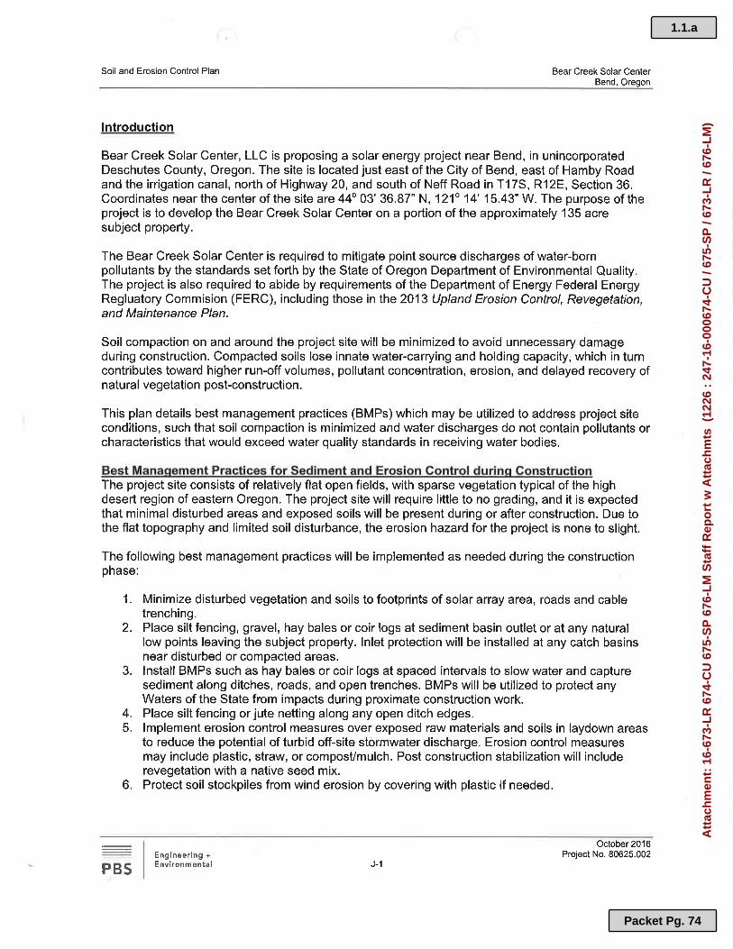
1.1.a
Packet Pg. 74
Att
ach
men
t: 1
6-67
3-L
R 6
74-C
U 6
75-S
P 6
76-L
M S
taff
Rep
ort
w A
ttac
hm
ts (
1226
: 2
47-1
6-00
0674
-CU
/ 67
5-S
P /
673-
LR
/ 67
6-L
M)

1.1.a
Packet Pg. 75
Att
ach
men
t: 1
6-67
3-L
R 6
74-C
U 6
75-S
P 6
76-L
M S
taff
Rep
ort
w A
ttac
hm
ts (
1226
: 2
47-1
6-00
0674
-CU
/ 67
5-S
P /
673-
LR
/ 67
6-L
M)

1.1.a
Packet Pg. 76
Att
ach
men
t: 1
6-67
3-L
R 6
74-C
U 6
75-S
P 6
76-L
M S
taff
Rep
ort
w A
ttac
hm
ts (
1226
: 2
47-1
6-00
0674
-CU
/ 67
5-S
P /
673-
LR
/ 67
6-L
M)

1.1.a
Packet Pg. 77
Att
ach
men
t: 1
6-67
3-L
R 6
74-C
U 6
75-S
P 6
76-L
M S
taff
Rep
ort
w A
ttac
hm
ts (
1226
: 2
47-1
6-00
0674
-CU
/ 67
5-S
P /
673-
LR
/ 67
6-L
M)

1.1.a
Packet Pg. 78
Att
ach
men
t: 1
6-67
3-L
R 6
74-C
U 6
75-S
P 6
76-L
M S
taff
Rep
ort
w A
ttac
hm
ts (
1226
: 2
47-1
6-00
0674
-CU
/ 67
5-S
P /
673-
LR
/ 67
6-L
M)

1.1.a
Packet Pg. 79
Att
ach
men
t: 1
6-67
3-L
R 6
74-C
U 6
75-S
P 6
76-L
M S
taff
Rep
ort
w A
ttac
hm
ts (
1226
: 2
47-1
6-00
0674
-CU
/ 67
5-S
P /
673-
LR
/ 67
6-L
M)

1.1.a
Packet Pg. 80
Att
ach
men
t: 1
6-67
3-L
R 6
74-C
U 6
75-S
P 6
76-L
M S
taff
Rep
ort
w A
ttac
hm
ts (
1226
: 2
47-1
6-00
0674
-CU
/ 67
5-S
P /
673-
LR
/ 67
6-L
M)
1.1.a
Packet Pg. 81
Att
ach
men
t: 1
6-67
3-L
R 6
74-C
U 6
75-S
P 6
76-L
M S
taff
Rep
ort
w A
ttac
hm
ts (
1226
: 2
47-1
6-00
0674
-CU
/ 67
5-S
P /
673-
LR
/ 67
6-L
M)

1.1.a
Packet Pg. 82
Att
ach
men
t: 1
6-67
3-L
R 6
74-C
U 6
75-S
P 6
76-L
M S
taff
Rep
ort
w A
ttac
hm
ts (
1226
: 2
47-1
6-00
0674
-CU
/ 67
5-S
P /
673-
LR
/ 67
6-L
M)

1.1.a
Packet Pg. 83
Att
ach
men
t: 1
6-67
3-L
R 6
74-C
U 6
75-S
P 6
76-L
M S
taff
Rep
ort
w A
ttac
hm
ts (
1226
: 2
47-1
6-00
0674
-CU
/ 67
5-S
P /
673-
LR
/ 67
6-L
M)

1.1.a
Packet Pg. 84
Att
ach
men
t: 1
6-67
3-L
R 6
74-C
U 6
75-S
P 6
76-L
M S
taff
Rep
ort
w A
ttac
hm
ts (
1226
: 2
47-1
6-00
0674
-CU
/ 67
5-S
P /
673-
LR
/ 67
6-L
M)
FARM AND FOREST MANAGEMENT EASEMENT – CONDITIONAL USE
______________________ and __________________________, herein called the Grantor/s, is/are the owner/s of real property described on Exhibit "A" attached hereto and by this reference incorporated herein, and identified or depicted on Deschutes County Assessor's Maps as ____________. In accordance with the conditions set forth in the decision of the Deschutes County Planning Division, dated __________, approving land use permit _________________, Grantor/s hereby grant/s to the owner(s) of all property adjacent to the above described property (Grantees), a perpetual non-exclusive farm and forest practices management easement as follows: 1. The Grantor/s, his/her/their heirs, successors, and assigns, hereby acknowledge/s by the
granting of this easement that the above-described property is situated in a designated farm zone in Deschutes County, Oregon, and may be subjected to conditions resulting from farming or forest practices on adjacent lands. Such operations include management and harvesting of timber, disposal of slash, reforestation, application of chemicals, road construction and maintenance, by raising, harvesting and selling crops or by the feeding, breeding, management and sale of, or the produce of, livestock, poultry, fur-bearing animals or honeybees or for dairying and the sale of dairy products or any other agricultural or horticultural use or animal husbandry or any combination thereof, and other accepted and customary farm and forest management activities conducted in accordance with federal and state laws. Such farm or forest management activities ordinarily and necessarily produce noise, dust, smoke, and other conditions that may conflict with Grantor's/s’ use of Grantor's/s’ property for residential purposes. Except as allowed by ORS 30.930 through 30.947, Grantor/s hereby waive/s all common law rights to object to normal, non-negligent farm and forest management activities legally conducted on adjacent lands that may conflict with Grantor’s/s’ use of Grantor’s/s’ property for residential purposes, and Grantor/s hereby give/s an easement to the adjacent property owners for the resultant impact on Grantor's/s’ property caused by the farm and forest management activities on adjacent lands.
2. Grantor/s shall comply with all restrictions and conditions for maintaining the development in farm and forest zones that may be required by State, Federal, and local land use laws and regulations. Grantor/s shall comply with all fire safety regulations developed by the Oregon Department of Forestry for residential development within a forest zone.
This easement is appurtenant to all property adjacent to the above-described property, and shall bind the heirs, successors, and assigns of Grantor/s, and shall endure for the benefit of the adjacent landowners, their heirs, successors, and assigns. The adjacent landowners, their heirs, successors, and assigns are hereby expressly granted the right of third-party enforcement of this easement. Dated this ____ day of __________, 2017 GRANTOR/S
(Staff Note: for example only)
1.1.a
Packet Pg. 85
Att
ach
men
t: 1
6-67
3-L
R 6
74-C
U 6
75-S
P 6
76-L
M S
taff
Rep
ort
w A
ttac
hm
ts (
1226
: 2
47-1
6-00
0674
-CU
/ 67
5-S
P /
673-
LR
/ 67
6-L
M)

1.1.a
Packet Pg. 86
Att
ach
men
t: 1
6-67
3-L
R 6
74-C
U 6
75-S
P 6
76-L
M S
taff
Rep
ort
w A
ttac
hm
ts (
1226
: 2
47-1
6-00
0674
-CU
/ 67
5-S
P /
673-
LR
/ 67
6-L
M)