airports - airlines - ansp/satellite navigation navigation satellite system course objective « to...
TRANSCRIPT
TRAINING CATALOGUE Airports - Airlines - ANSP/Satellite Navigation

Contents CUSTOMERS ......................................................................................................................................................... 3
TRAINING ............................................................................................................................................................. 4
Our philosophy ...................................................................................................................................................... 4
Our school: CGX AERO ACADEMY ................................................................................................................. 4
Quality: one of our golden rules ......................................................................................................................... 4
Respect of regulations ......................................................................................................................................... 4
TRAINING PACKAGES ....................................................................................................................................... 5
SYLLABUS ............................................................................................................................................................ 7
GLOBAL NAVIGATION SATELLITE SYSTEM ................................................................................................ 8
RNAV/RNP IN APPROACH ................................................................................................................................. 9
PBN AND AIRSPACE CONCEPTS .................................................................................................................... 10
DATA SURVEY................................................................................................................................................... 11
ICAO ANNEXES (4 & 15) AND CHARTING SPECIFICATIONS ................................................................... 12
PROCEDURE CODING FOR IFPD, AERONAUTICAL CARTOGRAPHER .................................................. 13
AIP GIS CHARTING® ........................................................................................................................................ 14
Find CGX AERO .................................................................................................................................................. 15
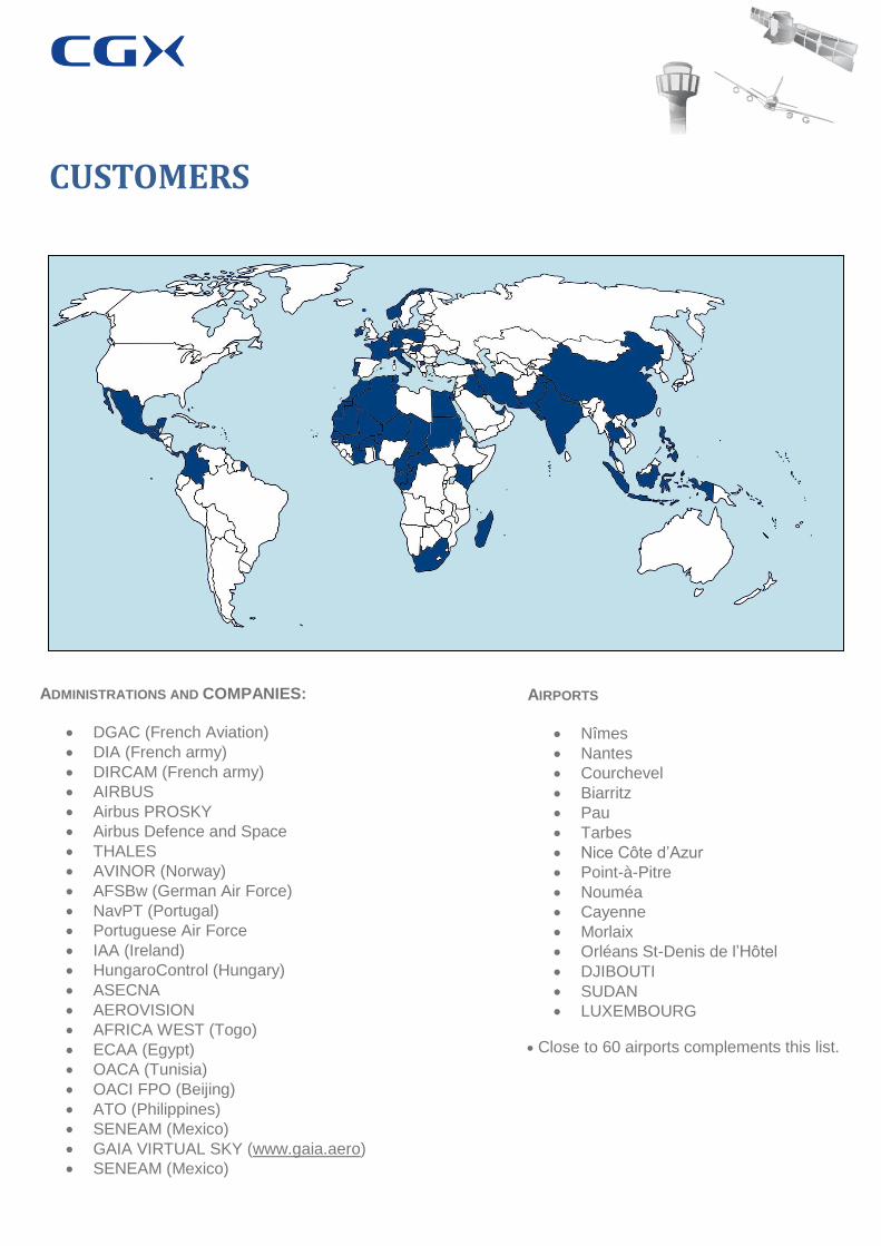
CUSTOMERS
ADMINISTRATIONS AND COMPANIES:
DGAC (French Aviation)
DIA (French army)
DIRCAM (French army)
AIRBUS
Airbus PROSKY
Airbus Defence and Space
THALES
AVINOR (Norway)
AFSBw (German Air Force)
NavPT (Portugal)
Portuguese Air Force
IAA (Ireland)
HungaroControl (Hungary)
ASECNA
AEROVISION
AFRICA WEST (Togo)
ECAA (Egypt)
OACA (Tunisia)
OACI FPO (Beijing)
ATO (Philippines)
SENEAM (Mexico)
GAIA VIRTUAL SKY (www.gaia.aero)
SENEAM (Mexico)
AIRPORTS
Nîmes
Nantes
Courchevel
Biarritz
Pau
Tarbes
Nice Côte d’Azur
Point-à-Pitre
Nouméa
Cayenne
Morlaix
Orléans St-Denis de l’Hôtel
DJIBOUTI
SUDAN
LUXEMBOURG
Close to 60 airports complements this list.

TRAINING
Air transport industry migrates to digital technologies. More and more data are transmitted between aircraft and ground stations, between stations and airline’s facilities, etc. The challenge today is to process data as fast as possible to accelerate decision making, optimize operating costs, and improve productivity & punctuality. We also believe that technology is never enough and that we can continuously improve our business processes. So change management is part of our DNA. For that, we contribute practically to handle change with our customers through training sessions and through our consulting services. Adaptation to our customer is the rationale of our company. So we adapt our courses to your need, ensuring that we fit your objectives.
Our philosophy
Our Academy delivers training sessions to our customers. They are ab-initio or experimented persons. They are professional in aeronautics, or want to learn more in aeronautics. They work for an ANSP, a Civil Aviation Authority, an OEM, an airport or an airline. In any case, we propose the appropriate course for them.
Our school: CGX AERO ACADEMY
Trainers are experts in their domain. They are part of CGX AERO or are affiliated consultants. CGX AERO is under ISO 9001 certification process. CGX AERO ACADEMY follows the same rules. Our quality system demonstrates everyday its robustness and relevancy through our services for the main OEM (Thales, Airbus, Airbus defense and Space) Tutorials and accompaniment may be proposed to follow our trainees.
Quality: one of our golden rules
Respect of regulations
Training sessions are based on following rules: Annexes and documents from International Civil Aviation Organization French regulations Foreign regulations (to be checked or adapted on a case by case basis)
And on norms proposed by IATA for instance.

OPERATIONAL ENGINEERING DURATION
AIRCRAFT OPERATIONS FAMILIARISATION 3J
Regulations & airline organization & aircraft operations 2J
Airspace 1/3J
Initiations to instruments flight procedures 1/3J
Satellite Navigation 1/3J
OPERATIONAL EFFICIENCY 2J
Airline efficiency 1,5J
Global Navigation Satellite System 1/2J
SAFETY MANAGEMENT SYSTEM (SMS) 2J
Basic rules of SMS 1/2J
Methodology for risk assesment and management 1J
Strategies for promoting SMS 1/2J
AIR TRANSPORT ECONOMY DURATION
AIR TRANSPORT ECONOMY 4D
Regulations & airline organization & aircraft operations
Airline economy, strategy
Airline efficiency
Future of air transport
TRAINING PACKAGES
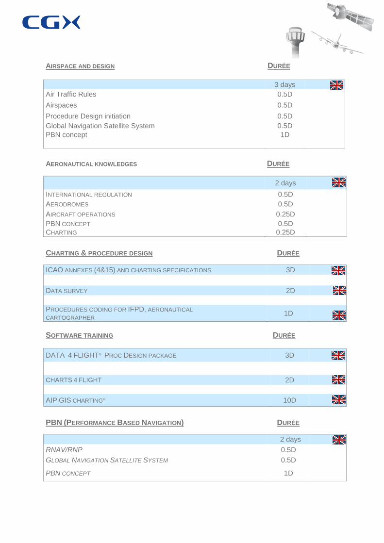
AIRSPACE AND DESIGN DURÉE
3 days
Air Traffic Rules 0.5D
Airspaces 0.5D
Procedure Design initiation 0.5D
Global Navigation Satellite System 0.5D
PBN concept 1D
AERONAUTICAL KNOWLEDGES DURÉE
2 days
INTERNATIONAL REGULATION 0.5D
AERODROMES 0.5D
AIRCRAFT OPERATIONS 0.25D
PBN CONCEPT 0.5D
CHARTING 0.25D
CHARTING & PROCEDURE DESIGN DURÉE
ICAO ANNEXES (4&15) AND CHARTING SPECIFICATIONS 3D
DATA SURVEY 2D
PROCEDURES CODING FOR IFPD, AERONAUTICAL CARTOGRAPHER
1D
SOFTWARE TRAINING DURÉE
DATA 4 FLIGHT® PROC DESIGN PACKAGE 3D
CHARTS 4 FLIGHT 2D
AIP GIS CHARTING® 10D
PBN (PERFORMANCE BASED NAVIGATION) DURÉE
2 days
RNAV/RNP 0.5D
GLOBAL NAVIGATION SATELLITE SYSTEM 0.5D
PBN CONCEPT 1D

SYLLABUS

GLOBAL NAVIGATION SATELLITE SYSTEM
COURSE OBJECTIVE
« To provide a comprehensive overview of the GNSS, to understand the implications for all aeronautical skateholders and what lies behind the GNSS acronym. »
COURSE CONTENT
1. Background and challenge of the GNSS
2. GNSS constellations:
GPS
GLONASS
GALILEO
IRNSS
3. GNNS – 4 essential criteria:
Accuracy
Integrity
Continuity
Availability of service
4. GNSS augmentation:
Aircraft Based Augmentation System
Satellite Based Augmentation System
Ground Based Augmentation System
5. Operational advantages of GNSS
6. ATC considerations
COURSE DETAILS
Course Reference : ICAO Documents
Duration : 3H
Participants : Up to 8
Pré-requisite : Nothing

RNAV/RNP IN APPROACH
COURSE OBJECTIVE
« To provide a comprehensive overview of the RNAV (aReaNAVigation) in approach. »
COURSE CONTENT
1. aRNAVigation:
Background
Definition
Differences between conventional and RNAV procedures
Waypoints
Areas of operations
Evolution
2. Required Navigation Performance:
Evolution
Definition
Performance monitoring and alerting
In which airspace
Protection design
T or Y procedure
Terminal Arrival Altitude
GNSS approaches
3. Comparison
COURSE DETAILS
Course Reference : ICAO Documents
Duration : 3H
Participants : Up to 8
Pré-requisite : Have followed the GNSS course or knowledge on GNSS

PBN AND AIRSPACE CONCEPTS
COURSE OBJECTIVE
« To better understand the concept of PBN, this course explains what it is. But the implementation of the PBN needs to have a general vision or a master plan. We teach you the Airspace concept. »
COURSE CONTENT
1. PBN Concept
Introduction
General
Benefits
Context of PBN
Lateral & vertical performance
Navigation specification
Introduction
On-board Performance Monitoring & Alerting
Navigation functional requirements
Designation of RNP & RNAV specification
2. Airspace Concept 1/2
What is the Airspace Concept ?
Airspace Concept and navigation application
Airspace Concept by area of operation
Stakeholder uses of PBN
Level of use of PBN concept
Users
Airspace Concept 2/2
PBN procedure design
Introduction
Changes for IFPD
Airworthiness and operational approval
General
Airworthiness approval process
Operational approval
Flight crew & Air Traffic Controler (End users)
3. Interactive exercises for navigation specifica- tion
COURSE DETAILS
Course Reference : ICAO Documents
Duration : 6H
Participants : Up to 12
Pré-requisite :

DATA SURVEY
COURSE OBJECTIVE COURSE OBJECTIVE
This course teaches the method to realize a data survey. Which data is needed to start an IFP design
Study?
It is decomposed in 3 parts:
3 hours to teach the knowledge to start the data survey
3 hours to teach how to prepare the day of the data survey on an airfield
1 day to realize a data survey on the airfield prepared (Tutoring part)
This course teaches the method to realize a data survey. Which data is needed to start an IFP design Study?
COURSE CONTENT COURSE CONTENT
Day 1 (morning) (Theoretical part)
Why creating an optimized A/D obstacle list, who can do it and when?
Definitions and regulations
Responsibilities?
How to do the data survey?
Exercises
Day 1 (afternoon) (Practical part)
Preparation of the Data Survey (Use of Maps, IPPD software (not mandatory)
Day 2
Data Survey on an airfield
For the last day, it’s better to have a topographer in the team.
COURSE DETAILS COURSE DETAILS
Course Reference : ICAO Documents
Duration : 2 days
Participants : Up to 4
Pré-requisite : Basic knowledge for IFPD
Course Reference : ICAO Documents
Duration : 2 days
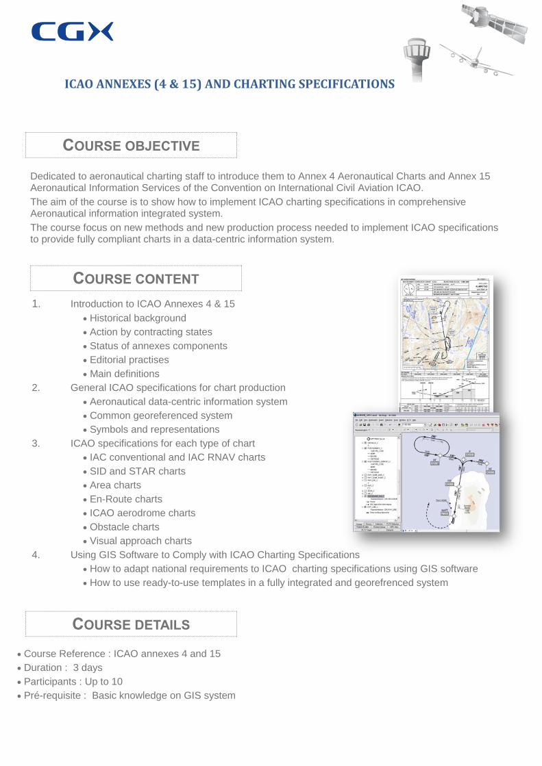
ICAO ANNEXES (4 & 15) AND CHARTING SPECIFICATIONS
COURSE OBJECTIVE
Dedicated to aeronautical charting staff to introduce them to Annex 4 Aeronautical Charts and Annex 15 Aeronautical Information Services of the Convention on International Civil Aviation ICAO.
The aim of the course is to show how to implement ICAO charting specifications in comprehensive Aeronautical information integrated system.
The course focus on new methods and new production process needed to implement ICAO specifications to provide fully compliant charts in a data-centric information system.
COURSE CONTENT
1. Introduction to ICAO Annexes 4 & 15
Historical background
Action by contracting states
Status of annexes components
Editorial practises
Main definitions
2. General ICAO specifications for chart production
Aeronautical data-centric information system
Common georeferenced system
Symbols and representations
3. ICAO specifications for each type of chart
IAC conventional and IAC RNAV charts
SID and STAR charts
Area charts
En-Route charts
ICAO aerodrome charts
Obstacle charts
Visual approach charts
4. Using GIS Software to Comply with ICAO Charting Specifications
How to adapt national requirements to ICAO charting specifications using GIS software
How to use ready-to-use templates in a fully integrated and georefrenced system
COURSE DETAILS
Course Reference : ICAO annexes 4 and 15
Duration : 3 days
Participants : Up to 10
Pré-requisite : Basic knowledge on GIS system

PROCEDURE CODING FOR IFPD, AERONAUTICAL CARTOGRAPHER
1. First module :
Introduction to the data chain (30’)
Introduction at the ARINC 424 (30’)
ARINC 424 Specifications for IFPD (1h30)
2. Second module :
Naming conventions (30’)
Transitions concept (30’)
3. Third module :
Procedure coding exercises (1h30)
Non Precision Approaches
SID & STAR
Approaches
GNSS procedures
SID & STAR
Approaches
Coding exercises with the GeoTITAN® & Ai-Sky Data® interoperability (2h)
COURSE OBJECTIVE
The goal of this course is to provide a global view of procedure coding and its relationship with the aeronautical data chain and data integrity requirements.
This training course provides a comprehensive overview of :
Aeronautical data chain,
ARINC procedure coding bases,
Path Terminator definitions,
Naming conventions and procedure transition concept.
This course is supported by practical exercises using dedicated software.
COURSE CONTENT
COURSE DETAILS
Course Reference : ARINC
Duration : 7H
Participants : Up to 12
Pré-requisite : Aeronautical and AIS system knowledge
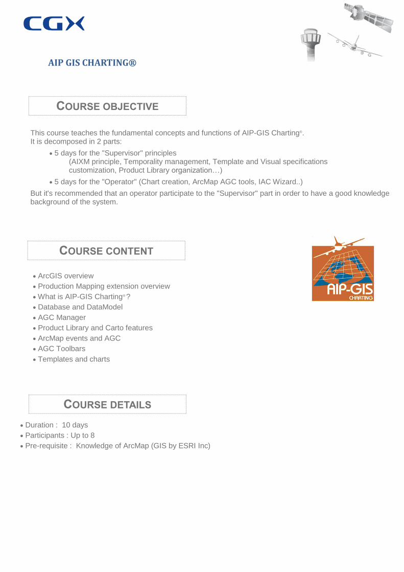
AIP GIS CHARTING®
COURSE OBJECTIVE
This course teaches the fundamental concepts and functions of AIP-GIS Charting®. It is decomposed in 2 parts:
5 days for the "Supervisor" principles (AIXM principle, Temporality management, Template and Visual specifications customization, Product Library organization…)
5 days for the "Operator" (Chart creation, ArcMap AGC tools, IAC Wizard..)
But it's recommended that an operator participate to the "Supervisor" part in order to have a good knowledge background of the system.
COURSE CONTENT
ArcGIS overview
Production Mapping extension overview
What is AIP-GIS Charting® ?
Database and DataModel
AGC Manager
Product Library and Carto features
ArcMap events and AGC
AGC Toolbars
Templates and charts
COURSE DETAILS
Duration : 10 days
Participants : Up to 8
Pre-requisite : Knowledge of ArcMap (GIS by ESRI Inc)
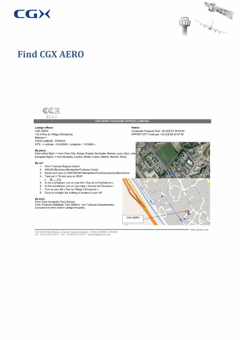
Find CGX AERO