aphg topic outline - keep in binder all year patterns and processes at different scales. patterns...
TRANSCRIPT
APHG Topic Outline - KEEP IN BINDER ALL YEAR
I. Geography: Its Nature and Perspectives . . . . . . . . . . . . . . . . . . . . . . . . . . .5–10%
The AP Human Geography course emphasizes the importance of geography as a field of inquiry. The course introduces students
to the importance of spatial organization — the location of places, people, and events; environmental relationships; and
interconnections between places and across landscapes — in the understanding of human life on Earth.
Geographic concepts emphasized throughout the course are location, space, place, scale, pattern, regionalization, and
globalization. These concepts are basic to students’ understanding of spatial interaction and spatial behavior, the dynamics of
human population growth and movement, patterns of culture, economic activities, political organization of space, social issues,
and human settlement patterns, particularly urbanization. Students learn how to use and interpret maps. They also learn to apply
mathematical formulas, interpret models, and analyze quantitative and qualitative geographic data.
The course teaches the concepts of space, place, and region; enables students to consider the regional organization of various
phenomena; and encourages geographical imagination in order to understand processes in a changing world. For example,
geographical perspectives on nature and society examine human alterations to the global and local environment, including
impacts on land, water, and atmosphere, as well as effects on population, biodiversity, and climate. A significant outcome of the
course is students’ awareness of geographic methods and the relevance of geospatial technologies to everyday life, planning and
public policy, professional decision making, and problem solving at scales from local to global. This combination of the conceptual
and the applied helps give students a sophisticated view of the world and an appreciation of the practical applications they have
learned in the course.
A. Geography, as a field of inquiry, looks at the world from a spatial perspective.
Explain the importance of geography as a field of study
Geographic information provides context for understanding spatial relationships and human– environment interaction.
B. Geography offers a set of concepts, skills, and tools that facilitate critical thinking and problem solving.
Explain major geographical concepts underlying the geographic perspective.
Geographical concepts include location, place, scale, space, pattern, nature and society, networks, flows, regionalization, and
globalization.
Use landscape analysis to examine the human organization of space.
Landscape analysis (e.g., field observations, photographic interpretations) provides a context for understanding the location
of people, places, regions, and events; human–environment relationships; and interconnections between and among places
and regions.
C. Geographical skills provide a foundation for analyzing world patterns and processes.
Use spatial thinking to analyze the human organization of space.
People apply spatial concepts to interpret and understand population and migration; cultural patterns and processes; political
organization of space; agriculture, food production, and rural land use; industrialization and economic development; and
cities and urban land use.
Use and interpret maps.
Maps are used to represent and identify spatial patterns and processes at different scales.
Types of maps include reference maps (e.g., physical and political maps) and thematic maps (e.g., choropleth, dot, graduated
symbol, isoline, cartogram).
All map projections (e.g., Mercator, polar) inevitably distort spatial relationships (e.g., shape, area, distance, direction).
Apply mathematical formulas and graphs to interpret geographic concepts.
Mathematical formulas and graphs are used to analyze rates of natural increase in population, population doubling time, rank-
size rule for cities, and distance-decay functions.
Use and interpret geographic models.
Geographers use models as generalizations to think systematically about topics such as land use (e.g., von Thünen model,
Latin American city model), industrial location (e.g., Weber model), and the distribution of settlements (e.g., Christaller’s
central place theory).
Use concepts such as space, place, and region to examine geographic issues.
Geographical issues include problems related to human– environmental interactions (e.g., sustainable agriculture); conflict
and cooperation among countries (e.g., European Union); and planning and public-policy decision making (e.g., pronatalist
policies).
Interpret patterns and processes at different scales.
Patterns and processes at different scales reveal variations in and different interpretations of data (e.g., age–sex pyramids,
population density).
Define region as a concept, identify world regions, and understand regionalization processes.
Regions are defined on the basis of one or more unifying characteristics (e.g., corn belt) or on patterns of activity (e.g.,
hinterlands of ports).
Types of regions include formal, functional, and perceptual.
World regions are defined for this course by the maps in the course curriculum section of the AP Human Geography Course
Description.
World regions may overlap (e.g., Southeast Asia and Asia) and often have transitional boundaries (e.g., North Africa and
Sub-Saharan Africa).
Explain and evaluate the regionalization process.
Regional thinking is applied at local, national, and global scales.
Regionalism refers to a group’s perceived identification with a particular region at any scale (e.g., Quebec).
Analyze changing interconnections among places.
Interconnections among places include exchanges of natural resources, agricultural commodities, finished products, services,
people, information, money, and pollutants.
D. Geospatial technologies increase the capability for gathering and analyzing geographic information with applications to
everyday life.
Use and interpret geospatial data.
Geospatial technologies include geographic information systems (GIS), satellite navigation systems (e.g., global positioning
system), remote sensing, and online mapping and visualization.
Geospatial data (e.g., census data, satellite imagery) is used at all scales for personal (e.g., navigation), business (e.g.,
marketing), and governmental (e.g., environmental planning) purposes.
E. Field experiences continue to be important means of gathering geographic information and data.
Use quantitative and qualitative geographic data.
Data may be gathered in the field by organizations (e.g., census data) or by individuals (e.g., interviews, surveys,
photography, informal observations).
Quantitative and qualitative geographic data are used in economic, environmental, political, and social decision making.
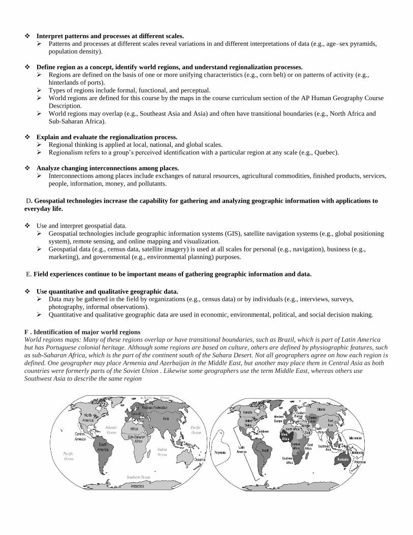
F . Identification of major world regions
World regions maps: Many of these regions overlap or have transitional boundaries, such as Brazil, which is part of Latin America
but has Portuguese colonial heritage. Although some regions are based on culture, others are defined by physiographic features, such
as sub-Saharan Africa, which is the part of the continent south of the Sahara Desert. Not all geographers agree on how each region is
defined. One geographer may place Armenia and Azerbaijan in the Middle East, but another may place them in Central Asia as both
countries were formerly parts of the Soviet Union . Likewise some geographers use the term Middle East, whereas others use
Southwest Asia to describe the same region
1.1 Economic Development and Human-Environment Interaction
This section of the course presents the geographic elements of industrialization and economic development, including past and
present patterns of industrialization, types of economic sectors, and how places acquire comparative advantage and
complementarity. Students also learn how models of economic development, such as Rostow’s stages of economic growth and
Wallerstein’s World Systems Theory, and programs like the Millennium Development Goals help to understand why the world is
divided into a more-developed economic core and a less-developed periphery .
Measures of development (e .g ., gross domestic product [GDP] per capita, the Human Development Index [HDI], the Gender
Inequality Index [GII], and the Gini coefficient) are tools to understand patterns of economic differences.
The analysis of contemporary patterns of industrialization and their impact on development is the third major theme of this
section. Topics to be studied include Weber’s industrial location theory and accounts of economic globalization, which accent
time–space compression and the international division of labor.
B. Measures of development are used to understand patterns of social and economic differences at a variety of scales.
Explain social and economic measures of development.
Measures of social and economic development include Gross National Income (GNI) per capita, sectoral structure of an
economy, income distribution, fertility rates, infant mortality rates, access to health care, and literacy rates.
Measures of gender inequality include reproductive health, indices of empowerment, and labor-market participation.
The Human Development Index (HDI) is a composite measure used to show spatial variation in levels of development.
Analyze spatial patterns of economic and social development.
Models like Rostow’s Stages of Economic Growth and Wallerstein’s World System Theory help explain spatial variations in
development.
The U.N. Millennium Development Goals help measure progress in development.
In contrast to the periphery and semiperiphery, the core countries achieved dominance through industrial production of
goods.
Evaluate the role of women in economic development and gender equity in the workforce.
Although there are more women in the workforce, they do not have equity in wages or employment opportunities.
Microloans have provided opportunities for women to create small local businesses, which have improved standards of
living.
C. Development is a process that varies across space and time.
Analyze the causes and consequences of international trade and growing interdependence in the world economy.
Complementarity and comparative advantage establish the basis for trade.
International trade and trading blocs (e.g., EU and NAFTA) have become more important as a result of globalization.
Geographies of interdependence in the world economy include global financial crises, the shift in manufacturing to newly
industrialized countries, imbalances in consumption patterns, and the roles of women in the labor force.
Explain how economic restructuring and deindustrialization are transforming the contemporary economic landscape.
Outsourcing and economic restructuring have led to a decline in jobs in manufacturing regions and to the relocation of a
significant segment of the workforce to other areas.
In countries outside the core, the diffusion of industry has resulted in the emergence of the international division of labor and
manufacturing zones (e.g., maquiladoras, special economic zones, free trade zones).
The contemporary economic landscape has been transformed by the emergence of service sectors, high technology industries,
and growth poles (e.g., Silicon Valley and the Research Triangle in the U.S.).
Government initiatives at all scales may help promote economic development.
D. Sustainable development is a strategy to address resource depletion and environmental degradation.
Analyze sustainability issues related to industrialization and development.
Sustainable development addresses issues of natural resource depletion, mass consumption, the costs and effects of pollution,
and the impact of climate change, as well as issues of human health, well-being, and social and economic equity.
Ecotourism is a strategy used by some countries to help protect the environment and generate jobs.
II. Population and Migration . . . . . . . . . . . . . . . . . . . . . . . . . . . . . . . . . . . . . .13–17%
An understanding of the ways in which the human population is organized geographically provides AP students with the tools they
need to make sense of cultural, political, economic, and urban systems . Thus many of the concepts and theories encountered in
this part of the course connect with other course units.
In addition the course themes of scale, pattern, place, and interdependence can all be illustrated with population topics . For
example, students may analyze the distribution of the human population at different scales: global, regional, national, state or
provincial, and local.
Explanations of why population is growing or declining in some places center on understanding the patterns and trends of fertility,
mortality, and migration. In stressing the relevance of place context, for example, students may assess why fertility rates have
dropped in some parts of the developing world, examine how age–sex structures (shown in population pyramids) vary from one
country to another, and comprehend the social, political, and economic implications of an aging population. Analysis of refugee
flows, immigration, internal migration, and residential mobility helps students appreciate the interconnections between population
phenomena and other topics. For example, environmental degradation and natural hazards may prompt population redistribution
at various scales, which in turn creates new pressures on the environment.
This part of the course also enhances students’ critical understanding of population trends across space and over time by
considering models of population growth and decline, including Malthusian theory, the demographic transition, and the
epidemiological (mortality) transition model. For example, as a country develops, the economic, social, and political roles of
women in society change and influence levels of fertility, mortality rates, and migration trends. Given these kinds of
understandings, students are in a position to evaluate the role, strengths, and weaknesses of major population policies, which
attempt to either promote or restrict population growth.
A. Knowledge of the geographic patterns and characteristics of human populations facilitates understanding of cultural,
political, economic, and urban systems.
Analyze the distribution of human populations at different scales.
Factors that explain patterns of population distribution vary according to the scale of analysis (i.e., local to global)
Physical factors (e.g., climate, land forms, water bodies) and human factors (e.g., cultural, economic, historical, political)
influence the distribution of population.
Use population density to explain the relationship between people and the environment.
The three methods for calculating population density are arithmetic, physiological, and agricultural.
Explain the implications of population distributions and densities.
Population distribution and density influence political, economic, and social processes (e.g., redistricting, provision of
services such as medical care).
Population distribution and density impact the environment and natural resources (e.g., carrying capacity).
Population distribution and density affect the need for infrastructure (e.g., housing) and urban services (e.g., sanitation).
Analyze population composition.
Age, sex, and ethnicity are elements of population composition that may be mapped and graphed at various scales.
Population pyramids are used to project population growth and decline and to predict markets for goods and services.
B. Populations grow and decline over time and space.
Explain contemporary and historical trends in population growth and decline.
Demographic factors that determine population growth and decline are fertility, mortality, and migration.
Rates of natural increase and population-doubling times are used to explain population growth and decline
Social, cultural, political, and economic factors influence fertility, mortality, and migration rates
Interpret and apply theories of population growth and decline
The demographic transition model may be used to explain population change over time and space.
Malthusian theory is used to analyze population change and its consequences
The epidemiologic transition explains causes of changing death rates.
Evaluate various national and international population policies
Types of population policies include those that promote or restrict population growth (e.g., pronatalist, antinatalist).
Analyze reasons for changes in fertility rates in different parts of the world.
Changing social values and access to education, employment, health care, and contraception have reduced fertility rates in
most parts of the world.
Changing social, economic, and political roles for women have influenced the patterns of fertility, mortality, and migration.
Explain the causes and implications of an aging population.
An aging population has social (e.g., retirement), economic (e.g., dependency ratio), and political (e.g., voting patterns)
implications.
C. Causes and consequences of migration are influenced by cultural, demographic, economic, environmental, and political
factors.
Explain how push and pull factors contribute to migration.
Push and pull factors can be cultural (e.g., religious freedom), demographic (e.g., unbalanced sex ratios, overpopulation),
economic (e.g., jobs), environmental (e.g., natural disasters), or political (e.g., persecution).
Push factors are often negative (e.g., poor economic conditions, warfare), while pull factors are often perceived as positive
(e.g., a better quality of life, economic opportunities).
Apply the concepts of forced and voluntary migration to historical and contemporary examples.
Forced migrations include those involving refugees, internally displaced persons, and asylum seekers.
Voluntary migrations may be transnational, internal, chain, step, and rural to urban.
Patterns of voluntary and forced migration may be affected by distance and physical features.
Analyze major historical migrations.
Major historical migrations include forced migration of Africans to the Americas, immigration waves to the U.S., and
emigration from Europe and Asia to colonies abroad.
Analyze the cultural, economic, environmental, and political consequences of migration.
Governments institute policies to encourage or restrict migration.
Migration has consequences (e.g., remittances; spread of languages, religions, innovations, diseases) for areas that generate or
receive migrants.
III. Cultural Patterns and Processes . . . . . . . . . . . . . . . . . . . . . . . . . . . . . . . . . . . . . .13–17%
Understanding the components and regional variations of cultural patterns and processes is critical to human geography. In
this section of the course, students begin with the concepts of culture and culture traits. They learn how geographers assess the
spatial and place dimensions of cultural groups as defined by language, religion, ethnicity, and gender, in the present as well as
the past.
A central concern is to comprehend how cultural patterns are represented at a variety of geographic scales from local to
global. Diffusion is a key concept in understanding how culture traits (e .g., agricultural practices, language, technology) move
through time and space to new locations, where interactions between global and local forces result in new forms of cultural
expression . Students learn that the concept of region is central to understanding the spatial distribution of cultural attributes.
The course explores cultural interaction at various scales, along with the conflicts that may result. The geographies
of language, religion, ethnicity, and gender are studied to illustrate patterns and processes of cultural differences.
Students learn to distinguish between languages and dialects, ethnic and universalizing religions, ethnic political
movements, and popular and folk cultures, and to understand why each has a different geographic pattern.
Another important emphasis of the course is the way culture shapes relationships between humans and the
environment. Students learn how culture is expressed in landscapes, and how land use in turn represents cultural
identity. Built environments enable the geographer to interpret cultural values, tastes, symbolism, and sets of
beliefs. For example, both folk and contemporary architecture are rich and readily available means of
comprehending the cultural landscape and how different cultures view it in separate ways A. Concepts of culture frame the shared behaviors of a society.
Explain the concept of culture and identify cultural traits.
Culture is comprised of the shared practices, technologies, attitudes, and behaviors transmitted by a society.
Cultural traits are individual elements of culture and include such things as food preferences, architecture, and land use.
Explain how geographers assess the spatial and place dimensions of cultural groups in the past and present.
Geographers use maps and the spatial perspective to analyze and assess language, religion, ethnicity, and gender.
Explain how globalization is influencing cultural interactions and change.
Communication technologies (e.g., the Internet) are reshaping and accelerating interactions among people and places and
changing cultural practices (e.g., use of English, loss of indigenous languages).
B. Culture varies by place and region. Explain cultural patterns and landscapes as they vary by place and region.
Regional patterns of language, religion, and ethnicity contribute to a sense of place, enhance place making, and shape the
global cultural landscape.
Language patterns and distributions can be represented on maps, charts, and language trees.
Religious patterns and distributions can be represented on maps and charts.
Ethnicity and gender reflect cultural attitudes that shape the use of space (e.g., women in the workforce, ethnic
neighborhoods).
Language, religion, ethnicity, and gender are essential to understanding landscapes symbolic of cultural identity (e.g., signs,
architecture, sacred sites). Explain the diffusion of culture and cultural traits through time and space.
Types of diffusion include expansion (contagious, hierarchical, stimulus) and relocation.
Language families, languages, dialects, world religions, ethnic cultures, and gender roles diffuse from cultural hearths, resulting in
interactions between local and global forces that lead to new forms of cultural expression (e.g., lingua franca).
Colonialism, imperialism, and trade helped to shape patterns and practices of culture (e.g., language, religion).
Acculturation, assimilation, and multiculturalism are shaped by the diffusion of culture.
Compare and contrast ethnic and universalizing religions and their geographic patterns.
Ethnic religions (e.g., Hinduism, Judaism) are generally found near the hearth or spread through relocation diffusion.
Universalizing religions (e.g., Christianity, Islam, Buddhism) are spread through expansion and relocation diffusion.
Explain how culture is expressed in landscapes and how land and resource use represents cultural identity.
Cultural landscapes are amalgamations of physical features, agricultural and industrial practices, religious and linguistic characteristics, and
other expressions of culture (e.g., architecture).
Compare and contrast popular and folk culture and the geographic patterns associated with each.
Folk culture origins are usually anonymous and rooted in tradition and are often found in rural or isolated indigenous communities.
Popular culture origins are often urban, changeable, and influenced by media.
IV. Political Organization of Space . . . . . . . . . . . . . . . . . . . . . . . . . . . . . . . . . . . . . .13–17%
This section of the course introduces students to the nature and significance of the political organization of territory at
different scales. Students learn that political patterns reflect ideas of territoriality — how Earth’s surface should be organized
— which in turn affect a wide range of exercises of power over space and boundaries.
Two major themes are the political geography of the modern state and relationships between countries. Students are
introduced to the different forces that shaped the evolution of the contemporary world political map.
These forces include the rise of nation-states in Europe, the influence of colonialism, the rise of supranational organizations,
and devolution of states.
Students learn about the basic structure of the political map, the inconsistencies between maps of political boundaries and
maps of ethnic, economic, and environmental patterns.
In addition students consider some of the forces that are changing the role of individual countries in the modern world,
including ethnic separatism, terrorism, economic globalization, and social and environmental problems that cross national
boundaries, such as climate change.
This part of the course also focuses on subnational and supranational political units. For example, at the scale above the state,
attention is directed to regional alliances, such as NATO, the European Union, ASEAN, and NAFTA.
At the scale below the state, students are introduced to the ways in which electoral districts, municipalities, indigenous areas,
and autonomous lands affect political, social, and economic processes.
A. The contemporary political map has been shaped by events of the past.
Explain the structure of the contemporary political map.
Independent states are the primary building blocks of the world political map.
Types of political entities include nations, states, nation-states, stateless nations, multinational states, multistate nations, and
autonomous regions.
Explain the evolution of the contemporary political map.
The concept of the modern nation-state began in Europe.
Colonialism and imperialism led to the spread of nationalism and influenced contemporary political boundaries.
Evaluate the geopolitical forces that influence the contemporary political map.
Independence movements and democratization have shaped the political map since the end of World War II.
The fall of Communism ended the Cold War, led to the creation of newly independent states, and changed the world balance
of power.
B. Spatial political patterns reflect ideas of territoriality and power at a variety of scales.
Explain the concepts of political power and territoriality.
Political power is expressed geographically as control over people, land, and resources (e.g., heartland, rimland, and organic
theories).
Territoriality is the connection of people, their culture, and their economic systems to the land.
Evaluate the nature and function of international and internal boundaries.
Boundaries are defined, delimited, demarcated, and administered.
International boundaries establish the limits of sovereignty and can be the source of disputes.
Boundaries can influence identity and promote or prevent international or internal interactions and exchanges.
The Law of the Sea has enabled states to extend their boundaries offshore, which sometimes results in conflicts.
Voting districts, redistricting, and gerrymandering influence the results of elections at various scales.
Analyze the spatial relationships between political systems and patterns of culture and economy.
Political boundaries do not always coincide with patterns of language, religion, ethnicity, nationality, and economy.
Compare and contrast forms of governance
Forms of governance include unitary states (centralized government) and federal states.
Powers of the subdivisions of states vary according to the form of governance (e.g., the United States and Switzerland as
federal states, France as a unitary state).
State morphology (e.g., compact, elongated, perforated, fragmented, prorupted states) has economic, political, and social
implications.
Describe patterns of local and metropolitan governance.
Local and metropolitan forms of governance (e.g., municipalities, school districts, regional planning commissions) are
subnational political units that have varying degrees of local control.
C. The forces of globalization challenge contemporary political–territorial arrangements.
Explain how the political, economic, cultural, and technological elements of globalization challenge state sovereignty.
Some forces that may lead to supranationalism include economies of scale, trade agreements, military alliances, and
transnational environmental challenges.
Supranationalism is expressed in the creation of multinational organizations (e.g., UN, NATO, EU, ASEAN, NAFTA).
Some forces that may lead to devolution of states include physical geography, ethnic separatism, terrorism, economic and
social problems, and irredentism.
Devolution is expressed in the fragmentation of states into autonomous regions (e.g., Nunavut, Native American
reservations), subnational political–territorial units (e.g., Spain, Belgium, Canada), or Balkanization (e.g., former Yugoslavia,
the Caucasus).
Advances in communication technology have facilitated devolution, supranationalism, and democratization.
Apply the concepts of centrifugal and centripetal forces at the national scale.
Centrifugal forces can originate in political dimensions (e.g., majority/ minority relationships, armed conflicts), economic
dimensions (e.g., uneven development), or cultural dimensions (e.g., stateless nations, ethnic movements).
Centripetal forces can originate in political dimensions (e.g., national identity), economic dimensions (e.g., equitable
infrastructure development), or cultural dimensions (e.g., linguistic, religious, and ethnic similarities)
V. Agriculture, Food Production, and Rural Land Use . . . . . . . . . . . . . . . . . . . . . . . . . . . . . . . . . . . . . .13–17%
This section of the course explores four themes:
the origin and diffusion of agriculture;
the characteristics and processes of the world’s agricultural production systems and land use;
the impact of agricultural change on quality of life and the environment;
and issues in contemporary agriculture.
Students examine centers where domestication originated and study the processes by which domesticated crops and animals
spread. This diffusion process makes clear why distinct regional patterns emerge in terms of diet, energy use, and the
adaptation of biotechnology.
The course also covers the major agricultural production regions of the world. Extensive activity (fishing, forestry, nomadic
herding, ranching, shifting cultivation) and intensive activity (plantation agriculture, mixed crop/livestock systems, market
gardening, horticulture, large-distcommercial agriculture) are examined, as are settlement patterns and landscapes typical of
each major agriculture type.
Students learn about land survey systems, environmental conditions, sustainability, global food supply problems, and the
cultural values that shape agricultural patterns. In addition this section presents the roles of women in agricultural
production, particularly in subsistence farming and market economies in the developing world.
Explanations for patterns of rural land use and associated settlements (e .g ., von Thunen’s land use model) are major
concerns . Also important are the impacts of large-scale agribusiness on food production and consumption. The effects of
economic and cultural globalization on agriculture and the need to increase food supplies and production capacity conclude
this section
A. The development of agriculture led to widespread alteration of the natural environment.
Identify major centers of domestication of plants and animals and patterns of diffusion in the first (Neolithic) agricultural
revolution.
Early hearths of domestication of plants and animals include Southwest Asia (e.g., the Fertile Crescent), Southeast Asia, and
the Americas.
Patterns of diffusion (e.g., Columbian Exchange) resulted in the globalization of various plants and animals.
Explain the connection between physical geography and agricultural practices.
Agricultural regions are influenced by the natural environment (e.g., climate, soils, landforms).
Populations alter the landscape (e.g., terraces, irrigation, deforestation, draining wetlands) to increase food production.
Explain the advances and impacts of the second agricultural revolution
New technology and increased food production led to better diet, longer life, and more people available for work in factories.
Analyze the consequences of the Green Revolution on food supply and the environment.
The Green Revolution began with the development of high-yield seeds (e.g., rice, wheat, maize), resulting in the increased
use of chemical and mechanized farming.
Positive consequences of the Green Revolution include increased food production and a relative reduction in hunger at the
global scale.
Negative consequences of the Green Revolution include environmental damage resulting from irrigation and chemical use
(e.g., pesticides, herbicides, fertilizers) and the cost of technology and seeds.
B. Major agricultural regions reflect physical geography and economic forces.
Identify agricultural production regions associated with major bioclimatic zones.
Plant and animal production is dependent on climatic conditions, including spatial variations in temperature and rainfall.
Some agricultural regions are associated with particular bioclimatic zones (e.g., Mediterranean, shifting agriculture, pastoral
nomadism).
Analyze the economic forces that influence agricultural practices.
Agricultural production regions are defined by the extent to which they reflect subsistence or commercial practices, or
intensive or extensive use of land.
Intensive farming practices include market gardening, plantation agriculture, mixed crop/livestock systems, etc.
Extensive farming practices include shifting cultivation, nomadic herding, ranching, etc
Explain the spatial organization of large- scale commercial agriculture and agribusiness.
Large-scale commercial agricultural operations are replacing small family farms.
The transformation of agriculture into large-scale agribusiness has resulted in complex commodity chains linking production
and consumption of agricultural products
Technological improvements have changed the economies of scale in the agricultural sector.
Explain the interdependence among regions of food production and consumption.
Food is part of a global supply chain; products from less developed low-latitude regions (e.g., coffee, bananas) are often
consumed globally.
Patterns of global food distribution are affected by political systems, infrastructure, and patterns of world trade.
C. Settlement patterns and rural land use are reflected in the cultural landscape.
Identify rural settlement patterns.
Rural settlement patterns are classified as clustered, dispersed, or linear
Compare and contrast the land use zones of von Thunen’s model.
Von Thünen’s model helps to explain rural land use by emphasizing the importance of transportation costs associated with
distance from the market.
Analyze the application of von Thunen’s land use model to agricultural production in the real world.
Von Thünen’s model helps explain the contemporary distribution of agricultural regions (e.g., dairy, horticulture, wheat).
Regions of specialty farming (e.g., South Florida, California’s Central Valley) do not always conform to von Thünen’s
concentric rings.
Evaluate the environmental consequences of agricultural practices.
Environmental systems are affected by land use/land cover change (e.g., irrigation, desertification, deforestation, wetland
destruction, conservation efforts).
D. Changes in food production and consumption present challenges and opportunities.
Explain issues related to the changing nature of contemporary agriculture. Agricultural innovations (e.g., biotechnology, genetically modified organisms, organic farming, aquaculture) have resulted in
ongoing debates over environmental, cultural, and health impacts.
Environmental issues related to agriculture include sustainability, soil degradation, reduction in biodiversity, overgrazing,
river and aquifer depletion, animal wastes, and extensive fertilizer and pesticide use.
Patterns of food production and consumption are influenced by food-choice issues (e.g., organic farming, value-added
specialty crops, fair trade, local-food movements).
Explain issues related to the location of food- production facilities.
Factors affecting the location of food-processing facilities include markets, economies of scale, transportation, government
policies, etc.
Explain the changing role of women in food production and consumption.
The role of women in food production has changed (e.g., food gathering, farming, managing agribusiness).
The role of women has changed the types of food a family consumes and the way food is prepared.
VI. Industrialization and Economic Development . . . . . . . . . . . . . . . . . . . . . . . . . . . . . . . . . . . . . .13–17%
This section of the course presents the geographic elements of industrialization and economic development, including past and
present patterns of industrialization, types of economic sectors, and how places acquire comparative advantage and
complementarity. Students also learn how models of economic development, such as Rostow’s stages of economic growth and
Wallerstein’s World Systems Theory, and programs like the Millennium Development Goals help to understand why the
world is divided into a more-developed economic core and a less-developed periphery .
Measures of development (e .g ., gross domestic product [GDP] per capita, the Human Development Index [HDI], the Gender
Inequality Index [GII], and the Gini coefficient) are tools to understand patterns of economic differences.
The analysis of contemporary patterns of industrialization and their impact on development is the third major theme of this
section. Topics to be studied include Weber’s industrial location theory and accounts of economic globalization, which accent
time–space compression and the international division of labor.
As an example, students study the reasons why some Asian economies achieved rapid rates of growth in the mid- to late 20th
century, whereas most sub-Saharan African economies did not.
In addition, students need to understand patterns of economic growth and deindustrialization in a region such as in North
America, where the emergence of service sectors, high technology, and growth poles (e .g ., Silicon Valley, the Research
Triangle, universities, and medical centers) is transforming the contemporary economic landscape .
Countries, regions, and communities must confront new patterns of economic inequity that are linked to geographies of
interdependence in the world economy, including global financial crises, the shift in manufacturing to newly industrialized
countries (NICs), imbalances in consumption patterns, and the roles of women in the labor force .
Communities also face difficult questions regarding raw material, energy use, the conservation of resources, and the impact of
pollution on the environment and quality of life .
A. The Industrial Revolution, as it diffused from its hearth, facilitated improvements in standards of living.
Explain the role of the Industrial Revolution in the growth and diffusion of industrialization.
Industrialization began in response to new technologies and was facilitated by the availability of natural resources (e.g., water
power, coal, iron ore).
The diffusion of industrialization led to growing populations and increased food supplies, which freed workers to seek
industrial jobs in cities.
Increased industrialization led to demands for raw materials and the search for new markets and was a factor in the rise of
colonialism and imperialism.
Identify the different economic sectors.
The economy consists of primary, secondary, tertiary, quaternary, and quinary sectors.
Use Weber’s model to explain industrial location.
Alfred Weber’s model of industrial location emphasized the owner’s desire to minimize transportation and labor costs and
maximize agglomeration economies.
B. Measures of development are used to understand patterns of social and economic differences at a variety of scales.
Explain social and economic measures of development.
Measures of social and economic development include Gross National Income (GNI) per capita, sectoral structure of an
economy, income distribution, fertility rates, infant mortality rates, access to health care, and literacy rates.
Measures of gender inequality include reproductive health, indices of empowerment, and labor-market participation.
The Human Development Index (HDI) is a composite measure used to show spatial variation in levels of development.
Analyze spatial patterns of economic and social development.
Models like Rostow’s Stages of Economic Growth and Wallerstein’s World System Theory help explain spatial variations in
development.
The U.N. Millennium Development Goals help measure progress in development.
In contrast to the periphery and semiperiphery, the core countries achieved dominance through industrial production of
goods.
Evaluate the role of women in economic development and gender equity in the workforce.
Although there are more women in the workforce, they do not have equity in wages or employment opportunities.
Microloans have provided opportunities for women to create small local businesses, which have improved standards of
living.
C. Development is a process that varies across space and time.
Analyze the causes and consequences of international trade and growing interdependence in the world economy.
Complementarity and comparative advantage establish the basis for trade.
International trade and trading blocs (e.g., EU and NAFTA) have become more important as a result of globalization.
Geographies of interdependence in the world economy include global financial crises, the shift in manufacturing to newly
industrialized countries, imbalances in consumption patterns, and the roles of women in the labor force.
Explain how economic restructuring and deindustrialization are transforming the contemporary economic landscape.
Outsourcing and economic restructuring have led to a decline in jobs in manufacturing regions and to the relocation of a
significant segment of the workforce to other areas.
In countries outside the core, the diffusion of industry has resulted in the emergence of the international division of labor and
manufacturing zones (e.g., maquiladoras, special economic zones, free trade zones).
The contemporary economic landscape has been transformed by the emergence of service sectors, high technology industries,
and growth poles (e.g., Silicon Valley and the Research Triangle in the U.S.).
Government initiatives at all scales may help promote economic development.
D. Sustainable development is a strategy to address resource depletion and environmental degradation.
Analyze sustainability issues related to industrialization and development.
Sustainable development addresses issues of natural resource depletion, mass consumption, the costs and effects of pollution,
and the impact of climate change, as well as issues of human health, well-being, and social and economic equity.
Ecotourism is a strategy used by some countries to help protect the environment and generate jobs.
VII. Cities and Urban Land Use . . . . . . . . . . . . . . . . . . . . . . . . . . . . . . . . . . . . . .13–17%
The course divides urban geography into two subfields. The first is the study of systems of cities, focusing on where cities are
located and why they are there. This involves an examination of such topics as the current and historical distribution of cities; the
political, economic, and cultural functions of cities; reasons for differential growth among cities; and types of transportation and
communication linkages among cities.
Theories of settlement geography, such as Christaller’s central place theory, the rank-size rule, and the gravity model, are
introduced. Quantitative information on such topics as population growth, migration, zones of influence, and employment is used
to analyze changes in the urban hierarchy.
The second subfield focuses on the form, internal structure, and landscapes of cities and emphasizes what cities are like as places
in which to live and work. Students are introduced to such topics as the analysis of patterns of urban land use, ethnic segregation,
types of intracity transportation, architectural traditions (e .g ., neoclassical, modern, postmodern), cycles of uneven
development, and environmental justice (e .g ., the disproportionate location of polluting industries in low-income or minority
residential areas) . Students’ understanding of cities as places is enhanced by both quantitative data from the census and
qualitative information from narrative accounts and field studies. Students also study models of internal city structure and
development in the United States and Canada (e .g ., the Burgess concentric zone model, the Hoyt sector model, the Harris–Ullman
multiple nuclei model, and the galactic city model) and discuss the strengths and weaknesses of these theories. Topics such as
economic systems, housing finance, culture, architectural history, and innovations in transportation can be useful in the analysis
of spatial patterns of urban landscapes. Although much of the literature in urban geography focuses on the cities of North
America, comparative urbanization is an increasingly important topic. The study of European, North African and Middle Eastern,
East and South Asian, Latin American, and sub-Saharan African cities serves to illustrate how differing economic systems and
cultural values can lead to variations in the spatial structures and urban landscapes.
Students also examine current trends in urban development that are affecting urban places, such as the emergence of edge cities,
new urbanism, smart growth, and the gentrification of neighborhoods . In addition, students evaluate sustainable urban- planning
design initiatives and community actions, such as the bikeways and walkable mixed-use commercial and residential developments
that reduce energy use and protect the environments of future cities.
A. The form, function, and size of urban settlements are constantly changing.
Explain the factors that initiate and drive urbanization and suburbanization.
Site and situation influence the origin, function, and growth of cities.
Transportation and communication have facilitated urbanization (e.g., Borchert’s epochs of urban growth) and
suburbanization.
Improvements in agriculture and transportation, population growth, migration, economic development, and government
policies influence urbanization.
World cities function at the top of the world’s urban hierarchy and drive globalization.
Megacities are rapidly increasing in countries of the periphery and semiperiphery.
Megacities and world cities experience economic, social, political, and environmental challenges.
B. Models help to understand the distribution and size of cities.
Apply models to explain the hierarchy and interaction patterns of urban settlements.
Models that are useful for explaining the distribution and size of cities include the rank-size rule, the law of the primate city,
and Christaller’s central place theory.
The gravity model is useful in explaining interactions among networks of cities.
C. Models of internal city structure and urban development provide a framework for urban analysis.
Explain the models of internal city structure and urban development.
Classic models that are useful for explaining the internal structures of cities and urban development are the Burgess
concentric-zone model, the Hoyt sector model, and the Harris– Ullman multiple-nuclei model.
The galactic city model is useful for explaining internal structures and urban development within metropolitan areas.
World-regional models (e.g., Latin America, Africa) are useful (with limitations) for explaining land use and urban
development.
D. Built landscapes and social space reflect the attitudes and values of a population.
Analyze residential land use in terms of low-, medium-, and high-density housing.
Residential buildings and patterns of land use reflect a city’s culture, technological capabilities, and cycles of development.
Evaluate the infrastructure of cities.
Economic development and interconnection within a metropolitan area are dependent upon the location and quality of
infrastructure (e.g., public transportation, airports, roads, communication systems, water and sewer systems).
Explain the planning and design issues and political organization of urban areas.
Sustainable design initiatives include walkable mixed-use commercial and residential areas and smart-growth policies (e.g.,
new urbanism, greenbelts, slow-growth cities).
Functional and geographic fragmentation of governments presents challenges in addressing urban issues.
Analyze the demographic composition and population characteristics of cities using quantitative and qualitative data.
Quantitative information about a city’s population is provided by census and survey data.
Qualitative data from field studies and narratives provide information about individual attitudes toward urban change.
E. Urban areas face economic, social, political, cultural, and environmental challenges.
Evaluate problems and solutions associated with growth and decline within urban areas.
Economic and social problems associated with the growth and decline of urban communities include housing and insurance
discrimination, housing affordability, access to food stores and public services, disamenity zones, zones of abandonment, and
gentrification.
Evaluate problems associated with urban sustainability.
Land use and environmental problems associated with the growth and decline of urban communities include suburban
sprawl, sanitation, air and water quality, remediation and redevelopment of brown fields, farmland protection, and energy
use.