appendix 1. hydrogeologic cross sections of the eastbank
TRANSCRIPT

Appendix 1 53
Appendix 1. Hydrogeologic Cross Sections of the Eastbank Aquifer System, Douglas County, Washington.
From
CH2
M H
ill (1
988)
Appendix 1a.

54 Hydrologic and Thermal Conditions, Eastbank Aquifer System near Rocky Reach Dam, Douglas County, Washington
Mod
ified
from
CH2
M H
ill (1
988)
From
CH2
M H
ill (1
988)
Appendix 1b.
CD6
CD10
CD8
Appendix 1.—Continued
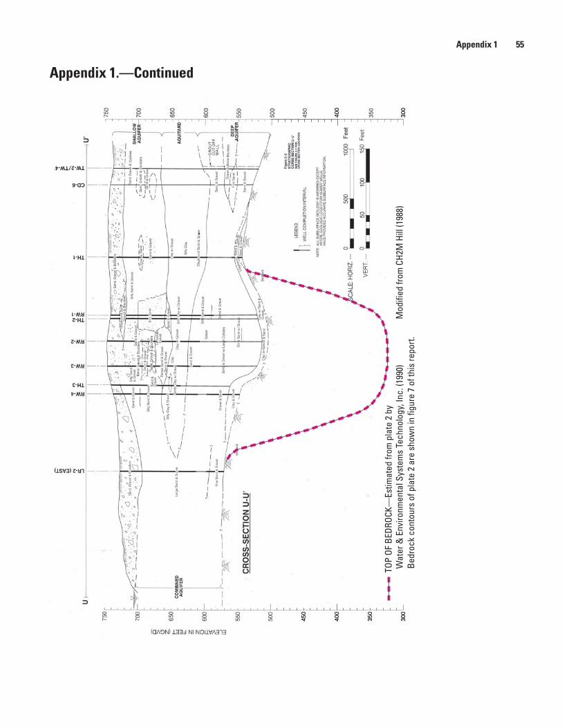
Appendix 1 55
250
200
350
300
450
400
Mod
ified
from
CH2
M H
ill (1
988)
TOP
OF B
EDRO
CK—
Estim
ated
from
pla
te 2
by
Wat
er &
Env
ironm
enta
l Sys
tem
s Te
chno
logy
, Inc
. (19
90)
Bedr
ock
cont
ours
of p
late
2 a
re s
how
n in
figu
re 7
of t
his
repo
rt.
Appendix 1c
350
300
300
450
400
400
250
350
450
200
300
400
Appendix 1.—Continued
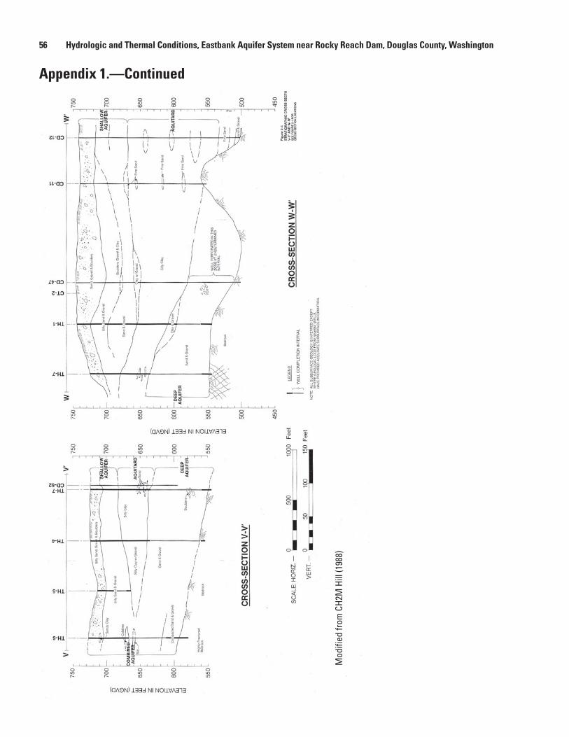
56 Hydrologic and Thermal Conditions, Eastbank Aquifer System near Rocky Reach Dam, Douglas County, Washington
Appendix 1.—Continued
Mod
ified
from
CH2
M H
ill (1
988)
Appendix 1d
450
450

Appendix 1 57
Appendix 1.—Continued
Mod
ified
from
CH2
M H
ill (1
988)
Appendix 1e
TOP
OF B
EDRO
CK—
Estim
ated
from
pla
te 2
by
Wat
er &
Env
ironm
enta
l Sys
tem
s Te
chno
logy
, Inc
. (19
90)
Bedr
ock
cont
ours
of p
late
2 a
re s
how
n in
figu
re 7
of t
his
repo
rt.
350
300
450
400
550
500
650
600
750
700
350
350
300
450
400
550
500
650
600
750
700
350
300
450
400
300
450
400

58 Hydrologic and Thermal Conditions, Eastbank Aquifer System near Rocky Reach Dam, Douglas County, Washington
This page intentionally left blank.

Appendix 2 59
Appendix 2. Summary of Down-Hole Camera Surveys of Selected Wells of the Eastbank Aquifer System, Douglas County, Washington, December 11–13, 2007.
Well CD6; USGS Well No. 24N/20E-35Q06
Down-hole camera survey by Kevin D. Knutson, USGS, December 11, 2007.
Survey proceduresThe depth reader for the camera was set to zero at the top of the well casing (TOC). After reaching the bottom of the well and bringing the camera back up, the TOC reading was 1.5 feet. Camera-depth readings may thus be as much as 1.5 feet too large. Depth readings on the movie represent the depth below TOC for the top of the camera unit. The downward-looking camera lens is 2.03 feet below the top of the camera unit and the sideward-looking camera lens is 1.68 feet below the top of the camera unit.
Basic information about the wellWell CD6 was drilled to a depth of 216 feet in 1972 or earlier, and probably 1957 or earlier. A 6-inch-diameter steel casing was installed without perforations. The well is a monitoring well and does not have a pump.
Summary of down-hole camera survey (Depths shown in this section have been corrected for the position of the camera lens and are depths below TOC.)
The camera contacted the water surface at 49.2 feet 1. below TOC, and the camera encountered sediments at the bottom of the well at 198.8 feet below TOC.
The well casing is in good condition with thin patchy 2. scaling attached to the casing at all depths.
No perforations were seen. No animals were seen.3.
Well CD47; USGS Well No. 24N/20E-35Q02
Down-hole camera survey by Kevin D. Knutson, USGS, December 11, 2007.
Survey proceduresThe depth reader for the camera was set to zero at the top of the metal manhole cover (TMMC) of the concrete vault that houses the well. The top of the metal manhole cover is 6.70 feet above the top of the well casing (TOC), which is below land surface. After reaching the bottom of the well and bringing the camera back up, the camera-depth reader indicated a depth of 1.2 feet for the TMMC. The camera-depth
readings may thus be as much as 1.2 feet too large. During the second part of the survey, when the camera moved from the bottom of the well to the top, the tripod from which the camera was suspended fell and it was put back up again. Depth readings on the movie represent the depth below TMMCs for the top of the camera unit. The downward-looking camera lens is 2.03 feet below the top of the camera unit and the sideward-looking camera lens is 1.68 feet below the top of the camera unit.
Basic information about the wellWell CD47 was drilled to a depth of 245 feet in 1972 or earlier, and probably 1957 or earlier. A 6-inch-diameter steel casing was installed and perforations were added later at unknown depths across from the Lower Aquifer. The well is a monitoring well and does not have a pump.
Summary of down-hole camera survey(Depths shown in this section have been corrected for the position of the camera lens and are depths below TOC.)
The camera contacted the water surface at 47.6 feet 1. below TOC. The camera did not reach the bottom of the well, because the casing became too narrow due to protruding of scaling. Maximum depth reached was 186.9 feet below TOC.
The well casing is in good condition with scaling 2. attached to the casing at all depths. The scaling is patchy and thin to a depth of approximately 115.3 feet below TOC when it gradually became rougher and more three-dimensional. At 134 feet below TOC, there may have been flow. However, it was difficult to be certain because falling scaling was disturbing the water. By 169.5 feet below TOC, there was flow and the scaling was solid instead of patchy. By 179.8 below TOC, the scaling had become hummocky and protruded into the casing by about 0.25 inch. By 180.5 feet below TOC, the water became noticeably clearer, which had been murky until that depth. By 181.3 feet below TOC, the scaling was protruding as much as about 0.5 inch and there was flow. By 186.9 feet below TOC, the protrusions narrowed the casing to the point where the camera could not go down farther. Based on these findings, it is concluded that the perforated interval of this well starts at about 180 feet below TOC and extends to an unknown depth.
60 Hydrologic and Thermal Conditions, Eastbank Aquifer System near Rocky Reach Dam, Douglas County, Washington
At 140.2 feet below TOC, a large piece of scaling 3. extended across the casing, which broke into pieces after the camera went through it. This may have been a sliver of corroded casing.
Two different types of invertebrate animals were 4. observed in this well, none of which have currently (2008) been sampled and identified.
An arthropod that may be an amphipod without a. pigment was observed at a depth of 186.9 feet below TOC moving along the well casing from the center right across the top of the picture and disappearing on the left. This animal was different than those seen in well TH6 and may have been the same animal as the second, larger possible amphipod in well TH2. The animal was about 1 inch long.
At the same depth, a second unidentified b. arthropod moved into view in the upper right-hand corner. This animal was different than any of the animals seen in wells TH6 and TH2. It had no pigment, was about 1 inch long, had a large head and dark eyes, and generally resembled a damselfly nymph (T. DeVries, Burke Museum of Natural History and Culture, oral commun., 2008). The animal appeared to be carrying prey, possibly of the same species. A temperature profile of the water column was measured in well CD47 on December 11, 2007 prior to the down-hole camera survey, with temperatures ranging from 11.9°C between 220 and 230 feet below TOC to 14.4°C at 160 feet below TOC. At the depth the arthropods were seen, temperatures ranged from 13.0°C at 180 feet below TOC to 12.7°C at 190 feet below TOC.
Video 1 of arthropod in well CD47 (http://pubs.usgs.gov/sir/2008/5071/VideoCD47A.wmv). Arthropod is possible amphipod.
Video 2 of arthropod in well CD47 (http://pubs.usgs.gov/sir/2008/5071/VideoCD47B.wmv). Arthropod generally resembles a damselfly nymph.
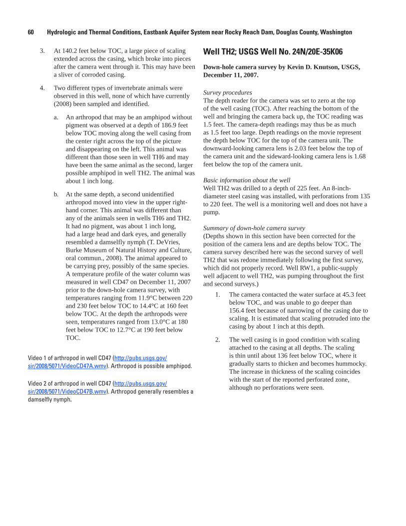
Well TH2; USGS Well No. 24N/20E-35K06
Down-hole camera survey by Kevin D. Knutson, USGS, December 11, 2007.
Survey proceduresThe depth reader for the camera was set to zero at the top of the well casing (TOC). After reaching the bottom of the well and bringing the camera back up, the TOC reading was 1.5 feet. The camera-depth readings may thus be as much as 1.5 feet too large. Depth readings on the movie represent the depth below TOC for the top of the camera unit. The downward-looking camera lens is 2.03 feet below the top of the camera unit and the sideward-looking camera lens is 1.68 feet below the top of the camera unit.
Basic information about the wellWell TH2 was drilled to a depth of 225 feet. An 8-inch-diameter steel casing was installed, with perforations from 135 to 220 feet. The well is a monitoring well and does not have a pump.
Summary of down-hole camera survey(Depths shown in this section have been corrected for the position of the camera lens and are depths below TOC. The camera survey described here was the second survey of well TH2 that was redone immediately following the first survey, which did not properly record. Well RW1, a public-supply well adjacent to well TH2, was pumping throughout the first and second surveys.)
The camera contacted the water surface at 45.3 feet 1. below TOC, and was unable to go deeper than 156.4 feet because of narrowing of the casing due to scaling. It is estimated that scaling protruded into the casing by about 1 inch at this depth.
The well casing is in good condition with scaling 2. attached to the casing at all depths. The scaling is thin until about 136 feet below TOC, where it gradually starts to thicken and becomes hummocky. The increase in thickness of the scaling coincides with the start of the reported perforated zone, although no perforations were seen.

Appendix 2 61
Two different types of invertebrate animals were 3. observed in this well, none of which have currently (2008) been sampled and identified.
Arthropods that appear to be blind isopods a. without pigment were observed clinging to the well casing from 117.6 to 155.4 feet below TOC. The estimated length of the possible isopods is about 1 inch.
At 132.7 and 113.3 feet below TOC, a second b. type of arthropod was observed that may be an amphipod. This animal was shorter than the possible isopods and moved faster. The possible amphipod seen at 113.3 feet below TOC was larger than the one seen at 132.7 feet below TOC. A temperature profile of the water column was measured in well TH2 on December 11, 2007 prior to the first down-hole camera survey, with temperatures ranging from 10.5°C at 50 feet below TOC to 15.1°C at 160 feet below TOC. At the depth range where arthropods were seen, temperatures ranged from 13.5°C at 110 feet below TOC to 15.1°C at 160 feet below TOC. Abundance of the possible isopods appeared to be unrelated to water temperature. Instead, abundance of the possible isopods appeared to be correlated with proximity to the perforated interval, presumably because water that is replenished is richer in oxygen and nutrients and thus can reasonably be expected to be preferred habitat for the possible isopods. The abundance of possible isopods in well TH2 was less than in well TH6.
Video 1 of arthropod in well TH2 (http://pubs.usgs.gov/sir/2008/5071/VideoTH2A.wmv). Arthropod is possible isopod.
Video 2 of arthropod in well TH2 (http://pubs.usgs.gov/sir/2008/5071/VideoTH2B.wmv). Arthropod is possible amphipod.
Video 3 of arthropod in well TH2 (http://pubs.usgs.gov/sir/2008/5071/VideoTH2C.wmv). Arthropod is possible isopod.
Video 4 of arthropod in well TH2 (http://pubs.usgs.gov/sir/2008/5071/VideoTH2D.wmv). Arthropod is possible amphipod.
Well TH4; USGS Well No. 24N/20E-35K02
Down-hole camera survey by Kevin D. Knutson, USGS, December 12, 2007
Survey proceduresThe depth reader for the camera was set to zero at the top of the well casing (TOC). After reaching the bottom of the well and bringing the camera back up, the TOC reading was 0.5 foot. The camera-depth readings may thus be as much as 0.5 foot too large. Depth readings on the movie represent the depth below TOC for the top of the camera unit. The downward-looking camera lens is 2.03 feet below the top of the camera unit and the sideward-looking camera lens is 1.68 feet below the top of the camera unit. Basic information about the wellWell TH4 was drilled to a depth of 170 feet. An 8-inch-diameter steel casing was installed with perforations from 100 to 168 feet. The well is a monitoring well and does not have a pump.
Summary of down-hole camera survey(Depths shown in this section have been corrected for the position of the camera lens and are depths below TOC.)
The camera contacted the water surface at 27.2 feet 1. below TOC, and the camera encountered sediments at the bottom of the well at 161.0 feet below TOC.
The well casing is in good condition with scaling 2. attached to the casing at all depths. The scaling is thin and patchy to about 50 feet below TOC, when the scaling starts to protrude more into the casing. By about 60 feet below TOC, the scaling is no longer patchy. The scaling continues to get thicker and more hummocky farther down. By about 110 feet below TOC, the scaling protrudes into the well by as much as about 1 inch. By about 100 feet below TOC, water is relatively clear except for suspended pieces of scaling.
One type of invertebrate animal was observed in this 3. well, which has currently (2008) not been sampled and identified. Two arthropods that appear to be small amphipods without pigment were observed moving along the well casing at 101.4 and 130.1 feet below TOC. A temperature profile of the water column was measured in well TH4 on December 12, 2007 prior to the down-hole camera survey, with temperatures ranging from 11.2 to 13.6°C throughout the well and ranging from 12.1 to 11.4°C from 100 to 130 feet below TOC.

62 Hydrologic and Thermal Conditions, Eastbank Aquifer System near Rocky Reach Dam, Douglas County, Washington
Well TH5; 24N/20E-35G01
Down-hole camera survey by Kevin D. Knutson, USGS, December 12, 2007.
Survey proceduresThe depth reader for the camera was set to zero at the top of the well casing (TOC). After reaching the bottom of the well and bringing the camera back up, the TOC reading was 0 foot. The camera depth readings were thus correct. Depth readings on the movie represent the depth below TOC for the top of the camera unit. The downward-looking camera lens is 2.03 feet below the top of the camera unit and the sideward-looking camera lens is 1.68 feet below the top of the camera unit.
Basic information about the wellWell TH5 was drilled in 1987 to a depth of 47 feet. An 8-inch-diameter steel casing was installed, with perforations from 25 to 45 feet. The well is a monitoring well and does not have a pump.
Summary of down-hole camera survey (Depths shown in this section have been corrected for the position of the camera lens and are depths below TOC.)
The camera contacted the water surface at 13.1 feet 1. below TOC, and the camera encountered sediments at the bottom of the well at 41.8 feet below TOC.
The well casing is in good condition with thin patchy 2. scaling attached to the casing at all depths.
No flow was seen from the water surface to as deep 3. as 34.3 feet below TOC. Flow may have been seen at 38.3 feet below TOC and possibly also perforations in the casing. Perforations also may have been seen at 39.3 feet below TOC. Perforations were difficult to see due to scaling, murky water, and a fuzzy image. Water at bottom of the well is clear. No animals were seen.
Well TH6; USGS Well No. 24N/20E-35G02
Down-hole camera survey by Kevin D. Knutson, USGS, December 12, 2007.
Survey proceduresThe depth reader for the camera was set to zero at the top of the well casing (TOC). After reaching the bottom of the well and bringing the camera back up, the TOC reading was -0.2 foot. The camera-depth readings may thus be as much as 0.2 foot too small. Depth readings on the movie represent the depth below TOC for the top of the camera unit. The
downward-looking camera lens is 2.03 feet below the top of the camera unit and the sideward-looking camera lens is 1.68 feet below the top of the camera unit.
Basic information about the wellWell TH6 was drilled in 1987 to a depth of 148 feet and the hole was sealed below 134 feet. An 8-inch-diameter steel casing was installed, with perforations from 60 to 115 feet. The well is a monitoring well and does not have a pump.
Summary of down-hole camera survey(Depths shown in this section have been corrected for the position of the camera lens and are depths below TOC.)
The camera contacted the water surface at 29.2 feet 1. below TOC, and the camera encountered sediments at the bottom of the well at 121.7 feet below TOC.
The well casing is in good condition with scaling 2. attached to the casing at all depths. The scaling is thicker and hummocky where the casing is perforated. Maximum protrusion of scaling into the well is estimated to be about 0.5 inch.
Starting at about 59 feet below TOC, horizontal flow 3. was observed in the well. This flow became stronger with depth, with strong currents from about 63 to about 72 feet below TOC. By 76 feet below TOC, the currents were weaker and by about 102 feet below TOC, there was no evidence of horizontal flow. In the zone of strong currents, the flow direction appeared to be spiraling.
From 103.6 to 105.6 feet below TOC, open vertical 4. perforations were seen. Additional open vertical perforations were seen from 118.1 to 119.4 feet below TOC.
Three different types of invertebrate animals were 5. observed in this well, none of which have currently (2008) been sampled and identified.
Arthropods that appear to be blind isopods a. without pigment were observed clinging to the well casing from just below the water surface to the bottom of the well. The estimated length of the possible isopods is about 1 inch. The possible isopods were most numerous in parts of the well with strong currents, although the current at times knocked the animals from the casing.
At the bottom of the well, a second type b. of arthropod was observed that may be an amphipod. This animal was about one-third the length of the possible isopods and moved faster.

Appendix 2 63
At the bottom of the well, two worms also were c. observed. One moved from its hiding place in the sediments and in doing so extended to a length of 5-6 times the length of the possible isopods. The possible amphipods were observed avoiding the moving worms. A temperature profile of the water column was measured in well TH6 on December 12, 2007 prior to the down-hole camera survey, with temperatures ranging from 8.5 to 9.2°C. Abundance of the possible isopods appeared to be unrelated to water temperature. Instead, abundance of the possible isopods appeared to be correlated with water flow, presumably because water that is replenished is richer in oxygen and nutrients and thus can reasonably be expected to be preferred habitat for the possible isopods.
Video 1 of arthropods in well TH6 (http://pubs.usgs.gov/sir/2008/5071/VideoTH6A.wmv). Arthropods are possible isopods.
Video 2 of arthropods and worms in well TH6 (http://pubs.usgs.gov/sir/2008/5071/VideoTH6B.wmv). Arthropods are possible isopods and possible amphipods.
Well TH7; USGS Well No. 24N/20E-35K01
Down-hole camera survey by Kevin D. Knutson, USGS, December 12, 2007.
Survey proceduresThe depth reader for the camera was set to zero at the top of the well casing (TOC). No TOC reading was taken when the camera was brought back up and thus the error of the camera depth reading is not known. Depth readings on the movie represent the depth below TOC for the top of the camera unit. The downward-looking camera lens is 2.03 feet below the top of the camera unit and the sideward-looking camera lens is 1.68 feet below the top of the camera unit.
Basic information about the wellWell TH7 was drilled in 1987 to a depth of 180 feet. An 8-inch-diameter steel casing was installed to 176 feet, with perforations from 90 to 165 feet. The well is a monitoring well and does not have a pump.
Summary of down-hole camera survey(Depths shown in this section have been corrected for the position of the camera lens and are depths below TOC.)
The camera contacted the water surface at 28.2 feet 1. below TOC, and the camera encountered sediments at the bottom of the well at 171.5 feet below TOC.
The well casing is in good condition, with scaling 2. attached to the casing at all depths. The scaling is thin and patchy until a depth of about 80 feet below TOC, when it starts to become more three-dimensional and less patchy. Scaling was protruding about 0.25 inch into the well at this depth. By about 92 feet below TOC, the scaling had become thicker and hummocky. The thick and hummocky scaling continued until the bottom of the well and protruded as much as about 1 inch into the casing. Scaling in this well appeared to be harder than and did not flake off as easily as scaling seen in other wells of the monitoring network.
From 153 to 158 feet below TOC, vertical 3. perforations were seen and water was very clear at this depth. Clear water was first noticed at a depth of 132 feet below TOC and it continued to be clear to the bottom of the well.
As many as three different types of invertebrate 4. animals were observed in this well, none of which have currently (2008) been sampled and identified.
Arthropods that appear to be blind isopods a. without pigment were observed clinging to the well casing. Two possible isopods were seen in the well and perhaps a few more between depths of 88 to 146.1 feet below TOC. The estimated length of the possible isopods is about 1 inch.
A second and third type of arthropod was b. more numerous in this well and may have been amphipods of two different sizes. One size was about 1 inch and the other about one-third of an inch. Only a few specimens were seen at depths ranging from 94.5 to 114.4 feet below TOC. These animals move faster than the possible isopods. A temperature profile of the water column was measured in well TH7 on December 12, 2007, prior to the down-hole camera survey, with temperatures ranging from 12.9 to 14.2°C throughout the well and ranging from 13.9 to 13.5°C from 90 to 150 feet below TOC. Abundance of the possible isopods and amphipods appeared to be related to proximity to the perforated interval.

64 Hydrologic and Thermal Conditions, Eastbank Aquifer System near Rocky Reach Dam, Douglas County, Washington
Well TH8; USGS Well No. 24N/20E-35K04
Down-hole camera survey by Kevin D. Knutson, USGS, December 13, 2007.
Survey proceduresThe depth reader for the camera was set to zero at the top of the well casing (TOC). After reaching the bottom of the well and bringing the camera back up, the TOC reading was -0.6 foot. The camera-depth readings may thus be as much as 0.6 foot too small. Depth readings on the movie represent the depth below TOC for the top of the camera unit. The downward-looking camera lens is 2.03 feet below the top of the camera unit and the sideward-looking camera lens is 1.68 feet below the top of the camera unit.
Basic information about the wellWell TH8 was drilled in 1987 to a depth of 255.5 feet. A 6-inch-diameter steel casing was installed to 255 feet and an 8-inch-diameter steel casing to 217 feet without perforations. Currently (2008), only the 6-inch-diameter casing is visible above land surface. The well is a monitoring well and does not have a pump.
Summary of down-hole camera survey (Depths shown in this section have been corrected for the position of the camera lens and are depths below TOC.)
The camera contacted the water surface at 52.4 feet 1. below TOC, and the camera encountered sediments at the bottom of the well at 258.1 feet below TOC.
The well casing is in good condition with thin 2. scaling attached to the casing at all depths. The scaling is more three-dimensional and patchier in about the bottom 10 feet of the well.
At about 177.3 and 197.2 feet below TOC, casing 3. sections were connected by some type of collar that was about 1–2 inches wide. Other casing connections were welded seams.
No flow was observed. No animals were observed.4.
Well TH9; USGS Well No. 24N/20E-35K03
Down-hole camera survey by Kevin D. Knutson, USGS, December 12, 2007.
Survey proceduresThe depth reader for the camera was set to zero at the top of the well casing (TOC). After reaching the bottom of the well and bringing the camera back up, the TOC reading was 0.1 foot. The camera-depth readings may thus be as much as 0.1 foot too large. Depth readings on the movie represent the depth below TOC for the top of the camera unit. The downward-looking camera lens is 2.03 feet below the top of the camera unit and the sideward-looking camera lens is 1.68 feet below the top of the camera unit.
Basic information about the wellWell TH9 was drilled in 1987 to a depth of 211.5 feet. An 8-inch-diameter steel casing was installed to 92.5 feet and a 6-inch-diameter steel casing was installed from 85 to 211 feet, with perforations from 130 to 165 feet and 180 to 205 feet. The well is a monitoring well and does not have a working pump. During the camera survey, a 1-inch inner-diameter PVC pipe was encountered at depth attached to a heavy object that was presumed to be a pump. The presumed pump and attached pipe fell to the bottom of the well.
Summary of down-hole camera survey(Depths shown in this section have been corrected for the position of the camera lens and are depths below TOC.)
The camera contacted the water surface at 41.9 feet 1. below TOC, and the camera encountered sediments at the bottom of the well at 188.3 feet below TOC.
The top of the broken off 1-inch-inner-diameter PVC 2. pipe is at 76 feet below TOC. The pipe runs all the way to the bottom of the well into the sediments.
At a depth of about 87.4 feet below TOC, the casing 3. appeared to narrow and the camera started getting stuck more frequently.
The well casing is in good condition with scaling 4. attached to the casing at all depths. The scaling is generally thin and patchy in places. It is notable that no particularly hummocky scaling was seen at any depth, perhaps indicating limited, if any flow in this well.
No perforations and no animals were seen. However, 5. the image was poor because water was murky due to large amounts of suspended matter. The water seemed less murky near the bottom of the well, although it was difficult to be certain due to the large amount of falling and suspended matter in the well.

Appendix 3 65
Appendix 3. Natural-Gamma Logs of Selected Wells of the Eastbank Aquifer System, Douglas County, Washington, December 13, 2007.
Altitude of land surface 744.7 feet 746.6 feet 741.4 feet
TH6727.6 feet
CD6 CD47 TH20
10
20
30
40
50
60
70
80
90
DEPT
H BE
LOW
LAN
D SU
RFAC
E. IN
FEE
T
100
110
120
130
140
150
160
170
180
190
0
10
20
30
40
50
60
70
80
90
100
110
120
130
140
150
160
200
210
220
230
170
180
190
0
10
20
30
40
50
60
70
80
90
100
110
120
130
140
150
0
10
20
30
40
50
60
70
80
90
100
110
12020 40 60 80
NATURAL GAMMA,IN API UNITS
20 40 60 80NATURAL GAMMA,
IN API UNITS
20 40 60 80NATURAL GAMMA,
IN API UNITS
20 40 60 80NATURAL GAMMA,
IN API UNITS
Appendix 3.

66 Hydrologic and Thermal Conditions, Eastbank Aquifer System near Rocky Reach Dam, Douglas County, Washington
This page intentionally left blank.