appendix a - nsgl.gso.uri.edu
TRANSCRIPT

APPENDIX AWater Quality Variables
Reprinted with permission from University of Maine Cooperative Extension and theMaine/New Hampshire Sea Grant Program,!


A LINI TY
Salinity is the concentration of dissolved salts in the water,usually expressed in parts of salts per thousand parts of water ppt!. Fresh water contains few salts drinking water usually has asalinity of less than 0.5 ppt!, while sea water averages 35 ppL
In estuaries, salinity changes with the tides and is also subjectto fluctuations due to changes in the rate of dilution by freshwater from the land. Salinity is the principal factor controlling thedistribution of marine organisms, especially as the salinity beginsto decrease weH below oceanic levels.
The determination and definition of salinity is somethingwhich has been given much attention over the years by marinechemists and physicists.
The salinity of marine waters is a fundamental propertywhich can be used to determine much about the mixing andchemical history of the waters. In the open ocean and even incoastal waters, variations in salinity are small and thus it isnecessary to use very precise methods to determine the extent ofreal differences. In estuaries, differences in salinity are typicallymuch greater and the use of high precision methods is oftencounter-productive. The use of such methods can introduceunwanted background noise which may obscure the informationsought.
Salinity can be measured by using a hydrometer, a sanityhand-held refractorneter, or a conductivity meter.
22

DISSOL YEO OXYGENDissolved oxygen DO! is essential for basic metabolic
processes of most plants and animals inhabiting coastal waters.However. it is a particularly sensitive collstituent because chemicalspresent in the water, biological processes, and temperature exert ainajor influence on its availability during the year.
A shortage of DO may not only be an indicator of pollution,but it can also be harmful to marine organisins, The ability oforganisms to tolerate low dissolved oxygen conditions isextremely varied. However, if levels fall beIow 5 ppm parts permiUion!, certain species in the community may becoine stressed.Oxygen depletion is a significant event that can occur as a resultof nutrient pollution and excessive phytoplankton production andcan resu1t in mass mortalities of fish and sheBftsh in coastal waters.
The oxygen in water comes from many sources. One of thelargest sources is oxygen absorbed from the atmosphere. Asecond inajor source of axygen is aquatic plants, including algae.During photosynthesis, plants reinove carbon dioxide from thewater and replace it with oxygen.
Once in the water, oxygen is used by tnarine organisms.Like land animals, fish and other marine animals need oxygen forrespiration, Oxygen is also consumed by bacteria decotnposingdead plants and animals.
The axygen level of water is dependent not only anproduction and consumption. Many other factors work tagetherto determirie the oxygen level, including salinity, temperature, andatmospheric pressure.
Dissolved oxygen can be measured using a dissolvedoxygen meter in the field or a Winkler titration method, which wiQgive you dissolved oxygen in parts per million ppm!.
23

CHLOROPHYLL aChlorophyll a is a green pigment contained in algae and
other organisms and is necessary for photosynthesis. Itsabundance is directly proportional to the abundance of algae in abody of water. Algal populations increase and decreasethroughout the surnrner As the population of algae increases,water clarity is reduced and a water body develops a greenishcoloration, unless it is a brown or red bloom of dinoflageilates. Asalgal populations increase, chlorophyll a concentrations shouldincrease. This increase leads to reduced water clarity.
Because chlorophyll a measurement requires specialinstrumentation, it probably wi11 require the services of a well-equipped laboratory.
FECAL COLIFORM BACTERIAThe fecal coliform group of bacteria is used by the U.S.
Food and Drug Administration FDA! as a microbiologicalindicator of sewage pollution to determine the potential for publichealth risks through dispersal of pathogenic organisms and forecological damage through nutrient loading.
Fecal coliforms were chosen as the indicator because theyoriginate in the digestive tract of warm-blooded animals and aredischarged into the environment with fecal wastes. Presence offecal coliforms therefore indicate the presence of sewage whichcould contain pathogenic bacteria, viruses, protazoans, orparasites. Detection of the pathogens would be an inefficient andsometimes impossible undertaking because of their limitednumbers and diversity. Fecal coliforms were aLso chosen becauseof their relative ease of detection and their viability in the aquaticenvironment.
One member of this group is sometimes considered as arepresentative of'the fecal coliform group. In fresh water, thebacteria E. coIi is used as an indicator of water quality by theEnvironmental Protection Agency EPA!, and the enterococcigroup is used as an indicator in marine swimming areas.
Fecal coliforms can be detected and counted in the lab byuse of media with specific substrates and specific incubation timesand temperatures.
24

TRANSPA RENC YTransparency of water is a quick and easy measurement that
integrates many important features of an aquatic system. Algae.microscopic animals, eroded soil, and resuspended bottomsediinent contained in the water column interfere with lightpenetration and lessen the transparency of the water.
ln late spring and early fall, there is usually lesstransparency because of plankton and algal blooms, and in theearly spring the water may become mote turbid with the siltbeing carried into the estuary with the spring run-off. Sincesunlight is the basic energy source for most life forms, thedegree of turbidity of the water has an important effect.
Transparency affects fish and other aquatic life by:
limiting photosynthetic processes and increasingrespiration, oxygen use and the amount of carbondioxide produced;
clogging of fish gills and feeding apparatus of bottomdwelling animals by suspended particles; and/orobscuring vision of fish as they hunt food andsmothering bottom-dwelling animals,
A Secchi disk can be used to determine how deep into thewater column the light penetrates. This technique may be lessuseful on mudflats and is impossible to use in shallow water
areas. To build a Secchi Disk;MAKtNG A SECCHI DtSK
l. Use an aluminum sheet. plexiglas. or masonitethat can be cut to a diameter of 20 centimeteeye bolt, washers, and braided dacron rope.some other rope that does not stretch!, markevery 10 centimeters for the first two metersevery 50 centimeters half-meter! thereafte
2. Divide the circle into quarters. Paint alquarters black and white.
3. Drill a hole through the center and asseas shown in the diagram in the margin A
metal weight will be needed if using plexigl Prepared by Michigan Department of Natural ResourcesSett-Help Water Ouatity Monitoring Prcgram
25

H
Most coastal groups monitoring in Maine do not regularlymeasure pH. It does becomes important, however, in certain situationssuch as during algal blooms or in freshwater streams flowing into anestuary.
pH is a measure of how acidic or basic alkaline! a solution is. Inany given solution some atoms of water dissociate to form hydrogen H! and hydrogen OH! ians H O=H + OH!. The pH scale shows whichion has the greater concentration.
At a pH of 7.0 the concentration of both hydrogen ions andhydroxyl ions is equal and the water is said to be neutral. Pure water hasa pH of 7.0. When the pH is less than 7.0, there are more hydrogen ionsthan hydroxyl ions and the water is said to be acidic. When the pH isgreater than 7.0, there are more hydroxyl ions than hydrogen ions andthe water is said to be basic or alkaline.
pH is define as the negative logarithm of the hydrogen ionconcentration which means that the concentration of hydrogen ionsdoes not increase ar decrease in a linear fashion; that is, a pH of 3 is notjust twice as acid as a pH of 6. Increases are in powers of 10. At pH of 5,there are IO times more H than at a pH of 6. A change in pH of onewhole number is, therefore, a large change.
Water dissolves mineral substances it contacts, picks up aerosolsand dust from the air, receives human wastes, and supportsphotosynthetic orgamsms, all of which affect pH. The bufferingcapacity of water, or its ability to resist pH change, is critical to aquaticlife, as it determines the range of pH.
Generally, the ability of aquatic organisms to complete a life cyclegreatly diminishes as pH exceeds 9.0 or falls below 5 0. Coastal marinesystems are well buffered. Consequently, pH is not an importantindicator. The exception is during intense algal blooms. In an estuarinesystem where the salinity is highly variable, pH is a useful indicator.Also, it becomes important where an industrial discharge could effectthe pH.
In fresh water, most fish can tolerate pH values between 5 and 9,but the ideal range falls between 6.5 and 8.2. When water with a low pHvalue comes in contact with certain chemicals and tnetals, the acid maycause these substances to become more soluble or more toxic thannormal. Fish that can stand a pH as low as 4.8 may die at a pH of 5.5 iflow concentrations of iron, aluminum, lead, or mercury are present.
Ocean water is a highly buffered solution with a pH of 8.I to 8.3.Fresh water is, therefore, more affected by acid rain than the ocean orestuaries.
pH can be measured with a meter. It is not possible to get anaccurate measurcmcnt with a prepared kit, especially in saIt water.

U TRI EN TS
NitrogenNitrogen is one of the major constituents of plant and
animal tissue. Its primary role is in the synthesis and maintenanceof protein. Nitrogen enters the ecosystem in several chemicalforms, including ammonia, nitrate, and nitrite. Nitrogen alsooccurs in other dissolved organic and particulate forms, such asliving and dead organisms.
Some bacteria and blue-green algae can extract nitrogen gasfrom the atmosphere and transform it into organic nitrogen. Thisprocess, called nitrogen fixation, is an important pathway in thecycling of nitrogen between organic and inorganic components.Nitrogen is the limiting nutrient in Maine coastal waters.
2 PhosphorusPhosphorus is another key nutrient and is found in the water
as dissolved organic and inorganic phosphorus and also inparticuhte form, Phosphorous is essential to cellular growth andreproduction. Phytoplankton and bacteria assimilate and usephosphorus in their growth cycles.
When phosphate is highly concentrated in waters whichcontain oxygen, it combines with iron and suspended particles andeventually settles to the bottom, becoming unavailable tophytoplankton and temporarily excluded from the cyclingprocess. Phosphate sometimes becomes a long-term constituent ofthe bottom sediments. When DO is absent, phosphorus is releasedand becomes available. Phosphorus is generally the limitingnutrient in freshwater lakes in Maine.
3. Uses of NutrientsJust as fertilizer aids the growth of agricultural crops,
nitrogen and phosphorus are vital to plant growth. These elementsare supplied in significant quantities by sewage treatment plants,food processing industries, and urban and agricultural run-off,They are generally needed in a ratio of l6 parts nitrogen to onepart phosphorus. If the availability of either drops below this ratio,it becomes the limiting nutrient in the growth of plant life.
Too many nutrients, on the other hand, can lead to over-abundances of phytoplankton, creating dense populations, orblootns, of plant cells. Blooms of green or blue-green phyto-plankton can become a nuisance in the upper tidal freshwaters. Asthe blooms decay, oxygen is used up in decomposition. This leadsto anoxic and odorous! conditions causing fish kills and nutrientreleases.
Nutrient samples can be collected and filtered by volunteers,but they require a qualified lab for analysis.
77


Winged KelpSea LettuceTube Weed
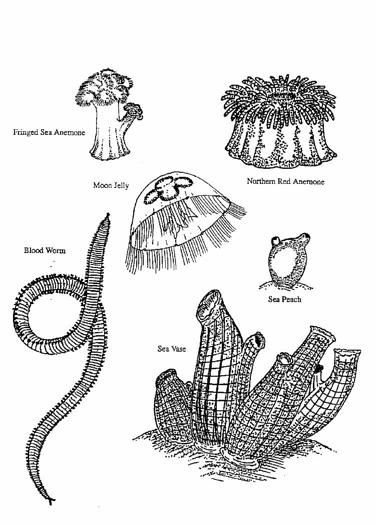
Fringed Sea Anemo
Moon Jell

Northern Sea Star
Purple Sunstar

Empty Test
reen Sea Urchin
Sea Cucumber
Rat-tailed Cucumber
Scarlet Psoltrsd Dollar
~ ~ C 'a
~ ~

Cornrnon Periwinkle
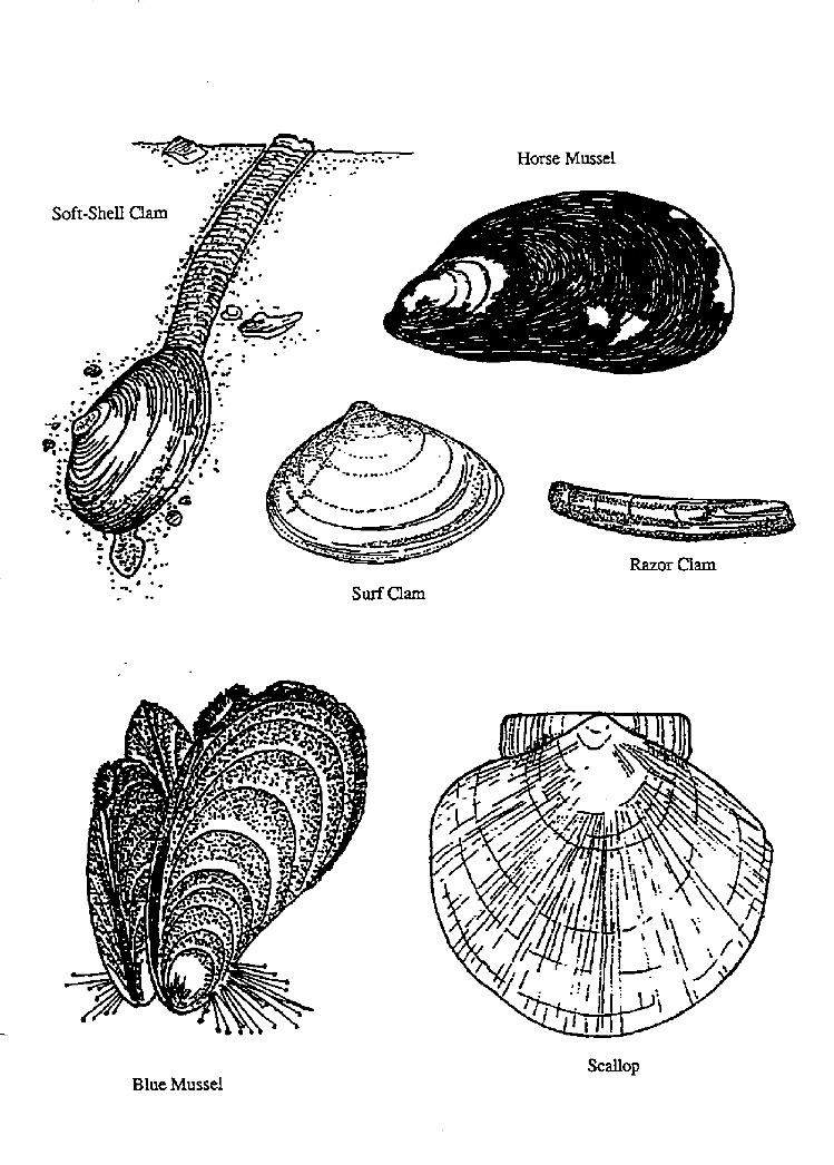
Blue MusselScaQop
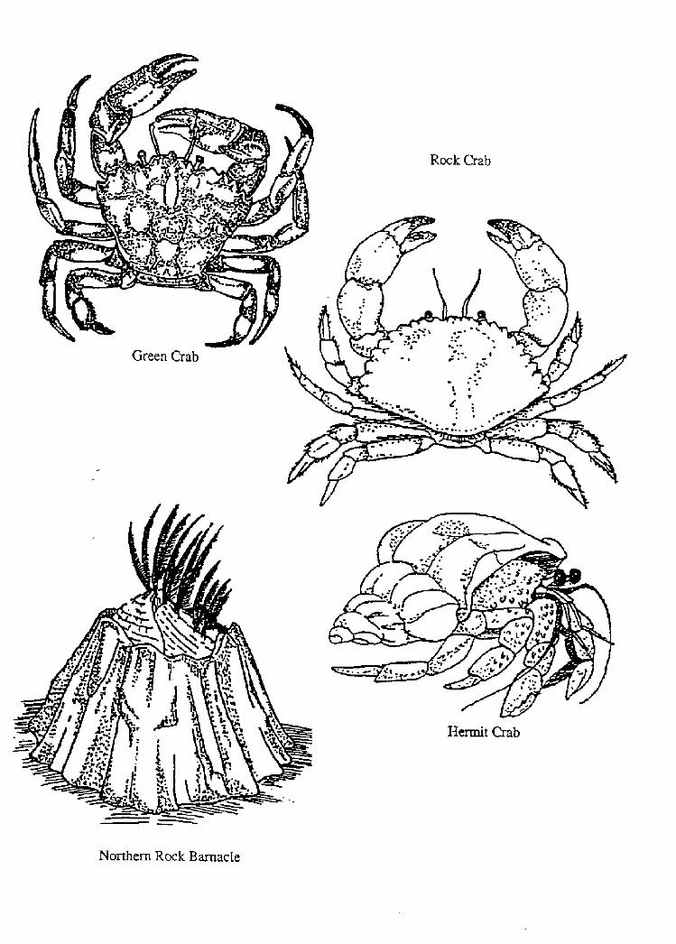
Northern Rock Barnacle


1 'I


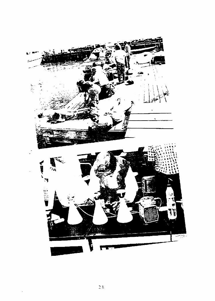
FIELD TRIP TO A ROCKY SHORE
Welcome to the Maine caast. While some flat,sandy beaches do exist in Maine, the major part ofthe coast is rugged and rock-lined. It is clearly de-scribed by Howard M. Weim and Michael W. Dotseyin their book Investigating the JVlarine Environ-ment;
Qn most rocky shores the following areas can be identified:
Above the tide � a transitional area extending from the forest down to the spray zane.Spray zorte � a black or greyish band found above high tide which sea water reaches regularly by splash or
spray action; the black colar is caused by the presence of millions of microscopic, individual blue-green algae.
High tide mark - a line along the shore caused by the uppermost rise of sea water an a given day; this line variesconsiderably due to storms, the monthly cycle of the moon, and the annual cycle of the sun.
Rockuteed or intertidal zone - a yellowish-brown band found between the high and low tide marks which isalternately exposed ta air and covered by sea water each day; organisms common in the zone includerockweeds, barnacles, periwinkles, blue mussels, and dog whelks; barnacles often form a distinctivewhite band between the black splash zone and the rockweeds.
Tide pools � places among the rocks between high and low tide marks where seawater is trapped each timethe tide goes out.
Irish moss zone � a belt of vegetation found below the rockweed zone and near the low tide mark; this zoneis dominated by Irish moss and other red algae.
Lozv tide mark � a line alang the shore created by the farthest drop of sea water on a given day; as with thehigh tide mark, this line varies with storms and the cycles of the moon and sun.
Kelp or subtida! zone - a band of vegetation located right at or below the low tide mark: common organismsinclude kelp, sea stars, sea urchins, and sea cucumbers.
1. Howard M. Weiss and Michael W. Dorsey, Investigating the Marine Environment; A Sourcebook. Volume I FieldStudies Groton, CT Project Oceanology, 1980!, pp. 37-38
"The rocky shore is a severe and rugged envi-ronment. It is battered by surf and covered by saltywater with each incoming tide and during storms.The rest oF the time it is exposed to the heat andradiation of the sun, to icy winds, to rain andsnow, and to the blistering heat of summer and thebitter cold of winter. The plants and animals thatlive here must be as rugged as this environment.
"Rocky share organisms must be able to holdtight to sheer rocks to keep from being washedaway. They must resist abrasion as they arescraped by rocks and bounced about by the tur-bulent water. They must be able to withstand ex-posure to salty sea water and fresh rainwater andother changes that occur as the tide rises and falls.
"In certain places the rocks form basinlike de-pressians that hald water as the tide recedes. Con-ditions in these basins, ar tide pools, are harsh and
unpredictable. When they are exposed to air, thesun can heat them up to the temperature of a warmtub. The sun's heat evaporates the water, increas-ing the salinity <sa!t content! higher than that oFthe open ocean. When it rains, the basin is filledwith fresh water, and the salinity can drop to zero.Although the rocky intertidal zone is a harsh en-vironment, a surprisingly large number of differ-ent plants and animals live there,
"Within a short distance, the environment onthe rocky shore changes from completely marineto completely terrestrial. This makes it an idealplace to study how the distribution of animals isaffected by the environment, The organisms livingnear the low-tide level on a rocky share are im-mersed in sea water almast all the time, whereasthe organisms living higher up are inundated onlyat high tide. Different plants and animals toleratethe conditions found at different locations be-
tween the tidal levels. Groups af organisms thattolerate similar conditions will generally occupybands or zones along the shore. As you walk fromthe land taward the water, you will pass over anumber of zones containing different groups oforgantsms.

10Connect>ons to the Sea
rock~eed
Procedure:
Following is an activity that wi!! help you locatethese various zones and the organisms that live ineach. Inc!uded is a Field Guide to the Organismsfound along the shore to help you identify them,Also helpful is the chart on Rocky Beach Survivalwhich follows the Field Guide.
ZONATION ALONG A ROCKY SHORE
Purpose: To study the zonation of plants andanimals !iving a!ong a rocky shore.
Introduction: The rocky shore is a severe andrugged environment, It is battered by surf andcovered by salty water with each incoming tideand during storms, The rest of the time it is exposedto the heat and radiation of the sun, to icy winds,to rain and snow, and to the blistering heat ofsummer and the bitter cold of winter. The plantsand animals that live here must be as rugged asthis environment. Within a short distance, the en-vironment on the rocky shore changes from com-plete! y marine to comp!etely terrestrial. Thismakes it an ideal place to study how the distribu-tion of animals is affected by the environment.
Materials and equipment needed:
Pail for collections
Coat hangers bent into square shape30 yard line marked at 2 yard intervalsData sheets or notebookClip boardPencil
Field Guide
Hand lens optional!
1. Plan to arrive at the shore at about one or twohours before low tide.
2. Divide your group into teams of three persons recorder, investigator, researcher!.
3, Starting at the edge of the woods or !andwardside of the beach, stretch out the transect lineat about a right angle to the beach. Place thehanger square quadrat frame! next to the up-permost marking on the transect line. Placenumber "1" under quadrat number on the datasheet.
4. Using your Field Guide, identify all the plantsand animals that you can which fall inside thequadrat frame. List these on your data sheet,
5. Complete the rest of the information re-quested on the data sheet: approximate num-ber of each type of organism; description ofthe environment rocks, sand, sunny! estimatethe elevation above or below the high tidemark and the zone in which your quadrat is ! o-cated spray zone, tidal pool, rockweed zone!
6. Continue toward the water using the sameprocedure for each quadrat. Move the transectline when you reach the end to form a straightline toward the water. Continue unti! youreach the low tide mark.
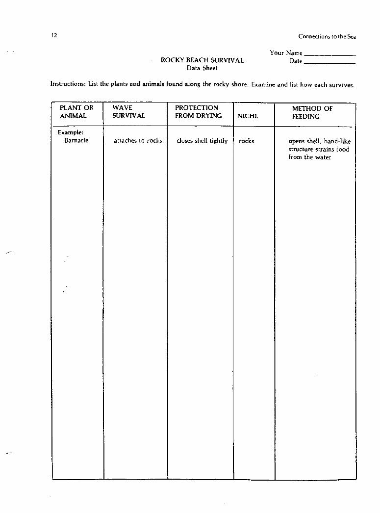
7 When you have finished your transect goback and study in detail the plants and ani-mals you found to discover how they survive.For each organism list: how it survives thecrashing waves, how it protects itself fromdrying, where it lives niche!, and how it getsfood. Record these observations on the RockyBeach Survival Data Sheet.
8. After returning home, prepare a map showingthe !ocation of each quadrat along the transectline, Show the location of the high tide mark,low tide mark. and the different zones, Makeup symbols For the different organisms youfound, such as
Fill in your map with the symbols for thedominant organisms found in each zone.

Trip Activities II
Your Name
Transect pDate
Zonation Along a Rocky ShoreData She t
Environment
rock, sand, etc.!Animals Plants
QuadratNumber
Approx.Number
Approx. ZNumber
Hevation
Feet above or below
high tide mark!

'I' , I~A
I B
Cal h3 MO % 00r � mmfQO$3~
Q 8Vl
l li
CA 0 ~A~ ~ chO~ 3 ~Qe~e Q
g! I
M IV 4! hD f4 hD h> M ~ ~ ~ ~O' Ol Ch 47 fO ~ C! % 0! M 0'
g KgC+QQZ7~QW~QI +9're c a c! I e g>>gQ>F+oogye~ggo<
O � 0EACA I
3
C CA
I Q 0 ee

eU~ 3 P!QO ~ y o Be
o I
pO�
~U
G! hJ M M ~ M ~ M ~ ~ ~ ~ ~ ~ ~ONCOVO Ph.utv~oeca~o-<U7ggX CAQQ+Chgt!c Ch
QQeO ~ 0 ~OS
I e cn �Cll Q Q
r !
0C
CAO
C/l
o O!

APPENDIX DAdaptations to Survive on a Rocky Beach
Reprinted with permission from University of Maine Cooperative Extension.!
Connections to the Sea
instructions; List the plants and animals found along, the rocky shore. Examine and list how each survives.
ROCKY BEACH SURVlVAL
Data Sheet
Your Name
Date

Trip Activities13
ROCKY BEACH SURVIVAL
The Irish Moss Zone
ORGANISM WAVE SURVIVAL METHOD OF FEEDING
attaches to rocksanemone
passes water throughcrumb of bread encrusts rocks
sponge
tidal pools; subtidal
catches food with tentaclesburrows inta mud
lies flat against sand
sand shrimp tidal pools; subtidal
sea cucumber tidal pools; subtidal
tube feet act as crawls into moist crevices;suction cups for clinging forms clusters
sea star
sea urchin crawls into rocky crevicestube feet act as
suction cups for clinging
slipper shell clamps onto rocks
embedded in jelly-like tidal pools; subtidalsubstance
squlf t
jellyfish kelp zone; subtidalfree swimming
fan worm
sand dollar
burrows into sand;free swimming
clings to rockswith tubular feet
holds onto rockswith muscular foot
PROTECTION FROM
DRYING
withdraws tentacles;covers with shell bits
burrows into mud
hard shell; sub tidal
catches food with
tentacles
tiny holes; traps food in-side
crha move food into
mouth
strains food throughstiff bristles
takes in organic debriswith mop-like branches ortentacles
open bivalve shells withtube feet; extends stomachinto shell
tube feet catch food;move under to mouth with
tiny feet
mouth, located in front offoot, scrapes tiny plantsoff rocks
siphans water throughbody; traps food inside
catches plankton on stickybands af umbrella; licksoff with mouth arms

Connections to the Sea14
ROCKY BEACH SURVIVAL
The Rockweed Zone
METHOD OF FEEDING
burrows into mud
burrows into mud burrows into mudclam worm
catches food with plumetube worm
closes shell tightlyattaches to rocksbarnacle
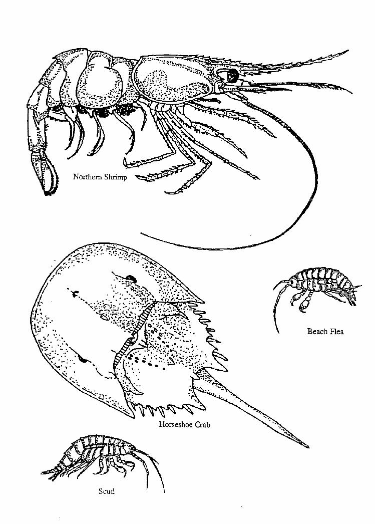
above high tide mark crawls under seaweedbeach flea
holds onto rocks with clamps onto rocksmuscular foot
chiton
burrows into mud closes shell tightlyclam
holds onto rocks with
muscular foot
clamps onto rocksdog whelk
holds onto rocks with
uscular foot
closes shell tightlydog winkle
holds onto rocks with
muscular footlimpet
attaches to rocks with
with byssus threadscloses shell tightlymussel
holds onto rocks with
muscular footperiwinkle
crawls under rocksrock crab uses claws to scavenge
crawls under rockshermit crab uses claws to scavenge
ORGANISM WAVE SURVIVAL
blood worm burrows into mud
attaches to rocks
and seaweed
PROTECTION FROM
DRYING
pulls plume into tube;has plug for end
clamps onto rocks trappingwater under shell; formsclusters in sheltered spots
clamps onto rocks; retreatsinto shell
crawls to moist areas
under rocks
pulls into shell; crawls towetter area
catches food with hook-
like jaws
catches food with hornyprotruding !aw
opens shell; hand-likestructure strains food
through mouth; scavenger
mouth, located in front offoot, scrapes tiny plantsoff rocks
pumps water through shellto filter food
rasps prey with file-likemouth part
rasps or drills into musselsor other shelled animals
mouth, located in frontof foot, scrapes tiny plantsoff rocks
pumps water throughshell to filter food
rasps seaweed with tinyfile-like mouth part