appendix e flood protection - university of south florida
TRANSCRIPT

Little Sarasota Bay Water Quality Management Plan
Appendix E Flood Protection
December 2012
Little Sarasota Bay Water Quality Management Plan
APPENDIX E i FLOOD PROTECTION
TABLE OF CONTENTS
1.0 INTRODUCTION ........................................................................................................... 1-1
2.0 BACKGROUND ............................................................................................................. 2-1
3.0 FLOOD-PROTECTION LEGISLATION AND ORDINANCES .................................. 3-1 3.1 LEGISLATION ................................................................................................... 3-1 3.2 LOCAL ORDINANCES ..................................................................................... 3-2
4.0 FLOOD PROTECTION LEVEL OF SERVICE (FPLOS) ............................................. 4-1
5.0 PLANNING STUDIES AND EFFORTS ........................................................................ 5-1 5.1 BASIN MASTER PLANNING ........................................................................... 5-1
5.1.1 Holiday Bayou ......................................................................................... 5-3 5.1.2 Clower Creek ........................................................................................... 5-3 5.1.3 South Creek .............................................................................................. 5-3 5.1.4 Catfish Creek ........................................................................................... 5-4 5.1.5 Elligraw Bayou ........................................................................................ 5-4 5.1.6 North Creek .............................................................................................. 5-4
5.2 WATERSHED MODELING AND MAP MODERNIZATION ......................... 5-5 5.3 CAPITAL IMPROVEMENT PROJECTS .......................................................... 5-6
6.0 CONCLUSION ................................................................................................................ 6-1
LIST OF FIGURES
Figure 2-1 Floodplain Changes Schematic (Adapted from www.dnr.sc.gov/) ..................... 2-1 Figure 4-1 Acceptable Flooding for a 100-Year Storm ......................................................... 4-2 Figure 5-1 Basin Boundaries ................................................................................................. 5-2 Figure 5-2 Little Sarasota Bay Watershed CIP Project ......................................................... 5-7
LIST OF TABLES
Table 4-1 Stormwater Quantity Level of Service (FPLOS) Design Criteria ....................... 4-1 Table 4-2 Acceptable Flooding Criteria ............................................................................... 4-2 Table 5-1 Little Sarasota Bay Watershed CIP Projects ........................................................ 5-8
Little Sarasota Bay Water Quality Management Plan
APPENDIX E 1-1 INTRODUCTION
11..00 IINNTTRROODDUUCCTTIIOONN
he Little Sarasota Bay Watershed is subject to coastal and inland flooding. Coastal flooding sources include storm surge and wind-driven waves. Inland flooding results from excessive rainfall. Storm surges are caused by high winds, and coastal and inland
flooding are usually associated with hurricanes or other tropical weather events. The relatively flat and low-lying topography and of Sarasota County make it inherently prone to both types of flooding, and the County’s “poorly drained” soils further promote inland flooding. Additionally, development has changed the natural environment within the Little Sarasota Bay Watershed and likely exacerbated the flooding problem before modern stormwater management regulations were implemented. Increased impervious surfaces throughout the heavily urbanized Clower Creek, Catfish Creek, North Creek, South Creek, Elligraw Bayou, Holiday Bayou, and Coastal basins have decreased the rainfall infiltration, and gutters and storm sewers speed runoff to the channels. As a result, more water runs off more quickly, and drainage systems including creeks can become overloaded, leading to flooding. The Sarasota County Watershed Management Program endeavors to address inland flooding. The County’s goal with regard to flood protection is to minimize flood risk to protect human safety and property in existing developed areas while protecting natural and beneficial functions of the remaining floodplain. This Watershed Quality Management Plan (WQMP) does not contain new analyses of flood conditions since the conditions have been analyzed and recommendations for improvements were previously proposed. Instead, this WQMP provides an overview of existing flood-protection-related activities and previous flood-protection recommendations. This section is an important component of the WQMP as flooding in the watershed directly impacts water quality in the tributaries and bay. Water quality best management practices (BMPs) are often designed to capture debris and sediment and remove pollutants during low-flow events and may not be as effective during larger storm events. Additionally, during large storm events, runoff may pool or flow in areas outside of drainage systems, such as over roads or in parking lots, and may collect more debris and pollutants than a low-flow event fully contained within a drainage system with water quality BMPs. Therefore, reducing the risk of flooding is an important component of improving water quality in Sarasota Bay. This overview includes a background section followed by a description of the significant flood-protection-related policies, programs, planning studies, and efforts and a summary of flood-protection activities for Sarasota County.
T
Little Sarasota Bay Water Quality Management Plan
APPENDIX E 2-1 BACKGROUND
22..00 BBAACCKKGGRROOUUNNDD
istorically, the Little Sarasota Bay Watershed consisted of pine and palmetto flatwoods with scattered isolated wetlands that sometimes connected during the rainy season. This diverse landscape provided significant flood storage capacity as well as a slow
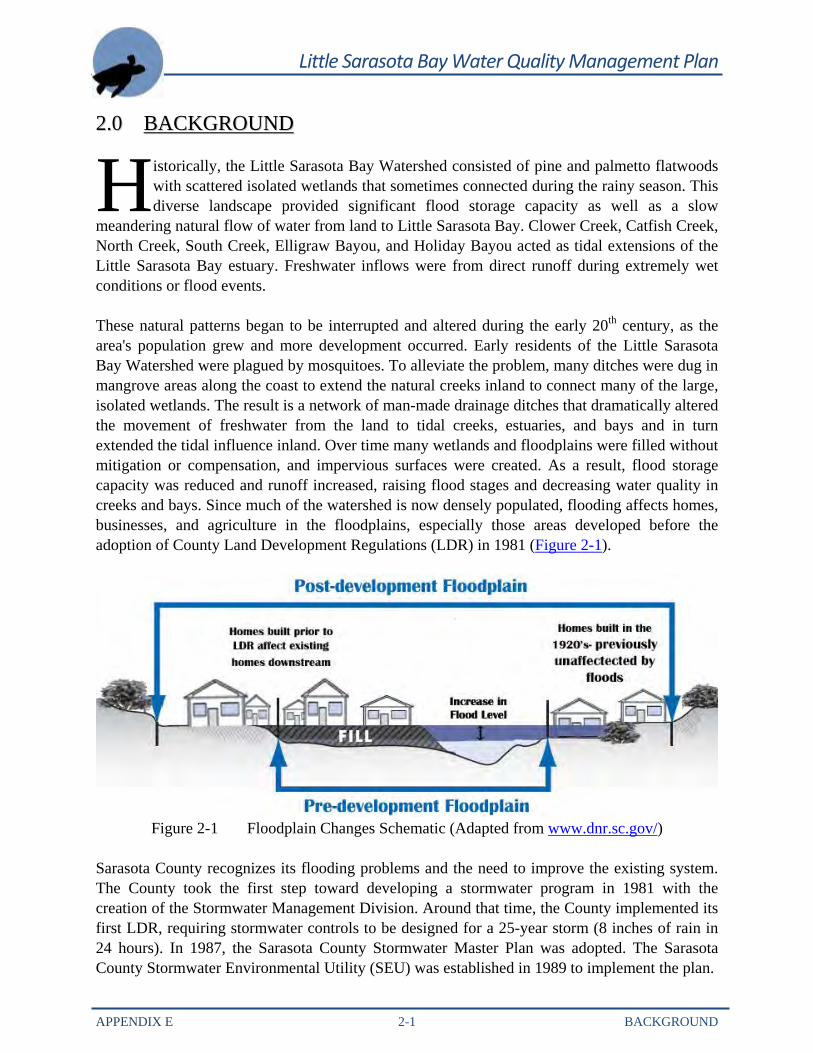
meandering natural flow of water from land to Little Sarasota Bay. Clower Creek, Catfish Creek, North Creek, South Creek, Elligraw Bayou, and Holiday Bayou acted as tidal extensions of the Little Sarasota Bay estuary. Freshwater inflows were from direct runoff during extremely wet conditions or flood events. These natural patterns began to be interrupted and altered during the early 20th century, as the area's population grew and more development occurred. Early residents of the Little Sarasota Bay Watershed were plagued by mosquitoes. To alleviate the problem, many ditches were dug in mangrove areas along the coast to extend the natural creeks inland to connect many of the large, isolated wetlands. The result is a network of man-made drainage ditches that dramatically altered the movement of freshwater from the land to tidal creeks, estuaries, and bays and in turn extended the tidal influence inland. Over time many wetlands and floodplains were filled without mitigation or compensation, and impervious surfaces were created. As a result, flood storage capacity was reduced and runoff increased, raising flood stages and decreasing water quality in creeks and bays. Since much of the watershed is now densely populated, flooding affects homes, businesses, and agriculture in the floodplains, especially those areas developed before the adoption of County Land Development Regulations (LDR) in 1981 (Figure 2-1).
Figure 2-1 Floodplain Changes Schematic (Adapted from www.dnr.sc.gov/)
Sarasota County recognizes its flooding problems and the need to improve the existing system. The County took the first step toward developing a stormwater program in 1981 with the creation of the Stormwater Management Division. Around that time, the County implemented its first LDR, requiring stormwater controls to be designed for a 25-year storm (8 inches of rain in 24 hours). In 1987, the Sarasota County Stormwater Master Plan was adopted. The Sarasota County Stormwater Environmental Utility (SEU) was established in 1989 to implement the plan.
H
Little Sarasota Bay Water Quality Management Plan
APPENDIX E 2-2 BACKGROUND
By the early 1990s, the Sarasota County SEU initiated a Countywide basin master planning project to develop hydrologic and hydraulic models to identify problematic flooding areas for all of the County’s major watersheds. These models are also used to analyze proposed drainage improvements to the County’s stormwater system. The Basin Master Plans for the Clower Creek, Catfish Creek, North Creek, South Creek, Elligraw Bayou, and Holiday Bayou basins were completed between 1994 and 2001. In addition, SEU continues to maintain the model by updating it periodically. The updated model is made available to developers to use as the base model to ensure that proposed projects will not impact neighboring areas. Since the models were developed, three notable efforts have been associated with them:
County staff and multiple consultants have updated the model based on additional information, Capital Improvement Program (CIP) projects, and development projects. The updates follow specific methodologies with detailed documentation and include independent reviews.
Multiple consultants performed a peer review of the model and the associated GIS
databases in 2004 in conjunction with the County and Southwest Florida Water Management District (SWFWMD). Potential issues were identified in peer review reports.
As part of the Map Modernization project for Sarasota County, Jones Edmunds
performed detailed updates to the Little Sarasota Bay model and GIS database. These updates were completed in 2007. Jones Edmunds completed a more limited update in 2008.
In the mid 1990s, the LDR was modified to require stormwater systems to be designed for a 100-year storm (10 inches of rain in 24 hours). The County also started the first stormwater capital improvement assessments. The County then completed feasibility analyses for projects in problem areas identified in the Basin Master Plans. Several of these projects are included in the County’s CIP. By the late 1990s, the SEU Strategic Plan was adopted and revenue bonds were issued to fund stormwater improvement projects. Today, several CIP projects, such as stormwater control structures, retrofit projects, and retention and detention ponds, have been constructed throughout the Little Sarasota Bay Watershed (Figure 5-2). Regular maintenance of stormwater management systems is essential to ensure the efficient function of existing stormwater conveyances and the new stormwater facilities. The County’s Environmental Services Department follows a 1999 Strategic Maintenance Plan for the Drainage Operations Division. The plan identifies maintenance practices and classifies practices into Routine, Extraordinary, and Support activities in which the staff engages for maintenance repairs, improvement, management, and operation of the public stormwater system. For more information on Stormwater Management Facility Maintenance, refer to Chapter 7 of the Roberts Bay North Watershed Management Plan.
Little Sarasota Bay Water Quality Management Plan
APPENDIX E 3-1 FLOOD-PROTECTION LEGISLATION AND ORDINANCES
33..00 FFLLOOOODD--PPRROOTTEECCTTIIOONN LLEEGGIISSLLAATTIIOONN AANNDD OORRDDIINNAANNCCEESS
he Sarasota County Comprehensive Plan is an official public document adopted by the Board of County Commissioners and approved by the State to provide the policy direction used in framing land use decision and growth management initiatives. The plan
covers legislation that has been adopted, planning studies and mitigation efforts, and levels of service for stormwater quality and quantity. The plan is subject to an annual amendment cycle as well as the Evaluation and Appraisal Report requirement every 7 years (last EAR update, November 2006). The 11 chapters that comprise the Sarasota County Comprehensive Plan include data and maps on and analysis of existing conditions and—based on that information—goals objectives, and policies to guide future development and conservation activities. 3.1 LEGISLATION The five water management districts—including SWFWMD—were initially created by the State of Florida to control flooding. The SWFWMD Governing Board is authorized in Chapter 373 and other chapters of the Florida Statutes to direct a wide range of programs, initiatives, and actions. These programs include flood control, regulatory programs, water conservation, education, and supportive data collection and analysis. SWFWMD’s goals for flood protection, water quality, and natural systems are:
To minimize the potential for damage from floods by protecting and restoring the natural water storage and conveyance functions of flood-prone areas.
To protect water quality by preventing further degradation of water resources and enhancing water quality wherever possible.
To preserve, protect, and restore natural systems to support their natural hydrologic and ecologic functions.
Sarasota County supports the following State regulations through its Comprehensive Plan and a series of ordinances:
Chapter 40D-2, Florida Administrative Code (FAC), includes stormwater system design criteria.
Chapter 40D-4 and Chapter 40D-40, FAC, state that SWFWMD governs surface water permitting and stormwater runoff.
Chapter 40D-4 limits peak discharge rates for new development. Rules also stipulate that activities affecting floodplains and floodways will not cause adverse impacts, such as increased flooding.
T
Little Sarasota Bay Water Quality Management Plan
APPENDIX E 3-2 FLOOD-PROTECTION LEGISLATION AND ORDINANCES
3.2 LOCAL ORDINANCES New developments are required to consider the impacts of a 100-year storm event to protect existing structures with the first habitable floor elevation at or just above the estimated 100-year, 24-hour flood elevation required by the Federal Emergency Management Agency (FEMA) and Sarasota County Ordinance No. 92-055 as amended. Unless properly managed, the increased volume and rate of runoff as well as the change in timing from upstream new developments will increase 100-year flood elevations, thus impacting structures built to previously lower flood elevations. Sarasota County Ordinance No. 2009-060 provides building construction requirements to maintain eligibility for flood insurance coverage in flood-prone areas in the unincorporated area of the County. This Ordinance amends Ordinance No. 92-055 as it relates to definition, adoption of flood hazard map, lowest floor elevation, machinery and equipment, and provides an effective date. The policy provides a guide for all new residential and non-residential construction and substantial improvements to existing residential and non-residential structures’ lowest floor elevation in reference to the base flood elevation. Sarasota County Ordinance No. 81-12, “Land Development Regulations,” as amended provides regulations that guide development as it pertains to the force of flowing water and drainage of runoff. These regulations require that post-development conditions do not exceed those under pre-development conditions for the 100-year storm. Furthermore, the LDR regulates development activities within the 100-year floodplain by withholding approval “unless the developer submits substantial and competent evidence that all lands intended for use as building sites can be used safely for building purposes, without undue hazard from flood or adverse soil or foundation conditions.” The LDR requires use of the applicable basin flood prediction model as the basis of review to ensure that development proposals of 35 or more total acres or 8 or more acres of impervious area will not result in an increase in offsite flood stages. Additionally, Ordinance No. 81-12 as amended requires new development to provide for the treatment of the first 1 inch of runoff. The Water Pollution Control Code, Ordinance No. 96-020 as amended provides regulations to prohibit discharge that cause pollution to surface water, groundwater, or the stormwater conveyance systems.
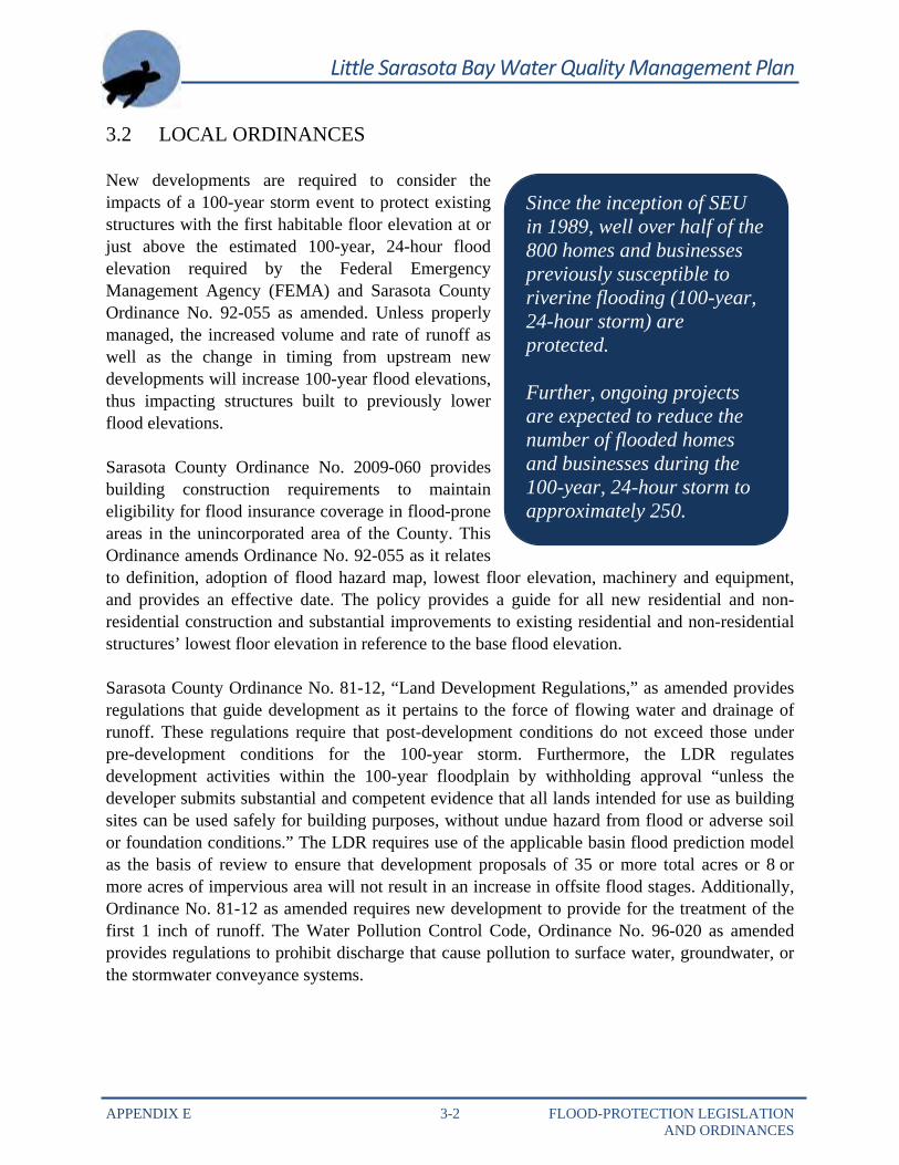
Since the inception of SEU in 1989, well over half of the 800 homes and businesses previously susceptible to riverine flooding (100-year, 24-hour storm) are protected. Further, ongoing projects are expected to reduce the number of flooded homes and businesses during the 100-year, 24-hour storm to approximately 250.
Little Sarasota Bay Water Quality Management Plan
APPENDIX E 3-3 FLOOD-PROTECTION LEGISLATION AND ORDINANCES
Sarasota County established SEU in 1989 (Ordinance No. 89-117, as amended). SEU is responsible for funding, planning, and constructing improvements and maintaining the County’s storm and surface water management facilities. SEU has been instrumental to the County’s progress in protecting existing homes from flooding as well as allocating significant resources to identify the riverine floodplain in rural areas to help guide development away from flood-prone areas. The Ordinance provides funding for the operation of SEU by enacting a “user fee.” Each parcel of land is charged an annual fee based on the characteristics of the parcel and its relative contribution to stormwater runoff. An associated “credit” program was enacted that enables “credits” to be granted against the “user fee” for properties that maintain their drainage facilities in full-functioning condition. SEU is also responsible for permitting proposed changes in the watershed. Sarasota County adopted a floodplain management ordinance (Ordinance No. 2003-085 as amended). This ordinance adopts the current FEMA Flood Insurance Study and the Sarasota County Flood Studies. Minimum lowest finished floor elevations for new construction and substantial improvements are required to be either at or above the base flood elevation as determined by FEMA or 1 foot above the 100-year flood stages established by Sarasota County. Since Fiscal Year 1993, the CIP contained funding for projects throughout the County. This program is well underway and is directed at addressing flood protection level-of-service (FPLOS) deficiencies, including flooded homes and businesses as well as flooded streets. To date, the primary focus of the stormwater improvement program has centered on flooded homes and businesses, with a secondary focus on street flooding. As this program reaches a point of diminishing returns in terms of addressing flooded buildings, it is likely to focus more on remaining street FPLOS deficiencies. In addition, flood insurance is another tool used to mitigate flood loss and assist in a community’s speedy recovery. Under the Community Rating System, flood insurance premium rates are adjusted to reflect the reduced flood risk resulting from BMPs. Sarasota County attained a Class 5 Rating in 2007, which equates to $5M–$6.3M in annual discounts for $11B in property protection.
Little Sarasota Bay Water Quality Management Plan
APPENDIX E 4-1 FLOOD PROTECTION LEVEL OF SERVICE (FPLOS)
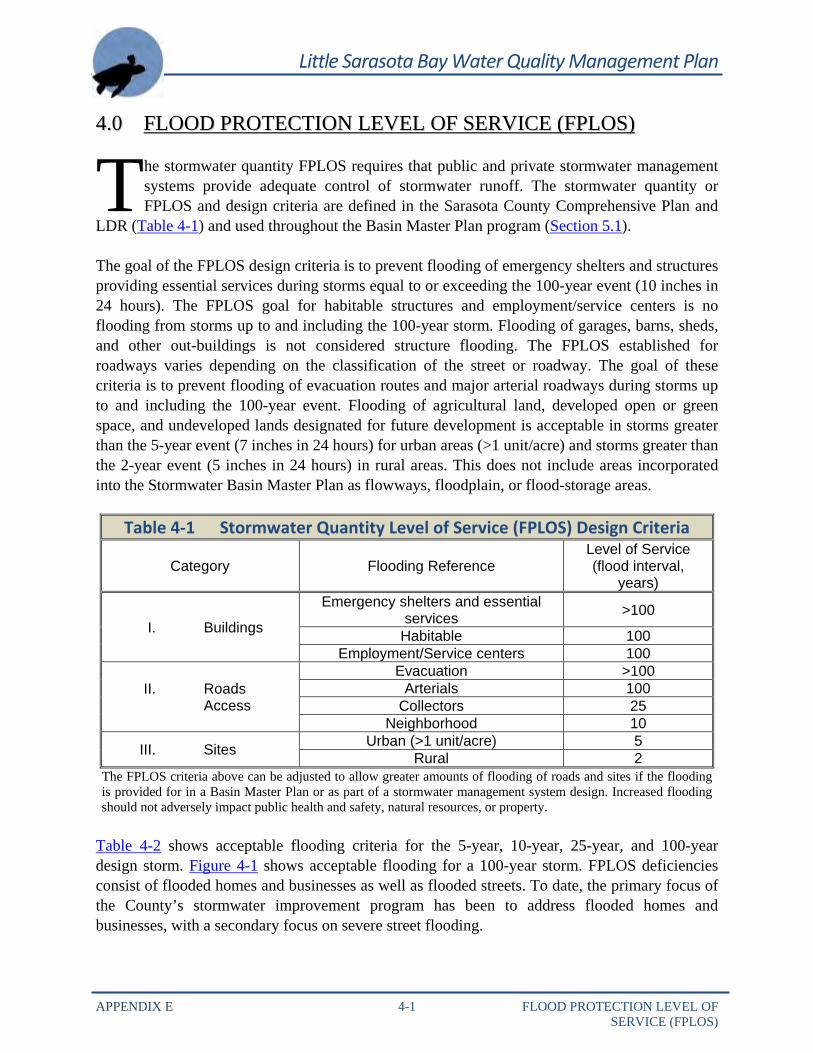
44..00 FFLLOOOODD PPRROOTTEECCTTIIOONN LLEEVVEELL OOFF SSEERRVVIICCEE ((FFPPLLOOSS))
he stormwater quantity FPLOS requires that public and private stormwater management systems provide adequate control of stormwater runoff. The stormwater quantity or FPLOS and design criteria are defined in the Sarasota County Comprehensive Plan and
LDR (Table 4-1) and used throughout the Basin Master Plan program (Section 5.1).
The goal of the FPLOS design criteria is to prevent flooding of emergency shelters and structures providing essential services during storms equal to or exceeding the 100-year event (10 inches in 24 hours). The FPLOS goal for habitable structures and employment/service centers is no flooding from storms up to and including the 100-year storm. Flooding of garages, barns, sheds, and other out-buildings is not considered structure flooding. The FPLOS established for roadways varies depending on the classification of the street or roadway. The goal of these criteria is to prevent flooding of evacuation routes and major arterial roadways during storms up to and including the 100-year event. Flooding of agricultural land, developed open or green space, and undeveloped lands designated for future development is acceptable in storms greater than the 5-year event (7 inches in 24 hours) for urban areas (>1 unit/acre) and storms greater than the 2-year event (5 inches in 24 hours) in rural areas. This does not include areas incorporated into the Stormwater Basin Master Plan as flowways, floodplain, or flood-storage areas.
Table 4-1 Stormwater Quantity Level of Service (FPLOS) Design Criteria
Category Flooding Reference Level of Service (flood interval,
years)
I. Buildings
Emergency shelters and essential services >100
Habitable 100 Employment/Service centers 100
II. Roads Access
Evacuation >100 Arterials 100
Collectors 25 Neighborhood 10
III. Sites Urban (>1 unit/acre) 5 Rural 2
The FPLOS criteria above can be adjusted to allow greater amounts of flooding of roads and sites if the flooding is provided for in a Basin Master Plan or as part of a stormwater management system design. Increased flooding should not adversely impact public health and safety, natural resources, or property.
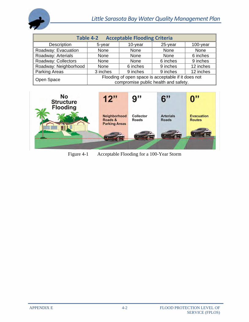
Table 4-2 shows acceptable flooding criteria for the 5-year, 10-year, 25-year, and 100-year design storm. Figure 4-1 shows acceptable flooding for a 100-year storm. FPLOS deficiencies consist of flooded homes and businesses as well as flooded streets. To date, the primary focus of the County’s stormwater improvement program has been to address flooded homes and businesses, with a secondary focus on severe street flooding.
T
Little Sarasota Bay Water Quality Management Plan
APPENDIX E 4-2 FLOOD PROTECTION LEVEL OF SERVICE (FPLOS)
Table 4-2 Acceptable Flooding Criteria Description 5-year 10-year 25-year 100-year
Roadway: Evacuation None None None None Roadway: Arterials None None None 6 inches Roadway: Collectors None None 6 inches 9 inches Roadway: Neighborhood None 6 inches 9 inches 12 inches Parking Areas 3 inches 9 inches 9 inches 12 inches
Open Space Flooding of open space is acceptable if it does not compromise public health and safety.
Figure 4-1 Acceptable Flooding for a 100-Year Storm
Little Sarasota Bay Water Quality Management Plan
APPENDIX E 5-1 PLANNING STUDIES AND EFFORTS
55..00 PPLLAANNNNIINNGG SSTTUUDDIIEESS AANNDD EEFFFFOORRTTSS
he drainage plans and programs from the early 1920s through the 1960s emphasized the removing surface waters from the land, primarily for mosquito control and agricultural uses. Water quality did not begin emerging as a major concern until the late 1960s.
In 1984, the Board of County Commissioners recognized major inadequacies in the existing stormwater management system and authorized the preparation of a Stormwater Master Plan to assess the need for improving major drainage systems in the developed portions of the County. The objectives of the plan included:
Assessing the adequacy of primary stormwater conveyance systems in developed or developing basins.
Estimating the cost for public stormwater improvements as watersheds are developed to their ultimate use.
Prioritizing stormwater management needs of each basin within a framework of the needs within the entire County.
Developing a plan or identifying options available to the County for financing the cost of construction, operation, and maintenance of stormwater management facilities.
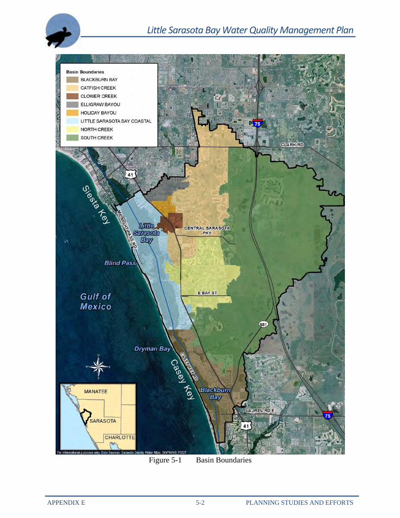
5.1 BASIN MASTER PLANNING Numerous hydrologic studies dating back to the late 1950s have been completed throughout Sarasota County; by late 2001 the Basin Master Plans for the Clower Creek, Catfish Creek, North Creek, South Creek, Elligraw Bayou, and Holiday Bayou basins were completed. See Figure 5-1. These Basin Master Plans were based on a detailed analysis of these studies of existing and projected land uses, existing drainage facilities, and projected stormwater management needs. This information was used to develop hydrologic and hydraulic models using ICPR’s routing engine to simulate runoff, conveyance, and flooding conditions for these Little Sarasota Bay subbasins. Model results were used to identify the location and magnitude of existing flooding problems in the basins. Based on model results, the plans provide recommendations for facilities improvements and management standards that will need to be met by the private sector for new construction and the expansion of existing activities to bring stormwater conveyance systems within the basins into compliance with the recommended FPLOS criteria.
T
Little Sarasota Bay Water Quality Management Plan
APPENDIX E 5-2 PLANNING STUDIES AND EFFORTS
Figure 5-1 Basin Boundaries
Little Sarasota Bay Water Quality Management Plan
APPENDIX E 5-3 PLANNING STUDIES AND EFFORTS
An important product of the Basin Master Plan effort is the horizontal limits of the riverine, 100-year floodplain. Much of the County riverine floodplain maps to be used for local stormwater management planning have been completed. These maps and the detailed flood-prediction models must, however, be kept up to date to reflect changes in the watershed, such as land development and stormwater projects, or they will become obsolete.
5.1.1 Holiday Bayou The assessment of the Holiday Bayou Basin Master Plan found no areas that are prone to flooding in excess of the FPLOS criteria. There are no known habitable structures flooding from the 5-, 10-, 25-, and 100-year floods. There was road flooding as result of the un-named 1995 storm event of 9 to 11 inches of rainfall on July 18, 1995. However, these roads are private and not considered evacuation routes. The Basin Master Plan recommends several alternatives that will eliminate the potential flooding of the roads from the 100-year storm. In spring 2001, the updated Basin Master Plan identified one structure susceptible to flooding. The BMP indicates that the structure flooding can best be addressed by the Florida Department of Transportation enlarging the downstream culvert under US 41 when this section of US 41 is improved. The plan also identifies flooding of Beneva Road, which was addressed by the completion of the Holiday Bayou Canal/Beneva Road–Holiday Bayou Basin CIP.
5.1.2 Clower Creek The Clower Creek Basin Master Plan did not identify any flooding deficiencies. 5.1.3 South Creek Results of the 2001 South Creek Basin Master Plan indicate that no structure FPLOS deficiencies exist in the South Creek Basin. However, several local street segments are susceptible to flooding in excess of the FPLOS criteria. The South Creek Basin Master Plan made preliminary investigations of existing FPLOS deficiencies, recommended several stormwater improvement projects, and encouraged the use of regional stormwater facilities. In the July 1995 storm, overflow from the South Creek basin into the North Creek basin was observed. The flooding was
Little Sarasota Bay Watershed Basin Master Plans:
• Clower Creek – March 1994 • Catfish Creek – July 2001 • North Creek – April 1999 • South Creek – June 2001 • Elligraw Bayou – April 1994 • Holiday Bayou – August 1997
Little Sarasota Bay Water Quality Management Plan
APPENDIX E 5-4 PLANNING STUDIES AND EFFORTS
caused by two significant impediments to flow. First, a major inlet at the intersection of Bay Street and Old Venice Road became completely covered with debris, preventing drainage from the Bay Street and the surrounding area. This inlet has since been re-constructed to make it less susceptible to clogging. Second, the Brazilian pepper growth in South Creek south of the east extension of Bay Street in Oscar Scherer State Park severely restricted the flow through a segment of the creek. After the Oscar Scherer State Park staff cleared the Brazilian pepper, a similar un-named storm event on November 14, 1997 of 10 inches of rainfall resulted in flood stages that were 2.5 to 3 feet lower. 5.1.4 Catfish Creek According to the Catfish Creek Basin Master Plan, the Country Club of Sarasota experienced chronic and severe road flooding. Street flooding was approximately 3 feet deep and lingered for up to a week following large storm events. Between 1986 and 1989, the stormwater infrastructure improvements undertaken by the Palmer Ranch have resolved the street flooding in this area. The Basin Master Plan cites poor-to-moderate drained soils as the cause for 12 structures’ and 12 streets’ FPLOS deficiencies in the upper Catfish basins. To reduce the potential exacerbation of the Clark Road flooding in the upper Catfish basins, the County adopted the Clark Road Corridor Plan that restricted the peak discharge from new development so that the post-development 100-year peak discharge could not exceed the pre-development 2-year event peak discharge. Ten public streets including an evacuation route and arterial and local streets experience FPLOS deficiencies. The Stormwater Capital Improvement Section evaluated recommendations from the Catfish Basin Master Plan and pursued land acquisition for storage facilities to reduce flooding. As a result of this effort, the County recently completed construction of the Catfish Creek Regional–Catfish Creek Basin, which will reduce flooding in the area. Completion of this project eliminates the need for the pre-post requirements set in the Clark Road Corridor Plan. 5.1.5 Elligraw Bayou The Elligraw Bayou Basin Master Plan identifies numerous flood-prone areas. Fifty habitable structures are estimated to be susceptible to flooding from 100-year floods. The Employment/ Service Center was also identified to be flood-prone during the 100-year flood. Based on the 100-year analysis, 14 public streets including arterial, collector, and local streets experience FPLOS deficiencies with flood depths ranging 0.9 to 2.4 feet. The Elligraw Bayou Basin Master Plan recommends three alternatives to address the FPLOS deficiencies. The Pinehurst Street/Bilmore Drive project was completed and addressed structural flooding within the area. 5.1.6 North Creek In June 2000, Stormwater staff presented the findings for the North Creek Basin Master Plan Update to the Board of County Commissioners. In the memo, Stormwater staff has confirmed flooding of 16 residential structures in addition to widespread street flooding within the basin.
Little Sarasota Bay Water Quality Management Plan
APPENDIX E 5-5 PLANNING STUDIES AND EFFORTS
Two capital projects were recommended to resolve these structure and street flooding FPLOS deficiencies. The Osprey Acres project was completed in 2000. This project addresses all but two of the structures that flood and provides major reductions in street flooding to meet the FPLOS. The two structures that will remain in the floodplain have finished floor elevations at or below the lowered flood elevation expected to be achieved by the project. The Bay Street project involves some inlet reconstruction and conveyance improvement at Bay Street and Old Venice Road. The construction was completed in summer 2000 and reduced local road flooding to meet the FPLOS. 5.2 WATERSHED MODELING AND MAP MODERNIZATION The County uses and maintains hydrologic and hydraulic watershed-specific models for most of the County. These models are used for development and CIP purposes to ensure that no adverse offsite impacts occur. Over time, land development, stormwater projects, erosion, and natural forces change water flow and drainage patterns. The risk of flooding in certain areas changes along with these factors. The detailed flood prediction models and County floodplain maps must therefore be updated regularly to be used for local stormwater management planning. Sarasota County is partnering with SWFWMD to provide model and flood map updates. SWFWMD became a Cooperative Technical Partner with the FEMA in 2001 to:
Digitize the current paper flood maps, which were most recently updated in 1992. Input up-to-date flood data from more current Flood Study Updates for the
County’s 28 watershed basins. The digital maps will reflect current flood risks, include areas of recent growth, and replace older paper maps. New digital mapping techniques and more detailed terrain information will provide more detailed, reliable, and current data on flood hazards. The new digital maps—known as Digital Flood Insurance Rate Maps or DFIRMs—will provide up-to-date, reliable information on a property-by-property basis electronically. The DFIRMs will include updated flood risks for riverine and coastal flooding and will generally be based on the 2007 LiDAR in NAVD 1988. After an adoption period, the maps will become the effective flood information for the National Flood Insurance Rate Program. The County will also continue to update the floodplain maps and models for flood insurance and stormwater management planning needs. The map modernization process is a concurrent work effort with this WQMP and will bring Little Sarasota Bay Watershed floodplain mapping up to 2007 LiDAR standards.
Little Sarasota Bay Water Quality Management Plan
APPENDIX E 5-6 PLANNING STUDIES AND EFFORTS
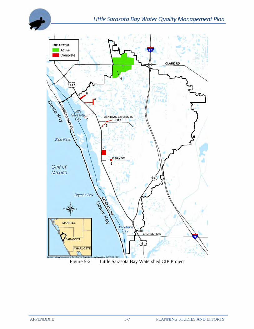
5.3 CAPITAL IMPROVEMENT PROJECTS CIPs address FPLOS deficiencies for structures and roadways. SEU started its first CIP projects in 1994 to address structure flooding and severe street flooding. Stormwater Improvement Assessments were initiated in 1995. A revolving 5-year plan of CIPs, as required by the Comprehensive Plan, was established to prioritize the initiation and implementation of the projects. CIP projects in the Little Sarasota Bay Watershed are presented in Figure 5-2 and Table 5-1.
Little Sarasota Bay Water Quality Management Plan
APPENDIX E 5-7 PLANNING STUDIES AND EFFORTS
Figure 5-2 Little Sarasota Bay Watershed CIP Project
Little Sarasota Bay Water Quality Management Plan
APPENDIX E 5-8 PLANNING STUDIES AND EFFORTS
Table 5-1 Little Sarasota Bay Watershed CIP Projects Map ID Project ID Project Title Project Description Project Status
1 75810 Catfish Creek
Regional – Catfish Creek Basin
The project will alleviate structure flooding of businesses and reduce street flooding on Clark Road, a major evacuation arterial. The project will involve creating a regional stormwater facility downstream of Clark Road to address street flooding and structural flooding.
Complete
2 85728 Clower Creek This project was added by IFAS upload. Complete
3 85837 Holiday Bayou
Canal/Beneva Road – Holiday Bayou Basin
This project involves improvements to the Beneva Road Drainage System to address roadway flooding (evacuation route) and improvements to the Holiday Bayou Canal to accommodate the increased flow from Beneva Road. During project design, the US 41 crossing will be evaluated for possible replacement to eliminate flooding of the Sunset Dodge dealership. This project also includes an update to the Holiday Bayou Basin Master Plan to better define the floodplain units.
Active
4 85879 Clark Road/Catfish Creek
This project was added by IFAS upload. Complete
Little Sarasota Bay Water Quality Management Plan
APPENDIX E 5-9 PLANNING STUDIES AND EFFORTS
Table 5-1 Little Sarasota Bay Watershed CIP Projects
5 85880 CH 11-80 – Catfish Creek
The project area is located on Catfish Creek approximately 900 feet upstream of US 41. This project involves the redesigning and re-permitting two concrete check dams and wetland littoral planting areas. Additional work will consist of removing existing sediment deposits within the channel near US 41 and excavating between the proposed check dam locations.
Complete
6 85886 Bay Street – North Creek Basin
The proposed improvements have been identified in North Creek Basin Study. The project will work in conjunction with the Osprey Acres project to reduce area structure and street flooding.
Complete
7 85887 Osprey Acres – North Creek Basin
This project has been identified in the preliminary phase of the North Creek Basin Study as a priority project to reduce structure flooding. Proposed improvements include modifying the control structure in the Oaks, replacing the corrugated metal pipe (CMP) along Glenwood Avenue, regrading road swales, and adding a pipe outfall to the Oaks Subdivision.
Complete
8 85881/85882 Pinehurst Street/Biltmore Drive
The Pinehurst project involves enlarging the storm sewer at both project areas, which will provide an increase conveyance capacity and efficiency.
Complete
Information provided by Sarasota County. Please contact the County office for additional details. Complete: Project that has been constructed. Active: Project that is currently being constructed.
Little Sarasota Bay Water Quality Management Plan
APPENDIX E 6-1 CONCLUSION
66..00 CCOONNCCLLUUSSIIOONN
arasota County has flood-protection-related policies and programs in place to minimize flood risk to protect human safety and property in existing developed areas while protecting natural and beneficial functions of the remaining floodplain. In addition, the
County LDR guide new development as it pertains to the force of flowing water and drainage of runoff. Several CIP projects—such as stormwater control structures and detention ponds—were implemented, were proposed, or are currently occurring throughout the watershed.
S