appendix e – idnr guidance - in.gov of contents appendix e – idnr guidance e idnr list of...
TRANSCRIPT

APPENDIX E – IDNR GUIDANCE

T A B LE O F C O N T E NT S
Appendix E – IDNR Guidance ...................................................................................................... E IDNR List of Indiana Waterways Declared Navigable ................................................................................ 1 IDNR - Public Freshwater Lakes ................................................................................................................. 9 IDNR – Salmonid Streams ......................................................................................................................... 17 IDNR - Indiana Scenic Rivers .................................................................................................................... 18 IDNR – List of Outstanding Rivers and Streams ....................................................................................... 19 IDNR – INDOT Maintenance MOU .......................................................................................................... 21 IDNR – Construction in a Floodway – Checklist ....................................................................................... 33 IDNR – State Form 42946 ......................................................................................................................... 39 IDNR – Form N4 – State Form 52086 ....................................................................................................... 41 IDNR – Form N2 – State Form 50354 ....................................................................................................... 42
Intended Use of Manual for INDOT and Local Projects
This manual has been written to set expectations for waterway permitting deliverables and review paths for projects developed by the Indiana Department of Transportation (INDOT). Other projects may also benefit from the guidance in this manual. Specifically, preparers of permits for local projects that receive federal funds and which follow INDOT standard specifications are encouraged to use this manual; however, INDOT does not review permits or other related deliverables for local projects.

Appendix E – IDNR Guidance
IDNR LIST OF INDIANA WATERWAYS DECLARED NAVIGABLE LISTED BY COUNTY NAME
A Adams County
(1) [St. Marys River: Nonnavigable.] (2) [Wabash River: Nonnavigable.]
Allen County (1) Little River: Navigable from its junction with the Wabash River 20.2 river miles to Ellison Road. (2) Maumee River: Navigable from the Indiana-Ohio state line 27.05 river miles to the Hosey Dam (Fort Wayne). (3) [St. Mary's River: Nonnavigable.]
B Bartholomew County
(1) Driftwood River: Navigable from its junction with the East Fork of the White River (Columbus) to the county line. (2) East Fork of White River: Navigable from the county line to its junction with the Driftwood and Flatrock Rivers (Columbus). (3) Flatrock River: Navigable from its junction with the East Fork of the White River (Columbus) to the county line.
Benton County No waterway has been declared navigable or nonnavigable.
Blackford County No waterway has been declared navigable or nonnavigable.
Boone County No waterway has been declared navigable or nonnavigable. Brown County
(1) North Fork of Salt Creek: Navigable from its junction with Salt Creek for 36.7 river miles to its junction with David Branch (near Nashville). (2) Salt Creek: Navigable from its junction with the East Fork of the White River into Lake Monroe.
C Carroll County
(1) Tippecanoe River: Navigable throughout the county. (2) Wabash River: Navigable throughout the county.
Cass County (1) Wabash River: Navigable throughout the county.
Clark County (1) Bull Creek: Navigable from its junction with the Ohio River for 1.1 river miles. (2) Camp Creek: Navigable from its junction with the Ohio River for 1.7 river miles. (3) Fourteen Mile Creek: Navigable from its junction with the Ohio River for 2.9 river miles. (4) Lancassange Creek: Navigable from its junction with the Ohio River for 0.3 river miles. (5) Ohio River: Navigable throughout the county. (6) Silver Creek: Navigable from its junction with the Ohio River for 3.0 river miles.
Clay County (1) Eel River: Navigable throughout the county.
Clinton County No waterway has been declared navigable or nonnavigable.
Crawford County (1) Big Blue River: Navigable throughout the county. (2) Dry Run Creek: Navigable from its junction with the Big Blue River for 1.4 river miles. (3) Little Blue River: Navigable from its junction with the Ohio River for 10.6 river miles. (4) Mill Creek: Navigable from its junction with the Little Blue River for 1.4 river miles. (5) Ohio River: Navigable throughout the county.
D Daviess County
(1) East Pork of the White River: Navigable throughout the county. (2) West Fork of the White River: Navigable throughout the county.
Dearborn County (1) Great Miami River: Navigable throughout the county. (2) Hogan Creek (including North Fork and South Fork): Hogan Creek (Main Stem) is navigable from its junction with the Ohio River for the entire length (0.4 river miles). The North Fork of Hogan Creek is navigable from its
Indiana Department of Transportation Waterway Permitting Manual E 1

Appendix E – IDNR Guidance
junction with Hogan Creek for 4.9 river miles. The South Fork of Hogan Creek is navigable from its junction with Hogan Creek for 5.0 river miles. (3) Laughery Creek: Navigable from its junction with the Ohio River for 10.8 river miles (near Milton). (4) Ohio River: Navigable throughout the county. (5) Tanners Creek: Navigable from its junction with the Ohio River in Lawrenceburg for 10.6 river miles. (6) Whitewater River: Navigable throughout the county. (7) Wilson Creek: Navigable from its junction with the Ohio River for 1.9 river miles.
Decatur County (1) Flatrock River: Navigable throughout the county.
DeKalb County No waterway has been declared navigable or nonnavigable.
Delaware County (1) Mississinewa River: Navigable throughout the county. (2) West Fork of the White River: Navigable to Smithfield.
Dubois County (1) Flat Creek: Navigable from its junction with the Patoka River throughout the county. (2) East Fork of the White River: Navigable throughout the county. (3) Patoka River: Navigable throughout the county.
E Elkhart County
(1) Baugo Creek (formerly Bangango Creek). (2) St. Joseph River: Navigable throughout the county.
F Fayette County
(1) West Fork of the Whitewater River: Navigable to the three forks (near Connersville). Floyd County
(1) Ohio River: Navigable throughout the county. (2) Silver Creek: Navigable from its junction with the Ohio River for 3.0 river miles.
Fountain County (1) Wabash River: Navigable throughout the county.
Franklin County (1) East Pork of the Whitewater River: Navigable throughout the county from its junction with the Whitewater River. (2) West Fork of the Whitewater River: Navigable throughout the county from its junction with the Whitewater River. (3) Whitewater River: Navigable throughout the county.
Fulton County No waterway has been declared navigable or nonnavigable. There is a discussion of navigability relative to a determination that Nyona Lake as a public freshwater lake in Bath v. Courts, Ind. App., 459 N.E. 2d 72 (1984).
G Gibson County
(1) Patoka River (also known as Houchins Ditch): Navigable throughout the county from its junction with the Wabash River. (2) Wabash River: Navigable throughout the county. (3) White River: Navigable throughout the county from its junction on the Wabash River.
Grant County (1) Mississinewa River: Navigable throughout the county.
Greene County (1) Black Creek: Navigable to near Marco. (2) Eel River: Navigable throughout the county from its junction with the West Fork of the White River. (3) West Fork of the White River: Navigable throughout the county.
H Hamilton County
(1) West Fork of the White River: Navigable throughout the county. Hancock County
(1) Big Blue River: Navigable throughout the county. Harrison County
(1) Big Blue River: Navigable throughout the county from its junction with the Ohio River. (2) Buck Creek: Navigable 5.8 river miles from its junction with the Ohio River.
Indiana Department of Transportation Waterway Permitting Manual E 2

Appendix E – IDNR Guidance
(3) Indian Creek: Navigable 4.8 river miles from its junction with the Ohio River. (4) Mosquito Creek: Navigable 2.8 river miles from its junction with the Ohio River. (5) Ohio River: Navigable throughout the county. (6) Potato Run: Navigable 0.4 river miles from its junction with the Ohio River.
Hendricks County (1) Mud Creek: Navigable to Tudor Road (near Hazelwood).
Henry County (1) Flatrock River: Navigable throughout the county.
Howard County No waterway has been declared navigable or nonnavigable.
Huntington County (1) [Huntington Lake: Nonnavigable for interstate commerce.] (2) Little River: Navigable throughout the county from its junction on the Wabash River. (3) Wabash River: Navigable throughout the county.
J Jackson County
(1) East Fork of White River: Navigable throughout the county. (2) Muscatatuck River: Navigable throughout the county.
Jasper County (1) Iroquois River: Navigable to near Parr. (2) Kankakee River: Navigable throughout the county.
Jay County No waterway has been declared navigable or nonnavigable.
Jefferson County (1) Big Saluda Creek: Navigable 1.0 river miles from its junction with the Ohio River. (2) Indian-Kentuck Creek: Navigable 3.8 river miles from its junction with the Ohio River. (3) Ohio River: Navigable throughout the county.
Jennings County (1) Muscatatuck River: Navigable to the main forks.
Johnson County (1) Big Blue River: Navigable throughout the county. (2) East Fork of White River: Navigable to its junction with the Flatrock and Driftwood rivers. (3) Sugar Creek: Navigable from its junction with the Big Blue River (to form the Driftwood River) throughout the county. (4) West Fork of White River: Navigable throughout the county.
K Knox County
(1) Black Creek: Navigable from its junction with the West Fork of the White River (near Edwardsport) throughout the county. (2) Busseron Creek: Navigable throughout the county. (3) Wabash River: Navigable throughout the county. (4) West Fork of White River: Navigable throughout the county from its junction with the White River. (5) White River: Navigable throughout the county from its junction with the Wabash River.
Kosciusko County (1) [Tippecanoe Lake: Nonnavigable.]
L Lagrange County
(1) Fawn River: Two segments of the river are navigable in Lagrange County. These segments are separated by portions of the river in Michigan. The Fawn River has been found to be nonnavigable at Greenfield Mills (river mile 32).
Lake County (1) Grand Calumet River: Navigable from the Illinois state line (near Hammond) to Marquette Park. (2) Indiana Harbor and Ship Canal: Navigable throughout the county. (3) Kankakee River: Navigable throughout the county. (4) Lake Michigan: Navigable throughout the county. (5) Little Calumet River: Navigable throughout the county. (6) [Wolf Lake: Nonnavigable.]
LaPorte County (1) Kankakee River: Navigable throughout the county. (2) Lake Michigan: Navigable throughout the county.
Indiana Department of Transportation Waterway Permitting Manual E 3

Appendix E – IDNR Guidance
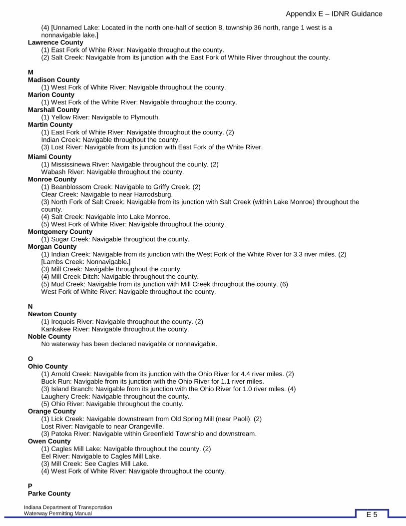
(3) Trail Creek: Navigable 1.0 river miles from its junction with Lake Michigan. (4) [Unnamed Lake: Located in the north one-half of section 8, township 36 north, range 1 west is a nonnavigable lake.]
Lawrence County (1) East Fork of White River: Navigable throughout the county. (2) Salt Creek: Navigable from its junction with the East Fork of White River throughout the county.
M Madison County
(1) West Fork of White River: Navigable throughout the county. Marion County
(1) West Fork of the White River: Navigable throughout the county. Marshall County
(1) Yellow River: Navigable to Plymouth. Martin County
(1) East Fork of White River: Navigable throughout the county. (2) Indian Creek: Navigable throughout the county. (3) Lost River: Navigable from its junction with East Fork of the White River. (1) Iroquois River: Navigable to near Parr. (2) Kankakee River: Navigable throughout the county.
Jay County No waterway has been declared navigable or nonnavigable.
Jefferson County (1) Big Saluda Creek: Navigable 1.0 river miles from its junction with the Ohio River. (2) Indian-Kentuck Creek: Navigable 3.8 river miles from its junction with the Ohio River. (3) Ohio River: Navigable throughout the county.
Jennings County (1) Muscatatuck River: Navigable to the main forks.
Johnson County (1) Big Blue River: Navigable throughout the county. (2) East Fork of White River: Navigable to its junction with the Flatrock and Driftwood rivers. (3) Sugar Creek: Navigable from its junction with the Big Blue River (to form the Driftwood River) throughout the county. (4) West Fork of White River: Navigable throughout the county.
K Knox County
(1) Black Creek: Navigable from its junction with the West Fork of the White River (near Edwardsport) throughout the county. (2) Busseron Creek: Navigable throughout the county. (3) Wabash River: Navigable throughout the county. (4) West Fork of White River: Navigable throughout the county from its junction with the White River. (5) White River: Navigable throughout the county from its junction with the Wabash River.
Kosciusko County (1) [Tippecanoe Lake: Nonnavigable.]
L Lagrange County
(1) Fawn River: Two segments of the river are navigable in Lagrange County. These segments are separated by portions of the river in Michigan. The Fawn River has been found to be nonnavigable at Greenfield Mills (river mile 32).
Lake County (1) Grand Calumet River: Navigable from the Illinois state line (near Hammond) to Marquette Park. (2) Indiana Harbor and Ship Canal: Navigable throughout the county. (3) Kankakee River: Navigable throughout the county. (4) Lake Michigan: Navigable throughout the county. (5) Little Calumet River: Navigable throughout the county. (6) [Wolf Lake: Nonnavigable.]
LaPorte County (1) Kankakee River: Navigable throughout the county. (2) Lake Michigan: Navigable throughout the county. (3) Trail Creek: Navigable 1.0 river miles from its junction with Lake Michigan.
Indiana Department of Transportation Waterway Permitting Manual E 4
Appendix E – IDNR Guidance
(4) [Unnamed Lake: Located in the north one-half of section 8, township 36 north, range 1 west is a nonnavigable lake.]
Lawrence County (1) East Fork of White River: Navigable throughout the county. (2) Salt Creek: Navigable from its junction with the East Fork of White River throughout the county.
M Madison County
(1) West Fork of White River: Navigable throughout the county. Marion County
(1) West Fork of the White River: Navigable throughout the county. Marshall County
(1) Yellow River: Navigable to Plymouth. Martin County
(1) East Fork of White River: Navigable throughout the county. (2) Indian Creek: Navigable throughout the county. (3) Lost River: Navigable from its junction with East Fork of the White River.
Miami County (1) Mississinewa River: Navigable throughout the county. (2) Wabash River: Navigable throughout the county.
Monroe County (1) Beanblossom Creek: Navigable to Griffy Creek. (2) Clear Creek: Navigable to near Harrodsburg. (3) North Fork of Salt Creek: Navigable from its junction with Salt Creek (within Lake Monroe) throughout the county. (4) Salt Creek: Navigable into Lake Monroe. (5) West Fork of White River: Navigable throughout the county.
Montgomery County (1) Sugar Creek: Navigable throughout the county.
Morgan County (1) Indian Creek: Navigable from its junction with the West Fork of the White River for 3.3 river miles. (2) [Lambs Creek: Nonnavigable.] (3) Mill Creek: Navigable throughout the county. (4) Mill Creek Ditch: Navigable throughout the county. (5) Mud Creek: Navigable from its junction with Mill Creek throughout the county. (6) West Fork of White River: Navigable throughout the county.
N Newton County
(1) Iroquois River: Navigable throughout the county. (2) Kankakee River: Navigable throughout the county.
Noble County No waterway has been declared navigable or nonnavigable.
O Ohio County
(1) Arnold Creek: Navigable from its junction with the Ohio River for 4.4 river miles. (2) Buck Run: Navigable from its junction with the Ohio River for 1.1 river miles. (3) Island Branch: Navigable from its junction with the Ohio River for 1.0 river miles. (4) Laughery Creek: Navigable throughout the county. (5) Ohio River: Navigable throughout the county.
Orange County (1) Lick Creek: Navigable downstream from Old Spring Mill (near Paoli). (2) Lost River: Navigable to near Orangeville. (3) Patoka River: Navigable within Greenfield Township and downstream.
Owen County (1) Cagles Mill Lake: Navigable throughout the county. (2) Eel River: Navigable to Cagles Mill Lake. (3) Mill Creek: See Cagles Mill Lake. (4) West Fork of White River: Navigable throughout the county.
P Parke County
Indiana Department of Transportation Waterway Permitting Manual E 5

Appendix E – IDNR Guidance
(1) Big Raccoon Creek: Navigable throughout the county. (2) Little Raccoon Creek: Navigable from its junction with Big Raccoon Creek for 5.3 river miles (Nevins Covered Bridge). (3) Cecil M. Harden Lake: See Big Raccoon Creek. (4) Sugar Creek: Navigable throughout the county. (5) Wabash River: Navigable throughout the county.
Perry County (1) Anderson River: Navigable from its junction with the Ohio River along the Spencer County line. (2) Bald Knob Creek: Navigable from its junction with Big Oil Creek for 0.5 river miles. (3) Bear Creek: Navigable from its junction with the Ohio River for 1.6 river miles. (4) Big Deer Creek: Navigable from its junction with the Ohio River for 5.9 river miles. See Deer Creek. (5) Big Oil Creek (including Webb Branch): Navigable from its junction with the Ohio River for 10.6 river miles. Webb Branch is navigable from its junction on Big Oil Creek for 0.9 river miles. (6) Big Poison Creek: Navigable from its junction with the Ohio River for 6.3 river miles. (7) Buck Creek: Navigable from its junction with the Ohio River for 0.7 river miles. (8) Bull Hollow: Navigable from its junction with Big Oil Creek for 0.7 river miles. (9) Caney Branch of Big Poison Creek: Navigable from its junction with Big Poison Creek for 0.2 river miles. (10) Caney Branch of Little Deer Creek: Navigable from its junction with Little Deer Creek for 0.8 river miles. (11) Clover Lick Creek: Navigable from its junction with Big Oil Creek for 0.7 river miles. (12) Deer Creek: Navigable from its junction with the Ohio River for 5.9 river miles. (13) East Deer Creek: Navigable from its junction with Deer Creek for 0.6 river miles. (14) Fanny Creek: Navigable from its junction with the Ohio River for 0.8 river miles. (15) Indian Fork: Navigable from its junction with Big Oil Creek for 1.4 river miles. (16) Kelly Hollow: Navigable from its junction with Millstone Creek for 1.0 river miles. (17) Kingly Creek: Navigable from its junction with the Ohio River for 0.2 river miles. (18) Knob Creek: Navigable from its junction with the Ohio River for 0.2 river miles. (19) Little Deer Creek (also known as West Fork of Deer Creek): Navigable from its junction with Deer Creek for 3.9 river miles. (20) Little Oil Creek: Navigable from its junction with Big Oil Creek for 4.4 river miles. (21) Little Poison Creek: Navigable from its junction with Big Poison Creek for 1.2 river miles. (22) Millstone Creek: Navigable from its junction with the Ohio River for 1.4 river miles. (23) Neglie Creek: Navigable from its junction with Little Deer Creek for 0.5 river miles. (24) Ohio River: Navigable throughout the county. (25) Oil Creek: See Big Oil Creek. (26) Poison Creek: See Big Poison Creek. (27) Sample Run: Navigable from its junction with the Ohio River for 0.2 river miles. (28) Tates Hollow: Navigable from its junction with the Ohio River for 0.3 river miles. (29) Webb Branch: See Big Oil Creek.
Pike County (1) East Fork of White River: Navigable throughout the county. (2) Flat Creek: Navigable downstream from a point in Franklin Township. (3) Patoka River: Navigable throughout the county. (4) White River: Navigable throughout the county.
Porter County (1) Burns Ditch: See Portage Burns Waterway. (2) Portage Burns Waterway: Navigable in its entirety (1.3 river miles) as a connection between the Little Calumet River and Lake Michigan. (3) Kankakee River: Navigable throughout the county. (4) Lake Michigan: Navigable throughout the county. (5) Little Calumet River: Navigable throughout the county.
Posey County (1) Big Creek: Navigable from its junction with the Wabash River for 25.4 river miles (near Cynthiana). (2) Harris Ditch: Navigable from its junction with the Ohio River for 0.9 river miles. (3) Hurricane Fork: See Little Fork of Big Creek. (4) Little Fork of Big Creek: Navigable from its junction with Big Creek for 5.1 river miles. (5) Little Pitcher Lake: Navigable as an extension of Harris Ditch. (6) South Fork: See Little Fork of Big Creek. (7) McFadden Creek: Navigable from its junction with the Ohio River for 2.3 river miles. (8) Ohio River: Navigable throughout the county. (9) Wabash River: Navigable from its junction with the Ohio River throughout the county.
Pulaski County Tippecanoe River: Navigable throughout the county.
Putnam County
Indiana Department of Transportation Waterway Permitting Manual E 6
Appendix E – IDNR Guidance
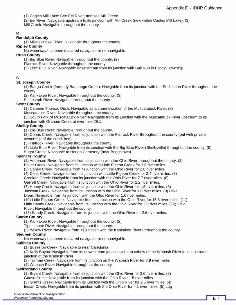
(1) Cagles Mill Lake: See Eel River, and see Mill Creek. (2) Eel River: Navigable upstream to its junction with Mill Creek (now within Cagles Mill Lake). (3) Mill Creek: Navigable throughout the county.
R Randolph County
(1) Mississinewa River: Navigable throughout the county. Ripley County
No waterway has been declared navigable or nonnavigable. Rush County
(1) Big Blue River: Navigable throughout the county. (2) Flatrock River: Navigable throughout the county. (3) Little Blue River: Navigable downstream from its junction with Ball Run in Posey Township.
S St. Joseph County
(1) Baugo Creek (formerly Banbango Creek): Navigable from its junction with the St. Joseph River throughout the county. (2) Kankakee River: Navigable throughout the county. (3) St. Joseph River: Navigable throughout the county.
Scott County (1) Cammie Thomas Ditch: Navigable as a channelization of the Muscatatuck River. (2) Muscatatuck River: Navigable throughout the county. (3) South Fork of Muscatatuck River: Navigable from its junction with the Muscatatuck River upstream to its junction with Graham Creek at river mile 28.1.
Shelby County (1) Big Blue River: Navigable throughout the county. (2) Conns Creek: Navigable from its junction with the Flatrock River throughout the county (but with private ownership of the creek bed). (3) Flatrock River: Navigable throughout the county. (4) Little Blue River: Navigable from its junction with the Big Blue River (Shelbyville) throughout the county. (5) Sugar Creek: Navigable to Hough Cemetery (near Boggstown).
Spencer County (1) Anderson River: Navigable from its junction with the Ohio River throughout the county. (2) Baker Creek: Navigable from its junction with Little Pigeon Creek for 1.8 river miles. (3) Caney Creek: Navigable from its junction with the Ohio River for 2.8 river miles. (4) Clear Creek: Navigable from its junction with Little Pigeon Creek for 2.4 river miles. (5) Crooked Creek: Navigable from its junction with the Ohio River for 7.7 river miles. (6) Garrett Creek: Navigable from its junction with the Ohio River for 2.2 river miles. (7) Honey Creek: Navigable from its junction with the Ohio River for 1.8 river miles. (8) Jackson Creek: Navigable from its junction with the Ohio River for 1.8 river miles. (9) Lake Drain: Navigable from its junction with the Ohio River for 1.6 river miles. (10) Little Pigeon Creek: Navigable from its junction with the Ohio River for 15.8 river miles. (11) Little Sandy Creek: Navigable from its junction with the Ohio River for 2.0 river miles. (12) Ohio River: Navigable throughout the county. (13) Sandy Creek: Navigable from its junction with the Ohio River for 2.6 river miles.
Starke County (1) Kankakee River: Navigable throughout the county. (2) Tippecanoe River: Navigable throughout the county. (3) Yellow River: Navigable from its junction with the Kankakee River throughout the county.
Steuben County No waterway has been declared navigable or nonnavigable.
Sullivan County (1) Busseron Creek: Navigable to near Caledonia. (2) Kelly Bayou: Navigable from its downstream junction with an oxbow of the Wabash River to its upstream junction of the Wabash River. (3) Turman Creek: Navigable from its junction on the Wabash River for 7.9 river miles. (4) Wabash River: Navigable throughout the county.
Switzerland County (1) Bryant Creek: Navigable from its junction with the Ohio River for 2.6 river miles. (2) Goose Creek: Navigable from its junction with the Ohio River 1.5 river miles. (3) Grants Creek: Navigable from its junction with the Ohio River for 2.5 river miles. (4) Indian Creek: Navigable from its junction with the Ohio River for 4.1 river miles. (5) Log
Indiana Department of Transportation Waterway Permitting Manual E 7

Appendix E – IDNR Guidance
Lick Creek: Navigable from its junction with the Ohio River for 2.3 river miles. (6) Ohio River: Navigable throughout the county. (7) Plum Creek: Navigable from its junction with the Ohio River for 2.9 river miles. (8) Sand Creek: Navigable from its junction with the Ohio River for 0.9 river miles. (9) Turtle Creek: Navigable from its junction with the Ohio River for 1.3 river miles.
T Tippecanoe County
(1) Tippecanoe River: Navigable from its junction with the Wabash River. (2) Wabash River: Navigable throughout the county.
Tipton County No waterway has been declared navigable or nonnavigable.
U Union County
(1) East Fork of Whitewater River: Navigable throughout the county.
V Vanderburgh County
(1) Bayou Creek: Navigable from its junction with the Ohio River for 1.5 river miles. (2) Locust Creek: Navigable from its junction with Pigeon Creek for 1.5 river miles. (3) Ohio River: Navigable throughout the county. (4) Pigeon Creek: Navigable from its junction with the Ohio River for 5.9 river miles.
Vermillion County (1) Big Vermillion River: Navigable for 10.8 miles from its junction with the Wabash River throughout the county (and for a total of 22.6 river miles to Carmargo, Illinois). (2) Wabash River: Navigable throughout the county.
Vigo County (1) Wabash River: Navigable throughout the county.
W Wabash County
(1) Mississinewa River: Navigable throughout the county. (2) Wabash River: Navigable throughout the county.
Warren County (1) Wabash River: Navigable throughout the county.
Warrick County (1) Baker Creek: Navigable from its junction with Little Pigeon Creek for 1.8 river miles. (2) Big Pigeon Creek: See Pigeon Creek. (3) Clear Creek: Navigable from its junction with Little Pigeon Creek for 2.4 river miles. (4) Cypress Creek (including Cypress Creek Diversion Channel): Navigable from its junction with the Ohio River for 6.6 river miles. (The original bed of Cypress Creek is also navigable west of Cypress Creek Diversion Channel, except where the creek bed has emerged and is no longer inundated.) (5) Little Pigeon Creek: Navigable from its junction on the Ohio River for 15.8 river miles. (6) Ohio River: Navigable throughout the county.
Washington County (1) Big Blue River: Navigable to the town of Fredricksburgh at river mile 57.2. (2) Cammie Thomas Ditch: Navigable as a channelization of the Muscatatuck River. (3) East Fork of White River: Navigable throughout the county. (4) Elk Creek: Navigable from its junction with the Cammie Thomas Ditch to river mile 3.0. (5) Muscatatuck River: Navigable from its junction with the East Fork of the White River throughout the county. (6) Twin Creek: Navigable from the East Fork of White River to river mile 7.98.
Wayne County No waterway has been declared navigable or nonnavigable.
Wells County (1) Wabash River: Navigable throughout the county (with navigability terminating at the Adams County line).
White County (1) Tippecanoe River: Navigable throughout the county.
Whitley County No waterway has been declared navigable or nonnavigable.
Indiana Department of Transportation Waterway Permitting Manual E 8

Appendix E – IDNR Guidance
IDNR - PUBLIC FRESHWATER LAKES
Adams County • Rainbow Lake, located in township 25 N, 1/2 mi. NE of Geneva • Saddle Lake, located in township 28 N, 1.75 mi. N of Decatur
Allen County • Lake Everett, located in township 31 N, 3 mi. N of Arcola • Fulk Lake, located in township 32 N, 41.260556 latitude, -85.286141 longitude • Hosey Lake, located in township 30 N,.5 mi. NE of Wash. & Anthony Blvds • Schoaff Lake, located in township 31 N,.75 mi. S of US 30 on Sherman Blvd • Viberg Lake, 41.247658 latitude, -85.060932 longitude
Carroll County • Lake Freeman, also in White County, located in township 26 N, 3 mi. N of Monticello*
Cass County • Lake Cicott, located in township 27 N, 9 miles West of Logansport
Dekalb County • Cedar Lake, located in township 35 N, 4 1/2 mi. NW of Waterloo • Dunton Lake, located in township 33 N, 6 1/2 mi. S of Auburn • Haynes Lake, located in township 34 N, 41.38889 latitude, -85.17056 longitude • Indian Lake, 41.464027 latitude, -85.169690 longitude • Lintz Lake, located in township 34 N, 3 1/2 North of Garrett • Lower Story Lake, located in township 35 N, 4 1/2 mi. N of Ashley, 41.51806 latitude, -85.14444 longitude • Terry Lake, located in township 36 N, 1/2 mi. E of Hamilton • Upper Story Lake, located in township 35 N, 4 1/2 mi. N of Ashley, 41.51417 latitude, -85.13611 longitude
Elkhart County • Boot Lake, located in township 38 N, 4 mi. NW of Elkhart • Buttonbush Lake, located in township 38 N • Butts Lake, located in township 36 N, 41.60488 latitude, -85.80549 longitude • Dock Lake, located in township 38 N, 3 mi. SE of Bristol • East Lake, located in township 38 N, 3 mi. NE of Middlebury, also in LaGrange County • Fish Lake, N of Millersburg, 41.579174 latitude, -85.663691 longitude • Goose Pond, located in township 37 N, 41.693857 latitude, -85.788009 longitude • Grange (or Orange) Lake, 41.689261 latitude, -85.766704 longitude • Heaton Lake, located in township 38 N, 3 mi. N of Elkhart & 4 mi. E of SR 19 • Hunter Lake, located in township 38 N, 5 mi. NE of Middlebury • Indiana Lake, located in township 38 N, 3 mi. NW of Bristol • Norton Lake, located in township 36 N, NE edge of Goshen • Round Lake, located in township 38 N, 3 mi. N of Bristol • Simonton Lake, located in township 38 N, 4 mi. N of Elkhart • Wolf Lake, located in township 37 N, 2 mi. N of Goshen on SR 15 • Yellow Creek Lake, located in township 36 N, 1 mi. N of Foraker
Fulton County • Anderson Lake, 41.125588 latitude, -86.305194 longitude • Barr Lake, located in township 31 N, 3 1/2 mi. NE of Athens • Bruce Lake, located in township 30 N, 6 mi. NW of Kewanna, also in Pulaski County • Fletcher Lake, located in township 29 N, 6 mi. SE of Grass Creek • King Lake, located in township 31 N, 1 mi. S of Delong • L Lake, located in township 30 N, 41.0125 lat, -86.03611 longitude • Lake Sixteen, located in township 30 N, 2 mi. SE of Athens • Lake Manitou, located in township 30 N, 1 mi. E of Rochester
• Landis Lake, located in township 30 N, 3 1/2 mi. SE of Akron • Lost Lake, located in township 30 N, 4 mi. SE of Akron • Millark Millpond, located in township 30 N, 4 mi. S of Athens • Mt. Zion Millpond, located in township 30 N, 3 mi. SW of Athens • Mud Lake, located in township 30 N, near Silver Lake • Nyona Lake, located in township 29 N, 4 mi. NE of Fulton • O'Blennis Lake, located in township 31 N, 7 mi. NW of Rochester • Rock Lake, located in township 30 N, 7 mi. SW of Silver Lake • South Mud Lake, located in township 29 N, 4 mi. NE of Fulton • Town Lake, located in township 30 N, 1/2 mi. SW of Akron • Upper Summit Lake, located in township 30 N, 2 1/2 mi. SE of Akron • Zink Lake, located in township 31 N, 7.5 mi. NW of Rochester
Kosciusko County Indiana Department of Transportation Waterway Permitting Manual E 9

Appendix E – IDNR Guidance
• Allen Lake, located in township 34 N, 41.360785 longitude, -85.674792 latitude • Backwater Lake (connected to Lake Webster), 1 mi. E of North Webster, 41.31312 latitude, -85.66310 longitude • Banning Lake, located in township 33 N, 2 1/2 mi. SW of North Webster • Barrel-and-a-half Lake, located in township 34 N, on Tri-County Fish and Wildlife Area near Syracuse • Beaver Dam Lake, located in township 30 N, 4 mi. NW of Silver Lake • Beigh Lake, located in township 30 N, 41.086306 latitude, -85.845317 longitude • Big Barbee Lake, located in township 33 N, 2 1/2 mi. S of North Webster • Big Chapman Lake, located in township 33 N, 2 mi. S of Oswego • Black Pond, 3 1/2 mi. NE of North Webster, 41.349463 latitude, -85.654778 longitude • Boner Lake, located in township 34 N, 2 mi. E of Syracuse • Bufflehead Pond, 2 1/2 mi. E of North Webster, 41.331419 latitude, -85.650787 longitude • Caldwell Lake, located in township 31 N, 4 mi. N of Silver Lake • Carr Lake, located in township 31 N, 5 mi. S of Warsaw • Center Lake, off of North Buffalo Street in Warsaw, 41.246497 latitude, -85.857557 longitude • Crystal Lake, located in township 32 N, 5 mi. N of Burket • Dewart Lake, located in township 34 N, 3 mi. N of Oswego • Diamond Lake, located in township 31 N, 3 mi. NW of Silver Lake • Durham Lake, located in township 33 N, 5 mi. SE of North Webster • Fish Lake, located in township 31 N, 3 1/2 mi. NE of Claypool • Hammond Lake, located in township 34 N, on Tri-County Fish and Wildlife Area near Syracuse • Goose Lake, 41.190117 latitude, -85.880841 longitude • Heckman Lake, 41.093430 latitude, -85.703157 longitude • Heron Lake, located in township 33 N, 2 mi. S of N. Webster • Hill Lake, located in township 31 N, 2 1/2 mi. N of Silver Lake • Hoffman Lake, located in township 33 N, 1 1/2 mi. NW of Atwood • Irish Lake, located in township 33 N, 3 1/2 mi. SW of North Webster • James Lake, located in township 33 N, 1 1/2 mi. W of North Webster • Kuhn Lake, located in township 33 N, 3 mi. SW of North Webster • Lake Wawasee, located in township 34 N, at Syracuse • Little Barbee Lake, located in township 33 N, 4 mi. SW of North Webster • Little Chapman Lake, located in township 32 N, 8 mi. NE of Lakeside Park • Little Pike Lake, located in township 32 N, 1 mi. N of Warsaw • Long Lake, located in township 33 N, 1 1/2 mi. N-NE of North Webster • Loon Lake, locate in township 30 N, 2.5 mi. E of Beaver Dam • McClures Lake, located in township 30 N, 3 1/2 mi. W of Silver Lake • Morehead Lake, located in township 33 N, 41.346939 latitude, -85.714832 longitude • Muskellunge Lake, located in township 31 N, 4 1/2 mi. S of Warsaw • North Little Lake, located in township 30 N, 1 mi. N of Silver Lake • Oswego Lake, located in township 33 N, at Oswego • Pierceton Lake, located in township 32 N, 2 mi. N of Pierceton • Pike Lake, located in township 32 N, at Warsaw • Price Lake, located in township 33 N, 41.347380 latitude, -85.677666 longitude • Reed Lake, located in township 31 N, 41.172259 latitude, -85.729471 longitude • Ridinger Lake, located in township 32 N, 4 mi. S of Warsaw • Robinson Lake, located in township 32 N, 4 mi. NW of Larwill, also in Whitley County • Rothenberger Lake, located in township 34 N, part of Flatbelly Lake • Sawmill Lake, located in township 33 N, 2 1/2 mi. SW of N. Webster • Sechrist Lake, located in township 33 N, 2 1/2 mi. SW of N. Webster • Sellers Lake, 41.152465 latitude, -85.745154 longitude • Sheely Lake, 41.193680 latitude, -85.770207 longitude • Sherburn Lake, 41.159643 latitude, -85.745221 longitude • Shock Lake, on Tri-County Fish and Wildlife Area near Syracuse; 41.353446 latitude, -85.690925 longitude • Shoe Lake, 41.307843 latitude, -85.749094 longitude • Silver Lake, located in township 30 N, 1 mi. N of Silver Lake • Spear Lake, located in township 34 N, 4 mi. N of Highbanks • Stafford Lake, 41.170340 latitude, -85.778559 longitude • Stanton Lake, 41.321955 latitude, -85.769864 longitude • Stevens Lake, 41.176217 latitude, -85.746210 longitude • Syracuse Lake, located in township 34 N, 2.5 mi. W of Wawasee • Tennant Lake, 41.147152 latitude, -85.731769 longitude • Tippecanoe Lake, 41.327180 latitude, -85.762759 longitude • Waubee Lake (also known as Wabee Lake), located in township 34 N, S edge of Shady Banks • Webster Lake, located in township 33 N, E edge of North Webster
Indiana Department of Transportation Waterway Permitting Manual E 10

Appendix E – IDNR Guidance
• Winona Lake, located in township 31 N, 1.5 mi. E of Warsaw • Wyland Lake, on Tri-County Fish and Wildlife Area near Syracuse • Yellow Creek, 41.104644 latitude, -85.953391 longitude
LaGrange County • Adams Lake, located in township 36 N, 1.5 mi. S of Woodruff • Aldrich Lake, located in township 38 N, 1/2 mi. NE of Ontario • Appleman Lake, 6.5 mi. E of Plato, 41.623330 latitude, -85.212805 longitude • Atwood Lake, located in township 36 N, 1.5 mi. E of Eddy • Basin Lake, located in township 36 N, 41.56861 latitude, -85.41222 longitude • Big Long Lake, located in township 36 N, 3 mi. NE of South Milford • Blackman Lake, located in township 36 N, 1 1/2 mi. NW of South Milford • Brokesha Lake, located in township 38 N, 5 mi. W of Scott • Buck Lake, located in township 37 N, 1 1/2 mi. SE of Seybert • Cass Lake, located in township 37 N, 4 mi. West/NW of Shipshewana • Cedar Lake, located 4 mi. NE of Howe, 41.738157 latitude, -85.367755 longitude • Cline Lake, located in township 37 N at Plato, 41.649932 latitude, -85.312247 longitude • Cotton Lake, located in township 37 N, 1 mi. SW of Shipshewana • Dallas Lake, located in township 36 N, 4 1/2 mi. NW of Wolcottville • Donaldson Lake, 41.718547 latitude, -85.356171 longitude • East Lake, located in township 38 N, 3 mi. NE of Middlebury, also in Elkhart County • Emma Lake, located in township 36 N, in Town of Emma • Eve Lake, located in township 36 N, 1 mi. SE of Woodruff • Fish Lake (in Plato), located 2 mi. S of Plato, 41.623132 latitude, -85.329517 longitude • Fish Lake (in Scott), 41.760687 latitude, -85.641710 longitude • Fennell Lake, located in township 38 N, 4 mi. NE of Brighton • Green Lake, located in township 32 N, 4 mi. W of Flint, also in Steuben County • Hackenburg Lake, located in township 36 N, 6 mi. NW of Wolcottville • Hayward Lake, located in township 36 N at Stroh, 41.584621 latitude, -85.204313 longitude • Lake of the Woods, located in township 36 N, 3 mi. S of Stroh • Little Turkey Lake, located in township 36 N, 1/2 mi. W of Elmira • Martin Lake, located in township 36 N, 3 mi. NW of Wolcottville • Messick Lake, located in township 36 N, 6 mi. NW of Wolcottville • Meteer Lake, located in township 38 N, 2 mi. E of Howe • Mud Lake, 41.571919 latitude, -85.222943 longitude • Mud Lake, 41.696758 latitude, -85.628828 longitude • Nauvoo Lake, located in township 36 N, 1 1/2 mi. E of Wolcottville • North Twin Lake, located in township 38 N, 1 1/2 mi. NW of Howe • Olin Lake, located in township 36 N, 2 1/2 mi. NW of Wolcottville • Oliver Lake, located in township 36 N, 2 1/2 mi. NW of Wolcottville • Pigeon Lake, located in township 38 N, 3 mi. W of Howe • Pretty Lake, located in township 36 N, 3 mi. W of Stroh • Rainbow Lake, located in township 37 N, near Shipshewanna • Royer Lake, located in township 36 N, 2 mi. S of Plato • Shipshewana Lake, located in township 37 N, 1 mi. W of Shipshewana • South Twin Lake, located in township 38 N, 2 mi. W of Howe • Spectacle Lakes, located in township 36 N, 3 mi. S of Stroh • Still Lake, located in township 38 N, 1 mi. NW of Howe • Stone Lake, located in township 38 N, 5 mi. W of Scott • Taylor Lake (at Shipshewana), located in township 38 N, 2 mi. N of Shipshewana • Taylor Lake (at Stroh), located in township 36 N, 2 mi. South of Stroh • The Spreads, located in township 36 N, 41.564625 latitude, -85.420549 longitude • Wall Lake, located in township 38 N, 2 mi. W of Orland • Weir Lake, located in township 37 N, 1/2 mi. N of Plato • Westler Lake, located in township 36 N, 2 mi. NW of Wolcottville • Witmer Lake, located in township 36 N, 1 mi. W of Wolcottville • Yost Pond, located in township 38 N, 3 1/2 mi. SW of Scott
Lake County • Cedar Lake, located in township 34 N, E edge of Cedar Lake • Fancher Lake, in Crown Point at Lake County Fairgrounds • Golf Lake, 41.461607 latitude, -87.458811 longitude • Lake George (Hobart), W edge of Hobart, 41.670872 latitude, -87.502204 longitude
LaPorte County • Clear Lake, 6.5 mi. N of Mill Creek
Indiana Department of Transportation Waterway Permitting Manual E 11

Appendix E – IDNR Guidance
• Clear Lake, located in township 36 N, 2 mi. W of Westville, also in Porter County • Crane Lake, 41.619695 latitude, -86.764634 longitude • Fish Trap Lake, 2 mi. N of LaPorte, 41.633436 latitude, -86.729619 longitude • Hog Lake, 2.5 mi. N of Rolling Prairie, 41.705855 latitude, -86.630034 longitude • Horseshoe Lake, 5 mi. S of Springville, 41.643537 latitude, -86.730878 longitude • Hudson Lake, 41.715524 latitude, -86.551806 longitude • Lily Lake, 1 mi. N of LaPorte, 41.612893 latitude, -86.732005 longitude • Pine Lake, 5 mi. S of Springville, 41.627776 latitude, -86.748939 longitude • Saugany Lake, N edge of Lake Park, 41.715216 latitude, -86.584026 longitude • Silver Lake, 2.5 mi. S of Birchim, 41.692493 latitude, -86.593875 longitude • Stone Lake, 41.614234 latitude, -86.745058 longitude • Tamarack Lake, located at Kingsbury Fish and Wildlife Area near LaPorte • Upper & Lower Fish Lake, 41.564340 latitude, -86.545977 longitude
Marshall County • Cook Lake, S edge of Twin Lakes, 41.299782 latitude, -86.366798 longitude • Dixon Lake, Southwest side of Plymouth, on Dixon Lake Trail, 41.326825 latitude, -86.344560 longitude • Eddy Lake, 41.186249 latitude, -86.310274 longitude • Flat Lake, 41.329254 latitude, -86.436989 longitude • Gilbert Lake, 41.335538 latitude, -86.446380 longitude • Holem Lake, 41.299782 latitude, -86.366798 longitude • Houghton Lake, 41.234587 latitude, -86.455385 longitude • Koontz Lake, see Koontz Lake in Starke county; located in township 34N • Lake Maxinkuckee, located in township 32 N, S edge of Culver • Lake of the Wood, 8 mi. SW of Bremen, 41.423786 latitude, -86.228653 longitude • Lawrence Lake, 2.5 mi. S of Plymouth on Olive Trail, 41.296591 latitude, -86.334971 longitude • Lost Lake, 41.198378 latitude, -86.422414 longitude • Myers Lake, 41.301159 latitude, -86.348994 longitude • Pretty Lake, 6 mi. SW of Plymouth, 41.326028 latitude, -86.373436 longitude • Thomas Lake, 41.292580 latitude, -86.394986 longitude • Zehner Millpond Lake, 2 mi. W of Twin Lakes, 41.298765 latitude, -86.386667 longitude
Noble County • Axel Lake, located in township 35 N, 2 mi. NE of Rome City • Barr Lake, located on township 35 N, 1/2 m mi. NE of Rome City • Bartley Lake, located in township 33 N, 3 mi. SW of Albion • Bass Lake, located in township 33 N, 2 mi. N of Burr Oak • Baugher Lake, located in township 33 N, 4 1/2 mi. NW of Etna • Bear Lake, located in township 33 N, 1 1/2 mi. SW of Wolfe Lake • Beck Lake, located in township 35 N, 3 mi. NW of Kendallville • Big Lake, located in township 33 N, 8 mi. N of Columbia City • Bixler Lake, located in township 34 N, edge of Kendallville • Bowen Lake, located in township 33 N, Chain-O-Lakes State Park • Bristol Lake, located in township 33 N, 1 1/2 mi. North of Merriam • Bushong Lake, located in township 34 N, 2 1/2 mi. SE of Albion • Crane Lake, 4.2 mi. S of Wolf Lake, 41.277236 latitude, -853482374 longitude • Cree Lake, located in township 35 N, 8 mi. N of Kendallville • Crooked Lake, 9 mi. N of Columbia City, 41.262075 latitude, -85.479572 longitude, also in Whitley County • Cub Lake, 41.315410 latitude, -85.508220 longitude • Deep Lake, 41.331390 latitude, -85.479531 longitude • Deer Lake, 41.374131 latitude, -85.555696 longitude • Diamond Lake, located 0.5 mi. S of Ligonier, 41.438679 latitude, -85.523519 longitude • Dock Lake, 41.335486 latitude, -85.373623 longitude • Dollar Lake, located in township 34 N, 41.363847 latitude, -85.484956 longitude • Duely Lake, 41.357840 latitude, -85.631972 longitude • Eagle Lake, located in township 34 N, 4 mi. N of Kimmell • Engle Lake, located in township 34 N, 6 mi. N of Kimmell • Finster, Big & Little, 41.338419 latitude, -85.368940 longitude • Gilbert Lake, located in township 33 N, 1 1/2 mi. SE of Knapp Lake • Gordy Lake, located in township 33 N, 2 mi. SE of Indian Village • Grannis Lake, located in township 35 N, 41.506903 latitude, -85.325942 longitude • Hall Lake, located in township 35 N, 3 1/2 mi. NW of Kendallville • Harper Lake, located in township 33 N, 4 1/2 mi. NW of Ormas • Hawk Lake, located in township 33 N, 1 mi. NE of Wolfe Lake • Henderson Lake, located in township 35 N, 1/2 mi. W of Kendallville • High Lake, located in township 33 N, 2 mi. SW of Wolfe Lake
Indiana Department of Transportation Waterway Permitting Manual E 12

Appendix E – IDNR Guidance
• Hindman Lake, located in township 33 N, 3 mi. NE of Wilmot • Horseshoe Lake, located in township 33 N, 1 1/2 mi. SW of Smalley Lake • Indian Lake @ Ligonier, located in township 35 N, 41.45444 latitude, -85.58000 longitude • Indian Lake @ Albion, located in township 34 N, SE of Albion, 41.37500 latitude, -85.4011 longitude • Johnson Lake, located in township 33 N, 2 1/2 mi. E of Wilmot • Jones Lake, located in township 35 N, 2 mi. W of Rome City • Keister Lake, located in township 33 N, 1 mi. E of Merriam • King Lake, 41.346632 latitude, -85.227287 longitude • Knapp Lake, located in township 33 N, 3 mi. NE of Wilmot • Latta Lake, located in township 35 N, 3 mi. E of Rome City • Lindsey Lake, located in township 33 N, 1 mi. E of Merriam • Little Bause Lake, located in township 33 N • Little Long Lake, located in township 35 N, 1 mi. North of Kendallville • Little Whitford Lake, 41.456908 latitude, -85.233903 longitude • Loon Lake, 3 mi. W of SR 109 on County Line Road, 41.272182 latitude, -85.539387 longitude, also in Whitley County • Long Lake, located in township 34 N, 3 1/2 mi. SW of Albion • Lower Long Lake, 41.3762 latitude, -85.4903 longitude • Marl Lake, located in township 33 N, 1 mi. E of Wolf Lake • Metz Lake, located in township 33 N, 1 mi. E of Washington Center • Miller Lake, located in township 33 N, W side of SR 9 • Moss Lake, located in township 33 N, 1 1/2 mi. N of Wilmott • Mud Lake, located in township 33 N in Chain-O-Lakes State Park • Muncie Lake, located in township 33 N, 2 1/2 mi. E of Wolf • Norman Lake, located in township 33 N, 4 mi. NE of Merriam • Petty Lake, located in township 33 N, 7 mi. E of Wolf Lake • Pleasant Lake, located in township 33 N, 2 mi. NE of Wolf Lake • Port Mitchell Lake, located in township 34 N, 3 mi. NE of Wolf Lake • Rider Lake, located in township 33 N, 41.353173 latitude, -85.630540 longitude • Rivir Lake, located in township 33 N, in Chain-O-Lakes State Park • Round Lake, located in township 35 N, 3 mi. NE of Kendallville • Sacarider Lake, located in township 34 N, 3 mi. SW of Kendallville • Sand Lake, located in township 33 N, in Chain-O-Lakes State Park • Schauweker Lake, located in township 34 N, 41.361037 latitude, -85.418953 longitude • Schockopee Lake, located in township 35 N, 3 1/2 mi. NE of Kendallville • Skinner Lake, located in township 34 N, 3 mi. E of Albion • Silver Lake, located in township 34 N, 3 mi. E of Albion • Smalley Lake, located in township 33 N, 3 1/2 mi. E of Wilmot • Sparta Lake, located in township 34 N, W edge of Kimmel • Steinbarger Lake, located in township 35 N, 2 1/2 mi. SW of Rome City • Summit Lake, located in township 33 N, 4 1/2 mi. NW of Ege • Stump Lake, located in township 33 N, 41.328349 latitude, -85.586907 longitude • Sweet Lake, located in township 34 N, 3 mi. E of Albion • Sylvan Lake, located in township 35 N, at Rome City • Tamarack Lake, located in township 35 N, 3 mi. SE of Wolcottville • Tamarack Lake, 2.5 mi. SW of Rome City, 41.495612 latitude, -85.421185 longitude • Upper Long Lake, located in township 34 N, 2.5 mi. N of Wolf Lake • Village Lake, located in township 39 N, at Indian Village • Waldron Lake, located in township 35 N, 2 1/2 mi. W of Rome City • Weber Lake, located in township 33 N, 41.338488 latitude, -85.393084 longitude • Wible Lake, located in township 35 N, 2 mi. N and 1 mi. W of Kendallville • Williams Lake, located in township 33 N, 2 mi. E of Wolf Lake • Wolf Lake, located in township 33 N, at Wolf Lake on SR 109
Porter County • Canada Lake, located in township 36 N, 4 mi. N of Valparaiso • Carlson Pond, located in township 36 N, 41.534017 latitude, -86.990873 longitude • Clear Lake, located in township 36 N, 2 mi. W of Westville, 41.5525 latitude, -86.9310 longitude, also in LaPorte County • Dog Lake, located in township 33 N, 1/2 mi. W of Hebron • Flint Lake, located in township 35 N, 3 mi. N of Valparaiso • Lake Eliza, located in township 35 N, 8 mi. SW of Valparaiso • Long Lake, located in township 36 N, 4 mi. N of Valparaiso • Loomis Lake, located in township 35 N, 2 1/2 mi. N of Valparaiso
Indiana Department of Transportation Waterway Permitting Manual E 13

Appendix E – IDNR Guidance
• Mink Lake, located in township 36 N, 4 1/2 mi. N of Valparaiso • Morgan Lake, located in township 36 N, 1 mi. SW of Chesterton • Moss Lake, located in township 36 N, 2 1/2 mi. N of Valparaiso • Wauhob Lake, located in township 36 N, 5 mi. N of Valparaiso
Pulaski County • Bruce Lake, located in township 30 N, 6 mi. NW of Kewanna, also in Fulton County • Langenbaum Lake, located in township 31 N, 3 mi. E of Ora, also in Starke County
St. Joseph County • Chamberlain Lake, located in township 37 N, SW of South Bend • Deer Lake, located in township 38 N, 10 mi. NW of South Bend • Goodman Lake, located in township 36 N, 41.603558 latitude, -86.314289 longitude • Kale Lake, located in township 36 N, 4 mi. N of North Liberty • Mud Lake, located in township 38 N, 5 mi. N of Lydick • North Chain (Bass) Lake, located in township 38 N, at Lydick • Pinhook Park Lake, located in township 38 N, at South Bend • Pleasant Lake, located in township 35 N, 1/2 mi. S of Lakeville • Riddles Lake, located in township 35 N, 3 mi. SE of Lakeville • Rupel Lake, located in township 36 N, 1 mi. SE of North Liberty • Sously Lake, located in township 36 N, 2 mi. N of North Liberty • South Chain Szmanda Lake, located in township 37 N, 6 mi. W of South Bend • South Clear Lake, 38 N, 9 mi. NW of South Bend • St. Joseph Lake, located in township 38 N, at University of Notre Dame • St. Mary's Lake, located in township 38 N, at University of Notre Dame
Starke County • Bass Lake, located in township 32 N, 4 mi. S of Knox • Eagle Lake, located in township 33 N, 3 mi. NE of Ober • Hartz Lake, located in township 32 N, 3 mi. E of Ora • Koontz Lake, located in township 34 N, 3 mi. E of Hamlet • Langenbaum Lake, located in township 31 N, 3 mi. E of Ora, also in Pulaski County • Round (Silver) Lake, located in township 32 N, 5 mi. NE of North Judson
Steuben County • Ball Lake, located in township 36 N, 1 1/2 mi. NW of Hamilton • Barton Lake (also called Hog Lake), located in township 38 N, 5 1/2 mi. NE of Orland • Beaver Dam Lake, located in township 38 N, 3 mi. SW of Orland • Bass Lake, located in township 37 N, 6 mi. W of Angola • Bell Lake, located in township 38 N, 4 mi. SE of Orland • Big Bower Lake, located in township 36 N, 3 mi. NW of Pleasant Lake • Big Otter Lake, located in township 38 N, 5 mi. North of Angola • Big Turkey Lake, located in township 36 N, 1/2 mi. E of Stroh • Black Lake, located in township 36 N, 4 mi. NW of Pleasant Lake • Booth Lake, located in township 37 N, 1 mi. W of Angola • Buck Lake, located in township 37 N, 2 mi. W of Angola • Cemetery Lake, located in township 38 N, 1 mi. S of Fremont • Center Lake, located in township 37 N, 1 mi. NW of Angola • Chair Factory Lake, located in township 38 N • Clear Lake, located in township 38 N, 6 mi. E of Fremont • Crooked Lake, located in township 37 N, 5 mi. NW of Angola • Deep Lake, located in township 37 N, 3 1/2 mi. SW of Orland • Eaton Lake, located in township 38 N, 1/2 mi. SW of Fremont • Failing Lake, located in township 38 N, 41.706330 latitude, -84.999266 longitude • Fish Lake, located in township 38 N, 2 mi. N of Fremont • Fox Lake, located in township 37 N, 1 mi. SW of Angola • Golden Lake, located in township 36 N, 4 mi. SW of Angola • Gooseneck Lake, located in township 36 N, 1 mi. E of Pleasant Lake • Green Lake, located in township 32 N, 4 mi. W of Flint, also in LaGrange County • Green Lake, located in township 38 N, 4 mi. W of Fremont • Hamilton Lake, located in township 36 N, at Hamilton, IN • Handy Lake, located in township 38 N, 1 1/2 mi. SE of Clear Lake • Henry Lake, located in township 36 N, 1 1/2 mi. SE of Wildwood • Hog Lake, located in township 38 N, 2.5 mi. W of Jamestown, 41.7556 latitude, -85.0619 longitude • Hogback Lake, located in township 37 N, 5 1/2 mi. W of Angola • Howard Lake, located in township 37 N, 5 1/2 mi. W of Angola • Jackson Lake, 41.554502 latitude, -84.955205 longitude • Jimmerson Lake, located in township 38 N, 7 mi. NW of Angola
Indiana Department of Transportation Waterway Permitting Manual E 14

Appendix E – IDNR Guidance
• Johnson Lake, located in township 36 N, 3 1/2 mi. N of Hamilton • Lake Anne, located in township 38 N, 1/4 mi. E of Clear Lake • Lake Arrowhead, located in township 37 N, 6 1/2 mi. W of Angola, 41.6209 latitude, -85.1583 longitude • Lake Charles East, located in township 37 N, 41.699860 latitude, -85.004900 longitude • Lake Charles West, 41.702892 latitude, -85.012461 longitude • Lake Gage, located in township 38 N, 3 mi. SE of Orland • Lake George, located in township 38 N, 1 mi. N of Jamestown • Lake James, located in township 37 N, 3 mi. NW of Angola • Lake Pleasant, located in township 38 N, 4 mi. NE of Orland • Lake Syl-Van, located in township 38 N, 4 mi. SE of Orland • Lime Lake, located in township 38 N, 1/4 mi. N of Lake Gage • Lime-Kiln Lake, located in township 38 N, 1 1/2 mi. NE of Helmer • Little Bower Lake, located in township 36 N, 2 mi. NW of Pleasant Lake • Little Center Lake, located in township 36 N, 41.641877 latitude, -85.006473 longitude • Little Otter Lake, located in township 38 N, 5 mi. N of Angola • Little Turkey Lake, located 1.5 mi. W of Hudson on CR 700S to 750W • Long Lake, located in township 36 N, 1/2 mi. N of Pleasant Lake • Loon Lake, located in township 37 N, 5 mi. NW of Angola • Marsh Lake, located in township 38 N, 6 mi. N of Angola • McClish Lake, located in township 36 N, 1 mi. NW of Helmer • Meserve Lake, located in township 36 N, 1/2 mi. E of Pleasant • Middle Center Lake, located in township 36 N, 41.643501 latitude, -85.011718 longitude • Milldam Lake, located in township 38 N, 1/2 mi. N of Orland • Mirror Lake, located in township 38 N, 1/2 mi. E of Clear Lake – between Long & Handy Lakes • Mud Lake at Snow Lake, 41.743204 latitude, -85.026589 longitude • Mud Lake, near Jamestown, located in township 36 N, 2 1/2 mi. NW of Pleasant Lake • Mud Lake, near Moonlight, located in township 38 N, 2 mi. E of Ray • Otter Lake (also known as West Otter), located in township 37 N, 9 mi. W of Angola, 41.63583 latitude, -85.16833 longitude • Pigeon Lake, located in township 37 N, 4 mi. E of Angola • Pine Canyon Lake, located in township 37 N, 6 1/2 mi. NW of Angola • Pleasant Lake, located in township 36 N in Pleasant Lake • Rhodes Lake, located in township 38 N, 2 1/2 mi. SE of Orland • Round Lake (Clear), located in township 38 N, 2 mi. E of Ray • Round Lake (Otsego), located in township 37 N, 6 1/2 mi. NW of Angola • Round Lake (Gage), located in township 36 N, 3 mi. N of Hamilton • Seven Sisters Lakes, located in township 38 N, 5 mi. N of Angola • Shallow Lake, located in township 37 N, 4 mi. SW of Orland • Silver Lake, located in township 37 N, 4 mi. W of Angola • Snow Lake, located in township 38 N, 6 mi. N of Angola • Stayner Lake, located in township 37 N, near junction of US 20 and SR 327 • Tamarack Lake, located in township 38 N, 2 1/2 miles East of Orland • Walters Lake, located in township 38 N, 1 1/2 mi. NW of Fremont • Warner Lake, located in township 38 N, 1 1/2 mi. SE of Orland • West Otter Lake, located in township 37 N, 9 mi. W of Angola on US 20
Wabash County • Bull Lake, located in township 29 N, 40.994428 latitude, -85.891584 longitude • Long Lake, located in township 29 N, 1mi. N of Laketon • Lotz Lake, located in township 30 N, 1 1/2 mi. NE of Disco • Luken's Lake, located in township 29 N, 4 mi. N of Roann • McColley Lake, located in township 29 N, 5 mi. North of Roann • Round Lake, located in township 29 N, E edge of Laketon • Twin Lakes, located in township 30 N, 1/2 mi. E of Disko
White County • Lake Freeman, also in Carroll County, located in township 26 N, 3 mi. N of Monticello* • Lake Shafer, located in township 27 N, 2 mi. N of Monticello*
Whitley County • Blue Lake, located in township 32 N, 2 mi. NW of Churubusco • Brown Lake, located in township 38 N, 1 1/2 mi. N of Etna • Cedar Lake, 5 mi. N of Columbia City, 41.253728 latitude, -85.452185 longitude • Crooked Lake, located in township 32 N, 9 mi. N of Columbia City, also in Noble County • Dollar Lake, located in township 33 N, 3 mi. NE of Etna • Goose Lake, located in township 32 N, 3 1/2 mi. SE of Etna • Larwill Lake, located in township31 N, 1/4 mi. S of Larwill
Indiana Department of Transportation Waterway Permitting Manual E 15

Appendix E – IDNR Guidance
• Little Cedar Lake, located in township 33 N, 41.248419 latitude, -85.439773 longitude • Little Wilson Lake, located in township 32 N, 3 mi. E of Larwill • Loon Lake, located in township 33 N, 2 mi. E of Etna;1 mi. S of Ormas, also in Noble County • Mud Lake, located in township 32 N, 2 mi. S of Etna • New Lake, located in township 32 N, 1 1/2 mi. SE of Etna • Old Lake, located in township 33 N, 1 mi. E of Etna • Rine Lake, located in township 32 N, 3 1/2 mi. N of Larwill • Robinson Lake, located in township 32 N, 4 mi. NW of Larwill, also in Kosciusko County • Round Lake, located in township 32 N, 7 1/2 mi. NE of Columbia City • Scott Lake, located in township 32 N, 1 1/4 mi. SW of Etna • Shriner Lake, located in township 32 N, 8 mi. NE of Columbia City • Troy Cedar Lake, located in township 32 N, 8 mi. NW of Columbia City • Wilson Lake, located in township 32 N, 3 mi. E of Larwill
* The authority of the DNR and of the Commission to govern Lake Freeman and Lake Shafer is abridged by IC 14-26-2-15.
Indiana Department of Transportation Waterway Permitting Manual E 16

Appendix E – IDNR Guidance
IDNR – SALMONID STREAMS
Indiana Department of Transportation Waterway Permitting Manual E 17

Appendix E – IDNR Guidance
IDNR - INDIANA SCENIC RIVERS
312 IAC 7-2-2 Blue River in Harrison, Crawford, and Washington Counties
Authority: IC 14-10-2-4; IC 14-29-6-9 Affected: IC 14-29-6 Sec. 2. (a) The Blue River in Harrison, Crawford, and Washington Counties is included in the Indiana natural, scenic, and recreational river system from river mile 57 downstream to river mile 11.5. (b) The portion of the Blue River described in subsection (a) is divided into the following segments:
(1) From river mile 57 downstream to river mile 42, the river is designated as a scenic river. (2) From river mile 42 downstream to river mile 32, the river is designated as a recreational river. (3) From river mile 32 downstream to river mile 22, the river is designated as a natural river. (4) From river mile 22 downstream to river mile 11.5, the river is designated as a recreational river.
(Natural Resources Commission; 312 IAC 7-2-2; filed Aug 20, 1997, 7:15 a.m.: 21 IR 25; readopted filed Jul 28, 2003, 12:00 p.m.: 27 IR 286; readopted filed May 26, 2009, 11:20 a.m.: 20090624-IR-312090153RFA) 312 IAC 7-2-3
Cedar Creek in Allen and DeKalb Counties Authority: IC 14-10-2-4; IC 14-29-6-9 Affected: IC 14-29-6 Sec. 3. Cedar Creek in Allen and DeKalb Counties from river mile 13.7 to the confluence with the St. Joseph River is included in the Indiana natural, scenic, and recreational river system and is designated as a recreational river. (Natural Resources Commission; 312 IAC 7-2-3; filed Aug 20, 1997, 7:15 a.m.: 21 IR 26; readopted filed Jul 28, 2003, 12:00 p.m.: 27 IR 286; readopted filed May 26, 2009, 11:20 a.m.: 20090624-IR-312090153RFA)
312 IAC 7-2-4 Wildcat Creek in Tippecanoe and Carroll Counties Authority: IC 14-10-2-4; IC 14-29-6-9 Affected: IC 14-29-6
Sec. 4. The North Fork of Wildcat Creek in Tippecanoe and Carroll Counties from river mile 43.11 to river mile 4.82 and the South Fork of Wildcat Creek in Tippecanoe County from river mile 10.21 to river mile 0.00 are included in the Indiana natural, scenic, and recreational river system and are collectively designated as a scenic river. (Natural Resources Commissions 312 IAC 7- 2-4; filed Aug 20, 1997, 7:15 a.m.: 21 IR 26; readopted filed Jul 28, 2003, 12:00 p.m.: 27 IR 286; readopted filed May 26, 2009, 11:20 a.m.: 20090624-IR-312090153RFA) (emphasis added)
Indiana Department of Transportation Waterway Permitting Manual E 18

Appendix E – IDNR Guidance
IDNR – LIST OF OUTSTANDING RIVERS AND STREAMS
Indiana Department of Transportation Waterway Permitting Manual E 19

Appendix E – IDNR Guidance
Indiana Department of Transportation Waterway Permitting Manual E 20

Appendix E – IDNR Guidance
IDNR – INDOT MAINTENANCE MOU
Indiana Department of Transportation Waterway Permitting Manual E 21
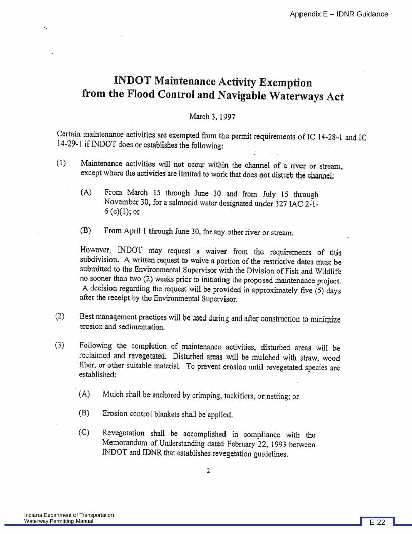
Appendix E – IDNR Guidance
Indiana Department of Transportation Waterway Permitting Manual E 22
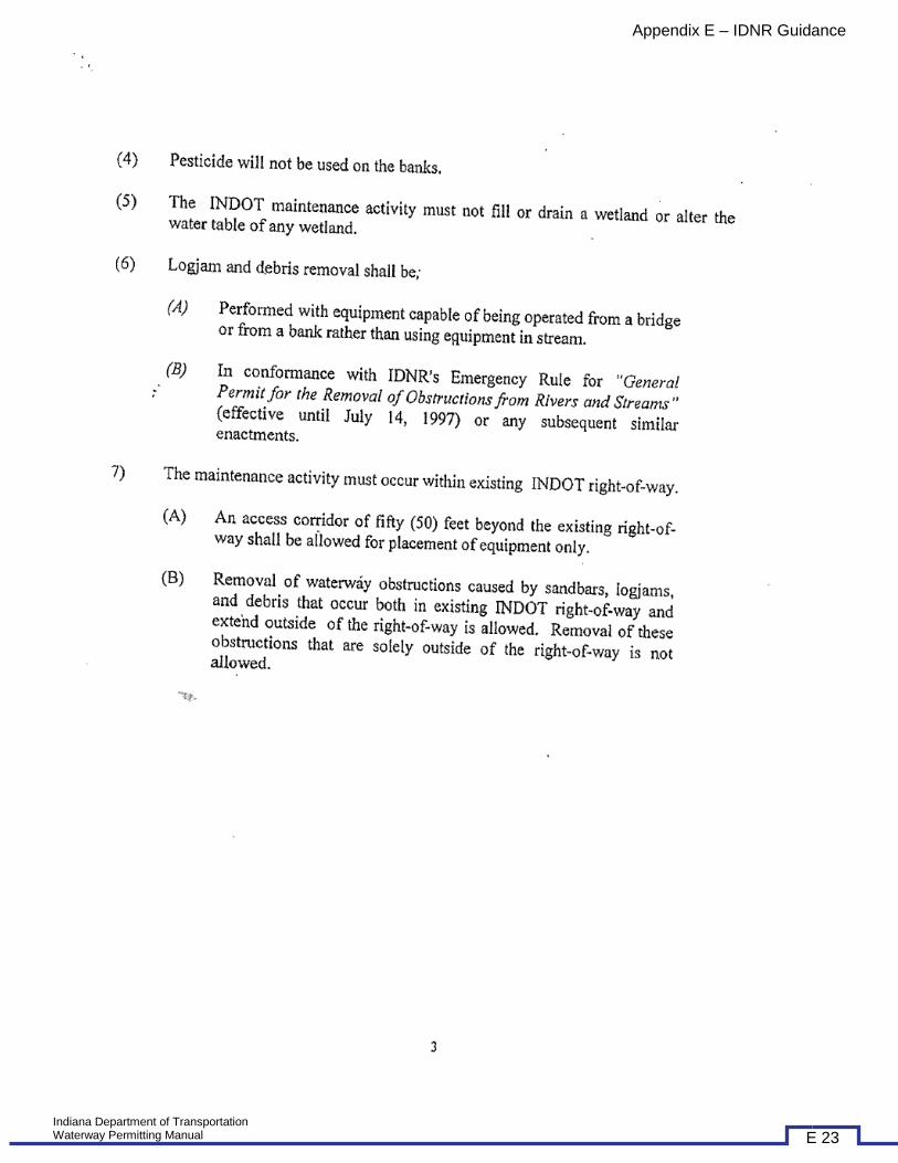
Appendix E – IDNR Guidance
Indiana Department of Transportation Waterway Permitting Manual E 23

Appendix E – IDNR Guidance
Indiana Department of Transportation Waterway Permitting Manual E 24

Appendix E – IDNR Guidance
Indiana Department of Transportation Waterway Permitting Manual E 25

Appendix E – IDNR Guidance
Indiana Department of Transportation Waterway Permitting Manual E 26
Appendix E – IDNR Guidance
Indiana Department of Transportation Waterway Permitting Manual E 27
Appendix E – IDNR Guidance
Indiana Department of Transportation Waterway Permitting Manual E 28

Appendix E – IDNR Guidance
Indiana Department of Transportation Waterway Permitting Manual E 29

Appendix E – IDNR Guidance
Indiana Department of Transportation Waterway Permitting Manual E 30
Appendix E – IDNR Guidance
Indiana Department of Transportation Waterway Permitting Manual E 31

Appendix E – IDNR Guidance
Indiana Department of Transportation Waterway Permitting Manual E 32

Appendix E – IDNR Guidance
IDNR – CONSTRUCTION IN A FLOODWAY – CHECKLIST
Indiana Department of Transportation Waterway Permitting Manual E 33

Appendix E – IDNR Guidance
Indiana Department of Transportation Waterway Permitting Manual E 34

Appendix E – IDNR Guidance
Indiana Department of Transportation Waterway Permitting Manual E 35

Appendix E – IDNR Guidance
Indiana Department of Transportation Waterway Permitting Manual E 36
Appendix E – IDNR Guidance
Indiana Department of Transportation Waterway Permitting Manual E 37

Appendix E – IDNR Guidance
Indiana Department of Transportation Waterway Permitting Manual E 38

Appendix E – IDNR Guidance
IDNR – STATE FORM 42946
Indiana Department of Transportation Waterway Permitting Manual E 39

Appendix E – IDNR Guidance
Indiana Department of Transportation Waterway Permitting Manual E 40

Appendix E – IDNR Guidance
IDNR – FORM N4 – STATE FORM 52086
Indiana Department of Transportation Waterway Permitting Manual E 41

IDNR – FORM N2 – STATE FORM 50354
Indiana Department of Transportation Waterway Permitting Manual E 42

Indiana Department of Transportation Waterway Permitting Manual E 43