appendix g cultural heritage assessment report - … · appendix g cultural heritage assessment...
TRANSCRIPT

Appendix G
Cultural Heritage Assessment Report: Built Heritage Resources and Cultural Heritage
Landscapes – Existing Conditions

Cultural Heritage Assessment Report: Built Heritage Resources and Cultural Heritage Landscapes
Existing Conditions
Class Environmental Assessment Study for Thornton Road, City of Oshawa, Ontario
Prepared for:
GHD 110 Scotia Court, Unit 41
Whitby, ON L1N 8Y7 Tel: (905) 429-4972
ASI File 13EA-031
September 2013

Cultural Heritage Assessment Report: Built Heritage Resources and Cultural Heritage Landscapes
Existing Conditions
Class Environmental Assessment Study for Thornton Road,
City of Oshawa, Ontario
EXECUTIVE SUMMARY
Archaeological Services Inc. (ASI) was contracted by GHD, on behalf of the City of Oshawa, to conduct a cultural heritage resource assessment as part of the Schedule C Class Environmental Assessment Study for Improvements to the Regional Road Corridor bounded by Thornton Road, Winchester Road, and Taunton Road. The study corridor extends south-easterly along Thornton Road from Winchester Road to Taunton Road in the City of Oshawa, Ontario. The study is being undertaken to provide a comprehensive and environmentally-sound Transportation and Road Infrastructure Improvement Plan (including 30 % Detailed Design). Based upon the results of background data collection and field review, five cultural heritage resources were identified along the Thornton Road study corridor. Based on the results of the assessment the following is recommended:
1. Road improvement activities should be suitably planned to avoid impacts to identified cultural heritage resources.
2. Once alternative or preferred designs of the preferred road improvements are available, a
qualified heritage consultant should be consulted to confirm impacts of the undertaking on cultural heritage resources identified within the study corridor and to recommend appropriate mitigation measures. Should it be determined that the identified cultural heritage resources will be impacted as a result of the undertaking, the subject resources should be evaluated to determine their specific heritage value. The results of such an examination would identify appropriate conservation measures for the resource where appropriate.
3. Should future work require an expansion of the current study corridor and/or an additional study
area, a qualified heritage consultant should be contacted in order to confirm impacts of the undertakings on potential cultural heritage resources.
4. Potential impacts to CHL 4 are expected given that this resource is located on either side of, and in
close proximity to, the existing roadway. Retention of CHL 4 should be considered in the designs for future improvements on Thornton Road.
~ Archaeological Services Inc.

Cultural Heritage Assessment Report – Existing Conditions Thornton Boulevard Class Environmental Assessment City of Oshawa, Ontario Page iii
ARCHAEOLOGICAL SERVICES INC. BUILT HERITAGE AND CULTURAL HERITAGE LANDSCAPE PLANNING DIVISION
PROJECT PERSONNEL
Corporate Responsibility: Robert Pihl, MA, CAHP Partner and Senior Archaeologist Manager, Environmental Assessment Division
Project Director: David Robertson, MA Senior Archaeologist Manager, Planning Applications and Special Projects Division
Project Manager: Lindsay Popert, MA, CAHP Cultural Heritage Specialist
Project Coordinator: Sarah Jagelewski, Hon. BA Research Archaeologist
Project Administrator: Carol Bella, Hon. BA Research Archaeologist
Report Preparation: Joel Konrad, Ph.D. Cultural Heritage Specialist
Graphics Preparation: Joel Konrad
Report Reviewer: David Robertson

Cultural Heritage Assessment Report – Existing Conditions Thornton Boulevard Class Environmental Assessment City of Oshawa, Ontario Page iv
TABLE OF CONTENTS
EXECUTIVE SUMMARY .................................................................................................................................. ii PROJECT PERSONNEL................................................................................................................................... iii TABLE OF CONTENTS ................................................................................................................................... iv 1.0 INTRODUCTION ................................................................................................................................ 1 2.0 BUILT HERITAGE RESOURCE AND CULTURAL HERITAGE LANDSCAPE ASSESSMENT CONTEXT ................. 1
2.1 Approach and Methodology .......................................................................................................... 1 2.2 Municipal Policies ........................................................................................................................ 5 2.3 Data Collection ............................................................................................................................. 6
3.0 BUILT HERITAGE RESOURCE AND CULTURAL HERITAGE LANDSCAPE ASSESSMENT ................................ 8 3.1 Introduction ................................................................................................................................. 8 3.2 Township Survey and Settlement .................................................................................................. 9
3.2.1 Township of Whitby .............................................................................................................. 9 3.2.2 Oshawa ............................................................................................................................... 9 3.2.3 The County of Ontario and the Regional Municipality of Durham ............................................. 9
3.3 Review of Historic Mapping ........................................................................................................ 10 3.4 Existing Conditions .................................................................................................................... 12 3.5 Screening for Potential Impacts .................................................................................................. 18
4.0 CONCLUSIONS ............................................................................................................................... 19 5.0 RECOMMENDATIONS ...................................................................................................................... 20 6.0 CULTURAL HERITAGE RESOURCE LOCATION MAPPING ....................................................................... 21 7.0 REFERENCES .................................................................................................................................. 28
LIST OF FIGURES
Figure 1: Location of the study corridor in the City of Oshawa. ........................................................................ 1 Figure 2: Approximate location of the study corridor overlaid on a map of the ............................................... 11 Figure 3: Approximate location of the study corridor on historic mapping ..................................................... 12 Figure 4: Key Plan showing the Thornton Road EA. ...................................................................................... 21 Figure 5: Thornton Road EA – Location of identified cultural heritage landscapes (CHLs) and built heritage
resources (BHRs). ........................................................................................................................... 22 Figure 6: Thornton Road EA – Location of identified cultural heritage landscapes (CHLs) and built heritage
resources (BHRs). ........................................................................................................................... 23 Figure 7: Thornton Road EA – Location of identified cultural heritage landscapes (CHLs) and built heritage
resources (BHRs). ........................................................................................................................... 24 Figure 8: Thornton Road EA – Location of identified cultural heritage landscapes (CHLs) and built heritage
resources (BHRs). ........................................................................................................................... 25 Figure 9: Thornton Road EA – Location of identified cultural heritage landscapes (CHLs) and built heritage
resources (BHRs). ........................................................................................................................... 26 Figure 10: Thornton Road EA – Location of identified cultural heritage landscapes (CHLs) and built heritage
resources (BHRs). ........................................................................................................................... 27
LIST OF TABLES
Table 1: Thornton Road – Nineteenth-century property owner(s) and historical features(s) ............................ 10 Table 2: Identified Cultural Heritage Landscapes (CHLs) and Built Heritage Resources (BHRs) in the Study
Corridor .......................................................................................................................................... 15
LIST OF PLATES

Cultural Heritage Assessment Report – Existing Conditions Thornton Boulevard Class Environmental Assessment City of Oshawa, Ontario Page v
Plate 1: Thornton Road corridor looking southeast from Winchester Road. .................................................... 14 Plate 2: View East from bridge over Oshawa Creek. ..................................................................................... 14 Plate 3: View of Thornton Road looking north. Note the wood telephone poles and fencing. .......................... 14 Plate 4: Detail of post and wire fencing with unique top board. .................................................................... 14 Plate 5: Subdivision on west side of Thornton Road between Winchester and Conlin. ................................... 14 Plate 6: Example of mid-twentieth century homes on the west side of Thornton Road. .................................. 14

Cultural Heritage Assessment Report – Existing Conditions Thornton Road Class Environmental Assessment City of Oshawa, Ontario Page 1 1.0 INTRODUCTION Archaeological Services Inc. (ASI) was contracted by GHD, on behalf of the City of Oshawa, to conduct a cultural heritage resource assessment as part of the Schedule C Class Environmental Assessment Study for Improvements to the Regional Road Corridor bounded by Thornton Road, Winchester Road, and Taunton Road. The study corridor extends south-easterly along Thornton Road from Winchester Road to Taunton Road, in the Town of Oshawa, Ontario (Figure 1). The study is being undertaken to provide a comprehensive and environmentally-sound Transportation and Road Infrastructure Improvement Plan (including 30 % Detailed Design). The purpose of this report is to present a built heritage and cultural heritage landscape inventory of cultural heritage resources in the study corridor, identify general impacts to identified cultural heritage resources, and propose appropriate mitigation measures. This research was conducted under the project direction of Lindsay Popert, Cultural Heritage Specialist.
Figure 1: Location of the study corridor in the City of Oshawa.
Base Map: NTS Map Sheets Oshawa 30-M-15
2.0 BUILT HERITAGE RESOURCE AND CULTURAL HERITAGE LANDSCAPE ASSESSMENT CONTEXT 2.1 Approach and Methodology This cultural heritage assessment considers cultural heritage resources in the context of improvements to specified areas, pursuant to the Environmental Assessment Act. This assessment addresses above ground cultural heritage resources over 40 years old. Use of a 40 year old threshold is a guiding principle when

Cultural Heritage Assessment Report – Existing Conditions Thornton Road Class Environmental Assessment City of Oshawa, Ontario Page 2
conducting a preliminary identification of cultural heritage resources (Ministry of Transportation 2006; Ministry of Transportation 2007; Ontario Realty Corporation 2007). While identification of a resource that is 40 years old or older does not confer outright heritage significance, this threshold provides a means to collect information about resources that may retain heritage value. Similarly, if a resource is slightly younger than 40 years old, this does not preclude the resource from retaining heritage value. For the purposes of this assessment, the term cultural heritage resources was used to describe both cultural heritage landscapes and built heritage features. A cultural landscape is perceived as a collection of individual built heritage resources and other related features that together form farm complexes, roadscapes and nucleated settlements. Built heritage features are typically individual buildings or structures that may be associated with a variety of human activities, such as historical settlement and patterns of architectural development. The analysis throughout the study process addresses cultural heritage resources under various pieces of legislation and their supporting guidelines. Under the Environmental Assessment Act (1990) environment is defined in Subsection 1(c) to include:
• cultural conditions that influence the life of man or a community, and; • any building, structure, machine, or other device or thing made by man.
The Ministry of Tourism, Culture and Sport is charged under Section 2 of the Ontario Heritage Act with the responsibility to determine policies, priorities and programs for the conservation, protection and preservation of the heritage of Ontario and has published two guidelines to assist in assessing cultural heritage resources as part of an environmental assessment: Guideline for Preparing the Cultural Heritage Resource Component of Environmental Assessments (1992), and Guidelines on the Man-Made Heritage Component of Environmental Assessments (1981). Accordingly, both guidelines have been utilized in this assessment process. The Guidelines on the Man-Made Heritage Component of Environmental Assessments (Section 1.0) states the following:
When speaking of man-made heritage we are concerned with the works of man and the effects of his activities in the environment rather than with movable human artifacts or those environments that are natural and completely undisturbed by man.
In addition, environment may be interpreted to include the combination and interrelationships of human artifacts with all other aspects of the physical environment, as well as with the social, economic and cultural conditions that influence the life of the people and communities in Ontario. The Guidelines on the Man-Made Heritage Component of Environmental Assessments distinguish between two basic ways of visually experiencing this heritage in the environment, namely as cultural heritage landscapes and as cultural features. Within this document, cultural heritage landscapes are defined as the following (Section 1.0):
The use and physical appearance of the land as we see it now is a result of man’s activities over time in modifying pristine landscapes for his own purposes. A cultural landscape is perceived as a collection of individual man-made features into a whole. Urban cultural landscapes are sometimes given special names such as townscapes or streetscapes that describe various scales of perception from the general scene to the

Cultural Heritage Assessment Report – Existing Conditions Thornton Road Class Environmental Assessment City of Oshawa, Ontario Page 3
particular view. Cultural landscapes in the countryside are viewed in or adjacent to natural undisturbed landscapes, or waterscapes, and include such land uses as agriculture, mining, forestry, recreation, and transportation. Like urban cultural landscapes, they too may be perceived at various scales: as a large area of homogeneous character; or as an intermediate sized area of homogeneous character or a collection of settings such as a group of farms; or as a discrete example of specific landscape character such as a single farm, or an individual village or hamlet.
A cultural feature is defined as the following (Section 1.0):
…an individual part of a cultural landscape that may be focused upon as part of a broader scene, or viewed independently. The term refers to any man-made or modified object in or on the land or underwater, such as buildings of various types, street furniture, engineering works, plantings and landscaping, archaeological sites, or a collection of such objects seen as a group because of close physical or social relationships.
The Ministery of Tourism and Culture has also published Standards and Guidelines for Conservation of Provincial Heritage Properties (April 2010; Standards and Guidelines hereafter). These Standards and Guidelines apply to properties the Government of Ontario owns or controls that have cultural heritage value or interest. They are mandatory for ministries and prescribed public bodies and have the authority of a Management Board or Cabinet directive. Prescribed public bodies include:
Agricultural Research Institute of Ontario Hydro One Inc. Liquor Control Board of Ontario McMichael Canadian Art Collection Metrolinx The Niagara Parks Commission. Ontario Heritage Trust Ontario Infrastructure Projects Corporation Ontario Lottery and Gaming Corporation Ontario Power Generation Inc. Ontario Realty Corporation Royal Botanical Gardens Toronto Area Transit Operating Authority St. Lawrence Parks Commission
The Standards and Guidelines provide a series of definition considered during the course of the assessment: A provincial heritage property is defined as the following (14):
Provincial heritage property means real property, including buildings and structures on the property, that has cultural heritage value or interest and that is owned by the Crown in right of Ontario or by a prescribed public body; or that is occupied by a ministry or a prescribed public body if the terms of the occupancy agreement are such that the ministry or public body is entitled to make the alterations to the property that may be required under these heritage standards and guidelines.

Cultural Heritage Assessment Report – Existing Conditions Thornton Road Class Environmental Assessment City of Oshawa, Ontario Page 4
A provincial heritage property of provincial significance is defined as the following (14):
Provincial heritage property that has been evaluated using the criteria found in Ontario Heritage Act O.Reg. 10/06 and has been found to have cultural heritage value or interest of provincial significance.
A built heritage resource is defined as the following (13):
…one or more significant buildings (including fixtures or equipment located in or forming part of a building), structures, earthworks, monuments, installations, or remains associated with architectural, cultural, social, political, economic, or military history and identified as being important to a community. For the purposes of these Standards and Guidelines, “structures” does not include roadways in the provincial highway network and in-use electrical or telecommunications transmission towers.
A cultural heritage landscape is defined as the following (13):
… a defined geographical area that human activity has modified and that has cultural heritage value. Such an area involves one or more groupings of individual heritage features, such as structures, spaces, archaeological sites, and natural elements, which together form a significant type of heritage form distinct from that of its constituent elements or parts. Heritage conservation districts designated under the Ontario Heritage Act, villages, parks, gardens, battlefields, mainstreets and neighbourhoods, cemeteries, trails, and industrial complexes of cultural heritage value are some examples.
Additionally, the Planning Act (1990) and related Provincial Policy Statement (PPS) make a number of provisions relating to heritage conservation. One of the general purposes of the Planning Act is to integrate matters of provincial interest in provincial and municipal planning decisions. In order to inform all those involved in planning activities of the scope of these matters of provincial interest, Section 2 of the Planning Act provides an extensive listing. These matters of provincial interest shall be regarded when certain authorities, including the council of a municipality, carry out their responsibilities under the Act. One of these provincial interests is directly concerned with:
2.0 …protecting cultural heritage and archaeological resources for their economic, environmental, and social benefits.
Part 4.5 of the PPS states that:
Comprehensive, integrated and long-term planning is best achieved through municipal official plans. Municipal official plans shall identify provincial interests and set out appropriate land use designations and policies. Municipal official plans should also coordinate cross-boundary matters to complement the actions of other planning authorities and promote mutually beneficial solutions. Municipal official plans shall provide clear, reasonable and attainable policies to protect provincial interests and direct development to suitable areas.

Cultural Heritage Assessment Report – Existing Conditions Thornton Road Class Environmental Assessment City of Oshawa, Ontario Page 5
In order to protect provincial interests, planning authorities shall keep their official plans up-to-date with this Provincial Policy Statement. The policies of this Provincial Policy Statement continue to apply after adoption and approval of a municipal official plan.
Those policies of particular relevance for the conservation of heritage features are contained in Section 2- Wise Use and Management of Resources, wherein Subsection 2.6 - Cultural Heritage and Archaeological Resources, makes the following provisions:
2.6.1 Significant built heritage resources and cultural heritage landscapes shall be conserved. A number of definitions that have specific meanings for use in a policy context accompany the policy statement. These definitions include built heritage resources and cultural heritage landscapes. Built heritage resources mean one or more buildings, structures, monuments, installations or remains associated with architectural, cultural, social, political, economic, or military history, and identified as being important to a community. Cultural heritage landscapes mean a defined geographical area of heritage significance that has been modified by human activities. Such an area is valued by a community, and is of significance to the understanding of the history of a people or place. Examples include farmscapes, historic settlements, parks, gardens, battlefields, mainstreets and neighbourhoods, cemeteries, trailways, and industrial complexes of cultural heritage value (PPS 2005). In addition, significance is also more generally defined. It is assigned a specific meaning according to the subject matter or policy context, such as wetlands or ecologically important areas. With regard to cultural heritage and archaeology resources, resources of significance are those that are valued for the important contribution they make to our understanding of the history of a place, an event, or a people (PPS 2005). Criteria for determining significance for the resources are recommended by the Province, but municipal approaches that achieve or exceed the same objective may also be used. While some significant resources may already be identified and inventoried by official sources, the significance of others can only be determined after evaluation (PPS 2005). Accordingly, the foregoing guidelines and relevant policy statement were used to guide the scope and methodology of the cultural heritage assessment. 2.2 Municipal Policies In the City of Oshawa’s Official Plan (2007), Section 5.10 Cultural Heritage Resources provides general policy direction regarding archaeology and cultural heritage. In particular, the following policies guide the management of cultural heritage in the City of Oshawa:
5.10.1 The City shall encourage and support the identification and preservation of heritage resources by designating properties, buildings and other structures which are of cultural heritage value or interest in accordance with the Ontario Heritage Act.
5.10.2 The City has a municipal heritage committee known as Heritage Oshawa. The City shall:

Cultural Heritage Assessment Report – Existing Conditions Thornton Road Class Environmental Assessment City of Oshawa, Ontario Page 6
a) Liaise with Heritage Oshawa when identifying, preserving and designating heritage
resources in accordance with the Ontario Heritage Act. b) Encourage Heritage Oshawa to prepare and maintain a comprehensive inventory that
lists properties, buildings and other structures which are considered to be of cultural heritage value or interest.
c) Encourage Heritage Oshawa to promote public awareness and stewardship in heritage conservation.
5.10.3 All development or redevelopment shall have regard for cultural heritage resources
and shall, wherever feasible, incorporate these resources into any site plan or design that may be prepared for such development. Alternatively, arrangements may be made to preserve the resource in an appropriate manner off-site.
5.10.4 The City may designate areas of the municipality as heritage conservation districts in accordance with the Ontario Heritage Act.
5.10.5 An archaeological assessment shall be required through the development review process in areas identified as having archaeological potential or known archaeological sites. In the event that significant archaeological resources are located on the site of any proposed development, such resources may be required to be preserved, removed, catalogued, and/or analyzed as part of developing the affected site, to the satisfaction of the City and the Province. 2.3 Data Collection In the course of the cultural heritage assessment, all potentially affected cultural heritage resources are subject to inventory. Short form names are usually applied to each resource type, (e.g. barn, residence). Generally, when conducting a preliminary identification of cultural heritage resources, three stages of research and data collection are undertaken to appropriately establish the potential for and existence of cultural heritage resources in a particular geographic area. Background historic research, which includes consultation of primary and secondary sources and historic mapping, is undertaken to identify early settlement patterns and broad agents or themes of change in a study corridor. This stage in the data collection process enables the researcher to determine the presence of sensitive heritage areas that correspond to nineteenth and twentieth-century settlement and development patterns. To augment data collected during this stage of the research process, federal, provincial, and municipal databases and/or agencies are consulted to obtain information about specific properties that have been previously identified and/or designated as retaining cultural heritage value. Typically, resources identified during these stages of the research process are reflective of particular architectural styles, associated with an important person, place, or event, and contribute to the contextual facets of a particular place, neighbourhood, or intersection. A field review is then undertaken to confirm the location and condition of previously identified cultural heritage resources. The field review is also utilized to identify cultural heritage resources that have not been previously identified on federal, provincial, or municipal databases.

Cultural Heritage Assessment Report – Existing Conditions Thornton Road Class Environmental Assessment City of Oshawa, Ontario Page 7
Several investigative criteria are utilized during the field review to appropriately identify new cultural heritage resources. These investigative criteria are derived from provincial guidelines, definitions, and past experience. During the course of the environmental assessment, a built structure or landscape is identified as a cultural heritage resource if it is considered to be 40 years or older, and if the resource satisfies at least one of the following criteria: Design/Physical Value:
It is a rare, unique, representative or early example of a style, type, expression, material or construction method.
It displays a high degree of craftsmanship or artistic merit. It demonstrates a high degree of technical or scientific achievement. The site and/or structure retains original stylistic features and has not been irreversibly altered so
as to destroy its integrity. It demonstrates a high degree of excellence or creative, technical or scientific achievement at a
provincial level in a given period. Historical/Associative Value:
It has a direct association with a theme, event, belief, person, activity, organization, or institution that is significant to: the City of Oshawa; the Province of Ontario; or Canada.
It yields, or has the potential to yield, information that contributes to an understanding of the history of The City of Oshawa; the Province of Ontario, or Canada.
It demonstrates or reflects the work or ideas of an architect, artist builder, designer, or theorist who is significant to the City of Oshawa; the Province of Ontario; or Canada.
It represents or demonstrates a theme or pattern in Ontario’s history. It demonstrates an uncommon, rare or unique aspect of Ontario’s cultural heritage. It has a strong or special association with the entire province or with a community that is found in
more than one part of the province. The association exists for historic, social, or cultural reasons or because of traditional use.
It has a strong or special association with the life or work of a person, group or organization of importance to the province or with an event of importance to the province.
Contextual Value:
It is important in defining, maintaining, or supporting the character of an area. It is physically, functionally, visually, or historically linked to its surroundings. It is a landmark. It illustrates a significant phase in the development of the community or a major change or
turning point in the community’s history. The landscape contains a structure other than a building (fencing, culvert, public art, statue, etc.)
that is associated with the history or daily life of that area or region. There is evidence of previous historic and/or existing agricultural practices (e.g. terracing,
deforestation, complex water canalization, apple orchards, vineyards, etc.) It is of aesthetic, visual or contextual important to the province.
If a resource meets one of these criteria it will be identified as a cultural heritage resource and is subject to further research where appropriate and when feasible. Typically, detailed archival research, permission to enter lands containing heritage resources, and consultation is required to determine the specific heritage significance of the identified cultural heritage resource.

Cultural Heritage Assessment Report – Existing Conditions Thornton Road Class Environmental Assessment City of Oshawa, Ontario Page 8
When identifying cultural heritage landscapes, the following categories are typically utilized for the purposes of the classification during the field review: Farm complexes: comprise two or more buildings, one of which must be a farmhouse or
barn, and may include a tree-lined drive, tree windbreaks, fences, domestic gardens and small orchards.
Roadscapes: generally two-lanes in width with absence of shoulders or narrow
shoulders only, ditches, tree lines, bridges, culverts and other associated features.
Waterscapes: waterway features that contribute to the overall character of the cultural
heritage landscape, usually in relation to their influence on historic development and settlement patterns.
Railscapes: active or inactive railway lines or railway rights of way and associated
features. Historical Settlements: groupings of two or more structures with a commonly applied name. Streetscapes: generally consists of a paved road found in a more urban setting, and may
include a series of houses that would have been built in the same time period.
Historical Agricultural Landscapes: generally comprises a historically rooted settlement and farming pattern
that reflects a recognizable arrangement of fields within a lot and may have associated agricultural outbuildings, structures, and vegetative elements such as tree rows;
Cemeteries: land used for the burial of human remains. Results of the desktop data collection and fieldwork are contained in Section 3.0. Section 4.0 summarizes the findings of the data collection while Section 5.0 contains recommendations for mitigation strategies. 3.0 BUILT HERITAGE RESOURCE AND CULTURAL HERITAGE LANDSCAPE ASSESSMENT 3.1 Introduction This section provides a brief summary of historic research and a description of identified above ground cultural heritage resources that may be affected by the proposed road improvements. A review of available primary and secondary source material was undertaken to produce a contextual overview of the study corridor, including a general description of Euro-Canadian settlement and land use. Historically, the study corridor is located within the road allowance between the following lots and concessions: City of Oshawa (Durham County)
Concession 3, Lots 16 and 17 Concession 4, Lots 16 and 17

Cultural Heritage Assessment Report – Existing Conditions Thornton Road Class Environmental Assessment City of Oshawa, Ontario Page 9
3.2 Township Survey and Settlement 3.2.1 Township of Whitby Whitby Township, when first laid out in the 1790s, was designated Township 9, although the name was changed shortly thereafter to Norwich. The first survey of this township was made in 1791 and the first settler arrived in 1794 (Armstrong 1985: 148). The first settler is believed to be Benjamin Wilson, a Loyalist from Vermont, who settled along the lakeshore east of Oshawa. Wilson’s house, built on Lot 4 in the Broken Front, was an early landmark that was depicted on several early township surveys and patent plans. Whitby was quickly settled by a mixture of Loyalists, disbanded troops, and emigrants from the United States, the United Kingdom, and Ireland. Boulton (1805: 90) noted that Whitby would command “particular advantages” due to its proximity to the seat of government, and by 1846 Smith described it as a “well settled township … [where] farms are generally well cleared and cultivated, and in good order.” The timber was a mixture of hardwood and pine (Smith 1846: 218). In 1851, Smith described it as “an exceedingly fine township…considered in point of value of property and agricultural productions, the first township in the County” (Smith 1851: 26). This statement is substantiated by an examination of extant census and assessment records for the township. 3.2.2 Oshawa Two major settlements were soon established in the southern half of the township, Whitby and Oshawa. These communities were advantageously located where watersheds (such as Lynde and Oshawa creeks) were crossed by the Kingston Road. Whitby further benefited from its harbour and from the construction of the Grand Trunk Railway in the 1850s. The 1850 De Rottenburg map shows that Whitby contained a much heavier concentration of roads than did neighboring Pickering, some of the roads having been planked or graveled. An early patent plan for Whitby (Chewett 1795) showed a road which originated at Wilson’s on Lot 4 in the Broken Front and which extended northwards to Lot 12 in Concession 9. This road forked at Lot 5, Concession 1, and the easterly branch extended up as far as Lot 1, Concession 8. It appears to have followed the high ground between the East Oshawa Creek and Harmony Creek watersheds and does not correspond to any later roads shown on the De Rottenburg (1850), Tremaine (Shier 1860), or Beers atlas (Beers 1877) maps. This early patent plan also showed minor road deviations from Lots 16 to 20 between Concessions 1 and 2, as well as from Lots 1 to 4 in Concession 1. 3.2.3 The County of Ontario and the Regional Municipality of Durham The former Township of Ontario was bounded on the north by the District of Muskoka, the east by the Durham and Victoria Counties, the south by Lake Ontario, and the west by York County and Lake Simcoe (Mika 1983: 112). The Township was given its name by Lord Simcoe, and was under the municipal and judicial administration of York and Peel Counties until 1852. In that year a provisional council was elected, a movement toward the eventual creation of Ontario County in 1854. The earliest residents to the area were of English, Irish and German extraction, with the initial wave of settlement occurring from the 1790s to the 1820s. During the mid to late nineteenth century, Ontario County’s primary industry was agriculture, and particularly cattle husbandry. Ports flourished in the settlements of Whitby, East Whitby (Oshawa), and Pickering, facilitating the transportation of beef, sheep and horses to other areas of the great lakes (Mika 1983: 113). The McLaughlin Carriage Company was founded in Oshawa in 1876, creating an industrial,

Cultural Heritage Assessment Report – Existing Conditions Thornton Road Class Environmental Assessment City of Oshawa, Ontario Page 10
social and cultural infrastructure for vehicle building in the area. By 1915, Oshawa was home to a General Motors facility and the automotive industry dominated the economy of the region for the rest of the twentieth-century. Ontario County was dissolved in the mid 1970s, with the majority of its municipal and judicial responsibilities being transferred to the newly created Regional Municipality of Durham. 3.3 Review of Historic Mapping The 1860 Tremaine’s Map of Ontario County and the 1877 Illustrated Historical Map of Ontario County were reviewed to determine the potential for the presence of cultural heritage resources within the study corridor which date from the nineteenth century (Figures 2 & 3). It should be noted, however, that not all features of interest were mapped systematically in the Ontario series of historical atlases, given that they were financed by subscription, and subscribers were given preference with regard to the level of detail provided on the maps. Moreover, not every feature of interest would have been within the scope of the atlases. Historically, the study area is located in the former Township of East Whitby, Ontario County. Details of historic property owners and historic features in the study area are listed in Table 1. Table 1: Thornton Road – Nineteenth-century property owner(s) and historical features(s)
Con. # Lot # Property Property Owners Historical Historical Owner(s) 1860 (1877) Feature(s) (1860) Feature(s) (1877)
Township of East Whitby, Ontario County 3 16 Mrs. Hyland, J. & G. Hyland, J. - Farmsteads (2)
Jason Nesbitt Nesbitt 17 Mrs. Hyland, J. Nesbitt, D. Kent - Farmstead (1)
Jason Nesbitt, D. Kent
4 16 S. Dearbourne, J. W. McGill, H. - Farmstead (3) Bowles, Chas. Dearborn, J. Reynolds Woodward, W. Hill
17 John Bowles, J. D. Hinkson, C. Farmsteads (2) Farmsteads (3) Groat, C. Groat, W. Hill Reynolds
Cultural Heritage Assessment Report – Existing Conditions Thornton Road Class Environmental Assessment City of Oshawa, Ontario Page 11
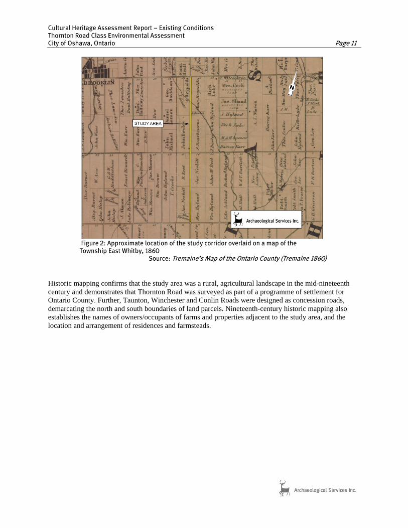
F T
igure 2: Approximate location of the study corridor overlaid on a map of the ownship East Whitby, 1860
Source: Tremaine’s Map of the Ontario County (Tremaine 1860)
Historic mapping confirms that the study area was a rural, agricultural landscape in the mid-nineteenth century and demonstrates that Thornton Road was surveyed as part of a programme of settlement for Ontario County. Further, Taunton, Winchester and Conlin Roads were designed as concession roads, demarcating the north and south boundaries of land parcels. Nineteenth-century historic mapping also establishes the names of owners/occupants of farms and properties adjacent to the study area, and the location and arrangement of residences and farmsteads.

Cultural Heritage Assessment Report – Existing Conditions Thornton Road Class Environmental Assessment City of Oshawa, Ontario Page 12
Figure 3: Approximate location of the study corridor on historic mapping
Source: Illustrated Historical Atlas of Ontario County (1877)
3.4 Existing Conditions A number of resources were consulted for the preliminary identification of built heritage resources and cultural heritage landscapes along the Thornton Road study corridor, including: the Canadian Register of

Cultural Heritage Assessment Report – Existing Conditions Thornton Road Class Environmental Assessment City of Oshawa, Ontario Page 13
Historic Places1; the City of Heritage Inventory available at the City of Oshawa Municipal Office; The City of Oshawa’s Official Plan available online; and the City of Oshawa’s by-law 11-2013, available through communications with the Town’s Heritage Resource Officer (Susan Ashton, August 2013). A field review was undertaken by Lindsay Popert and Joel Konrad, ASI, on 14 August 2013, to document the existing conditions of the study corridor. The Thornton Road EA study corridor is located in the northwest part of the City of Oshawa, Ontario. Thornton Road is orientated in a northeast-southwest direction. Thornton Road, an historic road dividing lots 16 and 17 in the historic Township of Whitby East, is a two-lane paved road that follows the area’s rolling topography and features generally narrow gravel shoulders, a lack of roadside curbs (apart from a short stretch north from Taunton Road) , and predominantly shallow drainage/ditches alongside the roadway (Plates 1 – 3). In a few cases, residences were difficult or impossible to see given their distance from the road, often obscured by vegetative screening or impeded by other buildings. The landscape along Thornton Road varies. The section between Winchester Road and Oshawa Creek is comprised of agricultural fields sloping towards the creek valley. The section between Oshawa Creek and Conlin Road is comprised of woodlands, agricultural land, and residential properties, including a sub-division located on the west side of Thornton Road, approximately halfway between Oshawa Creek and Conlin Road. Thornton Road, between Conlin and the former Canadian Northern Railway Corridor, consists of a variety of woodlots, residential properties, and some agricultural land. The short section between the disused railway corridor and Taunton Road is predominantly recreational, industrial, and commercial. Thornton Road, which historically served as the boundary between lots 16 and 17, is a two-lane paved road with minimal shoulders that follows the area’s gently elevating and descending topography and features a general lack of roadside curbs and the existence of drainage ditches of various depths (Plates 3 – 4). Although there is only one major housing development, most of the study corridor is agricultural/rural residential, and can thus broadly be considered altered. Based on the results of the background research and field review, five cultural heritage resources were identified within the Thornton Road study corridor. Table 2 below lists the cultural heritage resources identified in the study corridor while Section 6.0 provides feature mapping of these resources. It should be noted that the cultural heritage resource boundaries, as illustrated on the feature mapping, are estimated based on patterns in the landscape observed during field review and from aerial mapping, given that property parcel data was not available.
1 The Canadian Register contains information about recognized places of local, provincial, territorial and national significance. To be included in the Register, a place must be formally recognized under the Ontario Heritage Act through municipal designation by-law, ownership by the Ontario Heritage Trust, or a heritage conservation easement. It must also meet eligibility criteria and documentation standards. The searchable database is available online: http://www.historicplaces.ca/en/pages/register-repertoire.aspx (accessed September 9, 2013).

Cultural Heritage Assessment Report – Existing Conditions Thornton Road Class Environmental Assessment City of Oshawa, Ontario Page 14
Plate 1: Thornton Road corridor looking southeast from Winchester Road.
Plate 2: View East from bridge over Oshawa Creek.
Plate 3: View of Thornton Road looking north. Note the wood telephone poles and fencing.
Plate 4: Detail of post and wire fencing with unique top board.
Plate 5: Subdivision on west side of Thornton Road between Winchester and Conlin.
Plate 6: Example of mid-twentieth century homes on the west side of Thornton Road.

Cultural Heritage Assessment Report – Existing Conditions Thornton Road Class Environmental Assessment City of Oshawa, Ontario Page 15
Table 2: Identified Cultural Heritage Landscapes (CHLs) and Built Heritage Resources (BHRs) in the Study Corridor
Feature Inventory Description Photograph(s)
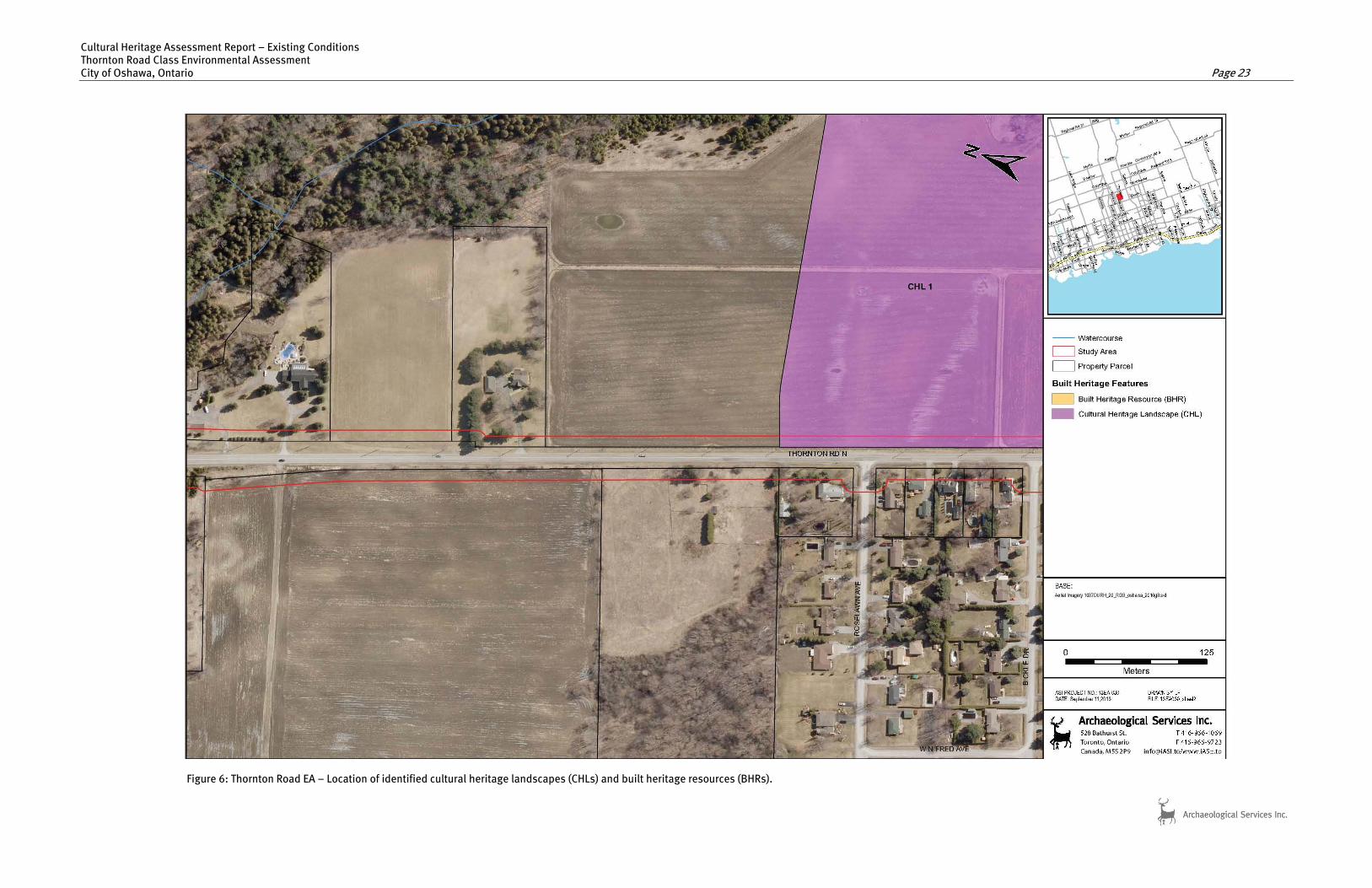
CHL 1 Location: 2203 Thornton Road
West elevation (front façade) of frame house
Feature Type: Farm Complex Recognition: Windfields Farm is listed on Oshawa’s Heritage Inventory
Historical: - On nineteenth-century historic mapping, this
property was owned/occupied by the Dearborn family. During the twentieth century the property was purchased by Windfields Farm and is now owned by the University of Ontario Institute of Technology.
Design: - This two-storey, frame dwelling with gabled
roof features modern multi-paned windows, internal brick chimney, gingerbread bargeboard ornament, and an L-shaped footprint.
- The house faces west and is located on the western edge of the historic and current parcel. The Rosslawn housing subdivision is located to the northwest of the property.
Context: - Contributes to the agricultural character of the
View of property east from Thornton Road
area through retention of the house, mature trees, wooden fences, and visual associationswith fields, woodlots, tree lines, wooden fences and boulder fences.

Cultural Heritage Assessment Report – Existing Conditions Thornton Road Class Environmental Assessment City of Oshawa, Ontario Page 16
Table 2: Identified Cultural Heritage Landscapes (CHLs) and Built Heritage Resources (BHRs) in the Study Corridor
Feature Inventory Description Photograph(s)
CHL 2 Location: 1725 Thornton Road Feature Type: Farm Complex Recognition: Listed on the City of Oshawa’s Heritage Inventory
Historical: - On nineteenth-century historic mapping, this
property was built/occupied by J. Nesbit. Design: - This one-and-a-half-storey, three-bay natural
faced stone house with elongated dormered element on a gabled roof features an internally-bracketed brick chimney and double-hung 9x9 sash windows on the west
West elevation (front façade) of stone house
façade. The building’s U-shaped footprint is completed by an attached three-door stone garage to the north and a stone addition to the east.
- The house faces west and is centrally located on the property with an early twentieth-century silo to the north of the building.
- The house is set within a grove of mature locust trees that flank Thornton Road. These trees, as well as a concentration of willows lining the northern edge of the property, contribute to the pastoral environment present on this section of Thornton Road.
Context: - Contributes to the agricultural character of this
View of property from north, including north elevation of
stone house
segment of the study corridor through retention of the original stone house and mature trees.

Cultural Heritage Assessment Report – Existing Conditions Thornton Road Class Environmental Assessment City of Oshawa, Ontario Page 17
Table 2: Identified Cultural Heritage Landscapes (CHLs) and Built Heritage Resources (BHRs) in the Study Corridor
Feature Inventory Description Photograph(s)
CHL 3 Location: North of Taunton Road, intersecting
Thornton Road running east-west Feature Type: Disused rail corridor Recognition: Identified during field review
Historical: - On early twentieth-century historic mapping,
this corridor is identified as the Canadian Northern Railway.
Design: - Former rail corridor is overgrown and obscured
from view on the east side of Thornton Road. It is thus not an excellent example of a remnant rail line.
Looking west down the former Canadian Northern
Railway
Context: - Contributes to an understanding of early
settlement patterns in the region. Road improvements have been undertaken resulting in a widening of Thornton Road and
curbs extant south from this point.
CHL 4 Location: Flanking Thornton Road, adjacent to CHL 2 Feature Type: Old growth tree line Recognition: Identified during field review
Historical: - Old growth locust tree line flanking former
division between lots 16 and 17. Design: - Tree line is sympathetic with the historic
character of 1725 Thornton Road. Context: - This tree line contributes to an understanding
of early settlement patterns in the region Looking south along Thornton Road
through its delineation of an historic settler’s road.

Cultural Heritage Assessment Report – Existing Conditions Thornton Road Class Environmental Assessment City of Oshawa, Ontario Page 18
Table 2: Identified Cultural Heritage Landscapes (CHLs) and Built Heritage Resources (BHRs) in the Study Corridor
Feature Inventory Description Photograph(s)
BHR 1 Location: Span crossing Oshawa Creek on Thornton Road south of Winchester Road Feature Type: Bridge Recognition: Identified during field review
Historical: - No evidence was found of prior bridges on this
site. However, as Thornton Road was an historic road, previous bridges must have spanned the creek at this site.
Design: - This one-span rigid-frame concrete bridge
carries the southeast and northwest lanes of Thornton Road over Oshawa Creek.
- The overall form, design and scale is typical of Oblique view of east elevation looking north
an unaltered mid-twentieth century rigid-framebridge.
Context: - Contributes to the historic character of the
subject corridor through the retention of the original features of the bridge, such as its period railing system.
3.5 Screening for Potential Impacts To assess the potential impacts of the undertaking, identified cultural heritage resources are considered against a range of possible impacts as outlined in the document entitled Screening for Impacts to Built Heritage and Cultural Heritage Landscapes (MTC September 2010) which include:
Destruction of any, or part of any, significant heritage attribute or feature (III.1). Alteration which means a change in any manner and includes restoration, renovation, repair or
disturbance (III.2). Shadows created that alter the appearance of a heritage attribute or change the visibility of a
natural feature of plantings, such as a garden (III.3). Isolation of a heritage attribute from it surrounding environment, context, or a significant
relationship (III.4). Direct or indirect obstruction of significant views or vistas from, within, or to a built and natural
feature (III.5). A change in land use such as rezoning a battlefield from open space to residential use, allowing
new development or site alteration to fill in the formerly open spaces (III.6). Soil Disturbance such as a change in grade, or an alteration of the drainage pattern or excavation
(III.7) A number of additional factors are also considered when evaluation potential impacts on identified cultural heritage resources. These are outlined in a document set out by the Ministry of Culture and Communications (now Ministry of Tourism, Culture and Sport) and the Ministry of the Environment

Cultural Heritage Assessment Report – Existing Conditions Thornton Road Class Environmental Assessment City of Oshawa, Ontario Page 19
entitled Guideline for Preparing the Cultural Heritage Resource Component of Environmental Assessments (October 1992) and include:
Magnitude: the amount of physical alteration or destruction which can be expected; Severity: the irreversibility or reversibility of an impact; Duration: the length of time an adverse impact persists; Frequency: the number of times an impact can be expected; Range: the spatial distribution, widespread or site specific, of an adverse impact; and Diversity: the number of different kinds of activities to affect a heritage resource.
Once alternative or preferred designs for the Thornton Road lane improvements have been identified, all cultural heritage resources identified within and adjacent to the study corridor will be evaluated against the above criteria and a summary of impact screening results provided. Various works associated with road improvements have the potential to affect cultural heritage resources in a variety of ways, and as such, appropriate mitigation measures for the undertaking need to be considered. Where any identified, above ground, cultural heritage resources which may be affected by direct or indirect impacts, appropriate mitigation measures should be developed. This may include completing a heritage impact assessment or documentation report, or employing suitable measures such as landscaping, buffering or other forms of mitigation, where appropriate. In this regard, provincial guidelines should be consulted for advice and further heritage assessment work should be undertaken as necessary. 4.0 CONCLUSIONS The results of background historic research and a review of secondary source material, including historic mapping, revealed a study corridor with a rural land use history dating back to the early nineteenth century. The field review confirmed that this area retains a number of nineteenth and twentieth-century cultural heritage resources along Thornton Road. The following provides a summary of field review and data collection findings:
A total of four cultural heritage landscapes and one built heritage resource were identified in the study corridor. One of these, 1725 Thornton Road North (CHL 2), has been “designated as being of cultural heritage value and interest” (by-law 11-2013) by the City of Oshawa using Section 29 of the Ontario Heritage Act. In addition, Windfields Farm, of which CHL 1 is a part, is listed as a property of cultural value in the Oshawa Heritage Registry. The built heritage resource (BHL 1) and the remaining two cultural heritage landscapes (CHL 3 and CHL 4) were identified during field review.
Of the five identified cultural heritage resources: two are farm complexes (CHL 1 and CHL 2);
one is a disused railroad corridor (CHL 3); one is an historic tree line (CHL 4); and one is a single-span, rigid-frame bridge (BHR 1);
Identified cultural heritage resources are historically, architecturally, and contextually associated
with nineteenth century and twentieth century land use patterns, agricultural processes and the historic settlement of farmsteads adjacent to Thornton Road.

Cultural Heritage Assessment Report – Existing Conditions Thornton Road Class Environmental Assessment City of Oshawa, Ontario Page 20
5.0 RECOMMENDATIONS Based upon the results of background data collection and field review, five cultural heritage resources were identified along the Thornton Road study corridor. Based on the results of the assessment the following is recommended:
1. Road improvement activities should be suitably planned to avoid impacts to identified cultural heritage resources.
2. Once alternative or preferred designs of road improvements are available, a qualified heritage
consultant should be consulted to confirm impacts of the undertaking on cultural heritage resources identified within the study corridor and to recommend appropriate mitigation measures. Should it be determined that the identified cultural heritage resources will be impacted as a result of the undertaking, the subject resources should be evaluated to determine their specific heritage value. The results of such an examination would identify appropriate conservation measures for the resource where appropriate.
3. Should future work require an expansion of the current study corridor and/or an additional
study area, a qualified heritage consultant should be contacted in order to confirm impacts of the undertakings on potential cultural heritage resources.
4. Potential impacts to CHL 4 are expected given that this resource is located on either side of,
and in close proximity to, the existing roadway. Retention of CHL 4 should be considered in the designs for future improvements on Thornton Road.

Figure 4: Key Plan showing the Thornton Road EA.
Cultural Heritage Assessment Report – Existing Conditions Thornton Road Class Environmental Assessment City of Oshawa, Ontario Page 21
6.0 CULTURAL HERITAGE RESOURCE LOCATION MAPPING

Cultural Heritage Assessment Report – Existing Conditions Thornton Road Class Environmental Assessment City of Oshawa, Ontario Page 22
Figure 5: Thornton Road EA – Location of identified cultural heritage landscapes (CHLs) and built heritage resources (BHRs)
Cultural Heritage Assessment Report – Existing Conditions Thornton Road Class Environmental Assessment City of Oshawa, Ontario Page 23
Figure 6: Thornton Road EA – Location of identified cultural heritage landscapes (CHLs) and built heritage resources (BHRs).

Cultural Heritage Assessment Report – Existing Conditions Thornton Road Class Environmental Assessment City of Oshawa, Ontario Page 24
Figure 7: Thornton Road EA – Location of identified cultural heritage landscapes (CHLs) and built heritage resources (BHRs).

Cultural Heritage Assessment Report – Existing Conditions Thornton Road Class Environmental Assessment City of Oshawa, Ontario Page 25
Figure 8: Thornton Road EA – Location of identified cultural heritage landscapes (CHLs) and built heritage resources (BHRs).

Cultural Heritage Assessment Report – Existing Conditions Thornton Road Class Environmental Assessment City of Oshawa, Ontario Page 26
Figure 9: Thornton Road EA – Location of identified cultural heritage landscapes (CHLs) and built heritage resources (BHRs).

Cultural Heritage Assessment Report – Existing Conditions Thornton Road Class Environmental Assessment
a, Ontario Page 27 City of Oshaw
Figure 10: Thornton Road EA – Location of identified cultural heritage landscapes (CHLs) and built heritage resources (BHRs).

Cultural Heritage Assessment Report – Existing Conditions Thornton Road Class Environmental Assessment City of Oshawa, Ontario Page 28
7.0 REFERENCES Armstrong, Frederick H. 1985 Handbook of Upper Canadian Chronology. Toronto: Dundurn Press. Beers, J.H.
1877 1877 Illustrated Historical Atlas of the County of Ontario, Ont. Toronto: J.H. Beers & Co.
Boulton, D’Arcy
1805 Sketch of His Majesty’s Province of Upper Canada. Toronto: Baxter Publishing Company (Reprinted 1961).
Chewett, William
1795 Whitby, Map C31. Toronto: Archives of Ontario C277-1-433-0-2 (N1097). Crossby, P.A. 1873 Lovell’s Gazetteer of British North America. Montreal: John Lovell. De Rottenburg, Major Baron
1850 Map of the Principal Communications in Canada West. Compiled from the Most Authentick Sources, Actual Surveys, District Maps &c. Ottawa: National Map Collection 3500 sheet 2 (copy held at Robarts Library, University of Toronto).
Mika, Nick and Helma Mika.
1977 Places in Ontario: Their Name Origins and History. Part II, F-M. Belleville: Mika Publishing Company.
Ministry of Culture, Ontario
1981 Guidelines on the Man-Made Heritage Component of Environmental Assessments 1992 Guidelines for Preparing the Cultural Heritage Resource Component of Environmental
Assessments 2005 Ontario Heritage Act
Ministry of Tourism and Culture, Ontario
2005 Ontario Heritage Act. 2006 Ontario Heritage Tool Kit 2010 Standards and Guidelines for the Conservation of Provincial Heritage Properties. 2010 Check Sheet for Environmental Assessments: Screening for Impacts to Built Heritage
Resources and Cultural Heritage Landscapes Ministry of Environment, Ontario 2006 Environmental Assessment Act Ministry of Municipal Affairs and Housing, Ontario
2005 Ontario Planning Act 2005 Provincial Policy Statement

Cultural Heritage Assessment Report – Existing Conditions Thornton Road Class Environmental Assessment City of Oshawa, Ontario Page 29
Ministry of Transportation 2002 Environmental Reference for Highway Design 2006 Cultural Heritage – Built Heritage and Cultural Heritage Landscapes: Technical
Requirements for Environmental Impact Study and Environmental Protection/Mitigation. 2007 Environmental Guide for Built Heritage and Cultural Heritage Landscapes
Rayburn, Alan. 1997 Place Names of Ontario. Toronto: University of Toronto Press. Scott, David E.
1997 Ontario Place Names. The Historical, Offbeat or Humorous Origins of More Than 1,000 Communities. Edmonton: Lone Pine Publishing.
Shier, John 1860 Tremaine’s Map of the County of Ontario, Upper Canada. Toronto: George C. Tremaine
(available in Toronto: Archives of Ontario A-19). Smith, W.H. 1846 Smith’s Canadian Gazetteer. Toronto: H. & W. Rowsell.
1851 Canada: Past, Present and Future, Being a Historical, Geographical, Geological and
Statistical Account of Canada West. Toronto: Thomas Maclear. Winearls, Joan.
1991 Mapping Upper Canada 1780-1867. An Annotated Bibliography of Manuscript and Printed Maps. Toronto: University of Toronto Press.

Historical Attributes
Summary
Along the shores of Lake Ontario small communities were popping up. The escarpment provided a good
source of stone. Fieldstone is found on many of the mid-nineteenth century homes that were built in
the surrounding area of East Whitby just outside of the area known at one time as Thornton’s Corners
within the present City of Oshawa.
The dwelling at 1725 Thornton Road North was likely built in the mid to late nineteenth century
by/for the Nesbitt family. Other stone houses in the area have been dated 1850 to 1875. The
house represents two phases of construction, stone and board and batten (second story
extension) both now appearing to have Classic Revival style influences. Alterations have not
compromised the architectural integrity; the house and yard maintain a timeless historic
presence in the area.
Early Lot History
The subject property is located on the south half of the north half of Lot 16, Concession 4, (100
acres) East Whitby township. The 100 acres of lot 16 was patented by the Canada Company in
1836. The Canada Company was a large private chartered British land development company,
incorporated by an act of British Parliament on July 27, 1825, to aid the colonization of Upper
Canada. Canada Company assisted emigrants by providing good ships, low fares, implements
and tools, and inexpensive land.
Nesbitt Family
In April 30 1836 James Nesbitt received an Upper Canada Land patent for the N ½ 100 acres of
Concession 4 Lot 16.
The 1861 census lists James Nesbitt a farmer 51, born in Ireland and of Methodist faith. His
wife Esther (?) 50, born in Ireland and also Methodist. Children all born in Upper Canada,
Emma (?), Christopher, John, Eliza, Georgina, Absolom (?) They had a stone, one and a half
storey house.

The 1881 census lists James Nesbitt a farmer 75, and his wife Esther 73 living with their son
John ages 38.
The 1877 atlas identifies "J.Nesbit" as the owner of the N ½ 100 acres of lot 16, concession 4. A
house is indicated on the south west point of the parcel, on Thornton Road North. This is
believed to be the subject dwelling. To the south were the property and house owned by J & G
Hyland, to the south east where the property and house of W. Hyland and to the east the
property and house of John Hyland.
Wray Family
The Land Registry documents indicate a B&S taking place in March 1910 unfortunately the
name is illegible but the most likely buyer was a member of the Wray Family whom are listed
on the land registry documents for the North ½ of Concession 4 Lot 16.
Joseph Wray married Mary Antena Ploughman on January 15 1889, they lived in a stone house
on Thornton Rd in Oshawa. According to one of Joseph Wray’s obits he moved there in 1915
from Pickering Ontario and they both remained there until their deaths.
Joeseph Wray, born in Lincolnshire England, a farmer was married to Mary Ploughman born in
Pickering, Ontario were married on the 15th of January, 1889 in Whitby, they were both
Methodists. They had six sons and four daughters, Arthur William, Russell Clinton, Issac, Alfred
Anthony, George Edward, Margaret Eliza, Emma Elizabeth, Mary Agnes, Joseph Milford and
Gertrude Victoria. Joseph and Mary had 12 children altogether which included 2 sets of twins.
The 2nd set of twins a boy and a girl both unnamed were born Feb 26 1908. The boy died the
same day and the girl died 24hrs later on February 27 1908.
Mary was born 23 July 1867 in Reach Twp, Ontario and died September 8 1927 at home in
Whitby. She was the daughter of George Ploughman and Margaret unknown.

Joseph was born on the 4 April 1866 in Wrangle, Lincolnshire, England and died November 6
1935 at home on Thornton Rd he was the son of Isaac Wray and Emma Houlden. Joseph was
the oldest of 6 children.
His mother Emma Houlden Wray passed away 8 Feb 1880 in Lincolnshire, England. His father
Isaac remarried in 1881 to Eliza Baxter the family housekeeper and in 1883 he moved with Eliza
and his 6 children to Canada where they settled in Oshawa.
Joseph Wrays death notice in 1935, stated:
“Joseph Wray has resided on his farm in East Whitby (the old Nesbitt property) for the last twenty years. His wife was Mary Plowman of Pickering. Mary’s death notice of September 8th 1927 states that “she was the beloved wife of Joseph Wray, in her 61st year. Funeral would take place from the family residence, Lot 16, con. 4 East Whitby.”
The property was willed to Joseph’s sons Arthur Wray and Russell Clinton Wray. The
were both residing with their father when he passed away.
Recent and Current Owners
It was Arthur Wray and Russell Clinton & Wife who sold to the Shirley Edward in 1937. In April
1946 Philip Druz and Shirley Edward were joint owners of the property.
Philip Druz was known known locally by many people as “The Sheeny Man” he had littered the
property with junk. Philip Druz and wife sold the property to Mary Smart in 1967. According to
the owner, the daughter of Mary Smart stated that her family was responsible for several
renovations to the house and property. Mary was also responsible for accidently burning down
the barn behind the house.
In 1972 TV personality, CTV news anchor, purchased the property. It was stated in his
biography, Nobody Calls Me Mr. Kirck, that the home at 1725 was purchased in the hopes that
his marriage to Renate would be saved. Unfortunately she was the second woman Harvey
Kirck divorced. While he resided at 1725 Thornton Road he was a news anchor for the
Canadian Television Network.

Cecil Russell lived in the home for a short period of time in the 1990’s. At the 1997 murder trial
of one of his steroid trafficking associates, Russell admitted to assisting with the burning and
disposal of the victim’s body in a corn silo that was located beside his home. He was recently in
the news again in October 2011 who is currently serving his second lifetime ban from coaching
in Canada due to his involvement in an international steroid trafficking ring.
The current owner of the home is William Girard. He has owned the home since 2004.

Architectural Attributes
Architectural Background and Date of Construction
This home was most likely built by a skilled stone mason for James Nesbitt between 1836 and
1860. James Nesbitt was farming the property shortly after the land was purchased in 1836.
The 1861 Agricultural Census indicates that James was living with his family in a 1 ½ story stone
dwelling. It should be noted that there are other stone dwellings located within the farmscape
of Oshawa that appear to have been built by a skilled stone mason. Further research is
required to discover who this stone mason may have been.
Style and Form
Architecturally, small cottage dwellings (such as this stone building) were promoted in the first
half of the nineteenth century by academics like American landscape architect A.J. Downing.
The suggestion in 1865 by the Canada Farmer that these were affordable country houses, made
them even more popular. Most had a 3-bay design (centre door, flanking windows) similar to
this stone dwelling. Many examples have side or rear kitchen extensions. The style was
popular into the early twentieth century.
The dwelling faces west onto Thornton Road North. A second storey extension on the east was
added in the 1960s by the Smiths.
Architectural Details
Foundation and Masonry
A skilled mason is responsible for the stonework on this dwelling. The stone is natural face, cut fieldstone
laid in random courses. The courses on the main (west) facade are more regular than on the
extension on the east façade and on the garage located on the north facade. There are red
brick heads over all the window openings. The corners of the dwelling feature large fieldstone
quoins. This feature defines the quality of the mason or craftsman that cut and installed them.
Overall the workmanship of the stone masonry, particularly on the west façade is of exceptional
quality.
The foundation is fieldstone.

Roof
The roof is low-pitched, gable type, with narrow molding along the eaves. Two chimney stacks
peak the roofline on the north and south ends. Gutters and downspouts have been added. A
roof dormer has been added to the west façade. The roof cladding is asphalt.
Window Openings
The window openings are flat and have red brick voussoirs (heads) which appear to match the
brick used on the chimneys – local fieldstone is used throughout the rest of the building. The
frames and lugsills appear to be wood. The existing sash on most of the windows are double
hung 9 x 9 panes. Most of the sashes on the home no longer contain multipane windows but
contain 1x1 double hung sash windows. The shutters are not original to the home.
Entranceway
The centre doorcase faces west onto Thornton Road North. What were sidelights with a
transom, have been covered to reduce the size of the opening. There is a small gable portico
above the current entranceway that is classical in design. The existing portico at the entrance is
a mid twentieth century design.
Additions
The attached garage on the north façade is an addition and the second storey on the east
façade is an addition – both were added in the late 1960’s by the Smart family. Although one
storey extensions or tails to main dwellings were standard as kitchen wings, the second storey
was added in the 60’s. The cladding on the additions are sympathetic in design by keeping with
the original use of fieldstone on the garage and board and batten on the second storey addition
over the east extension.
Condition
The small house has been added to create a larger living space. The earlier additions are clad in
fieldstone and have simple gable roofs similar to the original house and the later additions are clad in
board and batten. The completed series of wings to the house celebrate the original stone house

transforming what was once a modest stone farmhouse into an elegant and picturesque rural
composition.
Overall the dwelling is in stable condition, well maintained and has several sympathetic
upgrades. The prominent facade still presents a mid nineteenth century rural dwelling.

Summary of Significant Heritage Attributes
Historical Significance
The small house has been added to create a larger living space. The earlier additions are clad in
fieldstone and have simple gable roofs similar to the original house and the later additionis clad
in board and batten. The completed series of wings to the house celebrate the original stone
house transforming what was once a modest stone farmhouse into an elegant and picturesque
rural composition.
The dwelling at 1725 Thornton Road North was likely built in the mid to late nineteenth century
by/for the Nesbitt family. Other stone houses in the area have been dated 1850 to 1875. The
house represents two phases of construction, stone and board and batten (second story
extension) both now appearing to have Classic Revival style influences. Alterations have not
compromised the architectural integrity; the house and yard maintain a timeless historic
presence in the area. The architectural style and stone masonry are timeless.
Significant Architectural Attributes
One and a half storey classic revival design with centrally positioned main entrance.
Stone construction with original fieldstone foundation
Low pitched gabled roof reflective of the classic revival design
Large fieldstone quoins
Natural face fieldstone in random courses.
Flat window openings with wood lugsills.
Double hung 9 x 9 sash windows on the west façade
Contextual Attributes
The dwelling at 1725 was most likely built circa 1860 for/by James Nesbitt and his family. Many
of the stone dwellings that were located in East Whitby, along the outskirts of Oshawa, were
built between 1850 and 1875. It is the key building in a farmscape, along Thornton Road North,
and is framed by a trimmed lawn, shrubbery, gardens and mature vegetation.

Sources
Conveyances Abstract and related documents. Durham Land Registrar's Office
East Whitby census, 1851 to 1901. Oshawa Community Archives
Information provided by the 2011 owner, Mr. Girard Email November 2011
Beers, J.H. & Co. Ontario County atlas, 1877.
Blumenson, John. Ontario Architecture: A Guide to Styles and Building Terms 1784 to present. Toronto: 1990.
Wray Family Genealogy, Kathy Wray Email, December 2011
Websites
www.Ancesrty.ca
www.Ontarioarchitecture.ca

Photographs
West Façade, 2011
North East Façade, 2011

East Façade, showing the second story addition, 2011
South West Façade, 2011

East Façade, 2011

NESBITT HOUSE
1725 THORNTON ROAD NORTH
CITY OF OSHAWA
PREPARED FOR HERITAGE OSHAWA
BY
MELISSA COLE
HERITAGE CONSULTANT
2011