appendix – main modifications
TRANSCRIPT
East Riding of Yorkshire Local Plan: Strategy Document, Inspector’s Report January 2016
-1-
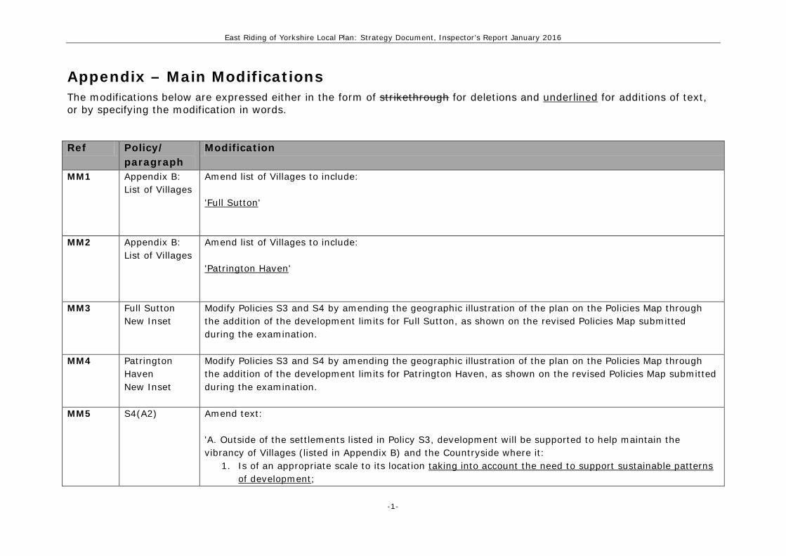
Appendix – Main Modifications The modifications below are expressed either in the form of strikethrough for deletions and underlined for additions of text, or by specifying the modification in words.
Ref Policy/
paragraph Modification
MM1 Appendix B: List of Villages
Amend list of Villages to include: 'Full Sutton'
MM2 Appendix B: List of Villages
Amend list of Villages to include: 'Patrington Haven'
MM3 Full Sutton New Inset
Modify Policies S3 and S4 by amending the geographic illustration of the plan on the Policies Map through the addition of the development limits for Full Sutton, as shown on the revised Policies Map submitted during the examination.
MM4 Patrington Haven New Inset
Modify Policies S3 and S4 by amending the geographic illustration of the plan on the Policies Map through the addition of the development limits for Patrington Haven, as shown on the revised Policies Map submitted during the examination.
MM5 S4(A2) Amend text: 'A. Outside of the settlements listed in Policy S3, development will be supported to help maintain the vibrancy of Villages (listed in Appendix B) and the Countryside where it:
1. Is of an appropriate scale to its location taking into account the need to support sustainable patterns of development;

East Riding of Yorkshire Local Plan: Strategy Document, Inspector’s Report January 2016
-2-
Ref Policy/ paragraph
Modification
2. Prioritises the Encourages the re-use of suitable previously developed land where appropriate; and 3. Does not involve a significant loss of best and most versatile agricultural land.; and 4. Does not compromise the general approach set out in Policy S3 to deliver a sustainable pattern of
development.' Development in Villages and the Countryside should also accord with the specific provisions of parts B or C of this policy.'
MM6 Cottingham Inset 11
Modify Policies S3 and S4 by amending the geographic illustration of the plan on the Policies Map through the revision of the development limit around Castle Hill Hospital as shown on the revised Policies Map submitted during the examination.
MM7 Dunswell Inset 13
Modify Policies S3 and S4 by amending the geographic illustration of the plan on the Policies Map through the revision of the development limit at the southern end of Dunswell to exclude the area of open space (Dene Park Sports Ground) from the settlement, as shown on the revised Policies Map submitted during the examination.
MM8 Hornsea Inset 24
Modify Policies S3 and S4 by amending the geographic illustration of the plan on the Policies Map through the revision of the development limit around Hornsea to include properties along Rolston Road, as shown on the revised Policies Map submitted during the examination.
MM9 South Cave Inset 46
Modify Policies S3 and S4 by amending the geographic illustration of the plan on the Policies Map through the revision of the development limit around South Cave to include property along Beverley Road, as shown on the revised Policies Map submitted during the examination.
MM10 Pollington Inset 124
Modify Policies S3 and S4 by amending the geographic illustration of the plan on the Policies Map through the revision of the development limit around Pollington to include land to the south of Main Street, as shown on the revised Policies Map submitted during the examination.

East Riding of Yorkshire Local Plan: Strategy Document, Inspector’s Report January 2016
-3-
Ref Policy/ paragraph
Modification
MM11 Seaton Inset 130
Modify Policies S3 and S4 by amending the geographic illustration of the plan on the Policies Map through the revision of the development limit around Seaton to include properties west of Manor Park, as shown on the revised Policies Map submitted during the examination.
MM12 Welton Inset 147
Modify Policies S3 and S4 by amending the geographic illustration of the plan on the Policies Map through the revision of the development limit around Welton to include properties on Welton Hill & Beach Hill and The Old Stables, Welton Mill and 33 Dale Road, as shown on the revised Policies Map submitted during the examination.
MM13 Patrington Haven New Inset
Modify Policies S3 and S4 by amending the geographic illustration of the plan on the Policies Map through the revision of the development limit in the southwestern corner of Patrington Haven to incorporate land east of Ravenspurn Road, as shown on the revised Policies Map submitted during the examination.
MM14 Hayton Inset 97
Modify Policies S3 and S4 by amending the geographic illustration of the plan on the Policies Map through the revision of the development limit to the western side of Hayton to incorporate the newly constructed property north of Gerbera, York Road, as shown on the revised Policies Map submitted during the examination.
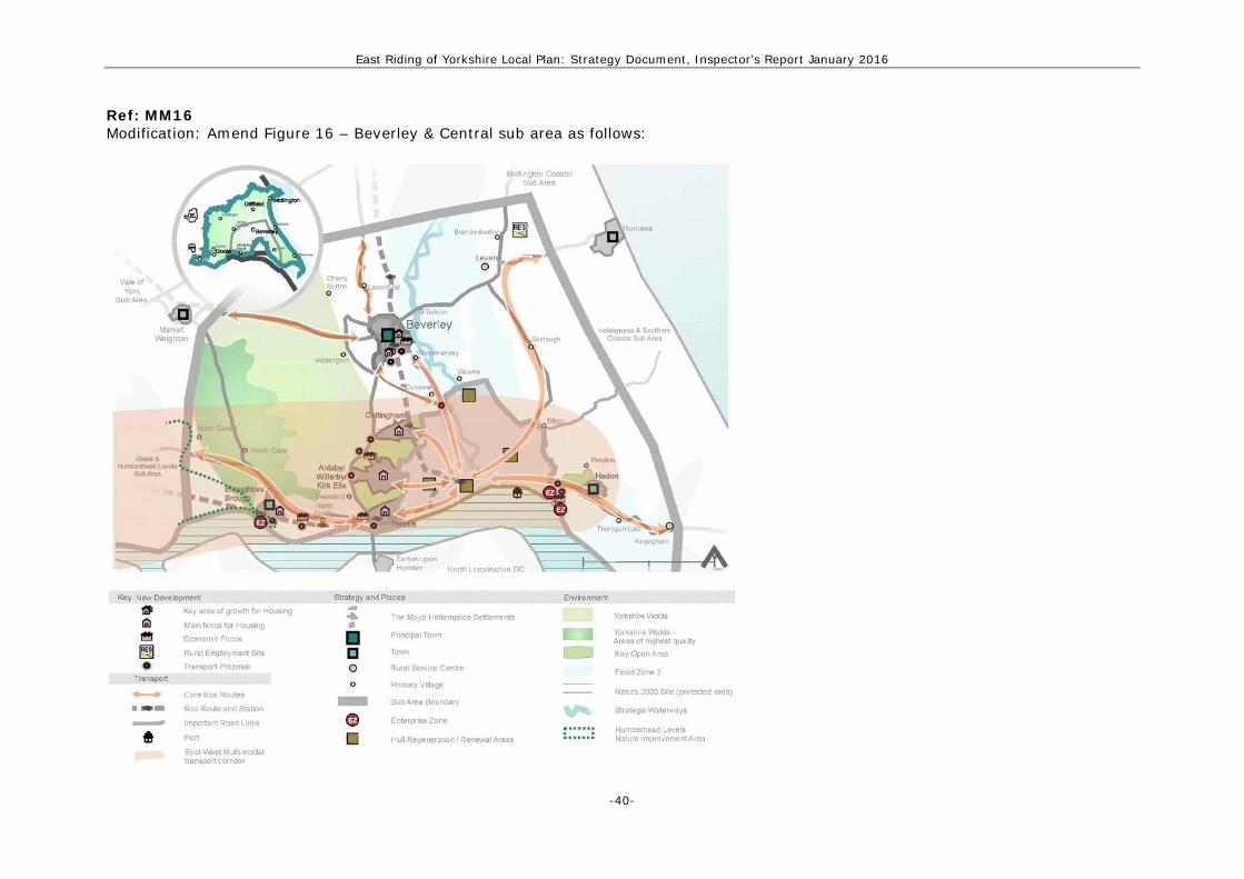
MM15 Figure 16 Amend Beverley and Central sub area diagram: • Amend house symbols for Beverley, Elloughton-cum-Brough and the Major Haltemprice Settlements
(Amend Key to show separate symbols for ‘Key area of housing growth’ and ‘Main focus for housing’) • Add Catfoss Industrial Area as a Rural employment site • Add Enterprise Zone symbol for Saltend area • Add Cherry Burton and Leconfield, and a symbol for Walkington • Remove the 'Hull Strategic Housing Market Area' from the diagram (and Key)
MM16 to MM21
See Figures below, after schedule table.
MM22 A1(A2) & 10.9 Amend text of policy:

East Riding of Yorkshire Local Plan: Strategy Document, Inspector’s Report January 2016
-4-
Ref Policy/ paragraph
Modification
'2. Support the delivery of housing, at a level commensurate to the scale and function of the settlement, in the role of the Major Haltemprice Settlements, Beverley, and Elloughton-cum-Brough as the main focus for residential development in the sub area , Leven, Brandesburton, Cherry Burton, Keyingham, Leconfield, North Cave, North Ferriby, Preston, Skirlaugh, South Cave, Swanland, Walkington, Wawne and Woodmansey through the allocation of sites within the settlements and a range of urban extensions. Housing allocations developments in Cottingham can only come forward following the completion of the Cottingham and Orchard Park Flood Alleviation Scheme (COPFAS), or if it has been demonstrated that acceptable solutions to the surface water flood risk issue can be implemented alongside new development. 3. Support the delivery of housing, at a level commensurate with the scale and function of the settlement, in Leven, Brandesburton, Cherry Burton, Keyingham, Leconfield, North Cave, North Ferriby, Preston, Skirlaugh, South Cave, Swanland, Walkington, Wawne and Woodmansey through the allocation of sites within the settlements and a range of urban extensions....' Re-number the further parts of section A accordingly. Amend supporting text: 'Housing allocations development in Cottingham can only come forward once the Cottingham and Orchard Park Flood Alleviation Scheme (COPFAS) has been implemented, unless it has been demonstrated that acceptable solutions to the surface water flood risk issue can be implemented alongside the proposed development. This is due to there being limited capacity in the sewer system to accommodate additional foul water flows. COPFAS, which includes the provision of various lagoons to store surface water, is currently scheduled to be completed by the end of 20172016. The scheme is needed to reduce peak flows of surface water overwhelming Cottingham's sewer system.'
MM23 A2(A) Amend text: '1. Support the delivery of housing, at a level commensurate with the scale and function of the settlement, in role of Bridlington as the main focus for residential development in the sub area, Beeford and Flamborough through the allocation of sites within the settlements and a range of urban extensions.

East Riding of Yorkshire Local Plan: Strategy Document, Inspector’s Report January 2016
-5-
Ref Policy/ paragraph
Modification
2. Support the delivery of housing, at a level commensurate with the scale and function of the settlement, in Beeford and Flamborough through the allocation of sites within the settlements and a range of urban extensions.' Re-number the further parts of section A accordingly.
MM24 A3(A) Amend text: '1. Support the role of delivery of housing, at a level commensurate to the scale and function of the settlement, in Driffield as the main focus for residential development in the sub area, Kilham, Hutton Cranswick, Middleton on the Wolds, Wetwang and Nafferton through the allocation of sites within the settlements and a range of urban extensions. 2. Support the delivery of housing, at a level commensurate with the scale and function of the settlement, in Kilham, Hutton Cranswick, Middleton on the Wolds, Wetwang and Nafferton, through the allocation of sites within the settlements and a range of urban extensions.' Re-number the further parts of section A accordingly.
MM25 A4 (A) Amend text: '1. Support the role of delivery of housing, at a level commensurate to the scale and function of the settlement, in Goole, and Howden, Snaith and Eastrington as the main focus for residential development in the sub area through the allocation of sites within the settlements and a range of urban extensions, avoiding areas of highest flood risk as far as possible. Housing allocations in Goole (except those South of Dutch River) and Eastrington can only come forward once surface water drainage improvement schemes have been put into place, or if it can be demonstrated that acceptable solutions to the surface water flood risk issue can be implemented alongside new development. 2. Support the delivery of housing, at a level commensurate with the scale and function of the settlement, in Snaith and Eastrington through the allocation of sites within the settlements and a range of urban extensions, avoiding areas of highest flood risk as far as possible. Housing allocations in Eastrington can

East Riding of Yorkshire Local Plan: Strategy Document, Inspector’s Report January 2016
-6-
Ref Policy/ paragraph
Modification
only come forward once surface water drainage improvement schemes have been put into place, or it can be demonstrated that acceptable solutions to the surface water flood risk issue can be implemented alongside new development.' Re-number the further parts of section A accordingly.
MM26 A5(A) Amend text: '1. Support the role of delivery of housing, at a level commensurate to the scale and function of the settlement, in Hornsea, and Withernsea, Aldbrough, Patrington and Roos through the allocation of sites within the settlements and a range of urban extensions. 2. Support the delivery of housing, at a level commensurate with the scale and function of the settlement, in Aldbrough, Patrington and Roos, through the allocation of sites within the settlements and a range of urban extensions.' Re-number the further parts of section A accordingly.
MM27 A6(A) Amend text: '1. Support the role of delivery of housing, at a level commensurate to the scale and function of the settlement, in Pocklington, and Market Weighton, Bubwith, Holme on Spalding Moor, Stamford Bridge, Melbourne and Wilberfoss as the main focus for residential development in the sub area through the allocation of sites within the settlements and a range of urban extensions. 2. Support the delivery of housing, at a level commensurate with the scale and function of the settlement, in Bubwith, Holme on Spalding Moor, Stamford Bridge, Melbourne and Wilberfoss through the allocation of sites within the settlements and a range of urban extensions.' Re-number the further parts of section A accordingly.
MM28 A1(D1) & 10.31
Add new criteria to policy:

East Riding of Yorkshire Local Plan: Strategy Document, Inspector’s Report January 2016
-7-
Ref Policy/ paragraph
Modification
'xi. Improvements to walking, cycling and public transport facilities, including those set out within Local Transport Plan individual settlement transport strategies, and major cross country routes such as Wolds Way, the Minster Way, and Transpennine Trail, the Public Rights of Way network, and the National Cycle Network; xii. A1033 Salt End Roundabout Improvements; xiii. A1033/B1362 Hedon By-pass Roundabout Improvements; xiv. B1362 Red House Farm Mini Roundabout Improvements; and xv. Traffic Management Measures to address issues with 3 junctions within Hedon and Preston.' Amend supporting text: '...Development of the full 200ha employment site at Hedon Haven will require provision of transport infrastructure improvements within the East Riding and the City of Hull, including upgrades to junctions on the A63 and a direct road (and potential rail) link from Haven Haven to the Port of Hull. At the signalised crossroads between Staithes Road, School Road, Main Street and Station Road in Preston, and the Baxtergate / Fletchergate and St Augustines's Gate / Fletchergate junctions in Hedon, traffic management measures will also be required to help address the limited highway capacity.'
MM29 A2(D1) Add new criterion to policy: 'Improvements to walking, cycling and public transport facilities, including those set out within Local Transport Plan individual settlement transport strategies and major cross country routes, such as the Way of the Roses, the Public Right of Way network, and the National Cycle Network.'
MM30 A3(D1) Amend text and add new criterion to policy: '1. Enhance connectivity within the sub area and with the rest of the East Riding by supporting transport infrastructure improvements, particularly: and
i. measures that link together Driffield town centre, the Riverhead area, Showground, new housing at Alamein Barracks and Kelleythorpe Industrial Estate. and;

East Riding of Yorkshire Local Plan: Strategy Document, Inspector’s Report January 2016
-8-
Ref Policy/ paragraph
Modification
ii. improvements to walking, cycling and public transport facilities, including those set out within Local Transport Plan individual settlement transport strategies and major cross country routes, such as the Way of the Roses, Wolds Way, the Public Right of Way network, and the National Cycle Network.'
MM31 A4(D1) Add new criterion to policy: 'improvements to walking, cycling and public transport facilities, including those set out within Local Transport Plan individual settlement transport strategies and major cross country routes, such as the Transpennine Trail, the Public Right of Way network, and the National Cycle Network;'
MM32 A5(D1) Amend text and add new criterion to policy: '1. Enhance connectivity within the sub area and with the rest of the East Riding and the City of Hull by supporting transport infrastructure improvements, particularly that: i. improvements to walking, cycling and public transport facilities, including those set out within Local Transport Plan individual settlement transport strategies and major cross country routes such as the Transpennine Trail, the Public Right of Way network, and the National Cycle Network reduce the effects of peripherality; and ii. measures to reduce reliance on the private car.'
MM33 A1(D3i, iv and v)
Amend text: '3. Support the provision of additional infrastructure, including:
i. additional sewage treatment capacity at within the existing Beverley, Leconfield, North Ferriby, and Melton waste water treatment works; ... iv. additional secondary school pupil capacity in at Beverley High and Grammar schools and Elloughton-cum-Brough South Hunsley School (Welton) area; and v. additional primary school pupil capacity for existing schools in Beverley, Brandesburton, Elloughton-

East Riding of Yorkshire Local Plan: Strategy Document, Inspector’s Report January 2016
-9-
Ref Policy/ paragraph
Modification
cum-Brough, Keyingham, and North Ferriby and Swanland, alongside the provision of a new primary school in Beverley and Elloughton-cum-Brough.'
MM34 A2(D2iii, iv and new criteria)
Amend text and add new criterion to policy: 'iii. additional primary school capacity for existing schools in Bridlington and Beeford; iv. additional secondary school pupil capacity at Headlands School (Bridlington); iv. improvement to the Bridlington waste water treatment works improvement in Bridlington; and...'
MM35 A3(D2) Amend text: 'i. additional sewage treatment capacity at within the existing Nafferton, and Wetwang waste water treatment works; ... iii. drainage and flood alleviation schemes, particularly in Driffield and Nafferton; and iv. additional primary school capacity for existing schools in Driffield, Kilham and Middleton-on-the-Wolds Nafferton; and v. additional secondary school pupil capacity at Driffield School.'
MM36 A4(D2iii & iv) Amend text: 'iii. additional secondary school pupil capacity at Goole High School; and iv. additional primary school pupil capacity in for existing schools in Goole, Gilberdyke and Howden, alongside the provision of a new primary school in Goole.'
MM37 A5(D2i & iv) Amend text: 'i. additional sewage treatment capacity at within the existing Aldbrough waste water treatment works; ... iv. additional primary school pupil capacity for the existing schools in Withernsea and Patrington.'

East Riding of Yorkshire Local Plan: Strategy Document, Inspector’s Report January 2016
-10-
Ref Policy/ paragraph
Modification
MM38 A6(D2i, iii, iv & v)
Amend text: 'i. additional sewage treatment capacity at within the existing Holme on Spalding Moor and Market Weighton waste water treatment works; iii. drainage and flood alleviation schemes, particularly in Pocklington and Market Weighton; and iv. secondary school pupil capacity in the Pocklington area; and iv. additional primary school pupil capacity for existing schools in Market Weighton.'
MM39 A2(C5) Amend text: 'Facilitate the relocation or roll back of existing development threatened by coastal erosion between Wilsthorpe and Skirlington...'
MM40 A5(C3) Amend text: 'Facilitate the relocation or roll back of existing development threatened by coastal erosion between Skirlington and Kilnsea....'
MM41 Policies Map Amend Policy S1 and other parts of the plan which rely on the identification of Neighbourhood Areas by amending the geographic illustration of the plan on the Policies Map through the addition of the following Neighbourhood Areas as shown on the revised Policies Map submitted during the examination: • Allerthorpe Neighbourhood Area • Market Weighton Neighbourhood Area • North Cave Neighbourhood Area • Pocklington Neighbourhood Area • Sutton upon Derwent Neighbourhood Area • Wawne Neighbourhood Area.
MM42 S5(E), 5.18 & Amend text of policy:

East Riding of Yorkshire Local Plan: Strategy Document, Inspector’s Report January 2016
-11-
Ref Policy/ paragraph
Modification
supporting text
'Approximately 45% of the total housing provision will be located in the East Riding part of the Hull Housing Market Area (as shown on the Key Diagram) Beverley & Central and Holderness & Southern Coastal sub areas. The overall delivery of housing in Hull and the East Riding will be monitored to ensure needs are being met across the two local authority areas.' Amend text of paragraph 5.18: 'Approximately 45% of new housing in the East Riding will be built within the Hull Housing Market Area Beverley & Central and Holderness & Southern Coastal sub areas. These sub areas reflect where the interactions between the City of Hull and those settlements in the East Riding are the strongest. This approach is continued from the Regional Spatial Strategy, and reflects the aim of both East Riding of Yorkshire Council and Hull City Council, to support the successful transformation and renaissance of the City of Hull, including housing market renewal and to help tackle low demand in the City. It will help to ensure that the City remains the prime focus for new housing in the Hull Housing Market Area.'
MM43 See Figure below, after schedule table.
MM44 5.4 Amend text: 'Importantly, the scale of housing planned for in the East Riding has been considered in a wider policy context, particularly in terms of the urban transformation of Hull [Footnote]. The vision and objectives of the Strategy Document recognise the importance of supporting a successful City and Policy S3 sets out a measured approach to growth around the City's boundaries. Significant increases in the supply of land around Hull would only serve to continue out-migration from the City and undermine regeneration efforts. The need for a joined-up approach that supports the regeneration of the City has been reflected through the scale and distribution of housing development, set out in the strategies of Hull and the East Riding.' [Footnote] 'For the purposes of establishing an objective assessment of need across the housing market area,

East Riding of Yorkshire Local Plan: Strategy Document, Inspector’s Report January 2016
-12-
Ref Policy/ paragraph
Modification
as required by paragraph 47 of the NPPF, the combined needs for the local authority districts of Hull and East Riding of Yorkshire have been considered.'
MM45 5.18 Add additional supporting text: 'The Council will work with Hull City Council to monitor the overall level of housing delivery in Hull and the East Riding in totality[Footnote], and determine whether the needs of the area are being met in accordance with the Plan. Should the process of preparing the Hull Local Plan result in a significant change between the presently assessed objective housing need for the combined authorities and how this is distributed between the Hull and East Riding Local Plans, then an immediate review of the East Riding Local Plan will be undertaken. A review of the Plan will take place by no later than 2020 and this will need to take account of delivery across Hull and the East Riding in this plan period and the latest evidence on housing need.
[Footnote] Reflecting the geography at which the objectively assessed needs of the housing market area are determined, which combines the whole of the Hull and East Riding local authority boundary areas and currently results in a housing need of approximately 2,100 dwellings per annum. This is consistent with Government best practice research.
MM46 Policy S5(B), (C), 5.7, 5.11 and Table 2
Amend table in policy (part B): Distribution of dwellings
(2012/13 – 2028/29) Major Haltemprice Settlements 14.9% (3,550 dwellings) Principal Towns 45.6% (10,850) Beverley 3,300 Bridlington 3,300 Driffield 2,300 Goole 1,950 Towns 22.4% (5,341) 5,340

East Riding of Yorkshire Local Plan: Strategy Document, Inspector’s Report January 2016
-13-
Ref Policy/ paragraph
Modification
Elloughton-cum-Brough 1,000 Hedon 901 Hornsea 750 Howden 800 Market Weighton 900 Pocklington 1,250 Withernsea 550 Rural Service Centres and Primary Villages
12.4% (2,960 3,585)
Villages and the Countryside 4.6% (1,099) 1,100 Amend text of policy (part C): 'C. In Rural Service Centres and Primary Villages, sites for housing will be allocated to support the level of growth set out in Table 2 based on:
1. 20% increase in the number of dwellings in a Rural Service Centre over the plan period, or a total of 170 dwellings, whichever is the lower;
2. 10% increase in the number of dwellings in a Primary Village over the plan period, or a total of 85 dwellings, whichever is the lower.'
Amend supporting text (paragraph 5.7): 'The vast majority of residential development will take place in the Major Haltemprice Settlements, the Principal Towns and Towns, equating to over almost 8380% of new houses.' Amend supporting text (paragraph 5.11): 'In Rural Service Centres and Primary Villages, development will be managed supported to ensure the overall growth of the village reflects its role in the Settlement Network and its size. For Rural Services

East Riding of Yorkshire Local Plan: Strategy Document, Inspector’s Report January 2016
-14-
Ref Policy/ paragraph
Modification
Centres, the policy supports their role as hubs for the rural areas and plans for growth in the order of 20% of the current number of dwellings. In Primary Villages, the policy recognises their basic sustainability credentials and promotes an approach which would increase the current number of dwellings by 10%.A total of 170 dwellings in a Rural Service Centre and 85 dwellings in a Primary Village will provide an average of 10 dwellings per annum and 5 dwellings per annum respectively over the plan period. The scale of development in some settlements is 'capped' at these levels to prevent excessive levels of development supported in the Rural Service Centres and Primary Villages and to will ensure that development here does not compromise the focus on the Major Haltemprice Settlements, Principal Towns and Towns as the most sustainable locations for development in the East Riding. Table 2 shows how this translates as a housing requirement for each settlement over the plan period.'
MM47 Amend table 2: Distribution of dwellings (2012/13 – 2028/29) Rural Service Centres
Primary Villages
Aldbrough 100 Bilton 2* Beeford 90 Brandesburton 60 Bubwith 80 Cherry Burton 60 Gilberdyke/ Newport
49* Dunswell 7*
Holme on Spalding Moor
170 225 Easington 19*
Hutton Cranswick
170 Eastrington 40
Keyingham 170 215 Flamborough 85 110 Kilham 90 Leconfield 70 Leven 170 210 Melbourne 30
East Riding of Yorkshire Local Plan: Strategy Document, Inspector’s Report January 2016
-15-
Ref Policy/ paragraph
Modification
Middleton on the Wolds
79 Nafferton 85 105
Patrington 140 North Cave 60 Snaith 170 245 North Ferriby 85 160 Stamford Bridge 170 295 Preston 85 95 Wetwang 70 Rawcliffe 23* *These figures represent the number of extant planning permissions as at November 2013 (including a discount for non delivery) added to the number of completions between April 2012/ and November 2013. No specific allocations for residential development will be made based on current evidence regarding the level of flood/health and safety risk in these settlements.
Roos 40 Skirlaugh 70 South Cave 85 160 Swanland 85 165 Thorngumbald 16* Tickton 4* Walkington 70 Wawne 40 Wilberfoss 80 Woodmansey 50
MM48 5.9 Amend text: '…The Council has commissioned some detailed hydraulic modelling work to further investigate the issues of flood risk and drainage in and around Hedon. Should the work identify deliverable solutions that would enable further residential development, a partial review of the Local Plan will then be necessary undertaken to identify the scale and location of housing development for the Town.'
MM49 S5(D) & 5.15 Amend text of policy: 'The Council will seek to ensure a minimum 5 year supply (plus appropriate buffer) of deliverable sites across the East Riding. Should monitoring reveal a over-provision of housing, the housing supply will be
East Riding of Yorkshire Local Plan: Strategy Document, Inspector’s Report January 2016
-16-
Ref Policy/ paragraph
Modification
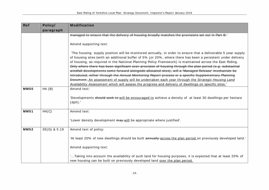
managed to ensure that the delivery of housing broadly matches the provisions set out in Part B.' Amend supporting text: 'The housing supply position will be monitored annually, in order to ensure that a deliverable 5 year supply of housing sites (with an additional buffer of 5% (or 20%, where there has been a persistent under delivery of housing, as required in the National Planning Policy Framework) is maintained across the East Riding. Only where there has been significant over-provision of housing through the plan period (e.g. substantial windfall developments come forward alongside allocated sites), will a 'Managed Release' mechanism be introduced, either through the Annual Monitoring Report process or a specific Supplementary Planning Document. An assessment of supply will be undertaken each year through the Strategic Housing Land Availability Assessment which will assess the progress and delivery of dwellings on specific sites.'
MM50 H4 (B) Amend text: 'Developments should seek to will be encouraged to achieve a density of at least 30 dwellings per hectare (dph).'
MM51 H4(C) Amend text: 'Lower density development may will be appropriate where justified'.
MM52 S5(G) & 5.19 Amend text of policy: 'At least 20% of new dwellings should be built annually across the plan period on previously developed land.' Amend supporting text: '...Taking into account the availability of such land for housing purposes, it is expected that at least 20% of new housing can be built on previously developed land over the plan period.

East Riding of Yorkshire Local Plan: Strategy Document, Inspector’s Report January 2016
-17-
Ref Policy/ paragraph
Modification
MM53 S3(B) & 4.15 Amend text of policy: '…The Rural Service Centres and Primary Villages will provide for more limited development in rural areas complemented by existing employment sites. New development should seek to prioritise the will be encouraged where it involves the re-use of suitable previously developed land.' Amend supporting text: 'The re-use of previously developed land remains a priority important in the East Riding, provided it is not of high environmental value..'
MM54 H4(A) Amend text: 'A. Proposals for new residential development will be supported where they make the most effective use of land or buildings. This will be achieved through prioritising encouraging the re-use of suitable previously developed land and encouraging supporting proposals that provide the optimum housing density.'
MM55 New paragraph
Insert new paragraph after 6.28: ‘The Council is committed to an early review of Policy H2. This review will consider:
• The implications of changing market conditions • New or revised evidence such as the AHVA and/or SHMA • The proportion of affordable housing being delivered by the policy • The potential to allocate additional housing sites for purely affordable housing development.’
MM56 S5(F) & 5.17 Amend text of policy:
‘The Council will support the provision of an average of 310 335 affordable homes per annum as part of the overall net additional homes provided each year.’ Amend text of paragraph 5.17:

East Riding of Yorkshire Local Plan: Strategy Document, Inspector’s Report January 2016
-18-
Ref Policy/ paragraph
Modification
‘A target has been set to support the delivery of an average of 310 335 (gross) affordable homes per year, which will be achieved through the planning system. This includes developer contributions and new affordable housing from other sources, such as rural exception sites and grant funding. Policy H2 sets out how affordable housing will be delivered on new housing sites.’
MM57 H2 (C1) &
6.26 Amend text of policy: 'Rural exception sites will be supported where they:
1. Are well related to the development limits of a Major Haltemprice Settlement, Principal Town, Town, Rural Service Centre or Primary Village; or...'
Amend supporting text: 'Special consideration will be given to supporting proposals that the granting of planning permission in rural settlements where the limited supply of housing land may create problems for the provision of provide affordable homes for local people. Rural exception sites for affordable housing will be supported in the countryside where they are should be well related to the development limits of a Major Haltemprice Settlement, Principal Town, Town, Rural Service Centre or Primary Village, or within or well related to the development limits of a Village. , where dDevelopment in such places can provide future occupants with opportunities to greater access to transport, employment opportunities and other services and facilities. In the more rural parts of the East Riding (for example, Rural Service Centres, Primary Villages and Villages) Ssites for affordable housing may be larger than would normally be considered appropriate in rural areas. In these instances the scale and design of development...'
MM58 H1(B) Amend text: 'The provision of specialist accommodation, especially for older people, will be required as part of the housing mix on larger allocations where they meet an identified need, unless it can be demonstrated that this would have an unacceptable impact on the economic viability of the proposed scheme. Specialist

East Riding of Yorkshire Local Plan: Strategy Document, Inspector’s Report January 2016
-19-
Ref Policy/ paragraph
Modification
accommodation on non-allocated sites will be supported within the development limits of settlements, where:…'
MM59 H1(B) Amend text: 'Specialist accommodation on non-allocated sites will be supported within the development limits of settlements, where: 1. T the proposal is of an appropriate scale in relation to the settlement; and 2.There is a need for the development.'
MM60 6.13 Amend text: '...This identifies a need to provide for older people through the design of general needs market housing, including one and two bed properties, and promotes the use of the lifetime homes standard. Lifetime homes standards aim to ensure housing is accessible to everyone throughout their lifetime, meeting the existing and changing needs of households from raising small children to coping with disability or illness. In addition, tThe design of housing types that are suitable for the elderly should consider whether wheelchair access and level access housing would be appropriate. Proposals that include housing suitable for older people...'
MM61 H2(F) & 6.28 Delete criterion: 'F. Affordable housing should seek to meet or exceed current Homes and Communities Agency design standards.' Amend supporting text: '...This could include provision of information on the housing register, as well as housing survey data that was used to inform the SHMA and information on the current provision of affordable housing. Proposals should aim to meet Homes and Communities Agency standards, currents the Design and Quality Standards (2007), whilst ensureing that the affordable housing is fully integrated into the development. The standards are mandatory for affordable housing funded by the Homes and Communities Agency and affordable homes

East Riding of Yorkshire Local Plan: Strategy Document, Inspector’s Report January 2016
-20-
Ref Policy/ paragraph
Modification
that met these standards are usually required by Registered Providers.' MM62 8.3 Amend text:
'...for good design that can help to:...
• Provide homes that are adaptable , for example, through the use of lifetime homes standards; and • Ensure local distinctiveness through development that...'
MM63 8.8 Amend text: 'Proposals should, through the layout and design of new development, consider the needs of users, including equality of access, and how these needs would change for individuals and families through the different stages of their life. The appropriateness of using standards, such as lifetime homes/ neighbourhoods and wheelchair standards should be considered as part of the design process. It will also be important consider whether the proposal would...'
MM64 New paragraph after 6.30
Add new paragraph: ‘In 2015 the national planning definitions of ‘Gypsies and Travellers’ and ‘Travelling showpeople’ were updated to remove those who have ceased travelling permanently. An early update of the GTANA will be undertaken by 2017, and potentially a review of Policy H3, to take account of the revised definitions in determining the number of new pitches that would be required over the plan period and ensure there is a 5 year supply of deliverable sites.’
MM65 Glossary (Gypsies and Travellers)
Amend text: ‘The Housing Act 2004 defines Gypsies and For the purposes of planning policy, Planning for Traveller Sites (DCLG, 2015) defines Gypsies and Travellers as; ‘Persons of nomadic habit of life whatever their race or origin, including such persons who on grounds only of their own or their family’s or dependents’ educational or health needs or old age have ceased to travel temporarily, but excluding members of an organised group of travelling showpeople or circus people travelling together as such. or permanently, and all other persons with a cultural tradition of nomadism and/or caravan dwelling.' In determining whether persons are “gypsies and travellers” consideration should be given to the following issues amongst other relevant matters: a) whether they previously led a nomadic habit of life b) the reasons for ceasing their nomadic habit of life

East Riding of Yorkshire Local Plan: Strategy Document, Inspector’s Report January 2016
-21-
Ref Policy/ paragraph
Modification
c) whether there is an intention of living a nomadic habit of life in the future, and if so, how soon and in what circumstances. Allocations for Gypsy and Traveller sites are shown on the Policies Map.’
MM66 6.34 Amend text: ‘In developing new sites, consideration should be given to: All sites will be expected to meet national design standards in accordance with Designing Gypsy and Traveller Sites: Good Practice Guide (2008). This includes…..’ • Providing the correct size and layout: site size should take into account the number of pitches and needs
of resident families …’
MM67 S6(B) Amend text:
'...The provision of at least 39 hectares of enhanced habitat will be required to mitigate the impact of development on the adjacent Humber Estuary Special Protection Area and Ramsar Site. In addition, proposals must be considered in the context of the statutory protection which is afforded to also ensure that they have no adverse effects on the integrity of the Humber Estuary Special Area of Conservation...'
MM68 S6(B) Amend text: '... the Humber Estuary Special Area of Conservation. The development will also be required to preserve or enhance those elements which contribute to the significance of the designated heritage assets in the area.'
MM69 5.31 Amend text: '...To satisfy the requirements of Policies S8 and EC4 it will be imperative that this impact is mitigated and any development is accompanied by a comprehensive transport assessment and travel plan and improvements are undertaken within the transport network that cost effectively limit the significant impacts of the development. A Transport Assessment (2013) has been prepared to support the Local Plan...'
MM70 EC1 (C1) & Amend text of policy:

East Riding of Yorkshire Local Plan: Strategy Document, Inspector’s Report January 2016
-22-
Ref Policy/ paragraph
Modification
7.9 'There is no longer a need, or it is not viable, for that or any other employment use on the site, which has been demonstrated by an up-to-date employment land review or through a comprehensive marketing exercise; or...' Amend supporting text: '...In some instances, an existing employment site may no longer be suitable to meet market demand now and in the future, or the use of the site for employment uses may not be viable. This could be identified through an up-to-date Employment Land Review or the marketing of the site for its current use.'
MM71 Table 4 Amend table:
Centre
Floorspace Capacity (gross sqm) Convenience Goods Comparison Goods Lower Upper Lower Upper
Beverley - - 10,200 4,900
20,500 9,800
MM72 EC3(C) & 7.33 Amend text of policy: 'Proposals for retail, office and leisure uses, that are not in accordance with an allocation, will be required to assess the impact of the development where they comprise more than:...' Amend text of paragraph 7.33 (second bullet point): '...Developments above the threshold may have a significant impact upon the Centre, or other Centres within the catchment area, and planning applications should be accompanied by an impact assessment. An impact assessment would not be required for an allocation where the proposed development delivers the

East Riding of Yorkshire Local Plan: Strategy Document, Inspector’s Report January 2016
-23-
Ref Policy/ paragraph
Modification
type and scale of retail floorspace specified by the relevant policy in the Allocations Document. Where a proposal serves a local need over a neighbourhood catchment, it will not be necessary to demonstrate that there is a sequentially preferable site.'
MM73 Goole Inset 19 & 19a
Modify Policy EC3 by amending the geographic illustration of the plan on the Policies Map through the addition of the Morrisons Supermarket on Boothferry Road, Goole, to the Primary Shopping Area, as shown on the revised Policies Map submitted during the examination.
MM74 Howden Inset 25 & 25a
Modify Policy EC3 by amending the geographic illustration of the plan on the Policies Map through the addition of the Cooperative Supermarket on Charles Briggs Avenue, Howden to the Primary Shopping Area, as shown on the revised Policies Map submitted during the examination.
MM75 A1(B) Add new criterion to policy: 'Support the role that Catfoss Industrial Estate has in contributing to the rural economy;
MM76 A3(B) Add new criterion to policy: 'Support the role that Hutton Cranswick Industrial Estate has in contributing to the rural economy.'
MM77 A4(B) Add new criterion to policy: 'Support the role that Gilberdyke Industrial Estate has in contributing to the rural economy.'
MM78 A6(B) Add new criterion to policy: 'Support the role that Full Sutton and Holme on Spalding Moor Industrial Estates have in contributing to the rural economy.'
MM79 Policy EC5, 7.65 & supporting text
Amend text of policy (part A): 'A. Proposals for the development of the energy sector, excluding wind energy but including the other types of development listed in Table 7, will be supported...'

East Riding of Yorkshire Local Plan: Strategy Document, Inspector’s Report January 2016
-24-
Ref Policy/ paragraph
Modification
Add new criteria to policy (part C) 'C. Suitable areas for wind energy development will be identified through a review of the Local Plan and/or preparation of Neighbourhood Development Plans. Prior to the completion of the review proposals involving wind energy development will be determined in accordance with national planning policy and practice guidance.' Add new paragraph (after 7.64): 'Proposals involving the development of wind energy will be determined in accordance with national planning policy and practice guidance. This is set out in a Written Statement made by the Secretary of State on 18 June 2015 and through revisions to the national Planning Practice Guidance. These outline that planning permission for wind energy development should only be granted if:
• the development site is in an area identified as suitable for wind energy development in a Local or Neighbourhood Plan; and
• following consultation, it can be demonstrated that the planning impacts identified by affected local communities have been fully addressed and therefore the proposal has their backing.'
Amend text of paragraph 7.65: '7.65 The Council will undertake a review of the Local Plan to identify areas that are suitable for wind energy development. This will take into account the impacts, including any cumulative impacts, on the local environment, as well as the views of the local community. Alongside any impacts identified by affected local communities, Wwind turbines have the potential to cause electromagnetic interference with radio signals,...'
MM80 EC5(A) Amend text: 'Proposals for the development of the energy sector, including those types of development listed in Table 7,

East Riding of Yorkshire Local Plan: Strategy Document, Inspector’s Report January 2016
-25-
Ref Policy/ paragraph
Modification
will be supported where any significant adverse impact are addressed satisfactorily minimised and the residual harm is outweighed by...'
MM81 EC5(A) & 7.60 Amend policy text: 'Proposals for the development of the energy sector, including those types of development listed in Table 7, will be supported where any significant adverse impacts are satisfactorily minimised, and the residual harm is outweighed by the public wider benefits of the proposal. Developments and their associated infrastructure should be acceptable in terms of;...' Amend supporting text: 'Development will be supported providing adverse environmental, social or economic impacts are satisfactorily addressed. Adverse impacts must outweigh the wider public benefits of the development....'
MM82 EC5 (A3.i) Amend text: 'i. local amenity, including noise, air and water quality, traffic, vibration, dust and visual impact;'
MM83 EC6(B5), 7.76, 7.77 & 7.78
Amend text of policy: '4. Non-mineral development is temporary in nature; or 5. Non-mineral development is in accordance with an allocation in the Allocations Document or a Neighbourhood Development Plan; or 5. 6. The underlying or adjacent mineral deposit can be extracted prior to the non-mineral development proceeding, or prior extraction of the deposit is not possible.
MM84 All relevant maps
Modify Policy EC6 by amending the geographic illustration of the plan on the Policies Map by:

East Riding of Yorkshire Local Plan: Strategy Document, Inspector’s Report January 2016
-26-
Ref Policy/ paragraph
Modification
• deleting the 200 metre ‘stand-off’ between proposed development limits and Mineral Safeguarding Areas (MSAs), so that MSAs extend up to the development limits where appropriate; and
• adding the full extent of higher quality chalk deposits as well as the unconcealed lower quality chalk deposits according to the British Geological Survey Mineral Resources Map to the Mineral Safeguarding areas,
all as shown on the revised Policies Map submitted during the examination.
MM85 Amend text of paragraph 7.76: 'Mineral Safeguarding Areas are identified on the Policies Map. In defining these, the extent of the different mineral resources and the likely development pressures within and adjacent to the resources was considered, as well as the location of significant existing mineral operations in the area. In the case of sand and gravel, limestone, and silica sand this is in line with the general extent of the resource, as shown on the British Geological Survey Map and in Figure 10. In the case of brick clay, crushed rock (chalk), and industrial chalk resources, the safeguarding areas are located around significant existing operations; and the general extent of the brick clay, higher purity chalk and unconcealed lower quality chalk according to the British Geological Survey Map. Urban areas are excluded from the Mineral Safeguarding Areas, but environmental designations, such as SSSIs, are included. Where necessary, tThe extent of Mineral Safeguarding Areas will be refined through the Joint Minerals Plan.'
MM86 Amend text of paragraph 7.77: '...Therefore, non-mineral development, which would adversely affect the viability of exploiting an underlying or adjacent deposit in the future, will be supported within and adjacent to a Mineral Safeguarding Area where:... • Test drilling, test pits or other evidence, including the quantity of mineral, overburden, mineral depth,
mineral thickness, and how fine the deposits are, suggest the underlying or adjacent mineral is of limited economic value, and its value is unlikely to become significantly greater in future, for example, by being of insufficient amount or quality. Documented attempts to market the mineral may be

East Riding of Yorkshire Local Plan: Strategy Document, Inspector’s Report January 2016
-27-
Ref Policy/ paragraph
Modification
required to demonstrate that the mineral resource is not viable; • The need for the development outweighs the need to safeguard the minerals for the future, for
example, the surface development is an essential piece of infrastructure and alternative sites are not available without a disproportionate cost;
• It can take place without preventing the mineral resource from being extracted in the future. This could include development covering a smaller area, such as householder development. Some larger proposals containing only limited built development could also take place without sterilising the resource, for example, golf courses or some types of agricultural development. This will depend on the nature of the proposal and the extent, nature and economic value of the mineral concerned. Other types of development which could take place without sterilising the mineral resource include, applications for alterations and extensions to existing buildings, change of use of existing development, advertisement consents, and applications for reserved matters following an outline consent;
• It is temporary in nature; or • It is in accordance with a development plan allocation; or • There is evidence that prior extraction of the mineral deposit is not possible, or that the deposit will be
extracted in an environmentally acceptable manner prior to the non-mineral development proceeding.' Amend text of paragraph 7.78 and add additional supporting text: 'In all instances it will also be necessary to consider the balance between how the quality, depth and thickness of the mineral deposit affects its viability, as well as the extent to which the non-mineral surface development would sterilise this resource. An assessment of the effect of the proposed development on the mineral resource beneath or adjacent to the site of the development (termed a Mineral Assessment) will normally be required. A proposal for a single dwelling, for example, could still sterilise a large area of resource if built in a certain location. In other cases, applications will be screened out of having to satisfy the policy's requirements by meeting one of a number of exemption criteria which include:
• Applications for householder development; • Applications for alterations and extensions to existing buildings and for change of use of existing
development, unless intensifying activity on site;

East Riding of Yorkshire Local Plan: Strategy Document, Inspector’s Report January 2016
-28-
Ref Policy/ paragraph
Modification
• Applications for advertisement consent; • Applications for reserved matters including subsequent applications after outline consent has been
granted; • Prior notifications (telecoms, forestry, agriculture, demolition); • Certificates of Lawfulness of Existing Use or Development (CLEUD) and Certificates of Lawfulness of
Proposed Use or Development (CLOPUD); • Applications for works to trees; • Applications for temporary planning permission.
7.79 Where non-mineral development is considered acceptable within or adjacent to a Mineral Safeguarding Area it will be necessary to ensure that the proposal minimises the impact on the minerals deposit, for example, through the siting and layout of any buildings. In assessing whether a proposed non-minerals development is adjacent to a Safeguarding Area, it will be necessary to consider the nature of the resource being safeguarded. For example, chalk and limestone deposits may require the use of explosives for extraction and the close proximity of non-mineral development may limit the use of this resource. However, sand and gravel, which can be dug from open workings, has a much lower potential impact. Guidance published by the British Geological Survey provides examples of typical distances from Mineral Safeguarding Areas for different mineral resources within which non-mineral development is likely to be considered to be 'adjacent'.
• Small heritage stone quarries (where currently disused)- 150 metres • Sand and gravel- 250 metres • Clay- 250 metres • Silica sand- 250 metres • Chalk (where blasting is likely)- 500 metres • Limestone (where blasting is likely)- 500 metres
7.80 Within these distances proposals will need to consider part B of the policy. In addition, any Greenfield non-mineral allocation adjacent to a development limit where it abuts a Mineral Safeguarding Area will be required to address the provisions of the policy.

East Riding of Yorkshire Local Plan: Strategy Document, Inspector’s Report January 2016
-29-
Ref Policy/ paragraph
Modification
7.81 The Joint Minerals Plan will address the need to safeguard existing, planned and potential rail heads, rail links to quarries, wharfage and associated storage, handling and processing facilities for the bulk transport by rail, sea or inland waterways of minerals, where it is appropriate to do so.'
MM87 11.5, 11.6 & Table 13
Delete text: 11.5 Table 13 sets out what infrastructure is likely to be needed to support the amount and distribution of housing and economic development set in the Strategy Document. It draws on information from the East Riding Infrastructure Study and identifies the main partners that will have a role in helping to deliver the Local Plan. The Community Infrastructure Levy (CIL) is likely to be an important way of funding infrastructure, especially where existing funding sources are insufficient. The delivery timescales set out in Table 13 are indicative and based on development occurring at a linear rate each year. However, the baseline (existing) capacity of infrastructure can change over time resulting in changes to timescales over which new investment would be required. 11.6 The infrastructure set out within the Delivery Plan has been broken down to highlight those elements considered to be essential in delivering the scale and location of development promoted within the Local Plan. Essential infrastructure is that which definitely needs to be provided prior to particular developments taking place. Whilst a need exists for other infrastructure, and has been set out within the Delivery Plan, it may still be possible for development to go ahead prior to this infrastructure being in place. Insert new paragraphs after 11.4: 'An Infrastructure Delivery Plan (IDP) has been published alongside the East Riding Local Plan. This details the infrastructure that is likely to be needed to support the planned scale and distribution of development. It draws on information from the East Riding Infrastructure Study and identifies the main partners that will have a role in helping to deliver the Local Plan. The IDP also highlights those types of infrastructure considered to be essential in delivering particular developments that are included within the Local Plan.

East Riding of Yorkshire Local Plan: Strategy Document, Inspector’s Report January 2016
-30-
Ref Policy/ paragraph
Modification
Other types of infrastructure are not essential to allow for the scale and distribution of development proposed by the Plan to come forward. Such infrastructure is set out in the IDP as it would be desirable and/or help deliver wider benefits. The Community Infrastructure Levy (CIL) is likely to be an important way of funding new infrastructure, especially where existing funding sources are insufficient. The IDP sets out indicative delivery timescales for each type of infrastructure. However, the baseline (existing) capacity of infrastructure can also change over time, which may result in changes to timescales over which new investment would be required. The IDP will be updated on a regular basis, which will take account of progress with the Council's CIL charging schedule, as well as reflect new evidence or funding streams.' Delete Table 13: Infrastructure Delivery Plan.
MM88 ENV2 (A5) Amend text: 'Retain, and not detract from, and enhance existing wetland and water feature characteristics.'
MM89 ENV2 (A) Amend text: 'Development proposals should be sensitively integrated into the existing landscape, demonstrate an understanding of the intrinsic qualities of the landscape setting and, where possible, seek to make the most of the opportunities to restore protect and enhance landscape characteristics and features. To achieve this development should:...'
MM90 ENV2 (A1) Amend text: 'Protect the character and individual identity of settlements by Mmaintaining their physical separation of settlements and protect the character and function of Key Open Areas, including those settlements and through the maintenance of the Key Open Areas identified in Policies A1-A6, where there is a risk of

East Riding of Yorkshire Local Plan: Strategy Document, Inspector’s Report January 2016
-31-
Ref Policy/ paragraph
Modification
settlement coalescence.'
MM91 A1(C2) Amend text: '2. Prevent coalescence by protecting the special character and individual identity of settlements by maintaining function of the Key Open Areas between:...'
MM92 A2(C8) Amend text: '8. Prevent coalescence by protecting the special character and individual identity of settlements by maintaining function of the Key Open Areas between Bridlington and Sewerby, and Bridlington and Bessingby.'
MM93 A4(C6) Amend text: '6. Prevent coalescence by protecting the special character and individual identity of settlements by maintaining function of the Key Open Areas between Goole and Hook, and Snaith and Cowick.'
MM94 5.34 Amend text: 'There are a number of designated heritage assets in the vicinity of Hedon Haven, including the medieval harbour and port of Hedon, which is a Scheduled Monument, two Grade I Listed Churches Paull and Hedon and Conservation Areas at Hedon and Paull and the medieval town of Hedon. In accordance with Policy ENV3 i It will be important that development proposals in this area minimise any potential harm to the significance of these assets, as required by Policy ENV3. As a result, development proposals will be expected to accord with the mitigation measures set out in and will need to be informed by the conclusions of the Heritage Impact Assessment.'
MM95 Aldbrough Inset 1
Modify Policy ENV3 by amending the geographic illustration of the plan on the Policies Map through the revision of the boundaries of the following Conservation Areas, as shown on the revised Policies Map submitted during the examination:

East Riding of Yorkshire Local Plan: Strategy Document, Inspector’s Report January 2016
-32-
Ref Policy/ paragraph
Modification
• Aldbrough Conservation Area; • Flamborough Conservation Area; • Howden Conservation Area; • South Cave East Conservation Area; • South Cave West Conservation Area; and • Bishop Wilton Conservation Area.
MM96 Stamford Bridge Inset 47
Modify Policy ENV3 by amending the geographic illustration of the plan on the Policies Map through the updating of the Ancient Monument to the south of Stamford Bridge, as shown on the revised Policies Map submitted during the examination.
MM97 ENV4 (C) & (D)
Amend text: 'C. Development resulting in loss or significant harm to a Local Site, or habitats or species supported by Local Sites, whether directly or indirectly, will only be supported if it can be demonstrated there is a need for the development in that location and the benefit of the development outweighs the loss or harm. Where loss or harm cannot be prevented or adequately mitigated, as a last resort, compensation for the loss/harm must be agreed. Development will be refused if loss or significant harm cannot be prevented, adequately mitigated against or compensated for. D. Where loss or harm to a National or Local designated site, as set out in Table 9, cannot be prevented or adequately mitigated, as a last resort, compensation for the loss/harm must be agreed. Development will be refused if loss or significant harm cannot be prevented, adequately mitigated against or compensated for. D. E. Proposals should further the aims...'
MM98 8.64 Amend text: 'Development proposals will be considered under the statutory context afforded to them including the Habitats Regulations and SSSI legislation. It will This may require consideration of potential impacts from developments some distance away, which is based on the nature of the development and potential pathways for impact. This is a more effective approach than a line of a map which would not take these factors into

East Riding of Yorkshire Local Plan: Strategy Document, Inspector’s Report January 2016
-33-
Ref Policy/ paragraph
Modification
account. At a local level, development should avoid harm and where appropriate enhance LWSs through buffering. The need for a management plan should be considered on a case by case basis and will depend on the development proposed and ownership of the LWS. The Council's Sustainable Development Team can provide advice on the circumstances where it may be appropriate to prepare a management plan.'
MM99 Policies Map Modify Policy ENV4 by amending the geographic illustration of the plan on the Policies Map through the following addition of and amendments to Local Wildlife Sites, as shown on the revised Policies Map submitted during the examination. • Add Beverley Westwood Waxcaps as a Local Wildlife Site • Remove Jubilee Copse, Staithes Road and Paull Road Local Wildlife Sites • Add Humber Bridge Country Park as a Local Wildlife Site • Amend area of Melbourne Grange Local Wildlife Site • Include further Candidate Local Wildlife Sites and update Local Wildlife Sites to reflect the
recommendations of the Local Wildlife Site Panel.
MM100 New paragraph
Add new paragraph after 8.77: Where new development will benefit either directly or indirectly from existing flood risk management infrastructure (e.g. flood defences), the developer may be expected to contribute to the costs of maintaining and improving that infrastructure. Where new defences are needed to protect new development, developers will be expected to meet the full cost. The delivery of this infrastructure will be secured through either the Community Infrastructure Levy (CIL) or Planning Obligations. This would depend on the type of infrastructure project being delivered. For example, improvements to flood defences to adapt to climate change, which would not relate to a specific development proposal, could be funded through CIL. The types of infrastructure projects funded by CIL will be set out through the preparation of the Council's CIL charging schedule.'
MM101 ENV6(B) Amend text:

East Riding of Yorkshire Local Plan: Strategy Document, Inspector’s Report January 2016
-34-
Ref Policy/ paragraph
Modification
'The risk of flooding to development will be managed by applying a Sequential Test to ensure that development is steered towards areas of lowest risk, as far as possible. The Sequential Test will, in the first instance, be undertaken on the basis of the East Riding of Yorkshire Strategic Flood Risk Assessment (SFRA) and the Environment Agency's Flood Map, within appropriate search areas. Where development cannot be steered away from Flood Zone 3, the sub-delineation of Zone 3a, detailed within the relevant Strategic Flood Risk Assessment (SFRA), will be used to apply the Sequential Test, with preference given to reasonably available sites that are in the lower risk/hazard zones. Where necessary, development must also satisfy the Exception Test.'
MM102 ENV6(C) Amend text: 'If, following application of the Sequential Test, it has not been possible to successfully steer development to Flood Zone 1 or a sequentially preferable site, a Sequential Approach will be taken to site layout and design, aiming to steer the most vulnerable uses towards the lowest risk parts of the site and upper floors'.
MM103 ENV6 (D1iii) 8.92
Amend text: 'iii. incorporate Sustainable Drainage Systems (SuDS) into major development proposals and proposals at risk of flooding, unless demonstrated to be inappropriate it is not feasible and practicable;' Amend text 8.92: Major development proposals[Footnote] and proposals at risk of flooding Proposals should incorporate SuDS unless it can be demonstrated they would not be inappropriate feasible or practicable. SuDS must be designed in accordance with national guidance the National Standards for SuDS and approved by the Council as part of the planning application process (the 'SuDS Approving Body' (SAB)) prior to construction, unless the type proposed is exempt from SAB approval. Pre-application discussion with the SAB, Local Planning Authority, Lead Local Flood Authority and other interested parties, such as statutory consultees (e.g. sewerage undertakers, Environment Agency, highway authority, internal drainage boards), is advised to enable the best drainage plan for the area and development to be prepared. The Lead Local Floor Authority

East Riding of Yorkshire Local Plan: Strategy Document, Inspector’s Report January 2016
-35-
Ref Policy/ paragraph
Modification
must be consulted at the planning application stage on all major development proposals. [Footnote] As defined in Article 2(1) of the Town and Country Planning (Development Management Procedure) (England) Order 2010). This includes residential schemes of 10 or more dwellings, or which are on a site of 0.5ha or more where the number dwellings is unknown, and non-residential schemes creating 1,000 sqm of floorspace or on sites with an area of 1 ha or more.
MM104 8.89 Amend text: '...For example, schools have their own catchment areas, as do retail and leisure facilities. Housing proposals will be considered against the supply position within the relevant sub area. Some proposal, such as householder extensions and changes of use, are exempt from the Sequential Test. Applicants should contact the Council for pre-application advice on the application of the Sequential Test. An SPD will be prepared to set out further guidance on the potential area of search for the Test. If the development cannot be directed to flood zone 1, the vulnerability of the proposed use(s) needs to be taken into account....'
MM105 Modify Policy ENV6 by amending the geographic illustration of the policy on the Policies Map through the deletion of Source Protection Zone 1, as shown on the revised Policies Map submitted during the examination.
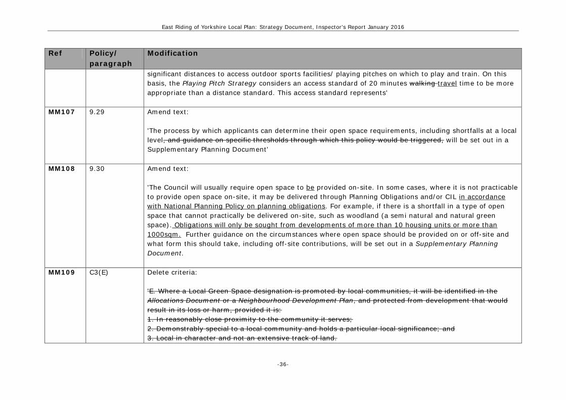
MM106 Table 12 Amend text of table 12: Outdoor sports facilities /Playing Pitches Accessibility Standard '20 minutes walking travel time' Amend text of paragraph 9.27: '...geographical variances across the East Riding mean that clubs and, therefore, individuals travel
East Riding of Yorkshire Local Plan: Strategy Document, Inspector’s Report January 2016
-36-
Ref Policy/ paragraph
Modification
significant distances to access outdoor sports facilities/ playing pitches on which to play and train. On this basis, the Playing Pitch Strategy considers an access standard of 20 minutes walking travel time to be more appropriate than a distance standard. This access standard represents'
MM107 9.29 Amend text: 'The process by which applicants can determine their open space requirements, including shortfalls at a local level, and guidance on specific thresholds through which this policy would be triggered, will be set out in a Supplementary Planning Document'
MM108 9.30 Amend text: 'The Council will usually require open space to be provided on-site. In some cases, where it is not practicable to provide open space on-site, it may be delivered through Planning Obligations and/or CIL in accordance with National Planning Policy on planning obligations. For example, if there is a shortfall in a type of open space that cannot practically be delivered on-site, such as woodland (a semi natural and natural green space). Obligations will only be sought from developments of more than 10 housing units or more than 1000sqm. Further guidance on the circumstances where open space should be provided on or off-site and what form this should take, including off-site contributions, will be set out in a Supplementary Planning Document.
MM109 C3(E) Delete criteria: 'E. Where a Local Green Space designation is promoted by local communities, it will be identified in the Allocations Document or a Neighbourhood Development Plan, and protected from development that would result in its loss or harm, provided it is: 1. In reasonably close proximity to the community it serves; 2. Demonstrably special to a local community and holds a particular local significance; and 3. Local in character and not an extensive track of land.

East Riding of Yorkshire Local Plan: Strategy Document, Inspector’s Report January 2016
-37-
Ref Policy/ paragraph
Modification
MM110 Policies Map Modify Policy C3 by amending the geographic illustration of the policy on the Policies Map through the
deletion of the Common Land designation and replacing it with an Open Space designation, as shown on the revised Policies Map submitted during the examination.
MM111 Policies Map Modify Policy C3 by amending the geographic illustration of the policy on the Policies Map through the following changes to the areas designated as Open Space, as shown on the revised Policies Map submitted during the examination: • removing the open space designation North of Sewerby Road, Bridlington; • including Cave Castle Golf Course as an Open Space; • amending designated Open Space boundaries as shown on the revised Policies Map; and • removing the Open Space designation from buildings.
MM112 EC4 Amend text: 'In order to increase overall accessibility, minimise congestion and improve safety, new development will be supported where it is accessible, or can be made accessible, by sustainable modes of transport and addresses its likely transport impact. Development proposals should:...'
MM113 Glossary of key terms
Add new row (following Community Infrastructure Levy): 'Community service/facility: Where a use furthers (or has recently furthered) the community's social well-being or social interests.'
MM114 A6(D1) & 10.132
Amend text and insert new criterion to policy: '....ii. provision for two way traffic on the A166 at within Stamford Bridge.; and iii. improvements to walking, cycling and public transport facilities, including those set out within Local Transport Plan individual settlement transport strategies and major cross country routes, such as the Wolds

East Riding of Yorkshire Local Plan: Strategy Document, Inspector’s Report January 2016
-38-
Ref Policy/ paragraph
Modification
Way and the Way of the Roses, the Public Right of Way network, and the National Cycle Network;' Amend text of paragraph 10.132: '...The Council is working with the Highways Agency and other relevant local authorities, including the City of York Council to reduce congestion and identify mitigation measures along the A64 corridor. The Council will also update the 2008 transport study for the A166 at Stamford Bridge, which will be used to inform future funding bids for improvements that make provision for two way traffic. In addition, a series of transport improvements in Pocklington and Market Weighton have also been prioritised through the Local Transport Plan.

East Riding of Yorkshire Local Plan: Strategy Document, Inspector’s Report January 2016
-39-
Ref: MM43 Modification: Amend Figure 3 - Key Diagram as follows:
East Riding of Yorkshire Local Plan: Strategy Document, Inspector’s Report January 2016
-40-
Ref: MM16 Modification: Amend Figure 16 – Beverley & Central sub area as follows:

East Riding of Yorkshire Local Plan: Strategy Document, Inspector’s Report January 2016
-41-
Ref: MM17 Modification: Amend Figure 17 – Bridlington Coastal sub area as follows

East Riding of Yorkshire Local Plan: Strategy Document, Inspector’s Report January 2016
-42-
Ref: MM18 Modification: Amend Figure 18 – Driffield & Wolds sub area as follows

East Riding of Yorkshire Local Plan: Strategy Document, Inspector’s Report January 2016
-43-
Ref: MM19 Modification: Amend Figure 19 – Goole & Humberhead Levels sub area as follows:
East Riding of Yorkshire Local Plan: Strategy Document, Inspector’s Report January 2016
-44-
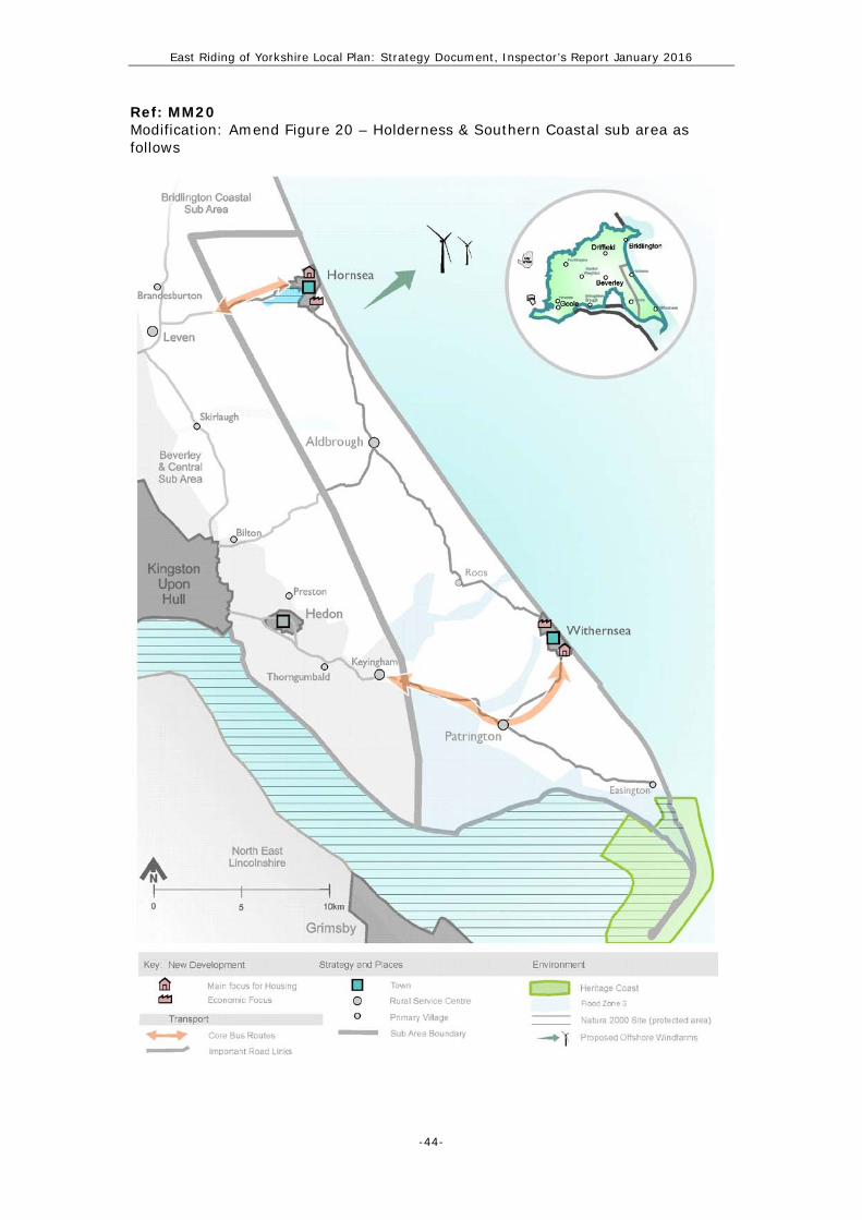
Ref: MM20 Modification: Amend Figure 20 – Holderness & Southern Coastal sub area as follows

East Riding of Yorkshire Local Plan: Strategy Document, Inspector’s Report January 2016
-45-
Ref: MM21 Modification: Amend Figure 21 – Vale of York sub area as follows: