appendix page 1 - kdot1.ksdot.org · ing projects and in the awarding of assistance to cities,...
TRANSCRIPT

APPENDIXto the
2007 Annual ReportKANSAS DEPARTMENT OF TRANSPORTATION’S
INCLUDES:Section A:
Transportation revolving fund; KDOT Right of Way information; Information on signs available for increasing tourism or
economic development; Financial compliance; An explanation of changes from last year’s Annual Report
project list; Reference Information;
--Glossary of commonly used KDOT terms--Commonly-used acronyms and abbreviations
Section B: Project Selection Criteria;
--Outline of four program categories (SE, MM, PB, and SM).
--Detailed explanation of the selection criteria used in develop-ing projects and in the awarding of assistance to cities, counties or other transportation providers.--Funding constraints of each program component.
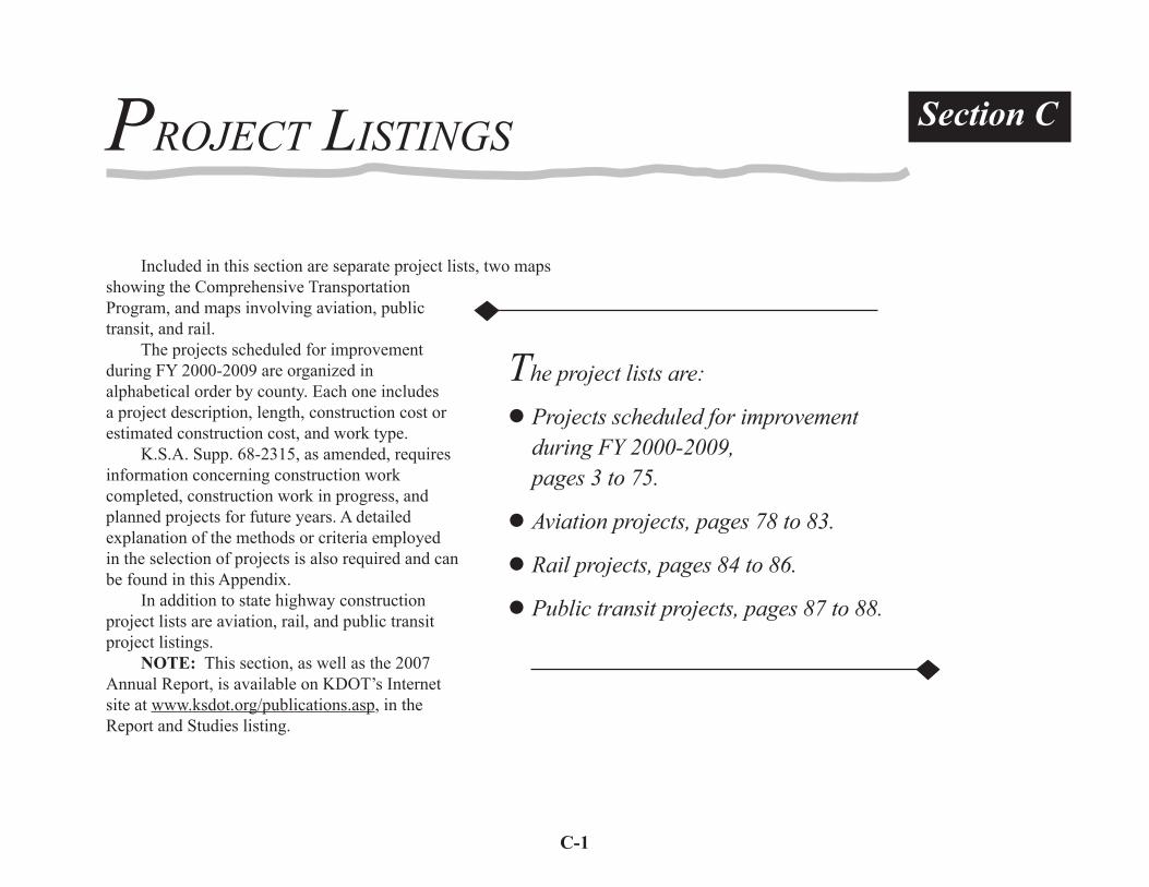
Section C: Project list detailing projects scheduled for improvement
during FY 2000-2009;--Each one includes a project description, length, construction cost or estimated construction cost, and work type. In addition to state highway construction project lists are aviation, rail, and public transit project listings.
Maps; --Two maps showing Comprehensive Transportation Program state highway system projects, and maps involving aviation, public transit, and rail.


A-1
Transportation Revolving FundThe Transportation Revolving Fund is a statewide revolving loan fund that provides low cost loans to local units of government for fi nancing road and bridge improvements. The improvement may be on or off the State Highway System. Since the fi rst loan in December 2003, the fund has provided 40 loans to 36 cities and counties. The fund has an approximately $53.2 million in executed loan agreements or loans completed with interest rates for the loans ranging from 3.76 percent to 4.36 percent.
Tracking KDOT Right of WaySince January 1, 2000, existing and new right-of-way has been
inventoried using an inventory database system. This enables KDOT to provide timely annual inventory updates at the same time that historical information is being captured and entered into the system. The Secretary fi les annual reports to the Legislature on all real property owned and real estate transactions engaged in by KDOT.
Information on SignsKDOT is currently developing an inventory of informational
signs across the state and will make the information available as soon as the work is complete. Additional details may be obtained in the Kansas Tourism Attraction Signage Application Kit at http://kdoch.state.ks.us/KDOCHdocs/TT/2005-Tourism_Attraction_Signage_Application.pdf.
GENERAL INFORMATION
Financial Compliance Each year the Department provides to the governor and the
Legislature summary fi nancial information and a statement of assurance that the Department has prepared a comprehensive fi nancial report of all funds for the preceding year. The fi nancial report must include a report by independent public accountants attesting that the fi nancial statements present fairly the fi nancial position of the Department in conformity with generally accepted accounting principles (GAAP).
The Department has prepared a Comprehensive Annual Financial Report (CAFR) for Fiscal Year (FY) 2006. Included in the CAFR is the report of the independent public accountants, Berberich Trahan & Co., P.A. and Allen Gibbs & Houlik, L.C. attesting that the fi nancial statements present fairly the fi nancial position of the Department in conformity with accounting principles generally accepted in the United States of America. Also included is a certifi cate of achievement awarded to the Department for excellence in fi nancial reporting for the 2005 CAFR. The award marks the eighteenth consecutive year the Department has received the award for excellence in fi nancial reporting.
The complete CAFR is available by contacting KDOT’s Offi ce of Transportation Information at 785-296-3585 (Voice)/(TTY). The CAFR is also available on KDOT’s Web site at http://www.ksdot.org/publications.asp, under Reports and Studies.
The Comprehensive Transportation Program (CTP) is a program for all modes of transportation: highways, aviation, rail, and public transit. Descriptions of the programs for each of the modes can be found in Section B of this Appendix.
Section A

A-2
Increase (Decrease) Percent from prior year 2006 of Total Amount Percent
FY 2006 FINANCIAL INFORMATION
The following schedule is a summary of revenues and expenditures for FY 2006 and the amount and percent of increases or decreases in relation to prior year amounts. All amounts are in thousands.
The Comprehensive Transportation Program is based on 10-year projections. The schedule below is a snapshot solely comparing FY 2006 revenues and expenditures to FY 2005 revenue and expenditures.
Increase (Decrease) Percent from prior year 2006 of Total Amount Percent
REVENUES
Motor Fuel Taxes Vehicle Registrations and Permits Intergovernmental Sales and Use Taxes Investment Earnings Motor Carrier Property Taxes Other Transfers from Other State Funds
Total revenues
$ 425,593
165,573 404,382 99,938 21,757
10,064 13,844
214,508
$ 1,355,659
31
123072
11
16
100
2,277
1,813
20,313 5,730 5,135
(0)
7,726
210,683
253,677
1 1 5 6
31 0
126
5,508
23
EXPENDITURES Current Operating Maintenance Construction Local Support Rail, Air and Public Trans. Management Debt Service Principal Interest and fees Transfers to Other State Funds
Total expenditures
OTHER FINANCING SOURCES (USES) Revenue Bond Proceeds Total other sources (uses)
Excess (Defi ciency) ofRevenues and OtherSources OverExpenditures
323,068 511,381 287,381
9,547 49,025
46,755 77,285
92,364
1,396,805
0
0
(41,147)
23 37 20 1 4
3 5
7
100
0
0
100
10,648 (5,176) 3,359 (1,783) (11,724) 8,295 9,757
(2,341)
11,035
(200,000)
(200,000)
42,642
4 (1)
1 (16)(19)
22 14
(2)
1
(100)
(100)
(56)
% $
% $
%
%
% $
% $
%%
% $
%
%
%%
%

A-3
11.4%Bond
Proceeds
10.3%Sales Tax
Direct Deposit
1.6%Sales TaxTransfer
4.7%Other
(Incl. DriversLicense Fees)
11.4%Vehicle
Registration Fees
31.1%Motor
Fuels Tax*
3.3%Local Funds
26.2%Federal Funds**
RoutineMaintenance(Incl. Snow
Removal& Mowing)
9.0%
Local TransportationPrograms
(Special City & CountyHighway, Local Federal
Aid Programs,Local Partnership Program,
City Connecting Link Payments,Transportation Enhancement)
20.2%
Transfers(Incl. KHP,Revenue)
5.7%
Buildings0.5%
Management(Incl. Administration,
Support Services,Technical &
PlanningAssistance)
4.0%
HighwayConstruction
(Right-of-Way,Design, Engineering,& Utility Adjustments
for: Substantial Maintenance,
Major Modifi cation,Priority Bridge & System
Enhancement)50.6%
Debt Service8.4%
Other Modal
Programs(Aviation,
PublicTransit,
Railroads)1.6%
State Highway Funds*Net Motor Fuels Tax Receipts:
(Ten-Year Average)64.4% to State Highway Fund
35.6% to Special City & CountyHighway Fund
**Federal Funds made up of:19.7% KDOT FHWA Obligation Authority5.2% Local FHWA Obligation Authority
1.3% FHA, FTA, NHSTSA
December 2006 Cash Flow Basis
Kansas Department of Transportation Fund Sources and DispositionFY 2000-2009

A-4
Explanation of Changes To/From 2005 Annual ReportComprehensive Transportation Program FY 2000-2009
Major Modifi cation Interstate and Non-Interstate and Priority Bridge Projects OnlyAssumes funding provided for in HB2071(April 1999), HB3011 (May 2002), and SB384 (April 2004)
9/19/06 KDOT
Project Category Changes Due to Scope Refi nement K-18 Ottawa Antelope Creek Bridge east of K-106 (Converted to future Substantial Priority Bridge Maintenance project due to bridge condition) US- 24 Shawnee UP RR Bridge west of Menoken Road (Converted to Substantial Priority Bridge Maintenance project; project development underway for post-CTP four-lane future bridge and tie-in to existing four-lane roadway) Project Additions Due to Changed Conditions I- 35 Johnson I-35/59th St./Lone Elm Road in Olathe (New interchange added as a Major Modifi cation result of federal earmark funds; no state funds) I-35 Lyon I-35/KTA/US-50 (KTA interchange project with proportional state Major Modifi cation funding participation)

A-5
Catch KDOT on the web:WWW.KSDOT.ORG
KDOT’S WEB SITE HAS DETAILS ON MANY TOPICS INCLUDING:KDOT offi ces throughout the state;City, county, and state maps;Other modes of transportation;Latest road condition information;News releases;
GLOSSARY OF COMMONLY USED KDOT TERMS
Various publications;Safety information;Career Opportunities;Information for highway contractors, design
consultants, vendors, and other organizations.
KDOT Connection:toll-free, 1-877-550-KDOT (5368)
Connect with any KDOT offi ce from anywhere in Kansas, toll-free 8 a.m. - 5 p.m., Monday through Friday. Closed holidays. Call 511
(anywhere in Kansas)or go to
http://511.ksdot.orgFind out route
specifi c road conditions, construction/detour, weather, and emergency road closure information 24 hours a day.
Outside of Kansas, call 1-866-511-5368.
At-grade intersection - An intersection with two or more roadways that provide for the movement of traffi c on the same level.
City Connecting Link (KLINK) - A city street that connects two rural portions of state highway. Normally a city is responsible for maintaining the connecting link.
Culvert - Generally a drainage structure constructed beneath an embankment. Box sections, pipes, and arches are examples of various culvert shapes.
Deck - That portion of a bridge that provides direct support of and the riding surface for vehicular and pedestrian traffi c. The deck distributes traffi c and deck weight loads to the superstructure elements.
Expressway - Multilane; divided highway where access is allowed at public roads via at-grade intersections.
Fiscal Year - A 12-month period to which the annual operating budget applies and at the end of which a government determines its fi nancial position and the results of its operations. The State
REFERENCE INFORMATION

A-6
of Kansas fi scal year (FY) is July 1 through June 30. The federal fi scal year (FFY) is October 1 through September 30.
Freeway - Multilane highway where access is provided only at grade-separated interchanges.
Geometric Improvement - A project that includes roadway improvements other than a surface treatment, such as shoulderand lane widening, curb and gutter work ,or roadway alignment.
Intersections - Where two or more roadways meet. An interchange has two or more roadways that provide for the movement of traffi c on different levels (grade separated). An at-grade intersection has two or more roadways that provide for the movement of traffi c on the same level.
Kansas Turnpike Authority - A 238-mile toll highway facility extending from Kansas City west and south past Wichita to the Kansas/Oklahoma state line. It is supported by user toll fees and is operated by the Kansas Turnpike Authority. KDOT has no jurisdiction over the KTA.
Let - Advertise and award a contract to the lowest responsible bidder.
Major Modifi cation - Program of projects to improve the service and safety of the existing highway system.
Pavement Management System (PMS) - A program of data gathering and analysis used by KDOT to select surface preservation locations and actions. The system can be used to determine actions to achieve the best pavement surface conditions
possible using available funds or alternatively to determine the minimum cost to achieve a given level of performance.
Priority Bridge - Program of projects to replace or rehabilitate bridges that are deteriorated or have defi ciencies in load carrying capacity, width, or traffi c service.
Reconstruction - Type of improvement designed to replace the existing roadway or bridge when it has reached the end of its useful life. Often accompanied by improvements to the functional and operational capacity of the highway.
Rehabilitation - Type of improvement designed to preserve and extend the service life and enhance the safety of an existing roadway or bridge when total replacement is not warranted.
Retrorefl ectivity - Light refl ected back to the driver’s eye from refl ective material on pavement marking or signing.
Rideability - A measure of the smoothness and riding characteristics of a road surface.
Right of Way - Land or property used specifi cally for transportation purposes.
Route Classifi cation System - A detailed classifi cation system that groups all state highway routes into fi ve levels:
Class A - the Interstate System.Class B - Routes that serve as the most important statewide and Interstate corridors for travel.Class C - Defi ned as arterials, these routes are closely integrated with Class A and B routes in service to all of the state.

A-7
Class D - These routes provide access to arterials and serve small urban areas not on a Class A, B, or C route, or access to county-seat cities.Class E - Primarily used for local service only, these routes are typifi ed by very short trips.
Routine Maintenance - The activities to preserve the “as built” condition of Kansas highways to the best extent possible by KDOT personnel. These activities include pot-hole patching, drainage work, guardrail repairs, highway striping, right-of-way mowing, and snow and ice control.
Set-aside - A program of funds reserved for a specifi c purpose.
Separation Structure - A bridge that separates the grades of two or more intersecting roadways or a highway and a railroad.
State Highway System - All state, US, and Interstate roadways in Kansas. State routes have K prefi xes (K-7, K-99, etc.); US routes are designated such as US-54, US-283, etc; Interstates have I prefi xes (I-70, I-35, etc.).
Substantial Maintenance - Program of projects selected annually to protect the investment in the State Highway System by preserving existing roadways and bridges.
Substructure - The abutments, piers, or other constructed bridge elements built to support the span of a bridge superstructure. The substructure transfers loads from the superstructure to the foundation soil or rock.
Superstructure - The entire portion of a bridge structure which primarily receives and supports traffi c loads transmitted through
the bridge deck. The superstructure carries these loads across the span and then transfers them to the bridge substructure.
Surface Preservation - Projects designed to preserve the “as-built” condition of roadways. This work can include a variety of actions (overlay, milling, crack repair, patching, edge drains, or mudjacking).
Surface Reconstruction - Projects designed to replace only the existing surface of a roadway whose geometric characteristics meet current standards.
System Enhancement - Program of projects to relieve congestion, improve access, enhance economic development, or improve safety on major segments of the State Highway System. Projects are in three basic categories - corridors, interchanges/separations, and bypasses. The program was originally established by the Comprehensive Highway Program and was reauthorized on a one-time only basis for the CTP FY 2000-2009. Projects were submitted by local governments and were selected after being ranked according to scores based on engineering criteria, a project’s potential for economic development, and the local government’s contribution to the project. Each project was prioritized against the other projects in this category, and projects were funded from the top down until dollars in that category were exhausted.
TEA-21 - Congress passed the Transportation Equity Act for the 21st Century (TEA-21) on June 9, 1998. It provided authorizations for highways, highway safety, and mass transit.
Work Zone - A designated area where highway construction or maintenance is taking place.

A-8
Commonly-usedAcronyms and Abbreviations
Abbreviation Description
AADT Average Annual Daily Traffi cAASHTO American Association of State Highway and Transportation Offi cialsACPA American Concrete Paving AssociationADA Americans with Disabilities ActADT Average Daily Traffi cAPE Advanced Preliminary EngineeringAPTA American Public Transit AssociationAPWA American Public Works AssociationARTBA American Road and Transportation Builders AssociationATSSA American Traffi c Safety Services AssociationBAC Blood Alcohol ContentBEST Basic Effective Supervisory TrainingBR BridgeCADD Computer-Aided Design and DraftingCAM Computer-Aided MappingCANSYS Control Section Analysis SystemCASE Computer-Aided Software EngineeringCDBG Community Development Block GrantCDL Commercial Driver’s LicenseCE Civil Engineer, Construction EngineeringCL County Line
C/L CenterlineCMAQ Congestion Mitigation and Air Quality Improvement ProgramCMS Contract Management System or Construction Management SystemCOLA Cost of Living AdjustmentCONST ConstructionCPMS Comprehensive Program Management SystemDBE Disadvantaged Business EnterpriseDE District EngineerDEIS Draft Environmental Impact StatementDOS Disk Operating SystemDOT Department of TransportationDUI Driving Under the Infl uenceE EastEA Environmental Assessment, Environmental Agency, Engineering AssociateEB EastboundED Economic DevelopmentEEO Equal Employment OpportunityEIS Environmental Impact StatementEIT Engineer in TrainingEMS Equipment Management SystemEO Equipment OperatorET Engineering TechnicianEWS End of Wearing SurfaceFAA Federal Aviation AdministrationFARS Fatal Accident Records SystemFEIS Final Environmental Impact StatementFEMA Federal Emergency Management AdministrationFFY Federal Fiscal YearFHWA Federal Highway Administration

A-9
FIMS Financial Information Management SystemFONSI Finding of No Signifi cant ImpactFTA Federal Transit AdministrationFY Fiscal Year (State)GAAP Generally Accepted Accounting PrinciplesGASB Governmental Accounting Standard BoardGI Geometric ImprovementGIS Geographic Information SystemGPS Global Positioning SystemHAC Highway Advisory CommissionHAZMAT Hazardous MaterialsHEEP Highway Engineering Exchange ProgramHMMS Highway Maintenance Management SystemHPMS Highway Performance Monitoring SystemIMMS Integrated Maintenance Management SystemINK Information Network of KansasISTEA Intermodal Surface Transportation Effi ciency ActITS Intelligent Transportation SystemKARS Kansas Accident Records SystemKCC Kansas Corporation CommissionKDOT Kansas Department of TransportationKHP Kansas Highway PatrolKLINK City Connecting Link ResurfacingKPERS Kansas Public Employees Retirement SystemKQM Kansas Quality Management KTA Kansas Turnpike AuthorityLAN Local Area NetworkLPA Local Public AuthorityMARC Mid-America Regional CouncilMCSAP Motor Carrier Safety Assistance ProgramMIS Managment Information System, Major Investment Study
MM Major Modifi cationMMS Maintenanc Management SystemMPO Metropolitan Planning OrganizationMUTCD Manual on Uniform Traffi c Control DevicesN NorthNB NorthboundNHI National Highway InstituteNHS National Highway SystemNHTSA National Highway Traffi c Safety AdministrationNRC National Research CouncilNSC National Safety CouncilOSHA Occupational Safety and Health AssociationPB Priority BridgePE Preliminary Engineering, Professional EngineerPI Public Involvement, Point of IntersectionPMS Pavement Management SystemPS&E Plans, Specifi cations and EstimatesQA Quality AssuranceQC Quality ControlRCB Reinforced Concrete BoxROW Right-of-WayRR RailroadS SouthSB SouthboundSCCHF Special City/County Highway FundSE System EnhancementSEIS Supplemental Environmental Impact StatementSEP System Enhancement ProgramSHA State Highway AgencySHRP Strategic Highway Research ProgramSM Substantial MaintenanceSMP Strategic Management Plan

A-10
SRA Safety Rest AreaSTIP State Transportation Improvement ProgramSTP Surface Transportation ProgramTE Transportation EnhancementTEA-21 Transportation Equity Act for the 21st CenturyTIP Transportation Improvement Program
TRB Transportation Research BoardTRIP The Road Information ProgramTTY Telecommunications Device for the DeafW WestWB Westbound
KANSAS TRANSPORTATION AT A GLANCE - 2005Background of Kansas 105 counties, 627 cities, 4 MPOs 135,462 miles of public roads Land area (sq. miles) 81,823Population (2000 census) 2,744,687
Registered vehicles Autos 1,442,888 Pickups & trucks 709,155 Trailers 125,563 Motorcycles 60,834 Motorized bikes 5,976 Special registrations 171,347 RV 13,306 Total 2,488,284Licensed drivers 2,006,060
Annual vehicle miles 29,907,741of travel (in 1,000s)
State tax rates (cents/gal.) (Effective July 1, 2002) Gasoline 24 Diesel 26 Gasohol 24Public road miles Rural 123,695 Urban 11,767 Total 135,462Rail Total Miles operated 4,776 Shortline Miles Operated 1,986 Class I miles operated 2,790
Bridges Structurally defi cient 3,040 Functionally obsolete 2,396 Non-defi cient 20,007 Not rated 384 Total 25,827Airports Public use 143 Commercial service 8Waterways Terminals 8
Accidents and fatalities Total accidents 68,675 Fatal accidents 384 Fatalities 428

B-1
ment are resurfaced or repaired annually through this set-aside pro-gram. The program’s intent is to maintain non-Interstate pavements in adequate condition and keep rideability at an acceptable level.
These projects are selected by using the Pavement Management System (PMS). PMS is an integrated set of procedures that was developed by KDOT and Woodward-Clyde Consultants. It recommends pavement maintenance and rehabilitation strategies on both a network and a project level PMS consists of three interconnected subsystems: The Pavement Management Information System (PMIS) is a data base and supporting computer programs and tools which contain network and project-level survey results, information downloaded from the planning database, and output from the Construction Priority System. Information from the planning database includes data on geo-metric features, traffi c, and truck load information. Information is regularly transferred between these multiple data sources.
The Network Optimization System (NOS) models the highway network and determines the action for each one-mile segment of the entire system to produce the
The Fiscal Year (FY) 2000-2009 Comprehensive Transportation Program (CTP) has four program categories that were originally established by the FY 1990 - 1997 Comprehensive Highway Program: Substantial Maintenance; Major Modifi cation; Priority Bridge; and System Enhancement. Within each of these major categories are funding and/or project-type subcategories. The selection criteria used in developing projects are tailored to the intent and funding constraints of each program component.
Substantial MaintenanceSubstantial Maintenance projects, the fi rst major component,
are intended to protect the traveling public and the public’s investment in its highway system by preserving the “as built” condition as long as possible. These projects are fi nanced with funds that are reserved (or set aside) for specifi c purposes.
Without proper maintenance, the cost for major repairs and/or replacement at a later date can be several times greater than the cost of timely maintenance. The Substantial Maintenance set-aside funds include Non-Interstate Resurfacing, Interstate Resurfacing, City Connecting Link (KLINK) Resurfacing, Contract Maintenance, Safety Projects, Emergency Repair, Bridge and Culvert Repair, Bridge Painting, Signing, Pavement Marking, and Lighting.
Non-Interstate ResurfacingApproximately 1,200 miles of two-lane non-Interstate pave-
PROJECT SELECTION CRITERIA
Non-Interstate Resurfacing, page B-1Interstate Resurfacing, page B-2KLINK Resurfacing, page B-2Contract Maintenance, page B-2Safety Projects, page B-2Emergency Repair, page B-3Bridge and Culvert Repair, page B-3Bridge Painting, page B-3 Signing, page B-3Pavement Marking, page B-4Lighting, page B-5
SubstantialMaintenanceComponents
of the CTP
Section B

B-2
optimal statewide benefi t. The system can operate in either a “desired- performance” mode or a “fi xed-budget” mode. In the desired- performance mode, the system selects actions to achieve the selected performance level at the lowest cost. In the fi xed-budget mode, the system selects the set of projects that produces the “best” total system performance for the fi xed-budget level. A linear programming model is used to minimize the long-term expected average cost of rehabilitation, subject to certain short-term requirements. Program development is a two-part process. NOS selects “locations only” for projects to be let to contract two years following the survey year. The second process (described below) develops scopes for resurfacing projects for the year following the pavement survey.
The Project Optimization System (POS) will serve two functions. First, it is a comprehensive design system for pavement structural sections on new grades. Second, it utilizes site-specifi c cost and material parameters to revise tentative project scopes from the NOS. Alternative rehabilitation strategies for a single project, or for groups of projects which meet cost and performance constraints from the NOS, are further evaluated. The POS selects the strategy which minimizes the need for future maintenance.
Interstate ResurfacingApproximately 20 center-line miles of divided Interstate
roadway (40 miles of two-lane pavement) are resurfaced or repaired annually through the Interstate Resurfacing set-aside program. Input from the Pavement Management System is used to decide which sections of Interstate are to be resurfaced.
City Connecting Link “KLINK” ResurfacingThis is a Local Partnership Program. The KLINK Resurfacing
set-aside program provides funding for resurfacing projects on city streets that connect two rural portions of state highway (called City Connecting Links). These projects are funded under a 50 percent
state/50 percent city funding matching arrangement for cities with greater than 10,000 population and a 75 percent state/25 percent city ratio for cities with less than 10,000 population. The maximum state share for a project is $200,000.
KDOT annually solicits requests for eligible projects. All State Highway System City Connecting Links are eligible except those on the Interstate System and fully-controlled access sections on the Freeway System. Cities requesting projects are encouraged to review the proposed projects with the KDOT District Engineer or designated representative before submitting applications. If requested funds exceed available funds, projects are prioritized and selected on the basis of pavement survey conditions.
Contract MaintenanceMaintenance activities are undertaken to offset the effects
of weather, deterioration, traffi c wear, damage, and vandalism. Eligible projects are those that KDOT is not adequately staffed or equipped to perform. Due to the diverse types of actions and/or geographic location, contracting for the service is the most cost-effective approach for the agency.
Selection is based on priority as seen from a statewide perspective. Basic criteria for contract maintenance projects are: 1) inability to perform necessary actions with existing maintenance forces; 2) not eligible for other maintenance programs; 3) not anticipated (generally the result of weather or traffi c conditions). Projects are selected on the basis of statewide need for corrective action, not on a balanced distribution between districts.
Safety Projects
This set-aside program provides for improvement of intersections or spot locations where major improvement of a corridor is not required. Geometric improvements (turn lanes, curb radius, roundabouts) and traffi c signals, along with signing and pavement marking, can be cost effective in reducing crashes at

B-3
these locations.The Bureau of Traffi c Engineering conducts traffi c studies
investigating the physical and operational characteristics of locations. These studies:
1. identify the reason the location is being reviewed; 2. identify sight characteristics; 3. identify concerns; 4. identify possible causes of the concerns; 5. identify possible countermeasures; 6. consider the effect of these countermeasures; 7. provide a recommendation.If the recommendation involves a geometric or signal
improvement, the location is added to the list of locations to be considered for funding. Depending on potential costs, a benefi t cost analysis may be completed.
Emergency RepairFunds are set aside annually for emergency repairs that occur
as the result of accidents or disasters. Allocation of these funds is authorized by the State Transportation Engineer when accidents/weather-related causes occur.
Bridge and Culvert Repair
The Bridge Repair and Culvert Repair set-aside programs supplement the Priority Bridge program (see B-11). The program aims to restore the structural integrity of bridges and culverts. Bridge repair work includes: overlaying concrete decks; replacing or resetting expansion joints; resetting bearing devices; repairing abutments, piers, or girders; and repairing damage from external sources.
Each District, using the Bridge Management Engineer’s recommended repair list, submits prioritized lists of candidate bridge and culvert projects to the Bureau of Construction and Maintenance and the Bureau of Design. Each candidate project is
reviewed for the structure’s condition history and latest inspection to confi rm necessary repairs or replacement. Statewide lists are prioritized using such factors as maintenance effort, safety, traffi c, and engineering judgment. The lists are submitted to the Bureau of Program Management for review to confi rm that the candidate structures are not programmed for future work under any other KDOT program. The prioritized lists are merged to create the yearly statewide repair list.
Bridge PaintingThere are approximately 800 bridge structures on the Kansas
State Highway System that require periodic painting of the structur-al steel to slow corrosion. These structures contain nearly 242,000 tons of structural steel. They are categorized into two groups: Group A:
Structures which have 10 tons or more of structural steel. The Bridge Management Engineer prioritizes these structures
(approximately 760 bridges) according to the Bridge Inspection Manual’s “Paint Condition Rating.” The statewide prioritized list is reviewed by the Bureau of Program Management to confi rm that each candidate structure is not programmed for future work under any other KDOT program. Projects are then scheduled in order of priority until available funds are exhausted.
Group B:Structures having less than 10 tons of structural steel. Each District is responsible for the painting of these structures
(approximately 40 bridges statewide).
SigningThis program was established in 1996 to address necessary
sign replacements on the State Highway System due to pending new federal requirements for minimum retrorefl ectivity of signs. This program schedules sign replacements based upon highway route mileage statewide and the total mileage of all the routes in

B-4
each District for that year. This program excludes signs on any other state projects that include sign replacement for that highway route in the same year. This program also excludes any signs that were replaced within fi ve years of the scheduled date of the replacement project.
Pavement MarkingThis set-aside program was established in
FY 1996 to address pavement marking necessary due to pending new federal requirements for minimum retrorefl ectivity of pavement markings. Improvements in this category utilize high-performance, long-life pavement marking materials. Efforts are also made to identify those marking materials with wet-weather retrorefl ectivity. This program is limited to projects that do not have high-performance markings included under any other KDOT program. Projects are selected by the Bureau of Traffi c Engineering based upon a roadway’s traffi c volumes, past performance of marking material, condition of existing marking, surface condition, surface type, crash history, and, in the case of new marking materials, the research benefi t.
LightingBecause lighting is benefi cial to the safety and operation of the
highway system, this set-aside program was established in FY 2000. Projects are selected by the Bureau of Traffi c Engineering based on the roadway’s volume and night-time crash history. This program is limited to projects which are not included under any other KDOT program. Projects are scheduled until the available lighting funds are exhausted. (At other locations, lighting may be installed by the local unit of government by obtaining a highway permit. In
general, the local entity bears the cost of installation, maintenance, and operation.)
MAJOR MODIFICATION
The Major Modifi cation program is the second major component of the FY 2000-2009 CTP. It is designed to improve the service, comfort, capacity, condition, economy, or safety of the existing system. It includes a number of set-aside programs: Economic Development; Geometric Improvement; and the federal-aid Railroad/Highway Crossing and Safety programs. Only a portion of the Railroad/Highway Crossing and Safety funds are included in the state program because most of the projects are off the State Highway System. Two new set-aside programs, Guard Fence Upgrades and Railroad Grade Separations, were established in FY 1996 and 1998 respectively.
For the CTP, four additional new set-aside programs were established: Corridor Management; Railroad Crossing Surfacing; Local Partnership Railroad Grade Separations; and Intelligent Transportation Systems (ITS).
Non-Interstate Roadwayand Associated Bridges
Construction Priority System - Major Modifi cation Interstate and Non-Interstate roadway and Priority Bridge projects are selected using the Construction Priority System. It ranks roadway sections and bridges for improvement by the seriousness
Non-Interstate Roadway andAssociated Bridges, page B-4Interstate Roadways and
Associated Bridges, page B-5Economic Development, page B-5Geometric Improvement, page B-6Railroad/Highway Crossing, page B-6STP Safety Projects, page B-7Railroad Grade Separations, page B-8Guard Fence Upgrades, page B-8Corridor Management, page B-8Railroad Crossing Surfacing, page B-8Local Partnership Railroad Grade
Separations, page B-9Intelligent Transportation Systems (ITS),
page B-9
MajorModifi cationComponents
of the CTP

B-5
of their defi ciencies.The system was developed by KDOT and Woodward-Clyde
Consultants in 1981. The system originally consisted of two formulas – one for roads and one for bridges – that used input from KDOT’s planning data base to measure the relative need for improvement of all roads and bridges. Both the roadway and the bridge formulas have since been modifi ed by KDOT, and a third formula, for Interstate roadway rehabilitation projects, has been developed by modifying the original roadway formula to apply to Interstate roadway sections only. All three formulas are currently under review.
KDOT runs the three priority formulas to update priority ratings by using updated survey information. The output from the formulas, prioritized lists of roadway control sections and bridges, are used to identify logical projects. Projects with the highest relative need are programmed for improvement fi rst within available funding and based on scheduling considerations. This process was used to select projects in the CTP Major Modifi cation program and Priority Bridge program. These are the basic steps used to develop the multiyear program:
1. Develop funding estimates.2. Identify and prioritize projects, determine improvement
scopes, and prepare cost estimates.3. Earmark set-aside funds.4. Balance project costs and funding by fund class and
obligation limit within each fi scal year.5. Prepare summary of project costs and funding by fund class
and fi scal year.6. Review of draft program, cost, and funding summary data
by Program Review Committee.Non-Interstate Projects - Roadway work in this category
includes reconstruction/heavy rehabilitation of pavement, widening traffi c lanes, adding or widening shoulders, and improving alignment (i.e., eliminating steep hills or sharp curves). Associated bridge work includes widening narrow bridges, replacing obsolete bridges, and modernizing bridge rails for bridges within the limits of each project. Non-Interstate roadway projects were prioritized using the Non-Interstate Roadway Priority Formula. A schematic of the formula is shown on page B-17.
Interstate Roadway and Associated Bridges Roadway work in this category includes resurfacing, restoring,
rehabilitating, and reconstructing pavement on the Interstate System. A separate priority formula was developed for Interstate
Road Category Jurisdictional Authority Fund SourcesState Highway System
10,372 miles*51.9% of total travelNonstate highway
system124,852 miles
42.9% of total travel**
State Highway FundFederal fundsLocal funds
Special City and CountyHighway Fund
Local FundsState allocated federal funds
KDOT
Cities and Counties
*Includes City Connecting Links.**The remaining 5.2 % of total travel is on the 238-mile Kansas Turnpike.
HIGHWAY JURISDICTION AND RESOURCES

B-6
roadway rehabilitation by KDOT in January 1988. A schematic of the formula is shown on page B-18.
The Interstate Roadway Formula was reviewed prior to selecting projects for FY 1998. As a result of this review, use of the formula was suspended due to data-related issues and the need for the formula to more accurately refl ect the structural condition of Interstate pavements. KDOT is in the process of reviewing both current data used in the formula and computer procedures for new data that evaluate pavement by pavement layer type, thickness, age, and axle loadings. For FY 1998-2009, Interstate Roadway projects were selected based on the age of the underlying pavement, pavement deterioration requiring frequent and repeated Substantial Maintenance projects, and system rehabilitation continuity.
Economic Development Economic Development projects are highway and bridge
construction projects intended to enhance the economic development of the State of Kansas. This is a Local Partnership Program in which a project’s cost is shared by the state and a local unit of government. Local support must be at least 25 percent of a project’s total cost. Eligible projects must have the potential to signifi cantly enhance the income, employment, sales receipts, and land values in the surrounding area.
KDOT annually solicits requests for eligible projects. Applicants are encouraged to review proposed projects with the KDOT District Engineer or a designated representative prior to the submission of the application. Upon submission, KDOT’s Bureau of Program Management reviews the proposed project scope and estimate. All projects are then assembled in a single package and presented to the Kansas Highway Advisory Commission. Staff from KDOT and the Kansas Department of Commerce and Housing assist the Highway Advisory Commission by evaluating the projects. The Highway Advisory Commission recommends a set of projects to the Secretary of Transportation who makes the fi nal selection.
Geometric Improvement This is a Local Partnership Program. Funds are set aside
annually to assist cities in funding geometric improvements on City Connecting Links (city streets which connect two portions of rural state highway). Geometric improvements are designed to widen pavements, add or widen shoulders, and add needed turning, acceleration, and deceleration lanes. The minimum local funding can range from 0 percent to 25 percent of the project cost, depending on the size of the city. The maximum state share ranges from $700,000 to $950,000.
KDOT annually solicits requests for eligible projects. Cities are encouraged to review proposed projects with the KDOT District Engineer or a designated representative before submitting the application. Upon submission, KDOT’s Bureau of Program Management reviews the proposed project scope and estimate. All projects are then assembled in a single package and presented to the Highway Advisory Commission. KDOT staff assists by providing project-related information and design criteria. The Highway Advisory Commission recommends a set of projects to the Secretary of Transportation, who makes the fi nal selection.
Railroad/Highway Crossing The 2005 Safe, Accountable, Flexible, Effi cient Transportation
Act: A Legacy for Users (SAFETY-LU) sets aside funding for use on railroad/highway crossings. This federal-aid program funds protective device installation and hazard elimination at railroad/highway grade crossings on public roads.
In accordance with Section 130 of the 1973 Federal-aid Highway Act, KDOT has established a state rail crossing inventory and formula to prioritize all 6,200 at-grade public crossings in Kansas.
The priority formula “hazard index” is used to rate the relative hazard potential for all crossings and is based on highway traffi c, train traffi c, and a warning device factor. A schematic of the formula

B-7
is shown on page B-18.Each year a number of the highest ranked crossings that have
not been addressed in prior programs are selected for review. A preliminary review of these crossings is conducted to verify crossing inventory information.
Crossings from this list that pass the preliminary review are scheduled for on-site diagnostic reviews. The diagnostic review team consists of KDOT, railroad, and local government staff. This team makes recommendations for each crossing as to type of warning system, crossing surface work, approach roadway improvements, drainage improvements, and brush and timber clearing. A rough cost estimate of the recommendations is developed for each crossing.
The on-site review is sent to the local government offi cials who have maintenance responsibilities for the highway or roadway. When crossing projects receive a commitment from local government, railroads, and the State, a project implementation procedure is started that leads to improvements at the crossing.
In conjunction with the United States Department of Transportation’s national highway/railroad crossing safety initiatives, KDOT is also addressing railroad corridor highway/railroad crossing safety projects. For corridor project approval there must be a reasonable number of highway/railroad crossing closures. The highest priority highway/railroad crossings in the corridor are improved with active fl ashing light and gate signal systems.
In addition to the federally-funded projects, $300,000 per year of state funds is programmed for crossing improvements. Prior to the CTP, this program was administered by the Kansas Corporation Commission. Crossings are eligible for this funding only if they don’t meet the federal eligibility requirements. Local jurisdictions must submit crossing for funding, which require 20 percent matching funds from the railroad company.
STP Safety ProjectsThe 2005 Safe, Accountable, Flexible, Effi cient Transportation
Act: A Legacy for Users (SAFETY-LU) sets aside funding for use on construction projects. These federal-aid projects provide safety improvements on all federal-aid systems. The Bureau of Traffi c Engineering administers the majority of this program. The Bureau of Local Projects administers a small portion of the program for projects on county roads and for cities under 5,000 population.
Four categories of roadway systems have been established for location analysis and funding to ensure that all roadway systems can benefi t from federal-aid safety improvements. Each category is allotted a portion of the total amount of STP Safety funds available at the beginning of each federal fi scal year.
Identifi cation of High-Crash Locations - For Jurisdictions U and N, cities are requested to submit two years of crash data for up to fi ve high-crash locations on federal-aid routes within their areas. High-crash locations are determined and ranked by descending equivalent-property-damage-only (EPDO) accident rate. The top 30 (approximately) are considered high-crash locations warranting further analysis. Projects in these categories are fi nanced with federal-aid and local matching funds.
For jurisdiction K, to determine if a location is a high-frequency crash location, a comparison is made between the actual crash rate and the statewide average rate for similar highways. The Bureau of Traffi c Engineering conducts county-wide road safety audits. From these audits and from traffi c studies, high-
Jurisdiction-Location Population Funding Split N Metropolitan Kansas City/Wichita 38 percent U Urban Over 5,000 30 percent K Rural State Hwys. 20 percent C County Rds. and Less than 5,000 12 percent other Roadways (These fi gures are not intended to be rigid. The percentages may vary by a few points in any given year. In addition, funds that cannot be utilized in one category may be transferred to another category.)

B-8
projects. The formula is based on railroad and highway operational characteristics. Projects are funded with a combination of federal, state, railroad company, and local monies.
Guard Fence UpgradesThis program was established in FY 1996 to address guard
fence upgrades on Interstate and selected high-priority corridors where guard fence is not a part of any other Major Modifi cation or Priority Bridge project. This set-aside fund is necessary due to federal requirements.
It is anticipated that the program will require several years to be completed. Locations of individual sites for the program are determined and grouped into projects according to proximity. Prioritization is based on traffi c exposure with locations having the highest traffi c volumes being scheduled for construction in the earlier years followed in subsequent years by routes with lower volumes.
Corridor ManagementThe Corridor Management set-aside program was created
to address the growing need for KDOT, cities, and counties to jointly manage transportation corridors, particularly in high-growth developing areas. This fund is divided into two subcategories with two-thirds going to a project subcategory and one-third to a contingency subcategory. To be eligible for either category of funds, a corridor must be designated in the district plan, there must be a partnering agreement between the Secretary, city, and county, and there must be a binding corridor master plan in place.
The contingency subcategory of funds is designed to address rapidly developing areas or sites where transportation infrastructure changes must be made to better accommodate changes in demand. This fund requires a minimum 50 percent local match for state monies. There is also a per-project maximum of $200,000.
The project subcategory of funds is designed to assist newly
crash locations are established. High-crash locations are ranked in descending EPDO crash rate order. The top locations are considered high-crash locations warranting further analysis. Projects in jurisdiction K on the rural State Highway System are fi nanced with federal-aid and state funds.
Jurisdiction C projects are fi nanced with federal-aid and local matching funds rather than state funds. These projects are selected by local units of government and are subject to Federal Highway Administration approval. They are administered by the Bureau of Local Projects.
Prioritization - The identifi ed high-crash locations are prioritized on the basis of the average annual net return for each location. The average annual net return is a dollar amount found by subtracting the average annual costs from average annual benefi ts. Priority consideration is given to the locations with high average annual net return and high benefi t cost ratio. Remaining projects are scheduled in descending order until funds are exhausted. Exceptions to this might be caused by the unavailability of city matching funds, future projects that may encompass the selected location, a grouping of proximate locations into one project, or combining several smaller projects for a total net return larger than one project.
Railroad Grade SeparationsThis program was established in FY 1998 to replace state
highway railroad at-grade crossings with grade separation structures. To be eligible for this program crossings must be:
a rural or City Connecting Link state highway crossing;main line railroad traffi c, excluding industrial spur tracks;
and route classifi cation must be “B” or “C” or be on the National
Highway System (NHS).Eligible at-grade crossings are prioritized using KDOT’s
priority formula hazard index. This is the ranking formula also used for the Major Modifi cation Railroad/Highway Crossing

B-9
developing areas in meeting the master plan or to retrofi t established areas to master plan standards. Projects are solicited annually and require a minimum 33 percent local match for state monies. There is a per-project maximum of $250,000.
Also, Corridor Management funds may be used for advance right-of-way acquisition or corridor studies in some special cases.
Railroad Crossing Surfacing This program was established in FY 2000. Projects under this
program will be for at-grade highway/railroad crossing approach and surface upgrades. Eligible crossings will be rural State Highway System crossings and State Highway System City Connecting Link crossings in cities up to 2,500 population.
Projects will be selected from applications for crossing surface improvement projects submitted by railroad companies and Districts. Project scopes will include all necessary materials and activities required for long-term crossing surface and approach improvements. These projects will be funded with 50 percent state and 50 percent railroad company monies.
Local Partnership Railroad Grade SeparationsThis is a new program established for the CTP. The Local
Partnership Railroad Grade Separation Program addresses highway/railroad at-grade crossings off the State Highway System and crossings on the State Highway System, which are on lower priority routes (Route Class “D” and “E”). Project applications will be solicited from local units of government. The project sponsor will be responsible for providing 10 to 20 percent of the project funds, depending on the population of the city or county. Funds provided by the railroad company will be counted as part of the local match funds; the project sponsor will be responsible for negotiating with the railroad.
Projects will be selected based on KDOT’s priority formula hazard index. This is the ranking formula also used for the Major
Modifi cation Railroad/Highway Crossing projects. The formula is based on railroad and highway operational characteristics. Additional selection consideration will be given to projects with relatively higher rates of local and railroad match fi nding in order to leverage state dollars. The project selection process will also give consideration to the overall positive effects on communities.
Intelligent Transportation Systems (ITS)The ITS set-aside program was established to meet the funding
needs of ITS/technology-related projects in Kansas. The funding is available to apply technology such as advanced sensor, computer, electronics, communications, and management strategies to increase the safety and effi ciency of the transportation system. The funding is available to both state and local agencies and is not necessarily limited to agencies that are responsible for transportation. ITS has applications in urban areas, rural areas, transit, and commercial vehicle operations, and consideration for funding will be given to all of these areas.
The Bureau of Transportation Planning, along with the ITS Steering Committee, establishes project rankings based on:
anticipated ITS benefi ts; likelyhood to succeed; cost effectiveness; matching funds or KDOT project; and rural/local impact.
Projects are solicited annually and selected based on the criteria listed above.
PRIORITY BRIDGE
The Priority Bridge program, the third major component of the 2000-2009 CTP, is designed to replace or rehabilitate substandard bridges. Substandard bridges are those in a

B-10
deteriorated condition or with defi ciencies in load-carrying capacity, width, or traffi c service. Special consideration is given to replacing one-lane bridges (bridges with roadway width less than 20 feet), restricted vertical clearance bridges, and cribbed bridges (bridges with temporary structural supports to keep them in use).
Priority Bridge projects are selected using the Bridge Priority Formula. The formula was developed by KDOT and Woodward-Clyde Consultants in 1981. It was modifi ed by KDOT in July 1987 and again in September 1988. Bridges with the highest relative need are programmed for improvement fi rst within available funding and based on scheduling considerations. A schematic of the formula appears on page B-18.
Bridge Deck Replacement and Culvert-BridgeBoth of these categories expand the Priority Bridge program.
The Culvert-Bridge program addresses culverts that are beyond the scope of a Substantial Maintenance project but do not qualify for the Priority Bridge Replacement/Rehabilitation program. The Bridge Deck Replacement program addresses bridges where the bridge superstructure and substructure are in satisfactory condition, but the bridge deck has deteriorated to the point where a Substantial Maintenance project would not be adequate.
Each District, using the Bridge Management Engineer’s recommended repair list, submits prioritized lists of candidate projects to the Bureau of Design. Each candidate project is reviewed for the structure’s condition history and latest inspection to confi rm necessary repairs or replacement. Statewide lists are prioritized using such factors as maintenance effort, safety, traffi c, and engineering judgment. The lists are submitted to the Bureau of Program Management for review to confi rm that each candidate structure is not programmed for future work under any other KDOT program. The prioritized lists are then merged to create the yearly statewide repair list.
SYSTEM ENHANCEMENT The System Enhancement Program is the fourth major
component of the CTP. Legislation authorizing the CTP, House Bill (HB) 2071, provides that the Secretary of Transportation shall include in the CTP “system enhancement projects which include additions to the system of highways or which substantially improve safety, relieve congestion, improve access, or enhance economic development. It is the intent of the Legislature that, as nearly as possible, the amount of $1.05 billion shall be expended or committed to be expended for the period beginning July 1, 1999, through June 30, 2009.” It also states KDOT “shall utilize the selection methodology developed by the Department to select system enhancement projects.”
CTP System Enhancement projects were selected using the same approach that was successfully used for the Comprehensive Highway Program System Enhancement Program in 1990. Project applications were solicited from local units of government. Candidate projects were submitted in three separate categories: Corridor Improvements, Bypass Construction, and Interchange/Separation Improvements.
Each category had unique, objective selection criteria primarily based on engineering and safety factors. Additional credit was given to a candidate project’s score for local match funding, lane-miles removed from the State Highway System, and partially complete project development. Local match is a way to measure a local community’s support for a project based upon their willingness to invest money in it. Lane-miles removed from the system are a way to gain local cooperation in removing redundant miles from the State Highway System. Credit for projects where project development is partially complete takes into account projects that have previously been determined to be a priority but for which funding has been unavailable.

B-11
Only city/county governments or coalitions of city/county governments were allowed to submit an application for a System Enhancement project. System Enhancement projects must be on the State Highway System or a logical addition to the State Highway System.
All of the selected System Enhancement projects for the CTP were announced August 4, 2000. Fund Distribution - No single set of criteria could be used to rate the three very different types of projects. Likewise, a distribution of the funds available had to be made to the various project types. Furthermore, a distribution of funds had to be made between the urban and rural regions of the state.
Funds were distributed between urbanized and nonurbanized counties on the basis of vehicle miles of travel. The breakdown was based on 1997 Annual Average Daily Traffi c (AADT) counts that showed approximately 35 percent of all vehicle miles traveled on the State Highway System are in the fi ve urbanized counties. The
urbanized counties are Douglas, Johnson, Sedgwick, Shawnee, and Wyandotte. Vehicle miles of travel are used because they are a measure of both the source of highway revenues and highway usage, which in turn relate to need.
The urban and rural fund allocations were further divided between the Corridor Improvements, Bypass Construction, and Interchange/Separation Improvements categories based on their percent of the total fi nal number of applications received in each category. In addition, $50 million of the System Enhancement funds were earmarked for the Wichita Rail Project. The chart below shows the fund distribution.
Economic Development Review Panel (EDRP) - An independent group of experts reviewed the economic development potential of the candidate projects. Governor Bill Graves appointed the EDRP in July 1999, and members included Lt. Governor Gary Sherrer (Chairman), Topeka; James M. AuBuchon, Pittsburg; Mary Birch, Overland Park; Sheryl Dick, Garden City; Don A.
CTP System EnhancementFund Distribution
Local Match Funds Not Included
*Urbanized/nonurbanized split based on proportion of vehicle miles of travel (1997). Douglas, Johnson, Sedg-wick, Shawnee, and Wyandotte are urbanized counties.**Category divisions based on percent of total fi nal number of applications evaluated.
All Projects100% of State Funds
$1,050 Million
Corridors**$93.9
11 applications
Interchanges/Separation Structures**
$222.026 applications
Bypasses**$34.1
4 applications
Wichita RailProject
$50 Million
Corridors**$494.3
73 applications
Interchanges/Separation Structures**
$40.66 applications
Bypasses**$115.1
17 applications
Urbanized Counties*35%$350
41 applications
Rural and Small Cities*65%$650
96 applications8/4/00

B-12
Hill, Emporia; John G. Montgomery, Junction City; John L. Rolfe, Wichita; Billie Jo Smart, Washington; and Lavern D. Squier, Hays. Based on their own knowledge and experience, their observations, and the information provided by the applicant, the panel assigned the Economic Development Enhancement Rating to each project. The panel could assign a score up to 20 points for each project.
Project Evaluation - As specifi ed in HB 2071, KDOT evaluated and ranked the eligible project requests based on criteria developed by the Department.
KDOT developed a score for each project based on objective engineering criteria, considering such factors as current and projected traffi c volume, design, and safety issues. This score could be a maximum of 80 points. The EDRP considered a project’s potential for economic development and assigned a project score of up to 20 points.
These scores were combined and then any points earned through “extra credit” categories were added to the score. A project sponsor could earn extra credit in one of three ways: offer to take over responsibility of lane miles currently on the State Highway System once the System Enhancement project is completed and open to traffi c; offer a percentage of the project cost as local matching funds; or submit a project where a portion of the project may already be complete. The combination of these three numbers - KDOT score, EDRP score, and extra credit points - created the project’s fi nal score. It was then prioritized against the other projects in its category, and projects were funded from the top down until dollars in that category were exhausted.
KDOT received more than $5 billion in project requests for the $1 billion System Enhancement pool. KDOT did decide to fund some projects that were ranked lower than other candidates because these projects could be fully funded with the remaining dollars available in the category. KDOT also decided to partially fund some projects. All of these decisions were made to make the best use of the dollars available.
Corridor ImprovementsEligibility for Corridor Improvements - Each proposed
project must be either on the currently approved State Highway System or must be eligible to be added to the System as determined by KDOT in accordance with the established guidelines. Eligible projects must also substantially improve the capacity and serviceability of signifi cant segments of the route. Design standard continuity and signifi cant traffi c volume changes are considered in determining eligibility. Projects in this category might include such improvements as replacing a two-lane facility with a four-lane facility, adding a new two-lane or four-lane corridor, or improving signifi cant segments of a major thoroughfare in an urban area.
Criteria for evaluating corridor candidate projects:Evaluation Attributes Percent Relative WeightEconomic Development Enhancement 20Current Volume/Capacity Ratio 25Estimated Future Volume/Capacity Ratio 20Average Trip Length Index 5Accident Rate 5Fatal Accident Rate 5Priority Formula Rating 10Truck Traffi c 10 Sub-Total 100
Extra-Credit Factors Lane-Miles Removed UnlimitedPercent Local Match 0 to 100Partially Complete Project Development 0 to 18 Bypass Construction
Eligibility for Bypass Construction - Each proposed project must be either on the currently approved State Highway System or must be eligible to be added to the System as determined by KDOT in accordance with the established guidelines. When the

B-13
bypass is constructed and open to traffi c, the existing route through the city will be removed from the State Highway System. Criteria for evaluating bypass candidate projects:Evaluation Attributes Percent Relative WeightEconomic Development Enhancement 20Estimated Future Traffi c Volume 15Percent Through Traffi c 20Current Volume/Capacity Ratio 20Accident Rate 10Truck Traffi c 15Sub-Total 100
Extra-Credit Factors Lane-Miles Removed UnlimitedPercent Local Match 0 to 100Partially Complete Project Development 0 to 35 Interchange/Separation Improvements
Eligibility for Interchange/Separation Improvements - All Interchange/Separation Improvements must be on the currently approved State Highway System. For this System Enhancement category only, the project sponsor must provide 100 percent of the total cost of preliminary engineering, right of way, and utility adjustment.* Criteria for evaluating interchange/separation candidate projects:Evaluation Attributes Relative WeightEconomic Development Enhancement 20Safety Enhancement 20Operational Enhancment 15Cost Effectiveness 15Traffi c Served 30Sub-Total 100
Extra-Credit Factors Lane-Miles Removed UnlimitedPercent Local Match 0 to 100*Partially Complete Project Development 0 to 47
System Enhancement ProjectsUS-24/40 STATE AVENUE
US-24/40 (State Avenue) in Wyandotte County from west of the K-7 interchange, east to 118th Street. This project will reconstruct the roadway to a fi ve-lane section, improve the US-24/40 & K-7 interchange, and complete any turnback work on US-24/40/73 from K-7 east to I-70 near KS-MO state line.
I-35 & US-69 INTERCHANGE WITH 87TH STREET I-35 and US-69 interchange with 87th Street in Lenexa and Overland Park. This project will reconstruct the interchange to current design standards and increase traffi c capacity.
US-40 (6TH STREET) LAWRENCEUS-40 (6th Street) in Lawrence from K-10 (South Lawrence Traffi cway) east through the Wakarusa Drive intersection. This project will reconstruct the roadway from two lanes to four lanes.
US-50 / 400 GARDEN CITY WESTUS-50/400 from Gray/Finney County line east to junction with US-83. This project will complete the design for a four-lane access-controlled facility within the project limits and construction from one mile west of Holcomb east to junction with US-83.
US-50 NEWTON INTERCHANGEUS-50 and K-15 interchange in Newton. This project will improve and signalize the intersection of K-15 and 15th Street.

B-14
US-50 SOUTH HUTCHINSON INTERCHANGEEast US-50 and K-96 interchange in South Hutchinson. This project will reconstruct the interchange to improve traffi c fl ow and capacity.
US-54 EL DORADO BYPASSSoutheast of El Dorado: new alignment from US-54/77, northeast to US-54. This project has been cancelled at the request of the project sponsors.
US-54 WOODLAWN INTERCHANGEUS-54 (Kellogg) from Sylvan Lane east to Mission Road. Reconstruct US-54 to six-lane freeway section and construct interchange at Woodlawn Road.
US-54 ROCK ROAD INTERCHANGEUS-54 (Kellogg) from Mission Road to Heather Street. Reconstruct US-54 to six-lane freeway section and construct interchange at Rock Road.
US-54 GODDARD BYPASSUS-54 from existing US-54 freeway section west of Goddard east to near 167th Street. Design and corridor preservation for a freeway section.
US-54 CORRIDOR FROM KINGMAN TO PRATTUS-54 from west of Pratt, east to the existing four-lane section east of Kingman. The System Enhancement recommendation is to complete the preliminary engineering and right-of-way acquisition for the entire corridor. Construction will begin approximately 4 miles east of the Pratt/Kingman County line and proceed east for 10 miles.
US-59 ATCHISON RIVER BRIDGEUS-59 the Amelia Earhart Bridge over the Missouri River in Atchison. This project will replace the current bridge with a four-lane improvement.
K-61 CORRIDOR FROM HUTCHINSON TO MCPHERSONK-61 from four-lane section in Hutchinson, north to existing four lanes south of McPherson. This project will construct a four-lane access controlled improvement with bypasses at Inman and Medora.
US-69 CORRIDOR IN JOHNSON COUNTYUS-69 from 119th Street, north to I-35, and then on to 75th Street. This project will complete the design work and right-of-way acquisition for a reconstruction to six lanes. Construction will be determined as funding permits.
I-70 JUNCTION CITY INTERCHANGEI-70 and Exit 298 interchange with East and Chestnut Streets. This project will reconstruct interchange to increase vertical clearance over the sideroad.
US-73 / K-7 (MAIN STREET) LANSING US-73/K-7 (Main Street) from south of Gilman Road, north to Connie Street. This project will widen the roadway to fi ve lanes and add lighting, landscaping, and access control.
US-75 JACKSON COUNTY INTERCHANGEUS-75 and County Road 150 intersection just south of Mayetta. This project will construct a new diamond interchange and frontage roads.
US-77/US-166 ARKANSAS CITY BYPASSUS-77 bypass of Arkansas City in the southeast part of town. This project is the continuation of the plans started under the Comprehensive Highway Program. It will construct a four-lane bypass of US-77.
US-81 (47TH STREET) IN WICHITAUS-81 (Broadway Avenue) from 48th Street, north to 47th Street, then east on US-81 (47th Street) from Broadway Avenue

B-15
east through the I-135 interchange. This project will complete a preliminary engineering study for future corridor improvements.
US-83 LIBERAL CORRIDOR PRESERVATIONUS-83 on the east side of Liberal from US-54 north to north of Liberal. This project has been cancelled at the request of the project sponsors.
I-135 SALINA INTERCHANGEI-135 and Waterwell road overpass. This project, located approximately 1 mile south of the Shilling Road interchange, will construct a diamond interchange utilizing the existing bridge.
US-169 COFFEYVILLE (TWO SYSTEM ENHANCEMENT PROJECTS)US-169 from the junction with US-166 north to County Road 2800. This project will construct a four-lane access-controlled improvement.
US-183 HAYSUS-183 from south of I-70 ramp terminal, north through 55th Street. This project will construct a four-lane access-controlled roadway.
K-254 NORTHWEST BYPASS IN SEDGWICK COUNTYThis new alignment will start from US-54 near 167th Street proceeding north and east to K-96 near 45th Street North. This project will acquire the right-of-way for a corridor preservation of a freeway section.
US-400 DODGE CITY BYPASSThis new alignment will start from the junction of US-50/US-50B, proceeding south and east to US-56 west of Dodge City. This project will construct a two-lane bypass on four-lane right-of-way with access control.
US-400 PARSONS BYPASSThis new alignment begins approximately 3.5 miles west of
Parsons, proceeding around the city to the north to 2.5 miles east of Parsons. This project will construct a two-lane bypass on four-lane right-of- way.
US-400 STUDYUS-400 from junction with US-83 near Garden City in Finney County, south and east to east of Mullinville in Kiowa County. This project will complete a location and design concept study for future four-lane improvements of this corridor.
I-435 ANTIOCH INTERCHANGEI-435 and Antioch overpass in Overland Park, Johnson County. This project will construct an interchange with Antioch Road in conjunction with I-435 widening and required work on US-69.
OTHER MODAL PROGRAMS
Kansas Airport Improvement ProgramWhen time is of the essence, no other means of travel can
fulfi ll time-sensitive requirements the way that air transportation does. Airports serve an important role in the state transportation system. The foremost role is the economic activity generated by companies that rely on airports in the daily conduct of their business. According to the 2006 General Aviation Manufacturers’ Association report, general aviation contributes $7 billion to the Kansas economy (the highest per capita economic impact of any state).
Also important are medical services, both fl y-in by professionals and emergency evacuations. In addition, agricultural application, charter, a link to the national air transportation system private air travel, and many other services are available.
The goals of the Kansas Airport Improvement Program include:

B-16
preserving and improving the state’s airport infrastructure;
minimizing surface travel time to air ambulance pick-up locations;
increasing safety by improvements to taxiways, ramps, and lighting;
enhancing community economic development appeal. A key element of the program is a matching requirement of
between 10 to 50 percent, which is determined by community population. The program’s $3 million per year in state funds, combined with local matching funds, results in $4 to $4.5 million in improvements per year. During the fi rst four years of the CTP, the average runway pavement condition in Kansas has improved from a “fair” rating in 1999 to a “very good” rating by 2002.
To date, the program has supported 200 projects at 85 public-use airports.
Rail Service Improvement FundMany areas of the state no longer have service from Class I
railroads. Short line railroads provide rail service to such areas, provide an alternative to trucks for freight (primarily grain) shippers, and keep rural areas of the state connected to the national rail network as well as national and international markets for Kansas grains and products. This alternative provides competition and helps keep shipping rates down. It also reduces the number of trucks that would otherwise be on Kansas roads and highways. This in turn avoids increased maintenance and rehabilitation costs for those roads.
The Rail Service Improvement Fund component of the CTP receives $3 million per year for eight years (through State Fiscal Year 2009) and is administered by KDOT’s Rail Affairs section. The fund makes available to short line railroads operating in Kansas low-interest, long-term (ten-year) loans and grants to be used
primarily for track rehabilitation projects. Funds may also be used for fi nancing and acquisition activities.
Public TransportationOne state and three federal public transit programs provide
services to the citizens of Kansas who depend upon public transportation. Without these programs, many citizens would have no way to make medical appointments, hold a job, shop, or be self-suffi cient.
Federal Transit Administration (FTA) 49 U.S.C. 5311 provides federal monies to support nonurban area (under 50,000 population) transportation programs that serve elderly persons and persons with disabilities while also providing the general public with an equal opportunity to utilize the services. About $8.0 million is available yearly to Kansas under the program. FTA 49 U.S.C. 5310 provides federal monies to private nonprofi t corporations and associations or public bodies approved by the state to purchase vehicles and related equipment to meet the special transportation needs of elderly persons and persons with disabilities. Urbanized areas and nonurban-areas under 50,000 population are eligible. About $1.0 million is available yearly to Kansas under this program.
FTA 49 U.S.C. 5309 is a capital investment program with annual funding about $3 million depending on Congressional earmarks. Assistance is available for the purchase of vehicles and vehicle related equipment and/or facility construction and/or renovation. Currently there are four facilities that will be built across the state.
Funding for the state program is available from the Elderly &Disabled Coordinated Public Transportation Assistance Fund. Under the CTP , the state program provides $6 million a year for needed transportation in areas of the state lacking service and to expand and enhance existing services.

B-17
Adjustment Factors Accident Posted Route AADT1 Rate Speed Class (See(See below) (See below) Facility Type Shoulder Type (See below) below)
Attri
bute
(Nee
dVa
lue)
Relat
iveWe
ight
Divid
ed
Undiv
ided
Stab
ilized
Unsta
-bil
ized
Non-Interstate Priority Formula (ATTRIBUTES/ADJUSTMENT FACTORS)
Non-Interstate Priority Formula (ADJUSTMENT FACTORS)
Accident Adjustment Posted Adjustment Route Adjustment Capacity Adjustment Rate Factor Speed Factor Class Factor -Adjusted AADT4 Factor High 1.0 > 55 MPH 1.0 A 1.0 20,000 1.0 Medium 0.858 B 0.9 10,000 0.925 Low 0.734 < 55 MPH Varies from C 0.7 6,000 0.895 0 to 1 D 0.5 2,000 0.865 E 0.3 0 0.850
FORMULA (USED
FOR CTP PROJECTS)REFERRED TO ON
PAGE B-5
*
Drive
r Exp
osure
At
tribute
s
* * 1 Average Annual Daily
Traffi c – The number of vehicles per day on a roadway segment averaged over one year.
2 Substandard Stopping Sight Distance – A stopping distance for a vehicle that is less than the agency standard. The standard is a function of the design speed which is based on the Kansas Route Classifi cation and AADT group.
3 Substandard Horizontal Curve – A sharp curve on a roadway segment on which the design speed cannot be maintained; the segment has a posted speed limit that is less than the design speed.
4 Capacity Adjusted AADT – Adjusted for number of lanes and capacity so that different roadway types can be evaluated on a comparable basis.
* *
No. of Narrow 0.086 0 to 1 0 to 1 0 to 1 0 to 1 Structures Per MileShoulder Width 0.089 0 to 1 0 to 1 0.54 1.0 0.607 1.0 0 to 1 0 to 1 No. of SSSD2 Per Mile 0.069 0 to 1 0 to 1 1.0 0 to 1 0 to 1 Lane Width 0.101 0 to 1 0 to 1 0.5 0 to 1 0 to 1 No. of SHC3 Per Mile 0.099 0 to 1 0 to 1 0 to 1 0 to 1 Volume/ Capacity (Max- 0.091 0 to 1 0 to 1 imum Default Value = 1.15)Commercial Traffi c (Max- 0.065 0.376 1.0 0.519 1.0 0 to 1 0 to 1 imum Default Value = 725)Rideability 0.088 0 to 1 0 to 1 Pavement Structural 0.208 0 to 1 0 to 1 Evaluation (PSE)Observed Condition 0.104 0 to 1 0 to 1 Sum of All Weights 1.000

B-18
Bridge Priority Formula(ATTRIBUTES/ADJUSTMENT FACTORS)
Adjustment Factors Attribute (Need Value) Rel. Weight AADT1 (See B-20) Bridge Width (Driver Exposure Attribute) 0.222 0 to 1 Deck Condition 0.169 0 to 1 Structural Condition 0.359 0 to 1 Operating Rating 0.250 0 to 1 Sum of All Weights 1.000
Priority Formula For Railroad Crossings
Hazard Index = AADT x T x WAADT = Average Annual Daily Traffi cT = Average Trains per dayW = 0.1 for gatesW = 0.6 for fl ashing lightsW = 1.0 for cross bucks
FORMULAS (USED FOR CTP PROJECTS) REFERRED TO ON PAGES B-5,B-6, AND B-10
1 Average Annual Daily Traffi c – The number of vehicles per day on a roadway segment averaged over one year.
Interstate Priority Formula (ATTRIBUTES/ADJUSTMENT FACTORS)
Attribute Relative(Need Value) Weight Divided Undivided Stabilized Unstabilized
Commercial Traffi c 0.140 0.376 1.0 0.519 1.0 0 to 1 0 to 1 Rideability 0.189 0 to 1 0 to 1 Pavement Structural 0.447 0 to 1 0 to 1 Evaluation (PSE) Observed Condition 0.224 0 to 1 0 to 1 Sum of All Weights 1.000 1 Average Annual Daily Traffi c – The number of vehicles
per day on a roadway segment averaged over one year.
Adjustment Factors Facility Type Shoulder Type Route AADT1 Class (See (See B-20) B-20)
C-1
PROJECT LISTINGS
Included in this section are separate project lists, two maps showing the Comprehensive Transportation Program, and maps involving aviation, public transit, and rail.
The projects scheduled for improvement during FY 2000-2009 are organized in alphabetical order by county. Each one includes a project description, length, construction cost or estimated construction cost, and work type.
K.S.A. Supp. 68-2315, as amended, requires information concerning construction work completed, construction work in progress, and planned projects for future years. A detailed explanation of the methods or criteria employed in the selection of projects is also required and can be found in this Appendix.
In addition to state highway construction project lists are aviation, rail, and public transit project listings.
NOTE: This section, as well as the 2007 Annual Report, is available on KDOT’s Internet site at www.ksdot.org/publications.asp, in the Report and Studies listing.
The project lists are:
Projects scheduled for improvement during FY 2000-2009, pages 3 to 75.
Aviation projects, pages 78 to 83.
Rail projects, pages 84 to 86.
Public transit projects, pages 87 to 88.
Section C

LC – Local Construction EDP – Economic Development HES – Hazard Elimination K1R – Klink Resurfacing K3R – Geometric Improvement
MM – Major Modifi cation COR – Corridor Management EDP – Economic Development GFU – Guard Fence Upgrades HES – Hazard Elimination IRI – Interstate Roadway Improvements ITS – Intelligent Transportation Systems K3R – Geometric Improvement RIM – Non-Interstate Roadway Improvements RRS – Rail Crossing Resurfacing RRX – Railroad/Highway Crossing Protection RSL – Local Partnership Rail Grade Separation RSP – Railroad Grade Separations PB – Priority Bridges PBR – Bridge Replacement/Rehabilitation PCR – Culvert Rehabilitation PDR – Bridge Redeck Rehabilitation
PROGRAM CATEGORIES
C-2
SE – System Enhancements SEB – System Enhancements – Bypasses SEC – System Enhancements – Corridors SEI – System Enhancements – Interchanges/Separations SEW – System Enhancements – Wichita Railroad Crossings SM - Substantial Maintenance 1RR – Non-Interstate Resurfacing BCR – Culvert Repair BSP – Bridge Painting BSR – Bridge Repair CMN – Contract Maintenance EMR – Emergency Repair ISR – Interstate Resurfacing K1R – Klink Resurfacing LTG – Highway Lighting PMR – Pavement Marking SAF – Safety Projects SOS – Highway Signing
The following is a breakdown of the Program Categories that are shown in the Project Listing.

C-3
PROJECT LISTINGFY 2000 - 2009 COMPREHENSIVE TRANSPORTATION PROGRAM
The following projects are scheduled for improvement during FY 2000 - 2009. The projects are listed in route/county order. The project listing includes Substantial Maintenance and Major Modifi cation and Priority Bride set-aside projects in addition to Major Modifi cation Interstate and Non-Interstate and Priority Bridge Replacement/Rehabilitation projects. Not all of the Substantial Maintenance and set-aside projects have been identifi ed at this time. System Enhancement projects are also listed separately in Part B.
(FY 2000-2009 CTP)
FiscalYear
@ Note: Program Categories 11/01/2006 See page C-2 for breakdown of categories and subcategories.
Route Location DescriptionEst. FY
Const. Cost(1,000)
ProgCtg @County Length
(Miles) Type of Work
AllenAllenAllenAllenAllenAllenAllenAllenAllenAllenAllenAllenAllenAllenAllenAllenAllen
AndersonAndersonAndersonAndersonAndersonAndersonAndersonAndersonAndersonAndersonAndersonAndersonAndersonAndersonAndersonAndersonAndersonAndersonAnderson
Atchison
Various Locations on US-54 in Allen County (Iola, East to Gas City)East City Limits of Iola, East to End of Concrete East of LaHarpeEast City Limits of Iola, East to End of Concrete East of LaHarpeWoodson-Allen County Line, to West City Limits of IolaApprox Vermont Street (Iola), East to approx East City Limits of LaHarpe4 lane Divided - 2 lane, East to Allen-Bourbon County LineBridge over the Marmaton RiverIola: Elm Street to East City Limits on US-54Junction US-54, North to Allen-Anderson County LineNeosho-Allen County Line, North to Junction US-54.5 Mile South US-54, East of Iola, North to Allen-Anderson County Line.5 Mile South US-54, East of Iola, North to Allen-Anderson County LineBridge over Neosho River, Local Road0.4 km South Tank Farm Road, North to 0.6 km South of Junction US-540.6 km South of Junction US-54, North to Allen-Anderson County LineAllen-Neosho County Line, North to Junction US-54US-169 & Humbolt/Chanute Interch,K-224, Minnesota Rd Interchanges
Bridge over N Fork Little Osage River Drainage, 2.1 km East US-59 JctSouth Junction US-59, East to Anderson-Linn County LineCoffey-Anderson County Line, East to North Junction US-59Coffey-Anderson County Line, East to North Junction of US-59Coffey-Anderson County Line, East to Junction US-169Br over S Fork Pottawatomie Cr Drainage, 1.5 km N of the S Jct US-169AN-AL County Line N to AN-FR County Line less S Jct U-169 to GarnettAllen-Anderson County Line, North to South Junction K-31N City Limits of Garnett, N to 0.4 km South of Anderson-Franklin Co LineSouth Junction US-169, North to North Junction US-169North Junction US-59/US-169, 1.25 Miles South of GarnettSouth Junction K-31, North to South Junction US-169Intersection of US-59 and 7th Street1.9 km North of Junction K-57, North to South Junction US-59Allen-Anderson County Line, North to 1.8 km North of Junction K-57North Junction US-59, North to Anderson-Franklin County LineIntersections of US-169 & Main Street & US-59 & 7th StreetJunction US-59, East to Junction US-169Union Pacifi c Railroad & US-169B 6th Avenue in Garnett
Deer Creek Bridge, 7.1 km (4.4 Miles) North of Junction US-73
US-54 US-54 US-54 US-54 US-54 US-54 US-54 US-54 US-59 US-59 US-169 US-169 US-169 US-169 US-169 US-169 US-169
K-31 K-31 K-31 K-31 K-57 US-59 US-59 US-59 US-59 US-59 US-59 US-59 US-59 US-169 US-169 US-169 US-169 US-169B US-169B
K-7
0.05.10.05.80.011.80.00.58.113.20.00.00.00.08.40.00.0
0.05.020.620.78.30.00.03.06.54.60.512.10.09.44.212.80.61.40.0
0.0
Guard FenceOverlayCrack RepairSlurry SealPavement Patching1 Inch OverlayBridge OverlayMilling & OverlayConventional SealSealingBridge RepairBridge ReplacementJoint RepairShouldersSlurry SealOverlayLighting
Bridge ReplacementConventional SealConventional Seal1 Inch Overlay25 mm Overlay (1 Inch)Bridge ReplacementCrack RepairConventional Seal40 mm Overlay (1-1/2 Inches)40 mm Overlay (1-1/2 Inches)Intersection Improvement1 Inch OverlayGrade & Surfacing40 mm Overlay (1-1/2 Inches)Slurry Seal1-1/2 Inch OverlayGrade & Surfacing40 mm Overlay (1-1/2 Inches)Flashing Light Signal
Bridge Replacement
952,617
45204205
1,148144150103
1,013248173164398328
2,998567
34152228
1,241381
1,1263341241283
2,23599479558158936
1,269181157
952
MM-GFUSM-1RRSM-CMNSM-1RRSM-CMNSM-1RRSM-BSRSM-K1RSM-1RRSM-1RRSE-SECSE-SECSM-BSRSM-CMNSM-1RRSM-1RRSM-LTG
PB-PBRSM-1RRSM-CMNSM-1RRSM-1RRPB-PBRSM-1RRSM-1RRSM-1RRSM-1RRMM-HESSM-1RRLC-EDPSM-1RRSM-1RRSM-1RRLC-EDPSM-1RR
MM-RRX
PB-PBR
20002000200120032003200520062000200220062002200220012000200320062008
2004200320032007200320042000200220022002200520052007200220032004200720022006
2004

FiscalYearRoute Location Description Length
(Miles)Type of Work
Est. FYConst. Cost
(1,000)Prog
Ctg @County
C-4(FY 2000 - 2009 CTP)
AtchisonAtchisonAtchisonAtchisonAtchisonAtchisonAtchisonAtchisonAtchisonAtchisonAtchisonAtchisonAtchisonAtchisonAtchisonAtchisonAtchisonAtchisonAtchisonAtchisonAtchisonAtchisonAtchisonAtchisonAtchisonAtchisonAtchisonAtchisonAtchisonAtchisonAtchisonAtchisonAtchisonAtchisonAtchisonAtchisonAtchisonAtchisonAtchisonAtchisonAtchisonAtchisonAtchisonAtchisonAtchisonAtchisonAtchison
BarberBarberBarber
K-7 K-7 K-7 K-7 K-7 K-7 K-9 K-9 K-9 K-9 K-9 K-74 K-116 K-116 K-116 K-116 K-116 K-116 US-59 US-59 US-59 US-59 US-59 US-59 US-59 US-59 US-59 US-59 US-59 US-59 US-59 US-59 US-59 US-73 US-73 US-73 US-73 US-73 US-73 US-73 US-73 US-73 US-73 US-73 US-159 US-159
K-2 K-2 K-2
Bridge over Independence CreekNorth City Limits of Atchison, North to Atchison-Doniphan County LineBridge over White Clay Creek, .03 Mile North of US-59North City Limits of Atchison, North to Atchison-Doniphan County LineAtchison: 10th & Main to North City Limits on K-7Atchison: Intersection 10th/Main to North City Limits on K-7Bridge, Grasshopper Creek, 2.9 km East Jackson-Atchison County LineEast Junction US-159, East to Junction US-73Jackson-Atchison County Line, East to West Junction US-159Jackson-Atchison County Line, East to Junction US-159East Junction US-159, East & North to Junction US-73Potter, East to Junction US-73Little Stranger Creek Bridge, 17.8 km East Jackson-Atchison Co LineJackson-Atchison County Line, East to West Junction US-159East Junction US-159, East to Junction US-59Junction Decatur Road, East to West Junction US-159East Junction US-159, East to Junction US-59Jackson-Atchison County Line, East to Junction US-159Bridge over White Clay Creek, 15.4 km Northeast K-116Atchison, 0.4 km East of West Junction US-73 (Wal-Mart)Jefferson-Atchison Co Line, Northeast to West City Limits of AtchisonCorridor: Amelia Earhart Bridge over Missouri RiverCorridor: Amelia Earhart Bridge over Missouri RiverBridge over Stranger Creek, 3.6 km Northeast of Junction K-116Bridge over Stranger Creek, 3.6 km Northeast of Junction K-116Jefferson-Atchison County Line, NE to West City Limits of AtchisonBridge over Missouri River, Missouri Pacifi c Railroad & Local StreetE Edge 4th Street, East 0.176 Mile (Approach to Missouri River Bridge)Bridge over Missouri River at AtchisonAtchison: West City Limits to Missouri/Kansas River BridgeUS-59 & US-73/K-7 AtchisonUS-59 & 14th/George in AtchisonAtchison:WCL to Edge of Wear Surface of Amelia Earhart Br on US-59Leavenworth-Atchison County Line, North 6.67 kmGreen Street, North to Spring Street in Atchison1.4 km Northwest Jct K-9, Northwest to Atchison-Brown County LineBridges, Walnut Creek Drainage & Walnut Creek6.4 km N of Atchison-Leavenworth Co Line, N to S City Limits of Atchison8 km West of West Junction US-59, Entrance of Shannon Industrial Park0.8 Miles Northwest Jct K-9, Northwest to Atchison-Brown County LineWest City Limits of Atchison, Northwest to West Junction FAS 25Leavenworth-Atchison County Line, North 4.145 MilesAtchison: 10th/Main to South City Limits on US-73/K-7South City Limits to 10th and Main Street on US-73/K-7Jefferson-Atchison Co Line, Northwest to Atchison-Brown Co LineAtchison-Jefferson Co Line, N, W, and N to the Atchison-Brown Co LineAtchison: US-73 from South City Limits to 10th/Main Intersection
Kiowa: Intersection: Railroad Avenue & 4th Street with Main Street (K-2)Junction US-281, East to Barber-Harper County LineBarnes Street to Hardtner Street in Kiowa
0.05.10.00.02.62.70.04.92.00.04.93.00.012.13.80.00.012.10.00.10.00.03.70.00.014.40.00.00.01.70.00.01.94.10.70.00.05.80.17.00.00.01.81.80.026.71.7
0.00.00.1
Bridge RepairConventional SealBridge RepairCrack RepairSurfacingMilling & OverlayBridge Replacement25 mm Overlay (1 Inch)25 mm Overlay (1 Inch)Crack RepairConventional SealConventional SealBridge Overlay25 mm Overlay (1 Inch)25 mm Overlay (1 Inch)Crack RepairCrack RepairConventional SealBridge ReplacementGrade & SurfacingCrack RepairPreliminary EngineeringBridge ReplacementBridge ReplacementBridge Repair1-1/2 Inch OverlayBridge RepairJoint RepairBridge RepairSealingTraffi c SignalsIntersection ImprovementOverlayGrade & SurfacingCurb & GutterCrack RepairBridge Overlay40 mm Overlay (1-1/2 Inches)Grade & Surfacing1-1/2 Inch OverlayJoint RepairCrack RepairSurfacingOverlayCrack Repair1 Inch OverlaySurfacing
Intersection ImprovementCrack RepairGrade & Surfacing
1302616111
200599671240132774439459324199
2241,3563091000
65,0001,487
221,2044684
100155564657196
5,07916719232
1,121202
1,0131742030019792
2,003142
18612334
SM-BSRSM-1RRSM-BSRSM-CMNSM-K1RLC-K1RPB-PBRSM-1RRSM-1RRSM-CMNSM-CMNSM-1RRSM-BSRSM-1RRSM-1RRSM-CMNSM-CMNSM-CMNPB-PBR
MM-K3RSM-1RRSE-SECSE-SECPB-PBRSM-EMRSM-1RRSM-BSRSM-CMNSM-BSRSM-K1RLC-HESLC-HESLC-K1R
MM-RIMMM-K3RSM-1RRSM-BSRSM-1RRLC-K3RSM-1RRSM-CMNSM-CMNSM-K1RLC-K1RSM-1RRSM-1RRLC-K1R
MM-K3RSM-CMNLC-K3R
20032003200520052002200620002000200020042005200520012002200220042004200620012001200120032009200420022004200420052007200320072007200720012001200020012002200520042005200520012008200120072004
200420022005

RouteFiscalYearLocation Description
Est. FYConst. Cost
(1,000)Prog
Ctg @County
C-5 (FY 2000 - 2009 CTP)
Length(Miles) Type of Work
BarberBarberBarberBarberBarberBarberBarberBarberBarberBarberBarberBarberBarberBarberBarberBarberBarberBarberBarberBarberBarberBarber
BartonBartonBartonBartonBartonBartonBartonBartonBartonBartonBartonBartonBartonBartonBartonBartonBartonBartonBartonBartonBartonBartonBartonBartonBartonBartonBartonBarton
K-2 K-2 K-2 K-2 K-2 K-2 K-8 K-8 K-42 US-160 US-160 US-160 US-160 US-160 US-160 US-160 US-160 US-160 US-281 US-281 US-281
K-4 K-4 K-4 K-96 K-96 K-96 K-96 K-156 US-56 US-56 US-56 US-56 US-56 US-56 US-56 US-56 US-56 US-56 US-56 US-56 US-281 US-281 US-281 US-281 US-281 US-281 US-281 US-281
Bridge over Little Mule Creek, 1.8 Miles East of US-281Bridge over Medicine River, 2.11 Miles Northeast of Junction K-8Culverts, Mule Creek DrainageJunction US-281, East to Barber-Harper County LineIntersection of K-2 and Campbell Street in KiowaBNSF Railway & K-2 in KiowaOklahoma-Kansas State Line, North to Junction K-2Oklahoma-Kansas State Line, North to Junction K-2Pratt-Barber County Line, East to Barber-Kingman County LineMedicine Lodge: East Junction US-281, East to Spring StreetBridges 21.9 km East CM-BA County Line & 7.4 km West E Jct US-281East City Limits of Medicine Lodge, East to Barber-Harper County LineEast City Limits of Medicine Lodge, East to Barber-Harper County LineBridge over Little Sandy Creek DrainageEast City Limits of Medicine Lodge, East to Barber-Harper County LineComanche-Barber County Line, East to East Junction US-281Bridge over Elm Creek, 0.78 Mile East of East Junction US-281Victoria & Southern Railroad & US-160 in Medicine LodgeNorth City Limits of Medicine Lodge Northwest to Barber-Pratt Co LineNorth City Limits of Medicine Lodge Northwest to Barber-Pratt Co LineOklahoma-Kansas State Line, North, East & North to West Jct K-160Barber County: RS-1346 from US-160 North 5.25 Miles
Bridge over Cow Creek, 17.0 km East of US-281 East JunctionEast Junction US-281, East to Barton-Rice County LineRush-Barton County Line, East to West Junction US-281Rush-Barton County Line, East to North City Limits of Great BendBridge over Walnut Creek DrainageRush-Barton County Line, East to the West City Limits of Great BendGreat Bend: Patton Road to 10th Street on K-96East Junction US-56, Northeast to Barton-Ellsworth County LineWest City Limits of Ellinwood, East to Barton-Rice County LineUS-56 & Kiowa Road Intersection in Great BendCulverts located 6.2 & 1 km West of Barton-Rice County LineEast City Limits of Pawnee Rock, NE to South City Limits of Great BendGreat Bend: US-56 from McKinley Street to EisenhowerPawnee-Barton Co Line, NE to E City Limits of Pawnee Rock on US-56Pawnee-Barton County Line, NE to E City Limits of Pawnee RockFrom McKinley Street, East to Washington Street in Great BendGreat Bend: US-56, West of Main to East of KansasGreat Bend: Lincoln to Adams on 10th Street (US-56)Central Kansas Railroad & US-56 East of EllinwoodKansas & Oklahoma Railroad & US-56 Southwest of Great BendBridges over Blood Creek & Blood Creek DrainageBridges over Blood Creek & Blood Creek DrainageWest Junction K-4, North to Barton-Russell County LineNorth City Limits of Great Bend, North to South City Limits of HoisingtonWest City Limits of Hoisington, West & North to West Junction K-4East Junction K-4, West to West City Limits of HoisingtonStafford-Barton County Line, North to South End Arkansas River BridgeWest City Limits of Hoisington, West to West Junction K-4
0.00.00.016.10.00.00.01.34.90.60.013.20.00.013.223.00.00.00.00.023.95.2
0.016.110.013.60.013.61.217.26.20.50.011.50.30.70.71.00.20.00.00.00.00.011.18.90.00.36.64.3
Bridge OverlayBridge DeckCulvertConventional SealSpecialSurfacingCrack RepairConventional Seal1.0 OverlayGrade & SurfacingBridge Replacement40 mm Overlay (1-1/2 Inches)Crack RepairBridge RepairConventional Seal1-1/2 Inch OverlayBridge DeckSurfacingLocation StudySpecial1-1/2 Inch OverlayGrade & Surfacing
Bridge Replacement40 mm Overlay (1-1/2 Inches)1 Inch OverlayConventional SealBridge RepairOverlaySlurry SealGrade, Bridge & Surfacing40 mm Overlay (1-1/2 Inches)Intersection ImprovementCulvertSlurry SealGrade & SurfacingConventional SealOverlayGrade & SurfacingMilling & OverlayMilling & OverlaySurfacingSurfacingBridge ReplacementBridge Replacement40 mm Overlay (1-1/2 Inches)25 mm Overlay (1 Inch)Crack Repair40 mm Overlay (1-1/2 Inches)Conventional Seal1 Inch Overlay
2181,966735243114110127399
1,1173,1251,063
49210213
1,7011,600
260
1391,7432,594
1,0281,352614158342
1,330135
17,167513493511566
1,8071160
3,2501494231657
1,6287349596722836164286
SM-BSRPB-PDRPB-PCR
SM-CMNSM-CMNMM-RRSSM-CMNSM-CMNSM-1RRMM-K3RPB-PBRSM-1RRSM-1RRSM-BSRSM-1RRSM-1RRPB-PDRMM-RRSMM-RIMSM-CMNSM-1RRLC-EDP
PB-PBRSM-1RRSM-1RRSM-1RRSM-BSRSM-1RRSM-K1RMM-RIMSM-1RRMM-K3RPB-PCRSM-1RRLC-K3RSM-1RRSM-1RRMM-RIMSM-K1RLC-K1R
MM-RRSMM-RRSPB-PBRSM-EMRSM-1RRSM-1RRSM-1RRSM-1RRSM-CMNSM-1RR
2005200620072005200620012002200520062002200720002001200420042005200820042000200320052008
2005200220052000200320072001200020002002200220012005200520052008200220072001200720042004200020012001200220032005

FiscalYearRoute Location Description Length
(Miles)Type of Work
Est. FYConst. Cost
(1,000)Prog
Ctg @County
C-6(FY 2000 - 2009 CTP)
BartonBartonBartonBartonBartonBarton
BourbonBourbonBourbonBourbonBourbonBourbonBourbonBourbonBourbonBourbonBourbonBourbonBourbonBourbonBourbonBourbonBourbonBourbonBourbonBourbonBourbonBourbonBourbonBourbonBourbonBourbonBourbonBourbonBourbonBourbonBourbonBourbonBourbonBourbon
BrownBrownBrownBrownBrownBrownBrownBrownBrown
US-281 US-281 US-281 US-281
K-3 K-3 K-3 K-7 K-7 K-7 K-7 K-31 K-31 K-31 K-31 K-39 K-65 K-65 US-54 US-54 US-54 US-54 US-54 US-54 US-54 US-69 US-69 US-69 US-69 US-69 US-69 US-69 US-69 US-69 US-69 US-69 US-69
K-20 K-20 K-20 K-20 K-20 K-20 K-20 K-20 K-246
US-281 from 3rd Street to 6th StreetBridge located 0.337 Mile West of North City Limits of HoisingtonWest Junction K-4, North to Barton-Russell County LineGreat Bend: 2nd to Kansas & Oklahoma RR,19th-24th on Main (US-281)Scenic Byway at Cheyenne Bottoms and Quivira Wildlife RefugeGreat Bend: 10th Street (US-56) from Adams to Main
Bridges over Marmaton River & Little Osage RiverCrawford-Bourbon County Line, North to East Junction K-39West Junction US-54, North to Bourbon-Linn County LineBridge over Little Osage River, 21.2 km North US-54Bridge over Lost Creek (0.68 km North of East Junction K-31)Crawford-Bourbon County Line, North & East to South Junction US-69East Junction K-31, North to Bourbon-Linn County LineJunction K-7 to Junction US-69Linn-Bourbon County Line, South to Junction K-65East Junction K-7, East to Junction US-69BNSF Railway & K-31 in FultonNeosho-Bourbon County Line, East to Junction K-7Bridge over Little Osage River, 9.2 km East Junction K-3Culvert, Little Osage River Drainage0.3 km W East City Limits of Fort Scott, E to Kansas-Missouri State LineBridge over Walnut Creek, 5.83 km East of the East Junction K-30.35 km West Old US-69, East & South to South Junction US-69North Junction US-69, City of Fort ScottAllen-Bourbon County Line, East to West City Limits of Ford ScottBridge over Tennyson CreekFort Scott: Caldwell Street to Steen Street on Wall Street (US-54)North Junction US-54, North to Bourbon-Linn County LineUS-69/K-7 & 12th Street, City of Fort ScottUS-69 near S City Limits of Fort Scott (New Mercy Medical Center Inters)Bridges over National Avenue (West lane & East lane).5 km South of North Junction US-54, North to Bourbon-Linn County LineBridge over Eastbound US-54 in Fort Scott0.1 km South of Junction K-7, North to 23rd Street in Fort ScottUS-69 & 3rd Street, US-69 & 6th Street, in Fort ScottBridge over W Fork Dry Wood Cr, 0.5 Mile N Crawford-Bourbon Co LineBridges - Pedestrian OverpassesBourbon-Crawford County Line, North 6.025 Miles0.6 Miles S of Jct K-7, N to 0.5 Miles S of South City Limits of Fort ScottFort Scott: National Street from 18th Street to US-69/K-7
Bridge over Delaware River, 6.1 km East of Junction US-751.6 km East of RS-1265, East 3.2 km (West of Horton)East Junction US-73, East to Brown-Doniphan County LineJunction US-75, East to West City Limits of HortonJunction US-73, North & East to Brown-Doniphan County LineIntersection of K-20 & Falcon Road, 3 Miles East of US-75/K-20 JunctionCulvert Repair, South Fork Wolf RiverJunction US-75, East to the West City Limits of HortonAntelope Road, East to West City Limits of Morrill
0.20.011.10.50.00.6
0.03.010.00.00.011.11.56.81.87.00.014.70.00.03.50.01.70.021.30.01.20.00.00.00.013.00.04.50.00.00.00.05.00.3
0.00.05.510.50.00.20.010.44.8
Grade & SurfacingBridge Repair1 Inch OverlayGrade & SurfacingScenic or Historic Hwy ProgsMilling & Overlay
Bridge OverlayConventional SealConventional SealBridge ReplacementBridge Overlay40 mm Overlay (1-1/2 Inches)1-1/2 Inch OverlaySealingConventional Seal1-1/2 Inch OverlaySurfacingOverlayBridge OverlayCulvertGrade, Bridge & SurfacingBridge ReplacementPavement ReconstructionLighting40 mm Overlay (1-1/2 Inches)Bridge RepairMilling & OverlayGrade, Bridge & SurfacingTraffi c SignalsRight of WayBridge OverlayOverlayBridge RepairSlurry SealTraffi c SignalsJoint RepairPavement PatchingPavement Patching1-1/2 Inch OverlayGrade & Surfacing
Bridge DeckSpecial25 mm Overlay (1 Inch)Conventional SealCrack RepairIntersection ImprovementCulvertConventional Seal1-1/2 Inch Overlay
1,009777592530
300
54950146
1,14410150469741938923825148305
9,552929
14,0207499536590
36,6991020
3041,510111323185103286290
1,750903
4842626512511
1,051100
1,036274
LC-K3RSM-BSRSM-1RRSM-K1RMM-RIMLC-K1R
SM-BSRSM-CMNSM-CMNPB-PBRSM-BSRSM-1RRSM-1RRSM-1RRSM-1RRSM-1RRMM-RRSSM-1RRSM-BSRPB-PCR
MM-RIMPB-PBR
MM-RIMSM-LTGSM-1RRSM-BSRLC-K1R
MM-RIMSM-SAF
MM-CORSM-BSRSM-1RRSM-BSRSM-1RRSM-SAFSM-BSRSM-BSRSM-CMNSM-1RRLC-EDP
PB-PDRSM-SAFSM-1RRSM-1RRSM-1RRLC-EDPSM-BCRSM-1RRSM-1RR
200820062007200420072004
2001200520052003200120022004200020032005200120032001200620032003200320042001200220082004200020012001200120022002200320052005200720072009
200120012002200320042007200720072005
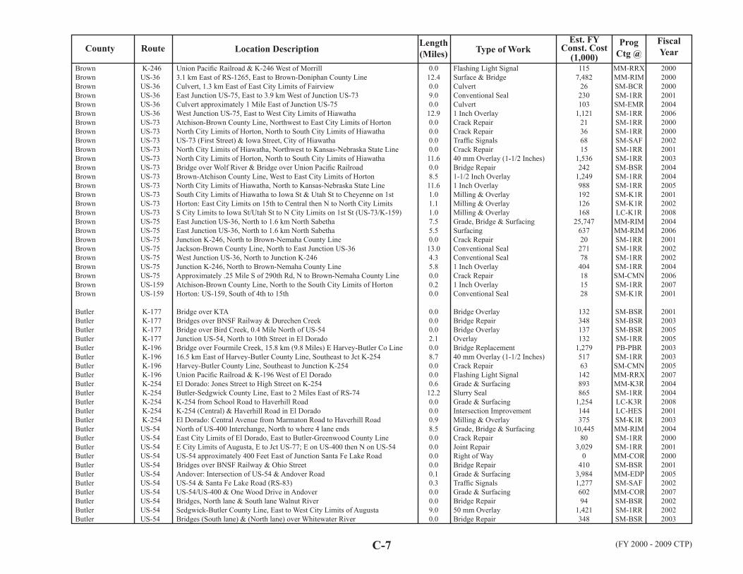
RouteFiscalYearLocation Description
Est. FYConst. Cost
(1,000)Prog
Ctg @County
C-7 (FY 2000 - 2009 CTP)
Length(Miles) Type of Work
BrownBrownBrownBrownBrownBrownBrownBrownBrownBrownBrownBrownBrownBrownBrownBrownBrownBrownBrownBrownBrownBrownBrownBrownBrownBrown
ButlerButlerButlerButlerButlerButlerButlerButlerButlerButlerButlerButlerButlerButlerButlerButlerButlerButlerButlerButlerButlerButlerButlerButler
K-246 US-36 US-36 US-36 US-36 US-36 US-73 US-73 US-73 US-73 US-73 US-73 US-73 US-73 US-73 US-73 US-73 US-75 US-75 US-75 US-75 US-75 US-75 US-75 US-159 US-159
K-177 K-177 K-177 K-177 K-196 K-196 K-196 K-196 K-254 K-254 K-254 K-254 K-254 US-54 US-54 US-54 US-54 US-54 US-54 US-54 US-54 US-54 US-54 US-54
Union Pacifi c Railroad & K-246 West of Morrill3.1 km East of RS-1265, East to Brown-Doniphan County LineCulvert, 1.3 km East of East City Limits of FairviewEast Junction US-75, East to 3.9 km West of Junction US-73Culvert approximately 1 Mile East of Junction US-75West Junction US-75, East to West City Limits of HiawathaAtchison-Brown County Line, Northwest to East City Limits of HortonNorth City Limits of Horton, North to South City Limits of HiawathaUS-73 (First Street) & Iowa Street, City of HiawathaNorth City Limits of Hiawatha, Northwest to Kansas-Nebraska State LineNorth City Limits of Horton, North to South City Limits of HiawathaBridge over Wolf River & Bridge over Union Pacifi c RailroadBrown-Atchison County Line, West to East City Limits of HortonNorth City Limits of Hiawatha, North to Kansas-Nebraska State LineSouth City Limits of Hiawatha to Iowa St & Utah St to Cheyenne on 1stHorton: East City Limits on 15th to Central then N to North City LimitsS City Limits to Iowa St/Utah St to N City Limits on 1st St (US-73/K-159)East Junction US-36, North to 1.6 km North SabethaEast Junction US-36, North to 1.6 km North SabethaJunction K-246, North to Brown-Nemaha County LineJackson-Brown County Line, North to East Junction US-36West Junction US-36, North to Junction K-246Junction K-246, North to Brown-Nemaha County LineApproximately .25 Mile S of 290th Rd, N to Brown-Nemaha County LineAtchison-Brown County Line, North to the South City Limits of HortonHorton: US-159, South of 4th to 15th
Bridge over KTABridges over BNSF Railway & Durechen CreekBridge over Bird Creek, 0.4 Mile North of US-54Junction US-54, North to 10th Street in El DoradoBridge over Fourmile Creek, 15.8 km (9.8 Miles) E Harvey-Butler Co Line16.5 km East of Harvey-Butler County Line, Southeast to Jct K-254Harvey-Butler County Line, Southeast to Junction K-254Union Pacifi c Railroad & K-196 West of El DoradoEl Dorado: Jones Street to High Street on K-254Butler-Sedgwick County Line, East to 2 Miles East of RS-74K-254 from School Road to Haverhill RoadK-254 (Central) & Haverhill Road in El DoradoEl Dorado: Central Avenue from Marmaton Road to Haverhill RoadNorth of US-400 Interchange, North to where 4 lane endsEast City Limits of El Dorado, East to Butler-Greenwood County LineE City Limits of Augusta, E to Jct US-77; E on US-400 then N on US-54US-54 approximately 400 Feet East of Junction Santa Fe Lake RoadBridges over BNSF Railway & Ohio StreetAndover: Intersection of US-54 & Andover RoadUS-54 & Santa Fe Lake Road (RS-83)US-54/US-400 & One Wood Drive in AndoverBridges, North lane & South lane Walnut RiverSedgwick-Butler County Line, East to West City Limits of AugustaBridges (South lane) & (North lane) over Whitewater River
0.012.40.09.00.012.90.00.00.00.011.60.08.511.61.01.11.07.55.50.013.04.35.80.00.20.0
0.00.00.02.10.08.70.00.00.612.20.00.00.98.50.00.00.00.00.10.30.00.09.00.0
Flashing Light SignalSurface & BridgeCulvertConventional SealCulvert1 Inch OverlayCrack RepairCrack RepairTraffi c SignalsCrack Repair40 mm Overlay (1-1/2 Inches)Bridge Repair1-1/2 Inch Overlay1 Inch OverlayMilling & OverlayMilling & OverlayMilling & OverlayGrade, Bridge & SurfacingSurfacingCrack RepairConventional SealConventional Seal1 Inch OverlayCrack Repair1 Inch OverlayConventional Seal
Bridge OverlayBridge RepairBridge OverlayOverlayBridge Replacement40 mm Overlay (1-1/2 Inches)Crack RepairFlashing Light SignalGrade & SurfacingSlurry SealGrade & SurfacingIntersection ImprovementMilling & OverlayGrade, Bridge & SurfacingCrack RepairJoint RepairRight of WayBridge RepairGrade & SurfacingTraffi c SignalsGrade & SurfacingBridge Repair50 mm OverlayBridge Repair
1157,482
26230103
1,12121366815
1,536242
1,249988192126168
25,7476372027178404181528
132348137132
1,27951763142893865
1,254144375
10,44580
3,0290
4103,9841,27760294
1,421348
MM-RRXMM-RIMSM-BCRSM-1RRSM-EMRSM-1RRSM-1RRSM-1RRSM-SAFSM-1RRSM-1RRSM-BSRSM-1RRSM-1RRSM-K1RSM-K1RLC-K1R
MM-RIMMM-RIMSM-1RRSM-1RRSM-1RRSM-1RRSM-CMNSM-1RRSM-K1R
SM-BSRSM-BSRSM-BSRSM-1RRPB-PBRSM-1RRSM-CMNMM-RRXMM-K3RSM-1RRLC-K3RLC-HESSM-K1RMM-RIMSM-1RRSM-1RR
MM-CORSM-BSRMM-EDPSM-SAF
MM-CORSM-BSRSM-1RRSM-BSR
20002000200020012004200620002000200220012003200420042005200120022008200420062001200220022004200620072001
200120032005200520032003200520072004200420082001200320042000200120002001200520022007200220022003

FiscalYearRoute Location Description Length
(Miles)Type of Work
Est. FYConst. Cost
(1,000)Prog
Ctg @County
C-8(FY 2000 - 2009 CTP)
ButlerButlerButlerButlerButlerButlerButlerButlerButlerButlerButlerButlerButlerButlerButlerButlerButlerButlerButlerButlerButlerButlerButlerButlerButlerButlerButlerButlerButlerButlerButlerButler
ChaseChaseChaseChaseChaseChaseChaseChaseChaseChaseChaseChaseChaseChaseChaseChaseChaseChase
US-54 US-54 US-54 US-54 US-54 US-54 US-54 US-54 US-54 US-54 US-54 US-54 US-54 US-54 US-54 US-77 US-77 US-77 US-77 US-77 US-77 US-77 US-77 US-177 US-400 US-400 US-400
K-57 K-150 K-177 K-177 K-177 K-177 K-177 K-177 K-177 K-177 K-177 K-177 K-177 K-177 K-177 US-50 US-50 US-50
Bridge (West lane) over Turkey CreekUS-54 & Santa Fe Lake RoadUS-54 near East City Limits of AndoverUS-54 & Yorktown, City of AndoverUS-54 from Lulu to Osage Streets in City of AugustaJct US-400, East to South City Limits of El Dorado (Southbound lanes)East City Limits of El Dorado, East to Butler-Greenwood County LineSedgwick-Butler County Line, East to the West City Limits of AugustaCenter of Andover Road, East to the West City Limits of AugustaIntersection of Prairie Creek Road & US-54Augusta: Edge of Wear Surface on BNSF RR Overpass to ECL on US-54El Dorado: Central, Griffi th to Railroad & Main,12th to PostBluff St to Edge of Wear Surface of BNSF Railway Overpass in AugustaHigh Street to Griffi th Street in El DoradoAugusta: West City Limits to Bluff Street on 7th Street (US-54/400)Cowley-Butler County Line, North to South City Limits of AugustaCowley-Butler County Line, North to South City Limits of AugustaCowley-Butler County Line, North to South City Limits of AugustaNorth City Limits of El Dorado, North to RS-862Junction RS-862, North to Butler-Marion County LineEl Dorado: 4th Avenue North to 12th Avenue on US-77Augusta: US-54 from South City Limits, 2nd to 7th StreetsUS-77 & 12th Street10th Street, North to Butler-Chase County LineEnd of Concrete at East Junction US-54, East 6.135 km1 km East of RS-1010, East 19.8 kmJunction US-54, East to Concrete Pavement East of LeonTowanda: from Old K-254, North to K-254 on Hunter RoadBridge: El Dorado State Park BridgeK-196/K-254; US-54/Haverhill Road; & US-54/US-400/US-77El Dorado: Oil Hill Road, 6th North to Northwest Traffi cwayEl Dorado: Main, Post to McCollum & Central, State to Jones
Morris-Chase County Line, South to Junction US-50/K-177 RampMarion-Chase County Line, East to Junction US-50Scenic Overlook South of Cottonwood FallsWashington St, N to S End Railroad Right of Way on K-177 (Strong City)South City Limits of Cottonwood Falls, North to Junction US-50/K-57Butler-Chase Co Line, North to South City Limits of Cottonwood FallsBridge over BNSF Railway, 17.5 km North of Butler-Chase County LineCulvert, 13.8 km North of Butler-Chase County LineCulvert at Milepost 8.852Bridge over Cottonwood RiverBridge over Fox CreekStrong City: from South City Limits to Washington Street on K-1772 Culverts, 13.4 & 13.5 Miles North of Butler-Chase County LineButler-Chase County Line, North to Junction US-50BNSF Railway & K-177 in Strong CityFrom Concrete Pavement W of Strong City, E to E of East City LimitsJunction K-150, Northeast to West City Limits of Strong CityBridges & Ditches
0.00.00.00.00.68.517.29.00.00.00.01.00.00.80.513.90.012.59.67.30.80.50.020.23.80.03.80.60.00.00.60.8
9.18.70.00.53.220.90.00.00.00.00.00.20.024.10.00.97.730.3
Bridge RepairRight of WayRight of WayIntersection ImprovementTraffi c Signals1-1/2 Inch OverlayOverlayOverlayPavement PatchingGrade & SurfacingPavement PatchingMilling & OverlayPavement PatchingMilling & OverlayMilling & OverlayPavement ReconstructionDetour(s)Detour(s)Grade, Bridge & SurfacingGrade & SurfacingMilling & OverlayMilling & OverlayIntersection Improvement1 Inch OverlayOverlayJoint RepairConventional SealGrade & SurfacingBridge OverlayLightingGrade & SurfacingMilling & Overlay
1-1/2 Inch OverlayGrade & SurfacingScenic Or Historic Hwy ProgsPavement Reconstruction40 mm Overlay (1-1/2 Inches)40 mm Overlay (1-1/2 Inches)Bridge OverlayCulvertCulvertBridge RepairBridge RepairGrade & SurfacingCulvert1 Inch OverlayFlashing Light SignalGrade & SurfacingConcrete PavementFlood Damage
19900
389516
1,1581,5351,611189645207254283227261
14,696211
1,96517,8006,873113188142
2,120835
3,199109423251225630249
1,04912,914
441971259
1,0622537080107125321129
2,52819
3,56780041
SM-BSRMM-CORMM-CORMM-CORSM-SAFSM-1RRSM-1RRSM-1RRSM-CMNMM-CORLC-K1RLC-K1RLC-K1RLC-K1RLC-K1R
MM-RIMMM-RIMMM-RIMMM-RIMMM-RIMSM-K1RSM-K1RLC-HESSM-1RRSM-1RRSM-1RRSM-1RRLC-EDPSM-BSRSM-LTGLC-EDPLC-K1R
SM-1RRMM-RIMMM-RIMMM-K3RSM-1RRSM-1RRSM-BSRSM-BCRSM-BCRSM-BSRSM-BSRLC-K3RPB-PCRSM-1RR
MM-RRXMM-RIMSM-CMNSM-EMR
20032003200220072006200520052007200720072005200420062005200720032003200320042003200020022003200720002002200520022005200920032003
200420022000200120002000200120012002200120022005200620072002200320002000

RouteFiscalYearLocation Description
Est. FYConst. Cost
(1,000)Prog
Ctg @County
C-9 (FY 2000 - 2009 CTP)
Length(Miles) Type of Work
ChaseChaseChaseChaseChase
ChautauquaChautauquaChautauquaChautauquaChautauquaChautauquaChautauquaChautauquaChautauquaChautauqua
CherokeeCherokeeCherokeeCherokeeCherokeeCherokeeCherokeeCherokeeCherokeeCherokeeCherokeeCherokeeCherokeeCherokeeCherokeeCherokeeCherokeeCherokeeCherokeeCherokeeCherokeeCherokeeCherokeeCherokeeCherokeeCherokeeCherokeeCherokeeCherokeeCherokeeCherokeeCherokeeCherokeeCherokee
US-50 US-50 US-50 US-50
K-99 K-99 US-166 US-166 US-166 US-166 US-166 US-166 US-166B US-166B
K-7 K-7 K-7 K-7 K-7 K-7 K-26 K-57 K-66 K-66 K-66 K-66 K-96 K-96 K-96 K-102 K-103 K-103 US-69 US-69 US-69 US-69 US-69 US-69 US-69 US-69 A US-69 A US-160 US-160 US-160 US-166 US-166 US-166 US-166
0.085 Mile East of Junction RS-92, East 4.151 Miles, except BridgesMarion-Chase Co Line, N & E to Chase-Lyon Co Line (Various Locations)Various Locations-Marion-Chase Co Line, N & E to Chase-Lyon Co LineEast City Limits of Strong City, East to Concrete (by Saffordville)Strong City Visitor & Community Center - Flint Hills
Oklahoma-Kansas State Line, North to East Junction US-166Junction US-166B, North to Chautauqua-Elk County LineCowley-Chautauqua County Line, East to 200 meters West of K-99East Junction K-99, East 14.966 kmJunction K-99, East to West City Limits of NiotazeCowley-Chautauqua County Line, East to Junction K-99PCCP in Niotaze, East to Chautauqua-Montgomery County LineBridge over Little Caney River, 11.39 Miles East of the East Jct of K-99West Junction US-166, East to East Junction US-166 (except Sedan)Sedan: K-99/US-166B, W City Limits to School St & S to S City Limits
Culverts located North of K-96Bridge over Little Cherry Creek 0.66 km South K-102Junction US-160, North to Junction US-400Columbus: K-7 & Bethlehem Road IntersectionJct US-69/US-160, North to Cherokee-Crawford County Line (US-400)BNSF Railway & K-7 North of ColumbusJunction US-166, North to Junction K-66Junction US-69, East to Kansas-Missouri State LineK-66 & Water Street, City of GalenaWest City Limits of Galena, East to Kansas-Missouri State Line1.1 km East of Junction US-400, East to West City Limits of GalenaBridge, Spring RiverBridge over Spring River, 5.6 km East East Junction US-69Bridge over Spring River, 5.6 km East East Junction US-69Bridge over Shawnee Creek, .6 km East of East Junction US-69East City Limits of West Mineral, East to Junction K-7Junction K-7, East to Junction US-69BNSF Railway & K-103 West of WeirOklahoma-Kansas State Line, North to ColumbusOklahoma-Kansas State Line, North to Junction US-166Columbus: North Side of Railroad Crossing to Maple Street on US-69Oklahoma-Kansas State Line, North to Junction US-166Junction K-7, East to Junction US-400South Junction US-160, North to Junction US-400Bridges over Shawnee Creek, Long Branch Creek, Shawnee CreekOK-KS State Line, North to Jct US-400-except 12th to 9th-Baxter SpringsBNSF Railway & US-69A 2.5 Miles North of RivertonBridges over Cherry Creek, East of Labette-Cherokee County LineBridge over Neosho River DrainageLabette-Cherokee County Line, East to West City Limits of ColumbusSpring River Drainge Bridge & Spring River BridgeLabette-Cherokee County Line, East to East City Limits of Baxter SpringsJunction US-400, East to Kansas-Missouri State LineSpring River Drainage Bridge, 5.3 Miles East of Junction US-69
4.20.00.08.40.0
5.913.519.80.09.019.72.80.06.50.9
0.00.011.10.211.20.03.64.90.01.83.00.00.00.00.05.07.00.09.10.00.52.27.010.70.04.00.00.00.012.80.019.45.20.0
OverlayJoint RepairJoint RepairOverlayScenic Or Historic Hwy Progs
1 Inch Overlay1 Inch Overlay50 mm OverlayJoint RepairOverlay1 Inch Overlay1 Inch OverlayBridge Repair1 Inch OverlayMilling & Overlay
CulvertBridge Replacement25 mm Overlay (1 Inch)Intersection Improvement1-1/2 Inch OverlayFlashing Light Signal40 mm Overlay (1-1/2 Inches)25 mm Overlay (1 Inch)Traffi c Signals40 mm Overlay (1-1/2 Inches)25 mm Overlay (1 Inch)Bridge RepairBridge ReplacementBridge ReplacementBridge OverlayConventional SealConventional SealSurfacingPavement ReconstructionCrack RepairGrade & Surfacing40 mm Overlay (1-1/2 Inches)40 mm Overlay (1-1/2 Inches)1-1/2 Inch OverlayBridge Overlay40 mm Overlay (1-1/2 Inches)SurfacingBridge ReplacementBridgeSealingBridge Replacement40 mm Overlay (1-1/2 Inches)40 mm Overlay (1-1/2 Inches)Bridge Replacement
1,54044121
1,13748
325470
1,410482
2,5961,78915276393187
1,16672538424496312721125147240391746
1,924705121608913
17,78818
1,577118599
1,13928028323
2,872136976
4,4631,524258749
SM-1RRSM-CMNSM-CMNSM-1RRMM-RIM
SM-1RRSM-1RRSM-1RRSM-1RRSM-1RRSM-1RRSM-1RRSM-BSRSM-1RRSM-K1R
PB-PCRPB-PBRSM-1RRMM-K3RSM-1RR
MM-RRXSM-1RRSM-1RRSM-SAFSM-1RRSM-1RRSM-BSRPB-PBRPB-PBRSM-BSRSM-CMNSM-CMNMM-RRSMM-RIMSM-1RRMM-K3RSM-1RRSM-1RRSM-1RRSM-BSRSM-1RRMM-RRSPB-PBRSM-BSRSM-1RRPB-PBRSM-1RRSM-1RRPB-PBR
20042004200520072007
2005200520002002200820052005200720052003
2001200120002004200720022001200120002001200320072003200320002003200320022007200020072001200220052006200120012002200620062000200120032007

FiscalYearRoute Location Description Length
(Miles)Type of Work
Est. FYConst. Cost
(1,000)Prog
Ctg @County
C-10(FY 2000 - 2009 CTP)
CherokeeCherokeeCherokeeCherokeeCherokeeCherokeeCherokeeCherokeeCherokee
CheyenneCheyenneCheyenneCheyenneCheyenneCheyenneCheyenneCheyenneCheyenneCheyenneCheyenne
ClarkClarkClarkClarkClarkClarkClarkClarkClarkClarkClarkClarkClarkClarkClarkClark
ClayClayClayClayClayClayClayClayClayClayClayClay
US-400 US-400 US-400 US-400 US-400 US-400 US-400
K-27 K-27 K-161 K-161 K-161 K-161 K-217 US-36 US-36 US-36 US-36
K-34 K-34 K-94 K-94 US-54 US-160 US-160 US-160 US-160 US-160 US-160 US-160 US-160 US-183 US-283 US-283
K-9 K-9 K-9 K-15 K-15 K-15 K-15 K-15 K-15 K-80 K-80 K-82
Junction US-160/US-69, South to Junction K-66Bridge over Wolf Creek, 1 Mile West of Junction K-7Culvert, Cow Creek Drainage, 4.63 km West US-69Labette-Cherokee County Line, East to Junction US-69US-400/K-66/Beasley Intersection West of Riverton2 Bridges, Lightning Creek DrainageSouth Kansas & Oklahoma Railroad & US-400 Southeast of CherokeeCulvert, Mined Land Wildlife AreaBNSF Railway & K-103 West of Weir
Sherman-Cheyenne County Line, North to East Junction US-36West Junction US-36, North to Kansas-Nebraska State LineBig Timber Creek Bridge, 15.22 km (9.46 Miles) North of US-36Junction US-36, North to Kansas-Nebraska State LineJunction US-36, North to the Kansas-Nebraska State LineNebraska Kansas Colorado & K-161 in Bird CityJunction US-36, North to WheelerKansas-Colorado State Line, East 19.779 kmWest Jct K-27, East to East Jct K-27 (also Frontage Rd at St Francis)Bridge over South Fork Republican River, 0.4 Miles E to the W Jct K-27Colorado-Kansas St Line, E to the W Edge of Wearing Surface of Bridge
Bluff Creek Drainage Bridge, 10.8 km North of Junction US-160Junction US-160/US-183, North to Clark-Ford County LineCulvert, 5.13 Miles South & West of Clark-Ford County LineClark Lake, North to Clark-Ford County LineMeade-Clark County Line, East to Clark-Ford County LineLittle Sandy Creek Bridge, 8.41 km East US-283Ashland: Humphries Street, East to Highland StreetBridge over Johnson Creek, 1.6 km East of Meade-Clark County LineS Jct US-283, East to Cowley-Comanche County Line (except 1.219 km)Meade-Clark County Line, East to North Junction US-283East City Limits of Ashland, East to Cowley-Comanche County LineAshland: Highland Street to the East City Limits on 4th Ave (US-160)West City Limits to Highland Avenue on Fourth Street (US-160)Oklahoma-Kansas State Line, North to Junction US-160North Junction US-160, North to Junction US-54Junction US-54, North to Clark-Ford County Line
Washington-Clay County Line, East to South Junction K-15Culvert, Parsons Creek DrainageEast City Limits of Clifton, East to South Junction K-15Clay Center: Junction US-24, North to Liberty StreetBridge over Otter Creek, 6.5 km North K-82Dickinson-Clay County Line, North to South City Limits of Clay CenterSouth City Limits of Clay Center, North to US-24Dickinson-Clay County Line, North to the South City Limits of Clay CenterNorth City Limits of Clay Center, North to Clay-Washington County LineBridge over Huntress Creek, 3.8 km West K-15 JunctionEast City Limits of Morganville, East to Junction K-15Milford Lake Bridge, 11.07 km East of K-15
7.30.00.020.30.50.00.00.00.0
13.021.10.017.017.00.00.512.36.70.012.3
0.019.60.06.910.10.00.40.023.45.011.90.40.913.511.52.1
0.00.07.80.80.016.10.90.011.90.03.80.0
40 mm Overlay (1-1/2 Inches)Bridge RepairCulvert1-1/2 Inch OverlayGrade & SurfacingBridge OverlayFlashing Light SignalCulvertFlashing Light Signal
Conventional SealConventional SealBridge ReplacementConventional SealConventional SealSurfacingConventional Seal40 mm Overlay (1-1/2 Inches)Conventional SealJoint RepairOverlay
Bridge Replacement1 Inch OverlayCulvertConventional SealOverlayBridge ReplacementGrade & SurfacingBridge Replacement50 mm Overlay40 mm Overlay (1-1/2 Inches)Conventional SealMilling & OverlayOverlayConventional Seal40 mm Overlay (1-1/2 Inches)1-1/2 Inch Overlay
Crack RepairCulvert1-1/2 Inch OverlayGrade & SurfacingBridge Replacement40 mm Overlay (1-1/2 Inches)Milling & OverlayCrack Repair40 mm Overlay (1-1/2 Inches)Bridge Replacement40 mm Overlay (1-1/2 Inches)Bridge Widen
63812841260
2,10053012388148
191258730204
1,190126
71320895
1,051
5331,49418469
1,3261,437458614
1,283252237143122677
1,417167
2069
1,039665774
1,28768314
1,1551,114195
2,835
SM-1RRSM-BSRSM-BCRSM-1RRSM-SAFSM-BSRMM-RRXSM-BCRMM-RRX
SM-1RRSM-1RRPB-PBRSM-1RRSM-1RRMM-RRSSM-1RRSM-1RRSM-1RRSM-BSRSM-1RR
PB-PBRSM-1RRSM-BCRSM-CMNSM-1RRPB-PBR
MM-K3RPB-PBRSM-1RRSM-1RRSM-1RRLC-K1RLC-K1RSM-1RRSM-1RRSM-1RR
SM-1RRSM-BCRSM-1RRMM-K3RPB-PBRSM-1RRMM-K3RSM-CMNSM-1RRPB-PBRSM-1RRPB-PBR
200320042004200420072007200220002004
20042004200420032007200220042000200420052007
2004200620032004200420012000200220002003200720072008200720012004
200020052006200120012000200220032003200420032000

RouteFiscalYearLocation Description
Est. FYConst. Cost
(1,000)Prog
Ctg @County
C-11 (FY 2000 - 2009 CTP)
Length(Miles) Type of Work
ClayClayClayClayClayClayClayClayClayClayClayClayClayClayClayClayClay
CloudCloudCloudCloudCloudCloudCloudCloudCloudCloudCloudCloudCloudCloudCloudCloudCloudCloudCloudCloudCloudCloudCloudCloudCloudCloudCloudCloudCloudCloudCloudCloudCloud
K-82 K-82 K-82 K-82 K-197 US-24 US-24 US-24 US-24 US-24 US-24 US-24 US-24 US-24 US-24 US-24
K-9 K-9 K-9 K-9 K-9 K-9 K-9 K-9 K-9 K-9 K-9 K-9 K-9 K-9 K-9 K-9 K-28 K-28 K-28 K-28 K-28 K-28 K-189 K-189 K-194 K-194 K-194 US-24 US-24 US-24 US-24 US-24 US-24
Milford Lake Bridge, 11.07 km East of K-15Junction K-15, East to Clay-Riley County LineJunction K-15, East to Clay-Riley County LineJunction K-15, East to Clay-Riley County Line (include Wakefi eld)Dickinson-Clay County Line, East to Junction K-15Republican River Bridge, 16.6 km East Cloud-Clay County LineRepublican River Bridge, 16.6 km East Cloud-Clay County LineBridge over North Branch Five Creek, 11.6 km E of Cloud-Clay Co LineClay Center: on US-24 from K-15 Junction East to 10th StreetEast City Limits of Clay Center, East to Clay-Riley County LineCloud-Clay County Line, East to West City Limits of Clay CenterClay Center: West of 2nd Street to West of K-15/US-24 JunctionBridge over North Branch Five Creek, 11.6 km E of Cloud-Clay Co LineEast City Limits of Clay Center, East to Clay-Riley County LineCloud-Clay County Line, East to West City Limits of Clay CenterW City Limits to Edge of Wear Surf Huntress/Spring Cr Br on CrawfordClay Center Area & Sub-Area Offi ces
Bridge over Elm Creek Drainage, 12.5 km East of Junction US-81Culvert at Milepost 12.17Mitchell-Cloud County Line, East & North to Junction K-28ECL Concordia to SCL Clyde & E City Limits of Clyde to CD-WS Co LineBridge over Ash CreekJunction K-28, East to West City Limits of ConcordiaBridge over Elk Creek, 0.830 Mile East of Bridge Street-ClydeMitchell-Cloud County Line, East & North to Junction K-28Junction K-28, East to West City Limits of ConcordiaEast City Limits of Concordia, East to South City Limits of ClydeEast City Limits of Clyde, East to Cloud-Washington County LineConcordia: Cloud Street to East City LimitsConcordia: 6th Street from Lincoln to CloudConcordia: West City Limits to Intersection 5th & Cedar on K-9Concordia: Broadway from 5th to 6th & Broadway to Lincoln on K-9BNSF Railway & K-9 (6th Street) in ConcordiaBridge over Buffalo Creek DrainageJewell-Cowley County Line, East to Junction K-9Bridge over Wolf Creek, 0.16 Mile Northwest K-9Jewell-Cloud County Line, Southeast to Junction K-9Bridge, Buffalo CreekKyle Railroad & K-28 at JamestownMiltonvale North to US-24East City Limits of Miltonvale, North to Junction US-24Culvert, 2.22 km South of US-24North City Limits of Simpson, North to Junction US-24North City Limits of Simpson, North to Junction US-24Mitchell-Cloud County Line, East to Junction K-189Junction K-189, East to Cloud-Clay County LineMitchell-Cloud County Line, East to Junction K-189Bridge over Mortimer Creek, 10.23 Miles E Mitchell-Cowley County LineJunction K-189, East to Cloud-Clay County LineBNSF Railway & US-24 at Miltonvale
0.09.20.01.50.30.00.00.00.48.10.00.50.00.011.90.50.0
0.00.017.80.00.00.00.00.01.712.31.20.80.90.50.20.00.00.00.014.90.00.00.90.90.00.01.60.00.027.10.04.20.0
Bridge Widen40 mm Overlay (1-1/2 Inches)Crack RepairConventional SealSealingBridge ReplacementSpecialBridge RepairIntersection Improvement40 mm Overlay (1-1/2 Inches)Crack RepairOverlayBridge OverlayCrack RepairConventional SealMilling & OverlayOverlay
Bridge RepairCulvert40 mm Overlay (1-1/2 Inches)Crack RepairBridge RepairCrack RepairBridge RepairCrack Repair1 Inch Overlay1-1/2 Inch Overlay1-1/2 Inch OverlayMilling & OverlayMilling & OverlayMilling & OverlayMilling & OverlayFlashing Light SignalBridge RepairCrack RepairBridge Overlay1 Inch OverlayBridge OverlaySurfacingCrack RepairConventional SealCulvertCrack RepairConventional SealCrack RepairCrack RepairConventional SealBridge OverlayConventional SealFlashing Light Signal
1,004736122424
4,2029464
1,066781555234220217231107
11467
1,039421394
21322234
1,9241921572621441281071062044
1,43922120291366320772151310963228
PB-PBRSM-1RRSM-CMNSM-CMNSM-1RRPB-PBRPB-PBRSM-BSRMM-K3RSM-1RRSM-1RRMM-K3RSM-BSRSM-CMNSM-1RRLC-K1R
SM-CMN
SM-BSRSM-BCRSM-1RRSM-1RRSM-BSRSM-CMNSM-BSRSM-CMNSM-1RRSM-1RRSM-1RRSM-K1RSM-K1RSM-K1RLC-K1R
MM-RRXSM-BSRSM-CMNSM-BSRSM-1RRSM-BSRMM-RRSSM-1RRSM-1RRSM-BCRSM-1RRSM-1RRSM-1RRSM-1RRSM-1RRSM-BSRSM-1RR
MM-RRX
20002002200420062000200420032001200520012001200420042005200620082001
200020022001200120022002200420042006200620062001200220032005200020022002200520062007200320012006200120002005200020012005200620062006

FiscalYearRoute Location Description Length
(Miles)Type of Work
Est. FYConst. Cost
(1,000)Prog
Ctg @County
C-12(FY 2000 - 2009 CTP)
CloudCloudCloudCloudCloudCloudCloudCloudCloudCloudCloudCloud
CoffeyCoffeyCoffeyCoffeyCoffeyCoffeyCoffeyCoffeyCoffeyCoffeyCoffeyCoffeyCoffeyCoffeyCoffeyCoffeyCoffeyCoffeyCoffeyCoffey
ComancheComancheComancheComancheComanche
CowleyCowleyCowleyCowleyCowleyCowleyCowleyCowleyCowleyCowleyCowley
US-24 US-81 US-81 US-81 US-81 US-81 US-81 US-81 US-81 US-81 US-81
I-35 I-35 I-35 I-35 I-35 K-31 K-31 K-31 K-31 K-57 K-57 K-58 US-75 US-75 US-75 US-75 US-75 US-75 US-75
K-1 US-160 US-160 US-160 US-183
K-15 K-15 K-15 K-15 K-15 K-15 K-15 K-15 K-55 K-55 K-360
BNSF Railway & US-24 at MiltonvaleExisting 4 lane South Edge of Concordia, North on US-81 to City LimitsExisting 4 lane South Edge of Concordia, North on US-81 to City LimitsAlong US-81 Corridor at ConcordiaConcordia: Intersection of US-81 & College Drive3 Different Locations between Mileposts 185.683 to 201.813Concordia: Junction of US-81 & K-90.215 Mile South of Ottawa-Cloud County Line, North 21.423 MilesSouthbound 1.1 to 8.7 Miles North of Junction US-24Concordia: Junction US-81 and College DriveBridge, 1.28 Miles North of Junction K-9Concordia: 5th (K-9 & K-28), Cedar to Broadway
Lyon-Coffey County Line, East to 0.5 km East K-1310.5 km East K-131, East to 0.5 km West US-75Approx 1.1 km (0.7 Miles) West of US-75, NE to Coffey-Osage Co LineApprox 0.6 km W of US-75, E to CF-OS County Line/N bound & S boundLyon-Coffey County Line, East to approximately 0.6 km West of US-75Rock Creek Bridge, 0.23 km East of East City Limits of WaverlyOsage-Coffey County Line, South & East to Coffey-Anderson County LineOsage-Coffey County Line, East to Coffey-Anderson County LineWaverly: Pierson Street (K-31), 6th to 1stAbout 1.5 Miles West of West City Limits of Gridley, East to AtherlystSouth Junction US-75, East to Coffey-Anderson County LineGreenwood-Coffey County Line, East to Jct US-75, excluding GridleyBridge over Neosho River, 13.7 km North K-57 North Junction Bridge over Neosho River, 13.7 km North K-57 North Junction RS-1133, North to 1.6 km North Old US-50North City Limits of Burlington to 0.9 km South of I-35North City Limits of Burlington, to 1.0 km South of I-35Woodson-Coffey County Line, North to South City Limits of BurlingtonNew Strawn: US-75 from Neosho Street North to Arrowhead DriveOgden Street from RS-2066, North to North City Limits of Lebo
Oklahoma-Kansas State Line, North to Junction US-160Bridges located 6.7 & 7.5 km East of the Clark-Comanche County LineBridge over Mule Creek, 3.7 km West of Barber-Comanche County LineClark-Comanche County Line, East to Comanche-Barber County LineJunction US-160, North to Comanche-Kiowa County Line
Bridge over Grouse Creek, 10.41 km (6.47 Miles) North US-166North Junction US-77, West to East City Limits of UdallEmergency Repair Flood ProjectEmergency Repair Flood ProjectOklahoma-Kansas State Line, North to East Junction US-166West Junction US-166, North to Junction US-160East City Limits of Udall, Northwest to Cowley-Sumner County LineBridge over Walnut RiverSumner-Cowley County Line, East to end of K-55BNSF Railway & K-55 at UdallEmergency Repair Flood Project
0.03.03.00.00.39.70.10.07.60.10.00.3
5.56.41.81.511.90.08.18.00.20.012.10.00.00.01.10.014.910.30.31.1
13.40.00.035.97.1
0.05.90.00.07.912.23.30.02.00.02.0
SurfacingGrade & BridgeSurface & BridgeLightingIntersection ImprovementConventional SealIntersection ImprovementJoint RepairSlurry SealGrade & SurfacingBridge RepairMilling & Overlay
Grade, Bridge & SurfacingGrade, Bridge & SurfacingPavement Reconstruction40 mm Overlay (1-1/2 Inches)SealingBridge ReplacementConventional Seal1 Inch OverlayGrade & SurfacingCulvert25 mm Overlay (1 Inch)Crack RepairBridge ReplacementSpecialSurfacingCrack Repair25 mm Overlay (1 Inch)1-1/2 Inch OverlayGrade & SurfacingMilling & Overlay
1 Inch OverlayBridge ReplacementBridge ReplacementConventional Seal40 mm Overlay (1-1/2 Inches)
Bridge Replacement40 mm Overlay (1-1/2 Inches)Bridge RepairBridge Repair50 mm OverlayConventional Seal1 Inch OverlayBridge Paint40 mm Overlay (1-1/2 Inches)Flashing Light SignalSpecial Maintance
331,3745,001
79296284124187210390611139
6,7407,0446,4831433402799264058818035616
6,325120
2,50156
1,132684243218
6942,9691,364612442
1,95130200
417152262169911670
MM-RRSMM-RIMMM-RIMSM-LTGMM-EDPSM-CMNLC-K3R
SM-CMNSM-1RRLC-K3RSM-BSRLC-K1R
SM-ISRSM-ISRMM-IRISM-ISRSM-ISRPB-PBR
SM-CMNSM-1RRLC-K1RSM-EMRSM-1RRSM-CMNPB-PBRPB-PBR
MM-RIMSM-1RRSM-1RRSM-1RRLC-K3RLC-EDP
SM-1RRPB-PBRPB-PBRSM-1RRSM-1RR
PB-PBRSM-1RRSM-EMRSM-EMRSM-1RRSM-1RRSM-1RRSM-BSPSM-1RR
MM-RRXSM-EMR
200620002001200120022003200620042005200920072004
20062006200420012001200020032007200720002003200620052004200820002003200420072006
20072005200420072002
20042000200020012002200220042005200020012001

RouteFiscalYearLocation Description
Est. FYConst. Cost
(1,000)Prog
Ctg @County
C-13 (FY 2000 - 2009 CTP)
Length(Miles) Type of Work
CowleyCowleyCowleyCowleyCowleyCowleyCowleyCowleyCowleyCowleyCowleyCowleyCowleyCowleyCowleyCowleyCowleyCowleyCowleyCowleyCowleyCowleyCowleyCowleyCowleyCowleyCowleyCowleyCowleyCowleyCowleyCowleyCowleyCowleyCowleyCowleyCowleyCowleyCowley
CrawfordCrawfordCrawfordCrawfordCrawfordCrawfordCrawfordCrawfordCrawfordCrawfordCrawford
K-360 US-77 US-77 US-77 US-77 US-77 US-77 US-77 US-77 US-77 US-77 US-77 US-77 US-77 US-77 US-77 US-77 US-77 US-77 B US-77 B US-77 B US-160 US-160 US-160 US-160 US-160 US-160 US-160 US-160 US-160 US-160 US-166 US-166 US-166 US-166 US-166 US-166
K-3 K-3 K-7 K-7 K-7 K-7 K-7 K-7 K-7 K-47 K-57
Junction US-77, South to Junction US-160N Urban Area Boundary Arkansas City, N to Walnut Road in Winfi eldUS-77 (Main Street) & 14th Street, City of Winfi eldTimber Creek Br, N to CL-BU Co Line; 0.4 km on K-15 West of K-77 Jct SE Arkansas City: US-77 & Summit, East & North to Junction US-166SE Arkansas City: US-77 & Summit, East & North to Junction US-166North City Limits of Winfi eld, North to the Cowley-Butler County LineBridge over Arkansas River 2.98 Miles N of Oklahoma-Kansas State LineOklahoma-Kansas State Line, N to South City Limits of Arkansas CityCorridor from Oklahoma-Kansas State Line, North to K-360 at Winfi eldWinfi eld: US-77 from 14th Avenue North to 12th AvenueWinfi eld: on Main: South City Limits North to Walnut River BridgeWinfi eld: US-77,14th to Railroad & US-160, Mill to LoomisWinfi eld: Two Locations US-77 & US-160Winfi eld: Main (US-77),19th to 14th & Railroad to Timber CreekBNSF Railway Underpass to W of US-77/166 Bypass in Arkansas CityBNSF Railway & US-77 at Strother Field South of Winfi eldS Kansas & Oklahoma Railroad & US-77 (Main Street) in Winfi eldEmergency Repair Flood ProjectArkansas City: Intersection of US-77B & Kansas AvenueArkansas City: Kansas Avenue to North City Limits on US-77BSumner-Cowley County Line, East to West City Limits of Winfi eldEast City Limits of Winfi eld, East, North & East to Cowley-Elk Co LineBridge over Spring CreekSpring Creek Bridge, 2.15 Miles East of Sumner-Cowley County LineSumner-Cowley County Line, to West City Limits of Winfi eldEast Junction K-15, East to Cowley-Elk County LineLoomis Street to College Street in Winfi eldWest City Limits to Mill Street & Harris Rd to Industrial Rd on US-160S Kansas & Oklahoma Railroad Crossing of US-160 E of CambridgeS Kansas & Oklahoma Railroad & US-160 (9th Street) in Winfi eldEmergency Repair Flood ProjectEmergency Repair Flood ProjectSW Arkansas City: West of Arkansas River, East to New BypassJct US-77, Ark City Bypass, East to Cowley-Chautauqua County LineSumner-Cowley County Line, East to West City Limits of Arkansas CityMonroe Avenue to US-166/US-77 Bypass on Summit Street (US-166)BNSF Railway Crossing at Kansas Avenue in Arkansas CityArkansas City: Intersection of Summit (US-77B) & Maple
Bridge over Big Walnut, 11.1 km North Junction K-57Jct K-47 North to Crawford-Bourbon County Line (exception 0.15 Mile)Bridge over Second Cow Creek, 8.58 km North of K-57Cherokee-Crawford County Line, North to Junction K-126Junction K-126, North to South of South City Limits of GirardJunction K-126, North to South of South City Limits of GirardBridge over West Fork Dry Wood Creek, 14.2 km North K-57North City Limits of Girard, North to Crawford-Bourbon County LineGirard: South City Limits to North City Limits on K-7Neosho-Crawford County Line, East to West City Limits of GirardCulvert located approximately 1.8 km East of K-7 Junction
0.09.40.015.72.20.00.00.03.00.00.20.71.21.20.00.50.00.03.70.11.57.629.30.00.07.619.50.92.40.00.00.00.00.00.05.00.40.00.1
0.011.50.05.06.06.00.011.01.712.60.0
Crack RepairPavement ReconstructionTraffi c Signals40 mm Overlay (1-1/2 Inches)Grade, Bridge & SurfacingGrade & SurfacingCrack RepairBridge Repair1-1/2 Inch OverlayPreliminary EngineeringCurb & GutterMilling & OverlayMilling & OverlayMilling & OverlayMilling & OverlayMilling & OverlayFlashing Light SignalFlashing Light SignalFencingGrade & SurfacingMilling & Overlay25 mm Overlay (1 Inch)Conventional SealBridge RepairBridge Replacement1 Inch OverlaySlurry SealMilling & OverlayMilling & OverlaySurfacingFlashing Light SignalBridge RepairBridge RepairPreliminary EngineeringCrack RepairOverlayMilling & OverlayGrade, Bridge & SurfacingMilling & Overlay
Bridge DeckConventional SealBridge ReplacementPavement ReconstructionGrade, Bridge & SurfacingSeeding, SoddingBridge Replacement40 mm Overlay (1-1/2 Inches)Milling & OverlayConventional SealBridge
1699,709
632,43010,1191,860
683585140
4663002962860
1352042200
87330029338958
1,193479
1,2622793033912000046463230
5,02898
275168301
6,1928,408
26819402192186505
SM-CMNMM-RIMSM-SAFSM-1RRSE-SEBSE-SEB
SM-CMNSM-BSRSM-1RR
MM-CORLC-K3RSM-K1RSM-K1RSM-K1RLC-K1RLC-K1R
MM-RRXMM-RRXSM-EMRLC-K3RSM-K1RSM-1RRSM-1RRSM-BSRPB-PBRSM-1RRSM-1RRLC-K1RLC-K1R
MM-RRSMM-RRXSM-EMRSM-EMRSE-SEB
SM-CMNSM-1RRLC-K1RMM-RSLLC-K1R
PB-PDRSM-CMNPB-PBR
MM-RIMMM-RIMMM-RIMPB-PBRSM-1RRSM-K1RSM-CMNPB-PCR
200620032000200120032003200220052005200520092000200220032005200620042007200120062001200020022003200520042005200620072006200720012000200320032004200820072004
20012005200120052007200820052002200020042000

FiscalYearRoute Location Description Length
(Miles)Type of Work
Est. FYConst. Cost
(1,000)Prog
Ctg @County
C-14(FY 2000 - 2009 CTP)
CrawfordCrawfordCrawfordCrawfordCrawfordCrawfordCrawfordCrawfordCrawfordCrawfordCrawfordCrawfordCrawfordCrawfordCrawfordCrawfordCrawfordCrawfordCrawfordCrawfordCrawfordCrawfordCrawfordCrawfordCrawfordCrawfordCrawfordCrawfordCrawfordCrawfordCrawfordCrawfordCrawfordCrawfordCrawfordCrawfordCrawford
DecaturDecaturDecaturDecaturDecaturDecaturDecaturDecaturDecaturDecaturDecaturDecaturDecatur
K-57 K-57 K-57 K-57 K-126 K-126 K-126 K-126 K-126 K-126 K-126 K-126 K-126 K-126 K-146 K-146 K-277 K-277 US-69 US-69 US-69 US-69 US-69 US-69 US-69 US-69 B US-69 B US-69 B US-69 B US-160 US-160 US-160
K-9 K-123 K-223 K-383 K-383 K-383 US-36 US-36 US-36 US-36 US-36 US-36 US-83
2nd Cow Creek Drainage Bridge, 5.16 km East Junction K-7Bridges over First Cow Creek, 9.0 km East K-7Bridge over Lightning Creek, 16.9 km East of Neosho-Crawford Co LineEast City Limits of Girard, East to North Junction US-69Lightning Creek Bridges located 9.16 & 8.66 km West of K-7Bridges located 9.66 & 1.87 km West K-7Bridges located 12.1 & 4.0 km West of K-7Junction US-160, North & East to Junction K-7East City Limits of Pittsburg, East to Kansas-Missouri State LineJunction K-7, East to Junction US-69Pittsburg: Intersection of K-126 & Rouse AvenueBridge over Middle Cow Creek, 0.20 Mile West of US-69K-126 & Walnut (Pittsburg)BNSF Railway & K-126 West of PittsburgNeosho-Crawford County Line, East to Junction K-3Neosho-Crawford County Line, East to Junction K-3Junction K-7, East to West Lake RoadBNSF Railway & K-277 North of Farlington1.6 km South Jct US-160 (Pittsburg) N to N Jct US-69B (North Arma)North Junction US-69B (Pittsburg) to North Jct US-69B (North Arma)1.6 km South Jct US-160 (Pittsburg) N to N Jct US-69B (North Arma)Crawford-Cherokee County Line, North to North Junction US-69BUS-69 & 20th Street, City of PittsburgJunction US-400, North to North Junction US-69B2 Locations: Southbound & Northbound at PittsburgSouth Junction US-69, North to North Junction US-69South Junction US-69, North to North Junction US-691st Street to 9th Street in PittsburgPittsburg: Williams to Madison on Broadway (US-69B)Junction US-160/K-57/US-69, East to Kansas-Missouri State LineJunction US-160/K-57/US-69, East to Kansas-Missouri State LineJunction US-160/K-57/US-69, East to Kansas-Missouri State LinePittsburg: 23rd Street over KC Southern Railroad (Michigan to Rouse St)E McKay St from E of Santa Fe to W of Kansas City Southern RailroadPittsburg: on East Ford: Broadway-JoplinGirard: St. John Street (K-57), West City Limits to East City LimitsSouth Kansas & Oklahoma Railroad & US-69 South Edge of Pittsburg
Sheridan-Decatur County Line, East to Decatur-Norton County LineSheridan-Decatur County Line, North to Junction K-383Sheridan-Decatur County Line, North to Junction K-383West City Limits of Jennings, Northeast to Decatur-Norton County LineWest City Limits of Jennings, East to Decatur-Norton County LineSheridan-Decatur Co Line, Northeast to West City Limits of Jennings1.07 km East of Junction US-83, East to Decatur-Norton County LineOberlin: from US-36/83 Junction , East to Pennsylvania AvenueRawlins-Decatur County Line, East to East City Limits of OberlinEast City Limits of Oberlin, East to Decatur-Norton County LineBridge over Sappa CreekNebraska Kansas Colorado Railroad & US-36 4 Miles West of NorcaturBridge over Sappa Creek Drainage, 5.7 km South of Junction US-36
0.00.00.07.10.00.00.015.12.86.00.10.00.00.06.66.60.90.07.20.70.07.70.37.60.02.72.50.50.34.80.00.00.00.50.21.50.0
7.23.51.67.37.314.118.20.311.718.10.00.00.0
Bridge ReplacementBridge ReplacementBridge Overlay25 mm Overlay (1 Inch)Bridge ReplacementBridgeBridge ReplacementConventional SealConventional Seal1-1/2 Inch OverlayIntersection ImprovementBridge RepairIntersection ImprovementFlashing Light Signal25 mm Overlay (1 Inch)Conventional Seal40 mm Overlay (1-1/2 Inches)SurfacingSurface & BridgeSurfacingIntersection ImprovementSlurry SealTraffi c Signals1-1/2 Inch OverlaySpecialSealing1-1/2 Inch OverlayMilling & OverlayMilling & OverlayGrade, Bridge & SurfacingSpecialConstruction ContractsGrade, Bridge & SurfacingGrade & SurfacingGrade & SurfacingSurfacingFlashing Light Signal
Conventional SealConventional SealConventional SealGrade & SurfacingSlurry SealSlurry Seal50 mm OverlayIntersection ImprovementConventional SealConventional SealBridge OverlaySurfacingBridge Repair
392721118246
1,26334054413935
1,3741,083
484001081731403513
1,573198
3,97638081690427027217370148
12,390116250
2,561645569186180
803818
6,772295425
2,1611,10117331434543238
PB-PBRPB-PBRSM-BSRSM-1RRPB-PBRPB-PDRPB-PBR
SM-CMNSM-1RRSM-1RRLC-K3RSM-EMRLC-HES
MM-RRXSM-1RRSM-CMNSM-1RRMM-RRSMM-RIMMM-RIMMM-RIMSM-1RRSM-SAFSM-1RRSM-EMRSM-1RRSM-1RRLC-K1RLC-K1R
MM-RIMMM-RIMMM-RIMMM-RSLLC-EDPLC-EDPLC-K1R
MM-RRX
SM-1RRSM-1RRSM-1RRMM-RIMSM-1RRSM-1RRSM-1RRLC-K3RSM-1RRSM-CMNSM-BSRMM-RRSSM-BSR
2001200120002001200420002004200220032004200720052007200220022006200220022001200020022001200220052005200020052007200620032003200320032005200020042008
2004200420042006200320042001200720042005200620012000

RouteFiscalYearLocation Description
Est. FYConst. Cost
(1,000)Prog
Ctg @County
C-15 (FY 2000 - 2009 CTP)
Length(Miles) Type of Work
DecaturDecaturDecaturDecatur
DickinsonDickinsonDickinsonDickinsonDickinsonDickinsonDickinsonDickinsonDickinsonDickinsonDickinsonDickinsonDickinsonDickinsonDickinsonDickinsonDickinsonDickinsonDickinsonDickinsonDickinsonDickinsonDickinsonDickinsonDickinsonDickinsonDickinsonDickinsonDickinsonDickinsonDickinsonDickinsonDickinsonDickinsonDickinsonDickinsonDickinsonDickinsonDickinsonDickinsonDickinsonDickinsonDickinsonDickinsonDickinsonDickinson
US-83 US-83 US-83 US-83
I-70 I-70 I-70 I-70 I-70 I-70 I-70 I-70 I-70 I-70 I-70 I-70 I-70 I-70 K-4 K-4 K-4 K-4 K-4 K-4 K-4 K-15 K-15 K-15 K-15 K-15 K-15 K-15 K-15 K-15 K-15 K-15 K-15 K-18 K-18 K-18 K-43 K-43 K-43 K-43 K-43 K-43 K-43 K-43 K-43 K-43
Junction US-36, North to Kansas-Nebraska State LineSheridan-Decatur County Line, North 9 Miles9 Miles N SD-DC Co Line, N to 0.05 Mile N of S City Limits of Oberlin9.01 Miles N Sheridan-Decatur Co Line, N to S City Limits of Oberlin
Saline-Dickinson County Line, East 14.1 kmBridge over Local Road, 5.4 km East K-431.5 km West of K-15, East to 3.6 km East of K-43Westbound I-70 Bridge over K-43Saline-Dickinson County Line, East to 1.55 km West of Junction K-15Bridges-Wabaunsee & Eastbound, Chapman Cr, 0.5 km E of Jct K-206Exits 275 & 277Bridges over K-15 & Chapman CreekBridge, RS-1084 (Jeep Rd), 2.55 Miles East of K-15East City Limits of Abilene, East approximately 8.2 MilesJunction K-43, East to Dickinson-Geary County LineReference Point 283.19 East to Dickinson-Geary County Line0.247 Mile West of Junction I-70/K-15 East to Dickinson-Geary Co Line0.4 Mile West Jct I-70/K-15, East to 2.3 Miles East of Jct I-70/K-43Bridges located 8.5 km & 11 km East of Saline-Dickinson County LineSaline-Dickinson County Line, East to Junction K-43CulvertBridge over Hobbs Cr Drainage, 0.23 Mi E of Dickinson-Saline Co LineNorth City Limits of Hope, East to Junction US-77Saline-Dickinson County Line, East to Junction K-43BNSF Railway & K-4 South Edge of HopeBridge over Mud Creek Drainage 4.3 km North I-70West Junction K-18, North to Dickinson-Clay County LineMarion-Dickinson County Line, North to West Jct K-18 (except Abilene)West Junction K-18, East & North to the Dickinson-Clay County LineNorth of I-70 Ramps to 130 meters North of Roller Coaster RoadBridge over Chapman Creek, 6.9 km North of East Junction K-18Marion-Dickinson County Line, North to West Jct K-18 (except Abilene)Jct I-70: under I-70 W Side K-15 & under K-15 at I-70 Eastbound RampBridge over Chapman Creek Drainage, 2.36 Miles North of East Jct K-18Abilene: 15th Street to North of I-70 on K-15Abilene: South City Limits to Northeast 13th on Buckeye Avenue (K-15)BNSF Railway & K-15 (Buckeye) in AbileneBridge over Chapman Creek, 7.8 km East East Junction K-15East Junction K-15, East to Dickinson-Geary County LineOttawa-Dickinson County Line, East to West Junction K-15Culverts, South of EnterpriseJunction K-4, North to I-70 (except Enterprise)Junction K-4, North to I-70 (except Enterprise)CulvertReplace PipeCulvert, Smoky Hill River Drainage, 7.23 Miles South of I-70Junction K-4, North to North of I-70 excluding City of EnterpriseBNSF Railway & K-43 at NavarreBNSF Railway & K-43 2.5 Miles South of EnterpriseBNSF Railway & K-43, 5th in Enterprise
12.49.08.07.9
8.80.08.90.08.20.00.00.00.00.00.00.00.08.50.017.00.00.07.80.00.00.011.00.00.00.30.026.70.10.00.71.70.00.09.09.00.00.019.70.00.00.020.70.00.00.0
40 mm Overlay (1-1/2 Inches)Slurry SealConventional SealOverlay
Grade, Bridge & SurfacingBridge ReplacementSurfacingGuard FenceOverlayBridge OverlayOverlayBridge RepairBridge OverlayPavement PatchingPavement PatchingJoint RepairPavement MarkingSealingBridge Replacement40 mm Overlay (1-1/2 Inches)CulvertBridge Replacement1 Inch OverlayCrack RepairSurfacingBridge Replacement40 mm Overlay (1-1/2 Inches)Crack RepairCrack RepairGrade & SurfacingBridge RepairConventional SealCulvertBridge RepairOverlaySurfacingFlashing Light SignalBridge DeckConventional SealConventional SealCulvertCrack RepairConventional SealCulvertCulvertCulvertConventional SealSurfacingSurfacingSurfacing
1,035317165795
35,8301,388930110910125204374280
1,1572,1102582926988289927077442623336208545111
513254380609219818515949412411698392125150484
1,074166620
SM-1RRSM-1RRSM-1RRSM-1RR
MM-IRIPB-PBRSM-ISR
MM-GFUSM-ISRSM-BSRSM-CMNSM-BSRSM-BSRSM-ISRSM-ISR
SM-CMNSM-PMRSM-ISRPB-PBRSM-1RRSM-BCRPB-PBRSM-1RRSM-CMNMM-RRSPB-PBRSM-1RRSM-1RRSM-CMNLC-K3RSM-BSRSM-1RRSM-CMNSM-EMRSM-K1RSM-K1RMM-RRXPB-PDRSM-1RRSM-1RRSM-BCRSM-1RRSM-1RRSM-BCRSM-BSRPB-PCRSM-1RRMM-RRSMM-RRSMM-RRS
2003200420042007
2005200720012001200320042004200620052005200920052006200720032002200320062005200520012003200020012003200620042004200420062001200220002001200320042003200220032006200720082007200120012003

FiscalYearRoute Location Description Length
(Miles)Type of Work
Est. FYConst. Cost
(1,000)Prog
Ctg @County
C-16(FY 2000 - 2009 CTP)
DickinsonDickinsonDickinsonDickinsonDickinsonDickinsonDickinsonDickinsonDickinsonDickinsonDickinsonDickinsonDickinsonDickinsonDickinsonDickinsonDickinsonDickinsonDickinsonDickinsonDickinsonDickinson
DoniphanDoniphanDoniphanDoniphanDoniphanDoniphanDoniphanDoniphanDoniphanDoniphanDoniphanDoniphanDoniphanDoniphanDoniphanDoniphanDoniphanDoniphanDoniphanDoniphanDoniphanDoniphanDoniphanDoniphanDoniphan
DouglasDouglas
K-197 K-197 K-206 K-206 K-206 K-209 K-209 US-56 US-56 US-56 B US-56 B US-56 B US-56 B US-56 B US-56 B US-56 B US-77 US-77
K-7 K-7 K-7 K-7 K-7 K-7 K-7 K-7 K-7 K-7 K-20 K-20 K-20 K-120 K-120 K-120 K-238 US-36 US-36 US-36 US-36 US-36 US-36 US-36 US-36
K-10 K-10
Bridge over Chapman Creek Drainage 1.7 km West Junction K-15Industry, East to Dickinson-Clay County LineNorth City Limits of Chapman, North to Junction I-70North City Limits of Chapman, North to Junction I-70North City Limits of Chapman, North to Junction I-70Bridge over Lyon Creek Drainage, 0.8 km West of Junction US-77North City Limits of Woodbine, East to Dickinson-Morris County LineJunction US-77, East to Dickinson-Morris County LineMarion-Dickinson Co Line, North & East to Dickinson-Morris Co LineBroadway to East City Limits of HeringtonLime Creek Bridge, 1.4 km North South Junction US-56 at HeringtonLime Creek Bridge, .03 km East of 5th Street in HeringtonThree Locations on US-56 (Trapp Street) through HeringtonE Edge of Broadway, E to 13.5 meters W of W Edge US-77-HeringtonSouth Junction US-56, North to South City Limits of HeringtonFrom Lime Creek Bridge East to Broadway on US-56B (Trapp Street)Junction US-56, North to Dickinson-Morris County LineApproximately 0.6 km North of Junction US-56Junction RS-197/RS-124, West 1.61 km on RS-197Chapman: S City Limits to N City Limits on Marshall St (excl Brick Pvmt)Herington: W of 7th (Main) over Union Pacifi c RR to E of 3rd (Walnut)Enterprise: K-43, S City Limits to Edge of Wear Surf of Smokey River Br
Junction K-20, North on New Alignment to Existing K-7 North of US-36Junction K-20, North on New Alignment to existing K-7 North of US-36Culvert, 5.5 km North of West Junction US-36West Junction US-36, Northwest to Kansas-Nebraska State LineBridge over Wolf River, 8.08 km Northwest of West Junction US-36Junction K-20, North to 0.563 km South of East Junction US-36Atchison-Doniphan County Line, North to Junction K-20Junction FAS-2128 (Old US-36), North to Kansas-Nebraska State LineNorth City Limits of Troy, North to East Junction US-36Atchison-Doniphan County Line, North to Junction K-20Bridge over Independence Cr Drain, 4.94 km E Brown-Doniphan Co LineBrown-Doniphan County Line, East to Junction K-7Brown-Doniphan County Line, East, North, & East to Junction K-7Wolf River Drainage Bridge, 3.62 km North K-20Junction K-20, North to South City Limits of HighlandJunction K-20, North to South City Limits of HighlandJunction US-36, North to Kansas-Missouri State LineBrown-Doniphan County Line, East 1.1 km0.5 km East Wathena, East to Missouri River BridgeCulvert, South City Limits of Wathena0.7 Mile East Brown-Doniphan County Line, East to 14.5 Miles0.2 km East of Junction K-7, East to 4 lane-2 lane DividedApprox 0.4 Mile SE of North City Limits of Wathena, SE approx 2 MilesJunction US-36 & Missouri State LineUS-36 & East Junction K-7; West Junction K-7; K-120
625 meters West of Jct Wakarusa Dr, East to 50 meters E of IntersectionFrom County Road 438, South & East to South Junction US-59
0.01.71.01.00.00.00.00.14.40.70.00.00.00.61.20.23.80.11.00.30.01.0
5.30.00.018.60.05.36.10.00.00.00.015.40.00.00.08.91.40.74.00.00.09.72.00.00.0
0.48.3
Bridge ReplacementSealing40 mm Overlay (1-1/2 Inches)40 mm Overlay (1-1/2 Inches)Crack RepairBridge OverlayCrack Repair40 mm Overlay (1-1/2 Inches)1 Inch OverlayGrade & SurfacingBridge ReplacementBridge ReplacementSurfacingMilling & Overlay1 Inch OverlayGrade & Surfacing1 Inch OverlayGradingSurfacingPavement ReconstructionGrade, Bridge & SurfacingSurfacing
Grade, Bridge & SurfacingConstruction ContractsCulvertConventional SealBridge Deck25 mm Overlay (1 Inch)Conventional SealCrack RepairJoint RepairCrack RepairBridge Replacement25 mm Overlay (1 Inch)Crack RepairBridge ReplacementCrack RepairConventional SealConventional SealSurface & BridgeGrade, Bridge & SurfacingCulvertJoint RepairConventional Seal1 Inch OverlayBridge RepairLighting
OverlayOverlay
6262188615
1541111
33466415643832718654526393247427
3,60173
12,797497323536672497620911
448719135771544722191
13,66745
2,591163474
1,926392
852,500
PB-PBRSM-1RRSM-1RRSM-1RRSM-CMNSM-BSRSM-1RRSM-1RRSM-1RRMM-K3RPB-PBRPB-PBRSM-EMRSM-1RRSM-1RRLC-K3RSM-1RRSM-CMNLC-EDPLC-EDPMM-RSLLC-K1R
MM-RIMMM-RIMSM-BCRSM-1RRPB-PDRSM-1RRSM-1RRSM-CMNSM-CMNSM-CMNPB-PBRSM-1RRSM-1RRPB-PBRSM-1RRSM-1RRSM-1RRMM-RIMMM-RIMSM-BCRSM-1RRSM-1RRSM-CMNSM-BSRSM-LTG
SM-CMNSM-1RR
2003200020002003200520002000200120052000200120042002200320052008200520012003200320072004
2004200620002001200320022003200320042005200420022004200120042007200120002004200020042003200620072009
20002000

RouteFiscalYearLocation Description
Est. FYConst. Cost
(1,000)Prog
Ctg @County
C-17 (FY 2000 - 2009 CTP)
Length(Miles) Type of Work
DouglasDouglasDouglasDouglasDouglasDouglasDouglasDouglasDouglasDouglasDouglasDouglasDouglasDouglasDouglasDouglasDouglasDouglasDouglasDouglasDouglasDouglasDouglasDouglasDouglasDouglasDouglasDouglasDouglasDouglasDouglasDouglasDouglasDouglasDouglasDouglasDouglasDouglasDouglasDouglasDouglasDouglasDouglasDouglasDouglasDouglasDouglasDouglas
EdwardsEdwards
K-10 K-10 K-10 K-10 K-10 K-10 K-10 K-10 K-10 K-10 K-10 K-10 K-10 K-32 K-33 K-33 US-24 US-24 US-40 US-40 US-40 US-40 US-40 US-40 US-56 US-56 US-56 US-56 US-56 US-56 US-59 US-59 US-59 US-59 US-59 US-59 US-59 US-59 US-59 US-59 US-59 US-59 US-59 US-59 US-59 US-59 US-59
K-19 K-19
K-10 connection, from US-59 East to K-10K-10 connection, from US-59 East to K-10Lawrence: Intersection of East Hills Drive & K-10 (23rd Street)K-10 Westbound Exit Ramp (RS-1347), N 175 meters, East & West SideJunction US-40, West of LawrenceBridge, Eastbound over Wakarusa RiverK-10 Interchanges: RS-1374, RS-209 (Church Street) & RS-2101Lawrence: K-10 from US-59 (Iowa Street) East to LouisianaLawrence: K-10 from US-59 (Iowa Street) East to LouisianaIntersection of K-10 (23rd) & Harper StreetK-10 & East Hills Business Park; City of LawrenceK-10 & East Hills Business Park; East of Lawrence23rd Street (K-10) & Barker Avenue in LawrenceJunction US-24, East to Douglas-Leavenworth County LineCulvert, 1.5 km North of Franklin-Douglas County LineFranklin-Douglas County Line, North to Junction US-56US-24/US-40 & US-59Jefferson-Douglas Co Line, S & E to Douglas-Leavenworth Co LineCorridor:Part 1: K-10 thru Champion Ln; Part 2-Champion Ln to Folks RdShawnee-Douglas County Line, East to Junction K-10Lawrence: Wakarusa Drive to Monterey Way on 6th (US-40)US-40 (6th Street) & Kasold in LawrenceLawrence: 6th Street (US-40/59), Arizona to ArkansasArkansas Street to Massachusetts Street in LawrenceWest Fork Tauy Creek Bridge, 11.9 Miles East Osage-Douglas Co Line9th Street, East to 3rd Street in Baldwin CityJunction US-59, East to Douglas-Johnson County LineOsage-Douglas County Line, East to Junction US-59US-56 & 6th Street, Baldwin CityJunction US-59, East to Douglas-Johnson County LineBridge over Wakarusa River Drainage, 9.8 km North of Junction US-56Bridge over US-59, 1.2 km North of Junction K-10Bridge over S Overfl ow Wakarusa River, 13.9 km N of Junction US-56Franklin-Douglas County Line, North to 2 lane/4 lane DividedE 1326 Road, from N 1000th Road, North to N 1031 RoadBridges, Wakarusa RiverBridge over Irving Hill Road over US-59Franklin-Anderson County Line, North to South City Limits of LawrenceUS-59 (Iowa) & 31St (31st St Corridor Project) in LawrenceBridge, US-59Franklin-Douglas County Line, North to South City Limits of LawrenceLawrence: 183 meters South of 19th North to Yale Rd on Iowa St (US-59)Lawrence: North 31st Street to approx 91 meters South of 19th StreetLawrence: K-10, Iowa to Louisiana/US-59, 34th to 31st27th & Iowa (US-59) in LawrenceIrving Hll Overpass to Harvard (US-59), Harper to E City Limits (K-10)23rd Street to Irving Hill Overpass & Harvard to 6th Street on US-59Lawrence: US-40&59, Industrial Lane to NCL & K-10, Learned to Silicon
Junction US-50, North to Edwards-Pawnee County LineJunction with US-50, North to Edwards-Pawnee County Line on K-19
0.00.00.30.20.00.00.00.00.00.10.00.00.30.20.02.00.06.91.911.50.80.01.60.70.00.511.212.50.011.80.00.00.011.10.30.00.00.00.00.012.71.51.51.50.31.11.31.3
3.73.7
Preliminary Engr & ROWGradingIntersection ImprovementSlide RepairLightingBridge RepairLightingSpecialSpecialGrade & SurfacingFlashing Light SignalFlashing Light SignalIntersection ImprovementOverlayCulvert1 Inch OverlayTraffi c SignalsOverlayGrade & Surfacing1-1/2 Inch OverlayMilling & OverlayIntersection ImprovementMilling & OverlayMilling & OverlayBridge ReplacementGrade & Surfacing25 mm Overlay (1 Inch)40 mm Overlay (1-1/2 Inches)Traffi c SignalsConventional SealBridge ReplacementBridge RepairBridge OverlayGrade & BridgeGrade & SurfacingBridge OverlayBridge PaintCrack RepairIntersection ImprovementBridge RepairConventional SealMilling & OverlayMilling & OverlayMilling & OverlayIntersection ImprovementMilling & OverlayMilling & OverlayMilling & Overlay
25 mm Overlay (1 Inch)Conventional Seal
08,2371095196371219732202340
125398353117699685
9,5001,160168
1,007399343736
1,41491649410435694523206
68,8001803136677300183764300300400590497631400
19371
MM-RIMMM-RIMMM-K3RSM-CMNSM-LTGSM-BSRSM-LTGLC-EDPLC-EDPLC-K3RSM-SAFSM-SAFLC-HESSM-1RRPB-PCRSM-1RRSM-SAFSM-1RRSE-SECSM-1RRSM-K1RLC-HESLC-K1RLC-K1RPB-PBR
MM-K3RSM-1RRSM-1RRSM-SAFSM-1RRPB-PBR
SM-CMNSM-BSRMM-RIMMM-RIMSM-BSRSM-BSPSM-1RRSM-SAFSM-BSRSM-1RRSM-K1RSM-K1RSM-K1RLC-HESLC-K1RLC-K1RLC-K1R
SM-1RRSM-CMN
200220032003200220032004200620072006200820062007200220032004200420012003200420052002200320042005200020002001200220042007200820002000200920072001200120012004200520072000200020012002200620082003
20002005

FiscalYearRoute Location Description Length
(Miles)Type of Work
Est. FYConst. Cost
(1,000)Prog
Ctg @County
C-18(FY 2000 - 2009 CTP)
EdwardsEdwardsEdwardsEdwardsEdwardsEdwardsEdwardsEdwards
ElkElkElkElkElkElkElkElkElkElkElkElkElkElkElkElkElkElkElk
EllisEllisEllisEllisEllisEllisEllisEllisEllisEllisEllisEllisEllisEllisEllisEllisEllisEllisEllisEllisEllisEllis
US-50 US-50 US-50 US-50 US-50 US-56 US-56 US-183
K-99 K-99 K-99 K-99 K-99 K-99 K-99 US-160 US-160 US-160 US-160 US-160 US-160 US-160 US-160 US-160 US-160 US-160
I-70 I-70 I-70 I-70 I-70 I-70 K-247 K-255 K-274 US-183 US-183 US-183 US-183 US-183 US-183 US-183 US-183 US-183 US-183 US-183 US-183 US-183
Bridge over BNSF Railway & US-56, 1 km Northeast US-56FO-ED Co Line, E to Railroad Br (Kinsley) & on US-56 to WCL KinsleyIntersection of US-50/US-183 in KinsleyMassachusetts St in Kinsley, East to Edwards-Stafford County LineEast Milner Street in Kinsley, East to Edward-Stafford County LineJunction US-50, Northeast to Edwards-Pawnee County LineBridge over Big Coon CreekKiowa-Edwards County Line, North to Junction US-56
Bridges (Mound Branch) & (Pawpaw Creek) NE Junction US-1600.2 km North of RS-229, North to Elk-Greenwood County LineEast Junction US-160, to Elk-Greenwood County LineEast Junction US-160, North 1.4 MilesChautauqua-Elk County Line, North to West Junction US-1601.4 Miles N of E Junction US-160, N to North City Limits of HowardSouth Kansas & Oklahoma Railroad & K-99 East of MolineCorum Creek Bridge, 8.74 km East of Cowley-Elk County LineCulverts located 3.4 km West & 1.1 km East K-99Bridges over Caney River & Caney River Drain 5.2 & 5.7 km East Co LineBridges over Stream & Hitchen Creek 4.5/20.3 km E of the E Jct K-99Cowley-Elk County Line, East to East Junction K-99Culverts located 12.2 & 14.8 km East of Cowley-Elk County Line1.1 km W of Elk-Montgomery Co Line, East to Elk-Montgomery Co LineEast Jct K-99, East to 1.6 km West of Elk-Montgomery County LineCowley-Elk County Line, East to East Junction K-99South Kansas & Oklahoma Railroad & US-160 West of GrenolaSouth Kansas & Oklahoma Railroad & US-160 at LongtonElk County: RS-679 South of Fall River; South & West 9.41 km
Trego-Ellis County Line, East to Junction US-183Junction US-183, East to Ellis-Russell County LineTrego-Ellis County Line, East to US-183 InterchangeTrego-Ellis County Line, East to Juction US-183Bridge over I-70 1.10 Miles East Junction I-70/US-183 AlternateBridge over I-70 1.10 Miles East Junction I-70/US-183 AlternateJunction I-70, South to North City Limits Ellis (Entire Route)I-70, South to North City Limits Victoria (Entire Route)Ag Experiment Station, North to Junction US-183AUS-183/27th Street in Hays (Corridor Management Program)Junction 55th Street, North of Hays, North to Ellis-Rooks County LineUS-183 at 43rd Street (West Connection) City of HaysUS-183 & 43rd St (East Connection), City of HaysUS-183, 26th to 27th Street, City of HaysCorridor: from South of I-70, N to North of 55th Street North of HaysCorridor: from South of I-70, N to North of 55th Street North of HaysCorridor: from South of I-70, N to North of 55th Street North of HaysCorridor: from South of I-70, N to North of 55th Street North of Hays48th Street (West), North of Hays43rd Street (West), in Hays45th Street (West), in HaysRush-Ellis County Line, North to Junction US-183 Alt
0.08.80.122.221.68.20.017.0
0.08.916.61.44.84.90.00.00.00.00.014.20.00.719.514.30.00.05.8
13.915.60.015.60.00.00.11.10.40.015.30.00.00.01.00.01.20.00.00.00.011.4
Bridge ReplacementGrade, Bridge & SurfacingIntersection Improvement1 Inch OverlayConventional Seal40 mm Overlay (1-1/2 Inches)Bridge Overlay40 mm Overlay (1-1/2 Inches)
Bridge ReplacementGrade & SurfacingSealing1 Inch Overlay1 Inch Overlay1 Inch OverlaySurfacingBridge ReplacementBridgeBridge ReplacementBridge ReplacementSealingCulvert25 mm Overlay (1 Inch)25 mm Overlay (1 Inch)1 Inch OverlaySurfacingSurfacingConventional Seal
Surface & BridgeOverlayMilling1-1/2 Inch OverlayBridge RepairBridge RepairConventional SealMilling & OverlayConventional SealIntersection ImprovementSurface & BridgeRight of WayRight of WaySpecialGrade & SurfacingTraffi c SignalsGrade & SurfacingGrade & SurfacingSpecialSpecialSpecialSlurry Seal
4,0216,630452
1,106327577307
1,055
3,13311,295
1665718218222454997
2,1372,470147624379685123077467
14,43017,233
322,666134490231236
15413,280
0038
10,9744031241020010180346
PB-PBRMM-RIMMM-K3RSM-1RRSM-1RRSM-1RRSM-BSRSM-1RR
PB-PBRMM-RIMSM-1RRSM-1RRSM-1RRSM-1RRMM-RRSPB-PBRPB-PCRPB-PBRPB-PBRSM-1RRPB-PCRSM-1RRSM-1RRSM-1RRMM-RRSMM-RRSLC-EDP
SM-ISRSM-ISRSM-1RRSM-ISR
SM-EMRSM-EMRSM-CMNSM-CMNSM-1RR
MM-CORMM-RIMMM-CORMM-CORMM-CORSE-SECSE-SECSE-SECSE-SEC
MM-CORMM-CORMM-CORSM-1RR
20002003200420042006200320062002
2004200520002004200520052005200220002003200320002003200120032004200520052002
2000200120022006200620062006200120042000200820002001200120062001200320072001200120012002

RouteFiscalYearLocation Description
Est. FYConst. Cost
(1,000)Prog
Ctg @County
C-19 (FY 2000 - 2009 CTP)
Length(Miles) Type of Work
EllisEllisEllisEllisEllisEllisEllisEllisEllisEllisEllisEllisEllis
EllsworthEllsworthEllsworthEllsworthEllsworthEllsworthEllsworthEllsworthEllsworthEllsworthEllsworthEllsworthEllsworthEllsworthEllsworthEllsworthEllsworthEllsworthEllsworthEllsworthEllsworthEllsworthEllsworthEllsworthEllsworthEllsworthEllsworthEllsworthEllsworthEllsworthEllsworthEllsworthEllsworthEllsworthEllsworthEllsworth
US-183 US-183 US-183 US-183 US-183 US-183 US-183 US-183 US-183 US-183 US-183 US-183A
I-70 I-70 I-70 I-70 K-4 K-4 K-14 K-14 K-14 K-14 K-14 K-14 K-14 K-14 K-14 K-111 K-140 K-140 K-140 K-141 K-141 K-156 K-156 K-156 K-156 K-156 K-156 K-156 K-156 K-156 K-156 K-156 K-232 K-232 K-232 K-232
US-183 (Vine Street) from 8th Street, North to 27th Street in Hays1.8 km North of Junction I-70, North to Ellis-Rooks County LineEast & West of US-183 from 45th to 48th Streets in HaysGeneral Hays Road Between 22nd Street, North to Cody Avenue in HaysHays Water Softening Plant Parking Entrance, SW of East 10th StreetEast & West of US-183, 48th Street to 55th Street in HaysEast 55th StreetRush-Ellis County Line, North to Junction US-183 AltBridge, Big CreekHays: 13th Street to 27th Street on US-183Hays: Vine (US-183), US-183 Bypass to 13thSouth Junction US-183, West & North to West Junction I-7041st Street from West of Indian Trail East to Canterbury Drive
Ellsworth Co: Exits 206 (K-232), 219 (West Junction K-14), 225 (K-156)Bridge over K-14 (North lane)Russell-Ellsworth County Line, East to Ellsworth-Lincoln County LineRussell-Ellsworth County Line, East to Ellsworth-Saline County LineRice-Ellsworth County Line, East to Ellsworth-McPherson County LineRice-Ellsworth County Line, East to Ellsworth-McPherson County LineBridge over Oxide Creek 20.7 km North Rice-Ellsworth County LineBridge over Ash CreekRice-Ellsworth Co Line, N to Ellsworth-Lincoln Co Line (ex Ellsworth)Junction I-70, North to Ellsworth-Lincoln County LineRice-Ellsworth County Line, North to Junction K-156Junction K-156, North to West Junction I-70Bridge over Smoky Hill River, 1.04 Miles North of Junction US-156Junction I-70, North Ellsworth-Lincoln County LineUnion Pacifi c Railroad & K-14 (Douglas) in EllsworthNorth City Limits of Kanopolis, North to Junction K-156Alum Creek Bridge, 9.5 km (5.88 Miles) East of Junction K-111Junction K-14, East to Ellsworth-Saline County LineJunction K-14, East to Ellsworth-Saline County LineJunction K-4, North to Junction K-140 (Entire Route)Junction K-4, North to Junction K-140Bridge over Plum Creek, 8.9 km Northeast Barton-Ellsworth Co LineBarton-Ellsworth Co Line, Northeast to East City Limits of HolyroodBridge over Smoky Hill River, 1.2 km Northeast K-156Main Street in Holyrood, Northeast to Junction K-140East City Limits of Holyrood, Northeast to Junction K-14Main Street in Holyrood, Northeast to Junction K-140Main Street in Holyrood, Northeast to Junction K-140East City Limits of Holyrood, Northeast to Junction K-140Junction K-140, North to I-70Junction K-140, North to Junction I-70North City Limits of Ellsworth, North to Junction I-70Old Junction US-40, North to Ellsworth-Lincoln County LineOld Junction US-40, North to Ellsworth-Lincoln County LineBridge over I-70North City Limits of Wilson, North to Ellsworth-Lincoln County Line
0.015.20.00.00.00.00.011.40.01.00.74.90.7
0.00.023.20.06.70.00.00.00.01.613.99.60.00.00.05.30.016.40.013.50.00.05.00.015.10.00.01.115.00.010.70.03.30.00.03.3
Traffi c Signals25 mm Overlay (1 Inch)Grade & SurfacingGrade & SurfacingCurb & GutterGrade & SurfacingGrade & Surfacing1 Inch OverlayBridge RepairSurfacingSurfacingConventional SealGrade & Surfacing
LightingBridge RepairOverlayCrack Repair40 mm Overlay (1-1/2 Inches)Crack RepairBridge ReplacementBridge RepairCrack RepairOverlayConventional Seal1-1/2 Inch OverlayJoint RepairCrack RepairFlashing Light Signal1-1/2 Inch OverlayBridge Replacement40 mm Overlay (1-1/2 Inches)Crack Repair40 mm Overlay (1-1/2 Inches)Crack RepairBridge ReplacementGrade, Bridge & SurfacingBridge WidenGrade, Bridge & SurfacingBridge ReplacementSpecialGrade & Surfacing25 mm Overlay (1 Inch)Crack Repair1-1/2 Inch OverlayCrack Repair40 mm Overlay (1-1/2 Inches)Crack RepairBridge Repair1-1/2 Inch Overlay
3081,02651920721
2,503161
1,485505523400109981
16053
3,7501026451071022353770154767642
113329453
1,5162267621928
3,6541,58221,5623,46610980079633
1,066293549
142522
SM-SAFSM-1RR
MM-CORMM-CORMM-CORMM-CORMM-CORSM-1RRSM-BSRSM-K1RSM-K1RSM-1RRLC-EDP
SM-LTGSM-BSRSM-ISRSM-ISRSM-1RRSM-CMNPB-PBRSM-BSRSM-CMNSM-1RRSM-1RRSM-1RRSM-BSRSM-CMNMM-RRXSM-1RRPB-PBRSM-1RRSM-1RRSM-1RRSM-1RRPB-PBR
MM-RIMPB-PDRMM-RIMMM-RIMMM-RIMMM-RIMSM-1RRSM-1RRSM-1RRSM-CMNSM-1RRSM-CMNSM-BSRSM-1RR
2003200320042004200320042006200620072004200220042008
200320042006200620032005200320022002200320042004200620062001200420052001200320012003200220002002200620022002200420002001200420062000200220042005

FiscalYearRoute Location Description Length
(Miles)Type of Work
Est. FYConst. Cost
(1,000)Prog
Ctg @County
C-20(FY 2000 - 2009 CTP)
FinneyFinneyFinneyFinneyFinneyFinneyFinneyFinneyFinneyFinneyFinneyFinneyFinneyFinneyFinneyFinneyFinneyFinneyFinneyFinneyFinneyFinneyFinneyFinneyFinneyFinneyFinneyFinneyFinneyFinneyFinneyFinneyFinneyFinneyFinneyFinneyFinneyFinneyFinneyFinneyFinneyFinneyFinneyFinneyFinneyFinneyFinneyFinney
FordFord
K-23 K-23 K-23 K-23 K-23 K-23 K-23 K-156 K-156 K-156 K-156 K-156 K-156 K-156 K-156 K-156 US-50 US-50 US-50 US-50 US-50 US-50 US-50 US-50 US-50 US-50 US-50 US-50 US-50 B US-50 B US-50 B US-50 B US-50 B US-50 B US-50 B US-83 US-83 US-83 US-83 US-83 US-83 US-83 B US-83 B US-83 B US-83 B
K-34 K-34
Gray-Finney County Line, North to East Junction K-156West Junction K-156, North to Finney-Lane County LineWest Junction K-156, North to Finney-Lane County LineGray-Finney County Line, North to East Junction K-156West Junction K-156 to East Junction K-156West Junction K-156, North to Finney-Lane County LineWest Junction K-156, North to Finney-Lane County Line0.763 km NE of Junction US-50/83, NE to West Junction K-230.8 km NE of Junction US-400, NE to West Junction K-23Bridge over Pawnee RiverK-156/Mary St/Jennie Barker Road, NE of Garden City.8 km NE of Jct US-50/83, NE to Finney-Hodgeman Co Line (ex K-23)Garden City: K-156 Campus Drive to Northbound US-50/83/400 Ramp.35 Mile NE of US-50/US-83/US-400 NE to Realigned Mary StreetBridge 2.58 Miles Northeast of Junction US-83Garden City: College Drive to 265 Feet East of Campus Drive1.4 km E Garden City, E & SE to .15 meters SE of Finney-Gray Co LineUS-50/US-83 Intersection, North of Garden CityUS-50/US-83 & Spruce Street, City of Garden CityUS-50/US-83 & Mary Street at Garden CityBridge at K-156, East of Garden CityUS-83 Highway & Spruce Street at Garden CityEast Interchange US-83 Ramp A & Loop ACorridor: From Kearney-Finney Co Line, East to North Junction US-83Kearney-Finney County Line, East to Concrete Pavement2.6 km East of RS-1657, East to 1.8 km South of Campus DriveGarden City Western Railroad (East Crossing) & US-50Garden City Western Railroad (West Crossing) & US-50East City Limits of Garden City, East to Junction US-400Junction US-50, South to Mary Street at Garden CityGarden City: Ballinger Street to Fleming Street on Fulton StreetGarden City: Fulton (US-50B), East of 1st to BallingerUS-50/83 Business (Kansas) & 8thGarden City: Fleming to Campus on Fulton (US-50B)Garden City: Hattie to 10th on Kansas Ave (US-50B/83B).8 km NE of US-83B Junction, NE to end of Concrete PavementEnd Concrete Pavement at Jct US-50, N to Finney-Scott County LineHaskell-Finney County Line, North to 4.7 km North of RS-247Bridge over Arkansas River, 0.81 Mile South US-50/400 Junction North End Concrete at West Jct US-50, North to Finney-Scott Co Line2.92 Miles North of RS-247, North to Concrete at Schulman Avenue0.9 km NW of US-83 Junction , NW to Arkansas River BridgeGarden City: From Arkansas River Bridge to near Carter DriveSouth Junction US-83, Northwest to South City Limits Garden CityGarden City: River Bridge to Maple on South Main (US-83B)Various Locations in District SixCity of Garden CityGarden City: Jct US-50B & K-156, E & S on US-50B & E on K-156
Bridge, St Louis-SW Railroad over K-34 at BucklinWest Junction US-54, Northwest to Junction K-154/US-400
4.00.00.04.06.00.014.121.721.70.00.028.70.80.00.00.210.10.00.00.00.00.00.412.05.70.00.00.00.61.029.80.20.00.40.42.417.77.90.017.69.11.70.21.70.40.00.00.2
0.03.6
SealingCrack RepairConventional Seal40 mm Overlay (1-1/2 Inches)Conventional SealCrack RepairOverlay50 mm OverlaySealingBridge RepairRight of WayConventional SealGrade & SurfacingGrade & SurfacingBridge RepairGrade & SurfacingGrade, Bridge & SurfacingGrade & SurfacingTraffi c SignalsInterchange/SSpecialPreliminary EngineeringSurfacingGrade, Bridge & Surfacing25 mm Overlay (1 Inch)Pavement PatchingSurfacingSurfacingOverlaySlurry SealSurfacingGrade & SurfacingIntersection ImprovementSurfacingGrade & SurfacingOverlaySealingOverlayBridge RepairSlurry Seal1 Inch OverlayOverlayGrade & Surfacing1 Inch OverlayPavement ReconstructionMillingIntelligent Transp SystemSurfacing
Bridge Replacement40 mm Overlay (1-1/2 Inches)
34742153586232
1,5391,7722556110
3492,262
0400272
17,8811,304
966,6881200
1,41766,9031,3131,120
202213255196314347675738143892986350
1,0291,463
66387348293560
218
3,094461
SM-1RRSM-1RRSM-1RRSM-1RRSM-1RRSM-CMNSM-1RRSM-1RRSM-1RRSM-BSRMM-CORSM-1RRLC-EDP
MM-RIMPB-PCRSM-K1RMM-RIMMM-RIMSM-SAFMM-RIMSM-SAF
MM-CORSM-CMNSE-SECSM-1RRSM-1RRMM-RRSMM-RRSSM-1RRSM-1RRSM-K1RSM-K1RLC-HESLC-K1RLC-K1RSM-1RRSM-1RRSM-1RRSM-CMNSM-1RRSM-1RRSM-1RRLC-K3RSM-1RRSM-K1RSM-CMNLC-ITSLC-K1R
PB-PBRSM-1RR
200020002001200320032003200620002001200420042003200720052008200120042000200020022000200120032009200320032006200620002005200020022004200620082000200120032005200520062000200720062003200620072004
20022002

RouteFiscalYearLocation Description
Est. FYConst. Cost
(1,000)Prog
Ctg @County
C-21 (FY 2000 - 2009 CTP)
Length(Miles) Type of Work
FordFordFordFordFordFordFordFordFordFordFordFordFordFordFordFordFordFordFordFordFordFordFordFordFordFordFordFordFordFordFordFordFord
FranklinFranklinFranklinFranklinFranklinFranklinFranklinFranklinFranklinFranklinFranklinFranklinFranklinFranklinFranklinFranklinFranklin
K-34 K-94 US-50 US-50 US-50 US-50 US-50 US-50 US-50 US-50 US-50 US-50 US-50 US-50 US-54 US-54 US-54 US-56 US-56 US-56 US-56 US-56 US-56 US-56 US-283 US-283 US-400 US-400 US-400 US-400 US-400
I-35 I-35 I-35 I-35 I-35 I-35 I-35 K-33 K-68 K-68 K-68 K-68 K-68 K-68 K-68 K-68 K-68
Clark-Ford County Line, North to Junction US-54Clark-Ford County Line, North to Junction US-54East City Limits of Dodge City East to include Junction US-56/US-50BFrom Junction RS-944, East to Junction US-400/US-50B3.22 km West of East Junction US-283, East to East Junction US-2831.4 km East of RS-257, Northeast to Ford-Edwards County LineGray-Ford County Line, East to RS-944 (Howell).2 km West of RS-944, East to East City Limits of Dodge CityUS-50 & 6th Street, City of Dodge CityEast Junction US-283, East to 1 Mile East of RS-257US-283/US-50/US-50 Business; City of Dodge City0.9 Mile East of RS-257, East to Ford-Edwards County LineUS-50 & 14th Avenue in Dodge CityUS-50 at St Andrews Street South to Casey Jones at WrightSafety Rest Area on US-54 at the East Edge of BloomWest City Limits of Bucklin, East to Ford-Kiowa County LineClark-Ford County Line, East to West City Limits of BucklinJunction US-50B/US-400, Northeast to East Junction US-283CulvertE City Limits of Dodge City, NE to 0.3 km E of East Junction US-283Gray-Ford County Line, Northeast to West Junction US-283South Junction US-283, East & North to Junction US-50B/US-400Gray-Ford County Line, East to Junction US-283US-56 & US-400 South Junction in Dodge CityClark-Ford County Line, North to Junction US-56East Junction US-56, North to Ford-Hodgeman County LineUS-50/50B, S & E to Jct US-56/283 (Bypass) - West of Dodge CityUS-50/50B, S & E to Jct US-56/283 (Bypass) - West of Dodge CityBridge over Arkansas RiverNorth City Limits of Ford, Southeast & East to Ford-Kiowa County LineSouth Junction US-56/US-283, East to 4th StreetWright: Casey Jones Ave, South to Jewell Rd on St Andrews StreetUnion Pacifi c Railroad & Main Street in Kingsdown
0.4 km West of West Jct US-50B, NE & North to 0.5 km North K-680.4 km West of West Jct US-50B, NE & North to 0.5 km North K-680.4 km West of West Jct US-50B, NE & North to 0.5 km North K-680.5 km North K-68, Northeast 11.7 km12.2 km Northeast K-68, Northeast to Franklin-Miami County LineOsage-Franklin Co Line, NE to Eisenhower Rd Interchange at OttawaOsage-Franklin County Line, Northeast approximately 9.174 MilesJunction K-68, North to Franklin-Douglas County LineOsage-Franklin County Line, East to West A Street in PomonaEast B Street in Pomona, East to West City Limits of OttawaEnd PCCP to Franklin-Miami County LineBridge over Turkey Creek, 1.2 km East of Junction K-33Bridge over the Marias Des Cygnes in OttawaBridge over Island CreekPomona: K-68 from B Street to D StreetOsage-Franklin County Line, East to West City Limits of OttawaJunction K-33, East to Franklin-Miami County Line
5.93.94.20.02.09.42.010.40.010.60.09.40.00.00.04.917.64.80.05.212.20.012.20.017.39.42.50.00.012.515.00.30.0
5.40.00.07.34.10.00.08.43.18.87.60.00.00.00.311.81.0
1 Inch OverlayConventional SealGrade, Bridge & SurfacingGuard FenceSlurry Seal40 mm Overlay (1-1/2 Inches)40 mm Overlay (1-1/2 Inches)OverlayGrtg, Surfacing, F1-1/2 Inch OverlayLightingOverlayIntersection ImprovementGrade & SurfacingSafety Rest Area40 mm Overlay (1-1/2 Inches)1 Inch OverlaySlurry SealCulvertOverlayConventional SealPavement Marking1 Inch OverlayTraffi c Signals1-1/2 Inch OverlayConventional SealGrade, Bridge & SurfacingSpecialBridge Repair25 mm Overlay (1 Inch)Conventional SealPavement ReconstructionFlashing Light Signal
Pavement ReconstructionIntersection ImprovementBridge RemovalPavement ReconstructionPavement ReconstructionPavement MarkingPavement Marking1 Inch Overlay40 mm Overlay (1-1/2 Inches)40 mm Overlay (1-1/2 Inches)SurfacingBridge OverlayBridge RepairBridge RepairGrade & SurfacingConventional Seal1 Inch Overlay
52541
4,88855518735242
1,244485
1,032200953680540271590
2,012953339317854
1,860227
1,289142
27,7662,750
22622379301180
27,645993765
22,12913,447
333173287155549
5,4131556219698919990
SM-1RRSM-CMNMM-RIMMM-GFUSM-EMRSM-1RRSM-1RRSM-1RRSM-SAFSM-1RRSM-LTGSM-1RRLC-HES
MM-RRXMM-RIMSM-1RRSM-1RRSM-1RRSM-BCRSM-1RRSM-1RRSM-PMRSM-1RRLC-HESSM-1RRSM-CMNSE-SEBSE-SEBSM-BSRSM-1RRSM-CMNLC-EDP
MM-RRX
MM-IRIMM-IRIMM-IRIMM-IRIMM-IRISM-PMRSM-ISRSM-1RRSM-1RRSM-1RRSM-1RRSM-BSRSM-EMRSM-BSRLC-K3R
SM-CMNSM-1RR
200620042004200220002001200120032004200520072007200620022002200220052000200220032003200320062006200420042008200620022003200620042007
20012000200120012002200720072004200020002001200020032004200720052006

FiscalYearRoute Location Description Length
(Miles)Type of Work
Est. FYConst. Cost
(1,000)Prog
Ctg @County
C-22(FY 2000 - 2009 CTP)
FranklinFranklinFranklinFranklinFranklinFranklinFranklinFranklinFranklin
GearyGearyGearyGearyGearyGearyGearyGearyGearyGearyGearyGearyGearyGearyGearyGearyGearyGearyGearyGearyGearyGearyGearyGearyGearyGearyGearyGearyGearyGearyGearyGearyGearyGearyGearyGearyGearyGearyGearyGearyGeary
US-50 B US-59 US-59 US-59 US-59 US-59 US-59 US-169
I-70 I-70 I-70 I-70 I-70 I-70 I-70 I-70 I-70 I-70 K-18 K-18 K-18 K-57 K-57 K-57 K-57 K-57 K-57 K-57 K-57 K-57 K-57 K-57 K-57 K-57 K-157 K-177 K-177 US-40 B US-40 B US-40 B US-40 B US-40 B US-40 B US-40 B US-40 B US-77 US-77 US-77 US-77
East City Limits of Ottawa, to I-35 InterchangeI-35 Northeast of Ottawa, North to Franklin-Douglas County LineI-35 Northeast of Ottawa, North to Franklin-Douglas County LineMissouri Road, Stafford Road North to Stafford TerraceNorth City Limits of Ottawa, North to Franklin-Douglas County Line0.4 km S of Anderson-Franklin Co Line, N to Concrete Pavement S of I-35Midland Railroad & US-59 North of OttawaAnderson-Franklin County Line, North to Franklin-Miami County LineOttawa: N Main (US-59), Logan to S Edge of Wear Surf of BNSF RR Br
Interchange: Exit 298 at E Street East of East City Limits Junction CityInterchange: Exit 298 at E Street East of East City Limits Junction CitySafety Rest Area Eastbound I-70, 1.6 km West of US-77 InterchangeBridges over Union Pacifi c Railroad TracksDickinson-Geary County Line, East to Geary-Riley County LineBridges (Westbound & Eastbound Exit 296), & (Junction K-57)Junction K-57, East to Geary-Riley County LineDickinson-Geary County Line East to Junction I-70/K-57Bridge, 1 Mile East of the Dickinson County Line West Junction City Safety Rest AreasNorth of East Junction I-70, Northeast to Geary-Riley County LineEast Junction I-70, East to Geary-Riley County LineDickinson-Geary County Line, East to Junction US-77Clark Creek Bridge, 5.1 km Southeast of I-70Dry Creek Drainage Bridge, 19.7 km Southeast of I-70Culverts located 17.6 & 18.0 km S of S City Limits Grandview PlazaJunction I-70, Southeast to Geary-Morris County LineNorth Junction US-77, to South Junction US-77Bridges over Dry Creek Drainage3 CulvertsDry Creek Drainage, Bridges on K-57 South of I-70Bridge over Dry Creek Drainage, 7.65 Miles South of I-70Culvert, West Bridge Humbolt Creek Drainage plus 3 other CulvertsNorth Junction US-77, South & East to 4 lane DividedJunction I-70/US-40B, Southeast to Geary-Morris County LineCulvert, W Branch Humbolt Cr Drain,1.03 Mile N of Morris-Geary Co LineRock Springs 4H Ranch, East to US-770.546 km South of I-70, North to the Geary-Riley County LineMorris-Geary County Line, North to 2 lane-4 lane South of I-70Smoky Hill River Bridge, 2.12 km East US-77E City Limits of Junction City, E to W City Limits of Grandview PlazaWest Junction US-40B & Westbound I-70 Ramps - Junction CityEast City Limits Junction City, East to Junction I-70/K-57Junction City: Franklin to 450 Feet East on US-40BJunction City: US-40B, Chestnut to 6th/K-57, 10th to 6thJunction City: Ash to Chestnut on Washington (US-40B)Junction City: Washington (K-57), 18th to 10thSmoky Hill River Bridge, 2.4 km South I-70Bridge over Union Pacifi c Railroad, 0.5 km South Junction I-70West of Junction City: approx 0.2 km North of I-70, North approx 0.5 kmMorris-Geary County Line, North to Geary-Riley County Line
1.17.67.60.57.313.20.02.40.8
0.00.00.00.00.00.00.00.00.00.02.70.05.30.00.00.017.65.40.00.00.00.00.07.317.60.03.91.113.70.00.00.11.70.50.70.43.20.00.00.30.0
25 mm Overlay (1 Inch)Grade & BridgeSurfacingGrade, Bridge & Surfacing25 mm Overlay (1 Inch)25 mm Overlay (1 Inch)Flashing Light Signal1-1/2 Inch OverlayMilling & Overlay
Interchange/sInterchange/sSpecialBridge RepairJoint RepairBridge OverlayPavement MarkingPavement MarkingBridge OverlaySafety Rest AreaGrade, Bridge & SurfacingShouldersConventional SealBridge ReplacementBridge ReplacementCulvertConventional SealConventional SealBridge PaintCulvertBridge ReplacementBridge RepairCulvert1 Inch Overlay1 Inch OverlayCulvertConventional SealConventional Seal40 mm Overlay (1-1/2 Inches)Bridge DeckCrack RepairGrade & SurfacingOverlayMilling & OverlayMilling & OverlaySurfacingMilling & OverlayBridge RepairBridge ReplacementGrade & SurfacingCrack Repair
21347,30031,000
572545453213139207
3,432632142789832335489272232159
8,994149728335382352101044621838994187739
1,6673004150
1,3441,344
67132551391699240453
4,133933114
SM-1RRMM-RIMMM-RIMMM-RIMSM-1RRSM-1RR
MM-RRXSM-1RRLC-K1R
SE-SEISE-SEI
MM-RIMSM-BSRSM-CMNSM-BSRSM-PMRSM-PMRSM-BSRMM-RIMMM-RIMSM-CMNSM-1RRPB-PBRPB-PBRPB-PCRSM-1RRSM-1RRSM-BSPSM-BCRPB-PBRSM-BSRSM-BCRSM-1RRSM-1RRPB-PCRSM-1RRSM-1RRSM-1RRPB-PDR
SM-CMNLC-K3RSM-1RRSM-K1RSM-K1RSM-K1RLC-K1RSM-BSRPB-PBR
MM-EDPSM-1RR
200020072008200720022002200620042004
20052007200420042005200620062006200720012006200120032000200120032001200120032003200520052005200520072007200320022003200020022006200720012002200420072001200420042000

RouteFiscalYearLocation Description
Est. FYConst. Cost
(1,000)Prog
Ctg @County
C-23 (FY 2000 - 2009 CTP)
Length(Miles) Type of Work
GearyGearyGeary
GoveGoveGoveGoveGoveGoveGoveGoveGoveGoveGoveGove
GrahamGrahamGrahamGrahamGrahamGrahamGrahamGrahamGrahamGrahamGrahamGrahamGrahamGrahamGrahamGrahamGrahamGrahamGrahamGraham
GrantGrantGrantGrantGrantGrantGrantGrantGrantGrantGrantGrantGrant
US-77 US-77
I-70 I-70 I-70 I-70 I-70 K-23 K-23 K-23 K-23 K-23 A K-23 A K-23 S
K-18 K-18 K-84 K-84 K-85 K-85 K-85 US-24 US-24 US-24 US-24 US-24 US-24 US-24 US-24 US-283 US-283 US-283 US-283 US-283
K-25 K-25 K-25 K-25 K-25 K-25 K-190 K-190 US-160 US-160 US-160 US-160
Morris-Geary County Line, North to Geary-Riley County LineBridge over Farnum Creek (Milford Lake)Junction City (along 6th Street from Jefferson to Eisenhower Street
Logan-Gove County Line, East to 0.99 Miles East of Junction K-230.985 Mile East of Junction K-23, East to Gove-Trego County Line0.985 Miles East of Junction K-23, East to Gove-Trego County LineBridges over US-40 & County RoadLogan-Gove County Line, East to Grainfi eldBridges over Hackberry Creek & Hackberry Creek DrainageGove: K-23 from 6th Street to 3rd StreetNorth City Limits of Gove, Northeast & North to Gove-Sheridan Co LineUnion Pacifi c Railroad & K-23 in Gove CountyGrainfi eld: 3rd Street to 4th Street, including Intersections on K-23South Junction K-23, Northeast to North Junction K-23Junction I-70, North to Junction K-23
Junction US-24, Southeast to Graham-Rooks County LineJunction US-24, Southeast to Graham-Rooks County LinePenokee, North to Junction US-24 (Entire Route)North City Limits of Penokee, North to Junction US-24North City Limits of Morland, North to Junction US-24 (Entire Route)Bridge over South Fork Solomon River, 0.7 Miles South Junction US-24North City Limits of Morland, North to Junction US-24Bridge over South Fork Solomon River Drainage, 0.17 Mile East K-180.4 km West of East City Limits of Hill City, East to Junction K-18Bridges over S Fork Solomon River Drainage & Coon Creek DrainageSheridan-Graham County Line, East to 0.4 km East of Junction US-283Junction K-18, East to Graham-Rooks County LineSheridan-Graham County Line, East to Junction K-18Junction K-18, East to Graham-Rooks County LineBridge over Spring Creek DrainageCurb & Gutter in Hill City, North to Graham-Norton County Line0.2 km S of N City Limits of Hill City, N to Graham-Norton County LineTrego-Graham County Line, North 4.3 km2.7 Mi N Trego-Graham County Line, N 14.19 Mi to Prout Street-Hill CityTrego-Graham County Line, North 2.7 Miles
1.6 km North US-160 Junction, North to Grant-Kearney County LineUlysses: Central Avenue to Nebraska Avenu on K-25Stevens-Grant County Line, North to Junction US-160 at UlyssesUlysses: K-25 from Oklahoma Terrace to Central AvenueStevens-Grant County Line, North to South City Limits of UlyssesCimarron Valley Railroad & K-25 in UlyssesJunction US-160, South & East to Grant-Haskell County LineCimarron Valley Railroad & K-190 at RyusEast City Limits of Ulysses, East to Grant-Haskell County LineStanton-Grant County Line, East to West City Limits of UlyssesStanton-Grant Co Line, East to Grant-Haskell Co Line (except Ulysses)US-160: Missouri to E City Limits, K-25: S City Limits to Oklahoma TerrRoad K from US-160 North 3.1 Miles & West 1 Mile to K-25
25.60.00.0
19.318.318.30.00.00.00.214.10.00.01.20.3
6.06.00.90.90.80.00.80.08.50.017.34.825.74.80.013.513.42.714.22.7
10.00.513.70.313.40.06.00.014.28.40.00.80.0
1 Inch OverlayBridge RepairPurchase Equipment, etc.
OverlayConventional SealOverlayBridge OverlaySpecialBridge ReplacementOverlay1 Inch OverlayFlashing Light SignalGrade & Surfacing1 Inch Overlay1 Inch Overlay
40 mm Overlay (1-1/2 Inches)Conventional Seal40 mm Overlay (1-1/2 Inches)Conventional Seal40 mm Overlay (1-1/2 Inches)Bridge OverlayConventional SealBridge ReplacementOverlayBridge Overlay40 mm Overlay (1-1/2 Inches)40 mm Overlay (1-1/2 Inches)Conventional SealConventional SealBridge RepairGrade, Bridge & SurfacingOverlay40 mm Overlay (1-1/2 Inches)1 Inch OverlayConventional Seal
40 mm Overlay (1-1/2 Inches)Grade & Surfacing40 mm Overlay (1-1/2 Inches)Grade & SurfacingConventional SealFlashing Light SignalOverlaySurfacing40 mm Overlay (1-1/2 Inches)40 mm Overlay (1-1/2 Inches)Crack RepairMilling & OverlayGrade & Surfacing
2,0502610
1,958722
9,1258572
1,6932968959017318051
5881034612419611
4371,197512
1,38742448268299
13,52740136689866
7615457826601818030626
1,04421263265
2,352
SM-1RRSM-BSRMM-ITS
SM-ISRSM-ISRSM-ISRSM-BSRSM-ISRPB-PBRLC-K3RSM-1RR
MM-RRXMM-K3RSM-1RRSM-1RR
SM-1RRSM-CMNSM-1RRSM-1RRSM-1RRSM-BSRSM-1RRPB-PBRSM-1RRSM-BSRSM-1RRSM-1RRSM-1RRSM-CMNSM-BSRMM-RIMSM-1RRSM-1RRSM-1RRSM-CMN
SM-1RRMM-K3RSM-1RRLC-K3R
SM-CMNMM-RRXSM-1RRMM-RRSSM-1RRSM-1RRSM-CMNLC-K1RLC-EDP
200520072001
200320042008200620062003200720052002200320052005
20022005200120052001200520052008200020002001200220052005200620032000200320042006
2000200320032006200520072005200720012001200320082009

FiscalYearRoute Location Description Length
(Miles)Type of Work
Est. FYConst. Cost
(1,000)Prog
Ctg @County
C-24(FY 2000 - 2009 CTP)
GrayGrayGrayGrayGrayGrayGrayGrayGrayGrayGrayGrayGrayGrayGrayGrayGray
GreeleyGreeleyGreeleyGreeleyGreeleyGreeleyGreeleyGreeley
GreenwoodGreenwoodGreenwoodGreenwoodGreenwoodGreenwoodGreenwoodGreenwoodGreenwoodGreenwoodGreenwoodGreenwoodGreenwoodGreenwoodGreenwoodGreenwoodGreenwoodGreenwoodGreenwoodGreenwoodGreenwoodGreenwoodGreenwoodGreenwood
K-23 K-23 K-23 K-23 K-23 K-23 K-144 K-144 US-50 US-50 US-50 US-50 US-50 US-56 US-56 US-56 US-56
K-27 K-27 K-27 K-27 K-27 K-27 K-96 K-96
K-57 K-57 K-58 K-96 K-96 K-99 K-99 K-99 K-99 K-99 K-99 K-99 K-99 K-99 K-99 US-54 US-54 US-54 US-54 US-54 US-54 US-54 US-54 US-400
North City Limits of Cimarron, North to Gray-Finney County LineCurb & Gutter in Cimarron, North to Gray-Finney County LineMeade-Gray County Line, North to 1000 Feet South of Junction US-561000 Feet South of Junction US-56, North to PCCP in CimarronCimarron Valley Railroad & K-23 at K-23 US-56 JunctionBNSF Railway & K-23, Main Street in CimarronHaskell-Gray County Line, East to Junction US-56K-144 & Cimarron Valley Railroad Northeast of CopelandAsh Street, East to 2nd Street in CimarronEast City Limits of Cimarron, East to Gray-Ford County LineCimarron: 2nd Street to 5th Street on US-50 (Avenue A)Approximately 252 meters East of 7th Street, East 0.36 km - CimarronFinney-Gray County Line, East to East City Limits of CimarronHaskell-Gray County Line, East to West City Limits of EnsignFrom Kiowa Street to Appache Street in MontezumaHaskell-Gray County Line, Northeast to Gray-Ford County LineHaskell-Gray County Line, Northeast to Gray-Ford County Line
North City Limits of Tribune, North to Greeley-Wallace County LineHamliton-Greeley County Line, North to Junction K-96 at TribuneHamliton-Greeley County Line, North to Junction K-96Newton Street, North to North City Limits TribuneK-27 from Newton Street to Harper StreetCentral Kansas Railroad & K-27 in TribuneJunction K-27, East to Greeley-Wichita County LineColorado-Kansas State Line, East to Junction K-27
Bridges over Halderman Cr Drainage & Halderman Cr E, ECL MadisonCulvert, 13.6 km South & East of Lyon-Greenwood County LineJct K-99, E to Greenwood-Coffey Co Line (excludes 3078 ft in Madison)3.6 Miles East of Butler-Greenwood County Line, E .54 Mile at Bridges3.6 Miles East of Butler-Greenwood County Line, E .5 Mile at BridgesVarious Locations in District 4Bridge over Slate Creek, 14.6 km North East Junction US-54Bridge over Homer Creek Drainage, 5.6 km North of East Junction US-54Bridge over Fall River Drainage, 18.0 km North East Junction US-400Bridges (Onion Creek), (Willow Creek) 18.0/20.1 km N E Jct US-54Elk-Greenwood County Line, North 1.3 kmElk-Greenwood County Line, to West Junction US-400Bridge over Bernard Creek, 8.08 km North of Junction US-54East Junction US-400, North to West Junction US-54Junction US-400, North to West Junction US-54Bridge over Verdigris River, .45 km W Greenwood-Woodson County LineButler-Greenwood County Line to East Junction K-99East Junction K-99, East to Greenwood-Woodson County LineUS-54 & Main Street in City of EurekaButler-Greenwood County Line, East to East Jct K-99 (exclude Eureka)Eureka: US-54 & Jefferson StreetEureka: West of Oak, East to East of Jefferson on River (US-54)295 Feet East of Jefferson Street to East City Limits in EurekaN Br Otter Cr Bridge & N Br Otter Cr Drainage E of BU-GW County Line
12.812.910.312.50.00.04.80.00.26.90.20.219.123.81.125.525.5
15.914.214.20.60.20.010.215.9
0.00.00.00.10.00.00.00.00.00.00.82.10.012.912.90.019.612.20.017.80.00.90.40.0
Sealing40 mm Overlay (1-1/2 Inches)Conventional SealSlurry SealSurfacingSurfacingConventional SealSurfacingGrade & Surfacing40 mm Overlay (1-1/2 Inches)Pavement ReconstructionGrade & Surfacing1-1/2 Inch Overlay50 mm OverlayGrade & SurfacingConventional Seal1 Inch Overlay
Grade, Bridge & SurfacingConventional SealOverlayOverlayGrade & SurfacingSurfacing50 mm OverlayOverlay
Bridge ReplacementCulvertCrack RepairGrade & SurfacingBridgeSigningBridge ReplacementBridge ReplacementBridge ReplacementBridge ReplacementGrade & SurfacingSealingBridge RepairConventional Seal1 Inch OverlayBridge ReplacementConventional SealConventional SealTraffi c Signals1 Inch OverlayCulvertMilling & OverlayMilling & OverlayMudjacking
1101,147140640161186236503833735815
1,6313,104552464
2,790
8,634213
1,01910658449
1,3701,180
1,01410426750636137
1,029486965
2,02676623108171
1,1626,979246673117
1,83012526713569
SM-1RRSM-1RRSM-1RRSM-1RRMM-RRSMM-RRSSM-1RRMM-RRSMM-K3RSM-1RRMM-K3RLC-K3RSM-1RRSM-1RRMM-K3RSM-1RRSM-1RR
MM-RIMSM-1RRSM-1RRSM-1RRLC-K3R
MM-RRSSM-1RRSM-1RR
PB-PBRSM-BCRSM-CMNSM-EMRSM-EMRSM-SOSPB-PBRPB-PBRPB-PBRPB-PBR
MM-RIMSM-1RRSM-BSRSM-1RRSM-1RRPB-PBRSM-1RRSM-1RRSM-SAFSM-1RRLC-K3RSM-K1RLC-K1RSM-EMR
20002003200520052001200320012007200220012007200820042000200320032006
20032001200520052008200120022005
200320002006200120002008200220032003200520052000200320032007200320012004200620062009200220062000

RouteFiscalYearLocation Description
Est. FYConst. Cost
(1,000)Prog
Ctg @County
C-25 (FY 2000 - 2009 CTP)
Length(Miles) Type of Work
Greenwood
HamiltonHamiltonHamiltonHamiltonHamiltonHamiltonHamiltonHamiltonHamiltonHamilton
HarperHarperHarperHarperHarperHarperHarperHarperHarperHarperHarperHarperHarperHarperHarperHarperHarperHarperHarperHarperHarperHarperHarperHarperHarperHarperHarperHarperHarperHarperHarperHarperHarperHarper
HarveyHarveyHarvey
K-27 K-27 K-27 K-27 K-27 US-50 US-50 US-50 US-50 US-50
K-2 K-2 K-2 K-2 K-2 K-2 K-2 K-14 K-14 K-14 K-44 K-44 K-44 K-44 K-44 K-44 K-44 K-44 K-179 K-179 K-179 K-179 US-160 US-160 US-160 US-160 US-160 US-160 US-160 US-160 US-160 US-160 US-160
I-135 I-135 I-135
Various Box & Bridge Locations on US-400 & US-54
Stanton-Hamilton County Line, North to South City Limits of SyracuseWest Junction US-50, North to Hamilton-Greeley County LineStanton-Hamilton County Line, North to East Jct US-50 at SyracuseWest US-50 Junction, North to Hamilton-Greeley County LineBNSF Railway & K-27 in SyracuseWest City Limits of Syracuse, East to Hamilton-Kearny County LineWest City Limits of Syracuse, East to Hamilton-Kearny County LineIntersection of US-50/East Junction K-27 in SyracuseColorado-Kansas State Line, Southeast to West City Limits SyracuseUS-50 & K-27 Intersection in City of Syracuse
Bridge over Little Sandy Creek .37 km East Barber-Harper County LineNorth City Limits of Anthony, North to West City Limits of HarperNorth City Limits of Harper, Northeast to Harper-Kingman County LineNorth City Limits of Harper, Northeast to Harper-Kingman County LineAnthony: Junction K-2/K-44, North to North City Limits on K-2Main Street to the North City Limits on LL&G Avenue (K-2)Approx 175 LF North of Junction with US-160, to North City Limits on K-2Junction US-160, North to Harper-Kingman County LineWest City Limits of Harper, North 4.77 MilesBNSF Railway & K-14 at West City Limits of HarperBridges, East of Junction K-179Anthony: Lawrence to Pennsyvania; 3rd to 5th StreetCulvert (Fall Creek Drainage), 0.047 km West of HP-SU County LineEast City Limits of Anthony, East to the Harper-Sumner County LineAnthony: K-44 from K-2 to Lawrence & Pennsylvania to KansasEast City Limits of Anthony, East to Harper-Sumner County LineAnthony:Railroad Tracks E of Vermont, E to E City Limits on Main (K-44)Vermont Street to 5th Avenue in AnthonyOklahoma-Kansas State Line, North to South City Limits of AnthonyN Railroad Right-Of-Way, N to N Side of Washington St in Anthony Oklahoma-Kansas State Line, North to 10.9 MilesAnthony:S City Limits to Main (K179), W City Limits to Vermont (K2&K44)Harper: Intersection of US-160/K-14Bridge over BNSF Railway, 12.3 km East of North Junction K-2North Junction K-2, East to Harper-Sumner County LineBridges, West Sandy Creek DrainageBridges, BNSF RailwayBridges over East Spring Creek & Chikaskia RiverBridge over East Sand Creek 3.2 km East North Junction K-2Barber-Harper County Line, East to Junction K-2East City Limits of Harper, East to Harper-Sumner County LineEast City Limits of Harper, East to Harper-Sumner County LineBarber-Harper County Line, East to South Junction K-2Harper: From West City Limits to East City Limits on 14th (US-160)
0.48 km S of the S Jct K-15, N & NW to 0.48 km N of the N Jct K-150.48 km S of the S Jct K-15, N & NW to 0.48 km N of the N Jct K-150.48 km S of the S Jct K-15, N & NW to 0.48 km N of the N Jct K-15
0.0
16.219.416.919.40.012.40.00.116.10.0
0.08.50.010.00.50.50.67.50.00.00.00.20.00.00.112.31.11.111.10.40.00.80.20.011.90.00.00.00.017.611.90.017.51.1
5.40.00.0
Mudjacking
SealingConventional Seal40 mm Overlay (1-1/2 Inches)SealingSurfacingGrade, Bridge & SurfacingPreliminary Engr & ROWIntersection Improvement40 mm Overlay (1-1/2 Inches)Right of Way
Bridge Replacement25 mm Overlay (1 Inch)Crack Repair1 Inch OverlaySurfacingSlurry SealMilling & Overlay40 mm Overlay (1-1/2 Inches)Joint RepairSurfacingBridge ReplacementCurb & GutterCulvertCrack RepairGrade & SurfacingConventional SealConventional SealSlurry Seal40 mm Overlay (1-1/2 Inches)Curb & GutterJoint RepairSealingIntersection ImprovementBridge DeckSlurry SealBridge OverlayBridge OverlayBridge OverlayBridge RepairConventional Seal1 Inch OverlayCrack RepairOverlayMilling & Overlay
Pavement ReconstructionPavement ReconstructionBridge
48
210292
1,6541,733
4911,019
0330
1,2980
1,388564358541281711003401449
2,1603421191546730317520559820830144449
1,057464407
1,13862926632273720
1,955202
47,7791,250596
SM-CMN
SM-1RRSM-1RRSM-1RRSM-1RRMM-RRSMM-RIMMM-RIMMM-K3RSM-1RR
MM-COR
PB-PBRSM-1RRSM-CMNSM-1RRSM-K1RLC-K1RLC-K1RSM-1RRSM-CMNMM-RRSPB-PBR
MM-K3RSM-BCRSM-CMNLC-K3RSM-1RRSM-K1RLC-K1RSM-1RRMM-K3RSM-CMNLC-K1R
MM-K3RPB-PDRSM-1RRSM-BSRSM-BSRSM-BSRSM-BSRSM-1RRSM-1RRSM-CMNSM-1RRLC-K1R
MM-IRIMM-IRIMM-IRI
2007
2000200120032007200120012000200220022002
2003200320032006200020082008200020042001200420022004200220072007200220062000200220042005200120002000200020012001200220032004200620072004
200020002000

FiscalYearRoute Location Description Length
(Miles)Type of Work
Est. FYConst. Cost
(1,000)Prog
Ctg @County
C-26(FY 2000 - 2009 CTP)
HarveyHarveyHarveyHarveyHarveyHarveyHarveyHarveyHarveyHarveyHarveyHarveyHarveyHarveyHarveyHarveyHarveyHarveyHarveyHarveyHarveyHarveyHarveyHarveyHarveyHarveyHarveyHarveyHarveyHarveyHarveyHarveyHarveyHarvey
HaskellHaskellHaskellHaskellHaskellHaskellHaskellHaskellHaskellHaskellHaskellHaskellHaskellHaskellHaskell
I-135 I-135 I-135 I-135 I-135 I-135 I-135 I-135 K-15 K-15 K-15 K-15 K-15 K-15 K-15 K-196 K-196 K-196 K-196 K-196 US-50 US-50 US-50 US-50 US-50 US-50 US-50 US-50 US-50 US-50 US-50 US-50 US-50
K-144 K-190 K-190 US-56 US-56 US-56 US-83 US-83 US-83 US-83 US-83 US-83 US-160 US-160 US-160
0.48 km S of the S Jct K-15, N & NW to 0.48 km N of the N Jct K-150.48 km South South Jct K-15, N & NW to 0.48 km North North Jct K-150.5 km N of the N Junction K-15, NW to Harvey-McPherson County Line0.5 km North of North Jct K-15, NW to Harvey-McPherson County LineBridges (Southbound) & (Northbound) over RS-875 (Old)1.4 km North of Junction K-15, North to Harvey-McPherson County LineBridges, Local Road over & RS-0752Bridge, RS-0304 over I-135, 6.5 Miles Northwest Junction K-15Bridge over Sand CreekK-15 & North 4th & North 5th Streets, City of NewtonNorth City Limits of Newton, North to Harvey-Marion County LineK-15 & 12th Street in NewtonK-15 (Main) & 1st Street in NewtonSoutheast 14th Street to Old 81 Highway on K-15BNSF Railway & K-15 (Main Street) in NewtonWeat Bridge Whitewater River Bridge, at Harvey-Butler County LineBridges over Wildcat Creek & Gypsum CreekBridges over Wildcat Creek & Gypsum CreekJunction I-135, East to Harvey-Butler County LineUnion Pacifi c Railroad & K-196 near WhitewaterWalton, East to the Harvey-Marion County LineIntersection K-15 & 14th Street in Newton (W Junction ), N of US-50Reno-Harvey County Line, East to approx East City Limits of BurrtonReno-Harvey Co Line, E to W Edge of Wear Surf Meridian St Br - NewtonReno-Harvey County Line, East to West City Limits of Newton0.5 Mile East of Junction RS-875, East to Harvey-Marion County Line0.551 Mile West of Junction RS-875, East to Harvey-Marion County LineReno-Harvey County Line, East through 4 lane Divided6.2 Miles E of Co Line, E 0.974 Mile; 11.85 Miles E of Co Line, E 0.97 Mile300 Ft W of Woodlawn Intersection, E to Harvey-Marion County LineUS-50 from Anderson Road, East to Old Main Street in NewtonNewton: Junction US-50 & AndersonEast City Limits of Burrton, East to West Junction K-15City of Newton: Railroad Safety Evalutation Corridor Study
Junction US-83, East to Haskell-Gray County LineEast Junction US-56, South to Haskell-Seward County LineGrant-Haskell County Line, Southeast to West Junction US-56630 Feet West of Junction US-83, East to Haskell-Gray County LineWest City Limits of Satanta, East to East City Limits of SatantaSeward-Haskell County Line, Northeast to Junction US-83North Junction US-160, North to Haskell-Finney County LineHaskell-Seward County Line, North to Junction US-56 (Railroad Tracks)Junction US-56, North through Junction US-160/K-144Seward-Haskell County Line, North to 1,000 Ft South of Junction US-56North Junction US-160, North to Haskell-Finney County LineCimarron Valley Railroad & US-83 West of SubletteGrant-Haskell County Line, East to Junction US-83/K-144Grant-Haskell County Line, East to North Junction US-83Grant-Haskell County Line, East to North Junction US-83
1.40.08.00.00.07.30.00.00.00.07.60.00.02.60.00.00.00.09.60.00.00.00.00.018.90.00.02.12.48.20.00.818.20.0
12.03.86.312.81.111.412.06.16.05.812.00.012.10.012.1
40 mm Overlay (1-1/2 Inches)SpecialPavement ReconstructionSeeding, SoddingBridge OverlaySlurry SealBridge RepairBridge OverlayBridge OverlaySpecial1-1/2 Inch OverlayIntersection ImprovementIntersection ImprovementMilling & OverlayFlashing Light SignalBridge ReplacementBridge ReplacementSpecial40 mm Overlay (1-1/2 Inches)Flashing Light SignalCrack RepairIntersection ImprovementCrack RepairSpecialConventional SealSpecialPavement Patching1 Inch OverlayOverlayOverlayRight of WayIntersection ImprovementOverlayPreliminary Engineering
Conventional Seal40 mm Overlay (1-1/2 Inches)OverlayOverlayOverlay1 Inch Overlay50 mm Overlay40 mm Overlay (1-1/2 Inches)OverlayConventional Seal1 Inch OverlayFlashing Light Signal40 mm Overlay (1-1/2 Inches)Crack RepairConventional Seal
16951
17,8582824072773413715152528416220
1,130647805
1,340498869114
1,1564882528
1,4382,8671,284185
1,4622,906
0767
1,4630
154173321
1,018246
1,2941,122564588100
1,68222090942369
MM-IRIMM-IRIMM-IRI
SM-EMRSM-BSRSM-ISRSM-BSRSM-BSRSM-BSRSM-SAFSM-1RRLC-HESLC-HESLC-K1R
MM-RRXPB-PBRPB-PBRPB-PBRSM-1RR
MM-RRXSM-CMN
SE-SEISM-1RRSM-1RRSM-1RRSM-1RRSM-1RRSM-1RRSM-1RRSM-1RR
MM-CORLC-K3RSM-1RRMM-RSL
SM-1RRSM-1RRSM-1RRSM-1RRSM-1RRSM-1RRSM-1RRSM-1RRSM-1RRSM-1RRSM-1RR
MM-RRXSM-1RRSM-CMNSM-CMN
2003200320032005200020022003200520022004200520042004200820042001200120012003200320012005200120022002200420042005200620062006200720072002
200120022005200420052006200020022005200620062007200120032007

RouteFiscalYearLocation Description
Est. FYConst. Cost
(1,000)Prog
Ctg @County
C-27 (FY 2000 - 2009 CTP)
Length(Miles) Type of Work
HodgemanHodgemanHodgemanHodgemanHodgemanHodgemanHodgeman
JacksonJacksonJacksonJacksonJacksonJacksonJacksonJacksonJacksonJacksonJacksonJacksonJacksonJacksonJacksonJacksonJacksonJacksonJacksonJacksonJacksonJacksonJacksonJacksonJacksonJacksonJacksonJacksonJacksonJacksonJackson
JeffersonJeffersonJeffersonJeffersonJeffersonJeffersonJeffersonJeffersonJeffersonJeffersonJefferson
K-156 K-156 K-156 K-156 US-283 US-283 US-283
K-9 K-9 K-9 K-9 K-16 K-16 K-16 K-16 K-16 K-16 K-16 K-16 K-16 K-62 K-62 K-62 K-62 K-62 K-79 K-116 K-116 K-116 K-214 K-214 US-75 US-75 US-75 US-75 US-75 US-75 US-75
K-4 K-4 K-4 K-4 K-4 K-4 K-4 A K-16 K-16 K-16 K-16
Buckner Creek Bridge & Buckner Creek Drainage BridgeFinney-Hodgeman County Line, Northeast to 1 km East of Jct US-283Approx 0.6 Mile E of Jct US-283, E to Hodgeman-Pawnee County LineJunction K-156 & RS-283/255 & County Road 1 Mile West RS-283/255Junction K-156, North to Hodgeman-Ness County LineJunction K-156, North to Hodgeman-Ness County LineFord-Hodgeman County Line, North to Brick Pavement in Jetmore
Nemaha-Jackson County Line, East to Jackson-Atchison County LineNemaha-Jackson County Line, East to Junction US-75Junction US-75, East to Jackson-Atchison County LineNemaha-Jackson County Line, East to Junction US-75Bridge over Soldier Creek, 1.0 km East Junction K-62Pottawatomie-Jackson County Line, East to West City Limits of HoltonEast City Limits of Holton, East to Jackson-Jefferson County LineHolton: US-75 East to East of Topeka & Nebraska East to WisconsinPottawatomie-Jackson County Line, East to Junction US-75Culvert, N Cedar Creek Drainage, 5.4 Miles SE of Junction K-116Approach of N Road at the Intersection with K-16East City Limits of Holton, East to Jackson-Jefferson County LineHolton: East City Limits to West City Limits on K-16Junction K-16, North to Jackson-Nemaha County LineBridge over Soldier CreekCulvert, Soldier Creek DrainageCulvert, Soldier Creek Drainage, 3.2 Miles North of Jct K-16Junction K-16, North to Jackson-Nemaha County LineJunction K-16, North to South City Limits of CirclevilleBridge over Bills Creek, 2.6 km East of Junction K-16Junction K-16, East to Jackson-Atchison County LineJunction K-16, East to Jackson-Atchison County LineK-214 at HoytSouth Junction US-75, East, North & West to North Junction US-75Interchange: US-75 & County Road 150 (1 Mile South of Mayetta)Junction K-9, North to Jackson-Brown County LineUS-75 & Columbine Drive, North of Holton-Jackson CountyShawnee-Jackson County Line, North to Junction K-165th Street in Holton, North to just North of Junction K-9Shawnee-Jackson County Line, North to Junction with K-16 on US-75Shawnee-Jackson County Line North to Junction US-75/K-16
K-4 at Wyandotte & Miller, East of MeridenBridge over Delaware River, 0.35 km Northeast West Junction K-16Bridge over Rock Creek, 2.2 km Northeast of Junction K-245Culvert at Milepost 4.0Shawnee-Jefferson Co Line, Northeast to Jefferson-Atchison Co LineShawnee-Jefferson Co Line, N to Jefferson-Atchison Co Line on K-7Junction K-4, North to Junction US-159Jefferson-Jackson County Line, East to West City Limits of Valley FallsSouth Junction US-59, East to Jefferson-Leavenworth County LineBridges over Brush Creek & Peter CreekJackson-Jefferson County Line, East to North Jct US-59
0.019.519.11.112.012.012.1
13.50.00.03.20.00.00.00.615.30.00.212.11.87.30.00.00.07.33.60.06.06.00.02.01.02.70.00.010.60.00.0
0.30.00.00.029.229.10.60.00.00.016.0
Bridge ReplacementConventional SealConventional SealIntersection ImprovementSealing1-1/2 Inch OverlayConventional Seal
25 mm Overlay (1 Inch)Crack RepairCrack Repair1 Inch OverlayBridge ReplacementCrack RepairCrack RepairGrade & Surfacing1 Inch OverlayCulvertGrade & Surfacing1 Inch OverlayMilling & OverlayConventional SealBridge RepairCulvertFunds OnlyConventional Seal1 Inch OverlayBridge Overlay25 mm Overlay (1 Inch)Conventional SealPreliminary Engineering1 Inch OverlayInterchange/sConventional SealGrade & SurfacingJoint RepairOverlayPavement MarkingPavement Marking
Intersection ImprovementBridge ReplacementBridge OverlayCulvert50 mm OverlayConventional Seal1 Inch OverlayCrack RepairCrack RepairBridge Repair1 Inch Overlay
1,939204194553159971227
690524247
1,3132115
1,767871229296943181948136710365182722891110
15711,177
52356366
1,5203
249
4639,71218333
2,591552501231238
1,276
PB-PBRSM-1RRSM-CMNLC-EDPSM-1RRSM-1RRSM-1RR
SM-1RRSM-CMNSM-CMNSM-1RRPB-PBRSM-1RRSM-1RRLC-K3RSM-1RRPB-PCRLC-EDPSM-1RRSM-K1RSM-1RRSM-BSRPB-PCRPB-PCRSM-1RRSM-1RRSM-BSRSM-1RRSM-CMNMM-RIMSM-1RRSE-SEI
SM-1RRSM-SAFSM-CMNSM-1RRSM-PMRSM-PMR
MM-HESPB-PBRSM-BSRSM-BCRSM-1RRSM-CMNSM-1RRSM-1RRSM-1RRSM-BSRSM-1RR
2004200320042007200020052006
2000200220042006200120002000200620042006200720062000200220032006200620072004200020022006200020042006200220032002200420052006
20002006200020012002200520062000200320042006

FiscalYearRoute Location Description Length
(Miles)Type of Work
Est. FYConst. Cost
(1,000)Prog
Ctg @County
C-28(FY 2000 - 2009 CTP)
JeffersonJeffersonJeffersonJeffersonJeffersonJeffersonJeffersonJeffersonJeffersonJeffersonJeffersonJeffersonJeffersonJeffersonJeffersonJeffersonJeffersonJeffersonJeffersonJeffersonJeffersonJeffersonJeffersonJeffersonJeffersonJeffersonJeffersonJeffersonJefferson
JewellJewellJewellJewellJewellJewellJewellJewellJewellJewellJewellJewellJewellJewellJewellJewellJewellJewellJewellJewellJewell
K-16 K-92 K-92 K-92 K-92 K-92 K-192 K-192 K-192 K-237 K-237 K-245 US-24 US-24 US-24 US-24 US-24 US-24 US-24 US-24 US-24 US-59 US-59 US-59 US-59 US-159
K-14 K-14 K-14 K-14 K-14 K-14 K-14 K-14 K-14 K-28 K-28 K-28 K-28 K-28 K-28 K-28 K-28 K-112 K-128 K-128 K-128
South Junction US-59, East to Jefferson-Leavenworth County LineBridge over Prairie Creek, 8.0 km North & East of East Junction K-16Bridge over Perry Reservoir, 6.8 km East of Junction K-40.2 km S of N City Limits McLouth, N to Jefferson-Leavenworth Co LineBridge over Fishpond CreekJunction K-4, East to Junction US-59Crooked Creek Bridge 0.08 km (0.05 Mile) East of Junction US-59Junction US-59, East to Jefferson-Leavenworth County LineJunction US-59, East to Jefferson-Leavenworth County LineJunction US-24, North to Perry State Park (Entire Route)Junction US-24, North to Perry State ParkJunction K-4, Northwest to South City Limits of Meriden4 lane/2 lane, East to Junction US-594 lane/2 lane, East to Junction US-59Bridge over Delaware RiverBridge over Stone House Creek, 12.4 km East Junction K-237West Junction US-59, East to Jefferson-Douglas County LineShawnee-Jefferson County Line, East 3.55 kmUS-24 from Milepost 372.0 to Milepost 386.5Bridges on US-24 over Muddy Creek2 Miles E of Shawnee-Jefferson County Line, E to 4 lane/2 lane DivisionCulvert at Milepost 20.2Junction US-24, North 7.64 MilesBridge over Big Slough Creek7.64 Mile North of Junction US-24, North to Jct K-4Jct K-4 Alt, North to JF-AT County Line/North City Limits of NortonvilleVarious Bridge Locations in Jefferson CountyBridge on Local Road over Brush Creek-Perry Lake Wildlife RefugeFive Bridges on Various Routes in Jefferson County
Various Locations in District 2West Buffalo Creek Bridge, 11.1 km North Mitchell-Jewell County LineEast Junction US-36, North to Kansas-Nebraska State LineMitchell-Jewell County Line, North to West Junction US-361/2 Mile North of Junction US-36Slide Repair .5 Mile North of Junction US-36East Junction US-36, North to Kansas-Nebraska State LineMitchell-Jewel County Line, North to West Junction US-36Bridge, Lovewall ReservoirCuster Street to Lincoln Street in JewellJunction K-14, East to Junction K-148Junction K-148, South & East to Jewell-Cowley County LineJunction K-14, East & South to Junction K-148Culvert, 5 Miles East of Junction K-14Bridge, Buffalo Creek Drainage, 5.89 Miles E of S Junction with K-14Junction K-148, South & East to Jewell-Cloud County LineBridge, 0.88 Mile East of South Junction K-14Junction US-36, North to South City Limits EsbonEast Junction US-36, to Kansas-Nebraska State LineMitchell-Jewell County Line, North to West Junction US-36Mitchell-Jewell County Line, North to Kansas-Nebraska State Line
7.70.00.00.00.012.70.07.77.73.43.40.30.07.70.00.04.42.214.50.00.00.07.60.017.20.70.00.00.0
0.00.015.215.30.00.00.00.00.00.16.10.00.00.00.08.00.00.015.915.30.0
Conventional SealBridge ReplacementBridge OverlayCrack RepairBridge RepairOverlayBridge ReplacementOverlayConventional SealConventional SealConventional SealOverlayPavement Patching40 mm Overlay (1-1/2 Inches)Bridge RepairBridge RepairOverlay25 mm Overlay (1 Inch)Guard FenceBridgePavement PatchingCulvertOverlayBridge Overlay1 Inch Overlay1 Inch OverlayBridgeBridgeBridge Repair
SigningBridge Replacement40 mm Overlay (1-1/2 Inches)OverlayFlood DamageFlood DamageCrack RepairCrack RepairBridge RepairCurb & Gutter25 mm Overlay (1 Inch)Crack RepairCrack RepairCulvertBridge Replacement1 Inch OverlayBridge RepairCrack Repair40 mm Overlay (1-1/2 Inches)25 mm Overlay (1 Inch)Crack Repair
386555
1,061109151
1,239424109387521685313587322210133834436042
1,71546460243
2,156673162860
1521,003801956532881948439540526101584867661155
85357362
SM-1RRPB-PBRSM-BSRSM-1RRSM-BSRSM-1RRPB-PBRSM-1RRSM-1RRSM-1RRSM-1RRSM-1RRSM-1RRSM-1RRSM-BSRSM-BSRSM-1RRSM-1RRSM-CMNSM-CMNSM-1RRSM-BCRSM-1RRSM-BSRSM-1RRSM-1RRSM-CMNSM-CMNSM-EMR
SM-SOSPB-PBRSM-1RRSM-1RRSM-EMRSM-EMRSM-CMNSM-CMNSM-BSRMM-K3RSM-1RRSM-CMNSM-CMNPB-PCRPB-PBRSM-1RRSM-BSRSM-CMNSM-1RRSM-1RRSM-CMN
20072004200020012004200420042003200720032007200020002001200220032003200320052006200720012004200620062006200620062006
200820042002200320042004200420052008200120002002200220062006200620072002200120022004

RouteFiscalYearLocation Description
Est. FYConst. Cost
(1,000)Prog
Ctg @County
C-29 (FY 2000 - 2009 CTP)
Length(Miles) Type of Work
JewellJewellJewellJewellJewellJewellJewellJewellJewellJewellJewellJewellJewellJewellJewellJewellJewellJewellJewellJewell
JohnsonJohnsonJohnsonJohnsonJohnsonJohnsonJohnsonJohnsonJohnsonJohnsonJohnsonJohnsonJohnsonJohnsonJohnsonJohnsonJohnsonJohnsonJohnsonJohnsonJohnsonJohnsonJohnsonJohnsonJohnsonJohnsonJohnsonJohnsonJohnsonJohnson
K-148 K-148 K-228 K-228 US-36 US-36 US-36 US-36 US-36 US-36 US-36 US-36 US-36 US-36 US-36 US-36 US-36 US-36 US-36
I-35 I-35 I-35 I-35 I-35 I-35 I-35 I-35 I-35 I-35 I-35 I-35 I-35 I-435 I-435 I-435 I-435 I-435 I-435 I-435 I-435 I-435 I-435 I-435 I-435 I-435 I-435 I-435 I-435 I-435
Junction K-28, East to Jewell-Republic County LineJunction K-28, East to Jewell-Republic County LineJunction K-128, East to Ionia (Entire Route)Entire Route, Junction K-128, East to IoniaW Junction K-128, E to Beginning of 4 lane Section West of MankatoW Junction K-128, E to Beginning of 4 lane Section West of MankatoEast City Limits of Mankato, East to 1.0 km East RS-1446Mankato: West of High Street, East to Lincoln Street on US-36Smith-Jewell County Line East to Jewell-Republic County LineEast City Limits of Mankato, East to Jewell-Republic County LineCulvert, 27.61 Miles East of Smith-Jewell County LineBridge over E Marsh Creek Drainage, 6.07 Miles E of E Junction K-14Bridge over E Marsh Creek Drainage, 8.66 Miles E of E Junction K-14Culvert, 32.88 Miles East of Smith-Jewell County LineCulvert, 22.92 Miles East of Smith-Jewell County LineReinforced Concrete Box, 28.06 Miles East of Smith-Jewell Co LineWest Approach to Bridge 010, 5.23 Miles East of East Junction K-14Mankato: US-36 from Lincoln Street to Lebow StreetCulvert, Limestone Creek Drainage, 2.89 Miles East of K-112Emergency Repair Flood Projects
I-35/US-169 Interchange (South Part of Olathe)I-35 Northbound Ramp to 75th Street in Overland ParkBridge, Local Road over I-35, 11.5 km Northeast County LineInterchange: I-35 & US-69 with 87th StreetAlong I-35 in District 1, Area 6I-35 & Gardner Road, South of the City of GardnerI-35 & 159th Street & Lone Elm Road in Olathe1420 Feet South of I-635, North to Lamar AvenueBridge, Clare Road over I-35MI-JO County Line, North to approx 1000 Feet North of 75th StreetAntioch North to Johnson-Wyandotte County LineBridge, 0.52 Mile Northeast of Junction I-435Bridge, 95th Street over I-35, LenexaEast Junction US-169, West to 0.6 km (0.4 Miles) West of US-69US-169, West to 0.6 km West of US-69East Junction US-169, West to 0.6 km (0.4 Mile) West of US-69Bridge, (West Lane) Antioch Road, 1.6 km East of Junction US-69Junction K-10, North to 87th Street, including Ramps53rd Street Bridge over Southbound I-435I-435 from 1.09 km North 87th, North 2.25 km (Milepost 11.594 to 12.992)Interchange: I-435 & Antioch Road in Overland ParkInterchange: I-435 & Antioch Road in Overland ParkK-10 & I-435 Interchange: Adjacent Property to SouthWest Side of I-35 Bridge, to East Side of K-10 Overpass BridgeBridge, North Lane over Santa Fe Trail Drive & BNSF RailwayWestbound I-435, approximately 650 meters West of I-35I-435, Eastbound & Westbound from Quivira Road to I-35 & Ramps87th Street, North to Kansas River BridgeBridge, 95th Street over I-435US-169/Metcalf, West to Quivira
7.00.00.40.06.46.48.70.20.014.60.00.00.00.00.00.00.00.40.00.0
0.00.00.00.00.00.00.00.00.00.01.70.00.02.40.00.00.00.00.01.40.00.00.01.40.00.00.00.00.00.0
25 mm Overlay (1 Inch)Joint Repair25 mm Overlay (1 Inch)Crack RepairGrade, Bridge & SurfacingSeeding, SoddingGrade, Bridge & SurfacingCurb & GutterCrack Repair1-1/2 Inch OverlayFlood DamageFlood DamageFlood DamageFlood DamageFlood DamageFlood DamageFlood DamageCurb & GutterCulvertFlood Damage
Bridge RepairGrade & SurfacingBridge OverlayInterchange/sSigningLightingInterchange/sPavement PatchingBridge RepairPavement PatchingOverlayBridge OverlayBridge RepairPavement ReconstructionPreliminary EngineeringSpecialBridge Deck PatchingPavement PatchingBridge RepairSurfacingInterchange/sGrade & SurfacingRight of WayOverlayBridge RepairSigningPavement PatchingPavement PatchingBridge RepairPavement Patching
43182011
5,09022
6,48019660
1,2325744733875843041011
3,62645588
50,9842454
40,6671,673138
4,4998,000364440
36,4700
34454
2,21734
1,65793,5071,4882,1002,23562112
1,7676,339
01,983
SM-1RRSM-CMNSM-1RRSM-CMNMM-RIMMM-RIMMM-RIMMM-K3RSM-CMNSM-1RRSM-EMRSM-EMRSM-EMRSM-EMRSM-EMRSM-EMRSM-EMRLC-K3RPB-PCRSM-EMR
SM-EMRMM-HESSM-BSRSE-SEI
MM-ITSSM-LTGMM-IRISM-ISRSM-BSRSM-ISRSM-ISRSM-BSRSM-BSRMM-IRIMM-IRIMM-IRISM-BSRSM-ISR
SM-CMNSM-ISRSE-SEISE-SEI
MM-CORSM-ISRSM-BSRSM-CMNSM-ISRSM-ISR
SM-CMNSM-ISR
20002003200220042007200920082003200220042004200420042004200420042004200720082004
200020002000200420042003200820032005200520082007200720062002200520002003200020012006200520072002200420032003200320042004

FiscalYearRoute Location Description Length
(Miles)Type of Work
Est. FYConst. Cost
(1,000)Prog
Ctg @County
C-30(FY 2000 - 2009 CTP)
JohnsonJohnsonJohnsonJohnsonJohnsonJohnsonJohnsonJohnsonJohnsonJohnsonJohnsonJohnsonJohnsonJohnsonJohnsonJohnsonJohnsonJohnsonJohnsonJohnsonJohnsonJohnsonJohnsonJohnsonJohnsonJohnsonJohnsonJohnsonJohnsonJohnsonJohnsonJohnsonJohnsonJohnsonJohnsonJohnsonJohnsonJohnsonJohnsonJohnsonJohnsonJohnsonJohnsonJohnsonJohnsonJohnsonJohnsonJohnsonJohnsonJohnsonJohnson
I-435 I-435 I-435 I-435 I-435 K-7 K-7 K-7 K-7 K-7 K-7 K-7 K-7 K-7 K-7 K-7 K-7 K-7 K-10 K-10 K-10 K-10 K-10 K-10 K-10 K-10 US-56 US-56 US-56 US-56 US-56 US-56 US-56 US-69 US-69 US-69 US-69 US-69 US-69 US-69 US-69 US-69 US-69 US-69 US-69 US-69 US-69 US-69 US-69 US-69 US-69
Kansas-Missouri State Line, East to Junction of US-169Bridges (North Lane) & (South Lane), over I-35Bridge (North Lane) over Pfl umm RoadBridges (Shawnee Mission Parkway)W-bound I-435/US-169/US-50 Off Ramp at Quivira Rd, Overland ParkJunction Harrison, West to Lone Elm Road in OlatheK-7 & 43rd Street in City of ShawneeNorth of Junction K-10 to South Side of Bridge over Kansas RiverNorthbound Exit Ramp to K-10 Westbound, Outside Shoulder0.8 km South of K-10, North 4.6 kmSpruce Street (Olathe), North to Approximately 2000 Feet South of K-10Olathe: K-7 from Old 56 Highway to Dennis AvenueSouth Junction K-101/2 Mile S of 83rd St, N to S Edge of Wearing Surface of Kansas River Br67th Street, City of Shawnee; & 83rd Street, City of LenexaOlathe: Dennis Street to 0.10 km North Park Street on K-7Olathe: K-7 from Meadow Lane to Old US-56Olathe: Intersection of K-7 & Old 56 HighwayK-10 Bridges over Mill Creek & BNSF RailwayBridges: Camp Creek, Frontage RoadDouglas-Johnson County Line, East to PCCP Bridges: RS-2101, BNSF RailwayEast of Junction K-7, East to Junction I-435Bridge, North Lane over Local RoadBridges Cedar Creek, (North Lane) & (South Lane) Cedar Creek ParkwayK-10 & Lone Elm Road, 1 Mile East of the Jct K-10/K-7Bridge over Martin Creek, 1.74 Mi (2.8 km) E Douglas-Johnson Co LineDouglas-Johnson County Line, East to PCCP in GardnerSycamore Street East to 155 meters West of Claire Road235 meters E Metcalf Ave, E to KS-MO St Line (Ex 650 meters Concrete)US-56 & Cedar Niles Road, City of GardnerEast of I-35 (PCCP), East to 0.2 km East of Metcalf AvenueNorth Junction I-35, East to Metcalf AvenueBridge, 103rd Street, 0.8 km North of Junction I-435Bridge, 87th Street over US-69Metcalf Split North to College Boulevard0.3 km South of Shawnee Mission Parkway, North to 1-35Corridor: from 119th Street, North to I-35 & I-35 North to 75th StreetCorridor: from 119th Street, North to I-35 & I-35 North to 75th StreetCorridor: from 119th Street, North to I-35 & I-35 North to 75th StreetCorridor: from 119th Street, North to I-35 & K-35, North to 75th StreetBridges, 143rd StreetBridge, Westbound Lanes & Eastbound Lanes over Johnson DriveCollege Boulevard, North to I-35US-69, between 135th Street & I-435, in Overland ParkMiami-Johnson County Line, North to Blue Valley ParkwayBridges: RS-0347, 199th StreetOld US-169, North to Junction I-3565th Street, North to I-35Johnson Co: US-69 (KS) East, to Holmes Rd (MO) 175th South to 199thBridge, 207th Street
0.00.00.00.00.11.00.06.80.02.90.00.10.08.20.00.90.70.10.00.012.40.04.50.00.00.00.08.31.83.20.01.41.40.00.00.01.90.00.00.00.00.00.00.00.011.60.06.21.80.00.0
Joint RepairBridge OverlayBridge OverlayBridge OverlayIntersection ImprovementGrade, Bridge & SurfacingTraffi c SignalsOverlaySigning25 mm Overlay (1 Inch)Joint RepairGrade & SurfacingBridge OverlayOverlayLightingMilling & OverlayMilling & OverlayMilling & OverlayBridge RepairBridge Overlay40 mm Overlay (1-1/2 Inches)Bridge RepairOverlayBridge RepairBridge RepairGrade, Bridge & SurfacingBridge Replacement25 mm Overlay (1 Inch)Milling & OverlaySurfacingTraffi c SignalsOverlaySealingBridge OverlayPavement PatchingPavement Patching25 mm Overlay (1 Inch)Preliminary Engr & ROWGrade, Bridge & SurfacingNoise BarrierCare Agt(Maint New Landscape)Bridge RepairBridge RepairPavement PatchingSigning25 mm Overlay (1 Inch)Bridge RepairGrade & SurfacingSealingPreliminary EngineeringBridge Overlay
2922,064417
1,547488
4,064205
3,8199
365155219361
1,855378300310279229388
3,5621,5483,8221834570
820920
1,3641,212141737301730139
1,49747600
4,096150521369
1,96358
2,5431,19610,850
3890
122
SM-CMNSM-ISRSM-ISRSM-BSRLC-HES
MM-RIMSM-SAFSM-CMNSM-SOSSM-1RRSM-CMNLC-K3RSM-BSRSM-1RRSM-LTGSM-K1RLC-K1RLC-K1R
SM-CMNSM-BSRSM-1RRSM-BSRSM-1RRSM-BSRSM-BSRMM-RIMPB-PBRSM-1RRSM-1RRSM-1RRSM-SAFSM-1RRSM-1RRSM-BSRSM-BSRSM-1RRSM-1RRSE-SECSE-SECSE-SECSE-SECSM-BSRSM-BSRSM-1RRSM-EMRSM-1RRSM-BSRSM-1RRSM-1RRMM-RIMSM-BSR
200520062006200620002001200020002001200320052009200720072008200220062007200020012001200320022003200320092007200120022002200220032007200020012001200120082008200420062002200220022002200320042009200720062007

RouteFiscalYearLocation Description
Est. FYConst. Cost
(1,000)Prog
Ctg @County
C-31 (FY 2000 - 2009 CTP)
Length(Miles) Type of Work
JohnsonJohnsonJohnsonJohnsonJohnsonJohnsonJohnsonJohnsonJohnsonJohnsonJohnsonJohnsonJohnsonJohnsonJohnsonJohnsonJohnsonJohnsonJohnsonJohnsonJohnsonJohnsonJohnsonJohnsonJohnsonJohnsonJohnsonJohnsonJohnsonJohnsonJohnson
KearnyKearnyKearnyKearnyKearnyKearnyKearnyKearnyKearnyKearnyKearny
KingmanKingmanKingmanKingmanKingmanKingmanKingman
US-69 US-69 US-69 US-69 US-69 US-69 US-69 US-169 US-169 US-169 US-169 US-169 US-169 US-169
K-25 K-25 K-25 K-25 K-25 K-25 K-25 US-50 US-50 US-50 US-50
K-2 K-2 K-2 K-2 K-14 K-14 K-14
Bridge, Missouri-Pacifi c RailroadBridge, Missouri-Pacifi c RailroadBridge, RS-1774, 151st StreetUS-69/56th Terrace/56th StreetMiami-Johnson County Line, North to 159th Street167th Street, 179th Street, & 199th Street - City of Overland ParkUS-69 & 151st Southbound Off Ramp (Overland Park)I-35 & US-169/K-7/151st Street Interchange Bridges175th Street, North to Junction I-35Overland Park: 103rd Street to I-435 on US-169Overland Park: 103rd Street to 86th Street on US-169Overland Park: Metcalf (US-169), 75th North to South of 63rdOverland Park: 99th Street to 86th Street on Metcalf Avenue (US-169)86th Street to 75th Street on Metcalf Avenue (US-169)Overland Park, Johnson County (On/Off System, Spot Locations)City of Olathe, Johnson County (Spot Intersections Locations)Olathe: College Boulevard over BNSF Railway West of Ridgeview RoadCity of Olathe (along BNSF Railway Spur)City of Olathe (119th & I-35 Interchange)City of Olathe12 Locations in Johnson CountyOlathe-Ridgeview, Santa Fe, Park & Loula - BNSF Railway TracksCity of LenexaCity of Overland ParkCity of Mission HillsCity of Overland ParkMoonlight Road, from Madison Street North to Prairie Village DriveCity of Overland ParkJohnson County Sections of I-435, I-35, K-10 & US-69City of Overland ParkCity of Overland Park
Various Locations in District 6Amazon Ditch Bridge, 1.21 km North of Junction US-50Junction US-50, North to Kearney-Wichita County LineLakin: Railroad Tracks to Junction with US-50 on K-25 (Main Street)Junction US-50, North to the Kearny-Wichita County LineGrant-Kearney County Line, North to Railroad Tracks in LakinJunction US-50, North to Kearney-Wichita County LineHamliton-Kearney County Line, East to West City Limits of LakinWest City Limits of Lakin, East to Kearney-Finney County LineEast City Limits of Lakin, East to Kearney-Finney County LineWest City Limits of Lakin, East to Kearny-Finney County Line
Harper-Kingman County Line, NE to Kingman-Sumner County LineHarper-Kingman County Line, NE to Kingman-Sumner County LineKansas & Oklahoma Railroad & K-2 Southeast of NorwichKansas & Oklahoma Railroad & K-2 Southeast of NorwichBridges Chickaskia River & Chickaskia River DrainageJunction US-54, North to Kingman-Reno County LineHarper-Kingman County Line, North to Junction K-42
0.00.00.00.10.00.00.00.02.90.02.11.41.81.40.00.00.00.00.00.00.00.00.00.00.00.00.70.00.00.00.0
0.00.022.10.50.016.422.115.010.49.510.4
0.05.60.00.00.06.05.0
Bridge OverlayBridge OverlayBridge OverlayCurb & GutterMillingLightingIntersection ImprovementJoint RepairGrade & SurfacingMilling & OverlayMilling & OverlayMilling & OverlayMilling & OverlayMilling & OverlaySpecialSpecialGrade, Bridge & SurfacingInstall EquipmentSpecialInstall EquipmentMudjackingGrade, Bridge & SurfacingIntelligent Transp SystemIntelligent Transp SystemIntelligent Transp SystemIntelligent Transp SystemGrade & SurfacingSpecialIntelligent Transp SystemIntelligent Transp SystemIntelligent Transp System
SigningBridge Replacement25 mm Overlay (1 Inch)Grade & SurfacingCrack Repair1-1/2 Inch Overlay1-1/2 Inch OverlayGrade, Bridge & Surfacing25 mm Overlay (1 Inch)Conventional SealOverlay
Crack Repair1 Inch OverlayFlashing Light SignalSurfacingBridge Replacement40 mm Overlay (1-1/2 Inches)40 mm Overlay (1-1/2 Inches)
16916918691
1,050588600136
7,083300600591
1,010669280130
12,761000
10421,498
00
1000
2,0290
57700
2071,588731
1,42446
1,1082,39615,396
554154991
164939118
3,603386245
SM-BSRSM-BSRSM-BSRSM-CMNSM-1RRSM-LTGLC-HES
SM-CMNSM-1RRSM-K1RSM-K1RSM-K1RLC-K1RLC-K1RSM-SAFSM-SAFMM-RSLMM-ITSMM-ITSMM-ITSSM-CMNMM-RSLLC-ITSLC-ITSLC-ITSLC-ITSLC-EDPLC-ITS
MM-ITSLC-ITSLC-ITS
SM-SOSPB-PBRSM-1RRMM-K3RSM-CMNSM-1RRSM-1RRMM-RIMSM-1RRSM-1RRSM-1RR
SM-CMNSM-1RR
MM-RRXMM-RRSPB-PBRSM-1RRSM-1RR
2007200720072007200720092007200120052000200220032008200920022002200720022002200220042006200420062004200520082007200720082008
20082001200020052002200420052001200020042007
2003200620022004200220002000

FiscalYearRoute Location Description Length
(Miles)Type of Work
Est. FYConst. Cost
(1,000)Prog
Ctg @County
C-32(FY 2000 - 2009 CTP)
KingmanKingmanKingmanKingmanKingmanKingmanKingmanKingmanKingmanKingmanKingmanKingmanKingmanKingmanKingmanKingmanKingmanKingmanKingmanKingmanKingmanKingmanKingmanKingmanKingmanKingmanKingmanKingmanKingman
KiowaKiowaKiowaKiowaKiowaKiowaKiowaKiowaKiowaKiowa
LabetteLabetteLabetteLabetteLabetteLabetteLabetteLabetteLabetteLabette
K-14 K-14 K-14 K-14 K-14 K-17 K-17 K-17 K-42 K-42 K-42 K-42 K-42 K-42 K-42 K-42 US-54 US-54 US-54 US-54 US-54 US-54 US-54 US-54 US-54 US-54 US-54 US-54 US-54
US-54 US-54 US-54 US-54 US-54 US-183 US-183 US-183 US-400 US-400
K-96 K-101 K-101 US-59 US-59 US-59 US-59 US-59 US-59 US-59
Bridge over Smoots Creek, 9.2 km North of West Junction US-54Bridge over Hunter CreekJunction K-42, North to 4 Lane in Kingman (8th Street)Kingman: Central Kansas Railroad North to D Avenue on K-14Kansas & Oklahoma Railroad & K-14 South of KingmanBridge over Smoots Creek, 0.8 km North Junction US-54Junction US-54, North to Kingman-Reno County LineJunction US-54, North to Kingman-Reno County LineBridge over Chikaskia River, 11.8 km West of Junction K-14Barber-Kingman County Line, East to Junction K-14Bridge, 2 Miles West of SpiveyKansas & Oklahoma Railroad & K-42 West of NorwichKansas & Oklahoma Railroad & K-42 at RagoKansas & Oklahoma Railroad & K-42 at NorwichKansas & Oklahoma Railroad & K-42 East of ZendaKansas & Oklahoma Railroad & K-42 East of NashvilleEast City Limits of Kingman, East to 2 Lane / 4 Lane DividedFrom the 2 lane/4 lane Division East to 0.16 km East of Junction K-17From the 2 lane/4 lane Division East to 0.16 km East of Junction K-17Corridor: Pratt-Kingman County Line, East 5.82 Miles5.82 Miles E of PR-KM County Line, E to approx 1.9 Miles W of Jct K-14Corridor: Pratt-Kingman County Line, East 5.82 MilesCorridor: 1.9 Miles West of Jct K-14 East to Exist 4 Lane E of KingmanWest City Limits Cunningham, East to East City Limits CunninghamEast City Limits Cunningham, East to West City Limits KingmanJunction K-17, East to Kingman-Sedgwick County LineBridge, Local over US-54Kingman: D Avenue (US-54), West City Limits to East City LimitsKansas & Oklahoma Railroad & US-54 at Cunningham
Junction US-183, East to East City Limits of GreensburgFord-Kiowa County Line, East to Kiowa-Pratt County LineWest City Limits to East City Limits GreensburgFord-Kiowa County Line, East to West City Limits GreensburgEast City Limits Greensburg, East to Kiowa-Pratt County LineComanche-Kiowa County Line, North to Kiowa-Edwards County LineBridge over Mule Creek, 3 Miles North of Comanche-Kiowa County LineBridges, 3.5 & 5.5 Miles North of Junction US-54Ford-Kiowa County Line, East to Junction US-54Ford-Kiowa County Line, East to the Junction US-54
Bridge over Deer Creek Drainage, 11.6 km East Junction K-222Culvert, 14.5 km North of Junction US-166Junction US-166, North to Junction US-160Bridge over Neosho River Drain, 3.3 km N of Oklahoma-Kansas St LineBridge, 1.2 km North of US-400West Junction US-160, North to South City Limits of ParsonsOklahoma-Kansas State Line, North to North City Limits of OswegoNorth City Limits of Oswego, North to West Junction US-59West Junction US-160, East to South City Limits of ParsonsNorth Edge of 26000 Road, North to Labette-Neosho County Line
0.00.012.60.30.00.04.54.30.023.70.00.00.00.00.00.02.66.46.45.80.00.00.00.716.27.10.02.10.0
2.330.41.314.314.724.30.00.06.66.3
0.00.09.90.00.08.313.38.78.31.0
Bridge OverlayBridge Overlay40 mm Overlay (1-1/2 Inches)SurfacingFlashing Light SignalBridge Replacement40 mm Overlay (1-1/2 Inches)1 Inch OverlayBridge Overlay1 Inch OverlayBridge RepairFlashing Light SignalSurfacingSurfacingSurfacingSurfacingPavement ReconstructionO-Lay & ShoulderSeeding, SoddingGrade, Bridge & SurfacingPreliminary Engr & ROWSpecialPreliminary Engr & ROW40 mm Overlay (1-1/2 Inches)Conventional Seal1-1/2 Inch OverlayBridge OverlayMilling & OverlaySurfacing
Slurry Seal40 mm Overlay (1-1/2 Inches)OverlayConventional Seal1 Inch Overlay40 mm Overlay (1-1/2 Inches)Bridge OverlayBridge Repair1-1/2 Inch OverlayConventional Seal
Bridge RepairGrade, Bridge & SurfacingConventional SealBridge OverlayBridge RepairDiamond Grind Concr Pavemnt1 Inch OverlayConventional SealOverlay1 Inch Overlay
116143865193124486191320113
1,9741758518304354
1,46612,366
3018,810
03260
1,207284
1,610180798185
1812,166577472
2,0661,509175132661102
71609233159100
1,560873143
7,47078
SM-BSRSM-BSRSM-1RRSM-K1RMM-RRXPB-PBRSM-1RRSM-1RRSM-BSRSM-1RRSM-BSRMM-RRXMM-RRSMM-RRSMM-RRSMM-RRSMM-RIMMM-RIMMM-RIMSE-SECSE-SECSE-SECSE-SECSM-1RRSM-CMNSM-1RRSM-BSRLC-K1R
MM-RRS
SM-1RRSM-1RRSM-1RRSM-1RRSM-1RRSM-1RRSM-BSRSM-BSRSM-1RRSM-CMN
SM-BSRPB-PCR
SM-CMNSM-BSRSM-BSRSM-1RRSM-1RRSM-1RRSM-1RRSM-1RR
20002001200220012002200220002007200020062007200220022003200320072003200620082009200920072009200320032004200620062002
2000200120052006200620022004200720042006
2001200220062000200020012004200420072006

RouteFiscalYearLocation Description
Est. FYConst. Cost
(1,000)Prog
Ctg @County
C-33 (FY 2000 - 2009 CTP)
Length(Miles) Type of Work
LabetteLabetteLabetteLabetteLabetteLabetteLabetteLabetteLabetteLabetteLabetteLabetteLabetteLabetteLabetteLabetteLabetteLabetteLabetteLabetteLabetteLabetteLabetteLabetteLabetteLabette
LaneLaneLaneLaneLaneLaneLaneLaneLaneLaneLaneLaneLane
LeavenworthLeavenworthLeavenworthLeavenworthLeavenworthLeavenworthLeavenworthLeavenworthLeavenworthLeavenworth
US-59 US-59 US-160 US-160 US-160 US-160 US-160 US-160 US-160 US-166 US-166 US-166 US-166 US-166 US-169 US-400 US-400 US-400 US-400 US-400 US-400 US-400 US-400 US-400 US-400 US-400
K-4 K-4 K-4 K-4 K-23 K-23 K-23 K-23 K-23 K-23 K-96 K-96 K-96
K-5 K-5 K-5 K-5 K-16 K-16 K-32 K-32 K-32 K-92
Crawford to Gabriel (US-59), Labette Creek Bridge to Leawood (US-400)South Kansas & Oklahoma Railroad & US-59 in OswegoMontgomery-Labette County Line, to West Junction US-59Culverts, 3.0 km & 2.9 km East of Montgomery-Labette County LineEast City Limits of Altamont, East to West Junction US-59East City Limits of Oswego, East to Labette-Cherokee County LineCulvert, Pumpkin Creek Drainage, 3.82 Miles East of the MG-LB Co LineMG-LB County Line, East to 0.1 Mile East of East City Limits of AltamontSouth Kansas & Oklahoma Railroad & US-160 .5 Mile West of AltamontBridge over Neosho River, 0.4 km East East Junction US-59Neosho River, East Edge of Chetopa, BridgeEast City Limits of Chetopa, East to Labette-Cherokee County LineOn US-166, approximately 5.6 km (3.5 Miles) West of West Jct US-59Montgomery-Labette County Line, East to West Junction US-59Montgomery-Labette County Line, North to Labette-Neosho County LineUS-400, approx 3.5 Miles West of WCL to 2.5 Miles East of ECL ParsonsUS-400, approx 3.5 Miles West of WCL to 2.5 Miles East of ECL ParsonsUS-400, approx 3.5 Miles West of WCL to 2.5 Miles East of ECL ParsonsUS-400, approx 3.5 Miles West of WCL to 2.5 Miles East of ECL ParsonsUS-400, approx 3.5 Miles West of WCL to 2.5 Miles East of ECL ParsonsUS-400, approx 3.5 Miles West of WCL to 2.5 Miles East of ECL ParsonsUS-400, approx 3.5 Miles West of WCL to 2.5 Miles East of ECL ParsonsEast City Limits of Parsons, East to Labette-Cherokee County LineParsons: Intersection of US-400 & 32nd StreetBridge, Junction US-59Parsons: on US-400, 32nd to 16th & 16th to 10th Street
Scott-Lane County Line, East to Lane-Ness County LineScott-Lane County Line, East to Lane-Ness County LineScott-Lane County Line, East to East Junction K-23East Junction K-23, East to Lane-Ness County Line27.31 meters S of Annabelle Street, N to 27.49 meters N of AnnabelleFinney-Lane County Line, North to South City Limits of DightonFinney-Linn County Line, North to North City Limits of DightonNorth City Limits of Dighton, North to Lane-Gove County LineFinney-Lane County Line, North to North City Limits of DightonKansas & Oklahoma Railroad & K-23 in DightonDighton: from Seventh Street to First Street on Long Street (K-96)Scott-Lane County Line, East to East City Limits of DightonCentral Kansas Railroad & K-96, 3.2 Miles East of Dighton
Wyandotte-Leavenworth County Line, North to Junction US-73Bridge over 7 Mile Creek, 4.3 Miles N Wyandotte-Leavenworth Co LineBridge over 7 Mile Creek, 5.91 Miles N Leavenworth-Wyandotte Co LineBridge over Nine Mile CreekJefferson-Leavenworth County Line, East to Junction US-24Jefferson-Leavenworth Co Line, East to West City Limits of TonganoxieBridge over Stranger Creek, 13.1 km East of KTAK-32 at Park, Main & Bowen Streets in LinwoodDouglas-Leavenworth Co Line, East to Leavenworth-Wyandotte Co LineJefferson-Leavenworth County Line, East to 15th Street in Leavenworth
0.80.014.00.01.01.90.013.10.00.00.00.50.023.51.910.910.90.21.01.40.10.08.60.10.02.1
24.20.011.912.30.014.615.414.70.00.00.412.50.0
7.60.00.00.00.08.40.00.216.80.0
Milling & OverlayFlashing Light SignalSealingCulvertConventional SealOverlayCulvert1 Inch OverlayFlashing Light SignalBridge ReplacementSpecial40 mm Overlay (1-1/2 Inches)CulvertConventional Seal50 mm OverlayGrade & BridgeSurfacingSurfacingOverlayOverlayIntersection ImprovementLighting40 mm Overlay (1-1/2 Inches)Intersection ImprovementBridge RepairMilling & Overlay
40 mm Overlay (1-1/2 Inches)Crack Repair1-1/2 Inch OverlayConventional SealIntersection ImprovementConventional SealOverlayConventional SealCrack RepairSurfacingGrade & SurfacingOverlaySurfacing
40 mm Overlay (1-1/2 Inches)BridgeSpecialBridge RepairCrack RepairConventional SealBridge ReplacementGrade & SurfacingOverlayCrack Repair
37719313548414
1,169650789169
4,663302444330146
11,20312,052
2312401573346465045680950
2,57239
2,033246214222
1,2122514169
1,05297529
5804356214126420
3,093638
1,715243
LC-K1RMM-RRXSM-1RRPB-PCRSM-1RRSM-1RRPB-PCRSM-1RR
MM-RRXPB-PBRSM-EMRSM-1RRSM-EMRSM-CMNSM-1RRSE-SEBSE-SEBSE-SEBSE-SEBSE-SEBSE-SEBSM-LTGSM-1RRLC-K3RSM-EMRLC-K1R
SM-1RRSM-CMNSM-1RRSM-1RRSM-CMNSM-1RRSM-1RRSM-CMNSM-CMNMM-RRSLC-K3RSM-1RRMM-RRS
SM-1RRPB-PCRPB-PCRSM-BSRSM-1RRSM-1RRPB-PBRSM-SAFSM-1RRSM-1RR
20072001200020012004200720062006200520022001200120012004200220012003200120032003200220032003200720072005
2000200220062007200120012004200520062003200720042001
2000200520052005200320072005200320032001

FiscalYearRoute Location Description Length
(Miles)Type of Work
Est. FYConst. Cost
(1,000)Prog
Ctg @County
C-34(FY 2000 - 2009 CTP)
LeavenworthLeavenworthLeavenworthLeavenworthLeavenworthLeavenworthLeavenworthLeavenworthLeavenworthLeavenworthLeavenworthLeavenworthLeavenworthLeavenworthLeavenworthLeavenworthLeavenworthLeavenworthLeavenworthLeavenworthLeavenworthLeavenworthLeavenworthLeavenworthLeavenworthLeavenworthLeavenworthLeavenworthLeavenworthLeavenworthLeavenworthLeavenworth
LincolnLincolnLincolnLincolnLincolnLincolnLincolnLincolnLincolnLincolnLincolnLincolnLincolnLincolnLincolnLincolnLincolnLincoln
K-92 K-92 K-192 K-192 K-192 K-192 US-24 US-24 US-24 US-24 US-24 US-24 US-73 US-73 US-73 US-73 US-73 US-73 US-73 US-73 US-73 US-73 US-73 US-73 US-73 US-73 US-73 US-73 US-73
I-70 K-14 K-14 K-14 K-14 K-14 K-14 K-14 K-14 K-18 K-18 K-18 K-18 K-18 K-181 K-181 K-181 K-181
Bridge over the Missouri River & Railroad TracksLeavenworth: Spruce (K-92), 15th to 4thJefferson-Leavenworth County Line Northeast to Junction US-73Jefferson-Leavenworth County Line, East to US-73Jefferson-Leavenworth County Line, East to US-73Bridge over Stranger Cr, 4.61 Miles E of Jefferson-Leavenworth Co LineIntersection US-24/40 & K-16, TonganoxieDouglas-Leavenworth County Line, North to Junction K-16US-24/US-40 & Northstar Drive, City of TonganoxieDouglas-Leavenworth County Line, Northeast to Junction K-162nd Street in Tonganoxie, East to Leavenworth-Wyandotte County LineCorridor from 2nd St in Tonganoxie E to Past Northbound Ramps K-72.3 km NW Jct K-192, NW to Leavenworth-Atchison County LineBridge over Threemile Creek, .5 km North South Junction K-92Lansing: US-73/K-7 & Fairlane IntersectionLeavenworth: Intersection US-73/K-7 & 18th StreetWY-LV Co Line, N to 113 meters N of Eisenhower Road in LeavenworthSouth of Gilman Road, North to Connie Street in LansingJunction 16th Street, North & NW 13.560 km to West of LowemontLeavenworth: Intersection of US-73/K-7 & 10th StreetSouth Entrance to St Marys College, North 0.33 km in LeavenworthEisenhower Road, North to Limit Street1.4 Miles NW of Jct K-192, North to Leavenworth-Atchison County LineUS-73 between Eisenhower Road & Limit Street in Leavenworth16th Street to the Centennial BridgeLeavenworth: 4th: Shawnee-Pawnee & Spruce-CherokeeUS-73/K-7,Connie to Eisenhower, City of LansingLeavenworth: Limit to Pennsylvania & Linn to SprucePennsylvanie Avenue to Linn Street on 4th Street (US-73/K-7)Wildlife & Parks Bridge R2-LVSL-01 (State Lake)Leavenworth: Hughes: Eisenhower to MuncieLansing: Gillman Road: US-73/K-7 East 0.76 km
Ellsworth-Lincoln County Line, East to Lincoln-Saline County LineBridge over Rattlesnake Creek, 1.9 km North K-284Bridge over Battle Creek, 11.5 km North K-18 Junction Bridges over Bullfoot Creek & Union Pacifi c RailroadEllsworth-Lincoln County Line, North to South City Limits of LincolnEllsworth-Lincoln County Line, North to Junction K-18Junction K-18, North to Lincoln-Mitchell County LineEllsworth-Lincoln County Line, North to Lincoln-Mitchell County LineKansas & Oklahoma Railroad & K-14 South Edge of LincolnJunction K-14, East to Lincoln-Ottawa County LineRussell-Lincoln County Line, East to Junction K-14Russell-Lincoln County Line, East to Lincoln-Ottawa County LineRussell-Lincoln County Line, East to Lincoln-Ottawa County LineKansas & Oklahoma Railroad & K-18 4 Miles West of LincolnCulvert, 1.6 km North of RS-1759CulvertRussell-Lincoln Co Line, East & North to Lincoln-Mitchell Co LineBridges over W Twin Creek, 6.5 & 11.7 km E Russell-Lincoln Co Line
0.01.50.08.58.50.00.49.40.09.010.10.02.40.00.20.44.52.50.00.10.01.80.00.00.01.00.21.20.40.00.30.5
7.20.00.00.00.013.311.60.00.013.218.50.031.70.00.00.023.80.0
Bridge RepairMilling & OverlayCrack RepairOverlay1 Inch OverlayBridge RepairIntersection ImprovementSealingTraffi c SignalsOverlaySealingPreliminary EngineeringGrade & SurfacingBridge RepairIntersection ImprovementIntersection Improvement40 mm Overlay (1-1/2 Inches)Grade, Bridge & SurfacingPavement PatchingGrade & SurfacingSpecial1-1/2 Inch OverlayCrack RepairCulvertPavement MarkingMilling & OverlayIntersection ImprovementMilling & OverlayMilling & OverlayBridge DeckGrade & SurfacingGrade, Bridge & Surfacing
Conventional SealBridge ReplacementBridge ReplacementBridge OverlayCrack RepairOverlay1 Inch OverlayCrack RepairSurfacing40 mm Overlay (1-1/2 Inches)OverlayCrack RepairConventional SealSurfacingCulvertCulvert40 mm Overlay (1-1/2 Inches)Bridge Repair
1,62918932414
1,070207631501034142710
3,502477483
5,3801,56910,3781,11925011736514647120598426293144493
1,120
917821
1,1334472097372064218189049567498781
1,448283
SM-BSRSM-K1RSM-1RRSM-1RRSM-1RRSM-EMRMM-K3RSM-1RRSM-SAFSM-1RRSM-1RR
MM-CORMM-RIMPB-PBR
MM-EDPLC-K3RSM-1RRSE-SECSM-1RRLC-K3R
SM-CMNSM-1RRSM-CMNSM-EMRSM-PMRSM-K1RLC-HESLC-K1RLC-K1RPB-PDRLC-EDPLC-EDP
SM-ISRPB-PBRPB-PBRSM-BSRSM-CMNSM-1RRSM-1RRSM-CMNMM-RRSSM-1RRSM-1RRSM-CMNSM-1RRMM-RRSSM-BCRSM-BCRSM-1RRSM-BSR
20042003200120032006200620022001200220032003200620012004200320082001200620032007200320042005200620062001200320052008200120012001
200420032003200120022003200420062005200120032004200620052000200220022003

RouteFiscalYearLocation Description
Est. FYConst. Cost
(1,000)Prog
Ctg @County
C-35 (FY 2000 - 2009 CTP)
Length(Miles) Type of Work
LincolnLincolnLincolnLincolnLincolnLincolnLincoln
LinnLinnLinnLinnLinnLinnLinnLinnLinnLinnLinnLinnLinnLinnLinnLinnLinnLinnLinnLinnLinnLinnLinnLinnLinnLinnLinnLinnLinnLinnLinnLinnLinnLinnLinnLinn
LoganLoganLoganLoganLoganLogan
K-181 K-232 K-232 K-232 K-252 K-284 K-284
K-3 K-7 K-7 K-7 K-31 K-31 K-52 K-52 K-52 K-52 K-152 K-152 K-152 K-152 K-152 K-152 K-239 K-239 US-69 US-69 US-69 US-69 US-69 US-69 US-69 US-69 US-69 US-69 US-69 US-69 US-69 US-69 US-69 US-69 US-69 US-69
I-70 I-70 K-25 K-25 K-25 K-25
Russell-Lincoln County Line, East & North to LC-MC County LineEllsworth-Lincoln County Line, North to Lincoln-Russell County LineEllsworth-Lincoln County Line, North to Lincoln-Russell County LineEllsworth-Lincoln County Line, North to Lincoln-Russell County LineJunction K-18, South to North City Limits of BeverlyEntire Route, Junction K-14, East to West City Limits BarnardJunction K-14, East to West City Limits of Barnard
Bourbon-Linn County Line, North to Junction K-31Bridge over Little Sugar Creek 0.5 km North of the North Junction K-52Culvert, 2.4 km North of North City Limits of Mound CityBourbon-Linn County Line, North to Linn-Miami County LineCulvert, 5.15 km East of Junction K-3Anderson-Linn County Line, East & South to Linn-Bourbon County LineCulverts, 2.2, 4.3, 4.8 km East Junction US-69North Junction US-69, to Kansas-Missouri State LineJunction K-31, East to South Junction US-69Junction K-31, East to South Junction US-69West City Limits of La Cygne, to Junction US-69Culvert, 2.09 km East of RS-403Junction K-7, East to West City Limits of LacygneBridge over Middle CreekBridge over Marias Des Cygnes River, 7.9 Miles East of Junction K-7BNSF Railway & K-152 in La CygneJunction US-69, East to Kansas-Missouri State LineBNSF Railway & K-239 in PrescottNorth Junction K-52, North to Linn-Miami County LineNorth Junction K-52, North to Linn-Miami County LineBourbon-Linn County Line, North to North of K-239 Interchange4 km South of North Junction K-52, North to Junction K-1521.2 km North of RS-1203, North to Linn-Miami County Line0.5 km South of RS-1204 Interchange, to 1.2 km North of RS-12030.5 km South of RS-1204 Interchange, to 1.2 km North of RS-12030.5 km South of RS-1204 Interchange, to 1.2 km north of RS-12031.7 km South of New K-52 Interchange, N to 0.5 km South of RS-1204North of K-239 Interchange, N to 1.7 km South of New K-52 InterchangeNorth of K-239 Interchange, N to 1.7 km South of New K-52 InterchangeNorth of K-239 Interchange, N to 1.7 km South of New K-52 InterchangeBourbon-Linn County Line, North to End of Concrete PavementN Edge of Wearing Surface of Bridge over K-152,N to Linn-Miami Co LineApprox 7.8 km S of S Jct K-52, N to approx 0.1 km N of the S Jct K-52North City Limits of Pleasanton, North 4.6 kmLinn County Safety Rest AreaLinn County Safety Rest Area at the North Junction K-52
Thomas-Gove County Line, Southeast to Logan-Gove County LineBridges over Union Pacifi c RailroadVarious Locations in District 3East Junction US-40, North to Logan-Thomas County LineBridge over Twin Butte Creek, 10.4 km North Wichita-Logan County LineWichita-Logan County Line, North 22.26 km
23.85.00.05.00.55.65.6
3.00.00.027.10.016.80.03.510.510.34.90.07.90.00.00.05.70.00.00.03.78.66.46.40.00.06.03.20.03.22.83.14.92.90.00.0
0.80.00.02.30.013.8
Conventional Seal40 mm Overlay (1-1/2 Inches)Crack Repair1-1/2 Inch Overlay40 mm Overlay (1-1/2 Inches)SealingConventional Seal
Conventional SealBridge ReplacementCulvert1-1/2 Inch OverlayCulvertConventional SealBridge40 mm Overlay (1-1/2 Inches)Conventional Seal1-1/2 Inch Overlay40 mm Overlay (1-1/2 Inches)Culvert1-1/2 Inch OverlayBridge OverlayBridge ReplacementSurfacing1-1/2 Inch OverlaySurfacingSafety Rest AreaSafety Rest AreaGrade, Bridge & Surfacing40 mm Overlay (1-1/2 Inches)Grade, Bridge & SurfacingGrade, Bridge & SurfacingSpecialSeeding, SoddingGrade, Bridge & SurfacingGrade, Bridge & SurfacingUtility AgreementsSeeding, SoddingOverlay50 mm Overlay25 mm Overlay (1 Inch)25 mm Overlay (1 Inch)Scenic Or Historic Hwy ProgsPedestrian & Bicycle Paths
OverlayBridge OverlaySigning25 mm Overlay (1 Inch)Bridge Overlay40 mm Overlay (1-1/2 Inches)
36755412766215664
471,316391
1,149142173860148151757233226661149
5,3461637533
2,647330
10,757428
26,48546,392
0100
49,05722,177
09349041462834515861
7975110120141600
SM-1RRSM-1RRSM-CMNSM-1RRSM-1RRSM-1RRSM-1RR
SM-CMNPB-PBRPB-PCRSM-1RRSM-BCRSM-1RRPB-PCRSM-1RRSM-1RRSM-1RRSM-1RRPB-PCRSM-1RRSM-BSRPB-PDRMM-RRSSM-1RRMM-RRSMM-RIMMM-RIMMM-RIMSM-1RRMM-RIMMM-RIMMM-RIMMM-RIMMM-RIMMM-RIMMM-RIMMM-RIMSM-1RRSM-1RRSM-1RRSM-1RRMM-RIMMM-RIM
SM-ISRSM-BSRSM-SOSSM-1RRSM-BSRSM-1RR
2006200020022005200120002004
200520042004200420032003200020002001200620002004200520062008200120052001200720082004200020052007200520092007200720062009200120022003200320082007
200320062008200020002003

FiscalYearRoute Location Description Length
(Miles)Type of Work
Est. FYConst. Cost
(1,000)Prog
Ctg @County
C-36(FY 2000 - 2009 CTP)
LoganLoganLoganLoganLoganLoganLoganLoganLoganLoganLoganLoganLoganLoganLoganLogan
LyonLyonLyonLyonLyonLyonLyonLyonLyonLyonLyonLyonLyonLyonLyonLyonLyonLyonLyonLyonLyonLyonLyonLyonLyonLyonLyonLyonLyonLyonLyonLyonLyonLyon
K-25 K-25 K-25 K-25 K-25 US-40 US-40 US-40 US-40 US-83 US-83 US-83 US-83 US-83 US-83 US-83
I-35 I-35 I-35 I-35 I-35 I-35 I-35 I-35 I-35 K-57 K-57 K-78 K-99 K-99 K-99 K-99 K-99 K-99 K-99 K-99 K-99 K-130 K-130 K-130 K-130 K-170 US-50 US-50 US-50 US-50 US-50 US-50 US-50 US-50
22.3 km North Wichita-Logan Co Line, North to West Junction US-40Bridge over Smoky Hill RiverEast Junction US-40, North to Logan-Thomas County LineUnion Pacifi c Railroad & K-25 West of MonumentUnion Pacifi c Railroad & K-25 West of MonumentWallace-Logan Co Line, East to 0.2 km West of West Junction US-83Union Pacifi c Railroad along US-24 or US-40Wallace-Logan County Line, East to West Junction with US-83Bridge over North Fork Smoky Hill RiverScott-Logan County Line, North 22.861 kmWest Junction US-40, North to Logan-Thomas County Line12.9 km North of RS-1067, North to East Junction US-40.2 km North of West Junction US-40, North to Logan-Thomas Co LineJunction with US-40, North to Logan-Thomas County LineBridge, Plum CreekUnion Pacifi c Railroad & US-83 West Edge of Oakley
East Junction US-50, East to the Lyon-Coffee County LineE Urban Area Boundary of Emporia, E to 1.4 km W of LY-CF Co LineApprox 1.403 km W of LY-CF County Line, E to Lyon-Coffee County LineFrom US-50 KTA Interchange, East to US-50 InterchangeBridge, Prairie Street over I-35KTA, East to Junction US-50I-35/KTA/US-50 InterchangeI-35 Eastbound Exit Ramp at Industrial RoadBridge, Westbound I-35 over BNSF Railway (NE Corner of Bridge)K-57 & South Avenue, City of EmporiaSouth City Limits of Emporia, South to Lyon-Greenwood County LineJct US-56, S to N City Limits of Miller (Include East & West Ramps)Bridge over 142 Mile Creek, 0.21 km North US-56Bridge over Elm Creek, 4.12 Miles (6.6 km) North US-56North Junction I-35, North to North Ramp at Junction K-170Culvert, approximately 6.6 km (4.1 Miles) North Junction K-170Bridge over Allen Creek, 1.29 Miles North of I-35 Junction Junction K-170, North to Lyon-Wabaunsee County LineK-99, Bridge over the KTA, 7.09 Miles North & East of Junction I-35Bridge over KTA, 4.6 Miles North of Junction I-35Emporia: Constitution to Market & Ks Ave to 2nd & 13th to N City LimitsBridge over Neosho River, 7.6 Miles (12.23 km) South I-35North City Limits of Hartford, North to Junction I-35Bridge over Plum Creek, 3.28 Miles South of Junction I-35BNSF Railway & K-130 near Neosho RapidsJunction K-99, East to Lyon-Osage County LineBridge over BNSF Railway & Streets 1.5 km East of K-99Emergency Repair Flood ProjectEast City Limits of Emporia, East to Junction I-35Chase-Lyon County Line, East to West City Limits of EmporiaEmporia: Intersection of US-50 & Graphic Arts RoadLyon County: Junction US-50 & Road FEmporia: Industrial to Prairie/Elm to ConstitutionEmporia: Intersection of US-50 & Prairie Street
22.90.02.30.00.035.70.00.00.014.20.00.00.90.00.00.0
10.39.30.90.00.00.00.20.50.00.015.61.20.00.010.70.00.015.20.00.01.40.08.10.00.08.00.00.00.60.00.40.61.20.1
Conventional SealBridge Repair1 Inch OverlaySurfacingFlashing Light Signal40 mm Overlay (1-1/2 Inches)Right of WayCrack RepairBridge Overlay40 mm Overlay (1-1/2 Inches)Crack RepairShoulders40 mm Overlay (1-1/2 Inches)Crack RepairBridge OverlaySurfacing
Pavement ReconstructionOverlaySealingPavement MarkingBridge RepairJoint RepairPreliminary EngineeringGrade & SurfacingSlide RepairTraffi c Signals25 mm Overlay (1 Inch)Conventional SealBridge ReplacementBridge Replacement25 mm Overlay (1 Inch)CulvertBridge RepairConventional SealBridge DeckBridge DeckMilling & OverlayBridge Replacement40 mm Overlay (1-1/2 Inches)Bridge RepairSurfacing25 mm Overlay (1 Inch)Bridge ReplacementBridge Repair25 mm Overlay (1 Inch)Joint RepairIntersection ImprovementGrade & SurfacingMilling & OverlayMilling & Overlay
261591810
1233,472
064135
1,39631811366720
35,5905132578125122
11,4001,612
680
20614827
1,9105746544196491551300
4,87755114546432
4,1100
90677
1,732996283157
SM-1RRSM-BSRSM-1RRMM-RRSMM-RRXSM-1RRMM-RIMSM-CMNSM-BSRSM-1RRSM-1RRSM-1RRSM-1RRSM-CMNSM-BSRMM-RRS
MM-IRISM-ISRSM-ISR
SM-PMRSM-BSRSM-CMNMM-IRILC-EDP
SM-CMNSM-SAFSM-1RRSM-1RRPB-PBRPB-PBRSM-1RRSM-BCRSM-BSRSM-1RRPB-PDRPB-PDRSM-K1RPB-PBRSM-1RRSM-BSRMM-RRSSM-1RRPB-PBRSM-EMRSM-1RRSM-CMNLC-K3RLC-EDPSM-K1RSM-K1R
2003200720062005200520022004200520062000200020002002200520072005
2001200020012002200420042007200720012003200320042001200720002003200420042005200520012007200020042002200020052000200320042007200920002002

RouteFiscalYearLocation Description
Est. FYConst. Cost
(1,000)Prog
Ctg @County
C-37 (FY 2000 - 2009 CTP)
Length(Miles) Type of Work
LyonLyonLyonLyonLyonLyonLyonLyonLyonLyonLyon
MarionMarionMarionMarionMarionMarionMarionMarionMarionMarionMarionMarionMarionMarionMarionMarionMarionMarionMarionMarionMarionMarionMarionMarionMarionMarionMarionMarionMarionMarionMarion
MarshallMarshallMarshallMarshallMarshallMarshallMarshall
US-50 US-50 US-50 US-50 US-56 US-56
K-15 K-15 K-15 K-15 K-150 K-168 K-215 K-215 K-256 K-256 US-50 US-50 US-50 US-50 US-50 US-50 US-50 US-50 US-56 US-56 US-56 US-56 US-56 US-56 US-77 US-77 US-77 US-77 US-77 US-77 US-77
K-9 K-9 K-9 K-9 K-9 K-9 K-9
Emporia: Prairie Street to Elm on 6th (US-50)U-50 & K-99, City of EmporiaGraphic Arts Road to Industrial Road in EmporiaElm Street to Constitution Street on 6th Avenue (US-50)Bridges over Bluff Creek, Hill Creek, 142 Mile CreekMorris-Lyon County Line, East to Lyon-Osage County LineEmporia: Peyton Street to Penny Lane on South AvenueCity of Emporia: Railroad Safety Evaluation Corridor StudyEmporia: Intersection of Weaver St & S Avenue; E .45 km on S AvenueEmporia: Logan Avenue from US-99/K-57 to Exchange StreetEmporia: Americus Road, US-50 North to 18th Avenue
Bridge over North Cottonwood River, 14.3 km North East Junction US-56Harvey-Marion County Line, North to West Junction US-56East Junction US-56, North to Marion-Dickinson County LineHarvey-Marion County Line, North to West Junction US-56Junction US-56, East to Marion-Chase County LineJunction US-56, North to South City Limits of LehighEast City Limits of Goessel, East to Junction K-15East City Limits of Goessel, East to Junction K-15Bridge over Cottonwood River, 1.1 km South Junction US-56Union Pacifi c Railroad & K-256, (Main St) in Marion0.16 km East RS-1410, East to Marion-Chase County LineBridge Approaches5.28 km (3.28 Miles) & 3.70 km (2.3 Miles) W of US-77 (500 Feet Long)Approximately 5.28 km & 3.70 km West of US-77 (each 500 Feet)Bridge over Cottonwood River, 1.82 km East of US-77Between Florence & Peabody (500 Feet Test Section)Harvey-Marion County Line, East to 0.381 Miles East of Junction US-77Harvey-Marion County Line, East to 0.381 Miles East of Junction US-77South City Limits of Lincolnville, North to Marion-Dickinson County LineSouth City Limits of Lincolnville, North to Marion-Dickinson County LineEast Junction K-15, East to Junction US-77Bridge over Mud Creek, Railroad & Walnut Sts, 0.83 Miles E of K-256McPherson-Marion County Line, East to East of East Junction K-15Junction US-77, North to South City Limits of Lincolnville1.6 km North of the North Jct RS-875, N to South City Limits FlorenceButler-Marion County Line, North to 1.6 km North of the N Jct RS-875Junction US-50, North to Junction US-56/K-150Junction US-50, North to Junction US-56/K-150Butler-Marion County Line, North 6.437 kmJunction US-50, North to Junction K-150/US-56Bridges over BNSF Railway, Doyle Cr & Local Rd, 0.55 Miles S of US-50
Bridges, 8.44 Miles East of the East Junction US-77East Junction US-77, East to West City Limits of Frankfort2nd Street to North City Limits of FrankfortWest City Limits of Waterville to East City Limits10th Street (North City Limits) in Frankfort, North to North Junction K-99South Junction K-99, East & North to 10th Street in FrankfortJunction K-87, East to Marshall-Nemaha County Line
0.60.00.60.70.022.10.40.00.30.30.5
0.013.117.013.08.00.50.50.50.00.04.00.00.00.00.00.00.00.08.40.00.00.08.39.16.74.48.80.34.08.80.0
0.011.90.60.61.00.70.0
Milling & OverlayTraffi c SignalsMilling & OverlayMilling & OverlayBridge Replacement1 Inch OverlayPavement ReconstructionPreliminary EngineeringPavement ReconstructionGrade & SurfacingGrade, Bridge & Surfacing
Bridge ReplacementOverlay1-1/2 Inch OverlaySealingGrade, Bridge & SurfacingOverlayOverlaySealingBridge OverlayFlashing Light SignalGrade, Bridge & SurfacingMudjackingSealingSealingSpecialSpecialSpecialPavement PatchingGrade, Bridge & SurfacingRailroad ImprovementJoint RepairBridge Repair1-1/2 Inch Overlay1-1/2 Inch OverlayGrade, Bridge & SurfacingGrade & SurfacingGrade, Bridge & SurfacingGrade & SurfacingSealingSealingBridge Repair
Bridge Replacement40 mm Overlay (1-1/2 Inches)Curb & GutterCurb & Gutter25 mm Overlay (1 Inch)25 mm Overlay (1 Inch)Crack Repair
24991255271
2,5581,3605710
254513
1,813
1,826788
2,1801,084417192738215147
6,077152444161
5,6112,3899,716
512,388
71988
1,41211,7444,41512,2663,02810825513
2,12559432525949767
SM-K1RLC-HESLC-K1RLC-K1RPB-PBRSM-1RRLC-EDPMM-RSLLC-EDPLC-EDPLC-EDP
PB-PBRSM-1RRSM-1RRSM-1RRMM-RIMSM-1RRSM-1RRSM-1RRSM-BSRMM-RRXMM-RIMSM-EMRSM-CMNSM-CMNSM-EMRSM-CMNSM-1RRSM-1RRMM-RIMMM-RIMSM-1RRSM-BSRSM-1RRSM-1RRMM-RIMMM-RIMMM-RIMMM-HESSM-1RRSM-1RRSM-EMR
PB-PBRSM-1RRMM-K3RMM-K3RSM-1RRSM-1RRSM-CMN
20032005200720082001200420032002200320072003
2002200120052006200220012001200620012000200020002002200320022004200420042001200220012005200520052001200420052006200020002004
2006200020022003200220022002

FiscalYearRoute Location Description Length
(Miles)Type of Work
Est. FYConst. Cost
(1,000)Prog
Ctg @County
C-38(FY 2000 - 2009 CTP)
MarshallMarshallMarshallMarshallMarshallMarshallMarshallMarshallMarshallMarshallMarshallMarshallMarshallMarshallMarshallMarshallMarshallMarshallMarshallMarshallMarshallMarshallMarshallMarshallMarshallMarshallMarshallMarshallMarshallMarshallMarshallMarshallMarshallMarshallMarshallMarshallMarshallMarshallMarshallMarshallMarshall
McPhersonMcPhersonMcPhersonMcPhersonMcPhersonMcPhersonMcPhersonMcPhersonMcPherson
K-9 K-9 K-9 K-9 K-87 K-87 K-88 K-99 K-99 K-99 K-99 K-99 K-99 K-99 K-99 K-99 K-99 K-110 K-233 US-36 US-36 US-36 US-36 US-36 US-36 US-36 US-77 US-77 US-77 US-77 US-77 US-77 US-77 US-77 US-77 US-77
I-135 I-135 I-135 I-135 I-135 I-135 I-135 I-135 K-4
Washington-Marshall County Line, East to West Junction US-77East Junction US-77, East to South Junction K-99Junction K-87, East to Marshall-Nemaha County LineSouth Junction K-99, North to North Junction K-99Village of Vliets, North to Junction US-36East Village of Vliet, North to Junction US-36Vermillion, North to Junction K-9Br over Clear Fork Creek, 2.6 km N of Pottawatomie-Marshall Co LineJunction US-36, North to Kansas-Nebraska State LinePottawatomie-Marshall County Line, North to Junction US-36North Junction K-9, North to Junction US-36Pottawatomie-Marshall County Line, North to South Junction K-9Junction US-36, North to Kansas-Nebraska State LineJunction US-36, North to Kansas-Nebraska State LinePottawatomie-Marshall County Line, North to Junction US-36Union Pacifi c Railroad & K-99 at SummitUnion Pacifi c Railroad & K-99 East of BeattieJunction US-36, North to South City Limits of AxtellJunction US-77, East to Oketo City LimitsUS-36 & US-77 Union Pacifi c Railroad Crossing (Marysville)Washington-Marshall County Line, East to End of 4 Lane DividedBridge over North Fork Black Vermillion River, 0.7 km East Jct K-110Junction K-87, East to Marshall-Nemaha County LineWS-MS County Line, E to Jct K-87 (Ex W Jct US-77 to ECL Marysville)12th Street to 20th Street on Center Street (US-36)Union Pacifi c Railroad & US-36 East of Home CityUS-36 & US-77 Union Pacifi c Railroad Crossing (Marysville)Bridge over Horseshoe Creek, 6.1 km North of West Junction U-36Bridge, 10.03 km East to West Junction K-9West Junction K-9, North to South City Limits of MarysvilleRiley-Marshall County Line, North to West Junction K-9West Junction US-36, North to Kansas-Nebraska State LineBlue Rapids: US-77 from Gypsum Street to Railroad StreetRL-MS County Line, N Approx 0.5 Mile S of S City Limits of MarysvilleWest Junction US-36, North to Kansas-Nebraska State LineMarshall County Railroad Historical Society & US-77US-36 & US-77 Union Pacifi c Railroad Crossing (Marysville)US-36 & US-77 Union Pacifi c Railroad Crossing (Marysville)US-36 & US-77 Union Pacifi c Railroad Crossing (Marysville)Junction of 11th Road & North Street, West 1.0 Kingman - MarysvilleCity of Marysville
1.6 km South of K-61 Junction, North to 1.5 km North of RS-4481.61 km South of Junction K-61, North 14.84 km1 Mile North of FAS 448, North to McPherson-Saline County Line9.6 km North of Junction US-56, North to McPherson-Saline Co LineHarvey-McPherson County Line, N to 1.3 Miles S of Junction US-81BNorth End PCCP, North 9.22 MilesBridge, Avenue A Bridge over I-135McPherson County: I-135 Exit No 65 (RS-448)Ellsworth-McPherson Co Line, East to West City Limits of Lindsborg
3.212.35.01.70.08.60.30.014.50.08.19.614.514.519.30.00.01.83.50.07.60.05.025.10.50.00.00.00.016.68.511.20.824.711.20.00.00.00.00.60.0
9.59.210.110.10.09.20.00.013.0
1-1/2 Inch Overlay1 Inch Overlay1 Inch OverlayConventional SealCrack RepairConventional Seal1 Inch OverlayBridge ReplacementSealingCrack Repair25 mm Overlay (1 Inch)25 mm Overlay (1 Inch)Conventional SealConventional SealConventional SealFlashing Light SignalFlashing Light SignalConventional SealConventional SealBridge ReplacementSealingBridge Overlay25 mm Overlay (1 Inch)1 Inch OverlayMilling & OverlayFlashing Light SignalBridge ReplacementBridge ReplacementBridge Repair40 mm Overlay (1-1/2 Inches)Conventional SealConventional SealCurb & Gutter1-1/2 Inch Overlay1-1/2 Inch OverlaySurfacingPreliminary EngineeringSpecialRailroad ImprovementGrade & SurfacingIntelligent Transp System
OverlaySurfacingOverlaySlurry SealJoint RepairMilling & OverlayBridge RepairLighting40 mm Overlay (1-1/2 Inches)
338781388414011129
1,4731643140046616072648379875939
10,150175205230
1,94724996
7,42395791
1,589142131758
3,3371,063
750
17,24313,429
5220
1,1836,4019,170478571715182344
SM-1RRSM-1RRSM-1RRSM-1RRSM-1RRSM-1RRSM-1RRPB-PBRSM-1RRSM-1RRSM-1RRSM-1RRSM-1RRSM-1RRSM-1RR
MM-RRXMM-RRXSM-1RRSM-1RRMM-RSPSM-1RRSM-BSRSM-1RRSM-1RRLC-K1R
MM-RRXMM-RSPPB-PBRSM-BSRSM-1RRSM-1RRSM-1RRLC-K3RSM-1RRSM-1RRMM-RRSMM-RSPMM-RSPMM-RSPLC-EDPLC-ITS
SM-ISRSM-ISRSM-ISRSM-ISR
SM-CMNSM-1RRSM-EMRSM-LTGSM-1RR
20042005200620072000200420062005200020002002200320032007200720002000200420032003200020002003200420082000200320012000200020022003200620052007200720002002200520062004
200220032005200320042004200720072003

RouteFiscalYearLocation Description
Est. FYConst. Cost
(1,000)Prog
Ctg @County
C-39 (FY 2000 - 2009 CTP)
Length(Miles) Type of Work
McPhersonMcPhersonMcPhersonMcPhersonMcPhersonMcPhersonMcPhersonMcPhersonMcPhersonMcPhersonMcPhersonMcPhersonMcPhersonMcPhersonMcPhersonMcPhersonMcPhersonMcPhersonMcPhersonMcPhersonMcPhersonMcPhersonMcPhersonMcPhersonMcPhersonMcPhersonMcPhersonMcPhersonMcPhersonMcPhersonMcPhersonMcPhersonMcPhersonMcPherson
MeadeMeadeMeadeMeadeMeadeMeadeMeadeMeadeMeadeMeadeMeadeMeadeMeadeMeadeMeadeMeade
K-4 K-4 K-61 K-61 K-61 K-61 K-86 K-153 K-153 K-153 K-153S K-153S K-175 K-175 K-260 US-56 US-56 US-56 US-56 US-56 US-56 US-56 US-56 US-56 US-56 US-56 US-56 US-56 US-81 A US-81 A US-81 B US-81 B US-81 B US-81 B
K-23 K-23 K-23 K-23 K-98 K-98 US-54 US-54 US-54 US-54 US-54 US-54 US-54 US-54 US-54 US-54
Ellsworth-McPherson Co Line, East to West City Limits of LindsborgWest City Limits to 3rd Street on K-4Corridor: RN-MP County Line NE to Begin of 4-Lane S of McPhersonCorridor: RN-MP County Line NE to Begin of 4-Lane S of McPhersonReno-McPherson County Line, Northeast to Junction K-153Reno-McPherson County Line, North to Junction K-153Junction US-56, North to South City Limits of CantonJunction K-61, North to South City Limits of McPhersonBridge, K-153 Spur OverJunction K-61, North to Junction US-56Junction K-61, Northeast to Junction K-153Junction K-61, North to Junction K-153North City Limits of Marquette, North to Junction K-4Junction K-4, South to North City Limits of MarquetteSouth Junction I-135, West to North Junction I-135Empire Street, East 0.45 km on US-56 in GalvaRice-McPherson County Line, East to Junction K-1534 Lane Divided/2 Lane, East to McPherson-Marion County LineUS-56 & Kansas Avenue (South of Canton)Junction Eby Street (in McPherson), East to Junction RS-319McPherson: West of Cherry to Hartup on US-56/US-81BRice-McPherson County Line, East 3.98 Miles & 1.08 Miles at ConwayWest of Eby Street in McPherson, East to 4 Lane Divided/2 LaneFrom Ash Street to .5 Block West of Cherry Street on US-56/81BJunction RS-319, East to McPherson-Marion County LineMcPherson: Junction K-153 to Maple Street on US-56McPherson: Kansas Avenue (US-56/US-81B), Hartup to EshelmanUS-56 & US-81 (Business), City of McPhersonJunction K-61, North to South City Limits of McPhersonJunction K-61, North to South City Limits of McPhersonUS-56/US-8B & Lakeside Drive; US-8B & A Avenue in McPhersonSmoky Hill River Bridge, 5.5 km (3.4 Miles) Northwest of I-135Junction I-135, North to McPherson-Saline County LineUS-81B from K-4 to Swensson Street
Bridges, 16.9 km South US-54 & 6.8 km North K-98Oklahoma-Kansas State Line, North to South City Limits of MeadeSouth City Limits of Meade to North City Limits of MeadeNorth City Limits of Meade, North to Meade-Gray County LineJunction K-23, East & South to Junction US-54Junction K-23, East to Junction US-54, except FowlerW City Limits of Meade to Spring Lake & State Street to 4 Lane/2 LaneMeade: Meade Center Street, East to State StreetMeade: Meade Center to State Street (Waterline)2 lane/4 lane, East to Spring Lake in MeadeState Street in Meade, East to 4 lane Divided/2 laneSouth City Limits of Plains, East to West City Limits of MeadeSeward-Meade County Line, Northeast to South City Limits of PlainsEast City Limits of Meade, Northeast to Meade-Cowley County LineEnd 4 Lane Divided at Meade, Northeast to Meade-Clark County LineSouth City Limits of Plains, East to West City Limits of Meade
0.00.07.47.112.412.50.32.90.03.51.21.20.50.03.60.313.213.20.20.00.25.11.30.313.10.90.80.01.41.40.00.07.40.7
0.00.01.012.68.48.41.90.40.00.71.313.72.90.014.413.7
Crack RepairMilling & OverlayGrade, Bridge & SurfacingGrade, Bridge & SurfacingConventional Seal50 mm OverlayOverlay25 mm Overlay (1 Inch)Bridge RepairSealing25 mm Overlay (1 Inch)Sealing40 mm Overlay (1-1/2 Inches)Crack Repair40 mm Overlay (1-1/2 Inches)Grade & SurfacingOverlayOverlayIntersection ImprovementPavement PatchingGrade & Surfacing1-1/2 Inch OverlayConventional SealGrade & SurfacingSealingSurfacingSurfacingIntersection Improvement25 mm Overlay (1 Inch)SealingTraffi c SignalsBridge Replacement40 mm Overlay (1-1/2 Inches)Pavement Reconstruction
Bridge ReplacementCrack RepairSlurry SealConventional SealSealingConventional SealOverlaySurfacingSpecialPavement ReconstructionGrade, Bridge & SurfacingSlurry Seal40 mm Overlay (1-1/2 Inches)ShouldersSlurry SealSlurry Seal
23192
46,16749,051
1689921623718833996121292
612439
1,5461,096351766
1,564572246
1,6031,74925662912474132102
1,852524577
2,16439531798198268
1,208101
4,0556,096638304147733704
SM-CMNLC-K1RSE-SECSE-SECSM-1RRSM-1RRSM-1RRSM-1RRSM-BSRSM-1RRSM-1RRSM-1RRSM-1RRSM-CMNSM-1RRMM-K3RSM-CMNSM-1RRSM-SAFSM-CMNLC-K3RSM-1RRSM-1RRLC-K3RSM-1RRSM-K1RLC-K1RLC-HESSM-1RRSM-1RRSM-SAFSE-SECSM-1RRLC-K3R
PB-PBRSM-CMNSM-CMNSM-1RRSM-1RRSM-CMNSM-1RRSM-1RRSM-1RRMM-RIMMM-RIMSM-1RRSM-1RRSM-1RRSM-1RRSM-CMN
2005200820092009200220022001200020032006200020062003200520002001200020012002200220062004200420082006200120052005200020062000200320022008
2005200320042005200020032000200020002006200620002001200120042004

FiscalYearRoute Location Description Length
(Miles)Type of Work
Est. FYConst. Cost
(1,000)Prog
Ctg @County
C-40(FY 2000 - 2009 CTP)
MeadeMeadeMeade
MiamiMiamiMiamiMiamiMiamiMiamiMiamiMiamiMiamiMiamiMiamiMiamiMiamiMiamiMiamiMiamiMiamiMiamiMiamiMiamiMiamiMiamiMiamiMiamiMiamiMiamiMiamiMiamiMiami
MitchellMitchellMitchellMitchellMitchellMitchellMitchellMitchellMitchellMitchellMitchellMitchellMitchellMitchellMitchellMitchellMitchell
US-54 US-160 US-160
I-35 K-7 K-7 K-68 K-68 K-68 K-68 K-68 K-68 K-68 K-68 US-69 US-69 US-69 US-69 US-69 US-69 US-169 US-169 US-169 US-169 US-169 US-169 US-169
K-9 K-9 K-9 K-9 K-14 K-14 K-14 K-14 K-14 K-14 K-14 K-14 K-14 K-14 K-14 K-14 K-128
Seward-Meade County Line, East to South City Limits of PlainsSeward-Meade County Line, East to West Junction US-54East Junction US-54, East to Meade-Clark County Line
Franklin-Miami County Line, Northeast to Miami-Johnson County LineLinn-Miami County Line, North to Junction US-169Union Pacifi c Railroad & K-7 South of OsawatomieK-68 & Old Kansas City Road (Old US-169) North of PaolaBridge over South Wea Creek, 0.68 Mile West of US-69Bridge over Missouri Pacifi c RailroadBridge over Bull Creek, SLSF RailroadCulvertLouisburg: Intersection of K-68 & East Crestview CircleFranklin-Miami County Line, East to Junction US-169Junction US-169, East to Kansas-Missouri State LineLinn-Miami County Line, North 7.48 km (4.65 Miles)7.6 km North Linn-Miami County Line, North to 2 lane/4 lane Divided2 lane/4 lane Divided, North to 9.5 km North K-68 (4 lane)US-69 & K-68, Southbound Ramp Terminal9.5 km North of Junction K-68, North to Miami-Johnson County LineLinn-Miami County Line, North 7.5 km.9 km SW K-7, NE 15.9 km to .5 km SW Interchange (Old K-263).9 km SW K-7, NE 15.9 km to .5 km SW Interchange (Old K-263).9 km SW K-7, NE 15.9 km to .5 km SW Interchange (Old K-263).5 km SW Interchange (Old K-263) Paola, NE & N to existing 4 Lanes.5 km SW Interchange (Old K-263) Paola, NE & N to existing 4 LanesFranklin-Miami County Line, North to 4 Lane South of Junction K-7US-169 & RS-460/223rd Road in Miami CountySpring Hill: South City Limits to South Street on Webster StreetBNSF Railway Crossing at 223rd Street in Miami CountyIndustrial Park Drive from Hospital Drive East approximately 1600 FeetPaola: from K-263 to Southeast CentennialJunction RS-1604/RS-264 Northeast of Osawatomie, East to US-169
Junction US-24, East to Mitchell-Cloud County LineJunction US-24, East to Mitchell-Cloud County LineKyle Railroad & K-9 East of Beloit at Gilbert StationKyle Railroad & K-9 at Gilbert StationBridge over Salt Creek, 4.1 km North Lincoln-Mitchell County LineBridge over Mulberry Creek Drainage, 8.1 km North of US-24Lincoln-Mitchell County Line, North to South City Limits of BeloitBeloit: Court Street to 3rd Street on K-14 (Main Street)Culvert, 1/4 Mile North of Junction US-24Lincoln-Mitchell County Line, North to South City Limits of BeloitJunction US-24, North to Mitchell-Jewell County LineCulvert, 2.34 Miles Northeast of Lincoln-Mitchell County LineJunction US-24, North to Mitchell-Jewel County LineBridge over Solomon River, 2.19 Miles South of Junction US-24Beloit: near S City Limits to Solomon River Br Edge of Wearing SurfaceBeloit: 9th to US-24 Intersection on Independence (K-14)Junction US-24, North to Mitchell-Jewell County Line
2.93.812.3
2.87.80.00.30.00.00.00.00.211.30.04.610.96.50.00.04.69.90.00.010.70.06.10.00.50.00.30.41.0
9.30.00.00.00.00.016.70.20.00.07.80.00.00.00.50.93.6
OverlayGrade & Surfacing40 mm Overlay (1-1/2 Inches)
Pavement Reconstruction1-1/2 Inch OverlayFlashing Light SignalIntersection ImprovementBridge ReplacementBridge OverlayBridge RepairCulvertGrade & Surfacing1-1/2 Inch Overlay1-1/2 Inch OverlayGrade & SurfacingGrade, Bridge & SurfacingPavement ReconstructionTraffi c SignalsCrack Repair50 mm OverlayGrade, Bridge & SurfacingBridgeBridgeGrade, Bridge & SurfacingBridge1-1/2 Inch OverlayLightingGrade & SurfacingGrade, Bridge & SurfacingSurfacingGrade, Bridge & SurfacingGrade, Bridge & Surfacing
40 mm Overlay (1-1/2 Inches)Crack RepairSurfacingFlashing Light SignalBridge ReplacementBridge Replacement40 mm Overlay (1-1/2 Inches)Pavement ReconstructionCulvertCrack RepairOverlayCulvertCrack RepairBridge OverlayMilling & OverlaySlurry Seal25 mm Overlay (1 Inch)
6514,032615
9,321352343
1,4974451266922870708
1,15818,53531,19914,638
9726589
56,3391,904292
42,476413354182
1,4153,875874
1,0021,142
5491116172
1,187934857636523446936164507247150
SM-1RRMM-RIMSM-1RR
MM-IRISM-1RR
MM-RRXMM-HESPB-PBRSM-BSRSM-BSRSM-BCRLC-K3RSM-1RRSM-1RRMM-RIMMM-RIMMM-RIMSM-SAFSM-1RRSM-1RRMM-RIMMM-RIMMM-RIMMM-RIMMM-RIMSM-1RRSM-LTGLC-EDPMM-RSLLC-EDPLC-EDPLC-EDP
SM-1RRSM-CMNMM-RRSMM-RRXPB-PBRPB-PBRSM-1RRMM-K3RSM-BCRSM-CMNSM-1RRSM-BCRSM-CMNSM-BSRSM-K1RLC-K1RSM-1RR
200620082003
20022004200620012008200220032005200720062006200420022003200020002002200220012001200120012004200720042007200820002002
20012004200120052004200120002004200320022003200420052007200120052002

RouteFiscalYearLocation Description
Est. FYConst. Cost
(1,000)Prog
Ctg @County
C-41 (FY 2000 - 2009 CTP)
Length(Miles) Type of Work
MitchellMitchellMitchellMitchellMitchellMitchellMitchellMitchellMitchellMitchellMitchellMitchellMitchellMitchellMitchellMitchellMitchellMitchellMitchellMitchellMitchellMitchell
MontgomeryMontgomeryMontgomeryMontgomeryMontgomeryMontgomeryMontgomeryMontgomeryMontgomeryMontgomeryMontgomeryMontgomeryMontgomeryMontgomeryMontgomeryMontgomeryMontgomeryMontgomeryMontgomeryMontgomeryMontgomeryMontgomeryMontgomeryMontgomeryMontgomeryMontgomeryMontgomeryMontgomery
K-128 K-128 K-181 K-181 K-181 K-181 K-181 K-181 K-181 K-181 K-193 K-193 US-24 US-24 US-24 US-24 US-24 US-24 US-24 US-24 US-24 US-24
K-96 US-75 US-75 US-75 US-75 US-75 US-75 US-75 US-75 US-75 US-75 US-75 US-75 US-75 US-75 US-160 US-160 US-160 US-160 US-160 US-160 US-166 US-166 US-166 US-166 US-166 US-166 US-166
Junction US-24 North to Mitchell-Jewell County LineKyle Railroad & K-128 2 Miles West of Glen ElderBridges, 3.1 & 11.9 Miles Northwest Lincoln-Mitchell County LineCulvert, 3.4 km South of TiptonCulverts at Milepost 9.454 & 9.504Lincoln-Mitchell Co Line, North & West to Mitchell-Osborne Co LineCulvert, Bacon Creek Drainage, 0.94 Mile N Lincoln-Mitchell Co LineLincoln-Mitchell County Line, West & North to MC-OB County LineKansas & Oklahoma Railroad & K-181 South Edge of HunterKansas & Oklahoma Railroad & K-181 West Edge of HunterEntire Length, Asherville, North to Junction US-24Asherville, North to Junction US-24Oak Street, East to Locust Street in Cawker CityJunction K-14, East to Mitchell-Cloud County LineOsborne-Mitchell County Line, East to Junction K-14Junction K-14, Southeast to Mitchell-Cloud County LineOsborne-Mitchell County Line, East to Junction K-14Culvert Repair, Browns Creek DrainageCulvert, 24.08 Miles East of Osborne-Mitchell County LineOsborne-Mitchell County Line, East to Mitchell-Cloud County LineKyle Railroad & US-24 at Cawker CityKyle Railroad & US-24 at Beloit
Wilson-Montgomery Co Line S & E to Montgomery-Labette Co Line10th, Main North to Laurel, Independence(Chestnut Street) 9th Street to 8th Street - IndependenceFrom Oklahoma-Kansas State Line, North to Junction RS-471West Junction US-160, East to West City Limits of IndependenceCaney: 5th Street North to 1st Street on US-75 (McGee Street)Oklahoma-Kansas State Line, North to West Junction US-160North Junction US-75/US-166, North of North City Limits of CaneyNorth City Limits of Independence, North 4.7 Miles (South of Sycamore)Independence: 27th to 21st & 19th to 10th on West MainIndependence: Oak Street to Morningside Drive on US-75Independence: Intersection of North Penn Avenue (US-75) & Oak StreetIndependence:10th to 6th on Main (US-160)South Kansas & Oklahoma Railroad & US-75 Southwest of IndependenceSouth Kansas & Oklahoma Railroad & US-75 South of IndependenceBridge over Verdigris River, 2.1 km East of the East Junction US-75South Junction US-169, to Montgomery-Labette County LineElk-Montgomery County Line, East to West Junction US-75South Junction US-169, East to Montgomery-Labette County LineIndependence: 1st to Cement Street on US-160/K-96South Kansas & Oklahoma Railroad & US-160, 4 Miles S of CherryvaleSycamore Creek, in CoffeyvilleCoffeyville: Intersection of US-166/US-169Bridge over US-75S Junction US-75, East to 1.4 km West of West City Limits of CoffeyvilleBridges-Eastbound, Onion Cr & E bound over Missouri Pacifi c RailroadEast City Limits of Coffeyville, East to Montgomery-Labette County LineBridge-N lane over Missouri Pacifi c Railroad, 14.2 Miles E S Jct US-75
0.00.00.00.00.013.30.013.30.00.00.50.00.212.10.00.020.70.00.032.80.00.0
15.50.10.10.01.10.320.70.04.70.51.00.00.60.00.00.04.516.94.50.30.00.00.10.013.40.03.90.0
Crack RepairSurfacingBridge ReplacementCulvertCulvert40 mm Overlay (1-1/2 Inches)CulvertConventional SealSurfacingSurfacing40 mm Overlay (1-1/2 Inches)Crack RepairCurb & Gutter40 mm Overlay (1-1/2 Inches)Crack RepairCrack RepairConventional SealCulvertCulvertOverlaySurfacingFlashing Light Signal
OverlayGrade & SurfacingGrade & SurfacingGuard Fence25 mm Overlay (1 Inch)Intersection Improvement25 mm Overlay (1 Inch)LightingConventional SealMilling & OverlaySurfacingMilling & OverlayMilling & OverlaySurfacingFlashing Light SignalBridge ReplacementSealing25 mm Overlay (1 Inch)1 Inch OverlayMilling & OverlaySurfacingSpecialIntersection ImprovementBridge RepairConventional SealBridge OverlayConventional SealBridge Replacement
116
1,5146981911425197303024121028131053243255250
4,39523209
5166402332491295528721056444924511444636154
1,778428421965716390524186202
1,27667
3,599
SM-CMNMM-RRSPB-PBRSM-BCRSM-BCRSM-1RRPB-PCRSM-1RRMM-RRSMM-RRSSM-1RRSM-CMNMM-K3RSM-1RRSM-1RRSM-CMNSM-1RRSM-BCRPB-PCRSM-1RRMM-RRSMM-RRX
MM-RIMMM-K3RMM-K3RMM-GFUSM-1RRMM-K3RSM-1RRSM-LTGSM-CMNSM-K1RSM-K1RLC-K1RLC-K1R
MM-RRSMM-RRXPB-PBRSM-1RRSM-1RRSM-1RRSM-K1RMM-RRSLC-EDP
MM-K3RSM-BSRSM-1RRSM-BSRSM-CMNPB-PDR
2004200220062001200120022007200620022002200020022001200020002002200320062008200720022004
2001200120022002200120042003200520042004200120062007200120042002200020012006200020012007200120032003200620042006

FiscalYearRoute Location Description Length
(Miles)Type of Work
Est. FYConst. Cost
(1,000)Prog
Ctg @County
C-42(FY 2000 - 2009 CTP)
MontgomeryMontgomeryMontgomeryMontgomeryMontgomeryMontgomeryMontgomeryMontgomeryMontgomeryMontgomeryMontgomeryMontgomeryMontgomeryMontgomeryMontgomeryMontgomeryMontgomeryMontgomeryMontgomeryMontgomery
MorrisMorrisMorrisMorrisMorrisMorrisMorrisMorrisMorrisMorrisMorrisMorrisMorrisMorrisMorrisMorrisMorrisMorrisMorrisMorrisMorrisMorrisMorrisMorrisMorrisMorrisMorrisMorrisMorris
US-166 US-166 US-166 US-166 US-166 US-166 US-166 US-169 US-169 US-169 US-169 US-169 US-169 US-169 US-169 US-169 US-169
K-4 K-4 K-4 K-4 K-4 K-4 K-57 K-57 K-57 K-57 K-57 K-57 K-149 K-177 K-177 K-177 K-177 K-209 US-56 US-56 US-56 US-56 US-56 US-56 US-56 US-56 US-77 US-77
Chautauqua-Montgomery County Line, East to North Junction US-75Bridge, BNSF Railway, 1.99 Miles E of Chautauqua-Montgomery Co LineBridge over Pumpkin Creek, 4.05 Miles East of West Junction US-169South Junction US-75, East to West City Limits of CoffeyvilleUS-166 (11th) & Buckeye Street in CoffeyvilleCoffeyville: End of 4 lane Divided to East of Hall on 11th (US-166)Davis St to Sunfl ower St on 11th St/Northeast Boulevard (US-166/169)0.3 km S of the S Jct US-160, North 0.1 km S N Jct US-160 (4 Lanes)North End East Junction US-166, North to South Junction US-160Corridor: US-169, Including Jct US-166, North to approx County Rd 3000Corridor: US-169, Including Jct US-166, North to approx County Rd 30000.5 km S of Jct US-400, Northeast to Montgomery-Labette County LineEast Junction US-166, North to 0.4 km South of South Junction US-160.2 km South of North Jct US-160, NE to 0.3 km South of Jct US-400Coffeyville: from 12th, South 0.69 km on South Walnut (US-169)South Kansas & Oklahoma Railroad & US-169, 6 Miles S of CherryvaleSouth Kansas & Oklahoma Railroad & US-169 Northeast of CoffeyvilleLiberty St (Old US-169) from S City Limits to N City Limits of CherryvaleCoffeyville: Ext of Cline Road between US-166 & 8thCoffeyville: South Walnut (US-169 ) from .184 km South of 15th, South
Bridge over Clark Creek Drainage, 4.9 km East US-77 Junction Culvert, 11.51 km Northeast of Junction US-77Wabaunsee-Morris County Line, North to Junction K-177Culvert, Munkers Creek DrainageBridges over Parkers Cr Drainage, Parkers Creek, Lairds Cr DrainageCulvert Repair, 0.75 Mile North of K-149East Junction K-4, South to North City Limits of Council GroveGeary-Morris County Line, South to Junction K-4Wabaunsee-Morris County Line, S to North City Limits of Council GroveVelie Street (Council Grove), South to Morris-Chase County LineGeary-Morris County Line, South to West Junction K-4 (Dwight)Main Street to the South City Limits in Council GroveBridge over West Fork Neosho River, 3.76 Miles North US-56City of Council GroveCity of Council Grove-Scenic Byway ProgramJunction K-4, North to Morris-Geary County LineBridge over Munkers CreekDickinson-Morris County Line, East to Junction US-77Bridge (Missouri Pacifi c Railroad over US-56) 5.5 km East US-77Council Grove Subarea, US-56 West of Council GroveDickinson-Morris County Line, East to Junction RS-819Junction RS-819, East to West City Limits of Council GroveEast City Limits of Council Grove, East to Morris-Lyon County LineDickinson-Marshall County Line, to Junction RS-819Council Grove: US-56 from West City Limits, then East through BelfryCouncil Grove: Belfry Street to East City Limits on Main StreetJunction K-209, Northeast to Morris-Geary County LineDickinson-Morris County Line, North to Morris-Geary County LineRS-1618, from US-56 North 2.8 Miles & East .2 Mile
2.30.00.014.20.30.00.01.00.05.51.91.311.39.50.10.00.00.80.21.0
0.00.00.10.00.00.00.02.111.09.82.10.90.00.00.01.20.00.00.00.014.18.86.514.11.01.10.012.13.0
1 Inch OverlayBridge OverlayBridge Repair1 Inch OverlayIntersection ImprovementJoint RepairPavement PatchingGrade & SurfacingCrack RepairGrade & SurfacingSurfacing50 mm Overlay40 mm Overlay (1-1/2 Inches)OverlayGrade & SurfacingFlashing Light SignalFlashing Light SignalOverlayGrade & SurfacingDiamond Grind Concr Pavemnt
Bridge ReplacementCulvert40 mm Overlay (1-1/2 Inches)CulvertBridge ReplacementCulvertCrack RepairConventional Seal40 mm Overlay (1-1/2 Inches)40 mm Overlay (1-1/2 Inches)1-1/2 Inch OverlayMilling & OverlayBridge RepairScenic Or Historic Hwy ProgsScenic Or Historic Hwy Progs40 mm Overlay (1-1/2 Inches)Bridge RepairCrack RepairGrade, Bridge & SurfacingSpecial40 mm Overlay (1-1/2 Inches)40 mm Overlay (1-1/2 Inches)40 mm Overlay (1-1/2 Inches)Conventional SealOverlayMilling & OverlayCrack Repair1 Inch OverlaySurfacing
162751829966130
4783,287
8739,312
540128918
1,231760178191180
1,050757
221744
1051,178
303725
1,15788419714021171541611108
1,04011973479373470711411613810676
SM-1RRSM-BSRSM-BSRSM-1RRLC-HESLC-K1RLC-K1R
MM-RIMSM-1RRSE-SECSE-SECSM-1RRSM-1RRSM-1RRSM-K1RMM-RRXMM-RRXLC-EDPLC-EDPLC-K1R
PB-PBRSM-BCRSM-1RRPB-PCRPB-PBRSM-BCRSM-1RRSM-1RRSM-1RRSM-1RRSM-1RRLC-K1RSM-BSRMM-RIMMM-RIMSM-1RRSM-BSRSM-1RRPB-PBR
MM-RIMSM-1RRSM-1RRSM-1RRSM-1RRSM-K1RLC-K1RSM-1RRSM-1RRLC-EDP
20052007200720072002200520082002200020082008200220032003200320002002200620072004
20062002200320062006200620002001200320032007200720072003200720032006200020002001200120012001200720022005200020052005

RouteFiscalYearLocation Description
Est. FYConst. Cost
(1,000)Prog
Ctg @County
C-43 (FY 2000 - 2009 CTP)
Length(Miles) Type of Work
MortonMortonMortonMortonMortonMortonMortonMortonMorton
NemahaNemahaNemahaNemahaNemahaNemahaNemahaNemahaNemahaNemahaNemahaNemahaNemahaNemahaNemahaNemahaNemahaNemahaNemahaNemahaNemahaNemahaNemahaNemahaNemahaNemahaNemahaNemahaNemahaNemahaNemahaNemaha
NeoshoNeoshoNeoshoNeoshoNeoshoNeoshoNeoshoNeosho
K-27 K-27 K-27 K-27 K-51 K-51 K-51 US-56 US-56
K-9 K-9 K-9 K-9 K-9 K-9 K-9 K-62 K-62 K-62 K-63 K-63 K-63 K-71 K-178 K-187 K-187 K-187 K-236 K-236 US-36 US-36 US-36 US-36 US-36 US-36 US-36 US-75 US-75 US-75 US-75
K-39 K-39 K-39 K-39 K-39 K-39 K-39 K-39
North City Limits of Elkhart, North to South Jct K-51 & Northeast BypassElkhart: Colorado Street to North Street on K-27South Junction K-51 North & East to the North Junction K-51North Junction K-51, North to Morton-Stanton County LineKansas-Colorado State Line, East to South Junction K-27North Junction K-27, East & South to the Junction US-56North Junction K-27, East & South to West Junction US-567.9 km Northeast RS-1488, East to Morton-Stevens County LineOklahoma-Kansas State Line, Northeast 14 Miles
South Branch Black Vermillion Drainage BridgesIllinois Creek Bridge, 15.9 km East Marshall-Nemaha County LineSouth Junction K-63, East to Nemaha-Jackson County LineMS-NM Co Line, East to N Jct K-63 & S Jct K-63, East to NM-JA Co LineNorth Junction K-63, South to South Junction K-63Marshall-Nemaha County Line, East to North Junction K-63South Junction K-63, East to Nemaha-Jackson County LineJackson-Nemaha County Line to Junction K-9Jackson-Nemaha County Line, North to Junction K-9Culvert, Soldier Cr Drainage, 4.15 Miles N of Jackson-Nemaha Co LineTennessee Creek Bridge, 8.5 km North K-9 North JunctionPottawatomie-Nemaha County Line, North to South Junction K-9North Junction K-9, North to East Junction US-36Junction K-63, East to South City Limits of BernJunction US-36, North to Street BenedictJunction K-9, North to Junction US-36Junction K-9, North to Junction US-36Union Pacifi c Railroad & K-187 West of SenecaJunction US-36, North to OneidaUnion Pacifi c Railroad & K-236 South of OneidaJunction K-236, East to West Junction US-75At-grade crossing of US-36/Union Pacifi c Railroad .5 Mile E of SenecaMarshall-Nemaha County Line, East to Junction K-236Junction K-236, East to Nemaha-Brown Co Line (West Junction US-75)West Junction K-63, East to Junction K-236Union Pacifi c Railroad & US-36 at BaileyvilleUnion Pacifi c Railroad & US-36 East of SenecaBridge over Rock CreekBrown-Nemaha County Line, Northwest to Kansas-Nebraska State LineBrown-Nemaha County Line, North to Kansas-Nebraska State LineBrown-Nemaha County Line, North to Kansas-Nebraska State LineSeneca: Community Drive: Main Street North to US-36
Big Creek Overfl ow Bridge & Big Creek BridgeBridge over Neosho River, 2.9 km East of South Junction Old US-169Bridge over S Kansas & Oklahoma RR in Chanute (2.6 km E Jct US-169)Bridge over S Kansas & Oklahoma RR in Chanute (2.6 km E Jct US-169)West of US-169, East to Plummer Avenue in ChanuteWilson-Neosho County Line, East to Junction US-1691.5 Miles East of East City Limits on Chanute, East 1.5 MilesEast Junction with US-59, East to Neosho-Bourbon County Line on K-39
9.80.30.09.47.90.017.48.014.0
0.00.014.00.05.011.014.06.06.00.00.06.18.14.63.58.08.00.01.50.08.00.016.08.00.00.00.00.00.01.10.00.6
0.00.00.00.00.72.50.04.0
Grade, Bridge & SurfacingGrade & SurfacingCrack Repair1-1/2 Inch OverlaySealingCrack Repair1-1/2 Inch OverlayGrade & SurfacingConventional Seal
Bridge ReplacementBridge Replacement25 mm Overlay (1 Inch)Crack Repair1 Inch Overlay1 Inch Overlay1 Inch OverlayConventional SealConventional SealCulvertBridge Replacement1 Inch Overlay1 Inch OverlayConventional SealConventional SealSealingConventional SealFlashing Light Signal25 mm Overlay (1 Inch)Flashing Light Signal25 mm Overlay (1 Inch)Preliminary Engineering25 mm Overlay (1 Inch)1 Inch OverlayCrack RepairFlashing Light SignalFlashing Light SignalBridge OverlayCrack Repair1 Inch OverlayCrack RepairGrade & Surfacing
Bridge ReplacementBridge ReplacementBridge ReplacementDetour(s)Grade & SurfacingSlurry SealOverlaySealing
9,8023409
6516417
1,1404,809440
58285569338267846
1,0937630240092532642258452184009175914670
1,0005422194921024793
916
2,5157,1254,636
661,741
8826446
MM-RIMMM-K3RSM-CMNSM-1RRSM-1RRSM-CMNSM-1RRMM-RIMSM-1RR
PB-PBRPB-PBRSM-1RRSM-CMNSM-1RRSM-1RRSM-1RRSM-1RRSM-1RRPB-PCRPB-PBRSM-1RRSM-1RRSM-CMNSM-1RRSM-1RRSM-1RR
MM-RRXSM-1RR
MM-RRXSM-1RRMM-RRSSM-1RRSM-1RRSM-CMNMM-RRXMM-RRXSM-BSRSM-1RRSM-1RRSM-CMNLC-EDP
PB-PBRPB-PBRPB-PBRPB-PBR
MM-RIMSM-1RRSM-1RRSM-CMN
200220032002200520002002200420022006
20042001200020022004200620062002200720082000200420042003200420002007200020002000200020002003200420052000200020012001200420062001
20002002200720062002200220072004

FiscalYearRoute Location Description Length
(Miles)Type of Work
Est. FYConst. Cost
(1,000)Prog
Ctg @County
C-44(FY 2000 - 2009 CTP)
NeoshoNeoshoNeoshoNeoshoNeoshoNeoshoNeoshoNeoshoNeoshoNeoshoNeoshoNeoshoNeoshoNeoshoNeoshoNeoshoNeoshoNeoshoNeoshoNeoshoNeoshoNeoshoNeoshoNeoshoNeoshoNeoshoNeoshoNeoshoNeoshoNeoshoNeoshoNeoshoNeoshoNeosho
NessNessNessNessNessNessNessNessNessNessNessNessNessNessNessNess
K-39 K-39 K-39 K-39 K-47 K-47 K-47 K-47 K-57 K-108 K-146 K-146 K-146 K-201 US-59 US-59 US-59 US-59 US-59 US-59 US-59 US-59 US-59 US-59 US-169 US-169 US-169 US-169 US-169 US-169 US-169
K-4 K-4 K-4 K-4 K-96 K-96 K-96 K-96 K-96 K-96 K-96 K-96 K-96 K-147 US-283 US-283
East Junction K-59, East to Neosho-Bourbon County LineWilson-Neosho County Line, East to Junction US-169PCCP East of Chanute, to West Junction US-59Bridge on K-39 over US-169Wilson-Neosho County Line, East to Junction US-59East City Limits of St Paul, East to Neosho-Crawford County LineWilson-Neosho County Line, East to Junction US-1690.2 Mile East of Junction US-169, East to North Junction US-59Junction K-59, East to East City Limits of St PaulErie: from Main Street to North Junction of US-59/K-108 on K-108Junction US-59, East to Neosho-Crawford County LineWest Junction US-59, East to Neosho-Crawford County LineUnion Pacifi c Railroad & K-146 North of ErieJunction US-59, East to West City Limits Stark (Entire Route)Bridge Labette Creek Drainage, 4.0 km N Labette-Neosho County LineBridge over Little Canville Creek, 1.5 km South of North Junction K-390.179 km North Junction K-146, North to 0.515 km South Junction K-39Bridge over Neosho River, 2.4 Miles North of Junction K-57Bridge over Canville CreekBridge over Neosho River Drainage, 200 Feet South of K-47Junction K-146, North to West Junction K-390.11 Mile E of W Jct of K-39, E & N to Neosho-Allen Co Line on US-59Labette-Neosho County Line, North to Junction K-146West Junction K-39, North to Neosho-Allen County Line150 meters South of South City Limits Thayer, N to 4.79 km N Jct K-474.8 km North of Junction K-47, North to Neosho-Allen County LineLabette-Neosho County Line, North 0.9 km0.9 km N of Labette-Neosho County Line, N to S City Limits of ThayerJunction US-169 & US-39, West of Chanute11.8 Miles S of Neosho-Allen County Line, N to Neosho-Allen County LinePipe, Located approximately 2.9 Miles North of Junction K-39Chanute: Plummer Avenue, from K-39 North to Ash Grove RoadChanute: South Santa Fe from 18th Street to 21st StreetChanute: on South Santa Fe: 21st Street South 0.46 km
Lane-Ness County Line, East to Junction US-283Lane-Ness County Line, East to the Junction US-283Junction US-283, East to Ness-Rush County LineNess-Lane County Line, East to Junction US-283Bridge over Long Branch, 2.1 km East Junction US-283Bridge over Walnut Creek Drainage, 0.5 km West of Ness-Rush Co LineNorth Fork Walnut Creek Bridges, 1.2 & 0.5 km West of US-283North Fork Walnut Creek Bridges, 1.2 & 0.5 km West of US-283Intersection K-96 (Sycamore Street)/Kansas Avenue in Ness CitySchool Street in Ness City, East Ness-Rush County LineLane-Ness County Line, East to Junction US-283Kansas & Oklahoma Railroad & K-96 East of BazineKansas & Oklahoma Railroad & K-96 East of BazineJunction K-4, North to Ness-Trego County LineHodgeman-Ness County Line, North to North City Limits of Ness City0.3 Mile S of N City Limits of Ness City, N to Ness-Trego County Line
4.02.57.00.014.04.02.810.86.00.59.09.00.00.00.00.05.10.00.00.05.58.115.58.26.20.00.66.70.00.00.00.50.00.3
19.00.017.019.00.00.00.00.00.117.319.00.00.03.913.716.6
Conventional Seal1 Inch OverlayConventional SealBridge RepairSlurry SealConventional Seal1 Inch Overlay1 Inch Overlay40 mm Overlay (1-1/2 Inches)Grade & Surfacing25 mm Overlay (1 Inch)Conventional SealFlashing Light SignalConventional SealBridge ReplacementBridge OverlayDiamond Grind Concr PavemntBridge RepairBridge RepairBridge RepairOverlaySealing1 Inch OverlayConventional SealGrade, Bridge & SurfacingPavement Patching50 mm OverlaySlurry SealLightingOverlayCulvertGrade & SurfacingGrade & SurfacingGrade & Surfacing
40 mm Overlay (1-1/2 Inches)Crack RepairConventional SealConventional SealBridge ReplacementBridge ReplacementBridge ReplacementSpecialCurb & Gutter40 mm Overlay (1-1/2 Inches)1-1/2 Inch OverlaySurfacingFlashing Light SignalConventional Seal40 mm Overlay (1-1/2 Inches)Conventional Seal
240215453802986581575438
1,1022471921260
77210066538865181
1,914116881574
8,4831,331
4731061
2,3553765
4861,313
1,89225198380807717
2,7650
2331,4751,210
3718052
1,606240
SM-1RRSM-1RRSM-1RRSM-BSRSM-1RRSM-CMNSM-1RRSM-1RRSM-1RRLC-K3RSM-1RRSM-CMNMM-RRXSM-1RRPB-PBRSM-BSRSM-1RRSM-BSRSM-BSRSM-BSRSM-1RRSM-CMNSM-1RRSM-1RRMM-RIMSM-1RRSM-1RRSM-1RRSM-LTGSM-1RRSM-EMRLC-EDPLC-EDPLC-EDP
SM-1RRSM-CMNSM-CMNSM-1RRPB-PBRPB-PBRPB-PBR
MM-RIMMM-K3RSM-1RRSM-1RRMM-RRSMM-RRXSM-CMNSM-1RRSM-CMN
2007200720072007200020042005200620012006200220062001200620052000200120032003200420072004200620072003200020022002200420062005200220022001
2000200220032007200520032006200620032001200520062007200320022004

RouteFiscalYearLocation Description
Est. FYConst. Cost
(1,000)Prog
Ctg @County
C-45 (FY 2000 - 2009 CTP)
Length(Miles) Type of Work
NessNess
NortonNortonNortonNortonNortonNortonNortonNortonNortonNortonNortonNortonNortonNortonNortonNortonNortonNortonNortonNortonNortonNortonNortonNortonNortonNorton
OsageOsageOsageOsageOsageOsageOsageOsageOsageOsageOsageOsageOsageOsageOsageOsageOsageOsageOsageOsageOsage
US-283 US-283
K-9 K-9 K-9 K-9 K-9 K-60 K-67 K-67 K-173 K-173 K-383 K-383 K-383 US-36 US-36 US-36 US-36 US-36 US-36 US-36 US-283 US-283 US-283 US-283 US-283 US-283
I-35 I-35 I-35 I-35 I-35 K-31 K-31 K-31 K-31 K-31 K-31 K-31 K-31 K-31 K-31 K-31 K-31 K-31 K-68 K-68 K-68
Kansas & Oklahoma Railroad & US-283 in Ness CityKansas & Oklahoma Railroad & US-283 in Ness City
Bridges over Elk Creek, East Elk Creek & OtterBridges over Elk Creek, East Elk Creek & OtterEast Junction US-283, East to Norton-Phillips County LineDecatur-Norton County Line, East to West Junction US-283East Junction US-283, East to Norton-Phillips County LineJunction US-36, North to Junction K-383Bridge over Prairie Dog Creek, 1 km North Junction US-36Kyle Railroad & K-67 East of NortonDensmore, North to Junction K-9Densmore, North to Junction K-9Decatur-Norton Co Line, Northeast & North to West Junction US-36Decatur-Norton County Line, Northeast to West Junction US-36East Junction US-36, Northeast to Norton-Phillps County LineDecatur-Norton County Line, East to West Junction K-383West Junction K-383, East to Curb & Gutter in NortonBridge over Railroad & Local Road, 1.8 km East US-283Intersections US-36/US-283 in NortonUS-36 & Wilmington Street, City of Norton, Norton County0.528 km E of WCL Norton, E to Norton-Phillips Co Line (except 1.2 km)Nebraska Kansas Colorado Railroad & US-36 East of ReagerJunction US-36 in Norton, North to Kansas-Nebraska State LineGraham-Norton County Line, North & West to West Junction K-9Graham-Norton County Line, North & West to West Junction K-9West Junction K-9, North to South City Limits of NortonArmory Drive, North to Kansas-Nebraska State LineKyle Railroad & US-283 in Norton
Coffee-Osage Co Line, E to approx 0.6 km (0.4 Mi) E of the E Jct K-31Coffee-Osage County Line, East to approx 0.698 km East of E Jct K-31Approx Milepost 164.5 East to approx Milepost 165.5 near Junction K-310.3 Mile East of East Junction K-31, NE to Osage-Franklin County Line4.9 Miles SW of Osage-Franklin Co Line, NE to Osage-Franklin Co LineOsage City: 7th Street East North & East 0.8 km on K-31East City Limits of Osage City, East to Junction US-75192 meters West of Junction US-75, East to South City Limits of MelvernBurlingame: K-31 near Prospect StreetMelvern: Hollman Street to Emporia Street on K-31 (Main Street)South Junction US-56, South to Junction K-170Curb & Gutter East Edge of Osage City, East to Junction US-75East Junction I-35, South to Osage-Coffee County LineWabaunsee-Osage Co Line, E to 0.16 Mile W of Prospect in BurlingameSouth City Limits of Melvern, South to Junction I-35South Junction US-75, East & South to Junction I-35East Junction I-35, East to Osage-Coffey County LineOsage City: 4th to 7th on Market Street (K-31)Junction K-268, East to Osage-Franklin County Line200 meters East of US-75 Junction , East to K-268 Junction Junction K-268, East to the Osage-Franklin County Line
0.00.0
0.00.012.716.212.74.30.00.00.60.613.613.610.39.55.80.00.20.013.80.011.36.06.013.711.00.0
6.56.50.00.00.00.56.73.50.10.11.57.21.35.40.00.01.30.31.00.00.0
SurfacingFlashing Light Signal
Bridge ReplacementSeeding, SoddingConventional SealConventional Seal1 Inch Overlay1 Inch OverlayBridge OverlaySurfacingConventional Seal1 Inch OverlayGrade, Bridge & SurfacingConventional Seal1 Inch OverlayGrade, Bridge & SurfacingGrade, Bridge & SurfacingBridge ReplacementIntersection ImprovementSpecial40 mm Overlay (1-1/2 Inches)SurfacingGrade, Bridge & SurfacingGrade, Bridge & SurfacingOverlayConventional SealConventional SealFlashing Light Signal
Pavement Reconstruction40 mm Overlay (1-1/2 Inches)Pavement PatchingPavement MarkingPavement PatchingGrade & SurfacingSealing40 mm Overlay (1-1/2 Inches)Pavement ReconstructionCurb & Gutter40 mm Overlay (1-1/2 Inches)25 mm Overlay (1 Inch)Conventional Seal1 Inch OverlayCrack RepairConventional Seal1 Inch OverlaySurfacing25 mm Overlay (1 Inch)Crack RepairCrack Repair
25166
2,7849
14418178534716017742
8,793219862
17,9076,5445,9994906
84769
13,5057,090193194200266
23,1446556410451
1,17186325290101101381163441325910510067172
MM-RRSMM-RRX
PB-PBRPB-PBRSM-1RRSM-1RRSM-1RRSM-1RRSM-BSRMM-RRSSM-1RRSM-1RRMM-RIMSM-CMNSM-1RRMM-RIMMM-RIMPB-PBR
MM-K3RSM-SAFSM-1RRMM-RRSMM-RIMMM-RIMSM-1RRSM-CMNSM-CMNMM-RRX
MM-IRISM-ISRSM-ISR
SM-PMRSM-ISR
MM-K3RSM-1RRSM-1RRMM-K3RMM-K3RSM-1RRSM-1RRSM-CMNSM-1RRSM-CMNSM-1RRSM-1RRSM-K1RSM-1RRSM-1RRSM-CMN
20022005
20012002200020042005200620002002200020052000200520062006200420032001200120032001200120032000200320052000
200420012006200720072001200020012004200420022003200320042005200720072001200020002002

FiscalYearRoute Location Description Length
(Miles)Type of Work
Est. FYConst. Cost
(1,000)Prog
Ctg @County
C-46(FY 2000 - 2009 CTP)
OsageOsageOsageOsageOsageOsageOsageOsageOsageOsageOsageOsageOsageOsageOsageOsageOsageOsageOsageOsageOsageOsageOsageOsageOsageOsageOsageOsageOsageOsage
OsborneOsborneOsborneOsborneOsborneOsborneOsborneOsborneOsborneOsborneOsborneOsborneOsborneOsborneOsborneOsborneOsborneOsborneOsborneOsborne
K-68 K-68 K-170 K-170 K-170 K-268 K-268 K-268 K-278 K-368 K-368 K-368 US-56 US-56 US-56 US-56 US-56 US-56 US-56 US-75 US-75 US-75 US-75 US-75 US-75 US-75 US-75 US-75 US-75 US-75
K-18 K-181 K-181 K-181 K-181 US-24 US-24 US-24 US-24 US-24 US-24 US-24 US-24 US-24 US-281 US-281 US-281 US-281 US-281 US-281
Junction US-75, East & North to Junction K-268Junction K-268, East to Osage-Franklin County LineLyon-Osage County Line, East to K-31 JunctionLyon-Osage County Line, East & North to Junction K-31BNSF Railway & K-170 East of ReadingJunction US-75, East to Junction K-68Junction US-75, East to Junction K-68Junction US-75, East to Junction K-68Melvern Recreation Area, East to Junction US-75/K-31Junction K-268, North to Entrance to Vassar State ParkJunction K-268, North to East 229th StreetJunction K-268, North to Pomona LakeMissouri Pacifi c Railroad Overpass Bridge, 9.2 km East US-75Bridges over Salt Creek & Swede Creek, East Lyon-Osage County LineBridge over Smith Creek, 1.2 km North South Junction K-31Bridge over Dragoon Creek DrainageSanta Fe Trail High School Entrance, 7.2 km West in OverbrookLyon-Osage County Line, East to Osage-Douglas County LineBridge over 110 Mile Creek, 1.88 Miles West of Junction US-75Bridges over US-56 (West lane & East lane)Bridges over Local Road (Northbound)North Junction K-31/K-268, North to 2 lane/4 lane2 lane/4 lane, North to Osage-Shawnee County LineBridges, East lanes over Local Road & Local Road over US-75Bridge Southbound over US-56 & Bridge Northbound over US-560.62 Mile S of S City Limits of Lyndon, N to S City Limits of LyndonNorth City Limits of Lyndon, North 1.6 MilesBridges Southbound over Local Road & Southbound over Local RoadEnd of Concrete Pavement, North to Osage-Shawnee County Line7.012 Miles N of Coffey-Osage County Line, N to 0.2 Mile North of K-68
Rooks-Osborne County Line, East to Osborne-Russell County LineJunction US-24, North to Osborne-Smith County LineMitchell-Osborne County Line, West & North to Jct US-24 in DownsBridge, South Fork Solomon RiverKyle Railroad & K-181 in DownsNorth Junction US-281, East to 2 lane/4 laneNorth Junction US-281, East to 2 lane/4 laneNorth Junction US-281, East to 2 lane/4 laneSouth Junction US-281, North to North Junction US-281Rooks-Osborne County Line, East to South Junction US-2811.68 km West of Junction K-181, East to Osborne-Mitchell County LineRooks-Osborne County Line, East to South Junction US-281Downs: US-24 from 2nd Street East to Clark StreetNorth Junction US-281, East 6.915 Miles to 2 lane/4 laneBridge over S Fork Solomon River, 32.7 km N Russell-Osborne Co LineBridge over S Fork Solomon River, 32.7 km N Russell-Osborne Co LineMassachusetts Street North to Jefferson Street in OsborneBridge over North Fork Solomon RiverRussell-Osborne County Line, North to South City Limits of OsborneNorth Junction US-24, North to Osborne-Smith County Line
11.41.013.713.80.09.50.09.53.00.00.01.00.00.00.00.00.332.80.00.00.09.56.50.00.00.60.00.00.05.1
7.84.014.70.00.06.90.00.14.019.24.019.20.26.90.00.00.70.020.54.0
1 Inch OverlaySealing25 mm Overlay (1 Inch)Conventional SealFlashing Light Signal25 mm Overlay (1 Inch)Crack RepairSealingSealingCrack RepairCrack RepairSealingBridge RemovalBridge ReplacementBridge ReplacementBridge ReplacementGrade & Surfacing40 mm Overlay (1-1/2 Inches)Bridge OverlayBridge PaintBridge Overlay40 mm Overlay (1-1/2 Inches)40 mm Overlay (1-1/2 Inches)Bridge RepairBridge Overlay1 Inch OverlayJoint RepairBridge OverlayCrack RepairOverlay
Conventional Seal1-1/2 Inch Overlay1-1/2 Inch OverlayBridge RepairSurfacingGrade, Bridge & SurfacingDetour(s)Overlay40 mm Overlay (1-1/2 Inches)Conventional SealConventional Seal1-1/2 Inch OverlayGrade & SurfacingConventional SealBridge ReplacementSpecialGrade & SurfacingBridge PaintConventional Seal40 mm Overlay (1-1/2 Inches)
5942771728122455122255514120471
1,457860485289
1,803227131203976
1,574335603471636845
1,019
118285
1,5903066
8,0444646751224886
2,957477205
2,059105
1,490215249438
SM-1RRSM-CMNSM-1RRSM-1RR
MM-RRXSM-1RRSM-CMNSM-CMNSM-CMNSM-1RRSM-CMNSM-CMNPB-PBRPB-PBRPB-PBRPB-PBR
MM-HESSM-1RRSM-BSRSM-BSPSM-BSRSM-1RRSM-1RRSM-BSRSM-BSRSM-1RRSM-CMNSM-BSRSM-CMNSM-1RR
SM-1RRSM-1RRSM-1RRSM-BSRMM-RRSMM-RIMMM-RIMMM-RIMSM-1RRSM-CMNSM-1RRSM-1RRLC-K3RSM-1RRPB-PBRPB-PBR
MM-K3RSM-BSPSM-1RRSM-1RR
200420052000200620052000200220052005200020022005200120032001200220002002200620012001200120012002200420042004200520042006
20032004200520072002200220022005200220022003200520092007200420022002200120022002

RouteFiscalYearLocation Description
Est. FYConst. Cost
(1,000)Prog
Ctg @County
C-47 (FY 2000 - 2009 CTP)
Length(Miles) Type of Work
OsborneOsborneOsborne
OttawaOttawaOttawaOttawaOttawaOttawaOttawaOttawaOttawaOttawaOttawaOttawaOttawaOttawaOttawaOttawaOttawaOttawaOttawaOttawaOttawaOttawaOttawaOttawaOttawaOttawaOttawaOttawaOttawaOttawaOttawa
PawneePawneePawneePawneePawneePawneePawneePawneePawneePawneePawneePawneePawneePawneePawnee
US-281 US-281
K-18 K-18 K-18 K-18 K-18 K-18 K-18 K-41 K-41 K-41 K-41 K-106 K-106 K-106 K-106 K-106 K-106 K-106 K-106 US-81 US-81 US-81 US-81 US-81 US-81 US-81 US-81 US-81 US-81 US-81 US-81
K-19 K-19 K-19 K-19 S K-19 S K-156 K-156 K-156 K-156 K-156 K-264 K-264 US-56 US-56 US-56
Russell-Osborne County Line, North to South City Limits of OsborneKyle Railroad & US-281 in OsborneDowns: from US-24, South & East to 3rd Street & Commercial Street
Lincoln-Ottawa County Line, East to Junction Old US-81Bridge over Solomon River, 3.59 km Northeast of Junction US-81South Junction Old US-81, East to Ottawa-Dickinson County LineSouth Junction Old US-81, East to Ottawa-Dickinson County LineLincoln-Ottawa County Line, East to South Junction Old US-81Kyle Railroad & K-18 in BenningtonKyle Railroad & K-18 in BenningtonEast City Limits of Delphos, East to Junction US-81 (Entire Route)Bridge over Dry Creek, 4.3 km West of Junction US-81Culvert, East of Delphos approximately 1.5 kmEast City Limits of Delphos, East to Junction US-81Bridge over Salt Creek, Southwest of MinneapolisBridge over Solomon River Drainage, 3.9 Miles East of Jct US-81Junction K-18, North & East to State ParkJunction K-18, North & East to State ParkMinneapolis: South City Limits to 1st Street on K-106Mill Street to Rothsay Avenue in MinneapolisKyle Railroad & K-106 Mill Street in MinneapolisKyle Railroad & K-106 in MinneapolisBridges over Solomon River 3.9 km North Junction K-18Saline-Ottawa County Line, North to 2.1 km South Junction K-106Bridges, (W lane & E lane) Local Rd, 1.6 km N of Saline-Ottawa Co LineUS-81 from Saline-Ottawa County Line, North to Junction K-106Saline-Ottawa County Line, North to Junction K-1062.5 km South of Junction K-106, North to Ottawa-Cloud County LineBridges (W lane) & (E lane), Jct K-18, 4 Miles N Saline-Ottawa Co LineSaline-Ottawa County Line, North to 1.2 Miles South of Junction K-106Southbound 0.7 Mile North of Junction K-106, North 5.8 MilesNorthbound 6.8 Miles N of Jct K-106, N to Ottawa-Cloud County Line1.8 Miles South of K-106, North 14.62 MilesUS-81 & K-18 in Ottawa County
Edwards-Pawnee County Line, North to Junction K-19 SpurJunction K-19 Spur, East to Pawnee-Stafford County LineEdwards-Pawnee County Line, North to Junction with K-19 Spur on K-19Junction K-19, N to Pawnee River Bridge (South City Limits of Larned)Junction with K-19, North to South City Limits of Larned on K-19 SpurBridges over Pawnee River & Cocklebur CreekBridge over Pawnee River Drainage, 5.6 km East of US-183Hodgeman-Pawnee County Line, East to West City Limits of LarnedBridges over Sawmill Creek, 5.99 & 7.59 Miles East of PN-HG Co LineHodgeman-Pawnee County Line, East to West City Limits of LarnedLarned State Hospital, North to Junction K-156 (Entire Route)State Hospital, North to Junction K-156 (Entire Route)Intersection of US-56 & K-156 in LarnedEdwards-Pawnee County Line, Northeast to South City Limits of LarnedE City Limits of Larned, NE to Pawnee-Barton County Line on US-56
20.50.01.5
17.20.00.014.60.00.00.05.00.00.04.90.00.00.016.30.30.50.00.00.010.20.00.00.00.00.010.25.85.90.00.0
11.510.211.50.40.40.00.00.00.025.10.01.00.116.97.4
1 Inch OverlaySurfacingGrade & Surfacing
40 mm Overlay (1-1/2 Inches)Bridge DeckCrack RepairConventional SealCrack RepairSurfacingFlashing Light SignalSealingBridge OverlayCulvertConventional SealSpecialBridge ReplacementCrack RepairConventional SealSurfacingMilling & OverlayFlashing Light SignalSurfacingBridge DeckMilling & OverlayBridge OverlayGuard FenceCrack RepairPavement PatchingSlide RepairOverlayConventional SealConventional SealJoint Repairlighting
25 mm Overlay (1 Inch)Conventional SealConventional Seal25 mm Overlay (1 Inch)Conventional SealBridge ReplacementBridge ReplacementCrack RepairBridge Replacement1 Inch OverlayCrack Repair1 Inch OverlayIntersection Improvement40 mm Overlay (1-1/2 Inches)Conventional Seal
1,77455
1,870
1,051771321773670198491199376140188361765221615523
2,1791,08026125464168545
10,629949578197
5751242042014
1,99686320
2,3462,414
1111308
1,276118
SM-1RRMM-RRSLC-EDP
SM-1RRPB-PDR
SM-CMNSM-1RRSM-CMNMM-RRSMM-RRXSM-1RRSM-BSRSM-BCRSM-1RRSM-CMNPB-PCR
SM-CMNSM-1RRSM-K1RLC-K1R
MM-RRXMM-RRSPB-PDRSM-1RRSM-BSRMM-GFUSM-CMNSM-CMNSM-CMNSM-1RRSM-1RRSM-1RRSM-CMNSM-LTG
SM-1RRSM-CMNSM-CMNSM-1RRSM-CMNPB-PBRPB-PBR
SM-CMNPB-PBRSM-1RRSM-CMNSM-1RRMM-K3RSM-1RRSM-1RR
200620012007
2001200320032004200420052006200020002002200520032005200320042001200620062006200020002000200120022003200420062005200520052009
200020022005200020052001200520022007200620022006200020032005

FiscalYearRoute Location Description Length
(Miles)Type of Work
Est. FYConst. Cost
(1,000)Prog
Ctg @County
C-48(FY 2000 - 2009 CTP)
PawneePawneePawneePawneePawneePawneePawneePawneePawneePawneePawnee
PhillipsPhillipsPhillipsPhillipsPhillipsPhillipsPhillipsPhillipsPhillipsPhillipsPhillipsPhillipsPhillipsPhillips
PottawatomiePottawatomiePottawatomiePottawatomiePottawatomiePottawatomiePottawatomiePottawatomiePottawatomiePottawatomiePottawatomiePottawatomiePottawatomiePottawatomiePottawatomiePottawatomiePottawatomiePottawatomiePottawatomiePottawatomiePottawatomiePottawatomiePottawatomiePottawatomie
US-56 US-56 US-56 US-56 US-56 US-56 US-56 US-183 US-183 US-183 US-183
K-9 K-9 K-121 K-383 K-383 K-383 K-383 US-36 US-36 US-36 US-183 US-183 US-183
K-13 K-13 K-13 K-13 K-16 K-16 K-16 K-16 K-16 K-16 K-16 K-16 K-16 K-16 K-63 K-63 K-63 K-63 K-63 K-99 K-99 K-99 K-99 K-99
East City Limits Larned, Northeast to Pawnee-Barton County LineBridge over Big Coon CreekEdwards-Pawnee County Line, Northeast to West City Limits of LarnedBridge over Pawnee RiverLarned: US-56/K-156, West City Limits to East City Limits9th Street to 14th Street on Broadway (US-56)Kansas & Oklahoma Railroad & US-56 Southwest of LarnedJunction US-56, North to Junction K-156Bridge over Pawnee River, 11.9 Miles North of US-56Junction K-156, North to Pawnee-Rush County LineKansas & Oklahoma Railroad & US-183 12 Miles West of Larned
Norton-Phillips County Line, East to Phillips-Smith County LineNorton-Phillips County Line, East to Phillips-Smith County LineKyle Railroad & K-121 at StuttgartBridges over Elk; Prairie Dog; Jack; & Dry CreekNorton-Phillips County Line, Northeast to Junction US-183CulvertK-383, 3.2 Miles East of Long Island along Prairie Dog CreekEast City Limits of Phillipsburg, East to Phillips-Smith County LineNorton-Phillips County Line, East to West City Limits of PhillipsburgEast City Limits of Phillipsburg, East to Phillips-Smith County Line0.5 km S of N City Limits Phillipsburg, N to Kansas-Nebraska State LineRooks-Phillips County Line, North to East Junction US-36Bridge over Deer Creek Drainage, 0.11 Mile South of Junction US-36Phillipsburg: 2nd Street (US-183), State to Walnut
Riley-Pottawatomie County Line, Northeast to Junction K-16Riley-Pottawatomie County Line, North to Junction K-16Bridges (2.26 & 4.09 Miles North of Riley-Pottawatomie Co Line)Pottawatomie-Riley County Line, North to Junction K-16Vermillion River Bridge, 1.26 km East K-259Bridge over Spring Creek, 1.6 km (1 Mile) West of Junction K-63Junction K-13, Northeast to South Junction K-99Bridge over Mill Creek, 1.2 km West of Junction K-259East Edge of Wearing Surface Big Blue River Bridge, East to Jct K-13North Junction K-99, East to North Junction K-63Junction K-13, North & East to South Junction K-99South Junction K-63, East to Pottawatomie-Jackson County LineJunction K-13, East to North Junction K-99Riley-Pottawatomie County Line, East to Junction K-13Bridges, Bartlett Creek & Union Pacifi c RailroadBridge over Little Noxie Creek, 11.98 Miles (19.3 km) North US-24Commercial Street from S City Limits to N City Limits in HavensvilleN City Limits of St Marys, N to Pottawatomie-Nemaha County LineBridge over Vermillion CreekBridges over Rock Creek & Rock Creek Drainage.176 km North of Jct US-24, North to South City Limits of WestmorelandSouth Junction K-16, North to Pottawatomie-Marshall County LineMain Street in Westmoreland, North to South Junction K-16North Junction K-16, North to Pottawatomie-Marshall County Line
7.40.016.90.01.20.40.012.30.011.20.0
30.730.70.00.015.40.00.013.617.113.618.013.20.00.6
13.60.00.013.60.00.08.10.010.419.30.02.08.610.50.00.00.426.80.00.014.10.07.34.6
OverlayBridge OverlayConventional SealBridge OverlaySealingMilling & OverlaySurfacing40 mm Overlay (1-1/2 Inches)Bridge Overlay1 Inch OverlaySurfacing
Conventional Seal1 Inch OverlaySurfacingBridge Replacement1-1/2 Inch OverlayCulvertSlide Repair40 mm Overlay (1-1/2 Inches)40 mm Overlay (1-1/2 Inches)Overlay40 mm Overlay (1-1/2 Inches)1-1/2 Inch OverlayBridge RepairSurfacing
SealingCrack RepairBridge Overlay1 Inch OverlayBridge ReplacementBridge Replacement40 mm Overlay (1-1/2 Inches)Bridge Overlay25 mm Overlay (1 Inch)40 mm Overlay (1-1/2 Inches)Crack Repair1 Inch Overlay1 Inch OverlayConventional SealBridge OverlayBridge ReplacementMilling & Overlay25 mm Overlay (1 Inch)Bridge RepairBridge Replacement25 mm Overlay (1 Inch)Crack Repair40 mm Overlay (1-1/2 Inches)25 mm Overlay (1 Inch)
54234738512618120280909351
1,05247
3431,754
102,71298357120
1,4492,3091,5621,1691,763130149
14153240613
1,70771468313549482213122
1,079198521809627
1,238172
1,6177078
346218
SM-1RRSM-BSRSM-CMNSM-BSRSM-K1RLC-K1R
MM-RRSSM-1RRSM-BSRSM-1RRMM-RRS
SM-1RRSM-1RRMM-RRSPB-PBRSM-1RRSM-BCRSM-CMNSM-1RRSM-1RRSM-1RRSM-1RRSM-1RRSM-BSRLC-K1R
SM-1RRSM-CMNSM-BSRSM-1RRPB-PBRPB-PBRSM-1RRSM-BSRSM-1RRSM-1RRSM-CMNSM-1RRSM-1RRSM-CMNSM-BSRPB-PBR
MM-K3RSM-1RRSM-BSRPB-PBRSM-1RRSM-1RRSM-1RRSM-1RR
20052006200620072002200820052003200520062005
20002005200220012004200620062000200120072002200420052003
200020042005200520012005200020002002200220022004200620062000200620042003200520042000200020022003

RouteFiscalYearLocation Description
Est. FYConst. Cost
(1,000)Prog
Ctg @County
C-49 (FY 2000 - 2009 CTP)
Length(Miles) Type of Work
PottawatomiePottawatomiePottawatomiePottawatomiePottawatomiePottawatomiePottawatomiePottawatomiePottawatomiePottawatomiePottawatomiePottawatomiePottawatomiePottawatomiePottawatomiePottawatomiePottawatomiePottawatomiePottawatomiePottawatomiePottawatomie
PrattPrattPrattPrattPrattPrattPrattPrattPrattPrattPrattPrattPrattPrattPrattPrattPrattPrattPrattPratt
RawlinsRawlinsRawlinsRawlinsRawlinsRawlinsRawlinsRawlins
K-99 K-99 K-99 K-99 US-24 US-24 US-24 US-24 US-24 US-24 US-24 US-24 US-24 US-24 US-24 US-24 US-24 US-24 US-24 US-24
K-42 K-61 K-61 K-61 K-64 US-54 US-54 US-54 US-54 US-54 US-54 US-54 US-54 US-54 US-281 US-281 US-281 US-281 US-281
K-25 K-25 K-117 K-117 K-117 US-36 US-36 US-36
Junction US-24, North to South Junction K-16North Junction K-16, North to Pottawatomie-Marshall County LineWamego: Valley Street to Junction with US-24 on Lincoln AvenueUnion Pacifi c Railroad & K-99 in WamegoUS-24 & Green Valley RoadUS-24/Green Valley Rd, 4.5 km East Riley-Pottawatomie County LineBridge over Vermillion River, 6.1 km East of Junction K-99E City Limits Belvue, E to PT-SN County Line (except St Marys, 2.2 km)1.6 km E of E City Limits of Wamego, E to E City Limits of BelvueRiley-Pottawatomie County Line, East 6.259 kmE City Limits of Belvue, East to PT-SN County Line (exclude St Marys)Bridge over Deep Creek4.06 Miles East of Riley-Pottawatomie County Line, East 9.17 MilesUnion Pacifi c Railroad along US-24 or US-40Westbound Lanes, 3.6 Miles East of RL-PT County Line, East 9.19 Miles4.4 Miles E of Jct K-177, E to 1.2 Miles E of East City Limits of WamegoIntersection of US-24 & Entrance to Manhattan Town CenterEast City Limits of Belvue, East to PT-SN County Line (except St Marys)East City Limits of Wamego, East to East City Limits of BelvueSt Marys:Bertrand, W City Limits to E City Limits & 6th, Bertrand to ElmPottawatomie County State Fishing Lake Bridge
Junction US-281, East & South to Pratt-Barber County LineJunction US-54, North to 2 LaneJunction US-54, Northeast to Pratt-Reno County Line4 lane/2 lane, North to Pratt-Reno County LineJunction US-281, East & North to Junction US-54Country Club Road to Junction K-61 in PrattKiowa-Pratt County Line, East to West City Limits of PrattCorridor: West of Pratt, East thru proposed Interchange East of PrattNear proposed Interchange East of Pratt, East to PR-KM County Line1.6 km East of Cairo Intersection, East to Pratt-Kingman County LineEast City Limits Pratt, East to Pratt-Kingman County LineKiowa-Pratt County Line, East to West City Limits of PrattPratt: Intersections at Jackson Street & Ninescah Street on 1stMound Street to Jackson Street on First Street (US-54/US-400)North & South Approaches to Railroad Tracks near N City Limits of PrattPratt: S of Central Kansas Railroad Crossing N to 10th on US-281Pratt-Barber County Line, N to approximately 165 meters N of Jct K-64North City Limits of Pratt, North to Pratt-Stafford County LinePratt: Railroad Tracks North to North City Limits on US-281Pratt: 30th Street from US-281 East to K-61
Jct US-36, N to Kansas-Nebraska State Line (exclude 0.3 km Concrete)Rawlins-Thomas County Line, North to Concrte Pavement in AtwoodJunction US-36, North to Kansas-Nebraska State LineJunction US-36, North to Kansas-Nebraska State LineNebraska Kansas Colorado Railroad & K-117 at Herndon5.5 km East RS-892, East to Rawlins-Decatur County Line110 meters W of East City Limits of Atwood, East to 5.5 km East RS-89215.9 km E of Cheyenne-Rawlins Co Line, E to W End of Concrete-Atwood
21.24.60.70.00.20.00.00.05.93.98.10.00.00.00.011.60.16.86.91.90.0
9.01.118.10.03.60.214.20.00.04.013.814.20.00.30.10.112.611.70.32.5
13.216.612.012.00.08.08.410.0
1 Inch OverlayConventional SealGrade & SurfacingFlashing Light SignalIntersection ImprovementIntersection ImprovementBridge WidenCrack Repair25 mm Overlay (1 Inch)25 mm Overlay (1 Inch)40 mm Overlay (1-1/2 Inches)Bridge RepairJoint RepairRight of WayPavement MarkingConventional SealGrade & Surfacing1-1/2 Inch Overlay1 Inch OverlayMilling & OverlayBridge Replacement
OverlaySlurry Seal40 mm Overlay (1-1/2 Inches)Crack Repair40 mm Overlay (1-1/2 Inches)Grade & Surfacing40 mm Overlay (1-1/2 Inches)Preliminary Engr & ROWPrel Engr, ROW & UtilitiesGrade & SurfacingSlurry SealConventional SealIntersection ImprovementMilling & OverlayGrade & SurfacingPavement ReconstructionSlurry SealSlurry SealMilling & OverlayGrade & Surfacing
40 mm Overlay (1-1/2 Inches)Overlay40 mm Overlay (1-1/2 Inches)1 Inch OverlaySurfacingGrade, Bridge & SurfacingGrade, Bridge & SurfacingSlurry Seal
1,637115
1,03513530825
2,51078450497103764204
30317458646021788
76113012340132810
1,14100
29,648712452200210250531595601119
2,603
1,26992659095913
9,6358,938433
SM-1RRSM-1RRLC-K1R
MM-RRXSM-SAFMM-RIMPB-PBRSM-1RRSM-1RRSM-1RRSM-1RRSM-BSRSM-CMNMM-RIMSM-PMRSM-CMNLC-K3RSM-1RRSM-1RRSM-K1RPB-PBR
SM-1RRSM-1RRSM-1RRSM-CMNSM-1RRMM-K3RSM-1RRSE-SECSE-SECSE-SECSM-1RRSM-1RRSM-K1RLC-K1R
MM-K3RMM-K3RSM-1RRSM-1RRSM-K1RLC-EDP
SM-1RRSM-1RRSM-1RRSM-1RRMM-RRSMM-RIMMM-RIMSM-1RR
200620072005200120012000200520002001200220022004200420042005200520082006200720022002
20052000200320062003200220012009200820092003200620002008200320042001200320012007
20032007200220062002200120002001

FiscalYearRoute Location Description Length
(Miles)Type of Work
Est. FYConst. Cost
(1,000)Prog
Ctg @County
C-50(FY 2000 - 2009 CTP)
RawlinsRawlinsRawlinsRawlinsRawlins
RenoRenoRenoRenoRenoRenoRenoRenoRenoRenoRenoRenoRenoRenoRenoRenoRenoRenoRenoRenoRenoRenoRenoRenoRenoRenoRenoRenoRenoRenoRenoRenoRenoRenoRenoRenoRenoRenoRenoRenoRenoRenoRenoRenoReno
US-36 US-36 US-36 US-36 US-36
K-14 K-14 K-14 K-14 K-14 K-14 K-17 K-17 K-17 K-61 K-61 K-61 K-61 K-61 K-61 K-61 K-61 K-61 K-61 K-61 K-61 K-61 K-61 K-61 K-61 K-96 K-96 K-96 K-96 K-96 K-96 K-96 K-96 K-96 K-96 K-96 K-96 K-96 K-96 K-96 K-96 K-96 US-50 US-50 US-50
Atwood: from US-36/K-25 Intersection East to East of 7th Street9.9 Miles East of Cheyenne-Rawlins County Line, East 10.061 Miles5th Street in Atwood, East 8.089 MilesRawlins-Decatur County Line, West 7.946 Miles9.9 Mi E of Cheyenne-Rawlins Co Line, E to W end Concrete Pavement
Various Locations in District 5Kingman-Reno County Line, North to Junction K-61Bridges over Goose Creek & Silver CreekNorth Fork Ninnescah River, (Bridge) along K-141 Mile West of South Junction K-96, North to Reno-Rice County LineEast Junction K-61, North to South Junction K-96Kingman-Reno County Line, North 18.185 km14 meters N of Pretty Prairie Rd, N to 114 meters N of Trails West RdKingman-Reno County Line, North to Junction K-96West City Limits of Turon, East to Junction K-14Hutchinson: Intersection of K-61 & Lorraine StreetCorridor: 4 lane/2 lane, N of 17th in Hutchinson, NE to RN-MP Co LineWest City Limits Turon, Northeast to West Junction US-50Bridges (East lane) & (West lane), Cow CreekPratt-Reno County Line, Northeast to West City Limits of TuronBridge, Pedestrian Overpass at 30th StreetWest City Limits of Turon, West to West Junction US-50North City Limits of Hutchinson, North to Reno-McPherson County LinePratt-Reno County Line, Northeast to West City Limits of TuronN Edge of Wearing Surface of Ninnescah River Br, NE to Ramp to US-50Hutchinson: North of Ave G, South of Lorraine & Ave A Ramps (K-61)Hutchinson: K-61, Junction US-50 to North of 30thHutchinson: K-61 from Junction US-50 to 0.32 km North of 30thHutchinson: Junction US-50/K-61 to Avenue G on K-61Lorraine Street to 11th Avenue on Ken Kennedy Freeway (K-61)Hutchinson Bypass: Junction US-50, North to K-96Hutchinson Bypass: Junction US-50, North to K-96Bridges, 1.45 & 1.74 km South of 5th in HutchinsonBridge, Arkansas River between Hutchinson & South HutchinsonBridge, Arkansas River between Hutchinson & South HutchinsonBridge, Avenue B, 1.2 km South of 5th Avenue in HutchinsonNickerson: Burr & Ave H; Ave H & Nickerson; Nickerson & Railroad1.3 km East of Buhler Road, East to Reno-Sedgwick County LineNickerson Blvd beginning at Yaggy Road to Cow Creek Bridge ApproachRice-Reno County Line, to East City Limits of Nickerson2.3 Miles South of Junction US-50, South to Reno-Sedgwick County LineS City Limits of Hutchinson, East to .8 Mile East of Haven/Buhler RoadEast City Limits of Nickerson, East 3.96 Miles to Concrete PavementJunction US-50, South 2.191 Miles to Begin 10 Foot ShouldersBridge: Blanchard Road, RailroadHutchinson: Arkansas River Bridge North to 5th on K-96Kansas & Oklahoma Railroad & K-96 at NickersonJunction K-14, East 12.6 km (includes K-61 Intersection)1: W Jct K-96, E to E Jct K-96; 2: E of E Jct K-96, East to West of K-611: W Jct K-96, East to E Jct K-96; 2: E of Jct K-96, East to West of K-61
0.410.98.17.910.1
0.010.70.00.01.217.211.30.016.614.10.38.625.30.01.90.00.06.70.08.30.93.93.91.00.91.60.00.00.00.00.00.23.43.40.00.014.14.02.20.01.30.07.82.40.8
Pavement ReconstructionConventional SealConventional SealConventional SealOverlay
Signing40 mm Overlay (1-1/2 Inches)Bridge OverlaySpecial1-1/2 Inch OverlayConventional Seal40 mm Overlay (1-1/2 Inches)Crack Repair1 Inch OverlaySlurry SealIntersection ImprovementGrade, Bridge & SurfacingOverlayBridge Repair40 mm Overlay (1-1/2 Inches)Bridge PaintCrack Repair1-1/2 Inch OverlayCrack Repair1 Inch OverlayMilling & OverlaySurfacingSurfacingMilling & OverlayMilling & OverlayGrade, Bridge & SurfacingCare Agt(Maint New Landsc)Bridge ReplacementPreliminary EngineeringBridge RepairBridge RepairIntersection ImprovementSlurry SealOverlayCrack RepairJoint RepairConventional SealOverlayOverlayBridge RepairMilling & OverlaySurfacingGrade & SurfacingGrade, Bridge & SurfacingGrade, Bridge & Surfacing
1,420256150174890
15369131734810391850337
1,024521384
61,6801,652338226411244946
1,457300400400400549
13,55067
1,9560
86312718613017239773183883734735838
5,71127,3631,095
MM-K3RSM-1RRSM-CMNSM-CMNSM-1RR
SM-SOSSM-1RRSM-BSRSM-CMNSM-1RRSM-1RRSM-1RRSM-CMNSM-1RRSM-1RRMM-K3RSE-SECSM-1RRSM-BSRSM-1RRSM-BSP
SM-CMNSM-1RRSM-CMNSM-1RRSM-K1RSM-K1RLC-K1RLC-K1RLC-K1R
MM-RIMMM-RIMPB-PBRSM-BSRSM-BSRSM-BSRMM-K3RSM-1RRSM-1RRSM-CMNSM-CMNSM-CMNSM-1RRSM-CMNSM-BSRLC-K1R
MM-RRSMM-RIMMM-RIMMM-RIM
20072005200520062007
200820002000200420042007200020022007200020032009200220032003200420032004200620072001200220032005200720012001200320012003200020042002200320032004200520052005200720042007200520072004

RouteFiscalYearLocation Description
Est. FYConst. Cost
(1,000)Prog
Ctg @County
C-51 (FY 2000 - 2009 CTP)
Length(Miles) Type of Work
RenoRenoRenoRenoRenoRenoRenoRenoRenoRenoRenoRenoRenoRenoRenoRenoRenoRenoRenoReno
RepublicRepublicRepublicRepublicRepublicRepublicRepublicRepublicRepublicRepublicRepublicRepublicRepublicRepublicRepublicRepublicRepublicRepublicRepublicRepublicRepublicRepublicRepublicRepublicRepublicRepublicRepublicRepublicRepublicRepublic
US-50 US-50 US-50 US-50 US-50 US-50 US-50 US-50 US-50 US-50 US-50 US-50 US-50 US-50 US-50 US-50 US-50 US-50 US-50
K-139 K-139 K-148 K-148 K-148 K-148 K-148 K-148 K-148 K-148 K-148 K-148 K-148 K-148 K-148 K-199 K-199 K-266 K-266 K-266 US-36 US-36 US-36 US-36 US-36 US-36 US-36 US-36 US-36 US-36
1: W Jct K-96, E to E Jct K-96; 2: E of E Jct K-96, East to West of K-611: W Jct K-96, E to E Jct K-96; 2: E of E Jct K-96, E to W of K-61Bridge, Missouri Pacifi c Railroad, 0.9 km East of Junction K-96Bridge over Salt Creek Drainage 19.1 km East of Old US-50From Stafford-Reno County Line, East to Junction K-14Junction K-14, East to West Junction K-61West Junction K-61, East to Junction K-96Junction K-96, East to Halstead StreetInterchange: Junction K-96/US-50 in South HutchinsonInterchange: East Junction K-96/US-50 in South Hutchinson50 meters East of Halstead Road, East to Reno-Harvey County LineHalstead Street, East to Reno-Harvey County Line50 meters East of Halstead Road, East to Reno-Harvey County LineStafford-Reno County Line, East to 180 meters West of Junction K-14US-50 & Airport Road, South of HutchinsonUS-50 & Airport Road (Yoder Road), South of HutchinsonEast Junction K-61, East to Reno-Harvey County LineStafford-Reno County Line, East to Junction K-14West Junction K-61, East 5.239 Miles to Centerline Valley Pride RoadHalstead Street from 4th Avenue to 11th Avenue
Bridge over South Fork Mill Creek, 0.9 km South of US-36Entire Length-West City Limits of Cuba, North to Junction US-36Bridge, East Creek, 12.7 km East & North US-81Jewell-Republic County Line, East to Junction US-81Culvert, 9.5 km West of Republic-Washington County LineJunction US-81, to Republic-Washington County LineBridge over Turkey CreekBridge over Marsh Creek, 0.57 Mile Northeast Jewell-Republic Co LineCulvert, Marsh Cr Drainage, 2.32 Miles E of Jewell-Republic Co LineJewell-Republic County Line, East to Republic-Washington County LineBridge over Marsh Creek, 0.57 Mile Northeast Jewell-Republic Co Line4 Culverts Plus Elk Creek Drainage CulvertsBNSF Railway & K-148 at KackleyBNSF Railway & K-148 at KackleyKyle Railroad & K-148 at NorwayNorth City Limits of Courtland, North to Junction US-36North City Limits of Courtland, North to Junction US-36Junction US-36, North to Pawnee Indian VillageK-266 at Milepost 4.53 in Republic CountyBridge over Mud Creek, 1.98 Miles North of Junction US-36Republican River Bridge 7, 5.8 km (3.6 Miles) East K-266Republican River Bridge 7, 5.8 km (3.6 Miles) East K-2662 km East Junction US-81, East to Republic-Washington County LineBridge, Junction US-81/US-363.2 km (2 Miles) East of K-266, East to West City Limits of BellevilleBridge over Riley CreekJewell-Republic County Line, East to 1.8 km East of Junction US-81Bridge, Republican River & Missouri Pacifi c RR, 3.6 Miles E of K-266Bridge over Riley Creek, 0.22 Miles East of Junction US-81Culvert, 11.14 Miles East of Jewell-Republic Co Line at RP 234.49
0.02.40.00.00.07.76.03.70.30.30.00.010.00.00.00.010.016.80.00.4
0.01.00.015.50.016.70.00.00.00.00.00.00.00.00.00.00.87.50.00.00.00.013.60.00.00.00.00.00.00.0
Funds OnlySeeding, SoddingBridge OverlayBridge RepairGuard FenceOverlayOverlayOverlayInterchange/sSeeding, SoddingCrack RepairSpecialConventional SealCrack RepairTraffi c SignalsTraffi c Signals1 Inch Overlay1 Inch OverlayCrack RepairGrade & Surfacing
Bridge Replacement40 mm Overlay (1-1/2 Inches)Bridge Replacement25 mm Overlay (1 Inch)Culvert40 mm Overlay (1-1/2 Inches)Bridge PaintBridge RepairCulvertJoint RepairFlood DamageCulvertFlashing Light SignalSurfacingSurfacingCrack Repair1 Inch OverlayConventional SealSpecialCulvertBridge ReplacementSpecial40 mm Overlay (1-1/2 Inches)Bridge OverlayGuard FenceBridge RepairCrack RepairFlood DamageFlood DamageFlood Damage
1553721472192784
1,545554
8,03177711
2408310861
2,0232,795
791,882
78062702939718222412272271473311116134409350400
6,644199
1,09240935813949882031
MM-RIMMM-RIMSM-BSRSM-BSRMM-GFUSM-1RRSM-1RRSM-1RRSE-SEISE-SEI
SM-1RRSM-1RRSM-1RRSM-CMNSM-SAFSM-SAFSM-1RRSM-1RRSM-CMNLC-EDP
PB-PBRSM-1RRPB-PBRSM-1RRSM-BCRSM-1RRSM-BSPSM-BSRSM-BCRSM-CMNSM-EMRPB-PCR
MM-RRXMM-RRSMM-RRSSM-CMNSM-1RRSM-1RRSM-EMRPB-PCRPB-PBRPB-PBRSM-1RRSM-BSRMM-GFUSM-BSRSM-CMNSM-EMRSM-EMRSM-EMR
20062009200020002004200120012001200720092001200220022002200520052005200620062008
200820002001200020012001200320042004200320042006200020012003200220052004200420082002200120002000200420012002200420042004

FiscalYearRoute Location Description Length
(Miles)Type of Work
Est. FYConst. Cost
(1,000)Prog
Ctg @County
C-52(FY 2000 - 2009 CTP)
RepublicRepublicRepublicRepublicRepublicRepublicRepublicRepublicRepublicRepublicRepublicRepublicRepublicRepublicRepublicRepublicRepublic
RiceRiceRiceRiceRiceRiceRiceRiceRiceRiceRiceRiceRiceRiceRiceRiceRiceRiceRiceRiceRiceRiceRiceRiceRiceRiceRiceRiceRiceRiceRiceRice
US-36 US-36 US-81 US-81 US-81 US-81 US-81 US-81 US-81 US-81 US-81 US-81 US-81 US-81 US-81 US-81
K-4 K-4 K-4 K-4 K-4 K-14 K-14 K-14 K-14 K-14 K-14 K-14 K-14 K-14 K-14 K-14 K-14 K-14 K-14 K-46 K-46 K-46 K-46 K-171 US-56 US-56 US-56 US-56 US-56 US-56 US-56 US-56
Jewell-Republic County Line, East to End of 4-Lane East of BellevilleBNSF Railway & US-36 Northwest of CourtlandCloud-Republic County Line, North to 1.3 Miles Northeast of US-36Cloud-Republic County Line, North to 1.3 Miles Northeast of US-361.3 Miles NE US-36, Belleville, N to .5 Mile S of the KS-NE State Line1.3 Miles NE US-36, Belleville, N to .5 Mile S of the KS-NE State Line5 km N Junction US-36, North to 0.8 km South of the KS-NE State LineUS-81 at US-36, at 18th Street & at 23rd Street Intersections5.2 km NE of US-36, NE to approximately 0.8 km South KS-NE State LineRCB, 17.05 Miles North of Cloud-Republic County Line at RP 223.21Bridge over Rose Creek Drainage 12.04 Miles North of Junction US-36Bridges over Rose Creek 10.5 Miles North of US-36Culvert, 19.1 Miles North of Cloud-Republic Co Line at RP 225.2620.04 Miles North of Cloud-Republic Co Line at RP 226.2 - Southbound1.402 Miles South of US-36 Junction , North 14.950 MilesFrom 1.402 Miles South Junction US-81/US-36, North 4.630 MilesEmergency Repair Flood Projects
Lost Creek Bridge, 8.13 km East Junction K-171Junction K-14, East to Rice-Ellsworth County LineBarton-Rice County Line, East to Junction K-14Junction K-14, East to Rice-Ellsworth County LineBarton-Rice County Line, East to Junction K-14Sterling : Cleveland Avenue to Forrest Avenue on K-14North City Limits of Lyons, North to Junction K-4Junction K-4, North to Rice-Ellsworth County LineBridge over Arkansas River, 2.3 Miles South of SterlingBridge over Cow CreekReno-Rice County Line, North to South City Limits of SterlingNorth City Limits of Sterling, to South City Limits LyonsJunction K-4, North to Rice-Ellsworth County LineIntersection of K-14/96 & American RoadNorth City Limits of Lyons, North to Junction K-4Sterling: Garfi eld Street North to Railroad Tracks on K-14Sterling: Jackson Street to Main Street on Broadway (K-14/96)Cleveland Avenue to Forest Avenue on Broadway Avenue (K-14/K-96)Central Kanss Railroad & K-14 2 Miles West of GeneseoJunction US-56, North to South City Limits of Little River (Entire Route)Culvert, 2.09 km North of Junction US-56Culvert, 0.8 km North of Junction US-56Junction US-56, North to South City Limits of Little RiverNorth City Limits of Bushton, North to Junction K-4Little Cow Creek Bridge, 21 km East Barton-Rice County LineBridge over Cow Creek, 16.2 km East of Barton-Rice County LineBarton-Rice County Line, East to West City Limits of LyonsEast City Limits of Lyons, to Rice-McPherson County LineEast City Limits of Lyons, East to Rice-McPherson County LineLyons: US-56 & K-14/96 JunctionLyons: US-56 from Grand Avenue, East to the East City LimitsFrom the Frisco Railroad Drainage Ditch to Grand Avenue on US-56
16.70.09.40.00.09.99.90.00.00.00.00.00.00.00.04.60.0
0.00.00.010.115.20.410.80.00.00.03.07.60.50.010.80.30.20.40.00.00.00.01.30.30.00.014.10.014.50.11.11.0
1 Inch OverlayFlashing Light SignalGrade & BridgeSurface & BridgeGrade & BridgeSurface & BridgeMilling & OverlayLightingMillingFlood DamageFlood DamageFlood DamageFlood DamageFlood DamageJoint RepairSealingFlood Damage
Bridge ReplacementCrack RepairCrack Repair40 mm Overlay (1-1/2 Inches)1-1/2 Inch OverlayMilling & Overlay50 mm OverlayCrack RepairBridge RepairBridge Repair1-1/2 Inch Overlay1-1/2 Inch OverlayConventional SealIntersection ImprovementConventional SealMilling & OverlaySurfacingSlurry SealSurfacingCrack RepairCulvertCulvert1-1/2 Inch Overlay1-1/2 Inch OverlayBridge ReplacementBridge Replacement40 mm Overlay (1-1/2 Inches)Crack Repair1-1/2 Inch OverlayIntersection ImprovementMilling & OverlayMilling & Overlay
1,492213
5,85020,0915,45619,426
441889915312065545218
8242326
1,2852,1512077966
230372156359
146705809276333
102389839962
1,46789620
1,234629257466
SM-1RRMM-RRXMM-RIMMM-RIMMM-RIMMM-RIMSM-1RRSM-LTGSM-1RRSM-EMRSM-EMRSM-EMRSM-EMRSM-EMRSM-CMNSM-CMNSM-EMR
PB-PBRSM-1RRSM-1RRSM-1RRSM-1RRMM-K3RSM-1RRSM-CMNSM-BSRSM-BSRSM-1RRSM-1RRSM-1RRLC-K3RSM-1RRSM-K1RLC-K1RLC-K1R
MM-RRSSM-1RRPB-PCRSM-BCRSM-1RRSM-1RRPB-PBRPB-PBRSM-1RRSM-1RRSM-1RRLC-K3RLC-K1RLC-K1R
20052005200020012000200120002001200220042004200420042004200420052004
20012000200120022005200320012002200420042004200420042008200720012003200820012000200320032004200520012003200020002004200720042007

RouteFiscalYearLocation Description
Est. FYConst. Cost
(1,000)Prog
Ctg @County
C-53 (FY 2000 - 2009 CTP)
Length(Miles) Type of Work
RileyRileyRileyRileyRileyRileyRileyRileyRileyRileyRileyRileyRileyRileyRileyRileyRileyRileyRileyRileyRileyRileyRileyRileyRileyRileyRileyRileyRileyRileyRileyRileyRileyRileyRileyRileyRileyRileyRileyRileyRileyRileyRileyRileyRileyRileyRileyRileyRileyRileyRiley
I-70 I-70 I-70 I-70 K-13 K-13 K-13 K-16 K-16 K-16 K-16 K-18 K-18 K-18 K-18 K-18 K-18 K-18 K-18 K-18 K-18 K-18 K-18 K-18 K-18 K-18 K-82 K-82 K-82 K-82 K-82 K-113 K-113 K-114 K-177 K-177 US-24 US-24 US-24 US-24 US-24 US-24 US-24 US-24 US-24 US-24 US-24 US-24 US-24 US-24 US-24
Geary-Riley County Line East to Riley-Wabaunsee County LineGeary-Riley County Line, East to the Riley-Wabaunsee County LineGeary-Riley County Line, East to Riley-Wabaunsee County LineGeary-Riley County Line, East to Riley-Wabaunsee County LineJunction US-24, Northeast to Riley-Pottawatomie County LineJunction US-24, North to Riley-Pottawatomie County LineJunction US-24, Northeast to Pottawatomie-Riley County LineBig Blue River Bridge (Tuttle Creek Reservoir) 3.6 km East of US-77US-77, East to West Edge of Wearing Surface Big Blue River BridgeBridge over Big Blue River (Tuttle Creek)Junction US-77, East to Riley-Pottawatomie County LineK-18/K-113 Interchange at ManhattanBridges (North lane) & (South lane) over K-113 in ManhattanGeary-Riley County Line, Northeast to 17th Street in ManhattanGeary-Riley County Line, Northeast to North of Walnut Street at OgdenGeary-Riley County Line, Northeast to 17th Street in ManhattanBridge over Kansas River, 0.2 km North of Geary-Riley County LineFrom Ogden to Jct K-113 in ManhattanEdge of Wearing Surface Kansas River Bridge, E 0.34 Mile to Jct K-177East Junction K-177, East to Riley-Wabaunsee County LineRiley County: Junction of K-18 & Wildcat Creek RoadCorridor: Walnut Street in Ogden, Northeast to near K-113 in ManhattanK-18 from Walnut Street in Ogden Northeast to K-113/Seth ChildJunction K-114, East to Junction K-113City of ManhattanK-18 & 15th Street in ManhattanClay-Riley County Line, East to South Junction US-77North Junction US-77, North to Junction US-24Clay-Riley County Line, East to South Junction US-77Clay-Riley County Line, East to South Junction US-77North Junction US-77, North to Junction US-24Junction K-18, North to Junction US-24Manhattan: 2 Intersections of K-113/Southwind & /Amherst RoadOgden East City Limits, East 0.256 kmGeary-Riley County Line, North 11.128 kmJunction K-18, South 0.1 MileTimber Creek Bridge, 0.56 km East K-82.36 km West of Junction K-82, East to West Junction US-77East Junction US-77, East to Junction K-13West Junction US-77, East to East Junction US-77Junction K-13, Southeast to PCCP (7.6 km)South Junction K-177, East to Riley-Pottawatomie County LineClay-Riley County Line, East to 0.2 km East of Junction K-82Manhattan: Intersection of US-24/K-177 & Kimball AvenueWest Junction US-77, East to Junction K-13Approximately 650 Ft East of Junction K-82, East & South 9.03 MilesBridge, Phiel Creek.25 Mile South of Ehler Road, South to Junction K-177Manhattan: US-24 & Marlatt AvenueClay-Riley County Line, East to West Junction US-77US-24 & Ehlers Road
6.00.06.00.01.00.01.00.01.70.02.60.00.00.80.00.00.00.00.08.90.30.00.06.50.00.01.54.00.01.54.05.60.60.26.90.00.09.40.04.14.70.02.60.113.79.00.00.90.111.70.0
Pavement ReconstructionBridgeSurfacingJoint RepairSealingCrack Repair1 Inch OverlaySlurry Seal25 mm Overlay (1 Inch)Bridge RepairConventional SealInterchange/SBridge ReplacementGrade, Bridge & SurfacingSpecialGrade & SurfacingJoint RepairPreliminary EngineeringJoint RepairSealingGrade & SurfacingPreliminary EngineeringPreliminary EngineeringOverlayIntelligent Transp SystemIntersection Improvement40 mm Overlay (1-1/2 Inches)Conventional SealCrack RepairConventional SealConventional Seal25 mm Overlay (1 Inch)Grade & SurfacingOverlayConventional SealJoint RepairBridge Replacement25 mm Overlay (1 Inch)Crack RepairConventional Seal25 mm Overlay (1 Inch)25 mm Overlay (1 Inch)Conventional SealGrade & Surfacing1-1/2 Inch OverlayConventional SealBridge RepairSealingGrade & SurfacingConventional SealIntersection Improvement
18,373540461107116602484
8,04653
6,2001,68032,4611,54044138801111051600
1,6956830014355553809422731053663
785519957664134197945117157380
2,006586260
MM-IRIMM-IRIMM-IRI
SM-CMNSM-1RRSM-CMNSM-1RRSM-EMRSM-1RRSM-BSRSM-CMNMM-RIMPB-PBR
MM-RIMMM-RIMSM-EMRSM-BSRMM-RIMSM-CMNSM-CMNLC-EDP
MM-CORMM-RIMSM-1RRLC-ITSLC-HESSM-1RRSM-1RRSM-CMNSM-CMNSM-1RRSM-1RRLC-K3RSM-1RRSM-1RRSM-CMNPB-PBRSM-1RRSM-1RRSM-1RRSM-1RRSM-1RRSM-1RRLC-K3RSM-1RRSM-1RRSM-BSRSM-1RRLC-K3RSM-1RRLC-HES
200020002000200420002004200520012002200520062005200520092008200620012003200420042007200520062007200720072002200320042006200720032007200320022004200020002000200120012002200320052004200420052006200920072004

FiscalYearRoute Location Description Length
(Miles)Type of Work
Est. FYConst. Cost
(1,000)Prog
Ctg @County
C-54(FY 2000 - 2009 CTP)
RileyRileyRileyRileyRileyRileyRileyRileyRileyRileyRiley
RooksRooksRooksRooksRooksRooksRooksRooksRooksRooksRooksRooks
RushRushRushRushRushRushRushRushRushRushRushRushRushRush
RussellRussellRussellRussellRussellRussellRussellRussellRussellRussellRussell
US-77 US-77 US-77 US-77 US-77 US-77 US-77 US-77
K-18 K-18 K-18 K-258 US-24 US-24 US-183 US-183 US-183 US-183 US-183
K-4 K-4 K-4 K-4 K-96 K-96 K-96 K-96 US-183 US-183 US-183 US-183 US-183
I-70 I-70 I-70 I-70 I-70 I-70 I-70 I-70 K-18 K-18 K-18
Bridge over Fancy Creek, 3.4 km North K-16Culvert, 7.66 km North of South Junction K-82Geary-Riley County Line, North to West Junction US-24East Junction US-24, North 12.844 km to County Road 893Junction County Road 893, North to Riley-Marshall County LineBridge over Abandoned CRIP Railroad, 6.01 Miles North of S Jct K-82Geary-Riley County Line, North & East to West Junction US-24Riley County Road 893, North to Riley-Marshall County LineOgden: West City Limits to East City Limits on Riley AvenueRiley County: Wildcat Creek Road, from Eureka Drive South .8 kmNorth Manhattan & Clafl in, Manhattan
Graham-Rooks County Line, East to Junction US-183Junction US-183, East to Rooks-Osborne County LineGraham-Rooks County Line, East to Junction US-183Webster Reservoir, North to Junction US-240.7 km East of Junction US-183, East to Rooks-Osborne County LineGH-RO Co Line, East to RO-OB Co Line (except Concrete in Stockton)From 7th Street, North to US-24 (Main Street) StocktonEllis-Rooks County Line, North to South City Limits of PlainvilleJunction K-18, North 16.606 km1.5 km S of Junction US-24, N to Rooks-Phillips Co Line (Except PCCP)Kyle Railroad & US-183 in StocktonPalco: Ash Avenue to Douglas Avenue on Main Street
Bridge over Big Timber Creek, 4.13 Miles Southeast Ness-Rush Co LineNess-Russell County Line, East to Junction US-183Junction US-183, East to Rush-Barton County LineNess-Rush County Line, East to Rush-Barton County LineSafety Rest Area West of AlexanderBridge over Walnut Creek Drainage, 0.7 km East of Ness-Rush Co LineWest City Limits of Alexander, East to Junction US-183Junction US-183, East to Rush-Barton County LineJunction K-4, North to Rush-Ellis County LineCulvert in Lacrosse near Junction K-4Pawnee-Rush County Line, North to Junction K-4Junction K-4, North to Rush-Ellsworth County LineKansas & Oklahoma Railroad & US-183 in Rush CenterLacrosse: 12th Street to K-4 on Oak Street
1.2 km West of Junction US-40B, East to Russell-Ellsworth County LineEllis-Russell County Line, East 21.365 kmFAS 48 from Old US-40, South 7.2 km (except 0.2 km Balta Interchange)Ellis County Line, East 13.28 MilesEastbound & Westbound from Ellis-Russell Co Line, East approx 19.4 kmEllis-Russell Co Line, East to 1.2 km West of East Junction US-40BSafety Rest Area on I-70, approximately 3.4 km East of Junction US-2812 Miles East of US-281, East to Russell-Ellsworth County LineEast Junction US-281, East to Russell-Lincoln County LineOsborne-Russell County Line, East to West Junction US-281East Junction US-281, East to Russell-Lincoln County Line
0.00.011.48.010.70.011.310.70.50.50.2
21.014.921.03.912.131.00.56.210.38.90.00.2
0.021.515.10.00.00.013.615.011.10.013.011.10.00.3
16.813.34.40.012.113.30.020.113.34.813.3
Bridge ReplacementCulvertConventional Seal25 mm Overlay (1 Inch)Conventional SealBridge Removal1-1/2 Inch Overlay1-1/2 Inch OverlayMilling & OverlayGrade, Bridge & SurfacingIntersection Improvement
Conventional SealConventional Seal1 Inch Overlay1-1/2 Inch OverlayConventional Seal1-1/2 Inch OverlayPavement ReconstructionGrade, Bridge & SurfacingSlurry Seal40 mm Overlay (1-1/2 Inches)SurfacingPavement Reconstruction
Bridge Replacement25 mm Overlay (1 Inch)25 mm Overlay (1 Inch)Crack RepairSafety Rest AreaBridge ReplacementSlurry SealConventional Seal25 mm Overlay (1 Inch)Culvert1 Inch OverlayConventional SealFlashing Light SignalPavement Reconstruction
Surface & BridgeSurface & Bridge40 mm Overlay (1-1/2 Inches)Preliminary EngineeringMilling & Overlay40 mm Overlay (1-1/2 Inches)Safety Rest AreaSealing40 mm Overlay (1-1/2 Inches)Conventional SealConventional Seal
7,437119205500177240627
1,527351972425
251217
1,958315146
5,012986
9,67549155352748
9101,03176458481769601214659130865207162312
18,33215,437
3730
3582,589410
5,0151,123
68232
PB-PBRSM-BCRSM-1RRSM-1RRSM-1RRSM-BSRSM-1RRSM-1RRLC-EDPLC-EDPLC-HES
SM-CMNSM-1RRSM-1RRSM-1RRSM-CMNSM-1RRMM-K3RMM-RIMSM-1RRSM-1RRMM-RRSLC-EDP
PB-PBRSM-1RRSM-1RRSM-CMNMM-RIMPB-PBRSM-1RRSM-CMNSM-1RRSM-BCRSM-1RRSM-CMNMM-RRXLC-EDP
SM-ISRSM-ISRSM-ISRSM-ISR
SM-EMRSM-ISR
MM-RIMSM-ISRSM-1RRSM-1RRSM-CMN
20072001200120022002200520042005200320072000
200220032006200520022005200120062003200320012004
20062002200320052000200320022003200120012004200520062004
20002004200420042002200220032007200020032005

RouteFiscalYearLocation Description
Est. FYConst. Cost
(1,000)Prog
Ctg @County
C-55 (FY 2000 - 2009 CTP)
Length(Miles) Type of Work
RussellRussellRussellRussellRussellRussellRussellRussellRussellRussellRussellRussellRussellRussellRussellRussellRussellRussellRussellRussellRussellRussell
SalineSalineSalineSalineSalineSalineSalineSalineSalineSalineSalineSalineSalineSalineSalineSalineSalineSalineSalineSalineSalineSalineSalineSalineSalineSalineSalineSaline
K-176 K-176 K-181 K-181 K-231 K-232 K-232 K-257 US-40 US-281 US-281 US-281 US-281 US-281 US-281 US-281 US-281 US-281 US-281 US-281
I-70 I-70 I-70 I-70 I-70 I-70 I-70 I-70 I-70 I-70 I-70 I-70 I-70 I-135 I-135 I-135 I-135 I-135 I-135 I-135 I-135 K-4 K-4 K-4 K-4 K-4 K-4 K-140
North City Limits of Lucas, North to Junction K-18 (Entire Route)North City Limits of Lucas, North 0.173 Mile to Jct K-18 (Entire Route)Junction K-232, East to Russell-Lincoln County LineJunction K-232, East to Russell-Lincoln County LineNorth City Limits of Dorrance, North to Junction I-70 (Entire Route)Lincoln-Russell Co Line, West & North to Junction K-18 (Entire Route)Lincoln-Russell County Line, North to Junction K-18Junction I-70 Right of Way, North to Gorham (Entire Route)East City Limits of Russell, East to Junction I-70Bridges over Landon Creek & Smoky Hill RiverWest Junction K-18, East to East Junction K-18Barton-Russell County Line, North to South City Limits of RussellEast Junction K-18, North to Russell-Osborne County LineBridges over Saline River & Paradise Creek0.796 km S of North City Limits of Russell, North to West Junction K-18BT-RS Co Line, N 11.46 Miles to Fossil Lake Bridge (exclude 1.17 Miles)West Junction K-18, East to East Junction K-18Junction K-18, North to Russell-Osborne County Line0.495 Mile South of N City Limits of Russell, North to W Junction K-18Russell: South City Limits to Dorrance Street on US-281Russell: Wichita Avenue from St Johns to US-281/40BData Collection System
.6 km West of I-135/US-81, East to .5 km West RS-1050
.6 km West of I-135/US-81, East to .5 km West RS-10500.5 km West of RS-1050, East to Saline-Dickinson County Line0.9 km West of RS-1050, East to Saline-Dickinson County LineBridges Local Roads Over, 1.6, 11.3, 17.8 km East County LineSaline County: I-70 Exit Numbers 244 (RS-522) & 249 (RS-1710)12.9 km East of Lincoln-Saline County Line, East 10.8 kmBridge, Eastbound I-70 over K-143 in SalinaRS-1050, East to Saline-Dickinson County LineLincoln-Saline County Line, East 12.915 kmLincoln-Saline County Line, East to Junction I-1352 Miles West of I-135, East to New Concrete PavementSaline County: I-70 Exit No 266 (K-221)Southbound & Northbound over K-4 1.4 km North MP-SA County LineMcPherson-Saline County Line, North to 0.5 km North Junction K-104McPherson-Saline County Line, North to 0.5 km North Junction K-104McPherson-Saline County Line, North to 0.5 km North Junction K-104Interchange: Waterwell Road, 1.6 km South of Shilling InterchangeNorthbound I-135 Bridge over I-70, Northwest of Salina0.5 Mile North of Mentor Interchange, North 9.66 MilesMcPherson-Saline County Line North to Junction I-135/I-70Bridge over Dry Creek, 0.43 km (0.27 Mile) East of North Jct I-135Junction K-104, East to Saline-Dickinson County LineBridge over Dry CreekSouth City Limits of Gypsum, East to Saline-Dickinson County LineBridge over Smoky Hill River, 2.24 Miles East of Junction K-104Junction K-104, East to South City Limits of GypsumEllsworth-Saline County Line, Northeast to Junction I-135
0.20.20.10.10.79.09.00.93.80.08.511.71.00.015.011.58.51.015.01.00.60.0
9.49.36.56.50.00.06.70.05.98.013.71.00.00.09.49.40.00.00.00.00.00.515.00.00.00.00.016.8
40 mm Overlay (1-1/2 Inches)Conventional Seal40 mm Overlay (1-1/2 Inches)Conventional Seal40 mm Overlay (1-1/2 Inches)40 mm Overlay (1-1/2 Inches)1-1/2 Inch Overlay40 mm Overlay (1-1/2 Inches)1-1/2 Inch OverlayBridge Replacement40 mm Overlay (1-1/2 Inches)Conventional SealConventional SealBridge Deck25 mm Overlay (1 Inch)1-1/2 Inch OverlayConventional Seal1 Inch OverlayConventional SealMilling & OverlayGrade & SurfacingIntelligent Transp System
Pavement Reconstruction40 mm Overlay (1-1/2 Inches)Grade, Bridge & SurfacingSeeding, SoddingBridge OverlayLightingConventional SealBridge RepairOverlayConventional SealOverlayOverlayLightingPreliminary EngineeringPavement ReconstructionOverlayBridge ReplacementInterchange/sBridge RepairJoint RepairPavement MarkingBridge Replacement40 mm Overlay (1-1/2 Inches)Bridge RepairCrack RepairBridge OverlayCrack Repair40 mm Overlay (1-1/2 Inches)
1377253668
1,04972403
2,84145217812
1,3047295921241363302007970
39,586567
25,306673591051940
610208
3,4425361850
29,704744
2,5444,514
23112557
1,2329012525
14119
1,561
SM-1RRSM-CMNSM-1RRSM-1RRSM-1RRSM-1RRSM-1RRSM-1RRSM-1RRPB-PBRSM-1RRSM-1RRSM-1RRPB-PDRSM-1RRSM-1RRSM-CMNSM-1RRSM-1RRSM-K1RLC-EDPLC-ITS
MM-IRIMM-IRIMM-IRIMM-IRISM-BSRSM-LTGSM-ISR
SM-EMRSM-ISRSM-ISRSM-ISRSM-ISRSM-LTGMM-IRIMM-IRIMM-IRIMM-IRISE-SEI
SM-EMRSM-CMNSM-PMRMM-RIMSM-1RRSM-BSRSM-CMNSM-BSRSM-1RRSM-1RR
2000200520022006200020002005200420042003200020022002200420032004200520062007200120052006
2003200220072009200020042002200220032003200420062009200120002000200120032002200520062007200220032005200620062001

FiscalYearRoute Location Description Length
(Miles)Type of Work
Est. FYConst. Cost
(1,000)Prog
Ctg @County
C-56(FY 2000 - 2009 CTP)
SalineSalineSalineSalineSalineSalineSalineSalineSalineSalineSaline
ScottScottScottScottScottScottScottScottScottScottScottScottScottScottScott
SedgwickSedgwickSedgwickSedgwickSedgwickSedgwickSedgwickSedgwickSedgwickSedgwickSedgwickSedgwickSedgwickSedgwickSedgwickSedgwickSedgwickSedgwickSedgwickSedgwickSedgwickSedgwickSedgwick
K-140 K-140 K-143 US-81 US-81 US-81 US-81 B
K-4 K-4 K-4 K-96 K-96 K-96 K-96 US-83 US-83 US-83 US-83 US-83 US-83 US-83 US-83
I-35 I-135 I-135 I-135 I-135 I-135 I-135 I-135 I-135 I-135 I-135 I-135 I-135 I-135 I-135 I-135 I-135 I-135 I-135 I-135 I-135 I-135 I-235
Ellsworth-Saline County Line, East to Junction I-135Ellsworth-Saline County Line, East to I-135/US-81 InterchangeDiamond Road, North & West to Junction US-81North of Junction I-70/I-135, North to Saline-Ottawa County LineJunction I-70, North to Saline-Ottawa County LineBridges (West lane) & (East lane) Saline River, 5.1 km North I-70McPherson-Saline County Line, North to Rose Hill IntersectionSalina: Schilling/Centennial: West to Arnold: South to JumperSalina: N Ohio St over Union Pacifi c RR & Central Kansas RR TracksSalina: N Ohio St over Union Pacifi c RR & Central Kansas RR TracksUnion Pacifi c Railroad & Brookville Road Southwest of Brookville
Junction US-83, East to Scott-Lane County LineJunction US-83, East to Scott-Lane County LineUS-83 Junction, East to Scott-Lane County LineWichita-Scott County Line, East to PCCP in Scott City (Church Street)Wichita-Scott County Line, East to PCCP at Scott CityJunction US-83, East to Scott-Lane County LineScott City: K-96, East of Junction US-83 to CollegeFinney-Scott County Line, North to Concrete at Scott City (12th Street)Railroad Tracks in Scott City, North to Scott-Logan County LineRailroad Tracks in Scott City, North to Scott-Logan County LineFinney-Scott County Line, North to 12th Street in Scott CityRailroad Tracks in Scott City, North to Scott-Logan County LineScott City: on Main Street: 4th Street North 0.14 kmScott City: 39 Feet N 3rd Street to 114 Feet N 1st Street on US-83Scott City:12th to K-96 on Main (US-83)
127th Street Bridge over KTA, 0.16 km Northeast Junction US-54End Viaduct, North to 0.1 km North of 37th Street85th Street (Coliseum), North to Sedgwick-Harvey County Line0.8 km North 85th Street North, North to Sedgwick-Harvey County LineNorth of Pawnee Street, North to Beginning Viaduct (Wichita)I-135/US-54 Interchange & Southbound I-135 (Lincoln to Harris)I-135 from Pawnee Street, North to Kellogg Street (Both Sides)Bridge (Unit 36) I-135 over 17th Street in WichitaBridge, Pedestrian Overpass over I-135Between US-54 & Pawnee Avenue, Northbound & Southbound LanesI-135 & 2nd Street, in Wichita85th Street Interchange, City of Park CityBridges over 61st Street; Bridges over Chisholm CreekBridges over 85th Street37th Street, North to 85th StreetRamps at 47th South, 53rd North & 61st North StreetsI-135 Northbound & Southbound from Pawnee St, N to US-54(Wichita)Northbound Raised Bridge (Canal Route)37th Street to 85th StreetBridge, 45th Street over I-135Pawnee Street, North to South End of ViaductKTA Entrance N to the N Edge of Wearing Surface of Pawnee Ave BridgeUS-54/I-235 Interchange; Central Kansas RR/Kansas Southwestern RR
0.016.84.35.85.80.01.00.00.00.00.0
11.90.011.911.80.011.80.114.915.30.014.815.80.10.10.0
0.02.65.04.60.00.00.00.00.00.00.00.00.00.06.00.00.00.06.70.00.00.00.0
Crack Repair1 Inch Overlay1 Inch OverlaySurface & BridgeMilling & OverlayBridge Deck40 mm Overlay (1-1/2 Inches)Pavement ReconstructionGrade, Bridge & SurfacingGradingFlashing Light Signal
40 mm Overlay (1-1/2 Inches)40 mm Overlay (1-1/2 Inches)1-1/2 Inch Overlay50 mm OverlayCrack RepairConventional SealGrade & SurfacingSealing50 mm OverlayCrack RepairSlurry SealConventional SealGrade & SurfacingGrade & SurfacingPavement Patching
Bridge WidenPavement ReconstructionOverlayPavement ReconstructionPavement ReconstructionLightingFencingBridge RepairBridge RepairPavement PatchingLightingLightingBridge RepairBridge RepairSlurry SealPavement PatchingPavement PatchingJoint RepairOverlayBridge OverlayPavement PatchingPavement MarkingRight of Way
221,440508
8,368618
1,684109
1,0799,728646144
1,44825
2,09190939468267781
1,70360894457164394212
40329,5251,84511,47619,9472,000
780
1931701871
1,02729237336254499
2,350591
1,7281680
SM-1RRSM-1RRSM-1RRMM-RIMSM-1RRPB-PDRSM-1RRLC-EDPMM-RSLMM-RSLMM-RRX
SM-1RRSM-CMNSM-1RRSM-1RRSM-CMNSM-1RRSM-K1RSM-1RRSM-1RRSM-CMNSM-1RRSM-1RRSM-K1RSM-K1RSM-K1R
PB-PDRMM-IRISM-ISRMM-IRIMM-IRIMM-IRI
SM-EMRSM-EMRSM-BSRSM-EMRSM-EMRSM-LTGSM-BSRSM-BSRSM-ISRSM-ISRSM-ISRSM-ISRSM-ISRSM-BSRSM-ISR
SM-PMRMM-IRI
20032007200520042000200220022004200620052006
200020022006200220042006200220012002200320052006200020012004
20052002200020042009200720002000200320022002200520042003200420042005200720082006200620062000

RouteFiscalYearLocation Description
Est. FYConst. Cost
(1,000)Prog
Ctg @County
C-57 (FY 2000 - 2009 CTP)
Length(Miles) Type of Work
SedgwickSedgwickSedgwickSedgwickSedgwickSedgwickSedgwickSedgwickSedgwickSedgwickSedgwickSedgwickSedgwickSedgwickSedgwickSedgwickSedgwickSedgwickSedgwickSedgwickSedgwickSedgwickSedgwickSedgwickSedgwickSedgwickSedgwickSedgwickSedgwickSedgwickSedgwickSedgwickSedgwickSedgwickSedgwickSedgwickSedgwickSedgwickSedgwickSedgwickSedgwickSedgwickSedgwickSedgwickSedgwickSedgwickSedgwickSedgwickSedgwickSedgwickSedgwick
I-235 I-235 I-235 I-235 I-235 I-235 I-235 I-235 I-235 I-235 I-235 I-235 I-235 I-235 I-235 I-235 I-235 K-15 K-15 K-15 K-15 K-42 K-42 K-42 K-42 K-42 K-42 K-49 K-49 K-96 K-96 K-96 K-96 K-96 K-96 K-96 K-96 K-96 K-96 K-96 K-96 K-163 K-163 K-251 K-251 K-254 K-254 K-254 K-254 K-254 K-254
I-235 from MacArthur Road, Northwest to Seneca (Both Sides)I-235 from MacArthur Road, Northwest to SenecaBridges over Oklahoma, Kansas & Texas Railroad (N lane & S lane)Bridges: Junction Bickell Street and West lane of I-235Bridges, Little Arkansas RiverFrom MacArthur Ramps North to Central RampsBridges, West lane & East lane over US-54Northbound I-235 Sign Truss just South of US-5425th Street Bridge over I-235 in WichitaBridge, Northbound I-235 Exit Ramp to Eastbound US-54E End Broadway Br to W Edge of Wear Surf of Hydraulic Br, Incl RampsS Jct I-35, North to Jct N Broadway Include All Ramps & Side RoadK-96 & I-235 RampsRamps at Central, Kellogg, McArthur, West & K-42Interchanges at US-54 (Kellogg Ave) & at Central AvenueBridge, Northbound I-235 Ramp to K-96 Westbound0.1 Mile N US-54, Ramp I-235 Southbound to US-54 Westbound, BridgeK-15 & Red Powell Road, City of Derby, Sedgwick CountyWichita: South City Limits, Northwest to I-135 on K-15Junction K-15 & 47th Street in WichitaNorth City Limits of Derby, North to North End of KTA Bridge Approach2.7 km Northeast of Junction K-49, Northeast 2.6 km119th Street, Northeast to Ridge RoadSumner-Sedgwick County Line, Northeast to Junction K-49Junction with K-49, Northeast to Ridge Road on K-42K-42 & Tyler Road (South West Side of Wichita)Reference Point 85.785 to Hoover RoadSumner-Sedgwick County Line, North to Junction K-42Sumner-Sedgwick County Line, North to Junction K-421.7 km NW of RS-1805, SE to West City Limits Wichita (4 lane)K-96 from Arkansas River Bridge, East to Junction I-235Hillside, Oliver, Woodlawn, Rock Road, Webb, Greenwich - US-54Reno-Sedgwick County Line, East to PCCP at MaizeWebb Road Interchange, City of WichitaBridge Westbound over Arkansas River, 0.56 Mile East of West StreetReno-Sedgwick County Line, East to Maize RoadJunction I-135, East to Jct US-54/400 Include all Ramps & Side RoadEast Edge of Wearing Surface Arkansas River Bridge, SE to Jct I-235K-96 Westbound Bridge over Meridian Avenue in Wichita0.25 Mile East of K-96 & West Street Ramps on Westbound K-96I-135 Interchange, East 6.337 MilesBridge over US-54, North lane & South laneNorth City Limits of Garden Plain, North to Junction US-54Junction US-54, North to Cheney ResevoirBridge, North Fork Ninnescah RiverBridges: Junction 45th Street and North lane of K-254NW Bypass: near US-54/151st West, N & E to K-96 near 45th St NorthNW Bypass: near US-54/151st West, N & E to K-96 near 45th St NorthHillside/45th Street, Oliver, & Woodlawn InterchangesBridges, Middle Fork Chisholm Creek South lane & North laneJunction K-135, East to Middle Fork Chisholm Creek
0.00.00.00.00.00.00.00.00.00.01.10.00.00.00.00.00.00.21.00.00.00.03.42.015.90.01.21.01.05.80.00.015.00.00.00.00.00.00.00.00.00.00.43.80.00.00.00.00.00.03.0
FencingLightingBridge OverlayBridge OverlayBridge OverlayPavement PatchingBridge OverlaySigningBridge RepairBridge Repair40 mm Overlay (1-1/2 Inches)Pavement MarkingPavement PatchingPavement PatchingPreliminary EngineeringBridge OverlayBridge RepairIntersection ImprovementGrade & SurfacingSpecialPavement MarkingGrade, Bridge & SurfacingSlurry Seal40 mm Overlay (1-1/2 Inches)1-1/2 Inch OverlayTraffi c SignalsOverlay25 mm Overlay (1 Inch)1 Inch OverlaySurface & BridgeGuard FenceLightingSlurry SealTraffi c SignalsBridge OverlayJoint RepairPavement MarkingPavement PatchingBridge RepairSigningOverlayBridge Overlay1-1/2 Inch Overlay1-1/2 Inch OverlayBridge OverlayBridge OverlayPreliminary EngineeringPreliminary EngineeringLightingBridge RepairConventional Seal
27354651191198406815320156393488507
1,5000
890100975953
4516,269297110
1,6259
2464089
10,550161535433131914744044670300
39816644118563600
483219118
SM-EMRSM-EMRSM-BSRSM-BSRSM-BSRSM-CMNSM-BSRSM-EMRSM-EMRSM-BSRSM-ISR
SM-PMRSM-ISRSM-ISRMM-IRISM-BSRSM-BSRSM-SAFMM-K3RSM-EMRSM-PMRPB-PBRSM-1RRSM-1RRSM-1RRSM-SAFSM-1RRSM-1RRSM-1RRMM-RIMMM-GFUSM-LTGSM-1RRSM-SAFSM-BSRSM-CMNSM-PMRSM-1RRSM-EMRSM-EMRSM-1RRSM-BSRSM-1RRSM-1RRSM-BSRSM-BSRSE-SEBSE-SEBSM-LTGSM-BSRSM-1RR
200020002001200120012001200220012002200320022005200620072006200720072001200420032006200020012003200420052007200020052003200120062002200320072004200520062006200620072000200420042006200020052005200720022002

FiscalYearRoute Location Description Length
(Miles)Type of Work
Est. FYConst. Cost
(1,000)Prog
Ctg @County
C-58(FY 2000 - 2009 CTP)
SedgwickSedgwickSedgwickSedgwickSedgwickSedgwickSedgwickSedgwickSedgwickSedgwickSedgwickSedgwickSedgwickSedgwickSedgwickSedgwickSedgwickSedgwickSedgwickSedgwickSedgwickSedgwickSedgwickSedgwickSedgwickSedgwickSedgwickSedgwickSedgwickSedgwickSedgwickSedgwickSedgwickSedgwickSedgwickSedgwickSedgwickSedgwickSedgwickSedgwickSedgwickSedgwickSedgwickSedgwickSedgwickSedgwickSedgwickSedgwickSedgwickSedgwickSedgwick
K-254 K-254 K-254 US-54 US-54 US-54 US-54 US-54 US-54 US-54 US-54 US-54 US-54 US-54 US-54 US-54 US-54 US-54 US-54 US-54 US-54 US-54 US-54 US-54 US-54 US-54 US-54 US-54 US-54 US-54 US-54 US-54 US-54 US-54 US-54 US-54 US-54 US-54 US-54 US-54 US-54 US-54 US-54 US-54 US-54 US-54 US-54 US-54 US-54 US-54 US-81
Bridge over 53rd StreetMiddle Fork Chisholm Creek, East to Sedgwick-Butler County LineJunction I-235/I-135 Northeast to Kechi InterchangeKingman-Sedgwick County Line, East to 0.8 km East K-163 (4 lane)US-54 from .5 Mile West 151st W to .5 Mile East 119th West in WichitaUS-54 Highway near 151st Street West in WichitaLight Tower approximately 1137.5 Feet West of HillsideWashington Street Bridge, East to Hillside AvenueUS-54 in Wichita Metropolitan AreaFrom existing Freeway West of Goddard East to near 183rd StreetInterchange: Mission Road to Heather Street - East Side WichitaInterchange: Mission Road to Heather Street - East Side WichitaInterchange: Mission Road to Heather Street - East Side WichitaInterchange: Mission Road to Heather Street - East Side WichitaInterchange: Mission Road to Heather Street - East Side WichitaInterchange: Mission Road to Heather Street - East Side WichitaInterchange: Mission Road to Heather Street - East Side WichitaInterchange: Mission Road to Heather Street - East Side WichitaInterchange: Mission Road to Heather Street - East Side WichitaInterchange: Sylvan Lane to Mission Road - East Side WichitaBridge, Pedestrian Overpass over US-54East City Limits of Wichita, East to Sedgwick-Butler County LineUS-54 & 183rd Street East of GoddardEastbound US-54 between Washington Street & I-135 in WichitaMeridian, Seneca & Washington in WichitaUS-54 in Wichita Metropolitan AreaBridge, Hydralic Avenue (Ramp)US-54 in GoddardUS-54/I-235 InterchangeS Access Road from 199th St West, East to 183rd St West at GoddardBridge, Wichita Flood Control CanalNorth Side of US-54 from Oak Street to Walnut Street in GoddardCulvert, 13.6 Miles East of Kingman-Sedgwick County LineBridge Westbound Kellogg over WashingtonBridges Southbound & Northbound over Ridge RoadJunction Ridge Road, East to Junction K-42S Side of US-54, 850 W & 250 Ft E of 1/2 Mile Point-Webb & GreenwichUS-54 between 119th Street West & 135th Street WestBridges over HillsideKellogg & Hillside; and Kellogg & Grove0.25 Mile East of K-163 Interchange, East to West Side of 119th StreetFront Rd, North of US-54 from 135th St West approximately 1,345 feet Edwards to the Washington Street Bridge in WichitaEast City Limits of Wichita, East to Sedgwick-Butler County Line0.17 Mile East of Hillside Avenue, East to 0.34 Mile East of Oliver StreetWichita: US-54: KTA, East to 127th Street (Westbound lane)Wichita: from KTA, East to 127th Street (Eastbound lanes)Wichita: 2 Locations - US-54/400 & US-81119th Street (West City Limits) to Lark Lane in Wichita0.25 Mile W of Webb Road to the E City Limits on Kellogg (US-54/400)Cowskin Cr Bridge 3.08 Miles (5.0 km) N Sumner-Sedgwick Co Line
0.07.34.57.50.00.00.01.70.00.00.80.00.00.00.00.00.00.00.01.00.02.00.00.00.00.00.00.00.00.00.00.00.00.00.03.00.00.00.00.00.00.00.02.00.02.22.21.00.52.30.0
Bridge OverlaySlurry SealSealingPavement ReconstructionPreliminary EngineeringRight of WayLightingOverlayIntelligent Transp SystemPreliminary EngineeringInterchange/sBridgeBridgeSurfacingGrade & SurfacingGrade & SurfacingInterchange/sInterchange/sInterchange/sInterchange/sBridge Repair50 mm OverlayTraffi c SignalsSigningTraffi c SignalsPreliminary EngineeringBridge RepairConstruction ContractsPavement MarkingGrade & SurfacingBridge RepairGrade & SurfacingCulvertBridge OverlayBridge Overlay1 Inch OverlayGrade & SurfacingGrade & SurfacingBridge OverlayPavement PatchingPavement MarkingGrade & SurfacingPavement MarkingOverlayPavement MarkingMilling & OverlayMilling & OverlayPavement ReconstructionMilling & OverlayMilling & OverlayBridge Replacement
218438779
18,3080030
1,45600
28,0005,9012,200800
1,6328,2003,00010,000
77042,728
145329329162060
3129258433
1,730150295
1,760798
1,08396
3,896710253224250170356108300284254263680798
SM-BSRSM-1RRSM-1RRMM-RIMMM-RIMMM-CORSM-LTGSM-1RRMM-ITSSE-SEBSE-SEISE-SEISE-SEISE-SEISE-SEISE-SEISE-SEISE-SEISE-SEISE-SEI
SM-BSRSM-1RRSM-SAFSM-EMRMM-HESSM-SAFSM-BSRMM-CORSM-PMRMM-CORSM-BSRMM-CORSM-EMRSM-BSRSM-BSRSM-1RR
MM-CORMM-CORSM-BSRSM-CMNSM-PMRMM-CORSM-PMRSM-1RRSM-PMRSM-K1RSM-K1RSM-K1RLC-K1RLC-K1RPB-PBR
200420042007200320072000200120012001200520072003200420052004200420052006200620032003200220032002200620022003200320022007200420072004200520052005200520072006200520062006200620072007200020012003200620072007

RouteFiscalYearLocation Description
Est. FYConst. Cost
(1,000)Prog
Ctg @County
C-59 (FY 2000 - 2009 CTP)
Length(Miles) Type of Work
SedgwickSedgwickSedgwickSedgwickSedgwickSedgwickSedgwickSedgwickSedgwickSedgwickSedgwickSedgwickSedgwickSedgwickSedgwickSedgwickSedgwickSedgwickSedgwickSedgwickSedgwickSedgwickSedgwickSedgwickSedgwickSedgwickSedgwickSedgwickSedgwickSedgwickSedgwickSedgwickSedgwick
SewardSewardSewardSewardSewardSewardSewardSewardSewardSewardSewardSewardSewardSewardSewardSewardSeward
US-81 US-81 US-81 US-81 US-81 US-81
K-51 K-51 K-190 US-54 US-54 US-54 US-54 US-54 US-54 US-54 US-54 US-54 US-54 US-56 US-83 US-83 US-83
US-81 & 63rd Street South, Northeast of HaysvilleSumner-Sedgwick County Line, North to Haysville Concrete SectionCorridor: Broadway Avenue East to I-135/KTA in WichitaUS-81 & Grand Street, City of HaysvilleBridge on 47th Street over I-135, approximately 0.25 Mile North of KTAUS-81 & 55th Street, City of WichitaNorthwest Beltway around WichitaVarious Locations in the City of WichitaVarious Bridges in Sedgwick CountyWichita Metropolitan Area (I-135, I-235, US-54 & K-96)Wichita Metropolitan AreaVarious Locations in Sedgwick CountyBypass: West of Goddard East & North to K-96 near 45th St NorthVarious Locations in WichitaCity of WichitaCity of WichitaWichita South AreaHoover Road from South of 31st Street, North to Harry StreetWichita Metro Area: I-135, I-235 & US-54Wichita Metro Area: I-135, I-235 & US-54Wichita Metro Area: I-135, I-235 & US-54Wichita Metro Area: I-135, I-235 & US-54Wichita Metro Area: I-135, I-235 & US-54Speed Monitoring TrailerInternational Trade Processing Center in WichitaJunction of Maize Road & 53rd Street NorthColwich: Wichita, Colwich & Crocker Street East of 1st StreetDerby: Madison Avenue from Water Street East to Buckner StreetWichita: Pawnee Street & Oliver Street-EdwardsWichita: BNSF Railway/Pawnee SeparationWichita: Central CorridorWichita: 21st Street SeparationHaysville: Grand Avenue/Union Pacifi c Railroad Grade Separation
Stevens-Seward County Line, East to Junction US-83Stevens-Seward County Line, East to Junction US-83Haskell-Seward County Line, East to Junction US-83Oklahoma-Kansas State Line, Northeast to Western Avenue in LiberalEast City Limits of Liberal, Northeast to West End Cimarron River BridgeE End Cimarron River Bridge, Northeast to South City Limits of KismetSouth City Limits of Kismet, Northeast to Seward-Meade County LineE City Limits of Liberal, E to W Edge of Wear Surf Cimarron River BridgeLiberal: N & NE legs of US-54/US-83/2nd Street/Bluebell Junction Cimarron River Bridge, East to Seward-Meade County LineE City Limits, E to W Edge of Wearing Surface of Cimarron River BridgeLiberal: Pancake: 90 meters East of Western, East 758 metersUS-54 (Pancake) & Kansas (Main Street)Stevens-Seward County Line, Northeast to Seward-Haskell County LineCimarron River Bridge, 8.96 km North K-51Oklahoma-Kansas State Line, North to 1.52 km North of Junction K-51Bridge over Cimmarron River, 8.96 km (5.57 Miles) N & E Junction K-51
0.26.00.00.00.00.00.00.00.00.00.00.00.00.00.00.00.01.20.00.00.00.00.00.00.00.50.40.10.10.02.60.01.8
0.08.07.03.710.70.04.511.30.29.010.90.50.00.80.013.70.0
Intersection Improvement25 mm Overlay (1 Inch)Preliminary EngineeringTraffi c SignalsBridge OverlayTraffi c SignalsPreliminary EngineeringLightingPavement MarkingIntelligent Transportation SysPurchase Equipment, etc.SigningPreliminary EngineeringLightingPurchase Equipment, etc.Purchase Equipment, etc.Location StudyGrade & SurfacingIntelligent Transp SystemIntelligent Transp SystemIntelligent Transp SystemIntelligent Transp SystemIntelligent Transp SystemIntelligent Transp SystemSpecialGrade & SurfacingGrade & SurfacingGrade & SurfacingGrade & SurfacingGrade, Bridge & SurfacingGrade, Bridge & SurfacingGrade, Bridge & SurfacingGrade, Bridge & Surfacing
Crack RepairConventional Seal40 mm Overlay (1-1/2 Inches)Grade, Bridge & SurfacingSealingCrack Repair40 mm Overlay (1-1/2 Inches)Slurry SealGrade & SurfacingOverlayOverlaySurfacingIntersection Improvement1-1/2 Inch OverlayBridge Repair25 mm Overlay (1 Inch)Bridge Overlay
4213100
1053776000
27154730320
116000
10,7831,848420
4,3670000
9766897207760
60,4130
4,934
55120316
20,62513152482687353
1,9531,0391,50029390201751
1,774
MM-HESSM-1RRSE-SECSM-SAFSM-BSRSM-SAFSE-SEBSM-LTGSM-PMRMM-ITSMM-ITSSM-SOSSE-SEBSM-LTGMM-ITSMM-ITSMM-RIMLC-EDPLC-ITS
MM-ITSMM-ITSMM-ITSLC-ITSLC-ITS
MM-RIMLC-EDPLC-EDPLC-EDPLC-EDPSE-SEWSE-SEWSE-SEWSE-SEW
SM-1RRSM-CMNSM-1RRMM-RIMSM-1RRSM-1RRSM-1RRSM-1RRLC-K3RSM-1RRSM-1RRSM-K1RLC-HESSM-1RRSM-CMNSM-1RRSM-BSR
200020012002200220072007200120002000200220022001200120022002200220042004200420072008200520052004200520082009200920012000200520012003
20012005200220062000200020012004200720062007200220062006200120022005

FiscalYearRoute Location Description Length
(Miles)Type of Work
Est. FYConst. Cost
(1,000)Prog
Ctg @County
C-60(FY 2000 - 2009 CTP)
SewardSewardSewardSewardSewardSeward
ShawneeShawneeShawneeShawneeShawneeShawneeShawneeShawneeShawneeShawneeShawneeShawneeShawneeShawneeShawneeShawneeShawneeShawneeShawneeShawneeShawneeShawneeShawneeShawneeShawneeShawneeShawneeShawneeShawneeShawneeShawneeShawneeShawneeShawneeShawneeShawneeShawneeShawneeShawneeShawneeShawneeShawneeShawneeShawnee
US-83 US-83 US-83 US-83 US-160
I-70 I-70 I-70 I-70 I-70 I-70 I-70 I-70 I-70 I-70 I-70 I-70 I-70 I-70 I-70 I-470 I-470 I-470 I-470 I-470 I-470 I-470 I-470 I-470 I-470 I-470 I-470 I-470 K-4 K-4 K-4 K-4 K-4 K-4 K-4 K-4 US-24 US-24 US-24 US-24 US-24 US-24 US-24 US-24
South Junction US-160, North to Seward-Haskell County Line0.9 Mile North of Junction K-51, North to South Junction US-160North City Limits of Liberal, North to 0.9 Mile North of Junction K-51Liberal: 11th Street North to Tucker RoadSouth Junction US-83, East to Seward-Meade County LineLiberal: Kansas Avenue East to Calvert Street on Tucker Road
K-4/I-70/KTA (I-470) Interchange in Topeka.8 km W Wabaunsee-Shawnee County Line, E to 0.5 km W Valencia Rd.8 km W Wabaunsee-Shawnee County Line, E to 0.5 km W Valencia Rd.8 km W Wabaunsee-Shawnee County Line, E to 0.5 km W Valencia Rd8th Street Bridge over I-70 in TopekaJunction I-470, East to West Edge of Wearing Surface Polk/QuincyEast End of Polk/Quincy Viaduct, East 5.6 kmValencia Road, East to Junction I-470Bridges, 0.14 Mile East of Topeka BoulevardE Edge of Wear Surf Polk-Quincy Viaduct, E to 0.2 Miles E of CarnahanBridge, 6th Street over I-70 in TopekaBridges, SE 4th Street & SE 3rd Street in TopekaI-70/I-470 & US-75 Interchange VicinityI-70 Westbound, I-70 Eastbound, US-75 Southbound approaching TopekaI-70 Eastbound & Westbound approaching Polk/Quincy Viaduct in TopekaWest of Martin Drive, East to Topeka BoulevardSouthbound I-470/US-75 Exit Ramp at 21st Street in TopekaJunction I-70 South & East to 1.2 km East of Gage BoulevardBridge, I-470 Westbound over I-70 (.2 Mile Northwest of 10th Street)I-470, at Milepost 6.50 on Eastbound I-470 in TopekaWestbound I-470Bridge, 0.5 km East of Gage Boulevard InterchangeIntersection: I-470/Huntoon/Arvonia in TopekaJunction I-70, South to 0.7 Mile East of Gage BoulevardI-470/US-75 Interchange East to Topeka BoulevardBridges, Shunganunga CreekBridges, 110 Mile Creek21st & I-470 Westbound Off RampK-4/I-70/KTA (I-470) Interchange in TopekaK-4/I-70/KTA (I-470) Interchange in TopekaBr 120 Mission Cr Drainage 7.4 km NE Wabaunsee-Shawnee Co LineEast Junction US-24, North to Shawnee-Jefferson County LineSouth Junction Auburn Road, North to 10th StreetJunction US-40, North to Junction US-24Wabaunsee-Shawnee County Line, Northeast to RS-514 (Auburn Road)Junction with US-24, North to Shawnee-Jefferson County Line on K-7Bridge over Union Pacifi c Railroad, 6.15 Miles Southeast of Silver LakeWest City Limits of Rossville, East to 2 lane/4 laneBridges: North lane & South lane over Goodyear Plant EntrancePT-SN Co Line, E to W City Limits of Silver Lake; ECL to 2 lane-4 lane1.3 km East of Junction US-75, East to 1.8 km East of Junction US-75Bridges: Old US-75 (West lane) & (East lane)Kansas Avenue East to Shawnee-Jefferson County LineUnion Pacifi c Railroad along US-24 or US-40
8.08.48.51.212.90.5
0.04.20.03.70.00.00.00.00.00.00.00.00.00.00.00.00.10.00.00.00.00.00.00.00.00.00.00.02.60.00.00.81.90.010.10.90.00.00.018.30.30.03.60.0
OverlayOverlayOverlayMilling & OverlayGrade & SurfacingGrade & Surfacing
SpecialPavement ReconstructionSpecialDetour(s)SpecialJoint RepairPavement PatchingJoint RepairBridge RepairPavement PatchingBridge OverlayBridge OverlayIntelligent Transp SystemIntelligent Transp SystemIntelligent Transp SystemCare Agt(Maint New Landsc)Intersection ImprovementPavement MarkingBridge RepairSpecialSigningBridgeRamp ImprovementJoint RepairJoint RepairBridge RepairBridge OverlayRamp ImprovementLandscaping & Beautifi cationCare Agt(Maint New Landsc)Bridge Replacement50 mm Overlay40 mm Overlay (1-1/2 Inches)Joint Repair1-1/2 Inch OverlayConventional SealBridge OverlayCrack RepairBridge Repair40 mm Overlay (1-1/2 Inches)40 mm Overlay (1-1/2 Inches)Bridge Repair25 mm Overlay (1 Inch)Right of Way
1,107608
1,023227
13,1051,201
1318,653
3097744
55714757
1,191376271316112693140140165144141121355324504432472142040
3726771112103750720305131233725602266620
SM-1RRSM-1RRSM-1RRSM-K1RMM-RIMLC-EDP
MM-IRIMM-IRIMM-IRIMM-IRISM-BSRSM-ISRSM-ISR
SM-CMNSM-BSRSM-ISRSM-BSRSM-BSRMM-ITSMM-ITSMM-ITSMM-IRISM-SAFSM-PMRSM-BSRSM-EMRSM-CMNSM-BSRSM-SAFSM-ISR
SM-CMNSM-BSRSM-BSRLC-HES
MM-RIMMM-RIMPB-PBRSM-1RRSM-1RRSM-CMNSM-1RRSM-CMNSM-BSRSM-1RRSM-BSRSM-1RRSM-1RRSM-BSRSM-1RRMM-RIM
200420052007200020082005
20032002200220022001200120032004200520042006200720082008200820002001200120022001200320042004200320042005200620052002200120042002200220042005200520072000200220022002200320032005

RouteFiscalYearLocation Description
Est. FYConst. Cost
(1,000)Prog
Ctg @County
C-61 (FY 2000 - 2009 CTP)
Length(Miles) Type of Work
ShawneeShawneeShawneeShawneeShawneeShawneeShawneeShawneeShawneeShawneeShawneeShawneeShawneeShawneeShawneeShawneeShawneeShawneeShawneeShawneeShawneeShawneeShawneeShawneeShawneeShawneeShawneeShawneeShawneeShawneeShawneeShawneeShawneeShawneeShawneeShawneeShawnee
SheridanSheridanSheridanSheridanSheridanSheridanSheridanSheridanSheridanSheridanSheridanSheridanSheridan
US-24 US-24 US-24 US-24 US-24 US-40 US-40 US-75 US-75 US-75 US-75 US-75 US-75 US-75 US-75 US-75 US-75 US-75 US-75 US-75 US-75 US-75 US-75 US-75
K-9 K-23 K-23 K-23 K-23 K-123 K-186 K-188 K-223 K-383 K-383 US-24 US-24
Bridges: Old US-75 West lane & East laneUS-24, from Pearl St East to East City Limits & Orange St ApproachUS-24/Main & US-24/Orange in RossvilleBridges on US-24 over Soldier CreekWest City Limits of Silver Lake, East to Rochester Road0.8 km East of Junction K-4, East to Shawnee-Douglas County LineJunction K-4, East to Shawnee-Douglas County LineKansas River Bridge - East lane, 0.8 km North I-70/US-75East Junction I-70, North to 0.3 km North Kansas River BridgeKansas River Bridge - West lane, 0.8 km North I-70/US-750.4 km North Kansas River Bridge, North to 1.1 km Northeast US-24US-75/46th Street North of TopekaUS-75/35th Street North of TopekaEnd of 4 lane, South of Topeka, North to North of KTABridges over Local Road, RS-207, & Wakarusa RiverBridges over Wakarusa River (East lane & West lane)Osage-Shawnee County Line, North 3.96 kmPart 1: 0.35 km S US-24, N to Soldier Creek; Part 2: N & S of 46th StreetBridge (West lane) over US-24, North of TopekaBridges over Wakarusa RiverBridge over RS-020749th St N to Jct I-470, & Soldier Cr N to Shawnee-Jackson County Line46th Street, North to Shawnee-Jackson County Line on US-750.45 Mile North of NW 46th Street North to Shawnee-Jackson Co LineE 6th Street, 600 Feet in length approximately 0.1 Mile W of Croco RoadTopeka Metropolitan AreaDistrict 1, Area 4 (Topeka Metro Area)City of TopekaTopeka: Kansas Avenue Extension from 37th to Topeka BoulevardI-470/US-75/Burlingame Rd; K-4/US-40 to US-24; US-75/62nd-N Co LineUnion Pacifi c RR Tracks at NW Lower Silver Lake Rd (NW 17th Street)Various Locations in Shawnee County (I-470; I-70; US-75)Topeka: MacVicar Avenue, I-70 Eastbound Exit to Outer Circle DI-70 & I-470; K-4 & US-40; I-470 & US-75; US-75 & 42ndTopeka - Shawnee CountyCity of TopekaVarious Locations on I-70, K-4 & US-40
Junction K-123, East to Sheridan-Decatur County LineBridge, Saline River, 3.1 km North of Gove-Sheridan County LineGove-Sheridan County Line, North to Junction US-24 (except Concrete)South City Limits of Hoxie, North & West to Junction US-83K-23 from Utah Avenue North to Queen AvenueJunction K-23, East & North to Sheridan-Decatur County LineNorth City Limits of Menlo, North to Junction US-24Sequin, North to Junction US-24Junction K-23, North to Decatur-Sheridan County LineJunction US-83, Northeast to Sheridan-Decatur County LineJunction US-83, Northeast to Sheridan-Decatur County Line0.3 km West of Junction K-23, East to Sheridan-Graham County LineThomas-Sheridan County Line, East to 0.256 km West of Junction K-23
0.00.30.00.010.75.75.80.00.50.01.70.00.05.70.00.02.51.30.00.00.00.00.00.00.00.00.00.00.50.00.00.00.80.00.00.00.0
6.40.015.519.60.32.01.63.11.01.31.315.215.3
Bridge RepairCurb & GutterTraffi c SignalsBridgeConventional Seal25 mm Overlay (1 Inch)1-1/2 Inch OverlayBridge ReplacementPavement ReconstructionBridge PaintPavement ReconstructionInterchange/sGrade, Bridge & SurfacingGrade, Bridge & SurfacingBridge OverlayBridge Paint40 mm Overlay (1-1/2 Inches)Slurry SealBridge RepairBridge RepairBridge RepairJoint RepairPavement MarkingPavement MarkingSpecialIntelligent Transp SystemPurchase EquipmentPreliminary EngineeringGrade & SurfacingPavement MarkingGrade, Bridge & SurfacingPavement MarkingGrade & SurfacingLightingIntelligent Transp SystemIntelligent Transp SystemPavement Marking
Conventional SealBridge ReplacementRecycle & O-Lay1-1/2 Inch OverlayGrade & SurfacingConventional SealConventional SealConventional SealConventional SealSlurry Seal1-1/2 Inch Overlay40 mm Overlay (1-1/2 Inches)25 mm Overlay (1 Inch)
070818177469468546
8,9142,7021,14820,56712,8325,32913,149
451299530129685281459946204186000
2,742125
3,948746
3,9396680
423388
691,5001,1422,3186602321401132157951
1,807
SM-CMNLC-K3RSM-SAFSM-CMNSM-1RRSM-1RRSM-1RRPB-PBR
MM-RIMPB-PBR
MM-RIMMM-RIMMM-RIMMM-RIMSM-BSRSM-BSPSM-1RRSM-1RRSM-EMRSM-BSRSM-BSRSM-CMNSM-PMRSM-PMRSE-SEBMM-ITSMM-ITSMM-ITSLC-EDPSM-PMRMM-RSLSM-PMRLC-EDPSM-LTGMM-ITSLC-ITS
SM-PMR
SM-1RRPB-PBRSM-1RRSM-1RRLC-K3RSM-1RRSM-1RRSM-1RRSM-1RRSM-1RRSM-1RRSM-1RRSM-1RR
2005200820062006200720012005200020002002200220022000200120002001200120012002200420042004200520062005200120022002200720032009200520072007200620082007
2004200320002005200820042003200320042004200720012003

FiscalYearRoute Location Description Length
(Miles)Type of Work
Est. FYConst. Cost
(1,000)Prog
Ctg @County
C-62(FY 2000 - 2009 CTP)
SheridanSheridanSheridan
ShermanShermanShermanShermanShermanShermanShermanShermanShermanShermanShermanShermanShermanShermanShermanShermanShermanShermanShermanShermanShermanShermanSherman
SmithSmithSmithSmithSmithSmithSmithSmithSmithSmithSmithSmithSmith
StaffordStaffordStaffordStaffordStaffordStaffordStaffordStaffordStafford
US-83 US-83 US-83
I-70 I-70 I-70 I-70 I-70 I-70 I-70 K-27 K-27 K-27 K-27 K-27 K-27 K-27 K-27 K-27 K-253 K-267 US-24 B US-24 B US-24 B US-24 B
K-8 K-9 K-9 K-181 K-182 K-191 K-248 US-36 US-36 US-36 US-281 US-281 US-281
K-19 K-219 US-50 US-50 US-50 US-281 US-281 US-281 US-281
Thomas-Sheridan County Line, NE & N to Sheridan-Decatur County LineThomas-Sheridan County Line, Northeast to Junction K-23Kyle Railroad & US-83 Northeast of Selden
CO-KS State Line, East to 0.2 km West of Co Line K-27 (I-70/K-27)E & W Bound Safety Rest Area approx 11.2 km E of CO-KS State LineBridges, Middle Fork Beaver CreekBridges, K-267East End PCCP at Junction K-253, East to Sherman-Thomas Co LineColorado-Kansas State Line, East to Junction K-27Bridges-Wabaunsee & Eastbound, 2.99 Miles East of Junction K-253North City Limits of Goodland, North to 2.9 km North RS-6252.9 km North RS-625, North to Sherman-Cheyenne County LineNear South City Limits, North to South of US-24B in GoodlandWallace-Sherman County Line, North to RS-1905N Fork Smoky Hill River Bridge, 7.3 km N of Wallace-Sherman Co LineRS-1905, North to South City Limits of GoodlandWallace-Sherman Co Line, N to .075 km N of S City Limits of Goodland6 km North of N Jct US-24B, North to Sherman-Cheyenne County LineJunction US-24B, North to Sherman-Cheyenne County LineJunction I-70, North to Junction Old US-24East City Limits of Kanorado, South to Junction I-70US-24/Cherry Street Intersection at Goodland0.015 km East of North Junction K-27, East, Southeast to Junction I-700.121 Mile East of North Junction K-27, East 2.349 MilesIntersection of US-24B & Cherry StreetRS-1668 from North of I-70 Exit 12 North to Sherman County Road 65
Junction US-36, North to Kansas-Nebraska State LinePhillips-Smith County Line, East to Junction US-281Phillips-Smith County Line, East to Junction US-281Osborne-Smith County Line, North to Junction US-36Kyle Railroad & K-182 at BellaireCulverts at Mileposts 0.1 & 0.8Kyle Railroad & K-248, Main in KensingtonPhillips-Smith Co Line, E to 0.5 km E of E City Limits of Smith Center0.473 km E of E City Limits of Smith Center, E to Smith-Jewell Co LineBridge located 1 Mile South of LebanonOsborne-Smith County Line, North to South City Limits of Smith CenterJunction US-36, North to Kansas-Nebraska State LineKyle Railroad & US-281 (Main Street) in Smith Center
Pawnee-Stafford County Line, East to Junction US-281Junction K-19, North to South City Limits of Seward (Entire Route)Edwards-Stafford County Line, East to Stafford-Reno County LineRattlesnake Creek Bridge, 10.92 Miles E Edwards-Stafford County LineJunction US-281, East to Stafford-Reno County LineJunction US-50, North to Junction K-19Pratt-Stafford County Line, North to Junction US-50Junction K-19, North to Stafford-Barton County LineJunction US-50, North to Junction K-19
12.011.30.0
0.00.00.00.07.917.10.06.310.20.97.10.06.113.212.87.90.70.80.52.32.30.21.0
16.015.415.415.20.00.00.016.014.30.016.915.50.0
9.01.030.00.015.014.09.17.114.0
Slurry Seal1-1/2 Inch OverlaySurfacing
Shoulders40 mm Overlay (1-1/2 Inches)Bridge RepairBridge RepairOverlayOverlayBridge OverlayGrade, Bridge & SurfacingGrade, Bridge & SurfacingGrade & SurfacingGrade & SurfacingBridge ReplacementGrade & Surfacing50 mm OverlayConventional SealConventional Seal50 mm Overlay50 mm OverlayIntersection ImprovementConventional Seal1-1/2 Inch OverlayGrade & SurfacingGrade & Surfacing
1 Inch OverlayConventional Seal1 Inch Overlay1-1/2 Inch OverlaySurfacingCulvertSurfacing40 mm Overlay (1-1/2 Inches)40 mm Overlay (1-1/2 Inches)Bridge RepairConventional SealSlurry SealFlashing Light Signal
Conventional SealConventional SealSlurry SealBridge WidenOverlaySlurry SealSlurry SealSlurry Seal1-1/2 Inch Overlay
3781,361
23
37132
1,7071,5142,2846,207320
5,7106,9091,2698,3353,0506,702939144368444577245471316
1,884
1,255168893
1,018269139
1,3331,168243255529237
10511
9291,2421,782570459351
1,335
SM-1RRSM-1RRMM-RRS
SM-1RRSM-ISRSM-ISRSM-ISRSM-ISRSM-ISRSM-BSRMM-RIMMM-RIMMM-K3RMM-RIMPB-PBR
MM-RIMSM-1RRSM-1RRSM-CMNSM-1RRSM-1RRMM-K3RSM-1RRSM-1RRLC-K3RLC-EDP
SM-1RRSM-1RRSM-1RRSM-1RRMM-RRSSM-BCRMM-RRSSM-1RRSM-1RRSM-BSRSM-1RRSM-1RR
MM-RRX
SM-CMNSM-CMNSM-1RRPB-PDRSM-1RRSM-1RRSM-1RRSM-1RRSM-1RR
200420072005
20002001200220032004200520052001200120002006200520062001200120062001200120012001200520082009
2006200020052004200320012003200020012007200220032001
200220022001200520062000200320042006

RouteFiscalYearLocation Description
Est. FYConst. Cost
(1,000)Prog
Ctg @County
C-63 (FY 2000 - 2009 CTP)
Length(Miles) Type of Work
StantonStantonStantonStantonStantonStantonStantonStantonStanton
StevensStevensStevensStevensStevensStevensStevensStevensStevensStevensStevensStevensStevensStevens
SumnerSumnerSumnerSumnerSumnerSumnerSumnerSumnerSumnerSumnerSumnerSumnerSumnerSumnerSumnerSumnerSumnerSumnerSumnerSumnerSumnerSumnerSumnerSumnerSumnerSumner
K-27 K-27 K-27 K-27 K-27 US-160 US-160 US-160 US-160
K-25 K-25 K-25 K-25 K-25 K-25 K-25 K-51 K-51 K-51 K-51 US-56 US-56 US-56
K-2 K-2 K-15 K-15 K-42 K-44 K-44 K-44 K-49 K-49 K-49 K-49 K-49 K-53 K-55 K-55 K-55 K-55 K-55 K-55 K-205 K-210 K-271 US-81 US-81 US-81
0.18 km S of Morton-Stanton County Line, N to 0.2 km N of S Jct US-160Morton-Stanton County Line, North to South Junction US-160South Junction US-160, North to Stanton-Hamilton County LineSouth Junction US-160, North to Stanton-Hamilton County LineCimarron Valley Railroad & K-27 at Johnson City1.5 Miles East of Junction US-160 & K-27North Junction K-27, East to Stanton-Grant County LineNorth Junction K-27, East to Stanton-Grant County LineColorado-Kansas State Line, East to South Junction K-27
Oklahoma-Kansas State Line, North to West Junction US-56Oklahoma-Kansas State Line, North to West Junction US-56East Junction US-56, North to Stevens-Grant County LineOklahoma-Kansas State Line, North to West Junction US-56East Junction US-56, North to Stevens-Grant County LineOklahoma-Kansas State Line, North to South of West Junction US-56Cimarron Valley Railroad & K-25 Northeast of HugotonWashington, East to Commercial-HugotonHugoton: Commercial Street, East County RoadEast City Limits of Hugoton, East to Stevens-Seward County LineEast City Limits of Hugoton, East to Stevens-Seward County LineMorton-Stevens County Line, East to West City Limits of HugotonWest City Limits of Hugoton, E & NE to Stevens-Seward County LineEast Junction K-25, East to End of Shoulder Section
Kingman-Sumner County Line, Northeast to Junction K-42Kingman-Sumner County Line, Northeast to Junction K-42Cowley-Sumner County Line, Northwest to Junction K-53Mile Marker 59.8, approx 3.6 Miles North of Cowley-Sumner County LineJunction K-2, Northeast to Sumner-Sedgwick County LineBridge over Fall Creek, 2.7 km East Harper-Sumner County LineHarper-Sumner County Line, East to the Junction K-44/K-49Harper-Sumner County Line, East to the End of K-44South City Limits of Conway Springs, East to Sumner-Sedgwick Co LineBridge over North Branch Slate CreekWest Junction US-160, North to Sumner-Sedgwick County LineNorth City Limits of Caldwell, North to East Junction US-160Kansas & Oklahoma Railroad & K-49 at Conway SpringsArkansas River Bridge 6.4 km East Junction US-81Cowskin Creek Bridge, 9.2 km East of Junction US-81East City Limits of Belle Plaine, East to Sumner-Cowley County LineEmergency Repair Flood ProjectEmergency Repair Flood ProjectJunction US-81, East to West City Limits of Belle PlaineBelle Plaine: Railroad East to East City Limits on K-55North City Limits of Milian, North to Junction US-160North City Limits of Argonia, North to Junction US-160North City Limits of Mayfi eld, North to Junction US-160Ninnescah River Drainage Bridge, 13.7 km North of the N Jct US-160US-81 & Harvey, City of Wellington4.8 km South of Wellington, North to South City Limits of Wellington
12.30.012.011.90.00.312.90.016.8
10.90.013.110.90.010.80.00.20.20.014.911.417.85.0
0.01.55.50.06.60.00.011.66.20.014.116.60.00.00.06.70.00.02.50.90.80.20.70.00.03.0
Grade, Bridge & SurfacingCrack Repair40 mm Overlay (1-1/2 Inches)Conventional SealSurfacingGrade & Surfacing40 mm Overlay (1-1/2 Inches)Crack Repair1-1/2 Inch Overlay
Conventional SealStockpile Bituminous Material40 mm Overlay (1-1/2 Inches)Conventional SealCrack Repair1-1/2 Inch OverlayFlashing Light SignalGrade & SurfacingGrade & SurfacingCrack RepairConventional SealGrade & Surfacing1-1/2 Inch OverlayConventional Seal
Crack Repair1 Inch Overlay1 Inch OverlaySurfacing40 mm Overlay (1-1/2 Inches)Bridge ReplacementCrack RepairConventional Seal25 mm Overlay (1 Inch)Bridge Repair1 Inch Overlay1 Inch OverlaySurfacingBridge SuperstructureBridge Replacement40 mm Overlay (1-1/2 Inches)Bridge RepairBridge Repair25 mm Overlay (1 Inch)Milling & Overlay1 Inch Overlay1 Inch Overlay1 Inch OverlayBridge ReplacementTraffi c Signals40 mm Overlay (1-1/2 Inches)
10,712112
1,32431013323895938802
1310
74314522850250735843109206
8,4012,356229
213042317241369713276279132994
1,54023
3,54060828100
1839724112651477150
MM-RIMSM-1RRSM-1RRSM-CMNMM-RRSLC-HESSM-1RRSM-CMNSM-1RR
SM-1RRSM-EMRSM-1RRSM-CMNSM-CMNSM-1RR
MM-RRXMM-K3RMM-K3RSM-1RRSM-CMNMM-RIMSM-1RRSM-CMN
SM-CMNSM-1RRSM-1RRSM-CMNSM-1RRPB-PBR
SM-CMNSM-1RRSM-1RRSM-BSRSM-1RRSM-1RRMM-RRSPB-PBRPB-PBRSM-1RRSM-EMRSM-EMRSM-1RRSM-K1RSM-1RRSM-1RRSM-1RRPB-PBRSM-SAFSM-1RR
200620002002200620062004200120032005
20022001200320042005200720072001200120012005200520062007
20032006200420072003200420022007200020032005200620052002200420002001200020012000200420042004200120002000

FiscalYearRoute Location Description Length
(Miles)Type of Work
Est. FYConst. Cost
(1,000)Prog
Ctg @County
C-64(FY 2000 - 2009 CTP)
SumnerSumnerSumnerSumnerSumnerSumnerSumnerSumnerSumnerSumnerSumnerSumnerSumnerSumnerSumnerSumnerSumnerSumnerSumnerSumnerSumnerSumnerSumnerSumnerSumnerSumnerSumnerSumnerSumnerSumnerSumner
ThomasThomasThomasThomasThomasThomasThomasThomasThomasThomasThomasThomasThomasThomasThomasThomasThomasThomasThomas
US-81 US-81 US-81 US-81 US-81 US-81 US-81 US-81 US-81 US-81 US-81 US-81 US-81 US-81 US-81 US-160 US-160 US-160 US-160 US-160 US-160 US-160 US-160 US-160 US-160 US-160 US-160 US-166 US-166
I-70 I-70 I-70 I-70 I-70 I-70 I-70 I-70 I-70 K-25 K-25 K-25 K-25 K-25 K-25 K-25 K-25 K-25 K-25
Emergency Repair Flood ProjectEmergency Repair Flood ProjectEmergency Repair Flood ProjectNorth City Limits of Wellington, North to Sumner-Sedgwick County LineOklahoma-Kansas State Line, North to South City Limits of CaldwellEast City Limits of Caldwell, North to 4.8 km South of WellingtonBridge over Slate Creek4.8 km S Wellington, N to S City Limits & N City Limits, North 25.662 kmBridge over Ninnescah River, 0.27 Mile West of K-55Caldwell: US-81/K-49 from Avenue A South to 1st AvenueOklahoma-Kansas State Line, North 25 Miles (except Caldwell)17th St to N City Limits on A St (US-81), A St to E City Limits on US-160Union Pacifi c Railroad & US-81 at CaldwellBlackwell & Northern Railroad & US-81 in South HavenBlackwell & Northern Railroad & US-81 North of South HavenEast City Limits of Wellington, East to KTAEast City Limits of Oxford, East to Sumner-Cowley County LineKTA, E to E City Limits Oxford (End at Edge of Wear Surf of Ark River Br)US-160 & Woodlawn Avenue, City of WellingtonUS-160 Bridge over I-35 (KTA), 3.6 km E of East City Limits of WellingtonHarper-Sumner County Line, East to West City Limits of WellingtonEast City Limits of Oxford, to Sumner-Cowley County LineEast City Limits of Wellington, East to KTAHarper-Sumner County Line, East to the West City Limits of WellingtonWellington: on 8th St: E Edge of Wear Surf of Slate Cr Br, E 0.124 kmWellington: Crestview Road, East 0.61 km on 8th (US-160)High Street/Circle Drive, then West 1900 Feet in WellingtonBridge over KTA9 Miles East of Junction US-81, to Sumner-Cowley County LineRS-641 from K-49 East approximately 137 meters - Conway SpringsWellington: 8th Street (US-160), High to Poplar
Various Locations on I-70 in Thomas CountyBridges: W-bound & E-bound, Union Pacifi c RR, 9.4 km SE of Jct K-25.55 km West of Junction US-24, East to .55 km East of Junction K-25Sherman-Thomas Co Line, East to 0.53 km West of US-24 Interchange0.34 Miles East of Jct K-25, SE 9.042 Miles to Mingo InterchangeRS-886 (Mingo Interchange), SE 11.96 Miles to Thomas-Logan Co LineSherman-Thomas County Line, East 10.623 MilesLogan-Thomas County Line, Northwest to MingoI-70 Exit No 54 (Country Club Road) City of Colby5th St to North of Bridge over Kyle Railroad, .45 km N US-24 in Colby5th St to North of Bridge over Kyle Railroad, .45 km N US-24 in Colby5th St to North of Bridge over Kyle Railroad, .45 km N US-24 in ColbyBridge, S Fork Sappa Creek 8.9 km North of N City Limits of ColbyLogan-Thomas County Line, North to South City Limits of ColbyNorth City Limits of Colby, North to Thomas-Rawlins County LineLogan-Thomas County Line, N to 0.25 Mile N of S City Limits of Colby0.25 Miles N of North City Limits of Colby, North to TH-RA County LineK-25 (Range) & Davis/Zelpher in ColbyColby: College Street to Cedar on Range Avenue (K-25)
0.00.01.515.91.822.30.00.00.00.10.01.60.00.00.02.20.79.80.00.021.50.72.20.00.10.20.40.05.00.10.2
0.00.08.710.39.112.010.612.00.00.00.00.00.015.511.515.811.20.20.8
Bridge RepairBridge RepairSpecial Maintance25 mm Overlay (1 Inch)40 mm Overlay (1-1/2 Inches)40 mm Overlay (1-1/2 Inches)Bridge RepairCrack RepairBridge RepairGrade & SurfacingJoint RepairMilling & OverlaySurfacingSurfacingSurfacing40 mm Overlay (1-1/2 Inches)25 mm Overlay (1 Inch)40 mm Overlay (1-1/2 Inches)Traffi c SignalsSpecial1 Inch Overlay1 Inch OverlaySealingCrack RepairGrade & SurfacingSurfacingGrade & SurfacingBridge PaintOverlayGrade & SurfacingSurfacing
Guard FenceBridge OverlaySurfacingSlurry SealOverlayConventional SealOverlayOverlayLightingBridge RemovalDetour(s)Surfacing & SignalBridge Replacement25 mm Overlay (1 Inch)25 mm Overlay (1 Inch)1 Inch Overlay1 Inch OverlayIntersection ImprovementMilling & Overlay
000
843119
1,4241572720355269242661659173294711200
1,3824544625109210464133307320201
513417
6,542979
2,638426
4,9532,329189
1,516223253872586617
1,242907337401
SM-EMRSM-EMRSM-EMRSM-1RRSM-1RRSM-1RRSM-BSRSM-CMNSM-BSRLC-K3R
SM-CMNLC-K1R
MM-RRSMM-RRSMM-RRSSM-1RRSM-1RRSM-1RRSM-SAFMM-RIMSM-1RRSM-1RRSM-1RRSM-CMNSM-K1RSM-K1RLC-K1RSM-BSPSM-1RRLC-EDPLC-K1R
MM-GFUSM-BSRSM-ISRSM-ISRSM-ISRSM-ISRSM-ISRSM-ISRSM-LTGPB-PBRPB-PBRPB-PBRPB-PBRSM-1RRSM-1RRSM-1RRSM-1RRLC-HESSM-K1R
2000200020002001200220022003200220052007200420072002200420042000200020022003200320042004200720062001200320072001200420052003
2000200020022002200420042006200720082003200220022003200020002006200620022003

RouteFiscalYearLocation Description
Est. FYConst. Cost
(1,000)Prog
Ctg @County
C-65 (FY 2000 - 2009 CTP)
Length(Miles) Type of Work
ThomasThomasThomasThomasThomasThomasThomasThomasThomasThomasThomasThomasThomasThomasThomasThomasThomas
TregoTregoTregoTregoTregoTregoTregoTregoTregoTregoTregoTregoTregoTregoTrego
WabaunseeWabaunseeWabaunseeWabaunseeWabaunseeWabaunseeWabaunseeWabaunseeWabaunseeWabaunseeWabaunseeWabaunseeWabaunseeWabaunseeWabaunseeWabaunseeWabaunsee
K-184 K-184 K-184 US-24 US-24 US-24 US-24 US-24 US-24 US-24 US-83 US-83 US-83 US-83 US-83 US-83 US-83
I-70 I-70 I-70 I-70 K-147 US-40 B US-40 B US-40 B US-283 US-283 US-283 US-283 US-283 US-283 US-283
I-70 I-70 I-70 I-70 I-70 I-70 I-70 I-70 K-4 K-4 K-4 K-4 K-4 K-4 K-4 K-4 K-18
I-70 Interchange, North to Brewster (Entire Route)Junction I-70, North to South City Limits of BrewsterKyle Railroad & K-184 at BrewsterJunction I-70, East to PCCP in ColbyEast City Limits of Colby, East to Junction US-83Junction US-83, East to Thomas-Sheridan County LineColby: US-24 from School Avenue to West of Franklin Avenue0.06 Mile South Co Line I-70, Northeast to County Road TH14 (4.0 Miles)3.884 Miles East of Junction I-70, East to PCCP in ColbyColby: K-25: Cedar-4th/US-24: Range-East City Limits/K-25Logan-Thomas County Line, North to Junction US-24Logan-Thomas County Line, North 16.087 km1.6 km North of RS-886, North to Junction US-24Junction US-24, Northeast to Thomas-Sheridan County LineLogan-Thomas County Line, North 10 Miles8 Miles South of Junction US-24, North to Junction US-24Junction US-24, North to Sheridan-Thomas County Line
Junction US-283, East to Trego-Ellis County LineWest Junction US-283, East to 319 meters East of Trego-Ellis Co LineGove-Trego County Line, East to Junction US-283Bridge 4.92 Miles East of Junction K-198Big Creek Bridge, 7.9 km South I-7013th (US-40B), S Avenue North to Union Pacifi c Railroad in WakeeneyWakeeney: I-70, North to South AvenueJunction US-283, South to Junction I-70Ness-Trego County Line, North 16.1 km16.1 km North of Ness-Trego Co Line, North to the South I-70 Ramps.7 km N of I-70, E & N to TR-GH Co Line (except US-40B Intersection)Junction US-40B, North to Trego-Graham County LineJunction I-70 Ramps, North 0.524 Mile to Barclay AvenueWakeeney: US-283/40B from First Street East to Fifth StreetWakeeney: 11th Street to 13th on Barclay Avenue (US-283/40B)
0.48 km West of K-138, East to 0.48 km East Junction K-300.48 km West of K-138, East to 0.48 km East Junction K-30Riley-Wabaunsee County Line, East to 0.6 km West Junction K-990.62 km East of Junction K-30, East to 0.8 km West WB-SN Co Line0.62 km East of Junction K-30, East to 0.8 km East WB-SN Co LineSafety Rest Area on I-70, approximately 6.3 km East of K-1380.4 Mile West of Junction K-99, East 14.195 MilesBridges on Eastbound I-70 over the Railroad and over Mill CreekBridge over Mission Cr Drainage; Bridges over Higby Creek DrainageBridge over Dragoon Cr Drainage 3.0 km Northeast East Junction K-99North Junction K-177, East to North City Limits of EskridgeBridges over S Branch Mill Creek & S Branch Mill Creek DrainageEast Junction K-99, East to Wabaunsee-Shawnee County LineJunction K-57, North to Wabaunsee-Morris County LineCulvert, Mission Creek DrainageJunction K-177, Northeast to Wabaunsee-Shawnee County LineRiley-Pottawatomie County Line, East to Junction K-99
1.61.60.08.48.68.30.24.04.31.70.010.08.011.50.08.011.5
16.80.014.00.00.00.50.30.710.011.98.57.70.50.30.1
8.78.75.14.14.10.00.00.00.00.00.00.015.20.90.039.55.2
Conventional SealOverlaySurfacingConventional Seal25 mm Overlay (1 Inch)25 mm Overlay (1 Inch)Grade & SurfacingOverlay1 Inch OverlayMilling & OverlayCrack Repair40 mm Overlay (1-1/2 Inches)Conventional Seal40 mm Overlay (1-1/2 Inches)Crack Repair1-1/2 Inch OverlayConventional Seal
Surface & BridgeSpecialConventional SealBridge OverlayBridge ReplacementGrade & SurfacingGrade & SurfacingConventional SealGrade, Bridge & SurfacingGrade, Bridge & Surfacing40 mm Overlay (1-1/2 Inches)Conventional SealConventional SealGrade & SurfacingGrade & Surfacing
Pavement ReconstructionOverlayPavement ReconstructionPavement ReconstructionDetour(s)Safety Rest AreaJoint RepairBridge RepairBridge ReplacementBridge ReplacementCrack RepairBridge RepairConventional Seal40 mm Overlay (1-1/2 Inches)Culvert1-1/2 Inch OverlaySealing
361382015752529477833541831280
1,23212585050962247
18,5801857617687343622624
11,55412,5841,11619227535275
41,236459
17,00417,070
506195177144
2,0347724015222894207
2,37362
SM-CMNSM-1RRMM-RRSSM-1RRSM-1RRSM-1RRLC-K3RSM-1RRSM-1RRSM-K1RSM-1RRSM-1RRSM-1RRSM-1RRSM-CMNSM-1RRSM-CMN
SM-ISRSM-ISRSM-ISRSM-BSRPB-PBR
MM-K3RMM-K3RSM-CMNMM-RIMMM-RIMSM-1RRSM-CMNSM-CMNLC-K3RLC-K1R
MM-IRIMM-IRIMM-IRIMM-IRIMM-IRI
MM-RIMSM-CMNSM-BSRPB-PBRPB-PBRSM-1RRSM-BSRSM-1RRSM-1RRPB-PCRSM-1RRSM-CMN
20022004200720022003200320072004200620002000200220032003200520072006
200220022005200720012001200120062005200520032006200620092008
20002000200120022002200120042007200120042000200220032003200720052004

FiscalYearRoute Location Description Length
(Miles)Type of Work
Est. FYConst. Cost
(1,000)Prog
Ctg @County
C-66(FY 2000 - 2009 CTP)
WabaunseeWabaunseeWabaunseeWabaunseeWabaunseeWabaunseeWabaunseeWabaunseeWabaunseeWabaunseeWabaunseeWabaunseeWabaunseeWabaunseeWabaunseeWabaunsee
WallaceWallaceWallaceWallaceWallaceWallaceWallaceWallaceWallaceWallaceWallaceWallaceWallace
WashingtonWashingtonWashingtonWashingtonWashingtonWashingtonWashingtonWashingtonWashingtonWashingtonWashingtonWashingtonWashingtonWashingtonWashingtonWashingtonWashingtonWashingtonWashingtonWashington
K-18 K-30 K-31 K-57 K-99 K-99 K-99 K-99 K-99 K-99 K-99 K-99 K-99 K-99
K-27 K-27 K-27 K-27 K-27 US-40 US-40 US-40 US-40 US-40 US-40 US-40 US-40
K-9 K-9 K-9 K-9 K-9 K-9 K-9 K-9 K-15 K-15 K-15 K-15 K-15 K-15 K-15 K-15 K-22 K-22 K-22 K-119
Bridge, Kansas River Drainage, 0.77 Mile E of Riley-Wabaunsee Co Line.5 Mile North of Junction I-70, North to South City Limits of Maple HillJunction K-99 East to Wabaunsee-Osage County LineJunction K-4, South to Wabaunsee-Morris County LineChicken Creek Bridge, 0.6 km North of Junction K-31North City Limits of Alma, North to Junction I-70Junction I-70, North to River BridgeBridge over Dragoon Creek Drainage, 6.0 km North Junction K-31Junction I-70, North to South City Limits of WamegoWest Junction K-4, North to South City Limits of AlmaLyon-Wabaunsee County Line, North to East Junction K-4Culvert, Middle Branch Mill Creek DrainageNorth City Limits of Alma, North to Wabaunsee-Pottawatomie Co LineAlma: Union Pacifi c Railroad to N City Limits on Missouri & 7th StreetsWabaunsee County: RS-1072 from K-4 East approximately 2.5 MilesUnion Pacifi c Railroad & Hays Street East of Alma
Bridge over Eagle Trail Creek, 1.0 km South US-40 West JunctionGreeley-Wallace County Line, N to W Jct US-40 (except Concrete)East Junction US-40, North to Wallace-Sherman County LineGreeley-Wallace Co Line, N to W Jct US-40 (Ex Conc in Sharon Springs)East Junction US-40, North to Sherman-Wallace County LineSafety Rest Area East of WallaceBridge over Pond Creek, 10.5 km East of East Junction K-27Colorado-Kansas State Line, East to 0.538 km West of West Jct K-27.33 Miles West of West Junction K-27, East to Wallace-Logan Co LineUnion Pacifi c Railroad along US-24 or US-40Bridge, 110 Mile CreekBridge, 110 Mile CreekBridge, Union Pacifi c Railroad
South Junction K-15, East to Washington-Marshall County LineCloud-Washington Co Line, East & South to North City Limits of CliftonClay-Washington County Line, North to Junction K-15Junction K-15/K-148, East to Washington-Marshall County LineCulvert, North of South Junction K-15 at Reference Point 196.7Clay-Washington County Line, North to Junction K-15/K-148Cloud-Washington County Line, East to North City Limits of CliftonJunction K-15/K-148, East to Washington-Marshall County LineJunction K-9, North to Junction US-36West Junction US-36, North to Kansas-Nebraska State LineJunction K-9, North to South City Limits of WashingtonBridge over Mill Creek, 2.59 Miles North of West Junction US-36West Junction US-36, North to Kansas-Nebraska State LineMelvin Creek Bridge, 0.6 meters North of West Junction US-36Junction K-9/K-148, North to Junction US-36Culvert Repair, 4.5 Miles South of Kansas-Nebraska State LineEntire Length (Junction US-36, North to South City Limits of Haddam)Junction US-36, North to South City Limits of HaddamBridge over Mill Creek, 2.92 Miles North of Junction US-36Junction K-9, North to South City Limits of Greenleaf
0.01.410.11.00.03.49.20.00.08.58.80.012.80.82.50.0
0.014.516.214.516.20.00.016.115.90.00.00.00.0
0.00.012.113.30.00.05.20.00.013.26.80.013.20.00.00.03.10.00.00.8
Bridge Deck1 Inch Overlay25 mm Overlay (1 Inch)40 mm Overlay (1-1/2 Inches)Bridge Replacement25 mm Overlay (1 Inch)25 mm Overlay (1 Inch)Bridge PaintCrack Repair25 mm Overlay (1 Inch)Conventional SealCulvert1 Inch OverlayOverlaySurfacingFlashing Light Signal
Bridge Replacement25 mm Overlay (1 Inch)25 mm Overlay (1 Inch)1-1/2 Inch Overlay1 Inch OverlaySafety Rest AreaBridge Overlay25 mm Overlay (1 Inch)1-1/2 Inch OverlayRight of WayBridge OverlayBridge OverlayBridge Overlay
Crack RepairCrack Repair40 mm Overlay (1-1/2 Inches)1-1/2 Inch OverlayCulvertCrack Repair1-1/2 Inch OverlayCrack RepairCrack Repair40 mm Overlay (1-1/2 Inches)40 mm Overlay (1-1/2 Inches)Bridge RepairConventional SealBridge RepairCrack RepairCulvert40 mm Overlay (1-1/2 Inches)Crack RepairBridge Paint1-1/2 Inch Overlay
4861486031015081693662720441115524
1,005222335170
1,464743728700
1,097487126523
1,641040137133
5025
1,3781,406
7711
693815
1,299752162183124142001751014283
PB-PDRSM-1RRSM-1RRSM-1RRPB-PBRSM-1RRSM-1RRSM-BSP
SM-CMNSM-1RRSM-1RRPB-PCRSM-1RRLC-K1RLC-EDP
MM-RRX
PB-PBRSM-1RRSM-1RRSM-1RRSM-1RRMM-RIMSM-BSRSM-1RRSM-1RRMM-RIMSM-BSRSM-BSRSM-BSR
SM-1RRSM-1RRSM-1RRSM-1RRSM-BCRSM-CMNSM-1RRSM-CMNSM-1RRSM-1RRSM-1RRSM-BSRSM-1RRSM-BSRSM-CMNSM-BCRSM-1RRSM-1RRSM-BSPSM-1RR
2006200520012003200520002000200120022003200420072006200420092007
2005200020002004200720022000200320042004200620062007
20002001200320042005200420062006200020022003200520052005200520072000200520072004

RouteFiscalYearLocation Description
Est. FYConst. Cost
(1,000)Prog
Ctg @County
C-67 (FY 2000 - 2009 CTP)
Length(Miles) Type of Work
WashingtonWashingtonWashingtonWashingtonWashingtonWashingtonWashingtonWashingtonWashingtonWashingtonWashingtonWashingtonWashingtonWashingtonWashingtonWashingtonWashingtonWashingtonWashingtonWashingtonWashington
WichitaWichitaWichitaWichitaWichitaWichitaWichitaWichitaWichitaWichitaWichitaWichitaWichitaWichita
WilsonWilsonWilsonWilsonWilsonWilsonWilsonWilsonWilsonWilsonWilsonWilsonWilsonWilson
K-119 K-148 K-148 K-148 K-148 K-148 K-148 K-148 K-148 K-148 K-234 K-234 K-243 K-243 US-36 US-36 US-36 US-36 US-36 US-36 US-36
K-167 K-167 K-25 K-25 K-25 K-25 K-96 K-96 K-96 K-96 K-96 K-96 K-96 K-96
K-39 K-39 K-39 K-39 K-39 K-39 K-39 K-47 K-47 K-47 K-47 K-47 K-47 K-96
Junction K-9, North to South City Limits of GreenleafCottonwood Creek Bridge, 4.78 km North US-36Republic-Washington County Line, to West Junction K-9East Junction K-9, North to Kansas-Nebraska State LineBridge, Parsons Creek, 6.05 Miles E of Republic-Washington Co LineRepublic-Washington County Line, East to Junction K-9/K-15Culvert Repair, Mercer Creek DrainageEast Junction K-148/K-9, North to Kansas-Nebraska State Line450 Feet S of Railroad Crossing, to 500 Feet N of Railroad CrossingUnion Pacifi c Railroad & K-148 Northeast of HanoverEast City Limits of Hanover, East to Junction K-148East City Limits of Hanover, East to Junction K-148Junction K-148, East to Pony Express StationJunction K-148, East to Pony Express StationJunction K-22, East to East City Limits of Washington2 lane/4 lane, East to Washington-Marshall County LineRepublic-Washington County Line, East to Junction K-22East City Limits of Washington, East approximately 14.5 kmEast City Limits of Washington, East to 2 lane-4 lane2 lane-4 lane, East to Washington-Marshall County LineWashington: US-36/K-15 Junction
Junction K-96, North to MarienthalKansas & Oklahoma Railroad & K-167 at MarienthalBridge over Ladder CreekSouth City Limits of Leoti, North to Wichita-Logan County LineKearney-Wichita County Line, North to South City Limits of LeotiKansas & Oklahoma Railroad & K-25 at LeotiBridge, White Woman Creek, 7 km East Greeley-Wichita County LineGreeley-Wichita County Line, East to East City Limits of LeotiGreeley-Wichita County Line, East to West City Limits of LeotiW City Limits of Leoti, E to Wichita-Scott Co Line (except PCCP in Leoti)West City Limits of Leoti, East to Wichita-Scott County LineLeoti: K-96 from Indian Street to Waters StreetGreeley-Wichita County Line, East to Waters Street in LeotiLeoti: 812 Ft W Co Line K-25 to 430 Ft E Co Line K-25 (exclude 300 Ft)
Bridge over Village Creek, 9.2 km East of East Junction US-75Verdigris River Bridge 13.64 km (8.48 Miles) E & NE Junction US-400Junction US-400, to West Junction US-75 (S of Buffalo) except .9 kmEast Junction US-75, East to Wilson-Neosho County LineBridge over Snake Creek, 11.5 km East of Junction US-4001 Mile East of Junction US-75, East to Wilson-Neosho County LineUnion Pacifi c Railroad & K-39 at BenedictRS-1378, East through US-75 IntersectionJunction US-75, East to Wilson-Neosho County Line (except Bridges)Junction US-400, East to Junction US-75East City Limits of Fredonia, East to Junction US-750.1 Mile East of Junction US-75, East to Wilson-Neosho County LineUnion Pacifi c Railroad & K-47 (13th Street) in AltoonaJunction K-47 Southeast to Wilson-Montgomery County Line
0.00.017.020.40.00.00.020.40.20.00.30.30.90.913.34.14.09.09.24.20.4
0.50.00.015.818.60.00.00.010.913.10.00.911.80.2
0.00.014.77.00.06.00.02.77.28.28.37.10.029.4
Crack RepairBridge Replacement40 mm Overlay (1-1/2 Inches)Conventional SealBridge OverlayCrack RepairCulvert1-1/2 Inch OverlayOverlaySurfacingConventional Seal1-1/2 Inch OverlayConventional Seal1-1/2 Inch Overlay40 mm Overlay (1-1/2 Inches)Sealing40 mm Overlay (1-1/2 Inches)Seeding, SoddingConventional Seal1 Inch OverlayIntersection Improvement
40 mm Overlay (1-1/2 Inches)SurfacingBridge Replacement40 mm Overlay (1-1/2 Inches)1-1/2 Inch OverlaySurfacingBridge ReplacementCrack RepairSealing40 mm Overlay (1-1/2 Inches)Crack RepairCurb & Gutter1 Inch OverlaySurfacing
Bridge OverlayBridge Deck25 mm Overlay (1 Inch)Slurry SealBridge Repair1 Inch OverlaySurfacingGrade, Bridge & SurfacingSlurry SealConventional Seal1 Inch Overlay1 Inch OverlayFlashing Light SignalSurfacing
16168363204721104
1,27628206271567
1,46710028039220331839
4962
2,4761,4071,141
661,445
3212796444411
1,549369
28176180624315650733
6,52915768357219200
1,247
SM-CMNPB-PBRSM-1RRSM-1RRSM-BSRSM-CMNSM-BCRSM-1RRSM-CMNMM-RRSSM-1RRSM-1RRSM-1RRSM-1RRSM-1RRSM-1RRSM-1RRSM-CMNSM-1RRSM-1RRLC-K3R
SM-1RRMM-RRSPB-PBRSM-1RRSM-1RRMM-RRSPB-PBRSM-1RRSM-1RRSM-1RRSM-CMNLC-K3RSM-1RRLC-K1R
SM-BSRPB-PDRSM-1RRSM-1RRSM-BSRSM-1RRMM-RRSMM-RIMSM-1RRSM-1RRSM-1RRSM-1RR
MM-RRXMM-RIM
200620012001200220052005200620062006200620022006200220062000200020002002200420042009
20012006200620032004200620032000200020012004200920072004
20002002200120022002200720022000200020002005200520072001

FiscalYearRoute Location Description Length
(Miles)Type of Work
Est. FYConst. Cost
(1,000)Prog
Ctg @County
C-68(FY 2000 - 2009 CTP)
WilsonWilsonWilsonWilsonWilsonWilsonWilsonWilsonWilsonWilsonWilsonWilsonWilsonWilson
WoodsonWoodsonWoodsonWoodsonWoodsonWoodsonWoodsonWoodsonWoodsonWoodsonWoodsonWoodsonWoodson
WyandotteWyandotteWyandotteWyandotteWyandotteWyandotteWyandotteWyandotteWyandotteWyandotteWyandotteWyandotteWyandotteWyandotteWyandotteWyandotteWyandotteWyandotteWyandotteWyandotteWyandotteWyandotte
K-96 K-96 US-75 US-75 US-75 US-75 US-75 US-75 US-75 US-75 US-75 B US-400 US-400 US-400
K-105 US-54 US-54 US-54 US-54 US-54 US-54 US-54 US-54 US-75 US-75 US-75 US-75
I-35 I-35 I-35 I-35 I-35 I-35 I-35 I-35 I-70 I-70 I-70 I-70 I-70 I-70 I-70 I-70 I-70 I-70 I-70 I-70 I-70 I-70
Junction K-47 Southeast to Wilson-Montgomery County LineJunction K-47 Southeast to Wilson-Montgomery County LineEast of Jct US-400 (Old K-96), East to West City Limits of Neodesha1.5 km N RS-494, N, W & N to 100 meters S Wilson-Woodson Co LineBridge over Chetopa Creek (5 km North of Neodesha)Junction K-47, North to 7.818 km North of K-47Bridge over Big Cedar Creek 1.43 Miles South of Junction K-47East City Limits of Neodesha, North to the Junction with K-4 on US-75US-75 at Altoona-Midway High SchoolSouth Kansas & Oklahoma Railroad & US-75 (Main St) in NeodeshaSouth Junction US-75, North to North Junction US-75Junction K-39, East 0.2 kmUS-400 & K-47 East of FredoniaSouth Kansas & Oklahoma Railroad & US-400 Northwest of Neodesha
From RS-1800 North to Junction US-54 (except Toronto)From Junction US-75, East to Woodson-Allen County LineEast City Limits of Yates Center, East to Woodson-Allen County LineYates Center: Intersection of US-54 (Mary Street) & US-75 (Fry Street)Bridge over Plum CreekGreenwood-Woodson Co Line, East to West City Limits of Yates CenterBridge, Missouri Pacifi c Railroad over US-54Yates Center: Mary Street (US-54), West City Limits to East City LimitsWCL to 150 Ft W of Jct US-54/75,Kalida to E City Limits of Yates CenterSafety Rest Area 8.0 km North of Yates CenterMissouri Pacifi c Railroad Bridge, 0.46 Mile N Wilson-Woodson Co LineWilson-Woodson Co Line, North to South City Limits of Yates CenterNorth City Limits of Yates Center, North to Woodson-Coffee County Line
East of Southwest Blvd, Northeast to Kansas-Missouri State LineEast of Southwest Blvd, Northeast to Kansas-Missouri State LineEast of Southwest Blvd, Northeast to Kansas-Missouri State LineBridge over Turkey Creek, 0.3 km Northeast Junction US-1692.8 km SW of Kansas-Missouri State Line, NE to KS-MO State LineSouthwest Boulevard, Northeast to Cambridge CircleBridge, Lamar & I-35, 0.15 Northeast of Johnson-Wyandotte Co LineBridge on I-35 Southbound over Roe Lane19.399 km East Leavenworth-Wyandotte County Line East 2.113 kmIntercity ViaductIntercity ViaductIntercity ViaductIntercity ViaductBridge, Eastbound over Union Pacifi c Railroad & 3 City Streets78th East to W of I-635; W of 18th Street East to E of Central AvenueBridge (Westbound), 0.36 km West of Junction I-43570 meters W of Bridges, East 1.8 km & East of Bridge, East 10.3 kmBridge: I-70 EastboundEastbound I-70 between Reference Point 421.0 & 421.2Bridge, Eastbound, 0.2 Mile West of Junction I-4352 Locations on Eastbound I-70 approximately 0.3 Mile E of Central Ave118th Street, West 1.824 km
0.00.00.910.90.04.90.08.50.00.01.60.10.50.0
9.60.011.80.10.012.70.01.30.50.00.010.710.5
1.90.00.00.01.71.10.00.01.30.00.00.00.00.00.00.00.00.00.00.00.01.1
Bridge RepairBridge ReplacementGrade, Bridge & SurfacingGrade, Bridge & SurfacingBridge Overlay40 mm Overlay (1-1/2 Inches)Bridge RepairConventional SealLocation StudyFlashing Light Signal1 Inch OverlayGrade & SurfacingGrade & SurfacingSurfacing
SealingGuard FenceSlurry SealIntersection ImprovementBridge RepairConventional SealBridgeMilling & OverlayOverlaySafety Rest AreaMudjacking40 mm Overlay (1-1/2 Inches)1-1/2 Inch Overlay
Pavement ReconstructionBridge ReplacementSpecialBridge Deck PatchingMilling & OverlayOverlayBridge OverlayBridge RepairPavement ReconstructionPreliminary EngineeringBridge PaintLocation StudyLocation StudyBridge RepairJoint RepairBridge RepairPavement PatchingBridgeSpecialBridge RepairSpecialOverlay
186196
3,72410,478
1594573891300
2505082
2,10039
9347650461650683200166229315
853790
47,1541,8343005151131735460
10,4530
5,1300023
1,09523
1,543464127847491
MM-RIMMM-RIMMM-RIMMM-RIMSM-BSRSM-1RRSM-BSRSM-CMNSM-SAF
MM-RRXSM-1RRSM-SAFSM-SAFMM-RRS
SM-1RRMM-GFUSM-1RRMM-K3RSM-BSRSM-1RRSM-BSRSM-K1RLC-K1R
MM-RIMSM-EMRSM-1RRSM-1RR
MM-IRIMM-IRIMM-IRISM-BSRSM-ISRSM-ISRSM-BSRSM-BSRMM-IRIPB-PBRSM-BSPPB-PBRPB-PBR
SM-CMNSM-ISRSM-BSRSM-ISRSM-BSRSM-CMNSM-CMNSM-CMNSM-ISR
20012002200120022001200220042004200520032005200320072004
2000200220012005200320042007200320072002200020022004
2004200320042000200120032006200720032000200120002003200020012002200320032003200320042004

RouteFiscalYearLocation Description
Est. FYConst. Cost
(1,000)Prog
Ctg @County
C-69 (FY 2000 - 2009 CTP)
Length(Miles) Type of Work
WyandotteWyandotteWyandotteWyandotteWyandotteWyandotteWyandotteWyandotteWyandotteWyandotteWyandotteWyandotteWyandotteWyandotteWyandotteWyandotteWyandotteWyandotteWyandotteWyandotteWyandotteWyandotteWyandotteWyandotteWyandotteWyandotteWyandotteWyandotteWyandotteWyandotteWyandotteWyandotteWyandotteWyandotteWyandotteWyandotteWyandotteWyandotteWyandotteWyandotteWyandotteWyandotteWyandotteWyandotteWyandotteWyandotteWyandotteWyandotteWyandotteWyandotteWyandotte
I-70 I-70 I-70 I-70 I-70 I-70 I-70 I-70 I-70 I-70 I-70 I-70 I-70 I-70 I-70 I-435 I-435 I-435 I-435 I-435 I-435 I-435 I-435 I-435 I-435 I-635 I-635 I-635 I-635 I-635 I-670 K-5 K-5 K-5 K-5 K-5 K-5 K-5 K-5 K-7 K-7 K-7 K-7 K-32 K-32 K-32 K-32 K-32 K-32 K-32 K-32
K-7 Ramps & Concrete Portion of MainlineI-70 in the Kansas City Metropolitan AreaIntercity Viaduct BridgesBridge, Ramp over Local Road, 0.11 Mile East Old K-32 W Junction Bridges,1.6 Miles East of Junction with Old K-132Bridge, Eastbound over Local Road (0.1 Mile E Old K-32 W Junction )Just South of I-70 & East of US-169 (7th St Traffi cway) in Kansas City94th Street, East to Lewis & Clark ViaductBridge, KS River, 3 Railroads & 5 Sts; 0.34 Mile W Missouri State LineIntercity Viaduct BridgesBridge located 0.57 Mile West of Kansas-Missouri State LineBridge located 0.49 Mile West of Kansas-Missouri State LineBr on I-70 Westbound over Southbound I-435 to Eastbound I-70 RampBridge on I-70 over Kaw DriveI-70 Exit 417 (57th Street); Kansas City1 km North Kansas Avenue, North to Kansas-Missouri State LineBridges, E lanes & W lanes over K-32 & Union Pacifi c RailroadI-435 & Donahoo RoadBridges (N bound), (S bound) over Metropolitan & (N bound) SwartzWoodend Ave/I-435, S-bound Ramp to N-bound Ramp-EdwardsvilleKansas River Bridge, North to 98th Street Bridges98th Street, North to Missouri River BridgeBridges (Northbound) & (Southbound) over Swartz RoadBridges (Northbound) & (Southbound) over Leavenworth RoadBridge located 2.3 Miles North of Junction K-32Junction K-32, North to 0.5 km North US-24 (43rd Street Bridge)Junction K-32, North to Junction US-24.5 km North US-24, Northeast to the Missouri River BridgeBridges over BNSF Railway & Old K-132Bridges, East lanes over 38th & 183rd, East lanes over K-5I-70, East to 7th Street BridgeReference Point 14.9, North to Wyandotte-Leavenworth County LineBridge over 10th StreetMcCormick to Junction I-635Bridge, 23rd Street over K-5Bridges over 18th StreetBridge over Missouri Pacifi c RR & Union Pacifi c RR, .52 Mi W Jct US-69Sunshine Road, West to I-635E of Jct W/38th St, E to N bound Ramp of I-635 on Leavenworth Rd (K-5) Bonner Springs 650 North K-7 (New Area Offi ce/Shop)North End Kansas River Bridge, North to US-24Ramp from Nettleton Street to Southbound K-7 in Bonner SpringsN Edge of Wearing Surface on Kansas River Bridge, N to Junction US-24East of Old K-132 Interchange, Southeast to 55th Street in Kansas CityEast of Old K-132 Interchange, Southeast to 55th Street in Kansas CityBridge, Old K-132/K-32 InterchangeBridges over Mill Creek & Little Turkey CreekK-32 (Kaw Drive) & 88th Street in Kansas CityBridge: Kansas River & RailroadJunction K-7, East to 59th StreetJunction K-7, East to K-7 Northbound Ramp (Eastbound Only)
0.70.00.00.00.00.00.00.00.00.00.00.00.00.00.00.00.00.00.00.10.08.20.00.00.02.30.02.90.00.00.02.00.02.00.00.00.00.00.20.04.10.04.11.00.00.00.00.00.09.70.4
OverlaySpecialBridge RepairBridge RepairBridge RepairBridge DeckGradingPavement PatchingBridge RepairBridge RepairBridge RepairBridge OverlayBridge RepairBridge RepairLightingPavement PatchingBridge RepairInterchange/sBridge RepairGrade & SurfacingPavement PatchingPavement MarkingBridge OverlayBridge OverlayBridge RepairPavement ReconstructionIntelligent Transportation SysGrade, Bridge & SurfacingBridge RepairPavement PatchingJoint Repair40 mm Overlay (1-1/2 Inches)Bridge Overlay25 mm Overlay (1 Inch)Bridge RepairBridge RepairBridge RepairCrack RepairGrade & SurfacingSpecial25 mm Overlay (1 Inch)Grade & SurfacingOverlayGrade, Bridge & SurfacingBridge ReplacementBridge OverlayBridge OverlayTraffi c SignalsBridge Repair25 mm Overlay (1 Inch)Overlay
3140
666210487
1,742487
10,5867287190884444297189
5,764297
13,194526
1,6924,3871,79444440165
70,0661,20746,20119,396
1203513631245013747837422556205671125
1,16912,01016,689
425873362138
1,51550
SM-ISRSM-SAFSM-BSRSM-BSRSM-BSRSM-ISR
SM-EMRSM-ISR
SM-EMRSM-ISRSM-ISRSM-ISRSM-BSRSM-BSRSM-LTGSM-ISRSM-BSRMM-IRISM-BSRLC-EDPSM-ISRSM-ISRSM-BSRSM-BSRSM-BSRMM-IRIMM-ITSMM-IRISM-ISRSM-BSRSM-CMNSM-1RRSM-BSRSM-1RRSM-BSRSM-BSRSM-CMNSM-CMNLC-K1R
MM-RIMSM-1RRSM-EMRSM-1RRMM-RIMPB-PBRSM-BSRSM-BSRSM-SAFSM-BSRSM-1RRSM-CMN
200420042005200520052006200520052005200620072007200720062008200320022007200320092003200520062006200720032007200520032002200420002001200120032006200620062007200020032005200720002000200020002002200320032003

FiscalYearRoute Location Description Length
(Miles)Type of Work
Est. FYConst. Cost
(1,000)Prog
Ctg @County
C-70(FY 2000 - 2009 CTP)
WyandotteWyandotteWyandotteWyandotteWyandotteWyandotteWyandotteWyandotteWyandotteWyandotteWyandotteWyandotteWyandotteWyandotteWyandotteWyandotteWyandotteWyandotteWyandotteWyandotteWyandotteWyandotteWyandotteWyandotteWyandotteWyandotteWyandotteWyandotteWyandotteWyandotteWyandotteWyandotteWyandotteWyandotte
Multi-CountyMulti-CountyMulti-CountyMulti-CountyMulti-CountyMulti-CountyMulti-CountyMulti-CountyMulti-CountyMulti-CountyMulti-CountyMulti-CountyMulti-CountyMulti-CountyMulti-CountyMulti-County
K-32 K-32 K-32 K-32 K-32 K-32 US-24 US-24 US-24 US-24 US-24 US-24 US-24 US-69 US-69 US-69 US-69 US-69 US-69 US-69 US-69 US-69 US-69 US-73 US-73 US-73 US-73 US-73 US-169 US-169 US-169
I-35 I-35 I-35 I-35 I-70 I-70 I-70 I-70 I-70 I-635 I-635 K-7 K-7 K-7 K-7 K-10
Crossroad Pipe(MP 20.8)E City Limits Bonner Springs;N-bound K-7 RmpBridges over Mission CreekK-32 (Kaw Drive) & 68th/Kansas Street, Kansas CityK-7 & K-32 Southbound Off Ramp Bonner SpringsKansas City:WB Kansas Ave, I-635 NB Ramp to I-635 SB RampCedar Street to the Southbound Off Ramp of K-7 on Front Street (K-32)Leavenworth-Wyandotte County Line, East to 118th St in Kansas CityCorridor: (State Ave) 142nd East to 118th Street, include K-7 InterchangeCorridor: (State Ave) 142nd East to 118th Street, include K-7 InterchangeCorridor: (State Ave) 142nd East to 118th Street, include K-7 InterchangeCorridor: (State Ave) 142nd East to 118th Street, include K-7 InterchangeBridge, Westbound I-70, US-24 and Minnesota Avenue1000 Feet West off Junction I-435, East to 94th StreetSouthbound US-69 Fairfax Bridge over Missouri RiverStreet over RailroadKansas River Bridge (Southbound),18th Street Expressway18th St Expressway Br, S-bound lanes, Kansas River & BNSF RailwayBridges (West lanes over I-35) & (East lanes over I-35)Steele Road, North to Pacifi c AvenueBridge, US-69 over Merriam Lane in Kansas CityI-35 North to Steele RoadBridge over Old K-132, UP & KC Southern Railroads, 0.36 Mile S of I-70Simpson Avenue to Sunshine Road on 7th Street (US-69)Junction US-24, North to Wyandotte-Leavenworth County LineUS-73/K-7 & Polfer Road, City of Kansas CityBridge, Southbound over Piper CreekDonahoo Road, North to Hollingsworth Road, East of City of BasehorBridge located 1.78 Miles North of Junction US-24Bridge over Union Pacifi c Railroad, Local Streets, 0.19 Mile N of K-132Bridge over I-70 EastboundSouth County Line on US-169, N to Simpson St on US-69 in Kansas CityKC: (Traffi c Control Services for Race Events at Kansas Speedway)Various Interchanges in Wyandotte CountyKansas City: K-32 Jct with Old Kansas Avenue E to Northbound I-635
I-35 & I-435 in Kansas City Metro Area5 projects (Discovery Phase)9 Mi N LY-OS Co Line; 3.5 Mi N OS-FR Co Line; 2.4 Mi N FR-MI Co LineI-35/I-29 Corridor from Mexico to Canada5 Locations along I-70 in District 3Trego Co Exit 135 (K-147); Ellis Co 161 (RS-2166), 163 (RS-1877)Various Locations in Gove, Logan, Sheridan, Wallace CountiesI-70 in District TwoGove County: Exit 85 (K-216), Russell County: Exit 180 (Balta Road)Junction I-35, North to Junction K-32Begin I-635 North to South End of BridgesFrom approx the MI-JO Co Line, North to approx the WY-LV Co LineMiami-Johnson County Line, N to Wyandotte-Leavenworth County LineMI-JO County Line, North to East Mary Street in LansingK-7, from 127th Street in Olathe to South City Limits of LansingK-10 from the East City Limits of Lawrence, East to I-435
0.00.00.00.00.80.53.03.33.33.30.00.01.00.00.00.00.00.00.00.00.00.03.06.10.00.00.00.00.00.02.50.00.01.4
0.00.00.00.00.00.00.00.00.00.00.00.00.00.00.00.0
SpecialBridge RepairIntersection ImprovementIntersection ImprovementPavement ReconstructionMilling & Overlay40 mm Overlay (1-1/2 Inches)Grade & SurfacingSigningSeeding, SoddingSurfacingBridge Repair1-1/2 Inch OverlayBridge PaintBridge RepairBridge RepairBridge RepairBridge RepairJoint RepairBridge RepairJoint RepairBridge RepairMilling & Overlay40 mm Overlay (1-1/2 Inches)Grade & SurfacingBridge RepairRight of WayBridge RepairBridge ReplacementBridge RepairMilling & OverlaySpecialIntelligent Transp SystemSurfacing
Intelligent Transp SystemPreliminary EngineeringGuard FencePreliminary EngineeringIntelligent Transp SystemLightingPavement MarkingIntelligent Transp SystemLightingIntelligent Transp SystemJoint RepairPreliminary EngineeringPreliminary EngineeringSpecialSigningSigning
48226594329800357589
37,884800624452
3231,929
843500911426739
1,135943312720
15717,622
2673800
799
13,54202500
151167555408
1,028437000
1,451897
SM-CMNSM-BSRLC-HESLC-HESSM-K1RLC-K1RSM-1RRSE-SECSE-SECSE-SECSE-SECSM-BSRSM-1RRSM-BSPSM-BSRSM-EMRSM-EMRSM-BSRSM-CMNSM-BSRSM-CMNSM-BSRLC-K1RSM-1RRSM-SAFSM-BSRMM-CORSM-BSRPB-PBRSM-EMRLC-K1RMM-ITSMM-ITSLC-K1R
MM-ITSMM-IRI
MM-GFUMM-IRIMM-ITSSM-LTGSM-PMRMM-ITSSM-LTGMM-ITSSM-CMNMM-CORMM-CORMM-RIMSM-SOSSM-SOS
2003200520022006200320082001200720092009200820052005200020002001200120022003200520042005200820012003200420042007200720072007200120032004
2002200420002001200220032002200720092007200520002006200420072001

RouteFiscalYearLocation Description
Est. FYConst. Cost
(1,000)Prog
Ctg @County
C-71 (FY 2000 - 2009 CTP)
Length(Miles) Type of Work
Multi-CountyMulti-CountyMulti-CountyMulti-CountyMulti-CountyMulti-CountyMulti-CountyMulti-CountyMulti-CountyMulti-CountyMulti-CountyMulti-CountyMulti-CountyMulti-CountyMulti-CountyMulti-CountyMulti-CountyMulti-CountyMulti-CountyMulti-CountyMulti-CountyMulti-CountyMulti-CountyMulti-CountyMulti-CountyMulti-CountyMulti-CountyMulti-CountyMulti-CountyMulti-CountyMulti-CountyMulti-CountyMulti-CountyMulti-CountyMulti-CountyMulti-CountyMulti-CountyMulti-CountyMulti-CountyMulti-CountyMulti-CountyMulti-CountyMulti-CountyMulti-CountyMulti-CountyMulti-CountyMulti-CountyMulti-CountyMulti-CountyMulti-CountyMulti-County
K-10 K-16 K-16 K-18 K-23 K-27 K-61 K-62 K-96 K-96 K-177 K-177 K-177 K-190 US-36 US-40 US-40 US-50 US-50 US-54 US-54 US-54 US-69 US-69 US-69 US-69 US-75 US-75 US-81 US-160 US-160 US-169 US-183 US-400 US-400 US-400 US-400
K-10 Corridor in Douglas & Johnson CountiesK-16, Bridge, over Tuttle Creek ReservoirK-16, Bridge, over Tuttle Creek ReservoirE Jct I-70, Northeast to Union Pacifi c Railroad Overpass at OgdenVarious Locations in District 6Various Locations in District 3Corridor: 17th St in Hutchinson, NE to existing 4 Lane S of McPhersonCulverts (Jackson County) & (Nemaha County)K-96 from South Hutchinson to WichitaK-17 & Haven (Reno Co) & Mt Hope & Andale Road (Sedgwick Co)Various Locations: BU, CS & MR Counties-Cassidy, N to Council GroveNorth City Limits Cassidy, North to South City Limits Council GroveFlint Hills National Scenic BywayK-190, from Satanta South & East to US-83ECL Marysville, E to WCL Seneca & West Jct US-75 East to RS-1265West Junction US-83 in Oakley, East to Junction I-70 (4 lanes)West Junction US-83 in Oakley, East to Junction I-70 (4 lanes)North City Limits Newton Northeast to 2.7 km East of US-77 Junction Various Locations on US-50 in Finney & Hamilton CountiesUS-400, W of Mullinville in Kiowa Co, E to E of E City Limits of KingmanFrom RP 336 (Allen County), East to Junction US-69 (Bourbon County)West of Pratt, East to 2 lane-4 lane East of KingmanK-239 (Linn Co), North to 7.48 km North Linn-Miami County LineK-103, North to North Arma, Cherokee-Crawford CountyFrom Junction K-103, North to North of Arma, Cherokee-Crawford CountyUS-69: 23rd to US-54 (Ft Scott) & N City Limits of Pittsburg to N K-57E City Limits Neodesha, N Jct RS-494 & N N Jct K-57, N to Jct RS-1133From N of N City Limits of Sabetha, N to Kansas-Nebraska State LineUS-81/K-143 in Saline County & Rest Area in Ottawa CountyVarious Locations in District 4US-183 Junction, East to Medicine Lodge (Gypson Hills)200 meters S of US-400, NE to 892 meters N of Labette-Neosho Co LineJunction US-160, North to Junction US-50BU-GW Co Line, SE to East End of PCCP Project in Labette CountyUS-400/US-169 Interch (MG Co): US-400/US-75 Interch (WL Co)N US-83 in Garden City (Finney Co), SE to E of Mullinville (Kiowa Co)BU-GW Co Line, SE through GW, WL, MG, LB Cos to W of ParsonsHistorical Bridge InventoryHistorical Concrete Bridge Inventory StatewideKDOT Work Zone Safety Public Awareness CampaignTopeka, Kansas City, & Wichita Metro AreaTopeka, Kansas City, & Wichita Metro AreaTopeka, Kansas City, & Wichita Metro AreaTopeka, Kansas City, & Wichita Metro AreaTopeka, Kansas City, & Wichita Metro AreaStatewide Motorist Assistance ProgramStatewide Motorist Assist ProgramTopeka, Kansas City, & Wichita Metro AreaStatewide Motorist Assistance ProgramStatewide Motorist Assistance ProgramVarious Locations in District 1
0.00.00.00.00.00.00.00.00.00.00.00.00.09.90.03.23.20.00.00.00.00.00.00.00.00.00.00.00.00.00.03.60.00.00.00.00.00.00.00.00.00.00.00.00.00.00.00.00.00.00.0
Preliminary EngineeringSpecialSpecialPavement PatchingSigningSigningPreliminary EngineeringCulvertLocation StudyLightingScenic Or Historic Hwy ProgsScenic Or Historic Hwy ProgsScenic Or Historic Hwy ProgsStockpile Bituminous MaterialGuard FencePavement ReconstructionPavement ReconstructionPavement MarkingGuard FenceLocation StudyGuard FencePreliminary EngineeringPreliminary EngineeringPreliminary EngineeringPreliminary EngineeringGuard FenceGuard FenceGuard FenceLightingSigningSigningSlurry SealCrack RepairPavement MarkingLightingPreliminary EngineeringPavement MarkingPreliminary EngineeringPreliminary EngineeringAdministrationPreliminary EngineeringPreliminary EngineeringPreliminary EngineeringPreliminary EngineeringPreliminary EngineeringPreliminary EngineeringPreliminary EngineeringPreliminary EngineeringPreliminary EngineeringPreliminary EngineeringSigning
00065127490
21405510211800
1,0129,1949,1941911270
1,5000000
304251
1,57112317468582111560
3100000000000000
329
200320042004200220072002200220012000200020042005200720002001200120012000200420002003200320002000200620012003200420062001200320002004200020002002200120022006200020002001200220032004200520062007200820092000
MM-RIMPB-PBRPB-PBR
SM-CMNSM-SOSSM-SOSSE-SECPB-PCR
MM-RIMSM-LTGMM-RIMMM-RIMMM-RIMSM-EMRMM-GFUMM-RIMMM-RIMSM-PMRMM-GFUMM-RIMMM-GFUSE-SEC
MM-RIMMM-RIMMM-RIMMM-GFUMM-GFUMM-GFUSM-LTGSM-SOSSM-SOSSM-CMNSM-CMNSM-PMRSM-LTGSE-SEC
SM-PMRPB-PBRPB-PBR
MM-RIMMM-RIMMM-RIMMM-RIMMM-RIMMM-RIMMM-RIMMM-RIMMM-RIMMM-RIMMM-RIMSM-SOS

FiscalYearRoute Location Description Length
(Miles)Type of Work
Est. FYConst. Cost
(1,000)Prog
Ctg @County
C-72(FY 2000 - 2009 CTP)
Multi-CountyMulti-CountyMulti-CountyMulti-CountyMulti-CountyMulti-CountyMulti-CountyMulti-CountyMulti-CountyMulti-CountyMulti-CountyMulti-CountyMulti-CountyMulti-CountyMulti-CountyMulti-CountyMulti-CountyMulti-CountyMulti-CountyMulti-CountyMulti-CountyMulti-CountyMulti-CountyMulti-CountyMulti-CountyMulti-CountyMulti-CountyMulti-CountyMulti-CountyMulti-CountyMulti-CountyMulti-CountyMulti-CountyMulti-CountyMulti-CountyMulti-CountyMulti-CountyMulti-CountyMulti-CountyMulti-CountyMulti-CountyMulti-CountyMulti-CountyMulti-CountyMulti-CountyMulti-CountyMulti-CountyMulti-CountyMulti-CountyMulti-CountyMulti-County
Various Locations in District 1Various Locations in District 1Various Locations in District 1Various Locations in District 1Various Locations in District 1Various Locations in District 2Various Locations in District 2Various Locations in District 2Various Locations in District 2Various Locations in District 2Various Locations in District 3Various Locations in District 3Various Locations in District 3Various Locations in District 5Various Locations in District 5Various Locations in District 5Various Locations in District 5Various Locations in District 5Various Locations in District 6Various Locations in District 6Various Locations in District 4Various Locations in District 4Various Locations in District 4Various Locations in District 4Various Locals, Oklahoma State Line, North to LeavenworthStatewide Interstates & Freeways (Logo Signing)Statewide (Tax Evasion Project Administered by KDOR)Statewide (Tax Evasion Project Administered by KDOR)Statewide (Tax Evasion Project Administered by KDOR)Statewide (Tax Evasion Project Administered by KDOR)Statewide (Tax Evasion Project Administered by KDOR)Statewide (Tax Evasion Project Administered by KDOR)Statewide (Tax Evasion Project Administered by KDOR)Statewide (Tax Evasion Project Administered by KDOR)Priority Formula Review By ConsultantButler Co: Various Locations; Stafford Co: Junction US-50/US-281Statewide, Road Safety AuditTEA-21 Allows for Row Credits to AccumulateTEA-21 Allows for Row Credits to AccumulateDistrict 6Statewide Fleet VehicleDistrict 6One Location in Each of the Six DistrictsScenic Byways ProgramVarious Locations in Johnson, Shawnee & Wyandotte CountiesRevenue Transfer to KDCH, Travel & Tourism Develop DivisionAll Six DistrictsKDOT Work Zone Safety Public Awareness CampaignKDOT Work Zone Safety Public Awareness CampaignKDOT Work Zone Safety Public Awareness CampaignKDOT Work Zone Safety Public Awareness Campaign
0.00.00.00.00.00.00.00.00.00.00.00.00.00.00.00.00.00.00.00.00.00.00.00.00.00.00.00.00.00.00.00.00.00.00.00.00.00.00.00.00.00.00.00.00.00.00.00.00.00.00.0
SigningSigningSigningSigningSigningSigningSigningSigningSigningSigningSigningSigningSigningSigningSigningSigningSigningSigningSigningSigningSigningSigningSigningSigningScenic Or Historic Hwy ProgsSigningSpecialSpecialSpecialSpecialSpecialSpecialSpecialSpecialSpecialLightingSpecialSpecialSpecialIntelligent Transp SystemPurchase EquipmentIntelligent Transp SystemPurchase EquipmentScenic Or Historic Hwy ProgsRegular MaintanceIntelligent Transp SystemSpecialPreliminary EngineeringPreliminary EngineeringPreliminary EngineeringPreliminary Engineering
14121620542733829120672953251171472121332008761135886664102319231139970000000009900000000
141000000
200120022007200820072000200120022004200720002007200720002001200220042007200120022000200220072007200820012000200120022003200420052007200720002000200020002000200120022005200220012001200120012001200220032004
SM-SOSSM-SOSSM-SOSSM-SOSSM-SOSSM-SOSSM-SOSSM-SOSSM-SOSSM-SOSSM-SOSSM-SOSSM-SOSSM-SOSSM-SOSSM-SOSSM-SOSSM-SOSSM-SOSSM-SOSSM-SOSSM-SOSSM-SOSSM-SOSMM-RIMMM-RIMMM-RIMMM-RIMMM-RIMMM-RIMMM-RIMMM-RIMMM-RIMMM-RIMMM-RIMSM-LTGSM-SAFMM-RIMMM-RIMMM-ITSMM-ITSMM-ITSMM-ITSMM-RIMSM-CMN
-ITSSM-PMRMM-RIMMM-RIMMM-RIMMM-RIM

RouteFiscalYearLocation Description
Est. FYConst. Cost
(1,000)Prog
Ctg @County
C-73 (FY 2000 - 2009 CTP)
Length(Miles) Type of Work
Multi-CountyMulti-CountyMulti-CountyMulti-CountyMulti-CountyMulti-CountyMulti-CountyMulti-CountyMulti-CountyMulti-CountyMulti-CountyMulti-CountyMulti-CountyMulti-CountyMulti-CountyMulti-CountyMulti-CountyMulti-CountyMulti-CountyMulti-CountyMulti-CountyMulti-CountyMulti-CountyMulti-CountyMulti-CountyMulti-CountyMulti-CountyMulti-CountyMulti-CountyMulti-CountyMulti-CountyMulti-CountyMulti-CountyMulti-CountyMulti-CountyMulti-CountyMulti-CountyMulti-CountyMulti-CountyMulti-CountyMulti-CountyMulti-CountyMulti-CountyMulti-CountyMulti-CountyMulti-CountyMulti-CountyMulti-CountyMulti-CountyMulti-CountyMulti-County
KDOT Work Zone Safety Public Awareness CampaignKDOT Work Zone Safety Public Awareness CampaignKDOT Work Zone Safety Public Awareness CampaignKDOT Work Zone Safety Public Awareness CampaignKDOT Work Zone Safety Public Awareness CampaignStatewideStatewideStatewideStatewideDistrict 3StatewideScenic Byway ProgramScenic Byway ProgramScenic Byway ProgramStatewide on All State HighwaysStatewide-Commercial Vehicle Info Systems & NetworksDistrict 5, Area 1Various Locations within District SixStatewideStatewide (Kansas State University)Bureau of Materials & ResearchStatewideVarious Locations in District 1Various Locations in District 5Statewide Roundabout StudyKansas City Metropolitan Area (Kansas University)District Maintenance Contract for Maintenance StatewideDistrict Maintenance Contract for Maintenance StatewideDistrict Maintenance Contract for Maintenance StatewideDistrict Maintenance Contract for Maintenance StatewideDistrict Maintenance Contract for Maintenance StatewideDistrict Maintenance Contract for Maintenance StatewideDistrict Maintenance Contract for Rest Area Services StatewideDistrict Maintenance Contract for Rest Area Services StatewideDistrict Maintenance Contract for Rest Area Services StatewideDistrict Maintenance Contract for Rest Area Services StatewideDistrict Maintenance Contract for Rest Area Services StatewideDistrict Maintenance Contract for Rest Area Services StatewideDistrict Maintenance Contract for R/W Easements StatewideDistrict Maintenance Contract for R/W Easements StatewideDistrict Maintenance Contract for R/W Easements StatewideDistrict Maintenance Contract for R/W Easements StatewideDistrict Maintenance Contract for R/W Easements StatewideDistrict Maintenance Contract for R/W Easements StatewideScenic Byway ProgramScenic Byway ProgramScenic Byway ProgramVarious Locations in District 1Various Locations in Johnson & Wyandotte CountiesVarious Locations in District 2Statewide (Kansas State University)
0.00.00.00.00.00.00.00.00.00.00.00.00.00.00.00.00.00.00.00.00.00.00.00.00.00.00.00.00.00.00.00.00.00.00.00.00.00.00.00.00.00.00.00.00.00.00.00.00.00.00.0
Preliminary EngineeringPreliminary EngineeringPreliminary EngineeringPreliminary EngineeringPreliminary EngineeringSpecialSpecialSpecialSpecialPurchase EquipmentPreliminary EngineeringScenic Or Historic Hwy ProgsScenic Or Historic Hwy ProgsScenic Or Historic Hwy ProgsPreliminary EngineeringIntelligent Transp SystemPavement MarkingMillingIntelligent Transp SystemIntelligent Transp SystemIntelligent Transp SystemIntelligent Transp SystemMillingMillingPreliminary EngineeringIntelligent Transp SystemSpecialSpecialSpecialSpecialSpecialSpecialSpecialSpecialSpecialSpecialSpecialSpecialSpecialSpecialSpecialSpecialSpecialSpecialScenic Or Historic Hwy ProgsScenic Or Historic Hwy ProgsScenic Or Historic Hwy ProgsRegular MaintanceRegular MaintanceMillingIntelligent Transp System
00000
250250000000000
1034900008875003980242719900003300000000000
16360190
MM-RIMMM-RIMMM-RIMMM-RIMMM-RIMSM-SAFSM-SAFSM-PMRSM-PMRMM-ITSSM-LTGMM-RIMMM-RIMMM-RIMSM-SAFMM-ITSSM-PMRSM-1RRMM-ITS
-ITS -ITS
MM-ITSSM-1RRSM-1RRSM-SAF
-ITSSM-CMNSM-CMNSM-CMNSM-CMNSM-CMNSM-CMNSM-CMNSM-CMNSM-CMNSM-CMNSM-CMNSM-CMNSM-CMNSM-CMNSM-CMNSM-CMNSM-CMNSM-CMNMM-RIMMM-RIMMM-RIMSM-CMNSM-CMNSM-1RR
-ITS
200520062007200820092002200520022004200220012002200420022001200120022002200220022006200320022002200320022002200320042005200620072002200320042005200620072002200320042005200620072003200420032003200320032005

FiscalYearRoute Location Description Length
(Miles)Type of Work
Est. FYConst. Cost
(1,000)Prog
Ctg @County
C-74(FY 2000 - 2009 CTP)
Multi-CountyMulti-CountyMulti-CountyMulti-CountyMulti-CountyMulti-CountyMulti-CountyMulti-CountyMulti-CountyMulti-CountyMulti-CountyMulti-CountyMulti-CountyMulti-CountyMulti-CountyMulti-CountyMulti-CountyMulti-CountyMulti-CountyMulti-CountyMulti-CountyMulti-CountyMulti-CountyMulti-CountyMulti-CountyMulti-CountyMulti-CountyMulti-CountyMulti-CountyMulti-CountyMulti-CountyMulti-CountyMulti-CountyMulti-CountyMulti-CountyMulti-CountyMulti-CountyMulti-CountyMulti-CountyMulti-CountyMulti-CountyMulti-CountyMulti-CountyMulti-CountyMulti-CountyMulti-CountyMulti-CountyMulti-CountyMulti-CountyMulti-CountyMulti-County
Statewide (Kansas State University)Statewide(Kansas State University & Kansas University)Various Projects in District 6Various Locations in District 3 on I-70 & US-83Various Locations in Jackson & Shawnee Counties (US-75 & I-70)Various Locations in District 1District Wide (District 4)District Wide (District 5)Kansas City Metropolitan AreaKansas City Metropolitan AreaKansas City Metropolitan AreaStatewide12 Locations in Shawnee Co, 1 in Marshall & 1 in NemahaStatewide on All Federal & State HighwaysBureau of Transportation Planning, ITS UnitVarious Locations throughout District 6US-183 in Ellis County & I-70 in Trego CountyVarious Locations in District 1Various Locations in District 5Various Locations in District 4Kansas City Metropolitan AreaStatewideBr, Rock Creek, Chase Co & Br (West lane), SSW RR, McPherson CoN City Limits of Leavenworth to Atchison; Atchison to KS-NE State LineAdministration of the Scenic Byway ProgramVarious Locations in District 1StatewideVarious Locations in Seward, Gray, Clark & Ford CountiesVarious Locations in Marshall & Jackson CountiesVarious Locations in District 3Various Locations in District 2Various Locations in District 4Various Routes in District 5Kansas Scenic Byway BookletsBureau of Transportation Planning, ITS UnitVarious Locations in District 1Various Locations in Johnson & Wyandotte CountiesUpgrade 800 MHZ Radio System to P25 CompliantVarious Locations in District 5Various Locations in District 3Various Locations in District 1Various Locations in District 2Various Locations in District 4District One, Area FourStatewideStatewideStatewideStatewide Scenic Byway ProgramStatewide Scenic Byway ProgramStatewide Scenic Byway ProgramVarious Locations in District Six
0.00.00.00.00.00.00.00.00.00.00.00.00.00.00.00.00.00.00.073.20.00.00.00.00.00.00.00.00.00.00.00.00.00.00.00.00.00.00.00.00.00.00.00.00.00.00.00.00.00.093.9
Intelligent Transp SystemIntelligent Transp SystemMillingSpecialSeeding, SoddingSpecialSpecialSpecialIntelligent Transp SystemIntelligent Transp SystemIntelligent Transp SystemSpecialMudjackingPreliminary EngineeringIntelligent Transp SystemMillingMillingSpecialSpecialMilling & OverlayIntelligent Transp SystemIntelligent Transp SystemBridge RepairSigningPreliminary EngineeringMudjackingSpecialMillingSpecialMillingMillingMillingMillingScenic Or Historic Hwy ProgsIntelligent Transp SystemMudjackingMudjackingIT 800 MHZ Radio SupportMillingMillingMillingMillingMillingSpecialPreliminary EngineeringPreliminary EngineeringPreliminary EngineeringScenic Or Historic Hwy ProgsScenic Or Historic Hwy ProgsScenic Or Historic Hwy ProgsMilling and Overlay
002566263324620
1,82000960023255098850
13917170
3070262412176166500
437408109
8,00073532647791030000
121065
-ITS -ITS
SM-1RRSM-1RRSM-CMNSM-1RRSM-1RRSM-1RRLS-ITSLS-ITSLS-ITS
SM-SAFSM-CMNMM-HESMM-ITSSM-1RRSM-1RRSM-1RRSM-1RRSM-1RRLS-ITS
MM-ITSSM-EMRSM-SOSMM-RIMSM-CMNMM-RIMSM-CMNSM-CMNSM-CMNSM-CMNSM-CMNSM-CMNMM-RIMMM-ITSSM-CMNSM-CMNMM-RIMSM-1RRSM-CMNSM-CMNSM-CMNSM-CMNSM-EMR
-ITS -ITS
MM-IRIMM-RIMMM-RIMMM-RIMSM-CMN
200820032003200320032003200320032004200620052004200420042004200420042004200420042005200720042006200420052005200520052005200520052005200520072006200620062006200620062006200620062006200620062007200720072007

RouteFiscalYearLocation Description
Est. FYConst. Cost
(1,000)Prog
Ctg @County
C-75 (FY 2000 - 2009 CTP)
Length(Miles) Type of Work
Multi-CountyMulti-CountyMulti-CountyMulti-CountyMulti-CountyMulti-CountyMulti-CountyMulti-CountyMulti-County
I-70 & other Selected Locations in Districts 2 & 3Statewide PE for Railroad InspectionsStatewide PE for Railroad InspectionsStatewide PE for Railroad InspectionsStatewide PE for Railroad InspectionsStatewide PE for Railroad InspectionsStatewide PE for Railroad InspectionsStatewide PE for Railroad InspectionsStatewide PE for Railroad Inspections
0.00.00.00.00.00.00.00.00.0
Intelligent Transp SystemFlashing Light SignalFlashing Light SignalFlashing Light SignalFlashing Light SignalFlashing Light SignalFlashing Light SignalFlashing Light SignalFlashing Light Signal
24800000000
200920002001200220032004200520062006
MM-ITSMM-RRXMM-RRXMM-RRXMM-RRXMM-RRXMM-RRXMM-RRXMM-RRX

C-76

C-77
Project Listings for Aviation,
Rail, and Public Transit

C-78(Aviation)
Kansas Airport Improvement ProgramProject Summary by County
FY 2000 - 2006
County Project Total Cost State Funds Local Funds FY
Allen Anderson Atchison Barber Barton Bourbon Brown Butler
Chase Chatauqua Cheyenne Clark Cloud Coffey Comanche
Automated Weather System at IolaExtend Rwy at IolaWiden Rwy 1-19
Overlay Twy and Ramp at GarnettTwy Lights and Radio at GarnettBury Power Line at Garnett
Automated Weather System at Atchison
Automated Weather System at Medicine Lodge
Extend Rwy 1,900 Ft at Great Bend
PAPIs, REILs and Beacon at Fort ScottAutomated Weather System at Fort ScottUpgrade AWOS for Internet at Fort Scott
Overlay Rwy at Sabetha
Seal Ramp at AugustaOverlay Rwy at BentonOverlay Rwy, Twy and Ramp at Rose HillWiden & Overlay Rwy at BentonReplace Rwy Lighting at Rose HillExtend & Repair Parallel Taxiway at BentonConst Parallel Twy at Rose Hill
Rwy Lights at Cottonwood Falls
Repair lighting at Sedan
Reconst. Rwy at St. FrancisAutomated Weather System at St. Francis
Reconst. Fuel Apron and Twy at Ashland
Seal and Mark Rwy at Concordia
Const. Twy at BurlingtonRepair Rwy Cracks and Joints at Burlington
Const. New Rwy at ColdwaterInstall Rwy Lights at Coldwater
200120042007
200020002005
2007
2003
2004
200020012007
2001
2002200220052006200620072007
2002
2007
20012006
2005
2000
20022005
20032005
$68,990$1,203,625$1,004,480
$24,886$39,205$14,123
$100,000
$75,092
$285,882
$77,277$76,235$4,000
$257,928
$19,980$192,533$259,313$153,898$152,280$143,060$57,000
$33,369
$9,576
$271,093$76,000
$51,091
$105,053
$185,967$88,000
$1,268,576$175,559
$34,495$500,000$500,000
$14,000$19,000$10,599
$50,000
$67,583
$142,941
$53,458$57,000$3,000
$193,446
$14,985
$144,400$187,500$138,508$114,210$128,754$42,750
$25,027
$8,618
$180,000$68,400
$43,200
$65,855
$124,500$66,000
$1,000,000
$154,800
$34,495$703,625$504,480
$10,886$20,205$3,524
$50,000
$7,509
$142,941
$23,819$20,235$1,000
$64,482
$4,995
$48,133$71,813$15,390$38,070$14,306$14,250
$8,342
$958
$91,093$7,600
$7,891
$39,198
$61,467$22,000
$268,576$20,759

County Project Total Cost State Funds Local Funds FY
C-79 (Aviation)
Crawford
Decator Dickinson Edwards Ellsworth Geary Graham Grant Gray Greeley Greenwood Hamilton
Harper
Automated Weather System at PittsburgNew Beacon at PittsburgExtend and Widen Rwy at Pittsburg
Overlay Rwy at OberlinAutomated Weather System at Oberlin
Rwy Markings at HeringtonOverlay Rwy at AbileneReplace NDB at HeringtonSeal Cracks on Ramp and Twy at HeringtonRotating Beacon at Herington
Seal Rwy at Kinsley
Reconst. Rwy at EllsworthAutomated Weather System at Ellsworth
Overlay Rwy at Junction CityOverlay Twy at Junction CityInstall Twy Lights and Replace Beacon at Junction CityCrack Repair and Seal Coat Rwy & Twy at Junction City
Const. New Rwy at Hill CityPAPIs and Wind Cone at Hill City
Automated Weather System at UlyssesRotating Beacon at UlyssesUpgrade AWOS for Internet
Reconst. Ramp and Overlay Rwy at Cimarron
Const. New Rwy at TribuneAutomated Weather System at TribuneBeacon & Lghted Wind Cone at Tribune
Overlay Rwy at EurekaReplace Ramp at Eureka
Overlay Rwy at SyracuseConst. New Rwy (Ph. I) at SyracuseConstruct New Rwy (Ph. II) at SyracuseRepl. Rwy Lighting Runway 13-31
Seal Rwy, Twy and Ramp at AnthonyPAPIs, Radio Controller and Wind Cone at AnthonySeal Rwy at HarperReconst. Twy at Anthony
200120012005
20012005
20002002200420052006
2001
20002004
2000200220032006
20032005
200120062007
2002
200420062007
20002002
2002200620072007
2000200320012007
$99,405$22,500
$400,000
$233,293$76,000
$6,686$371,908$10,637$32,867$6,808
$72,795
$493,751$20,000
$205,242$73,447$15,542$85,500
$1,305,889$55,412
$75,196$10,000$4,000
$171,405
$1,098,438$76,000$76,074
$160,705$88,551
$246,152$507,344$603,767$125,000
$137,278$66,863$17,052$63,000
$49,703$11,250
$200,000
$174,970$68,400
$5,000
$275,331$9,000
$22,500$6,127
$53,000
$250,000$18,000
$94,000$36,724$7,771
$42,750
$1,000,000$44,933
$56,397$7,500$3,000
$128,554
$988,594$68,400$68,467
$120,529$66,551
$180,000$456,610$543,390$112,500
$102,959$54,777$12,789$56,700
$49,703$11,250
$200,000
$58,323$7,600
$1,686
$96,577$1,637
$10,367$681
$19,795
$243,751
$2,000
$111,242$36,723$7,771
$42,750
$305,889$10,479
$18,799$2,500$1,000
$42,851
$109,844
$7,600$7,607
$40,176$22,000
$66,152$50,734$60,377$12,500
$34,319$12,086$4,263$6,300

County Project Total Cost State Funds Local Funds FY
C-80(Aviation)
Haskell
Hodgeman
Jewell Johnson Kearny Kingman Labette Lane Leavenworth Logan Lyon Marion Marshall McPherson Meade Miami
Overlay Rwy at SatantaReconst. Rwy at SubletteReconstruct Twy & Apron at Satanta
Overlay Rwy at Jetmore
Overlay Rwy at MankatoRepair& Mark Rwy, TWY, & Ramp at Mankato
Reconst. Twys at GardnerO-Lay & Mark 8-26 at Gardner
Overlay Rwy at Lakin
Upgrade Rwy Lighting at NorwichConst. X-wind Rwy at Kingman
Reconst. Rwy at OswegoReconst. 500 Ft of Rwy at Parsons
Overlay Rwy at Dighton
FBO Ramp & Twy Improvement
Automated Weather System at OakleyUpgrade AWOS for Internet at Oakley
Overlay Twys at EmporiaCrack Seal Ramp at Emporia
Overlay Rwy at HillsboroInstall Rwy Lighting at HillsboroReconst Ramp, Twy and Lights at MarionTwy&Ramp Improvement, Helipad at Hillsboro
Extend and Widen Rwy at Marysville
Overlay Rwy at MoundridgeAutomated Weather System at McPhersonOverlay Ramp and Rwy at MoundridgeRaise West End of Turf Rwy at McPhersonReplace Beacon at McPhersonReplace NDB at McPhersonRepair and Seal Twys at McPhersonReplace Airfi eld Marking at McPhersonUpgrade AWOS for Internet
Automated Weather System at Meade
Extend Ramp at Paola
200120032007
2001
20012007
20022007
2003
20002002
20012006
2003
2007
20032007
20002002
2002200320042007
2001
200020012003200420052005200520072007
2003
2002
$214,350$309,163$163,975
$201,414
$251,707$104,890
$212,978$379,966
$83,968
$11,848$930,496
$149,069$250,000
$120,253
$237,500
$72,489$4,000
$13,197$25,108
$168,104$56,031
$100,927$221,950
$678,188
$113,768$65,310
$149,427$22,845$5,046
$20,000$108,188$32,500$4,000
$76,000
$439,811
$156,257$278,247$147,578
$151,060
$188,781$94,401
$145,000$189,983
$75,501
$8,886
$492,000
$111,802$125,000
$108,227
$118,750
$65,240$3,000
$6,000
$11,000
$124,000$47,728$90,000
$199,755
$400,000
$75,000$32,655$65,564$11,423$2,523
$10,000$54,094$16,250$3,000
$68,400
$56,250
$58,093$30,916$16,398
$50,354
$62,926$10,489
$67,978
$189,983
$8,467
$2,962$438,496
$37,267
$125,000
$12,026
$118,750
$7,249$1,000
$7,197
$14,108
$44,104$8,303
$10,927$22,195
$278,188
$38,768$32,655$83,863$11,422$2,523
$10,000$54,094$16,250$1,000
$7,600
$383,561

County Project Total Cost State Funds Local Funds FY
C-81 (Aviation)
Morton Neosho Ness Norton Osage Osborne Pawnee Phillips Pottawatomie Pratt Rawlins Reno Republic
Const. X-wind Rwy at ElkhartAutomated Weather System at ElkhartConst. and Light Twy at ElkhartSeal Rwy 4-22 & Twys at Elkhart
Install PAPIs at ChanuteSeal Ramp Joints at ChanuteRepair & Mark Twy and Ramp at Chanute
Overlay Rwy at Ness CityConstruct New Rwy
Const. New Rwy at NortonAutomated Weather System at NortonReconst. Ramp at NortonUpgrade AWOS for Internet at Norton
Overlay Rwy at Osage City
Seal Rwy at OsborneConstruct Twy and Ramp at Osborne
Extend Rwy at LarnedT-Hangar Taxilanes at Larned
Extend Rwy at PhillipsburgAutomated Weather System at Phillipsburg
Overlay Rwy at Wamego
Automated Weather System at PrattSeal Twy Cracks at PrattSeal Ramp Cracks at PrattSeal Rwy and Twy Cracks and Reconst. Apron at PrattRepair Rwy and Twy Cracks at Pratt
Seal Rwy at AtwoodAutomated Weather System at Atwood
Install Ramp Lights and Relocate Beacon at HutchinsonRepair Rwy and Twy at HutchinsonReconst. X-wind Rwy at HutchinsonSeal Cracks Twy C at HutchinsonInstall Twy Lights at HutchinsonSeal Rwy at HutchinsonOverlay Twy at HutchinsonOverlay Terminal Ramp at HutchinsonOverlay FBO Ramp at Hutchinson
Replace NDB at BellevilleOverlay Ramp and Twys at Belleville
2000200120022006
200020042007
20032006
2000200220042007
2000
20012007
20022006
20002003
2002
20012002200320042005
20012007
200020002001200220052005200520052005
20012003
$723,535$73,572
$449,232$136,800
$47,713$47,448$89,471
$236,720$1,110,000
$1,326,411$86,560
$242,990$4,000
$142,667
$22,500$128,700
$97,467$167,405
$588,269$73,764
$146,829
$78,866$15,000$15,000$45,840$15,000
$35,000$100,000
$120,042$27,952
$870,000$29,920
$200,000$163,294$380,604$168,618$64,546
$9,990$114,343
$300,000$55,179
$170,000$102,600
$30,000$35,586$67,103
$216,284
$1,000,000
$500,000$57,000
$218,691$3,000
$107,000
$16,875
$115,830
$73,101$142,292
$402,020$66,388
$100,000
$57,000$11,250$11,250$33,750$11,250
$26,000$90,000
$60,000$13,976
$400,000$14,960
$100,000$81,647
$190,302$84,309$32,273
$7,493
$102,908
$423,535$18,393
$279,232$34,200
$17,713$11,862$22,368
$20,436
$110,000
$826,411$29,560$24,299$1,000
$35,667
$5,625
$12,870
$24,366$25,113
$186,249
$7,376
$46,829
$21,866$3,750$3,750
$12,090$3,750
$9,000
$10,000
$60,042$13,976
$470,000$14,960
$100,000$81,647
$190,302$84,309$32,273
$2,497
$11,435

County Project Total Cost State Funds Local Funds FY
C-82(Aviation)(Aviation)
Rush Russell Scott Sedgwick Sheridan Sherman Smith Stanton Stevens Stockton Sumner Thomas Trego Washington
Overlay Rwy at LaCrosse
Extend Rwy at RussellReconst. Rwy at Lucas
Automated Weather System at Scott CitySeal Rwy Cracks at Scott CitySeal Rwy and Upgrade Lighting Syst. At Scott CityReconst. Fuel Apron at Scott CityUpgrade AWOS for Internet at Scott City
Overlay Rwy at Wichita RiversideInstall Beacon at Wichita RiversideRepair Rwy 17-35 at Cessna Field
Install Rwy Lights at HoxieSeal Rwy at HoxieInstall Beacon, Wind Cone and Obstr. Lights at Hoxie
Seal Rwy and Twy Cracks at GoodlandInstall Rwy and Twy Lights at GoodlandRemark 5-23; Twy Fillet at Goodland
Overlay Rwy at Smith CenterConst. New Twys at Smith CenterAutomated Weather System at Smith CenterConst. New Rwy at Smith CenterPAPI for New Rwy
Automated Weather System at Johnson CitySeal Rwy Cracks and Joints at Johnson CityUpgrade AWOS for Internet at Johnson City
Automated Weather System at HugotonOverlay Rwy and Install Lights at Hugoton
Replace Rwy Lights and Beacon at Stockton
Automated Weather System at Wellington
Replace Rwy and Twy Lights at ColbyRemark Rwy and Twy, Upgrade AWOS at Colby
Seal Rwy at WaKeeneyReplace Beacon and Install VASIs at WaKeeneySeal & Mark Rwy & Ramp at WaKeeneyTwy, Turnarounds, & Repair Lights at WaKeeney
Const. New Ramp at WashingtonReconst. Rwy and Replace Lighting at Washington
2000
20032004
20012003200420052007
200220062007
200020002002
200420052007
20002002200320062007
200120042007
20022007
2001
2004
20022004
2000200320062007
20002005
$212,439
$160,967$283,493
$76,475$27,900
$145,642$74,606$4,000
$127,567$8,000
$379,424
$102,800$70,955$35,255
$189,800$171,277$88,000
$215,519$40,249$79,726
$1,110,000$76,000
$72,234$124,362
$4,000
$78,501$425,000
$33,377
$76,000
$200,550$23,975
$24,913$9,985
$51,450$56,564
$81,463$875,668
$150,000
$120,000$235,000
$57,000$20,925
$109,125$55,954$3,000
$54,000$4,000
$189,712
$75,000$53,216$24,000
$139,000$127,500$66,000
$148,000$30,187$68,400
$1,000,000$68,400
$54,176
$111,926$3,600
$57,000
$300,000
$25,033
$57,000
$150,000$17,981
$19,000$8,987
$38,588$42,423
$61,098
$656,751
$62,439
$40,967$48,493
$19,475$6,975
$36,517$18,652$1,000
$73,567$4,000
$189,712
$27,800$17,739$11,255
$50,800$43,777$22,000
$67,519$10,062$11,326
$110,000$7,600
$18,058$12,436
$400
$21,501$125,000
$8,344
$19,000
$50,550$5,994
$5,913
$998$12,862$14,141
$20,365
$218,917

County Project Total Cost State Funds Local Funds FY
C-83 (Aviation)
Wichita Wilson Woodson
Replace Rwy Lights at LeotiOverlay Rwys and Ramp at Leoti
Overlay Rwy at NeodeshaReplace Rwy / TWY Lights at Neodesha
Install Rwy Lights at Yates Center
Totals: $34,603,225 $23,476,518 $11,127,709
20032004
20012007
2001
$55,707$341,513
$203,179$180,700
$20,878
$50,136$302,850
$152,384$162,630
$15,659
$5,571$38,663
$50,795$18,070
$5,219

C-84
State Loan/Grant Short Line Rail Rehabilitation ProgramFY 2000 - FY 2006
Project ScopeRail Carrier Rail Line SegmentProject Number
County Loan Amount Total Miles Project Comp
DateGrant
Amount
FY 2002
Totals: $1,608,332.38 $3,206,249.29
Project Scope
FY 2001
Totals: $226,984.60 $2,170,238.60
Rail Carrier Rail Line SegmentProject Number
County Grant
Amount Total Miles Project Comp Date
Loan Amount
784.0
210.8
Project ScopeRail Carrier Rail Line SegmentProject Number
County Loan Amount Total Miles Project Comp
Date
FY 2000
Totals: $1,950,361.62 214.40
(Rail)
BH & W
K & O
K & O
K & O
KYLE
SK & O
SK & O
RR-8019-21
RR-8029-21
RR-8029-22
RR-8029-23
RR-8033-21
RR-8054-21
RR-8054-22
Ford
Statewide
Statewide
McPherson
Statewide
Statewide
Montgomery
Dodge City - Wilroads
All
Wichita - Hutchinson
McPherson - Conway
Scandia - Phillipsburg
Cherryvale - Fredonia
Cherryvale - Caney
$246,548.00
$0.00
$395,250.00
$148,800.00
$266,513.89
$251,100.00
$300,120.49
$184,911.00
$2,000,000.00
$296,437.50
$111,600.00
$199,885.42
$188,325.00
$225,090.37
9.0
50.0
10.0
85.0
27.0
29.8
07/11/2002
06/29/2001
11/30/2002
06/05/2002
10/23/2002
08/21/2002
03/18/2003
Ties, Ballast, Surface, OTM
Rail Line Acquisition
Ties, Surface
Ties, Ballast, Surface, OTM
Ballast, Surface
Ties, Surface
Ties, Ballast, Surface, OTM
06/29/2001
08/24/2001
K & O
KYLE
RR-8029-11
RR-8033-11
Statewide
Statewide
All
Norton - Clayton & Colby - Kanorado
$2,000,000.00
$170,238.60
725.0
59.0
Rail Line Acquisition
Ties, Surface, OTM
$0.00
$226,984.60
RR-8028-01
RR-8033-01
RR-8049-01
RR-8054-01
RR-8054-02
RR-8072-01
Sterling - Geneseo
Belleville - Dresden
Cedar Bluffs - St. Francis
Grant Summit - Winfi eld
Chanute - Cherryvale
New Century Air Center
KSW / K & O
KYLE
NKC RAILNET
SK & O
SK & O
NCA
Rice
Statewide
Statewide
Cowley
Statewide
Johnson
$435,811.76
$386,002.40
$443,097.75
$249,615.64
$225,834.07
$210,000.00
22.2
62.0
73.2
28.4
23.6
5.0
11/20/2000
06/26/2001
09/30/2001
08/15/2000
05/25/2001
06/21/2001
Ties, Ballast, Surface, OTM
Ties
Ties, Ballast, Surface, Rail, OTM
Ties, Ballast, Surface
Ties, Ballast, Surface, OTM
Ties, Ballast, Surface, Rail, OTM

C-85
Rail Carrier Project ScopeRail Line SegmentProject Number
County Loan Amount Total Miles Project
Comp DateGrant
Amount
FY 2003
Totals: $1,817,287.66 $2,862,965.74 173.8
Rail Carrier Project ScopeRail Line SegmentProject Number
County Loan Amount Total Miles Project
Comp DateGrant
Amount
FY 2004
Totals: $1,023,454.12 $2,467,661.83 77.1
State Loan/Grant Short Line Rail Rehabilitation Program
(Rail)
K & O
K & O
K & O
KYLE
SK & O
SK & O
SK & O
SK & O
SK & O
NCA
RR-8029-31
RR-8029-32
RR-8029-33
RR-8033-31
RR-8054-31
RR-8054-33
RR-8054-35
RR-8054-37
RR-8054-38
RR-8072-31
Statewide
Statewide
Statewide
Statewide
Wilson
Statewide
Statewide
Statewide
Montgomery
Johnson
All
Amy - Scott City
Yaggy - Sterling
Dresden - Colby
Cherryvale
Cherokee - Sherwin
Hallowell - Cherryvale
Grenola - Burden
Cherryvale - Coffeyville
New Century Air Center
$0.00
$183,681.36
$175,076.51
$406,929.60
$55,281.00
$190,117.56
$247,207.16
$163,721.00
$178,076.27
$217,197.20
$1,500,000.00
$137,761.02
$131,307.38
$305,197.20
$41,460.75
$142,588.17
$185,405.37
$122,790.75
$133,557.20
$162,897.90
17.0
13.5
36.0
0.25
26.7
37.2
20.0
18.1
5.0
06/29/2001
07/03/2003
05/29/2003
12/12/2003
10/03/2003
12/18/2003
06/24/2004
11/13/2003
08/04/2004
01/20/2004
Rail Line Acquisition
Ties, Ballast, OTM
Ties, Ballast, Surface
Ties, Ballast, Surface
Ties, Ballast, Surface, Rail, OTM
Ties, Ballast, Surface, OTM
Ties, Ballast, Surface, OTM
Ties, Ballast, Surface, OTM
Ties, Ballast, Surface, OTM
Ties, Ballast, Surface, Rail, OTM
K & O
K & O
K & O
K & O
K & O
KYLE
SK & O
NCA
RR-8029-41
RR-8029-42
RR-8029-43
RR-8029-44
RR-8029-45
RR-8033-31
RR-8054-42
RR-8072-41
Statewide
Statewide
Sedgwick
Statewide
Statewide
Statewide
Neosho
Johnson
All
Kingman - Calista &Waldeck - Pratt
Wichita
Alden - Great Bend
Frontier - Conway Springs
Yuma - Scandia
Chanute - Thayer
New Century Air Center
$0.00
$170,031.78
$150,441.50
$178,390.15
$208,126.80
$232,548.33
$83,915.56
$0.00
$1,500,000.00
$127,523.84
$112,831.12
$133,792.61
$156,095.10
$174,411.25
$62,936.67
$200,071.24
16.4
1.2
15.0
17.5
14.0
8.00
5.0
06/29/2001
09/09/2004
12/31/2004
03/14/2005
02/07/2005
06/21/2005
02/03/2005
03/11/2005
Rail Line Acquisition
Ties, Ballast, Surface, OTM
Ties, Ballast, Surface, Rail, OTM
Ties, Ballast, Surface
Ties, Ballast, Surface
Ties, Ballast, Surface
Ties, Ballast, Surface
Switches, Ties, Ballast, OTM

C-86
Rail Carrier Project ScopeRail Line SegmentProject Number
County Loan Amount Total Miles Project
Comp DateGrant
Amount
FY 2005
State Loan/Grant Short Line Rail Rehabilitation Program
OTM – Other Track Materials such as anchors, bolts, joint bars, plates, spikes, and etc.
Totals: $1,944,907.86 $1,500,000.00 104.1
(Rail)
RR-8029-51
RR-8029-52
RR-8054-51
RR-8054-53
RR-8024-51
All
Great Bend - Ness City
Fredonia - Moline
Chanute - Humboldt
Sharon - Medicine Lodge
K & O
K & O
SK & O
SK & O
V & S
Statewide
Statewide
Elk
Statewide
Barber
$00.00
$1,132,833.64
$383,004.78
$196,142.20
232,927.24
64.0
19.0
11.1
10.0
Rail Line Acquisition
Ties, Ballast, Surface, OTM
Ties, Ballast, Surface, OTM
Ties, Ballast, Surface, OTM
Ties, Ballast, Surface, Rail, OTM
$1,500,000.00
$0.00
$0.00
$0.00
$0.00
06/29/2001
06/23/2006
05/31/2006
05/31/2006
01/17/2006
Rail Carrier Project ScopeRail Line SegmentProject Number
County Loan Amount Total Miles Project
Comp DateGrant
Amount
FY 2006
Totals: $2,945,329.24 $1,500,000.00 142.3
RR-0218-61
RR-8029-61
RR-8029-63
RR-8029-65
RR-8054-61
RR-8054-62
RR-8054-63
Salina - Lincoln
All
West Wichita - Andale
Newton-McPherson
Morehead - Cherryvale
Grenola - Burden
Cherryvale - Caney
K & O/PPO
K & O
K & O
K & O
SK & O
SK & O
SK & O
Statewide
Statewide
Sedgwick
Statewide
Statewide
Statewide
Montgomery
$600,000.00
$0.00
$379,469.61
$462,927.92
$308,933.87
$430,264.38
$763,733.46
35.3
14.0
25.0
13.0
22.0
33.0
Ties, Ballast, Surface, OTM
Rail line acquisition
Ties, Ballast, Surface, OTM
Ties, Ballast, Surface, OTM
Ties, Ballast, Surface, OTM
Ties, Ballast, Surface, OTM
Ties, Ballast, Surface, OTM
$0.00
$1,500,000.00
$0.00
$0.00
$0.00
$0.00
$0.00
06/29/2001

C-87
Counties Served LocalShare
TotalVehicle Costs
Coordinated Transit District (CTD) Operating
FederalShare
StateShare
FederalShare
StateShare
LocalShare
TotalOperating
Costs
State/Federal Public Transit Programs
FY 2005 Coordinated Transit District (CTD) Operating/Capital
(Public Transit)
Tri-County Paratransit Council, Inc. (CTD 1)
Topeka/Shawnee County Paratransit Council, Inc. (CTD 2)
Northeast Kansas Transit Council, Inc. (CTD 3)
Two Lakes Coordinated Transit Alliance, Inc. (CTD 4)
Flint Hills Transit Council (CTD 5)
Marion/McPherson CTD (CTD 6)
North Central Kansas Transit Council, Inc. (CTD 7)
Northwest Kansas Area Transit Coordinating Council, Inc. (CTD 8)
Kansas Area Transit District, Inc. (CTD 9)
Southeast Kansas Area Transit Coordinating Council, Inc. (CTD 10)
South Central Kansas Transit Council, Inc. (CTD 11)
Central Plains Coordinated Transit District, Inc. (CTD 12)
Mid-Kansas Transit District, Inc. (CTD 13)
West Central Kansas Regional Transportation Council, Inc. (CTD 14)
Douglas, Johnson, Leavenworth, Wyandotte
Shawnee
Atchinson, Brown, Donipha, Jackson, Jefferson, Nemaha
Clay, Geary, Marshall, Pottawatomie, Riley, Washington
Chase, Lyon, Morris, Osage, Wabaunsee
Marion, McPherson
Cloud, Dickenson, Ellsworth, Jewell, Lincoln, Mitchell, Ottawa, Republic, Saline
Cheyenne, Decatur, Ellis, Gove, Graham, Logan, Norton, Osborne, Phillips, Rawlins, Rooks, Russell, Sheridan, Sherman, Smith, Thomas, Trego, Wallace
Franklin, Miami, Coffey, Anderson
Linn, Woodson, Allen, Bourbon, Wilson, Neosho, Crawford, Montgomery, Labette, Cherokee
Greenwood, Elk, Chatauqua, Cowley
Butler, Sedgwick, Harvey
Rice, Reno, Kingman, Harper, Sumner
Rush, Barton, Pawnee, Stafford, Edwards, Pratt, Kiowa, Comanche, Barber
$726,880.61
$51,629.32
$547,605.20
$675,942.49
$480,285.70
$212,539.00
$912,207.16
$670,567.15
$460,547.00
$1,058,371.79
$390,532.87
$715,235.48
$1,074,609.96
$490,923.29
$217,780.18
$15,197.30
$164,128.56
$202,542.75
$143,945.71
$63,361.70
$273,037.15
$200,655.15
$138,014.10
$316,784.04
$116,769.86
$213,820.64
$321,436.29
$146,714.49
$170,522.43
$34,100.02
$117,236.33
$148,994.22
$107,205.72
$46,727.80
$192,620.01
$140,947.01
$103,237.98
$218,790.79
$85,898.01
$178,332.84
$224,457.17
$99,916.80
$338,578.00
$2,332.00
$266,240.31
$324,405.52
$229,134.27
$102,449.50
$446,550.00
$328,965.00
$219,294.92
$522,796.96
$187,865.00
$323,082.00
$528,716.50
$244,292.00
$308,511.00
$46,000.00
$77,345.00
$120,051.00
$131,004.00
$73,564.00
$331,318.00
$95,289.00
$304,860.00
$514,972.00
$157,828.00
$944,917.00
$234,624.00
$91,320.00
$61,702.20
$9,200.00
$15,469.00
$24,010.20
$26,200.80
$14,712.80
$66,263.60
$19,057.80
$60,972.00
$102,994.40
$31,565.60
$188,983.40
$46,924.80
$18,264.00
$246,808.80
$36,800.00
$61,876.00
$96,040.80
$104,803.20
$58,851.20
$265,054.40
$76,231.20
$243,888.00
$411,977.60
$126,262.40
$755,933.60
$187,699.20
$73,056.00

C-88
FederalShare
StateShare
LocalShare
TotalOperating
Costs
These amounts include all federal and state operating monies given to the CTDs, CTD Federal Administration dollars, and 5310 State operating expenses.Totals: $8,942,729.18 $2,676,018.55 $1,974,966.15 $4,291,744.48 $3,464,803.00 $692,960.60 $0.00 $2,771,842.40
Counties Served LocalShare
TotalVehicle Costs
Coordinated Transit District (CTD) Operating
FederalShare
StateShare
FY 2005 Urban Metropolitan ContractsCounties Served Local
ShareTotal
Vehicle Costs
FederalShare
StateShare
FederalShare
StateShare
LocalShare
TotalOperating
CostsUrban Metropolitan Contracts
Totals: $3,540,000.00
FY 2005 Other Misc. Contracts
Counties Served LocalShare
TotalVehicle Costs
FederalShare
StateShare
FederalShare
StateShare
LocalShare
TotalOperating
CostsOther Misc. Contracts
Totals: $228,144.00 $368,761.50$129,971.50$726,877.00
(Public Transit)
Southwest Kansas Regional Transportation Council, Inc. (CTD 15)
Greeley, Wichita, Scott, Lane, Ness, Hamilton, Kearny, Finneym Hodgeman, Stanton, Grant, Haskell, Gray, Ford, Seward, Morton, Stevens, Meade, Clark
$474,852.16 $141,830.65 $105,979.01 $227,042.50 $33,200.00 $6,640.00 $26,560.00
Wichita Transit
Johnson County Transit
Unifi ed Govt. of Wyandotte County/Kansas City Kansas
Topeka Transit
City of Lawrence/Lawrence Transit
Wichita Urbanized Area
Johnson County Urbanized Area
Kansas City Kansas Urbanized Area
Topeka Urbanized Area
Lawrence Urbanized Area
$1,085,375.00
$1,282,715.00
$460,462.00
$460,462.00
$250,986.00
Kansas University Center for Research
Kansas Public Transit Association
Kansas CTD Council
Developmental Services of NW Kansas - Health Express
Developmental Services of NW Kansas - Intercity Bus Project
O.C.C.K. - Intercity Bus Project
O.C.C.K. - Medical Van Project
Statewide Projects
Statewide Project
Statewide Project
Ellis, Russell, Rush, Ness, Trego, Rooks
Cheyenne, Decatur, Ellis, Gove, Graham, Logan, Norton, Phillips, Rawlins, Rooks, Russell, Sheridan, Franklin, Miami, Coffey, Anderson
Republic, Cloud, Ottawa, Saline
Clay, Cloud, Dickenson, Ellsworth, Ottawa, Republic, Saline
$226,797.00
$53,125.00
$23,650.00
$57,000.00
$64,975.00
$73,150.00
$228,180.00
$0.00
$5,125.00
$4,730.00
$11,400.00
$29,907.50
$33,173.00
$45,636.00
$0.00
$0.00
$0.00
$45,600.00
$0.00
$0.00
$182,544.00
$226,797.00
$48,000.00
$18,920.00
$0.00
$35,067.50
$39,977.00
$0.00

JOHNSON
DOUGLAS
JEFFERSONSHAWNEE
LEAVENWORTH
ATCHISON
BROWN
SUMNER
LYON
McPHERSON
MARION
CHASE
HARVEY
SEDGWICK BUTLER
GREENWOOD
ELK
CHAUTAUQUACOWLEY
GEARY
CLOUD
REPUBLIC
JACKSON
WASHINGTON MARSHALL NEMAHA
POTTAWATOMIE
RILEY
WABAUNSEE
MORRIS
CLAY
OTTAWA
DICKINSONSALINE
KIOWA
PRATT
KINGMAN
HARPER
RUSH
BARTON
RICE
PAWNEE
RENO
STAFFORD
CRAWFORD
CHEROKEE
OSAGE
FRANKLIN MIAMI
ANDERSONCOFFEY LINN
BOURBONALLENWOODSON
NEOSHO
WILSON
LABETTEMONTGOMERY
WYANDOTTE
EDWARDS
BARBERCOMANCHECLARK
RUSSELL
LINCOLN
ELLSWORTH
ELLIS
MITCHELL
OSBORNE
JEWELLSMITH
ROOKS
PHILLIPS
TREGO
RAWLINSCHEYENNE
DECATUR NORTON
GRAHAM
GOVE
SHERIDANSHERMAN THOMAS
LOGANWALLACE
SCOTTWICHITAGREELEY
LANE NESS
HODGEMAN
FORDGRAY
MEADE
HASKELL
FINNEYKEARNYHAMILTON
GRANTSTANTON
SEWARDSTEVENSMORTON
14
156
96
14
61
335
70
160
3152
169
36
36
36
7
50
283
50
54
281
2
2
400400 400
400
54
7
146
47
52
54
39
31
36
9
99
20
19
56
281
156
96
40
196
183
4
40
183
4
94
17146
214
228
251
163
360210 205 271
160
171
126
54
73
54
20
183
383
144
25
27
51
51
27
160
56
59
169
31
58
7
239
152
3165
3
397
69
126
59
47
169
75
39
7160
103
101
160
5924
10
169
6833268
170 68
31
4
4
56
192
73
592
59116
92
416
7
16
62 159
166
160
75
40
9623
4
9696
25
27
1827
281183
24
83
70
24
27
27
27
25
9
383283
9
24
70
75
36
23
98
2325
14
81
70
1696963570
56169
35
56
83
83
183
156
4
157
160
254
160
77
99
15
148
10
75
70
75
54
69
69
69
7
3
169
99
75
59160
166
160
160
96
50
61
14
400
281
50
283
183
16054
83
56
156
50
120
775
56
77
36
15
15
283
7070
15
54
77
400
148
924
36 36
77
36
51
190
24
35
81
135
283
36
5968
16
32
281
26
102
105
224
201
202203
277
279
130131
256
147
181
14
24
18
18
24283
128
36
181
9
19
148
16
1399
99
69
435
32
524
73192
15
77
54
40
35
160
183
283
42
1
34
281
8
111
14
18
232
281
15973
36
56
99
335
335
60
160
83
156
40
25
9
24
50
161 36
83
117
383
25
23
40
23
23
96
23
83
4
95
27
96
25
86 168
89
260
215
78
195
368
276
278
76
79
238
71
246
236178110
233243234
119
115
80
189
41
22
139
258
252
284
194193
199
266
112191
182
204248
121
173
67
85 84
261
188186
184267253
216 211212
198
274 255257
231
218
209
206
57244
30185
138
237
99
166
55
53
61
1796
50
15
50
150
66
56
56
15
15
166
81
81
160
2 49
4944
9
9
18
143
63
149
4
24
113
187
9
87
56
31
4
18
17799
57
18
63
77
177
400
128
10
42
81
77
2424
82
28
106
141
140
15
18
4315
4
4
40
183179
miles
Major Modification Interstate and Non-Interstate and Priority Bridge
2008 2009
Roadway
2000-2006
*Assumes Funding provided for in HB 2071 (April 1999),HB3011 (May 2002), and SB384 (April 2004).
CTP06.GWS NOVEMBER 17 , 2006USING CANSYS DATABASE CPMS DATA 11/06
KDOT makes no warranties, guarantees, or representations for accuracy
2000-2006
of this information and assumes no liability for errors or omissions
10 0 10 20
CTP SE PROJECTS
30
PREPARED BY THE
Interchanges
Substantial Maintenance
Corridors & Bypasses2007
Preliminary Engineering
2007 KANSAS DEPARTMENT OF TRANSPORTATIONBUREAU OF TRANSPORTATION PLANNING
Substantial Maintenance Projects areselected one year at a time, andthe remainder of the CTP SubstantialMaintenance projects have not been selected.
Bridge
and / or Right of Way OnlyWichita Rail Project
FY 2000-2009 COMPREHENSIVE TRANSPORTATION PROGRAM *

JOHNSON
DOUGLAS
JEFFERSONSHAWNEE
LEAVENWORTH
ATCHISON
BROWN
SUMNER
LYON
McPHERSON
MARION
CHASE
HARVEY
SEDGWICK BUTLER
GREENWOOD
ELK
CHAUTAUQUACOWLEY
GEARY
CLOUD
REPUBLIC
JACKSON
WASHINGTON MARSHALL NEMAHA
POTTAWATOMIE
RILEY
WABAUNSEE
MORRIS
CLAY
OTTAWA
DICKINSONSALINE
KIOWA
PRATT
KINGMAN
HARPER
RUSH
BARTON
RICE
PAWNEE
RENO
STAFFORD
CRAWFORD
CHEROKEE
OSAGE
FRANKLIN MIAMI
ANDERSONCOFFEY LINN
BOURBONALLENWOODSON
NEOSHO
WILSON
LABETTEMONTGOMERY
WYANDOTTE
EDWARDS
BARBERCOMANCHECLARK
RUSSELL
LINCOLN
ELLSWORTH
ELLIS
MITCHELL
OSBORNE
JEWELLSMITH
ROOKS
PHILLIPS
TREGO
RAWLINSCHEYENNE
DECATUR NORTON
GRAHAM
GOVE
SHERIDANSHERMAN THOMAS
LOGANWALLACE
SCOTTWICHITAGREELEY
LANE NESS
HODGEMAN
FORDGRAY
MEADE
HASKELL
FINNEYKEARNYHAMILTON
GRANTSTANTON
SEWARDSTEVENSMORTON
14
156
96
14
61
335
70
160
3152
169
36
36
36
7
50
283
50
54
281
2
2
400400 400
400
54
7
146
47
52
54
39
31
36
9
99
20
19
56
281
156
96
40
196
183
4
40
183
4
94
17146
214
228
251
163
360210 205 271
160
171
126
54
73
54
20
183
383
144
25
27
51
51
27
160
56
59
169
31
58
7
239
152
3165
3
397
69
126
59
47
169
75
39
7160
103
101
160
5924
10
169
6833268
170 68
31
4
4
56
192
73
592
59116
92
416
7
16
62 159
166
160
75
40
9623
4
9696
25
27
1827
281183
24
83
70
24
27
27
27
25
9
383283
9
24
70
75
36
23
98
2325
14
81
70
1696963570
56169
35
56
83
83
183
156
4
157
160
254
160
77
99
15
148
10
75
70
75
54
69
69
69
7
3
169
99
75
59160
166
160
160
96
50
61
14
400
281
50
283
183
16054
83
56
156
50
120
775
56
77
36
15
15
283
7070
15
54
77
400
148
924
36 36
77
36
51
190
24
35
81
135
283
36
5968
16
32
281
26
102
105
224
201
202203
277
279
130131
256
147
181
14
24
18
18
24283
128
36
181
9
19
148
16
1399
99
69
435
32
524
73192
15
77
54
40
35
160
183
283
42
1
34
281
8
111
14
18
232
281
15973
36
56
99
335
335
60
160
83
156
40
25
9
24
50
161 36
83
117
383
25
23
40
23
23
96
23
83
4
95
27
96
25
86 168
89
260
215
78
195
368
276
278
76
79
238
71
246
236178110
233243234
119
115
80
189
41
22
139
258
252
284
194193
199
266
112191
182
204248
121
173
67
85 84
261
188186
184267253
216 211212
198
274 255257
231
218
209
206
57244
30185
138
237
99
166
55
53
61
1796
50
15
50
150
66
56
56
15
15
166
81
81
160
2 49
4944
9
9
18
143
63
149
4
24
113
187
9
87
56
31
4
18
17799
57
18
63
77
177
400
128
10
42
81
77
2424
82
28
106
141
140
15
18
4315
4
4
40
183179
miles
See separate list for explanation of changes from 2006 report map.Roadway
*Assumes Funding provided for in HB 2071 (April 1999),HB3011 (May 2002), and SB384 (April 2004).
CTP06.GWS NOVEMBER 17 , 2006USING CANSYS DATABASE CPMS DATA 11/06
KDOT makes no warranties, guarantees, or representations for accuracyof this information and assumes no liability for errors or omissions
10 0 10 20 30
PREPARED BY THE
KANSAS DEPARTMENT OF TRANSPORTATIONBUREAU OF TRANSPORTATION PLANNINGBridge
See project list for more specific project information.
Major Modification Interstate and Non-Interstate and Priority Bridge OnlyCOMPREHENSIVE TRANSPORTATION PROGRAM FY 2000-2009*


Kansas Coordinated Transit District Map

Wilburton
RollaFeterita
Saunders
Manter
Moscow
Hickok
Ryus
Elkhart
Ulysses
Hugoton
Satanta
Liberal
Kismet
Plains
Fowler
Copeland
Montezuma
Ensign
Minneola
Meade
Ingalls
CharlestonPierceville
Cimarron
Missler
Holcomb
Garden City
Deerfield
Kendall
Coolidge
Syracuse
Lakin
Tri
bu
ne
Leo
ti
SharonSpringsWeskan
Wallace
McAllaster
Ho
race
Wh
itel
aw
Sel
kirk
Co
ron
ado
Mar
ien
thal
Mo
do
c
Oakley
Monument
Page City
Winona
Campus
Grigston
Amy
Healy
Manning
AlamotaBeeler
Dighton
Grinnell
Grainfield Quinter CollyerVoda
Mingo
Norton
Almena
PrairieView
Long Island
Stuttg
art
Phillip
sburg
Gretn
a
Agra
Kensi
ngton
Athol Bel
laire
Leban
on
Harlan
Esbon
Ote
go Mankato
Montrose
Stockton WoodstonAlton
Osb
orne
Downs
CawkerCity
GlenElder B
eloit
Tipton
Hunter
Wakeeney
McCracken
Ellis
Victoria
Yocemento
ToulonWalker
Gorham
BisonOtisLaCrosse
Russell BunkerHill
Dorrance
Wilson
BlackWolf
Ellsworth Kanopolis
Redwin
g
Olmitz
Hoisin
gton
Clafli
n
FrederickBushton
Ogallah
Hays
Linc
olnDen
mar
kBloom
Kingsdown
Bucklin
Mulli
nville
Brenham
Havila
nd
Wel
lsfo
rd
Cullis
on
Ford
Wright
Coats
Green
sburg
SpearvilleBellefont
Offerle
Lewis
BelpreMacksville
Garfield
Hanston
Burdett Rozel
BazineAlexander
Nekoma TimkenAlbert
Ness City
Kinsley
Larned
Medicine Lodge
Pratt
Harper
Kingman
Hazelton
Sharon Attica
Nashville
Zenda
RagoIsabel
Cairo
Cunningham Calista
Partridge
AbbyvillePlevna
SylviaZenith
Arlington
LangdonTuron
Preston
Raymond
Silic
a
Cha
se
Ellin
woo
d
Lyons
Nickerson
Heizer
Great Bend
Stafford
St. John
DodgeCity
Sawyer
Tampa
Ramona
Brookville
Bavaria
Hedville
JuniataWestfall
Hope
Navarre
Detroit
TalmageBennington
Niles
Minneapolis
Solomon
Enterprise
Chapman
Abi
leneSalin
a
Concordia
Delphos
GlascoSimpson
Asherville
Scottsville
Jamestow
n
Ames
Belleville
Courtland
ScandiaRydal
Norway
MarysvilleSeneca
Hollenberg
Hanover
Bremen
HerkimerAxtell
Winifred
Onaga
Lillis
Home
Manhattan
Junction City
Paxico Hill
Alta Vista
Dwight
McFarland
BelvueAlm
a
Herington
Latimer
White City
Maple
Emmett
Formoso
Frankfort
Argonia
Milan
Corbin
Mayfield
Danvi
lle
Murdock
Caldwell
ConwaySprings
Wellington
Perth
Riverdale
Udall
Cambridge
Burden
ArkansasCity
Winfield
El Dorado
Augusta
Salem
Rock
Douglass
Grenola
Moline
Emporia
Cassoday
Whitewater
Towanda
Saffordville
Elmdale
Clements
CedarPoint
MatfieldGreen
StrongCity
Bazaar
Clearwater
Cheney
Maize
Colwich
MountHope
Andale
GardenPlain
Kechi
Valley Center
Mulvane
WICHITA
Derby
Sedgwick
Peck
Elbing
ZimmerdaleWalton
Hesston
Newton
Haven
Hutchinson
Inman
Groveland Elyria
Moundridge
McPherson
GalvaConway
ElmerYoder
Medora
New
Peabody
Marion
Durham
Florence
Hunnewell
Akron
Sabetha
Hiawatha
Oneida
Robinson
Mor
rill
Hamlin
Padonia
Reserve
Elwood
Grove
Delia
Kiro
Tecumseh
Scranton
Pauline
Reading
Melvern
PomonaQuenemo
Ottawa
EdgertonBonita
Hillsdale
Wagstaff
Spring Hill
Gardner
Wellsville
CityBaldwin
Osawatomie
Lawrence De Soto
Eudora
Lin
wo
od
Bucyrus
Caney
Cherryvale
Independence
Coffeyville
Dearing
Liberty
Sycamore
Oswego
MoundValley
Labette
Baxter
Galena
Scammon
Cherokee
Hallowell
Neodesha
Altoona
Buffalo
Morehead
Roper
YatesCenter
HumboldtElsmore
Moran
Savonburg
Chanute
ErieEarlton
Stark
Thayer
Girard
Pittsburg
Farlington
Fort Scott
Hammond
Garland
La Cygne
Pleasanton
Parker
Centerville
Prescott
Garnett
Kincaid
Westphalia
GreeleyLebo
Fontana
Neosho
Rapids
Fredonia
Springs
LeRoy
Beardsley
Wheeler Bird City
McDonaldSt. FrancisOberlin
Ludell
HerndonTraer Cedar Bluffs
ReagerKanona
Norcatur
Levant
GemRexford
Seldon
Dresden
Colby
ClaytonJennings
Kanorado
Ruleton
Edson
Brewster
Goodland
Willis
Everest
Huron
Lancaster
AldenSterling
Longton
Elk Falls
Buxton
SubletteTice
Portis
ForneyCorinthBloomington
SolomonRapids
Gol
denr
od
Barton
Dar
tmou
th
Joy
Waldeck
Dillwyn
FrizellSanford
Wilroads
Carvel
Basil
Eula
Roland
Millerton
BurrtonWhiteside
Berwet
Yaggy North Newton
Halstead
Sand Creek
Putman
Lindsey
Yuma
Gilbert
Bestwall
Alcove Springs
Car
den
Up
lan
d
Sullivan
Lacy
Stoney
Fort Riley Funston
Eureka Lake
Ellinor
Gladstone
Vanora
Furley
Greenwich
Benton
Chelsea
Alkman
Rome
Hay
svill
e
Mur
rayg
ill
Baynev
ille
Grand Summit
Bolton
Durand
Hilford
Parsons
Garvin
New Strawn Spur
Burlingame
Carbondale
RossvilleWamego
Men
oken
Alkins
Jeffrey
Baileyville
St. Joseph, Mo.
Parnell
Kansas City
Leavenworth
Atchison
Topeka
Ft. Leavenworth
Lansing
Gra
ntvi
lleN
ewm
anPe
rry
Buc
k C
reek
Mid
land
Ho
rne
Co
ldsp
ur Ed
war
dsv
ille
Nearm
an
Woolc
ott
Morris
Lenexa
Olathe
Paola
Henson
Dunlay
Edward
Anna
Arcadia
Carona
Neutral
Cornell
Mulberry
Military
Sherwin
Cave
Hayne
Julian Sulliva
n
Stand
Shamrock
Collano
Haggard
Sutton
Wo
lfP
eter
son
Rit
chal
Lo
we
Ro
dke
y
Brookover
Tennis
Gano
Friend
Shallow Water
Quinby
HutchinsTractor
Kan
coA
stor
Wal
king
hood
Howell
Gray
Laird
Hargrave
Buffalo Park
Spica
Breton
Blakeman
Atwood
Lincolnville
Antelope
Aulne
4
7
6
6
Beattie
Summit
Beulah
Avian
Kenneth
Redel
Stillwell
Holliday
Argentine
Oronoque
Boyd
Spivey
Crisfield
Caruso
Altamont
Trigo
Balta
Riga
Pixley
Mu
nci
e
Rin
ger
Blake
Kiowa
St.Marys
SilverLake
SpringsLost
RushCenter
BellePlaine
RoseHill
JohnsonCity
BigBow
OsageCity
Dundee
Ash
JunctionN.R.
Grove
Pawnee Rock
South Haven
New Cambria
66
109
45
10
8 9
910
8
8 54
9
6
412
12
9
9 58
9
2
2 244
6
7
3 5 7
10
11
7
4 4
8
2
10
4
14
8
7512
15
2
12
7
9
88
9
9
7 4 4 2 5
11
4
13
7
9
8
9
1
7
83
7
5
411
10
6
7
8
9
9
8
6
66
7
10
9
13
57
116
8
8
9
5 55
8
9 8
69
7
118
6 7 8 9
4
57
7
6
6
11
9
6
78
7
7
7
2
1011
5
512
10
8
4
11
9
87
9
8
7
86
5
8
109
9
5 8
98
5 8
86
5
6
6
6
8
4 4
9
6
9
66 7 5 8
7 5
5
6
7
56
7
6
10
9
5
58
5
7
11
6
4
678
8
8
7
3 5
6
5
412
10
9
2
6
8
77
12
107
68
84
187
7
66
6
7
5
12
9
6
13
10
6
64
7
7
8
7
3
3
6
4
6 6 8
11
66
8
55
5
66556
975
14
105
4
7
83
78 9
10 8
6
7
77 5
5
5
6
48
7
7
9
13
8
4
6
6
9
7
8
5
9
8
5
9
12
12
8
8
4
10
11
10
7
8
7
8
65
8
7
6
8
43
8
6
6
8
6
16
24
7105
77
3
7
262
2
66 5
4
15
6
5
6
8
2
5
6 5
57
8
7
9
1
4
5
11
8
5
7
5
4
6
5
678
6
7
9
5
7
8
8
8
2
15
1
14
13
3
14
6
8
9
13
14
13
12
9
3
4
10
8
1
5
10
611
87
81
6 5
6
6
7
8
9
9
4
7
10
8
7
6
5
3
5
15
14
9
14
8
14
12
8
7
6
6
1
11
5
4
7 2011
33
5 5 4 82
3
11
87
7
78
6
6
2 8
7
6
7
4
6
9
13
5
6
12
5 3 1
6
3
10
10
5
3
8
6
5
2
5
4
10
7
5
9
1
2
9
16
12
6
10
6
7
10
4
8
10
719
1
5
5
1
11
11
85
11
3
2
1
UP
7
8
4
5
3
6
10
1
7
6
610
1110
3
1
8
2
6
6
8
8
11
5
2
65
5
8
5 6
7
7
4 6
68
7
10
6
1
7
7
8
84
11
57
5
5
7
6
13
7
5
2
7
8 8
5
8
6
6
6
9
5
55
34
3
8
1155
8
2
8
7
7
10
1
6
38
8 58
5
9
4
16
1
7
5 3
7
8
3 4
13
11
6
2
28
5
1310
858
4
6
8
5
3
5
5
5
6
19
8
4
12
7
7
12
36
5
5
4
GCW
GC
W
SKO
KC
SK
CS
KCS
SKO
UP
MID
L
UP
UP
UP
UP
UP
UP
UP
KY
LE
UP
UP
UP
UP
UP
UP
UP
UP
UP
UP
UP
SKO
UP
MORTON STEVENS SEWARD
STANTON GRANT
HAMILTON KEARNY FINNEY
HASKELL
MEADE
GRAY FORD
HODGEMAN
NESSLANEGREELEY WICHITA SCOTT
WALLACE LOGAN
THOMASSHERMAN
SHERIDAN
GOVE
GRAHAM
NORTON
DECATURCHEYENNE RAWLINS
TREGO
PHILLIPS
ROOKS
SMITH JEWELL
OSBORNE
MITCHELL
ELLIS
ELLSWORTH
LINCOLN
RUSSELL
CLARK COMANCHE BARBER
EDWARDS
STAFFORD
RENO
PAWNEE
RICE
BARTON
RUSH
HARPER
KINGMAN
PRATT
KIOWA
SALINE
DICKINSON
OTTAWA
CLAY
MORRIS
WABAUNSEE
RILEY POTTAWATOMIE
NEMAHAMARSHALL
WASHINGTON
JACKSON
REPUBLIC
CLOUD
GEARY
COWLEY
CHAUTAUQUA
ELK
GREENWOOD
BUTLER
SEDGWICK
HARVEYCHASE
MARION
McPHERSON
LYON
SUMNER
ATCHISON
SHAWNEE
JEFFERSON
DOUGLASJOHNSON
DONIPHAN
MONTGOMERYLABETTE
WILSON
NEOSHO
WOODSON ALLEN
BOURBON
LINN
COFFEY
ANDERSON
MIAMIFRANKLIN
OSAGE
CHEROKEE
CRAWFORD
LEAVENWORTH
KYLE(UP)
UP(M&NA)
NKCNKC
BN
SF
BNSF
BN
SF
BNSF
BNSF
BNSF
BNSF
BNSF
CVR
BNSF
CVR
9
5
4
13
BN
SF
(UP
)
(UP)
BNSF(UP)
(UP, SK&O)
(BNSF)
(BNSF)
(BNSF)
CVR
Woodbine
A&SVPearl
6
7
1
2
7
12
(UP)
UP
UP
UP
Oxford
Kel
logg
SKO
53
NKC
(NKC)
Canton
BNSF(UP)
UP
6Manchester
Longford
6
5
Oak Hill9
Miltonvale
99
Aurora6
Huscher
6
14
Kackley
6
7
6
5
CB
OK
UP
2
2 244
6
7
3 5 7
7
4 46
9
7
118
6 7 8 9
678
8
8
7
7
8 8
2
2 244
6
710
3 5 7
7
4 46
9
7
118
6 7 8 9
678
8
8
7
7
8 8
2
2 244
6
7
3 5 7
7
4 46
9
7
118
6 7 8 9
678
8
8
7
7
8 8
BN
SF
Webber
WYANDOTTESwampAngel
Smith
Cen
ter
ScottCity
11
Norwich
9
4Milton
Almeda
Chetopa
(SKO)
Lovewell
(UP
)
(KYLE)
SKO
NCA
(SK
O)
(UP)
BH&W
V&S
K&O
K&O
K&
O
K&O
K&O
K&O
K&O
K&O
K&
O
K&O
K&O
K&O
K&O
K&O
AMTRAK
AMTRAKAMTRAK AMTRAK
AMTRAK
K&
O
K&O
SKO
SK
O
SK
O
SKO
BR
R
MSPA / KYLE
MSPA / KYLE
MSPA / KYLE
BN
SF
UP
(UP
)
(UP
)
(UP)
BNSF
BN
SF AMTRAK
SKO
(UP)
(UP)
BN
SF
BN
SF
(UP)(KYLE)
(BNSF)
UP
UP
(BNSF)
K&O
K&O (UP)
K&
O K&O (UP)
(BN
SF
)
(BN
SF)
(K&O)
(KYLE)
(UP
)
KY
LE(U
P)
KYLE(U
P)KYLE(UP)
KYLE(UP)
KDOT makes no warranties, guarantees, or representations for accuracyof this information and assumes no liability for errors or omissions.
Waterville
Blue
5
RapidsCBRR
Columbus
Barnes7
Mileage figures are owned main line route miles unless indicated otherwise
Geneseo
BROWN
K&O
Kansas Railroad Map 2006