applications of geospatial information in disaster management
TRANSCRIPT

UNITED NATIONS E/CONF.97/6/IP. 17 ECONOMIC AND SOCIAL COUNCIL Seventeenth United Nations Regional Cartographic Conference for Asia and the Pacific Bangkok, 18-22 September 2006 Item 7 of the provisional agenda* INVITED PAPERS
THE ROLE OF GIS SERVICES, DATA AND PORTALS IN DISASTER MANAGEMENT – PLANNING, RESPONSE AND RECOVERY
Submitted by Environmental Systems Research Institute (ESRI) **
* E/CONF.97/1 ** Prepared by Mr. Bill Shepherd, ESRI, Asia Pacific.

The Role of GIS Services, Data and Portals in Disaster Management –Planning, Response and Recovery
Bill ShepherdESRI, Asia Pacific
Disaster Management - Why GIS?

And Making It Accessible
Database
GIS
Managing Disasters - Why GIS?Bringing Together Our Complex Data & Knowledge

Managing Disasters - Why GIS?Better Decisions and Informed Action!
Providing Many BenefitsProviding Many Benefits•• UnderstandingUnderstanding•• EfficiencyEfficiency•• Cost SavingsCost Savings•• Improved AnalysisImproved Analysis•• Effective PlanningEffective Planning•• Better Decision MakingBetter Decision Making•• BetterBetter
–– CommunicationCommunication–– CollaborationCollaboration–– CoordinationCoordination
ActionAction
DecisionsDecisions
ModelModel
AnalyzeAnalyze
MeasureMeasure
Historically Largely Applied Individual Systems
PlanningPlanning

The FutureGeoWeb
. . . Creating New Opportunities for Collaboration
• Many Authors & Publishers
• Interconnected• Interoperable• Integrative• Dynamic
GeoWeb – The Geographically-Enabled WebMany Services and Many of Communities
TodayMapping & Visualization
DistributedCollaboration

The GeoWeb - CollaborationSystems & Communities Leveraging One Another’s Services
. . . Dynamically Integrating Our Common Geospatial Knowledge
GeoWeb
Requires• Geographic Framework• Collaboration• Sharing Content • Interoperability• Enabling Technology
Breaking Down the Earth Into Domains, Components and
Geographic Areas . . .
. . . Distributing Management

A New Framework for “Seeing & Doing”Building Understanding – Empowering Action
The Common Operational PictureThe Common Operational Picture…… Changing How We CommunicateChanging How We Communicate
Providing More• Science• Accuracy/Detail• Realism• Logic & Analysis• Immediacy
Creating a Sense of Creating a Sense of Engagement Engagement

Server-Based GIS Systems – Powering the GeoWebManaging & Disseminating Geographic Knowledge
Making GIS Knowledge Available To Anyone . . .. . . Integrates With Other Systems Via Standards
Use
Serve
Author
Web MapViewer
Desktop Explorer
GIS Server
Mobile EnterpriseService Bus
OpenAPIs

The Geographic Information SystemFor Authoring, Serving and Using GIS Knowledge
. . . And Integrates With Other Geospatial Technology and Standard IT Infrastructure
GIS Knowledge• Metadata• Maps• Globes• Data• Models• Data Models• GeoServices
3 Tiers
MetadataServices
GlobeServices
MapServices
Analysis &ModelingServices
ImageServices
Open OGCServices
Web MapViewer
Desktop Explorer Mobile EnterpriseService Bus
OpenAPIs
Use
Serve
Author
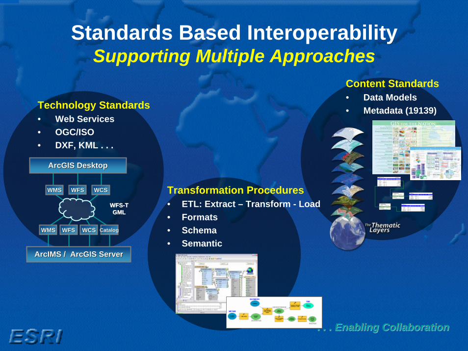
Standards Based InteroperabilitySupporting Multiple Approaches
. . . Enabling Collaboration. . . Enabling Collaboration
Simple feature classHaul Contains Z values
Contains M valuesGeometry Point
NoNo
Data typeField namePrec-ision Scale LengthDomainDefault value
Allownulls
OBJECTID Object IDSHAPE Geometry Yes
HAULJOIN Long integer No 0VESSELCODE Long integer No 0
CRUISE Long integer No 0HAUL Long integer No 0
STATION_ID String No 7SSTEMP Float No 0 0
BOTTOMTEMP Float No 0 0EFFORT Float No 0 0
DataSourceID String Yes 50
TableDataSource
Data typeField namePrec-ision Scale LengthDomainDefault value
Allownulls
OBJECTID Object IDDESC_ String Yes 35
SOURCE String Yes 35CONTACT String Yes 20
PREC String Yes 20CREATE_DATE Long integer Yes 0LAST_UPDATED Long integer Yes 0
DataSourceID String Yes 50
TableFishCatch
Data typeField namePrec-ision ScaleLengthDomainDefault value
Allownulls
OBJECTID Object IDHAULJOIN Long integer No 0
SPECIESCODE Long integer No 0LATINNAME String No 28
COMMONNAME String No 21WEIGHTCPUE Double No 0 0NUMBERCPUE Double No 0 0
Relationship class
NamePrimary keyForeign key
TypeCardinalityNotification
Forward labelBackward label
No relationship rules defined.
DataSourceHasHaul
Origin table Destination feature class
SimpleOne to manyNone
HaulDataSource
DataSourceDataSourceIDDataSourceID
HaulName
Relationship class
NamePrimary keyForeign key
TypeCardinality
Notification
Forward labelBackward label
No relationship rules defined.
HaulHasFishCatch
Origin feature class Destination table
SimpleOne to manyNone
FishCatchHaul
HaulHAULJOINHAULJOIN
FishCatchName
Content Standards• Data Models • Metadata (19139)
Transformation Procedures• ETL: Extract – Transform - Load• Formats• Schema• Semantic
Technology Standards• Web Services• OGC/ISO• DXF, KML . . .
WMSWMS WFSWFS WCSWCS
WMSWMS WFSWFS WCSWCS CatalogCatalog
ArcGIS DesktopArcGIS Desktop
ArcIMS / ArcGIS ServerArcIMS / ArcGIS Server
WFSWFS--TTGMLGML

Applying This to Disaster ManagementThe Context
• Recent World events, natural or human caused, continue to challenge and tax our collective ability to respond.
• In every instance we have witnessed an outpouring of care and a commitment to improve.
• In every case there has been a need for collaborative approaches and integrated systems.
• Each in their own way is dependent on critical information, critical resources and infrastructure.
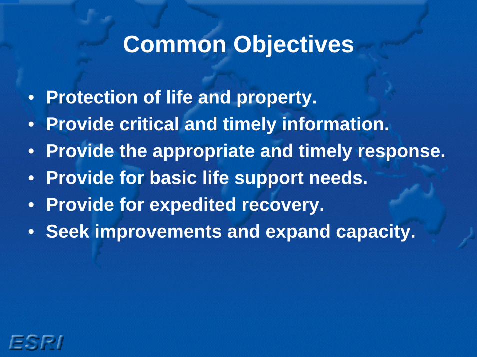
Common Objectives
• Protection of life and property.• Provide critical and timely information.• Provide the appropriate and timely response.• Provide for basic life support needs.• Provide for expedited recovery.• Seek improvements and expand capacity.

Common Challenges
• Planning and Mitigation to All Phases of the Disaster:- Planning and Mitigation- Readiness- Response- Recovery

Common Need
• Timely acquisition of information• Shared and combined information• Compartmentalize information• Multiple information sources and arrays• Secure and dependable dissemination of
information• Appropriate use of information technology

Desired Outcome
• Common Information Framework• Base Information• Real Time Information• Simulation Capacity• Uniform Data Standards

Disaster and Emergency PlanningDisaster and Emergency Planning
• Locate values at-risk areas for prevention/mitigation needs
• Identify natural and Technological hazards
• Understand the geographic distribution of incidents
• Plan Mitigation efforts
Planning is a process, not an event!
Event modeling to understandpotential incident effects
Planning and Analysis

Desktop GISAuthoring and Using Geographic Knowledge
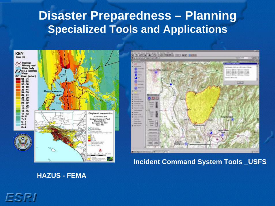
Disaster Preparedness – PlanningSpecialized Tools and Applications
HAZUS - FEMA
Incident Command System Tools _USFS

Structural Fire PlanningFireView – GIS Desktop Application

Wildfire - Mitigation Planning Tools

Wildfire - Server-Based Planning ApplicationsBrowser-Based Interfaces
Wildfire - Server-Based Planning ApplicationsBrowser-Based Interfaces

Wildfire – Response and Recovery
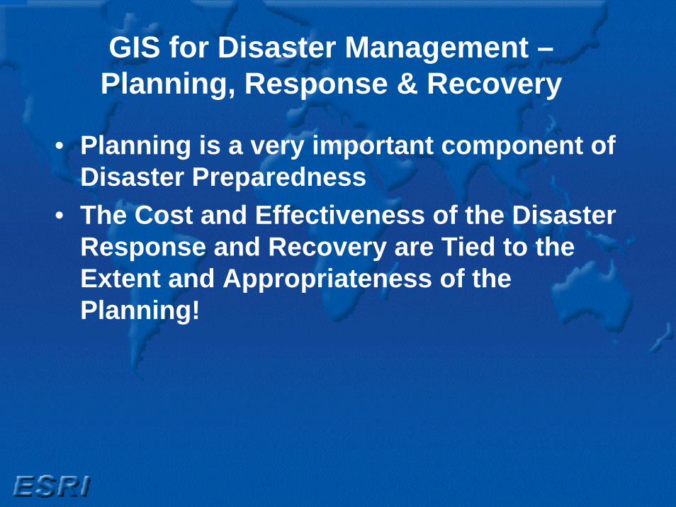
GIS for Disaster Management –Planning, Response & Recovery
• Planning is a very important component of Disaster Preparedness
• The Cost and Effectiveness of the Disaster Response and Recovery are Tied to the Extent and Appropriateness of the Planning!
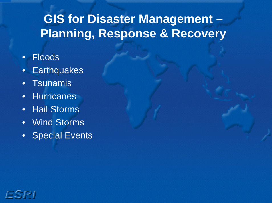
GIS for Disaster Management –Planning, Response & Recovery
• Floods• Earthquakes• Tsunamis• Hurricanes• Hail Storms• Wind Storms• Special Events

GIS Was Used Extensively in Response to Hurricane Katrina
Great Demand for Maps and Geospatial Analysis
Hundreds Of Separate Mission Focused Efforts

Many Examples Of Powerful GIS ApplicationsFlood Status Visualization
Evacuation And RescueDamage Assessment
Demographic Analysis
Utility Planning& Response
Forecasting and Tracking
Command and Control

There Was Very Little Preparedness of Geospatial Infrastructure
. . . Required A Lot of Heroic Efforts
• Metadata on Web• Data Discover Acquisition• Processing• Data Modeling• Application Development• System Acquisition/Installation• Training
. . . Done Repetitively, Inconsistently, and with Considerable Cost

They Envisioned and Began to Create a “GIS for the Gulf”
• Extended Database• Integrated Data Model• Distributed via Web and Media• Consistent/Responsible Application
. . . Datasets Assembled and Distributed in 14 Days. . . A Model for GIS for the Nation

Responding To The Crisis –A Multi Agency Effort Created An Integrated
Database for the Gulf
• Integration Of Existing Data• Standard Data Model• Consistent Applications• Dissemination Via Web and Media
Houston
New OrleansPriority Areas OfPriority Areas OfLouisiana, Alabama, Mississippi and TexasLouisiana, Alabama, Mississippi and Texas

An ETL Interoperability Process Was Used Integrating And Disseminating Existing
Local, State And Federal Data
Spatial ETL• Transformation• Conversion• Integration
Database And Server
Data &Services
Data Sets• Local Gov• State Gov• Federal Gov• Commercial DVD Data Sets
Data Bricks
Data Model
…Creating A Successful Multi Agency System
National Data Model
• Emergency Operations• Structures/Critical Infrastructure• Governmental Units• Utilities• Addresses• Transportation• Ownership Parcels• Hydrography• Environmental• Land Use/Land Cover• Base Map• Geodetic Control• Elevation• Imagery• Geodetic Control
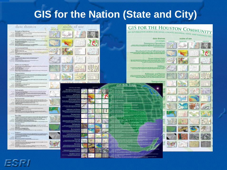
GIS for the Nation (State and City)

LocalTransactions
Local Data SetsLocal Data Sets
GOSGOS
• Transformation• Conversion• Integration
National Data SetsNational Data Sets
DistributionDistribution
High-Quality Data Compiled from Local Sources
Emerging Geospatial Community Vision
Common NationalSpecifications
Map Products& Services
EmergencyEmergencyoperationsoperations

This Event Is Full Of Lessons For The Geospatial Community
• Planning• Data• Organization• Methodology• Collaboration• Infrastructure
•• Significant work was done . . . but not efficientSignificant work was done . . . but not efficient•• Success required heroic effortsSuccess required heroic efforts•• Many data collection efforts were repetitive, Many data collection efforts were repetitive,
inconsistent , & costly inconsistent , & costly –– consuming time and consuming time and resourcesresources
•• No integrated Situational Awareness existedNo integrated Situational Awareness existed•• A multiA multi--purpose database was needed purpose database was needed •• Data sharing needs to be part of future emergency Data sharing needs to be part of future emergency
response plansresponse plans
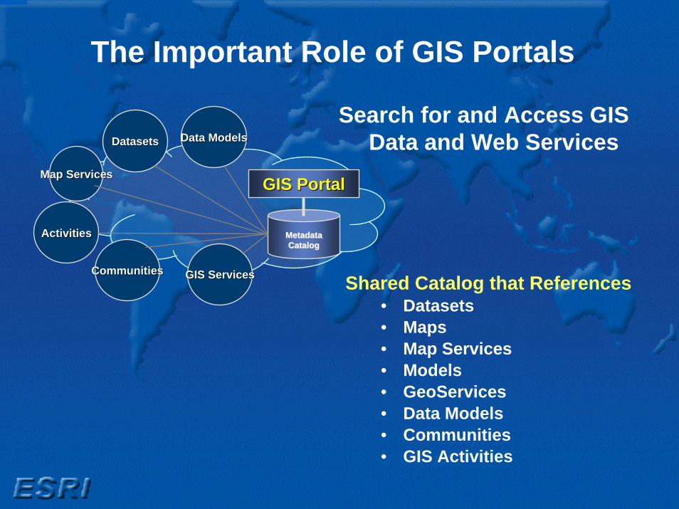
The Important Role of GIS Portals
Metadata Metadata CatalogCatalog
GIS PortalGIS Portal
DatasetsDatasets
Map ServicesMap Services
CommunitiesCommunities
ActivitiesActivities
Data ModelsData Models
GIS ServicesGIS Services
Search for and Access GIS Data and Web Services
Shared Catalog that References• Datasets• Maps• Map Services• Models• GeoServices• Data Models • Communities• GIS Activities

Key Role of GeoSpatial PortalGeoSpatial One-Stop (Phase 2)
SpecialChannel
Communities
Fusion of Data & Services
Marketplace
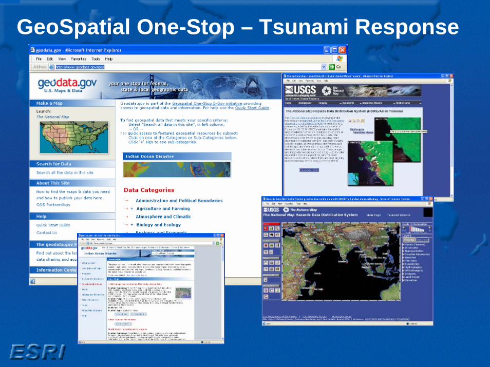
GeoSpatial One-Stop – Tsunami Response
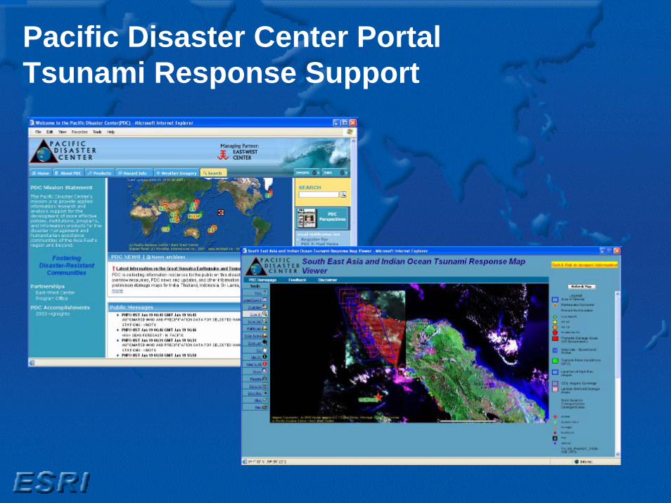
Pacific Disaster Center PortalTsunami Response Support
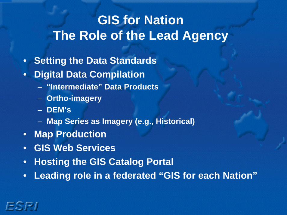
GIS for NationThe Role of the Lead Agency
• Setting the Data Standards• Digital Data Compilation
– “Intermediate” Data Products– Ortho-imagery– DEM’s– Map Series as Imagery (e.g., Historical)
• Map Production• GIS Web Services • Hosting the GIS Catalog Portal• Leading role in a federated “GIS for each Nation”


New Developments – New Opportunities

The Geographic Information SystemFor Authoring, Serving and Using GIS Knowledge
3 Tiers
MetadataServices
GlobeServices
MapServices
Analysis &ModelingServices
ImageServices
Open OGCServices
Web MapViewer
Desktop Explorer Mobile EnterpriseService Bus
OpenAPIs
Use
Serve
Author

ArcGIS Explorer – An Introduction• A No-Cost, General Purpose
GIS Viewer and Application– ArcGIS Server
• 2D Maps, 3D Globes, Tasks– ArcIMS– ArcWeb Services– WMS– Other Web Services
• And More– Swipe and Transparency Tools,
Identify, etc…– Task-Based GIS Analysis
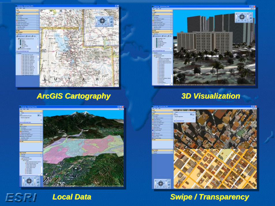
ArcGIS CartographyArcGIS Cartography
Local DataLocal Data Swipe / TransparencySwipe / Transparency
3D Visualization3D Visualization

Business AnalysisBusiness Analysis
Service Area AnalysisService Area Analysis Electric Utility TraceElectric Utility Trace
HCA AnalysisHCA Analysis

Easy Access to ContentArcGIS Explorer Resource Center
• Direct connectfrom Explorer
• Base Maps• Featured Maps• User Community

• Default Tasks• Custom Tasks
– Authored using ArcGIS Desktop & Published using ArcGIS Server
• No programming necessary• SDK for extending tasks, or building
new tasks
ArcGIS Explorer - Tasks ArcGIS Server-based FunctionsArcGIS Explorer - Tasks ArcGIS Server-based Functions

A Customizable ApplicationArcGIS Explorer - SDK
A Customizable ApplicationArcGIS Explorer - SDK
Simple, Yet Everything You NeedSimple, Yet Everything You Need
• Visual Studio 2005 (.NET)

In Summary• GIS is an Important Platform for Disaster
Management – Planning, Response and Recovery• Many Lessons To Be Learned from Past Events –
What Worked and What Didn’t• New Technology Creates New Opportunities - For
– Collaboration– Coordination– Enhanced Effectiveness
• Technology is Important, But Institutional and Organizational Issues are More Important
