archaeologicalassessmentfortheproposednextel … partnersinc.easthilocellsiteno.hi195p, ... 1...
TRANSCRIPT

T. S. Dye & Colleagues, Archaeologists, Inc.735 Bishop St., Suite 315, Honolulu, Hawai‘i 96813
Archaeological Assessment for the Proposed NextelPartners Inc. East Hilo Cell Site No. HI195P,
Laukapu Industrial Center, 811 Laukapu Street, Hilo,Hawaii, TMK:(3)2–2–050:041 por.�
omas S. Dye, Ph.D. Elaine H. R. Jourdane
June 1, 2006
Applicant: Clayton Group Services.Applicant’s Consultant: T. S. Dye & Colleagues, Archaeologists, Inc.Location: Laukapu Industrial Center, 811 Laukapu Street, Hilo, Hawaii.Tax map key: (3)2–2–050:041 por.Request: Proposed Nextel Partners Inc. East Hilo Cell Site No. HI195P.Direct E�ect: No historic properties in Area of Potential E�ect (APE) for direct e�ects.Visual E�ect: No historic properties in Area of Potential E�ect (APE) for visual e�ects.
1 IntroductionAt the request of Clayton Group Services, T. S. Dye & Colleagues, Archaeologists, Inc.conducted an archaeological assessment of a parcel at the Laukapu Industrial Center forthe proposed Nextel Partners Inc. (NPI) cellular site. e primary focus of the projectwas on the discovery and appropriate treatment of historic properties within the area ofpotential e�ect. e goals of the archaeological investigation were to determine whetherthe installation of antennas and construction of an equipment facility will have direct orvisual e�ects on historic properties.
1.1 Project AreaNPI proposes to install a 60 �. tall monopole and an equipment room within a 250 �.2lease area at the southeast end of the existing warehouse at the Laukapu IndustrialCenter parcel. Up to nine panel antennas will be mounted to the top of the pole. e
�Prepared for Clayton Group Services, Inc.
1
2 1 INTRODUCTION
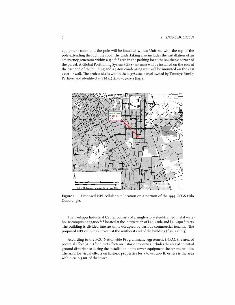
equipment room and the pole will be installed within Unit 20, with the top of thepole extending through the roof. e undertaking also includes the installation of anemergency generator within a 150 �.2 area in the parking lot at the southeast corner ofthe parcel. A Global Positioning System (GPS) antenna will be installed on the roof atthe east end of the building and a 3-ton condensing unit will be mounted on the eastexterior wall. e project site is within the 0.9784 ac. parcel owned by Tanouye FamilyPartners and identi�ed as TMK:(3)2–2–050:041 (�g. 1).
Figure 1. Proposed NPI cellular site location on a portion of the 1995 USGS HiloQuadrangle.
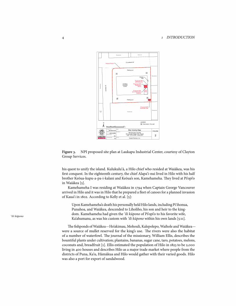
e Laukapu Industrial Center consists of a single-story steel-framed metal ware-house comprising 19,800 �.2 located at the intersection of Lanikaula and Laukapu Streets. e building is divided into 20 units occupied by various commercial tenants. eproposed NPI cell site is located at the southeast end of the building (�gs. 2 and 3).
According to the FCC Nationwide Programmatic Agreement (NPA), the area ofpotential e�ect (APE) for direct e�ects on historic properties includes the area of potentialground disturbance during the installation of the tower, equipment shelter and utilities. e APE for visual e�ects on historic properties for a tower 200 �. or less is the areawithin ca. 0.5 mi. of the tower.

1.2 Background Research 3
Figure 2. Location of Laukapu Industrial Center on an NOAA-NOS aerial photograph.
1.2 Background Research is archaeological assessment includes the review of historic documents, maps andarchaeological reports on �le at the State Historic Preservation Division library, theHawaii State Archives and the State Bureau of Conveyances. No �eld inspection wasconducted of the area.
1.2.1 Natural Setting
e NPI project site lies at an elevation between 30 and 35 �. above sea level, ca. 1.25 mi.south of Hilo Bay in the ahupua‘a of Waiakea in the district of South Hilo, Hawai‘i. e ahupua‘a
soils underlying the area are classi�ed as Papai extremely stony muck on 3 to 25 percentslopes. is soil consists of a thin, very brown, well drained, extremely stony organic soilsover fragmented ‘a‘a lava. [2]. e project site receives an average rainfall of 120–160 in. ‘a‘a
annually [3].
1.2.2 Traditional and Historic Land Use
e physical environment, historic properties, and history of Hilo have been well docu-mented in several studies including those of McEldowney [9] and Kelly et al. [5]. efollowing information is a brief review that provides context for the project. e project is located in the ahupua‘a of Waiakea, one of the largest, in the district of
South Hilo. Waiakea’s importance in the traditional and legendary history is depicted inseveral accounts. ‘Umi-a-Liloa, a son of Liloa, conquered each of the island’s districts in
4 1 INTRODUCTION
Proposed NPIGenerator Site
Subject Parcel
Proposed NPIEquipment
Room
Proposed NPI60’ 0” Monopole
Antenna
Proposed NPIGPS Antenna
Lauk
apu
St
E Lanikaula St
Parking Lot
Parking Lot
LaukapuIndustrialCenter
Residential
Residential
Residential
ResidentialResidential
Res
iden
tial
Open Lot
OpenLot
GreaseTrap
Stormdrain / Dry well
Unit# 20
LEGEND
0 50 10025Feet±
85-06197.00
02/01/2006
RC
TS
Project No.:
Date:
Revised By
Checked By:
Title:
Location:
Client
FIGURE
2
Site Vicinity MapNPI East Hilo Cell Site
811 Laukapu Street, Hilo, HawaiiTMK: (3) 2-2-050: Parcel 041
Nextel Partners, Inc.
Figure 3. NPI proposed site plan at Laukapu Industrial Center, courtesy of ClaytonGroup Services.
his quest to unify the island. Kulukulu‘a, a Hilo chief who resided at Waiakea, was his�rst conquest. In the eighteenth century, the chief Alapa‘i-nui lived in Hilo with his halfbrother Keoua-kupu-a-pa-i-kalani and Keoua’s son, Kamehameha. ey lived at Pi‘opi‘oin Waiakea [5].Kamehameha I was residing at Waiakea in 1794 when Captain George Vancouver
arrived in Hilo and it was in Hilo that he prepared a eet of canoes for a planned invasionof Kaua‘i in 1802. According to Kelly et al. [5]:
UponKamehameha’s death his personally heldHilo lands, includingPi‘ihonua,Punahoa, and Waiakea, descended to Liholiho, his son and heir to the king-dom. Kamehameha had given the ‘ili kupono of Pi‘opi‘o to his favorite wife,
‘ili kuponoKa‘ahumanu, as was his custom with ‘ili kupono within his own lands [5:11].
e�shponds ofWaiakea—Ho‘akimau, Mohouli, Kalepolepo,Waihole andWaiakea—were a source of mullet reserved for the king’s use. e rivers were also the habitatof a number of waterfowl. e journal of the missionary, William Ellis, describes thebountiful plants under cultivation; plantains, bananas, sugar cane, taro, potatoes, melons,coconuts and, breadfruit [1]. Ellis estimated the population of Hilo in 1823 to be 2,000living in 400 houses and describes Hilo as a major trade market where people from thedistricts of Puna, Ka‘u, Hamakua and Hilo would gather with their varied goods. Hilowas also a port for export of sandalwood.
1.2 Background Research 5
In January 1824 the �rst missionary station was set up at Waiakea. A few monthslater the �rst church services were held and by 1825 a school had been established. It wasduring 1824 that the �rst whaling ship entered Hilo Bay.During the maheleWaiakea became Crown Land, while Pi‘opi‘o descended to Kina‘u mahele
and Kamamalu and later became a part of the Bishop Estate Lands. Haun and Henry [4]summarize the kuleana claims for Waiakea. kuleana
Twenty-six parcels were awarded to 24 claimants. Chiefess Kamamulu(sic) was awarded the entire ‘ili of Pi‘opi‘o under Land Commission Award ‘ili
(LCA) No. 7713. e remaining claims are for kuleana parcels ranging kuleana
from 0.24 to 13.14 acres in area with an average of 3.6 acres. All, except �veclaims, were for single parcels . . .Land use described in the LCA testimonyincluded agriculture, pasture, burial, and residence. irty-four houses arementioned and LCA 2274 also describes the presence of a grave. Most of theclaim testimony mentions cultivated �elds. Crops include wet taro, sweetpotatoes, breadfruit, co�ee, and kukui. A hala (Pandanus spp.) grove and kukui
hala�shponds are also mentioned. [4:8]
Waiakea was leased for pasture by Kamehameha IV in 1861 and in 1874 the ahupua‘awas leased to Rufus A. Lyman for 25 years. By the late 1870s commercial sugar caneproduction had started and theWaiakea Mill was built by eo. H. Davies and AlexanderYoung. By 1880 there were nine sugar planters and plantations within 3.5 mi. of Hilotown. In 1888 all of Waiakea except for the �shpond and �shery rights was leased toDavies and Young for 10 years. e plantation lands extended south to the uplands ofWaiakea and by 1915 nearly 7,000 ac. of land was cultivated. eWaiakea Mill continuedto produce until 1947.Based on information provided byClaytonGroup Services, the recent land use history
records trace ownership of the project site to Frank B. Wrigley in 1938. e property,described as “Waiakea Houselots” was deeded to Realty Investment Company Ltd. at thetime. Since 1950 the parcel has undergone change in ownership and parcel designationuntil deeded to the current owners in 1995. e current Laukapu Industrial Centerbuilding was constructed in 1995.
1.2.3 Archaeological Background
ere are no known archaeological surveys conducted for this parcel. During his surveyof heiau of the island of Hawaii, Stokes [12] recorded six heiau in the Hilo area. All had heiau
been destroyed by the time of his visit and only one, Ohele heiau, was said to be located inWaiakea. Since Stokes’ survey, several archaeological investigations have been conductedwithin the general area.McEldowney [9] developed a land use and settlement pattern for the Hilo area. Her
model de�ned a coastal settlement zone that extended approximately 0.5 mi. inland fromthe shoreline to the 50 �. elevation. e distribution of known sites at the time of her worksuggested both permanent and temporary use along the entire coast. Population wasdense with settlements along Hilo Bay and other sheltered bays. e area was rich withresources from the ocean and �shponds, as well as cultivated crops. Inland of the coastal
6 3 DISCUSSION AND CONCLUSIONS
settlement zone is the upland agricultural zone, where “[s]cattered huts, emphasized byadjacent garden plots and small groves of economically bene�cial tree species, dottedthis expanse up to 1,500 feet elevation (i.e., the edge of the forest)” [9:18]. e proposedNPI project site lies within this upland agricultural zone.Several archaeological investigations have been conducted in the general vicinity of
the proposed NPI project site. In 1994, Kennedy and Ireland [6] conducted an archaeo-logical inventory survey of a 0.5 ac. parcel ca. 0.5 mi. southwest of the proposed projectsite. No archaeological sites or features were found on the property which had beenplanted in sugar cane.Also in 1994, Maly et al. [8] conducted an inventory survey of a 4.5 ac. parcel ca.
1.0 mi. southwest of the proposed project site. Four historic sites (sites 50–10–35–19431through –19434) were found during the survey. e sites includedC-shaped and L-shapedenclosures, mounds, terraces, and walls and were thought to be the result of early historicsugar cane cultivation and transportation. One subsurface deposit, a �re pit, indicatedprehistoric occupation of the area prior to commercial sugar cane cultivation. In 1995,Spear [11] conducted further data recovery work at sites 50–10–35–19431 through –19434. ey concluded that the sites were a result of sugar cane cultivation.In 2002, Haun andHenry [4] conducted an archaeological inventory survey ca. 1.0 mi.
southeast of the proposed project site. No archaeological sites or features were identi�edwithin the 28 ac. parcel, which had been completely cleared and modi�ed by heavymachinery. eir report provides a synthesis of the archaeological work conductedwithin the general Hilo area. Archaeological investigations in the Hilo area has coveredover 1,570 acs within Waiakea from the coast to the 5,100 �. elevation. Few traditionalHawaiian sites were reported within undeveloped lands east and west of the proposedNPI project area. e absence of traditional sites has been attributed to the extensivesugar cane cultivation and to commercial and residential development of Hilo town. ere are no historic properties listed on the National Register of Historic Places
within the area of potential e�ect for the undertaking.
2 ResultsNo �eld inspection was conducted of the project site by T. S. Dye & Colleagues, Archae-ologists, Inc. However, a �eld inspection was conducted by Clayton Group Services andthe information and photographs of the project site were reviewed. According to ClaytonGroup Services, a 1940 topographic map shows at least one structure on the propertyand in 1949 two structures are shown on an aerial photograph of the parcel. A 1977 aerialphotograph shows further development on the western side of the parcel. e existingLaukapu Industrial Center building was constructed in 1995 (�gs. 4 and 5). No historicproperties were reported during the construction of the existing complex.
3 Discussion and ConclusionsA review of the archaeological literature, historic maps, and information provided byClayton Group Services shows that the project site has been previously modi�ed andhas been developed as recently as 1995 by the construction of the Laukapu Industrial

GLOSSARY 7
Figure 4. Proposed NPI cellular site in Unit 20 Laukapu Industrial Center, lookingnorthwest. Courtesy of Clayton Group Services.
Figure 5. Proposed NPI generator site at Laukapu Industrial Center, looking south.Courtesy of Clayton Group Services
Center. No surface historic properties exist within the area of potential e�ect for theproposed Nextel cellular site and no subsurface deposits are likely to be found because ofpast land alteration. erefore the construction of the facility will have no direct e�ecton historic properties. Since there are no known historic sites listed on the Register ofHistoric Places within 0.5 mi. of the subject area, we also believe that the undertakingwill have no visual e�ect on historic properties.
8 BIBLIOGRAPHY
GlossaryEntries for Hawaiian words are excerpted or paraphrased, where possible, from theHawaiian Dictionary [10], or from Lucas [7].
‘a‘a Basaltic lava ows typi�ed by a rough, jagged, spinose, clinkery surface. See alsopahoehoe.
‘ili A land section, next in importance to ahupua‘a and usually a subdivision of anahupua‘a.
‘ili kupono A nearly independent ‘ili land division within an ahupua‘a, paying tribute tothe ruling chief and not to the chief of the ahupua‘a. See also ‘ili, ahupua‘a.
ahupua‘a Traditional Hawaiian land division usually extending from the uplands to thesea.
hala An indigenous tree, Pandanus tectorius.
heiau Traditional Hawaiian place of worship.
kukui e candlenut, Aleurites moluccana.
kuleana Right, title, property, portion, responsibility, jurisdiction, authority, interest,claim, ownership.
mahele Land division of 1848.
pahoehoe Basaltic lava ows typi�ed by smooth, billowy, or ropy surface. See also ‘a‘a.
Bibliography[1] Ellis, W. (1963). Journal of William Ellis. Honolulu: Advertiser Publishing Company,Ltd.
[2] Foote, D. E., E. L. Hill, S. Nakamura, and F. Stephens (1972). Soil Survey of theIslands of Kauai, Oahu, Maui, Molokai, and Lanai, State of Hawaii. Washington, D.C.:United States Department of Agriculture, Soil Conservation Service. Published incooperation with the University of Hawaii Agricultural Experiment Station.
[3] Giambelluca, T. W. and T. A. Schroeder (1998). Climate. In S. P. Juvik and J. O. Juvik(Eds.), Atlas of Hawai‘i ( ird ed.)., pp. 49–59. Honolulu: University of Hawaii Press.
[4] Haun, A. E. and D. Henry (2002, April). Archaeological Inventory Survey DHHLProject at Panaewa, Land of Waiakea, South Hilo District, Island of Hawai‘i (TMK:2–2–47:01). Prepared for Department of Hawaiian Home Lands. Kea‘au, Hawai‘i: Haun &Associates.

BIBLIOGRAPHY 9
[5] Kelly, M., B. Nakamura, and D. B. Barrere (1981, March). Hilo Bay: A ChronologicalHistory; Land and Water Use in the Hilo Bay Area, Island of Hawai‘i. Prepared forU. S. Army Engineer District, Honolulu. Honolulu: Anthropology Department, B. P.Bishop Museum.
[6] Kennedy, J. and S. Ireland (1994, January). An Archaeological Inventory Survey for theProposed Hilo Forestry O�ce Complex Extension Located at TMK:2–2–27:01 (Portion)in Waiakaea Ahupua‘a, South Hilo District, Island of Hawaii. Prepared for Wil CheePlanning. Haleiwa, Hawaii: Archaeological Consultants of Hawaii, Inc.
[7] Lucas, P. F. N. (1995). A Dictionary of Hawaiian Legal Land-Terms. Honolulu:Native Hawaiian Legal Corporation and University of Hawai‘i Committeee for thePreservation and Study of Hawaiian Language, Art and Culture.
[8] Maly, K., A. T. Walker, and P. H. Rosendahl (1994, June). Archaeological InventorySurvey, Waiakea Cane Lots, Portion of Parcel 6, Land of Waiakea, South Hilo District,Island of Hawai‘i. Prepared for Roy Takemoto. Hilo, Hawaii: Paul H. Rosendahl, Ph.D.,Inc.
[9] McEldowney, H. (1979, May). Archaeological and Historic Literature Search andResearch Design Lava Flow Control Study, Hilo, Hawai‘i. Prepared for U. S. ArmyEngineer Division, Paci�c Ocean. Honolulu: Anthropology Department, B. P. BishopMuseum.
[10] Pukui, M. K. and S. H. Elbert (1971). Hawaiian Dictionary ( ird ed.). Honolulu:University of Hawaii Press.
[11] Spear, R. L. (1995, April). Data Recovery Excavations for Sites 50–10–35–19431, –19432,–19433, and –19434, Land of Waiakea, South Hilo District, Island of Hawai‘i. Preparedfor Roy Takemoto. Honolulu: Scienti�c Consulting Services.
[12] Stokes, J. F. G. (1991). Heiau of the Island of Hawai‘i: A Historic Survey of NativeHawaiian Temple Sites. Number 2 in Bishop Museum Bulletin in Anthropology.Honolulu: Bishop Museum. Edited and introduced by Tom Dye.