architectural design report
TRANSCRIPT

ARCHITECTURAL DESIGN REPORT
Centre of Excellence in Agricultural Education Richmond NSW Application No. SSD-1500146
Schools Infrastructure NSW MAY 2021
https://nbrsarchitecture.sharepoint.com/PROJECTS/20/20417 HCOE/05_DOC/02_Reports/01_Design Statement/CoE - Design Report.docx PAGE 2 OF 44
TABLE OF CONTENTS
1.0 INTRODUCTION ............................................................................................................................................... 4
1.1 Project Overview ............................................................................................................................. 4
1.2 Secretary’s Environmental Assessment Requirements ......................................................... 4
1.3 Project Description ........................................................................................................................ 4
1.4 Architectural Design Statement .................................................................................................. 6
1.5 Site Context and Analysis ............................................................................................................. 7
1.6 Site Opportunities and Constraints .......................................................................................... 11
1.7 Master plan options ..................................................................................................................... 13
2.0 DESIGN INTENT ............................................................................................................................................. 21
2.1 Design concept ............................................................................................................................. 21
2.2 Building Envelope ......................................................................................................................... 22
2.3 Landscape Concept ..................................................................................................................... 24
2.4 Interior Design ............................................................................................................................... 26
2.5 Signage .......................................................................................................................................... 28
2.6 Visual Impact Assessment ........................................................................................................ 30
2.7 Waste Management .................................................................................................................... 30
2.8 Crime Prevention through Environmental Design ................................................................. 31
2.9 Government Architects NSW Feedback .................................................................................. 38
2.10 WSU Consultation ........................................................................................................................ 41
2.11 Community Consultation ............................................................................................................ 41
3.0 DESIGN PRINCIPLES ..................................................................................................................................... 42
3.1 Principle 1 – Context, Built Form and Landscape ................................................................. 42
3.2 Principle 2 – Sustainable, Efficient and Durable .................................................................... 42
3.3 Principle 3 – Access and inclusive ........................................................................................... 42
3.4 Principle 4 – Health and Safety ................................................................................................. 43
3.5 Principle 5 – Amenity .................................................................................................................. 43
3.6 Principle 6 – Whole of life, Flexibility and Adaption .............................................................. 43
3.7 Principle 7 – Aesthetics .............................................................................................................. 44

https://nbrsarchitecture.sharepoint.com/PROJECTS/20/20417 HCOE/05_DOC/02_Reports/01_Design Statement/CoE - Design Report.docx PAGE 3 OF 44
NBRS & PARTNERS Pty Ltd
4 Glen Street
Milsons Point
NSW 2061 Australia
Telephone +61 2 9922 2344
ABN: 16 002 247 565
Nominated Architects;
Andrew Duffin: Reg No. 5602
This document remains the property of NBRS & PARTNERS Pty Ltd.
The document may only be used for the purposes for which it was produced.
Unauthorised use of the document in any form whatsoever is prohibited.
ISSUED REVIEW ISSUED BY
25th June 2021 SSDA Ewan Saunders
21st May 2021 SSDA Stephanie Ferguson
29th April 2021 SSDA Stephanie Ferguson
09th April 2021 Draft Issue for information Stephanie Ferguson

https://nbrsarchitecture.sharepoint.com/PROJECTS/20/20417 HCOE/05_DOC/02_Reports/01_Design Statement/CoE - Design Report.docx PAGE 4 OF 44
1.0 INTRODUCTION 1.1 PROJECT OVERVIEW This Design Analysis Report has been prepared by NBRS Architecture for Schools Infrastructure NSW (the client). It accompanies an Environmental Impact Statement (EIS) in support of the State Significant Development Application for a new Centre of Excellence (CoE) in Agricultural Education. The site is a parcel of leased land within the Western Sydney University (Hawkesbury Campus), Richmond NSW. The purpose of the Design Analysis report is to identify and demonstrate the design process, consultation and development of the design principles considered to satisfy the brief and the Secretary’s Environmental Assessment Requirements (SEARs)
1.2 SECRETARY’S ENVIRONMENTAL ASSESSMENT REQUIREMENTS
On the 22nd March 2021, the Department of Planning, Industry and Environment (DPIE) issued Secretary’s Environmental Assessment Requirements (SEARs) to the applicant for the preparation of an Environmental Impact Statement for the proposed development. This report has been prepared having regard to the relevant SEARs as shown below: Built Form and Urban Design
• Address: - The height, density, bulk and scale, setbacks and interface of the development in relation
to the surrounding development, topography, streetscape and any public open spaces. - Design quality and built form, with specific consideration of the overall site layout,
streetscape, open spaces, façade, rooftop, massing, setbacks, building articulation, materials and colour palette.
- How Crime Prevention through Environmental Design (CPTED) principles are to be integrated into development.
- How good environmental amenity would be provided, including access to natural daylight and ventilation, acoustic separation, access to landscape and outdoor spaces and future flexibility.
- How design quality will be achieved in accordance with Schedule 4 Schools design quality principles of State Environmental Planning Policy (Educational Establishments and Child Care Facilities) 2017 and the GANSW Design Guide for Schools (GANSW, 2018).
- How services, including but not limited to waste management, loading zones, and mechanical plant are integrated into the design of the development.
• Provide: - A detailed site and context analysis to justify the proposed site planning and design
approach including massing options and preferred strategy for future development. - A visual impact assessment that identifies any potential impacts on the surrounding built
environment and landscape including views to and from the site and any adjoining heritage items.
1.3 PROJECT DESCRIPTION The proposed development involves the construction and operation of a new Centre of Excellence (CoE) in Agricultural Education on a leased land parcel within the Western Sydney University (Hawkesbury Campus) site, Richmond NSW. The CoE will provide new agricultural / STEM teaching facilities with general learning and administration spaces to be utilised by rural, regional, metropolitan and international school students. The CoE will accommodate up to 325 students and up to 25 employees consisting of farm assistants,

https://nbrsarchitecture.sharepoint.com/PROJECTS/20/20417 HCOE/05_DOC/02_Reports/01_Design Statement/CoE - Design Report.docx PAGE 5 OF 44
administration staff and teachers and up to five itinerant staff members. The CoE will also include short-term on-site accommodation facilities for up to 62 visiting students and teaching professionals from regional and rural NSW. The CoE will include five science laboratories, ten general learning spaces, practical activity teaching areas, seminar, botany room, administration block and accommodation facilities. It will also include covered outdoor learning areas, dining / recreation hall, canteen and kitchen, agricultural plots, significant landscaping spaces, car parking and provision of necessary infrastructure. The proposed development has been designed to be well integrated into the Western Sydney University site, having due regard for scale, bulk and orientation of existing buildings. The educational facilities will display linear open building forms in single storey design with open spaces and lightweight construction techniques. The site will enjoy views to the Blue Mountains (west) and the building and landscape plans have incorporated viewing opportunities into the design. The scope of the project includes the following elements:
• Three academic blocks (Block B, C and D). • Short-term, dormitory site accommodation with capacity for 62 patrons (Block F). • Dining / Conference Hall and Canteen (Block E). • Administrative building (Block A). • Support facilities for management and maintenance of site. • External works to accommodate circulation and covered walkways between buildings. • Pedestrian walkways. • Student and staff amenities. • Covered Outdoor Learning Areas. • 5 Visitor parking and drop off / pick up located off Vines Drive • 34 Staff parking and accommodation drop off / pick up off Maintenance Lane • Green house. • Various agricultural and animal plots and associated agricultural workshop. • Landscape treatment • Provision of waste facility area. • Installation of all essential services including stormwater management devices where
required. • Operation of the CoE site.

https://nbrsarchitecture.sharepoint.com/PROJECTS/20/20417 HCOE/05_DOC/02_Reports/01_Design Statement/CoE - Design Report.docx PAGE 6 OF 44
1.4 ARCHITECTURAL DESIGN STATEMENT The Centre of Excellence (CoE) in Agricultural Education is a specialist education facility for Year 7 to 12 students. The proposed facility is located on a leased parcel of land within the Western Sydney University (WSU) Hawkesbury Campus. The new school will be the most advanced agricultural high school in Australia and will benefit from a unique partnership with WSU’s School of Science and Health. The integrated model of high school-university framed education will infuse critical stages of the educational experience with the intensive agricultural and STEM innovations. Students at the school will have access to the university’s leading science, agricultural, environmental and STEM research. The design of CoE is centred around community, agriculture, and place. A place where students can gather and interact with the environment. The orientation of buildings and interaction with the landscape encourages spontaneous, voluntary, and joyful learning opportunities for students to explore and interact within a safe indoor and outdoor learning areas. The site axis is based off the existing Stable Square vista which is structured to be the main pedestrian promenade (access) into the site. The scale of the buildings has been developed as single storey linked pavilions within a gardenesque setting which is a reflection of the existing WSU campus. Large eave overhangs will be used as covered walkways between the buildings and each learning space will have direct access to a landscaped area. The building materiality developed off existing materials used within the WSU campus, with tones and textures from the surrounding bush environment. The building’s response to climatic conditions is a scientific area of study that will be displayed in various forms. The building management system will gather data from the PV array on the roof and the air handling units, which will be interpreted and displayed in the science breakout area. This will provide the occupants with realtime information on the building’s energy production and demand. The ecologically sustainable response of the building is further underpinned by its materiality. Thermal mass, thermally broken glazing, shading mechanisms, and cross ventilation have been articulated in the design to ensure the comfort of occupants and a reduction of the environmental footprint.
Figure 1. View of proposed development from Vines Drive on Stable square axis

https://nbrsarchitecture.sharepoint.com/PROJECTS/20/20417 HCOE/05_DOC/02_Reports/01_Design Statement/CoE - Design Report.docx PAGE 7 OF 44
1.5 SITE CONTEXT AND ANALYSIS
Site location: Located within proximity to the Hawkesbury River, Richmond town centre and train station The site is approximately 30mins west to blue mountains, 45mins South to future aerotropolis and 1hr SE to Sydney CBD. The 11hectare site is located within the 29hectare Western Sydney University Hawkesbury campus.
Figure 2: Location plan
Climate: Summer mean daily max 30 degrees. Mean daily minimum 16 degrees. Hot westerly winds, advantageous cooling evening easterly, Southerly storm events, sometimes heavy morning dew. Winter mean daily max 20 degrees. Mean daily minimum 4 degrees. Cold westerly winds, southerly storms, heavy morning fogs
Figure 3: Climate Analysis

https://nbrsarchitecture.sharepoint.com/PROJECTS/20/20417 HCOE/05_DOC/02_Reports/01_Design Statement/CoE - Design Report.docx PAGE 8 OF 44
Topography: The site is generally flat but slopes to the south to a drainage canal. There are three drainage swales that cross the site Acoustic: RAAF Aircraft noise generally low Londonderry Road generally low Views: Pleasant views to the west over the fields to the Blue mountains Adjacent WSU student accommodation and WSU microbiology Strong north axis with WSU stable square Existing Built form: The surrounding campus architecture consists of single storey and two storey buildings set within a landscape rural setting Local Heritage items on WSU: Memorial hall Potts hall Adams building, Grandstand Blacksmith shop 1897 Stable Square (1895 federation) formerly used as a stable for Hawkesbury agricultural college it is a renovated stable that now functions as a Student Hub’ including a Café and WSU student services centre. Significant estate planting - pacific island palms, formalised campus estate planting adapted to Australian climate
Figure 4: Heritage Items

https://nbrsarchitecture.sharepoint.com/PROJECTS/20/20417 HCOE/05_DOC/02_Reports/01_Design Statement/CoE - Design Report.docx PAGE 9 OF 44
Bushfire: Site is classified Category 2 - Bushfire buffer, Category 3 – Grass lands Buildings to achieve a 12.5 BAL rating
Figure 5: Bushfire Category map
Flooding: The Site is affected by PMF riverine flooding and a 1:100 overland flow path (the site not affected by 1:100 riverine flooding) Building ground floor has been set 400-900mm above natural ground
Figure 6: Flood affected land map

https://nbrsarchitecture.sharepoint.com/PROJECTS/20/20417 HCOE/05_DOC/02_Reports/01_Design Statement/CoE - Design Report.docx PAGE 10 OF 44
Contamination: Portion of the site has contaminated material refer to Remediation Action Plan prepared by Douglas and Partners. The RAP outlines contamination to be removed from site and some contaminated material suitable for retention on site.
Figure 7: Contaminated material site plan (Douglas and Partners RAP)
Transport: The transport concerns identified by NBRS include: Cycle safety on road network School zone Vines drive Council concern regarding rat run through WSU site RMS concern intersection Londonderry Road, Vines Drive and Southee Road

https://nbrsarchitecture.sharepoint.com/PROJECTS/20/20417 HCOE/05_DOC/02_Reports/01_Design Statement/CoE - Design Report.docx PAGE 11 OF 44
Figure 8: Location Plan with transport overlay
1.6 SITE OPPORTUNITIES AND CONSTRAINTS Opportunities identified which guided the design process include:
• Orientation of buildings to reflect the Western Sydney University grid • Orientation of buildings for optimal Ecologically Sustainable Design principles • Views over the agricultural plots, grazing pastures, and the Blue Mountains beyond • Utilizing the buildings to protect the outdoor learning squares from the cold westerly winds • Utilizing a large eaves overhang for covered walkways and protecting the facades from the
hot summer sun
Figure 9: Masterplan study - site diagram

https://nbrsarchitecture.sharepoint.com/PROJECTS/20/20417 HCOE/05_DOC/02_Reports/01_Design Statement/CoE - Design Report.docx PAGE 12 OF 44
Early in the site analysis and planning review, a number of constraints were identified: • Location of the lease line and approval from Western Sydney University • Bushfire Prone Land, designing the buildings for a BAL 12.5 rating • Flood Prone Land and Overland Flow Path, design the buildings 500mm above the predicted
flood level

https://nbrsarchitecture.sharepoint.com/PROJECTS/20/20417 HCOE/05_DOC/02_Reports/01_Design Statement/CoE - Design Report.docx PAGE 13 OF 44
1.7 MASTER PLAN OPTIONS Master planning for the Centre of Excellence site was undertaken by Fitzpatrick & Partners in August 2019. The process involved: RELATIONSHIP DIAGRAMS: From school and SI NSW briefings a relationship diagram was produced, identifying the required spaces and their relationships to each other. AREA ANALYSIS : A detailed area analysis for the relationship diagrams was then prepared. Whilst initial reservations were raised to the appropriateness of applying EFSG guidelines to this project, it was found that in nearly all cases, the spatial guidelines were appropriate. As such, the only variations to the EFSG related to the number of defined spaces for this specific learning facility and the accommodation facilities. SPATIAL DEFINITION: The relationship diagrams and area analysis were used to define a series of spatial blocks. This documentation cross referenced the relationships to neighbouring spaces, appropriate EFSG guidelines and spatial proportions. SITE PLANNING: Key objectives that were stated by the PCG were:
• Entry via Vines Drive, with maintenance lane only suitable for service vehicle access • Facility to make a clear statement to Vines Drive - not just a gateway • Architecture to express its purpose - an agricultural immersion learning facility, where every
space should relate to the agricultural uses surrounding the built form - the enterprises. • Efficient and flexible spaces as the needs and uses will change over time • Appropriate relationships between administration, learning, dining/rec and accommodation • A safe environment for all users at all times • As with all agricultural facilities, the layouts should be driven by function, but the buildings
should also be part of the learning curriculum: expression of structure, orientation and sun paths, winds. Winter and Summer use, water and energy management, technology to monitor and share information throughout related to environment, buildings, and the enterprises.
• Securable lockdown zone for evenings and emergencies, where the buildings are understood generally not to be the lockdown line
NBRS were commissioned in November 2020 to commence concept design based off option 8. A graphic representation of the master plan options is displayed below:

https://nbrsarchitecture.sharepoint.com/PROJECTS/20/20417 HCOE/05_DOC/02_Reports/01_Design Statement/CoE - Design Report.docx PAGE 14 OF 44
Figure 10: Masterplan option 1 - fitzpatrick+partners Option 1
Figure 11: Masterplan option 2 - fitzpatrick+partners Option 2

https://nbrsarchitecture.sharepoint.com/PROJECTS/20/20417 HCOE/05_DOC/02_Reports/01_Design Statement/CoE - Design Report.docx PAGE 15 OF 44
Figure 12: Masterplan option 3 - fitzpatrick+partners Option 3
Figure 13: Masterplan option 4 - fitzpatrick+partners Option 4

https://nbrsarchitecture.sharepoint.com/PROJECTS/20/20417 HCOE/05_DOC/02_Reports/01_Design Statement/CoE - Design Report.docx PAGE 16 OF 44
Figure 14: Masterplan option 5 - fitzpatrick+partners Option 5
Figure 15: Masterplan option 6 - fitzpatrick+partners Option 6

https://nbrsarchitecture.sharepoint.com/PROJECTS/20/20417 HCOE/05_DOC/02_Reports/01_Design Statement/CoE - Design Report.docx PAGE 17 OF 44
Figure 16: Masterplan option 7 - fitzpatrick+partners Option 7
Figure 17: Masterplan option 8 - fitzpatrick+partners Option 8

https://nbrsarchitecture.sharepoint.com/PROJECTS/20/20417 HCOE/05_DOC/02_Reports/01_Design Statement/CoE - Design Report.docx PAGE 18 OF 44
Figure 18: Masterplan option 9 - fitzpatrick+partners ` Option 9

https://nbrsarchitecture.sharepoint.com/PROJECTS/20/20417 HCOE/05_DOC/02_Reports/01_Design Statement/CoE - Design Report.docx PAGE 19 OF 44
1.7.1 SUMMARY OF OPTIONS

https://nbrsarchitecture.sharepoint.com/PROJECTS/20/20417 HCOE/05_DOC/02_Reports/01_Design Statement/CoE - Design Report.docx PAGE 20 OF 44
1.7.2 CONCEPT PLAN
Figure 19: Concept plan -NBRS Architecture ` Cons: • Screen required to protect courtyard from unfavourable cold westerly winds • Disconnect between aboriginal enterprise and gathering spaces Pros: • Good surveillance around the site for student supervision • Hall is ideally located for all potential uses • Clear distinction between carparking and service areas for school site • Buildings have good solar access and blocking unfavourable cold westerly winds • Creates large intimate courtyards for student and community gatherings

https://nbrsarchitecture.sharepoint.com/PROJECTS/20/20417 HCOE/05_DOC/02_Reports/01_Design Statement/CoE - Design Report.docx PAGE 21 OF 44
2.0 DESIGN INTENT 2.1 DESIGN CONCEPT The building form consists of a series of single storey linked pavilions set within a landscape setting in keeping with the WSU campus. The buildings have been designed and orientated to capture views of the landscape and to maximise the connection between internal and external agriculture teaching spaces The concept design focuses on developing a strong axial link back to the WSU campus and Stable Square with a pedestrian plaza and promenade, flanked by buildings on one side and the school’s technology enterprise on the other side to showcase future focused agriculture. The establishment of a new square a village green the school’s heart that talks to stable square. The village green has been orientated to a North South ESD grid and designed to capture views over the agriculture plots and the blue mountains. At the end of the square are large sliding barn doors designed to allow the space to be closed down to create a sun trap in winter and shield the square from cold westerly winds or open the site up in summer. The circulation and building forms have been inspired by the natural environment, the Hawkesbury river, the flood plains, the weaving pattens found in food bowls, and fish traps. This relates back to the Richmond / Hawkesbury region from the native Durag People and development of Sydney by the first settlers.
Figure 20: Design inspiration and sketches `

https://nbrsarchitecture.sharepoint.com/PROJECTS/20/20417 HCOE/05_DOC/02_Reports/01_Design Statement/CoE - Design Report.docx PAGE 22 OF 44
2.2 BUILDING ENVELOPE It is natural that the design of the Centre of Excellence would draw on precedents from the rich history of new and old Agricultural Architecture at the WSU campus, future focused Agricultural research architecture, the Australian vernacular farm and architecture from Aboriginal cultural centres.
Figure 21: Precedent images A warm colour palette has been selected for the facades. Mainly neutral colours, greys, blacks, with some warm timber or timber look finishes as features. Reflecting the natural colours in the Australian landscape.
Figure 22: Site Photos top and proposed materials bottom

https://nbrsarchitecture.sharepoint.com/PROJECTS/20/20417 HCOE/05_DOC/02_Reports/01_Design Statement/CoE - Design Report.docx PAGE 23 OF 44
Materials: Metal sheeting, CFC Barestone, Vitra panel Timber look CFC, timber look battens and metal woven screen.
Figure 23: Materials
Figure 24: Early Sketch of Facade

https://nbrsarchitecture.sharepoint.com/PROJECTS/20/20417 HCOE/05_DOC/02_Reports/01_Design Statement/CoE - Design Report.docx PAGE 24 OF 44
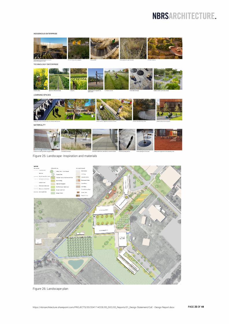
2.3 LANDSCAPE CONCEPT The landscape design for the Centre of Excellence in Agricultural Excellence responds to the existing site character, context and the school’s curriculum. The design accommodates 325 students through a variety of different sized outdoor spaces that offer shade, seating, informal recreation and learning moments. The design focuses on integrating outdoor learning into the landscape. This is evident through the following landscape spaces/uses.
• Kitchen gardens • Gardenesque crops • Technology enterprise • Indigenous enterprise • Garden orchards • Breakout spaces (lawn and foyer areas)
The school’s curriculum is set up by the landscape design in a way to provide beneficial outdoor learning spaces. The landscape will be used within the school’s curriculum by providing learning spaces and opportunities revolving around technology, production of food and indigenous culture. This is particularly evident in the Indigenous Enterprise and Technology Enterprise. The school will propagate agricultural plants, maintain and direct future compositions of these spaces. A robust pallet of materials, furniture and fixtures is selected in order to maintain a rural and robust aesthetic. The following is a summary of the elements selected for this project.
• Concrete plain and coloured • Pavers porous and decorative • Timber pergola (hardwood) • Insitu concrete benches and stools • Proprietary timber furniture • Decomposed granite
The planting design for the site is a combination of deciduous/exotic and natives compositions. The exotic species reflect upon the cultural significance of the site and the seasonality of agricultural enterprises. Whilst the native vegetation is sympathetic to the natural systems and connection to the pre-colonised landscape.
https://nbrsarchitecture.sharepoint.com/PROJECTS/20/20417 HCOE/05_DOC/02_Reports/01_Design Statement/CoE - Design Report.docx PAGE 25 OF 44
Figure 25: Landscape -Inspiration and materials
Figure 26: Landscape plan
https://nbrsarchitecture.sharepoint.com/PROJECTS/20/20417 HCOE/05_DOC/02_Reports/01_Design Statement/CoE - Design Report.docx PAGE 26 OF 44
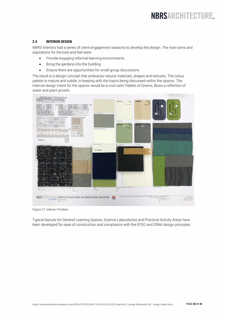
2.4 INTERIOR DESIGN NBRS Interiors had a series of client engagement sessions to develop the design. The main aims and aspirations for the look and feel were:
• Provide engaging informal learning environments • Bring the gardens into the building • Ensure there are opportunities for small group discussions
The result is a design concept that embraces natural materials, shapes and textures. The colour palette is mature and subtle, in keeping with the topics being discussed within the spaces. The Internal design intent for the spaces would be a cool calm Palette of Greens, Blues a reflection of water and plant growth.
Figure 27: Interior Finishes Typical layouts for General Learning Spaces, Science Laboratories and Practical Activity Areas have been developed for ease of construction and compliance with the EFSG and DfMA design principles

https://nbrsarchitecture.sharepoint.com/PROJECTS/20/20417 HCOE/05_DOC/02_Reports/01_Design Statement/CoE - Design Report.docx PAGE 27 OF 44
Figure 28: Interior furniture

https://nbrsarchitecture.sharepoint.com/PROJECTS/20/20417 HCOE/05_DOC/02_Reports/01_Design Statement/CoE - Design Report.docx PAGE 28 OF 44
2.5 SIGNAGE A signage has been developed for the project and the below signage items have been identified: Refer to Sheet 8500 in the architectural documentation for more details
Code Description
SGN01 Signage Wall (Dual language sign) Location: Vines Drive Engage Consultant: Design to completed by signage designer Guidelines: EFSG, WSU signage guide Stakeholder sign off: School, WSU and AECG Logo: School logo English Text: Centre of Excellence in Agricultural Education- Richmond Agricultural College'' Darug Languages text: TBA
SGN02 Totem Signage (Dual language sign) Location: Entry (gates near block A) Engage Consultant: Design to completed by signage designer Guidelines: EFSG, WSU signage guide Stakeholder sign off: School, AECG and Architect Logo: School logo English Text: Centre of Excellence in Agricultural Education- Richmond Agricultural College'' School information text: TBA Darug Languages text: TBA
SGN03 Colour Graphic Vinyl decal Location: Entry reception glass (block A) Engage Consultant: Design to completed by local Aboriginal Artist and printed and installed by signage contractor Stakeholder sign off: School, AECG and Architect Requirement: must meet AS1428.1 visual indicator requirements
SGN04 Colour Graphic Vinyl decal artwork print on wall (Dual language if required) Location: Block C north elevation Engage Consultant: Design to completed by local Aboriginal Artist and printed and installed by signage contractor Stakeholder sign off: School, AECG and Architect Graphic Theme: Aboriginal + Small signage section talking About Architecture project concept food bowl and weave, building design and ESD initiatives as learning aid. Darug Language text: TBA English text if required: TBA
SGN05 Colour Graphic Vinyl decal artwork print on wall (Dual language if required) Location: Block B north elevation Engage Consultant: Design to completed by local Aboriginal Artist and printed and installed by signage contractor Stakeholder sign off: School, AECG and Architect Graphic Theme: TBA Darug Language text: TBA English text if required: TBA
SGN06 Colour Graphic Vinyl decal to glass Location: Internal glazing to learnings spaces
https://nbrsarchitecture.sharepoint.com/PROJECTS/20/20417 HCOE/05_DOC/02_Reports/01_Design Statement/CoE - Design Report.docx PAGE 29 OF 44
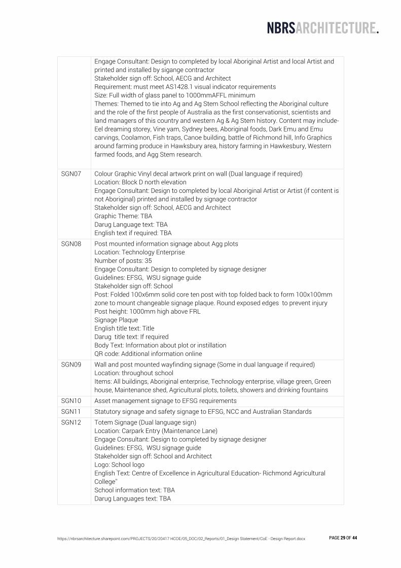
Engage Consultant: Design to completed by local Aboriginal Artist and local Artist and printed and installed by sigange contractor Stakeholder sign off: School, AECG and Architect Requirement: must meet AS1428.1 visual indicator requirements Size: Full width of glass panel to 1000mmAFFL minimum Themes: Themed to tie into Ag and Ag Stem School reflecting the Aboriginal culture and the role of the first people of Australia as the first conservationist, scientists and land managers of this country and western Ag & Ag Stem history. Content may include- Eel dreaming storey, Vine yam, Sydney bees, Aboriginal foods, Dark Emu and Emu carvings, Coolamon, Fish traps, Canoe building, battle of Richmond hill, Info Graphics around farming produce in Hawksbury area, history farming in Hawkesbury, Western farmed foods, and Agg Stem research.
SGN07 Colour Graphic Vinyl decal artwork print on wall (Dual language if required) Location: Block D north elevation Engage Consultant: Design to completed by local Aboriginal Artist or Artist (if content is not Aboriginal) printed and installed by signage contractor Stakeholder sign off: School, AECG and Architect Graphic Theme: TBA Darug Language text: TBA English text if required: TBA
SGN08 Post mounted information signage about Agg plots Location: Technology Enterprise Number of posts: 35 Engage Consultant: Design to completed by signage designer Guidelines: EFSG, WSU signage guide Stakeholder sign off: School Post: Folded 100x6mm solid core ten post with top folded back to form 100x100mm zone to mount changeable signage plaque. Round exposed edges to prevent injury Post height: 1000mm high above FRL Signage Plaque English title text: Title Darug title text: If required Body Text: Information about plot or instillation QR code: Additional information online
SGN09 Wall and post mounted wayfinding signage (Some in dual language if required) Location: throughout school Items: All buildings, Aboriginal enterprise, Technology enterprise, village green, Green house, Maintenance shed, Agricultural plots, toilets, showers and drinking fountains
SGN10 Asset management signage to EFSG requirements
SGN11 Statutory signage and safety signage to EFSG, NCC and Australian Standards
SGN12 Totem Signage (Dual language sign) Location: Carpark Entry (Maintenance Lane) Engage Consultant: Design to completed by signage designer Guidelines: EFSG, WSU signage guide Stakeholder sign off: School and Architect Logo: School logo English Text: Centre of Excellence in Agricultural Education- Richmond Agricultural College'' School information text: TBA Darug Languages text: TBA
https://nbrsarchitecture.sharepoint.com/PROJECTS/20/20417 HCOE/05_DOC/02_Reports/01_Design Statement/CoE - Design Report.docx PAGE 30 OF 44
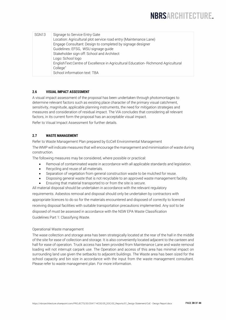
SGN13 Signage to Service Entry Gate Location: Agricultural plot service road entry (Maintenance Lane) Engage Consultant: Design to completed by signage designer Guidelines: EFSG, WSU signage guide Stakeholder sign off: School and Architect Logo: School logo EnglishText:Centre of Excellence in Agricultural Education- Richmond Agricultural College'' School information text: TBA
2.6 VISUAL IMPACT ASSESSMENT A visual impact assessment of the proposal has been undertaken through photomontages to determine relevant factors such as existing place character of the primary visual catchment, sensitivity, magnitude, applicable planning instruments, the need for mitigation strategies and measures and consideration of residual impact. The VIA concludes that considering all relevant factors, in its current form the proposal has an acceptable visual impact. Refer to Visual Impact Assessment for further details.
2.7 WASTE MANAGEMENT Refer to Waste Management Plan prepared by EcCell Environmental Management The WMP will indicate measures that will encourage the management and minimisation of waste during construction. The following measures may be considered, where possible or practical:
• Removal of contaminated waste in accordance with all applicable standards and legislation. • Recycling and reuse of all materials. • Separation of vegetation from general construction waste to be mulched for reuse. • Disposing general waste that is not recyclable to an approved waste management facility. • Ensuring that material transported to or from the site is secure.
All material disposal should be undertaken in accordance with the relevant regulatory requirements. Asbestos removal and disposal should only be undertaken by contractors with appropriate licences to do so for the materials encountered and disposed of correctly to licenced receiving disposal facilities with suitable transportation precautions implemented. Any soil to be disposed of must be assessed in accordance with the NSW EPA Waste Classification Guidelines Part 1: Classifying Waste. Operational Waste management The wase collection and storage area has been strategically located at the rear of the hall in the middle of the site for ease of collection and storage. It is also conveniently located adjacent to the canteen and hall for ease of operation. Truck access has been provided from Maintenance Lane and waste removal loading will not interrupt carpark use. The Operation and access of this area has minimal impact on surrounding land use given the setbacks to adjacent buildings. The Waste area has been sized for the school capacity and bin size in accordance with the input from the waste management consultant. Please refer to waste management plan. For more information.

https://nbrsarchitecture.sharepoint.com/PROJECTS/20/20417 HCOE/05_DOC/02_Reports/01_Design Statement/CoE - Design Report.docx PAGE 31 OF 44
2.8 CRIME PREVENTION THROUGH ENVIRONMENTAL DESIGN Crime Prevention through Environmental Design (CPTED) is a crime prevention strategy that focuses on the planning, design and structure of cities and neighbourhoods. It reduces opportunities for crime by using design and place management principles that reduce the likelihood of essential crime ingredients (law, offender, victim or target, opportunity) from intersecting in time and space. Predatory offenders often make cost-benefit assessment of potential victims and locations before committing crime. CPTED aims to create the reality (or perception) that the costs of committing crime are greater than the likely benefits. This is achieved by creating environmental and social conditions that:
• Maximise risk to offenders (increasing the likelihood of detection, challenge and apprehension);
• Maximise the effort required to commit crime (increasing the time, energy and resources required to commit crime);
• Minimise the actual and perceived benefits of crime (removing, minimising or concealing crime attractors and rewards); and
• Minimise excuse making opportunities (removing conditions that encourage/facilitate rationalisation of inappropriate behaviour).
CPTED employs four key strategies. These are territorial re-enforcement, surveillance, access control and space/activity management. All CPTED strategies aim to create the perception or reality of capable guardianship.
2.8.1 SAFER BY DESIGN EVALUATION The Safer by Design program commenced in NSW in the early 1990’s. The program is a co-operative initiative involving the NSW Police, local councils, government departments and key private sector organisations. The aim of the program is to ensure that development application proposals are routinely assessed for crime risk, and that preventable risk is reduced before the development is approved. The NSW Police assessment tools Safer By Design Evaluation and a Companion to the Safer By Design Evaluation are based upon Australian Risk Management Standard 4360:1999. The Safer By Design Evaluation process is a contextually flexible, transparent process that identifies and quantifies crime hazards and location risk. The evaluation measures include crime likelihood (statistical probability), consequence (crime outcome), distributions of reported crime (hotspot analysis), socio-economic conditions (relative disadvantage), situational hazards and crime opportunity. Crime, Design and Urban Planning: From theory to Practice The best time to apply this theory is in the design stage, before a building or neighbourhood is built. However, you can also successfully apply it later, but retro-fitting an existing environment can sometimes be costly. By conducting this process and using the Companion (which outlines research-based strategies capable of minimising crime risk within the built environment), NSW Police can suggest treatments to be considered in order to reduce opportunities for crime following CPTED principles of:
• Natural • Technical/Mechanical (low) • Organised (low)
2.8.2 TERRITORIAL RE-ENFORCEMENT Community ownership of public space sends positive signals to the community. Places that feel owned and cared for are likely to be used, enjoyed, and revisited. People who have guardianship or ownership of areas are more likely to provide effective supervision and to intervene in crime than passing strangers and criminals rarely commit crime in areas where

https://nbrsarchitecture.sharepoint.com/PROJECTS/20/20417 HCOE/05_DOC/02_Reports/01_Design Statement/CoE - Design Report.docx PAGE 32 OF 44
the risk of detection and challenge are high. Effective guardians are often ordinary people who are spatially ‘connected’ to a place and feel an association with, or responsibility for it. Territorial Re-enforcement uses actual and symbolic boundary markers, spatial legibility and environmental cues to ‘connect’ people with space, to encourage communal responsibility for public areas and facilities, and to communicate to people where they should/not be and what activities are appropriate.
2.8.3 SURVEILLANCE People feel safe in public areas when they can see and interact with others, particularly people connected with that space, such as shopkeepers or adjoining residents. Criminals are often deterred from committing crime in places that are well supervised. Natural surveillance is achieved when normal space users can see and be seen by others. This highlights the importance of building layout, orientation, and location; the strategic use of design; landscaping and lighting – it is a by-product of well-planned, well-designed and well-used space. Technical/mechanical surveillance is achieved through mechanical/electronic measures such as CCTV, help points and mirrored building panels. It is commonly used as a ‘patch’ to supervise isolated, high risk locations. Formal (or Organised) surveillance is achieved through the tactical positioning of guardians. An example would be the use of on-site supervisors, e.g. security guards at higher risk locations.
2.8.4 ACCESS CONTROL Access control treatments restrict, channel and encourage people and vehicles into, out of and around the development. Way-finding, desire-lines and formal/informal routes are important crime prevention considerations. Effective access control can be achieved by using physical and symbolic barriers that channel and group pedestrians into areas, therefore increasing the time and effort required for criminals to commit crime. Natural access control includes the tactical use of landforms and waterways features, design measures including building configuration; formal and informal pathways, landscaping, fencing and gardens. Technical/Mechanical access control includes the employment of security hardware. Crime, Design and Urban Planning: From theory to Practice Formal (or Organised) access control includes on-site guardians such as employed security officers. Formal (or Organised) access control includes on-site guardians such as employed security officers.
2.8.5 SPACE/ACTIVITY MANAGEMENT Space/Activity Management strategies are an important way to develop and maintain natural community control. Space management involves the formal supervision, control and care of the development. All space, even well planned and well-designed areas need to be effectively used and maintained to maximise community safety. Places that are infrequently used are commonly abused. There is a high correlation between urban decay, fear of crime and avoidance behaviour.
2.8.6 BUILDING GENERALLY
Performance Criteria
Design Requirements
Purpose/Explanation
Proposed Compliance

https://nbrsarchitecture.sharepoint.com/PROJECTS/20/20417 HCOE/05_DOC/02_Reports/01_Design Statement/CoE - Design Report.docx PAGE 33 OF 44
A. Avoid blind corners
Avoid blind corners in pathways, stairwells and carparks
Pathways should be direct. All barriers along pathways should be permeable. Consider the installation of mirrors to allow users to see ahead of them and around corners.
Blind corners' or concealed areas make people feel uneasy and unsafe. Not knowing 'what is around the next corner' can discourage genuine users of a space to use and maximise it.
Corridors have been kept to a minimum with open planning.
Yes
B. Communal Areas
Provide natural surveillance for communal and public areas
Position active uses or habitable rooms with windows adjacent to main communal/ public areas Communal areas and utilities should be easily seen. Where elevators or stairwells are provided, open style or transparent materials are encouraged on doors and/or walls of elevators/ stairwells. Waiting areas and entries to elevators / stairwells should be close to areas of active uses, and should be visible from the building entry. Seating should be located in areas of active uses.
Enables users of a space feel safe as they 'are not alone' in a secluded area. There is always the potential for someone to 'help' if there are any problems. Deters illegitimate users as their presence in and misuse of the space will be rapidly noticed.
All communal or public areas for people to gather in are positioned adjacent to highly active walkways or buildings. Windows or half height glazed partitions exist along the majority of corridors and walkways.
Yes
C. Entry Points
https://nbrsarchitecture.sharepoint.com/PROJECTS/20/20417 HCOE/05_DOC/02_Reports/01_Design Statement/CoE - Design Report.docx PAGE 34 OF 44
Provide entries which are clearly visible
Entrances should be at prominent positions. Design entrances to allow users to see in before entering.
Natural surveillance from street Users to feel safe and to easily access the area Emergency services to access the property rapidly
Glazed doors allow users to see in before entering. The drop off / pick up has a clear line of sight from the administration / clerical.
Yes
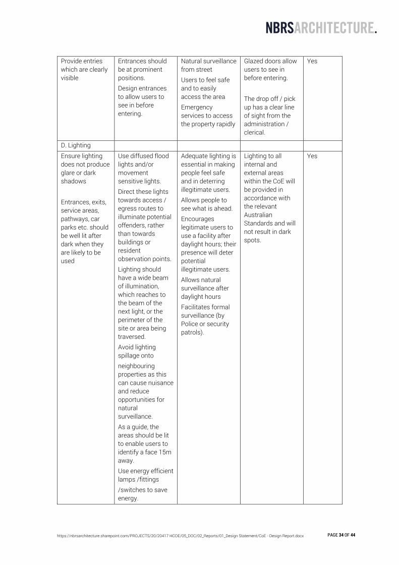
D. Lighting
Ensure lighting does not produce glare or dark shadows Entrances, exits, service areas, pathways, car parks etc. should be well lit after dark when they are likely to be used
Use diffused flood lights and/or movement sensitive lights. Direct these lights towards access / egress routes to illuminate potential offenders, rather than towards buildings or resident observation points. Lighting should have a wide beam of illumination, which reaches to the beam of the next light, or the perimeter of the site or area being traversed. Avoid lighting spillage onto neighbouring properties as this can cause nuisance and reduce opportunities for natural surveillance. As a guide, the areas should be lit to enable users to identify a face 15m away. Use energy efficient lamps /fittings /switches to save energy.
Adequate lighting is essential in making people feel safe and in deterring illegitimate users. Allows people to see what is ahead. Encourages legitimate users to use a facility after daylight hours; their presence will deter potential illegitimate users. Allows natural surveillance after daylight hours Facilitates formal surveillance (by Police or security patrols).
Lighting to all internal and external areas within the CoE will be provided in accordance with the relevant Australian Standards and will not result in dark spots.
Yes
https://nbrsarchitecture.sharepoint.com/PROJECTS/20/20417 HCOE/05_DOC/02_Reports/01_Design Statement/CoE - Design Report.docx PAGE 35 OF 44
E. Security
Security grilles, shutters and doors should allow natural observation of the street and be sympathetic to the architectural style of the building
Security grilles and security doors should be permeable Avoid solid shutters on front windows and doors.
Traditional security related equipment will help make a space more difficult for intruders to break into, however its overuse may impinge on adequate levels of natural surveillance.
If security grilles are required, they will be visually permeable
Yes
2.8.7 ACCESS CONTROL
Performance Criteria
Design Requirements
Purpose/Explanation
Proposed Compliance
A. Building Identification
Ensure buildings are clearly identified by street number.
Street/building numbers should be at least 7cm high, and positioned between 0.6m and 1.5m above ground level on the street frontage. Street/building numbers should be made of durable materials, preferably reflective or luminous, and unobstructed. Location maps and directional signage should be provided for larger development.
Clear building identification prevents unintended access and assists persons trying to find the building - particularly emergency vehicles in an urgent situation.
The address and name of the facility will be prominently displayed on Vines Drive and Building numbers will be made of durable materials, preferably reflective or luminous, and unobstructed. They will be located at the entrance or close to the main entry to the facility on Vines Drive.
Yes
B. Entry Points
Clear entry points Entrances should be recognisable through design
Clear entries avoid confusion Assist emergency personnel
Directional signage located at the entries and exits for the ease of users.
Yes
https://nbrsarchitecture.sharepoint.com/PROJECTS/20/20417 HCOE/05_DOC/02_Reports/01_Design Statement/CoE - Design Report.docx PAGE 36 OF 44
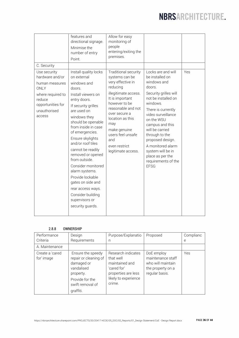
features and directional signage. Minimise the number of entry Point.
Allow for easy monitoring of people entering/exiting the premises.
C. Security
Use security hardware and/or human measures ONLY where required to reduce opportunities for unauthorised access
Install quality locks on external windows and doors. Install viewers on entry doors. If security grilles are used on windows they should be openable from inside in case of emergencies. Ensure skylights and/or roof tiles cannot be readily removed or opened from outside. Consider monitored alarm systems. Provide lockable gates on side and rear access ways. Consider building supervisors or security guards.
Traditional security systems can be very effective in reducing illegitimate access. It is important however to be reasonable and not over secure a location as this may make genuine users feel unsafe and even restrict legitimate access.
Locks are and will be installed on windows and doors. Security grilles will not be installed on windows. There is currently video surveillance on the WSU campus and this will be carried through to the proposed design. A monitored alarm system will be in place as per the requirements of the EFSG
Yes
2.8.8 OWNERSHIP
Performance Criteria
Design Requirements
Purpose/Explanation
Proposed Compliance
A. Maintenance
Create a 'cared for' image
Ensure the speedy repair or cleaning of damaged or vandalised property. Provide for the swift removal of graffiti.
Research indicates that well maintained and 'cared for' properties are less likely to experience crime.
DoE employ maintenance staff who will maintain the property on a regular basis.
Yes

https://nbrsarchitecture.sharepoint.com/PROJECTS/20/20417 HCOE/05_DOC/02_Reports/01_Design Statement/CoE - Design Report.docx PAGE 37 OF 44
Provide information advising where to go for help and how to report maintenance or vandalism problems.
B. Materials
Use materials which reduce the opportunity for vandalism
Strong, wear resistant laminate, impervious glazed ceramics, treated masonry products, stainless steel materials, anti-graffiti paints and clear over sprays will reduce the opportunity for vandalism. Flat or porous finishes should be avoided in areas where graffiti is likely to be a problem. External lighting should be vandal resistant. High mounted and/or protected lights are less susceptible to vandalism. Communal/ street furniture should be made of hard-wearing vandal resistant materials and secured by sturdy anchor points or removed after hours.
A reduction in vandalism through careful selection of materials will contribute to beautifying and maintaining an area. This will reduce expenditure on unscheduled maintenance.
Anti-graffiti products will be used where an opportunity is provided.
Yes
C. Spaces
Spaces should be clearly defined to express a sense of
Physical and/or psychological barriers can be
The definition of clear boundaries
All spaces will be clearly identified with appropriate signage and
Yes
https://nbrsarchitecture.sharepoint.com/PROJECTS/20/20417 HCOE/05_DOC/02_Reports/01_Design Statement/CoE - Design Report.docx PAGE 38 OF 44
ownership and reduce illegitimate use/entry.
used to define different spaces.
Allows people to know when they are trespassing on private property. Passers-by to clearly identify when someone is trespassing and illegally using the premises.
physical delineation (eg. fencing, landscape treatment etc)
D. Pride + Involvement
Encourage design that promotes pride and a sense of place for community
Encourage community involvement in design, volunteer management and maintenance of areas and community use of areas.
A sense of community pride in a particular area will help maintain an area. Identify and report any problems. Identify illegitimate behaviour.
DoE employ maintenance staff who will maintain and monitor the property.
Yes
2.9 GOVERNMENT ARCHITECTS NSW FEEDBACK The project was presented to the Government Architect NSW (GANSW) on the 10th March 2021. The aim of the design review session was to demonstrate the strategy for achieving design excellence, in accordance with Schedule 4 Schools design quality principles of State Environmental Planning Policy (Education and Child Care Facilities) 2017. The design feedback is summarised below: The following elements of the design approach are supported, in particular:
• The intention to establish a low‐scale rural typology for the built form. • The intention to create a strong presence and connection to the existing WSU Campus. • The intention to prioritise pedestrian amenity. • The use of landscape species that are endemic to the site.
The following commentary provides advice and recommendations for the project: • Connection with Country
An understanding of Country can inform richer and more place responsive design solutions. The following recommendations apply:
1. Demonstrate how engagement with Traditional Custodians, including Indigenous parents and local organisations has informed a meaningful approach to Country. Consider opportunities for participatory design.
2. Anchor the connection to Country by allowing the cultural complexities of the floodplain’s history, which culminated in the Battle of Richmond Hill, to inform the design approach. Consider the role of food in this history and how stories might be woven into the Centre’s fabric, practices, operation, and pedagogy.

https://nbrsarchitecture.sharepoint.com/PROJECTS/20/20417 HCOE/05_DOC/02_Reports/01_Design Statement/CoE - Design Report.docx PAGE 39 OF 44
3. Incorporating the Aboriginal Enterprise focused teaching area and indigenous planting with the school’s pedagogical approach is commended. The location of the facilities, however, feels singular and disconnected from the rest of the centre and its processes. Demonstrate how Indigenous Culture and Heritage can be integrated with the architectural and landscape design strategy in a more holistic way: for example opportunities for practices & processes (including foraging), naming, the incorporation of stories and history, massing, materiality, form, circulation and movement, landscape, plant selection, art installations/murals, wayfinding devices, play equipment, paving, colour and texture.
• Connectivity and Access
As articulated by the design team, the concept layout has the potential to develop a strong link to the WSU campus. As yet, this potential is not demonstrated and the site’s connectivity to the campus and broader community is unrealised. The project has the potential to act as catalyst to improve the broader campus’ lack of pedestrian and cycle amenity and connectivity with the wider community and active networks. The following is recommended:
1. The road network is not conducive to cycle safety. Provide an analysis of how students will access the centre and connect with relevant WSU campus facilities. This will include an analysis of the pedestrian and cycle experience and sequence of movement. The results will support the development of targeted strategies for improving the site’s connectivity with the campus and community, and the prioritisation of pedestrian and cycle safety.
2. Create safe, accessible and legible connections with public transport. 3. Provide undercover bike parking in the vicinity of the school entrance. 4. Strengthen the amenity, quality and legibility of circulation along the northsouth axis
and connection with the campus to the north. Consider: space allocation, landscaping, accessibility, safety and/or other strategies.
5. Work has been undertaken to provide a level surface between the village green and adjoining built form. Demonstrate how the school, its pathways and buildings are accessible and inclusive to people with different needs and capabilities.
• Masterplan and Landscape There is an opportunity to develop the masterplan to amplify the site’s rural character and embed a systems‐based approach to inform a richer and more place responsive scheme. The following is recommended:
1. Demonstrate how the centre’s agricultural purpose and operational functions have informed the site strategy and pedagogical approach. Address the following:
a) water sensitive urban design, including management, detention and reuse across the site. Consider how the dam(s), creek and/or swales might inform the site strategy, while ensuring student safety.
b) climate conditions: prevailing winds, the mitigation of seasonal temperature variations, (consider landscape buffers, canopy cover and distribution and species selection).
c) landscape characteristics: contours, soil type d) agricultural principles including regenerative farming principles e) incorporation of future technologies f) opportunities for foraging, for example along fencing. g) structured use of planting to define edges, buffers (perhaps to supplant traditional fencing) h) agricultural infrastructure: potting and tool sheds, manure, structural planting, fencing,
paddocks, orchards, grazing, vehicular access.
https://nbrsarchitecture.sharepoint.com/PROJECTS/20/20417 HCOE/05_DOC/02_Reports/01_Design Statement/CoE - Design Report.docx PAGE 40 OF 44
2. Investigate best practice approaches to improving the site’s ecology. 3. Integrate the site’s remnant vegetation into the landscape strategy. 4. Explore how a rich connection with the landscape might support an ambitious sustainability
strategy. 5. Maximise tree retention. Provide an arborist assessment that indicates the 6. significance of existing trees and a drawing that identifies trees to be retained, 7. removed and new trees proposed. 8. Maximise tree canopy for biodiversity, shade and amenity. Increase the tree canopy along site
boundaries, within and surrounding carparks, and along walkways. Consider a double avenue of trees in certain locations to provide strength and definition, maximise shade, minimise surface temperatures, and provide windbreaks.
9. Maximise the site’s permeable surfaces, including carparks and the village green. 10. Explore opportunities to amplify the varied character of the outdoor spaces so that they
might reflect and integrate the needs of the different uses and adjacencies. There is an opportunity for the accommodation in Block ‘F’ to better frame and define the adjoining agricultural plot to its south.
• Buildings 1. The expression of the built form was noted as preliminary. In developing the architecture,
consider the character, material, and spatial quality of the interstitial spaces between buildings, including edges and transitions. These should be viewed as an opportunity to mediate the external climate and gain additional active and passive learning space for students with the dining, hall and functions of the centre.
2. The location of the commercial kitchen in Block ‘C’ appears disconnected from relevant functions within the site. Revisit the location and configuration of the kitchen to allow for greater integration, communication and coordination with the dining and hall in Block ‘H’ and the agricultural processes across the site.
In response to the feedback received from the GANSW, the project team undertook the below measures:
• Connection with Country Consultation with the AECG (Durag) regarding the use and integration of the aboriginal enterprise for learning outcomes, way finding and integrating artwork into the architecture.
• Connectivity and Access A traffic management report has been prepared since the GANSW presentation which address the concerns raised. A green travel plan is also being established for public transport / cycling systems focusing on student safety.
• Masterplan and Landscape The masterplan for the landscaping has developed with a focus on the local rural character of the area with ensuring the design integrates well with the learning outcomes of the school. The on site detention dams will be used to irrigate the agricultural plots. Minimal trees are being removed this is outlined further in the Arborist Report A tree planting / finishes schedule developed to show the biodiversity, shade and amenity
• Buildings The development from concept to schematic design has seen the built form, character and materiality transition into a comfortable solution for the client.

https://nbrsarchitecture.sharepoint.com/PROJECTS/20/20417 HCOE/05_DOC/02_Reports/01_Design Statement/CoE - Design Report.docx PAGE 41 OF 44
Buildings have been designed for active and passive learning with each General Learning Space including the dining hall opening out to a landscaped area. The location of semi-commercial kitchen works with the pedagogy of the school and is connected to other learning areas. The dining facilities are supported by a canteen / kitchen which operationally is very separate from the semi-commercial learning kitchen.
2.10 WSU CONSULTATION Throughout the design process, the project team undertook fortnightly design workshops with Western Sydney University of which the below items were discussed:
• Leased Line • Location of utility services • Built Form and Materiality • Access / Traffic
2.11 COMMUNITY CONSULTATION In preparation for the SSD application, the project team undertook community consultation with (Richmond High School community and greater Richmond Area), SINSW, WSU, Transport NSW and Government Architects Review Panel. For further detail about of the consultations, refer to the Community Feedback Report.
Continued engagement will take place with stakeholders and communities during the statutory exhibition of the SSDA, as well as during future stages of the planning and development process.
School Infrastructure NSW will continue to update the project webpage and produce updates at key project stages for stakeholders and communities.

https://nbrsarchitecture.sharepoint.com/PROJECTS/20/20417 HCOE/05_DOC/02_Reports/01_Design Statement/CoE - Design Report.docx PAGE 42 OF 44
3.0 DESIGN PRINCIPLES 3.1 PRINCIPLE 1 – CONTEXT, BUILT FORM AND LANDSCAPE
Communication through architecture by being mindful of the existing site conditions, transport, demographic and local schools. Respecting the areas sense of place within the existing WSU campus and streetscape. This will provide a space for children within the local community and WSU campus. The CoE buildings will be single storey set within a gardenesque landscape which is reflected by the existing 1-2 storey buildings elsewhere on the existing WSU campus.
3.2 PRINCIPLE 2 – SUSTAINABLE, EFFICIENT AND DURABLE
Environmental sustainability is vital in the design of schools, with natural lighting and ventilation to maximize learning opportunities. It is understood that natural light is critical in the circadian rhythm of the human body in adjusting to day and night conditions, this informing routine, which is vital in the structure of a child’s day. The materiality of the building is driven by locally sourced materials used in an authentic manner to underpin the DoE’s commitment and investment into enhancing the environment and a pursuit of design excellence to provide a world class teaching facility. The School will be constructed of durable, resilient, and adaptable materials which will preserve their look and feel over time and have timeless and durable qualities, to ensure they knit into the existing community. The Solar shading - created through metal framed eaves - will control solar gain, while the timber look panels will add warmth and texture. Integrated landscaping strategies soften the architectural composition, with planting enhancing the public facing areas.
3.3 PRINCIPLE 3 – ACCESS AND INCLUSIVE
Different environments accessed via ramps encourage spontaneous, voluntary and joyful learning opportunities for students to explore and interact with their peers and the world around them. This provokes way finding between indoor learning areas, intimate courtyards, outdoor play areas, vegetable gardens and breakout spaces promoting learning activities for team work and hands on experiences. The design aims to offer various universal access routes in order to avoid unnecessary congestion. The design ensures that there is always an alternative ramped access into the building and that access routes to/from the agriculture are visible and welcoming, making the way finding strategy intuitive rather than prescriptive.

https://nbrsarchitecture.sharepoint.com/PROJECTS/20/20417 HCOE/05_DOC/02_Reports/01_Design Statement/CoE - Design Report.docx PAGE 43 OF 44
3.4 PRINCIPLE 4 – HEALTH AND SAFETY
Safety, access and connection are critical in providing a welcoming and secure place for students. Landscaped areas and materials have been considered to minimise safety risks, safety gates control access and open areas promote sight lines and passive surveillance. The development has been designed following Crime Prevention through Environmental Design (CPTED) strategy principles. The design aspires to create a safe pedestrian route for students, staff and members of the WSU community along Vines Drive with footpaths on both sides of the road and frequent pedestrian crossings
3.5 PRINCIPLE 5 – AMENITY
The most beneficial relationships between children are grounded in equality, learning and gaining insight from each other. There is a need for a variety of learning styles, thus sensory indoor spaces and experiences should be encouraged. In this way many modes of learning are valued including verbal, visual, kinaesthetic, logical, tactile and rhythmic The design will provide socially and environmentally responsive solutions creating a pleasant and engaging spaces internally and externally. The design provides a variety of learning modes through flexibility of spatial arrangement, agile furniture, interactive indoor / outdoor environments that allow for individual, teamwork and gathering forms of learning.
3.6 PRINCIPLE 6 – WHOLE OF LIFE, FLEXIBILITY AND ADAPTION
Adaptability is a response to evolving learning outcomes. The students needs can be supported by the manipulation of fixtures and furnishings. It addresses the ability for multi modal spaces to become efficient and personal environments. Catering for students to be free in their learning experience. All the general learning areas and laboratories all open to a practical activities area. Learning spaces also have sliding door connections between them to encourage super lab / combined teaching arrangement.
https://nbrsarchitecture.sharepoint.com/PROJECTS/20/20417 HCOE/05_DOC/02_Reports/01_Design Statement/CoE - Design Report.docx PAGE 44 OF 44
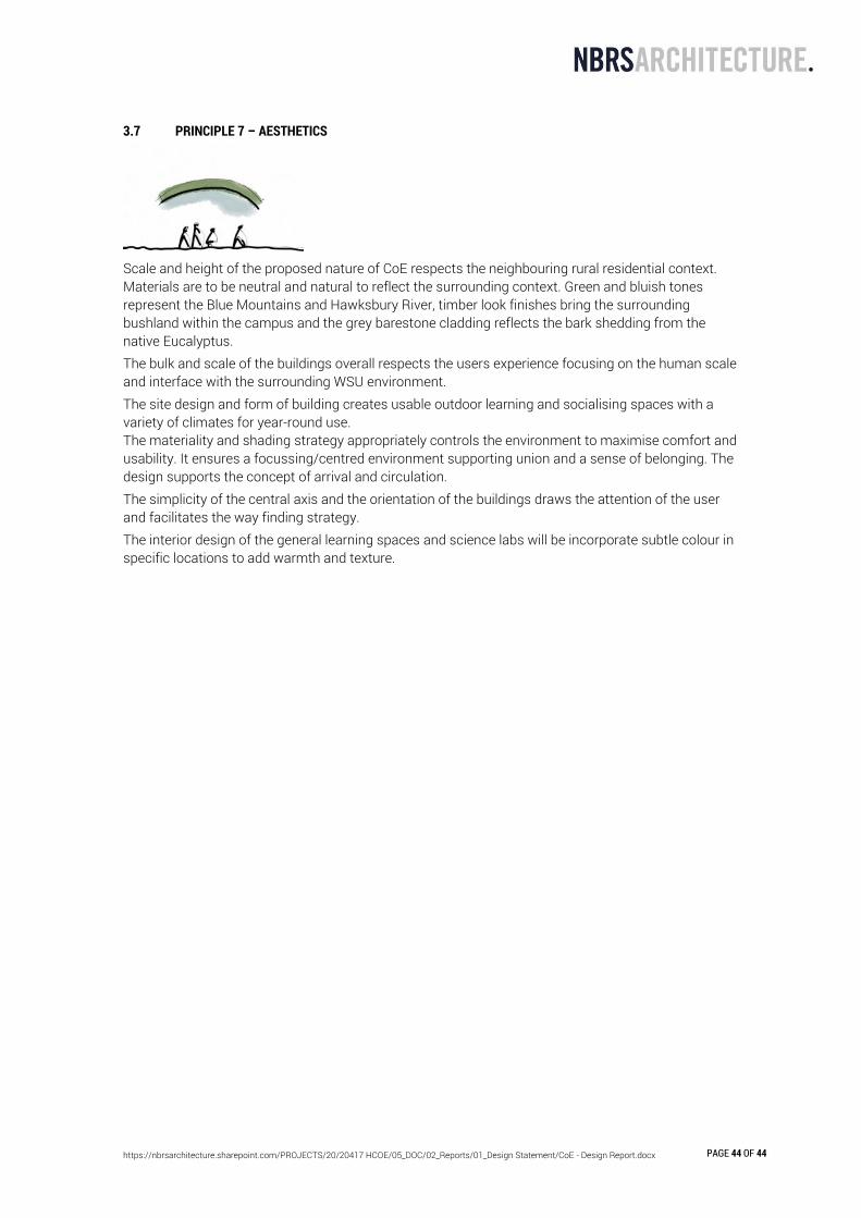
3.7 PRINCIPLE 7 – AESTHETICS
Scale and height of the proposed nature of CoE respects the neighbouring rural residential context. Materials are to be neutral and natural to reflect the surrounding context. Green and bluish tones represent the Blue Mountains and Hawksbury River, timber look finishes bring the surrounding bushland within the campus and the grey barestone cladding reflects the bark shedding from the native Eucalyptus. The bulk and scale of the buildings overall respects the users experience focusing on the human scale and interface with the surrounding WSU environment. The site design and form of building creates usable outdoor learning and socialising spaces with a variety of climates for year-round use. The materiality and shading strategy appropriately controls the environment to maximise comfort and usability. It ensures a focussing/centred environment supporting union and a sense of belonging. The design supports the concept of arrival and circulation. The simplicity of the central axis and the orientation of the buildings draws the attention of the user and facilitates the way finding strategy. The interior design of the general learning spaces and science labs will be incorporate subtle colour in specific locations to add warmth and texture.