archival evaluation ne w or pean siana( orelan s … · ad-a121 74 archival evaluation 0 dfoodwal...
TRANSCRIPT

AD-A121 74 ARCHIVAL EVALUATION 0 DFOODWAL ALIGNMENTS NE WOR PEAN 5 OUT SIANA( U )REEVE SALL K AND WILLAM 0) NEWORELAN S LA S K REI EE ET AL 22 0 CT82
UNCLASSIFE O AWW9- _1 9 /6 N L

LU Q
tu 1.0 ha __
1111.25 1 4 LIA6
MICROCOPY RESOLUTION TEST CHART
NATIONAL BUREAU OF STANDARDS- 1963-A
NO. 218

Report One
ARCHIVAL EVALUATION OF FLOODWALL ALIGNMENTS
New Orleans, Louisiana
Sally K. ReevesWilliam D. Reeves5801 St. Charles AvenueNew Orleans, Louisiana 70115
October 22, 1982
Interim Report for Period August 25, 1982 - October 22, 1982
Prepared for Q1' r' T J2- 1" |Nov 2 198?
Cultural Resources SectionUSA Engineer District, N.O.P.O. Box 60267, Foot of Prytania Street ANew Orleans, Louisiana 70160
l t has been approg
r Public release and sale; itsdistribution is unlimit.&

SECURITY CLASS#IFICATION OF THIS PAGIE M(3B Date Iffia,.e
REPORT DOCUMENTATION PAGE 33703 COMPTUIG ,
IREPORT HUME 2. GOVT ACICESSION NO: 11. RIECIPIENTS CAALO HUMMER
q. One4. ~~I TITL (adS"ld S. TiPE OF REPORT & PERIO0 COVERED
Archival Evaluation of Floodwall Draft Interim j
Alignments: New Orleans, Louisiana Aug. 25-Oct,.22,'19826PERFORMING OR.REPORT NUMBER
___________________________________ One7. AUTNOR(i) 11. CONTRACT OR GRANT NUMUIERtO)
Sally K. and William D. Reeves DACW29-82-M-1980
9. PERFORMING ORGANIZATION NAME AND ADDRESS 10. PROGRAM KLEMENT. PROJE6CT, TASM
Sally K. and William D. ReevesAa OIUNTUM.0
5801 St. Charles AvenueNew Orleans, La. 70115 ___________
1t. CONTROLLING OFFICE NAME AND ADDRESS 12. REPORT DATEUSA Engineer Distri .ct, N.O. October 22, 1982P. 0. Box 60267, Foot of Prytania Street IS. NUM§ER OFPPAGES
NwOrleans, La. 70160 MIF: Planning DI-V1.MONITORING AGENCY NAME 4k ADDRESS(If d~fofat Iar Cntrollbid 0111") 15. SECURITY CLASS. (of MIS "POO
I~.gC~SIICATIONDOWNGRADING
16. DISTRIBIUTION STATEMENT (of Uife Rbport)
17. DISTRIIBUTION STATEMENT (of the abftract entered in mtock It. ifl,rn tre, Root)
18. SUPPLEMENTARY NOTES
S IS9. KEY WORDS (Continuoaon rovera. aide It necoaamy onE identif by Meok mumbo)
2L ABSTACT' m ff nmm ad o m~Ir 6F Meek .MMb0i
ireport identifies and evaluates significantstructures formerly on the site of the proposed Floodvall forNew Orleans, Louisiana between Louisiana Avenue and JacksonAvenue. Research to date has identified only four sawmills andthe levee on the site prior to 1830. Between 1830 and 1860 thesite blossomed with large and small homes occupied mainly byTartisans and immigrants along with brick warehouses. kove)
Fom , 3 amma or I mv asm ee9InsM1Iu
SEU1T -wMFCAH OF -t PA

/C7UP4TY CLAWZF|PCATOW OF THIS PAGE(II Da Eiqe
20. The site was part of the City of Lafayette, a center ofGerman settlement near the river. After the Civil War the sitecontinued to reflect the commercial base of the New Orleanseconomy These major estalishments--the Lafayette Brewery,Louisian Brewery, and the New Orleans Elevator and WarehouseCompany r flected commerce directed to the local population orto the poit. The latter was the first and largest grainelevator oits type in New Orleans for several decades.
'-)esidential use on the site generally declinedafter the Civil War. Towards the end of the 19th centuryseveral new companies located on the site, including afertilizer and paint company, and a shippingi ompany. Increasinglyland along the riverfront in the area was used for-co ;rcialstorage, staveyards, lumber yards, and salt warehousin-. About1908 the City of New Orleans acquired the site for the publicbelt railroad right of way and all buildings were cleared.
The area's significance lies primarily in itsreflection of the New Orleans' economic base, and its functionas a first clustering area for German immigrants. The lack ofindustrial growth and continued use in commerce rather thanindustry is a test of New Orleans historic failure to developa manufacturing base for its economy.
-~- SmUPmTY CLA8SiPICATION OP THIS PA09MAR Dlee t-
- w-

TABLE OF CONTENTS
Introduction ............. ° ...... ............ l
Square 3 District 4 ....... .............. ..9
Square 4 District 4. ........ .......... . 12
Square 8 District 4 .................................. ee
Square 10 District 4 ... ................... 19
Square 11 District 4 ..... . ................. . ......... 22
Square 12 District 4..... .. ......... ........ ....... ...25
Square 13 District 4............... ceec...... ....... .29
Square 14 District 4 ................... ........ 66
Square 15 District 4..................5
Square 16A District 4 .......................... ° ...... 66
Square 99A District 6.......... .......... .. c..... 69
Bibliography.................. c .. c... .......... 72
001,
L

I NTRODUCTION
The New Orleans Mississippi River floodwall designed
to protect the city from high river water and hurricane surges
will stretch from Louisiana Avenue to the Industrial Canal on
the east bank. The first phase of construction begins at Loui-
siana Avenue and extends downriver to Jackson Avenue. It cros-
ses the waterfront area of New Orleans' Garden District, which
became a suburb of New Orleans during the first third of the
nineteenth century after development of the omnibus system of
transportation and the Pontchartrain Railroad on present St.
Charles Avenue made commuting to the old city possible.
This Garden District of New Orleans earned its fragrant
reputation in the early 19th century as subdivisions spreading
upriver from the city met a unique combination of circumstan-
ces. The first was a sudden improvement in the quality of the
soil, a result of the McCarty Crevasse that spilled vast quan-
tities of fertile river soil across the upriver area of the
* city. The second was the popularity of a new style of suburban
life that opened residential patterns to free standing arrange-
ments with open views and houses placed amidst large lots.
The third factor was a booming prosperity that prompted the
suburban dweller to emulate the planter by growing gardens
about the main house.
Closer to the riverfront, however, the residential
area filled with the homes and shops of immigrant artisans and
laborers who lived near their place of work. At the river's

T Floodwall Study: Louisiana to Jackson
edge on the water side of Levee (tchoupitoulas) Street ware-
houses sproutea in response to the development of wharves
serving the port of New Orleans.
The Garden District evolved out of an area serving
the city as part of its agricultural hinterland. Much of the
region was the plantation of the Livaudais family, whose Louis-
iana progenitor Jacques Enoul Livaudais came to the colony
during the French regime as a military officer. Livaudais'
son (born in 1735) married well, to Charlotte Chauvin de Lery
des Islets in 1763 [Kernion, p. 22]. In 1769, the son, Jacques
Enoul Livaudais, fils, purchased the tract that came to be
called Livaudais plantation. It extended from present Harmony
Street downriver to just below First Street.
At the time Jacques Livaudais was an inactive military
officer receiving only half pay. He purchased the plantation
from Augustin Chantalou, a Royal Notary and Chief Secretary of
the Council (Chantalou bought from LeMarquis). Chantalou might
very well have learned that a large Spanish army was being
prepared to seize Louisiana from a rebellious Council and
decided to dispose of some property. The Spanish government
indeed took possession of Louisiana the year that Chantalou
sold to Livaudias, 1769 [Dart, 1938, 674-676].
The plantation at the time of Livaudais' purchase
was planted in indigo and consisted of eleven and a half ar-
pents' front on the river by forty arpents in depth. It had a
". residence, at which Livaudais declared he would live, and the
2

Floodwall Study: Louisiana to Jackson
sale included twenty-five slaves, one hundred barrels of corn,
and tools, all for 45,000 livres [Ihid.].
Livaudais purchased the plantation on terms, putting
down only $4,705 livres, or just over ten percent of the cost.
He was to pay the balance in indigo each year between November
1 and 8 at the rate of 2,000 lbs. for 1769, 1770, 1771, and
1772. In 1773 he was to pay 984 lbs. of indigo for the balance,
and thus was to pay out the debt in four years. Each pound of
indigo was valued for this transaction at 4.5 livres. Curi-
ously, in spite of the very specific payment schedule, fully
eleven years later Livaudais had paid only 26,000 livres of the
debt, something over half [Ibid.]. This suggests that the
vendor was rather relaxed in demanding payment, and that the
indigo crop was poor.
Jacques Livaudais served as the Commandant for the
Upper Suburbs of New Orleans for a long period of time exten-
ding from the 1790s to past 1807. He died in 1816 [Padgett,
675732; New Orleans Public Library, Old Inventories].
Livaudais' son was Jacques Francois Enoul de
Livaudais, captain of militia, lieutenant-colonel in the colo-
nial troops, and later president of the Louisiana state senate.
Born about 1772, he signed a marriage contract on November 1797
and married Marie Celeste de Marigny de Mandeville, daughter of
Pierre Philippe de Marigny de Mandeville. He was reputed to be
the richest man of his day in Louisiana, and played host to the
Duc d'Orleans, later Louis Philippe, King of France, and his
3
V.Floodwall Study: Louisiana to Jackson
two brothers in 1798 (Holmes, 202; Pedro Pedesclaux, vol. 30,
p. 659]. Jacques Francois died on April 9, 1850.
Jacques Francois' brother was Jacques Philippe Enoul
Dugue Livaudais [1779-1836, wife--Rose Victoire Voisin]. The
Cabildo elected him Petty Judge for the West Bank on Jan. 7,
1803. He served with his brothers in the Volunteers of the
Mississippi regiment of the Louisiana militia [Holmes, 1965,
203]. A third brother was Francisco Enoul Livaudais, born c.
1776 [Holmes, 1965, 202].
As the new century turned Jacques Enoul Dugue Livau-
dais' plantation had expanded to sixteen arpents and began
about two miles above New Orleans. It was now planted in sugar.
In 1805 Livaudias added three arpents purchased from Joseph
Wiltz, his upriver neighbor, for $6,000 cash [Pierre
Pedesclaux, 5/2/05].
The earliest map found of this stretch of the river
showing the Livaudais plantation was prepared by Major A. La
Carriere Latour in 1815, titled *Map Shewing the Landing of the
British Army..." This delineation of the senior Livaudais
plantation the year before the owner's death shows a prosperous
establishment with sixteen slave cabins, a main house, detached
kitchen and various other outbuildings. None of these struc-
tures appear to be close enough to the river to abut the flood-
wall right-of-way.
At Livaudais' death in 1816 his son Jacques Francois
Enoul Livaudais inherited his plantation. What he didn't inher-
4

Floodwall Study: Louisiana to Jackson
it he purchased in 1818 from his brothers--3 arpents and 18
toises at the lower end of the tract [Marc Lafitte, vol 13, p.
341, 7/7/18].
In 1822 Jacques Livaudais disposed of his upper three
arpents (from today's Toledano St. to Harmony), retaining a
portion of the uppermost arpent. The sale did include all of
the batture in front of the three arpents. The buyer was Guy
Dupldntier, who had a verbal agreement with Valery Jean
Delassize and the widow of Louis Avart to operate a brickyard
on the site [Marc Lafitte, 12/30/22]. This was Livaudais" first
reduction of agricultural acreage, coming at a transitional
time when the larger economy of New Orleans was changing in
force from an agrarian to a commercial base. Present research
has not positively sited the brickyard, and it is unclear
whether it lies in the floodwall right-of-way.
In 1825 Duplantier sold his interest in the brickmak-
ing company to Widow Avart and Delassize [Phillipe Pedesclaux,
1/20/251. The following year Livaudais sold the retained por-
tion of the uppermost arpent to Valery Jean Delassize, who
apparently lived there. This property remained intact until
1842 when it was subdivided by Benjamin Buisson (7/24/42). The
Buisson plan shows a plantation house with gardens in front,
all between Chippewa and Jersey Streets in the slice of land
behind Square 16, bounded by Toledano and Pleasant (Plan book
11, folio 13). This is not in the right-of-way.
4About 1818 Jacques Livaudais and his wife began
~5

J .46 -~
.1 *1 '
., 1. X
of2 s a1 V awI no &A,~ VI
Th hoeo aeyJenDlsie
182 to14.Ti poet a
reandbyLvuai mte saloftreapnst ulniri
Pla of Bej uson 144

I Study: Louisiana to Jackson
tion of an elaborate new home in the middle of their
on. It was located in the present square bounded by
on and Sixth, Tchoupitoulas and Fulton, facing theit set back. Work on the house progressed slowly. During
te the marriage of over twenty years evidently gradually
1. The house was never finished and ended up as an
:uriosity in the neighbohood, the "haunted house of
.e,
The Succession of Marie Therese Livaudais, free woman
, hints at a possible cause for the Livaudais' marriage
At Ms. Livaudais' death in 1836 she owned a lot in
i Annunciation which she acquired from Jacques Francois
vaudais on September 17, 1818 [Old Inventories, NOPL,
1833-38]. Marie Therese Livaudais had four minor chil-
.h a surname different from her own.
City inventories yield yet another inventory that
a sadder story. In 1819 Jacques Francois reported that
Charles Octave Livaudais was missing, and requested an
y of his estate. Charles Octave resided at a house at
er of Ursulines and Treme belonging to Rita Lugar,frmma
uL libre, in an area known for miscegenetic households.
he items in the inventory were a porcelaine service,
overs of silver, and a pair of dueling swords. Perhaps
udais family was incohesive.
With the present information it is not possible to
e what prompted Madame Livaudais to abandon her hus-
6
Floodwall Study: Louisiana to Jackson
band, but on June 28, 1825, represented by her attorney Etienne
Mazureaux, she won a judgment of separation made final on
December 5, 1825 after Livaudais refused to appear or respond.
The court awarded the plantation to Madame Livaudais. It was
described as a sugar plantation with 70 slaves, 170,000 bricks,
80 cows and the usual dependencies [Marc Lafitte 1/25/18261.
Mrs. Marie Celeste Marigny Livaudais left New
Orleans and moved to Paris, where she lived out her life in
high social circles as a member of the coterie of King Louis
Philippe [Samuel, 1961,10]. In 1832 she sold Plantation
Livaudais to four Americain developers, and Faubourg Livaudais
was born. With its birth died one of the last agricultural
regions on the New Orleans riverfront.
Matthew Morgan, Samuel Jarvis Peters, Pierce Levi, and
William Henry Chase acquired the plantation in February, 1832
[L.T.Caire 2-24-32]. The property then began to reflect for the
first time the commercial and residential growth of the New
Orleans port. It took substantial capital for Morgan, Peters,
Pierce, and Chase to purchase the Livaudais property. These
American entrepreneurs however had enough business contacts to
raise the capital. They were the "booster" types of urban
speculators, builders with unremitting faith in growth and
commerce, and committed to the belief that private development
promoted the public weal. From such dreams were the cities of
trans-Appalachian America built in the nineteenth century.
The source of Morgan t.al's capital for such a
7

Floodwall Study: Louisiana to Jackson
momentous investment is at present unknown. It is difficult to
imagine that a local bank could have provided $490,000 in
financing in 1832. The magnitude of the purchase suggests
English financing, perhaps the house of Baring. The investors
lost no time in subdividing the plantation, no doubt because
their interest payment period was running. They divided the
tract into 185 squares and put them up for auction just three
weeks after their act of purchase from Mrs. Livaudais.
The most valuable squares in this auction, held March
12, 1832, were those that fronted the Mississippi riverfront,
designated by surveyor Buisson squares "F" to "0". They were
between Levee St. and the river, fronting on both, and extend-
ing from Harmony St. to just below First St. Significantly,
buyers of these squares received with them the right to all of
the batture in front of them, with any future accretions.
These are the squares in the present floodwall right-of-way.
8

I
SQUARE SUMMARIES AND DIGGING SEQUENCES
Abstracted from Report OneOctober 22, 1982
by
Sally K. Reeves
William D. Reeves
i4

SUMMARY Square 99A
The site of the floodwall from its beginning at the
foot of Louisiana Avenue through squa.e 99A resided in the
Mississippi River until the late 19th century. The first and
only constructions on the site projected initially into the
river batture. In themselves they do not possess historical
significance. However, the initial hundred feet of the flood-
wall may uncover valuable marine artifacts. The most desirable,
of course, would be ship remains.
SUMMARY Square 16A
Like square 99A immediately upriver, square 16A is of
comparatively recent origin, the product of batture accretion.
The likelihood of historically significant buildings is mini-
mum. However, the floodwall departs square 16A and traverses
Water Street for a short distance. It is probable that granite
stone street paving will be uncovered. It is also possible that
an early street railway dating to 1885 may be crossed. Whether
any tracks will be uncovered is doubtful. Finally, in this
short run down Water street there is always the possibility of
an early 19th century waterfront shack. This area is part of
the general area of the location of an early 19th century
brickyard. Finally, some remanants of the 1890s structures put
up on square 16A may be found, but their nature is not known.
SUMMARY Square 15
Square 15 is one of the two most important squares
both for the value of its former structures and for the
archeological possibilities due to the positioning of the
floodwall across the square. The floodwall appears to enter the

square from Water Street at the lower edge of the eight story
main tower of the 19th century grain elevator. It moves across
the square in a generally northerly direction parallel to the
edge of the building, and then turns and crosses the
foundations of a four story warehouse, followed by a one story
brick warehouse, probably the original building on the site
constructed in the 1840s. It is also possible that the four
story building was built by Milbank or the Louisiana
Manufacturing Company. The Zimpel map of 1834 shows a sawmill
on the site, a building that could also be related to the
brickyard known to exist in this vicinity. The important area
to watch is between P.1. Sta 10+99.76 and Gate Sta 12+70.45 on
Drawings 2 and 3 of the Corps of Engineers Plan Louisiana
Avenue to Jackson Avenue Floodwall, Right of Way (1981).
Digging Sequne
1. On Corps of Engineers, Plan Louisiana Avenue to Jackson
Avenue Floodwall, from P.1. Sta. 10+99.76 to P.1. Sta. 11+54.78
expect possible heavy foundations for 8 story building, made of
wood with iron facing. At lower level possible early brickyard
or sawmill remnants.
2. On Corps plan, from P.I. Sta. 11+54.78 to before Sta. 12+30,
or a distance of approximately 60 feet from P.1. Sta. 11+54.78
going down river, expect foundations possible 1850s four story
brick warehouse. Below that good possibility for sawmill
(1820s) remains. Also possible brickyard.
3. On Corps plan, from approximately 20' upriver from Sta.
12+30 to Gate Sta. 12+70.45 look for remains of one story brick
2

I
warehouse, probably built before 1844.
SUMMARY Square 14
SUMMARY LOT BJ SQ.14
No evidence found of construction during plantation era, butZimple map of 1834 indicates a levee crossing the lot.First construction possible concurrent with mortgaging activityin 1837; more likely in 1843.Some building definitely on lot by 1848, probably a 2 storybrick warehouse. Building removed after 1848, exact timeunknown.Lot vacant by 1874, used as staveyard. [Braun survey, 1874.1Lot continues vacant during era of New Orleans Elevator andWarehouse Co.(after 1874 and until 1908;) used as lumber andwood yard with small frame stable and sheds at rear, not inR.O.W.
SUMMARY LOT BH
No evidence found of constructions during plantation era, priorto 1832, but a levee crossed the lot in 1834.No evidence of construction during ownership of Evans (1832-1837) or Hanson (18381843)Geiger may have built a warehouse during late 1840s, butevidence about it is extremly scant and confined to a briefincrease in lot value between 1846 and 1861.Braun survey of 1874 confirms lot vacant and used as staveyard.No evidence of construction during ownership of N.O. Elevator &Warehouse Co. (1881-1909); lot used as lumber and wood yard.Vacant on Sanborn Insurance Map of 1909.
SUMMARY OF LOT BG
No evidence of construction before 1843.Received a two story brick warehouse on downriver half, a lot21.6 feet wide, in late 1843.Probably used as service area to neighboring brewery after1867.Braun's survey of 1874 shows that the lot was vacant exceptfor use as a staveyard.Lafayette Brewing Company built new a four story brick brew-house in 1888. It straddled Lots BG, BF, BE, and part of BD.The beer cellar portion of the brewhouse was on Lot BG.
SUMMARY OF LOT BF
UPPER (HARMONY STREET SIDE) HALF%
Brick warehouse built between June, 1843 and Feb., 1844.Decrease in value of lot from $2800 in 1847 to $1900 in 1858( suggests that brick warehouse may have been damaged or removed.Braun survey of 1874 shows vacant lot, a staveyard.Four story brick brewhouse covered most of Lot BF 1888-ca.1908,
A____3

except for small frame building in rear (Sanborn, 1896]. Sitesold to the City of New Orleans in 1908 for Public Belt R.R.right-of-way.
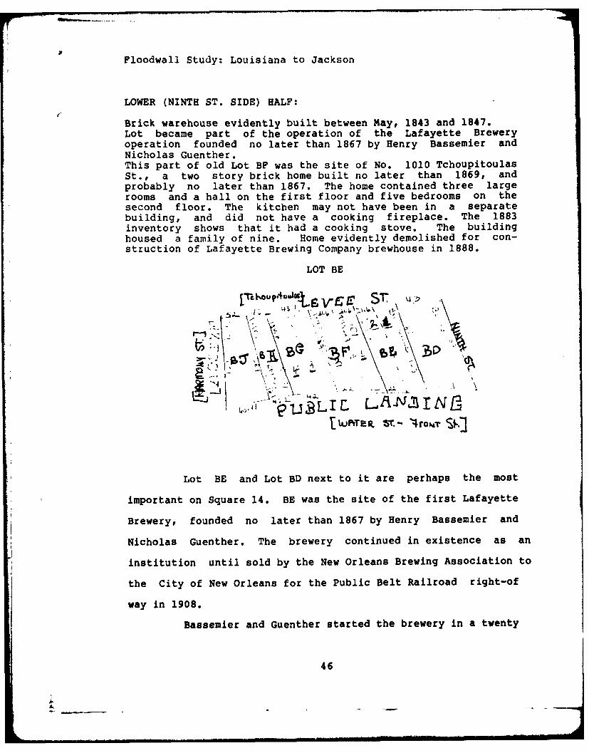
LOWER (NINTH ST. SIDE) HALF:
Brick warehouse evidently built between May, 1843 and 1847.Lot became part of the operation of the Lafayette Breweryoperation founded no later than 1867 by Henry Bassemier andNicholas Guenther.This part of old Lot BF was the site of No. 1010 TchoupitoulasSt., a two story brick home built no later than 1869, andprobably no later than 1867. The home contained three largerooms and a hall on the first floor and five bedrooms on thesecond floor. The kitchen may not have been in a separatebuilding, and did not have a cooking fireplace. The 1883inventory shows that it had a cooking stove. The buildinghoused a family of nine. Home evidently demolished for con-struction of Lafayette Brewing Company brewhouse in 1888.
SUMMARY LOT BE
No evidence of buildings during plantation era, but leveecrossed lot in 1834.Two story brick warehouse built between June, 1843 andFebruary, 1844.Warehouse converted into brewery about 1867.Braun survey of 1874 indicates 2-story brick brewery with slateroof, sharing a common wall with home at 1010 Tchoupitoulas(Bassemier House, Lot BF) and feedstore on corner (Lot BD).Lafayette Brewing Company evidently demolished old warehouse tomake way for new brewhouse in 1888. Lot BE's portion of newbrewhouse contained ice machines and water tanks, and a fivestory tower.
SUMMARY LOT BD
1834 Levee crossed lot, on Zimpel map.1851 Warehouse/feedstore built.1888 Lafayette Brewing Company demolished other buildings onthe square, but may have reused old feedstore/warehouse asoffice.By 1909 entire brewing complex removed for railroad right-of-way.
Diggijng Seuence(Locations from Corps of Engineers Plans,
1981, sequence is from upriver to downriver)
1. The floodwall will first cross lot BJ. Location 15' after
Gate Sta 12+70.45 to 40' after Sta 13 + 05.45.
2. Next is lot BH. Location 40' after Sta 13+05.45 (or 10'
4

before 13+55.45) to 37' after Sta 13+55.45.
3. Next is lot BG. Location 37' after 13+55.45 to 80' after Sta
13+55.45.
4. Next is lot BF. Location 80' after Sta 13+55.45 to 9' before
Sta 15.00.
5. Next is lot BE. Location 9' before Sta 15.00 to 34' after
Sta 15.00.
6. Next is lot BD. Location is 7.5' past Sta 15+16.31 to 50'
past Sta 15+16.31.
SUMMARY
Square 13 should be watched only at the upriver
corner.
Digging Seguenc
1. Beginning at upriver corner (Tchoupitoulas and Ninth), watch
carefully for the lot (BC), which extends for 51' 1".
2. The square is 258 feet long. The balance of 206' 110 may
have some early structures, but they have not been identified.
SUMMARY
Careful attention should be given to the downriver
corner of square 12. The structures here have been documented
and could be of value. They were built and used by members of
the German community of Lafayette. However, the presence of
buildings on the rest of the square cannot be ruled out.
Digging SegLic@2
1. Beginning at the upriver end of the square, the first 208'
20 7'" were occupied by the stave yard.
2. The lower corner consisting of lots C and D of Lot AQ
occupies 52' 5'0.
15

SUMMARY Square 11
This square contains the enterpriseb of an importart
German family of Lafayette. Care should be maintained in
excavation in the middle of the square.
pigging Sequence*
1. Beginning at upriver corner, Tchoupitoulas and Seventh,
actual boundary line, not street curbs, first 104' 9'" do not
show structures.
2. Lot D or upper half of lot AN contained a two story wooden
structure. Could be significant. Extends 26'1.
3. Next is lower half of Lot AN extending for 25' 6.5', on
which sat a one story wooden building, probably dating at least
until 1842.
4. Lot 6, part of Lot AN, extends for 34' on Tchoupitoulas. It
contained a two story brick structure, probably built as a
store.
5. Lot 7, part of lots AM and AL, extends for 34' on
Tchoupitoulas, and did not contain a structure in 1874, but did
contain one as early as 1834. Probably wooden.
6. The lowest lot on the square extends for 37.0225 ', but the
small one story wooden dwelling occupied about one half of the
frontage, set a few feet back.
Overall length of the square is 260.71'.
SUMMARY Square 10
The Manson salt warehouse presents an excellent
opportunity to examine the remains of a long-standing business.
There should not be remains of any other structure beneath it.
; 6

The marble works might yield remnants of marble as well as
evidence of the frame house behind the brick front. Curiously,
Braun shows the entire structure as built of brick.
Diggina Snce
1. The first five lots of the square were used as a lumber yard
in 1874. Total distance from upriver Tchoupitoulas corner of
square is 131' 60 6'".
2. Lot 6 measures 26' 6" 1'" and held a two story wood frame
structure.
3. Lot 7 was vacant, measures 26' 6" 1'".
4. Lots AF and AE held the Manson Salt warehouse, with a
combined width of 92' 4" 4'".
5. Lot AD may have held some buildings prior to 1874. Not
documented. Measures 46' 2" 2'" wide.
6. Lot AC held the marble works, measures 46' 2" 3'" wide.
7. Lots AB and AA may have held some buildings prior to 1874.
Not documented. Measures 92' 4" 6'" total width to end of
square.
SUMMARY Square 8
Of all the identified buildings on the square, the
floodwall is most likely to go through the brick cottage on lot
12. However, the more extensive digging required for the gate
at Third Street may intrude more dramatically on the
residential building on lot 20. This entire square should be
watched.
1. Lot 11--Beginning at the upriver corner of the square (Fourth
Street), no building identified in first 25' 11" 6'''
7
I. ___

2. Lot 12--Brick residential building c. late 1850s, next 25' 110 6'.
3. Lots 13, 14--No buildings identified for next 51' 110.
4. Lot 15--Brick one story building over creole cottage, next
25' 11 61'.
5. Lots 16, 17, 18--No buildings identified next 77' 10. 6'".
6. Lot 19--One story brick building next 25' 11 6'0.
7. Lot 20--Two story wooden structure next 25' 11 6'". See attached
front and rear elevations.
SUMM4ARY Square 4
Square 4 has had an interesting late 19th century
history, but like the other lots at the lower end of the site,
the floodwall does not appear to cross it.
SUMMARY Square 3
The floodwall does not appear to cross square 3. This
is true of square 3, 4, 5, 6, and 7. Consequently, the
importance of these squares is minimal.
I -~ 8

.1 Zm - ,~ A Bee
PICq
.... ... . i
Jr;,jL ~j ~ y I:I
"NAi
7 0 Xt ~~ii ~ 97-
ago- &.~,.1.' 17_First plan for the subdivision ofthe Livaudais plantation. Benj.
Buisson, 3/5/1832 in Tulane Uni-'ersit)
I. __Library.

-'Aft
~~r'\
T 4
-;j 7 - O
.* 3k
N _-4,_
-1
~ )72-
* Uperporio FlodwllSit. 134Chares . Zipel Tulne nivesit

IIt,
Ic
It.
A ......11kVii 'R
~ L 'FLoe poto lodalsie 84
-~.I p.2' vChresF Klpl.TlaeU
p.)T b J 'E

Floodwall Study: Louisiana to Jackson
SQUARE 3 DISTRICT 4
Tchoupitoulas
C6
Water Street
(Braun's Survey 1874)
In 1779 Don Jacinto Panis purchased an eight arpent
plantation extending from the Livaudais lands (just above
Soraparu) to St. Andrew street. His widow, Marguerite Wiltz
Milhet Panis, subdivided the plantation and laid out Cours
Panis (Jackson Avenue) in 1813. Her daughter by her first
marriage, Catiche Milhet, wife of Pierre George Rousseau, inhe-
rited the land, but in 1818 sold it to John Poultney, and the
current subdivision was made. Poultney was to pay $100,000 for
the property, but before he did he went bankrupt and died. His
creditors were led by Charles Harrod and Francis B. Ogden and
they won a suit entitled Charles Harrod et al vs Widow
9

Floodwall Study: Louisiana to Jackson
Poultney, tutrix of minor heirs of John Poultney. On February
23, 1824 the plantation was sold at public sale and Harrod and
Ogden purchased it.
Harrod and Ogden then immediately began selling the
lots on a large scale. The upriver half of the square 3 consis-
ted of lots R, Q, and P. George Washington Morgan purchased lot
o on June 30, 1824 for $875. He soon sold it to Jean Baptiste
Drouet, who sold it to Samuel C. Rodgers of the city of
Philadelphia, but the price had dropped to $850.
Rodgers evidently erected buildings on the lot, and
he sold it on February 8, 1830 to Harmon Warre Bozeman, George
Green, and Willis Cheek. These gentlemen subdivided lot Q into
three parts, each with 21' 5" 7'" facing Levee street (Tchoupi-
toula-
Bozeman and his partners then partitioned the
pzoperty between them and Bozeman received the upper end of lot
Q. He sold it to James and Partick Devine, who immediately sold
it to Patrick McGarey, with buildings. The following year, July
2, 1832, Patrick McGarey sold the lot to Mary McGarey, wife of
James McGarey.
James McGarey and wife held on to the land for the
next forty-one years. The Lafayette City Directory for 1838
shows McGarey operating a clothing store on Water street near
Philip, on this site. By 1850 he had become a justice of the
peace with an office on the end of his lot facing Levee street
and his residence on the end facing Water street.[Cohen's New
10

Floodwall Study; Louisiana to Jackson
Orleans and Lafayette Director, 1850].
In 1873 an English company organized a steamship line
to run to New Orleans and named it the Mississippi & Dominion
Steam Ship Co. Ltd. In July of 1873 the company purchased the
McGarey and adjoining land. This company held the 120 feet in
the center of the square between Philip and Jackson.
In 1891 Mississippi & Dominion sold their property to
a new firm, the American White Lead and Color Works for
$17,033. Three years later this company acquired the property
at the Philip street end of the square. American White Lead
evidently ran into some financial difficulties, for in 1900
they reorganized under the name of American Paint Works.
However, the city's drive to upgrade the levees and build the
Public Belt Railroad doomed the enterprise at this location. In
1908 they sold out to the City of New Orleans for $73,000.
SUMMARY
The floodwall does not appear to cross square 3. This
is true of square 3, 4, 5, 6, and 7. Consequently, the
importance of these squares is minimal.
Floodwall Study: Louisiana to Jackson
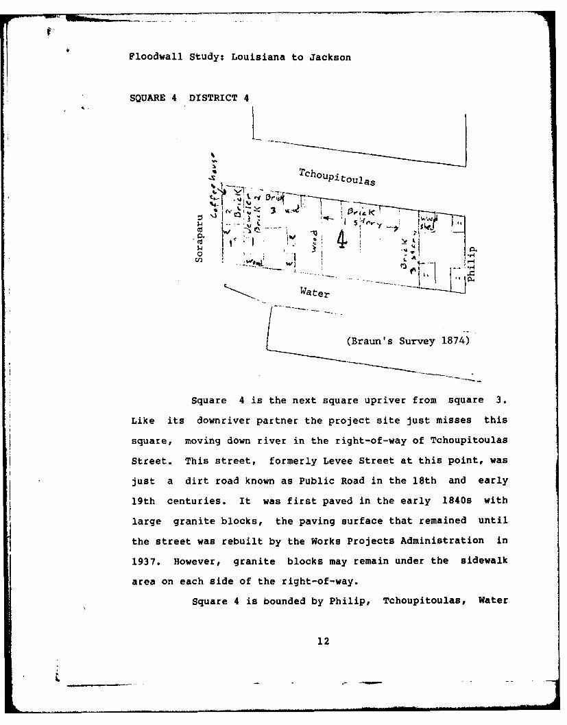
SQUARE 4 DISTRICT 4
.. ~Tchoupito a
7 COp1 tOulas
0 -'.
W. Water
/ (Braun's Survey 1874)
Square 4 is the next square upriver from square 3.
Like its downriver partner the project site just misses this
square, moving down river in the right-of-way of Tchoupitoulas
Street. This street, formerly Levee Street at this point, was
just a dirt road known as Public Road in the 18th and early
19th centuries. It was first paved in the early 1840s with
large granite blocks, the paving surface that remained until
the street was rebuilt by the Works Projects Administration in
1937. However, granite blocks may remain under the sidewalk
area on each side of the right-of-way.
Square 4 is bounded by Philip, Tchoupitoulas, Water
12
L _ _ - -

Floodwall Study: Louisiana to Jackson
and Soraparu Streets. It was probably laid out about 1824 when
Harrod and Ogden began selling lots on a large scale in the
Faubourg Panis.
Most of the square was acquired by Robert Layton
about 1824. Layton had been present in the faubourg for some
years as the operator of a rope walk on the lower boundary of
Faubourg Panis. The rope walk required a long narrow strip of
ground on which hemp was laid and spun and twisted. The Layton
rope walk was located between Saraparu and First, extending
from Levee street inland.
Layton died in 1843, and his inventory showed a total
value of $102,275. On February 2, 1844 Hugh Grant, surveyor for
the City of Lafayette, prepared a plan for the Layton estate
known as "Plan of 254 Valuable Lots of Ground Situated in the
City of Lafayette Belonging to the estate of Robert Layton,"
(Plan Book 102, folio 18). On April 13, 1844 the lots were
sold at public auction at Banks Arcade. Layton's testamentary
Executor was Isaac Trimble Preston, who soon married Layton's
widow, Margaret Newman Hewes. The heirs of Layton purchased
many of the lots at the public sale, but purchased them in
solido. Four years later they partitioned their joint estate,
with lots 11-14 on square 4 going to the widow. In 1856 she
sold the four lots to her son, Robert Layton, Jr. and Edward
Ivy; together the lots were worth $9,247.42, and contained
buildings. About this time adjoining lot 15 also contained a
building, a three story brick warehouse. These buildings make
13

Floodwall Study Louisiana to Jackson
up the heart of the square and are evident on the Braun survey
done in 1873. All five above mentioned lots were acquired by
Josephus M. and James W. Reeve about 1859, who sold out in 1866
to Mrs. Catherine Chandler for $12,000. She kept the buildings
until 1881 when Albert Baldwin and others organized the South-
ern Manufacturing and Exporting Company of New Orleans.
This company apparently was formed to prepare ferti-
lizer from animal fats according to the "Mege Patent", and the
company was to have the exclusive right in Louisiana and Texas.
The company was apparently not too successful, for six years
later it sold out to the Planters Fertilizer Manufacturing
Company for $5,500. This company acquired lot S on the
downriver end of the square the following year and operated
until 1904. The company then sold everything to Empire Rice
Mill, which four years later sold out to the city of New Orleans.
Lot S was acquired by Alexander Philips from Harrod
and Ogden in 1824 and stayed in his possession for fifty three
years. The purchaser, Mrs. Catherine Kerns, bought it for
$1,750, held it for eleven years and sold it in 1888 to
Planters Fertilizer for $3,500.
SUMMARY
Square 4 has had an interesting late 19th century
history, but like the other lots at the lower end of the site,
the floodwall does not appear to cross it.
14
tI eFloodwall Study: Louisiana to Jackson
SQUARE 8 DISTRICT 4
..... TchOupi-toulas . . : . .-3
' 'I
Water Street (Braun's Survey 1874)
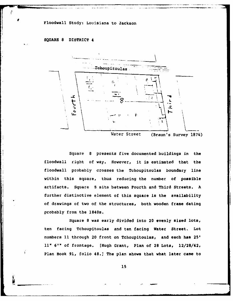
Square 8 presents five documented buildings in the
floodwall right of way. However, it is estimated that the
floodwall probably crosses the Tchoupitoulas boundary line
within this square, thus reducing the number of possible
artifacts. Square 8 sits between Fourth and Third Streets. A
further distinctive element of this square is the availability
of drawings of two of the structures, both wooden frame dating
probably from the 1840s.
Square 8 was early divided into 20 evenly sized lots,
ten facing Tchoupitoulas and ten facing Water Street, Lot
numbers 11 through 20 front on Tchoupitoulas, and each has 25'
11" 6' of frontage. [Hugh Grant, Plan of 28 Lots, 12/28/42,
Plan Book 91, folio 48.] The plan shows that what later came to15

00
U.
t'Au
...... ~. .
Sid :n Fon.Eevtin .o
rjes . . A.1~ He .111 8 5
Sid and rot9 foletio o
ReietaEtucuelhr n

Floodwall Study: Louisiana to Jackson
be called Water Street was referred to as OLevee or Public
Landing,* while Tchoupitoulas at this time was referred to as
Levee Street.
The most spectacular complex of residential buildings
provable on the entire site sits at the lower end of square 8.
Front and side elevations of these structures are preserved in
Plan Book 49, folio 62. The ubiquitous coffee house occupied
the corner of Third and Water, while apparently a purely resi-
dential structure stood at Third and Tchoupitoulas. Both of
these buildings were still present in 1874 on Braun's survey.
The building on lot 20 may touch the floodwall right of way. It
was apparently built while the lot was owned by one Jean Brown,
whose wife was Johanna Bruhn, thus suggesting strongly that
Jean Brown was actually Johan Bruhn, a process familiar to
Louisiana history that saw such changes as Zweig to Labranche a
hundred years earlier. Jean Brown purchased the land for $940
in 1845 and sold it for $2,200 in 1848, and the act recorded
for the first time the presence of buildings. In any case Jean
Brown sold out to an Irishman. Patrick Carmody, who held it for
a few years and sold to Henry Scheltmeyer, who sold to another
German, Bernard H. Mieden. Incidentally the value of the
properrty was plummeting, $2,000 in 1853 and $1,425 in 1855.
The Mieden's held on to the property for twenty
years, but it continued to decline in value, reaching $1,060 in
1878, after it had gone through several additional owners.
Diedrich H. Koehler, yet another German, held the property for
16

Floodwall Study: Louisiana to Jackson
r another twenty years, but it appears that the buildings were
removed during his tenure.
Braun's survey of 1873 shows three brick buildings
touching the front boundary line of the square, and thus
possibly touching the floodwall right of way. They are all one
story, and probably all residential. Each has a rear building,
an outhouse or kitchen.
The building on lot 15 is the most substantial of the
three. It replaced a small wooden creole cottage that formerly
sat on that lot and for which an archival drawing exists. [Plan
book 46, folio 38] The plan is undated.
After the turn of the century the Crescent Ice Company
took over most of the square. Its reign was short-lived, however,
for it had to sell out to the City in 1908.
SUMMARY
Of all the identified buildings on the square, the
floodwall is most likely to go through the brick cottage on lot
12. However, the more extensive digging required for the gate
at Third Street may intrude more dramatically on the
residential building on lot 20. This entire square should be
watched.
Digging Sequefln:
1. Lot 11--Beginning at the upriver corner of the square (Fourth
17
Floodwall Study: Louisiana to Jackson
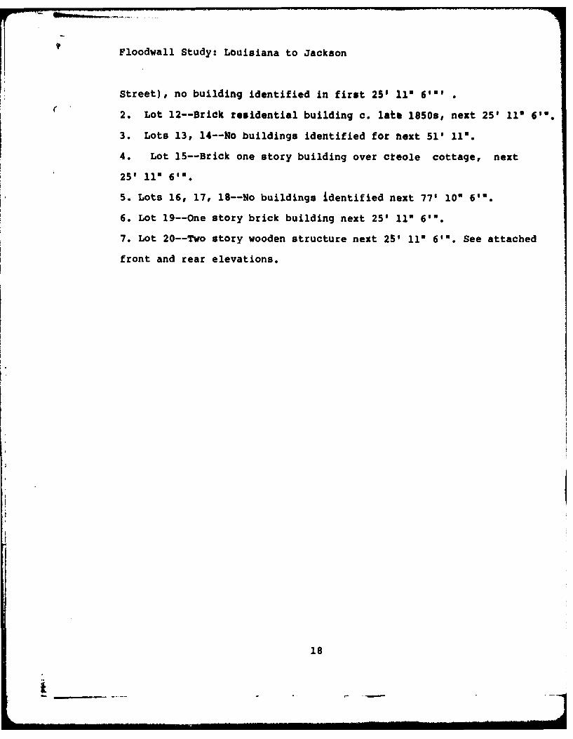
Street), no building identified in first 25' 110 6'10
2. Lot 12--Brick residential building c. latb 1850s, next 25' 11 6'0.
3. Lots 13, 14--Vo buildings identified for next 51' 110.
4. Lot 15--Brick one story building over ckeole cottage, next
25' 111 6".
5. Lots 16, 17, 18--No buildings identified next 77' 10" 61'.
6. Lot 19--One story brick building next 25' 11 6'".
7. Lot 20--Two story wooden structure next 25' 111 6'". See attached
front and rear elevations.
18

2.113,17
61 5

Floodwall Study; Louisiana to Jackson
business in 1850, and maintained the principal business at
Tchoupitoulas and Common Streets. In 1856 a partnership of
Theodore L. McGill, Theodore McGill, James Jackson, and Charles
Manson purchased lots AF and AE with buildings for $16,500. Two
years later Manson bought his partners out. Later Manson took
in as a partner David Jackson and the firm changed its name to
Jackson and Manson. In 1878 Charles Manson retired and his son
Robert succeeded him. Five years later another son, James
Manson, bought out David Jackson, and renamed the firm Manson
Bros. The property stayed in the Manson family until they sold
to the City of New Orleans in 1908. [Englehardt, 110-111]
The second largest building that once sat across the
floodwall site was used as a marble works in the late 19th
century. It was a one story brick front frame house with slate
roof and two attached wooden sheds at the rear. [T. Guyol
4/30/18901 It occupied lots 7 and 8 of larger lot AC. [Plan of
Hugh Grant 12/4/1846, in D. J. Ricardo 12/8/1846; also sketch
in Alcee J. Villere 7/2/1900] The developer of the lots was
probably Daniel Seltzer Dewees who puchased lots 7 and 8 in
1850 for $2,000. [L. R. Kenny 2/26/1850] This is a high price,
and suggests that a frame building might have been on them by
that date. Dewees sold his interest in lots 1-8 in 1871 with
buildings for $10,000 and in a sale three years later the
buildings contained machinery, fixtures for cutting, sawing and
polishing marble. IE. L. Gottschalk 3/7/1871; Joseph Cohn
6/26/1874]
20

dwall Study: Louisiana to Jackson
The final structure on the square through which the
dwall will pass is a two story wooden structure on lot 6 of
etch attached to D. J. Ricardo 12/8/46.
SUMMARY
The Hanson salt warehouse presents an excellent
rtunity to examine the remains of a long-standing business.
,e should not be remains of any other structure beneath it.
marble works might yield remnants of marble as well as
lence of the frame house behind the brick front. Curiously,
Ln shows the entire structure as built of brick.
dng Sequence
'he first five lots of the square were used as a lumber yard
1874. Total distance from upriver Tchoupitoulas corner of
ire is 131' 6" 6'".
Lot 6 measures 26' 6" 1'" and held a two story wood frame
icture.
,ot 7 was vacant, measures 26' 6" 1'".
Lots AF and AE held the Hanson Salt warehouse, with a
oined width of 92' 4" 4'".
Lot AD may have held some buildings prior to 1874. Not
imented. Measures 46' 2" 2'" wide.
,ot AC held the marble works, measures 46' 2" 3'" wide.
Lots AB and AA may have held some buildings prior to 1874.
documented. Measures 92' 4" 6'" total width to end of
ire.
21

Floodwall Study: Louisiana to Jackson
SQUARE 11 DISTRICT 4Tchoupitoulas
Water(Braun's Survey 1874)
Square 11 is one of the best candidates for
uncovering residential remains. Houses dating back to 1834 can
be documented. Square 11 is bounded by Seventh Street and Sixth
Street.
Examination of Braun's survey of 1874 indicates that
the most significant properties in the right of way still
standing at that date are in the middle of the block. They
consist of a two story wooden building, a one story wooden
building, a brick building, and a small one story wooden build-
ing, probably a creole cottage. The latter is set back from the
property line and may not be on the right of way.
This square like the others in this area was
subdivided in 1832. In May of 1840 John Deniger, probably a
German, purchased the lower half of lot AN. Two years later the
City Directory shows Deniger operating a coffee house on Levee
between Sixth and Seventh, presumably on this lot. This could
be the one story wooden structure there in 1874. By 1850
22
Floodwall Study: Louisiana to Jackson
Deniger is operating a feed store dcwnriver, below Jackson, but
in 1853 he has moved his establishment back to his lot, no
longer a coffee house, now a feed store.
Deniger was prosperous, for in 1857 and 1858 he
purchased the two lots immediately down river, known as lots 6
and 7. Both had buildings on them in 1834. By 1874 lot 6
supported a large brick building containing a feed store. John
Deniger had since died, but the properties remained in the
possession of his widow until 1898, and the businesses could
well have been operated by her and her children. In 1868 she
purchased yet another lot in the area, lot E, which faced the
river and had a very large brick dwelling on it.
SUMMARY
This square contains the enterprises of an important
German family of Lafayette. Care should be maintained in
excavation in the middle of the square.
pigging Seuncee
1. Beginning at upriver corner, Tchoupitoulas and Seventh,
actual boundary line, not street curbs, first 104' 9'" do not
show structures.
2. Lot D or upper half of lot AN contained a two story wooden
structure. Could be significant. Extends 26'11.
3. Next is lower half of Lot AN extending for 25' 6.5", on
which sat a one story wooden building, probably dating at least
until 1842.
4. Lot 6, part of Lot AM, extends for 34' on Tchoupitoulas. It
23

Floodwall Study: Louisiana to Jackson
contained a two story brick structure, probably built as a
store.
5. Lot 7, part of lots AM and AL, extends for 34' on
Tchoupitoulas, and did not contain a structure in 1874, but did
contain one as early as 1834. Probably wooden.
6. The lowest lot on the square extends for 37.0225 ', but the
small one story wooden dwelling occupied about one half of the
frontage, set a few feet back.
Overall length of the square is 260.71'.
24

+i! Floodwall Study: Louisiana to Jackson
SQUARE 12 DISTRICT 4
-Thi~pto~~aS Ia Ae
bX2
Water Street
(Braun's Survey 1874)
Square 12 sits across the right of way between Eighth
and Seventh Streets. Of the squares in this floodwall study
area, it appears to have the most vacant land. In 1873 (Braun's
survey), four-fifths of the land was used as a stave yard.
Staveyards were an essential component of the nexus of industry
. long this stretch of the river. Here staves were gathered from
sawmills and fabricated into barrels for the nearby grain
elevator (New Orleans Elevator Company, sq. 15) and the
Lafayette Brewery on square 14.
It is unclear whether buildings ever existed on this
four fifths of the square. Samuel Brown purchased the area
before 1850 and his succession turned it over to Elizabeth
Brown Blue on April 30, 1850. She owned it for twenty years,
before it turned over three times and ended up as the E. J.
Bobet staveyard. He sold the land to the City of New Orleans in
1909.
25

ALA
z6 Nt-IL ?; %
~7
~t
INZ
~A 0
-_NN

Floodwall Study; Louisiana to Jackson
The only proven development occurred on the lower end
of the square along Seventh street between Tchoupitoulas and
Water Streets. Like its neighbors the square was subdivided in
1832. Lots AP and AQ ended up jointly owned by Ernest Henry
Kiesekamp and the Bank of the United States. On August 18, 1841
the property was partitioned between Kiesekamp and the Bank,
with Kiesekamp receiving Lot AQ at the lower end of square 12
and the Bank receiving lot AP at the upper end of square 11.
[Judgment of the First Judicial District Court, Bank of the
U.S. vs. E. H. Kiesekamp, in COB 3, folio 441, Transcribed
records of Jefferson Parish, Orleans Parish Conveyance Office.
The attorney for the Bank was the famous Democratic politican
and Senator, John Slidell].
Lot AQ of square 12 stretched for fifty-two feet
along Tchoupitoulas from the corner of Seventh street, and
extended originally to the river bank. In the middle 1850s
Water Street was cut through, forming the square, but not
obliterating the batture rights of the property owner. The
directory of 1843 shows Ernest Henry Kiesekamp residing at the
corner of Levee and Seventh [Michel Directory 1843]
Kiesekamp built three structures on the lot after
subdividing it into lots B, C, and D. He evidently intended to
offer a lot A, but never built. The structure on lot B was the
largest of the three, and apparently functioned as a coffee
house for a long period of time prior to 1873.
The New Orleans coffee house was a distinctive
26

SFloodwall Study: Louisiana to Jackson
institution, best described by a visitor in 1835, Yankee Joseph
Holt Ingraham. New Orleans had hundreds of coffee houses in the
ante-bellum era, and Lafayette alone had fifteen in 1838, with
its population not a thousand. Staffed by bilingual waiters,
the coffee house was decorated in French taste, with engravings
and printings of a risque nature. Rows and castles of glasses
sparkled from behind highly polished bars. Lamps and tables
hosted a numerous throng throughout the day, for much commerce,
newspapering, and politicing went on in the coffee house.
Alternatively, the visitor was sure to be playing dominoes, the
game of the creoles. The indespensible "segar" was never far
from the creole's hand, and clouds of smoke swirled around
every cluster. Coffee was seldom to be seen, the drink was
negus, a beverage of wine, hot water, sugar, nutmeg, and lemon
juice. [Register n.p.]
Two of Kiesekamp's buildings sat across the present
site of the Floodwall. Both were built right up to the property
line of Tchoupitoulas. The corner building was two stories of
brick, with a slate roof. The smaller is of wood, one story.
The corner building is the larger, yet the 1870 sketch by J. A.
d'Hemecourt does not show a cistern for it while showing one
for the smaller building. [J. A. d'Hemecourt, Deputy City
Surveyor, 12/9/1870 in J. F. Coffey 12/13/1870] The corner
building (C) occupies its entire frontage of the lot, 33' 2".
The smaller building is long and narrow, probably about 15'
wide by 40' deep, with a cistern at the rear. The privies show
27

b1Floodwall Study: Louisiana to Jackson
in the center of lot AQ at the intersections of the four lots.
Ernest H. Kiesekamp died in 1869 and the following
year his son, Casper William Kiesekamp inherited the property.
He immediately sold lot D with its buildings to William Macke
for $775. Over the next three decades all three lots wound up
in the Kampen family, and in 1908 Mrs. Mary Kampen, the wife of
John Hanneman sold the lots to the City of New Orleans for
$8,000.
SUMMARY
Careful attention should be given to the downriver
corner of square 12. The structures here have been documented
and could be of value. They were built and used by members of
the German community of Lafayette. However, the presence of
buildings on the rest of the square cannot be ruled out.
Digging Seuncee
1. Beginning at the upriver end of the square, the first 208'
2" 7'" were occupied by the stave yard.
2. The lower corner consisting of lots C and D of Lot AQ
occupies 52' 5'".
28

Floodwall Study: Louisiana to Jackson
SQUARE 13 DISTRICT 4
Tchoupitoulas
\S~a6
Water Street
(Braun's Survey 1874)
Square 13, like square 12, was virtually empty of
buildings in 1874. The square stretches between Ninth and
Eighth streets.
The only structure on the right of way as of 1874 was
a building described in 1887 as "a double tenement two story
house forming the corner of Levee and Ninth Streets." This was
clearly a residential structure. The lot (BC) was purchased in
1836 from the subdividers of Faubourg Livaudais by John
Mitchell, and he and his heirs owned it until 1887 when they
sold it to Alphonse and E. J. Bobet, who operated the stave-
yards on squares 12 and 13. Directory research strongly sug-
gests that John Mitchell did not live there, and the term
tenement suggests it was rental property. Its address on the
old system was 1000-1002 Tchoupitoulas.
29

Floodwall Study. Louisiana to Jackson
SUMMARY
This square should be watched only at the upriver
corner.
Diggina Sequene
1. Beginning at upriver corner (Tchoupitoulas and Ninth), watch
carefully for the lot (BC), which extends for 51' 1.
2. The square is 258 feet long. The balance of 206' 11" may
have some early structures, but they have not been identified.
30

Floodwall Study: Louisiana to Jackson
SQUARE 14 DISTRICT 4
Square 14 emerged as a separate piece of real estate outthe old Livaudais Plantation in 1832. It was the most upriverterminus of Plantation Livaudais, later the uppermost terminusof the City of Lafayette. It was bounded on the downriver sideby Ninth St., and on the upriver side by Faubourg DeLassize,which never became part of the City of Lafayette.
In the auction of Livaudais Plantation Square "0", nowSquare 14, was divided into six lots, Nos. BD to BJ. Each wasabout 40 to 45 feet wide, by about 135 feet deep.
LOT BJ
Lot BJ was purchased at the 1832 Livaudais auction
[G.R.Stringer 4-5-32 and Lafayette C.O.B. 7/99] by Peter
Hanson, a sometime milkman, tavern keeper and boarding house
keeper, according to local city directories. Hanson, evidently
a small-scale but bold entrepreneur, paid $2800 for BJ in 1832.
At the time he already owned waterfront property in the area.
This he had purchased in Faubourg Panis as early as 1826 on
Tchoupitoulas and St. Philip Sts. [Felix de Armas, 2-28-1826.]
Five years after purchasing Lot BJ, Hanson mortgaged it along
31

Floodwall Study: Louisiana to Jackson
with a lot facing it across Tchoupitoulas Street to the Citi-
zens'Bank for $5500 [F.E.D.Livaudais 4-24-1837].
Hanson evidently used the mortgage money to expand,
for the very next month he purchased the lot adjacent to BJ
[Lot BH] from a credit sale [L.T. Caire, 5-8-18371. Hanson
then retained both properties on Square 14 until his death in
1846.
After Hanson's death his estate sold two of his
properties, including the second lot in Square 14 [BHI and one
across Tchoup itoulas St., but retained Lot BJ. This attempt by
Hanson's executor F.J. Laizer to conserve some of the estate
did not satisfy Hanscn's creditors, and in 1848 the Citi-
zens'Bank sued to recover the $5300 it had loaned Hanson in
1837 [3rd Judicial District Court for Jefferson Parish, 3-14-
1848]. This forced a sheriff's sale of Lot BJ. The Jefferson
sheriff then auctioned BJ to Carl Kohn for $5300, which sum
included the purchase of Lot 8 Sq. 9. Kohn sold one month
later to John Morris Bach and his wife "Pepitte" Toledano
[L. Hermann, 4-20-1848], residents of St. Helena Parish. [MC
LTC 6-20-1829]. Bach's purchase papers mention a building,
probably a brick warehouse, on Lot BJ. It is presumed to have
been built by Peter Hanson in 1843, when several other ware-
houses were built on the square, as the discussions following
this section will show.
Bach held lot BJ until 1860 when he sold to Henry F.
Hall for $2900 cash [E.G. Gottschalk 3-6-1860]. Hall, a member
32
... ........
Floodwall Study: Louisiana to Jackson
of the commercial firm B.L. Mann & Co.,held the property for
the next twenty years, when his firm sold BJ to Fidel Engster,
a Cuban associated with the New Orleans Elevator and Warehouse
Company. [N.B.Trist 4-1-1880]. Engster turned over title of
Lot BJ to the company the year after he bought it, for $2500,
the price that he had paid Henry F. Hall for both BJ and the
adjacent lot in Sq. 14, Lot BH. [N.B. Trist 4-27-18811.
Both lots BJ and BH now became facilities of the
Elevator Company operation on adjacent Square 15 for the
following thirty years. According to Sanborn's Tnaurance M
New Orleans, Loisia [vol. 3, 1896 ed., Sq.14] (hereafter
"Sanborn" ) Lots BJ and BH were used as a lumber and wood yard
during that time. At the rear of Lot BJ was a small frame
stable and some sheds. (For the subsequent history of Lots BJ
and BH until they were sold with Square 15 to the City of New
Orleans for the Public Belt RR right of way, see report on
Square 15.)
SUMMARY LOT BJ SQ.14
No evidence found of construction during plantation era, butZimple map of 1834 indicates a levee crossing the lot.First construction possible concurrent with mortgaging activityin 1837; more likely in 1843.Some building definitely on lot by 1848, probably a 2 storybric warehouse. Building removed after 1848, exact timeunknown.Lot vacant by 1874, used as staveyard. [Braun survey, 1874.]Lot continues vacant during era of New Orleans Elevator andWarehouse Co.(after 1874 and until 1908;) used as lumber andwood yard with small frame stable and sheds at rear, not inR.O.W.
33

wall Study: Louisiana to Jackson
Lot BH
--- \ e7
u -: _.. -- ! r l- , a
. l ',t- "- ' '
Lot BH, along with the remainder of the lots in
e 14 downriver from it, was included in the bankruptcy of
Evans in 1837. It was sold by the syndic for Evans'
tors to Peter Hanson [L.T. Caire 5-8-1838] for $1825, a
that by ccmparison indicates the lot was probably bare at
ime. BH was still in Hanson's ownership when he died, and
sold by his estate in 1846 with another lot for $3270, a
t sum that suggests it still had no building ir 1846.
The new buyer was Philip Geiger [D. Clark, Jr.,
rson Parish Recorder, 12-4-1846], an immigrant from Baden
, Germany, who lived in the City of Lafayette at Levee
upitoulas) and First St. Geiger probably built a
ouse on Lot BH during the 1840s, although we know little
it. The elusive clue to its existence is the $3400 value
Lot BH in Geiger's estate, invt ?oried in 1853
Kenny, 5-14-18531. This value was about double what Geiger
34

Floodwall Study: Louisiana to Jackson
paid for the lot in 1846.
Geiger's will and estate inventory [6DC 5245] sug-
gest that he was a good example of a German immigrant to New
Orleans who achieved prosperity after migrating to the United
States. He was born in the Dukedom of Baden in 1810. His
father, John Michael Geiger, was born in Mannheim, Germany,
where he worked as a court messenger. His mother, Anna
Francisca Ehreinger, was born in Baden Baden. The younger
Geiger married Caroline Helfer. They had no children. Geiger's
brother Joseph was a journeyman shoemaker in Mannheim, where
Philip was probably born. To Joseph, Philip left $500 in his
will. He also left $500 to a second brother, Ludwig, who also
emigrated to North America, going to Mexico in 1847, althougi,
Geiger believed that he was dead at the time he made his will
in 1852.
By the time of his death, Philip Geiger had accumu-
lated four pieces of real estate, all in the City of
Lafayette, and lived in a home furnished with 12 mahogany
chairs, marble topped furniture, and other comforts. He had
1250 shares of stock in the Lafayette and Pontchartrain R.R.
and the N.O., Opelousas, and Great western R.R.; along with
land in Mississippi and Texas.
Philip Geiger's succession remained open for seven
years (1853-1860), and by the time it was closed his widow had
remarried to Abraham Bronsema (6DC # 5245, 6-27-18601. Mrs.
Caroline Geiger Bronsema then sold Lot BH in 1861 to Henry F.
35
Floodwall Study: Louisiana to Jackson
Hall [J.F. Coffey 4-3-1861] for $1800. The act of sale did not
mention any buildings, and the $1800 value was a substantial
reduction from that specified in 1853.
Subsequent to 1861, the history of lot BH is identi-
cal to that of Lot BJ, described above. Both were merged into
the operation of the New Orleans Elevator and Warehouse Company
in 1880, after being held as staveyard properties by Henry F.
Hall from 1860-1880. Like Lot BJ, BH was used as a lumber and
wood yard by the Elevator company during the 1890s [Sanborn,
1896].
SUMMARY LOT BH
No evidence found of constructions during plantation era, priorto 1832, but a levee crossed the lct in 1834.No evidence of construction during ownership of Evans (1832-1837) or Hanson (18384843)Geiger may have built a warehouse during late 1840s, butevidence about it is extremly scant and confined to a briefincrease in lot value between 1846 and 1861.Braun survey of 1874 confirms lot vacant and used as staveyard.No evidence of construction during ownership of N.O. Elevator &Warehouse Co. (1881-1909); lot used as lumber and wood yard.Vacant on Sanborn Insurance Map of 1909.
36

Floodwall Study: Louisiana to Jackson
LOT BG(
Like the two previously described lots on Sq. 14, Lot
BG came out of the creditors'sale of the property of James
Evans in 1838. It was then sold to James McGarey [L.T. Caire
5-8 1838] for $1700. McGarey sold it to Gustave Leroy in 1843
[F. Grima 3-2-18431 for $2000.
That same spring, the City of Lafayette determined
to build a steam boat wharf in front of square 14, [wharf
building contract L.R. Kenny 10-10-1844] probably because of
investor activity on the square. The prospect of the new wharf
then set off a rush of warehouse construction on the square.
Gustave Leroy, owner of Lot BG, traded interests in his proper-
ty with business partners P.F.V. and P.L. Labarre. In June,
1843 Labarre had Lafayette Surveyor Hugh Grant subdivide Lot BG
and adjacent Lot BF into four equal lots, Nos. 1-4. Labarre and
Leroy then built a two story brick warehouse on the downriver
half of Lot BG (now numbered lot 3).
37

Floodwall Study: Louisiana to Jackson
A plan of Lot BG showing the warehouse on the lower
half of Lot BG is attached to a act of sale between members of
the Labarre family [S. Magner 8-18-1856]. Labarre and Leroy
must have used the warehouse in connection with a large brick-
yard and sawmill that they owned and operated on the West Bank
of the river directly across from Lafayette [Reeves 1980,
87,104]. No evidence has been found to indicate that they built
a warehouse on the upriver half of Lot BG.
The Leroy-Labarre partnership continued to control
Lot BG for roughly the next fifteen years, until 1860. At that
time they sold out both halves of the lot to L. Auguste
Bernard, a French immigrant baker who lived in the neighborhood
on Eighth St. between Constance and Laurel [J.F. Coffey, 2-23-
1860].
Bernard and several members of his family had
extensive interests on Square 14. Philibert Bernard, probably
his father or an older brother, had owned Lot BD at the Ninth
Street end of the square since 1837. J. Xavier Bernard, evi-
dently a brother of Auguste, owned Lot BE next to that, and
after 1851 kept the family coffee house and a feedstore on the
corner of Tchoupitoulas and Ninth St. with the widow of
Philibert Bernard, Rosalie Weigtman Bernard. L. Auguste and J.
Xavier Bernard split ownership of Lot BF, right in the middle
of the square. The family thus owned all of Square 14 from
Ninth Street to the upriver end of Lot BG. Auguste was married
to a German girl, Elizabeth Metick, and his close friend was
38

Floodwall Study: Louisiana to Jackson
Kaspar Auch, leader of the German community in the City of
Lafayette. [CDC 22,6691.
As the report on Lot BE will show, a brewery was
founded on Lot BE about 1867. Louis Auguste Bernard continued
to own Lot BG during the operation of the brewery, and until
his death in 1877. BG was probably used during that time as a
service area for the brewery. The brewery was small family
operation at first, but continued to expand during the 1870s
and 1880s. In 1887 the Lafayette Brewing Company bought it out,
and at that time Louis Auguste Bernard's widow and children
sold Lot BG along with the upper half of adjacent Lot BF to the
company.
The Lafayette Brewing Company added substantial
buildings to their property on Square 14 between 1888 and 1890.
Lot BG then became the site of the beer cellar portion of a new
four-story brewhouse they built. Subsequent portions of this
report will describe the brewery in more detail.
For the history of Lot BG after 1890, see Lot BE.
SUMMARY OF LOT BG
No evidence of construction before 1843.Received a two story brick warehouse on downriver half, a lot21.6 feet wide, in late 1843.Probably used as service area to neighboring brewery after1867.Braun's survey of 1874 shows that the lot was vacant exceptfor use as a staveyard.Lafayette Brewing Company built new a four story brick brew-house in 1888. It straddled Lots BG, BF, BE, and part of BD.The beer cellar portion of the brewhouse was on Lot BG.
39
- mm

Floodwall Study: Louisiana to Jackson
LOT BF
Lot BF was sold in the 1838 James Evans creditors saleto James McGarey [L.T.Caire 581838]. McGarey sold to JohnMcLaughlin in 1842 IF. Grima 11211842].
McLaughlin's lot then participated in the subdivision bySurveyor Hugh Grant which divided Lot BF and BG each into twoequal parts. The following discussion will treat the upper(Harmony St. side) and then the lower (Ninth St. side) of the twohalves of original Lot BF.
Lot BF-- UPPER HALF
John McLaughlin sold the upper half of original lot
BF to Laurent Ignace Sigur IF. Grima, 5-17-1843], a young
attorney who had inherited $20,000 from his grandfather Laurent
Sigur of Iberville Parish, and who was putting his inheritance
into New Orleans real estate. [A. Chiapella 5-8-1843]. Sigur
paid only $822.50 for the property, about the same value per
square foot that the lot had five years earlier in the Evans
creditors' sale. Sigur then sold the property to his fiancee,
Agnes Malvina Roche, widow deLa Ronde, who was his cousin.
40
Floodwall Study: Louisiana to Jackson
The fiancee paid the same amount for the bare lot,
$822.50 [A. Chiapella 6-14-1843]. However, when Sigur and his
cousin Mrs. Widow deLa Ronde signed a marriage contract the
following February [A.Chiapella 2-2-1844], they stated that
there was a brick warehouse on the upper half of Lot BF. The
warehouse was thus built, like the one on Lot BG, in the late
months of 1843. This construction probably came in response to
the construction of the steamboat wharf in front of Square 14
that year. [As the report on Lot BE will show, the same
sequence of events and construction occurred on Lot BE, which
Laurent Sigur purchased bare in 1843 but declared in his
marriage contract to hold a brick warehouse in Feb., 1844.1
The Sigurs held their (upper) half of Lot BF until
about 1847 when Mrs. Sigur turned her title over to John Hoey,
the Lafayette omnibus line owner, for $2800, or $2000 more than
she paid her fiancee for it in 1843. [D.J.Ricardo 6-2- 1847].
Hoey held it only two years, selling to Victor Rochebrun in
1849 [J.R. Beard 3-27-1849]. Nine years later Rochebrun sold to
Louis Auguste Bernard, and the upper half of old Lot BF, now
with a reduced value of only $1900, became part of the Bernard
family complex on Square 14, ending up as a staveyard.
When Louis Auguste Bernard died in 1877, the property was
still in his possession. His heirs sold to the Lafayette Brewing
Company in 1887. The new company brewhouse covered Lot BF, except
for a frame building in the rear. For more details and subsequent
owners, see Lots BD and BE.
41

Floodwall Study: Louisiana to Jackson
LOT BF --LOWER HALF
(C.
"I -- -i-
I - . = -' - ,,, ..-- - - "
After having original Lot BF subdivided in 1843, John
McLaughlin sold the lower half to Mrs. Marie Adele Roche, the
mother of Agnes Malvina Roche deLa Ronde, fiancee of Laurent
Sigur, to whom McLaughlin sold the upper half of the lot the
same day, May 17, 1843 [F.Grima]. Mrs. Roche paid the same
$822.50 that her future son-in-law paid, the value of an unim-
proved lot. In 1847, Mrs. Roche sold to John Hoey for $2800.
As stated above, Hoey also purchased the upper half
of Lot BF in 1847. His purchase price of the lower half
strongly indicates that Mrs. Roche had had a brick warehouse
built on it in 1843, as the Sigurs had on their half. Hoey sold
the lower half two years later [J.R.Beard 2-1-1849] to Jean
Baptiste Marmazet, an illiterate Frenchman whose resources to
buy and manage the investment are yet unexplained. Marmazet
retained the property for the next nine years, when he sold to
Joseph Xavier Bernard for $2900 [E.G.Gottschalk 7-9-1859].
After that the lower half of Lot BF while still in Bernard's
ownership became an adjunct of the brewery complex on the
42

Floodwall Study: Louisiana to Jackson
adjacent lot.
The history of the lower half of Lot BF becomes
potentially very interesting during the period of its ownership
by Joseph Xavier Bernard (1859-1871). During that time, a
German brewer named Henry Bassemier, with a second German
brewer, Nicholas Guenther, founded a small brewery next door to
lot BF on Xavier Bernard's property. Bassemier and Guenther
lived next to the brewery premises, probably on the lower half
of Lot BF.
New Orleans city directories begin to list Bassemier
and Guenther as brewers on Tchoupitoulas and Ninth sts. in
1867, and begin to specify their residence there (1010
Tchoupitoulas) in 1870. This residence was on lower BF. In 1871
Xavier Bernard sold the property with the brewery complex,
which included the lower half of Lot BF and Lot BE next door,
to Henry Bassemier (J.F.Coffey 11-27-1871]. Bassemier paid
$6000 for the complex in 1871, a sum of sufficient substance to
indicate that the sale included two buildings. Bassemier and
his five sons and two daughters continued to live there from
that time until the deaths of Bassemier and his wife Catherine,
who were both deceased by 1883.
The Bassemiers'estate was inventoried in February,
1883 for their joint succession [CDC 3883; J.F. Coffey 2-3-
1883]. The inventory reveals that the Bassemier home faced
Tchoupitoulas St. and was municipal No. 1010, as directory
research has indicated. The home was a two story brick dwel-
43
Floodwall Study: Louisiana to Jackson
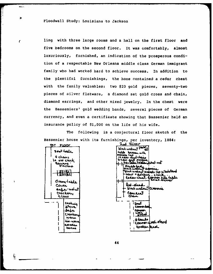
( ling with three large rooms and a hall on the first floor and
five bedrooms on the second floor. It was comfortably, almost
luxuriously, furnished, an indication of the prosperous condi-
tion of a respectable New Orleans middle class German immigrant
family who had worked hard to achieve success. In addition to
the plentiful furnishings, the home contained a cedar chest
with the family valuables: two $20 gold pieces, seventy-two
pieces of silver flatware, a diamond set gold cross and chain,
diamond earrings, and other mixed jewelry. In the chest were
the Bassemiers' gold wedding bands, several pieces of German
currency, and even a certificate showing that Bassemier held an
insurance policy of $1,000 on the life of his wife.
The following is a conjectural floor sketch of the
Bassemier house with its furnishings, per inventory, 1884:
}1m11 4%UA.j
Irb ' " I.m.a. .
I bOUI ~pi , Jd444
ZL.1
44-

Floodwall Study: Louisiana to Jackson
In 1884, the Bassemier heirs sold the home
with the brewery, machinery, and stable for a hefty $15,200 to
brewers George and Joseph Wegmann [J.F. Coffey 6-1-8-841. The
Wegmanns continued to operate the brewery for four years.
Joseph bought out his brother's interest in the total operation
in 1887 [J.D. Taylor 6-24-1887], but his act of purchase did
not describe the house. The following year, Joseph Wegmann sold
the brewery to a company incorporated as the Lafayette Brewing
Company, in which Wegmann retained a part interest in the form
of 80 shares of the stock [J.D. Taylor 1-26-1888]. Again, the
act of sale did not describe the house on the lower half of Lot
BF.
The 1888 act did describe the brewery, with its machi-
nery and a large frame stable on the property, all of which
belong more properly to the description of Lot BE, below. In
February, 1888, all of the buildings that formed part of the
original brewery complex were evidently demolished, including the
Bassemier house, for construction of the company's ambitious new
brewhouse. For the history of Lot BF after 1888, see Lot BE.
SUMMARY OF LOT BF
UPPER (HARMONY STREET SIDE) HALF:
Brick warehouse built between June, 1843 and Feb., 1844.Decrease in value of lot from $2800 in 1847 to $1900 in 1858suggests that brick warehouse may have been damaged or removed.Braun survey of 1874 shows vacant lot, a staveyard.Four story brick brewhouse covered most of Lot BF 1888-ca.1908,except for small frame building in rear [Sanborn, 1896). Sitemold to the City of New Orleans in 1908 for Public Belt R.R.right-of-way.
45
F1Floodwall Study: Louisiana to Jackson
LOWER (NINTH ST. SIDE) HALF:
Brick warehouse evidently built between May, 1843 and 1847.Lot became part of the operation of the Lafayette Breweryoperation founded no later than 1867 by Henry Bassemier andNicholas Guenther.This part of old Lot BF was the site of No. 1010 TchoupitoulasSt., a two story brick home built no later than 1869, andprobably no later than 1867. The home contained three largerooms and a hall on the first floor and five bedrooms on thesecond floor. The kitchen may not have been in a separatebuilding, and did not have a cooking fireplace. The 1883inventory shows that it had a cooking stove. The buildinghoused a family of nine. Home evidently demolished for con-struction of Lafayette Brewing Company brewhouse in 1888.
LOT BE
J LI. ATWO4or &K
Lot BE and Lot BD next to it are perhaps the most
important on Square 14. BE was the site of the first Lafayette
Brewery, founded no later than 1867 by Henry Bassemier and
Nicholas Guenther. The brewery continued in existence as an
institution until sold by the New Orleans Brewing Association to
the City of New Orleans for the Public Belt Railroad right-of
way in 1908.
Bassemier and Guenther started the brewery in a twenty
46
-- -- 1 1- . i I i ,illi l lli . . . . . ... 11 1 - . ... . t - i . . . . . I nll - -A

Floodwall Study: Louisiana to Jackson
year-old brick warehouse first built by attorney Laurent Sigur
in late 1843 to serve commerce on the steamboat wharf in front
of the square. The brewery began as a modest, almost literally
a "home brew" operation called "Lafayette Brewery" by its two
founders. At the time, immediately after the Civil War, there
were a number of small brewing enterprises in New Orleans,
most begun by German immigrants who transported their culture
to New Orleans [Nau, 1958, 63-68). Many German immigrants
settled in the City of Lafayette. There were 11,425 Germans in
New Orleans in 1850, about ten percent of the city's popula-
tion. By 1870, the German population in New Orleans had grown
to over 15,000, and tens of thousands more had passed through
the city in immigrating to the United States during the prece-
ding twenty years [Nau, 1958, 6-81. In 1867, the Lafayette
Brewery was one of eighteen breweries listed in Gardner's
After Bassemier's death his heirs sold the brewery to
George and Jos,?h Wegmann in 1884. [J.F. Coffey 6-18-1884].
Joseph Wegmann bought out his brother's interest in 1887, and
in turn sold out the following year to the Lafayette Brewing
Company, incorporated in December, 1887 [J.D. Taylor 12-3-
1887]. Joseph Wegmann was one of the main stockholders of the
Lafayette Brewing Company, but in his act of sale to the compa-
ny he agreed upon a "non-competition" clause, binding himself
not to engage in the brewing business in Orleans Parish for
five years after 1888 [J.D. Taylor 1-26-1888].
47

3wall Study: Louisiana to Jackson
After 1888, the Lafayette Brewing Company vastly in-
3ed the capacity of the Lafayette Brewery. They purchased
of the land on Square 14 except for the two lots at the
)ny Street end of the square (BH and BJ). They built a fine
Eour story brewhouse, described in the building contract as
ted at Tchoupitoulas and Ninth Street, but really strad-
I lots BG, BF, BE, and part of BD. The new brewhouse was
Ined by prominent New Orleans architect William Fitzner
* Taylor vol. 19 # 3387].
The company employed a professional brewmaster from
igo, and had sophisticated refrigerating machinery, tanks,
'es, and storage casks built. In just over two years, from
ary, 1888, to May, 1890, they increased the capital value of
Lafayette Brewery from $12,000 to $150,00 1J.D.Taylor 1-26-
and 5-31-1890].
By 1890, there were too many breweries for the New
ins market to sustain [Nau, 1958,64-67]. Several of the
r German brewing companies at that time decided to consol-
, forming a consortium known as the New Orleans Brewing
:iation. The Association was actually a holding company
i owned the Lafayette, Pelican, Louisiana, Southern,
rling, and Crescent Breweries [L.C. Quintero 10-4-1899].
were located all around New Orleans:Lafayette: Tchoupitoulas & NinthPelican: North Peters & ClouetLouisiana: Jackson Avenue & TchoupitoulasSouthern: St. Louis & VillereWeckerling: Howard & MagazineCrescent: Canal & Claiborne
48

Floodwall Study: Louisiana to Jackson
The holding company also owned a number of retail establish-
ments around the city. Peter Blaise of the Southern Brewery was
its president. Ernest Pragst was secretary.
According to Nau [1958, p. 66], the Brewing Associa-
tion "went into a program of consolidationw which resulted in
the closing of the Lafayette and Crescent Breweries and the
firing of four of six brewmasters. Nau, who collected his
information about German breweries in New Orleans from an
interview with John Rettenmeier in December, 1952, reports that
the Association's efforts to consolidate were unsuccessful, and
that "one brewery after another was lost.* The Association did
go into receivership in 1899 when its major creditor the Metro-
politan Bank sued for collection of debts [CDC 47,534, 7-3-
18991. These court records however show that the Association
still owned all six of the breweries in 1899, along with their
retail establishments. The Lafayette brewery buildings were
still very much in existence.
In October, 1699, a consortium led by Gustave Adolphe
Blaffer, Jean Edmond Merilh, and Charles Hernsheim purchased
all of the assets of the New Orleans Brewing Association for a
scant $860,000 [L.C. Quintero 10-4-1899] and reorganized as the
New Orleans Brewing Company [F.J. Puig 10-9-1899] with a capi-
talization of almost $2 million. The Lafayette Brewery, with
its machines, boilers, engines, ice machines and brewery appa-
ratus0 now became part of the New Orleans Brewing Company. It
continued to function from 1899 until 1908 when the Brewing
49

Floodwall Study: Louisiana to Jackson
Company sold all of its property on Square 14 (lots BD through
BG) to the City of New Orleans for the Public Belt Railroad
right-of-way.[W.V. Seeber 6-22-19081.
What were the facilities of the Lafayette Brewery, and
how did they originate or increase?
The first brewery building was on Lot BE, a converted
brick warehouse dating from late 1843. It is clear that Laurent
Sigur had it built between June, 1843, when he purchased the
bare lot from Mrs. Rachael Bannister [C. Pollock 6/27/1843] and
February, 1844, when he enumerated a "brick warehouse on Lot
BE" in the list of his assets for his marriage contract to
Agnes M. Roche, widow de La Ronde [A. Chiapella, 2/2/1844].
Sigur sold the property with the warehouse in 1847 to John Hoey
[D. I. Ricardo 6/2/18471, the Lafayette omnibus operator, for a
good price, $5,600. Following an interim owner (18491858), J.
Xavier Bernard, the German baker, purchased the warehouse [J.
F. Coffey 11/4/1858].
During Bernard's ownership the building was converted
into a small time brewery by Bassemier and Guenther. Their
business faced Front Street. As recited above, they operated
the brewery until Bassemier died, and Bassemier's heirs sold to
the Wegmann brothers in 1884. The Wegmann purchase of 1884 [J.
F. Coffey 6/18/1884] provides the first description of the
brewery apparatus. In the warehouse-turned-brewery facing Front
Street were:
6hp upright steam engine malt mill1 tubular boiler, pulleys, shafting 2 coolers
50

Floodwall Study: Louisiana to Jackson
7 cisterns or vats malt, hops,1 80-gal. copper kettle molasses1 No. 6 Blake pump firewood1 No. 2 Cameron pump
There was also a large frame building facing Front Street, used
as a stable. It had nine stalls, sets of harness, and there
were 11 horses.
In 1887, Joseph Wegmann purchased his brother's
interest in the brewery [J. D. Taylor 6/24/1887]. This sale
specifies the same brewery buildings and apparatus, except that
the Cameron pump had been exchanged for a second No. 6 Blake
pump.
The following year, Wegmann sold out to the Lafayette
Brewing Company [J. D. Taylor 1/26/1888]. Under the company
aegis, the brewery began immediately to expand in 1888. The new
brewhouse was begun in January, 1888. By 1890 the brewery
complex consisted of:
A 4-story brick brewhouse (on Lots BG to part of BD)Cold storage and beer cellas in a 4-story brick building,which appears from the 1896 Sanborn map to be an extensionof or part of the brewhouse, or at the BG sideA 2-story brick office (on Lot BD at corner)A 2-story brick building containing two ice machines, andengine (straddled rear of BE and BD)Boiler house containing two boilers (rear of BD)Wash houses and shipping sheds (rear of BG, BF, and BE)
Property records for Lot BE during the eras of
Lafayette Brewing Company (1888-1890), the New Orleans Brewing
Association (1890-1899), and the New Orleans Brewing Company
(1899-1908) do not differentiate the buildings on various lots
owned by the brewery on Square 14, but the 1896 Sanborn map
51
Floodwall Study: Louisiana to Jackson
does. The large brewhouse appears at the far right of a photo-
graph in George Engelhardt's Tha City f lam Qrlanaj Ih Bgak
oh Chamber 2f Commerce,, published in 1894 (illustrated).
SUMMARY LOT BE
No evidence of buildings during plantation era, but leveecrossed lot in 1834.Two story brick warehouse built between June, 1843 andFebruary, 1844.Warehouse converted into brewery about 1867.Braun survey of 1874 indicates 2-story brick brewery with slateroof, sharing a common wall with home at 1010 Tchoupitoulas(Bassemier House, Lot BF) and feedstore on corner (Lot BD).Lafayette Brewing Company evidently demolished old warehouse tomake way for new brewhouse in 1888. Lot BE's portion of newbrewhouse contained ice machines and water tanks, and a fivestory tower.
52
17

4'4$14
it- 0
14-
"9" j 4[I44
rj/9= 0.~4
Ir- -A~
Cd
~ Cg I '-4

Floodwall Study: Louisiana to Jackson
LOT BD
AMA
-i.
AJP~T(5K 4RO*4T 5r
Lot BD, at the corner of Tchoupitoulas and Ninth
Streets, was one of several lots in the bankruptcy of James
Evans in 1838. At that time, Philibert Bernard purchased it for
$3,100, about twice what the other lots in the sale sold for.
There may have been a small commercial building such as a
corner store on the property at that time. The lot continued to
be owned by the Bernard family from 1838 until the 1870s. New
Orleans city directories of 1838-1848, however, do not indicate
that Philibert Bernard operated a store on Lot BD. He lived at
the corner of Rousseau and Washington in the neighborhood. He
was deceased by 1851.
In 1851, Bernard's widow Rosalie Weightman Bernard
had a two story brick warehouse built on Lot BD by carpenter-
brickmason John Dumond [L. R. Kenny, 2/26/1851]. Architect
Charles Ferguson wrote specifications for the building. It was
designed to house a feedstore at the corner of Tchoupitoulas,
53

Floodwall Study: Louisiana to Jackson
Ninth, and Front, and had doors on all three facades. It shared
a common wall with the warehouse on Lot BE (later the brewery.)
The warehouse/feedstore's brick foundations under its
three walls facing Tchoupitoulas, Ninth, and Water (Front)
streets were set in a trench two feet deep. The foundations
were five bricks wide at the bottom of the trench, lying on two
thicknesses of cypress planking. The trench was 4 16 U wide. The
brick foundations narrowed one-half brick with each course
until at the ground surface they were 1.5 bricks wide. Down the
center of the building, which was 43' wide facing Tchoupitou-
las, there were seven square pits 1'6" deep and 416" square,
designed to receive the heavy 8x10" posts that supported fra-
ming to carry freight on the second story. Across the front on
Tchoupitoulas street were four 11' high doors, each 5' wide. On
Ninth Street were 4 openings, each 6' wide and I' high. The
river facade on Water Street had three openings. The roof was
Welsh slate. The building had at least one chimney. The glass
panes in the windows were 12"xl8".
Mrs. Rosalie Bernard and several members of the
Bernard family operated the feed store during the 1850s and
until 1867. They also operated a coffeehouse across
Tchoupitoulas Street at the corner of Ninth during that period.
City directories show that in addition to Mrs. Rosalie Bernard,
Xavier, Celestine, and Samuel Bernard shared business duties at
the feedstore and coffee house (1850-1867).
About 1867 Xavier Bernard evidently lost a court suit
54
VFloodwall Study: Louisiana to Jackson
which forced him out of the feedstore and coffeehouse business.
After this he became a clerk at a local shop. [Directories,
1866-1870 and 5th DC 8834]. The family was forced to sell out
during the late 1870s [A. Hero, Jr., 12/10/1877 and
2/156/1878]. John Henderson acquired the lot, building, and
batture rights in 1882 [W. J. Castell 11/14/18821.
Henderson retained the store until his death in
1887, and his heirs sold it to brewer Joseph Wegmann [CDC
15,797 and J.J. Woulfe 10/14/18871. Lot BD was described in
1887 as a "store property," and was worth $2,800 at the time.
Wegmann sold Lot BD and the 1851 feedstore to the Lafayette
Brewing Company in 1888 [J. D. Taylor 1/26/1888]. It is diffi-
cult to demonstrate the feedstore's fate after 1888. It could
be the warehouse visible in the 1894 photograph, far right, the
old feedstore converted into an office. The 1896 Sanborn map
indicates that the building on the site of Lot BD in 1896 was
just two stories, used as an office. It is reasonable to
presume, but cannot be proved, that at least part of the 1851
feedstore/warehouse survived until 1908, and that its
foundations underground may well have not been disturbed.
The new brewhouse put up in 1888 was one of those
ornamental industral buildings that embroidered much of the New
Orleans waterfront during the late nineteenth century. It had
banks of arched windows, brick-moulded gables, brick
stringcourses, and a tower set asymmetrically near one end. The
1894 photograph shows it straddling several lots on Square 14.
55
0o!

Floodwall Study: Louisiana to Jackson
Thomas O'Neill was the builder [J. D. Taylor Jan. 1888, vol.
19, No. 3387]. Unfortunately, the building specifications are
no longer attached to the building contract in Taylor's nota-
rial record.
The 1851 feedstore/warehouse was substantial, had
heavy framing, and good foundations. It is not unreasonable to
presume that the brewing company reused it.
In January, 1888 [J. D. Taylor, Vol. 19, No. 34121,
the company contracted with Fred W. Wolf Co. of Chicago to
supply and install in the cellars two 25-ton daily capacity No.
5 "Linde" refrigerating machines, two Corliss 14x36 engines
connected to the Linde, two improved iron condensing tanks,
coils, and connections, three improved brine tanks, coils, and
connections, one cellar cooling brine pump, and one pump for
"Boudelottel beer cooling. The company agreed to provide water
supply, waste pipes and steam and exhaust pipes for this appa-
ratus. This machinery and apparatus was in the portion of the
brewery that occupied Lot BG.
Wolf's contract cost the brewery a cool $23,000.
However, their machinery was guaranteed to cool cellar rooms of
260,000 cubic feet and daily to cool a brewing of 100 barrels
of beer over and above the wBaudelotte" brewing. However, the
Chicago company specified that the brewery supply the machines
a well water connection. They guaranteed the consumption of
coal and water by their machines to be "no more than are used
by any other compression machine--" approximately four gross
56

Floodwall Study: Louisiana to Jackson
tons of coal in 24 hours and 50 gallons of water per minute.
The brewery had to have a private water line to provide that
amount of water to the machines, and to use for brewing. There-
fore the Common Council of New Orleans granted the company the
right to extend its water pipeline into the river [Ordinance
2900 and 3155, Council Series]. The Lafayette Brewery, like the
Louisiana Brewery (discussed in Square 3), brewed its beer from
water right out of the Mississippi River, filtered of course.
The brewery was to provide a suitable building, foun-
dations for the engines, pumps and tanks, anchors bolts and
pumps, steam boiler power to operate the plant, and salt for
making the brine and ammonia.
In the same cold storage and beer cellars were proba-
bly also the company's storage casks. In January, 1888, the
brewery engaged Steffan & Klamt of New Orleans [J. D. Taylor,
vol. 19, No. 3460] to supply and place on blocking forty-seven
105-barrel st/c:age casks of planed white oak. They were made of
8' to 10' staves and one inch-thick iron rods with twelve 8-
gauge iron hoops. They were set on a rail foundation.
Professional brewmaster Martin Huss of Chicago was
the chief brewer at Lafayette Brewing Company [J. D. Taylor
19/3454]. As brewmaster he had control of employment and was
paid $3,000 per year. Huss may have been one of the brewmasters
let go in the retrenchment program begun by the New Orleans
Brewing Association in 1890.
57
kh
Floodwall Study: Louisiana to Jackson
SUMMARY LOT BD
1834 Levee crossed lot, on Zimpel map.1851 Warehouse/feedstore built.1888 Lafayette Brewing Company demolished other buildings onthe square, but may have reused old feedstore/warehouse asoffice.By 1909 entire brewing complex removed for railroad right-of-way.
pijgging suenc:I(Locations from Corps of Engineers Plans,
1981, sequence is from upriver to downriver)
1. The floodwall will first cross lot BJ. Location 15' after
Gate Sta 12+70.45 to 40' after Sta 13 + 05.45.
2. Next is lot BH. Location 40' after Sta 13+05.45 (or 10'
before 13+55.45) to 37' after Sta 13+55.45.
3. Next is lot BG. Location 37' after 13+55.45 to 80' after Sta
13+55.45.
4. Next is lot BF. Location 80' after Sta 13+55.45 to 9' before
Sta 15.00.
5. Next is lot BE. Location 9' before Sta 15.00 to 34' after
Sta 15.00.
6. Next is lot BD. Location is 7.5' past Sta 15+16.31 to 50'
past Sta 15+16.31.
58
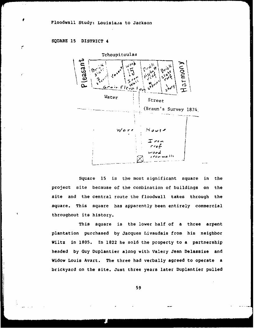
Floodwall Study: Louisia-ia to Jackson
SQUARE 15 DISTRICT 4
Tchoupitoulas
\\
VP-
Water' W r Street
--- (Braun's Survey 1874.
PIC 0"
Square 15 is the most significant square in the
project site because of the combination of buildings on the
site and the central route the floodwall takes through the
square. This square has apparently been entirely commercial
throughout its history.
This square is the lower half of a three arpent
plantation purchased by Jacques Livaudais from his neighbor
Wiltz in 1805. In 1822 he sold the property to a partnership
headed by Guy Duplantier along with Valery Jean Delassize and
Widow Louis Avart. The three had verbally agreed to operate a
brickyard on the site. Just three years later Duplantier pulled
59

I4J
0
-Er
A --
-W r-4..d 0
S., 4 o
, -. 4=J ,0
< C,
.2 P
00 0
0 X
-4 --
£ 0
>' 1
0
E0~0 I

loodwall Study: Louisiana to Jackson
ut and Valery Jean Delassize and Widow Avart operated the
rickyard. In The 1822 sale Livaudais had reserved part of the
pper one arpent from the sale, but a few years later Livaudais
old it to Delassize, who apparently moved into the fine home
ocated there. In the early thirties William Doherty purchased
mill operated with steam power on the batture, along with
oilers and tools. However, the records of this sale were
onsumed in a fire at the office of notary W. Y. Lewis in the
ate 1830s. No records of Doherty's ownership appears in any
hain of title. One possible explanation is the sale fell
hrough soon after it was agreed upon and the property reverted
o Delassize. In any event, the evidence shows some compara-
ively significant industry operating at this point of the
atture quite early. Doherty's extensive purchases of slaves
uggests the business used a great deal of labor. [Pierre
edesclaux, 5/2/05; Marc Lafitte, 12/30/22, Phillipe Pedesclaux,
/20/25]
On March 16, 1836 Valery Delassize and the widow
vart sold the three arpent plantation for subdivision to
amuel Herman, Jr., a merchant of New Orleans, for the handsome
rice of $79,345. [Felix Grima, 3/16/36] The batture property
onsisting of present day squares 15 and 16 was subdivided into
ots A, B, C, D, E, F, G, H (square 16), J, K, L, M, N, 0, P,
, and R (square 15). Samuel Herman promptly sold these lots to
artin Gordon, Jr. for over $25,000. In 1841 Gordon went bank-
upt and the Merchants Bank took over the property for $28,000
60

and renamed the lots on square 15 with numbers 1 through 8.
Three years later (1844) Merchants Bank turned the
entire square over to the commercial firm of R. W. Milbank &
Co. in satisfaction of a debt of $16,000 the bank owed the
firm. There were buildings on the square at this date, which is
a significant date for this stretch of the batture for it is
this year that the wharf was built in front of square 14 and
brick warehouses go up in the adjoining square. [Felix Griiiia,
3/16/36; F. Grima, 5/23/36; F. Grirna, 1/24/38; Lucien Herman,
2/8/41; G. R. Stringer, 3/20/441
The buildings could be part of the mill business that
was operated by Doherty or remains of the brickyard. In any
event, when Milbank sold the property in 1854 the firm des-
cribed the buildings as "the whole of their Brick Warehouses,
i.e., to say about 75 feet front on Levee street, 75 feet front
on Water street, by about 96 feet on Harmony street.* The firm
also included in the sale "the Machinery contained therein,
consisting of Engines, and Boilers, Shafting, Belting, drums
etc." It may be inferred that there were no other buildings on
the square in 1854.
In 1854 the principals in the firm of R. W. Milbank
put together a new manufacturing company, "The Louiziana Manu-
facturing Company." Its primary goal was to produce hemp rope
using Slaughter & Perry's "Improved cordage machines." Out of
the initial capital of $100,000, the firm agreed to pay
Slaughter & Perry $25,000 for the right to the machines in the
61
Floodwall Study: Louisiana to Jackson
states of Arkansas, Texas, Louisiana, Mississippi, Tennessee,
Alabama, Georgia, Florida, North and South Carolina. The new
company was also to give Slaughter & Perry an additional
$13,000 to install and begin operating the machines in the
brick warehouses. The specification provided that the machines
should be capable of turning out from rough hemp 10,000 lbs
dressed hemp and 10,000 lbs superior bale rope daily. As a
distinctly secondary purpose Louisiana Manufacturing was also
to produce cotton clothing for the southern trade, ie., slave
goods. [Louisiana Manufacturing Company, 5/20/53]
In accordance with the agreement, Milbank turned lots
1, 2, and 3 over to Louisiana Manufacturing in September of
1853 and the following year the remainder of the square. The
business probably prospered during the balance of the 1850s,
but the arrival rc the Civil War must have brought hard times.
Just after Louisiana secoeded from the Union Charles D.
Singleton, president of Louisiana Manufacturing, borrowed
$16,785.84 from Leeds & Co. and promised to repay in 12 months.
This proved impossible, and after the war Leeds brought suit
and forced a public sale of the company. [Fourth District
Court, #175911
The buildings and property was purchased by Lewis
John Higby of Milwaukee, Wisconsin who transferred it to a new
company, the New Orleans Elevator and Warehouse Company. The
sale was for $35,000. Higby, and his local brother Len Higby,
had established the property as a grain elevator to re-esta-
62

Floodwall Study: Louisiana to Jackson
blish New Orleans' ties with the Middle West. In 1868 the
Higby's built a wharf, elevator, conveyor, a boarding house,
and acquired the necessary machinery. They also introduced a
new twist, floating elevators, designed to be moved to the
location of ships or barges that needed to be unloaded. The
initial two elevators were the Steam Boat Cotile and the Barge
Alice. Also active in the firm was Fidel Engster of Cuba, a
principal in the grain exporting house of Engster and Co. The
New Orleans Elevator & Warehouse company was a "well-known"
company in 19th century New Orleans since it built the first
large grain elevator there in 1868. By the 1890s the company
had three large floating elevators, the "Dora", "Gov. Morton",
and the "Windward." In the month of April, 1892 the company
handled and loaded on foreign-going steamers over 3,250,000
bushels of grain, an average month for the time. The elevators
could store 250,000 bushels of grain and load 180,000 bushels a
day. It employed over 200 workers, and had rail connections.
[Englehardt, p. 75]
Its principal manager was Leonhard Naef, who joined
the firm in 1870 and took full control in 1881. He was born in
Switzerland in 1847, and came to New Orleans in 1869. In 1881
Naef served a term on the city council during the administra-
tion of Mayor W. J. Behan. He was also connected with the large
cotton and grain commission house of Engster & co., one of the
largest exporting houses of New Orleans. Naef married Miss Eliz
Klink, a native of Germany, who came to the United States in
63

Floodwall Study: Louisiana to Jackson
1868. [Goodspeed, II, 273]
In 1900 the New Orleans Elevator Company closed its
doors and sold its property to Charles A. Hubbard for $30,000.
The next eight years witnessed a series of owners, including
the Schwartz Foundry Co. Ltd. In 1909 the land was sold to the
City of New Orleans and the structures were removed.
SUMMARY
Square 15 is one of the two most important squares
both for the value of its former structures and for the
archeological possibilities due to the positioning of the
floodwall across the square. The floodwall appears to enter the
square from Water Street at the lower edge of the eight story
main tower of the 19th century grain elevator. It moves across
the square in a generally northerly direction parallel to the
edge of the building, and then turns and crosses the
foundations of a four story warehouse, followed by a one story
brick warehouse, probably the original building on the site
constructed in the 1840s. It is also possible that the four
story building was built by Milbank or the Louisiana
Manufacturing Company. The Zimpel map of 1834 shows a sawmill
on the site, a building that could also be related to the
brickyard known to exist in this vicinity. The important area
to watch is between P.1. Sta 10+99.76 and Gate Sta 12+70.45 on
Drawings 2 and 3 of the Corps of Engineers Plan Louisiana
Avenue to Jackson Avenue Floodwall, Right of Way (1981).
64

Floodwall Study: Louisiana to Jackson
pigging Sequences
1. On Corps of Engineers, Plan Louisiana Avenue to Jackson
Avenue Floodwall, from P.1. Sta. 10+99.76 to P.1. Sta. 11+54.78
expect possible heavy foundations for 8 story building, made of
wood with iron facing. At lower level possible early brickyard
or sawmill remnants.
2. On Corps plan, from P.1. Sta. 11+54.78 to before Sta. 12+30,
or a distance of approximately 60 feet from P.1. Sta. 11+54.78
going down river, expect foundations possible 1850s four story
brick warehouse. Below that good possibility for sawmill
(1820s) remains. Also possible brickyard.
3. On Corps plan, from approximately 20' upriver from Sta.
12+30 to Gate Sta. 12+70.45 look for remains of one story brick
warehouse, probably built before 1844.
65

Tchoupi~tOulas
oE-4
Water street
(Braun's Survey 1874)
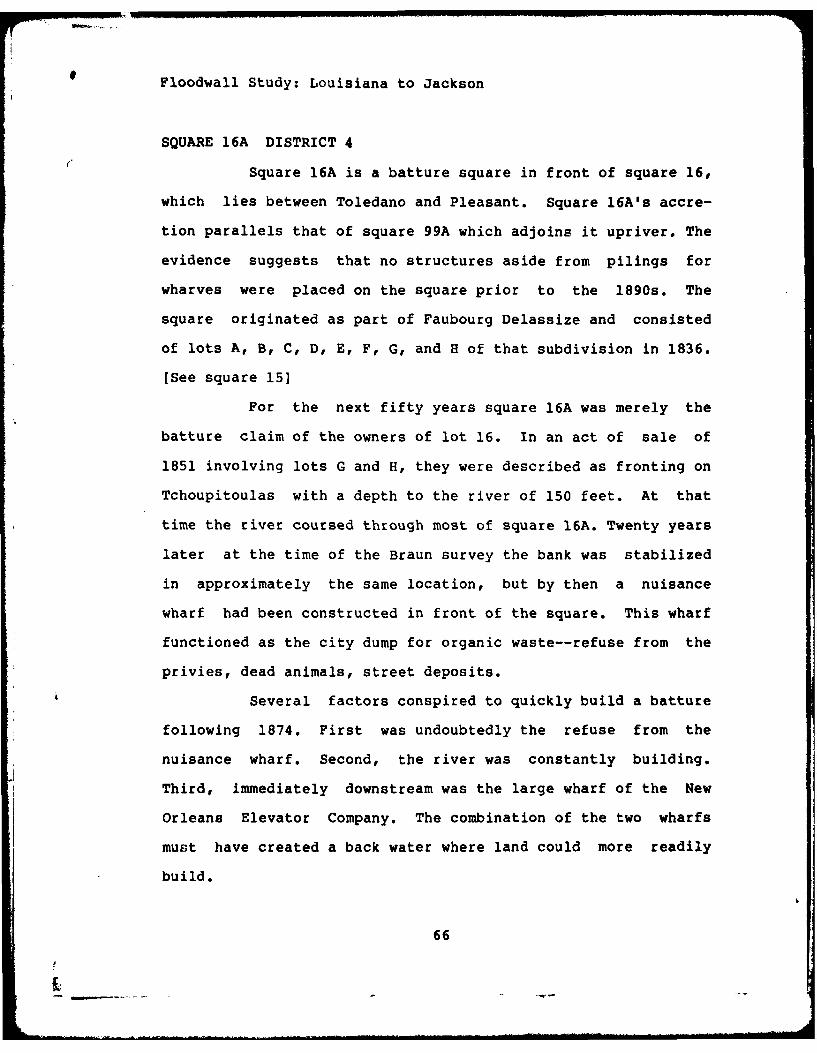
Floodwall Study: Louisiana to Jackson
SQUARE 16A DISTRICT 4
Square 16A is a batture square in front of square 16,
which lies between Toledano and Pleasant. Square 16A's accre-
tion parallels that of square 99A which adjoins it upriver. The
evidence suggests that no structures aside from pilings for
wharves were placed on the square prior to the 1890s. The
square originated as part of Faubourg Delassize and consisted
of lots A, B, C, D, E, F, G, and H of that subdivision in 1836.
[See square 15]
For the next fifty years square 16A was merely the
batture claim of the owners of lot 16. In an act of sale of
1851 involving lots G and H, they were described as fronting on
Tchoupitoulas with a depth to the river of 150 feet. At that
time the river coursed through most of square 16A. Twenty years
later at the time of the Braun survey the bank was stabilized
in approximately the same location, but by then a nuisance
wharf had been constructed in front of the square. This wharf
functioned as the city dump for organic waste--refuse from the
privies, dead animals, street deposits.
Several factors conspired to quickly build a batture
following 1874. First was undoubtedly the refuse from the
nuisance wharf. Second, the river was constantly building.
Third, immediately downstream was the large wharf of the New
Orleans Elevator Company. The combination of the two wharfs
must have created a back water where land could more readily
build.
66
Floodwall Study: Louisiana to Jackson
Ten years later, in 1884, Hyman Levin of Chicago,
purchased most of the batture in front of square 16 by an act
passed in the city of Leadville, County of Lake, State of
Colorado, from James Beattie. He paid $1,600. Since Levin's
home was Chicago, it suggests that he might be in the grain
business. This possibility is further reinforced by the proxi-
mity of the site to the New Orleans Elevator Company. Levin
sold out in 1890 for $3,300, a price jump that suggests he made
some improvements to the property. A plan of 1908 shows the
site in 1893 and shows the entire square 16A now securely
within the levee. The 1890 purchaser, Henry Wellman and Robert
J. Whann, seemingly made some further improvements to the
property, for the two mortgages from the period show an
increasing value and refer to buildings. In 1904 Whann and the
widow of his partner sold out, and the land passed to the City
of New Orleans for the expansion of the levee in 1909.
SUMMARY
Like square 99A immediately upriver, square 16A is of
comparatively recent origin, the product of batture accretion.
The likelihood of historically significant buildings is mini-
mum. However, the floodwall departs square 16A and traverses
Water Street for a short distance. It is probable that granite
stone street paving will be uncovered. It is also possible that
an early street railway dating to 1885 may be crossed. Whether
any tracks will be uncovered is doubtful. Finally, in this
short run down Water street there is always the possibility of
67

Floodwall Study: Louisiana to Jackson
an early 19th century waterfront shack. This area is part of
the general area of the location of an early 19th century
brickyard. Finally, some remanants of the 1890s structures put
up on square 16A may be found, but their nature is not known.
68
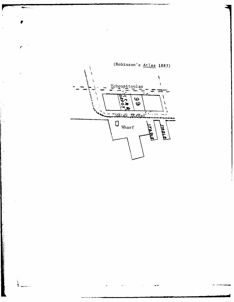
(Robinson's Atlas 1883)
.. _ . Tchoupitoulas
-Wharf
Floodwall Study: Louisiana to Jackson
SQUARE 99A DISTRICT 6
Square 99a is a comparatively late creation of the
Mississippi River. As late as the Robinson atlas of 1883 the
square is not shown, though various awkward land masses are
portrayed projecting into the river. The floodwall site in its
initial stages thus was in the river bed.
Surveyor Benjamin Buisson drew the earliest signifi-
cant plan for the area in May 22, 1839. This plan lays out
Levee Street, the future Tchoupitoulas, and Grand Cours Wiltz,
the future Louisiana Avenue. The plan shows lots for a specific
sale on squares 100 and 99. Square 100 is across Tchoupitoulas
from the site and square 99 is between Tchoupitoulas and the
river. Like all the early squares, all the lots extended from
Tchoupitoulas to the river. Buisson provides the depth of the
lots on his plan, approximately 150 feet, and then he drew in
the river. The contemporary square 99 occupies the first 82
feet of this 150 feet, stretching from Tchoupitoulas. In the
lo3Os, however, a new street was cut through between Tchoupi-
toulas and the river, this was Water Street, then variously
called Public Landing or Levee. Water varies from 50 to 60 feet
in width, and thus on present maps would occupy the next 60
feet after the 82 feet of square 99. By subtraction, if it was
150 feet to the water from Tchoupitoulas, and 142 of the feet
are occupied by square 99 and Water Street, only 8 feet of
square 99A was present in 1839. (Benj. Buisson, Plan d
Lots dg Ii Quartier dg °laisance, May 22, 1839]
69
p-

I UfI
J .
dj~ mv. "..'j,
To e n an o ', mIo ti g i
th 1850 .Pln ok 7
Notar al A c ive

Floodwall Study: Louisiana to Jackson
A famous plan of 1865 shows the site in excellent
detail. See attached plate. The river batture has added more
land in the intervening 26 years. Using again 82 feet as the
average depth of square 99, the plan shows that the river edge
was 136 feet from the river side of square 99. AfteL allowing
60 feet for Water Street (here called Levee), it is now appar-
ent that 76 feet are now available. However the plan clearly
shows the levee immediately adjacent to Levee Street, with the
outside land referred to as Batture. Thus most of square 99A
was subject to flooding, if not actually underwater. No
development took place for another 11 years. [C. A. deArmas,
Plan of 2 Lots of Ground with Right to Batture, October 4,
18651
In 1867 the City Council granted a street railway
franchise to the Crescent City Railroad Company for the Tchou-
pitoulas line. On January 15, 1876 Crescent City Railroad
awatded a building contract to John Page to build a brick car
house, frame stables, and a wharf on its property recently
acquired from Christian Schopp. [It should be noted that the
public record shows the company acquired the car house parcel
in 1879. The building contract thus implies the company pur-
chased the land earlier by act under private signature! The
architect for the buildings and wharf was the noted engineez
Benjamin Morgan Harrod, who was also to supervise construction.
Typical of the time was the quick construction schedule--all
the buildings and wharf was to be completed in two months. The
70
loodwall Study: Louisiana to Jackson
harf was to cost $1,475 and the car barn and stables $10,600.
The exposed position of the stables on the very edge
f the river was risky. This is verified by a note attached to
he contract permitting an extension of the completion date for
he stables. A rise in water had interrupted work, and it would
ave to be completed after the high water season. [N. B. Trist,
/15/761 The stables and wharf built on the site of souare 99A
re clearly shown on Robinson's Atlas of 1883.
Ten years later the levee stood just on the river
ide of lot 99A and its companion downriver, 16A. Its toe
efined the river edge of the squares. The stables were now on
ry land. It is significant that the City of New Orleans ac-
uired 99A in 1908 for levee purposes, while it did not acquire
quare 99 on Tchoupitoulas until 1918, for the Public Belt
ailroad.
SUMMARY
The site of the floodwall from its beginning at the
oot of Louisiana Avenue through square 99A resided in the
ississippi River until the late 19th century. The first and
nly constructions on the site projected initially into the
iver oatture. In themselves they do not possess historical
ignificance. However, the initial hundred feet of the flood-
all may uncover valuable marine artifacts. The most desirable,
f course, would be ship remains.
71
AD-A121 74 ARCHIVAL EVALUATION 0f FOOWAL ALIGNMENTS: NEW a~ORLEAN 0 U SIANAU PERE ES (SALL K AND WILLAM D) NEW
OR1,ELAN LA S K QP VE A L.22 0C 82
UNCASFE AW98-M1 A 5 5 8 9 PG 5 /6 .NL
EHEHEL mmom

1.511111 . MQ AS 6
-I-
MICROCOPY RESOLUTION TEST CHART
NATIONAL BUREAU OF STANDARDS-1963-A
,oJ
i,
!I
Floodwall Study: Louisiana to Jackson
4 &RLTOGRAPB QE WORKS CTr
PRIMARY
Louisiana Manufacturing Company. Articles of Agreement. Attachedto W. L. Poole, 9/22/1853.
Michel & Co. I&M Qrilaang AnnmAjl &ad ar~mcgial Direc.tory].l.4.. Justin L. Solleez New Orleans, 1842.
New Orleans City Directories. 1838-1880
Orleans Parish Notaries. Notarial Archives.Beard, J. R.Borgstede, John R.Caire, Louis P.Coffey, John F.Cohn, JosephCuvellier, P. C.Gottschalk, E. L.Grima, FelixGuyolp TheodoreHero, Andrew Jr.Kenny, L. R.Lafitte, MarcMarks, Joseph B.Poole, W. L.Ricardo, D. J.Seeber, W. V.Stringer, G. R.Trist, N. B.Villere, Alcee J.
SECONDARY
Arthur, Stanley Clisby and Kernion, George Campbell Huchet de.FJ amilis g.f L-ouininna. New Orleans: Harmanson, 1931.
Dart, Henry F. "A Sale of Real Property in Louisiana in 1769."Lois~iana Hlistorical QUAatAxlj, XXI, 1938, pp. 674-676.
Engelhardt, Geo. W., ed. Tha QU aL ft Orle~aans- M Thak 2L theChambetr 2L Commerce nd Industry 2f LouisianaA and atharriabjj.& B&iAa QL thl "Crescmnt Ciy.! New Orleans: Geo W.Engelhardt, 1894.
Fortier, Alcee, ed. LgjaiaaJ.IL ComprL~ing Sketches n.L PAzjAhaaTowns. Evns Inst itut ions, M Pesos &ftflflDBd in
CY1aaeic r =. 3 vols. NP: Century HistoricalAssociation, 1914.
72

Floodwall Study: Louisiana to Jackson
Goodspeed Publishing Company. Bioagrahical ad insLori.calMemoLrsof Loi i na. 3 vols. Louisiana Classic Series Reprint of1892 edition. Baton Rouge: Claitor's Publishing Division, 1975.
Holmes, Jack D. L. Honor and F Tha Loniiana Lnfantryegime n the Louana Militia CM£ania 2.Birmingham: 1965.
Jewell, Edwin L. jewell' Dig.ot 2fth Qj Ordnac.. NewOrleans: 1887.
Nau, John Fredrick. Th German epo.9le .f Ore n 1850-190.. Leiden: E. J. Brill, 1958.
Padgett, James A. *Some Documents Relating to the Batture Contro-versy in New Orleans." Louisiana Historical QUAr±&,L1 ,XXIII (1940), pp. 675-732.
Register, James, ed. R Orleans " My Name. Shreveport, La.:1971.
Samuel, Martha Ann Brett and Samuel, Ray. Tbe Great D~A 2f t hGarden Distri ad th =l d QjU 2f Lafoayt. New Orleans:Parents' League of the Louise S. McGehee School, 1978.
73

HISTORIC,
F LOOD

S'AL PLANS
DWA L L

18150
jt1:76
PLANTATION .-
JOSEPH WILTZ- -
1do
.011
. ......

in~ 69 - - - -
.' . ... ..
MISISIPI RIE

the Br it ish Army, its several
ment du Cheniin Public sur
par Benj. Bujason. Arpantagedu 16 Janvier 1832 in Louis T.Caire, M.P., 2/24/32, vol. le.
'uT I 42Y sea
'd vk 1 1
0? 8C
IDO 01'ac ,,,p

C
i
I/
(
-~ A

'34
LO U
GOP
.NW mo
- - -- -111lillil~ iilliiilllllllllillililiiilll~ l~ ~ ~lIIIIIIIIIIII11111,11iiiill
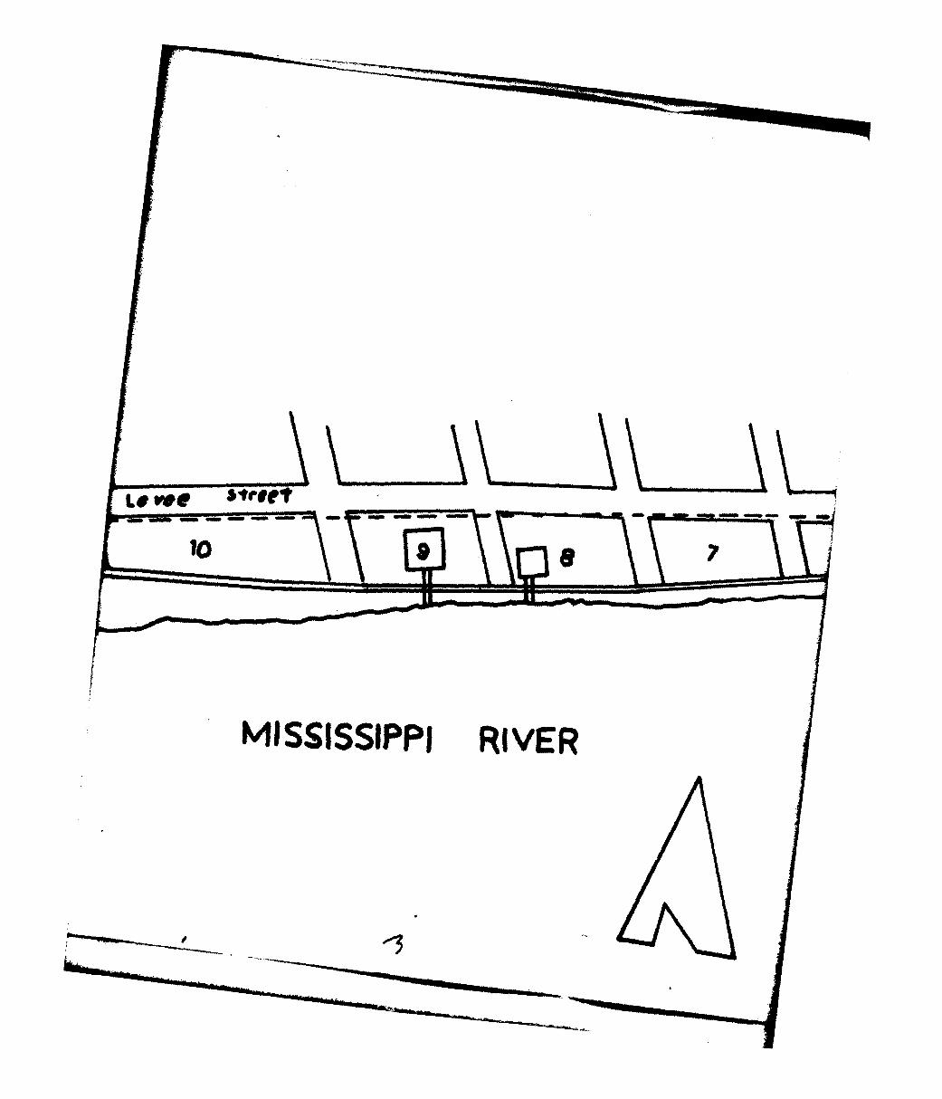
10.
MISSISSIPPI RIVER

0%- wAINNOW11,11,11iiiiiiIIIII
ER
"areOil

-. 7
Based on Charles F. Zimpel"Topographical Map of New Orleans and Vicinity"New Orleans: 1834
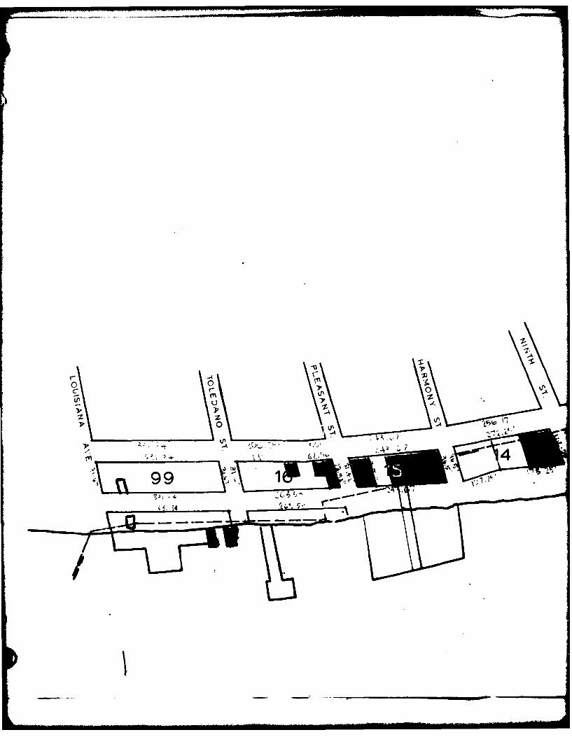
0 '
C- 0
99 t

11857 187
Atp I
s. I$A A '
'p I
2.' 13
4L

18747 0
A
A ~ ~ %' STAOP" .
. 14 ,pl
\ASSISSIPPI j~E

IPA
PLAN FOR ARCHIVAL
A
CORPS OF E
JACKSON AVE
GRAPHIC SCALE PREPARED BY WM.Dld SEP1
PLAZ$FROM: J.F. BRAUN,
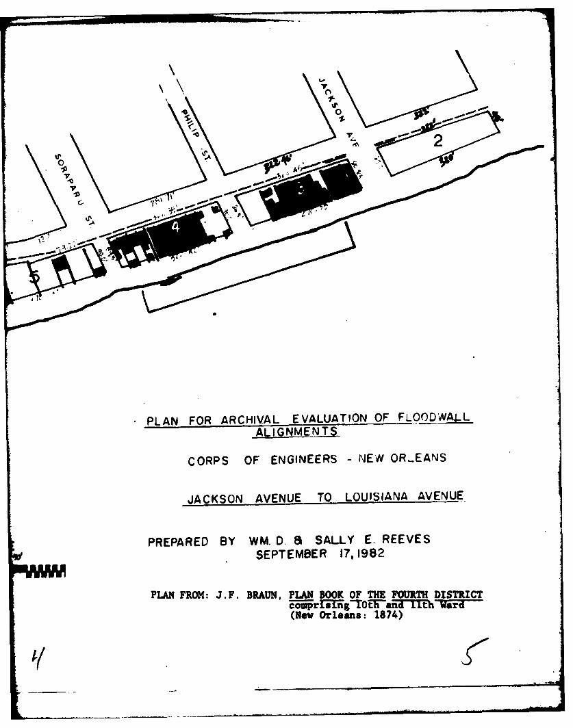
00
'~' +\ -11
PLAN FOR ARCHIVAL EVALUATION OF FLOODWA4-LALIGNMENTS
CORPS OF ENGINEERS - NEW OR.EANS
JACKSON AVENUE TO LOUISIANA AVENUE
PREPARED BY WM. D. 8 SALLY E. REEVES
SEES@ SEPTEMBER 17,1982
PLAN FROM: J.F. BRAUN, PLAN BOOK OF THE FOURTH DISTRICTc-r 1ng-TOtF-a-lTt- Ward(New Orleans: 1874)
Ii

~Iq~