aren (arenga pinnata (wurmb) merr.) traditional management
TRANSCRIPT
INAFOR 11H-062
INTERNATIONAL CONFERENCE OF INDONESIAN FORESTRY RESEARCHERS (INAFOR)
Section H Community and Social Forestry
Aren (Arenga pinnata (Wurmb) Merr.) Traditional Management System in Batang Toru, North Sumatra and Tomohon, North Sulawesi,
Indonesia
Endri Martini and James M. Roshetko
World Agroforestry Centre and Winrock International Jl. CIFOR Situgede, Sindang barang, Bogor 16880, INDONESIA
Paper prepared for The First International Conference of Indonesian Forestry Researchers (INAFOR)
Bogor, 5 – 7 December 2011
INAFOR SECRETARIAT Sub Division of Dissemination, Publication and Library
FORESTRY RESEARCH AND DEVELOPMENT AGENCY Jl. Gunung Batu 5, Bogor 16610
552
Aren (Arenga pinnata (Wurmb) Merr.) traditional management system in Batang Toru, North Sumatra and Tomohon, North Sulawesi, Indonesia
Endri Martini and James M. Roshetko
World Agroforestry Centre and Winrock International
Jl. CIFOR Situgede, Sindang barang, Bogor 16880, INDONESIA
ABSTRACT
Aren or sugarpalm (Arenga pinnata (Wurmb) Merr.) is a multipurpose palm species found across tropical Asia which is traditionally utilized as source of livelihoods in Indonesia such as in Batang Toru landscape, North Sumatra and Tomohon district, North Sulawesi. Interestingly, despites of aren sustainable contribution to local livelihoods, indigenous domestication efforts have been limited. Thus, traditional aren management systems were studied to understand the regeneration and management practices of aren trees in the landscape. Data on aren tree management across the landscape, aren‘s role to local livelihood, and local ecological knowledge of aren management were collected through interviews with key farmers, focus group discussion, and direct observations (transect walk). Results show no significant different in aren traditional tree management between sites, however farmers in Batang Toru harvest more diverse aren products than in Tomohon because of the better market opportunities. In the study sites, two types of aren tree regeneration were identified, i.e. a) natural regeneration, b) transplanted regeneration. Under current conditions, natural regeneration is most practiced by farmers. Farmers perceive aren as an abundant natural asset that is best regenerated by wildlife. Potential improvements in smallholder aren productivity are best by managing aren trees density and selecting superior germplasm. This paper provides best options for domesticating the non timber forest product (NTFP) species for community-based reforestation and livelihood enhancement in Indonesia.
Keywords: natural regeneration, transplanted regeneration, livelihood, tree management.
1. INTRODUCTION
Aren or sugarpalm (Arenga pinnata (Wurmb) Merr.) is a multipurpose palm species belongs to Arecaceae family. The trunk is single and covered with a black fibrous hessian like material. Aren often found in tropical Asian landscape with ample sun, lots of water (usually occur near the river), and in a well drained position. The species grows best at high altitude area (500-800 m asl) with precipitation above 1200 mm/year, 7-10 rainy months and average temperature around 25ºC (Soeseno, 2000). Animals such as palm civets (Paradoxurus hermaphroditus Pallas) play an important role in aren natural regeneration. In many areas, farmers believe that the best aren planters are the palm civets (Mogea et al., 1991).
Traditionally, aren multiple non timber products (such as flower sap, thatch and fruits) has been harvested for home consumption and to supply the local market demand. Thus, aren has become a major contributor to the livelihoods in Indonesia (Mogea et al., 1991, Smits and Widawati, 1999). Extractive harvesting with limited indigenous domestication efforts has become the traditional management of aren in many parts in Indonesia. The perception that aren trees are still abundant in the landscape may be a reason of farmer‘s reluctance in cultivating and proactively managing aren. In the future, intense utilization of aren without improvement of its domestication efforts would have negative impact on aren resource and natural ecosystem.
553
In Indonesia, Batang Toru in North Sumatra and Tomohon in North Sulawesi are the two site that received attention from scientists for aren study. Mogea et al. (1991) study has summarized the aren utilization in those two sites, thus it would be useful to reconfirm the information that was collected 20 years ago. Batang Toru and Tomohon have similar aren‘s management practices, but only in Batang Toru is the fruit harvested and utilized. Fruit harvesting is suspected to decrease the production of aren flower sap and potentially have a negative effect on genetic variation, as fruit is harvested from superior trees and thus do not regenerate. Raebild et al. (2001) study in Southern Burkina Faso showed that intensive seed harvest of Parkia biglobosa has limited the natural regeneration of the species.
Utilization of non timber forest product (NTFP) is an alternative to optimize forest value with limited impact on forest degradation when compared with timber extraction (Belcher et al., 2005). NTFPs are generally used to supplement diets and household income, notably during particular seasons in the year, and as economic buffer in hard times. However, NTFP harvesting can affect the genetic diversity of the population being exploited, especially when harvesting flowers or fruits (Peters, 1994). As NTFPs utilization is intensified (commercialization), NTFP harvesting can altered and degraded the forest resource (Arnold and Perez, 2001). Traditional low intensity harvesting of NTFP is expected can contribute to the sustainable forest management. The traditional production systems are in harmony with the environment prior to exposure to various forces of pressure (Kang and Akinnifesi, 2000). Knowledge on traditional species management can be used as starting point to identify the actions necessary to sustain the productivity of NTFPs species. Thus, in regards to maintain the sustainability of aren‘s contribution to local livelihood and environment, traditional aren management systems are studied to understand the regeneration and management practices of aren trees in the landscape. As aren has been using as species for land rehabilitation, information from this study can be used to foster community-based reforestation and livelihood enhancement in Indonesia.
2. METHODS
2.1 Location of Study
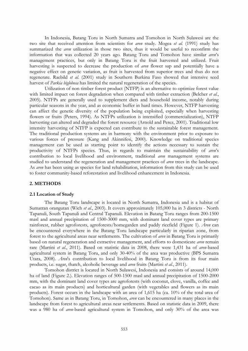
The Batang Toru landscape is located in North Sumatra, Indonesia and is a habitat of Sumatran orangutan (Wich et al., 2003). It covers approximately 105,000 ha in 3 districts - North Tapanuli, South Tapanuli and Central Tapanuli. Elevation in Batang Toru ranges from 200-1500 masl and annual precipitation of 1500-3000 mm, with dominant land cover types are primary rainforest, rubber agroforests, agroforests/homegarden and paddy ricefield (Figure 1). Aren can be encountered everywhere in the Batang Toru landscape particularly in riparian zone, from forest to the agricultural areas near settlements. The cultivation of aren in Batang Toru is primarily based on natural regeneration and extractive management, and efforts to domesticate aren remain rare (Martini et al., 2011). Based on statistic data in 2008, there were 1,431 ha of aren-based agricultural system in Batang Toru, and only 30-40% of the area was productive (BPS Sumatra Utara, 2008). Aren's contribution to local livelihood in Batang Toru is from its four main products, i.e. sugar, thatch, alcoholic beverage and aren fruits (Martini et al., 2011).
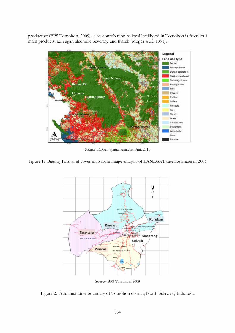
Tomohon district is located in North Sulawesi, Indonesia and consists of around 14,000 ha of land (Figure 2.). Elevation ranges of 500-1500 masl and annual precipitation of 1500-2000 mm, with the dominant land cover types are agroforests (with coconut, clove, vanilla, coffee and cacao as its main products) and horticultural garden (with vegetables and flowers as its main products). Forest occurs in the landscape with an area of 1,615 ha (ca. 10% of the total area of Tomohon). Same as in Batang Toru, in Tomohon, aren can be encountered in many places in the landscape from forest to agricultural areas near settlements. Based on statistic data in 2009, there was a 980 ha of aren-based agricultural system in Tomohon, and only 30% of the area was
554
productive (BPS Tomohon, 2009). Aren contribution to local livelihood in Tomohon is from its 3 main products, i.e. sugar, alcoholic beverage and thatch (Mogea et al., 1991).
Source: ICRAF Spatial Analysis Unit, 2010
Figure 1: Batang Toru land cover map from image analysis of LANDSAT satellite image in 2006
Source: BPS Tomohon, 2009
Figure 2: Administrative boundary of Tomohon district, North Sulawesi, Indonesia
Hutaraja Sigiring-giring
Banuaji IV
Aek Nabara
Paran Julu
Hutagurgur
Pagaran Tulason
Lumban Lobu
Sipirok

555
2.2 Data Collection
Primary data was collected in June to July 2010. General information on aren tree management across the landscape, aren‘s contribution to local livelihood, and local ecological knowledge on aren management were collected through interviews with key farmers, focus group discussion, and direct observations (transect walk). The semi-structured interviews collected quantitative data on empirical yield and qualitative data on tree regeneration strategy and harvesting techniques. Interviews were conducted in 4 villages in Batang Toru (i.e. Aek Nabara, Sigiring-giring, Hutaraja and Banuaji IV) and 5 villages in Tomohon (i.e. Tara-tara, Pinaras, Kayawu, Rokrok and Rurukan). In total, 45 farmers were selected randomly for interview, with at least 5 farmers per village. Markets issues were identified through discussion with farmers and local traders. Secondary information from previous studies (Martini et al., 2011 and Mogea et al., 1991) was used as supplement of the primary data.
2.3 Data Analysis
Rapid Assessment of Agroforestry Practices and Technology (RAFT) analytical framework (Joshi and van Noordwijk, 2009) was modified to analyze information collected on aren tree management systems in both sites. Quantitative data on aren productivity were compared by t-test and descriptive statistics.
3. RESULTS AND DISCUSSION
3.1 Aren’s Tree Regeneration, Management and Productivity
Aren trees occur scattered across both Batang Toru and Tomohon landscapes. In Batang Toru, farmers harvested productive aren trees in their rubber agroforest garden (at elevation of 0-800 m asl) and abandoned agroforest garden (above 800 m asl). Aren trees are also occurred in the Batang Toru forest, however farmers are reluctant to harvest product from those trees due to the long distances between forests and road or settlements. In Tomohon, farmers harvested productive aren trees that occur in their agroforest garden (where clove and coconut as the dominant species). Based on direct observation (transect walk), at the landscape scale aren tree density in Tomohon is higher than in Batang Toru (Figure 3). Aren tree maintenance is rarely practiced by farmers at either study sites, however thatch removal is belief to enhance tree diameter growth.
Figure 3: Aren occurrence in Batang Toru (left) and Tomohon (right)
Batang Toru Tomohon
556
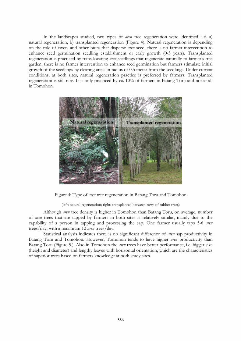
In the landscapes studied, two types of aren tree regeneration were identified, i.e. a) natural regeneration, b) transplanted regeneration (Figure 4). Natural regeneration is depending on the role of civets and other biota that disperse aren seed, there is no farmer intervention to enhance seed germination seedling establishment or early growth (0-5 years). Transplanted regeneration is practiced by trans-locating aren seedlings that regenerate naturally to farmer‘s tree garden, there is no farmer intervention to enhance seed germination but farmers stimulate initial growth of the seedlings by clearing areas in radius of 0.5 meter from the seedlings. Under current conditions, at both sites, natural regeneration practice is preferred by farmers. Transplanted regeneration is still rare. It is only practiced by ca. 10% of farmers in Batang Toru and not at all in Tomohon.
Figure 4: Type of aren tree regeneration in Batang Toru and Tomohon
(left: natural regeneration; right: transplanted between rows of rubber trees)
Although aren tree density is higher in Tomohon than Batang Toru, on average, number of aren trees that are tapped by farmers in both sites is relatively similar, mainly due to the capability of a person in tapping and processing the sap. One farmer usually taps 5-6 aren trees/day, with a maximum 12 aren trees/day.
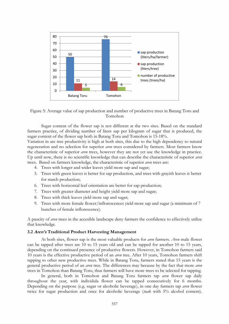
Statistical analysis indicates there is no significant difference of aren sap productivity in Batang Toru and Tomohon. However, Tomohon tends to have higher aren productivity than Batang Toru (Figure 5.). Also in Tomohon the aren trees have better performance, i.e. bigger size (height and diameter) and lengthy leaves with horizontal orientation, which are the characteristics of superior trees based on farmers knowledge at both study sites.
Natural regeneration Transplanted regeneration
557
Figure 5: Average value of sap production and number of productive trees in Batang Toru and Tomohon
Sugar content of the flower sap is not different at the two sites. Based on the standard farmers practice, of dividing number of liters sap per kilogram of sugar that is produced, the sugar content of the flower sap both in Batang Toru and Tomohon is 15-18%. Variation in are tree productivity is high at both sites, this due to the high dependency to natural regeneration and no selection for superior aren trees considered by farmers. Most farmers know the characteristic of superior aren trees, however they are not yet use the knowledge in practice. Up until now, there is no scientific knowledge that can describe the characteristic of superior aren trees. Based on farmers knowledge, the characteristic of superior aren trees are:
4. Trees with longer and wider leaves yield more sap and sugar;
5. Trees with green leaves is better for sap production, and trees with grayish leaves is better
for starch production;
6. Trees with horizontal leaf orientation are better for sap production;
7. Trees with greater diameter and height yield more sap and sugar;
8. Trees with thick leaves yield more sap and sugar;
9. Trees with more female flower/inflorescences yield more sap and sugar (a minimum of 7
bunches of female inflorescence).
A paucity of aren trees in the accesible landscape deny farmers the confidence to effectively utilize that knowledge.
3.2 Aren’s Traditional Product Harvesting Management
At both sites, flower sap is the most valuable products for aren farmers. Aren male flower can be tapped after trees are 10 to 15 years old and can be tapped for another 10 to 15 years, depending on the continued presence of productive flowers. However, in Tomohon farmers said 10 years is the effective productive period of an aren tree. After 10 years, Tomohon farmers shift tapping to other new productive trees. While in Batang Toru, farmers stated that 15 years is the general productive period of an aren tree. The differences may because by the fact that more aren trees in Tomohon than Batang Toru, thus farmers will have more trees to be selected for tapping.
In general, both in Tomohon and Batang Toru farmers tap aren flower sap daily throughout the year, with individula flower can be tapped consecutively for 6 months. Depending on the purpose (e.g. sugar or alcoholic beverage), in one day farmers tap aren flower twice for sugar production and once for alcoholic beverage (tuak with 5% alcohol content).
50
76
11 14
5 6
0
10
20
30
40
50
60
70
80
Batang Toru Tomohon
sap production(liters/ha/farmer)
sap production(liters/tree)
number of productivetrees (trees/ha)
558
Tapping techniques are similar in both sites. However, post-harvest processing techniques are a different.
Besides aren flower sap, Batang Toru farmers also harvested the fruits for sweetmeat (kolang-kaling). Because the fruit bunches are considered as source for sugar, thus out of 3-12 fruit bunches only 1-2 fruit bunches per tree that are harvested per year. Total weight of one fruit bunch is around 60 kg which can be processed into 180 kg kolang kaling. The kolang-kaling is sold to Medan, Jakarta, Riau with the price at farmer level Rp 2500/kg. The demand for kolang-kaling is greatest during the Ramadhan (Moslem fasting month). Farmers in Tomohon didn‘t produce kolang-kaling due to lack of market channel and local demand for kolang-kaling in Tomohon.
Aren thatch is more intensively harvested in Batang Toru than in Tomohon, again this is due to the presence of stronger market demand. In Batang Toru, thatch is sold for road foundation material. While in Tomohon thatch is harvested for broom production. Poor families, who do not have aren trees, harvested thatch of other farmer‘s aren tree and made it into brooms. From 5 aren trees, usually at least 4 sheets of thatch can be harvested per year, with at least 2 kg/sheet and the price Rp 3,000/kg of thatch. Thatch production per trees are variative, depend on the growth of the trees. Annually, thatch usually harvested twice every 6 months.
3.3. Aren’s Contribution in Local Livelihood
Aren's contribution to local livelihood both in Batang Toru and Tomohon can be classified into its four main products, i.e. sugar, alcoholic beverage (5% and 30-40% alcohol content), fruits (kolang-kaling) and thatch (ijuk) (Table 1.). However, farmers at the two sites have different income strategy from aren products which are affected by the availability of productive aren trees and market access.
Table 1. Aren‘s contribution to local livelihood in Batang Toru and Tomohon
Products
Batang Toru Tomohon
Income strategy Gross revenues
(per farmer) Income strategy
Gross revenues
(per farmer)
Sugar Weekly 12-20 USD/week Daily 13 USD/day
Alcoholic
beverage (Tuak
5% alcohol content)
Weekly 2-10 USD/week Daily 18 USD/day
Alcoholic
beverage (Tuak
30-40% alcohol
content)
None None Daily 14 USD/day
Kolang-kaling Annually 450 USD/year None None
Ijuk Annually 2 USD/year Weekly 7 USD/week
3.4 Discussion
Despite aren‘s importance to local livelihoods, in the past two decades there has been little effort by farmers to cultivate aren in either Batang Toru or Tomohon. This trend is valid for most
559
palms in the tropics (Byg and Balslev, 2006). Based on discussion with farmers, main reason for limited aren domestication is because aren trees are still abundant in the natural landscape, and that wildlife is percieved to be the appropriate and efficient mode for aren regeneration.
Based on analysis of Net Present Value and Return to Labour in Batang Toru Martini et al. (2011) determined that aren management systems that depend on natural regeneration were more profitable where aren trees are still abundant and the wildlife are still active in pollination and seed dispersal. However, in areas where natural vegetation has been converted to other land uses, cultivating aren by transplanted regeneration was a better option for supporting the sustainability of aren utilization as a source of local livelihood systems. Byg and Balslev (2006) also showed that perceptions of declining palm availability in combination with heavy reliance on palm products were positively related to palm cultivation (domestication).
Currently, farmers in Batang Toru have begun to cultivate aren at regular spacing, while in Tomohon farmers do not yet have strong motivation to do so. This is because natural regeneration in Tomohon maintains aren tree density that is sufficient for farmer needs and greater than in Batang Toru. The lack of fruit harvesting in Tomohon is suspected to facilitate higher aren tree density as more fruit/seed are present to produce natural regeneartion.
Aren fruit harvesting is also thought to have an indirect negative effect on sap productivity. In Tomohon where fruit is not harvesting, the trees are larger and the flower sap production is greater. Mogea et al. (1991) reported that the sizes of aren trees in Tomohon are larger than those described in other places. They suspected that the positive selection by Tomohon farmers has resulted in aren populations with high sap production, as well as the fertile dark andosols soil occurring in the area. For NTFP species which depend on natural regeneration not only may deplete the species stocking in the area, but also deplete the genetic diversity which is essential for selecting superior variants. This phenomenon was also observed with Parkia biglobosa in Southern Burkina Faso (Raebild et al., 2001). Further genetic study need to be conducted to collect more evidence of negative linkage between reduced natural regeneration and fruit harvesting of aren.
Aren‘s value to local livelihood can also be enhanced by improving market access and share of end-user value received by farmers. Sugar and tuak are primarily sold in local markets, which is an advantage as price are relative stable compare to international market. On the other hand, aren‘s thatch and fruits are exported mainly to Singapore. With the current global economic crisis, international market prices of export product may reduce the economic benefit of the exported products, in that context local market may be more secure.
In Indonesia, aren has been used to support ecological restoration and land rehabilitation, because aren root systems contribute to the soil and water conservation, its contribution to local livelihood and its compatibility with other plant species. Recent study by Martini et al. (2011) concluded that to optimize the role of aren for local livelihoods and conservation, the number of aren trees per hectare needs to be considered. A density of 12 aren trees/ha seems to be the minimum for an aren agroforest to significantly contribute to a family livelihood. Thus, aren has the potential to be used as species in community based forest restoration in Indonesia. Furthermore, supported activities in enhancing aren‘s productivity under community based reforestation scheme, needs to be identified.
4. CONCLUSION
In Batang Toru and Tomohon, aren is a source of livelihood for local communities. In both landscape, aren trees are primarily encountered in degraded forests and farmers‘ tree gardens. In this study, two types of aren tree regeneration were identified, i.e. a) natural regeneration, b) transplanted regeneration. Currently, natural regeneration is preferred by farmers. Farmers perceived wildlife as an appropriate and efficient mode of aren regeneration. Under natural regeneration management, aren fruit harvesting may deplete the species stocking in

560
the area and the aren genetic diversity which is essential for selecting superior variants. However, further genetic studies are required to collect evidence of negative linkage between reduced natural regeneration and fruit harvesting of aren. Furthermore, supported activities in enhancing aren‘s productivity under community based forest restoration scheme, also need to be identified.
ACKNOWLEDGEMENT
Activities in this study was funded by Agentschap NL Ministerie van Economische Zaken Landbouw en Innovatie under Project number PEGENL085046 that was implemented by Ecofys Netherlands Bv and Winrock International in 2011. Authors would like to thanks Dr. Meine van Noordwijk, Dr. Willie Smits, Harry Kaunang and the Yayasan Masarang team, Jasper van de Staaij, David Walden and all the farmers, traders and government officers in Batang Toru and Tomohon for the support during the study.
REFERENCES
Arnold JEM, Perez MR (2001): Can non-timber forest products match tropical forest conservation and development objectives?. Ecological Economics 39:437-447.
Biro Pusat Statistik (BPS) Sumatra Utara (2008): Sumatra Utara in Figures 2008. BPS Statistics Province of Sumatra Utara.
Biro Pusat Statistik (BPS) Sulawesi Utara (2009): Sulawesi Utara in Figures 2009. BPS Statistics Province of Sulawesi Utara
Biro Pusat Statistik (BPS) Tomohon (2009): Kota Tomohon in Figures 2009. BPS Statistics City of Tomohon.
Belcher B., Perez MR, Achdiawan R (2005): Global Patterns and Trends in the Use and Management of Commercial NTFPs: Implications for Livelihoods and Conservation. World Development 33(9):1435–1452.
Byg A, Balslev H (2006): Palms in indigenous and settler communities in southeastern Ecuador: farmers‘ perceptions and cultivation practices. Agroforestry Systems 67:147-158
Joshi L, van Noordwijk M (2009): Rapid Appraisal of Agroforestry Practices, Systems and Technology (RAFT). Trees in Multi-Use Landscape in South East Asia (TULSEA) project. World Agroforestry Centre. http://www.worldagroforestrycentre.org/sea/Publications/files/leaflet/LE0152-09.PDF
Kang BT, Akinnifesi FK (2000): Agroforestry as alternative land-use production systems for the tropics. Natural Resources Forum 24: 137-151.
Martini E, Roshetko JM, van Noordwijk M, Rahmanulloh A, Mulyoutami E, Joshi L, Budidarsono S (2011): Sugar palm (Arenga pinnata (Wurmb) Merr.) for livelihoods and biodiversity conservation in the orangutan habitat of Batang Toru, North Sumatra, Indonesia: mixed prospects for domestication. Agroforestry System online first. DOI 10.1007/s10457-011-9441-0.
Mogea J, Seibert B., Smits W (1991): Multipurpose palms: the sugar palm (Arenga pinnata (Wurmb) Merr.). Agroforestry Systems 13: 111-129
Peters, CM (1994): Sustainable Harvest of Non-Timber Plant Resources in Tropical Moist Forest: An Ecological Primer. Biodiversity Support Program, Washington, DC.
561
Raebild A, Hansen UB, Kambou S (2011): Regeneration of Vitellaria paradoxa and Parkia biglobosa in a parkland in Southern Burkina Faso. Agroforestry Systems in press. DOI 10.1007/s10457-011-9397-0.
Smits W, Widawati (1999): The sugar palm: unexploited potential for further domestication. In: Domestication of agroforestry trees in Southeast Asia. Forest, Farm, and Community Tree Research Reports, Special Issue, eds J.M. Roshetko and D.O. Evans. Winrock International, Morrilton, Arkansas, USA. 242 p
Soeseno S (2000): Bertanam Aren. Penebar Swadaya. Anggota IKAPI. Jakarta
Wich SA, Singleton I, Utami-Atmoko SS, Geurts ML, Rijksen HD and van Schaik CP (2003): The status of the Sumatran orangutan Pongo abelii: an update (Pongo abelii). Oryx 1:49–54.
INAFOR 11H-063
INTERNATIONAL CONFERENCE OF INDONESIAN FORESTRY RESEARCHERS (INAFOR)
Section H Community and Social Forestry
Evaluation of Sustainable Forest Management: Review on Teak Forests Management (Case Study at KPH Mantingan, Central Java)
Baharinawati W. Hastanti1 and Hasanu Simon2
1Forestry Research Institute of Manokwari Jl. Inamberi Susweni, Manokwari 98313, INDONESIA
2Faculty of Forestry, Gadjah Mada University
Jl. Agro-Bulaksumur, Yogyakarta 55281, INDONESIA
Paper prepared for The First International Conference of Indonesian Forestry Researchers (INAFOR)
Bogor, 5 – 7 December 2011
INAFOR SECRETARIAT Sub Division of Dissemination, Publication and Library
FORESTRY RESEARCH AND DEVELOPMENT AGENCY Jl. Gunung Batu 5, Bogor 16610
563
Evaluation of Sustainable Forest Management: Review on Teak Forests Management (Case Study at KPH Mantingan, Central Java)
Baharinawati W. Hastanti1 and Hasanu Simon2
1Forestry Research Institute of Manokwari Jl. Inamberi Susweni, Manokwari 98313, INDONESIA
2Faculty of Forestry, Gadjah Mada University
Jl. Agro-Bulaksumur, Yogyakarta 55281, INDONESIA
ABSTRACT
This study aim is to evaluate the sustainability management teak forest at KPH Mantingan, which reviewed with benchmarks: 1) The dynamics calculation the etat between period, 2) quality of stands to predict the change on productive area and provision of standing stock from period to period and be successful plants and , 3) The intensity of theft that have happened from year to year and the frequency of illegal logging throughout the year. This research method in accordance with the descriptive method of research purposes. Research conducted in the area KPH Mantingan. KPH Mantingan which is administratively located in Rembang Regency and Blora Regency, Central Java Province. The results showed that forest sustainability in KPH Mantingan is within normal limits, judging from the decline in productive forest area and standing stock. Age class composition was dominated by young stands. Socioeconomic conditions in the study area are characterized by the society condition around the
teak forests in Java, which has a variety of social problems.
Keywords: Management, forests, sustainable, etat, quality, standing, stakeholders
1. INTRODUCTION
According to Ministry of Forestry (2007), forest degradation rate in Indonesia have reached approximately 59.2 million hectares with a rate deforestation approximately 2.83 million hectares per year. Deforestation in Indonesia is caused by incorrect forest management over the years. Nowadays, the purpose of forest management in general approaches the concept of the sustainable forest development. A forest can improve people welfare, or in accordance with sustainable forest slogan, the prosperous society. Java has the highest population density in Indonesia because of its soil fertility. Developments on this island already result on severe forest deforestations, and effects on floods and landslides which have taken place each year. Decreasing on forest areas in Java occurs due to the pressure of increasing population. The result is an increase in total labor force that is not accommodated on employment area. High unemployment rate become a burden to forest managers and it raises many sorts of problems as threats to forest sustainability. Perum Perhutani is a state owned company that has authorized to conduct the management of teak forests in Java since 1963. Forest areas that managed by Perum Perhutani is covering about 2,904,547 ha, and around 55% (1,060,858 ha) has classified on teakwood enterprise-class. After management by Perhutani, the condition of productive forest area is about 625,641 ha, which around 60% are dominated by younger-age class or below 40 years old. This condition occurs because of high level of security disturbances on trees over 40 years old, the suitable age for harvesting. The security disturbance is due to the dense population in the
564
surrounding forests and low level of education which contribute to the local people with lack skills, thus causing a high dependence on nature resource in vicinity. Perhutani has instructive (top-down) planning system that affects forest management does not correspond with the socio-economic and biophysics condition which exist in a forest area. The result is an increasingly widespread non-productive forest area, because of the failure of forest management.
One of the necessities on forest sustainability is the calculation of the guaranteed cutting-etat is not over-cutting level. Etat calculations are affected by conditions related to the stands quality, which can be seen in broad classes of productive forest and stock condition (growing stock). Declining on class area of productive forest and the potential provision will result in declining on specified etat. The stands quality is associated with productive forest area and the potential class of stock that grows stands, both is influenced by the quality of crops and intensity of timber theft. Then, the failure of crops and occurrence of timber theft are influenced by socio-economic and cultural conditions of communities around the forest. According to the previous problem formulation, the purpose of this study is directed to evaluate the sustainability of teak forests management in KPH Mantingan, which reviews the benchmarks: 1) dynamic calculations of short period to long etat, 2) quality stands based on changes of productive areas and standing stock in the long term and also successful crops rate and 3) timber theft intensity that occurred from year to year and frequency of timber theft throughout the year.
2. EXPERIMENTAL METHODS
Basic method used in this study is a descriptive method which related to research purpose that evaluated the sustainability of teaks forest management at the KPH Mantingan. The changes in the productive forest area and standing (growing stock) were used as forest sustainability indicators. Parameters to control whether a forest manager has implemented the concept of sustainability forest management are still difficult to be formulated objectively. But theoretically, there are three conditions that must be met to establish a sustainable basis (Simon, 2007). This study taken two measurements, which are : 1) it refers to formulated etat that have guaranteed no over-cutting, then it is prepared to be annual harvest plans that was consistent with the spirit and purpose of sustainable principle, 2) it has been formulated to ensure the successful regeneration system on logged over areas.
The research was conducted in KPH Mantingan that administratively located in Rembang Regency and Blora Regency, Central Java Province. The study was carried out on January to April 2009.
Types of data in this research consisted of primary data and secondary data. The primary data were: 1) the results of calculations on extensive and volume etat from term to term, 2) the conditions and stands structure, as result of comparing the composition of age classes from term to term, 3) preparation and evaluation of crop plants for 5 years, 4) the composition of forest age classes for each forest section on the long-period, 5) the intensity of timber theft obtained from the letter A and the stump. Secondary data which also collected were: 1) the general conditions of research areas, 2) climate information, 3) population demography of Rembang Regency and Blora Regency, and 4) Monograph of Mantingan Village.
Data analysis is a very important part in the scientific method, because the analysis give a meaning and significance information to the data that are useful in solving research problems (Nazir, 2005). Raw data have been collected need to be solved in groups, organized categorization, manipulation or squeezed in such a way that the data has meaning to answer the problem. Once the data is arranged in groups, and the relationships which occur has analyzed,
565
they should be interpreted related to the phenomena and compare with other phenomena beyond the research.
3. RESULT AND DISCUSSION
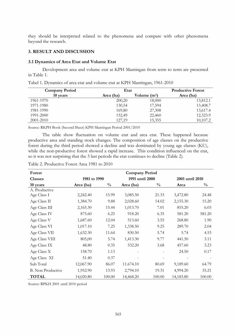
3.1 Dynamics of Area Etat and Volume Etat
Development area and volume etat at KPH Mantingan from term to term are presented in Table 1.
Tabel 1. Dynamics of area etat and volume etat at KPH Mantingan, 1961-2010
Company Period Etat Productive Forest 10 years Area (ha) Volume (m3) Area (ha)
1961-1970 200,20 18,000 13,812.1 1971-1980 130,54 17,594 13,408.7 1981-1990 169,80 27,308 13,617.4 1991-2000 152,49 22,460 12,323.9 2001-2010 127,19 15,355 10,107.2
Source: RKPH Book (Second Sheet) KPH Mantingan Period 2001/2010
The table show fluctuation on volume etat and area etat. These happened because productive area and standing stock changes. The composition of age classes on the productive forest during the third period showed a decline and was dominated by young age classes (KU), while the non-productive forest showed a rapid increase. This condition influenced on the etat, so it was not surprising that the 3 last periods the etat continues to decline (Table 2).
Table 2. Productive Forest Area 1981 to 2010
Forest Company Period
Classes 1981 to 1990 1991 until 2000 2001 until 2010
10 years Area (ha) % Area (ha) % Area % A. Productive Age Class I 2,242.40 15.99 3,085.50 21.33 3,472.80 24.48
Age Class II 1,384.70 9.88 2,028.60 14.02 2,155.30 15.20
Age Class III 2,165.30 15.44 1,013.70 7.01 855.20 6.03
Age Class IV 875.60 6.25 918.20 6.35 581.20 581.20
Age Class V 1,687.60 12.04 513.60 3.55 268.80 1.90
Age Class VI 1,017.10 7.25 1,338.50 9.25 289.70 2.04
Age Class VII 1,632.30 11.64 830.50 5.74 5.74 4.53
Age Class VIII 805,00 5.74 1,413.30 9.77 441.50 3.11
Age Class IX 48.80 0.35 532.20 3.68 457.60 3.23
Age Class X 158.70 1.13 - - 24.50 0.17
Age Class XI 51.40 0.37 - - - -
Sub Total 12,067.90 86.07 11.674.10 80.69 9,189.60 64.79
B. Non Productive 1,952.90 13.93 2,794.10 19.31 4,994.20 35.21
TOTAL 14,020.80 100.00 14,468.20 100.00 14,183.80 100.00
Source: RPKH 2001 until 2010 period
566
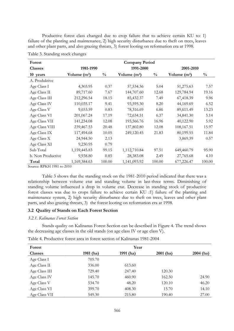
Productive forest class changed due to crop failure that to achieve certain KU to: 1) failure of the planting and maintenance, 2) high security disturbance due to theft on trees, leaves and other plant parts, and also grazing threats, 3) forest looting on reformation era at 1998.
Table 3. Standing stock changes
Forest Company Period
Classes 1981-1990 1991-2000 2001-2010
10 years Volume (m3) % Volume (m3) % Volume (m3) %
A. Produktive Age Class I 4,303.95 0.37 57,534.36 5.04 51,275.63 7.57
Age Class II 89,717.60 7.67 144,707.60 12.68 129,784.94 19.16
Age Class III 212,296.54 18.15 85,432.37 7.49 67,418.39 9.96
Age Class IV 110,035.17 9.41 93,595.30 8.20 44,169.69 6.52
Age Class V 9,653.59 0.83 78,316.69 6.86 89,611.49 13.23
Age Class VI 201,067.24 17.19 72,634.51 6.37 34,841.30 5.14
Age Class VII 141,234.08 12.08 193,566.76 16.96 40,122.90 5.92
Age Class VIII 239,467.53 20.48 137,802.80 12.08 108,167.51 15.97
Age Class IX 117,494.68 10.05 249,120.45 21.83 80,199.55 11.84
Age Class X 24,944.50 2.13 3,869.39 0.57
Age Class XI 9,230.95 0.79
Sub Total 1,159,445.83 99.15 1,112,710.84 97.51 649,460.79 95.90
b. Non Productive 9,938.80 0.85 28,383.08 2.49 27,765.68 4.10
Total 1,169,384.63 100.00 1,141,093.92 100.00 677,226.47 100.00 Source: RPKH 1981 to 2010
Table 3 shows that the standing stock on the 1981-2010 period indicated that there was a relationship between volume etat and standing volume in last-three terms. Diminishing of standing volume influenced a drop in volume etat. Decrease in standing stock of productive forest classes was due to crops failure to achieve certain KU :1) failure of the planting and maintenance system, 2) high security disturbance due to theft on trees, leaves and other plant parts, and also grazing threats, 3) the forest looting on reformation era at 1998.
3.2 Quality of Stands on Each Forest Section
3.2.1. Kalinanas Forest Section
Stands quality on Kalinanas Forest Section can be described in Figure 4. The trend shows the decreasing age classes in the old stands (on age class IV or age class V).
Table 4. Productive forest area in forest section of Kalinanas 1981-2004
Forest Year
Classes 1981 (ha) 1991 (ha) 2001 (ha) 2004 (ha)
Age Class I 705.70 Age Class II 336.00 613.60
Age Class III 729.40 247.40 120.30 Age Class IV 145.70 460.90 162.50 24.90
Age Class V 534.70 48.20 120.10 46.20
Age Class VI 399.70 408.30 15.70 14.10
Age Class VII 549.30 215.80 190.40 27.00
567
Forest Year
Classes 1981 (ha) 1991 (ha) 2001 (ha) 2004 (ha)
Age Class VIII 257.70 362.70 143.90 57.50
Age Class IX 11.80 203.50 110.60 -
Age Class X - - - -
Age Class XI - - - -
Total 3,670.00 2,560.40 863.50 169.70 Source: RPKH 1981 to 2010
Age Classes reduction to long period reflected in table above. In the 1981 until 1990 saw the even distribution of age classes composition, although there was a decrease when old stand area. The reduction age classes occurred in 1991 until 2000 period, but not too significant as which occurred in 2001. In the 1991 until 2000 period, Kalinanas Forest Section also suffered of pillage, but apparently with no very serious consequences, because there was not a sharp reduction in the other Forest Section. Thus in the year 2001 until 2004 there was a sharp reduction in the stands due to looting and security disturbances on growing area of this forest Section. Forest looting in the year 1998 in the reformation era gived great influenced the reduction of productive forest area and age classes distribution of productive standing arrangement. This would threaten the sustainability of the results, because occured over cutting from ilegal cutting.
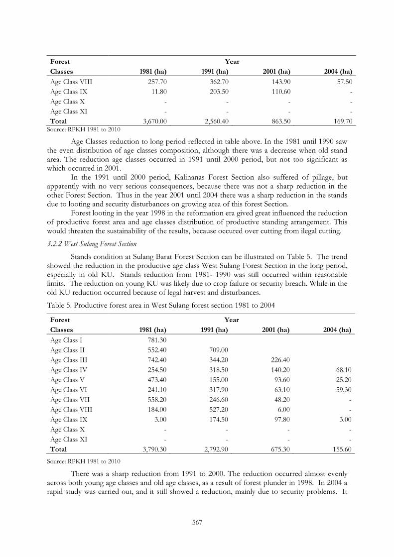
3.2.2 West Sulang Forest Section
Stands condition at Sulang Barat Forest Section can be illustrated on Table 5. The trend showed the reduction in the productive age class West Sulang Forest Section in the long period, especially in old KU. Stands reduction from 1981- 1990 was still occurred within reasonable limits. The reduction on young KU was likely due to crop failure or security breach. While in the old KU reduction occurred because of legal harvest and disturbances.
Table 5. Productive forest area in West Sulang forest section 1981 to 2004
Forest Year
Classes 1981 (ha) 1991 (ha) 2001 (ha) 2004 (ha)
Age Class I 781.30 Age Class II 552.40 709.00
Age Class III 742.40 344.20 226.40 Age Class IV 254.50 318.50 140.20 68.10
Age Class V 473.40 155.00 93.60 25.20
Age Class VI 241.10 317.90 63.10 59.30
Age Class VII 558.20 246.60 48.20 -
Age Class VIII 184.00 527.20 6.00 -
Age Class IX 3.00 174.50 97.80 3.00
Age Class X - - - -
Age Class XI - - - -
Total 3,790.30 2,792.90 675.30 155.60
Source: RPKH 1981 to 2010
There was a sharp reduction from 1991 to 2000. The reduction occurred almost evenly across both young age classes and old age classes, as a result of forest plunder in 1998. In 2004 a rapid study was carried out, and it still showed a reduction, mainly due to security problems. It
568
seems that in the years 2000 until 2004 there was not yet secure, because forest looting still occurred in many places.
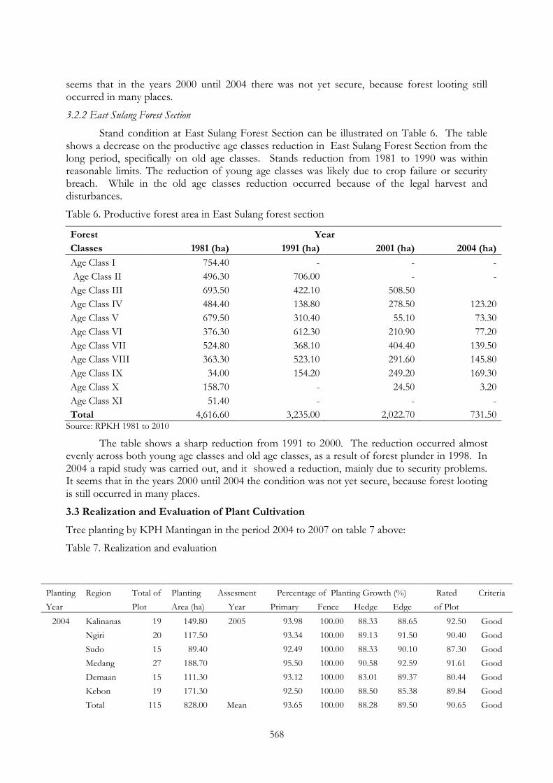
3.2.2 East Sulang Forest Section
Stand condition at East Sulang Forest Section can be illustrated on Table 6. The table shows a decrease on the productive age classes reduction in East Sulang Forest Section from the long period, specifically on old age classes. Stands reduction from 1981 to 1990 was within reasonable limits. The reduction of young age classes was likely due to crop failure or security breach. While in the old age classes reduction occurred because of the legal harvest and disturbances.
Table 6. Productive forest area in East Sulang forest section
Forest Year
Classes 1981 (ha) 1991 (ha) 2001 (ha) 2004 (ha)
Age Class I 754.40 - - -
Age Class II 496.30 706.00 - -
Age Class III 693.50 422.10 508.50 Age Class IV 484.40 138.80 278.50 123.20
Age Class V 679.50 310.40 55.10 73.30
Age Class VI 376.30 612.30 210.90 77.20
Age Class VII 524.80 368.10 404.40 139.50
Age Class VIII 363.30 523.10 291.60 145.80
Age Class IX 34.00 154.20 249.20 169.30
Age Class X 158.70 - 24.50 3.20
Age Class XI 51.40 - - -
Total 4,616.60 3,235.00 2,022.70 731.50 Source: RPKH 1981 to 2010
The table shows a sharp reduction from 1991 to 2000. The reduction occurred almost evenly across both young age classes and old age classes, as a result of forest plunder in 1998. In 2004 a rapid study was carried out, and it showed a reduction, mainly due to security problems. It seems that in the years 2000 until 2004 the condition was not yet secure, because forest looting is still occurred in many places.
3.3 Realization and Evaluation of Plant Cultivation
Tree planting by KPH Mantingan in the period 2004 to 2007 on table 7 above:
Table 7. Realization and evaluation
Planting Region Total of Planting Assesment Percentage of Planting Growth (%) Rated Criteria
Year
Plot Area (ha) Year Primary Fence Hedge Edge of Plot 2004 Kalinanas 19 149.80 2005 93.98 100.00 88.33 88.65 92.50 Good
Ngiri 20 117.50
93.34 100.00 89.13 91.50 90.40 Good
Sudo 15 89.40
92.49 100.00 88.33 90.10 87.30 Good
Medang 27 188.70
95.50 100.00 90.58 92.59 91.61 Good
Demaan 15 111.30
93.12 100.00 83.01 89.37 80.44 Good
Kebon 19 171.30
92.50 100.00 88.50 85.38 89.84 Good
Total 115 828.00 Mean 93.65 100.00 88.28 89.50 90.65 Good
569
Source: Result of Planting Assesment KPH Mantingan 2004 to 2007
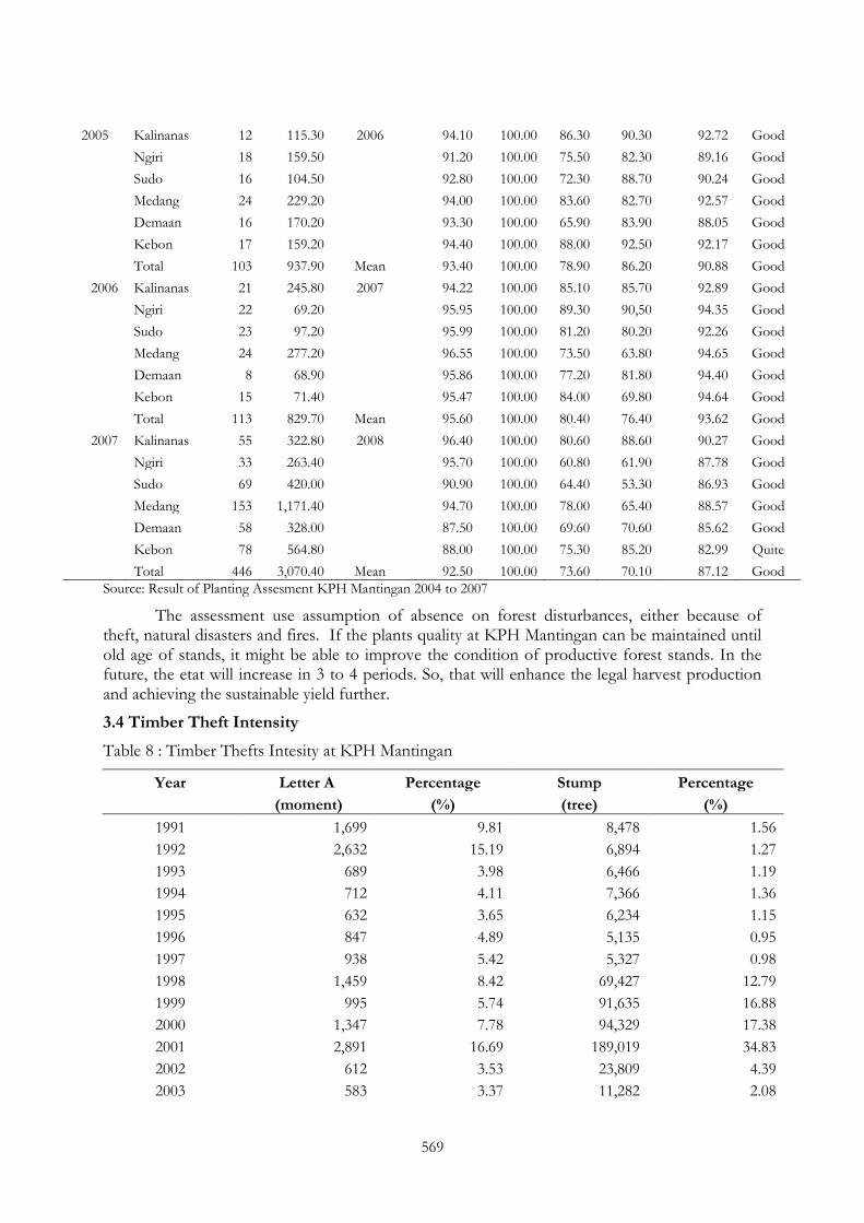
The assessment use assumption of absence on forest disturbances, either because of theft, natural disasters and fires. If the plants quality at KPH Mantingan can be maintained until old age of stands, it might be able to improve the condition of productive forest stands. In the future, the etat will increase in 3 to 4 periods. So, that will enhance the legal harvest production and achieving the sustainable yield further.
3.4 Timber Theft Intensity
Table 8 : Timber Thefts Intesity at KPH Mantingan
Year Letter A Percentage Stump Percentage
(moment) (%) (tree) (%)
1991 1,699 9.81 8,478 1.56
1992 2,632 15.19 6,894 1.27
1993 689 3.98 6,466 1.19
1994 712 4.11 7,366 1.36
1995 632 3.65 6,234 1.15
1996 847 4.89 5,135 0.95
1997 938 5.42 5,327 0.98
1998 1,459 8.42 69,427 12.79
1999 995 5.74 91,635 16.88
2000 1,347 7.78 94,329 17.38
2001 2,891 16.69 189,019 34.83
2002 612 3.53 23,809 4.39
2003 583 3.37 11,282 2.08
2005 Kalinanas 12 115.30 2006 94.10 100.00 86.30 90.30 92.72 Good
Ngiri 18 159.50
91.20 100.00 75.50 82.30 89.16 Good
Sudo 16 104.50
92.80 100.00 72.30 88.70 90.24 Good
Medang 24 229.20
94.00 100.00 83.60 82.70 92.57 Good
Demaan 16 170.20
93.30 100.00 65.90 83.90 88.05 Good
Kebon 17 159.20
94.40 100.00 88.00 92.50 92.17 Good
Total 103 937.90 Mean 93.40 100.00 78.90 86.20 90.88 Good
2006 Kalinanas 21 245.80 2007 94.22 100.00 85.10 85.70 92.89 Good
Ngiri 22 69.20
95.95 100.00 89.30 90,50 94.35 Good
Sudo 23 97.20
95.99 100.00 81.20 80.20 92.26 Good
Medang 24 277.20
96.55 100.00 73.50 63.80 94.65 Good
Demaan 8 68.90
95.86 100.00 77.20 81.80 94.40 Good
Kebon 15 71.40
95.47 100.00 84.00 69.80 94.64 Good
Total 113 829.70 Mean 95.60 100.00 80.40 76.40 93.62 Good
2007 Kalinanas 55 322.80 2008 96.40 100.00 80.60 88.60 90.27 Good
Ngiri 33 263.40
95.70 100.00 60.80 61.90 87.78 Good
Sudo 69 420.00
90.90 100.00 64.40 53.30 86.93 Good
Medang 153 1,171.40
94.70 100.00 78.00 65.40 88.57 Good
Demaan 58 328.00
87.50 100.00 69.60 70.60 85.62 Good
Kebon 78 564.80
88.00 100.00 75.30 85.20 82.99 Quite
Total 446 3,070.40 Mean 92.50 100.00 73.60 70.10 87.12 Good

570
Year Letter A Percentage Stump Percentage
(moment) (%) (tree) (%)
2004 685 3.95 9,458 1.74
2005 601 3.47 1 1.46
Total 17,322 100.00 54,762 100.00
Source: RPKH Period 2001 to 2010
Low level of social welfare and a lack of community involvement in forest management, leading to increased intensity of the timber theft. The highest intensity occurred in 2001 was the peak year of forest plunder, given the unstable security conditions, as a result of domestic political upheaval.
3.5 Profil of Mantingan Village
The profile of Mantingan Village indicates a sosio-economic condition of communities around RPH Mantingan (Forest Autonomy Resort). The description of socio-economic conditions used to determine the social problems which threaten the sustainability forest. Socio-economic conditions in the Mantingan Village describes the characteristics of socio-economic conditions of communities around the teak forests in Java.
3.5.1 Land Use and Land Ownership
Most of the land in the Mantingan Village is state forest area, which cover area around 903.42 hectares or 88.59% of the total land area in the Mantingan Village. This forest area included in the territory of RPH Mantingan, consists of Mantingan Tourism Forest and Teak Production Forest. From that area, farm area reached 51.962 ha or 5.1%. Area of rice-field with irrigated or rain-fed area was 45.064 ha, or 4.42% of the land area of the village. The smallest area of land was used as public forests, only about 0.2 ha.
3.5.2 Population
Distribution of population according to age in Mantingan Village tend to be evenly from age 14 to age 44 years. Total population aged 0 to 14 years is 402 people or 25.69% of the total population of the village. Population aged 15 to 29 years is 401 people or 25.63% of total population and the population aged 30 to 44 years is 398 people or approximately 25.43% from total population. All three groups are distributed on each of the range of 25%. People aged 14 to 59 years belong to the population productive age.
In general, rural children aged 15 years have been able to help their parents to work as handymen in their village or as domestic servants in the city. Although the actual age of the child is school-age. The smaller age distribution is at age above 44 years. Age group of 45 to 59 years is about 209 people or 13.35% of the population. The elderly population is only about 9.90% or as many as 155 people.
The count ratio of the load-dependent (dependency ratio) of the population reached point of 55. This means that 100 people in productive age population will bear the economic burden of 55 people on unproductive aged population. In other words, a person from productive age bear the burden of 2 people from unproductive aged. This condition showed how heavy the load of a resident in the village of Mantingan.
3.5.3 Labor Absorbed by Several Sectors
Most of the labors in the village of Mantingan were absorbed in the agricultural sector. Around 424 people or approximately 61.01% of the total labor works in farming. Services sector absorbed around 93 people or 13.38%. Others are absorbed in the formal sector are PNS/TNI/ POLRI which recorded 40 people or 5.76%. In the trading sector, as many as 30 people or
571
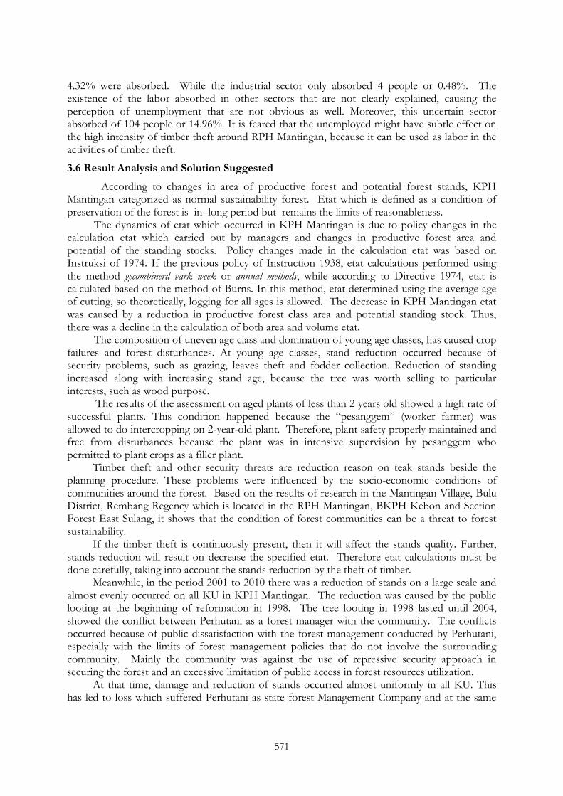
4.32% were absorbed. While the industrial sector only absorbed 4 people or 0.48%. The existence of the labor absorbed in other sectors that are not clearly explained, causing the perception of unemployment that are not obvious as well. Moreover, this uncertain sector absorbed of 104 people or 14.96%. It is feared that the unemployed might have subtle effect on the high intensity of timber theft around RPH Mantingan, because it can be used as labor in the activities of timber theft.
3.6 Result Analysis and Solution Suggested
According to changes in area of productive forest and potential forest stands, KPH Mantingan categorized as normal sustainability forest. Etat which is defined as a condition of preservation of the forest is in long period but remains the limits of reasonableness.
The dynamics of etat which occurred in KPH Mantingan is due to policy changes in the calculation etat which carried out by managers and changes in productive forest area and potential of the standing stocks. Policy changes made in the calculation etat was based on Instruksi of 1974. If the previous policy of Instruction 1938, etat calculations performed using the method gecombinerd vark week or annual methods, while according to Directive 1974, etat is calculated based on the method of Burns. In this method, etat determined using the average age of cutting, so theoretically, logging for all ages is allowed. The decrease in KPH Mantingan etat was caused by a reduction in productive forest class area and potential standing stock. Thus, there was a decline in the calculation of both area and volume etat.
The composition of uneven age class and domination of young age classes, has caused crop failures and forest disturbances. At young age classes, stand reduction occurred because of security problems, such as grazing, leaves theft and fodder collection. Reduction of standing increased along with increasing stand age, because the tree was worth selling to particular interests, such as wood purpose.
The results of the assessment on aged plants of less than 2 years old showed a high rate of successful plants. This condition happened because the ―pesanggem‖ (worker farmer) was allowed to do intercropping on 2-year-old plant. Therefore, plant safety properly maintained and free from disturbances because the plant was in intensive supervision by pesanggem who permitted to plant crops as a filler plant.
Timber theft and other security threats are reduction reason on teak stands beside the planning procedure. These problems were influenced by the socio-economic conditions of communities around the forest. Based on the results of research in the Mantingan Village, Bulu District, Rembang Regency which is located in the RPH Mantingan, BKPH Kebon and Section Forest East Sulang, it shows that the condition of forest communities can be a threat to forest sustainability.
If the timber theft is continuously present, then it will affect the stands quality. Further, stands reduction will result on decrease the specified etat. Therefore etat calculations must be done carefully, taking into account the stands reduction by the theft of timber.
Meanwhile, in the period 2001 to 2010 there was a reduction of stands on a large scale and almost evenly occurred on all KU in KPH Mantingan. The reduction was caused by the public looting at the beginning of reformation in 1998. The tree looting in 1998 lasted until 2004, showed the conflict between Perhutani as a forest manager with the community. The conflicts occurred because of public dissatisfaction with the forest management conducted by Perhutani, especially with the limits of forest management policies that do not involve the surrounding community. Mainly the community was against the use of repressive security approach in securing the forest and an excessive limitation of public access in forest resources utilization.
At that time, damage and reduction of stands occurred almost uniformly in all KU. This has led to loss which suffered Perhutani as state forest Management Company and at the same
572
time threatens forest sustainability. Specified etat in any subsequent period was decrease greatly, owing to a decrease in standing stock and broad classes of productive forest.
The steady depletion of the specified etat caused the collapse of forest management conducted by Perhutani. The decline in forest area and standing stock was influenced by socio-economic conditions communities of surounding forest. Moreover, the lack of community involvement happened in forest management.
According to the cases that occurred around the Mantingan Village in RPH Mantingan, it is necessary to involve the community programs, also the various interests of the parties (multi-stakeholder). In line with the population development, followed by the emergence of socio-economic problems, the concept of monoculture forests had to be abandoned. Hence the concept of forest management timber management paradigm should be increased to the concept of forest management paradigm with Forest Resource Management (FRM). One forest management paradigms with FRM is the Pengelolaan Hutan Jati Optimal (PHJO, Optimal Management of Teak Forest) which has tested in KPH Madiun (Simon, 2008).
PHJO is suitable to be applied in forest management at KPH Mantingan as forest in Java, because the decrease in area productive forest and standing stock affect social problems, which characterized by:
• The land ownership is only about 0.2 ha / household, so the need for land beyond the maximum.
• The need for food and forest products increases along with the population.
• The high number of unemployment
Planning system in PHJO is incentive planning that aims to maximize the productivity of the region in order to improve the community welfare. This planning model should be more emphasized on efforts to understand the public perception in the use and manage forest resources, so that the system of forest management on PHJO is more comprehensive (holistic). The division results in a system PHJO are weighing more on the principle of symbiosis mutualism, so there would be an equally profitable relation between forest managers and community. Therefore, PHJO is designed to form a relationship with a balanced position and the comparable status between the actors (stakeholders) in determining the policies and operational programs.
4. CONCLUSION AND RECOMMENDATION
4.1 CONCLUSION
1. Sustainability forest in KPH Mantingan is in normal range. Although there is a tendency of decrease in long period etat. However it is within reason. The etat decline occurred in forest productive area and standing stock which caused by stands quality decrease.
2. Quality stands decline in KPH Mantingan caused by stands age classes is not evenly distributed. Distribution of age classes in the long term show that the old stands (age class V above) tend to decrease than the young stands (age class I to age class IV). The crops quality in the first years showed a good percentage of the ―to be‖ criteria 90% above for planting trees. The old stands that reduced caused by security disturbance like timber thefts, cause this age stands already can be sold.
3. Timber thefts intensity in KPH Mantingan was so high, but in recent years tends to decline. The high intensity of timber thefts caused by socio-economic conditions in the less-welfare community. Therefore, the community can be utilized by the certain parties to commit the theft. While the theft timber intensity falling over due to decreasing tree numbers in stands, so the security staff has to be more intensive in controlling.
573
4. Forest looting that occurred on reformation era 1998, influenced on productive forest area. The even reduction of productive age class stands affected etat decline. Forest looting were caused by social conflict between forest manager (Perhutani) and the communities. This is due to dissatisfaction with the lack of forest management opportunities at the community stage in the forest resources utilization.
4.2 Recommendation
1. Etat calculation should be determined carefully to avoid over-cutting that threatens the sustainability of the forest. Number of illegal cutting due to pilferage should be taken into account by the legal cutting.
2. There is a need to increase people participation in forest planning and management, in the period of the community attainment. Role of the community of forest management lead to a sense of ownership of forests, which will reduce the disturbance of forest security and social conflict.
3. Based on the problems at the research sites, due to the increase in population among others, lack of arable land, high number of unemployment and the increasing need for food and wood, the program of Optimal Management of Teak Forests (PHJO) should be applied to accommodate the interests of managers and the public interest.
4. PHJO is one of community empowerment programs. The program provides an opportunity for community forest management plan together with forest managers. Community acted as subject and have a parallel role as a partner of Perhutani.
REFERENCES
Nazir, M (2005): Metode Penelitian. Bogor. Ghalia Indonesia
Perum Perhutani (1993): Prosiding Lokakarya Pemantapan Klas Perusahaan Jati. Jakarta. Direksi Perum Perhutani.
Perum Perhutani (1960): Rencana Perusahaan KPH Mantingan Jangka 1961-1970. Seksi Perencanaan Hutan Rembang.
Perum Perhutani (1970): Rencana Perusahaan KPH Mantingan Jangka 1971-1980. Seksi Perencanaan Hutan Rembang.
Perum Perhutani (1980): Rencana Pengaturan Kelestarian Hutan KPH Mantingan Jangka 1981-1990. Seksi Perencanaan Hutan Wilayah Rembang.
Perum Perhutani (1990): Rencana Pengaturan Kelestarian Hutan KPH Mantingan Jangka 1991-2000. Seksi Perencanaan Hutan Wilayah Rembang.
Perum Perhutani (2000): Rencana Pengaturan Kelestarian Hutan KPH Mantingan Jangka 2000-2010. Seksi Perencanaan Hutan Wilayah Rembang.
Perum Perhutani (2008): Laporan Definitif Pembuatan Tanaman KPH Mantingan 2008. KPH Mantingan.
Perum Perhutani (2006): Statistik Hutan KPH Mantingan. Rembang. KPH Mantingan.
Perum Perhutani (1986): Petunjuk Penyusunan RPKH SK Dirjen Kehutanan No 143/Kpts/Dj/I/1974. Semarang. Perum Perhutani Unit I Jawa Tengah.
Simon, H (2004): Aspek Sosio Teknis Pengelolaan Hutan Jati di Jawa. Yogyakarta. Pustaka Pelajar.
Simon, H (2004): Membangun Desa Hutan. Kasus Dusun Sambiroto. Yogyakarta. Gadjah Mada University Press.
574
Simon, H (2006): Hutan Jati dan Kemakmuran. Yogyakarta. Pustaka Pelajar.
Simon, H (2007): Diktat Perencanaan Pembangunan Sumber Daya Hutan. Yogyakarta. Unpublished.
Simon, H (2008): Pengelolaan Hutan Bersama Rakyat. Yogyakarta. Pustaka Pelajar
INAFOR 11H-064
INTERNATIONAL CONFERENCE OF INDONESIAN FORESTRY RESEARCHERS (INAFOR)
Section H Community and Social Forestry
Vulnerability of Mountains People of Papua to the Climate Change
Susan T. Salosa
Forestry Research Institute of Manokwari Jl. Inamberi Susweni, Manokwari 98313, INDONESIA
Paper prepared for The First International Conference of Indonesian Forestry Researchers (INAFOR)
Bogor, 5 – 7 December 2011
INAFOR SECRETARIAT Sub Division of Dissemination, Publication and Library
FORESTRY RESEARCH AND DEVELOPMENT AGENCY Jl. Gunung Batu 5, Bogor 16610
576
Vulnerability of Mountains People of Papua to the Climate Change
Susan T. Salosa
Forestry Research Institute of Manokwari Jl. Inamberi Susweni, Manokwari 98313, INDONESIA
ABSTRACT
Global climate change effects have different intensities on people‘s life related to the degree of vulnerability to the change. The avaibility of natural resources like forest, water and other resources have taken role to the people‘s vulnerability. Mountain people is a community that might vulnerable to the climate change because of depending on natural resouces for their life socially, economically and culturally. The research was conducted in two villages on Arfak Mountains and two villages of Jayawijaya district at more than 1,500 m asl. The research method was descriptive with semi-structural interviewed technique in order to predict the vulnerability of local people to the climate change. Data were analized by tabulation and scorings. The result of the research showed that local people of Arfak Mountains and Wamena are relatively vulnerable when extremely climate change occur like raising on temperature and rainfall. The scores identify people of Arfak Mountains and Wamena sensitivity as quite sensitive to sensitive related to social, economics and biofisic of the location. Their main source of income, agriculture, and place where they live will be affected because their position on slope which is at big risks of erosion and flood. Where as, people in Wamena, the district of Jayawijaya, experience adversity sometimes and lost their source of income, sweet potato, because of unpredictable flood. Keywords: climate change, vulnerability, Arfak Mountains people, Wamena
1. INTRODUCTION
In Papua, there are certain places in the high mountains consideraly colder than low land areas. The temperatures of the places are below 300C and once upon the time, those were lower than 100C. Today, the temperatures are going warmer than before. Many changes occure at the areas because of temperature transformation, such as presents of new plants, decreasing of firewood utilization, change on a house construction and other new changes.
The change of the temperature as the effect of the Global climate influences either biophisics or ecology aspects. Those aspects can not be seperated from people‘s life, particularly to forest people, and those who live along river bank and coastal area, so their lifes are counted as vulnerable on the situation and at the point of adaptation, they will need government awarness to cope the situation.
Arfak mountain and Jayawijaya lie on areas of Papua and West Papua provinces. There are several sub districts in Arfak Mountain, such as Minyambouw, Anggi, Sururey, Taige, Anggi Gida and Hingk with around 104 villages. Minyambouw sub district itself is consisted of 56 villages. The local people also devided to three main tribes; Hatam/Moule, Soughb dan Meyakh. Where as Jayawijaya district consists of 11 sub districts with some tribes like Welesy and other tribes. Those people have similarlity on way of life eventhough they live on different part of Papua island.
People from other places had roles in the transportation and introduction of new species in the areas. People were coming from USA and Europe brought some kinds of plants which were suitable for low temperature at 1960‘s such as markisa (passion fruit), tomat belanda, daun bawang (onion leaf), kentang (potatos) and lately strawberry.

577
The terminology of climate is still uncommon for the local people of Arfak and Wamena. They are more familiar with the changes of micro climate and local season which cause unpredictable of wet and dry season because both of them can occur at the same time one after the other without consider on season calender used to use since long time ago.
If the climate change can not be interupted and emission continue goes up, so the very dangerous disaster will be happen for all people. People in the remote area and women will put on very risk groups to climate change because they are subject of agriculture. When the season and climate change, it is possible, the plants in the garden will be affected either on their quality or quantity. People need transformation in plant use, so they have to have sufficient knowledge to try something new, nothing in regular. This research is going to find out how vulnerable of local community to the climate change or extrimely change of season especially community who live in forest or around the forest. How people adapt to the change based on their local wisdom or their economic ability. The research goal is to predict how vulnerable of forest local community to the extrimely climate and season change.
2. EXPERIMENTAL METHODS
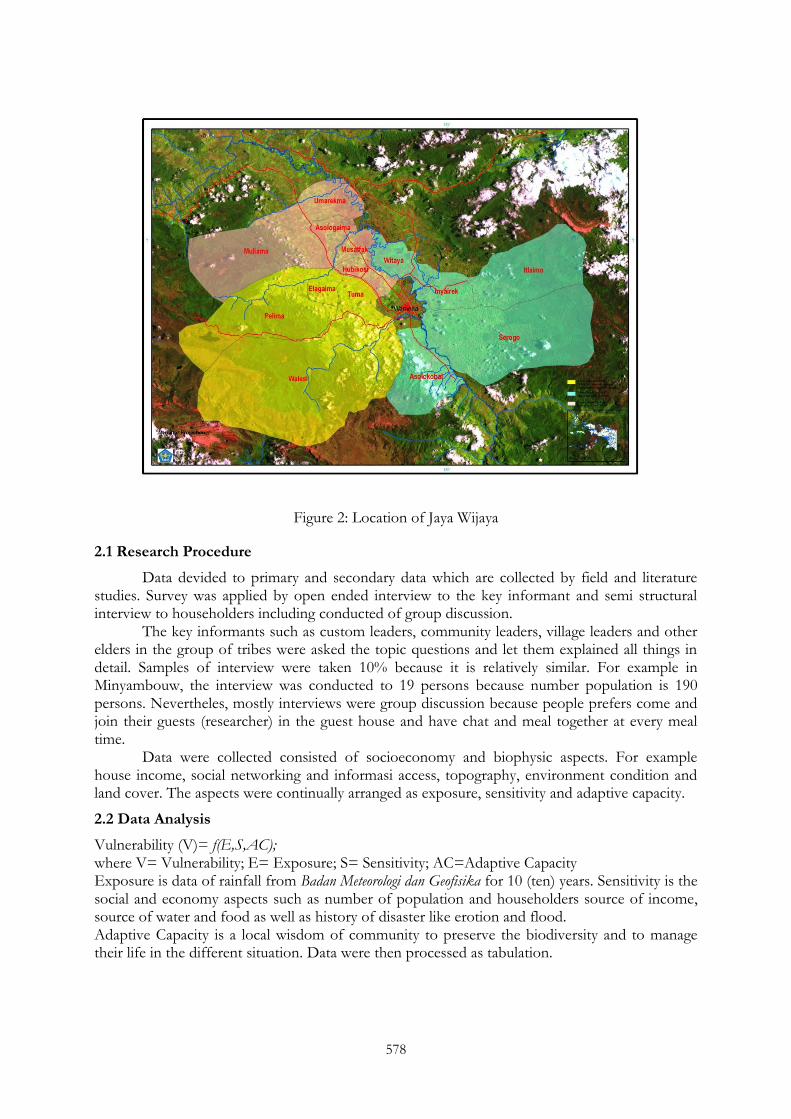
The research was conducted from May 2010 to November 2011 in the two villages of Minyambaw sub district and district of Jayawijaya at mountain ecosysitems. Minyambouw sub dustrict consists of 56 villages as a result of area enlargement under special autonomy laws. The locations of the research are shown in the Figure 1 and 2 below.
Figure 1: Location of Minyambow sub district
578
Figure 2: Location of Jaya Wijaya
2.1 Research Procedure
Data devided to primary and secondary data which are collected by field and literature studies. Survey was applied by open ended interview to the key informant and semi structural interview to householders including conducted of group discussion.
The key informants such as custom leaders, community leaders, village leaders and other elders in the group of tribes were asked the topic questions and let them explained all things in detail. Samples of interview were taken 10% because it is relatively similar. For example in Minyambouw, the interview was conducted to 19 persons because number population is 190 persons. Nevertheles, mostly interviews were group discussion because people prefers come and join their guests (researcher) in the guest house and have chat and meal together at every meal time.
Data were collected consisted of socioeconomy and biophysic aspects. For example house income, social networking and informasi access, topography, environment condition and land cover. The aspects were continually arranged as exposure, sensitivity and adaptive capacity.
2.2 Data Analysis
Vulnerability (V)= f(E,S,AC); where V= Vulnerability; E= Exposure; S= Sensitivity; AC=Adaptive Capacity Exposure is data of rainfall from Badan Meteorologi dan Geofisika for 10 (ten) years. Sensitivity is the social and economy aspects such as number of population and householders source of income, source of water and food as well as history of disaster like erotion and flood. Adaptive Capacity is a local wisdom of community to preserve the biodiversity and to manage their life in the different situation. Data were then processed as tabulation.
579
3. RESULT AND DISCUSSION
Located in the different mountains areas which are Arfak mountains at vogelcop area at the birdhead of Papua island where as Jayawijaya mountain is at the series of central mountains of Papua island, the lifestyle in the local communities shows similarities in the practice of gardening, hunting and collecting in the forest. People mostly live their lives through garden. One garden belongs to the members of the family, because they share same location eventhough they are married.
Kinship relations are very close and young couples who get married at a very young age are generally still living together with parents including widows or widowers. Thus in one house may consist of two or more families. In Wamena, one house consists of a husband with many wives in the place named honay.
3.1 Living on Arfak Mountain
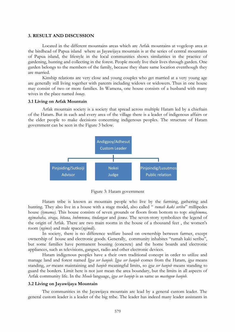
Arfak mountain society is a society that spread across multiple Hatam led by a chieftain of the Hatam. But in each and every area of the village there is a leader of indigenous affairs or the elder people to make decisions concerning indigenous peoples. The structure of Hatam government can be seen in the Figure 3 below.
Figure 3: Hatam government
Hatam tribe is known as mountain people who live by the farming, gathering and hunting. They also live in a house with a stage model, also called ― rumah kaki seribu‖ millipedes house (iymama). This house consists of seven grounds or floors from bottom to top: ninghimma, ngimabaha, siraga, bitaua, buhmnewa, tindangan and ijcowa. The seven-story symbolizes the legend of the origin of Arfak. There are two main rooms in the house of a thousand feet , the women's room (ngimsi) and male space(ngimdi).
In society, there is no difference welfare based on ownership between farmer, except ownership of house and electronic goods. Generally, community inhabites ―rumah kaki seribu‖, but some families have permanent housing (concrete) and the home boards and electronic appliances, such as televisions, gangset, radio and other electronic devices.
Hatam indigenous peoples have a their own traditional concept in order to utilize and manage land and forest named Igya ser hanjob. Igya ser hanjob comes from the Hatam, igya means standing, ser means maintaining and hanjob meaningful limits, so igya ser hanjob means standing to guard the borders. Limit here is not just mean the area boundary, but the limits in all aspects of Arfak community life. In the Moule language, igya ser hanjop is as same as mastogow hanjob.
3.2 Living on Jayawijaya Mountain
The communities in the Jayawijaya mountain are lead by a general custom leader. The general custom leader is a leader of the big tribe. The leader has indeed many leader assistants in
Andigpoy/Adhesut
Custom Leader
Pinjoiding/Sutkoiji
Advisor
Nekei
Judge
Pinjoindig/Lusutmos
Public relation
580
the group or villages who have responsibilities to handle all the custom bussiness in the community, such as conflicts between tribe members, married and other occasions in the tribe. Where as, the custom institution is also supported by LMA (Lembaga masyarakat adat) and the elders in the communities.
In order to fulfill their needs of food, People in Wamena are mostly doing gardening. Garden is also source of income beside rising pigs and chickens. The food also can be gathered from forest and people in Wamena have local knowledge about source of food based on the type and function of the forest:
1. Tomoba, area consits of hills and mounts. 2. Wiramokama; a source of small size forest coconuts (wiramo). 3. Sakalimo; no wood but small grass. 4. Dimekama; from word dim means big size forest coconut. 5. Pilikhila; The cornerest area is a place for pig hunting. 6. Hawisekama; a big size trees for timber and construction. 7. Ikewa/bidiba (Trikora peak); Alpine vegetation. 8. Hasuba; no human and pig.
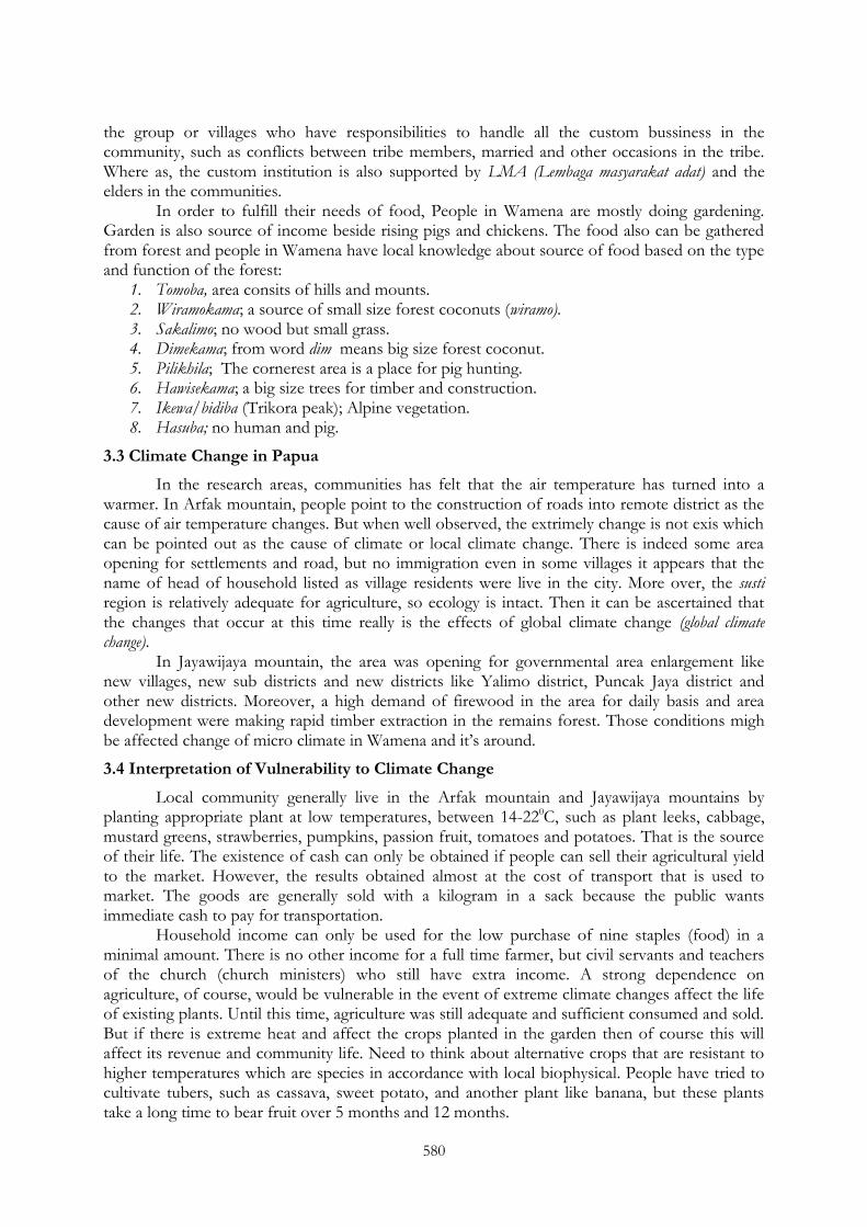
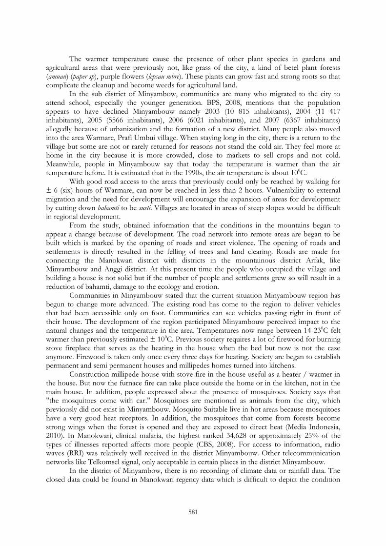
3.3 Climate Change in Papua
In the research areas, communities has felt that the air temperature has turned into a warmer. In Arfak mountain, people point to the construction of roads into remote district as the cause of air temperature changes. But when well observed, the extrimely change is not exis which can be pointed out as the cause of climate or local climate change. There is indeed some area opening for settlements and road, but no immigration even in some villages it appears that the name of head of household listed as village residents were live in the city. More over, the susti region is relatively adequate for agriculture, so ecology is intact. Then it can be ascertained that the changes that occur at this time really is the effects of global climate change (global climate change).
In Jayawijaya mountain, the area was opening for governmental area enlargement like new villages, new sub districts and new districts like Yalimo district, Puncak Jaya district and other new districts. Moreover, a high demand of firewood in the area for daily basis and area development were making rapid timber extraction in the remains forest. Those conditions migh be affected change of micro climate in Wamena and it‘s around.
3.4 Interpretation of Vulnerability to Climate Change
Local community generally live in the Arfak mountain and Jayawijaya mountains by planting appropriate plant at low temperatures, between 14-220C, such as plant leeks, cabbage, mustard greens, strawberries, pumpkins, passion fruit, tomatoes and potatoes. That is the source of their life. The existence of cash can only be obtained if people can sell their agricultural yield to the market. However, the results obtained almost at the cost of transport that is used to market. The goods are generally sold with a kilogram in a sack because the public wants immediate cash to pay for transportation.
Household income can only be used for the low purchase of nine staples (food) in a minimal amount. There is no other income for a full time farmer, but civil servants and teachers of the church (church ministers) who still have extra income. A strong dependence on agriculture, of course, would be vulnerable in the event of extreme climate changes affect the life of existing plants. Until this time, agriculture was still adequate and sufficient consumed and sold. But if there is extreme heat and affect the crops planted in the garden then of course this will affect its revenue and community life. Need to think about alternative crops that are resistant to higher temperatures which are species in accordance with local biophysical. People have tried to cultivate tubers, such as cassava, sweet potato, and another plant like banana, but these plants take a long time to bear fruit over 5 months and 12 months.
581
The warmer temperature cause the presence of other plant species in gardens and agricultural areas that were previously not, like grass of the city, a kind of betel plant forests (amuan) (paper sp), purple flowers (lepsau mbre). These plants can grow fast and strong roots so that complicate the cleanup and become weeds for agricultural land.
In the sub district of Minyambow, communities are many who migrated to the city to attend school, especially the younger generation. BPS, 2008, mentions that the population appears to have declined Minyambouw namely 2003 (10 815 inhabitants), 2004 (11 417 inhabitants), 2005 (5566 inhabitants), 2006 (6021 inhabitants), and 2007 (6367 inhabitants) allegedly because of urbanization and the formation of a new district. Many people also moved into the area Warmare, Prafi Umbui village. When staying long in the city, there is a return to the village but some are not or rarely returned for reasons not stand the cold air. They feel more at home in the city because it is more crowded, close to markets to sell crops and not cold. Meanwhile, people in Minyambouw say that today the temperature is warmer than the air temperature before. It is estimated that in the 1990s, the air temperature is about 100C.
With good road access to the areas that previously could only be reached by walking for ± 6 (six) hours of Warmare, can now be reached in less than 2 hours. Vulnerability to external migration and the need for development will encourage the expansion of areas for development by cutting down bahamti to be susti. Villages are located in areas of steep slopes would be difficult in regional development.
From the study, obtained information that the conditions in the mountains began to appear a change because of development. The road network into remote areas are began to be built which is marked by the opening of roads and street violence. The opening of roads and settlements is directly resulted in the felling of trees and land clearing. Roads are made for connecting the Manokwari district with districts in the mountainous district Arfak, like Minyambouw and Anggi district. At this present time the people who occupied the village and building a house is not solid but if the number of people and settlements grew so will result in a reduction of bahamti, damage to the ecology and erotion.
Communities in Minyambouw stated that the current situation Minyambouw region has begun to change more advanced. The existing road has come to the region to deliver vehicles that had been accessible only on foot. Communities can see vehicles passing right in front of their house. The development of the region participated Minyambouw perceived impact to the natural changes and the temperature in the area. Temperatures now range between 14-230C felt warmer than previously estimated ± 100C. Previous society requires a lot of firewood for burning stove fireplace that serves as the heating in the house when the bed but now is not the case anymore. Firewood is taken only once every three days for heating. Society are began to establish permanent and semi permanent houses and millipedes homes turned into kitchens.
Construction millipede house with stove fire in the house useful as a heater / warmer in the house. But now the furnace fire can take place outside the home or in the kitchen, not in the main house. In addition, people expressed about the presence of mosquitoes. Society says that "the mosquitoes come with car." Mosquitoes are mentioned as animals from the city, which previously did not exist in Minyambouw. Mosquito Suitable live in hot areas because mosquitoes have a very good heat receptors. In addition, the mosquitoes that come from forests become strong wings when the forest is opened and they are exposed to direct heat (Media Indonesia, 2010). In Manokwari, clinical malaria, the highest ranked 34,628 or approximately 25% of the types of illnesses reported affects more people (CBS, 2008). For access to information, radio waves (RRI) was relatively well received in the district Minyambouw. Other telecommunication networks like Telkomsel signal, only acceptable in certain places in the district Minyambouw.
In the district of Minyambow, there is no recording of climate data or rainfall data. The closed data could be found in Manokwari regency data which is difficult to depict the condition
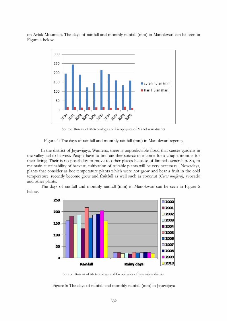
582
on Arfak Mountain. The days of rainfall and monthly rainfall (mm) in Manokwari can be seen in Figure 4 below.
Source: Bureau of Meteorology and Geophysics of Manokwari district
Figure 4: The days of rainfall and monthly rainfall (mm) in Manokwari regency
In the district of Jayawijaya, Wamena, there is unpredictable flood that causes gardens in the valley fail to harvest. People have to find another source of income for a couple months for their living. Their is no possibility to move to other places because of limited ownership. So, to maintain sustainability of hasvest, cultivation of suitable plants will be very necessary. Nowadays, plants that consider as hot temperature plants which were not grow and bear a fruit in the cold temperature, recently become grow and fruitfull as well such as coconut (Cocos nucifera), avocado and other plants.
The days of rainfall and monthly rainfall (mm) in Manokwari can be seen in Figure 5 below.
Source: Bureau of Meteorology and Geophysics of Jayawijaya district
Figure 5: The days of rainfall and monthly rainfall (mm) in Jayawijaya
0
50
100
150
200
250
300
curah hujan (mm)
Hari Hujan (hari)
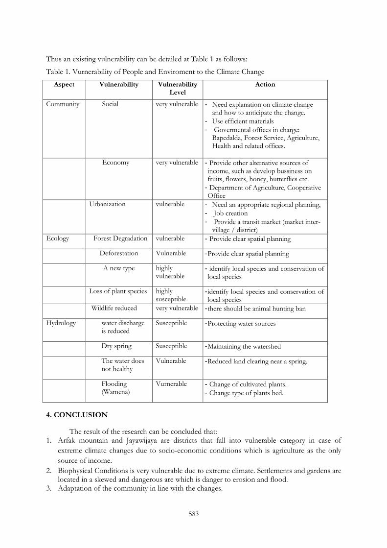
583
Thus an existing vulnerability can be detailed at Table 1 as follows:
Table 1. Vurnerability of People and Enviroment to the Climate Change
Aspect Vulnerability Vulnerability Level
Action
Community Social very vulnerable
- Need explanation on climate change and how to anticipate the change.
- Use efficient materials
- Govermental offices in charge: Bapedalda, Forest Service, Agriculture, Health and related offices.
Economy
very vulnerable - Provide other alternative sources of income, such as develop bussiness on fruits, flowers, honey, butterflies etc.
- Department of Agriculture, Cooperative Office
Urbanization vulnerable - Need an appropriate regional planning,
- Job creation
- Provide a transit market (market inter-village / district)
Ecology Forest Degradation vulnerable - Provide clear spatial planning
Deforestation Vulnerable - Provide clear spatial planning
A new type
highly vulnerable
- identify local species and conservation of local species
Loss of plant species highly susceptible
- identify local species and conservation of local species
Wildlife reduced very vulnerable - there should be animal hunting ban
Hydrology water discharge is reduced
Susceptible - Protecting water sources
Dry spring Susceptible - Maintaining the watershed
The water does not healthy
Vulnerable - Reduced land clearing near a spring.
Flooding (Wamena)
Vurnerable - Change of cultivated plants.
- Change type of plants bed.
4. CONCLUSION
The result of the research can be concluded that: 1. Arfak mountain and Jayawijaya are districts that fall into vulnerable category in case of
extreme climate changes due to socio-economic conditions which is agriculture as the only
source of income.
2. Biophysical Conditions is very vulnerable due to extreme climate. Settlements and gardens are located in a skewed and dangerous are which is danger to erosion and flood.
3. Adaptation of the community in line with the changes.
584
Recommendations: 1. Government need to give an explanation or elucidation about global climate change and its effects. 2. Government and stakeholders work together to explore other potential source of income and give trainings to improve people‘s skill. 3. Improve spatial planning to make room for the development of residential areas and farming.
REFERENCES
BPS (2008): Kabupaten Manokwari Dalam Angka. Badan Pusat Statistik Kabupaten Manokwari.
Gleick, P H (1989): Climate Change, Hydrology and Water Resources, Rev. Geophys. 27(3):329–344.
Hamlet, A F and Lettenmaier D P (1999): Effects of climate change on hydrology and water resources in the Columbia River basin. Journal of the American Water Resources Association 35(6):1597-1623.
Handoko, I, Sugiarto, Y and Syaukat, Y (2008): Keterkaitan perubahan iklim dan produksi pangan strategis: telaah kebijakan independen dalam bidang perdagangan dan pembangunan. Seameo Biotrop for Kemitraan (Partnership). Bogor.
Kapissa, N (2008): Balai Pementapan Kawasan Hutan Wilayah X Papua: Integrasi Kesatuan Pengelolaan Hutan Dalam Kebijakan Pengelolaan Hutan berkelanjutan di Papua. Makalah Dalam Seminar Forum Komunikasi Multi Pihak di Tanah Papua-Swiss_Belhotel, 28 Juli 2008. Balai Penelitian Kehutanan Manokwari.
Kayoi, M (2008): Dinas Kehutanan Provinsi Papua Barat: Strategi dan Kebijakan Pembangunan Kehutanan di Papua Barat. Makalah Dalam Seminar Forum Komunikasi Multi Pihak di Tanah Papua-Swiss_Belhotel, 28 Juli 2008. Balai Penelitian Kehutanan Manokwari.
Media Indonesia (2010): Hutan Terbuka, Nyamuk Malaria Masuk Kota
Partnership (2008): Supporting Indonesia in Climate Change Mitigation & Adaptasi. Bogor. (http://www.beritadaerah.com/artikel.php?pg=artikel_papua&id=7998&sub=Artikel&page=1). Februari 2010.
INAFOR 11H-065
INTERNATIONAL CONFERENCE OF INDONESIAN FORESTRY RESEARCHERS (INAFOR)
Section H Community and Social Forestry
Growth and Production of Porang (Amorphopallus oncophillus Prain) under Damar (Agathis borneensis) Stand
Murniati and Sumarhani
The Center for Research and Development on Forest Conservation and Rehabilitation Jl. Gunung Batu 5, Bogor 16610, INDONESIA
Paper prepared for The First International Conference of Indonesian Forestry Researchers (INAFOR)
Bogor, 5 – 7 December 2011
INAFOR SECRETARIAT Sub Division of Dissemination, Publication and Library
FORESTRY RESEARCH AND DEVELOPMENT AGENCY Jl. Gunung Batu 5, Bogor 16610
586
Growth and Production of Porang (Amorphopallus oncophillus Prain) under Damar (Agathis borneensis) Stand
Murniati and Sumarhani
The Center for Research and Development on Forest Conservation and Rehabilitation Jl. Gunung Batu 5, Bogor 16610, INDONESIA
ABSTRACT
Porang (Amorphopallus oncophillus Prain) is a perrennial herb and a shade demanding plant, which produces tubers. The plant grow naturally in tropical forests and recently started to be cultivated due to its high economic value tubers. The research aimed to analyse the growth and production of the porang plant under two age classes of damar (Agathis borneensis) stand in forest area of KPH Banyumas Timur, Perhutani in the period of 2007 until 2009. The research was an experiment using Split Plot Design with three replications. The main plot was age classes (KU) of damar stand (KU II and KU V). The sub-plots cover two factors i.e.: A: source of planting materials (A1: tuber and A2: bulbil or bupil; bupil is a like fruit produce at each of branch); B: lime (B0: without lime and B1: with lime, 2 ton per ha). Age class of damar stand did not lead to a significant effect on survival rate of porang at three months old, but after a dormant period the survival rate of porang under KU V was significantly higher than KU II. Lime treatment gave a negative impact to the survival rate of porang derived from tuber, in contrary it gave a positive impact to those derived from bupil. Height of the plant, number of branches and dry weight of tubers produced under KU V of damar stand, with only 19% of light intensity reached the forest floor, were significantly higher than those under KU II, with 71% light intensity reached the forest floor. The height and number of branches of the plants derived from tuber were significantly higher than those derived from bupil. Interaction between source of planting materials and lime treatments was lead to a significant effect to the harvested dry weight of the tubers production, where the treatments of tuber without lime have the highest harvested dry weight of tuber production. It is recommended to develop porang plantation under five or more age class of damar stand by using tubers as planting materials without lime or bupil with lime.
Keywords: Shad tolerant, tuber, bupil, lime, age classes, light intensity
1. INTRODUCTION
Porang (Amorphopallus oncophillus Prain) is a perennial herb plant. The plant is shade demanding and produces tubers. It naturally grows in tropical regions. Recently, the plant has been started to be cultivated for tuber production which can be used as foods and medicines raw materials. The tubers can also be used to produce alcohol and acids. The tubers have a high economic value and have a good prospect to be developed in a large scale. The flour prepared from the tubers is used industrially in China and Japan because gluco-mannan content in the flour is useful in preparing stabilizers and emulsifiers for food, drinks, and cosmetics. Therefore, the tubers have international market opportunities (export) to Japan, China and some of Europe countries. In some regions, the porang plant was used as traditional medicines against dysentery, cholera, respiratory problems, to reduce blood pressure and cholesterol levels, to cure rheumatic pains and digestive problems. In addition, all species of Amorphophallus can be cultivated for ornaments (Jansen et al., 1996).
Amorphopallus oncophillus Prain belong to family Araceae and synonym to Amorphopallus muelleri Blume. Genus Amorphophallus has four species, i.e. A. konjac, A.muelleri, A. Paeoniifolius and A.variabilis (Jansen et al.,1996). There are several local names of porang in Indonesia such as
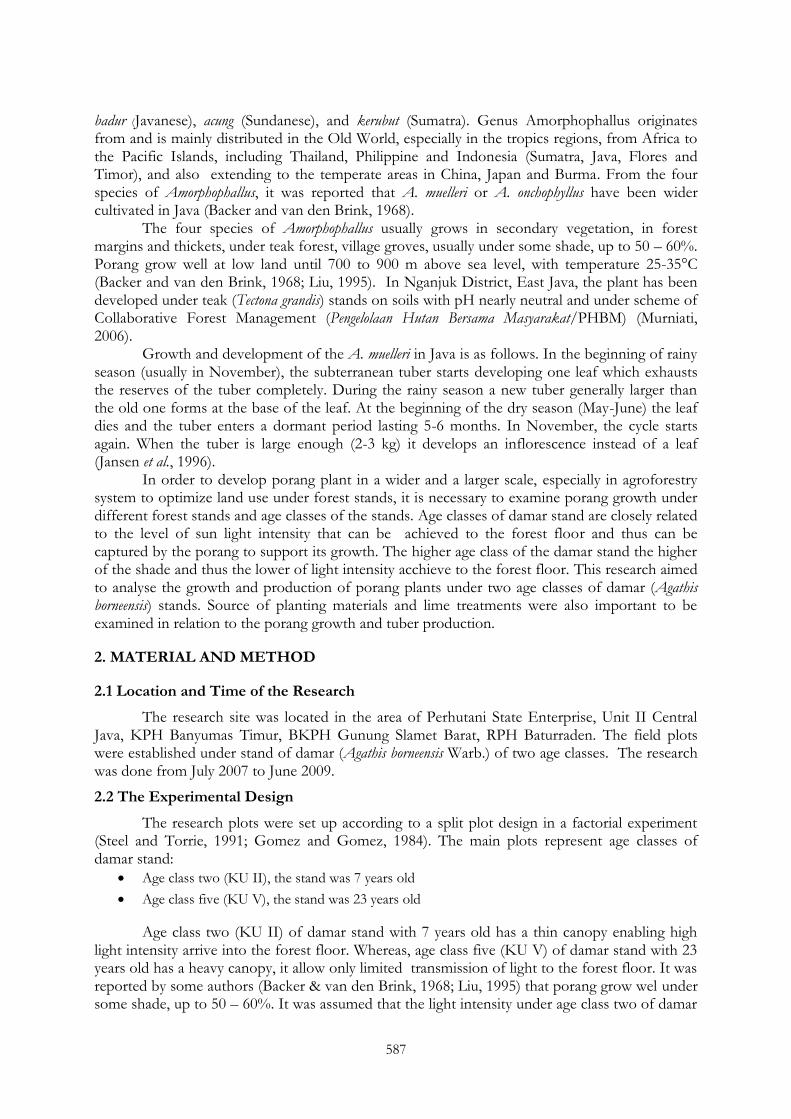
587
badur (Javanese), acung (Sundanese), and kerubut (Sumatra). Genus Amorphophallus originates from and is mainly distributed in the Old World, especially in the tropics regions, from Africa to the Pacific Islands, including Thailand, Philippine and Indonesia (Sumatra, Java, Flores and Timor), and also extending to the temperate areas in China, Japan and Burma. From the four species of Amorphophallus, it was reported that A. muelleri or A. onchophyllus have been wider cultivated in Java (Backer and van den Brink, 1968).
The four species of Amorphophallus usually grows in secondary vegetation, in forest margins and thickets, under teak forest, village groves, usually under some shade, up to 50 – 60%. Porang grow well at low land until 700 to 900 m above sea level, with temperature 25-35°C (Backer and van den Brink, 1968; Liu, 1995). In Nganjuk District, East Java, the plant has been developed under teak (Tectona grandis) stands on soils with pH nearly neutral and under scheme of Collaborative Forest Management (Pengelolaan Hutan Bersama Masyarakat/PHBM) (Murniati, 2006).
Growth and development of the A. muelleri in Java is as follows. In the beginning of rainy season (usually in November), the subterranean tuber starts developing one leaf which exhausts the reserves of the tuber completely. During the rainy season a new tuber generally larger than the old one forms at the base of the leaf. At the beginning of the dry season (May-June) the leaf dies and the tuber enters a dormant period lasting 5-6 months. In November, the cycle starts again. When the tuber is large enough (2-3 kg) it develops an inflorescence instead of a leaf (Jansen et al., 1996).
In order to develop porang plant in a wider and a larger scale, especially in agroforestry system to optimize land use under forest stands, it is necessary to examine porang growth under different forest stands and age classes of the stands. Age classes of damar stand are closely related to the level of sun light intensity that can be achieved to the forest floor and thus can be captured by the porang to support its growth. The higher age class of the damar stand the higher of the shade and thus the lower of light intensity acchieve to the forest floor. This research aimed to analyse the growth and production of porang plants under two age classes of damar (Agathis borneensis) stands. Source of planting materials and lime treatments were also important to be examined in relation to the porang growth and tuber production.
2. MATERIAL AND METHOD
2.1 Location and Time of the Research
The research site was located in the area of Perhutani State Enterprise, Unit II Central Java, KPH Banyumas Timur, BKPH Gunung Slamet Barat, RPH Baturraden. The field plots were established under stand of damar (Agathis borneensis Warb.) of two age classes. The research was done from July 2007 to June 2009.
2.2 The Experimental Design
The research plots were set up according to a split plot design in a factorial experiment (Steel and Torrie, 1991; Gomez and Gomez, 1984). The main plots represent age classes of damar stand:
Age class two (KU II), the stand was 7 years old
Age class five (KU V), the stand was 23 years old
Age class two (KU II) of damar stand with 7 years old has a thin canopy enabling high light intensity arrive into the forest floor. Whereas, age class five (KU V) of damar stand with 23 years old has a heavy canopy, it allow only limited transmission of light to the forest floor. It was reported by some authors (Backer & van den Brink, 1968; Liu, 1995) that porang grow wel under some shade, up to 50 – 60%. It was assumed that the light intensity under age class two of damar
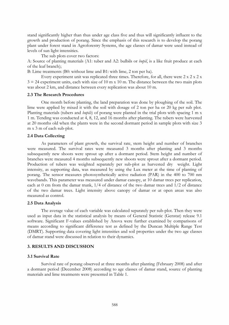
588
stand significantly higher than thus under age class five and thus will significantly influent to the growth and production of porang. Since the emphasis of this research is to develop the porang plant under forest stand in Agroforestry Systems, the age classes of damar were used instead of levels of sun light intensities.
The sub plots cover two factors: A: Source of planting materials (A1: tuber and A2: bulbils or bupil, is a like fruit produce at each of the leaf branch); B: Lime treatments (B0: without lime and B1: with lime, 2 ton per ha).
Every experiment unit was replicated three times. Therefore, for all, there were 2 x 2 x 2 x 3 = 24 experiment units, each with size of 10 m x 10 m. The distance between the two main plots was about 2 km, and distance between every replication was about 10 m.
2.3 The Research Procedures
One month before planting, the land preparation was done by ploughing of the soil. The lime were applied by mixed it with the soil with dosage of 2 ton per ha or 20 kg per sub plot. Planting materials (tubers and bupils) of porang were planted in the trial plots with spacing 1 m x 1 m. Tending was conducted at 4, 8, 12, and 16 months after planting. The tubers were harvested at 20 months old when the plants were in the second dormant period in sample plots with size 3 m x 3 m of each sub-plot.
2.4 Data Collecting
As parameters of plant growth, the survival rate, stem height and number of branches were measured. The survival rates were measured 3 months after planting and 3 months subsequently new shoots were sprout up after a dormant period. Stem height and number of branches were measured 4 months subsequently new shoots were sprout after a dormant period. Production of tubers was weighted separately per sub-plot as harvested dry weight. Light intensity, as supporting data, was measured by using the Lux meter at the time of planting of porang. The sensor measures photosynthetically active radiation (PAR) in the 400 to 700 nm wavebands. This parameter was measured under damar canopy, at 10 damar trees per replication, each at 0 cm from the damar trunk, 1/4 of distance of the two damar trees and 1/2 of distance of the two damar trees. Light intensity above canopy of damar or at open areas was also measured as control.
2.5 Data Analysis
The average value of each variable was calculated separately per sub-plot. Then they were used as input data in the statistical analysis by means of General Statistic (Genstat) release 9.1 software. Significant F-values established by Anova were further examined by comparisons of means according to significant difference test as defined by the Duncan Multiple Range Test (DMRT). Supporting data covering light intensities and soil properties under the two age classes of damar stand were discussed in relation to their dynamics.
3. RESULTS AND DISCUSSION
3.1 Survival Rate
Survival rate of porang observed at three months after planting (February 2008) and after a dormant period (December 2008) according to age classes of damar stand, source of planting materials and lime treatments were presented in Table 1.

589
Table 1. Effect of age classes of damar stand, source of planting materials and lime treatments on the survival rate of porang three months after planting and after a dormant period
Treatments
Survival (%) Three months after planting
After a dormant period
Age classes (KU) of damar stand: KU II (7 years old) KU V (23 years od)
71.8ns
81.0
37.5a
79.1b
Source of planting materials: Tuber Bupil
69.2a
83.6b
49.4ns
67.2 Lime Treatment: Without lime With lime, 2 ton/ha
86.9a
65.8b
63.9ns
52.7 Interaction among Source of Planting materials and lime treatments: Tuber without lime Tuber with lime Bupil without lime Bupil with lime
92.2a
46.2b
81.7a
85.5a
64.8a
34.0b
63.0a
71.3a
Remarks: Numbers followed by different letters. a or b in the same column indicate significant differences (P<0.05) according to Duncan‘s Multiple Range Test. NS = not significantly different (P > 0.05)
Statistical data analysis of the survival rate (Table 1 and Appendix 1) showed that age
classes (KU) of damar stand did not give a significant effect to the survival of porang within three months after planting. However, after a dormant period (Tabel 1 and Appendix 2), survival rate of porang under KU V of damar stand was significantly higher than thus under KU II, This assumed caused by the high light intensities under KU II (average 71%, see Table 2) inhibit the broken the dormancy of the tubers. Porang is tipical for shade demanding plant, it need certain light intensity level (Backer & van den Brink, 1968; Liu, 1995). The survival at the first time (three months after planting) was not affected by the high light intensities since before planted the tubers have been treated by watering and put it under cool and fresh air. Jansen et al., (1996) reported that the dormancy of porang seed can be broken by keeping seed for six days in running water.
Table 2. Light intensities under two age classes of damar stands at three different times: morning. noon and afternoon
Age classes (KU) of damar stand and Replication
Sun Light Intensities (%) at: Morning (9 am)
Noon (12 am)
Afternoon (3 pm)
Average
KU II: I II III
78 66 73
75 68 73
68 65 70
74 63 72
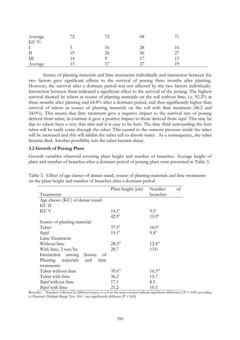
590
Average 72 72 68 71 KU V: I II III
5 19 14
16 26 9
28 36 17
16 27 13
Average 13 17 27 19
Source of planting materials and lime treatments individually and interaction between the
two factors gave significant effects to the survival of porang three months after planting. However, the survival after a dormant period was not affected by the two factors individually. Interaction between them indicated a significant effect to the survival of the porang. The highest survival showed by tubers as source of planting materials on the soil without lime. i.e. 92.2% at three months after planting and 64.8% after a dormant period, and thus significantly higher than survival of tubers as source of planting materials on the soil with lime treatment (46.2 and 34.0%). This means that lime treatment gave a negative impact to the survival rate of porang derived from tuber, in contrary it gave a positive impact to those derived from bupil. This may be due to tubers have a very thin skin and it is easy to be hurt. The lime fluid surrounding the hurt tuber will be easily come through the tuber. This caused to the osmosis pressure inside the tuber will be increased and this will inhibit the tuber cell to absorb water. As a consequence, the tuber became died. Another possibility was the tuber became decay.
3.2 Growth of Porang Plant
Growth variables observed covering plant height and number of branches. Average height of plant and number of branches after a dormant period of porang plant were presented in Table 3.
Table 3. Effect of age classes of damar stand, source of planting materials and lime treatments on the plant height and number of branches after a dormant period
Treatments
Plant height (cm) Number of branches
Age classes (KU) of damar stand: KU II KU V
14.1a
42.9b
9.5a
15.9b
Source of planting material: Tuber Bupil
37.9a
19.1b
16.0a
9.4b
Lime Treatment: Without lime With lime, 2 ton/ha
28.3ns
28.7
12.4ns
13.0 Interaction among Source of Planting materials and lime treatments: Tuber without lime Tuber with lime Bupil without lime Bupil with lime
39.6ns
36.2 17.1 21.2
16.3ns
15.7 8.5 10.3
Remarks: Numbers followed by different letters. a or b in the same column indicate significant differences (P < 0.05) according to Duncan‘s Multiple Range Test. NS = not significantly different (P > 0.05)
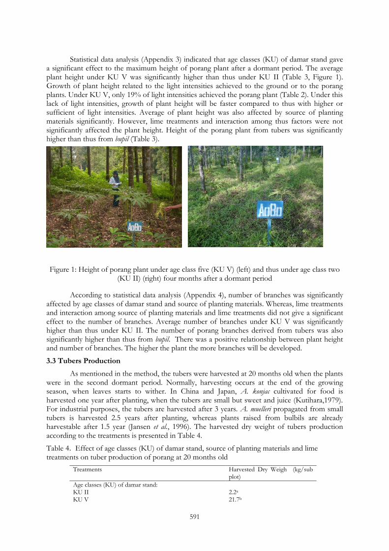
591
Statistical data analysis (Appendix 3) indicated that age classes (KU) of damar stand gave a significant effect to the maximum height of porang plant after a dormant period. The average plant height under KU V was significantly higher than thus under KU II (Table 3, Figure 1). Growth of plant height related to the light intensities achieved to the ground or to the porang plants. Under KU V, only 19% of light intensities achieved the porang plant (Table 2). Under this lack of light intensities, growth of plant height will be faster compared to thus with higher or sufficient of light intensities. Average of plant height was also affected by source of planting materials significantly. However, lime treatments and interaction among thus factors were not significantly affected the plant height. Height of the porang plant from tubers was significantly higher than thus from bupil (Table 3).
Figure 1: Height of porang plant under age class five (KU V) (left) and thus under age class two (KU II) (right) four months after a dormant period
According to statistical data analysis (Appendix 4), number of branches was significantly affected by age classes of damar stand and source of planting materials. Whereas, lime treatments and interaction among source of planting materials and lime treatments did not give a significant effect to the number of branches. Average number of branches under KU V was significantly higher than thus under KU II. The number of porang branches derived from tubers was also significantly higher than thus from bupil. There was a positive relationship between plant height and number of branches. The higher the plant the more branches will be developed.
3.3 Tubers Production
As mentioned in the method, the tubers were harvested at 20 months old when the plants were in the second dormant period. Normally, harvesting occurs at the end of the growing season, when leaves starts to wither. In China and Japan, A. konjac cultivated for food is harvested one year after planting, when the tubers are small but sweet and juice (Kutihara,1979). For industrial purposes, the tubers are harvested after 3 years. A. muelleri propagated from small tubers is harvested 2.5 years after planting, whereas plants raised from bulbils are already harvestable after 1.5 year (Jansen et al., 1996). The harvested dry weight of tubers production according to the treatments is presented in Table 4.
Table 4. Effect of age classes (KU) of damar stand, source of planting materials and lime treatments on tuber production of porang at 20 months old
Treatments Harvested Dry Weigh (kg/sub plot)
Age classes (KU) of damar stand: KU II KU V
2.2a
21.7b
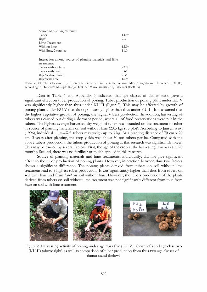
592
Source of planting materials: Tuber Bupil
14.6ns
9.3
Lime Treatment: Without lime With lime, 2 ton/ha
12.9ns
11.0
Interaction among source of planting materials and lime treatments: Tuber without lime Tuber with lime Bupil without lime Bupil with lime
23.5a
5.6b
2.3b
16.4a
Remarks: Numbers followed by different letters, a or b in the same column indicate significant differences (P<0.05) according to Duncan‘s Multiple Range Test. NS = not significantly different (P>0.05)
Data in Table 4 and Appendix 5 indicated that age classes of damar stand gave a significant effect on tuber production of porang. Tuber production of porang plant under KU V was significantly higher than thus under KU II (Figur 2). This may be affected by growth of porang plant under KU V that also significantly higher than thus under KU II. It is assumed that the higher vegetative growth of porang, the higher tubers production. In addition, harvesting of tubers was carried out during a dormant period, where all of food preservations were put in the tubers. The highest average harvested dry weigh of tubers was founded on the treatment of tuber as source of planting materials on soil without lime (23.5 kg/sub plot). According to Jansen et al., (1996), individual A. muelleri tubers may weigh up to 3 kg. At a planting distance of 70 cm x 70 cm, 3 years after planting, the crop yields was about 50 ton tubers per ha. Compared with the above tubers production, the tubers production of porang at this research was significantly lower. This may be caused by several factors. First, the age of the crop at the harvesting time was still 20 months. Second, there was no fertilizer or mulch applied in this research.
Source of planting materials and lime treatments, individually, did not give significant effect to the tuber production of porang plants. However, interaction between thus two factors shows a significant difference. The porang plants derived from tubers on soil without lime treatment lead to a highest tuber production. It was significantly higher than thus from tubers on soil with lime and from bupil on soil without lime. However, the tubers production of the plants derived from tubers on soil without lime treatment was not significantly different from thus from bupil on soil with lime treatment.
Figure 2: Harvesting activity of porang under age class five (KU V) (above left) and age class two (KU II) (above right) as well as comparison of tuber production from thus two age classes of
damar stand (below)
593
4. CONCLUSION AND RECOMMENDATION
1. After a dormant period the survival rate of porang under age class five (KU V) of damar
stand with light intensity only 19% was 79.1%. It was significantly higher than thus under age
class two (KU II) with light intensity about 71% where the survival rate was only 37.5%.
2. Source of planting material from tubers on soil without lime resulted a highest average
survival rate of porang plants (92.2%) and was significantly different from tubers on soil with
lime treatment (46.2%). Lime treatment gave a negative impact to the survival rate of porang
derived from tuber, in contrary it gave a positive impact to those derived from bupil.
3. Height of the plant, number of branches and harvested dry weight of tubers production
produced under age class five (KU V) of damar stand, were significantly higher than those
under age class two (KU II). The height and number of branches of the plants derived from
tuber were significantly higher than those derived from bupil. Interaction between source of
planting materials and lime treatments was lead to a significant effect to the harvested dry
weight of the tubers production, where the treatments of tuber without lime have the highest
harvested dry weight of tuber production.
4. It is recommended to develop porang plantation under five or more age class of damar stand
by using tubers as planting materials without lime or bupil with lime.
REFERENCES
Backer, C A, R C Bakhuizen van den Brink Jr. (1968): Flora of Java (Angiospermae) Vol. III: 113. Wolters Noordhoff N.V., Groningen, The Netherlands.
Gomez, K A and A A Gomez (1984): Statistical Procedures for Agricultural Research. 2nd Edition. A Wiley-Inter science Publication JOHN WILEY & SONS, New York.
Jansen, P C M, C van den Willd and W L A Hetterscheid (1996): Amorphophallus. In M. Flach & F. Rumawas (Eds ). Plant Yielding Non seed Carbohydrates. PROSEA 9: 40-50.
Kurihara, H (1979): Trends and problems of konjac (Amorphophallus konjac). Cultivation in Japan. Japanese Agriculture Research Quarterly 13:174-179.
Liu Pei Ying (1995): Research and Utilization of Amorphophallus in China. In : Li, H (Ed). Proceedings of the International Aroid Conference, Kunming 26 June - 2 July 1995. Editorial Department of Acta Botanica Yunnanica, Kunming, China. pp: 20-36
Murniati (2006): Laporan Hasil Penelitian. Pusat Penelitian dan Pengembangan Hutan dan Konservasi Alam. Unpublished.
Steel, R G D and J H Torrie (1991): Prinsip dan Prosedur Statistika, suatu pendekatan biometrik (terjemahan). PT Gramedia Pustaka Utama, Jakarta.

594
Appendix 1. Analysis of variance of survival rate of porang plant 3 months after planting
Source of variation d.f s.s m.s v.r. F pr.
Replication 3 1117.0 558.5 1.90
Replication.KU KU Residual
1 2
513.4 588.0
513.4 294.0
1.75 3.57
0.317
Replication.KU.Source of planting materials Source of planting material KU.Source of planting material Residual
1 1 4
1247.0 360.4 329.3
1247.0 360.4 82.3
15.15 4.38 0.45
0.018 0.105
Replication.KU.Source of planting materials.Lime treatment Lime treatment KU.Lime treatment Source of planting material.Lime treatment KU.Source of planting material.Lime treatment Residual
1 1 1 1 8
2667.0 84.4 3725.0 51.0 1451.0
2667.0 84.4 3725.0 51.0 181.4
14.70 0.47 20.54 0.28
0.005 0.514 0.002 0.610
Total 23 12133.6
Appendix 2. Analysis of variance of survival rate of porang plant after a dormant period
Source of variation d.f s.s m.s v.r. F pr.
Replication 2 283.1 141.5 0.23
Replication.KU KU Residual
1 2
10375.0 1215.1
10375.0 607.5
17.08 1.43
0.054
Replication.KU.Source of planting materials Source of planting material KU.Source of planting material Residual
1 1 4
1890.4 2.0 1694.8
1890.4 2.0 423.7
4.46 0.00 0.81
0.102 0.948
Replication.KU.Source of planting materials.Lime treatment Lime treatment KU.Lime treatment Source of planting material.Lime treatment KU.Source of planting material.Lime treatment Residual
1 1 1 1 8
759.4 108.4 2301.0 0.0 4171.7
759.4 108.4 2301.0 0.0 521.5
1.46 0.21 4.41 0.00
0.262 0.661 0.069 0.993
Total 23 22801.0
Appendix 3. Analysis of variance of plant height after a dormant period
Source of variation d.f s.s m.s v.r. F pr.
Replication 2 177.59 88.80 0.44
Replication.KU KU Residual
1 2
4985.28 399.40
4985.28 199.70
24.96 4.77
0.038
Replication.KU.Source of planting materials Source of planting material

595
KU.Source of planting material Residual
1 1 4
2107.50 756.00 167.40
2107.50 756.00 41.85
50.36 18.06 0.46
0.002 0.013
Replication.KU.Source of planting materials.Lime treatment Lime treatment KU.Lime treatment Source of planting material.Lime treatment KU.Source of planting material.Lime treatment Residual
1 1 1 1 8
0.84 25.01 83.25 57.97 723.83
0.84 25.01 83.25 57.97 90.48
0.01 0.28 0.92 0.64
0.925 0.613 0.366 0.447
Total 23 9484.08
Appendix 4. Analysis of variance on number of branches after a dormant period
Source of variation d.f s.s m.s v.r. F pr.
Replication 2 15.54 7.77 0.83
Replication.KU KU Residual
1 2
248.33 18.66
248.33 9.33
26.61 1.82
0.036
Replication.KU.Source of planting materials Source of planting material KU.Source of planting material Residual
1 1 4
261.36 89.71 20.49
261.36 89.71 5.12
51.01 17.51 0.35
0.002 0.014
Replication.KU.Source of planting materials.Lime treatment Lime treatment KU.Lime treatment Source of planting material.Lime treatment KU.Source of planting material.Lime treatment Residual
1 1 1 1 8
2.41 1.71 8.64 1.13 118.59
2.41 1.71 8.64 1.13 14.82
0.16 0.12 0.58 0.08
0.698 0.743 0.467 0.790
Total 23 786.55
Appendix 5. Analysis of variance on tubers production
Source of variation d.f s.s m.s v.r. F pr.
Replication 2 69.7 34.9 0.87
Replication.KU KU Residual
1 2
2273.7 79.9
2273.7 40.0
56.91 0.19
0.017
Replication.KU.Source of planting materials Source of planting material KU.Source of planting material Residual
1 1 4
164.1 106.0 825.9
164.1 106.0 206.5
0.79 0.51 1.47
0.423 0.513
Replication.KU.Source of planting materials.Lime treatment Lime treatment KU.Lime treatment Source of planting material.Lime treatment KU.Source of planting material.Lime treatment Residual
1 1 1 1 8
22.3 5.4 1540.5 1021.3 1124.1
22.3 5.4 1540.5 1021.3 140.5
0.16 0.04 10.96 7.27
0.701 0.849 0.011 0.027
Total 23 7232.9
INAFOR 11H-066
INTERNATIONAL CONFERENCE OF INDONESIAN FORESTRY RESEARCHERS (INAFOR)
Section H Community and Social Forestry
Integrating Community Forestry and Forest Products Based-Rural Industrialization for Enhancing Rural Community Welfare and
Sustaining Forest Resources
Didik Suharjito
Dept. of Forest Management, Faculty of Forestry, Bogor Agricultural University Jl. Raya Darmaga, Kampus IPB Darmaga Bogor 16680, INDONESIA
Corresponding email: [email protected]
Paper prepared for The First International Conference of Indonesian Forestry Researchers (INAFOR)
Bogor, 5 – 7 December 2011
INAFOR SECRETARIAT Sub Division of Dissemination, Publication and Library
FORESTRY RESEARCH AND DEVELOPMENT AGENCY Jl. Gunung Batu 5, Bogor 16610
597
Integrating Community Forestry and Forest Products Based-Rural Industrialization for Enhancing Rural Community Welfare and
Sustaining Forest Resources
Didik Suharjito
Dept. of Forest Management, Faculty of Forestry, Bogor Agricultural University Jl. Raya Darmaga, Kampus IPB Darmaga Bogor 16680, INDONESIA
Corresponding email: [email protected]
ABSTRACT
Research on community forestry or social forestry (CF/SF) in Indonesia has been done on various topics, however mostly they did‘nt pay attention to linkage household forest and forest products industry in rural areas. Whereas forest products industries have very important role in rural socio-economic development. The objectives of this article are to describe wood based-industries in rural areas, to describe household owned forest (hutan rakyat) or private forest and wood based-industry relationship in rural areas, and to explain why integration of community forest and forest product based-rural industrialization is necessary to be developed. The research was done in Palabuhan Ratu, Bojong Genteng, Parungkuda and Kalapanunggal of Sukabumi District using a case study method. The results showed that household-owned forest and small scale or household forest products based-industry in rural areas (HFPI) have interdependent relationship. The HFPI could support forest resource management to be sustainable, while sustainable forest could support sustainability of the HFPI. Both could enhance absorption of rural labor force, rural labor productivity, and household income; strengthen social relationship, and supposedly will enhance circulation of money in rural areas and decrease urbanization. Keywords: Community forestry, household forest products based-industry, rural industrialization, rural development.
1. INTRODUCTION
State forest resources utilization in Indonesia for very long time since collonial era to present have been dominated by big forestry companies. This forest utilization practices have not adequately supported forest community well being, although the companies have launched community development and or partnership model programs. The Indonesian people who live in or arround forest area are mostly categorized as poor people. Meanwhile, since decades rural communities have actively carried out tree planting activities on their own agricultural land (household owned forest or private forest or hutan rakyat). Some wood based-industries have been depended on timber production of hutan rakyat.
Research on household owned forest in Indonesia has been done on many topics such as yield arrangement, economic and financial analysis, wood marketing, adaptive strategy, forest farmer‘s decision making in tree species choice, certification, and carbon sequestration (Suharjito, 2000; Hardjanto, 2003, Maryudi, 2005, Hinrichs et al., 2008; Irawan, 2011). Meanwhile some research on private forest or non industrial forest in developed countries (mostly in Europe and United State) recently concern with de-fragmentation of woodland (Quine and Watts, 2009), landowners' policy preferences for promoting wood-based bioenergy (Shivan and Mehmood, 2010), incentives for landowners to cooperate to be joint forest management (Vokoun et al., 2010), and typology of small-scale private woodland (Urquhart and Courtney, 2011). Lack of research concerned with cooperation or relationship among forest household and wood processing industry. In term of private forest or non industrial forest, there are research on
598
forest–mill integration (Niquidet and O'Kelly, 2010) and shared wood procurement areas and co-production within a multi-firm environment (Beaudoin et al., 2010).
The Ministry of Forestry GOI has launched community forest (hutan kemasyarakatan, HKm) program since more than fiveteen years ago, and recently people plantation forest (hutan tanaman rakyat, HTR) and village forest (hutan desa, HD) programs. These programs are in line with the government‘s slogan of pro-growth, pro-job, pro-poor, and pro-environment. The objectives of community forest, village forest, and people plantation forest programs are to enhance more access and rights over state forestland for forest communities, reduce unemployment, ameliorate forest communities poverty, support village infrastructure development, enhance forest resources productivity, ensure forest management sustainably, and increase forestry sector contribution to national economic development.
HKm has been executed since more than fiveteen years ago, while HD and HTR programs recently have also been launched. Those programs have enhanced more access and rights over state forestland for local communities. Nevertheless, those were still limited, during the period of 2007-2011 state forest stipulated by the ministry of forestry for HKm (license or permit, IUPHHKm) and HD (IUPHHD) are respectively 41.330 hectares and 10.310 hectares, while state forest alocated for HTR is of 631,628 hectares. HKm, HD, and HTR areas would be continously enlarged to attain of 5.6 million hectars in 2030 consisting of 2.5 million hectares HKm, 500 hectares HD, and 2.6 million hectares HTR (National Forestry Plan/ RKTN, 2011). Those programs will enhance forest products supply of timber, non timber, as well as environmental services.
Household owned forests in Java have grown and continuously extend. Ministry of Forestry reported that the area of hutan rakyat in Java reached 3.5 million hectares in 2011. The expansion and intensification of hutan rakyat is driven by government grants (greening program, GNRHL, etc.) and wood based industries. Supply of timber from hutan rakyat in Java has helped the wood based industries who are facing shortages of raw materials in recent years. Natural forests degradation outside Java has caused logs supply to large-scale forest industry continues to decline, so the company sought to obtain timber from hutan rakyat. Several large and medium scale forest industry companies have established partnerships with forest farmers (household). Increased demand for logs from hutan rakyat by forest industry companies are expected to provide increased benefits to forest farmers family and without lead to excessive forest exploitation. This paper does not give attention to the large and medium scale forestry industry, but on small scale/ households scale industries that have been developed in the villages. This research elaborate research conducted by Suharjito (2002) that put attention to household wood based-industry and its role in rural employment and household income. The objectives of this article are to describe wood based-industries in rural areas, to describe household-owned forest (hutan rakyat) and wood based-industry relationship in rural areas, and to explain why integration of community forest and forest product based-rural industrialization is necessary to be developed.
2. RESEARCH METHODS
The research was done in Palabuhan Ratu, Bojong Genteng, Parungkuda and Kalapanunggal of Sukabumi District using a case study method. The exsistence of household wood based industry was taken into consideration when choosing the study site. The industries were located within and around villages in rural areas. In this study I used different sources of data i.e. forest farmers (peasants), timber collectors (middleman), owners of wood based-industries, and industry laborers. I conducted semi-structured interview with informants, field observation, and secondary data collection. Primary data and information were collected through focused, probed, in-depth interviews with the informants.
599
3. RESULT AND DISCUSSION
In rural areas, livelihoods outside agriculture can be broadly classified into two types of work i.e. off-farm and non-farm. Palte (1989: 181) defined off-farm activities as: ―off-farm employment comprises all income-earning activities other than cultivation or rearing of livestock on the family farm‖. While farm is ―an agricultural holding (i.e. any tract(s) of land and its buildings, worked as a unit and owned or rented under one management, used for growing crops and/or raising livestock)‖. Using this definition Palte classified wages work in farming and agricultural product processing as off-farm. Off-farm activities carried out by the villagers in Sukabumi include trade of agricultural products (bananas, durian, coconut, beans, rubber, fish, etc.) and agriculture/forest product industry (sawmills, rubber, rice hulling). While non-farm activities carried out by the villagers in Sukabumi include trade (grocery shops, itinerant peddlers, meatballs), building construction, garages, motorcycle for public transport and drivers.
3.1 Wood Based Industry: Raw Material and Its Products
Wood based industries in the Sub-district of Palabuhan Ratu (Buniwangi village), Bojong Genteng (Bojong Genteng, Berekah, Cibodas villages), Parungkuda (Parungkuda, Sundawenang, Kompa, Pakuwon villages), and Kalapanunggal (Kalapanunggal village) Sukabumi was built and in operation since 1960. The number of industries and production volume have been growing. Type of product consist of board, chest, pallet, rafter, pole, furniture (Table 1).
Table 1. Number of wood based-industry (WBI) by year of establishment, type and volume of product
Establishment of WBI The current production
Year Number of WBI
Type of product Volume
1960-1970 1 Chest for tomato and bottle 1000 chests/ month
1970-1980 2 Board, chest for tomato 30 m3 boards/ month, 1800 chests/ month
1980-1990 7 Board, rafter, pole, chest (for soap/detergent, egg, money, bottle, kopling, hasfel, pallet
729.5 m3 boards/ month; 18760 set pallet/ month; 5170 chests/ month
1990-2000 18 Board, chest for money, pallet, bistek, furniture
1700 m3 boards/ month, 1200 chest/ month, 37420 set pallet/ month
2000-2005 9 Board, rafter, pole, window or door frame, chest (for egg, money, bottle, sugar), hasfel, pallet
11300 set pallet/ month, 376 m3 boards/ month, 4210 chests/ month
Total 28
Raw materials used by these industries are log of teak (Tectona grandis), sengon
(Paraserianthes falcataria), afrika (Maesopsis eminii), puspa (Schima wallichii), rasamala (Altingia excelsa), mahogany (Swietenia mahagoni), akasia (Acacia auriculiformis), suren (Toona sureni), jackfruit (Artocarpus heterophyllus), rambutan (Nephelium lappaceum), and durian (Durio zibethinus). Log were obtained from forests or mixed garden in the vicinity of the industry (Bojong Genteng, Kelapa Nunggal, Parungkuda, Kabandungan, Pelabuhan Ratu, Cipetir and Cikidang) as well as from more distant areas within the district (Surade, Jampang, Jampang Kulon, Jurang Malang, Cisaat, Situ Gunung, Cikembar, Nagrak, Sukabumi), even from more distant areas outside the district
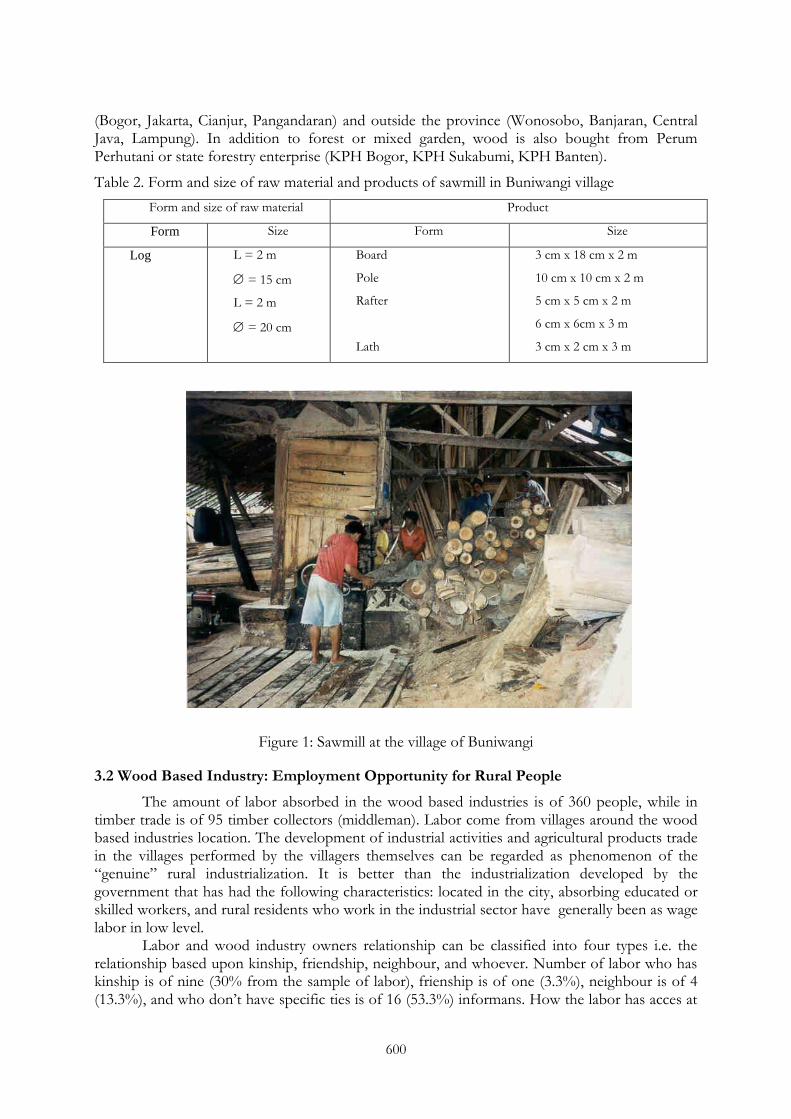
600
(Bogor, Jakarta, Cianjur, Pangandaran) and outside the province (Wonosobo, Banjaran, Central Java, Lampung). In addition to forest or mixed garden, wood is also bought from Perum Perhutani or state forestry enterprise (KPH Bogor, KPH Sukabumi, KPH Banten).
Table 2. Form and size of raw material and products of sawmill in Buniwangi village
Form and size of raw material Product
Form Size Form Size
Log L = 2 m
= 15 cm
L = 2 m
= 20 cm
Board
Pole
Rafter
Lath
3 cm x 18 cm x 2 m
10 cm x 10 cm x 2 m
5 cm x 5 cm x 2 m
6 cm x 6cm x 3 m
3 cm x 2 cm x 3 m
Figure 1: Sawmill at the village of Buniwangi
3.2 Wood Based Industry: Employment Opportunity for Rural People
The amount of labor absorbed in the wood based industries is of 360 people, while in timber trade is of 95 timber collectors (middleman). Labor come from villages around the wood based industries location. The development of industrial activities and agricultural products trade in the villages performed by the villagers themselves can be regarded as phenomenon of the ―genuine‖ rural industrialization. It is better than the industrialization developed by the government that has had the following characteristics: located in the city, absorbing educated or skilled workers, and rural residents who work in the industrial sector have generally been as wage labor in low level.
Labor and wood industry owners relationship can be classified into four types i.e. the relationship based upon kinship, friendship, neighbour, and whoever. Number of labor who has kinship is of nine (30% from the sample of labor), frienship is of one (3.3%), neighbour is of 4 (13.3%), and who don‘t have specific ties is of 16 (53.3%) informans. How the labor has acces at

601
the first time to join the industry can be noted that who followed his friend is of seven (23.3%), who enrolled for himself is of 10 (33.3%), who was invited by the industry owner is of 11 (36.7%), and two (6.7%) labor were recruited by his uncle and parent in law. The fact that the relation ties among labor and wood industry owner is mosly based on professional contract.
Figure 2: Woman worker in small scale wood based industry
Some labors have worked for the wood based industries since 20 years ago, while the others worked since last week. Mostly labor has work experiences from other company before entering the present wood based industry, while the others have not had experiences from other work places before working in the present work place. Labor learn about their jobs to his boss or the owner, his parent, brothers, or friends, but mostly they were learning by doing and learn to his friends. There is no labor who participated in training before or during working in the present work place. Most of the labor of wood based industry did not have other source of income. Some of them have income from paddy field, garden, or small shop. They worked for it usually in weekend.
3.3 Netwoking and Forward Lingkage
The household wood based industries sell their products to local market and outside areas. Boards (papan) have been bought by local people, local bulding material shops, and some industries such as PT Trigraha in Bogor, PT Alexindo and PT Poxel in Bekasi, PT Fajar in Cibitung, PT Bulan Seribu Bintang and PT Usaha Bersama in Jakarta, and PT Indah Kiat in Serang. Chest (peti) have also been bought by local enterprise, as well as some enterprises in other districts such as PT Walet in Tangerang, PT Intisari in Citeureup, PT Jokpindo, and Perum PERURI (state money printing) in Jakarta. Palet have been supplied to PT. Aqua in Cicurug, PT. Yanmar in Cimanggis-Bogor, PT. Indocement in Cibinong, PT. Vidio Glas and PT. Mulia Ceramic in Cikarang, PT. Indodeli and PT. Ceramic Euro in Karawang, PT. Eszenza Ceramic in Tangerang, PT. Indah Kiat in Serang, PT. Polibed in Anyer, PT. Risat Brasali in Merak, PT. Beranta-export, PT. Subur, and PT. Harga Karya.
The facts show that wood based industries in rural areas have had linkage with various industry near the wood based industries area as well as far-off. This linkage indicate that household wood based industries have capacity in developing network. In this case study most (90%) of the industry owners are Sundanese and local people. They developed the wood based industry through learning by doing and or learn to their parent. The industry owners in this case
602
have the same characteristic as the industry owners in Tasikmalaya (Ariyadi, 2004) and Wonosobo (Setiyadi, 2004).
3.4 Wood Based Industry and Forest Farmer Relationship
The owners of wood based Industry build an interdependent relationship with timber collectors (middleman) and forest farmers. Farmers can not sell directly to the timber industry because of the amount of timber sold slightly so inefficient. Middleman buy from some farmers and transport it in sufficient quantities so that more efficient. Unfortunately, the price of wood at farmer level is quite low, the farmers did not get information of the real market price at industry place. Other factor causing the low price is the ijon system, farmers sell the trees when it still small, or farmers borrow money to middleman or industry owner with agreement that the farmers must sell the trees to the middleman or industry owner.
The wood based-industries has not concerned with forest sustainability. They are depended on continuity of timber supply as raw material of the industry. However, they give little attention to support the farmer‘s life who manages the trees.
4. CONCLUSION AND RECOMMENDATION
Rural industrialization that has developed (this case in Sukabumi areas) among other were sawmills, pallet, chest, and furniture. Wood based industry activities provide employment opportunities for labor force in the villages. According to Boeke (1966), economic activities of agriculture, industry, and trade that have developed in the rural Java areas show disappearance of economic dualism model.1)
Integrating the development of community based forest management (HKm, HD, HTR) and the development of small scale or household forest products based-industry in rural areas (HFPI)) is essential for rural economy development. The reasons are to strengthen the existing social relationship in rural areas through managing their forest resources. Secondly, to enhance the productivity of rural economic resources (forests and labor). The implications of that integration are an increase in family incomes, money supply (or circulation), and families and communities welfare, restraint labor urbanization, as well as sustainability of forest resources.
The role of facilitator is very urgent as proposed by Chambers (1993, 1997) and Korten (1984, 1987) to increase the community capacity in term of developing an appropriate technology and strengthening local social institutions. Korten (1987) explained that the development approach of community-based resource management concern with local variety, local resources and local accountability. Chambers (1993) mentioned four elements: conditions are diverse and complex; rates of change are accelerating; poor rural people are knowledgeable, and rural people are capable of self-reliant organization. The role of outsiders (especially the government and NGOs) is as a facilitator who can provide basket of choices.
Efforts to integrate the development of community based forest management and forest products industry in the village will increase the carrying capacity of local natural (forest) resources, reduce population pressure, and maintain the ecological quality, and will achieve the ultimate goal of improving the quality of life of the community. Thus, that efforts is the urgency of forestry development and rural community development.
REFERENCES
Ariyadi (2004): Hubungan Nilai Sosial dan Karakteristik Pengusaha dengan Perilaku Kewirausahaan pada Industri Kecil Berbahan Baku Kayu di Tasikmalaya. Skripsi, Jurusan Manajemen Hutan IPB, Bogor. Unpublished.
603
Beaudoin D, Frayret JM, LeBel L (2010): Negotiation-based Distributed Wood Procurement Planning within a Multi-firm Environment. Forest Policy and Economics 12:79–93.
Boeke JH (1966): Dualism in colonial societies. In:. Sociology of South East Asia: Readings on Social Change and Development, ed. HD Evers (1980). Oxford University Press, New York.
Chambers R (1993): Challenging the Professions: Frontiers for Rural Development. Intermediate Technology Publications, London.
Chambers R (2007): Whose Reality Counts ? Putting the First Last. Intermediate Technology Publications, London.
Hardjanto (2003): Keragaan dan Pengembangan Usaha Kayu Rakyat di Pulau Jawa. Disertation, Program Studi Ilmu Pengetahuan Kehutanan Pascasarjana IPB, Bogor.
Hinrichs A, Muhtaman DR and Irianto N (2008): Sertifikasi Hutan Rakyat di Indonesia. GTZ, Jakarta.
Korten DC (1985): Rural Development Programming: the Learning Process Approach. In People Centered Development, (Eds.) DC Korten and R Klauss. Kumarian Press, Connecticut.
Korten DC (1987): Introduction: Community Based Resource Management. In Community management: Asian Experience and Perspectives, (Eds.) DC Korten. Kumarian Press, Connecticut.
Maryudi A (2005): Beberapa Kendala Bagi Sertifikasi Hutan Rakyat. Jurnal Hutan Rakyat, 7(3):25-39.
Moreno-Pérez OM, Arnalte-Alegre E and Ortiz-Miranda D (2011): Breaking down the growth of Family Farms: A Case Study of an Intensive Mediterranean Agriculture. Agricultural Systems, 104:500–511.
Niquidet K and O'Kelly G (2010): Forest–mill integration: A transaction cost perspective. Forest Policy and Economics 12:207–212.
Quine CP and Watts K (2009): Successful De-fragmentation of Woodland by Planting in an Agricultural Landscape? An Assessment Based on Landscape Indicators. Journal of Environmental Management 90:251-259.
Setiyadi, E (2004): Hubungan Religiusitas dan Kekerabatan dengan Ketahanan Industri Kecil Berbahan Baku Kayu di Kabupaten Wonosobo. Skripsi, Jurusan Manajemen Hutan IPB, Bogor.
Shivan GC and Mehmood SR (2010): Factors influencing nonindustrial private forest landowners' policy preference for promoting bioenergy. Forest Policy and Economics 12:581–588.
Suharjito D (2002): Kebun-Talun: Strategi Adaptasi Sosial Kultural dan Ekologi Masyarakat Pertanian Lahan Kering Di Desa Buniwangi, Sukabumi, Jawa Barat. Disertation Universitas Indonesia, Depok.
Suharjito D (2000): Hutan Rakyat di Jawa: Perannya dalam Perekonomian Desa. P3KM, Fakultas Kehutanan IPB, Bogor.
Urquhart J and Courtney P (2011): Seeing the Owner Behind the Trees: A Typology of Small-scale Private Woodland Owners in England. Forest Policy and Economics 13:535–544.
Vokoun M, Amacher GS, Sullivan J and Wear D (2010): Examining Incentives for Adjacent Non-industrial private forest Landowners to Cooperate. Forest Policy and Economics 12:104–110.
INAFOR 11H-067
INTERNATIONAL CONFERENCE OF INDONESIA FORESTRY RESEARCHERS INAFOR
Section H Community and Social Forestry
Carbon and Watershed Function as Conditionality for Community Forestry (Case study in Sesaot Lombok)
Noviana Khususiyah, Subekti Rahayu, Tonni Asmawan and S.Suyanto
World Agroforestry Centre (ICRAF) Jl. CIFOR Situgede, Sindang barang, Bogor 16880, INDONESIA
Corresponding email: [email protected]
Paper prepared for The First International Conference of Indonesian Forestry Researchers (INAFOR)
Bogor, 5 – 7 December 2011
INAFOR SECRETARIAT Sub Division of Dissemination, Publication and Library
FORESTRY RESEARCH AND DEVELOPMENT AGENCY Jl. Gunung Batu 5, Bogor 16610
605
Carbon and Watershed Function as Conditionality for Community Forestry (Case study in Sesaot Lombok)
Noviana Khususiyah, Subekti Rahayu, Tonni Asmawan and S.Suyanto
World Agroforestry Centre (ICRAF) Jl. CIFOR Situgede, Sindang barang, Bogor 16880, INDONESIA
Corresponding email: [email protected]
ABSTRACT
Forests provide a number of ecosystems services to human life-support. The most important are as climate regulation which is close relationship with carbon sequestration and watershed function. However, forest conversion and degradation occurred in the large area in Indonesia due to economic reason. Involving community on managing degraded forest through agro-forestry systems is an alternative option to enhance carbon stock, biodiversity, maintaining watershed function and generate income for community. Assessment of carbon stock, watershed and livelihood condition was conducted in buffer area of Sesaot protected forest, West Lombok, Nusa Tenggara Barat. Rapid carbon stock appraisal (RaCSA) and participatory landscape appraisal (PaLA) developed by ICRAF was applied to assess carbon stock and watershed condition. Amount of 30 plots were set up in for land use systems namely secondary forest and agroforest which differentiate based on land status (private land, management permitted, non permitted). Household survey was conducted for 120 respondents across three land status. Carbon stock in agroforestry system is affected by type of planted trees as well as land status. Higher carbon stock was found in agroforestry of private land (72 ton/ha) compared to forest land (42 ton/ha). More timber trees were grown in private land rather than in forest land, both in management permitted or non-permitted. Water quality and quantity in this area is relatively good. There is no high fluctuation of discharge between wet and dry season. Dependence of local community to forest land in is quite high, because 33-59% of total income come from agroforestry systems in the buffer area of protected forest and play an important role in poverty alleviation through narrowing inequity income. Keywords: Carbon stock, community forestry, Flow Persistence, income and equity
1. INTRODUCTION
Protected forest of Sesaot in West Lombok District, East Nusa Tenggara Province is an important area as providing ecosystem regulation. This forest is located in the upper part of Dodokan and Jangkok watershed which plays an important role in the water supply to Mataram city, as well as Central and East Lombok District. However, forest degradation and conversion to other land use systems such as agriculture and agro-forestry occurred in this area. It will impact to loss of forest function particularly carbon dioxide sequestration and hydrological function, even though potentially on increasing local income.
Local community in the buffer area of protected forest had practiced agro-forestry systems mostly coffee and cocoa mixed with other trees such as timber, fruit trees, shading trees as well as some annual crops for a couple of decades. However, tree composition growth in the systems is varied depend on the land status. So far, there are three types of land status across the buffer area are private land, permitted managing forest called community forestry and non permitted.
Community forestry (Hutan Kemasyarakatan/HKm) is one of mechanism strategy to improve degraded forest through involving community on managing forest area (Suyanto et al.,
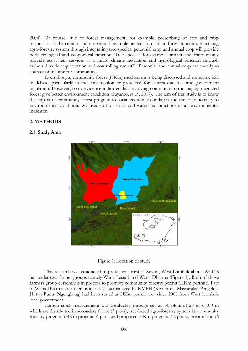
606
2004). Of course, rule of forest management, for example, prescribing of tree and crop proportion in the certain land use should be implemented to maintain forest function. Practicing agro-forestry system through integrating tree species, perennial crop and annual crop will provide both ecological and economical function. Tree species, for example, timber and fruits mainly provide ecosystem services as a micro climate regulation and hydrological function through carbon dioxide sequestration and controlling run-off. Perennial and annual crop are mostly as sources of income for community.
Even though, community forest (HKm) mechanism is being discussed and sometime still in debate, particularly in the conservation or protected forest area due to some government regulation. However, some evidence indicates that involving community on managing degraded forest give better environment condition (Suyanto, et al., 2007). The aim of this study is to know the impact of community forest program to social economic condition and the conditionality to environmental condition. We used carbon stock and watershed functions as an environmental indicator.
2. METHODS
2.1 Study Area
Figure 1: Location of study
This research was conducted in protected forest of Sesaot, West Lombok about 5950.18 ha under two farmer groups namely Wana Lestari and Wana Dharma (Figure 1). Both of those farmers group currently is in process to promote community forestry permit (HKm pertmit). Part of Wana Dharma area there is about 21 ha managed by KMPH (Kelompok Masyarakat Pengelola Hutan Bunut Ngengkang) had been stated as HKm permit area since 2008 from West Lombok local government.
Carbon stock measurement was conducted through set up 30 plots of 20 m x 100 m which are distributed in secondary forest (3 plots), tree-based agro-forestry system in community forestry program (HKm program 6 plots and proposed HKm program, 12 plots), private land (6
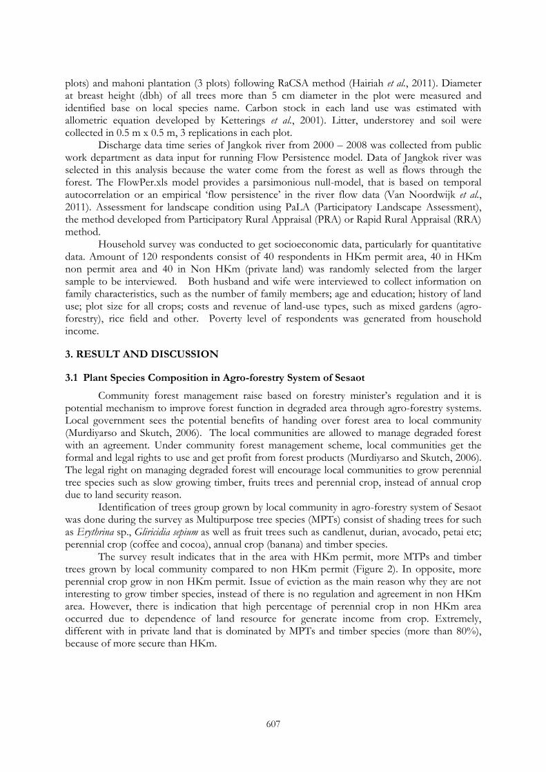
607
plots) and mahoni plantation (3 plots) following RaCSA method (Hairiah et al., 2011). Diameter at breast height (dbh) of all trees more than 5 cm diameter in the plot were measured and identified base on local species name. Carbon stock in each land use was estimated with allometric equation developed by Ketterings et al., 2001). Litter, understorey and soil were collected in 0.5 m x 0.5 m, 3 replications in each plot.
Discharge data time series of Jangkok river from 2000 – 2008 was collected from public work department as data input for running Flow Persistence model. Data of Jangkok river was selected in this analysis because the water come from the forest as well as flows through the forest. The FlowPer.xls model provides a parsimonious null-model, that is based on temporal autocorrelation or an empirical ‗flow persistence‘ in the river flow data (Van Noordwijk et al., 2011). Assessment for landscape condition using PaLA (Participatory Landscape Assessment), the method developed from Participatory Rural Appraisal (PRA) or Rapid Rural Appraisal (RRA) method.
Household survey was conducted to get socioeconomic data, particularly for quantitative data. Amount of 120 respondents consist of 40 respondents in HKm permit area, 40 in HKm non permit area and 40 in Non HKm (private land) was randomly selected from the larger sample to be interviewed. Both husband and wife were interviewed to collect information on family characteristics, such as the number of family members; age and education; history of land use; plot size for all crops; costs and revenue of land-use types, such as mixed gardens (agro-forestry), rice field and other. Poverty level of respondents was generated from household income.
3. RESULT AND DISCUSSION
3.1 Plant Species Composition in Agro-forestry System of Sesaot
Community forest management raise based on forestry minister‘s regulation and it is potential mechanism to improve forest function in degraded area through agro-forestry systems. Local government sees the potential benefits of handing over forest area to local community (Murdiyarso and Skutch, 2006). The local communities are allowed to manage degraded forest with an agreement. Under community forest management scheme, local communities get the formal and legal rights to use and get profit from forest products (Murdiyarso and Skutch, 2006). The legal right on managing degraded forest will encourage local communities to grow perennial tree species such as slow growing timber, fruits trees and perennial crop, instead of annual crop due to land security reason.
Identification of trees group grown by local community in agro-forestry system of Sesaot was done during the survey as Multipurpose tree species (MPTs) consist of shading trees for such as Erythrina sp., Gliricidia sepium as well as fruit trees such as candlenut, durian, avocado, petai etc; perennial crop (coffee and cocoa), annual crop (banana) and timber species.
The survey result indicates that in the area with HKm permit, more MTPs and timber trees grown by local community compared to non HKm permit (Figure 2). In opposite, more perennial crop grow in non HKm permit. Issue of eviction as the main reason why they are not interesting to grow timber species, instead of there is no regulation and agreement in non HKm area. However, there is indication that high percentage of perennial crop in non HKm area occurred due to dependence of land resource for generate income from crop. Extremely, different with in private land that is dominated by MPTs and timber species (more than 80%), because of more secure than HKm.
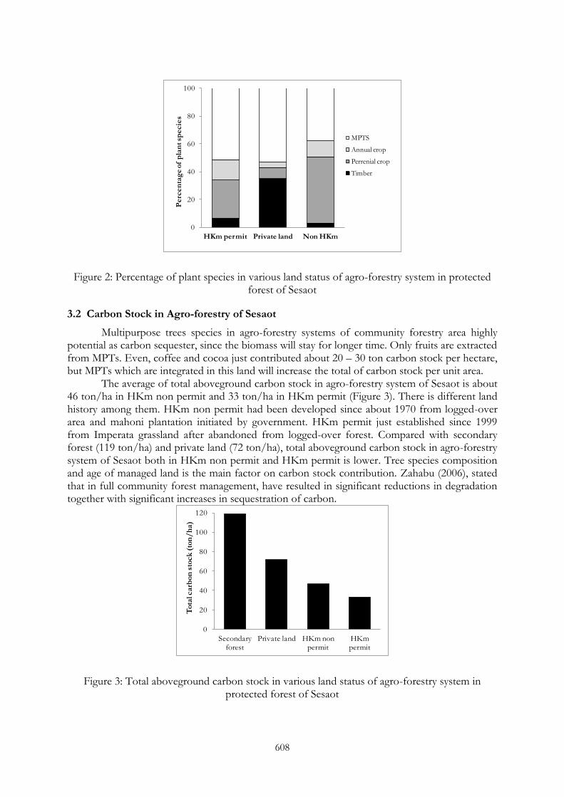
608
Figure 2: Percentage of plant species in various land status of agro-forestry system in protected forest of Sesaot
3.2 Carbon Stock in Agro-forestry of Sesaot
Multipurpose trees species in agro-forestry systems of community forestry area highly potential as carbon sequester, since the biomass will stay for longer time. Only fruits are extracted from MPTs. Even, coffee and cocoa just contributed about 20 – 30 ton carbon stock per hectare, but MPTs which are integrated in this land will increase the total of carbon stock per unit area.
The average of total aboveground carbon stock in agro-forestry system of Sesaot is about 46 ton/ha in HKm non permit and 33 ton/ha in HKm permit (Figure 3). There is different land history among them. HKm non permit had been developed since about 1970 from logged-over area and mahoni plantation initiated by government. HKm permit just established since 1999 from Imperata grassland after abandoned from logged-over forest. Compared with secondary forest (119 ton/ha) and private land (72 ton/ha), total aboveground carbon stock in agro-forestry system of Sesaot both in HKm non permit and HKm permit is lower. Tree species composition and age of managed land is the main factor on carbon stock contribution. Zahabu (2006), stated that in full community forest management, have resulted in significant reductions in degradation together with significant increases in sequestration of carbon.
Figure 3: Total aboveground carbon stock in various land status of agro-forestry system in protected forest of Sesaot
0
20
40
60
80
100
HKm permit Private land Non HKm
Perc
en
tag
e of
pla
nt sp
ecie
s
MPTS
Annual crop
Perrenial crop
Timber
0
20
40
60
80
100
120
Secondary forest
Private land HKm non permit
HKm permit
To
tal c
arb
on
sto
ck
(to
n/
ha)
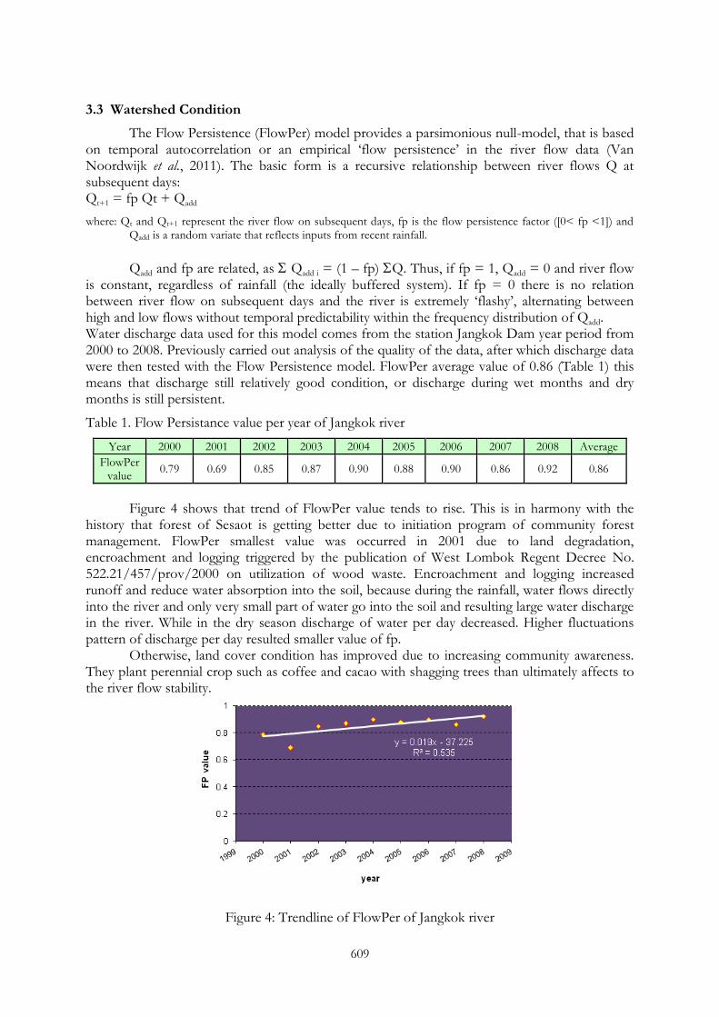
609
3.3 Watershed Condition
The Flow Persistence (FlowPer) model provides a parsimonious null-model, that is based on temporal autocorrelation or an empirical ‗flow persistence‘ in the river flow data (Van Noordwijk et al., 2011). The basic form is a recursive relationship between river flows Q at subsequent days: Qt+1 = fp Qt + Qadd
where: Qt and Qt+1 represent the river flow on subsequent days, fp is the flow persistence factor ([0< fp <1]) and Qadd is a random variate that reflects inputs from recent rainfall.
Qadd and fp are related, as Qadd i = (1 – fp) Q. Thus, if fp = 1, Qadd = 0 and river flow is constant, regardless of rainfall (the ideally buffered system). If fp = 0 there is no relation between river flow on subsequent days and the river is extremely ‗flashy‘, alternating between high and low flows without temporal predictability within the frequency distribution of Qadd. Water discharge data used for this model comes from the station Jangkok Dam year period from 2000 to 2008. Previously carried out analysis of the quality of the data, after which discharge data were then tested with the Flow Persistence model. FlowPer average value of 0.86 (Table 1) this means that discharge still relatively good condition, or discharge during wet months and dry months is still persistent.
Table 1. Flow Persistance value per year of Jangkok river
Year 2000 2001 2002 2003 2004 2005 2006 2007 2008 Average
FlowPer value
0.79 0.69 0.85 0.87 0.90 0.88 0.90 0.86 0.92 0.86
Figure 4 shows that trend of FlowPer value tends to rise. This is in harmony with the
history that forest of Sesaot is getting better due to initiation program of community forest management. FlowPer smallest value was occurred in 2001 due to land degradation, encroachment and logging triggered by the publication of West Lombok Regent Decree No. 522.21/457/prov/2000 on utilization of wood waste. Encroachment and logging increased runoff and reduce water absorption into the soil, because during the rainfall, water flows directly into the river and only very small part of water go into the soil and resulting large water discharge in the river. While in the dry season discharge of water per day decreased. Higher fluctuations pattern of discharge per day resulted smaller value of fp.
Otherwise, land cover condition has improved due to increasing community awareness. They plant perennial crop such as coffee and cacao with shagging trees than ultimately affects to the river flow stability.
Figure 4: Trendline of FlowPer of Jangkok river
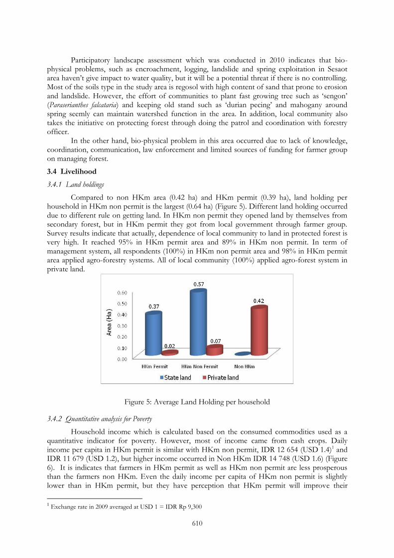
610
Participatory landscape assessment which was conducted in 2010 indicates that bio-physical problems, such as encroachment, logging, landslide and spring exploitation in Sesaot area haven‘t give impact to water quality, but it will be a potential threat if there is no controlling. Most of the soils type in the study area is regosol with high content of sand that prone to erosion and landslide. However, the effort of communities to plant fast growing tree such as ‗sengon‘ (Paraserianthes falcataria) and keeping old stand such as ‗durian pecing‘ and mahogany around spring seemly can maintain watershed function in the area. In addition, local community also takes the initiative on protecting forest through doing the patrol and coordination with forestry officer.
In the other hand, bio-physical problem in this area occurred due to lack of knowledge, coordination, communication, law enforcement and limited sources of funding for farmer group on managing forest.
3.4 Livelihood
3.4.1 Land holdings
Compared to non HKm area (0.42 ha) and HKm permit (0.39 ha), land holding per household in HKm non permit is the largest (0.64 ha) (Figure 5). Different land holding occurred due to different rule on getting land. In HKm non permit they opened land by themselves from secondary forest, but in HKm permit they got from local government through farmer group. Survey results indicate that actually, dependence of local community to land in protected forest is very high. It reached 95% in HKm permit area and 89% in HKm non permit. In term of management system, all respondents (100%) in HKm non permit area and 98% in HKm permit area applied agro-forestry systems. All of local community (100%) applied agro-forest system in private land.
Figure 5: Average Land Holding per household
3.4.2 Quantitative analysis for Poverty
Household income which is calculated based on the consumed commodities used as a quantitative indicator for poverty. However, most of income came from cash crops. Daily income per capita in HKm permit is similar with HKm non permit, IDR 12 654 (USD 1.4)1 and IDR 11 679 (USD 1.2), but higher income occurred in Non HKm IDR 14 748 (USD 1.6) (Figure 6). It is indicates that farmers in HKm permit as well as HKm non permit are less prosperous than the farmers non HKm. Even the daily income per capita of HKm non permit is slightly lower than in HKm permit, but they have perception that HKm permit will improve their
1 Exchange rate in 2009 averaged at USD 1 = IDR Rp 9,300
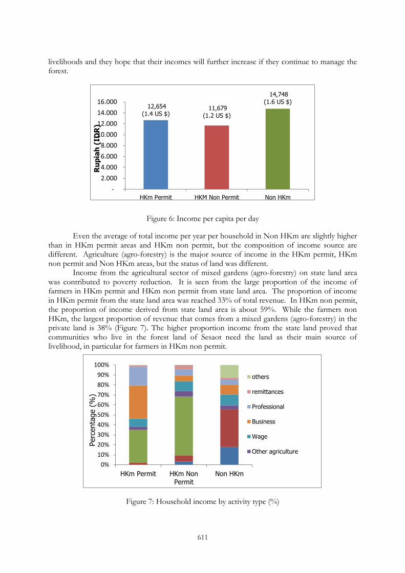
611
livelihoods and they hope that their incomes will further increase if they continue to manage the forest.
Figure 6: Income per capita per day
Even the average of total income per year per household in Non HKm are slightly higher than in HKm permit areas and HKm non permit, but the composition of income source are different. Agriculture (agro-forestry) is the major source of income in the HKm permit, HKm non permit and Non HKm areas, but the status of land was different.
Income from the agricultural sector of mixed gardens (agro-forestry) on state land area was contributed to poverty reduction. It is seen from the large proportion of the income of farmers in HKm permit and HKm non permit from state land area. The proportion of income in HKm permit from the state land area was reached 33% of total revenue. In HKm non permit, the proportion of income derived from state land area is about 59%. While the farmers non HKm, the largest proportion of revenue that comes from a mixed gardens (agro-forestry) in the private land is 38% (Figure 7). The higher proportion income from the state land proved that communities who live in the forest land of Sesaot need the land as their main source of livelihood, in particular for farmers in HKm non permit.
Figure 7: Household income by activity type (%)
12,654 (1.4 US $)
11,679 (1.2 US $)
14,748
(1.6 US $)
-
2.000
4.000
6.000
8.000
10.000
12.000
14.000
16.000
HKm Permit HKM Non Permit Non HKm
Ru
pia
h (
ID
R)
0%
10%
20%
30%
40%
50%
60%
70%
80%
90%
100%
HKm Permit HKm Non
Permit
Non HKm
Perc
enta
ge (
%)
others
remittances
Professional
Business
Wage
Other agriculture
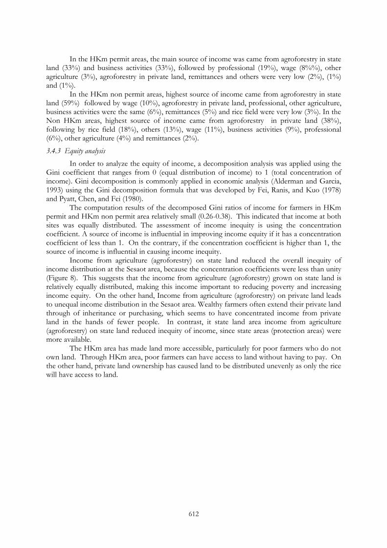
612
In the HKm permit areas, the main source of income was came from agroforestry in state land (33%) and business activities (33%), followed by professional (19%), wage (8%%), other agriculture (3%), agroforestry in private land, remittances and others were very low (2%), (1%) and (1%).
In the HKm non permit areas, highest source of income came from agroforestry in state land (59%) followed by wage (10%), agroforestry in private land, professional, other agriculture, business activities were the same (6%), remittances (5%) and rice field were very low (3%). In the Non HKm areas, highest source of income came from agroforestry in private land (38%), following by rice field (18%), others (13%), wage (11%), business activities (9%), professional (6%), other agriculture (4%) and remittances (2%).
3.4.3 Equity analysis
In order to analyze the equity of income, a decomposition analysis was applied using the Gini coefficient that ranges from 0 (equal distribution of income) to 1 (total concentration of income). Gini decomposition is commonly applied in economic analysis (Alderman and Garcia, 1993) using the Gini decomposition formula that was developed by Fei, Ranis, and Kuo (1978) and Pyatt, Chen, and Fei (1980).
The computation results of the decomposed Gini ratios of income for farmers in HKm permit and HKm non permit area relatively small (0.26-0.38). This indicated that income at both sites was equally distributed. The assessment of income inequity is using the concentration coefficient. A source of income is influential in improving income equity if it has a concentration coefficient of less than 1. On the contrary, if the concentration coefficient is higher than 1, the source of income is influential in causing income inequity.
Income from agriculture (agroforestry) on state land reduced the overall inequity of income distribution at the Sesaot area, because the concentration coefficients were less than unity (Figure 8). This suggests that the income from agriculture (agroforestry) grown on state land is relatively equally distributed, making this income important to reducing poverty and increasing income equity. On the other hand, Income from agriculture (agroforestry) on private land leads to unequal income distribution in the Sesaot area. Wealthy farmers often extend their private land through of inheritance or purchasing, which seems to have concentrated income from private land in the hands of fewer people. In contrast, it state land area income from agriculture (agroforestry) on state land reduced inequity of income, since state areas (protection areas) were more available.
The HKm area has made land more accessible, particularly for poor farmers who do not own land. Through HKm area, poor farmers can have access to land without having to pay. On the other hand, private land ownership has caused land to be distributed unevenly as only the rice will have access to land.
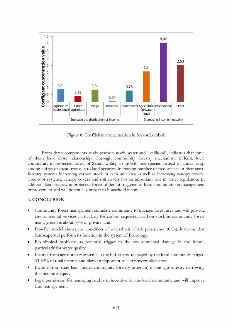
613
Figure 8: Coefficient concentration in Sesaot Lombok
From three components study (carbon stock, water and livelihood), indicates that three of them have close relationship. Through community forestry mechanism (HKm), local community in protected forest of Sesaot willing to growth tree species instead of annual crop among coffee or cacao tree due to land security. Increasing number of tree species in their agro-forestry systems increasing carbon stock in each unit area as well as increasing canopy covers. Tree root systems, canopy covers and soil covers has an important role in water regulation. In addition, land security in protected forest of Sesaot triggered of local community on management improvement and will potentially impact to household income.
4. CONCLUSION
Community forest management stimulate community to manage forest area and will provide
environmental services particularly for carbon sequester. Carbon stock in community forest
management is about 54% of private land.
FlowPer model shows the condition of watersheds which persistence (0.86), it means that
landscape still perform its function in the system of hydrology.
Bio-physical problems as potential trigger to the environmental damage in the future,
particularly for water quality.
Income from agroforestry systems in the buffer area managed by the local community ranged
33-59% of total income and plays an important role in poverty alleviation.
Income from state land (under community forestry program) in the agroforestry narrowing
the income inequity.
Legal permission for managing land is an incentive for the local community and will improve
land management.
0,9
0,39
0,84
0,04
0,78
2,1
4,07
2,53
0
0,5
1
1,5
2
2,5
3
3,5
4
4,5
Agriculture(state land)
Otheragriculture
Wage Business Remittances Agriculture(privateland)
Professional Other
Increase the distribution of income Increasing income inequality
Co
eff
icie
nt
co
nce
ntr
ati
on
va
lue

614
REFERENCES
Alderman, H and M Garcia (1993): Poverty, household food security and nutrition in rural Pakistan. Research Report 96, Washington, D.C. : International Food Policy Research Institute.
Fei, J C H, G Ranis and S W Y Kuo (1978): Growth and family distribution of income by factor component. Quarterly Journal of Economics 92:17-53.
Gouyon A, de Foresta, H and Levang P (1993): "Does Jungle Rubber Deserve its Name? An Analysis of Rubber Agroforestry Systems in Southeast Sumatra." Agroforestry Systems 22:181-206.
Hairiah K, A Ekadinata, RR Rika and S Rahayu (2011): Pengukuran cadangan karbon: dari tingkat plot ke tingkat bentang lahan. World Agroforestry Centre. Bogor.
Ketterings Q M, Coe R, van Noordwijk M, Ambagau Y and Palm CA (2001): Reducing uncertainty in the use of allometric biomass equations for predicting above-ground tree biomass in mixed secondary forests. Forest Ecology and Management 146:199-209.
Murdiyarso, D and M Skutsch (2006): Promoting Carbon Benefits from Community Forest Management. In: Murdiyarso D and M Skutsch (eds.). Community Forest Management as a Carbon Mitigation Option: Case Study. Center for International Forestry Research (CIFOR). p: 1-8.
Pyatt, G, Chen, C and Fei, J (1980): The distribution of income by factor components. Quarterly Journal of Economics 95 (November): 451-473.
Suyanto, S, Permana, RP, Khususiyah, N and Joshi, L (2004): Land tenure agroforestry adoption and reduction of fire hazard in a forest: a case study from Lampung, Sumatra Indonesia. Agroforestry Systems 65(1):1-11.
Suyanto, S, Khususiyah, N and Leimona, B (2007): Poverty and environmental services: case study in Way Besai watershed, Lampung Province, Indonesia. Ecology and Society 12(2): 13. [online] URL: http://www.ecologyandsociety.org/vol12/iss2/art13/.
UNDP. (2009): Human Development Report 2007/2008 Indonesia. http://hdrstats.undp.org/countries/country_fact_sheets/cty_fs_IDN.html.
Van Noordwijk, M, Widodo RH, Farida A, Suyamto DA, Lusiana B, Tanika L and Khasanah N (2011): GenRiver and FlowPer: Generic River Flow Persistence Models. User Manual Version 2.0. . Bogor. World Agroforestry Centre - ICRAF, SEA Regional Office. 119 p.
Zahabu, E (2006): Kitulangalo Forest Area, Tanzania. In: Murdiyarso D and M Skutsch (eds.). Community Forest Management as a Carbon Mitigation Option: Case Study. Center for International Forestry Research (CIFOR). p: 20-25.