asymmetric threat tracker advanced convoy scenario donald e. brown, phd james h. conklin department...
TRANSCRIPT

Asymmetric Threat TrackerAdvanced Convoy Scenario
Donald E. Brown, PhDJames H. Conklin
Department of Systems & Information EngineeringUniversity of VirginiaCharlottesville, VA 22904
October 26, 2006

Purpose
•The purpose of this scenario is to describe the capabilities of the Asymmetric Threat Tracker in the context of operational scenarios.
The 3rd Infantry(c) BBC News
http://news.bbc.co.uk/aboutbbcnews/hi/news_update/newsid_3850000/3850491.stm
Department of Systems & Information Engineering, University of Virginia.

Department of Systems & Information Engineering, University of Virginia.
Military Decision Making Process & Intelligence Cycle
•Intelligence Cycle
•Tasking
•Collection
•Processing
•Exploitation
•Dissemination
•Military Decision Making Process
•Receive Mission
•Mission Analysis
•Intelligence Preparation of the Battlefield
•Course of Action Development
•Course of Action Analysis
•Course of Action Comparison
•Course of Action Approval
•Orders Production

Department of Systems & Information Engineering, University of Virginia.
Scenario Background
•The user in this scenario is a Convoy Planner
•The location is Baghdad, Iraq
•Threat: US Convoys have been repeatedly attacked en-route.
•The convoy planner’s role is to plan the convoy such that risk is minimized and security is commensurate with the cargo and within the resources available
Department of Systems & Information Engineering, University of Virginia.
Convoy Planner’s Information
•The Convoy Planner has access to the following information:
•Database of past attacks on US Forces
•date
•location
•time
•type
•narrative
•Maps of region
•Previous convoy routes
•Intelligence databases
•Convoy Origination and Destination Points
•Convoy Departure Time

Department of Systems & Information Engineering, University of Virginia.
Planner Objective
•With this data, the planner needs to
•Plan the route for the convoy
•Plan the departure time for the convoy
•Provide convoy drivers information about high risk areas
•Provide convoy drivers any possible alternate routes or backup plans

Department of Systems & Information Engineering, University of Virginia.
Planner Performs Risk Assessment
•The planner can use the ATT to perform a risk assessment
•Open ATT
•Select Area of Interest
•Select Spatial Features for Analysis
•Select Temporal Features for Analysis
•Query Database for past Incidents
•Enter planned start and end times for convoy
•Run ATT algorithm to generate threat surface
•Run ATT change detection to generate a change surface
•Assess risk of convoy and plan accordingly Next slide shows example ATT analysis
•Inform convoy drivers of high risk areas and areas where the threat has changed significantly since their last run

Department of Systems & Information Engineering, University of Virginia.
Planner Analyzes ATT Output
•Once the ATT has generated a threat surface, the planner can view the surface as an interactive map.
•View Map
•Observe “hot spot” and click click mouse
•Analyze relevant features and their values
• If a feature has a red bar, that means that at the clicked location, that feature has a value that contributes to a higher threat level.
•Conversely, if a feature has a black bar, that means that the clicked location has a feature value that does not contribute to a higher threat level. click mouse again

Department of Systems & Information Engineering, University of Virginia.
Interpretation of ATT Result
•The ATT assesses threats using a feature based model
• Example Features:• Distance to Roads• Distance to Mosques
•Higher (or lower) values for these features may be predictive of a higher level of threat• The less distance from a location to a
road, the higher the threat is.• Distance to road is the feature and a
lower value is predictive of a higher threat
• When the clicked location is close to a road, the threat bar will be red
• Conversely, when the clicked location is far from a road, the bar will be black
Department of Systems & Information Engineering, University of Virginia.
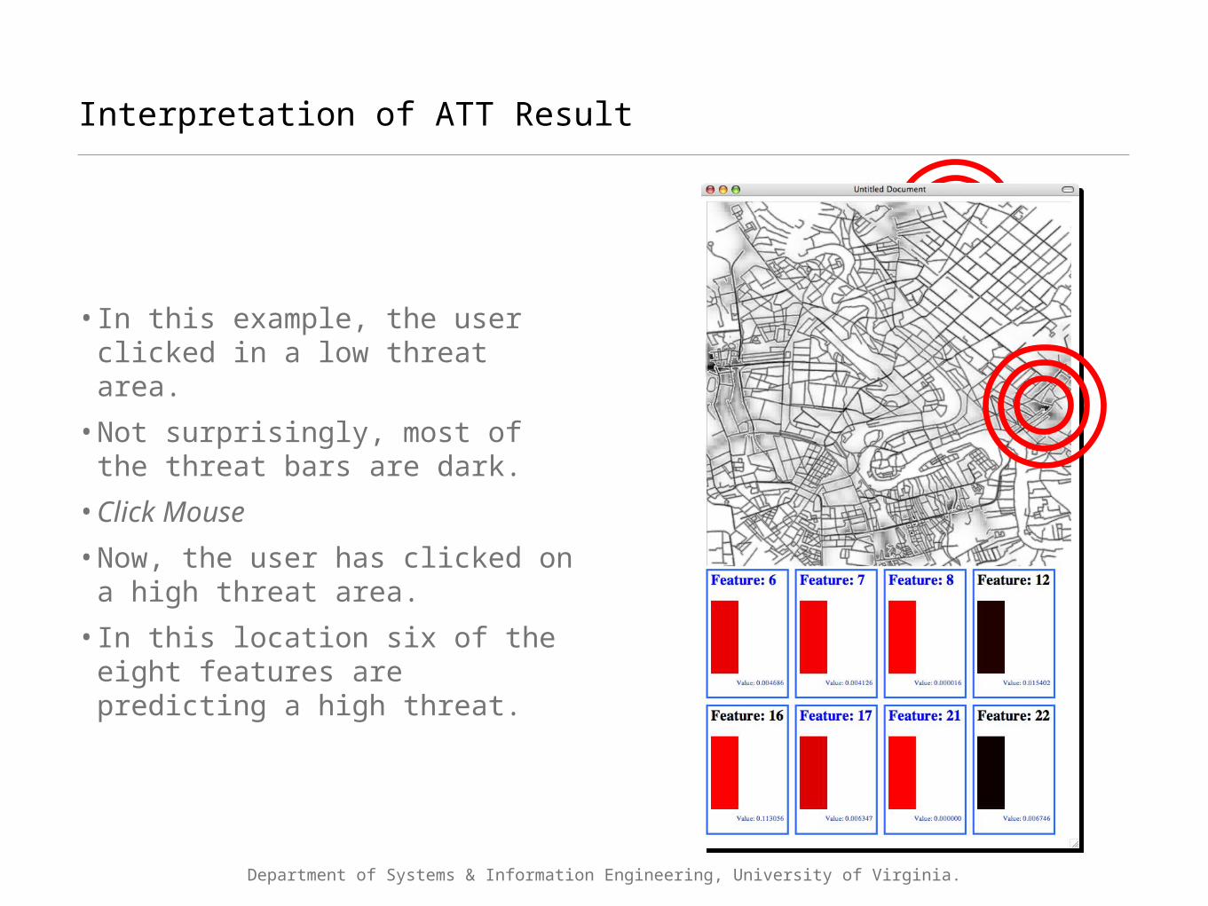
Interpretation of ATT Result
•In this example, the user clicked in a low threat area.
•Not surprisingly, most of the threat bars are dark.
•Click Mouse
•Now, the user has clicked on a high threat area.
•In this location six of the eight features are predicting a high threat.

Department of Systems & Information Engineering, University of Virginia.
Report Dissemination to Convoy Drivers
•Once planner has selected the best time, route, and backup plans, he can brief the convoy drivers.
•This brief will outline
•dangerous areas •areas of significant change•points of recent activity
•Drivers connect to the network with their PDAs and download
•Threat report•Threat surface•Route information © Garmin, © Garmin,
http://www.garmin.com/products/iQueM4/#http://www.garmin.com/products/iQueM4/#
Department of Systems & Information Engineering, University of Virginia.
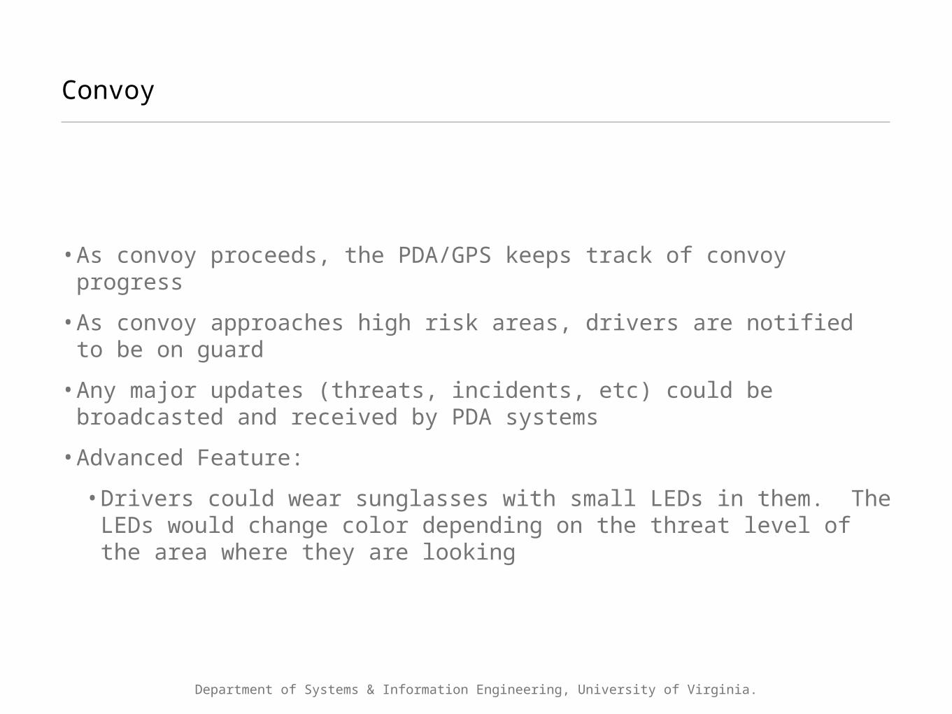
Convoy
•As convoy proceeds, the PDA/GPS keeps track of convoy progress
•As convoy approaches high risk areas, drivers are notified to be on guard
•Any major updates (threats, incidents, etc) could be broadcasted and received by PDA systems
•Advanced Feature:
•Drivers could wear sunglasses with small LEDs in them. The LEDs would change color depending on the threat level of the area where they are looking
Department of Systems & Information Engineering, University of Virginia.
Update Data
•Once the convoy departs, they are collecting data for the next convoy. Any incident they experience/witness, is reported
•These new incidents get recorded in the intelligence databases and used for the next round of convoy planning
•Major updates are broadcast to deployed convoys

On The Horizon...
15
Department of Systems & Information Engineering, University of Virginia
CCRI Proprietary Information
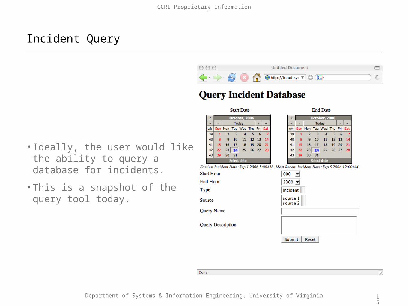
Incident Query
•Ideally, the user would like the ability to query a database for incidents.
•This is a snapshot of the query tool today.

16
Department of Systems & Information Engineering, University of Virginia
CCRI Proprietary Information
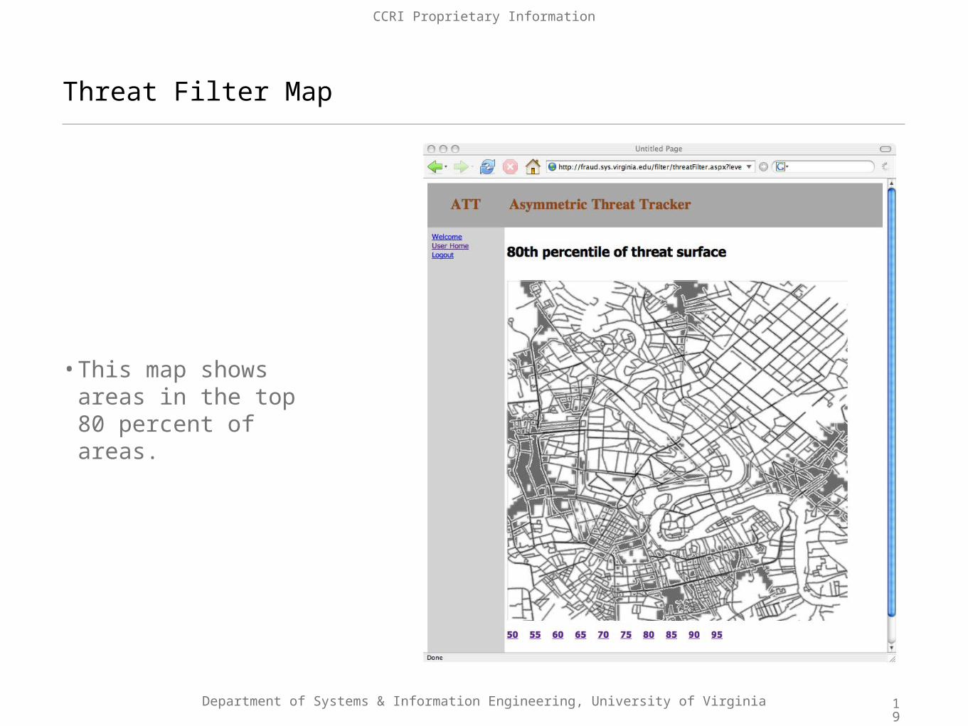
Threat Filter Map
•This map shows areas in the top 95 percent of areas.

17
Department of Systems & Information Engineering, University of Virginia
CCRI Proprietary Information
Threat Filter Map
•This map shows areas in the top 90 percent of areas.

18
Department of Systems & Information Engineering, University of Virginia
CCRI Proprietary Information
Threat Filter Map
•This map shows areas in the top 85 percent of areas.
19
Department of Systems & Information Engineering, University of Virginia
CCRI Proprietary Information
Threat Filter Map
•This map shows areas in the top 80 percent of areas.

20
Department of Systems & Information Engineering, University of Virginia
CCRI Proprietary Information
Threat Filter Map
•This map shows areas in the top 75 percent of areas.

21
Department of Systems & Information Engineering, University of Virginia
CCRI Proprietary Information
Threat Filter Map
•This map shows areas in the top 70 percent of areas.

22
Department of Systems & Information Engineering, University of Virginia
CCRI Proprietary Information
Threat Filter Map
•This map shows areas in the top 65 percent of areas.

23
Department of Systems & Information Engineering, University of Virginia
CCRI Proprietary Information
Threat Filter Map
•This map shows areas in the top 60 percent of areas.

24
Department of Systems & Information Engineering, University of Virginia
CCRI Proprietary Information
Threat Filter Map
•This map shows areas in the top 55 percent of areas.

25
Department of Systems & Information Engineering, University of Virginia
CCRI Proprietary Information
Threat Filter Map
•This map shows areas in the top 50 percent of areas.

A good run...US Air Force (USAF) Staff Sergeant (SSGT) Rene Anderson, of the 506th
Expeditionary Logistics Readiness Squadron (ELRS), has a light moment during a convoy rest at Baghdad International Airport (BIAP), in support of Operation IRAQI
FREEDOM. www.DefenseLINK.mil