attachment 3 final eagle conservation plan for the alta · pdf filefinal conservation plan for...
TRANSCRIPT

Attachment 3 Final Eagle Conservation Plan for the Alta East
Wind Project

F in a l
Conservation Plan for the Avoidance and Minimization of
Potential Impacts to Golden Eagles Alta East Wind Project
Submitted to
Bureau of Land Management
U.S. Fish and Wildlife Service
Submitted by
Alta Wind X, LLC
September, 2016
Prepared by
With Technical Assistance by


IS111510093937SAC/387639/110530001 iii
Contents
Section Page
Acronyms and Abbreviations .......................................................................................................... v
1.0 Introduction ................................................................................................................................ 1-1 1.1 Project Description ................................................................................................. 1-1 1.2 Background ............................................................................................................. 1-2 1.3 Purpose of the Conservation Plan ........................................................................ 1-2 1.4 Interagency Coordination and Communication History ............................ 1-2
2.0 Eagle Conservation Plan Development ................................................................................. 2-1 2.1 Stage 1 – Initial Site Assessment ........................................................................... 2-1 2.2 Stage 2 – Site-specific Surveys and Assessment ................................................. 2-1
2.2.1 Avian Point Count Surveys ..................................................................... 2-1 2.2.2 Nesting Territory Surveys ...................................................................... 2-13 2.2.3 Assessment of Nonbreeding Habitat .................................................... 2-19
2.3 Stage 3 – Predicting Eagle Fatalities................................................................... 2-20 2.3.1 Collision Risk ........................................................................................... 2-21 2.3.2 Impacts to Nests or Nesting Territories ............................................... 2-25 2.3.3 Foraging Habitat Loss ............................................................................. 2-25 2.3.4 Wintering Habitat Use ............................................................................ 2-25 2.3.5 Cumulative Impacts ................................................................................ 2-26
2.4 Stage 4 – Avoidance and Minimization of Risk and Compensatory Mitigation ................................................................................... 2-28 2.4.1 Project Macrositing .................................................................................. 2-28 2.4.2 Micrositing of Project Features .............................................................. 2-28 2.4.3 Construction Measures ........................................................................... 2-29 2.4.4 Minimizing Potential Habitat Disturbance .......................................... 2-30 2.4.5 Minimizing Potential Collision and Direct Disturbance.................... 2-30 2.4.6 Operation Measures ................................................................................ 2-31 2.4.7 Compensatory Mitigation ...................................................................... 2-32
2.5 Stage 5 – Post-construction Monitoring ............................................................ 2-32 2.5.1 Fatality Studies ........................................................................................ 2-33 2.5.2 Nesting/Breeding Monitoring .............................................................. 2-36
3.0 Adaptive Management ............................................................................................................. 3-1
4.0 References ................................................................................................................................... 4-1

CONTENTS, CONTINUED ALTA EAST WIND PROJECT
iv IS111510093937SAC/387639/110530001
Appendixes A Viewshed Analyses of Avian Use Survey Points
Tables 1 Golden Eagle Observations during Year 1 (May 11, 2009 to May 6, 2010) 2 Eagle Observations during Year 2 (from July 10, 2010 through June 1, 2011) 3 Assessment of Golden Eagle Risk Factors 4 Summary of Fatality Estimates Using All Avian Survey Data from May 11, 2009
through June 1, 2011 5 Basic Search Parameters for Alta East General Avian Mortality and Injury Survey 6 Summary of Advanced Conservation Measures using a Step-wise Approach
Figures 1 Project Layout Before-After Comparison Map 2 Project Area Map 3 Avian Use Survey Points from May 11, 2009 to May 6, 2010 4 Avian Use Survey Points from July 10, 2010 to June 1, 2011 5 Golden Eagle Observations from May 11, 2009 to May 6, 2010 6 Golden Eagle Observations from July 10, 2010 to June 1, 2011 7 Golden Eagle Nesting Territory Survey Results, April 13, 2010 and May 24, 2010 8 Golden Eagle Nesting Territory Survey Results, February 22, April 12, and June 1-2, 2011 9 Average Preconstruction Golden Eagle Use Values for Wind Energy Facilities With and
Without Observed Golden Eagle Fatalities as Compared to Alta East

IS111510093937SAC/387639/110530001 v
Acronyms and Abbreviations
ACP advanced conservation practice
agl above ground level
AOCM Alta-Oak Creek Mojave
APLIC Avian Power Line Interaction Committee
AWD Alta Windpower Development, LLC
BCR Bird Conservation Region
BGEPA Bald and Golden Eagle Protection Act
BLM U.S. Bureau of Land Management
BMP best management practices
CEC California Energy Commission
CFR Code of Federal Regulations
ECP Eagle Conservation Plan
EIS Environmental Impact Statement
MW megawatt(s)
NEPA National Environmental Policy Act
NSR North Sky River Wind Project
PT Pine Tree Wind Project
SR State Route
USFWS U.S. Fish and Wildlife Service
USGS U.S. Geological Survey
WEST Western Ecosystems Technology, Inc.
WTG wind turbine generator

SECTION 1.0
IS111510093937SAC/387639/110530001 1-1
Introduction
Alta Windpower Development, LLC (AWD, Alta East, Alta Wind X, LLC) constructed the Alta East Wind Project (aka Alta Wind X, LLC) in the Tehachapi region of southern California. Portions of the project are located on land managed by the U.S. Bureau of Land Management (BLM) and privately owned land under the jurisdiction of Kern County. AWD is preparing an Eagle Conservation Plan (ECP) to demonstrate the actions taken to avoid and minimize project impacts on golden eagles to the maximum degree achievable, and is pursuing a programmatic take permit under 50 Code of Federal Regulations (CFR) 22.26.
1.1 Project Description The project is located on approximately 2,274 acres on the southern side of State Route (SR) 58 in southeastern Kern County, California, within and adjacent to an area of existing wind development. The project area is approximately 3 miles northwest of the town of Mojave and approximately 11 miles east of the city of Tehachapi.
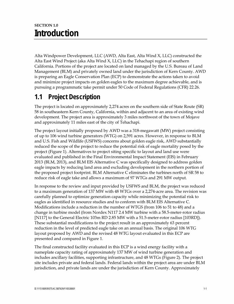
The project layout initially proposed by AWD was a 318-megawatt (MW) project consisting of up to 106 wind turbine generators (WTG) on 2,591 acres. However, in response to BLM and U.S. Fish and Wildlife (USFWS) concerns about golden eagle risk, AWD substantially reduced the scope of the project to reduce the potential risk of eagle mortality posed by the project (Figure 1). Alternatives to project siting specific to layout and land use were evaluated and published in the Final Environmental Impact Statement (EIS) in February 2013 (BLM, 2013), and BLM EIS Alternative C was specifically designed to address golden eagle impacts by reducing land area and excluding development in the northern portion of the proposed project footprint. BLM Alternative C eliminates the turbines north of SR 58 to reduce risk of eagle take and allows a maximum of 97 WTGs and 291 MW output.
In response to the review and input provided by USFWS and BLM, the project was reduced to a maximum generation of 137 MW with 48 WTGs over a 2,274-acre area. The revision was carefully planned to optimize generation capacity while minimizing the potential risk to eagles as identified in resource studies and to conform with BLM EIS Alternative C. Modifications include a reduction in the number of WTGS (from 106 to 51 to 48) and a change in turbine model (from Nordex N117 2.4 MW turbine with a 58.5-meter-rotor radius [N117] to the General Electric 103m RD 2.85 MW with a 51.5-meter-rotor radius [103RD]). These substantial modifications to the project result in an approximately 63 percent reduction in the level of predicted eagle take on an annual basis. The original 106 WTG layout proposed by AWD and the revised 48 WTG layout evaluated in this ECP are presented and compared in Figure 1.
The final constructed facility evaluated in this ECP is a wind energy facility with a nameplate capacity rating of approximately 137 MW of wind turbine generation and includes ancillary facilities, supporting infrastructure, and 48 WTGs (Figure 2). The project site includes private and federal lands. Federal lands within the project area are under BLM jurisdiction, and private lands are under the jurisdiction of Kern County. Approximately

SECTION 1.0: INTRODUCTION ALTA EAST WIND PROJECT
1-2 IS111510093937SAC/387639/110530001
76 percent of the project’s area (1,999 acres) and 39 of the 48 WTGs are located on land managed by BLM. The location of the project site is shown on Figure 2, Project Area Map.
1.2 Background BLM is the lead agency for review of the project under the National Environmental Policy Act (NEPA); however, USFWS is the lead for NEPA analysis related to authorization of a Programmatic Take Permit under the Bald and Golden Eagle Protection Act (BGEPA).
1.3 Purpose of the Conservation Plan The project may have the potential to affect golden eagles or their habitat. USFWS made the initial assessment in a letter dated November 1, 2012, that this project poses a moderate risk of eagle take, given that other nearby projects in the Tehachapi Wind Resource Area have taken eagles, thus designating it a Category 2 project under the Eagle Conservation Plan Guidance, Module 1 – Land-based Wind Energy, Version 2(“Guidance”; USFWS, 2013). Category 2 projects are described as presenting high to moderate risk to eagles but opportunities exist to mitigate impacts to eagle populations (USFWS, 2013). Therefore, this ECP follows the five-stage process outlined in the Guidance to avoid and minimize project impacts on golden eagles to the maximum degree achievable, and presents strategies for AWD to meet its obligation to qualify for an eagle take permit under 50 CFR 22.26, which includes application of any necessary advanced conservation measures to reduce golden eagle take and implementation of compensatory mitigation measures to result in no net loss of eagles at the Bird Conservation Region (BCR) scale.
This ECP has been developed in coordination with USFWS and BLM to evaluate options to avoid and minimize project impacts on golden eagles and address siting, construction, operations, and monitoring.
This ECP has been developed to meet BLM and USFWS requirements for addressing the BGEPA. The BGEPA prohibits take of eagles, which is defined as any action to pursue, shoot, shoot at, poison, wound, kill, capture, trap, collect, destroy, molest, disturb, or otherwise harm eagles, their nests, or their eggs. The BGEPA defines “disturb” as “to agitate or bother a bald or golden eagle to a degree that causes, or is likely to cause, based on the best scientific information available: (1) injury to an eagle; (2) decrease in its productivity, by substantially interfering with normal breeding, feeding, or sheltering behavior; or (3) nest abandonment, by substantially interfering with normal breeding, feeding, or sheltering behavior.” USFWS set in place rules establishing two new permit types: (1) incidental take of bald and golden eagles, which is associated with an activity but not the purpose of the activity; and (2) purposeful take of eagle nests that pose a threat to human or eagle safety (September 11, 2009; Federal Register, 50 CFR 13 and 22). This ECP is submitted to USFWS as part of the requisite material for a programmatic take permit.
1.4 Interagency Coordination and Communication History April 29, 2010 AWD provided USFWS with the biological resources study plan
for review and input.
November 29, 2010 Representatives from AWD met with Ashleigh Blackford and Danielle Dillard of USFWS and Justin Sloan of the California

ALTA EAST WIND PROJECT SECTION 1.0: INTRODUCTION
IS111510093937SAC/387639/110530001 1-3
Department of Fish and Wildlife. Jacqui Kitchen of the Kern County Planning Department participated via telephone. The project was introduced and the results of baseline wildlife studies completed to date were presented.
November 30, 2010 AWD received correspondence from USFWS regarding the baseline study plan presented to USFWS in April 2010.
December 10, 2010 AWD responded to correspondence from USFWS regarding the baseline study plan.
March 22, 2011 ECP Draft 1 was submitted to USFWS.
January 2011 Draft ECP Guidance released USFWS.
September 26, 2011 Comments on draft ECP received from USFWS.
March 8, 2012 ECP Draft 2 provided to USFWS for review.
August 1, 2012 ECP Guidance Module 1 Technical Appendices released by USFWS.
October 31, 2012 Conference call with AWD and USFWS to discuss the draft ECP.
January 8, 2013 AWD provided revised draft ECP to USFWS for discussion.
February 19, 2013 Conference call with AWD, BLM, and USFWS to discuss required revisions to the draft ECP.
February 27, 2013 AWD submitted a revised ECP Draft 3
Feb. 28 to April 19, 2013 Weekly calls to discuss details of ECP and finalize document.
April 26, 2013 AWD revised and re-submitted ECP Draft 3
May 21, 2013 AWD submitted ECP Draft 4October 28, 2015 Draft EA published in Federal Register
September, 2016 AWD submitted Final ECP to USFWS

FIGURE 1Project Layout Before-AfterComparison MapAlta East Wind ProjectAlta Wind Energy Center Project
BAO \\ZINFANDEL\PROJ\TERRAGENPOWERLLC\387639ALTAWINDCENTER\2_GENERAL\GIS\387639ALTAWINDCENTER\MAPFILES\ALTAWINDCENTER\2013_PROJECT_AREA_COMPARISON.MXD KMINO 4/26/2013 4:00:31 PM
VICINITY MAP
!
!!
!
!
!
!
!
!
!
!
!
!
!
!
!
!
!
!
!
!
!
!
!
!
!
!
!
!
!
!
!
!
!
!
!
!
!
!
!
!
! !
!
!
!
!
!
!(
!(
!(
!(
!(
!(
!(!(
!(
!(
!(
!(
!(
!(
!(
!(
!(
!(
!(
!(
!(
!(
!(
!(!(
!(
!(
!(
!(
!(
!(
!(
!(
!(
!(
!(
!(
!(
!(!(
!(
!(
!(
!(
!(
!(
!(
!(!(
!(
!(
!(
!(
!(
!(
!(
!(
!(!(
!(
!(
!(
!(
!(
!(
!(
!(!( !(
!(
!(
!(
!(
!(!(
!(
!(
!(
!(
!(
!(
!(
!(
!(!(
!(
!(
!(!(
!(!(
!(
!(
!(
!(
!(
!( !(
!(
!(
!(
!(
!(
!(
!(
!(
!(!(
0 0.25 0.50.125
Miles
LEGEND
! Installed Wind Turbine Layout
Proposed Access Road
Alta East Wind Project Area
!( Original Proposed Wind Turbine Layout
Previously Proposed Access Road
BLM Land
Project Area
Sources: Esri, DeLorme,NAVTEQ, USGS, NRCAN,METI, iPC, TomTom
$

FIGURE 1Project Area MapAlta East Wind ProjectAlta Wind Energy Center Project
BAO P:\TERRAGENPOWERLLC\387639ALTAWINDCENTER\2_GENERAL\GIS\387639ALTAWINDCENTER\MAPFILES\ALTAWINDCENTER\2013_PROJECT_AREA.MXD GPERDEW 2/25/2013 9:37:01 AM
VICINITY MAP
0 0.25 0.50.125
Miles
LEGENDInstalled Wind Turbine Layout Proposed Access RoadAlta East Wind Project Area BLM Land
Project Area
Sources: Esri, DeLorme,TomTom, USGS, Esri Japan,Esri China (Hong Kong)
$
2
IS111510093937SAC_Alta_East_Wind\AltaEast_Graphics\April_2013


SECTION 2.0
IS111510093937SAC/387639/110530001 2-1
Eagle Conservation Plan Development
2.1 Stage 1 – Initial Site Assessment In July 2009, AWD completed an initial site assessment to evaluate potential constraints or risks related to the project and its impacts on golden eagles. The Tehachapi area was specifically selected for evaluation because of the extensive existing wind energy development in the region, the lack of critical habitat for federally endangered species, and the apparently manageable issues related to other special-status species potentially present onsite. Based on pre-field review of publicly available resources (California Natural Diversity Database [California Department of Fish and Game, 2009], California Native Plant Society database [2009], BLM special-status species management manual [BLM, 2001], and the California Desert Conservation Area Plan [BLM, 1999]), as well as reconnaissance surveys conducted at the site between 2006 and 2009 and during a March 19, 2009, site visit specifically designed to evaluate potential resource issues, it was determined that investment in site-specific resource studies was warranted to evaluate the extent of golden eagle use and potential impacts to the species.
2.2 Stage 2 – Site-specific Surveys and Assessment Consistent with the Stage 2 recommendations for site-specific surveys and assessment presented in the USFWS Guidance, AWD has considered golden eagles and their habitat in its baseline characterization studies of the project area. AWD applied the Interim Golden Eagle Technical Guidance: Inventory and Monitoring Protocols and other Recommendations in Support of Golden Eagle Management and Permit Issuance (“Protocol and Recommendations”; Pagel et al., 2010) and additional onsite studies of eagle use, completed in accordance with The California Guidelines for Reducing Impacts to Birds and Bats from Wind Energy Development (California Energy Commission [CEC], 2007), to evaluate eagle use at the project site. Additionally, AWD coordinated its baseline study plan with USFWS in April 2010.
Baseline eagle studies completed to date for the project include 30-minute point counts conducted at approximately 1-week intervals throughout the area proposed for development, from May 2009 through June 2011, and helicopter surveys were completed in April and May 2010, and February, April, and June 2011, to identify potential eagle nesting territories within 10 miles of the project area. The nest survey analysis area was determined in accordance with the Protocols and Recommendations (Pagel et al., 2010) as requested by USFWS in the November 29, 2010, meeting. Site-specific survey methods and results are summarized below, and complete avian reports that include detailed discussion of methods and results are presented in Chatfield et al. (2010a, 2011).
2.2.1 Avian Point Count Surveys The objective of the fixed-point bird use surveys was to estimate the seasonal and spatial use of the study area by birds, particularly diurnal raptors, which include golden eagles. Fixed-point surveys (variable circular plots) were conducted using methods described by Reynolds et al. (1980). All birds, with a focus on raptors and large birds, observed during
SECTION 2.0: EAGLE CONSERVATION PLAN DEVELOPMENT ALTA EAST WIND PROJECT
2-2 IS111510093937SAC/387639/110530001
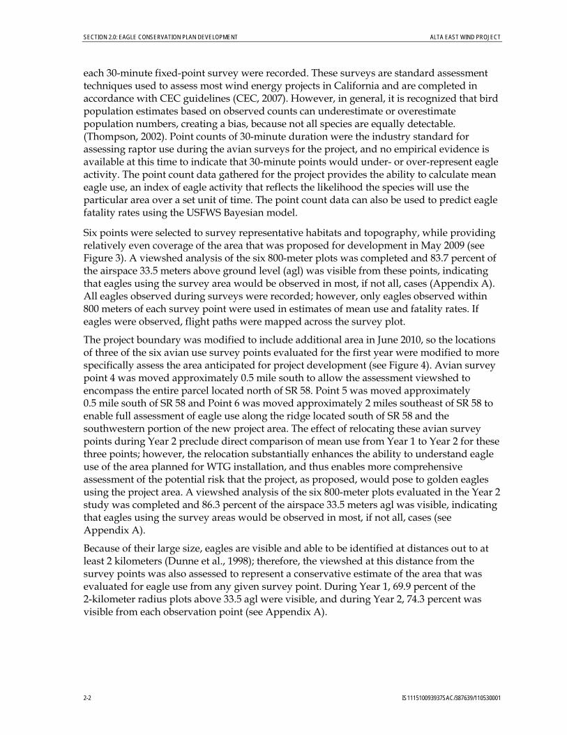
each 30-minute fixed-point survey were recorded. These surveys are standard assessment techniques used to assess most wind energy projects in California and are completed in accordance with CEC guidelines (CEC, 2007). However, in general, it is recognized that bird population estimates based on observed counts can underestimate or overestimate population numbers, creating a bias, because not all species are equally detectable. (Thompson, 2002). Point counts of 30-minute duration were the industry standard for assessing raptor use during the avian surveys for the project, and no empirical evidence is available at this time to indicate that 30-minute points would under- or over-represent eagle activity. The point count data gathered for the project provides the ability to calculate mean eagle use, an index of eagle activity that reflects the likelihood the species will use the particular area over a set unit of time. The point count data can also be used to predict eagle fatality rates using the USFWS Bayesian model.
Six points were selected to survey representative habitats and topography, while providing relatively even coverage of the area that was proposed for development in May 2009 (see Figure 3). A viewshed analysis of the six 800-meter plots was completed and 83.7 percent of the airspace 33.5 meters above ground level (agl) was visible from these points, indicating that eagles using the survey area would be observed in most, if not all, cases (Appendix A). All eagles observed during surveys were recorded; however, only eagles observed within 800 meters of each survey point were used in estimates of mean use and fatality rates. If eagles were observed, flight paths were mapped across the survey plot.
The project boundary was modified to include additional area in June 2010, so the locations of three of the six avian use survey points evaluated for the first year were modified to more specifically assess the area anticipated for project development (see Figure 4). Avian survey point 4 was moved approximately 0.5 mile south to allow the assessment viewshed to encompass the entire parcel located north of SR 58. Point 5 was moved approximately 0.5 mile south of SR 58 and Point 6 was moved approximately 2 miles southeast of SR 58 to enable full assessment of eagle use along the ridge located south of SR 58 and the southwestern portion of the new project area. The effect of relocating these avian survey points during Year 2 preclude direct comparison of mean use from Year 1 to Year 2 for these three points; however, the relocation substantially enhances the ability to understand eagle use of the area planned for WTG installation, and thus enables more comprehensive assessment of the potential risk that the project, as proposed, would pose to golden eagles using the project area. A viewshed analysis of the six 800-meter plots evaluated in the Year 2 study was completed and 86.3 percent of the airspace 33.5 meters agl was visible, indicating that eagles using the survey areas would be observed in most, if not all, cases (see Appendix A).
Because of their large size, eagles are visible and able to be identified at distances out to at least 2 kilometers (Dunne et al., 1998); therefore, the viewshed at this distance from the survey points was also assessed to represent a conservative estimate of the area that was evaluated for eagle use from any given survey point. During Year 1, 69.9 percent of the 2-kilometer radius plots above 33.5 agl were visible, and during Year 2, 74.3 percent was visible from each observation point (see Appendix A).

FIGURE 3 Avian Use Survey Points from May 11, 2009 to May 6, 2010Alta East Wind ProjectAlta Wind Energy Center Project
IS111510093937SAC_Alta_East_Wind\AltaEast_Graphics\April_2013

FIGURE 4 Avian Use Survey Points from July 10, 2010 to to June 1, 2011 Alta East Wind ProjectAlta Wind Energy Center Project
IS111510093937SAC_Alta_East_Wind\AltaEast_Graphics\April_2013

ALTA EAST WIND PROJECT SECTION 2.0: EAGLE CONSERVATION PLAN DEVELOPMENT
IS111510093937SAC/387639/110530001 2-7
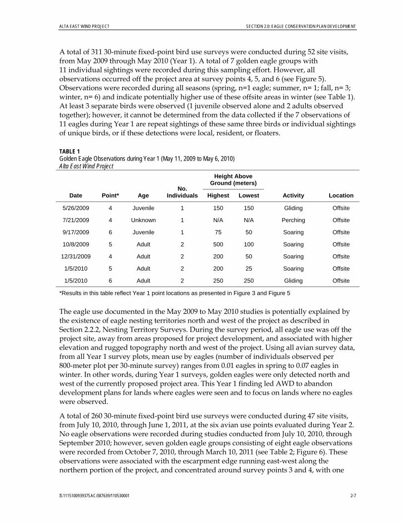
A total of 311 30-minute fixed-point bird use surveys were conducted during 52 site visits, from May 2009 through May 2010 (Year 1). A total of 7 golden eagle groups with 11 individual sightings were recorded during this sampling effort. However, all observations occurred off the project area at survey points 4, 5, and 6 (see Figure 5). Observations were recorded during all seasons (spring, n=1 eagle; summer, n= 1; fall, n= 3; winter, n= 6) and indicate potentially higher use of these offsite areas in winter (see Table 1). At least 3 separate birds were observed (1 juvenile observed alone and 2 adults observed together); however, it cannot be determined from the data collected if the 7 observations of 11 eagles during Year 1 are repeat sightings of these same three birds or individual sightings of unique birds, or if these detections were local, resident, or floaters.
TABLE 1 Golden Eagle Observations during Year 1 (May 11, 2009 to May 6, 2010) Alta East Wind Project
Date Point* Age No.
Individuals
Height Above Ground (meters)
Activity Location Highest Lowest
5/26/2009 4 Juvenile 1 150 150 Gliding Offsite
7/21/2009 4 Unknown 1 N/A N/A Perching Offsite
9/17/2009 6 Juvenile 1 75 50 Soaring Offsite
10/8/2009 5 Adult 2 500 100 Soaring Offsite
12/31/2009 4 Adult 2 200 50 Soaring Offsite
1/5/2010 5 Adult 2 200 25 Soaring Offsite
1/5/2010 6 Adult 2 250 250 Gliding Offsite
*Results in this table reflect Year 1 point locations as presented in Figure 3 and Figure 5
The eagle use documented in the May 2009 to May 2010 studies is potentially explained by the existence of eagle nesting territories north and west of the project as described in Section 2.2.2, Nesting Territory Surveys. During the survey period, all eagle use was off the project site, away from areas proposed for project development, and associated with higher elevation and rugged topography north and west of the project. Using all avian survey data, from all Year 1 survey plots, mean use by eagles (number of individuals observed per 800-meter plot per 30-minute survey) ranges from 0.01 eagles in spring to 0.07 eagles in winter. In other words, during Year 1 surveys, golden eagles were only detected north and west of the currently proposed project area. This Year 1 finding led AWD to abandon development plans for lands where eagles were seen and to focus on lands where no eagles were observed.
A total of 260 30-minute fixed-point bird use surveys were conducted during 47 site visits, from July 10, 2010, through June 1, 2011, at the six avian use points evaluated during Year 2. No eagle observations were recorded during studies conducted from July 10, 2010, through September 2010; however, seven golden eagle groups consisting of eight eagle observations were recorded from October 7, 2010, through March 10, 2011 (see Table 2; Figure 6). These observations were associated with the escarpment edge running east-west along the northern portion of the project, and concentrated around survey points 3 and 4, with one

SECTION 2.0: EAGLE CONSERVATION PLAN DEVELOPMENT ALTA EAST WIND PROJECT
2-8 IS111510093937SAC/387639/110530001
occurring at Point 5. It is evident from these data that at least three separate individuals were recorded based on the observation of single adults, single birds of undetermined age, and an observation of two juveniles together); however, it cannot be determined whether these eight detections included a local, resident, or floaters. Assuming each bird recorded was a unique individual, a total of eight different eagles may have been detected using the project area during fall 2010 and winter 2010–11. All eight of these fall and winter observations were of flying eagles, indicating movement through the project area. No perching eagles or those actually feeding on prey items have been recorded within or near the project boundary.
Golden eagle mean use in Year 2 was 0.0 birds/30-minute count during spring and summer, 0.02 birds/30-minute count in fall, and 0.08 birds/30-minute count in winter. Golden eagles constituted less than 2 percent of all birds observed during any of the four seasons evaluated. The eagle use documented in the fall and winter of the Year 2 study is potentially explained by seasonal or annual variation in the use of the project area by eagles. No strong association with topography is evident within the main project area, with the exception of use documented along the escarpment edge running east-west along the northern portion of the project.
TABLE 2 Eagle Observations During Year 2 (from July 10, 2010 through June 1, 2011) Alta East Wind Project
Date Point* Age No.
Individuals
Height Above Ground (meters)
Activity Location Highest Lowest
10/7/2010 3 Adult 1 400 200 Soaring Onsite
11/30/2010 3 Juvenile 1 110 40 Gliding Onsite
12/7/2010 1 Unknown 1 45 25 Gliding Offsite
1/20/2011 3 Adult 1 85 20 Soaring Onsite
2/17/2011 4 Juvenile 2 125 40 Circle Soaring Onsite
2/25/2011 3 Unknown 1 40 40 Gliding Onsite
2/25/2011 5 Unknown 1 40 25 Gliding Offsite
Source: Chatfield et al., 2011 *Results in this table reflect Year 2 point locations as presented in Figure 4 and Figure 6. Points 3 and 4 are located near Points 3 and 4 from the Year 1 surveys. These point locations were modified for Year 2 to more accurately assess the modified project boundary and results cannot be compared directly to Points 3 and 4 from Year 1 surveys. Point 6 is a new point, added for Year 2 surveys.

FIGURE 5Golden Eagle Observations from May 11, 2009 to May 6, 2010Alta East Wind ProjectAlta Wind Energy Center Project
IS111510093937SAC_Alta_East_Wind\AltaEast_Graphics\April_2013

FIGURE 6Golden Eagle Observations from July 10, 2010 and June 1, 2011Alta East Wind ProjectAlta Wind Energy Center Project
IS111510093937SAC_Alta_East_Wind\AltaEast_Graphics\April_2013


ALTA EAST WIND PROJECT SECTION 2.0: EAGLE CONSERVATION PLAN DEVELOPMENT
IS111510093937SAC/387639/110530001 2-13
2.2.2 Nesting Territory Surveys Aerial eagle nest surveys were conducted via helicopter on April 13 and May 24, 2010, and again on February 22, April 12, and June 1–2, 2011 (Chatfield et al., 2010a; 2011). The objective of the surveys was to locate nests that may be subject to disturbance or displacement effects from project construction or operation. While active (eggs, young, or incubating adults observed) and inactive (no eggs, young, or incubating adults observed) nests of all raptor species were recorded, the survey specifically targeted golden eagles and was consistent with the USFWS Guidelines (Pagel et al., 2010). The survey area for golden eagle nests included all eagle nesting habitat within a 10-mile radius of the project.
No active eagle nests were located within the project boundary in 2010 (see Figure 7). One active golden eagle nest was observed on a cliff ledge approximately 4.2 miles from nearest proposed WTG. This nest was located on the northeastern side of a large rock outcrop in a side drainage off of Oil Canyon within the Freemont Basin. Two nestlings were observed in this nest on May 24, 2010. A second active golden eagle nest was observed in a live gray pine (Pinus sabineana) approximately 10.9 miles west of the nearest proposed turbine. One adult was observed on this nest on April 13, 2010, and two adults were observed perched in the nest vicinity on May 24, 2010. Single adult golden eagles were observed perched at two additional locations within the survey area during the 2010 surveys, approximately 7.0 miles northeast and approximately 7.5 miles south of the project area. Additionally, nine inactive nests that could have potentially been constructed or used by golden eagles were documented within the survey area, the closest of which was approximately 2.3 miles northwest of the nearest proposed WTG.
No active eagle nests were located within the project boundary in 2011. One aerial eagle nest survey was conducted in late February 2011 for the area within 10 miles of the project site. The nests identified in the 2010 surveys were present; however, no eagles were observed and the nests were determined inactive at this time. Eight additional inactive nests of varying condition were documented in the February 2011 survey that may have been initially constructed or historically used by golden eagles. A second survey was completed in April 2011 and three active golden eagle nests were identified within 10 miles of the project (see Figure 8). The nest nearest the proposed project site was very close to the nest documented as active in 2010 (approximately 100 feet to the east), and was located on the northwest side of a large rock outcrop in a small drainage off of Oil Canyon, approximately 4.1 miles northwest of the nearest proposed turbine location. The second nest was located on the northwest side of large rock outcrop above an unnamed drainage approximately 4.5 miles north of the nearest proposed turbine location. The third nest was located on a north-facing cliff above a side drainage off of Pine Tree Canyon approximately 7.6 miles north of the nearest proposed turbine location. The northwestern nest was confirmed to have failed and the two nests to the north of the project site were confirmed active on a follow-up survey completed on June 1, 2011, in which two young were observed in the nest 7.6 miles to the north and one chick was observed in the nest 4.5 miles to the north. The young were estimated to be between 7 to 8 weeks old. An additional 14 nest structures that could potentially be used by golden eagles were documented during the 2011 nest survey, the closest of which were 2.3 and 4.0 miles from the nearest proposed turbine.


FIGURE 7Golden Eagle Nesting Territory Survey Results, April 13, 2010 and May 24, 2010Alta East Wind ProjectAlta Wind Energy Center Project
IS111510093937SAC_Alta_East_Wind\AltaEast_Graphics\April_2013
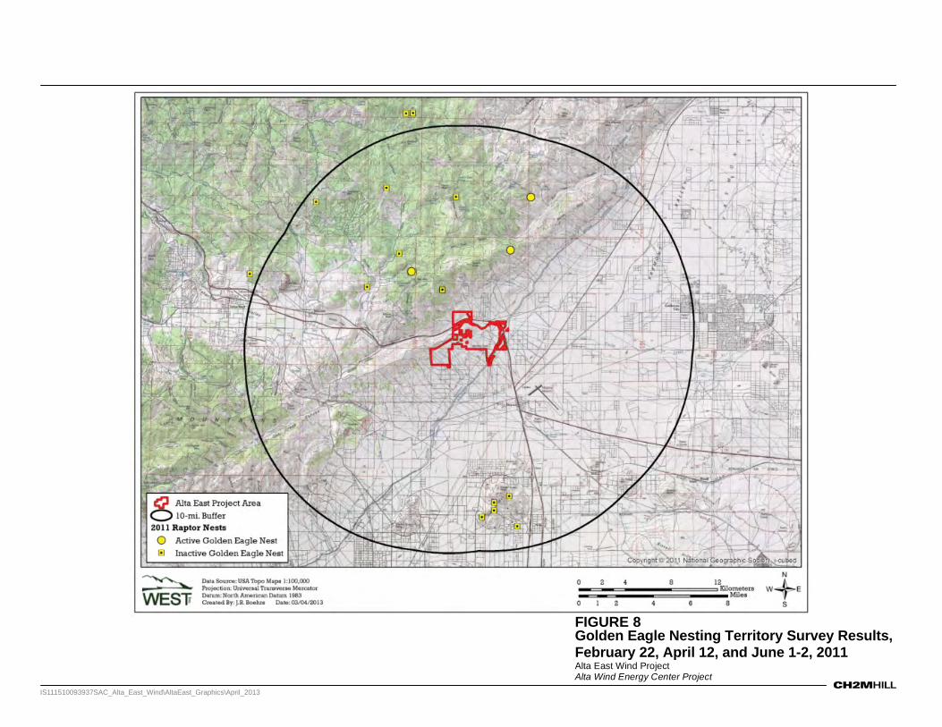
FIGURE 8 Golden Eagle Nesting Territory Survey Results, February 22, April 12, and June 1-2, 2011Alta East Wind ProjectAlta Wind Energy Center Project
IS111510093937SAC_Alta_East_Wind\AltaEast_Graphics\April_2013


ALTA EAST WIND PROJECT SECTION 2.0: EAGLE CONSERVATION PLAN DEVELOPMENT
IS111510093937SAC/387639/110530001 2-19
2.2.3 Assessment of Nonbreeding Habitat According to the National Land Cover Database (U.S. Geological Survey, 2001), the dominant cover type within the project area is scrub-shrub, which constitutes approximately 96.7 percent of the study area. Grasslands and low-intensity developed areas represent approximately 1.3 percent and 1.0 percent of the project area, respectively.
Studies in California indicate that golden eagles select grasslands and oak savanna, with fewer eagles selecting oak woodland and open shrublands (Hunt et al., 1998). The Hunt et al. (1998) study is of the Altamont Pass wind resource area and was completed in response to USFWS concern that fatalities might adversely affect the golden eagle population in the region. It was not specifically a food/habitat selection study, but documents some of the highest nest densities in California and thus the habitat described indicates fairly optimal conditions. The Alta East project area differs from the Altamont Pass wind resource area in that it has few perches. Primary prey species for golden eagles are rabbit, hare, and rodents, but golden eagles also take other mammals, birds, reptiles, and scavenge a limited amount of carrion (Olendorff, 1976). California ground squirrels (Spermophilus beecheyi) and black-tailed jackrabbits (Lepus californicus) are the among the most important prey species for the golden eagle (Hunt et al., 1998). Eagles generally hunt prey from favored perches near regular updrafts, which allow soaring to heights sufficient for them to efficiently scan their hunting areas (Johnsgard, 1990). Prey studies were not conducted for the Alta East project; however, eagles were observed infrequently and those observed were not hunting or foraging. Additionally, no prominent or used perches were detected after careful evaluation of the project area.
A potential indicator of the risk to golden eagles is the extent of use relative to other areas on the landscape. Data collected to evaluate the Alta East project area indicate that during the first 12-month period of evaluation (Chatfield et al., 2010a), eagle use within the project area was distinctly different from the area observed to the north and west, where eagle use was documented (Figure 5; 11 eagles observed offsite and 0 observed onsite). Of the seven golden eagle groups (n = 11 birds; Table 1) observed during the Year 1 study, all were north and west of the area currently proposed for development and outside the project boundaries at survey points 4, 5, and 6. Observations were recorded during all seasons (spring, n=1 eagle; summer, n= 1; fall, n= 3; winter, n= 6) and indicate potentially higher use of these offsite areas in winter because no eagles were recorded at the survey points 1, 2, and 3 located onsite (Figure 5). This difference in eagle use could be associated with lower-quality foraging habitat, lack of perch sites or foraging opportunities, less desirable thermal or wind characteristics, or general land use activity differences that make the project area less attractive to eagles than the surrounding landscape. This difference in eagle use is measurable in the data collected during this period.
Eight eagles were documented within the project site between October 7, 2010, and February 25, 2011 (Table 2; Figure 6). Observed eagle use was primarily outside of the nesting season for this species; nest construction typically occurs in February and egg-laying occurs March through mid-May (Polite and Pratt, 1990). No use was recorded during the 2010 nesting season, and four observations were made very early during the 2011 nesting season. While the winter observations may or may not have included eagles from nesting territories in the project vicinity, most eagle use on the project site occurred during the

SECTION 2.0: EAGLE CONSERVATION PLAN DEVELOPMENT ALTA EAST WIND PROJECT
2-20 IS111510093937SAC/387639/110530001
period in which eagles were not actively nesting, incubating, or rearing chicks (Figure 6; Table 2).
2.3 Stage 3 – Predicting Eagle Fatalities The USFWS draft ECP guidance (USFWS, 2011) presents factors potentially associated with wind turbine collision risk for eagles. Some of these factors may be present during operation of the project and may include bird density, age, residency status, season, flight style, interaction with other birds, and hunting or presence of foraging opportunities. Information that conclusively defines the functional relationship of these factors to actual eagle mortality during operation is, for the most part, unavailable; however, these risk factors make intuitive sense and are therefore considered in AWD’s assessment of risk. AWD’s assessment and conclusions related to risk are based on the data collected from March 2009 to June 2011. Risk analysis and conclusions are summarized in Table 3 and described in more detail in the following sections.
TABLE 3 Assessment of Golden Eagle Risk Factors Alta East Wind Project
Risk Factor Analysis Conclusion
Bird Density Eagle use is low when compared to other facilities with similar preconstruction data (see Chatfield et al., 2010a; 2011).
Low risk
Age Age of individuals was estimated during point count surveys; however, inconsistent age determination and infrequent detection preclude understanding of the age structure of eagles occasionally using the project area. Although age is an unreliable stand-alone indicator of risk for a variety of reasons, each age class may have its own particular vulnerabilities that are dependent on a variety of other risk factors and circumstances.
Unknown Risk
Residency Status Distance of nests from the project indicates nesting eagles occur in reasonable proximity to the site to present risk. Nesting territory occupants, and adult and juvenile floaters, may comprise the population of eagles using the site; however, this cannot be determined from the data available. No evidence of foraging or territorial behavior was observed on the project site. According to Hunt (2002), subadults and floating adults are highly vulnerable to turbine blade strikes, which would be associated with higher risk than for resident adults.
Moderate to High Risk
Season A potential relationship of eagle use with fall and winter season is evident based on the fall 2010 and winter 2010–11 avian use data. Foraging, perching, or consistent use of specific areas was not documented; however, seasonal and annual variability was evident.
Potential Seasonal Variation in Risk
Flight Style Soaring and gliding is documented in and out of the altitudes above ground level associated with WTG collision risk; however, infrequent detection of eagles and no higher-risk flight behaviors, such as hunting, kiting, or stooping were observed.
Moderate Risk

ALTA EAST WIND PROJECT SECTION 2.0: EAGLE CONSERVATION PLAN DEVELOPMENT
IS111510093937SAC/387639/110530001 2-21
TABLE 3 Assessment of Golden Eagle Risk Factors Alta East Wind Project
Risk Factor Analysis Conclusion
Interaction With Other Birds With the exception of two juvenile eagles observed on February 17, 2011, all observations of onsite eagles were of individual birds. No evidence of territoriality or interaction with other eagles was observed.
Low Risk
Hunting Not observed. Low Risk
Presence of Foraging Opportunities
Not observed. Unknown Risk
Topographic Features for Slope Soaring
The majority of the project area is flat, and rugged topography is limited to the north and western edges.
Risk may vary with topography
Topographic Features for Flight Corridors
The majority of the project area is flat, and rugged topography is limited to the north and western edges; however, observed use was infrequent and not specific to a particular feature or corridor
Low Risk
Perch Structures No perching eagles were detected onsite. Additionally, no unique perch sites associated with topography or artificial structures are present on the project site.
Low Risk
2.3.1 Collision Risk Eagle density, age, residency status, time spent in zone of risk, season, flight style, interaction with other birds, and hunting or presence of foraging opportunities all may influence the likelihood of an eagle colliding with a WTG or other project features. However, to date, the information required to estimate eagle fatalities based on these criteria is currently lacking. Thus, a higher-level approach is required to estimate potential eagle fatalities. The following discussion evaluates fatality estimates using three different approaches: regression analysis, eagle use / mortality rate comparison, and modeling using the USFWS-recommended Bayesian collision risk model (USFWS, 2013).
2.3.1.1 Regression Analysis One method of estimating site-specific mortality predictions for eagles is to look at mean use for all raptors, and then look at the proportion of the overall raptor use attributed to golden eagles. Using methods described in Chatfield et al. (2010a, 2011), a regression analysis of raptor use and mortality for 20 new-generation wind energy facilities, where similar methods were used to estimate raptor use and mortality, found that there was a strong correlation between use and mortality (R2 = 65%). Using this regression to predict overall raptor collision mortality at the project (based on mean raptor use [adjusted from 30-minute to 20-minute survey intervals] of 0.09 raptors/800-m/20-min survey) yielded an estimated fatality rate of less than 0.01 fatalities/MW/year or approximately 1.45 raptor fatality per year for the 51 turbine project as proposed (WEST, 2012). A 90 percent prediction interval around this estimate is zero to 0.19 raptor fatalities/MW/year.

SECTION 2.0: EAGLE CONSERVATION PLAN DEVELOPMENT ALTA EAST WIND PROJECT
2-22 IS111510093937SAC/387639/110530001
Golden eagle use accounted for approximately 22.2 percent of the observed raptor use at the project site during the 2 years of study; therefore, assuming the proportion of eagles observed is related to the proportion of eagle mortality that would be expected, an eagle mortality rate of 0.0022 eagles/MW/year (0.0066 eagles/turbine/year), or 0.320 eagle fatalities per year would be estimated for the proposed 145.35-MW (51 WTG) wind energy project. Using this prediction, project-wide eagle mortality would be approximately 1.6 eagles for the duration of the 5-year permit. This approach may be conservative because golden eagles are easier to detect than some other raptor species; therefore, the proportion of raptor use attributed to golden eagles may be overestimated. It is also probable that collision risk for eagles is different than for other raptors, introducing further bias to this estimate, though the direction of this bias is uncertain.
2.3.1.2 Eagle Use / Mortality Rate Comparison By comparing mean use values of eagles at 13 projects in western and midwestern states where fatality monitoring results have been reported, no take has been documented where annual eagle use values are less than 0.05/20-minute survey period (Figure 9). Overall mean golden eagle use recorded at the Alta East project site during the 2 years of study (0.020 eagles/800-m plot/20-min survey) is within the range of preconstruction eagle use values estimated for projects with no documented take of eagles during operation.

ALTA EAST WIND PROJECT SECTION 2.0: EAGLE CONSERVATION PLAN DEVELOPMENT
IS111510093937SAC/387639/110530001 2-23
FIGURE 9 Average Preconstruction Golden Eagle Use (per 20-min survey) Values for Wind Energy Facilities
With and Without Observed Golden Eagle Fatalities as Compared to Alta East Data from the following sources:
Wind Energy Facility
Golden Eagle Use Use Reference
Golden Eagle Fatality Recorded? Fatality Reference
Alta East, CA 0.02 Chatfield et al. 2010a, 2011 Campbell Hill, WY 0.36 Taylor et al. 2008 Yes Taylor et al. 2011 In Press Diablo Winds, CA 0.3 WEST 2006 Yes WEST 2006, 2008 Elkhorn, OR 0.27 WEST 2005 Yes Enk et al. 2011 In Press Foot Creek Rim, WY 0.26 Johnson et al. 2000 Yes Young et al. 2003a Wild Horse, WA 0.05 Erickson et al. 2003a No Erickson et al. 2008 Combine Hills, WA 0.03 Young et al. 2003b No Young et al. 2006 Leaning Juniper, OR 0.02 Kronner et al. 2005 No Kronner et al. 2007; Gritski et al. 2008 Hopkins Ridge, WA 0.01 Young et al. 2003c No Young et al. 2007a Stateline, OR/WA 0.01 Erickson et al. 2002 No Erickson et al. 2004 Vansycle, OR 0.01 Erickson et al. 2002 No Erickson et al. 2000 Klondike, OR >0.01 Johnson et al. 2002 No Johnson et al. 2003 Nine Canyon, WA >0.01 Erickson et al. 2001 No Erickson et al. 2003b Grand Ridge, IL 0 Derby et al. 2009 No Derby et al. 2010

SECTION 2.0: EAGLE CONSERVATION PLAN DEVELOPMENT ALTA EAST WIND PROJECT
2-24 IS111510093937SAC/387639/110530001
2.3.1.3 Collision Risk Modeling A third approach to attempt to predict the frequency of eagle fatalities associated with a wind project is to use the modeling approach prescribed in the USFWS Guidance (USFWS, 2013). The model assumes that a functional relationship exists between preconstruction eagle use, behavior, and risk of collision. The USFWS Bayesian collision risk model assumes that higher site-specific eagle flight activity will correspond to higher annual eagle mortality once the wind energy facility is operational (USFWS, 2013). Under this assumption, predictions of annual eagle mortality were modeled as the preconstruction measure of eagle exposure within areas of potential eagle-wind turbine interactions, multiplied by a collision correction factor as described in the USFWS ECP Guidance and detailed in Appendix B.
In order to evaluate the benefits from the project siting decisions, AWD evaluated the predicted eagle fatalities for the original 106-turbine layout and the current 51-turbine layout for both turbine types being considered. Credible interval limits (a Bayesian confidence interval) were calculated using a simulation of 10,000 Monte Carlo draws from the posterior distribution of eagle exposure and the collision probability distribution (Manly, 1991). The product of each of these draws with the exposure area corresponding to the N117 and 103RD turbine models were used to estimate fatality using all avian survey data collected for the project. Inclusion of these eagle survey data results in upper 80 percent credible interval limit take estimates for the 106-WTG layout of 1.33 eagles per year for the N117 WTG and 1.03 eagles per year for the 103RD WTG. For the 51-WTG layout, upper 80 percent credible interval limits are 0.64 eagles per year for the N117 WTG and 0.50 for the 103RD WTG (Table 4).
TABLE 4 Summary of Fatality Estimates Using All Avian Survey Data from May 11, 2009 through June 1, 2011 Alta East Wind Project
Fatality Estimate
106-Turbine Layout 51-Turbine Layout
N117 103RD N117 103RD
Annual Fatalities
(5-year total) 0.901
(4.505) 0.698
(3.491) 0.434
(2.168) 0.336*
(1.680)*
Upper 80% Credible Interval Limit (5-year total)
1.331 (6.656)
1.031 (5.153)
0.641 (3.203)
0.496*
(2.478)*
*Fatality estimate for proposed project analyzed in this ECP and Resource Equivalency Analysis.
2.3.1.4 Fatality Risk Summary Each analysis presented above involves substantial assumptions and does not take into account further siting decisions and advanced conservation practices that may be incorporated during the Environmental Assessment and programmatic take permitting processes currently underway; however, the three approaches generate project-wide fatality estimates for golden eagles ranging from near zero to 0.496 eagles per year, or from near zero to 2.48 eagles for the 5-year duration of the programmatic take permit. Although some golden eagle fatalities may occur, based on the use data and prediction models currently available to estimate operational take based on preconstruction eagle use data, it appears that the number of fatalities would likely be small and mitigable should they occur. Overall

ALTA EAST WIND PROJECT SECTION 2.0: EAGLE CONSERVATION PLAN DEVELOPMENT
IS111510093937SAC/387639/110530001 2-25
eagle use of the project area is infrequent, and fatality of eagles would be estimated using the Bayesian model to be 0.496 eagles in a given year.
2.3.2 Impacts to Nests or Nesting Territories The nearest known, recently active eagle nest is located approximately 4.1 miles northwest of the nearest proposed wind turbine. This nest was active during the 2011 nest survey and likely was the same nesting pair or territory as the nest documented within 0.10 mile of this nest in 2010. Additionally, one inactive nest was documented in 2011 approximately 2.3 miles northwest of the nearest turbine. No eagle nests were documented within the project area, and measures of eagle use of the project site are low; however, a nesting territory or territories may overlap the project area.
Historical nest and territory data or population status or assessment data are not available from USFWS to evaluate historical eagle territory locations in and near the project area or the current status of golden eagles in the region (Blackford, 2011, pers. comm.); however, AWD has assessed the potential impacts on golden eagles in the absence of these data. Its conclusion is that impacts to nesting golden eagles are unlikely during construction due to the distance between documented nests and project activities (Suter and Jones, 1981). Additionally, the potential for low levels of take during operation exists, but such low level of take can be fully mitigated if it occurs, as described in Section 2.4.7.
It is generally understood that nonbreeding eagles use areas on the margins of territories occupied by breeding adults (Watson, 1997; Hunt, 1998; Caro et al., 2010). These “floaters” have been shown to be more vulnerable to collision with turbine blades at wind energy projects than locally breeding adults and juveniles are (Hunt et al., 1999; Hunt, 2002); however, Hunt (2002) associates this risk with hunting of live prey behavior, which was not observed and is not common at the project site based on the data collected for the project. WTGs sited near eagle nesting territories may pose risks to eagle populations because population stability is likely influenced by a robust nonbreeding cohort in the form of floaters to replace breeding individuals that die. Based on studies completed to date, it is appropriate to conclude that risk of project impacts to nesting eagles, or floaters of any age, does exist.
2.3.3 Foraging Habitat Loss During the first 12 months of evaluation, eagle use within the project area was distinctly different from that in the area observed to the north and northwest, where eagle use was documented. Subsequent data collected in fall 2010 and winter 2010–11 indicate that eagles use the project area during the nonbreeding season and use the project area differently between seasons and years. It is possible that established territories could expand or shift to include the project area in response to prey fluctuations. No hunting or foraging behavior was observed onsite in 2 years of study.
2.3.4 Wintering Habitat Use Potential for seasonal variability in use of the project area exists, and data indicate that the project area may support more eagles in the fall and winter than during other times of the year or that repeated use by the same individuals may be occurring. Based on studies completed to date, it is appropriate to conclude that potential project impacts on wintering habitat for eagles are expected to occur.

SECTION 2.0: EAGLE CONSERVATION PLAN DEVELOPMENT ALTA EAST WIND PROJECT
2-26 IS111510093937SAC/387639/110530001
2.3.5 Cumulative Impacts USFWS is required to evaluate and consider the effects of programmatic take permits on eagles at the eagle management unit, local area, and project area population scales, including cumulative effects, as part of its permit application review process (50 CFR 22.26 (f)(1) and USFWS, 2009). Therefore, AWD presents general information that is publicly available regarding threats to eagles and operating projects in the vicinity.
Based on the USFWS Guidance (2013), USFWS is required to evaluate the effects of programmatic take permits on golden eagles at three different scales: (1) the BCR, which is USFWS’s designated management unit for golden eagles, (2) the local area population, and (3) the project area population. BCRs are ecologically distinct regions in North America with similar bird communities, habitats, and resource management issues (NABCI, 2013), and these regions represent the largest area of the three population scales. The local area population is defined in the USFWS Guidance (USFWS, 2013) as the total number of golden eagles estimated to occur within a 140-mile radius of the project boundary, inclusive of the proposed project area. Because take is being mitigated to a no net loss standard, the project will not contribute to the cumulative impacts at the BCR or local area population scale region. The project area population has been assessed in detail in this ECP.
There are a variety of current and foreseeable future actions that are known to result in unauthorized take and that could potentially occur within a 140-mile radius of the project boundary. Lethal take of golden eagles is commonly caused by electrocution associated with power lines (Benson, 1981; Hunt, 2002); collision with power lines (Avian Power Line Interaction Committee [APLIC], 2012), communication towers and guy wires (USGS, 2010), wind turbine blades (Hunt, 2002; Smallwood and Karas, 2009), and vehicles (Phillips 1986, Russell and Harden, 2009); lead poisoning (Craig et al., 1990); secondary poisoning from predator control efforts (Bortolotti, 1984); secondary poisoning from pesticides (Henny et al., 1984; Mineau et al., 1999); and illegal shooting (Ellis et al., 1969; Phillips, 1986). Other causes of lethal take include collision with trains (Hunt, 2002) and aircraft (FAA, 2013), and unintentional trapping (Bortolotti, 1984; Phillips, 1986).
Typical activities that may be disruptive or detrimental to eagles occurring throughout the project region, although very limited on the project area, include illegal shooting, off-highway vehicle activity, loss of habitat to development through non-wind-industry-related development, and general encroachment into nesting territories. AWD has not obtained information regarding the specific extent of these detrimental activities; however, each likely contributes to negative impacts on the regional eagle population.
Wind energy power generation is common in the Tehachapi region and AWD is aware that eagle fatalities have been documented at the North Sky River (NSR) Wind Project located 10.5 miles north, the Pine Tree (PT) Wind Project located approximately 7 miles north, and the Alta-Oak Creek Mojave (AOCM) project located approximately 3 miles to the south. Although specifics about the date and age of the individual(s) killed are not available at each project, with the exception of AOCM where a fatality was documented on November 29, 2011, it is possible that these impacts could influence the eagle territories documented within 10 miles of the project site and thus influence the dynamics of the local eagle population.

ALTA EAST WIND PROJECT SECTION 2.0: EAGLE CONSERVATION PLAN DEVELOPMENT
IS111510093937SAC/387639/110530001 2-27
The NSR project is located approximately 10.5 miles north of Alta East, within topography substantially more rugged than that at the Alta East site. Vegetation is typified by pinyon-juniper woodland and oak woodland on the west side of the project and grasslands and chaparral scrub on the east side of the project. Two substantial drainages lie between Alta East and NSR, and the NSR project is located near eagle nests discovered during the Alta East eagle nest surveys. AWD is aware of one eagle fatality having occurred at this project in January 2012, occurring less than 2 months after start of operations. Although take has been documented at NSR, this project differs substantially from Alta East in terms of site characteristics and with respect to suitability for golden eagle use. The final environmental impact report documents over 50 sightings of golden eagles in one year of surveys covering four seasons in 2010–11 (County of Kern, 2012a), 22 eagle sightings during spring surveys (132 hours of observation between March 15 and May 26, 2011) (Erickson et al., 2011), and 36 additional observations during a full year of avian use surveys. Due to the difference in site characteristics, eagle risk between the NSR and Alta East projects is not comparable.
The PT project is located approximately 7 miles north of Alta East, and immediately south of NSR, and is also located within more rugged topography than Alta East and much closer to the eagle nests detected during surveys for the Alta East project than either the Alta East or NSR projects. While no preconstruction eagle use data are available for comparative analysis, eight eagle fatalities has been documented at the PT project as of April 13, 2013, per USFWS. Due to the difference in site characteristics, eagle risk between the PT and Alta East projects is not comparable.
The AOCM project is located approximately 3 miles to the south and consists of up to 720 MW of wind energy generation capacity with 150 WTGs (300 MW) installed during 2010 and an additional 140 WTGs installed during 2011. AOCM was granted state and county permits. The AOCM project is sited to minimize impacts on eagles and incorporates appropriate measures to detect or mitigate impacts on eagles should they occur. Baseline eagle use at the AOCM project site was very low relative to other projects in the geographic range of golden eagles, and comparable to that documented at Alta East.
The Alite Project is located approximately 3.75 miles southwest of the Alta East project and consists of eight 3.0-MW turbines constructed in 2008. It is located at the interface of the Western Mojave Desert and Tehachapi Mountains ecological regions, in juniper-woodland-dominated habitat with some areas of perennial native grassland, rabbitbrush scrub, and Joshua tree woodland. This is similar to the northern and westernmost turbine locations of the Alta East project; however, fatality studies conducted from June 15, 2009, to June 15, 2010, at the Alite Project estimated overall bird fatality rates of 0.55 birds/MW/year and no golden eagle fatalities were reported during one year of robust surveys (weekly during spring and fall migration and biweekly in summer and winter) around all turbines (Chatfield et al., 2010b).
With the project take estimated by this ECP, cumulative impacts on golden eagles could occur from past, present, and reasonably foreseeable future actions in the vicinity of the project. However, estimated eagle take at Alta East will be offset with required mitigation. Construction and operation best management practices (BMP) are presented in this plan to minimize risk of project-related impacts and measures in this ECP and via the programmatic take authorization process is designed to mitigate impacts, if necessary.

SECTION 2.0: EAGLE CONSERVATION PLAN DEVELOPMENT ALTA EAST WIND PROJECT
2-28 IS111510093937SAC/387639/110530001
2.4 Stage 4 – Avoidance and Minimization of Risk and Compensatory Mitigation The project’s ECP documents how siting, design, and planned operation will achieve the following results: 1) minimization and avoidance of golden eagle take to the maximum degreed achievable; 2) application of any necessary advanced conservation practices to reduce golden eagle take to that which is unavoidable; and 3) implementation of any compensatory mitigation necessary to result in no net loss of eagles or even a net conservation benefit at the BCR scale.
The analyses and documentation provided in this ECP show the project’s risk to eagles is predicted to be approximately 0.496 eagles per year and will result in mitigable levels of potential take. This minimal risk can be further reduced through siting, construction, and operation measures, including mortality monitoring during operation and a plan of action if eagles are taken during construction or operation. These advanced conservation practices (ACP) are presented in the following sections.
2.4.1 Project Macrositing 2010 Boundary Revision. The Alta East project area was originally selected for development based on analysis of existing data as described in Section 2.1, Stage 1 – Initial Site Assessment. However, site-specific studies documented eagle nesting and use in the areas north and west of the project boundary. In response, the project boundary was modified in June 2010 to eliminate areas in the north and west, and include additional areas extending southward from the golden eagle use areas and extending development into the flat, nonrugged topography to reduce potential impacts to golden eagles.
Low levels of eagle use were subsequently documented during fall 2010 and winter 2010–11 in the second year of surveys within the revised project boundary, indicating potential annual variation in eagle use of the project area.
Project Planning. Alternatives to project siting specific to layout and land use were evaluated and published in the Final Environmental Impact Statement in February 2013 (BLM, 2013). Alternative C was specifically designed to address golden eagle impacts by reducing land area and excluding development in the northern portion of the proposed project footprint. Areas excluded from development in Alternative C shifted project activities farther south and away from nests and documented eagle activity north of the project. Alternative C was selected as the Preferred Alternative for having the least potential for impacts to golden eagles (BLM, 2013). In response to agency concerns, and as a result of the selection of BLM EIS Alternative C as the Preferred Alternative, AWD made significant modifications to the layout to further address this risk by reducing the number of turbines to 48 and selecting a different turbine model with a smaller blade radius to minimize risk of eagle collision with turbines to the maximum extent practical (discussed in Section 2.4.2).
2.4.2 Micrositing of Project Features Based on 2 years of eagle survey data, some eagle use of the project area may occur during construction or operation, although it is not expected to be common. No unique habitat features such as prominent perch sites (rock outcrops, cliffs, trees) or unique concentrations

ALTA EAST WIND PROJECT SECTION 2.0: EAGLE CONSERVATION PLAN DEVELOPMENT
IS111510093937SAC/387639/110530001 2-29
of prey are evident; however, WTG locations were revised to avoid areas of documented eagle use.
2013 Project Modification. In February 2013, AWD substantially reduced the scope of the project in response to BLM (2013) and USFWS concerns about golden eagle risk. The initially proposed 318-MW, 106 WTG project was reduced to 145.35 MW with 51 WTGs to a final project layout of 137 MW with 48 WTG through careful revision to optimize generation capacity while minimizing turbines located in areas posing a relatively higher risk to eagles as identified in resource studies. The turbine model was changed from the N117 2.4 MW (58.5-meter-rotor radius) to the 103RD 2.85 MW (51.5-meter-rotor radius) to allow fewer turbines with a greater generation capacity. The revised layout is shown in Figure 2 and has been discussed throughout this ECP, and it is compared to the original project in Figure 1. The original fatality estimate for the 106-WTG layout using N117 WTG was 0.901 eagle fatalities per year with an upper 80 percent credible interval limit of 1.331. The revised 51-WTG layout with the 103RD WTG results in a take estimate of 0.336 eagle fatalities per year with an upper 80 percent credible interval limit of 0.496. This substantial modification to the project results in estimated take that is only 37 percent of that predicted for the original layout; in other words a 63 percent reduction in estimated take on an annual basis.
Other Micrositing Measures. All other project features have been located away from the higher elevation and rugged topography that are associated with the eagle use documented to the north, west, and central areas of the project. In addition, project design includes installation of approximately 25.5 miles of underground collection lines, which eliminates approximately 450 aboveground power poles and associated aboveground collection lines that could have otherwise posed electrocution or collision hazard to eagles and other birds.
2.4.3 Construction Measures Appropriate site-specific measures for avoidance of impact to golden eagles have been identified by AWD and include measures specified in the Final Environmental Impact Statement (BLM, 2013) and Final Environmental Impact Report (County of Kern, 2012b) published for the project. These measures are consistent with those identified in BLM right-of-way grants received by the Applicant on nearby wind development projects, and applicable measures from the adjacent AOCM project. Potentially applicable measures from the above references are listed below. The Final Programmatic Environmental Impact Statement on Wind Energy Development on BLM-administered Lands in the Western United States (BLM, 2005) also includes BMPs and mitigation measures for a plan of development and project design. Upon completion of the USFWS programmatic take permitting and NEPA review, applicable mitigation measures will be refined, and additional mitigation measures may be incorporated with input from BLM and USFWS.
The following specific measures that are required by BLM and the County of Kern to minimize impact and risk to a variety of wildlife species and habitat areas had the added benefit of minimizing potential for impacts to eagles during construction:
Nesting Impact Avoidance. Because eagle courtship and nesting areas are not located in the project vicinity (greater than 4 miles), construction activities would not need to be scheduled to avoid important periods of eagle nesting. No eagle nests were detected during construction activities.

SECTION 2.0: EAGLE CONSERVATION PLAN DEVELOPMENT ALTA EAST WIND PROJECT
2-30 IS111510093937SAC/387639/110530001
Designated Biologist. AWD employed a Designated Biologist who was responsible for ensuring compliance with all applicable mitigation measures and requirements as set forth by the appropriate regulatory agencies, including the authority to halt any project activities that are in violation of the terms of the applicable mitigation measures and requirements; daily compliance inspections; federal law; and various reporting requirements. The Designated Biologist was appropriately qualified to oversee eagle conservation and impact avoidance actions.
General Impact Avoidance and Minimization. AWD minimized the area required for temporary construction work and operational activities. A speed limit of 15 miles per hour was enforced on all dirt access/maintenance roads, and all vehicles were restricted to designated access/maintenance roads to minimize the risk of vehicle collision with eagles on roads and to reduce excessive airborne dust.
Worker Education Awareness Program. AWD implemented a mandatory worker education awareness program for all construction and operational personnel, which educated staff about the sensitive biological resources on or potentially occurring on the project site, including golden eagles; federal and state regulations applicable to the resources onsite and the consequences of non-compliance with these regulations; actions and reporting procedures to be used if golden eagles are encountered in accordance with procedures explained in section 2.5.1 Incidental Fatality Monitoring; fire protection measures; measures to minimize the spread of weeds during construction; hazardous substance spill prevention and containment measures; who to contact at the on-call biological services provider in the event of the discovery of dead or injured wildlife; driving procedures and techniques to reduce mortality of wildlife on roads; and project mitigation requirements.
Preconstruction Surveys for Nesting Birds. AWD conducted preconstruction surveys and no nests were identified.
2.4.4 Minimizing Potential Habitat Disturbance The following measures were implemented to minimize habitat reduction or alteration during construction:
Reduce the Number of Turbine Pads. The size of all disturbed areas was minimized due the reduction in the number of WTGs from 106 to 51 to 48. By eliminating construction of 58 turbine pads, ground disturbance associated with turbine installation and turbine pads is reduced by approximately 55 percent.
Limit Traffic. Vehicles were restricted to designated access/maintenance roads, which reduced the extent of habitat disturbance. Additionally, foot and vehicle traffic through undisturbed areas was limited.
Use Existing Roads. Existing roads and utility corridors were used to the maximum extent feasible.
2.4.5 Minimizing Potential Collision and Direct Disturbance The following measures were implemented to minimize direct disturbance to golden eagles:
Buried Collector Lines. In addition to significant modifications to the project design to relocate high-risk features, approximately 25.5 miles of electrical collector lines was buried

ALTA EAST WIND PROJECT SECTION 2.0: EAGLE CONSERVATION PLAN DEVELOPMENT
IS111510093937SAC/387639/110530001 2-31
to eliminate the need for approximately 450 aboveground power poles and associated aboveground collection lines, which could pose potential electrocution or collision risk to eagles.
Perch Deterrents. Permanent meteorological towers, remaining transmission towers, and other facility structures were designed to discourage eagles and other birds from perching or nesting on them (for example, non-lattice towers, follow APLIC [2006, 2012] standards). Meteorological towers placed on BLM-managed lands adhere to BLM guidelines (BLM, 2011).
Flight Diverters. All guy wires installed on project structures, such as temporary meteorological towers, were marked with bird flight diverters to minimize collision risk for eagles and other birds. All temporary meteorological towers have been removed from the project site.
Free-standing Permanent Meteorological Towers. All permanent meteorological towers are free-standing without the use of guy wires.
Minimize Electrocution Risk. Power lines were configured to minimize the potential for electrocution of birds, by following established guidelines (APLIC, 2006).
Limited Use of Explosives. No explosives were used during construction.
Preconstruction Survey. Prior to initial construction activities (for example, mechanized clearing or rough grading), a qualified biologist conducted a preconstruction survey of the project site for golden eagle use, which included inspecting the project area for eagles, nests, or signs of nesting or courtship behavior. If an eagle, nest, or sign of nesting was discovered, avoidance and construction timing measures were to be implemented in coordination with USFWS to ensure that no impacts to these nests or individuals occur during construction. During construction, no eagle nests were detected.
Environmental Training. AWD provided environmental training to all personnel working on the site during project construction. The training included a review of golden eagle identification and ecology to promote awareness and facilitate implementation of appropriate measures if an eagle was encountered or killed. If an eagle was encountered or killed, the appropriate employee will be required to contact the on-call biological services provider for the project. AWD will report an injured or dead eagle to USFWS, BLM, and the Kern County Planning Department within 24 hours of discovery.
2.4.6 Operation Measures Environmental Training: As part of AWD’s mortality monitoring and reporting program outlined in the project’s Bird and Bat Conservation Strategy, AWD provides environmental training to all personnel working onsite during project operations. The training includes a review of golden eagle identification and ecology to promote awareness and facilitate implementation of appropriate measures if an eagle is encountered or killed. The importance of onsite staff is significant in that they are onsite daily, can become familiar with how eagles and other wildlife move through and use the project site and vicinity, are the eyes and ears of environmental staff for identifying project risk or impact issues, and can help identify ways to reduce unexpected impacts or risks if they are detected.

SECTION 2.0: EAGLE CONSERVATION PLAN DEVELOPMENT ALTA EAST WIND PROJECT
2-32 IS111510093937SAC/387639/110530001
Carcass Removal: Onsite management efforts, such as removing large animal carcasses, reduce attractants to eagles.
Radar Based Monitoring: A radar based monitoring system is voluntarily being investigated for use to determine the effectiveness in detecting raptors. This is an experimental system and may be used in the future when data shows the effects of this technology. Discussion with USFWS will occur when the system is determined to be effective for use.
Full-time Biological Monitor: A full-time qualified biological monitor will be employed by the project during operation for the life of the project. The daily activities of the monitor include intensive observation of the site during daylight hours 365 days per year at the observation tower located on the project site, and monitoring and recording all observations of eagles and eagle behavior to inform curtailment of specific turbine(s) to avoid risk of collision. If adaptive management is necessary (see Table 6), the information gathered by the biological monitor may help inform appropriate ACPs to further minimize risk to eagles. . The monitor records all observed occurrences and behaviors of eagle’s onsite and in the project vicinity. If unsafe conditions are present (i.e. weather, fire, etc.) that would jeopardize the safety of the monitor they will evacuate the observation tower and return when safe conditions are present.
Informal Operational Monitoring: Informal operational monitoring will be performed during the life of the project as a course of business by all AWD operations staff. Staff will be required to report all eagle observations, nesting behavior, and nests, and record fatalities and injuries. While this monitoring will not be statistically based (i.e., systematic sampling), it will allow detection of issues that may potentially occur onsite year-round for the life of the project. If an injured or dead eagle is encountered during project operations, the employee involved will be required to implement the appropriate response protocol, which will include notifying USFWS. Specifics of the response protocol are presented in Section 2.5.1, Wildlife Incident Reporting.
Formal operational monitoring. Formal operational monitoring and reporting measures are described in detail in Section 2.5, Stage 5 − Post-Construction Monitoring.
2.4.7 Compensatory Mitigation Alta East will deposit compensatory mitigation funds into the NFWF Eagle Mitigation Account. Further deposits will be required if the funds run out before the required retrofits are completed.
2.5 Stage 5 – Post-Construction Monitoring As part of AWD’s mortality monitoring and reporting program, AWD will complete post-construction monitoring and reporting to determine whether estimated eagle fatalities are consistent with operational outcomes. Post-construction monitoring will enable AWD to document eagle fatalities if they occur and identify factors associated with eagle fatalities that might warrant additional ACPs to specifically address the identified risk factor. The USFWS Region 8’s ACP Stepwise Table was modified to address adaptive management responses to project-specific levels of take (see Section 3.0).
The monitoring program is explained below.
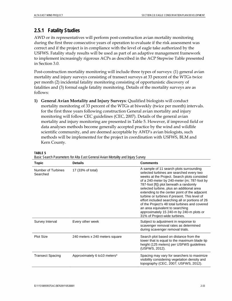
ALTA EAST WIND PROJECT SECTION 2.0: EAGLE CONSERVATION PLAN DEVELOPMENT
IS111510093937SAC/387639/110530001 2-33
2.5.1 Fatality Studies AWD or its representatives will perform post-construction avian mortality monitoring during the first three consecutive years of operation to evaluate if the risk assessment was correct and if the project is in compliance with the level of eagle take authorized by the USFWS. Fatality study results will be used as part of an adaptive management framework to implement increasingly rigorous ACPs as described in the ACP Stepwise Table presented in Section 3.0.
Post-construction mortality monitoring will include three types of surveys: (1) general avian mortality and injury surveys consisting of transect surveys at 33 percent of the WTGs twice per month (2) incidental fatality monitoring consisting of opportunistic discovery of fatalities and (3) formal eagle fatality monitoring. Details of the mortality surveys are as follows:
1) General Avian Mortality and Injury Surveys: Qualified biologists will conduct mortality monitoring of 33 percent of the WTGs at biweekly (twice per month) intervals. for the first three years following construction General avian mortality and injury monitoring will follow CEC guidelines (CEC, 2007). Details of the general avian mortality and injury monitoring are presented in Table 5. However, if improved field or data analyses methods become generally accepted practice by the wind and wildlife scientific community, and are deemed acceptable by AWD’s avian biologists, such methods will be implemented for the project in coordination with USFWS, BLM and Kern County.
TABLE 5 Basic Search Parameters for Alta East General Avian Mortality and Injury Survey Topic Details Comments
Number of Turbines Searched
17 (33% of total) A sample of 11 search plots surrounding selected turbines are searched every two weeks at the Project. Search plots consisted of a 240-meter by 240-meter (m; 787-foot by 787-foot [ft]) plot beneath a randomly selected turbine, plus an additional area extending to the center point of the adjacent turbine or turbines if present. This level of effort included searching all or portions of 26 of the Project’s 48 total turbines and covered an area equivalent to searching approximately 15 240-m by 240-m plots or 31% of Project-wide turbines.
Survey Interval Every other week Subject to adjustment in response to scavenger removal rates as determined during scavenger removal trials.
Plot Size 240 meters x 240 meters square Search plot based on distance from the tower that is equal to the maximum blade tip height (125 meters) per USFWS guidelines (USFWS, 2012).
Transect Spacing Approximately 6 to10 meters* Spacing may vary for searchers to maximize visibility considering vegetation density and topography (CEC, 2007; USFWS, 2012).

SECTION 2.0: EAGLE CONSERVATION PLAN DEVELOPMENT ALTA EAST WIND PROJECT
2-34 IS111510093937SAC/387639/110530001
TABLE 5 Basic Search Parameters for Alta East General Avian Mortality and Injury Survey Transect Length 240 meters
Rate of Travel 1.7 to 2.2 miles per hour Slow pace to allow careful visual inspection on each side of transect.
Duration of Surveys During first 3 years of operation (2014, 2015 and 2016)
As required per Kern County Environmental Impact Report Mitigation Measures (County of Kern, 2012b) and BLM conditions (BLM, 2013).
*Transect spacing of 6 to 10 meters is selected based on experience surveying for avian fatalities in low-growing desert vegetation and topography comparable to conditions present in the facility area. Six to 10 meters is a standard and generally accepted for fatality monitoring at other wind energy projects in similar vegetation and topography. The CEC guidelines recommend 6-meter spacing with adjustments based on vegetation and topographic conditions (CEC, 2007). Additionally, USFWS (2012) recommends spacing at 4- to 10-meter intervals based on vegetation and topography.
• Carcass Persistence and Searcher Efficiency Trials: Carcass persistence trials are conducted concurrently with the other study components during the study period. The approach presented in this field study is modified from and consistent with those described in Smallwood (2007), Huso (2009), Strickland et al. (2011), and Warren-Hicks et al. (2013). Carcasses of small birds, medium to large birds, and carcasses, if available, are randomly placed within the general mortality and injury survey plots. Ducks, quail and mice were used for the carcass persistence trials. In addition, whole birds found during the monitoring were also used for the trial. Searcher efficiency trials are completed concurrent with the scavenger trials using the same test subjects. The carcasses are placed on a minimum of two dates during each season (spring, summer, fall, and winter), thereby spreading the trials throughout the survey period to incorporate the effects of varying weather, climatic conditions, and scavenger types and densities. Carcasses are dropped from waist high or higher and allowed to land in a random posture. Each trial carcass is discreetly marked (with tape or thread) prior to placement so that it can be identified as a study carcass if it is found by observers or wind facility personnel, particularly if the carcass is moved by a scavenger. Observers conducting carcass searches will monitor the trial birds over a 40-day period according to the following schedule as closely as possible. Carcasses will be checked every day for the first 4 days, and then on days 5, 7, 10, 14, 18, 25, and 40. This schedule may vary slightly depending on weather and coordination with the other survey work. At each visit, the observer will note the condition of the carcass (e.g., intact, scavenged, feather spot [i.e., more than 10 feathers], or absent [less than 10 feathers]). Trial carcasses will be left at the location until the end of the 40-day trial or until the carcass is removed entirely by scavengers. After 40 days, any remaining evidence of the carcasses will be removed.
These carcass removal and searcher efficiency trials will not be used to adjust estimates of eagle fatalities due to the potential difference in scavenger removal and detection rates between the test subjects and eagles, but are instead intended for adjustment of fatality rates for other species as described in the Bird and Bat Conservation Strategy. Searcher detection of eagles or eagle remains is assumed to be near 100 percent due to the sparse vegetation and the long persistence times of large raptors (Smallwood, 2007).

ALTA EAST WIND PROJECT SECTION 2.0: EAGLE CONSERVATION PLAN DEVELOPMENT
IS111510093937SAC/387639/110530001 2-35
Reporting: The results of the general mortality monitoring analysis will be provided to USFWS, BLM and Kern County annually. The mortality analysis will note species, number, location, distance from the WTG for each recovered eagle, and apparent cause of mortality. At a minimum, the mortality analysis will consider the following:
a) Number of annual eagle mortalities per turbine and facility b) Comparison to existing public data on wind farm mortality at projects with
similar habitats and study methodology.
2) Incidental Fatality Monitoring: In addition to the standardized monitoring during the first 3 years of operation required as permitting conditions for BLM and Kern County, if the biologists or any operational staff incidentally detect an injured or dead eagle, the incident will be reported as outlined below.
a. All golden eagle fatalities will be reported to USFWS, BLM, and Kern County within 24 hours of detection. Fatality reports will include GPS location, photographs, and related information describing the incident. Any detected eagle will be left in position, without disturbance or handling, pending USFWS evaluation of the circumstances surrounding the detection and further direction from USFWS.
b. Upon authorization from USFWS, any injured eagles detected during surveys or incidentally will be carefully captured by an observer authorized and qualified to do so safely and humanely, examined to determine type and extent of injury, and transported to the nearest wildlife rehabilitation center or veterinary clinic in a timely manner. The avian rehabilitation facility identified to care for injured eagles potentially detected during the program is the Facility for Animal Care and Treatment, California State University, Bakersfield Biology Department, 9001 Stockdale Highway, Bakersfield, California, 661-654-3167, or via the Bird Rescue Hotline: 661-654-BIRD (2473).
For all eagle injuries or deaths determined to be caused by project activities or operation, AWD will consult with USFWS in accordance with the Step-wise Response process outlined in Section 3.0, Adaptive Management.
3) Eagle Fatality Monitoring
Formal eagle fatality monitoring will occur for one year (12 months) up to two years (24 months) starting when the eagle take permit is issued or at the conclusion of the General Avian Mortality Monitoring which is scheduled to end in the Spring of 2017, whichever occurs later. The purpose of the eagle fatality monitoring is to formally monitor the ground under the turbines to ensure that any eagle fatalities are observed, reported and documented. Although the project has a Wildlife Incident Reporting procedure to address the incidental observations of wildlife incidents the formal eagle monitoring plan ensures that a formal search is conducted at each turbine.
All turbines will be monitored monthly for at least the first year to provide assurances that any potential eagle take is detected. AWD will consult with USFWS to develop a monitoring protocol, appropriate for the landscape, designed to detect

SECTION 2.0: EAGLE CONSERVATION PLAN DEVELOPMENT ALTA EAST WIND PROJECT
2-36 IS111510093937SAC/387639/110530001
eagles rather than all birds. The site biologists and potential supplemental assistance from a third party consultant will conduct a formal search at each turbine every 28 to 30 days. The Eagle Fatality Monitoring Plan will be developed by March, 2017.
2.5.2 Nesting/Breeding Monitoring AWD or its representative will conduct post-construction nesting/breeding monitoring of eagle territories within the project area. Two 4-hour surveys will take place on foot within the project area with the use of optics twice a year (February and May). These surveys will be conducted by site biologist staff following the Pagel et al 2010 protocol or the Driscoll 2010 protocol. Survey results will be provided annually to BLM and USFWS.

SECTION 3.0
IS111510093937SAC/387639/110530001 3-1
Adaptive Management
All study results, including methods and analysis, pertaining to golden eagles will be provided to USFWS and BLM for review. If eagle take occurs, it will be reported within 24 hours of discovery so that the opportunity for real-time response is available to address unforeseen issues or levels of take that may warrant concern.
Use of the decision framework and threshold-based response process provided in Table 6 provides the defined protocol for agency coordination and adaptive management planned for the Alta East Wind Project. Adaptive management will be implemented immediately if take exceeds the identified response thresholds.
In addition to adaptive management, AWD commits to mitigation measures that will include, but not necessarily be limited to, power pole retrofitting at a level determined necessary through the Resource Equivalency Analysis (presented in Appendix B) and the USFWS Programmatic Take Permit/Environmental Assessment process, and to other offsetting measures as required by USFWS to ensure no net loss to the regional population as a result of project activities.
TABLE 6 Summary of Advanced Conservation Measures using a Step-wise Approach Alta East Wind Project
Step Threshold or
Trigger Advanced Conservation Measures
Step I One eagle taken Assess eagle fatality to determine if cause or risk factor can be determined (e.g., season, time of day, weather, presence of prey/carrion, fire, or other event) and management response is warranted. Consult with USFWS. Take is within permitted level and fully mitigated.
Step II Two eagles taken within any 36-month period.
Assess eagle fatality to determine if cause or risk factor can be determined (e.g., season, time of day, weather, presence of prey/carrion, fire, or other event) and management response is warranted. Of primary concern is if there are common elements between the two eagle fatalities that indicate more concentrated evaluation of the cause of mortality should be performed. Consult with USFWS to determine if 1) Immediate response or management action is needed 2) A longer term action plan or management response plan should be
developed 3) Study plans should be modified or extended Take is within permitted level and mitigated

SECTION 3.0: ADAPTIVE MANAGEMENT ALTA EAST WIND PROJECT
3-2 IS111510093937SAC/387639/110530001
TABLE 6 Summary of Advanced Conservation Measures using a Step-wise Approach Alta East Wind Project
Step Threshold or
Trigger Advanced Conservation Measures
Step III
Three eagles taken within the 5-year permit period
Assess eagle fatality to determine if cause or risk factor can be determined (e.g., season, time of day, weather, presence of prey/carrion, fire, or other event) and management response is warranted. Consult with USFWS. If appropriate (e.g., threshold is reached within 3 or 4 years of permit duration), the following ACMs will be considered for implementation in consultation with USFWS. • Employ onsite biological monitor(s) during daylight hours to curtail
turbine(s) when an eagle approaches the turbines. Monitors will be stationed within the highest areas of measured or perceived risk. Consult with USFWS on development of curtailment protocol.
• Deployment of a radar-based or other system to potentially deter eagles from approaching turbines or curtail turbines when an eagle approaches the turbines. Consult with USFWS to evaluate the development and deployment of the system.
• Initiate eagle behavior studies (eagle point counts at high-risk locations, sample interval and season determined based on existing fatalities and operational eagle use data).
Conduct a minimum of 1 year of mortality monitoring designed specifically to evaluate the effectiveness of the biological monitor, or deterrent or curtailment system. Take is within permitted level and mitigated for up to 3.0 eagles over the 5-year permit period.
Step IV
Four or more eagles taken within the 5-year permit period
Initiate consultation with USFWS to determine curtailment schedules based on evaluation of data collected to date. Options may include limited curtailment based on spatial and temporal locations of eagles. Focused eagle movement and mortality monitoring will be implemented for a minimum of 1 year to enhance ability to identify and respond effectively to the risk issues. Deploy radar-based or other deterrent or curtailment system if determined effective, or initiate/continue development of radar-based or other deterrent or curtailment system. In consultation with USFWS and BLM, determine other appropriate actions necessary to minimize and compensate for additional impacts to eagle populations and/or modify Programmatic Take Permit to make mitigation commensurate with identified impacts.
With the publication of draft policies in the Federal Register on February 18, 2011, regarding golden eagle take permitting and ACPs, it is understood that commitments made in this ECP may require adaptation relative to the forthcoming guidance and may warrant modification for permit renewal after 5 years. AWD will work collaboratively with BLM and USFWS to apply necessary policy changes to the project ECP throughout the life of the project.

SECTION 4.0
IS111510093937SAC/387639/110530001 4-1
References
Avian Power Line Interaction Committee (APLIC). 2006. Suggested Practices for Avian Protection on Power Lines: The State of The Art in 2006. Edison Electric Institute, APLIC, and the California Energy Commission. Washington D.C. and Sacramento, CA, USA. Available online at: http://www.aplic.org/SuggestedPractices2006(LR-2watermark).pdf.
Avian Power Line Interaction Committee (APLIC). 2012. Reducing Avian Collisions With Power Lines: The State of the Art in 2012. Edison Electric Institute and APLIC. Washington D.C. Available online at: http://www.aplic.org/uploads/files/11218/Reducing_Avian_Collisions_2012watermarkLR.pdf
Benson, P. C. 1981. Large Raptor Electrocution and Powerpole Utilization: A Study in Six Western States. Ph.D. Dissertation, Department of Zoology, Brigham Young University.
Blackford, Ashleigh/USFWS, wildlife biologist. 2011. Personal communication with David Phillips/CH2M HILL. December 10.
Bortolotti, G. R. 1984. Trap and poison mortality of golden and bald eagles. Journal of Wildlife Management 48(4):1173-1179.
California Department of Fish and Game. 2009. California Natural Diversity Database. Web site: http://www.dfg.ca.gov/biogeodata/cnddb/
California Energy Commission (CEC). 2007. California Guidelines for Reducing Impacts to Birds and Bats from Wind Energy Development. CEC-700-2007-008-CMF. October.
California Native Plant Society. 2009. Inventory of Rare and Endangered Plants. Web site: http://cnps.web.aplus.net/cgi-bin/inv/inventory.cgi.ca/pdf/pdfs/ cdd_pdfs/wemo_pdfs.Par.4dfb777.file: wemo_rod_3-06.pdf
Caro, J., D. Ontiveros, M. Pizarro, and J. M. Pleguezuelos. 2010. Habitat Features of Settlement Areas Used by Floaters of Bonelli’s and Golden Eagles. Bird Conservation International. Available on CJO 23 Apr 2010 doi:10.1017/S0959270910000213.
Chatfield, A., W. P. Erickson, and K. Bay. 2010a. Avian Baseline Studies for the Sun Creek Wind Resource Area, Kern County, California. Final Report: May 2009 – May 2010. Prepared for CH2M HILL, Oakland, California. Prepared by Western EcoSystems Technology, Inc. (WEST), Cheyenne, Wyoming. July 30.
Chatfield, A., W.P. Erickson, and K. Bay. 2010b. Avian and Bat Fatality Studies at the Alite Wind-Energy Facility, Kern County, California. Final Report June 15, 2009-June 15, 2010.
Chatfield, A., W. P. Erickson, and K. Bay. 2011. Avian Baseline Studies at the Alta East Resource Area, Kern County, California. Final Report: July 2010 – June 2011. Prepared for CH2M HILL, Oakland, California. Prepared by Western EcoSystems Technology, Inc. (WEST), Cheyenne, Wyoming. July 13.

SECTION 4.0: REFERENCES ALTA EAST WIND PROJECT
4-2 IS111510093937SAC/387639/110530001
County of Kern Planning and Community Development (County of Kern). 2012a. North Sky River Wind Energy Project and Jawbone Wind Energy Project Final Environmental Impact Report. Available online at: http://www.co.kern.ca.us/planning/pdfs/eirs/northsky_jawbone/RTC/Index.htm
County of Kern Planning and Community Development (County of Kern). 2012b. Final Plan Amendment and Final Environmental Impact Statement/Final Environmental Impact Report for the Alta East Wind Project. December. Available online at: http://pcd.kerndsa.com/planning/environmental-documents/250-alta-east-wind-project. Accessed March 28, 2013.
Craig, T. H., J. W. Connelly, E. H. Craig, and T. L. Parker. 1990. Lead concentrations in golden and bald eagles. Wilson Bulletin 102(1):130-133.
Derby, C., J. Ritzert, and K. Bay. 2010. Bird and Bat Fatality Study, Grand Ridge Wind Resource Area, Lasalle County, Illinois. January 2009 - January 2010. Prepared for Grand Ridge Energy LLC, Chicago, Illinois. Prepared by Western EcoSystems Technology, Inc. (WEST), Bismarck, North Dakota. July 13, 2010. Revised January 2011.
Derby, C., K. Bay, and J. Ritzert. 2009. Bird Use Monitoring, Grand Ridge Wind Resource Area, La Salle County, Illinois. Year One Final Report, March 2008 - February 2009. Prepared for Grand Ridge Energy LLC, Chicago, Illinois. Prepared by Western EcoSystems Technology, Inc. (WEST), Cheyenne, Wyoming. July 29, 2009.
Dunne, P., D. Sibley, and C. Sutton. 1988. Hawks in Flight. Houghton Mifflin Co. Boston, MA.
Ellis, D. H., D. G. Smith, and J. R. Murphy. 1969. Studies of raptor mortality in western Utah. The Great Basin Naturalist 29(3):165-167.
Enk, T., C. Derby, K. Bay, and M. Sonnenberg. 2011. 2010 Post-Construction Fatality Monitoring, Elkhorn Valley Wind Farm, Union County, Oregon. Final Report: January-December, 2010. Prepared for Horizon Wind Energy, Houston, Texas. Prepared by Western EcoSystems Technology, Inc. (WEST), Walla Walla, Washington, and Cheyenne, Wyoming.
Erickson, W.P., G.D. Johnson, M.D. Strickland, and K. Kronner. 2000. Avian and Bat Mortality Associated with the Vansycle Wind Project, Umatilla County, Oregon: 1999 Study Year. Technical report prepared by WEST, Inc. for Umatilla County Department of Resource Services and Development, Pendleton, Oregon. 21pp. http://www.west-inc.com/reports/vansyclereportnet.pdf
Erickson, W. P., E. Lack, M. Bourassa, K. Sernka, and K. Kronner. 2001. Wildlife Baseline Study for the Nine Canyon Wind Project, Final Report May 2000-October 2001. Technical report prepared for Energy Northwest, Richland, Washington.
Erickson, W. P., G. D. Johnson, D. P. Young, Jr., D. Strickland, R. Good, M. Bourassa, K. Bay, and K. Sernka. 2002. Synthesis and Comparison of Baseline Avian and Bat Use, Raptor Nesting and Mortality Information from Proposed and Existing Wind Developments. Technical report prepared for Bonneville Power Administration, Portland, Oregon by WEST, Inc., Cheyenne, Wyoming
ALTA EAST WIND PROJECT SECTION 4.0: REFERENCES
IS111510093937SAC/387639/110530001 4-3
Erickson, W.P., D.P. Young, Jr., G. Johnson, J. Jeffrey, K. Bay, R. Good, and H. Sawyer. 2003a. Wildlife Baseline Study for the Wild Horse Wind Project. Summary of Results from 2002-2003 Wildlife Surveys May 10, 2002- May 22, 2003. Draft report prepared for Zilkha Renewable Energy, Portland, Oregon. Prepared by Western EcoSystems Technology, Inc. (WEST), Cheyenne, Wyoming. November 2003.
Erickson, W.P., K. Kronner, and B. Gritski. 2003b. Nine Canyon Wind Power Project Avian and Bat Monitoring Report. September 2002 – August 2003. Prepared for the Nine Canyon Technical Advisory Committee and Energy Northwest by Western EcoSystems Technology, Inc. (WEST), Cheyenne, Wyoming, and Northwest Wildlife Consultants (NWC), Pendleton, Oregon. October 2003. http://www.west-inc.com/reports/nine_canyon_monitoring_final.pdf
Erickson, W.P., J. Jeffrey, K. Kronner, and K. Bay. 2004. Stateline Wind Project Wildlife Monitoring Annual Report. July 2001 - December 2003. Technical report peer-reviewed by and submitted to FPL Energy, the Oregon Energy Facility Siting Council, and the Stateline Technical Advisory Committee. Western EcoSystems Technology, Inc., Cheyenne, Wyoming. December 2004.
Erickson, W. P., J. Jeffrey, and V. K. Poulton. 2008. Avian and Bat Monitoring: Year 1 Report. Puget Sound Energy Wild Horse Wind Project, Kittitas County, Washington. Prepared for Puget Sound Energy, Ellensburg, Washington, by Western EcoSystems Technology, Inc. (WEST), Cheyenne, Wyoming. January 2008.
Erickson, W. P., A. Chatfield, and K. Bay. 2011. Avian Baseline Studies for the North Sky River Wind Energy Project. Kern County, California. Final Report, May 18, 2010 – May 26, 2011.
Federal Aviation Administration (FAA). 2013. FAA wildlife strike database. Available online at http://wildlife.faa.gov/database.aspx. Accessed March 3, 2013.
Gritski, B., K. Kronner, and S. Downes. 2008. Leaning Juniper Wind Power Project, 2006 − 2008. Wildlife Monitoring Final Report. Prepared for PacifiCorp Energy, Portland, Oregon. Prepared by Northwest Wildlife Consultants, Inc. (NWC), Pendleton, Oregon. December 30, 2008.
Henny, C. J., L. J. Blus, and T. E. Kaiser. 1984. Heptachlor seed treatment contaminates hawks, owls, and eagles of Columbia Basin, Oregon. Raptor Research 18(2):41-48.
Hunt, G. 2002. Golden Eagles in a Perilous Landscape: Predicting the Effects of Mitigation for Wind Turbine Bladestrike Mortality. California Energy Commission Report P500-02-043F. Sacramento, California.
Hunt, W. G. 1998. Raptor Floaters at Moffat’s Equilibrium. Oikos 82:191-197.
Hunt, W. G., R. E. Jackman, T. L. Brown, D. E. Driscoll, and L. Culp. 1998. A Population Study of Golden Eagles in the Altamont Pass Wind Resource Area: Population Trend Analysis 1997. Report to National Renewable Energy laboratory, Subcontract XAT-6-16459-01. Predatory Bird Research Group, University of California, Santa Cruz, California.
Hunt, W. G., R. E. Jackman, T. L. Brown, and L. Culp. 1999. A Population Study of Golden Eagles in the Altamont Pass Wind Resource Area: Population Trend Analysis 1994-1997. Report to

SECTION 4.0: REFERENCES ALTA EAST WIND PROJECT
4-4 IS111510093937SAC/387639/110530001
National Renewable Energy Laboratory, Subcontracts XAT-5-15174-01, XAT-6-16459-01. Predatory Bird Research Group. University of California, Santa Cruz, California.
Huso, M. 2009. Comparing the Accuracy and precision of Three Different Estimators of Bird and Bat Fatality and Examining the Influence of Searcher Efficiency, Average Carcass Persistence and Search Interval on These. Proceedings of the NWCC Wind Wildlife Research Meeting VII, Milwaukee, Wisconsin. Prepared for the Wildlife Workgroup of the National Wind Coordinating Collaborative by RESOLVE, Inc., Washington, D.D. October 28-29, 2008.
Huso, M. 2012. Personal communication with L. Nagy/Tetratech. May.
Johnsgard, P. A. 1990. Hawks, Eagles, & Falcons of North America. p. 260-268. Washington and London: Smithsonian Institution Press.
Johnson, G. D., D. P. Young, W. P. Erickson, C. E. Derby, M. D. Strickland, and R. E. Good. 2000. Wildlife Monitoring Studies, Seawest Windpower Plant, Carbon County, Wyoming, 1995-1999. Final report prepared for SeaWest Energy Corporation, San Diego, California, and the Bureau of Land Management, Rawlins, Wyoming, by Western EcoSystems Technology, Inc. (WEST), Cheyenne, Wyoming. August 9, 2000. Available online at: http://www.west-inc.com/reports/fcr_final_baseline.pdf
Johnson, G. D., W. P. Erickson, K. Bay, and K. Kronner. 2002. Baseline Ecological Studies for the Klondike Wind Project, Sherman County, Oregon. Final report prepared for Northwestern Wind Power, Goldendale, Washington, by Western EcoSystems Technology, Inc. (WEST) Cheyenne, Wyoming, and Northwest Wildlife Consultants, Inc. (NWC), Pendleton, Oregon. May 29, 2002.
Johnson, G.D., W.P. Erickson, and J. White. 2003. Avian and Bat Mortality During the First Year of Operation at the Klondike Phase I Wind Project, Sherman County, Oregon. March 2003. Technical report prepared for Northwestern Wind Power, Goldendale, Washington, by Western EcoSystems Technology, Inc. (WEST), Cheyenne, Wyoming. http://www.west-inc.com
Kronner, K., R. Gritski, J. Baker, V. Marr, G. Johnson, and K. Bay. 2005. Wildlife Baseline Study for the Leaning Juniper Wind Power Project, Gilliam County, Oregon. Northwest Wildlife Consultants, Inc., Western Ecosystems Technology, Inc., Prepared for PPM Energy, Portland, Oregon and CH2MHILL, Portland, Oregon by NWC, Pendleton, Oregon, and WEST, Inc., Cheyenne, Wyoming. November 3, 2005.
Kronner, K., B. Gritski, Z. Ruhlen, and T. Ruhlen. 2007. Leaning Juniper Phase I Wind Power Project, 2006-2007: Wildlife Monitoring Annual Report. Unpublished report prepared by Northwest Wildlife Consultants, Inc. for PacifiCorp Energy, Portland, Oregon.
Manly, B. F. J. 1991. Randomization and Monte Carlo Methods in Biology. Chapman and Hall, London, United Kingdom.
Mineau, P., M. R. Fletcher, L. C. Glaser, N. J. Thomas, C. Brassard, L. K. Wilson, J. E. Elliott, L. A. Lyon, C. J. Henny, T. Bollinger, and S. L. Porter. 1999. Poisoning of raptors with organophosphorus and carbamate pesticides with emphasis on Canada, U.S. and U.K. Journal of Raptor Research 33:1-37.

ALTA EAST WIND PROJECT SECTION 4.0: REFERENCES
IS111510093937SAC/387639/110530001 4-5
Olendorff, R. R. 1976. The Food Habits of North American Golden Eagles. Am. Midi. Nat. 95:231-236.
North American Bird Conservation Initiative – United States (NABCI). 2013. Bird Conservation Regions. Available online at: http://www.nabci-us.org/bcrs.htm. Accessed on March 25, 2013.
Pagel, J. E., D. M. Whittington, and G. T. Allen. 2010. Interim Golden Eagle Technical Guidance: Inventory and Monitoring Protocols and other Recommendations in Support of Golden Eagle Management and Permit Issuance. Division of Migratory Bird Management, U.S. Fish and Wildlife Service.
Phillips, R. L. 1986. Current issues concerning the management of golden eagles in the western U.S.A. Birds of Prey Bulletin No. 3:149-156.
Polite, C., and J. Pratt. 1990. Golden Eagle. Life history accounts for species in the California Wildlife Habitat Relationships (CWHR) System published in: D. C. Zeiner, W. F. Laudenslayer, Jr., K. E. Mayer, and M. White, eds. 1988-1990. California’s Wildlife. Vol. I–III. California Depart. of Fish and Game, Sacramento, California.
Reynolds, R. T., J. M. Scott, and R. A. Nussbaum. 1980. A Variable Circular-Plot Method for Estimating Bird Numbers. Condor 82(3): 309-313.
Russell, A. C., and J. E. Harden. 2009. RAVEN Project: Application of WRI Rehabilitation Acquisition Data to State Endangered and Threatened Species and Species of Conservation Concern. Report to New Mexico Department of Fish and Game, Share With Wildlife Program.
Smallwood, K.S. 2007. Estimating Wind Turbine-Caused Bird Mortality. Journal of Wildlife Management 71: 2781-2791.
Smallwood, K. S., and B. Karas. 2009. Avian and bat fatality rates at old generation and repowered wind turbines in California. Journal of Wildlife Management 73:1062-1071.
Strickland, D., E. Arnett, W. Erickson, D. Johnson, G. Johnson, M. Morrison, J. Shaffer, W. Warren-Hicks. 2011. Comprehensive Guide to Studying Wind Energy/Wildlife Interactions. Prepared for the National Wind Coordinating Collaborative. June.
Suter, G. W., and J. Jones. 1981. Criteria for golden eagle, ferruginous hawk, and prairie falcon nest site protection. Raptor Research 15: 12-18.
Taylor, K., J. Gruver, and K. Bay. 2008. Wildlife Studies for the Campbell Hill Wind Resource Area, Converse County, Wyoming. Fall Summary Report: September 9 - November 5, 2008. Prepared for Three Buttes Windpower, LLC/Duke Energy. Prepared by Western EcoSystems Technology, Inc. (WEST), Cheyenne, Wyoming. December 30, 2008.
Taylor, K., T. Rintz, and K. Bay. 2011. In Press. Year 1 Post-Construction Monitoring for the Campbell Hill Windpower Project, Converse County, Wyoming. Final Report: February 2010 – January 2011. Prepared for Duke Energy. Prepared by Western EcoSystems Technology, Inc. (WEST), Cheyenne, Wyoming.
Thompson, W. L. 2002. Overview Towards Reliable Bird Surveys: Accounting for Individuals Present but Not Detected. The Auk 119(1): 18-25.

SECTION 4.0: REFERENCES ALTA EAST WIND PROJECT
4-6 IS111510093937SAC/387639/110530001
U.S. Bureau of Land Management (BLM). 1999. California Desert Conservation Area Plan of 1980. Amended 1999.
U.S. Bureau of Land Management (BLM). 2001. Special Status Species Management Manual 6840. Available online at: http://www.blm.gov/pgdata/etc/medialib//blm/ ca/pdf/pdfs/pa_pdfs/biology_pdfs.Par.9d22a8ee.File.pdf/6840_ManualFinal.pdf
U.S. Bureau of Land Management (BLM). 2005. Final Programmatic Environmental Impact Statement on Wind Energy Development on BLM-administered Lands in the Western United States. June. Available online at: http://windeis.anl.gov/documents/fpeis/index.cfm. Accessed: February 24, 2013.
U.S. Bureau of Land Management (BLM). 2011. BLM Instructional Memorandum No. CA-2011-014. Revision of Guy Wire and Lighting Requirements for Tall Structures. April 19.
U.S. Bureau of Land Management (BLM). 2013. Alta East Wind Project Proposed Plan Amendment and Final Environmental Impact Statement. February. Available online at: http://www.blm.gov/ca/st/en/fo/ridgecrest/alta_east_wind_project.html. Accessed: February 24.
U.S. Fish and Wildlife Service (USFWS). 2009. Final Environmental Assessment. Proposal to Permit Take Provided under the Bald and Golden Eagle Protection Act. U.S. Fish and Wildlife Service, Division of Migratory Bird Management, Washington D.C., USA
U.S. Fish and Wildlife Service (USFWS). 2011. Draft Eagle Conservation Plan Guidance. http://www.fws.gov/windenergy/docs/ECP_draft_guidance_2_10_final_clean_omb.pdf]
U.S. Fish and Wildlife Service (USFWS). 2012. Land-based Wind Energy Guidelines. UOMB Control No. 1018-0148. March 23, 2012.
U.S. Fish and Wildlife Service (USFWS). 2013. Eagle Conservation Plan Guidance, Module 1 – Land-based Wind Energy, Version 2. USFWS Division of Migratory Bird Management. April.
U.S. Geological Survey. 2001. National Land Cover Database. Land Use/Land Cover. USGS Headquarters, USGS National Center. Reston, Virginia.
U.S. Geological Survey (USGS). 2010. Bird banding laboratory band returns for eagles 1960-2010 (unpublished data). Data current as of December 20, 2010.
Warren-Hicks, W., J. Newman, W. Wolpert, B. Karas and L. Tran. 2013. Final Project Report – Improving Methods for Estimating Fatality of Birds and Bats at Wind Energy Facilities. Final report prepared for the California Energy Commission. February. CDC-500-2012-086.
Watson, J. 1997. The Golden Eagle. 1st ed. T. and A. D. Poyser: London, U.K.
Western EcoSystems Technology, Inc. (WEST). 2005. Exhibit A: Ecological Baseline Study at the Elkhorn Wind Power Project. Draft final report prepared for Zilkha Renewable Energy, LLC, Portland, Oregon, by WEST, Cheyenne, Wyoming. June.
Western EcoSystems Technology, Inc. (WEST). 2006. Diablo Winds Wildlife Monitoring Progress Report, March 2005–February 2006. Technical report submitted to FPL Energy and Alameda County California. WEST. Cheyenne, Wyoming.
ALTA EAST WIND PROJECT SECTION 4.0: REFERENCES
IS111510093937SAC/387639/110530001 4-7
Western EcoSystems Technology, Inc. (WEST). 2008. Diablo Winds Wildlife Monitoring Progress Report: March 2005 – February 2007. Prepared by WEST, Cheyenne, Wyoming. August.
Western EcoSystems Technology, Inc. (WEST). 2012. Technical Memorandum. Golden Eagle Fatality Predictions for the Proposed Alta East Wind Resource Area Kern County, California. May 25.
Western EcoSystems Technology, Inc. (WEST). 2013. Golden eagle Fatality Predictions using the USFWS Bayesian Collision Risk Model for the Proposed Alta East Wind Resource Area Kern County, California. April 26.
Young, D. P. Jr., W. P. Erickson, R. E. Good, M. D. Strickland, and G. D. Johnson. 2003a. Avian and Bat Mortality Associated with the Initial Phase of the Foote Creek Rim Windpower Project, Carbon County, Wyoming, Final Report, November 1998 - June 2002. Prepared for Pacificorp, Inc. Portland, Oregon, SeaWest Windpower Inc. San Diego, California, and Bureau of Land Management, Rawlins District Office, Rawlins, Wyoming.
Young, D. P. Jr., W. P. Erickson, J. Jeffrey, K. Bay, and M. Bourassa. 2003b. Avian and Sensitive Species, Baseline Study Plan and Final Report, Eurus Combine Hills Turbine Ranch, Umatilla County, Oregon. Technical report for Eurus Energy America Corporation and Aeropower Services, Inc. Prepared by Western EcoSystems Technology, Inc. (WEST), Cheyenne, Wyoming.
Young, D. P. Jr., W. P. Erickson, K. Bay, J. Jeffrey, E. G. Lack, R. E. Good, and H. H. Sawyer. 2003c. Baseline Avian Studies for the Proposed Hopkins Ridge Wind Project, Columbia County, Washington. Final Report, March 2002 - March 2003. Prepared for RES North America, LLC., Portland, Oregon, by Western EcoSystems Technology, Inc.(WEST), Cheyenne, Wyoming. April 30, 2003.
Young, D. P. Jr., J. Jeffrey, W. P. Erickson, K. Bay, and V. K. Poulton. 2006. Eurus Combine Hills Turbine Ranch. Phase 1 Post Construction Wildlife Monitoring First Annual Report. Technical report prepared for Eurus Energy America Corporation, San Diego, California, and the Combine Hills Technical Advisory Committee, Umatilla County, Oregon. Prepared by Western EcoSystems Technology, Inc. (WEST), Cheyenne, Wyoming, and Northwest Wildlife Consultants, Inc. (NWC), Pendleton, Oregon.
Young, D. P. Jr., W. P. Erickson, J. Jeffrey, and V. K. Poulton. 2007a. Puget Sound Energy Hopkins Ridge Wind Project Phase 1 Post-Construction Avian and Bat Monitoring First Annual Report, January - December 2006. Technical report for Puget Sound Energy, Dayton, Washington and Hopkins Ridge Wind Project Technical Advisory Committee, Columbia County, Washington. Western EcoSystems Technology, Inc. (WEST) Cheyenne, Wyoming, and Walla Walla, Washington. 25 pp.
Young, D.P. Jr., G.D. Johnson, V.K. Poulton, and K. Bay. 2007b. Ecological Baseline Studies for the Hatchet Ridge Wind Energy Project, Shasta County, California. Prepared for Hatchet Ridge Wind, LLC, Portland, Oregon by Western EcoSystems Technology, Inc. (WEST), Cheyenne, Wyoming. August 31, 2007. http://www.co.shasta.ca.us/Departments/Resourcemgmt/drm/Hatchet%20Ridge/DEIR/App_C-1.pdf

SECTION 4.0: REFERENCES ALTA EAST WIND PROJECT
4-8 IS111510093937SAC/387639/110530001
Young, D.P. Jr., V.K. Poulton, and K. Bay. 2007c. Ecological Baseline Studies Report. Proposed Dry Lake Wind Project, Navajo County, Arizona. Prepared for PPM Energy, Portland, Oregon, by Western EcoSystems Technology, Inc. (WEST), Cheyenne, Wyoming. July 1, 2007
SECTION 4.0
IS111510093937SAC/387639/110530001 4-1
Appendix A Viewshed Analyses for Avian Survey Plots

FIGURE 1 Alta East Viewshed 800 m - Year 1Alta East Wind ProjectAlta Wind Energy Center Project
IS111510093937SAC_Alta_East_Wind\AltaEast_Graphics\ECP

FIGURE 2 Alta East Viewshed 800 m - Year 2 CrosshatchAlta East Wind ProjectAlta Wind Energy Center Project
IS111510093937SAC_Alta_East_Wind\AltaEast_Graphics\ECP

FIGURE 3 Alta East Viewshed 2 km - Year 1Alta East Wind ProjectAlta Wind Energy Center Project
IS111510093937SAC_Alta_East_Wind\AltaEast_Graphics\ECP

FIGURE 4 Alta East Viewshed 2 km - Year 2 Alta East Wind ProjectAlta Wind Energy Center Project
IS111510093937SAC_Alta_East_Wind\AltaEast_Graphics\ECP