baleen 2d hr seismic survey environment plan · pdf fileasset energy pty ltd baleen 2d hr...
TRANSCRIPT

BALEEN 2D HR SEISMIC SURVEY
ENVIRONMENT PLAN SUMMARY
Rev 2
Petroleum Exploration Permit 11 (PEP11)
Offshore Sydney Basin
January 2018
Asset Energy Pty Ltd
Baleen 2D HR Seismic Survey Environment Plan Summary Rev 2
ii
TABLE OF CONTENTS
TABLE OF CONTENTS ii
LIST OF FIGURES iv
LIST OF TABLES v
GLOSSARY OF TERMS AND ABBREVIATIONS vi
1 Introduction 7
1.1 Background 7 1.2 EP Nominated Liaison Person 7
2 Activity description 8
2.1 Location 8
2.2 Operational Area 8
2.3 Schedule 11 2.4 Description of Activity 11
3 Description of the Environment 13
3.1 Regional Setting 13
3.2 Key Ecological Features 13 3.3 Physical Environment 16 3.4 Biological Environment 16
3.5 Socio-Economic Environment 35 3.6 Values and Sensitivities 38
4 Environmental Impacts And Risk Evaluation methodolgy 40
4.1 Risk Assessment Methodology 40
4.2 Quantification of the Level or Risk 40 4.3 Control Measures and Residual Ranking 42
4.4 Demonstration of ALARP and Acceptability 42
5 Environmental Risks and Management – Planned Activities 45
5.1 Underwater Noise 45 5.2 Interference with Other Users of the Sea 54 5.3 Artificial Lighting 56
5.4 Routine Discharges (Sewage and Grey Water Discharges) 57 5.5 Routine Discharges - Putrescible Waste Discharge 58 5.6 Atmospheric Emissions 59
6 Environmental Risks and Management – Unplanned Activities 60
6.1 Introduction of Marine Pests 60 6.2 Disturbance of the Seabed / Loss of Equipment 62 6.3 Hazardous and Non-Hazardous Solid Wastes 63
6.4 Physical Presence of Vessel (Marine Fauna / Vessel Collision, Entanglement of Fishing
Gear) 64 6.5 Spillage of Hazardous Chemicals and Liquid Waste (excluding fuel) to the Sea Introduction
65 6.6 Accidental Hydrocarbon (Fuel) Spill 66
7 Implementation Strategy 68
7.1 Systems Practices and Procedures 68
7.2 New Information 68 7.3 Training, Competencies and On-going Awareness 69 7.4 Monitoring, Auditing, Management of Non-conformance and Review 69 7.5 Emergency Response Preparedness and response 70

Asset Energy Pty Ltd
Baleen 2D HR Seismic Survey Environment Plan Summary Rev 2
iii
7.6 Oil Pollution Emergency Plan 71 7.7 Record Keeping 71
8 Environmental Reporting 72
8.1 Routine Reporting (Internal) 72 8.2 Routine Reporting (External) 72 8.3 Incident Reporting (Internal) 72 8.4 Environment Plan Revision and Resubmission 73
9 Stakeholder Consultation 74
9.1 Consultation Strategy 74 9.2 Key Issues Raised During Consultation 74 9.3 Consultation Correspondence and Summary 76
REFERENCES
APPENDIX A STAKEHOLDER CONSULTATION SUMMARY
Asset Energy Pty Ltd
Baleen 2D HR Seismic Survey Environment Plan Summary Rev 2
iv
LIST OF FIGURES
Figure 2-1 Two-dimensional marine seismic survey operational area for Baleen EP 9
Figure 2-2 Survey Area and Proposed Line Plan 10
Figure 2-3 2D Source Configuration, Pacific Conquest 11
Figure 3-1 KEFs in the vicinity of the Baleen 2D HR Seismic Survey operational area 14
Figure 3-2 Great white shark BIA overlap with Operational Area 25
Figure 3-3 Grey nurse shark BIA overlap with Operational Area 26
Figure 3-4 Pygmy blue whale distribution around Australia (Source DoE, 2015) 27
Figure 3-5 Pygmy blue whale migration routes (Source: DoE, 2015) 28
Figure 3-6 Humpback whale distribution around Australia (Source: TSSC, 2015) 29
Figure 3-7 Humpback whale migration routes (Source: TSSC, 2015) 29
Figure 3-8 Humpback whale BIA overlap with Operational Area 30
Figure 3-9 Indian Ocean Bottlenose Dolphin BIA overlap with Operational Area 32
Figure 3-10 Antipodean albatross BIA overlap with Operational Area 33
Figure 3-11 Black petrel BIA overlap with Operational Area 33
Figure 3-12 Flesh footed shearwater BIA overlap with Operational Area 34
Figure 3-13 Operational Area overlap with an important fishing region (“the Farm”) 36
Figure 4-1 Risk Assessment Matrix 42
Figure 4-2 The ALARP Triangle 44

Asset Energy Pty Ltd
Baleen 2D HR Seismic Survey Environment Plan Summary Rev 2
v
LIST OF TABLES
Table 2-1 Coordinates of the Proposed Survey Operational Area (Degrees, Minutes, Seconds GDA94)8
Table 3-1 Summary of KEFs in the vicinity of the Baleen 2D HR Seismic Survey operational area 15
Table 3-2 Protected species list for the survey area 18
Table 3-3 Bony fish groups and their associated functional groups that may occur in the vicinity of the survey
area 23
Table 3-4 Shark and Ray species listed under the EPBC Act 24
Table 3-5 Summary of activity windows for ecological and socio-economic sensitivities (indicating spatial
overlap) 38
Table 4-1 Consequence Definitions 41
Table 4-2 Guide for Assessing Likelihood 41
Table 4-3 Hierarchy of Risk Control 43
Table 5-1: Predicted maximum SELs (single shot and cumulative with a 24-hour period), Peak SPLs, Peak-
Peak SPLs and RMS SPLs across water column at various ranges from the source location. 46
Table 5-2 Summary of Underwater Noise Assessment 46
Table 8-1 Summary of Reporting Requirements and Schedule 72
Table 9-1 Stakeholders Contacted 76
Asset Energy Pty Ltd
Baleen 2D HR Seismic Survey Environment Plan Summary Rev 2
vi
GLOSSARY OF TERMS AND ABBREVIATIONS
AHO Australian Hydrographic Office
AIS Automatic Identification System
ALARP As Low as Reasonably Practicable
AFZ Australian Fishing Zone
AMFA Australian Fisheries Management
Authority
AMSA Australian Maritime Safety Authority
Anthropogenic Produced or caused by human activity
BHP Break Horse Power
CTS Commonwealth Trawl Sector
cu in Cubic Inch
DAWR Department of Agriculture and Water
Resources
DGPS Differential Global Positioning Service
DOtE Department of the Environment
DSEWPaC The Department of Sustainability,
Environment, Water, Population and
Communities
EAC East Australia Current
EP Environmental Plan
EPBC Environment Protection and Biodiversity
Conservation
EPBC ACT Environment Protection and Biodiversity
Conservation Act 1999
ESD Ecologically Sustainable Development
ETBF Eastern Tuna and Billfish Fishery
FAD Fish Attraction Device
GMP Garbage management plan
GRB Garbage record book
HAZID Hazard Identification
HP Horse Power
IEEM Institute of Ecology and Environmental
Management
IMO International Maritime Organisation
IMS Integrated Management System
MARPOL International Convention for the
Prevention of Pollution from Ships, 1973
and 1978
MGO Marine Gas Oil
MV Motor Vessel
NES National Environmental Significance
NOPSEMA National Offshore Petroleum Safety and
Environmental Management Authority
NM Nautical Miles
NMP Ningaloo Marine Park
NSW New South Wales
OCS Offshore Constitutional Settlement
OIC Officer in charge
OIW Oil in Water
OPGGSA Offshore Petroleum and Greenhouse Gas
Storage Act 2006
OPGGS(E)R Offshore Petroleum and Greenhouse Gas
Storage (Environment) Regulation 2009
OPRC International Convention on Oil Pollution
Preparedness, Response and
Cooperation 1990
OTLF Ocean Trap and Line Fishery
PEP Petroleum Exploration Permit
PSI Pounds Per Square Inch
PSU Practical Salinity Units
QA Quality Assurance
QC Quality Control
RAM Risk Analysis Matrix
SOPEP Shipboard Oil Pollution Emergency Plan
SESSF South East Shark and Scalefish Fishery
SETFIA South East Trawl Fishing Association
SST Sea Surface Temperature
SWL Safe Working Load
TACC Total Allowable Commercial Catch
WGS84 World Geodetic System 1984

Asset Energy Pty Ltd
Baleen 2D HR Seismic Survey Environment Plan Summary Rev 2
7
1 INTRODUCTION
1.1 Background
Asset Energy Pty Ltd, as the Titleholder, proposes to undertake a high resolution two-dimensional
(2D) seismic survey located in PEP -11 offshore Commonwealth waters, New South Wales (NSW).
The survey will be predominantly undertaken within an area of 12.25 square kilometres (km2) plus a
single 2D tie line, to the surface location of the exploration well: New Seaclem-1, of ~50km length.
The duration of the survey is between 3 to 4 days and will be undertaken using a purpose-built survey
vessel equipped with the necessary hardware to conduct a seismic acquisition survey. For the
purposes of this Environment Plan, it is assumed that the survey vessel will be the Pacific Conquest
(IMO 8600741).
Seismic and drilling operations have previously been undertaken by Asset Energy in PEP-11 in the
vicinity of the proposed survey area, the most recent offshore drilling campaign was in 2010. The
purpose of this 2018 campaign is to further the understanding of the shallow sub-surface geology
and the potential drilling hazards over a prospect in the area of interest through the acquisition of high
resolution geophysical data (high-resolution 2D seismic survey).
1.2 EP Nominated Liaison Person
Asset Energy’s contact details and nominated contact person (with respect to this EP Summary) are
as follows:
Tobias Foster
Director
Asset Energy Pty Ltd
Suite 2, Level 3, 1111 Hay Street,
West Perth, Western Australia 6005
Telephone Number: +61 (0)8 9200 6190
Mobile Number: +61 (0) 431 040 120
Email: [email protected]
Website: www.adventenergy.com.au

Asset Energy Pty Ltd
Baleen 2D HR Seismic Survey Environment Plan Summary Rev 2
8
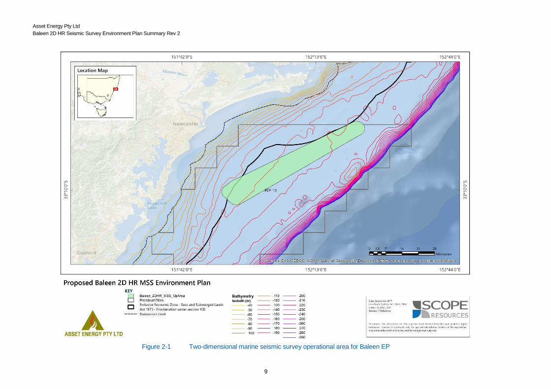
2 ACTIVITY DESCRIPTION
2.1 Location
The seismic survey will be located entirely within Permit Area PEP-11 – offshore Sydney Basin
(Figure 2.1), NSW. The larger permit area PEP-11 covers approximately 4,568 km2 and extends
approximately 120 km from Sydney to Newcastle with an average width of 50 km (Australia, 2014).
Water depths in the area of interest are expected to range between 125 and 145 m.
2.2 Operational Area
Approximate coordinates and location for the operational area of the 2D seismic site survey can be
found in Table 2-1 and Figure 2-1, respectively. The operational area covers approximately 460km2.
The high resolution survey area (Figure 2-2) lies within this operational area and predominantly
occurs within a grid of 12.25 km2 (see Section 2.4).
Table 2-1 Coordinates of the Proposed Survey Operational Area (Degrees, Minutes, Seconds
GDA94)
Survey Area Easting Northing Latitude
(Approximate)
Longitude
(Approximate)
North Point 398720 6331244 33° 09’ 10.22” S 151°54’50.28” E
East Point 401048 6328632 33° 10’ 35.80” S 151°56’19.11” E
South Point 398436 6326305 33°11’50.51” S 151° 54’37.33” E
West Point 396107 6328916 33°10’24.92” S 151°53’08.50” E
New Seaclem-1 441441 6356247 32°55’49.70” S 152°22’ 25.08” E
Coordinate system: GDA1994 UTM Grid Zone 56 Southern Hemisphere
Asset Energy Pty Ltd
Baleen 2D HR Seismic Survey Environment Plan Summary Rev 2
9
Figure 2-1 Two-dimensional marine seismic survey operational area for Baleen EP

Asset Energy Pty Ltd
Baleen 2D HR Seismic Survey Environment Plan Summary Rev 2
10
Figure 2-2 Survey Area and Proposed Line Plan
Asset Energy Pty Ltd
Baleen 2D HR Seismic Survey Environment Plan Summary Rev 2
11
2.3 Schedule
The seismic survey will operate on a 24-hour basis for three to four days and will be undertaken
between 15 March and 31 May 2018, excluding the period 23 March to 8 April surrounding Easter.
2.4 Description of Activity
The seismic survey will consist of a series of survey lines designed in a grid to be surveyed following
conventional geophysical techniques. One seismic cable (streamer) containing a series of
hydrophones will be towed behind the vessel together with only a single sound source (one airgun).
The survey is a total of 208 km acquired on a grid comprised of:
• 36 survey lines orientated in a north-west / south-east direction, with a line spacing of 100m,
• 9 survey lines oriented in a north-east / south-west direction, with a line spacing of 400m, and
• 1 survey line oriented in a north-east / south-west direction to tie the high resolution survey area to the New Seaclem-1 (2010) well location.
The high resolution survey area predominantly occurs within a grid of 12.25 km2. A single acoustic
source will be used, firing every 6.25 m and will not be fired during the line turns, but will be kept at
pressure ready to conduct the required soft start at the commencement of each line. When running
lines, the vessel will sail at a speed of 3–4 knots. It is estimated that each survey line will take
approximately 1 hour to complete (including line turns). Source configuration (Figure 2-3) will
comprise the following:
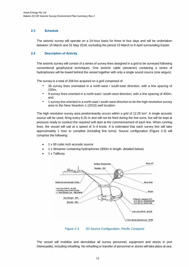
1 x 90 cubic inch acoustic source
1 x Streamer containing hydrophones (900m in length, detailed below)
1 x Tailbuoy
Figure 2-3 2D Source Configuration, Pacific Conquest
The vessel will mobilise and demobilise all survey personnel, equipment and stores in port
(Newcastle), including refuelling. No refuelling or transfer of personnel or stores will take place at sea.
Asset Energy Pty Ltd
Baleen 2D HR Seismic Survey Environment Plan Summary Rev 2
12
Airgun
The single airgun is towed by an umbilical line which is usually around 30m in length from the stern
of the vessel. The gun is attached to a gun hanger by chains of a fixed length and the hanger is
attached by ropes to a buoy. 2D data will be acquired using a single source / streamer configuration
due to the requirements of acquiring high resolution, shallow information below the seabed in the
area of interest. The configuration of the proposed survey is described below:
1 x 90 cubic inch acoustic source
High pressure air fed to the airguns is expected to be at a pressure of 2000psi.
The firing interval will be every three to four seconds, which translates to shots being
repeated approximately every 6.25 m along pre-selected traverses.
Seismic Streamer (Hydrophones)
The depth that the streamer operates at is 3 m. The depth of the streamer is controlled by units called
‘birds’, to an accuracy of +/- 1m (OGP, 2011)(OGP, 2011). One streamer of 900 m in length with a
group spacing of 6.25 m and shot point of 6.25 m will be towed from the survey vessel.
Tailbuoy
The tailbuoy is located at the rear of a streamer and will have a white flashing light.
Vessel Information
The survey will be undertaken by the survey vessel Pacific Conquest. Pacific Conquest is owned by
East Coast Maritime.
Asset Energy Pty Ltd
Baleen 2D HR Seismic Survey Environment Plan Summary Rev 2
13
3 DESCRIPTION OF THE ENVIRONMENT
3.1 Regional Setting
The Baleen Operational Area overlaps sections of the Temperate East Marine Region, which
includes all Commonwealth waters from the eastern side of Cape York to just north of the NSW–
Victoria border. It runs parallel to the coast and includes an elongate area of continental shelf ranging
in width from 10–60 km. The deepest point in the provincial bioregion is 240 m (DSEWPaC, 2012):
The Operational Area is located within the Commonwealth waters of the Central Eastern Shelf
Province and overlaps sections of the Temperate East Marine Region. The area to be surveyed lies
approximately 20 km off the coast, ~70 km north-east of Sydney, and ~30 km south-east of
Newcastle, offshore of the central coast region of NSW. A series of small terraces run parallel to the
shoreline at the shelf edge and covers over 15% of the Central Eastern Shelf Province area, which
is further characterised by the following biophysical features:
The East Australian Current (EAC) is the dominant oceanographic influence on ecosystems
in the Region. The East Australian Current’s movement along and away from the shelf
causes upwelling of nutrient-rich, cool water onto the shelf, resulting in phytoplankton growth
and increased primary production.
There is a tropical/temperate transition in the marine invertebrates found in the Region that
is most evident on the continental shelf and becomes less distinct in deeper waters off the
shelf.
Geomorphology and sediment types are the primary determinates of the distribution of
benthic organisms. Pelagic (ocean-going) species distribution is more closely linked with
variations in water masses.
The presence of internationally significant migratory routes, resident populations, breeding
and feeding grounds for a number of EPBC Act listed threatened and migratory species;
including humpback whales (Balaenoptera musculus), marine turtles, seabirds and
migratory shorebirds.
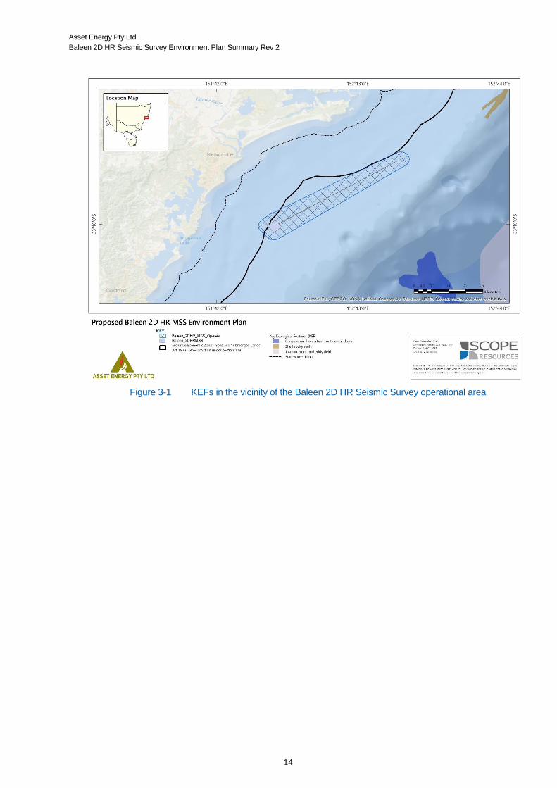
3.2 Key Ecological Features
The Operational Area does not overlap Key Ecological Features (KEF), which are elements of the
Commonwealth marine environment with regional importance for either the region’s biodiversity or ecosystem
function and integrity (DSEWPaC, 2012). However, of the eight KEFs identified in the Temperate East Marine
Region, the closest KEFs to the Baleen operational area include (Figure 3-1; Table 3-1):
1. Shelf rocky reefs (>30 km away) 2. Canyons on the eastern continental slope (>34 km away) 3. Tasman Front and eddy field (>40 km away).
Asset Energy Pty Ltd
Baleen 2D HR Seismic Survey Environment Plan Summary Rev 2
14
Figure 3-1 KEFs in the vicinity of the Baleen 2D HR Seismic Survey operational area

Asset Energy Pty Ltd
Baleen 2D HR Seismic Survey Environment Plan Summary Rev 2
15
Table 3-1 Summary of KEFs in the vicinity of the Baleen 2D HR Seismic Survey operational area
KEF Distance from
Operational Area
Values Description Environmental Concerns
Shelf rocky reefs >30 km away Unique sea-floor feature with ecological properties of regional significance
Along the continental shelf south of the Great Barrier Reef, communities
associated with the shift from algae-dominated sea-floor communities to
those dominated by attached invertebrates (including large sponges, moss
animals and soft corals). This shift generally occurs at a depth of 45 m.
These invertebrates create a complex habitat that supports a multitude of
animals including crabs, snails, worms and starfish. The habitats also contain
a diverse assemblage of bottom-dwelling fishes that show distinct patterns of
association with shelf-reef habitats.
Potential concerns include bycatch and extraction of living resources, physical habitat modification, climate change and marine debris.
Noise impacts were not identified as an environmental concern.
Canyons on the eastern
continental slope
>34 km away Unique sea‑ floor feature with ecological properties of regional significance
Canyon systems have a marked influence on the diversity and abundance of
species, driven by the combined effects of steep and rugged topography,
ocean currents, sea-floor types and nutrient availability. They significantly
contribute to the overall habitat diversity of the sea floor, by providing hard
surfaces in depth zones where soft sediment habitats prevail. Large benthic
animals such as sponges and feather stars are abundant, with particularly
high diversity found in the upper slope regions (150–700 m). Canyons also
create localised changes in productivity in the water column above them,
providing feeding opportunities for a range of species, many of which are
commercially important or threatened.
Potential concerns include bycatch and extraction of living resources, physical habitat modification, climate change, marine debris and oil and chemical pollution/contaminants (shipping).
Noise impacts were not identified as an environmental concern.
Tasman Front and eddy
field
>40 km away High productivity;
aggregations of marine
life; biodiversity and
endemism
The Tasman Front is a region of intermediate productivity that separates the
warm, nutrient-poor waters of the Coral Sea from the cold, nutrient-rich
waters of the Tasman Sea. The front is located between 27º S and 33º S,
moving north during winter and south in summer. It is associated with warm-
core eddies, a number of which are semi-permanent features.
Potential concerns include bycatch and extraction of living resources, climate change, marine debris and shipping-related oil and chemical pollution/contaminants.
Noise impacts were not identified as an environmental concern.
*Source: DSEWPaC, 2012
Asset Energy Pty Ltd
Baleen 2D HR Seismic Survey Environment Plan Summary Rev 2
16
3.3 Physical Environment
Climate, Meteorology and Oceanographic Currents
The region has a temperate climate with air temperatures ranging from 17-25ºC in summer and 9-
17ºC in winter. The dominant wind direction varies with season; moderate westerlies (7-10 knots)
predominant in the winter months, with moderate easterlies (8-12 knots) over the summer.
The oceanic currents of the study area are dominated by the influence of the East Australian Current
(EAC), the main western boundary current in the south-west Pacific and the largest ocean current
close to the coast of Australia.
The EAC starts off Queensland and forms a distinctive core boundary current off NSW (Hayes, 2005).
Within the central part of the core EAC region (~25-30°S), the current at the surface averages ~ 1ms-
1.
The current strength weakens with depth, but its effects extend down several thousand metres. The
EAC generates a series of meandering eddies, resulting in shelf-edge effects and advection of
nutrient-rich water onto the continental shelf and associated reef systems (Longhurst, 2007).
The current is strongest in summer, peaking in February, and weakest (by as much as half the flow)
in winter (Hayes, 2005). Surface current velocity and direction at the operational area is variable,
and is affected by prevailing winds, ranging from 0.5 – 1ms-1 on average.
Average sea surface temperature (SST) ranges from 18-23°C depending on season. Near seabed
temperatures average 16-17°C at 150m (CSIRO, 1996).
Bathymetry and seabed features
The survey area is located on the NSW Continental Shelf region. Surveys of the south-eastern shelf
have characterised the region as dominated by sediment flats, with isolated areas of reef, bedrock
and consolidated sediments (Bax, 2001).
The sediment flats comprise mainly relict sandy sediments - terrigenous in origin close to the coast
and becoming carbonate in origin as depth increases below 60m. Muds are uncommon (Poore,
1995)(Poore, 1995).
Bathymetric data shows no significant sea features in the area, with the sea floor sloping gently
from ~70 m to ~150 m west to east across PEP11. There are no known reefs within the area of the
proposed survey.
3.4 Biological Environment
Protected Matters Under the EPBC Act 1999
A search of the EPBC Act Protected Matters Database was undertaken to identify the likelihood of
occurrence of listed fauna within and around the Operational Area. The search resulted in the
following areas/species identified (Table 3-2):
36 listed threatened species (22 likely to occur in the survey area);
42 migratory species (23 considered likely to occur in the survey area and 23 also listed as
threatened);

Asset Energy Pty Ltd
Baleen 2D HR Seismic Survey Environment Plan Summary Rev 2
17
32 whales and other cetaceans;
No World Heritage Properties nor National or Commonwealth Heritage Places;
No Wetlands of International Importance;
No Threatened Ecological Communities;
No Critical Habitats;
No Australian Marine Parks; and
No KEFs.

Asset Energy Pty Ltd
Baleen 2D HR Seismic Survey Environment Plan Summary Rev 2
18
Table 3-2 Protected species list for the survey area
Common Name Scientific Name Migratory Threatened Status Type of Presence
Birds
Southern Royal Albatross Diomedea epomophora Vulnerable Foraging, feeding or related behaviour likely to occur within area
Northern Royal Albatross Diomedea epomophora sanfordi Endangered Foraging, feeding or related behaviour likely to occur within area
Antipodean Albatross Diomedea exulans antipodensis Vulnerable Foraging, feeding or related behaviour likely to occur within area
Gibson's Albatross Diomedea exulans gibsoni Vulnerable Foraging, feeding or related behaviour likely to occur within area
Wandering Albatross Diomedea exulans (sensu lato) Vulnerable Foraging, feeding or related behaviour likely to occur within area
Antipodean Albatross Diomedea antiposensis Vulnerable Foraging, feeding or related behaviour likely to occur within area
Lesser Frigatebird, Least Frigatebird Fregata ariel Species or species habitat likely to occur within area
Great Frigatebird, Greater Frigatebird Fregata minor Species or species habitat likely to occur within area
White-bellied Storm-Petrel (Tasman Sea), White-
bellied Storm-Petrel (Australasian) Fregetta grallaria Vulnerable Species or species habitat likely to occur within area
Southern Giant-Petrel Macronectes giganteus Endangered Species or species habitat may occur within area
Northern Giant-Petrel Macronectes halli Vulnerable Species or species habitat may occur within area
Gould's Petrel Pterodroma leucoptera Endangered Species or species habitat may occur within area
Kermadec Petrel (western) Pterodroma neglecta Vulnerable Foraging, feeding or related behaviour may occur within area
Buller's Albatross, Pacific Albatross Thalassarche bulleri Vulnerable Species or species habitat may occur within area
Shy Albatross, Tasmanian Shy Albatross Thalassarche cauta Vulnerable Foraging, feeding or related behaviour likely to occur within area
Salvin's Albatross Thalassarche cauta salvini Vulnerable Foraging, feeding or related behaviour likely to occur within area
Common Noddy Anonus stolidus Species or species habitat may occur within area
Streaked Shearwater Calonectris leucomelas Species or species habitat may occur within area
Great Skua Catharacta skua Species or species habitat may occur within area
Osprey Pandion haliaetus Species or species habitat may occur within area
Flesh-footed Shearwater Puffinus carneipes Species or species habitat likely to occur within area
Chatham Albatross Thalassarche eremita Endangered Foraging, feeding or related behaviour likely to occur within area
Campbell Albatross, Campbell Black-browed Albatross Thalassarche impavida Vulnerable Species or species habitat may occur within area
Common Sandpiper Actitis hypoleucos Species or species habitat may occur within area
Sharp-tailed Sandpiper Calidris acuminate Species or species habitat may occur within area
Red Knot, Knot Calidris canulus Endangered Species or species habitat may occur within area
Curlew Sandpiper Calidris ferruginea Critically endangered Species or species habitat may occur within area
Pectoral Sandpiper Calidris melanotos Species or species habitat may occur within area
Black-browed Albatross Thalassarche melanophris Vulnerable Species or species habitat may occur within area
White-capped Albatross Thalassarche cauta steadi Vulnerable Foraging, feeding or related behaviour likely to occur within area
Eastern Curlew, Far Eastern Curlew Numenius madagascariensis Critically
Endangered Species or species habitat may occur within area
Fairy Prion (southern) Pachyptila turtur subantartica Vulnerable Species or species habitat may occur within area
Sooty Albatross Phoebetria fusca Vulnerable Species or species habitat may occur within area
Australian Fairy Tern Sternula nereis Vulnerable Foraging, feeding or related behaviour likely to occur within area

Asset Energy Pty Ltd
Baleen 2D HR Seismic Survey Environment Plan Summary Rev 2
19
Northern Buller’s Albatross, Pacific Albatross Thalassarche bulleri platei Vulnerable Species or species habitat may occur within area
Campbell Albatross Thalassarche melanophris impavida Vulnerable Species or species habitat may occur within area
Fish
Shortpouch Pygmy Pipehorse Acentronura tentaculata Species or species habitat may occur within area
Girdled Pipefish Festucalex cinctus Species or species habitat may occur within area
Tiger Pipefish Filicampus tigris Species or species habitat may occur within area
Upside-down Pipefish, Eastern Upside-down
Pipefish, Eastern Upside-down Pipefish Heraldia nocturna Species or species habitat may occur within area
Beady Pipefish, Steep-nosed Pipefish Hippichthys penicillus Species or species habitat may occur within area
Big-belly Seahorse, Eastern Potbelly Seahorse, New
Zealand Potbelly Seahorse Hippocampus abdominalis Species or species habitat may occur within area
White's Seahorse, Crowned Seahorse, Sydney
Seahorse Hippocampus whitei Species or species habitat may occur within area
Crested Pipefish, Briggs' Crested Pipefish, Briggs'
Pipefish Histiogamphelus briggsii Species or species habitat may occur within area
Javelin Pipefish Lissocampus runa Species or species habitat may occur within area
Sawtooth Pipefish Maroubra perserrata Species or species habitat may occur within area
Red Pipefish Notiocampus ruber Species or species habitat may occur within area
Common Seadragon, Weedy Seadragon Phyllopteryx taeniolatus Species or species habitat may occur within area
Robust Ghost pipefish, Blue-finned Ghost Pipefish, Solenostomus cyanopterus Species or species habitat may occur within area
Spiny Pipehorse, Australian Spiny Pipehorse Solegnathus spinosissimus Species or species habitat may occur within area
Rough-snout Ghost Pipefish Solenostomus paegnius Species or species habitat may occur within area
Ornate Ghost pipefish, Harlequin Ghost Pipefish,
Ornate Ghost Pipefish Solenostomus paradoxus Species or species habitat may occur within area
Spotted Pipefish, Gulf Pipefish Stigmatopora argus Species or species habitat may occur within area
Widebody Pipefish, Wide-bodied Pipefish, Black
Pipefish Stigmatopora nigra Species or species habitat may occur within area
Pipefish Stigmatopora olivacea Species or species habitat may occur within area
Double-end Pipehorse, Double-ended Pipehorse,
Alligator Pipefish Syngnathoides biaculeatus Species or species habitat may occur within area
Bentstick Pipefish, Bend Stick Pipefish, Shorttailed
Pipefish Trachyrhamphus bicoarctatus Species or species habitat may occur within area
Hairy Pipefish Urocampus carinirostris Species or species habitat may occur within area
Mother-of-pearl Pipefish Vanacampus margaritifer Species or species habitat may occur within area
Mammals
Blue Whale Balaenoptera musculus Endangered Species or species habitat may occur within area
Southern Right Whale Eubalaena australis (Balaena glacialis
australis) Endangered Species or species habitat likely to occur within area
Humpback Whale Megaptera novaeangliae Vulnerable Species or species habitat known to occur within area
Sei Whale Balaenoptera borealis Vulnerable Foraging, feeding or related behaviour likely to occur within area

Asset Energy Pty Ltd
Baleen 2D HR Seismic Survey Environment Plan Summary Rev 2
20
Fin Whale Balaenoptera physalus Vulnerable Foraging, feeding or related behaviour likely to occur within area
Minke Whale Balaenoptera acutorostrata Species or species habitat may occur within area
Bryde's Whale Balaenoptera edeni Species or species habitat may occur within area
Pygmy Right Whale Caperea marginata Foraging, feeding or related behaviour likely to occur within area
Pygmy Killer Whale Feresa attenuata Species or species habitat may occur within area
Short-finned Pilot Whale Globicephala macrorhynchus Species or species habitat may occur within area
Long-finned Pilot Whale Globicephala melas Species or species habitat may occur within area
Risso's Dolphin, Grampus Grampus griseus Species or species habitat may occur within area
Dusky Dolphin Lagenorhynchus obscurus Species or species habitat may occur within area
Southern Right Whale Dolphin Lissodelphis peronei Species or species habitat may occur within area
Pygmy Sperm Whale Kogia breviceps Species or species habitat may occur within area
Dwarf Sperm Whale Kogia simus Species or species habitat may occur within area
Andrew’s Beaked Whale Mesoplodon bowdoini Species or species habitat may occur within area
Blainville’s Beaked Whale, Dense-beaked Whale Mesoplodon densirostris Species or species habitat may occur within area
Strap-toothed Beaked Whale, Strap-toothed Whale,
Layard’s Beaked Whale Mesoplodon layardii Species or species habitat may occur within area
True’s Beaked Whale Mesoplodon mirus Species or species habitat may occur within area
Killer Whale, Orca Orcinus orca Species or species habitat may occur within area
Spotted Dolphin, Pantropical Spotted Dolphin Stenella attenuata Species or species habitat may occur within area
Striped Dolphin, Euphrosyne Dolphin Stenella coeruleoalba Species or species habitat may occur within area
Long-snouted Spinner Dolphin Stenella longirostris Species or species habitat may occur within area
Rough-toothed Dolphin Steno brenadensis Species or species habitat may occur within area
Sperm Whale Physeter macrocephalus Species or species habitat may occur within area
Common Dolphin, Short-beaked Common Dolphin Delphinus delphis Species or species habitat may occur within area
Melon-headed Whale Peponocephala electra Species or species habitat may occur within area
False Killer Whale Pseudorca crassidens Species or species habitat may occur within area
Indian Ocean Bottlenose Dolphin, Spotted Bottlenose
Dolphin Tursiops aduncus Species or species habitat likely to occur within area
Bottlenose Dolphin Tursiops truncatus s. str. Species or species habitat may occur within area
Cuvier’s Beaked Whale Ziphius cavirostris Species or species habitat may occur within area
Long-nosed Fur-seal, New Zealand Fur-seal Arctocephalus forsteri Species or species habitat may occur within area
Australian Fur-seal, Australo-African Fur-seal Arctocephalus pusillus Species or species habitat may occur within area
Reptiles
Loggerhead Turtle Caretta Endangered Species or species habitat known to occur within area
Green Turtle Chelonia mydas Vulnerable Species or species habitat known to occur within area
Leatherback Turtle, Leathery Turtle Dermochelys coriacea Endangered Species or species habitat known to occur within area
Hawksbill Turtle Eretmochelys imbricata Vulnerable Species or species habitat known to occur within area
Flatback Turtle Natator depressus Vulnerable Species or species habitat known to occur within area
Yellow-bellied Seasnake Pelamis platurus Species or species habitat may occur within area
Sharks and Rays
Asset Energy Pty Ltd
Baleen 2D HR Seismic Survey Environment Plan Summary Rev 2
21
Shortfin Mako, Mako Shark Isurus oxyrinchus Species or species habitat likely to occur within area
Longfin Mako Isurus paucus Species or species habitat likely to occur within area
White Shark, Great White Shark Carcharodon carcharias Vulnerable Breeding known to occur within area
Whale Shark Rhincodon typus Vulnerable Species or species habitat may occur within area
Grey Nurse Shark Carcharias taurus (east coast
population)
Critically
Endangered Species or species habitat likely to occur within area
Porbeagle, Mackerel Shark Lamna nasus Species or species habitat likely to occur within area
Reef Manta Ray, Coastal Manta Ray, Inshore Manta
Ray, Prince Alfred’s Ray, Resident Manta Ray Manta alfredi Species or species habitat likely to occur within area
Giant Manta Ray, Chevron Manta Ray, Pacific Manta
Ray, Pelagic Manta Ray, Oceanic Manta Ray Manta birostris Species or species habitat may occur within area
Asset Energy Pty Ltd
Baleen 2D HR Seismic Survey Environment Plan Summary Rev 2
22
Benthic Communities
Habitat studies in southern NSW and Victoria have shown that the composition of benthic communities to be
related to sediment composition (Bax, 2001; Jordan Davies, 2010), with the majority of the survey area composed
of medium grained sand.
The majority of animals associated with the sediment type found in the survey area occur as infauna, with low
densities of larger sessile epifauna, such as sponges, ascidians, bryozoans gorgonians and sea whips (Jordan
Davies, 2010) along with intermittent high density congregations of crinoids (Zann, 2000). The benthic habitat may
also support the presence of bentho-pelagic fish and cephalopods in low densities.
Crustaceans, including Paneaus plebejus (king prawn), Metapenaeus macleayi (school prawn) Haliporoides
sibogae (royal red prawn) and M. bennettae (greasy back prawns) may occur in the area, and are potentially
targets of the NSW Ocean trawl fishery. The eastern rock lobster (Jasus vereauxi) is also known to occur in the
region and is targeted by state fisheries.
Reptiles
Five marine turtle species were identified on the EPBC protected matters search as species that are migratory
and ‘known to occur’ in the proposed survey area. There are resident groups of hawksbill (Eretmochelys
imbricata), loggerhead (Caretta caretta) and green turtles (Chelonia mydas) in the waters of northern NSW (EA,
2003). Under the EPBC Act, leatherback (Dermochelys coriacea) and loggerhead turtles are listed as
Endangered, while green, hawksbill and flatback (Natador depressus) turtles are listed as Vulnerable (DOE,
2014a). However, the survey area does not overlap with any known biologically important areas (BIA) for marine
turtles, the closest of which is the loggerhead turtle BIA at >400 km away.
3.4.3.1 Green Turtles
Green turtles (C. mydas) are mostly associated with inshore areas of algae and seagrass, as their generalised
diet is primarily herbivorous, although pelagic juveniles feed on algae, pelagic crustaceans and molluscs (DOEE,
2017; Limpus, 2008b). Given the location and depth of the proposed survey area, it is unlikely to provide a suitable
feeding habitat for green turtles. While the species distribution range overlaps with the survey area, the survey
area does not overlap with foraging, nesting or internesting BIAs for green turtles (DOEE, 2017). Of the nine
genetically-distinct stocks in Australia, the Southern Great Barrier Reef stock has the closest nesting sites to the
survey area, which is >840 km away.
3.4.3.2 Loggerhead Turtles
Loggerhead turtles are found in the waters of coral and rocky reefs, seagrass beds and muddy bays throughout
eastern, northern and western Australia (DOE, 2014b; DOtE, 2014c). While nesting on the east coast of Australia
is concentrated in southern Queensland, foraging areas are more widely distributed and may extend into NSW
(Limpus, 2008a). Loggerhead turtles are thought to feed in near shore habitat to 50-60m in depth. Given the
location and depth of the proposed survey area it is unlikely to provide a suitable feeding habitat for loggerhead
turtles.
3.4.3.3 Hawksbill Turtles
Juvenile hawksbill turtles (E. imbricata) spend their first five to ten years drifting on ocean currents (DOE, 2014b;
DOtE, 2014c). Adult turtles settle and forage primarily in tropical tidal and sub-tidal coral and rocky reef habitat,
and occasionally seagrass meadows, where they feed on sponges and algae (Limpus, 2009a). Given the location
and depth of the proposed survey area it is unlikely to provide a suitable feeding habitat for adult hawksbill turtles.
Hawksbill turtles have been observed in temperate regions including the deeper habitats of trawl fisheries as far
south as northern NSW (Limpus, 2009a) and are known to cover large distances between breeding and feeding
grounds, and so may occur in the area.
3.4.3.4 Leatherback Turtles

Asset Energy Pty Ltd
Baleen 2D HR Seismic Survey Environment Plan Summary Rev 2
23
Leatherback turtles (D. coriacea) are pelagic and are found in all regions of the Australian coast including NSW.
This species may traverse and forage in the waters at and surrounding the proposed site, however they are
thought to concentrate feeding activity in areas of upwelling or convergence associated with steeply sloping
bathymetry (DOE, 2014a; Limpus, 2009b). Nesting occurs in eastern Australia in summer between December
and January (Limpus, 2009b), however there are no significant rookeries in Australia (DOE, 2014a; DOE, 2014).
Scattered nesting has been reported along the south Queensland coast from Bundaberg to Round Hill Head and
along the coast of Arnhem Land from Coburg Peninsula to Maningrida, including Crocker Island. Some nesting in
the past has occurred in northern NSW near Ballina, approximately 400 km north of the proposed survey area
(DOE, 2014a).
3.4.3.5 Flatback Turtles
Flatback turtles (N. depressus) are endemic to Australia, and are concentrated in the northern regions of Australia
(DOE, 2014a; Limpus, 2007). On the East coast, no significant nesting areas are located south of the Queensland
region (DOE, 2014b); DOtE, 2014c). Flatback turtles feed primarily in shallow soft bottom inshore habitats. Given
the location and depth of the proposed survey area it is unlikely to provide a suitable feeding habitat for flatback
turtles.
3.4.3.6 Seasnake
The yellow bellied seasnake (Pelamus platurus) may occur in the area of operation. It is listed under the EPBC
ACT, however is not threatened. It is a pelagic feeder, and is often found associated with areas of calm water and
marine debris (Kropach, 1971).
Fish Populations
A search of the EPBC Act Protected Matters Database listed 23 fish species and 3 species of sharks of national
environmental significance that may occur in, or may relate to the survey area (Table 3-2).
A number of bony fish groups occur along the coast of NSW ranging from shallow demersal territorial species,
such as gobies (Gobiidae), damselfishes (Pomacentridae) and pipefish (Syngnathidae) to oceanic piscivorous fish
such as striped marlin (Tetrapturus audax), yellowfin tuna (Thunnus albacares) and swordfish (Xiphias gladius)
(CSIRO, 2009). Table 3-3 represents an example of bony fish groups and the most dominant species which are
likely to occur within the vicinity of the survey area.
Table 3-3 Bony fish groups and their associated functional groups that may occur in the vicinity of the survey area
Functional Group1 Dominant Fish Species
Shallow pelagic small planktivorous Anchovy (Engraulis australis), pilchard (Sardinops neopilchardus) and whitebait (Hyperlophus vittatus, Spratelloides robustus)
Shallow pelagic large planktivorous Mackerel species (Scomber australiasicus, Scomberomorus spp.) and yellowtail kingfish (Seriola
lalandi)
Shallow pelagic piscivorous Australian salmon (east) (Arripus trutta), barracouta (Thyrsites atun), tailor (Pomatomus saltatrix),
snook/barracuda (Sphyraena novaehollandiae), dolphinfish (mahi mahi), yellowtail kingfish (Seriola
lalandi), mulloway (Argyrosomus hololepidotus), teraglin (Atractoscion aequidens), mackerel
(Spanish & spotted) (Scomberomorus commerson, Scomberomorus munroi), mackerel tuna
(Euthynnus affinis), bonito (Sarda australis)
Deep demersal Mirror dory (Zenopsis nebulosus), hapuku (Polyprion oxygeneios), painted gurnard (Pterygotrigla
andertoni), long-finned gemfish (Rexea antefurcata), silverside (Argentina australiae), whiptails (family
Macrouridae, various sp), cardinalfish (family Berycidae,various sp), spiny flathead (Hoplichthys
haswelli)
Oceanic piscivorous Leadenall (frigate mackerel or tuna) (Auxis thazard), skipjack tuna (Katsuwonus pelamis), yellowfin
tuna (Thunnus albacares), Southern bluefin tuna (Thunnus maccoyii), striped marlin (Tetrapturus
audax), blue marlin (Makaira mazara), swordfish (Xiphias gladius).
Source; Ecological sustainable development of the regional marine and estuarine resources of NSW: Modelling of the NSW continental shelf ecosystem.
CSIRO, March 2009.
1 Functionally grouped according to habitat, predators and prey, growth characteristics and movement patterns (CSIRO, 2009) * Key secondary species.

Asset Energy Pty Ltd
Baleen 2D HR Seismic Survey Environment Plan Summary Rev 2
24
A number of fish species are targeted by both state and commonwealth fisheries including ‘Ocean Trap and Line’
(OTLF), Trawl fisheries (including the commonwealth trawl sector of the South East Shark and Scalefish) and the
Eastern Tuna and Billfish Fishery (AFMA, 2014). Several species of shark are also targeted, either as a primary
or secondary species by the NSW trawl fisheries.
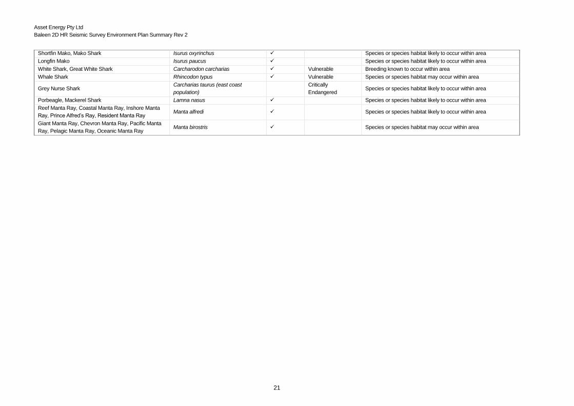
Six species of shark and one species of manta ray protected under the EPBC Act may occur within the vicinity of
the survey area (Table 3-4). Two of these species are listed as Vulnerable [great white (Carcharodon carcharias)
(refer Figure 3-2 for BIA) and the whale shark (Rhincodon typus)], with six species listed as Migratory, including
the giant manta ray (Manta birostris) (Table 3.3). The grey nurse shark (Carcharias Taurus) east coast population
is listed as being Critically Endangered.
Table 3-4 Shark and Ray species listed under the EPBC Act
3.4.4.1 Great white sharks (Carcharodon carcharias)
Distribution includes coastal waters of NSW (refer Figure 3-2), with evidence suggesting that juveniles appear to
aggregate seasonally in the coastal region between Newcastle and Forster (DSEWPaC, 2013c). Satellite
telemetry suggests that juvenile white sharks were resident in the Port Stephens region of central NSW from late
winter to spring and the Corner Inlet region of eastern Victoria from summer to autumn (B.D. Bruce, 2008)
corresponding with historical catches from shark control programs in NSW (1950-1993) suggesting a peak from
September to November (DSEWPaC, 2013c).
Common Name Scientific Name Migratory Threatened
Status
Type of Presence
Shortfin mako shark Isurus oxyrinchus
Species or species habitat likely to occur
within area
Great white shark Carcharodon carcharias Vulnerable Breeding known to occur within area
Longfin Mako Isurus paucus Species or species habitat likely occur
within area
Whale shark Rhincodon typus Vulnerable Species or species habitat may occur
within area
Grey nurse shark Carcharias taurus (east
coast population) Critically Endangered
Species or species habitat likely to occur
within area
Porbeagle, mackerel shark Lamna nasus Species or species habitat likely to occur
within area
Giant manta ray,
Chevron/Pacific/pelagic
/oceanic manta ray
Manta birostris Species or species habitat likely to occur
within area
Reef manta ray.
Coastal/Inshore/ Prince
Alfred’s/Resident manta ray
Manta alfredi Species or species habitat likely to occur
with area

Asset Energy Pty Ltd
Baleen 2D HR Seismic Survey Environment Plan Summary Rev 2
25
Figure 3-2 Great white shark BIA overlap with Operational Area
3.4.4.2 Shortfin mako (Isurus oxyrinchus)
The shortfin mako (Isurus oxyrinchus) are widespread in Australian waters (DSEWPaC, 2012c) including the
entire NSW coast and occur in surface waters to depths of at least 650 m (NSW, 2008/09). Shortfin mako are
recorded as giving birth off NSW around November (NSW, 2008/09).
3.4.4.3 Longfin mako (Isurus paucuss)
The longfin mako (Isurus paucus) is an epipelagic species with a usual depth range between 120 and 240 metres.
Longfin mako sharks were only confirmed from Australian waters in 1995, with north-eastern waters considered
a locally important region (DSEWPaC, 2012c). Within the region, it is known to occur south to at least Port
Stephens in New South Wales.
3.4.4.4 Porbeagle sharks (Lamna nasus)
Porbeagle sharks (Lamna nasus) are wide-ranging, inhabiting subtropical and temperate waters of the North
Atlantic and Southern hemisphere (DSEWPaC, 2012c). They are typically found in oceanic waters on the
continental shelf and occasionally in coastal waters. Little data exist for southern hemisphere populations;
however, some studies suggest that in Australian and New Zealand waters, birthing peaks June-July (winter),
which contrasts with studies from the North Atlantic which suggest that porbeagles give birth in spring-summer
(Francis & Stevens, 1999).
3.4.4.5 Whale sharks (Rhincodon typus)
Whale sharks are listed as migratory and vulnerable under the EPBC Act. There are no identified BIAs for the
whale shark in the vicinity of the survey area. Given the lack of associated reef systems and upwelling particular
to the area of proposed operation, it is unlikely that whale sharks will be encountered.
3.4.4.6 Giant Manta Ray (Manta birostris)
Asset Energy Pty Ltd
Baleen 2D HR Seismic Survey Environment Plan Summary Rev 2
26
The giant manta ray (Manta birostris) is listed as a migratory species and protected under the EPBC Act. It is
classified as vulnerable on the IUCN Red List of threatened species and has been identified as potentially
occurring within the survey area. Little is known about this ray except that it is elusive and potentially migratory. In
Australia they have been recorded from south-west, Western Australia around the tropical north of the country to
the southern coast of NSW (IUCN, 2014) and sometimes migrate into temperate waters (Williams & Williams,
2014). It is reasonable to surmise that they may be present within the survey area. However, their presence would
not be expected in significant numbers and would most likely occur while transiting to preferred habitats or feeding
grounds.
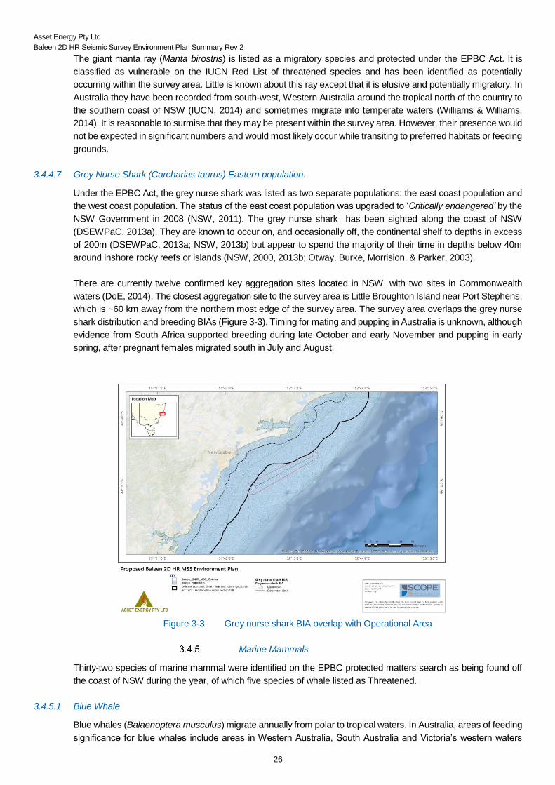
3.4.4.7 Grey Nurse Shark (Carcharias taurus) Eastern population.
Under the EPBC Act, the grey nurse shark was listed as two separate populations: the east coast population and
the west coast population. The status of the east coast population was upgraded to ‘Critically endangered’ by the
NSW Government in 2008 (NSW, 2011). The grey nurse shark has been sighted along the coast of NSW
(DSEWPaC, 2013a). They are known to occur on, and occasionally off, the continental shelf to depths in excess
of 200m (DSEWPaC, 2013a; NSW, 2013b) but appear to spend the majority of their time in depths below 40m
around inshore rocky reefs or islands (NSW, 2000, 2013b; Otway, Burke, Morrision, & Parker, 2003).
There are currently twelve confirmed key aggregation sites located in NSW, with two sites in Commonwealth
waters (DoE, 2014). The closest aggregation site to the survey area is Little Broughton Island near Port Stephens,
which is ~60 km away from the northern most edge of the survey area. The survey area overlaps the grey nurse
shark distribution and breeding BIAs (Figure 3-3). Timing for mating and pupping in Australia is unknown, although
evidence from South Africa supported breeding during late October and early November and pupping in early
spring, after pregnant females migrated south in July and August.
Figure 3-3 Grey nurse shark BIA overlap with Operational Area
Marine Mammals
Thirty-two species of marine mammal were identified on the EPBC protected matters search as being found off
the coast of NSW during the year, of which five species of whale listed as Threatened.
3.4.5.1 Blue Whale
Blue whales (Balaenoptera musculus) migrate annually from polar to tropical waters. In Australia, areas of feeding
significance for blue whales include areas in Western Australia, South Australia and Victoria’s western waters
Asset Energy Pty Ltd
Baleen 2D HR Seismic Survey Environment Plan Summary Rev 2
27
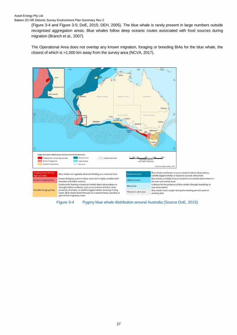
(Figure 3-4 and Figure 3-5; DoE, 2015; DEH, 2005). The blue whale is rarely present in large numbers outside
recognised aggregation areas. Blue whales follow deep oceanic routes associated with food sources during
migration (Branch et al., 2007).
The Operational Area does not overlap any known migration, foraging or breeding BIAs for the blue whale, the
closest of which is >1,000 km away from the survey area (NCVA, 2017).
Figure 3-4 Pygmy blue whale distribution around Australia (Source DoE, 2015)

Asset Energy Pty Ltd
Baleen 2D HR Seismic Survey Environment Plan Summary Rev 2
28
Figure 3-5 Pygmy blue whale migration routes (Source: DoE, 2015)
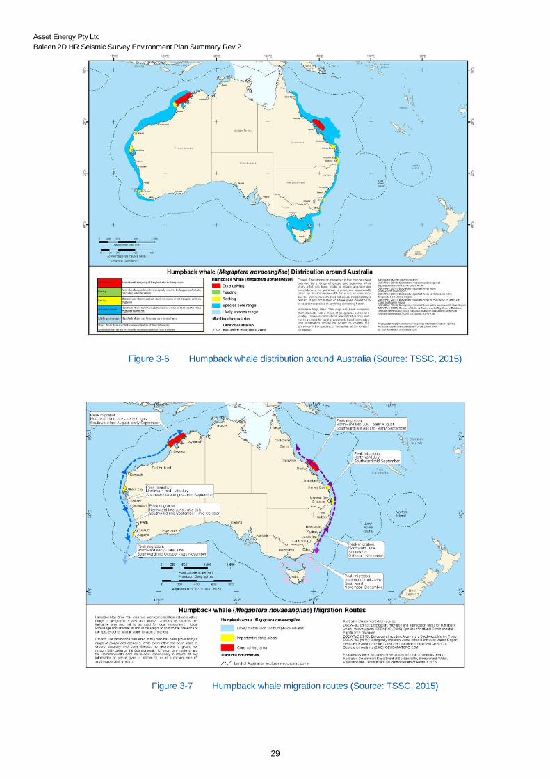
3.4.5.2 Humpback Whale
The humpback whale (Megaptera novaeangliae) is listed as a cetacean, and as a threatened and migratory
species under the EPBC Act. Peak humpback whale northern migration along Australia’s eastern coastline is June
–July), and the southward migration to Antarctic waters is around August–September (DSEWPaC, 2010; DEH,
2005a). During the northern migration humpbacks travel close to the coast (within 0–9 km), while the southern
migratory paths are more widespread and show significant variation (Advent/RPS EP Reference, 2010). The
survey area overlaps the humpback whale migration BIA only, and there are no known breeding, feeding or resting
BIAs within or adjacent to the survey area (TSSC, 2015; Figure 3-6, Figure 3-7, and Figure 3-8).
Asset Energy Pty Ltd
Baleen 2D HR Seismic Survey Environment Plan Summary Rev 2
29
Figure 3-6 Humpback whale distribution around Australia (Source: TSSC, 2015)
Figure 3-7 Humpback whale migration routes (Source: TSSC, 2015)

Asset Energy Pty Ltd
Baleen 2D HR Seismic Survey Environment Plan Summary Rev 2
30
Figure 3-8 Humpback whale BIA overlap with Operational Area
3.4.5.3 Other Cetaceans
Bryde's Whale
The Bryde’s whale (Balaenoptera edeni) is known to migrate seasonally and is generally found in temperate to
tropical waters in depths ranging from 200m to 1000m. The species is most commonly limited to the 200m depth
isobar (DSEWPaC, 2012). Bryde’s whales have been recorded in all areas of Australia however no specific
breeding or feeding grounds have been found within Australia (DSEWPaC, 2012). Due to the depth range of the
Operational Area, and absence of any known aggregation areas, it is unlikely Bryde’s whales would be present in
significant numbers, though isolated individuals may transit the area.
Minke Whale
The dwarf minke whale (Balaenoptera acutorostrata) and the subspecies Antarctic minke whale (Balaenoptera
bonaerensis) have been recorded in all state waters (except the Northern Territory) and in Commonwealth waters
up to north Queensland (DSEWPaC, 2009). They are listed as Migratory under the EPBC Act. While Minke
Whales may be present in the survey area, they will likely be only one or two individuals transiting the area.
Southern Right Whale
In Australia, southern right whales have been recorded in the coastal waters of all States (with the exception of
the NT). Sydney is thought to mark the northern extent of the Southern right whale migration path, though
sightings have been made as far north as Cape Byron (Bannister et al., 2001). The closest known calving area is
Eden, approximately 400 km south of the survey area (DEH, 2005).
Pygmy Right Whale
The pygmy right whale is found throughout the southern hemisphere temperate and sub-Antarctic waters. Few or
no records are available for NSW (DOtE, 2013a), but pygmy right whales have primarily been recorded in areas
associated with upwelling and with high zooplankton abundance (Kemper, 2002). There are no known
reproductive behaviours that may make pygmy right whales specifically vulnerable to threatening processes.

Asset Energy Pty Ltd
Baleen 2D HR Seismic Survey Environment Plan Summary Rev 2
31
Pygmy right whales are found all year round in temperate Australian waters and there are no known areas of
significance for this species in the region.
Killer Whales
Killer whales (Orcinus orca) prefer deep, cold waters (Bannister et al., 1996) and have been recorded along
continental slopes (DSEWPaC, 2012). The species is found throughout the world’s oceans and recorded in all
areas of Australia. They appear to travel seasonally according to prey availability, and it is likely they will be found
in close proximity to populations of pinnipeds (Bannister et al., 2001). Given the distance from the nearest
significant seal breeding area or haul-out site, the presence of Killer whales in the survey area is considered
unlikely.
Dusky Dolphin
Dusky dolphins (Lagenorhynchus obscurus) occur mostly in temperate and sub-Antarctic zones. They occupy
primarily inshore habitats, but may be found in pelagic waters at times. There are no key localities known in
Australian waters (Bannister et al., 2001).
Other Dolphins
Other marine mammal species that have widespread or temperate deepwater distributions may also occur in the
area in small numbers. These include:
Spotted Dolphin (Stenella attenuata);
Risso's Dolphin (Grampus griseus);
Common Dolphin (Delphinus delphis);
Striped Dolphin (Stenella coeruleoalba);
Long-snouted Spinner Dolphin (Stenella longirostris);
Rough-toothed Dolphin (Stenella bredanensis);
Indo-Pacific Humpback Dolphin (Sousa chinensis);
Bottlenose Dolphin (Tursiops truncatus s. str.); and
Indian Ocean Bottlenose Dolphin (Tursiops aduncus).
Bottlenose dolphins are common and are found around the Australian coastline, from estuaries to the open ocean
(Figure 3-9). Common dolphins are found in offshore waters. While they have been recorded in waters off all
Australian states and territories, they appear to occur in two main southern locations, with one cluster in the south-
eastern Indian Ocean and another in the Tasman Sea (DEWHA, 2008). The area of Australian occupancy of
Risso’s dolphins, spotted dolphins and dusky dolphins cannot be accurately determined due to the scarcity of
sighting records for large proportions of their expected ranges (DEWHA, 2008). They are, however, likely to be
rare species that are infrequently encountered, if ever, within the survey area.

Asset Energy Pty Ltd
Baleen 2D HR Seismic Survey Environment Plan Summary Rev 2
32
Figure 3-9 Indian Ocean Bottlenose Dolphin BIA overlap with Operational Area
Source: National Conservation Values Atlas
Seals
There are no known breeding colonies of either the Australian fur seal (Arctocephalus pusillus doriferus) or the
New Zealand fur seal (Arctocephalus forsteri) in the East Marine Region (DEWHA, 2009). Montague Island is the
major haul-out site along the coast of NSW for both species (Shaughnessy, 1999). Montague Island is located
more than 300 km south of the survey area.
Seabirds and shorebirds
The EPBC Act Protected Matters Search found 35 avifauna species, of which 24 are listed as Vulnerable or
Endangered, and 2 as Critically Endangered (Table 3-2). The nearest known breeding ground for any of the
birds listed is located 60 km north of the proposed survey area. However, the survey area overlaps a small
section of the large foraging BIAs for five avifauna species (Figure 3-10, Figure 3-11 and Figure 3-12):
Antipodean albatross (Vulnerable);
Black petrel (Marine);
Flesh-footed shearwater (Migratory;)
Short-tailed shearwater (Marine); and
Sooty shearwater (Marine).

Asset Energy Pty Ltd
Baleen 2D HR Seismic Survey Environment Plan Summary Rev 2
33
Figure 3-10 Antipodean albatross BIA overlap with Operational Area
Figure 3-11 Black petrel BIA overlap with Operational Area

Asset Energy Pty Ltd
Baleen 2D HR Seismic Survey Environment Plan Summary Rev 2
34
Figure 3-12 Flesh footed shearwater BIA overlap with Operational Area
Figure 3.12 A Short-tailed shearwater BIA overlap with Operational Area

Asset Energy Pty Ltd
Baleen 2D HR Seismic Survey Environment Plan Summary Rev 2
35
Figure 3.12 B Sooty shearwater BIA overlap with Operational Area
3.5 Socio-Economic Environment
The nearest major population centre to the area of operation is Newcastle, approximately 28 km inshore from the
main part of the survey area and Sydney (~80 km) to the south.
Commercial Fisheries
Waters off the coast of NSW in the vicinity of the survey area are managed by both Commonwealth and State
fisheries.
3.5.1.1 Commonwealth Fisheries
The Australian Fisheries Management Authority (AFMA) is responsible for the efficient management and
sustainable use of Australia’s Commonwealth fisheries resources (AFMA, 2014a)(AFMA, 2014a).
A search undertaken by AFMA have listed two fisheries as being active within the survey area;
Commonwealth Trawl Sector of the South East Shark and Scalefish Fishery (SESSF); and
Eastern Tuna and Billfish Fishery (ETBF).
The Commonwealth trawl sector (CTS) of SESSF covers the area of the Australian Fishing Zone (AFZ) extending
southward from Barranjoey Point (north of Sydney) around the NSW, Victorian and Tasmania coastlines to Cape
Jervis in South Australia (AMFA, 2014a). It is therefore unlikely that fishers from this industry would occur within
the vicinity of the survey area. The Eastern Tuna and Billfish Fishery extends from Cape York, Queensland to the
South Australian / Victorian Border. Fishing occurs in both the Australian Fishing Zone (AFZ) and the adjacent
high seas (AFMA, 2014a).
3.5.1.2 State Fisheries
Significant commercial fishing activity occurs in the proposed survey area (DPI, 2016), including line fishing
(rod/handline and setline), trapping (lobster and fish), and trawling (fish and prawn).

Asset Energy Pty Ltd
Baleen 2D HR Seismic Survey Environment Plan Summary Rev 2
36
The proposed survey activities may overlap with the following fisheries and share classes:
Ocean Trap and Line Fishery
o Demersal fish trapping
o Line fishing western zone (<180 m depth)
o Line fishing eastern zone (<180 m depth)
Ocean Trawl Fishery:
o Offshore prawn trawl
o Deepwater prawn trawl
o Fish trawl northern zone
Lobster Fishery (lobster trapping).
Asset Energy recognises the economic importance of catches in the periods leading up to peak seafood
consumption periods including Christmas and Easter each year, and has scheduled the survey to avoid these
times.
Asset Energy has identified that the Operational Area overlaps a highly-profitable and viable fishing region, which
was colloquially named “the Farm” (Figure 3-13). However, stakeholders informed Asset Energy that adverse
impacts were not and would not be recorded on Logbook Return Records, as fishers move fishing efforts
elsewhere.
Figure 3-13 Operational Area overlap with an important fishing region (“the Farm”)
Commercial Shipping
Newcastle and Sydney Harbour, along with Botany Port comprise the major ports in the region of the greater
Asset Energy Pty Ltd
Baleen 2D HR Seismic Survey Environment Plan Summary Rev 2
37
permit area. Approximately 10% of the total shipping traffic entering the Port of Newcastle arrives from the south,
therefore it is expected that ships pass through the survey area on transit to and from the Port of Newcastle. It is
also likely that the survey area falls within potential shipping approaches to the Port of Newcastle given the volume
of shipping traffic in and out of the port.
3.5.2.1 Port of Newcastle
The Port of Newcastle receives approximately 5,000 vessel movements annually and is one of the largest coal
ports in the world. There are no designated anchor points within the approaches to the port (pers.com Port of
Newcastle, Wayne Mabbott, Paul Thomas, NSW Port Authority). It is very unlikely that vessels at anchor will be
located within the area of operation due to the distance offshore and depth (i.e. >12 nm (22.2 km)) the depth
becomes too deep to anchor. However, it is possible that vessels on standby may drift into the vicinity of the survey
location.
Cultural and National Heritage
Under the EPBC Act protected matters report, no world heritage properties or national heritage places are listed
as occurring within the vicinity of the survey area.
Tourism and Recreational Fishing
Advice from the NSW DPI (2017) stated that recreational fishing (e.g. stationary, drifting and trolling line fishing)
occurs regularly within the Operational Area. The fishing includes both private recreational and commercial charter
fishing. There are estimated to be 150,000 recreational fishers in the Hunter region, and the most popular time for
fishing is mid-December through to mid-April (peak from January–March), with more activity over the Christmas
and Easter holidays. Peak game fishing activity is usually from February–March, with slightly less activity in both
January and April. An important area for game fishing is the ‘carpark’, which encompasses a relatively large area
(from GPS coordinates 33.02 S and 152.24 E), which is 10 km south of the New Seaclem-1 location. NSW DPI
(2017) confirmed that the carpark area can move around 10 nm in either direction. The following fishing
tournaments are scheduled for 2018 within/around the ‘carpark’ area (DPI 2017):
Bigfish Bonanza - Lake Macquarie 9-11 Feb
The Billfish Shootout - Port Stephens 16-18 Feb
Port Stephens Interclub 23-26 Feb
East Coast Classic - Newcastle 10-11 March.
Recreational fishers in the vicinity of the proposed survey area operate from both Newcastle and Port Stephens
on a year-round basis (Davis, 2014). Within the vicinity of the area of operation there are currently 10 fish charter
businesses currently licenced to operate. Seasonal peaks are likely to occur during the summer months due to
improved weather conditions and increased visitor numbers to the region, especially during holiday periods, i.e.
Christmas and Easter. Fish attraction devices (FAD) are utilised in NSW. Two FADs are anchored to the sea floor
via a floating buoy beyond the boundary of the Operational Area (Figure 3-13). The Newcastle FAD is >15 km
away, while the Swansea FAD is 3.5 km away from the Operational Area boundary and 5.5 km from the closest
survey line. These FADs are usually deployed between 1st November and 30th June (DPI, 2014), so would be in
place during the period of the survey.
Given the lack of significant seabed features in the area of operation, the distance from shore and the extent to
which recreational fishers can utilise the ocean, high levels of recreational fishing are not expected to occur within
the vicinity of the survey area.
Port Stephens has a year-round dolphin watching industry, which conducts approximately four tours a day during
winter and six during the summer months when the number of visitors to the region increase and weather
conditions improve. These tours operate within the bay and do not extend into offshore waters (Davis, 2014).
Further to this whale watching tours also operate in the region between May to November, with an average of
three to four tours a day depending upon visitor numbers and weather conditions. The duration of these tours (~
Asset Energy Pty Ltd
Baleen 2D HR Seismic Survey Environment Plan Summary Rev 2
38
2.5 – 3.5 hours) will most likely act to limit the distance travelled offshore (visitnewcastle, 2014). While there is the
possibility that some whale tours may venture into the region of operation, it is unlikely that significant numbers
will be encountered, especially considering that the survey will not occur during peak whale migration season.
Other marine related activities including recreational diving, kayak tours and surf lessons, both of these latter two
activities are beach / nearshore activities (visitnewcastle, 2014). No recreational diving is expected to occur in the
vicinity of the survey area due to the lack of significant seabed features and that the water depth far exceeds the
limitations applied to recreational divers to reach the seabed.
3.6 Values and Sensitivities
Marine Protected Areas
There are no marine protected areas or Australian Marine Parks within the proposed survey location. The closest
Australian Marine Park is the Hunter Marine Reserve, which is 24 km away from the Operational Area. The
closest marine protected area is the Port Stephens – Great Lakes Marine Park, which is located approximately 30
km from the northern most point of the Operational Area.
Wetlands of International Importance (Ramsar Wetlands)
Ramsar Wetland sites and a Marine Reserve are located in the region of the survey area (the Hunter Estuary
Wetlands and Myall Lakes to the north and Towra Point Nature Reserve to the south (DOtE, 2010)). However,
the nearest site is > 25 km from the northern most point of the Operational Area and is not affected by the survey.
Particular Issues or Sensitivities (Other Marine Values)
The Operational Area overlaps with migratory routes for humpback whales; however, the survey will occur outside
the peak migratory season. Further to this, there are no bathymetric features that could obstruct or enclose
transiting individuals and there are no areas of particular significance (feeding, calving or resting) for humpback
whales in the vicinity of the Operational Area.
Both state and commercial fishers utilise the region, including lobster fishers. Effort in lobster catch (and potentially
prawn) may peak prior to the Christmas period and again prior to Easter (i.e. during the latter days of March).
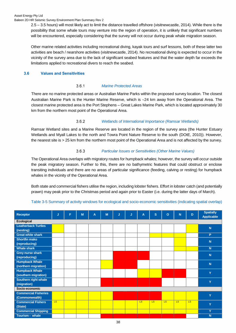
Table 3-5 Summary of activity windows for ecological and socio-economic sensitivities (indicating spatial overlap)
Receptor J F M A M J J A S O N D Spatially
Applicable
Ecological
Leatherback Turtles
(nesting)
N
Great white shark P
Shortfin mako
(reproducing)
N
Whale shark N
Grey nurse shark
(reproducing)
N
Humpback Whale
(northern migration)
N
Humpback Whale
(southern migration)
Y
Southern right whale
(migration)
Y
Socio-economic
Commercial Fisheries
(Commonwealth)
Y
Commercial Fishers
(State)
LS LS LS LS LS LS
Y
Commercial Shipping Y
Tourism - whale N

Asset Energy Pty Ltd
Baleen 2D HR Seismic Survey Environment Plan Summary Rev 2
39
watching tours
Tourism -
Recreational Fishing
U
Code
U Unlikely to occur within the survey area
P Possibility of spatial overlap (individuals may be encountered within the survey area).
Y Yes - spatial overlap occurs – effects controlled through mitigation controls
Seasonality legend (months are indicative only)
Species likely to be present with year to year variability / activity occurs year-round. LS – Lobster Spawning (October /
November represent peak spawning)
Seasonal Peaks (presence of animals reliable and predictable each year / peak in activity i.e. peak catch rates)
Asset Energy Pty Ltd
Baleen 2D HR Seismic Survey Environment Plan Summary Rev 2
40
4 ENVIRONMENTAL IMPACTS AND RISK EVALUATION METHODOLGY
4.1 Risk Assessment Methodology
The methodology used to evaluate the potential environmental effects arising from the proposed survey has been
derived in accordance with the principles laid down in international standards (AS/NZS ISO 31000 and ISO 14001)
and guidelines for ecological impact assessment, such as those designed for the marine and coastal environment
of Britain and Ireland (UK Institute of Ecology and Environmental Management – IEEM).
The risk assessment process consisted of the following steps:
Environmental Hazard Identification –establishing a comprehensive list, definition and description of
hazards association with the activity;
Risk Analysis – assessment of potential environmental impact(s) on each receptor (values and
sensitivities) identified;
Consequence Ranking – ranking the level of inherent consequence of each hazard prior to the
introduction of any control measures.
Impact Management – development of environmental performance outcomes, performance standards,
and measurement criteria to reduce (or eliminate) the level of risk to acceptable, ALARP levels.
Demonstration of ALARP and Acceptability – presentation of supporting information to demonstrate that
environmental consequences following the implementation of control measures, will be of an acceptable
level and that further control measures would not substantially reduce the impact without being grossly
disproportionate.
Post-Control Ranking – ranks the level of environmental consequence of each hazard with management
controls in place (referred to as the residual risk).
Risk Monitoring, Review and Reporting – process in which control measures are implemented reviewed
and reported to ensure control measures are adequate to maintain an acceptable level (ALARP).
Running in parallel with the above procedure is a consultation process in which targeted individuals,
organisations or groups who may either have useful contributions to the technical assessment / existing
environment or who may have views on the project or its potential impact on the marine environment (including
social and economic), were included.
4.2 Quantification of the Level or Risk
A Risk Analysis Matrix (RAM) in line with international standards is used by Asset Energy. The RAM standardises
qualitative risk assessment and facilitates the categorisation the environmental risk associated with this seismic
survey activity. Information from the consultation process is incorporated.
Asset Energy Pty Ltd
Baleen 2D HR Seismic Survey Environment Plan Summary Rev 2
41
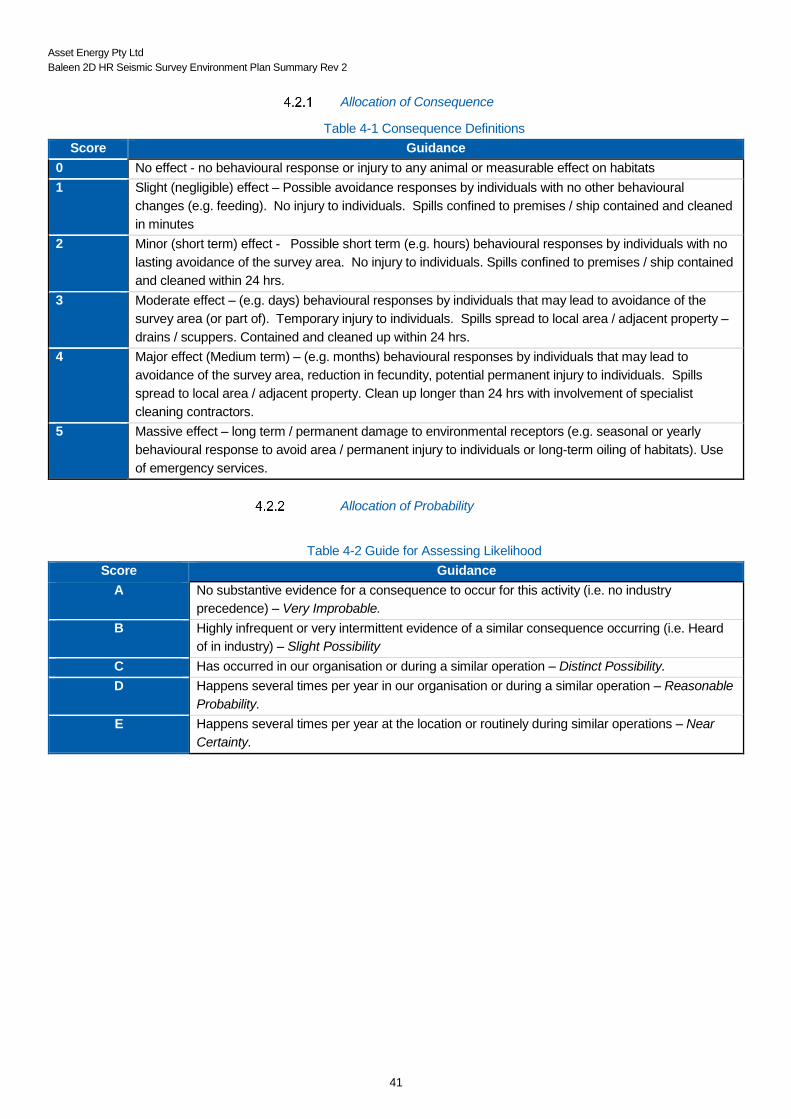
Allocation of Consequence
Table 4-1 Consequence Definitions
Score Guidance
0 No effect - no behavioural response or injury to any animal or measurable effect on habitats
1 Slight (negligible) effect – Possible avoidance responses by individuals with no other behavioural
changes (e.g. feeding). No injury to individuals. Spills confined to premises / ship contained and cleaned
in minutes
2 Minor (short term) effect - Possible short term (e.g. hours) behavioural responses by individuals with no
lasting avoidance of the survey area. No injury to individuals. Spills confined to premises / ship contained
and cleaned within 24 hrs.
3 Moderate effect – (e.g. days) behavioural responses by individuals that may lead to avoidance of the
survey area (or part of). Temporary injury to individuals. Spills spread to local area / adjacent property –
drains / scuppers. Contained and cleaned up within 24 hrs.
4 Major effect (Medium term) – (e.g. months) behavioural responses by individuals that may lead to
avoidance of the survey area, reduction in fecundity, potential permanent injury to individuals. Spills
spread to local area / adjacent property. Clean up longer than 24 hrs with involvement of specialist
cleaning contractors.
5 Massive effect – long term / permanent damage to environmental receptors (e.g. seasonal or yearly
behavioural response to avoid area / permanent injury to individuals or long-term oiling of habitats). Use
of emergency services.
Allocation of Probability
Table 4-2 Guide for Assessing Likelihood
Score Guidance
A No substantive evidence for a consequence to occur for this activity (i.e. no industry
precedence) – Very Improbable.
B Highly infrequent or very intermittent evidence of a similar consequence occurring (i.e. Heard
of in industry) – Slight Possibility
C Has occurred in our organisation or during a similar operation – Distinct Possibility.
D Happens several times per year in our organisation or during a similar operation – Reasonable
Probability.
E Happens several times per year at the location or routinely during similar operations – Near
Certainty.

Asset Energy Pty Ltd
Baleen 2D HR Seismic Survey Environment Plan Summary Rev 2
42
Risk Assessment Matrix (RAM)
The consequence and the likelihood are combined to determine the level of risk attributable to the resulting ranking
using a qualitative RAM (Figure 4-1).
Figure 4-1 Risk Assessment Matrix
4.3 Control Measures and Residual Ranking
Risk mitigation plans are developed using a hierarchy of risk control (Table 4-3). They form part of Asset Energy’s
risk management framework. The mitigation control measures are taken into account and the risk is then
reassessed in the RAM to ensure they are ALARP.
Once the control measures have been identified to reduce the risk rating to ALARP, the process of risk assessment
must be undertaken again to evaluate the effectiveness of the controls resulting in a ‘residual risk rating’. Any
hazard (activity / task) that cannot be moved from the red risk area after the implementation of controls to yellow or
blue risk (i.e., from high to moderate / low risk) should not proceed as planned. With reference to the risk assessment
of the hazards identified as part of this EP, control measures have resulted in all hazards having a moderate to low
risk.
4.4 Demonstration of ALARP and Acceptability
Demonstration of Acceptability
The following criteria are used to determine whether impacts and risks were acceptable:
Likelihood
VERY
IMPROBABLE
SLIGHT
POSSIBILITY
DISTINCT
POSSIBILITY
REASONABLE
PROBABILITY
NEAR
CERTAINTY
A B C D E
Co
nseq
uen
ce
No Effect 0
Slight Effect 1
Minor Effect 2
Moderate Effect 3
Major Effect 4
Massive Effect 5
TASK CAN CONTINUE - RECORD DETAILS AND FILE
RISK ASSESSMENT REQUIRED TO ENSURE - ALARP – AUTHORISATION AND ADDITIONAL ASSESSMENT REQUIRED IF CANNOT
CONTROL INTO BLUE
TASK CANNOT CONTINUE - RISK ASSESSMENT REQUIRED TO ENSURE - ALARP

Asset Energy Pty Ltd
Baleen 2D HR Seismic Survey Environment Plan Summary Rev 2
43
• The level of risk is determined to be low or medium (refer Figure 4-2); • The activities, the identified impact and risk and/or the identified control measures are compliant with
applicable legislation; • The activities, the identified impact and risk and/or the identified control measures are consistent with
Conservation Advice, Recovery Plans, Marine Reserve Management Prescriptions and/or other industry guidelines and standards and corporate policies, standards and procedures;
• The activities, the identified impact and risk and/or the identified control measures are consistent with the following principles of Ecologically Sustainable Development, as set out in section 3A of the EPBC Act, and the precautionary principle where relevant;
• Relevant stakeholder objections, claims, concerns or information have been considered during the assessment of impacts and risks and selection of control measures, where they are considered to have merit.
Acceptable levels are evaluated independently of ALARP and the acceptability criteria are considered when
selecting the environmental performance outcomes that apply to managing a particular impact or risk
Demonstration of ALARP
For all risks, risk mitigation plans are developed and implemented using the Hierarchy of Risk Control. The
mitigation control measures are taken into account and the risk is then reassessed in the RAM to ensure they are
ALARP.
The following hierarchy of control is used to develop the necessary control measures when reducing risks to
ALARP.
Table 4-3 Hierarchy of Risk Control
Hierarchy of Risk Control
1 Elimination of hazard or task
2 Substitution of hazard or task
3 Changing work methods or patterns
4 Reduced or limited time exposure
5 Engineering controls (e.g. isolation, insulation and ventilation)
6 Good housekeeping
7 Safe systems of work
8 Trai Training and information
9 Personal Protective Equipment and Clothing
10 Welfare
The following criteria were used to determine whether impacts and risks were ALARP:
• No reasonably practicable alternatives/substitutes to the activity are available that could eliminate, isolate or provide a net reduction in the risk to environmental values or sensitivities;
• No reasonably practicable additional controls (e.g. engineering, administrative or procedural controls) are available that could provide a net reduction in the risk to environmental values or sensitivities; and
• No reasonably practicable improvements are available that could increase the effectiveness of adopted control measures in terms of functionality, availability, reliability, survivability, independence and compatibility.
In making this determination, consideration was given to trade-offs of implementing the alternatives or additional
controls in terms of cost, technical, environmental, safety and logistical implications.

Asset Energy Pty Ltd
Baleen 2D HR Seismic Survey Environment Plan Summary Rev 2
44
Source: Image is based on concepts presented by NOPSEMA in N-04300-GN0166 Rev 5 June 2014
Figure 4-2 The ALARP Triangle

Asset Energy Pty Ltd
Baleen 2D HR Seismic Survey Environment Plan Summary Rev 2
45
5 ENVIRONMENTAL RISKS AND MANAGEMENT – PLANNED ACTIVITIES
This section provides details of the hazards, impacts and risks, and Environmental Performance Standards
(control measures) associated with the following aspects are described and discussed in the subsections below:
Underwater noise;
Interference with other users of the sea
Artificial lighting;
Routine discharges (sewage and grey water);
Routine discharges (putrescible waste); and
Atmospheric emissions.
5.1 Underwater Noise
The project centres around the ability to acquire geophysical information through the use of instruments designed
to emit noise into the marine environment at varying frequencies and intensities. Any anthropogenic activity that
occurs in vicinity to the sea can potentially result in an increase of the underwater noise levels and as a result the
potential to disturb the marine fauna through physical, behavioural, perceptual, chronic and indirect effects
(Richardson, Greene, Malme, & Thomson, 1995; Southall et al., 2007).
In line with this, responses received as part of the Stakeholder Consultation process has highlighted a concern
regarding the potential effects of underwater noise on marine fauna, specifically commercially targeted fish species
and crustacea (specifically lobster Jasus vereauxi). As a result, a higher level of detail has been included within
this subsection with respect to the propagation of underwater noise and its effect on marine fauna. Details of
acoustic modelling are described below (Sections 5.1.1). The overall noise risk assessment is shown in Table 5-2
and individual risk assessments to specific receptors are summarised in Sections 5.1.2 to 5.1.5.
Underwater Noise Modelling
An independent third party was engaged to undertake sound transmission loss modelling for the survey to predict
the received sound exposure levels (SELs) (both SELs from a single shot and cumulative SELs within a 24-hour
period), peak sound pressure levels (Peak SPLs), peak-to-peak sound pressure levels (Peak-Peak SPLs) and
root-mean-square sound pressure levels (RMS SPLs) from the survey within the most immediate adjacent
receiving areas.
The modelling included the following components:
• Airgun source modelling, i.e. modelling the sound energy emissions from the proposed GI Gun unit, including its far-field signature and power spectral density;
• Short range modelling, i.e. prediction of the received SELs (both cumulative SELs and SELs from a single shot), Peak SPLs, Peak-Peak SPLs and RMS SPLs over a range of 4 km from the source location.
• Accumulated modelling – using the survey parameters for number of lines (45), length of line (3.5 km), shot-point interval (6.25 m) and survey duration (48 hours without downtime), the cumulative SEL was estimated for the near-field SEL values adjacent to the survey area for the first 24 hours. It should be noted this is the utmost worst-case scenario for the sound field with close proximity to the survey area, assuming that every shot has the equal contribution (i.e. source SEL) to the sound field to be assessed. In reality, the received SEL values are expected to be much lower than the estimated values, as the contributions from those gun shots that are not in the source location would be significantly lower than the source SEL value.
Peak SPLs, Peak-Peak SPLs, RMS SPLs and cumulative SELs are derived from modelled SELs for single shot
scenario applied with relevant correction factors, based on relevant worst-case assumptions.
The modelling was based on the following environmental parameters:

Asset Energy Pty Ltd
Baleen 2D HR Seismic Survey Environment Plan Summary Rev 2
46
1. Water depths within the survey area vary from 125–145 m. Based on a conservative consideration, the shallowest water depth of 125 m was selected for this modelling study.
2. The most significant seasonal differences in speed profiles occur within the mixed layer near the sea surface. Typically, spring and summer seasons have downwardly refracting near-surface profiles, with the summer profile having the stronger downwardly refracting feature. Both the autumn and winter seasons exhibit a mixed surface layer surface duct, with the profile in the winter season having a stronger and deeper surface duct than that in the autumn season. Due to the stronger surface duct within the profile, it is expected that the winter season will mostly favour the propagation of sound from a near-surface acoustic source among four seasons. In a descending order, the autumn, spring and summer seasons are expected to have relatively weaker sound propagation for a near-surface acoustic source. As survey acquisition is planned during summer or autumn season in 2018, the autumn seasonal profile was selected for the modelling study, based on a conservative consideration of the sound speed profile in autumn and its greater influence on propagation of sound compared to summer. As summer sound speed profiles are expected to result in the weakest sound propagation of all four seasons, the precautionary approach supports the use of autumn as the worst-case scenario.
3. From dropcore results from 2010, the sandy seabed is generally more reflective than silt-clay seabed. Therefore, based on a conservative consideration, a half-space seafloor geoacoustic model with fine sand seafloor material is used for this modelling study.
The noise modelling results are shown in Table 5-1. Table 5-1: Predicted maximum SELs (single shot and cumulative with a 24-hour period), Peak SPLs, Peak-Peak
SPLs and RMS SPLs across water column at various ranges from the source location.
Predicted
Parameter
Maximum levels across the water column at various ranges
from the source location, dB re 1µPa2·S or dB re 1µPa
10 m 50 m 100 m 200 m 1.0 km 1.5 km 2.0 km 4.0 km
SEL – single shot 178.2 164.3 158.4 152.6 143.0 140.0 137.2 129.5
SEL – cumulative 219.5 205.6 199.7 193.9 184.3 181.3 178.5 170.8
Peak SPL 205.8 191.9 186.0 180.2 170.6 167.6 164.8 157.1
Peak-Peak SPL 211.0 197.1 191.2 185.4 175.8 172.8 170.0 162.3
RMS SPL 199.0 185.1 179.2 173.4 163.8 160.8 158.0 150.3
Table 5-2 Summary of Underwater Noise Assessment
NOISE
Hazard Noise generated from the vessel, Pacific Conquest (i.e. engine and propellers) during transit to and from the area of
operation and while conducting the survey.
Release of acoustic energy from the vessel will generate multiple pulses of high intensity noise which may impact on
noise sensitive marine fauna, especially cetaceans that use sound for navigation and communication.
Extent Localised, until a few kilometres from the vessel, depending on noise propagation loss.
Duration Duration of the survey (~3–4 days).
Risk Ranking with no
controls
Consequence Likelihood
Moderate Effect (e.g. days), localised with no lasting
avoidance or impacts
Reasonable probability – will probably occur in most
circumstances
Inherent Risk
ALARP

Asset Energy Pty Ltd
Baleen 2D HR Seismic Survey Environment Plan Summary Rev 2
47
Cetaceans
Hazard
Noise generated from the vessel (i.e. engine and propellers) during transit to and from the area of operation and while conducting the survey.
Release of acoustic energy from the vessel will generate multiple pulses of high intensity noise.
Extent
Localised, until a few kilometres from the vessel, depending on noise propagation loss.
Duration
Duration of the survey (~3–4 days).
Impact
Without adequate controls in place, sound emitted from the seismic or vessel sound source has the potential to impact cetaceans in the
following ways:
• Physiological: o non-auditory – damage to body tissues and induction of gas and fat embolism and auditory (sound induced hearing loss);
o damage to the auditory system, permanent hearing threshold shift (PTS) and temporary hearing threshold shift (TTS); and
o mortality.
• Perceptual: masking of communication with con-specifics, masking of other biologically important sounds used for navigation, finding prey, etc.
• Behavioural: interruption of normal behaviours such as feeding, breeding and nursing, behaviour modification, adaptive shifting of vocalisation intensity/frequency, and displacement from area (short or long term).
Receptors
EPBC listed cetacean species, including:
• Pygmy blue whales – the pygmy blue whale migration, foraging or breeding BIAs are located >1 000 km from the Operational Area;
• Indian Ocean Bottlenose Dolphin – Operational Area overlaps the foraging BIA;
• Humpback whales – the Operational Area overlaps the migratory route, but does not overlap any resting or calving areas; and
• Other transient cetacean species, such as occasional pygmy right whale and dolphins.
Environmental Performance Standards
Seismic acquisition will not take place outside accepted (agreed) time period for the survey.
Adherence to EPBC Policy Guidelines 2.1 (Part A), as appropriate for the activity (Nov – May);
Part A of EPBC Policy Statement 2.1 will be applied in full to mitigate potential impacts to cetaceans, including:
• Observation zone: 3+ km horizontal radius from the seismic source;
• Low Power Zone: 2 km horizontal radius from the seismic source;
• Shut-down zone: 500 m horizontal radius from the seismic source;
• Pre-Start-up Visual Observations (> 30 mins before soft start);
• Soft-start Procedures;
• Start-up Delay Procedures;
• Operational Shut-down and Low-power Procedures;
• Night-time and Low Visibility Procedures; and
• Sighting Reports.
Aspects of Part B of EPBC Policy Statement 2.1 will be applied to mitigate potential impacts to cetaceans as follows:
• Marine Mammal Observers (B.1); and
• Increased low power zone: 2 km horizontal radius from the seismic source (B.4).
Vessel propulsion system(s) (engines and thrusters) maintained in good working order in accordance with manufacturers specification via
the Planned Maintenance System (PMS) to ensure efficient operation.
Seismic source will be adequate for the project objectives (i.e. not overcharged), water depths and underlying geology.
Use of MFO to observe for marine fauna and Soft Start Policy.
Use of thrusters to maintain vessel’s position only as required.

Asset Energy Pty Ltd
Baleen 2D HR Seismic Survey Environment Plan Summary Rev 2
48
Spatial separation from cetaceans maintained at all times in compliance with Part 8 of the EPBC Regulations (Interactions with cetaceans
and whale watching).
The survey will not be undertaken during peak humpback whale migrations (northern and southern migrations); 01 June – 31 July or 01
October – 30 November respectively.
MFO will maintain vigilant observation for marine cetaceans within precaution zones and vessel planned path throughout duration of
seismic survey.
Seismic array will be shut down if cetacean (or whale shark) enters shut-down zone.
When observations cannot extend to 3 km (i.e. during night time or times of low visibility) operations may proceed provided there have not
been 3 or more whales instigated power-down or shut-down situations during the preceding 24 hours.
Seismic gun will not be fired if cetaceans (or whale sharks) are within low power or shut-down zone within intended passage of vessel –
alternative line plan to be selected as required.
The single airgun is initiated at increasing pressure from a lowest pressure of 800 psi to the maximum 2,000 psi.
Vessel and survey crew to attend environmental induction containing basic information and legal requirements on procedures to manage
interactions between survey vessel, survey equipment and marine fauna (including, EPBC Act Policy Statement 2.1 Part A and Part B
requirements, soft start, start-up delay, operations and stop work procedures, night time and low visibility procedures).
Details of Residual Impacts and Risks
Based on acoustic modelling and with the proposed controls in place, impacts to marine mammals such as cetaceans and dolphins, are
primarily expected to be localised behavioural avoidance impacts with no long term ecological implications. PTS and TTS impacts are
unlikely given that the received sound levels at the low power (2 km) and observation zones (3 km) control measures are well below the PTS
and TTS impact thresholds, and the fact that there are no aggregation, feeding, breeding or calving areas within or adjacent to the Operational
Area.
The likelihood for any serious physiological impact (i.e. mortality or serious injury) during the seismic survey is considered Very Improbable,
particularly after implementation of mitigation measures. Based on the site-specific acoustic modelling results, sound levels at 2 km away
(i.e. Low-power zone) are below sound levels that are likely to cause mortality or serious injury to marine mammals.
At 3 km there is a slight possibility of avoidance behaviour by whales. This avoidance behaviour represents only a minor effect on either the
individual or the species unless avoidance results in displacement of whales from nursery, resting or feeding areas, at an important period
for the species. Cetaceans may experience masking to a small degree, but this would be temporary and only at close proximity to the sound
source.
The introduction of low frequency acoustic noise into the marine environment has the potential to cause significant impacts to marine fauna.
These potential impacts can be reduced through implementing control measures.
Conducting the survey outside peak migration periods has a substantial mitigating effect. Strict adherence to the EPBC Policy Statement
2.1 (Part A and aspects of Part B) will be the primary control point in preventing impacts to marine fauna. The addition of two MFOs to the
vessel’s crew ensure that mitigation controls are followed and that continuous observations are kept when/if a whale is sighted and monitoring
of performance standards are kept (as they will operate as back-to-backs). The continuous movement of the vessel will lessen the time that
any one area of seabed is exposed to the airguns, providing an additional mitigation factor and the slow speed of the vessel (~3-4 knots) as
it traverses each survey line will support the ability of fauna to move away from the source.
Given the timing and short duration of the survey, the absence of critical habitats (feeding, breeding, calving, resting), relatively low numbers
of marine mammals expected to be encountered in the Operational Area and the control measures proposed, the residual impacts and risks,
with the control measures in place, have therefore been assessed as ALARP.
Risk Ranking Consequence Likelihood Risk Ranking
Inherent Risk Moderate Effect (e.g. days),
localised with no lasting
avoidance or impacts
Reasonable probability- will
probably occur in most
circumstances
ALARP - Medium
Residual Risk Minor - Short term effect,
localised with no lasting
avoidance
Reasonable probability- will
probably occur in most
circumstances
ALARP - Medium
Asset Energy Pty Ltd
Baleen 2D HR Seismic Survey Environment Plan Summary Rev 2
49
Fish
Hazard
Noise generated from the vessel, Pacific Conquest (i.e. engine and propellers) during transit to and from the area of operation and while
conducting the survey.
Release of acoustic energy from the vessel will generate multiple pulses of high intensity noise.
Extent
Localised, until a few kilometres from the vessel, depending on noise propagation loss.
Duration
Duration of the survey (~3–4 days).
Impact
Without adequate controls in place, sound emitted from the seismic or vessel sound source has the potential to impact fish in the following
ways:
• Mortal injury or recoverable injury to fish at very close range to the seismic source;
• Temporary changes in hearing (temporary threshold shift; TTS) experienced by fish exposed to high sound levels for prolonged periods;
and
• Behavioural impacts resulting from disturbance, or masking or interfering with biologically important sounds.
Receptors
EPBC listed fish species, including:
• Whale sharks – there are no known BIAs in the Operational Area and it is unlikely that whale sharks will be encountered;
• Grey nurse shark – the Operational Area does not overlap any known aggregation sites. It does overlap a breeding BIA but the survey
will not be undertaken in the possible mating or pupping periods;
• Great white sharks – the survey area overlaps the BIA; and
• Other transient fish such as occasional mako (shortfin and longfin), giant manta ray and porbeagle sharks.
Environmental Performance Standards
Seismic acquisition will not take place outside accepted (agreed) time period for the survey.
The survey will not be undertaken during grey nurse shark breeding; 01 June - 31 July.
Adherence to EPBC Policy Guidelines 2.1 (Part A), as appropriate for the activity (Nov – May);
Part A of EPBC Policy Statement 2.1 will be applied in full to mitigate potential impacts to marine fauna, including:
• Observation zone: 3+ km horizontal radius from the seismic source;
• Low Power Zone: 2 km horizontal radius from the seismic source;
• Shut-down zone: 500 m horizontal radius from the seismic source;
• Pre-Start-up Visual Observations (> 30 mins before soft start);
• Soft-start Procedures;
• Start-up Delay Procedures;
• Operational Shut-down and Low-power Procedures;
• Night-time and Low Visibility Procedures; and
• Sighting Reports.
Aspects of Part B of EPBC Policy Statement 2.1 will be applied to mitigate potential impacts to cetaceans as follows:
• Marine Mammal Observers (B.1); and
• Increased low power zone: 2 km horizontal radius from the seismic source (B.4).
Vessel propulsion system(s) (engines and thrusters) maintained in good working order in accordance with manufacturers specification via
the Planned Maintenance System (PMS) to ensure efficient operation.
No overcharging of the airgun.
Use of thrusters to maintain vessel’s position only as required.
Seismic source will be adequate for the project objectives (i.e. not overcharged), water depths and underlying geology.

Asset Energy Pty Ltd
Baleen 2D HR Seismic Survey Environment Plan Summary Rev 2
50
MFO will maintain vigilant observation for marine fauna within precaution zones and vessel planned path throughout duration of seismic
survey.
Seismic gun will not be fired if cetaceans (or whale sharks) are within low power or shut-down zone within intended passage of vessel –
alternative line plan to be selected as required.
Seismic array will be shut down if cetacean (or whale shark) enters shut-down zone.
The single airgun is initiated at increasing pressure from a lowest pressure of 800 psi to the maximum 2,000 psi.
Vessel and survey crew to attend environmental induction containing basic information and legal requirements on procedures to manage
interactions between survey vessel, survey equipment and marine fauna (including, EPBC Act Policy Statement 2.1 Part A and Part B
requirements, soft start, start-up delay, operations and stop work procedures, night time and low visibility procedures).
Details of Residual Impacts and Risks
The introduction of low frequency acoustic noise into the marine environment has the potential to cause significant impacts to marine fauna.
These potential impacts can be reduced through implementing control measures.
The knowledge of fish hearing capabilities and how they respond to acoustic signals and increased ambient sounds is still very limited. No
studies to date have demonstrated direct mortality of adult fish in response to vessel noise or seismic airgun emissions, even when fired at
close proximity (within 1–7 m; DFO 2004; Boeger et al. 2006 as cited in NSW DPI 2014; Popper et al. 2014). Carroll et al (2017; Table 3.16)
concluded that “for fish, there are few data on the physical effects of seismic airguns (e.g. mortality, barotrauma), and of these none have
shown mortality.”
For fish that are able to move away from seismic sources as they approach, the potential for lethal physical damage from airgun emissions
is even further nullified. Reef-associated fish may show greater site attachment and may be less inclined to flee from a seismic sound source
and experience greater effects as a consequence. While there are no identified habitats within the Operational Area for site-attached fish to
occur, there are two FADs installed by the NSW DPI within the region. The Newcastle FAD is >15 km away from the Operational Area
boundary, and received sound levels are not likely to cause acoustic disturbance to fish species aggregated there. The Swansea FAD is 3.5
km away from the Operational Area boundary but is 5.5 km from the closest seismic source (survey line). At these distances from the sound
source, the cumulative SEL is predicted to be at a level which available scientific evidence supports that no mortality or permanent injury will
occur to fish species aggregated at the FADs.
Based on the site-specific modelling and short duration of survey, the likelihood of permanent hearing loss/recoverable injury beyond 10 m
from the acoustic source is very improbable, while the likelihood for TTS beyond 1 km is very improbable. Within 1 km, the risk from temporary
and recoverable hearing loss to individual and populations of fish is moderate and beyond 1 km, is slight and negligible, which are acceptable
levels.
Current literature suggests that the risk of masking from seismic air guns is low and there has been no reported mortality of fish caused by
air gun pulses. The approach of the survey vessel as with other vessels in the region (commercial shipping, fishing, recreational / tour boats)
will most likely instigate an avoidance behaviour from some pelagic fish species, however the temporary nature of the vessel’s movement
and the comparative influence of the survey vessel compared to the region as a whole is considered minimal.
The risk of behavioural impact from the seismic survey, associated with airgun pulses and vessel movement can be considered major closer
to the source. There may be a high risk of behavioural impacts in fish species within near and intermediate ranges from the source. The
survey operational area does overlap with areas that contain bony fish and those that use swim bladders for hearing (e.g. the Farm). Short
term avoidance of the area may occur with a return within 24 hours, there are no cumulative impacts as the source is moving; therefore,
there are not multiple impacts on the same fish. However. mitigation measures, predominantly the soft start procedure (and power down/shut
down zones regarding approaching cetaceans) reduce this impact to acceptable.
Strict adherence to the EPBC Policy Statement 2.1 (Part A and aspects of Part B) will be an additional control point in preventing the severity
of any impacts to any visible marine fauna, not just cetaceans.
Any residual impacts are expected to be minor and are not expected to result in any lasting population level impacts or longer ecological
implications for the fish. The residual impacts and risks, with the control measures in place, have therefore been assessed as ALARP.
Risk Ranking Consequence Likelihood Risk Ranking
Inherent Risk Moderate Effect (e.g. days),
localised with no lasting
avoidance or impacts
Reasonable probability- will
probably occur in most
circumstances
ALARP - Medium
Residual Risk Minor - Short term effect,
localised with no lasting
avoidance
Reasonable probability- will
probably occur in most
circumstances
ALARP - Medium
Asset Energy Pty Ltd
Baleen 2D HR Seismic Survey Environment Plan Summary Rev 2
51
Crustacea (Lobster spp)
Hazard
Noise generated from the vessel, Pacific Conquest (i.e. engine and propellers) during transit to and from the area of
operation and while conducting the survey.
Release of acoustic energy from the vessel will generate multiple pulses of high intensity noise.
Extent
Localised, until a few kilometres from the vessel, depending on noise propagation loss.
Duration
Duration of the survey (~3–4 days).
Impact
Without adequate controls in place, sound emitted from the seismic or vessel sound source has the potential to impact
Lobsters in the following ways:
• Mortal injury or recoverable injury at very close range to the seismic source;
• Behavioural impacts;
• Larvae; and
• Population reductions.
Receptors
Lobsters.
Environmental Performance Standards
Seismic acquisition will not take place outside accepted (agreed) time period for the survey.
The survey will not be undertaken between 01 June and 31 January to avoid spawning of eastern lobsters.
Vessel propulsion system(s) (engines and thrusters) maintained in good working order in accordance with manufacturers
specification via the Planned Maintenance System (PMS) to ensure efficient operation.
No overcharging of the airgun.
Use of thrusters to maintain vessel’s position only as required.
Seismic source will be adequate for the project objectives (i.e. not overcharged), water depths and underlying geology.
The single airgun is initiated at increasing pressure from a lowest pressure of 800 psi to the maximum 2,000 psi.
Vessel and survey crew to attend environmental induction containing basic information and legal requirements on
procedures to manage interactions between survey vessel, survey equipment and marine fauna (including, EPBC Act Policy
Statement 2.1 Part A and Part B requirements, soft start, start-up delay, operations and stop work procedures, night time
and low visibility procedures).
Details of Residual Impacts and Risks
No exposure threshold criteria exist to enable an evaluation of mortality/mortal injury in crustaceans. However, based on the research findings to date these effects are likely to be confined to extremely close ranges (i.e. <10 m) from the source.
Day et al. (2016) contained no evidence of lobster mortality for any experiment, as well as no evidence of impact to lobster embryos, which were described as resilient to the acoustic exposure, it is reasonable to conclude that the predicted sound levels generated by the Baleen 2D HR seismic survey acoustic source will likewise not cause mortality or serious injury to lobsters or crustaceans directly at the seabed. Therefore, lobster mortality in direct response to seismic airgun exposure is unlikely to occur, and the risk to the population is negligible, which is an acceptable level.
Day et al. (2016) concluded that overall there were no differences in the quantity or quality of hatched larvae, indicating that the condition and development of spiny lobster embryos were not adversely affected by air gun exposure. The results also suggested that early life stage crustaceans may be more resilient to seismic air gun exposure than other marine organisms and highlight the caution necessary in extrapolating results from the laboratory to real world scenarios or across life history stages. Therefore, based on these larvae results, long-term, adverse impacts from acoustic exposure are unlikely to occur at the early embryonic developmental stage, and the risk to individual development and the greater population is negligible, which is an acceptable level.
Sub-lethal, short-term behavioural impacts may occur to individual lobsters and other crustaceans. However, long-term, adverse impacts at the population level (and thus associated commercial fisheries) are unlikely to occur, based on the experimental research, the site-specific acoustic modelling results for the Baleen survey and the short duration of the activity. As such the risk to the catch rates are minor, which is an acceptable level.
Risk Ranking Consequence Likelihood Risk Ranking
Inherent Risk Moderate Effect (e.g. days), localised with no lasting avoidance or impacts
Reasonable probability- will probably occur in most circumstances
ALARP - Medium
Residual Risk Minor - Short term effect, localised with no lasting avoidance
Reasonable probability- will probably occur in most circumstances
ALARP - Medium

Asset Energy Pty Ltd
Baleen 2D HR Seismic Survey Environment Plan Summary Rev 2
52
Zooplankton
Hazard
Noise generated from the vessel, Pacific Conquest (i.e. engine and propellers) during transit to and from the area of
operation and while conducting the survey.
Release of acoustic energy from the vessel will generate multiple pulses of high intensity noise.
Extent
Localised, until a few kilometres from the vessel, depending on noise propagation loss.
Duration
Duration of the survey (~3–4 days).
Impact
Without adequate controls in place, sound emitted from the seismic or vessel sound source has the potential to impact
Zooplankton in the following ways:
• Mortal injury or recoverable injury at very close range to the seismic source; and
• Behavioural impacts.
Receptors
Zooplankton communities (including copepods, cladocerans and krill larvae).
Environmental Performance Standards
Seismic acquisition will not take place outside accepted (agreed) time period for the survey.
Vessel propulsion system(s) (engines and thrusters) maintained in good working order in accordance with manufacturers
specification via the Planned Maintenance System (PMS) to ensure efficient operation.
Use of thrusters to maintain vessel’s position only as required.
Seismic source will be adequate for the project objectives (i.e. not overcharged), water depths and underlying geology.
The single airgun is initiated at increasing pressure from a lowest pressure of 800 psi to the maximum 2,000 psi.
Vessel and survey crew to attend environmental induction containing basic information and legal requirements on
procedures to manage interactions between survey vessel, survey equipment and marine fauna (including, EPBC Act Policy
Statement 2.1 Part A and Part B requirements, soft start, start-up delay, operations and stop work procedures, night time
and low visibility procedures).
Details of Residual Impacts and Risks
Asset Energy Pty Ltd
Baleen 2D HR Seismic Survey Environment Plan Summary Rev 2
53
The range of pathological effect on zooplankton is likely to be restricted to < 2-5 m. Calculations based on the site-specific modelling indicated that less than 0.02% of plankton in an area would be affected. The percentage of plankton affected is considered very minor, and the effects from the seismic discharge is insignificant compared with the size of the planktonic population in a survey area or natural mortality rates for planktonic organisms.
Sætre and Ona (1996) calculated that under the ‘worst case’ scenario, the number of larvae killed during a typical seismic survey was 0.45% of the total population. There may be substantial impact from seismic activity on zooplankton populations on a local scale within or close to the survey area. However, on a regional scale, the impacts are expected to be minimal and not discernible at a regional level. Zooplankton biomass is known to recover to pre-seismic levels only three days following the completion of seismic surveys.
Acoustic impacts are not significant when compared to rates of natural mortality in planktonic populations (10–50% per
day), and population-level impacts are not expected to occur, particularly as recovery has been documented within three
days of exposure.
There is a moderate relative risk of impairment (i.e. recoverable injury and TTS) effects to fish eggs and larvae < 10 m of
the acoustic source. The relative risk of impairment to zooplankton >10 m from the acoustic source is low and negligible,
which is an acceptable level.
There is a moderate relative risk of behavioural effects to fish eggs and larvae < 10 m of the acoustic source, and a low
relative risk >10 m from the source. It is not clear what these behavioural impacts could be, but it is possible that
zooplankton (including free-swimming larvae) could move either vertically or horizontally within the water column in
response to a stimulus such as underwater noise. These impacts are not likely to be significant, especially as they will be
restricted to a range of a <10 m from the acoustic source. Therefore, the relative risk of behavioural impacts to
zooplankton >10 m from the acoustic source is low and negligible, which is an acceptable level.
The Operational Area does not overlap known foraging BIA for any marine fauna species, and thus the sound levels
generated by the acoustic source is not likely to cause higher ecosystem-level impacts, and the risk for higher trophic
levels is negligible, which is an acceptable level.
Given the limited size of the survey area and the short duration of the sound exposure, it is expected that long-term
impacts on the zooplankton communities in the survey area will be minimal and acceptable. After a mass die-off following
a seismic survey, previous research found that the zooplankton biomass recovers three days after completion of the
survey (Richardson et al., 2017). As such, the overall risk to zooplankton is negligible, which is an acceptable level.
Risk Ranking Consequence Likelihood Risk Ranking
Inherent Risk Moderate Effect (e.g. days),
localised with no lasting
avoidance or impacts
Reasonable probability- will
probably occur in most
circumstances
ALARP - Medium
Residual Risk Minor - Short term effect,
localised with no lasting
avoidance
Reasonable probability- will
probably occur in most
circumstances
ALARP - Medium
Tourism
Refer to Other Interference with Other Users of the Sea Section 5.2

Asset Energy Pty Ltd
Baleen 2D HR Seismic Survey Environment Plan Summary Rev 2
54
5.2 Interference with Other Users of the Sea
Hazard
The presence of Pacific Conquest within the survey area may potentially interfere with other users (i.e. commercial fishers,
recreational fishers, commercial shipping (including whale watching vessels)) of the sea.
Extent
Operational Area only.
Duration
Duration of the survey (~3–4 days).
Impact
• Restricting or prohibiting access to the survey location and adjacent areas along with increasing the chance of collision and risk to these operators;
• Increased risk of loss / damage to fishing equipment resulting in loss of catch; and • Loss of income or increased costs associated with other uses.
Receptors
• Commercial and recreational fishers; and
• Tourism businesses based around marine activities e.g. whale watching.
Environmental Performance Standards
Seismic acquisition will not take place outside accepted (agreed) time period for the survey
Adherence to EPBC Policy Guidelines 2.1 (Part A), as appropriate for the activity (Nov – May);
Part A of EPBC Policy Statement 2.1 will be applied in full to mitigate potential impacts to cetaceans, including:
• Observation zone: 3+ km horizontal radius from the seismic source;
• Low Power Zone: 2 km horizontal radius from the seismic source;
• Shut-down zone: 500 m horizontal radius from the seismic source;
• Pre-Start-up Visual Observations (> 30 mins before soft start);
• Soft-start Procedures;
• Start-up Delay Procedures;
• Operational Shut-down and Low-power Procedures;
• Night-time and Low Visibility Procedures; and
• Sighting Reports.
Aspects of Part B of EPBC Policy Statement 2.1 will be applied to mitigate potential impacts to cetaceans as follows:
• Marine Mammal Observers (B.1); and
• Increased low power zone: 2 km horizontal radius from the seismic source (B.4).
Vessel propulsion system(s) (engines and thrusters) maintained in good working order in accordance with manufacturers
specification via the Planned Maintenance System (PMS) to ensure efficient operation.
No overcharging of the airgun.
Use of thrusters to maintain vessel’s position only as required.
Relevant stakeholders identified and notified of proposed activity, including location and schedule
Consultation with appropriate regulators / stakeholders prior to commencement of survey (with notification of location and
survey duration and schedule).
Location and timing of the survey forwarded to AMSA and Australian Hydrographic Office >2 weeks prior to mobilisation (for
issue of NTM) and warnings broadcast to shipping in region.
Direct communications with fishers and careful management with respect to access of the survey area will be implemented
throughout operations to minimise the level of disturbance.
Direct communication through NSW DPI communication channels (e.g. Newscast, Charter Chatter and NSW DPI
Facebook).
The survey will not be undertaken between 01 June - 31 January to avoid spawning of eastern lobsters.
The single airgun is initiated at increasing pressure from a lowest pressure of 800 psi to the maximum 2,000 psi.
Vessel and survey crew to attend environmental induction containing basic information and legal requirements on
procedures to manage interactions between survey vessel, survey equipment and marine fauna (including, EPBC Act Policy
Statement 2.1 Part A and Part B requirements, soft start, start-up delay, operations and stop work procedures, night time
and low visibility procedures).
Compliance with EPBC Act Policy Statement 2.1.
Vessel to be equipped with necessary navigation aids (i.e. radar, vessel GPS tracking).
Maintain appropriate lighting, communication and navigation equipment (including operational maintenance) as required to
satisfy navigation / marine safety legislation (i.e. International Regulations for the Prevention of Collisions at Sea 1972 (as
amended), International Convention of the Safety of Life at Sea (SOLAS), 1974 and Navigation Act 2012).
Tail buoy markers maintained and visible.
Enforcement of 2 nm exclusion zone around the vessel to avoid entanglement and collision.
Look-out duties maintained 24 hours per day by competent and trained crew, with additional watch officer / rating for night
time activities as required through international legislation (i.e. SOLAS) and internal vessel procedures.
Asset Energy Pty Ltd
Baleen 2D HR Seismic Survey Environment Plan Summary Rev 2
55
Regular updates with relevant stakeholder / regulators (local fisheries, AMSA (AMSA Rescue Coordination Centre-RCC))
on vessel movements and intended movements (line plan).
Vessel management systems adhered to.
The survey will not to be undertaken during key recreational fishing period and during the planned game fishing tournaments
defined as in s3.6.5 being from 9 February to 11 March, plus 23 to 25 March.
The survey will not overlap the temporal or spatial boundaries of the ‘carpark’ area at the times of known game fishing
tournaments, defined as being from 9 February to 11 March and 23-25 March.
The survey will not be undertaken between 23 March and 8 April, being the week lead up to and after Easter – 1 April 2018
(due to overlap with peak commercial and recreational fishing activities).
Details of Residual Impacts and Risks
There are no designated shipping routes or anchor points located in the survey area. Commercial shipping has the ability
to navigate to avoid the survey area with little disruption to their main course and will be required to do so through notices
administered by AMSA / Hydrographic Office. Adherence to ship safety protocols to ensure that the survey vessel is visible
to other users and open communications will provide control measures to reduce the risk of collision. The potential effects
on commercial shipping are considered negligible and acceptable.
The socioeconomic impact of the temporary exclusion of fishers from potential fishing grounds has the potential to cause
disruptions (i.e. possible loss of catch, amendments to fishing practices). However, due to the ability of fishers to utilise other
locations, the short duration of the survey and the inability to determine the movement of fish specifically in the survey
location (and therefore the consequence of excluding fishers from this area) this is considered an acceptable risk.
The survey will not be undertaken during key recreational fishing periods, planned game fishing tournaments or weeks
surrounding Easter, and will not overlap spatially or temporally with the ‘carpark’ area at the times of known game fishing
tournaments. The nearest FAD, the Swansea FAD, is 3.5 km away from the Operational Area but is 5.5 km away from the
closest survey line which is the seismic source. Temporary behavioural impact has been found to be at a distance of 2 km
(Pena et al 2013), and based on the site-specific modelling the Swansea FAD is well outside the impact risk area. In addition,
Popper et al (2014) found that there was only a low behavioural risk to fish at the (F) far distance - thousands of meters.
The consequences of conducting the survey will not cause serious long-term damage to regional fishers, any exclusion from
fishing grounds will be temporary in nature (~three to four days) and will be restricted to the vicinity of the survey vessel (i.e.
2 nm exclusion zone), which will move on a daily basis. Therefore, with the control measures implemented, adverse impacts
to other maritime users would be moderate, localised and temporary (3–4 days), causing no lasting avoidance or impacts,
which is considered an acceptable level.
Risk Ranking Consequence Likelihood Risk Ranking
Inherent Risk Moderate Effect (e.g. days),
localised with no lasting
avoidance or impacts
Reasonable probability- will
probably occur in most
circumstances
ALARP - Medium
Residual Risk Minor - Short term effect,
localised with no lasting
avoidance
Reasonable probability- will
probably occur in most
circumstances
ALARP - Medium
Asset Energy Pty Ltd
Baleen 2D HR Seismic Survey Environment Plan Summary Rev 2
56
5.3 Artificial Lighting
Hazard
Pacific Conquest will maintain lighting for navigation and onboard safety requirements (i.e. during deck operations) at all
times throughout the duration of the survey
Extent
Artificial surface lighting will be limited to the area directly adjacent to the vessel and would not directly spill outside the area
of operation.
Vessel lighting (particularly at night-time) will be visible at distances of at least 10 km, depending upon weather conditions,
with intensity attenuating with distance.
Duration
Duration of the survey (~3–4 days).
Impact
Light emissions can affect fauna in the following ways:
• Behaviour; and • Orientation.
Receptors
• Turtles;
• Seabirds; and
• Marine mammals and organisms.
Environmental Performance Standards
Seismic acquisition will not take place outside accepted (agreed) time period for the survey.
Minimum lighting used as required, to satisfy navigation / marine safety (International Regulations for the Prevention of
Collisions at Sea 1972 (as amended). Minimum lighting used for safe (deck) operations with lights orientated to work surfaces to reduce ‘marine light pollution (The
Australian Offshore Support Vessel Code of Safe Working Practice (Section 9.1.4 Deck lighting – AMSA, version 3, 2002).
Awareness training for all crew to minimise unnecessary lighting, with continuous reminders throughout duration of the
activity.
Compliance with EPBC Act Policy Statement 2.1.
Details of Residual Impacts and Risks
It is unlikely that lights from the vessel will have a significant impact on seabirds. The nearest known bird breeding site is
~60 km north of the survey and the closest point of the Operational Area to land is ~20 km. Due to the small size of the
Operational Area the environmental risk associated with collision from seabirds attracted to the light is considered to be low,
with no specific, additional mitigation required.
Artificial lighting may result in localised short-term aggregation of fish activity. However, as the vessel is moving this
occurrence is likely to be minimal, if at all, and will be temporary with any long-term changes to fish species composition or
abundance highly unlikely. The consequence is determined to be slight with a distinct possibility of the effect occurring
leading to no requirement for additional mitigation to be incorporated in relation to lighting.
There are no known turtle rookeries within the region of the survey area and the likelihood of encountering adult turtles is
determined as being slight. The vessel will be operating at least 20 km from the coast at its closest point. The survey vessel
will be continuously moving, albeit at a slow speed, and consequently the effects of artificial lighting are likely to be less than
for a stationary source such as an offshore facility or coastal developments. The consequence of any impact is deemed to
be moderate leading to no additional mitigation being required.
Marine fauna that encounter the vessel may display short term behavioural changes. Reports (BHP Billiton, 2005, Stybarrow
Development, northwest Australia and Husky Oil Operations, White Rose Oilfield, 2001, Newfoundland, Canada) have
concluded that there was no evidence to suggest an impact on the feeding or breeding behaviours of cetaceans. The survey
is going to be undertaken outside peak Humpback whale migration periods but may encounter occasional early migrators,
however, the risk with the controls in place (adherence to EPBC Act Policy Statement 2.1) is acceptable.
Given the temporary nature of the project (~3-4 days) and the control measures in place, including directional lighting, the
adverse impacts on the receiving environment are considered to be of an acceptable level.
Risk Ranking Consequence Likelihood Risk Ranking
Inherent Risk Slight – possible avoidance
responses
Slight possibility – could
occur but not expect to
ALARP - Low
Residual Risk Slight (Negligible) Effect Slight possibility (could
occur but not expected)
ALARP - Low

Asset Energy Pty Ltd
Baleen 2D HR Seismic Survey Environment Plan Summary Rev 2
57
5.4 Routine Discharges (Sewage and Grey Water Discharges)
Hazard
During normal vessel operations a number of routine discharges (sewage, greywater, deck drainage and bilge water) to the
marine environment will be required.
Extent
Small volumes of discharged material are likely to be localised to the survey vessel and surface waters.
Duration
Intermittently throughout duration of the survey (~3–4 days).
Impact
Routine discharges may reduce the water quality of the marine environment as follows:
• disease introduction; • oxygen depletion; and
• nutrient enrichment.
• Receptors
Marine fauna.
Environmental Performance Standards
Waste management in accordance with Vessel Shipboard Garbage Management Plan (including the treatment of sewage
and grey water discharges via an approved sewage treatment plant).
Vessel’s sewage treatment plant is maintained in accordance with PMS.
Grey water (from showers, laundry, dishwasher) may be discharged at sea as per Annex IV.
Discharge to comply with Protection of the Sea (Prevention of Pollution by Ships) Act 1983 and sewage will be treated in
accordance with MARPOL (Annex IV) / AMSA Marine Orders 96, including:
• Discharge of sewage is permitted in Operational Area (i.e. >3 nm from nearest shoreline if comminuted and disinfected using an approved system and/or >12 from nearest shoreline if not comminuted and disinfected using an approved system).
Quantity, time and location of disposal are recorded.
Tools and resources available to clean up spills consistent with SOPEP.
Crew inductions will include details for correct waste disposal, spill response and good housekeeping practices (including
minimising the level of waste (i.e. water use minimisation, shower duration, launder clothing as necessary).
Discharges of bilge water in accordance with MARPOL Annex 1, (Regulation 6, 14 and 7).
Bilge water discharged via oil water separators (as per MARPOL Annex I which specifies <15ppm oil content).
Oil filtering system of an adequate and approved design maintained in accordance with vessel PMS.
Correct storage of chemicals and hydrocarbons in accordance with Hazardous Goods Procedure.
Tools and resources available to clean up spills consistent with SOPEP.
Scupper plugs or equivalent deck drainage control measures (bunding) where chemicals and hydrocarbons are stored and
frequently handled to prevent run off.
Crew inductions will include details for correct waste disposal, spill response and good housekeeping practices.
Details of Residual Impacts and Risks
Routine discharges will be generated throughout the duration of the activity. The release of these discharges, providing they
are compliant with MARPOL requirements are permitted in Australian waters under the Protection of the Sea (Prevention of
Pollution from Ships) Act 1983, which enacts MARPOL requirements.
Good housekeeping and minimising waste as far as practicably possible will have a positive impact on the volume of material
discharged. MARPOL requirements are internally accepted and utilised globally and are considered to be the most
appropriate standard to adhere to in this environment given the nature and scale of the activity. Therefore, with the control
measures implemented, adverse impacts from routine discharges would be negligible, which is considered an acceptable
level of environmental impact.
Risk Ranking Consequence Likelihood Risk Ranking
Inherent Risk Minor (possible short-term
effect)
Near certainty ALARP - Low
Residual Risk Slight (Negligible) Effect Near certainty ALARP - Low
Asset Energy Pty Ltd
Baleen 2D HR Seismic Survey Environment Plan Summary Rev 2
58
5.5 Routine Discharges - Putrescible Waste Discharge
Hazard
During normal vessel operations putrescible wastes are discharged to the marine environment.
Extent
Small volumes of discharged material are likely to be localised to the survey vessel and surface waters.
Duration
Intermittently throughout the duration of the survey.
Impact
Potential impacts from the discharge of putrescible waste include:
• Temporary and localised increase in the content of nutrients in the surrounding surface waters;
• Increase scavenging behaviour of marine fauna and seabirds; and
• Marine pollution from debris (direct or indirect), physiological impacts through entanglement and ingestion including infection and death.
Receptors
• Marine fauna; and
• Seabirds.
Environmental Performance Standards
Galley crew will contain all food scraps for discharge in accordance with MARPOL Annex V (enacted by AMSA Marine
Orders Part 95, Garbage).
Permission from the bridge will be acquired prior to discharge. Galley crew will ensure that all non-putrescible galley waste (i.e. packing, cooking oils and grease) is securely stored
prior to transfer back to shore for recycling or disposal.
All wastes not treated on-board disposed of at an appropriate licensed facility.
Waste management in accordance with Vessel Shipboard Garbage Management Plan and in line with the Company’s
Waste Management Plan.
Waste records maintained (controlled waste transfer note).
Galley crew adequately training and notified of all waste management requirements.
All wastes not treated on-board will be disposed at an appropriate licensed facility.
Solid wastes will be segregated into clearly marked containers.
Waste management in accordance with MARPOL (Annex V) (enacted by AMSA Marine Orders 94, Packaged harmful
substances and Marine Order 95 Garbage), Garbage Management Plan and Company’s Waste Management Plan.
All bins on deck will be covered to prevent rubbish blowing overboard.
Crew inductions will include details for correct waste disposal, spill response and good housekeeping practices.
Waste records maintained (controlled waste transfer note).
Details of Residual Impacts and Risks
Routine discharges will be generated throughout the duration of the activity. The release of these discharges, providing they
are compliant with MARPOL requirements are permitted in Australian waters under the Protection of the Sea (Prevention of
Pollution from Ships) Act 1983, which enacts MARPOL requirements.
Good housekeeping and minimising waste as far as practicably possible will have a positive impact on the volume of material
discharged. MARPOL requirements are internally accepted and utilised globally and are considered to be the most
appropriate standard to adhere to in this environment given the nature and scale of the activity. In the absence of a
macerator, food scraps requiring disposal are only permitted at a distance of at least 12 nm from the nearest land. Therefore,
with the control measures implemented, adverse impacts from routine discharges would be negligible, which is considered
an acceptable level of environmental impact.
Risk Ranking Consequence Likelihood Risk Ranking
Inherent Risk Minor (possible short-term
effect)
Near certainty ALARP - Low
Residual Risk Slight (Negligible) Effects Near certainty ALARP - Low

Asset Energy Pty Ltd
Baleen 2D HR Seismic Survey Environment Plan Summary Rev 2
59
5.6 Atmospheric Emissions
Hazard
Combustion of fuel from the vessel’s engines, generators, mobile and fixed plant and equipment will result in greenhouse
gas emissions such as carbon dioxide (CO2), methane and nitrous oxide (N2O).
The use of ozone depleting substances (ODS) in closed systems i.e. rechargeable refrigeration systems is permitted for use
on vessels.
Extent
Localised around the point source, and under normal circumstances gaseous emissions quickly dissipate into the
atmosphere.
Duration
Temporary, throughout the duration of the activity (~3-4 days).
Impact
Potential impacts from the discharge of putrescible waste include:
• Temporary and localised increase in the content of nutrients in the surrounding surface waters;
• Increase scavenging behaviour of marine fauna and seabirds; and
• Marine pollution from debris (direct or indirect), physiological impacts through entanglement and ingestion including infection and death.
Receptors
• Marine fauna; and
• Seabirds.
Environmental Performance Standards
All machinery will undergo planned service and maintenance in accordance with the vessels PMS.
Incineration will be in compliance with Annex VI, i.e. no incineration of substances that will have an adverse effect on air
emissions (oily rags, tyres). Compliance with MARPOL (Annex VI) for the Prevention of Air Pollution from Ships (AMSA Marine Order Part 97 (Air
pollution)) including:
• Low sulphur diesel will be selected in line with MARPOL Annex VI requirements to minimise SOx emissions; • No discharge of ozone-depleting substances (ODS) MARPOL Annex VI; • Vessel maintains records of ODS onboard; and
• Transport use will be carefully planned to essential travel only to keep fuel use to a minimum
Ozone-depleting substances managed in accordance with Regulation 13 of MARPOL Annex VI.
Comply with Fuel Management Standard (M31SM/P008) - Automotive diesel fuel to be purchased from a registered supplier
that confirms fuel to contain less than 3.5% m/m sulphur.
Monitor of vessel’s fuel usage or abnormal consumption and in the event of high usage the chief engineer will initiate
corrective action to minimise excessive air pollution.
Details of Residual Impacts and Risks
Atmospheric emissions from vessels are permissible under MARPOL Annex VI requirements and the Protection of the Sea
(Prevention of Pollution from Ships) Act 1983, which enacts MARPOL legislative requirements. Automotive diesel is used
by Pacific Conquest, which is lower in sulphur oxides compared to heavy fuel oil. The fuel will meet regulated sulphur content
levels (detailed in fuel receipt) in order to control emission quality and will be sourced through an approved supplier.
Air pollution is regulated internationally by the IMO through the International Convention for the Prevention of Pollution from
Ships (MARPOL, Annex VI) and national legislation that acts to implement the requirements of MARPOL. Pacific Conquest
meets the requirements with respect to atmospheric emissions (IAPP certificate), fuel use is monitored and controls / vessel
procedures are in place to monitor these emissions to ensure continual compliance. Therefore, with the control measures
implemented, adverse impacts to the atmospheric environment would be negligible, which is considered an acceptable level
of environmental impact.
Risk Ranking Consequence Likelihood Risk Ranking
Inherent Risk Slight (Negligible) Effects Near
certainty
ALARP - Low
Residual Risk Slight (Negligible) Effects Near
certainty
ALARP - Low

Asset Energy Pty Ltd
Baleen 2D HR Seismic Survey Environment Plan Summary Rev 2
60
6 ENVIRONMENTAL RISKS AND MANAGEMENT – UNPLANNED
ACTIVITIES
This section provides details of the hazards, impacts and risks, and Environmental Performance
Standards (control measures) associated with the following aspects are described and discussed in
the subsections below:
• Introduction of Marine Pests; • Disturbance of the Seabed or Loss of Equipment; • Hazardous and Non-Hazardous Solid Wastes; • Physical Presence of Vessel (Marine Fauna or Vessel Collision, Entanglement of Fishing
Gear); • Spillage of Hazardous Chemicals and Liquid Waste (excluding fuel) to the Sea; and • Accidental Hydrocarbon (Fuel) Spill.
The control measures proposed to reduce the risk of impact to ALARP are described in the relevant
tables below.
6.1 Introduction of Marine Pests
Hazard
Vessels originating outside Australian waters may act as a vector for Introduced Marine Species (IMSs). This can arise
through a number of mechanisms:
• Biofouling on the vessel’s external hull, equipment (such as seismic array) or internal systems (e.g., sea chest, seawater
systems); and
• Ballast water may contain organisms such as fish, invertebrate larvae and phytoplankton from foreign-sourced waters.
Extent
Localised (seabed and water column in immediate vicinity of vessel) to widespread establishment of IMP along the east
coast of Australia (and potentially the whole coast) as a worst case.
Duration
Temporary (activity of the vessel) to long term (if IMP successfully established).
Impact
Once established, an IMP has the potential to spread, disrupt and displace native ecosystems and associated values and
sensitivities (e.g. tourism, commercial fisheries, and heritage values).
Receptors
• Marine environment; and
• Socio-economic.
Environmental Performance Standards
Vessel anti-fouling systems are maintained in compliance with International Convention on the Control of Harmful Anti-
fouling Systems on Ships and regulations of the Biosecurity Act 2015 (Australian Ballast Water Management and Anti-
fouling and In-water Cleaning Guidelines).
Vessel has DAWR clearance to be in Australian waters. A bio-fouling vessel risk assessment (VRASS) was completed prior to mobilisation to Australia as defined within the National
Biofouling Management Guidance for the Petroleum Production and Exploration Industry (Commonwealth of Australia,
2009) and ranked as “low”.
Immersible equipment and the survey vessel hull, sea chests and other niches must be ‘clean’ before the survey activity
begins.
The suspected or confirmed presence of any marine pests or disease must be reported to NOPSEMA as a reportable
incident.
Under normal operations of the survey activity, no ballast water discharge will take place.
Details of Residual Impacts and Risks
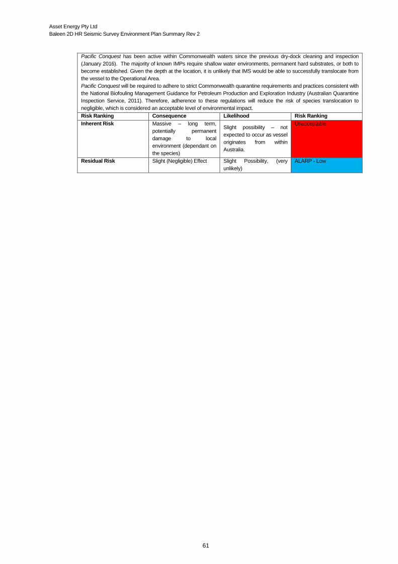
Asset Energy Pty Ltd
Baleen 2D HR Seismic Survey Environment Plan Summary Rev 2
61
Pacific Conquest has been active within Commonwealth waters since the previous dry-dock cleaning and inspection
(January 2016). The majority of known IMPs require shallow water environments, permanent hard substrates, or both to
become established. Given the depth at the location, it is unlikely that IMS would be able to successfully translocate from
the vessel to the Operational Area.
Pacific Conquest will be required to adhere to strict Commonwealth quarantine requirements and practices consistent with
the National Biofouling Management Guidance for Petroleum Production and Exploration Industry (Australian Quarantine
Inspection Service, 2011). Therefore, adherence to these regulations will reduce the risk of species translocation to
negligible, which is considered an acceptable level of environmental impact.
Risk Ranking Consequence Likelihood Risk Ranking
Inherent Risk Massive – long term,
potentially permanent
damage to local
environment (dependant on
the species)
Slight possibility – not
expected to occur as vessel
originates from within
Australia.
Unacceptable
Residual Risk Slight (Negligible) Effect Slight Possibility, (very
unlikely)
ALARP - Low

Asset Energy Pty Ltd
Baleen 2D HR Seismic Survey Environment Plan Summary Rev 2
62
6.2 Disturbance of the Seabed / Loss of Equipment
Hazard
Disturbance of the seabed habitat from anchoring or dropped objects.
Loss of equipment (including floating debris) causing entanglement of marine fauna and a navigational hazard to other
marine users (i.e. commercial shipping, fisheries).
Extent
Direct impacts due to the anchor making contact (including anchor drag) with the seabed or dropped objects would be
restricted to the impact zone within the Operational Area. Depending upon the nature of the item(s) dropped or lost
overboard, some could be carried by currents and drift beyond the area of operation.
The loss of equipment essential to the completion of the survey could result in significant delays with time schedules
impacting upon other aspects of the environmental management plan.
Duration
The hazard will exist throughout the timeframe of the activity. Anchoring is not a planned activity during the survey, and the
water depth in the Operational Area is greater than appropriate for anchoring.
Impact
• Damage to benthic habitats and associated biota that lie directly within the footprint of the dropped object or anchor; and
• Hazard to other marine users.
Receptors
Benthic habitat.
Environmental Performance Standards
The Pacific Conquest cannot anchor in the Operational Area due to water depth (except in the event of an emergency).
Any incidents of vessel anchoring or grounding shall be reported to NOPSEMA as a reportable incident. Capstans and anchor handling equipment maintained in accordance with the Planned Maintenance System (PMS), and
operation of the anchor winch and associated deployment and recovery equipment in accordance with procedures.
All lifting equipment used on the vessel to be certified.
Streamers will be:
• retrieved if lost accidentally; and
• checked/inspected prior to use (including associated equipment).
Capstans and anchor handling equipment maintained in accordance with the Planned Maintenance System (PMS), and
operation of the anchor winch and associated deployment and recovery equipment in accordance with procedures.
Shipboard safety procedures to be followed, all equipment checks to be completed prior to deployment (deployment and
recovery of streamers handled in accordance with vessel-specific procedure).
Competent personnel onboard operating lifting equipment and overseeing deployment and recovery of equipment.
Emergency procedures in place for equipment entanglement, loss and retrieval.
In-water equipment lost will be recovered (where possible) and detailed records maintained of any loss of in-water equipment
lost.
If equipment lost is irretrievable, maintain records of the circumstances that prohibited the equipment from being recovered
and inform AMSA of the potential navigation hazard to other mariners.
Streamer tow depth will be 3 m and no closer than 50 m from the seabed.
Details of Residual Impacts and Risks
Disturbance of the seabed will only occur from dropped equipment as part of deployment of the seismic equipment (i.e. gun
array or streamer) or general boat operations. All equipment required for deployment and retrieval will be maintained as per
Pacific Conquest PMS and operational procedures. Potential environmental impacts from a seabed disturbance would most
likely be minor and related to indents in the soft sediment habitat assumed to cover the Operational Area.
The application of controls to ensure that the risk of loss or entanglement of towed equipment is reduced to ALARP (i.e. 2
nm safety exclusion zone) acts will lessen the likelihood of such an occurrence. Therefore, with the control measures
implemented, adverse impacts to the seabed would be negligible, which is considered an acceptable level of environmental
impact.
Risk Ranking Consequence Likelihood Risk Ranking
Inherent Risk Moderate, depending upon
the item(s) lost / dropped.
Slight possibility – (not
expected to occur)
ALARP - Low
Residual Risk Slight (Negligible) Effect Slight Possibility, (very
unlikely)
ALARP - Low

Asset Energy Pty Ltd
Baleen 2D HR Seismic Survey Environment Plan Summary Rev 2
63
6.3 Hazardous and Non-Hazardous Solid Wastes
Hazard
Hazardous (e.g. aerosol cans, batteries, fluorescent tubes or medical wastes) and non-hazardous solid wastes (paper, drink
cans, plastics and packaging) may be released unintentionally to the marine environment.
Extent
The hazard originates within the area of operation. All non-buoyant waste material is expected to remain within the area of
operation. However buoyant waste material would potentially extend well beyond the boundaries of the survey area due to
wind and currents.
Duration
An unplanned release of waste may occur during the survey. However, the potential impacts may continue long after the
completion of the survey (i.e. until the waste degrades or is removed from the environment).
Impact
• Reduction of water quality and long term ‘pollution’ of the marine environmental; • Physiological harm through ingestion or entanglement may occur to individual fish, cetaceans, marine reptiles or
seabirds, and potentially terrestrial organisms when debris is beached; and • Damage to fishing gear (trawl / gill nets) and aesthetic impacts (beach litter) may also occur.
Receptors
Marine environment (flora and fauna).
Environmental Performance Standards
All wastes collected, stored, processed and disposed of in accordance with Pacific Conquest’s Shipboard Garbage
Management Plan, as required under MARPOL Annex V, Regulation 9.
All non-hazardous waste (including scrap metal and wood) stored within suitably enclosed bins or stowed appropriately
below decks. Hazardous wastes separated, labelled and stored within secondary containment (e.g. bin located in bunded areas).
Vessel crew to take precautions against the loss of waste over the side, including ensuring all equipment on deck to be
secured when not in use.
Induction and crew training in good housekeeping and correct stowage of solid waste material.
Non-food waste will be disposed of onshore at a suitable waste facility or to a carrier licensed to receive the waste should
the port of demobilisation not have sufficient facilities.
Accidental release of waste to the marine environment reported and investigated, and corrective actions are implemented.
Details of Residual Impacts and Risks
Good housekeeping and minimising waste as far as practicably possible will have a positive impact on the containment of
these materials. Adequate crew training and reminders throughout the duration of the voyage will assist in minimising the
risk of accidental release of solids. MARPOL requirements are internationally accepted and utilised globally and are
considered to be the most appropriate standard to adhere to in this environment given the nature and scale of the activity.
With adherence to these standards, adverse impacts to the marine environment would be negligible, which is considered
an acceptable level of environmental impact.
Risk Ranking Consequence Likelihood Risk Ranking
Inherent Risk Major effect Reasonable probability Unacceptable
Residual Risk Slight (Negligible) Effect Slight Possibility, (very
unlikely)
ALARP - Low

Asset Energy Pty Ltd
Baleen 2D HR Seismic Survey Environment Plan Summary Rev 2
64
6.4 Physical Presence of Vessel (Marine Fauna / Vessel Collision, Entanglement of Fishing
Gear)
Hazard
The potential exists for interactions or collisions between Pacific Conquest and marine fauna, and entanglement with fishing
gear. Collision with commercial / recreational vessels, potentially catastrophic impacts (fatalities, sinking, marine pollution).
Extent
Restricted to the immediate area around Pacific Conquest while underway during transit to and from the port of mobilisation
to the area of operation and throughout the area of operation.
Duration
Throughout the duration of the activity (3-4 days).
Impact
• Marine fauna, causing injury (lacerations) or death due to vessel / propeller strike, entanglement / entrapment in streamers and tail buoys. The main risk involves large marine fauna such as slow-moving cetaceans, dolphins, dugongs, whale sharks and marine turtles to differing degrees; and
• Entanglement with fishing gear, especially trap and lines.
Receptors
Marine fauna and other users of the sea.
Environmental Performance Standards
At all times during the survey, the vessel will implement control measures based on the EPBC Act Part 8 (Interacting with
cetaceans and whale watching) / Australian National Guidelines for Whale and Dolphin Watching (2005):
• the vessel will not travel at speeds greater than 6 knots within 300 m (caution zone) of a cetacean and will not approach
closer than 100 m from an animal (with the exception animals bow riding);
• the survey vessel must not enter the caution zone of a calf; and
• if a calf appears in the caution zone, then the vessel must either:
disengage the gears; or
withdraw the vessel from the caution zone at a constant speed of less than 6 knots.
Vessels to be equipped with navigational aids, radar, vessel GPS tracking/AIS, qualified crew, vessel and management
systems. Maintain appropriate lighting, communication and navigation equipment (including operational maintenance) as required to
satisfy navigation / marine safety legislation (i.e. International Regulations for the Prevention of Collisions at Sea 1972 (as
amended), International Convention of the Safety of Life at Sea (SOLAS), 1974 and Navigation Act 2012).
Tail buoy markers maintained and visible. Enforcement of 2 nm exclusion zone around the vessel to avoid entanglement and collision. Look-out duties maintained 24 hours per day by competent crew, with additional watch officer / rating for night time activities
as required through international legislation (i.e. SOLAS) and internal vessel procedures.
Regular updates with relevant stakeholders (local fisheries) on vessel movements and intended movements (line plan) to
avoid overlap with fishers.
MFO to maintain vigilant observations for marine cetaceans and other marine fauna noting precaution zones and vessel
planned path.
Visual observations to be maintained on animals approaching the vessel to avoid collision.
Marine cetacean sightings and any interactions reported to the DOtE within two months of survey completion.
Tail buoys used are designed to avoid entrapment of turtles. Vessel and survey crew to attend environmental induction
containing basic information and legal requirements on procedures to manage interactions between survey vessel, survey
equipment and marine fauna.
Details of Residual Impacts and Risks
Application of the proposed management controls and adherence to Commonwealth regulations will reduce the likelihood
of vessel interactions with marine fauna. While the potential exists for a collision to occur, it is considered a rare scenario
and extremely unlikely given the speed of the vessel and the limited number of individual animals expected to be
encountered during the survey (i.e. outside the known migration period of humpback whales).
Pacific Conquest will be travelling at a slow steady speed (maintaining course) within the area of operation, allowing any
approaching animal time to alter its course, thereby reducing the likelihood of a strike. Given that there is no universal
solution to vessel strike, adherence to management controls, including vigilant observations maintained during all day light
hours (by the MFO, EPBC Regulations and speed limits) will ensure that adverse impacts to the marine fauna would be
minor to short-term, which is considered an acceptable level of environmental impact.
Risk Ranking Consequence Likelihood Risk Ranking
Inherent Risk Massive effect Slight possibility (unlikely to occur) ALARP - Medium
Residual Risk Minor (Short Term) Effect Slight ALARP - Low

Asset Energy Pty Ltd
Baleen 2D HR Seismic Survey Environment Plan Summary Rev 2
65
6.5 Spillage of Hazardous Chemicals and Liquid Waste (excluding fuel) to the Sea
Introduction
Hazard
Hazardous liquids including, hydraulic / lubricating oils and a variety of miscellaneous chemicals (e.g. cleaning and cooling
agents, stored or spent chemicals) will be used or stored on board Pacific Conquest as part of normal operations. Accidental
loss of liquid wastes to the marine environment could occur via pipework failure or rupture, inadequate bunding and / or
storage, insufficient fastening or inadequate handling (e.g. during bunkering).
Extent
The maximum volume of hazardous substances that could be released during routine operations (excluding vessel fuel) is
likely to be limited to small volume on-deck spills. In the event that the spill is not contained on deck, there would be a release
to the marine environment, which would likely disperse rapidly given the low spill volume and the massive dilution afforded
by the open ocean. Large scale spills of hydrocarbons are addressed separately in Section 6.6.
Duration
Duration of the survey (3-4 days).
Impact
Short term reduction in water quality
Receptors
Marine environment (flora and fauna).
Environmental Performance Standards
Hazardous liquids to be packaged, labelled and stowed in accordance with MARPOL Annex III and in accordance with
Pacific Conquests Shipboard, Safety Procedures Manual; Handling and control of harmful substances (i.e. use of bunded
areas).
Harmful substances shall be properly stored in accordance with relevant material safety data sheets (MSDS). Transfer of fuel to and from Pacific Conquest in compliance with Pacific Conquest’s fuel transfer procedure. No fuel transfer
to take place at sea (unless in an emergency situation).
Implement Shipboard Oil Pollution Emergency Plan (SOPEP) and Emergency Spill Response Plan (spill incident).
Tools and resources available to clean up spills consistent with SOPEP.
Crew inductions will include details for correct waste disposal, spill response and good housekeeping practices (including
minimising the level of waste).
Contaminated material contained onboard for onshore disposal in accordance MARPOL Annex III and in accordance with
Pacific Conquests Shipboard, Safety Procedures Manual; Handling and control of harmful substances.
All shipboard chemical spills / hydrocarbon spills managed in accordance with vessel’s SOPEP.
All ocean hydrocarbon spills managed in accordance with vessel’s SOPEP.
Spill clean-up equipment located where chemicals and hydrocarbons are stored and frequently handled.
Scupper plugs or equivalent deck drainage control measures available where chemicals and hydrocarbons are stored and
frequently handled.
Only non-hazardous, biodegradable detergents used for deck washing.
Excess water to be cleared from decks (especially following rainfall).
All equipment / machinery containing involved in the discharge and transfer of hazardous liquids to be maintained to
manufacturer’s specifications and in accordance with PMS.
Details of Residual Impacts and Risks
Mitigation and management controls and checks are in place on the vessel to ensure that the risks of spills and leaks
occurring and subsequent impacts are minimised. This includes:
Ensuring chemicals and hydrocarbons used pose the lowest risk possible to the environment;
Appropriate storage and handling procedures undertaken at all times; and
Equipment maintenance schedules maintained.
The volume of liquid spilt on deck would be of a volume covered under the vessel’s SOPEP. The resulting impacts to marine
fauna that potentially result from a spill of this size would be negligible, with impacts restricted the immediate area.
With the controls in place to prevent accidental spills and the negligible impacts predicted from a spill of this size, the
environmental risk of using and handling the required chemicals is considered acceptable
Risk Ranking Consequence Likelihood Risk Ranking
Inherent Risk Minor (possible short-term
effect)
Slight Possibility ALARP - Low
Residual Risk Slight (Negligible) Effects Slight Possibility ALARP - Low

Asset Energy Pty Ltd
Baleen 2D HR Seismic Survey Environment Plan Summary Rev 2
66
6.6 Accidental Hydrocarbon (Fuel) Spill
Hazard
Vessel-vessel collision occurring between the Pacific Conquest and a commercial vessel or fishing vessel within the
Operational Area resulting in a diesel spill of 24.5 m3.
Extent
The maximum volume of diesel that could be released to the marine environment in a vessel collision is 24.5 m3.
Duration
Duration of the survey (3-4 days) and for a spill of 24.5 m3 of diesel, evaporation and dispersion of ~97% of the release
volume would occur within 42 hours in summer and 75% within 16 hours in autumn.
Impact
• Localised short-term reduction in water quality - given the low spill volume, high evaporation and dispersion capability of diesel and the massive dilution afforded by the open ocean;
• Acute toxicity or physical effects on marine fauna (if contacted immediately < 24 hours); • Injury or death of marine fauna resulting from toxic compound (if contacted immediately, < 24 hours); and • Impact to stakeholders (especially commercial fishing).
Receptors
Marine environment (flora and fauna).
Environmental Performance Standards
Notification provided to key stakeholders including relevant Australian Government agencies.
Australian Hydrographic Office (AHO) (including [email protected]) notified of Operational Area, exclusion
zone, activity and duration at least 14 days prior to mobilisation. They will then issue a ‘Notice to Mariners’. AMSA RCC notified of Operational Area, exclusion zone, activity and duration prior to mobilisation, which triggers RCC to
issue an AusCoast Warning.
Australian Fisheries Management Authority (AFMA), Department of Fisheries and commercial fishing stakeholders notified
prior to mobilisation.
Navigation equipment and vessel procedures compliant with all marine navigation and vessel safety requirements under
the International Convention of the Safety of Life at Sea (SOLAS) 1974 and Navigation Act 2012.
Pacific Conquest equipped with an automatic identification system (AIS) and an ARPA system which can identify, track and
project the closest approach for any vessel (time and location) within the Operational Area and radar range (<70 km away).
All refuelling to occur while vessel is in port.
Bridge-watch on vessel 24 hours per day.
Sulphur content of fuel complies with Regulation 14 of MARPOL Annex VI to control SOX and particulate matter emissions.
Diesel storage tanks and fluid transfer hose maintenance (including replacement of refuelling hoses every six months and
base oil transfer lines at least every 12 months) undertaken in accordance with the PMS.
In line with MARPOL Annex I, Pacific Conquest will have a current Shipboard Oil Pollution Emergency Plan SOPEP in place
and a valid IOPP certificate.
Oil spill response executed in accordance with the Activity OPEP.
Oil spill response executed in accordance with the vessel’s SOPEP as required under MARPOL.
Oil spill exercise conducted prior to the commencement of the Activity.
Details of Residual Impacts and Risks
In the unlikely event that a vessel collision did occur resulting in a release of 24.5 m3 of diesel within the Operational Area,
the potential impacts to the environment would be greatest within several kilometres from the spill when the toxic aromatic
components of the fuel will be at their highest concentration and when the hydrocarbon is at its thickest on the surface of
the receiving waters. The potential sensitive receptors in the surrounding areas of the spill will include fish, marine mammals,
marine reptiles and seabirds at the sea surface, which may ingest the automotive diesel or become coated. The number of
receptors present at the immediate activity location are expected to be limited to a small number of transient individuals,
given the distance from the nearest shoreline is approximately 20 km and no significant areas of habitat are present in the
immediate vicinity of the Operational Area.
As diesel is a relatively high volatile substance, the potential impacts to receptors would decline rapidly within 24-48 hours.
Additionally, the modelling showed that a spill would only reach shorelines under very rare circumstances and present as
an extremely low sheen, non-toxic and patchy.
Although there is potential shipping traffic within the Operational Area, the management controls in place are considered to
result in a low risk of a collision occurring. Given the management controls in place to prevent a vessel collision (including a
SOPEP and OPEP), the timing of the survey, the distance offshore of the survey, the low volume of diesel released, the low
frequency of significant volume spills that occur in the industry and the highly evaporative, volatile and dispersible nature of
diesel, the risk of is considered acceptable.
Risk Ranking Consequence Likelihood Risk Ranking
Inherent Risk Massive Slight Possibility ALARP - Moderate
Residual Risk Major Slight Possibility ALARP - Moderate

Asset Energy Pty Ltd
Baleen 2D HR Seismic Survey Environment Plan Summary Rev 2
67
Spill response mitigation measures described in the OPEP will be implemented as appropriate to reduce the
likelihood of impacts to key marine environmental receptors. Based upon the outcome of the predictive spill
modelling and the properties of diesel, the following spill response options are considered applicable:
• Source control - which will include reducing the head of fuel or emptying the leaking tank by transferring contents into another empty or slack tank onboard; pumping water into the leaking tank to create a water cushion to prevent further fuel loss; attempt temporary repair by plugging hole or rupture; and trimming or lightening the vessel to avoid further damage to intact tanks;
• Monitor and evaluate the trajectory and extent of the spill – which includes aerial and vessel surveillance, and oil spill trajectory modelling,
• Mechanical Agitation; • Oiled Wildlife Plan; and • Scientific Monitoring Plan.
The above spill response options are not expected to introduce additional hazards to the marine environment
or to result in significant additional potential impacts. The response options of source control, monitor and
evaluate and assisted natural dispersion will use existing survey and/or support vessels, and the potential
impacts associated with the use vessels is evaluated in Section 5.2 for planned activities.

Asset Energy Pty Ltd
Baleen 2D HR Seismic Survey Environment Plan Summary Rev 2
68
7 IMPLEMENTATION STRATEGY
The Implementation Strategy in the EP describes:
1. The Asset Energy Environmental Management System (EMS);
2. Roles and responsibilities, competency and training;
3. Arrangements for ongoing stakeholder consultation and notifications.
4. Compliance assurance arrangements, including arrangements for monitoring, review and reporting
of environmental performance; and
5. Preparedness for responding to oil pollution emergencies through an OPEP and appropriate
arrangements for environmental monitoring.
The Baleen 2D HR Seismic Survey will be undertaken in accordance with the control measures,
environmental performance outcomes, environmental performance standards and measurement
criteria defined in the NOPSEMA-accepted EP, applicable legislation and the Asset Energy
Environmental Management System.
7.1 Systems Practices and Procedures
Compliance with this EP is assured and reviewed using Asset Energy and its contractor(s) systems,
practices and procedures that are followed throughout the duration of the seismic survey to mitigate
and control environmental impacts and risks to ALARP and acceptable levels.
7.2 New Information
At least four weeks prior to the survey, Asset Energy shall undertake pre-survey planning that will
review and consider the following at a minimum:
• Ongoing consultation process with relevant stakeholders and initiate pre-survey notification including but not limited to:
o Review fisheries (commercial and recreational) peak spawning and fishing periods and fishing areas that overlap the operational area;
o Changes to commercial fishery license areas, fishery status, current fishing effort and licence holders overlapping the OA based on:
Current status reports of the fisheries and aquatic resources; Information provided directly by fishers, the NSW DPI and AFMA through the
stakeholder consultation process; Fishing locations; and Spawning areas.
• Consultation with the NSW Office of Environment and Heritage on permitted research within or adjacent to the survey area;
• New issues and or concerns raised by stakeholders; • Changes to all relevant legislation or regulatory guidelines; • Existing information in relation to any component of the receiving environment described in Chapter
3 (including BIAs); • Australian Marine Parks (AMP) status (including any changes in status) and relevant IUCN
principles; • Avoidance of multiple surveys undertaken in same area in less than one month apart. • Newly-available scientific research; • Conservation advice and/or Recovery Plans under the EPBC Act and from the Department of the
Environment and Energy; and • Any other new information relevant to the environmental management of the activity.
Asset Energy Pty Ltd
Baleen 2D HR Seismic Survey Environment Plan Summary Rev 2
69
If new information regarding the receiving environment relevant to the Baleen Operational Area is
found, Asset Energy will undertake an internal risk assessment as per the Risk Management
Process. Any new or increased impacts or risks that may arise will be managed through the
Management of Change process.
7.3 Training, Competencies and On-going Awareness
All vessel personnel, including subcontractors, will participate in a project specific induction session
prior to joining the vessel. The induction will include a section on Health, Safety and Environment to
complement the policies and procedures outlined in the company’s International safety management
system (ISM) and will include environmental information specific to the activity location.
Prior to the commencement of the survey, Asset Energy representatives will hold a pre-job meeting
with all vessel crew. This meeting will include an EP induction and will provide an opportunity to
address any specific environmental sensitivities or commitments associated with the program, as
required.
During operations monthly HSE meetings will be held on the vessel involving all crew. Regular tool
box meetings are held prior to any activity / task that takes place on the vessel between OoW,
surveyors (navigators) and all crew involved in the task.
All personnel involved in survey operations will be trained and competent to carry out their role. A
training matrix will be maintained onboard the Vessel for vessel personnel.
Training may be in the form of ‘On the Job’ or external training. Job specific project managers are
responsible for undertaking the final quality control in ensuring appropriately trained survey personnel
are provide. Vessel managers are responsible for ensuring marine crew joining the vessel are
adequately trained.
MFO Training Requirements
As per the EPBC Policy Statement 2.1 requirements, the MFO will be “trained and experienced in
whale identification and behaviour, distance estimation, and be capable of making accurate
identifications and observations of whales in Australian waters.”
7.4 Monitoring, Auditing, Management of Non-conformance and Review
Monitoring Environmental Performance
The following environmental records will be maintained during the execution of the survey as
supporting evidence that the requirements as stated in the environmental commitments table
Appendix E of this EP were successfully achieved:
Daily log of survey activities
Waste / garbage record log
Incident reports and non-conformances with this EP (Section 7.4)
Induction records (Section 7.3)
Emissions and discharge records
Cetacean sightings and associated survey reports (Section 8.2)
Records of internal inspections and audits (Section 7.4)
Monitoring in the event of a spill.

Asset Energy Pty Ltd
Baleen 2D HR Seismic Survey Environment Plan Summary Rev 2
70
Auditing and Review
In addition to the statutory audits and inspections that are undertaken to maintain the ship in class
and comply with SOLAS, ISM / SPS and MARPOL, an environmental audit / performance will take
place.
A programme of review and verification will be undertaken by Asset Energy’s offshore representative
during the survey and on completion of the survey. These reviews will include the collation of relevant
supportive documentation and records which will be assessed against the established measurement
criteria. This programme will ensure that environmental performance outcomes and standards are
being implemented and will highlight areas where their applicability is insufficient, arduous or
unnecessary, concluding with potential amendments. The following arrangements will be established
to review environmental performance and the implementation strategy of the activity:
An inspection of the vessel will be completed before the survey commences to ensure that procedures and equipment for managing routine discharges and emissions are in-place to ensure compliance with the EP;
An inspection of the vessel will be completed with every new contractor to ensure that contractor HSE management systems are in accordance with all relevant requirements of Asset Energy’s HSE management system and this EP’s environmental management framework;
A summary of the EPO, EPS and MC for the activity will be distributed aboard the survey vessel and monitored each day by the MFO via environmental audits and inspections; and
A test of the oil spill emergency response arrangements will be conducted during the mobilisation phase of the survey (unless a test has already been undertaken in Australian waters within a month prior to mobilisation) to ensure that the vessel SOPEP is current and applicable.
Upon completion of the survey, Asset Energy will review the Post Survey Environmental Performance
Report, including the environmental management framework, the environmental performance and
implementation strategy. The results of the review and any identified improvements or
recommendations will be incorporated into processes and procedures for future surveys to help
facilitate continuous improvements.
Management of Non-conformance
Following a reported event, Asset Energy and vessel contractor will review the circumstances and
take all necessary time to fully investigate what can be done to prevent re-occurrence and harm.
Depending upon the severity potential will decide what course of investigation type is considered i.e.
non-conformance and improvement or incident response as per Asset Energy’s procedures.
7.5 Emergency Response Preparedness and response
Asset Energy’s Emergency Preparedness procedure provides the frame work and requirements for
incident response and crisis management, experience, knowledge and availability. During offshore
operations emergency response teams include both onshore (EMT and CMT) and offshore
personnel (Emergency Management Team, ERT).
A project specific emergency response plan (ERP) is developed for every project. The plan details
contact information of emergency services available including those particular to the region in which
the activity is being undertaken (i.e. closest hospital, port authorities). It also details medevac
procedures and contact numbers for relevant project personnel and other relevant third parties.

Asset Energy Pty Ltd
Baleen 2D HR Seismic Survey Environment Plan Summary Rev 2
71
7.6 Oil Pollution Emergency Plan
To incorporate the nature and scale of the survey and respond to the identified credible spill
scenarios, the Oil Pollution Emergency Plan (OPEP) for the survey encompasses multiple levels of
planning and response capability. The seismic survey OPEP is therefore represented by various
levels of emergency planning, which comprise of:
• Vessel(s) SOPEP – for spills contained on the vessel or spills overboard which can be managed
by the vessel;
• The National Plan for Maritime Environmental Emergencies (National Plan) (AMSA 2014) - for
spills from vessels which affect Commonwealth waters and waters of the Ashmore and Cartier
Territory.
AMSA is the jurisdictional authority and control agency for spills from vessels which affect
Commonwealth waters and waters of the Operational Area.
In the unlikely event of a spill of hydrocarbons or chemicals to the marine environment, Asset
Energy will notify AMSA. AMSA will advise of any response actions required.
7.7 Record Keeping
In addition to statutory requirements, a record system will be in place for the identification,
maintenance and storage of environmental records in accordance with Sub-regulation 14(7) and Part
3 of the OPGGS(E)R. All environmental records will be legible, identifiable and traceable to the
activity involved.

Asset Energy Pty Ltd
Baleen 2D HR Seismic Survey Environment Plan Summary Rev 2
72
8 ENVIRONMENTAL REPORTING
8.1 Routine Reporting (Internal)
Start and end of activity notifications
Asset Energy shall notify NOPSEMA that the survey is to commence, at least 10 days before the
activity commences. This pertains to each phase within the survey activity.
Asset Energy shall notify NOPSEMA that an activity is completed within 10 days after the
completion. This pertains to each phase within the survey activity.
Asset Energy shall notify NSW Department of Planning and Environment that an activity is to
commence. This pertains to each phase within the survey activity.
Daily Progress Report
The Daily Progress Report (DPR) is a key component of internal reporting. It is critical to any project
that key support personnel and the client (Titleholder) are kept fully informed of all mechanical,
weather, positional and data acquisition details regarding the activity being undertaken.
Dedicated Safety Meetings
At commencement of the survey a dedicated safety meeting is to be held onboard the vessel, chaired
by the Master and including all crew currently employed on the vessel. Dedicated health, safety and
environmental meetings are held between the offshore and Perth-based management and advisers
to address health, safety and environment incidents and initiatives.
8.2 Routine Reporting (External)
In accordance with the requirements of the OPGGS(E)R (Regulation 26, Sub-regulations 26A, 26AA
26B and 26C) Asset Energy are required to report information on environmental performance to
NOPSEMA. Table 8-1 details environmental performance reporting and notification specific to the
seismic activity and vessel detailed within this EP.
8.3 Incident Reporting (Internal)
Asset Energy will report on the below incidents.
Table 8-1 Summary of Reporting Requirements and Schedule

Asset Energy Pty Ltd
Baleen 2D HR Seismic Survey Environment Plan Summary Rev 2
73
Reporting
Requirements
Type Timing Recipient
Cetacean Sighting
Report
Electronic
('Cetacean Sightings
Application’)
Within two months of survey completion DOtEE
Environmental
Performance Report
(End of Activity)
Written Following completion of all project closeout actions and documentation. Within 3 months of completion of the seismic survey.
NOPSEMA
Report on Recordable
Incidents
Written Monthly, on or prior to the 15th day of each
month
NOPSEMA
Notification of Reportable
Incident
Oral As soon as practicable and not later than two
hours of the incident occurring or Asset
Energy becoming aware of the incident
NOPSEMA
As soon as
practicable
Written (including record of notification) NOPSEMA;
Titles Administrator
Department of the responsible
State Minister
8.4 Environment Plan Revision and Resubmission
New information, changes or updates will be considered against Regulation 17 of the OPGGS (E) Regulations,
to determine if resubmission of the EP to NOPSEMA is required. Relevant sub regulations and triggers for EP
resubmission under Regulation 17 include the following:
• 17(1) New Activity • 17(5) Significant modification of the activity • 17(5) New stage of the activity • 17(6) New or increased environmental impact or risk • 17(7) Change in Titleholder
An internal risk assessment will be undertaken for all changes in scope to assess potential impacts of the
change. If the change meets any of the criteria detailed above, a revision/resubmission of the EP will occur.
Risk Assessment Process
The risk assessment methodology and decision-making framework adopted has been designed to ensure
that activities do not pose an unacceptable environmental risk, are ALARP and are in line with AS/NZS ISO
31000:2009 Risk management–Principles and guidelines and Oil & Gas UK Guidance on Risk Related
Decision Making (2014).
Management of Change
Amendments made to the accepted EP are done via the Management of Change (MoC) in accordance with
the process described in the EP, Asset Energy will:
• Implement the rigorous methods of environmental assessment; • Keep a comprehensive record of the consideration of Regulation 17 for each change; • Demonstrate continuous reduction of environmental impacts and risks to ALARP and acceptable
levels by appropriately applying MoC processes to incremental improvements; and • Implement MoC processes prior to a change occurring, thus allowing for exploration of alternative
management options.

Asset Energy Pty Ltd
Baleen 2D HR Seismic Survey Environment Plan Summary Rev 2
74
9 STAKEHOLDER CONSULTATION
9.1 Consultation Strategy
Asset Energy has a Stakeholder Consultation Strategy of which the principle goals are:
to identify and successfully engage in a 2-way process with all relevant stakeholders through recognition that the activity (i.e. seismic survey) may affect legal uses of the marine space by communities, organisations and people;
to effectively communicate and discuss the risks and consequences of the activity;
to identify and agree practicable and fit-for-purpose mitigation measures taking in to account realistic potential effects with resultant residual risks being both acceptable and ALARP; and
to continually improve the stakeholder engagement process.
Asset Energy maintains a comprehensive stakeholder database, which was developed during
previous campaigns in the region. This database has been updated and managed throughout the
preparation of this EP and will remain live throughout the duration of the activity.
Relevant stakeholders were identified as:
• Departments and agencies of the Commonwealth to which the activities to be carried out may be relevant;
• Departments and agencies of the State of NSW to which the activities to be carried out may be relevant;
• Persons or organisations whose functions, interests or activities may be affected by the activities to be carried out;
• Government departments or other agencies that have a role in emergency preparedness and response in relation to unplanned vessel incidents and spills; and
• Any other person or organisation that Asset Energy consider relevant.
9.2 Key Issues Raised During Consultation
Prior to the commencement of the consultation process, Asset Energy identified two key areas of
interest that may be affected by the seismic campaign. These included commercial / merchant
shipping and fishing activities (commercial and recreational). While other impacts were considered,
such as tourism, they were not deemed key with respect to potential impacts and no concerns were
raised during the consultation period from any tourism related organisation (e.g. whale watching
tours).
Commercial shipping, is likely to pass through the proposed survey location, for example bulk carriers
en-route to Newcastle or container ships en-route to Sydney. Consultation with the relevant port
authorities took place to assess the level of impact. Neither port has anchorage sites to their
approaches and there are no designated shipping routes / lanes that cross the survey area, i.e. once
a vessel is underway they chart their own course.
Neither port authority or safety regulators raised concerns regarding the seismic survey. However,
management is required in terms of shipping safety (issuance of notice to mariners, identification of
an acceptable exclusion zone, oil spill response) which will require a coordinated approach and
careful management between Asset Energy, the vessel and AMSA / AHO.
Six fisheries overlap with the survey location including, Eastern Tuna and Billfish (ETBF), Ocean Trap

Asset Energy Pty Ltd
Baleen 2D HR Seismic Survey Environment Plan Summary Rev 2
75
and Line, Ocean Trawl, Ocean Haul and Lobster fisheries. Negotiations took place with fisheries
regulator(s) at both state and Commonwealth levels to better understand the management of these
fisheries and to assess more accurately the level of impact to individual fishers specific to the survey
location (Appendix A).
Non-governmental fisheries organisations and associations with strong local membership were also
consulted, including: Fisheries Association, South East Trawl Fishing Industry Association,
Professional Fishermen’s Association, Commercial Fishermen’s Cooperative and Australian Marine
Alliance. Correspondence with these, and similar groups, aid in reaching a variety of individuals who
may have an interest in the proposed activity. Consulting through these avenues provided the means
of effective consultation, enabling individuals to respond through a central point of contact, i.e. as
noted with the Commercial Fishermen’s Cooperative who took a proactive approach in inviting
stakeholders to partake in proposed discussions.
The main concerns raised by fishers during the public consultation process included:
Physical exclusion from fishing grounds (especially during prime fishing periods i.e. Christmas and Easter);
Physiological impact on lobster larvae; and
Behavioural responses of fish species to seismic activity resulting in a loss of catch.
At the consultation meeting (25 May 2017), fishers identified the region as a highly-profitable and
viable fishing region, which was nicknamed “the Farm”. Fishers expressed concern regarding the
damage to local fish species and fishing activity due to the previous seismic surveys conducted. The
meeting noted that this impact would not be recorded on Logbook Return Records as fishers move
fishing efforts elsewhere, but it does impact on catch efficiencies and creates more cost to a business
in locating alternate fish stocks. Stakeholders noted that fish from the areas were dead and rotting
on the seafloor and coming up in the trawl nets. It appeared to these fishers that targeted fish species
did not return to the area for many months afterwards.
Also, at the meeting, fishers advised that the area was considered of significance for the local
commercial and recreational fishing fleets. Due to the use of the single gun and streamer, it was
emphasised that there would be a lower likelihood for an impact in comparison to previous years.
However, several commercial fishers and recreational fishing representatives expressed that the
area was considered too important and sensitive to risk the consequence of impact to the commercial
and recreationally important species. Additionally, concerns were expressed that there is no true
knowledge regarding the potential impacts and the consequences of the survey to fish, which was of
great concern to the fishers.
The meeting noted the high use by international traffic of the region and the risk this would mean in
any petroleum activity in the area.
Asset Energy acknowledged and considered the concerns raised by all and provide responses where
appropriate. During the activity, Asset Energy will communicate with the stakeholders regarding any
effects and interactions observed.
Recreational and game fishing is also known to take place within the area, which is supported by fish
attraction devices (FADs) installed along the NSW coast, with the primary purpose of aggregating
pelagic fish and therefore increasing recreation fishing opportunities. FAD’s are installed by NSW DPI
and are not located within the Operational Area.
Asset Energy understand additional stakeholders may be identified as part of ongoing consultation.
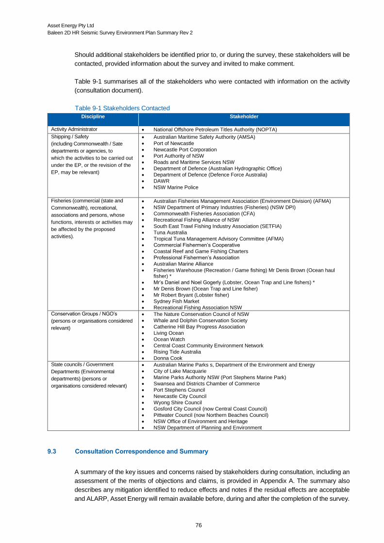
Asset Energy Pty Ltd
Baleen 2D HR Seismic Survey Environment Plan Summary Rev 2
76
Should additional stakeholders be identified prior to, or during the survey, these stakeholders will be
contacted, provided information about the survey and invited to make comment.
Table 9-1 summarises all of the stakeholders who were contacted with information on the activity
(consultation document).
Table 9-1 Stakeholders Contacted
Discipline Stakeholder
Activity Administrator National Offshore Petroleum Titles Authority (NOPTA)
Shipping / Safety
(including Commonwealth / Sate
departments or agencies, to
which the activities to be carried out
under the EP, or the revision of the
EP, may be relevant)
Australian Maritime Safety Authority (AMSA)
Port of Newcastle
Newcastle Port Corporation
Port Authority of NSW
Roads and Maritime Services NSW
Department of Defence (Australian Hydrographic Office)
Department of Defence (Defence Force Australia)
DAWR
NSW Marine Police
Fisheries (commercial (state and
Commonwealth), recreational,
associations and persons, whose
functions, interests or activities may
be affected by the proposed
activities).
Australian Fisheries Management Association (Environment Division) (AFMA)
NSW Department of Primary Industries (Fisheries) (NSW DPI)
Commonwealth Fisheries Association (CFA)
Recreational Fishing Alliance of NSW
South East Trawl Fishing Industry Association (SETFIA)
Tuna Australia
Tropical Tuna Management Advisory Committee (AFMA)
Commercial Fishermen’s Cooperative
Coastal Reef and Game Fishing Charters
Professional Fishermen’s Association
Australian Marine Alliance
Fisheries Warehouse (Recreation / Game fishing) Mr Denis Brown (Ocean haul fisher) *
Mr’s Daniel and Noel Gogerly (Lobster, Ocean Trap and Line fishers) *
Mr Denis Brown (Ocean Trap and Line fisher)
Mr Robert Bryant (Lobster fisher)
Sydney Fish Market
Recreational Fishing Association NSW
Conservation Groups / NGO’s
(persons or organisations considered
relevant)
The Nature Conservation Council of NSW
Whale and Dolphin Conservation Society
Catherine Hill Bay Progress Association
Living Ocean
Ocean Watch
Central Coast Community Environment Network
Rising Tide Australia
Donna Cook
State councils / Government
Departments (Environmental
departments) (persons or
organisations considered relevant)
Australian Marine Parks s, Department of the Environment and Energy
City of Lake Macquarie
Marine Parks Authority NSW (Port Stephens Marine Park)
Swansea and Districts Chamber of Commerce
Port Stephens Council
Newcastle City Council
Wyong Shire Council
Gosford City Council (now Central Coast Council)
Pittwater Council (now Northern Beaches Council)
NSW Office of Environment and Heritage
NSW Department of Planning and Environment
9.3 Consultation Correspondence and Summary
A summary of the key issues and concerns raised by stakeholders during consultation, including an
assessment of the merits of objections and claims, is provided in Appendix A. The summary also
describes any mitigation identified to reduce effects and notes if the residual effects are acceptable
and ALARP, Asset Energy will remain available before, during and after the completion of the survey.

Asset Energy Pty Ltd
Baleen 2D HR Seismic Survey Environment Plan Summary Rev 2
77
REFERENCES
Note : these references were used in the preparation of the EP and not all are referenced in the summary
AFMA (2014, 12 June 2014). [Commerical fishing activities within the seismic survey area (Commonwealth)].
AMSA, 2014b, The effects of Maritime oil spills on Wildlife including non-avian Marine life, AMSA, Canberra, Retrieved from URL: http://www.amsa.gov.au/environment/maritime-environmental-emergencies/national-plan/General-Information/oiled-wildlife/marine-life/index.asp.
AFMA (Producer). (2014a, 23 July 2014). Managing our Fisheries. Retrieved from http://www.afma.gov.au/managing-our-fisheries/
AFMA (Producer). (2014b, 16 July 2014). Managing our fisheries (Fisheries A-Z Index). Retrieved from http://www.afma.gov.au/managing-our-fisheries/fisheries-a-to-z-index
AMSA (Producer). (2014a, 26 Septemer 2014). Automatic Identification System (AIS) Class A. Fact Sheet. Retrieved from http://www.amsa.gov.au/forms-and-publications/Fact-Sheets/AISA_Fact.pdf
AMSA (Producer). (2014b, July 2014). Protection of the Sea. [marine safety] Retrieved from https://www.amsa.gov.au/environment/legislation-and-prevention/protection-of-the-sea/index.asp
Anatec. (2010). Shipping Traffic Survey and Collision Risk Assessment. New Seaclem-1 (Technical Note). In A. Ltd (Ed.). Aberdeen, UK.
Australia, G. (Producer). (Unknown, 5th June 2014). Sydney Basin. Retrieved from http://www.ga.gov.au/scientific-topics/energy/province-sedimentary-basin-geology/petroleum/offshore-eastern-australia/sydney
B.D. Bruce, R. B. (2008). Spatial dynamics & habitat preferences of juvenile white sharks - identifying critical habitat and options for monitoring recruitment. Final report to the department of the environment, water, heritage and the arts. Hobart: Commonwealth of Australia.
Bannister, J. L. (2001). Baleen Whales. In H. S. John, K. T. Karl & A. T. Steve (Eds.), Encyclopedia of Ocean Sciences (pp. 276-287). Oxford: Academic Press.
Barrett, G. (2014, 1st August 2014). [Pers. comm.].
Bax, A., N. J.; Williams. (2001). Seabed habitat on the south-eastern Australian continental shelf: context, vulnerability and monitoring. Marine and freshwater research, 52, 491-512.
Black, H. (2017, 26 June 2017). Seismic death rate concerns. Energy News Bulletin
Blaikley, D.R. et al (1977), “SLIKTRAK - A Computer Simulation of Offshore Oil Spills, Cleanup, Effects and Associated Costs”, EPA/API Oil Spill Conference, New Orleans
Bolle LJ, de Jong CAF, Bierman SM, van Beek PJG, van Keeken OA, et al. (2012) Common Sole Larvae Survive High Levels of Pile-Driving Sound in Controlled Exposure Experiments. PLoS ONE 7(3): e33052. doi:10.1371/journal.pone.0033052
BOM (Producer). (2014, 11 August 2014). Forecast Help - Sea Surface Salinity. Retrieved from http://www.bom.gov.au/oceanography/forecasts/forecast-help.shtml
Bonn Agreement, 1998-2012, Bonn Agreement Aerial Surveillance Handbook, 2004, Annexe A. Retrieved from http://www.bonnagreement.org/eng/html/welcome.html

Asset Energy Pty Ltd
Baleen 2D HR Seismic Survey Environment Plan Summary Rev 2
78
Booman C, Dalen J, Leivestad H, Levsen A, Van Der Meeren, T and Toklum K (1996) Effekter av luftkanonskyting på egg, larver og yngel. Fisken og Havet nr. 3 1996.
Bowles, A. E., Smultea, M., Wursig, B., Demaster, D. P., & Palka, D. (1994). Relative abundance and behaviour of marine mammals exposed to transmission from the Heard Island feasibility test. Journal of the Acoustical Society of America, 96, 2469-2484.
Branch, T., Stafford, K., Palacios, D., Allison, C., Bannister, J., Burton, C., Cabrera, E., Carlson, C., Galletti Vernazzani, B. and Gill, P. 2007. Past and present distribution, densities and movements of blue whales Balaenoptera musculus in the Southern Hemisphere and northern Indian Ocean. Mammal Review 37(2): 116-175.
Breitzke, M., Boebel, O., El Naggar, S., Jokat, W., & Werner, B. (2008). Broad-band calibration of marine seismic sources used by R/V Polarstern for academic research in polar regions. Geophysical Journal International, 174, 505–524.
Bruce, B. D., & Bradford, R. (2008). Spatial dynamics & habitat preferences of juvenile white sharks - identifying critical habitat and options for monitoring recruitment. Final report to the department of the environment, water, heritage and the arts. Hobart: Commonwealth of Australia.
Bruce, B. D., Bradford, R. W., & Stevens, J. D. (2005). Designing protected areas for grey nurse sharks off eastern Australia. Report to the Austrlian Government Department of the Environment and Heritage. Hobart: Commonwealth of Australia.
Campana, S. E., Joyce, W., & Fowler, M. (2010). Subtropical pupping ground for a cold-water shark. Canadian Journal of fish. Aquatic Science, 67, 769-773. doi: 10.1139/F10-020.
Camphuysen C.J. 2007. Chronic oil pollution in Europe, a status report. Report Royal Netherlands Institute for Sea Research, commissioned by International Fund for Animal Welfare, Brussels, 85pp.
Cardno. (2010). Development and Implementation of a Population Estimation Protocol to Provide an Estimate of East Coast Population Numbers for Grey Nurse Sharks (Carcharias taurus). Prepared for the Department of the Environment, Water, Heritage and the Arts. In C. E. Lab (Ed.). Brookvale.
Carroll, A.G., Przeslawski, R., Duncan, A., Gunning, M. and Bruce, B. (2017). A critical review of the potential impacts of marine seismic surveys on fish and invertebrates. Marine Pollution Bulletin 114: 9-24.
Casper, B. M., Halvorsen, M. B., Matthews, F., Carlson, T. J., & Popper, A. N. (2013). Recovery of barotrauma injuries resulting from exposure to pile driving sound in two sizes of hybrid striped bass. [Research Support, Non-U.S. Gov't]. PloS one, 8(9), e73844. doi: 10.1371/journal.pone.0073844
Cato, D. H. (1997). Ambient Sea Noise in Australian Waters. Paper presented at the Fifthe International Congress on sound and Vibration, Adelaide, South Australia. http://www.acoustics.asn.au/conference_proceedings/ICSVS-1997/pdf/scan/sv970015.pdf
Cato, D. H. (2008). Ocean Ambient Noise: It's Measurement and its Significance to Marine Animals. Proceedings of the Institute of Acoustics, 30, Pt. 5.
Christian JR, Mathieu A, Thompson DH, White D, and Buchanan R (2003). Effect of Seismic Energy on Snow Crab (Chionoecetes opilio). Report No. SA694 to the Canadian National Energy Board (Calgary, Alberta) by LGL Ltd (King City, Ontario) and Oceans Ltd (St John's, Newfoundland). 106 pp.
CONCAWE (1981), “A Field Guide to Coastal Oil Spill Control and Clean-up techniques”, Report 9/81.

Asset Energy Pty Ltd
Baleen 2D HR Seismic Survey Environment Plan Summary Rev 2
79
Cogger, P., H. G., Cameron, E. E., Sadlier, R. A., Eggle. (1993). The Action Plan for Australian Reptiles: Australian Nature Conservation Agency.
Cox BS et al. (2011). Use of Seismic Air Guns to Reduce Survival of Salmonid Eggs and Embryos. University of Idaho Project Number 11017.
CSIRO. (1996). Interim Marine Bioregionalsiation for Australia- Towards a National System of Protected Areas.
CSIRO. (2009). Ecological sustainable development of the regional marine and estuarine resources of NSW: Modelling of the NSW continental shelf ecosystem. Hobart: CSIRO Retrieved from http://www.dpi.nsw.gov.au/__data/assets/pdf_file/0007/281185/Gibbs-et-al_CSIRO-report-re-ESD_REPORT.pdf.
Dalen J and Knutsen GM (1986). Scaring effects in fish and harmful effects on egg, larvae and fry by offshore seismic. In: Merklinger, HM (ed.), Progress in Underwater Acoustics, Ass. Symposium on Underwater Acoustics, Halifax, Nova Scotia (1986). Plenum Publishing Corporation, New York.
Davies, T. W., Duffy, J. P., Bennie, J., & Gaston, K. J. (2014). The nature, extent, and ecological implications of marine light pollution. Ecological Environment, 12(6), 347-355. doi: 10.1890/130281
Davis, L. (2014, 1st August 2014). [Pers.Comm.].
Day, R.D., McCauley, R.M. Fitzgibbon, Q.P., Hartmann, K., Semmens, J.M., Institute for Marine and Antarctic Studies, 2016, Assessing the impact of marine seismic surveys on southeast Australian scallop and lobster fisheries, University of Tasmania, Hobart, October.
DECC. (2011). Review and Assessment of Underwater Sound Produced from Oil and Gas Sound Activities and Potential Reporting Requiremetns under the Marine Strategy Framework Directive. (P. b. G. O. a. G. C. Ltd, Trans.): Department of Energy and Climate Change.
Deda, P., Elbertzhagen, I., & Klussmann, M. (2007). Light pollution and the impacts on biodiversity, species and their habitats. In C. o. M. S. o. W. A. (UNEP-CMS) (Ed.), (pp. 133-139): Conservation of Migratory Species of Wild Animals (UNEP-CMS)
DEH (2005). Humpback whale recovery plan, 2005-2010. Department of Environment and Heritage, Canberra.DEWHA. (2002). Recovery Plan for the Grey Nurse Shark (Carcharias taurus) in Australia. Canberra: Commonwealth of Australia.
DEWHA, (2007), The humpback whales of Eastern Australia Factsheet, Retrieved from: http://www.environment.gov.au/resource/humpback-whales-eastern-australia
DEWHA. (2009). The East Marine Bioregional Plan; Bioregional Profile. A description of the ecosystems, conservation values and uses of the East Marine Region. Canberra: Commonwealth of Australia.
Det Norske Veritas. (2011) Assessment of Risk of Marine Oil Pollution. Report for Australian Maritime Safety Authority, Det Norske Veritas Project PP002916, December 2011.
DFO (2004). Potential Impacts of Seismic Energy on Snow Crab. DFO Can. Sci. Advis. Sec. Habitat Status Report 2004/003.
DOD (Producer). (2014, 11 August 2014). Coastal Sea Surface Salinity (search tool). Retrieved from http://www.metoc.gov.au/products/data/aussss.php
DOE. (2014a). EPBC Act Species profile and Threats Database. , from http://www.environment.gov.au/cgi-

Asset Energy Pty Ltd
Baleen 2D HR Seismic Survey Environment Plan Summary Rev 2
80
bin/sprat/public/sprat.pl
DOE. (2014b). EPBC Act Species profile and Threats Database.: Department of the Environment.
DOI (Producer). (2014, 26 May 2014). Offshore Petroleum Exploration Acreage Release, Australia 2014. Retrieved from www.petroleum-acreage.gov.au
DOtE (Producer). (1999, 4th August 2014). Criteria for identifying Wetlands of International Importance. Retrieved from http://www.environment.gov.au/topics/water/water-our-environment/wetlands/ramsar-convention-wetlands/criteria-identifying-wetlands
Environmental Protection and Biodiversity Conservation Regulations 2000 (Satutory Rules No. 181, 2000 as amended). (Part 8). § Part 8 (2000).
DOtE. (2007). Nomination for listing a key threatening process under the Environmental Protection and Biodiversity Conservation Act 1999 (EPBC Act). Canberra: Australian Government Retrieved from http://www.environment.gov.au/system/files/pages/87ef6ac7-da62-4a45-90ec-0d473863f3e6/files/nomination-boat-strike-2007.pdf.
DOtE (Producer). (2010), 2nd August 2014). Australian Ramsar Wetlands. Retrieved from http://www.environment.gov.au/cgi-bin/wetlands/alphablist.pl
DOtE (Producer). (2013a, 27 June 2014). Caperea marginata - Pygmy Right Whale. Retrieved from http://www.environment.gov.au/cgi-bin/sprat/public/publicspecies.pl?taxon_id=39
DOtE (Producer). (2013b, 18 July 2014). Grey Nurse Shark Biology and Ecology. Retrieved from http://www.environment.gov.au/resource/grey-nurse-shark-biology-and-ecology
DOtE. (2014a). Draft recovery plan sawfish and river sharks: Largetooth Sawfish (Pristis pristis), Green Sawfish (Pristis zijsron), Dwarf Sawfish (Pristis clavata), Speartooth Shark (Glyphis glyphis), Norther River Shark (Glyphis garricki) (Vol. Draft). Canberra: Department of the Environment.
DOtEE (Producer). (2017, 26 April 2017). EPBC Act Protected Matters Report. Retrieved from http://www.environment.gov.au/topics/about-us/legislation/environment-protection-and-biodiversity-conservation-act-1999/protected
DOtE (Producer). (2014c, 18 July 2014). Whale Shark (Rhincodon typus) Issue Paper. Retrieved from http://www.environment.gov.au/topics/marine/marine-species/sharks/whale-shark
DPI, N. (2014). NSW Department of Primary Industries submission on PEP11 seismic survey proposal 2014/15. (Fisheries, Trans.) (pp. 15): Department of Primary Industries (Fisheries).
DPI, N. (2016). NSW Department of Primary Industries submission on PEP11 seismic survey proposal 2016/17. (Fisheries, Trans.) (pp. 17): Department of Primary Industries (Fisheries).
DSEWPaC. (2012a). Commonwealth marine environment report card Supporting the marine bioregional plan.
DSEWPaC. (2012b). Marine Bioregional Plan for the Temperate East Marine Region. Canberra: Australian Government.
DSEWPaC. (2012c). Species group report card - sharks. Supporting the marine bioregional plan for the Temperate East Marine Region. Canberra: Commonwealth of Australia Retrieved from http://www.environment.gov.au/system/files/pages/1e59b6ec-8b7e-42a8-9619-b5d728f878b2/files/temperate-east-report-card-sharks.pdf.
Asset Energy Pty Ltd
Baleen 2D HR Seismic Survey Environment Plan Summary Rev 2
81
DSEWPaC. (2013a). DRAFT issues paper for the Grey Nurse Shark (Carcharias taurus). Canberra: Commonwealth of Australia Retrieved from http://www.environment.gov.au/system/files/resources/c99bc40a-cca5-4bc0-9be0-958f30ddb1f2/files/draft-issues-paper-grey-nurse-shark.pdf.
DSEWPaC. (2013b). Draft Recovery Plan for the Grey Nurse Shark (Carcharias taurus). Canberra: Commonwealth of Australia Retrieved from http://www.environment.gov.au/system/files/resources/c99bc40a-cca5-4bc0-9be0-958f30ddb1f2/files/draft-recovery-plan-grey-nurse-shark.pdf.
DSEWPaC. (2013c). Issues Paper for the White Shark (Carcharodon carcharias). Canberra: Australian Government Retrieved from http://www.environment.gov.au/system/files/resources/6eb72ed4-a3fa-4604-b722-a5c2b45ad1e9/files/white-shark-issues-paper.pdf.
DEWHA. (2008) EPBC Act Policy Statement 2.1 - Interaction between offshore seismic exploration and whales: Industry guidelines, Department of the Environment, Water, Heritage and the Arts.
Dunlop, R. A., Noad, M. J., McCauley, R. D., Scott-Hayward, L., Kniest, E., Slade, R., Paton, D., et al. (2017). Determining the behavioural dose–response relationship of marine mammals to air gun noise and source proximity. The Journal of Experimental Biology, 220: 2878–2886.
EA. (2003). Recovery Plan for Marine Turtles in Australia: Environment Australia.
EPA. (2010). Environmental Assessment Guideline for Protecting Marine Turtles from Light Impacts (pp. 1-30). Perth: Environmental Protection Authority, Western Australia.
Erbe, C. (2012). The effects of underwater noise on marine mammals. In: Noise on Aquatic Life. Advances in Experimental Medicine and Biology, 730.
Etkin D.S (1997) The Impact of Oil Spills on Marine Mammals, OSIR Report 13 March 1997 Special Report.
Francis, M. P., & Stevens, J. D. (1999). Reproduction, embryonic development and growth of the Porbeagle Shark, Lamna nasus, in the southwest Pacific Ocean. Fish Bulletin, 98, 41-63. \
French DP, Schuttenberg H and Isaji, T. 1999. Probabilities of oil exceeding thresholds of concern: examples from an evaluation for Florida Power and Light, in: Proceedings of the 22nd Arctic and Marine Oil Spill Program (AMOP) Technical Seminar, June, Environment Canada, pp. 243-270.
Gausland, I. (2003). Seismic Surveys Impact on Fish and Fisheries (pp. An overview of the possible impact that seismic surveys may have on fish and fisheries): Norwegian Oil Industry Association (OLF).
Goertner, J. F. (1982). Prediction of underwater explosion safe ranges for sea mammals (pp. 1-42). Silver Spring, Maryland, Virginia 22448: Naval Surface Weapons Centre, White Oak Laboratory, Silver Spring.
Golder, A. (2007). Literature review, synthesis, and design of monitoring of ambient artificial light intensity on the OCS regarding potentila effects on resident marine fauna. Prepared for: U.S. Department of the Interior, Minerals Management Service. (pp. 1-96). Anchorage, Alaska.
Goold, J. C. (1196). Acoustic assessment of populations of common dolphin (Delphinus delphis) in conjunction with seismic surveying. Journal of the Marine Biological Association of the UK, 76, 811-820.
Goold, J. C., & Fish, P. J. (1998). Broadband spectra of seismic survey air-gun emissions with reference to dolphin auditory thresholds. Journal Acoustic Society of America, 103(4), 177-184.

Asset Energy Pty Ltd
Baleen 2D HR Seismic Survey Environment Plan Summary Rev 2
82
Gordon, J., Gillespie, D., Potter, J., Frantzis, A., Simmonds, M. P., Swift, R., & Thompson, D. (2003). A Review of the Effects of Seismic Surveys on Marine Mammals. Marine Technology Society Journal, 37(4), 16-34.
Götz, T., Hastie, G., Hatch, L. T., Raustein, O., Southall, B. L., & Tasker, M. (2009). Overview of the impacts of anthropogenic underwater sound in the marine environment. (441/2009). UK: OSPAR Commission UK.
Götz, T., & Janik, V. (2011). Repeated elicitation of the acoustic startle reflex leads to sensitisation in subsequent avoidance behaviour and induces fear conditioning. BMC Neuroscience, 12:30. doi: 10.1186/1471-2202-12-30
Government, A. (2010). Offshore Petroleum Greenhouse Gas Storage Act 2006. Canberra: Office of Legislative Drafting and Publishing.
Government, A. (2014). Offshore Petroleum and Greenhouse Gas Storage (Environmental) Regulations 2009. (Statutory Rules No 228, 1999 as amended). Canberra: Office of Parliamentary Council.
Greenlaw WH and Holliday DV (1988). Effects of air gun energy releases on northern anchovy. The Journal of the Acoustical Society of America 84, S165 (1988); doi: 10.1121/1.2025935.
Halvorsen, M. B., Casper, B. M., Matthews, F., Carlson, T. J., & Popper, A. N. (2012). Effects of exposure to pile-driving sounds on the lake sturgeon, Nile tilapia and hogchoker. [Comparative Study
Research Support, Non-U.S. Gov't]. Proceedings. Biological sciences / The Royal Society, 279(1748), 4705-4714. doi: 10.1098/rspb.2012.1544
Hastings, M. C. (2008). Coming to terms with the effects of ocean noise on marine animals. Acoustic Today, 4(2), 22-34.
Hayes, G., D., Lyne, V., condie, S., Griffiths, B., Pigot, S., Hallegraeff. (2005). Collation and Analysis of Oceanographic Datasets for National Marine Bioregionalisation. A report to the Australian Government, National Oceans Office.
Hildebrand, J. A. (2009). Anthropogenic and natural sources of ambient noise in the ocean. Marine Ecology Progress Series, 395, 5-20. doi: 10.3354/meps08353
Hill, S. H. (1978). A guide to the effects of underwater shock waves in arctic marine mammals and fish. Pacific Marine Science (pp. 50). Patricia Bay, Sidney, B.C: Ocean Sciences, Patricia Bay, Sidney, B.C.
IEM, 2010, Economic Impact of the Deepwater Horizon Oil Spill: Part One- Fisheries, Report prepared for Greater New Orleans Inc. Regional Economic Alliance. 15th October, 2010
IMO (Producer). (2014, 10 September 2014). Greenhouse Gas Emissions. Air Pollution and Greenhouse Gas Emissions. Retrieved from http://www.imo.org/OurWork/Environment/PollutionPrevention/AirPollution/Pages/GHG-Emissions.aspx
Incardona, J.P. Gardner, L.D., T. L. Linbo, T. L. Brown, A. J. Esbaugh, E. M. Mager, J. D. Stieglitz, B. L.
French, Labenia, J. S. C. A. Laetz, M. Tagal, C. A. Sloan, A. Elizur, D. D. Benetti, M. Grosell, B. A.
Block, N. L. Schol, 2014, Deepwater Horizon crude oil impacts the developing hearts of large
predatory pelagic fish, PNAS, E1510-E1518.

Asset Energy Pty Ltd
Baleen 2D HR Seismic Survey Environment Plan Summary Rev 2
83
IUCN (Producer). (2014, 18 July 2014). The IUCN Red List of Threatened Species; Manta birostris. Retrieved from http://www.iucnredlist.org/details/198921/0
Jerry F. Payne, Jamie Coady and Dave White, July 2009. Potential Effects of Seismic Airgun Discharges on Monkfish Eggs (Lophius americanus) and Larvae Environmental Studies Research Funds Report No.170. St. John’s, NL. 32 p.
Jordan Davies, A., P., Ingleton, T., Foulsham, E., Neilson, J., Pritchard, T. (2010). Seabed habitat mapping of the continental shelf of NSW.
Kemper, C. A. (2002). Distribution of the pygmy right whale, Caperea marginata in the Australiasian region. Marine Mammal Scinece 18(1), 99-111.
Kostyvchenko LP (1973). Effect of elastic waves generated in marine seismic prospecting on fish eggs in the Black Sea. Hydrobiological Journal, 9 (5): 72-75.
Kropach, C. (1971). Sea snake (Pelamis platurus) aggregations on slicks in Panama. Herpetologica, 27, 131-135.
Laist, D. W., Knowlton, A. R., Mead, J. G., Collet, A. S., & Podesta, M. (2001). Collisions between ships and whales. Marine Mammal Science, 17(1), 35-75.
Larcombe, J., Noriega, R. and Stobutzki, I (editors) 2015. ABARES 2015, Reducing uncertainty in fisheries stock status, ABARES research report, Commonwealth of Australia.
Liggins, G. (2014, July 2014). [Lobster Scientist.].
Limpus, C. (2007). A biological review of Australian marine turtle species. 5. Flatback turtle, Natator depressus (Garman).
Limpus, C. (2008a). A biological review of Australian marine turtle species. 1. Loggerhead turtle, Caretta caretta (Linneaus): Queensland Environmental Protection Agency.
Limpus, C. (2008b). A biological review of Australian marine turtle species. 2. Green turtle, Chelonia mydas (Linnaeus): Queensland Environmental Protection Agency.
Limpus, C. (2009a). A biological review of Australian marine turtle species. 3. Hawksbill turtle, Eretmochelys imbricata (Linnaeus). In L. Fien (Ed.). Brisbane: Queensland Environmental Protection Agency.
Limpus, C. (2009b). A biological review of Australian marine turtle species. 6. Leatherback turtle, Dermochelys coriacea (Vandelli).
Longhurst, A. (2007). Ecological Geography of the Sea. Amsterdam ; Boston, MA: Academic Press.
Macgillivray, A. O., & Chapman, N. R. (2005). Results from an acoustic modelling study of seismic airgun survey noise in Queen Charlotte Basin: University of Victoria
Matishov GG (1992). The reaction of bottom-fish larvae to airgun pulses in the context of the vulnerable Barents Sea ecosystem. Fisheries and Offshore Petroleum Exploitation 2nd International Conference, Bergen Norway, 6th – 8th April 1992.
McCauley, R.D. (1994). The environmental implications of offshore oil and gas development in Australia – seismic surveys. In: Swan, J.M., Neff, J.M. and Young, P.C. (eds.), Environmental Implications of Offshore Oil and Gas Development in Australia - The Findings of an Independent Scientific Review, pp. 123-207. Australian Petroleum Exploration Association, Sydney. pp. 19-21.

Asset Energy Pty Ltd
Baleen 2D HR Seismic Survey Environment Plan Summary Rev 2
84
McCauley, R. D., Fewtrell, J., Duncan, A. J., Jenner, C., Jenner, M. N., Penrose, J. D., . . . McCabe, K. A. (2000). Marine seismic surveys: Analysis and propagation of air gun signals; and effects of airgun exposure on humpback whales, sea turtles, fishes and squid. Prepared for The Australian Petroleum Production and Exploration Association. (pp. 198). Perth: Curtin University of Technology.
McCauley, R. D., & Kent, C. S. (2012). A lack of correlation between airgun signal pressure waveforms and fish hearing damage. . In: Popper AN, Hawkins AD (eds) The effects of noise on aquatic life. New York: Springer Science and Business Media, LLC.
McCauley, R. D. et al. Widely used marine seismic survey air gun operations negatively impact zooplankton. Nat. Ecol. Evol. 1, 0195 (2017).
McCracken, K., & Siciliano, F. (Producer). (Unknown, 31 July 2014). Atlas of New South Wales; People Population. Retrieved from http://www.atlas.nsw.gov.au/public/nsw/home/topic/article/population.html
McKenna, M. F., Ross, D., Wiggins, S. M., & Hildebrand, J. A. (2012). Underwater radiated noise from modern commercial ships. [Research Support, U.S. Gov't, Non-P.H.S.]. The Journal of the Acoustical Society of America, 131(1), 92-103. doi: 10.1121/1.3664100
Mitson, R. (2003). Causes and effects of underwater noise on fish abundance estimation. Aquatic Living Resources, 16(3), 255-263. doi: 10.1016/s0990-7440(03)00021-4
MPA (Producer). (2011, 16 July 2014). Distribution, relative abundance, habitat use and seasonal variation of Black Cod (Epinephelus daemelii) within the Port Stephens - Great Lakes Marine Park. Retrieved from http://www.hcr.cma.nsw.gov.au/uploads/res/black_cod_report_final.pdf
MPA. (2014). Port Stephens - Great Lakes Marine Park. Zoning plan user guide. In M. P. A. N. Government (Ed.): NSW Government.
Murphy, J. (2014, 1st August 2014). [Pers. comms].
Murphy, J. J., & Steffe, A. S. (2011). Recreational fishing surveys in the Greater Sydney Region. (No. 131 (ISSN 1837-2112)). Cronulla: NSW Government.
Newcastle (Producer). (2013, 31 July 2014). Community Profile; City of Newcastle. Retrieved from http://profile.id.com.au/newcastle
Nieukirk, S. L., Stafford, K. M., Mellinger, D. K., Dziak, R. P., & Fox, C. G. (2004). Low-frequency whale and seismic airgun sounds recorded in the mid-Atlantic Ocean. Journal Acoustic Society of America, 115, 1832–1843.
NMFS (National Marine Fisheries Service) 2016. Technical Guidance for Assessing the Effects of Anthropogenic Sound on Marine Mammal Hearing: Underwater Acoustic Thresholds for Onset of Permanent and Temporary Threshold Shifts. U.S. Department of Commerce, NOAA. NOAA Technical Memorandum NMFS-OPR-55. 178 pp. http://www.nmfs.noaa.gov/pr/acoustics/Acoustic%20Guidance%20Files/opr-55_acoustic_guidance_tech_memo.pdf.
NOAA Marine Mammal Acoustic Threholds (2016) http://www.westcoast.fisheries.noaa.gov/protected_species/marine_mammals/threshold_guidance.html
NOPSEMA (Producer). (2014, 8th July 2014). Legislation and Regulations. Offshore Petroleum & Greenhouse Gas Storage Act 2006. Retrieved from http://www.nopsema.gov.au/legislation-and-regulations/environment/
Asset Energy Pty Ltd
Baleen 2D HR Seismic Survey Environment Plan Summary Rev 2
85
Norman, B. (2002). CITES Identification Manual, Whale Shark (Rhincodon typus Smith 1829). (ISBN 0 642 54900 1). Canberra: Commonwealth of Australia Retrieved from http://www.environment.gov.au/system/files/resources/2ad2cfba-5382-4731-8592-02b22893d9b3/files/id-manual.pdf.
Norman, B. M. (1999). Aspects of the biology and ecotourism industry of the whale shark Rhincodon typus in north-western Australia Thesis presented for the degree of Master of Philosophy of Murdoch University. Perth Murdoch University, Western Australia.
NPC (Producer). (2014, 31 July 2014). Newcastle Port Corporation. Retrieved from http://www.newportcorp.com.au/site/
NSW (Producer). (2013a, 31 July 2014). NSW Ports; Botany Port. Retrieved from http://www.nswportsbotany.com.au/
NSW, D. (Producer). (2000, 18 July 2014). The biology, ecology, distribution, abundance and identification of marine protected areas for the conservation of threatened Grey Nurse Sharks in south east Australian waters. Retrieved from http://www.dpi.nsw.gov.au/research/areas/aquatic-ecosystems/outputs/2000/greynurse-conservation
NSW, D. (2003). Fishery Management Strategy for the Ocean Hauling Fishery. (ISBN 0 7310 9426 3). Cronulla: NSW Fisheries Retrieved from http://www.dpi.nsw.gov.au/__data/assets/pdf_file/0003/224481/OH-FMS.pdf.
NSW, D. (Producer). (2005, 16 July 2014). Threatened speices in NSW, Great white shark. Primefacts. Retrieved from http://www.dpi.nsw.gov.au/__data/assets/pdf_file/0011/5105/Primefact_Great_white_shark.pdf
NSW, D. (2007a). Fishery Management Strategy for the NSW Lobster Fishery. (ISBN 978 0 7347 1841 9 ). Cronulla: NSW Department of Primary Industries Retrieved from http://www.dpi.nsw.gov.au/__data/assets/pdf_file/0015/224214/Lobster-FMS.pdf.
NSW, D. (2007b). Fishery Management Strategy for the NSW Ocean Trawl Fishery. Cronulla: NSW DPI Retrieved from http://www.dpi.nsw.gov.au/fisheries.
NSW, D. (Producer). (2007c, 16 July 2014). Threatened Species in NSW Black Cod Epinephelus daemelii. Retrieved from http://www.dpi.nsw.gov.au/__data/assets/pdf_file/0019/144154/black-cod.pdf
NSW, D. (Producer). (2008/09, 17 July 2014). Mako Sharks (Isurus spp.). Retrieved from http://www.dpi.nsw.gov.au/__data/assets/pdf_file/0004/375916/Mako-Sharks.pdf
NSW, D. (2011). Discussion paper for Grey Nurse Shark Protection. Nelson Bay: DPI NSW Retrieved from http://www.dpi.nsw.gov.au/__data/assets/pdf_file/0004/392197/GNS-Public-Consultation-Discussion-Paper.pdf.
NSW, D. (Producer). (2012, 4th August 2014). Ramsar sites in New South Wales. Retrieved from http://www.environment.nsw.gov.au/wetlands/nswramsarsites.htm
NSW, D. (Producer). (2013b, 18 July 2014). Factsheet Grey Nurse Shark (Carcharias taurus).
NSW, D. (Producer). (2014, 26 June 2014). Fishing and Aquaculture. Retrieved from http://www.dpi.nsw.gov.au/fisheries/info/nsw-fish-species
OGP, I. (2011). An overview of marine seismic operations (Report No. 448) (I. A. o. G. Contractors, Trans.). In I. A. o. O. a. G. Producers (Ed.), (pp. 50). London.

Asset Energy Pty Ltd
Baleen 2D HR Seismic Survey Environment Plan Summary Rev 2
86
O'hara, P.D., Morandin, L. A., 2010, Effects of Sheens Associated with Offshore Oil and Gas Development on the Feather Microstructure of Pelagic Seabirds,Environmental Studies Research Fund, Natural Resources Canada.
Otway, N. M., Burke, A. L., Morrision, N. S., & Parker, P. C. (2003). Monitoring and identification of NSW Critical Habitat Sites for conservation of Grey Nurse Sharks. Nelson Bay: Environment Australia.
Parente, C. L., & de Araújo, E. (2005). Is the diversity of cetaceans in Brazil reduced by the intensification of the seismic surveys? Paper SC/57/E6 presented to the IWC Scientific Committee. Ulsan, Korea.
Payne, J. F., Andrews, C. A., Fancey, L. L., Cook, A. L., Christian, J. R., and others. 2007. Pilot study on the effects of seismic air gun noise on lobster (Homarus americanus). Citeseer. (Accessed July 2017).
http://citeseerx.ist.psu.edu/viewdoc/download?doi=10.1.1.516.5711&rep=rep1&type=pdf
Pearson WH et al. (1994) Effects of seismic energy releases on the survival and development of zoeal larvae of dungeness crab (Cancer magister). Marine Environmental Research Volume 38, Issue 2, 1994, Pages 93-113 [Available to purchase]
Pendoley, K. L. (2005). Sea Turtles and the Environmental Management of Industrial Activities in North Western Australia. Doctor of Philosophy, Murdoch University, Perth.
Pidcock, S., Burton, C., & Lunney, M. (2003). The potential sensitivity of marine mammals to mining and exploration in the Great Australian Bight Marine Park Marine Mammal protection Zone. An independent review and risk assessment report to Environment Australia. Canberra: Commonwealth of Australia.
Pogonoski, J. J., Pollard, D. A., & Paxton, J. R. (2002). Conservation overview and action plan for Australian threatened and potetentially threatened marine and estuarine fishes. (ISBN 0642547866). Canberra: Environment Australia Retrieved from http://www.environment.gov.au/system/files/resources/ca415225-5626-461c-a929-84744e80ee36/files/marine-fish.pdf.
Poore, G. C. B. (1995). Australias marine ecosystems: the continental shelf and slope. In P. Zann, L. P., Kailola (Ed.), State of the Marine Environment Report for Australia: Technical Annex I: The Marine Environment: Great Barrier Reef Marine Park Authority for the Department of the Environment, Sport and Territories.
Poot, H., Ens, B. J., de Vries, H., Donners, M. A. H., Wernand, M. R., & Marquenie, J. M. (2008). Green Light for Nocturnally Migrating Birds. Ecology and Society, 13(2).
Popper, A. N. (2014). Sound Exposure Guidelines for Fishes 1 and Sea Turtles.
Popper, A. N., Halvorsen, M. B., Kane, A., Miller, D. L., Smith, M. E., Song, J., . . . Wysocki, L. E. (2007). The effects of high-intensity, low-frequency active sonar on rainbow trout. [Research Support, N.I.H., Extramural]. The Journal of the Acoustical Society of America, 122(1), 623-635. doi: 10.1121/1.2735115
Popper, A. N., & Hastings, M. C. (2005). Effects of sound on fish. Subconsultants to Jones & Stokes Under California Department of Transportation.
Popper, A. N., & Hastings, M. C. (2009). The effects of human-generated sound on fish. [Review]. Integrative zoology, 4(1), 43-52. doi: 10.1111/j.1749-4877.2008.00134.x
Popper, A. N., & Higgs, D. M. (2009). Fish: Hearing, Lateral Lines (Mechanisms, role in Behavior,

Asset Energy Pty Ltd
Baleen 2D HR Seismic Survey Environment Plan Summary Rev 2
87
Adaptations to Life Underwater) (pp. 6).
RC. (2009). Artificial Light in the Environment. (ID 2328242 11/09). Richmond: Her Majesty's Stationary Office.
Recovery Plan for the Grey Nurse Shark (Carcharias Taurus), Commonwealth of Australia 2014
Recovery Plan for Marine Turtles in Australia, Commonwealth of Australia 2017
Rich, C., & Longcore, T. (2006). Ecological Consequences of Artificial Night Lighting C. Rich & T. Longcore (Eds.), Retrieved from http://www.google.com.au/url?sa=t&rct=j&q=&esrc=s&source=web&cd=3&ved=0CCsQFjAC&url=http%3A%2F%2Fplay.psych.mun.ca%2F~mont%2Fpdfs%2Finfluences.PDF&ei=Xl0JVOv8LsG3uATT8oGYCw&usg=AFQjCNGmITdZO-NlgWqyG2sZj79QLAi1Bw&bvm=bv.74649129,d.c2E
Richardson, W. J., Greene, C. R. J., Malme, C. I., & Thomson, D. H. (1995). Marine Mammals and Noise. . San Diego: Academic Press.
Ross, G.J.B. (2006). Review of the Conservation Status of Australia's Smaller Whales and Dolphins. Page(s) 124. [Online]. Report to the Australian Department of the Environment and Heritage, Canberra. Retrieved from: http://www.environment.gov.au/resource/review-conservation-status-australias-smaller-whales-and-dolphins.
Shahidul Islam, M., & Tanaka, M. (2004). Impacts of pollution on coastal and marine ecosystems including coastal and marine fisheries and approach for management: a review and synthesis. [Review]. Marine pollution bulletin, 48(7-8), 624-649. doi: 10.1016/j.marpolbul.2003.12.004
Simpkin, P. (2003). Exploration gazière et pétrolière du golfe du Saint-Laurent: Revue sommaire sur les impacts potentiels, ANNEXE 1: Rappel d'acoustique marine.: IKB Technologies Ltd & INRS-ETE, Québec, Canada.
Southall, B. L., Bowles, A. E., Ellison, W. T., Finneran, J. J., Gentry, R. L., Greene Jr, C. R., . . . Tyack, P. L. (2007). Marine Mammal Noise Exposure Criteria: Initial Scientific Recommendations. Aquatic Mammals, 33(4), 411-509.
Stamation, K., Croft, D.B., Shaughnessy, P.D. and Waples, K.A. (2007). Observations of humpback whales (Megaptera novaeangliae) feeding during their southward migration along the coast of southeastern New South Wales, Australia: Identification of a possible supplemental feeding ground. Aquatic Mammals 33(2): 165-174.
Steffe, A. S., Chapman, D. J., & Murphy, J. J. (1999). A Description of the Charter Fishing Boat Industry Operating in the Coastal and Estuarine Waters of New South Wales during 1997-98. (ISSN 1442-0147). NSW Fisheries Research Institute.
Stone, C. J., & Tasker, M. L. (2006). The effects of seismic airguns on cetaceans in UK waters. Journal of Cetacean Research and Management, 8(3), 255.
Sydney (Producer). (2014a, 31 July 2014). Sydney Ports Corporation; First Port, Future Port. Retrieved from http://www.sydneyports.com.au/
Sydney, C. o. (Producer). (2014b, 31 July 2014). City of Sydney. Retrieved from http://www.cityofsydney.nsw.gov.au/about-us
Thomsan, P. (2014, 1st August 2014). [Pers.comm.].
Threatened Species Scientific Committee (2015): Conservation Advice for Megaptera novaeangliae

Asset Energy Pty Ltd
Baleen 2D HR Seismic Survey Environment Plan Summary Rev 2
88
(humpback whale).
Thrush, S. F., Milburn, C. J., Hewitt, J. E., Cummings, V. J., Dayton, P. K., Cryer, M., . . . Wilkinson, M. R. (1998). Disturbance of the Marine Benthic Habitat by Commercial Fishing: Impacts at the Scale of the Fishery. Ecological Applications, 8, 886-879.
Todd Jones, A., T., Seminoff. (2013). Feeding Biology: Advances from field-based observations, phsyiological Studies, and molecular techniques. In Wyneken, J., Lohmann, K. J., Musick, J. A. (Ed.), The Biology of Sea Turtles (pp. 211-248): CRC Press.
Vermeire, M. B. (2007). Everything you need to know about marine fuels Global Marine Products (pp. 32). Ghent: Chevron.
visitnewcastle (Producer). (2014, 1 August 2014). Newcastle Tourism Website. Retrieved from http://www.visitnewcastle.com.au/
Ward, P, Mazur, K, Stenekes, N, Kancans, R, Curtotti, R, Summerson, R, Gibbs, C, Marton, M, Moore, A & Roach, J. A socioeconomic evaluation of three eastern Australian game-fishing regions. ABARES report to client prepared for the Fisheries Research and Development Corporation, Canberra, August 2012.
Warner, G., McCrodan, A., & Hannay, D. (2011). Sound Source Verification of Statiol's 2011 Marine Shallow Hazards Seismic Survey, Chukchi Sea. 5-Day Field Report. In J. A. Sciences (Ed.), (Vol. 02). Houston: JASCO Applied Sciences.
Watkins, W. A., Daher, M. A., Fristrup, K. M., & Howald, T. J. (1993). Sperm Whales Tagged with Transponders and Tracked Underwater by Sonar. Marine mammal Science, 9(1), 55-67.
West, L.D., Stark, K.E., Murphy, J.J, Lyle, J.M., and Ochwada-Doyle, F.A (2016). Survey of Recreational
Fishing in New South Wales and the ACT, 2013/14. NSW Department of Primary Industries
Fisheries Final Report Series No. 149.
Wiese, F. K., Montevecchi, W. A, Davoren, G. K., Huettmann, F., Diamond, A. W., Linke, J., 2001, Seabirds at risk around offshore oil platforms in the north-west atlantic, Marine Pollution Bulletin.
Williams, D., & Williams, B. (Producer). (2014, 11 August 2014). Coral Bay - Western Australia. Retrieved from http://www.coralbay.org/index.htm
Wyatt, R. (2008). Joint Industry Programme on Sound and Marine Life; Review of Existing data on Underwater Sounds Produced by the Oil and Gas Industry. Great Torrington: Seiche Measurements Limited Ref - S186.
Zann, L. P. (2000). The eastern Australian region: a dynamic tropical/temperate biotone. Marine Pollution Bulletin, 41, 188–203.

Asset Energy Pty Ltd
Baleen 2D HR Seismic Survey Environment Plan Summary Rev 2
89
APPENDIX A STAKEHOLDER CONSULTATION SUMMARY

Asset Energy Pty Ltd
Baleen 2D HR Seismic Survey Environment Plan Summary Rev 2
90
Summary of Key Responses from Stakeholder
Stakeholder*
(Discipline)
Information Provided (Date, Method) Summary of Response (Date, Method) Assessment of Merit
Shipping / Safety
AMSA Email (09 May 2017) with consultation
documentation.
No response received. Delivery failure to email recipients. Follow-up phone call 4 July 2017 and re-sent
information to generic AMSA email address
AMSA emailed (5 July 2017) guidance and advice (See
Table 8.3).
Asset confirmed (email 18 Oct 2017) that the survey
will implement and adhere to AMSA advice (Table 8.3)
and provided updated fact sheet of EP revisions.
Emailed (20 October 2017) fact sheet
regarding EP revision and resubmission.
AMSA confirmed revisions (e.g. new commencement
date) and previous advice (email 20 Oct 2017).
Asset provided feedback (email 27 Oct 2017)
regarding warranted use of a chase vessel (Table 8.3).
Return receipt (30 Oct 2017) No further action until response received.
Newcastle Port
Corporation (aka Port
Authority of NSW)
Email (09 May 2017) with consultation
documentation
No response nor email error message received.
Follow-up phone call 4 July 2017 and
confirmed change of name to Port
Authority NSW, whom Asset emailed
previously 22 May 2017 (see below).
Confirmed receipt of email (22 May 2017) and unable to
attend community meeting. No direct impacts expected
on the port and only minor impacts on shipping in area.
Asset thanked Port Authority for their response (email
22 May 2017) and confirmed future consultation.
Email (19 October 2017) fact sheet
regarding EP revision and
resubmission.
No response nor email error message received. No further action required until pre-survey notification.
Port of Newcastle Email (09 May 2017) with consultation
documentation.
No expected impacts on Port’s operations, do not intend
to attend the consultation meeting. Advised that Port
Authority of NSW responsible for navigation safety.
Asset thanked Port of Newcastle (email 10 May 2017)
and attempted to contact Port Authority NSW.
Email (20 October 2017) fact sheet
regarding EP revision and
resubmission.
No response nor email error message received. No further action required until pre-survey notification.
Division Roads and
Maritime Services
Email (09 May 2017) with consultation
documentation.
Emailed response (10 May 2017) that unable to attend
community meeting and will discuss survey later with
phone call
Asset set-up conference call for 17 May 2017.
Noted to ensure that Asset Energy is aware of maritime
requirements (i.e. notice to mariners and requirements
of the AHO). No concerns.
Asset confirmed that all maritime requirements will be
implemented and compliant. No further action
required.
Email (19 October 2017) fact sheet
regarding EP revision and
resubmission.
Thanked Asset for updated information (email 20 Oct
2017) and provided updated contact details.
No further action required until pre-survey notification.
Australian Hydrographic
Office (AHO)
Email (09 May 2017) with consultation
documentation and again on 11 May
2017 (correct email address)
Emailed response (11 May 2017), with details of change
of address for AHO. No additional response received
after resending information to new address.
No further action required until pre-survey notification.
Email (22 October 2017) fact sheet
regarding EP revision and
Confirmed receipt and no additional comments (email 24
oct 2017).
No further action required until pre-survey notification.

Asset Energy Pty Ltd
Baleen 2D HR Seismic Survey Environment Plan Summary Rev 2
91
resubmission.
Australian Department of
Defence (Offshore
Petroleum)
Email (09 May 2017) with consultation
documentation.
No response nor email error message received.
No further action required.
Email (22 October 2017) fact sheet
regarding EP revision and
resubmission.
No response nor email error message received.
No further action required until pre-survey notification.
AQIS Central East
Region Biosecurity
Services
Email (09 May 2017) with consultation
documentation.
Delivery failure.
Alternate email address found
Email (20 October 2017) fact sheet
regarding EP revision and
resubmission.
Confirmed receipt (email 20 Oct 2017) and email
forwarded to DAWR, who confirmed receipt and new
contact information (email 24 Oct 2017).
No further action required until pre-survey notification.
Automatic reply from DAWR (email 20 Oct 2017) with
updated vessel information.
No further action required until pre-survey notification.
NSW Marine Police
(Newcastle Water Police)
Email (09 May 2017) with consultation
documentation.
Confirmed receipt (email 22 May 2017) and attendance
at community meeting. No concerns were raised.
No further action required.
Email (19 October 2017) fact sheet
regarding EP revision and
resubmission.
Confirmed receipt (email 20 Oct 2017) and no further
comments provided.
No further action required until pre-survey notification.
Fisheries**
Australian Fisheries
Management Association
(Environmental Division)
AFMA
Email (09 May 2017) containing
information on proposed survey
location.
No response nor email error message received.
Follow-up phone call and emailed response (08 Jun
2017) containing links to consultation process and
promise of further response.
Emailed receipt (8 June 2017) and replied with
suggestions for stakeholders with whom to consult and
fishery status reports by ABARES.
Asset Energy thanked AFMA for their response (email
30 Oct 2017) and confirmed consultation with the
suggested stakeholders and acknowledged the fishery
information from ABARES. No further action required.
Emailed (20 October 2017) fact sheet
regarding EP revision and resubmission
to AFMA email.
No response nor email error message received.
No further action required until pre-survey notification.
Email (30 October 2017) PEP11
stakeholder update – reduced scale and
duration of seismic survey
Response received by Asset Energy confirming email
received (email 9 November 2017)
No further action required
NSW DPI, Fisheries
NSW
Email (09 May 2017) with consultation
documentation.
Email response (12 May 2017) with previous response
document from 2016
Asset acknowledged receipt and was reviewing
document.
Email (15 May 2017) with follow-up
question regarding FADs nearby.
Email response (15 May 2017) confirming no FADs in or
close to the survey area.
No further action required.
Email (19 May 2017) confirming attendance at
community meeting
Asset invited DPI for an in-person meeting before
community meeting
In-person meeting with DPI Fisheries and Asset Energy:
discussed potential concerns that will be raised at
community meeting. Attended community meeting and
No further response required.

Asset Energy Pty Ltd
Baleen 2D HR Seismic Survey Environment Plan Summary Rev 2
92
no concerns were raised from DPI.
Email (26 June 2017) provided Asset Energy with new
scientific publications FYI.
Emailed response (29 June 2017) acknowledged
receipt and requested further information on coral
snapper.
Email response (29 June 2017) was unable to confirm
species and suggested contacting PFS or fishers
directly.
Emailed response (29 June 2017) confirming no
response from PFA.
Confirmed coral snapper species information (email 30
June 2017)
Emailed thanks and confirmation (30 June 2017).
Verbal communication (25 May 2017) to
obtain information on local fisheries to
determine most appropriate contacts /
method of disseminating survey
information.
NSW DPI will assist where applicable regarding
dissemination of information.
No further action required until pre-survey notification.
Email (26 Sept 2017) fact sheet
regarding EP revision and
resubmission.
Confirmed receipt (email 12 Oct 2017) Asset requested response as soon as possible (email
12 Oct 2017)
Emailed updated response (23 Oct 2017) see details in
Table 8.3
Emailed response (26 Oct 2017) see Table 8.3
Requested update on Swansea FAD
2018 location, type and deployment
(email 24 Oct 2017)
Confirmed Swansea FAD position and deployment date
(email 24 Oct 2017). And further email 6 December
2017)
No further action required until pre-survey notification.
Requested information on how FADs
work (email 6 Dec 2017.
Email (6 Dec 2017) described how fish aggregate
around any floating object, hence why FADs are
effective
Emailed response (6 Dec 2017) querying whether FAD
has any active electronic components. Received
response (email 6 Dec 2017) that FADs are passive
devices other than having a light for navigation
purposes. No further action required.
Email (18 Dec 2017) acknowledging timing of survey is
Asset’s decision and noting that leadup to Easter is
commercially important.
Email (19 Dec 2017) detailing proposed survey dates
and why these were selected. Also discussed
behavioural impact effects likely to be temporary only
plus use of DPI’s social media to advise fishers of
survey. No response received. No further action
required
NSW DPI, Fisheries
NSW
Phone call (16 June 2017) requesting
further information about rock lobster
spawning.
The following information was provided to Asset Energy:
main spawning area from Port Stephens northwards to Far North Coast
Likelihood of some spawning near survey area
Spawning area between 10—30 m water depth on mid-continental shelf
Life cycle stages – eggs laid in September and carried for 3 months
Email (16 June 2017) thanking DPI for phone
conversation, summarising main points and providing
public consultation document. No further action
required until pre-survey notification.
NSW DPI, Fisheries
NSW (Recreation
Phone call and follow-up email (27 Oct
2017) to about general discussion of
Email response (27 Oct 2017) with additional information
such as peak periods, main area (‘carpark’) and target
Emailed thanks for information and confirmation (28
Oct 2017) that main area ‘carpark’ is 10 km sound of

Asset Energy Pty Ltd
Baleen 2D HR Seismic Survey Environment Plan Summary Rev 2
93
Fisheries) survey and potential concerns for
recreational fisheries (see Table 8.3 for
details)
species (see Table 8.3). New Seaclem well site, and thus no impacts are
expected.
Emailed (30 Oct 2017) additional information about
game fishing.
Emailed thanks for information and confirmation with
map (30 Oct 2017) that main area ‘carpark’ is 10 km
sound of New Seaclem well site, and thus no impacts
are expected. Requested specific details about size of
carpark area.
Emailed (31 Oct 2017) additional information about
carpark variability (+/- 10 nm) with coordinates.
Emailed thanks and receipt of information (31 Oct
2017).
Asset Energy advised potential dates
for survey (email 8 Dec 2017) and
requested offshore tournament dates.
No response received. Followed up via
phone call 13 December requesting
same information
Email (13 December 2017) provided to Asset Energy
with offshore tournament dates for NSW
Emailed thanks for information on tournaments (15
Dec 2017), queried date of tournament in late March
and discussed how proposed dates of survey were
selected to minimise overlap with seasonal peaks for
recreational and commercial fishing.
Email (18 Dec 2017) suggesting April / May less
recreational fishing activity and asking plans for
contacting fishing clubs / organisations
Email (19 Dec 2017) detailing proposed survey dates
and why these were selected. Also discussed
behavioural impact effects likely to be temporary only
plus use of DPI’s social media to advise fishers of
survey. No response received. No further action
required
Commonwealth Fisheries
Association
Email (09 May 2017) with consultation
documentation.
No response nor email error message received. No further action required.
Email (22 Oct 2017) fact sheet
regarding EP revision and
resubmission.
No response nor email error message received.
No further action required until pre-survey notification.
Recreational Fishing
Alliance of NSW
Email (10 May 2017) with consultation
documentation.
Email response (10 May 2017) requesting details of
depth range, GPS coordinates of the survey area and
differences between the proposed airgun source for this
survey compared with previous surveys. Confirmed
attendance at community meeting.
Follow-up with phone call (10 May 2017) and emailed
(12 May 2017) with survey details (e.g. coordinates,
track lines, etc.)
Attended community meeting (25 May 2017) and no
further comments raised.
No further actions required.
Emailed (19 Oct 2017) updated fact
sheet regarding EP revision and
resubmission
Emailed receipt (20 Oct 2017) and noted Swansea FAD
location and deployment. Requested testing and
sampling regarding potential impacts to fish (see Table
8.3).
Asset emailed response (23 Oct 2017) and see Table
8.3 for details. No further action required until pre-
survey notification.
South East Trawl Fishing
Industry (SETFIA)
Email (5 Apr 2017) with consultation
documentation
. Email response (7 April 2017) that SETFIA trawl fishery
ends at Barrenjoey Point and offshore Newcastle does
not affect them. Asked to be removed from stakeholder
No further action required as no longer a stakeholder
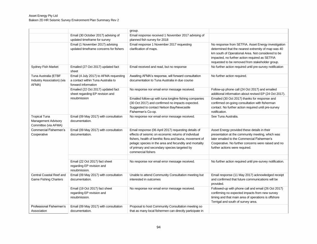
Asset Energy Pty Ltd
Baleen 2D HR Seismic Survey Environment Plan Summary Rev 2
94
group.
Email (30 October 2017) advising of
updated timeframe for survey
Email response received 1 November 2017 advising of
planned fish survey for 2018
Email (1 November 2017) advising
updated timeframe concerns for fishers
Email response 1 November 2017 requesting
clarification of maps.
No response from SETFIA. Asset Energy investigation
determined that the nearest extremity of map was 40
km south of Operational Area. Not considered to be
impacted, no further action required as SETFIA
requested to be removed from stakeholder group.
Sydney Fish Market Emailed (27 Oct 2017) updated fact
sheet
Email received and read, but no response No further action required until pre-survey notification
Tuna Australia (ETBF
Industry Association) (via
AFMA)
Email (4 July 2017) to AFMA requesting
a contact within Tuna Australia to
forward information
Awaiting AFMA’s response, will forward consultation
documentation to Tuna Australia in due course
No further action required.
Emailed (22 Oct 2017) updated fact
sheet regarding EP revision and
resubmission
No response nor email error message received.
Follow-up phone call (24 Oct 2017) and emailed
additional information about revised EP (24 Oct 2017).
Emailed follow-up with tuna longline fishing companies
(30 Oct 2017) and confirmed no impacts expected.
Suggested to contact Nelson Bay/Newcastle
Fishermen’s Co-op.
Emailed (30 Oct 2017) thanks for response and
confirmed on-going consultation with fisherman
contact. No further action required until pre-survey
notification.
Tropical Tuna
Management Advisory
Committee (via AFMA)
Email (09 May 2017) with consultation
documentation.
No response nor email error message received.
See Tuna Australia.
Commercial Fishermen’s
Cooperative
Email (09 May 2017) with consultation
documentation.
Email response (06 April 2017) requesting details of
effects of seismic on economic returns of individual
fishers, health of benthic flora and fauna, movement of
pelagic species in the area and fecundity and mortality
of primary and secondary species targeted by
commercial fishers
Asset Energy provided these details in their
presentation at the community meeting, which was
later emailed to the Commercial Fishermen’s
Cooperative. No further concerns were raised and no
further actions were required.
Email (22 Oct 2017) fact sheet
regarding EP revision and
resubmission.
No response nor email error message received. No further action required until pre-survey notification.
Central Coastal Reef and
Game Fishing Charters
Email (09 May 2017) with consultation
documentation.
Unable to attend Community Consultation meeting but
interested in outcomes
Email response (11 May 2017) acknowledged receipt
and confirmed that future communications will be
provided.
Email (19 Oct 2017) fact sheet
regarding EP revision and
resubmission.
No response nor email error message received. Followed-up with phone call and email (26 Oct 2017)
confirming no expected impacts from new survey
timing and that main area of operations is offshore
Terrigal and south of survey area.
Professional Fishermen’s
Association
Email (09 May 2017) with consultation
documentation.
Proposal to host Community Consultation meeting so
that as many local fishermen can directly participate in

Asset Energy Pty Ltd
Baleen 2D HR Seismic Survey Environment Plan Summary Rev 2
95
the consultation process.
Follow-on email communications related
to Community Consultation Meeting on
25 May 2017.
Requested PowerPoint presentation (30 May 2017) Asset provided PowerPoint presentation (30 May
2017)
Provided signed attendance list and draft outcomes
document (23 June 2017).
Emailed thanks and edits to document (26 June 2017).
Emailed request for EP and concerns regarding survey
location and impacts on fish stocks and industry, as well
as potential impacts on zooplankton (2 Aug 2017).
Emailed response (19 Oct 2017) see Table 8.3.
Email (12 Oct 2017) fact sheet
regarding EP revision and
resubmission.
Emailed thanks for update and effort to reduce impact
(23 Oct 2017) and emailed additional concerns for
restricting access, zooplankton impacts and copy of EP
(see Table 8.3).
Emailed response (27 Oct 2017) and map of ‘farm’
area (see Table 8.3). No further actions required until
pre-survey notification.
Fishermen’s Warehouse Email (09 May 2017) with consultation
documentation.
Requested in email (11 May 2017) GPS coordinates of
survey area. Planned to attend Community Consultation
on 25 May 2017. No direct response.
Asset re-sent documentation (11 May 2017) and
clarified that survey coordinates provided the following
confirmations:
Survey coordinates were included in the consultation document provided
Water depth is approximately 125 m
No significant bottom structures
Water depth is 143 m at New Seaclem-1 drilling site, which is also featureless bottom.
Attended community meeting (25 May 2017) and no
concerns raised.
No actions required.
Email (19 October 2017) fact sheet
regarding EP revision and
resubmission.
No response nor email error message received.
No further action required until pre-survey notification.
Mr Daniel and Noel
Gogerly
Email (05 April 2017) with details of
proposed survey.
No response nor email error message received. No actions required.
Follow-up email (09 May 2017) with
consultation documentation.
No response nor email error message received. No actions required.
Mr Dennis Brown Email (09 May 2017) with consultation
documentation.
Emailed thanks (9 May 2017) and unable to attend
community meeting. Advised of his communications to
the Professional Fisherman’s Association regarding the
proposed survey
No further action required.
Email (20 October 2017) fact sheet
regarding EP revision and
resubmission.
No response nor email error message received.
No further action required until pre-survey notification.
Mr Robert Bryant Email on 29 June 2017 requested
confirmation of survey area overlapping
with lobster traps and provided survey
coordinates
Emailed response (29 June 2017) regarding lobster trap
procedures and requested date for survey
Email response (29 June 2017) acknowledged receipt
and informed that survey proposed for September.
Confirmed that more information will be provided
closer to the survey date.
Email (29 June 2017) acknowledged receipt and future No further action required until pre-survey notification.

Asset Energy Pty Ltd
Baleen 2D HR Seismic Survey Environment Plan Summary Rev 2
96
communications.
Email (18 October 2017) fact sheet
regarding EP revision and
resubmission.
Emailed additional information (19 Oct 2017) regarding
lobster fishing in area until end of March and hopes to
be finished before survey commences. Requested
updates.
Emailed thanks and confirmation of all updates (19 Oct
2017). No further action required until pre-survey
notification.
Sydney Fish Market Email (27 October 2017) consultation
documentation and fact sheet regarding
EP revision and resubmission.
Return receipt received 30 Oct 2017. No further actions required until pre-survey notification.
Conservation Groups / NGO’s
The Nature Conservation
Council of NSW
Email (09 May 2017) with consultation
documentation.
Advice received that the communication was received
and will be responded to in seven days. No further
response received
No further action required.
Email (22 October 2017) fact sheet
regarding EP revision and
resubmission.
Emailed receipt and response pending (20 Oct 2017). No further action required until pre-survey notification.
Whale and Dolphin
Conservation Council
Email (09 May 2017) with consultation
documentation.
Delivery failed.
Asset found alternate contact.
Email (20 October 2017) fact sheet
regarding EP revision and
resubmission.
No response nor email error message received.
No further action required until pre-survey notification.
Catherine Hill Bay
Progress Society
Email 09 May 2017) with consultation
documentation.
No response nor email error message received.
No further action required.
Email (22 October 2017) fact sheet
regarding EP revision and
resubmission.
No response nor email error message received.
No further action required until pre-survey notification.
Rising Tide Australia Email (09 May 2017) with consultation
documentation.
No response nor email error message received.
No further action required.
Email (22 October 2017) fact sheet
regarding EP revision and
resubmission.
Delivery failed.
Asset could not find other contact information.
Ocean Watch Email (09 May 2017) with consultation
documentation.
No response nor email error message received.
No further action required.
Email (22 October 2017) fact sheet
regarding EP revision and
resubmission.
No response nor email error message received.
No further action required until pre-survey notification.
Living Ocean Email (5 April 2017) updated
correspondence on seismic survey
No response nor email error message received.
No further action required.
Email (9 May 2017) inviting Living
Ocean to stakeholder engagement
discussion on seismic survey
Phone call on 25 May 2017 Living Ocean requesting
status of survey.
Phone call 25 May 2017 Living Ocean advising survey
was small scale, short duration. Agreed to provide
survey information and include in future stakeholder
engagements. No further action required until pre-

Asset Energy Pty Ltd
Baleen 2D HR Seismic Survey Environment Plan Summary Rev 2
97
survey notification.
Email (31 May 2017) slide presentation
on Proposed 2D Seismic Survey
offshore Newcastle / PEP11 provided
Letter received (06 July 2017) confirming receipt of slide
presentation and advising of concerns to humpback
whale migration interactions. Asset Energy responded
with confirmation receipt via email 17July 2017. Advised
that modelled noise output was low and unlikely to affect
whales and that EPBC policy on interactions with
cetaceans would be followed,
Asset Energy considered all stakeholder responses
and advised Living Ocean (email 13 October 2017)
that new survey dates early 2018. No further action
required.
Emails (7 and 26 September 2017)
information on EP progress and
updated factsheet
Phone call from Living Ocean (9 Oct 2017) to confirm
that resubmission meant survey date would be early
2018 and great for avoiding whale migration times.
Thanked Asset for transparency
No further action required.
Email (13 October 2017) advising on
what impact Living Ocean had on
decision to alter survey dates.
Email received from Living Oceans (13 Oct 2017)
acknowledging Asset Energy’s response.
No further action required
Phone call from Living Ocean (30 Nov 2017 and 1 Dec
2017) asking status of EP resubmission. Advised
response not yet received from NOPSEMA
No further action required
Central Coast
Community
Environmental Network
Email (09 May 2017) with consultation
documentation
Delivery failed.
Asset could not find other contact information.
Email (19 October 2017) fact sheet
regarding EP revision and
resubmission.
Delivery failed. Asset could not find other contact information.
Donna Cook Email (5th April 2017) stakeholder
update
No response nor email error message received No further action required.
State Councils / Government Departments
Marine Parks Authority
NSW (Port Stephens
Marine Park)
Email (09 May 2017) with consultation
documentation.
Out of office reply (9 May 2017) but will respond upon
return.
No further actions required.
Email (22 October 2017) fact sheet
regarding EP revision and
resubmission.
Out of office reply (22 Oct 2017) but will respond upon
return.
No further action required until pre-survey notification.
Swansea and District
Chamber of Commerce
Email (09 May 2017) with consultation
documentation.
No response nor email error message received.
No further action required.
Email (22 October 2017) fact sheet
regarding EP revision and
resubmission.
Email delivery failed (22 Oct 2017). Asset re-sent to president of Chamber of Commerce
(22 Oct 2017) and no response nor email error
message received. No further action required.
Port Stephens Council Email (09 May 2017) with consultation
documentation.
No response nor email error message received.
No further action required.
Email (22 October 2017) fact sheet No response nor email error message received. No further action required until pre-survey notification.

Asset Energy Pty Ltd
Baleen 2D HR Seismic Survey Environment Plan Summary Rev 2
98
regarding EP revision and
resubmission.
Newcastle City Council Email (09 May 2017) with consultation
documentation.
Emailed (9 May 2017) that the communication was
received and will be forwarded to the appropriate person
for their action.
No further action required.
Email (22 October 2017) fact sheet
regarding EP revision and resubmission
Emailed (22 Oct 2017) that the communication was
received and will be forwarded to the appropriate person
for their action.
No further action required until pre-survey notification.
Wyong Shire Council Email (09 May 2017) with consultation
documentation.
No response nor email error message received.
No further action required.
Email (22 October 2017) fact sheet
regarding EP revision and
resubmission.
Emailed thanks (20 Oct 2017) and forwarded email to
council member for action.
No further action required until pre-survey notification.
Central Coast/Gosford
City Council
Email (09 May 2017) with consultation
documentation.
Advice received that the communication was received
and will be forwarded to the appropriate person for their
action.
No further action required.
Email (22 October 2017) fact sheet
regarding EP revision and
resubmission.
Emailed thanks (20 Oct 2017) and forwarded email to
council member for action.
No further action required until pre-survey notification.
Lake Macquarie City
Council
Email (09 May 2017) with consultation
documentation.
No response nor email error message received.
No further action required.
Email (22 October 2017) fact sheet
regarding EP revision and
resubmission.
No response nor email error message received.
No further action required until pre-survey notification.
Office of Environment
and Heritage, NSW
National Parks and
Wildlife Service
Email (21 August 2017) concern of survey overlap with
southern migration of humpback whales and
consideration in EP and asked if NSW National Parks
and Wildlife were consulted
Email response (22 August 2017) providing the
following information:
confirming that survey unlikely to overlap with southern migration of humpback whales
survey vessel information and risks from vessel presence
soft start summary
survey duration and details in Commonwealth waters
confirmed consultation with Port Stephens Great Lakes Marine Parks group.
Email response (23 August 2017) acknowledged receipt,
satisfied that survey will not occur during whale
migration season and requested future communications
as ‘relevant person’.
Email response (27 September 2017) with fact sheet
of revised EP.
Email response (4 October 2017) acknowledged receipt
of fact sheet and requested future communications
regarding survey.
No further action required until pre-survey notification.
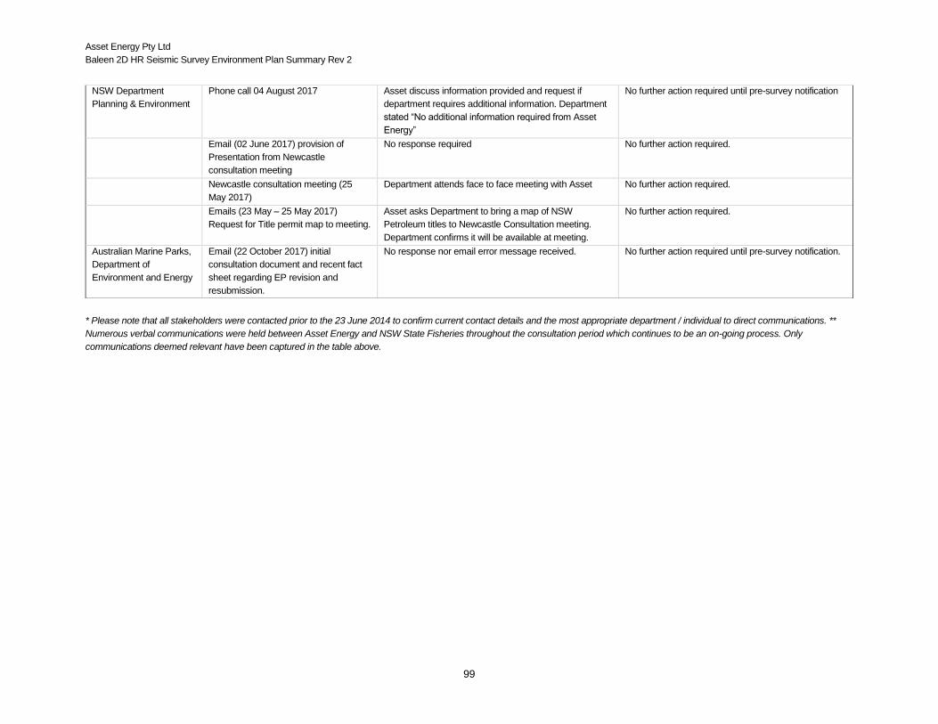
Asset Energy Pty Ltd
Baleen 2D HR Seismic Survey Environment Plan Summary Rev 2
99
* Please note that all stakeholders were contacted prior to the 23 June 2014 to confirm current contact details and the most appropriate department / individual to direct communications. **
Numerous verbal communications were held between Asset Energy and NSW State Fisheries throughout the consultation period which continues to be an on-going process. Only
communications deemed relevant have been captured in the table above.
NSW Department
Planning & Environment
Phone call 04 August 2017 Asset discuss information provided and request if
department requires additional information. Department
stated “No additional information required from Asset
Energy”
No further action required until pre-survey notification
Email (02 June 2017) provision of
Presentation from Newcastle
consultation meeting
No response required No further action required.
Newcastle consultation meeting (25
May 2017)
Department attends face to face meeting with Asset No further action required.
Emails (23 May – 25 May 2017)
Request for Title permit map to meeting.
Asset asks Department to bring a map of NSW
Petroleum titles to Newcastle Consultation meeting.
Department confirms it will be available at meeting.
No further action required.
Australian Marine Parks,
Department of
Environment and Energy
Email (22 October 2017) initial
consultation document and recent fact
sheet regarding EP revision and
resubmission.
No response nor email error message received.
No further action required until pre-survey notification.

Asset Energy Pty Ltd
Baleen 2D HR Seismic Survey Environment Plan Summary Rev 2
100
Summary of Issues Raised during Consultation and Asset Energy’s Response
Issue Stakeholders Raising the Issue Asset Energy Assessment and Response
Impact of underwater
noise affecting
commercial fish
stocks
Commercial Fishermen’s’ Cooperative,
Professional Fishermen’s Association
(PFA)
This issue is fully recognised by Asset Energy as having the potential to occur. However, (as set out in Section
5.3.6.2) the overall risk is determined to be minor (i.e. potential short term behavioural effects (avoidance of the noise
source) due to the variation in response by different species, the temporary nature of the survey and the implantation
of mitigation controls to reduce the risk of impact to ALARP. To date no research has attributed adult fish mortality with
seismic activities. In order to mitigate any undesirable outcomes, the following mitigation has been committed to:
- Soft start procedures will be followed each time the acoustic sources are initiated; - No overcharging of the guns will occur; and - Regular communications with relevant stakeholders during the survey with information on vessel
movement and intended movements will occur every 24 hours (a central point of contact will be decided upon following face to face consultation.
Considering the scientific information available, the baseline characterisation of the fishery within the survey area and
consultations it is considered that residual effects are acceptable and ALARP.
The following summary of impacts and risk from underwater noise was provided to the Commercial Fishermen’s
Cooperative and PFA:
The noise source (compressed air release via “airgun”) is incredibly small. Our survey will not be effective with a smaller noise source, and the number of days over which it will be activated will be 3-4. It will not be activated during the numerous line turns. The noise levels are very low. Additional acoustic modelling is presently being undertaken, however we don’t believe the acoustic impacts of our survey will threaten the mortality of any species in the area. We are also aware of the potential impacts of large seismic surveys on zooplankton (as identified in that paper you referred to) but understand also that CSIRO’s paper (29 June 2017, “Potential impacts on zooplankton of seismic surveys”) responded to McCauley’s paper and described that zooplankton populations recovered after the survey. We note that the modelled survey in CSIRO’s paper was of much greater duration than our planned survey. We believe we will not have any impacts on mortality or local population of any species due to the small airgun size and short duration of the survey, and that behavioural impacts, if any, will be temporary.
We reiterate that our understanding of zooplankton impacts (from McCauley, CSIRO and others) are that population-level recovery will occur rapidly (within a few days) following our seismic survey. The accurate and robust environmental risk assessment in the EP acknowledged that acoustic impacts are likely to occur to zooplankton, but based on the survey’s short duration (3–4 days) and low levels of underwater noise, long-term, population-level impacts are not likely and the risk to zooplankton is minor. Furthermore, based on the independent, underwater noise modelling, our single source will generate sound levels lower than those used in the study. The survey sound source will be 90 in3 (150 in3 in the study) with estimated received sound levels of SEL 143 dB re 1μPa2·s (SEL 153 dB re 1μPa2·s at 1 km in the study).
Thanks again for the provision of material related to the farm. We can appreciate that this information may be sensitive to some in the fishing industry, and therefore acknowledge the interest you and your members have with our proposed survey and its location. We reiterate that our survey will only restrict access to this area for a very short duration (3–4 days), and that no permanent impacts on the fishery in this region will result.
Exclusion from fishing
grounds impacting
commercial/
Commercial Fishermen’s Cooperative,
Professional Fishermen’s Association
This issue if fully recognised by Asset Energy as likely to occur. However, (as set out in Section 5.4) the overall risk is
determined to be moderate (i.e. short term (days) with no lasting effects or impact) due to the mitigation measures
which will be implemented and the temporary nature of the survey. While Asset Energy are aware of the legitimacy of

Asset Energy Pty Ltd
Baleen 2D HR Seismic Survey Environment Plan Summary Rev 2
101
recreational fishing
activities.
concerns with respect to this particular impact, it is very difficult to quantify the effect to individual fishers due to the
variety of factors that would influence their necessity to access specific areas of the survey location at any particular
time. The most effective way forward is to employ practical mitigation measures in discussion with local fishers with
the goal of reducing potential impacts. While these may change as the consultation process, the following mitigation
has been committed to:
Face to face consultation with relevant stakeholders;
Identification of main point of contact (TBC);
Regular communications with relevant stakeholders during the survey with information on vessel movement and intended movements every 24 hours;
Considering the difficulty in quantifying the impact to individual fishers, the ability of fishers to potentially target other
species and / or other areas of the ocean and on-going consultation, it is considered that residual effects area
acceptable and ALARP
PFA raised concerns about the restriction on access would also apply to Ocean Trap & Line fishers and East Coast
Tuna fishers; we also note your statement that the size of the farm is small. However, it is highly productive and
important compared to any other area within that region due to the nature of the significant geographical features of
the area that attract large quantities and variety of species that are commercial and recreationally significant. We
reiterate that the survey will have onerous impact on our commercial fishing activities.
The following response of impacts and risk from temporary restriction on fishing access was provided to the
Commercial Fishermen’s Cooperative and PFA:
We note this is a very small area of impact, and the survey will be for a very small duration (~3-4 days). Therefore, we believe this highly localised and very short duration isn’t of onerous impact on your activities.
Please be assured that we are aware of the highly-productive and important area to commercial fisheries. We do, however, reiterate that our survey area is generally small, and that an exclusion zone of 2 nautical miles around the vessel during the 3-4 days of operations will ensure safety to all other users, vessels and infrastructure. Based on the relative size of the potential fisheries in the offshore central coast area (i.e. thousands of square kilometres, pending location restrictions and key fish locations), our environmental risk assessment concluded that a very short term overlap of a relatively miniscule area (~15km2) will have a minor, temporary and localised impact on any fishery.
Request for further
consultation i.e. face
to face meetings
(before, during and
after the survey)
Recreational Fishing Alliance of NSW,
Commercial Fishermen’s Cooperative,
Professional Fishermen’s Association,
NSW DPI
Due to the concerns raised above Asset Energy expected a high level of consultation. As with previous experience in
the region, Asset Energy are looking to improve upon the consultation process with the goal of delivering clear
information on realistic risks and potential impacts. In order to address this request Asset Energy are committed to:
Liaising with NSW Department of Fisheries in the first instance;
Schedule community consultation meeting(s) prior to the commencement of the survey (during and on completion of the survey, as required);
Respond to all concerns in a reasonable time.
In direct response to these concerns, Asset Energy had a community public meeting hosted by PFA on 25 May 2017
(see Table 8.4).
Management of
commercial shipping /
other marine users.
Roads and Maritime Services (NSW) No issues were raised with respect to the management of commercial shipping. Comments obtained from Roads and
Maritime were gentle reminders of the necessary management procedures to be followed during offshore operations.
Asset Energy and their contractor are committed to executing a safe and successful project. Vessel collision is

Asset Energy Pty Ltd
Baleen 2D HR Seismic Survey Environment Plan Summary Rev 2
102
considered to be low, providing the survey vessel operates as required under maritime law. In order to mitigate any
undesirable outcomes, the following mitigation has been committed to:
Information regarding the location and survey schedule will be provided to AHO at least two weeks prior to commencement (for issue of Notice to Mariners);
The vessel will operate at all times in compliance with maritime law i.e. International Regulations for
the Prevention of Collisions at Sea 1972 (as amended), International Convention of the Safety of Life
at Sea (SOLAS), 1974 and Navigation Act 2012);
All vessel management systems will be adhered to; and
Adequately trained and competent crew.
Through complying with relevant legislation and undertaken consultation with appropriate stakeholders, Asset Energy
consider that residual risk involved in potential safety at sea impacts (i.e. vessel collision) are considered acceptable
and ALARP.
Via phone call 11 May 2017Asset Energy confirmed directly with Roads and Maritime Services (S Wilde) that the
survey will operate in compliant with all maritime laws (e.g. MARPOL Conventions, etc.).
AMSA AMSA provided advice regarding maritime safety:
escort/guard vessel is recommended when the survey vessel is conducting activities from the coast out to the 4,000m depth contour or to the 153° line of longitude, whichever is the farthest.
Given the length of tow of 900m, any guard/support vessel, in cooperation with the survey vessel, will need to be active and maintain exceptional communications with commercial shipping in the survey area noting there will be a considerable speed
difference between these craft and the survey vessel whilst the latter is conducting operations.
The seismic vessel must display appropriate day shapes, lights, streamers and reflective tail buoys, to indicate the vessel is towing and is therefore restricted in her ability to manoeuvre. Visual and radar watches must be maintained on the bridge at all times.
Please have the survey vessel notify AMSA’s Joint Rescue Coordination Centre (JRCC) through [email protected] (Phone: 1800 641 792 or +61 2 6230 6811) for promulgation of radio-navigation warnings 24-48 hours before operations commence.
AMSA’s JRCC will require the survey vessel’s details (including vessel name, callsign and Maritime Mobile Service Identity (MMSI)), satellite communications details (including INMARSAT-C and satellite telephone), area of operation, requested clearance from other vessels and need to be advised when operations start and end.
The Australian Hydrographic Service must be contacted through [email protected] no less than four working days.
Asset Energy responded with the following:
Thanked AMSA for comments and advice on the upcoming Baleen 2D High Resolution Seismic Survey.
It has always been planned that the vessel being used for the survey will follow normal convention in relation to displaying appropriate day shapes, lights and reflective tailbuoys as well as maintaining visual and radar watches on the bridge at all time.
We have noted the advance times required to notify the JRCC and the Hydrographic Service and will advise accordingly.
At present the issue of using a guard vessel during operations is still under consideration.
Please see attached updated information regarding our proposed seismic survey. The key change is the anticipated timing – now likely an early 2018 survey.
Asset Energy further responded with:

Asset Energy Pty Ltd
Baleen 2D HR Seismic Survey Environment Plan Summary Rev 2
103
We believe that the reduced scale of operations in conducting the seismic survey do not warrant the use of a chase vessel. The survey will be 3-4 days in duration involving one day deploying equipment, two days of operations and possibly another day for weather downtime plus retrieval of the equipment. The survey vessel is small (30m) when compared with those normally used for seismic survey (~100m) and the seismic streamer at 900m length is also reduced in length to those used for a typical survey (5-6kms or longer).
By following the requirements for maintaining bridge and radar watches at all time combined with the safety measures described within the Environment Plan to be submitted to NOPSEMA, we believe that the risks will be reduced to ALARP.
As an additional comment, advice has been received from the Newcastle Harbour Master that he is of the opinion the survey will have "only minor impacts on shipping in the area".
Management of waste
and oil spills
Roads and Maritime Services (NSW) Asset Energy and their contractor are committed to executing a safe and successful project. Disposal of waste will
follow MARPOL requirements. The vessel’s Waste Management Plan provides for no waste, other than food, to be
disposed of at sea. Food waste can be disposed of past the 12 nm limit. All solid waste to be offload onshore for
disposal as per vessel management systems.
This information was confirmed to Roads and Maritime Services (S Wilde) via phone call on 11 May 2017.
Impacts to
recreational fisheries
NSW DPI, Recreational Fisheries NSW DPI provided the following information regarding recreational fishing activities (via phone call and emails):
Peak recreational fishing period is January to March, with more activity at Xmas and Easter holidays. Peak game fishing activity in usually Feb - March inc. with slightly less activity in both January and April - although this is very much dependent on environmental conditions.
Most of the game fishing activity is targeting dolphinfish, marlin and some shark fishing. There will also be some deep-water bottom fishing.
A particularly important area for game fishing is the 'carpark' which encompasses a relatively large area (several miles north/ south) from the GPS co-ords 33.02 S 152.24 E. This area can have upwards of 100-150 boats accessing it if the bait (blue mackerel/ jack mackerel) is gathered here and the marlin are present. Activity here is usually controlled by the EAC strength, if the EAC is particularly strong and the water particularly warm then the baitfish don't tend to aggregate here. However, if the EAC eddies in this area, the bait gathers and the fishing can be world-class.
Target fish species and associated water depths are: o Marlin generally 60- 100 fathoms
o Black marlin can be caught inshore or can be found around the shelf o Striped marlin is generally on the shelf area between 60-100 fathoms o Blue marlin is generally on the shelf edge and beyond
Fishing tournaments currently include: o Bigfish Bonanza - Lake Macquarie 9-11 Feb o The Billfish Shootout - Port Stephens 16-18 Feb o Port Stephens Interclub 23-26 Feb
o East Coast Classic - Newcastle 10-11 March.
There can be upwards of 200 boats competing in good years.
Carpark area can move around 10 nm in either direction. Well-known areas are at the following coordinates:
o 32.50–32.54 S o Main area around 33.00–33.04 S
o Can run down to 33.12 S.
Asset Energy responded that the centre of the ‘carpark’ is about 10 km south of the well site in the survey area and 48
km away from the main survey area. It is possible that the survey would be near to the ‘carpark’ area for less than 8
hours, given the slow speed of the vessel. A map was provided to show the relative location of the ‘carpark’ and the

Asset Energy Pty Ltd
Baleen 2D HR Seismic Survey Environment Plan Summary Rev 2
104
survey area. And further information was requested regarding the extent of the ‘carpark’.
NSW DPI raised concerns about:
the significance of recreational and charter fishing activity within the survey area, including associated expenditure and benefit to regional economies.
impact on popular and peak recreational and charter fishing times to minimise disruption to fishing and fishing competitions during the peak recreational fishing season.
effective consultation directly with recreational and charter fishers.
Seismic activity may disturb schooling baitfish
Notification to Department regarding the proposed dates the survey vessel will be operating, and the proposed routes or area coverage within specified periods.
Asset Energy agrees and confirmed that:
recreational and charter fishing activity and interest in the proposed area are significant, though we note from the recreational fishing report by L. West in December 2015 that less than 2% of recreational fishing is done at distances greater than 5km from the shoreline. We confirm engagement with recreational fishers/representatives, charter vessel operators and associated tackle shop stakeholders with an interest in our proposed survey. Similar to above, the EP contains an accurate and robust environmental impact and risk assessment, including the commissioning of site-specific, underwater noise modelling undertaken independently by an acoustic consultancy. Based on the modelling prediction of low received sound levels (i.e. not exceeding acoustic thresholds for fish or other marine fauna) and the survey’s short duration (3–4 days), impacts to recreational fishing activities were assessed to be recoverable, localised and ALARP. The risk was assessed to be minor and acceptable.
Survey activities will not be impacting the key recreational and charter fishing period around Christmas and Easter, and notes that the location of the closest FADs (Swansea and Newcastle) are approximately 8km and 19.5km shoreward of their closest points to the survey area. Based on independent, underwater noise modelling, the survey is not likely to have acoustic impacts at these distances away (i.e. received sound levels will be <170 dB re 1 μPa2·s beyond 4 km away).
Proposed dates for survey will avoid fishing tournaments, peak recreational activity in the week before and after Easter (1 April 2018) and lobster spawning period
Survey activity will have a short overlap period (< 6 hours) with small portion of ‘carpark’ and that any effects on fish dispersal would be temporary.
effective consultation with recreational fishermen has been initiated and will continue throughout the valid period of the EP.
Asset Energy will use DPI’s social media (Newscast, Charter Chatter and Facebook) to advise recreational and commercial fishers of activity when survey commences.
Asset Energy notified Department and are awaiting response.
Request for scientific
trawling exercise to
determine effects of
seismic surveys on
fishers in area
Commercial Fishermen’s Cooperative,
Professional Fishermen’s Association,
Recreational Fishing Alliance of NSW
The concern was raised that should this project go ahead, we are supportive of a scientific trawling exercise to
determine the effect of the seismic survey on fisher in the area. We would expect that Asset Energy would
commission and fund a scientifically robust project and we would be happy to provide some form of assistance.
Asset Energy agrees with PFA and the Commercial Fishermen’s Cooperative and recognises the value of scientific
research on impacts from seismic surveys, especially with assistance from commercial fisheries. However, at this
time, Asset Energy does not have the capacity to fund a scientific trawling exercise in the area. With the short survey
duration and low levels of environmental impacts, our environmental risk assessment assures that all control
measures are sufficient to protect the marine environment and reduce impacts to ALARP and acceptable levels. In
addition, we are aware that numerous scientific reports into effects of the oil and gas industry on the environment and
fisheries have become recently available, and that a number of suitable research organisations have an interest in
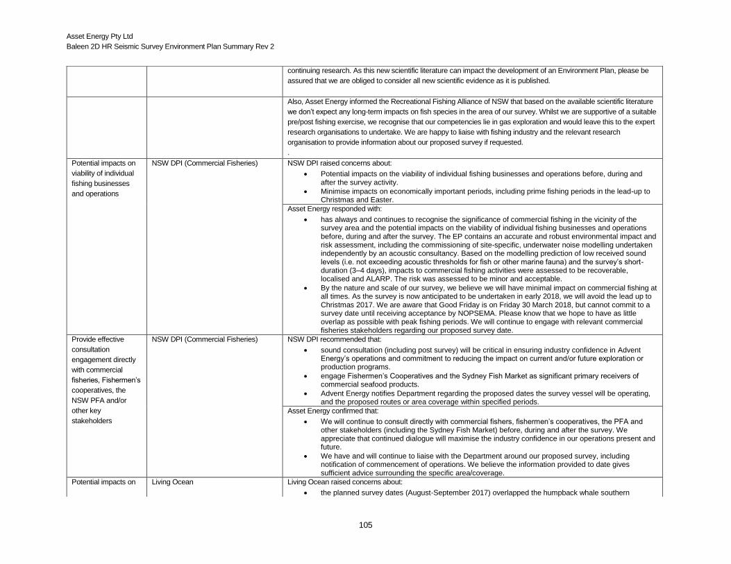
Asset Energy Pty Ltd
Baleen 2D HR Seismic Survey Environment Plan Summary Rev 2
105
continuing research. As this new scientific literature can impact the development of an Environment Plan, please be
assured that we are obliged to consider all new scientific evidence as it is published.
Also, Asset Energy informed the Recreational Fishing Alliance of NSW that based on the available scientific literature
we don’t expect any long-term impacts on fish species in the area of our survey. Whilst we are supportive of a suitable
pre/post fishing exercise, we recognise that our competencies lie in gas exploration and would leave this to the expert
research organisations to undertake. We are happy to liaise with fishing industry and the relevant research
organisation to provide information about our proposed survey if requested.
.
Potential impacts on
viability of individual
fishing businesses
and operations
NSW DPI (Commercial Fisheries) NSW DPI raised concerns about:
Potential impacts on the viability of individual fishing businesses and operations before, during and after the survey activity.
Minimise impacts on economically important periods, including prime fishing periods in the lead-up to Christmas and Easter.
Asset Energy responded with:
has always and continues to recognise the significance of commercial fishing in the vicinity of the survey area and the potential impacts on the viability of individual fishing businesses and operations before, during and after the survey. The EP contains an accurate and robust environmental impact and risk assessment, including the commissioning of site-specific, underwater noise modelling undertaken independently by an acoustic consultancy. Based on the modelling prediction of low received sound levels (i.e. not exceeding acoustic thresholds for fish or other marine fauna) and the survey’s short-duration (3–4 days), impacts to commercial fishing activities were assessed to be recoverable, localised and ALARP. The risk was assessed to be minor and acceptable.
By the nature and scale of our survey, we believe we will have minimal impact on commercial fishing at all times. As the survey is now anticipated to be undertaken in early 2018, we will avoid the lead up to Christmas 2017. We are aware that Good Friday is on Friday 30 March 2018, but cannot commit to a survey date until receiving acceptance by NOPSEMA. Please know that we hope to have as little overlap as possible with peak fishing periods. We will continue to engage with relevant commercial fisheries stakeholders regarding our proposed survey date.
Provide effective
consultation
engagement directly
with commercial
fisheries, Fishermen’s
cooperatives, the
NSW PFA and/or
other key
stakeholders
NSW DPI (Commercial Fisheries) NSW DPI recommended that:
sound consultation (including post survey) will be critical in ensuring industry confidence in Advent Energy’s operations and commitment to reducing the impact on current and/or future exploration or production programs.
engage Fishermen’s Cooperatives and the Sydney Fish Market as significant primary receivers of commercial seafood products.
Advent Energy notifies Department regarding the proposed dates the survey vessel will be operating, and the proposed routes or area coverage within specified periods.
Asset Energy confirmed that:
We will continue to consult directly with commercial fishers, fishermen’s cooperatives, the PFA and other stakeholders (including the Sydney Fish Market) before, during and after the survey. We appreciate that continued dialogue will maximise the industry confidence in our operations present and future.
We have and will continue to liaise with the Department around our proposed survey, including notification of commencement of operations. We believe the information provided to date gives sufficient advice surrounding the specific area/coverage.
Potential impacts on Living Ocean Living Ocean raised concerns about:
the planned survey dates (August-September 2017) overlapped the humpback whale southern

Asset Energy Pty Ltd
Baleen 2D HR Seismic Survey Environment Plan Summary Rev 2
106
Summary of Issues Raised during Asset Energy’s Consultation Meeting 25 May 2017
whales migration period (mid-August to mid-December) and occupation of the area by Southern Right Whales (May to November)
unlikely that proposed procedures for whale sighting will result in insignificant fraction of whales being observed
there was risk of collision with whales by the vessel
Asset Energy responded with:
Risk of striking whales was low considering volume of other shipping traffic in the area
Modelled noise output is low, therefore unlikely to impact whales
Will be implementing EPBC Act policy on interaction of seismic vessels with cetaceans, including ramp-ups / soft starts, whale sighting shutdown zones.
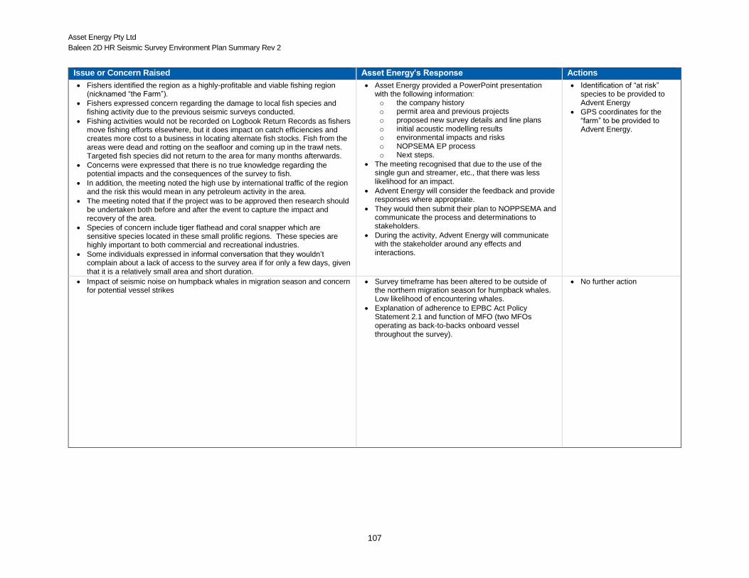
Asset Energy Pty Ltd
Baleen 2D HR Seismic Survey Environment Plan Summary Rev 2
107
Issue or Concern Raised Asset Energy’s Response Actions
Fishers identified the region as a highly-profitable and viable fishing region (nicknamed “the Farm”).
Fishers expressed concern regarding the damage to local fish species and fishing activity due to the previous seismic surveys conducted.
Fishing activities would not be recorded on Logbook Return Records as fishers move fishing efforts elsewhere, but it does impact on catch efficiencies and creates more cost to a business in locating alternate fish stocks. Fish from the areas were dead and rotting on the seafloor and coming up in the trawl nets. Targeted fish species did not return to the area for many months afterwards.
Concerns were expressed that there is no true knowledge regarding the potential impacts and the consequences of the survey to fish.
In addition, the meeting noted the high use by international traffic of the region and the risk this would mean in any petroleum activity in the area.
The meeting noted that if the project was to be approved then research should be undertaken both before and after the event to capture the impact and recovery of the area.
Species of concern include tiger flathead and coral snapper which are sensitive species located in these small prolific regions. These species are highly important to both commercial and recreational industries.
Some individuals expressed in informal conversation that they wouldn’t complain about a lack of access to the survey area if for only a few days, given that it is a relatively small area and short duration.
Asset Energy provided a PowerPoint presentation with the following information: o the company history o permit area and previous projects
o proposed new survey details and line plans
o initial acoustic modelling results o environmental impacts and risks o NOPSEMA EP process
o Next steps.
The meeting recognised that due to the use of the single gun and streamer, etc., that there was less likelihood for an impact.
Advent Energy will consider the feedback and provide responses where appropriate.
They would then submit their plan to NOPPSEMA and communicate the process and determinations to stakeholders.
During the activity, Advent Energy will communicate with the stakeholder around any effects and interactions.
Identification of “at risk” species to be provided to Advent Energy
GPS coordinates for the “farm” to be provided to Advent Energy.
Impact of seismic noise on humpback whales in migration season and concern for potential vessel strikes
Survey timeframe has been altered to be outside of the northern migration season for humpback whales. Low likelihood of encountering whales.
Explanation of adherence to EPBC Act Policy Statement 2.1 and function of MFO (two MFOs operating as back-to-backs onboard vessel throughout the survey).
No further action