basics of floodplain management & planning in new …
TRANSCRIPT

BASICS OF FLOODPLAIN BASICS OF FLOODPLAIN MANAGEMENT & PLANNING MANAGEMENT & PLANNING
IN NEW JERSEYIN NEW JERSEY
STATE OF NEW JERSEY STATE OF NEW JERSEY DEPARTMENT OF ENVIRONMENTAL PROTECTIONDEPARTMENT OF ENVIRONMENTAL PROTECTION
VINCENT J. MAZZEI, JR., PEVINCENT J. MAZZEI, JR., PENovember 12, 2008November 12, 2008

What is a What is a 100100--year floodyear flood??
Better described as a Better described as a 1% flood1% flood: : a flood that has 1% percent a flood that has 1% percent probability of being equaled or probability of being equaled or exceeded in any oneexceeded in any one--year periodyear period
Flood Hazard AreasFlood Hazard Areas

Flood Hazard AreasFlood Hazard Areas
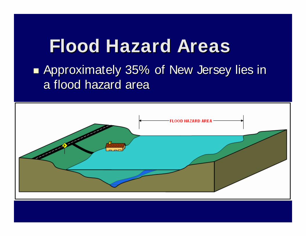
Flood Hazard AreasFlood Hazard AreasApproximately 35% of New Jersey lies in Approximately 35% of New Jersey lies in a flood hazard area a flood hazard area

Area inundated by the Area inundated by the flood hazard flood hazard area design floodarea design flood
Under New Jersey laws:Under New Jersey laws:–– In tidal areas: equal to 100In tidal areas: equal to 100--yr (1%) floodyr (1%) flood–– In fluvial areas: equal to 100In fluvial areas: equal to 100--yr (1%) yr (1%)
flood plus a factor of safetyflood plus a factor of safety
Flood Hazard AreasFlood Hazard Areas

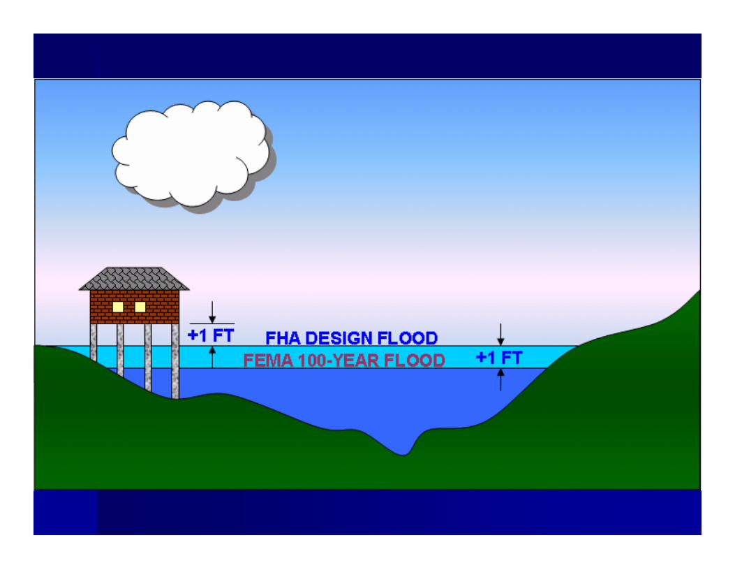
NJ laws add different factors of safety NJ laws add different factors of safety to the 100to the 100--year flood depending on year flood depending on the mapping resources available:the mapping resources available:–– NJ StudiedNJ Studied –– add 25% additional flowadd 25% additional flow–– FEMA StudiedFEMA Studied –– add 1 ft to the 100add 1 ft to the 100--year year
flood elevation (in fluvial areas)flood elevation (in fluvial areas)–– Applicant StudiedApplicant Studied –– add 25% additional add 25% additional
flowflow
Flood Hazard AreasFlood Hazard Areas

Flood Hazard AreasFlood Hazard Areas

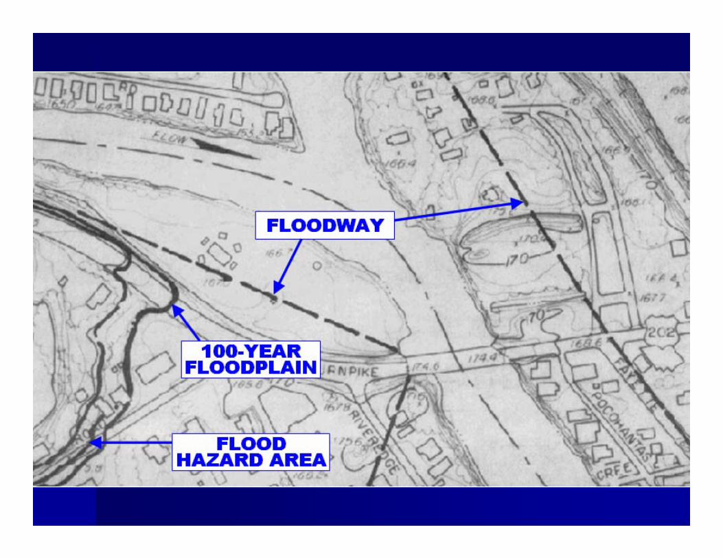
The flood hazard area is comprised of The flood hazard area is comprised of the the floodwayfloodway and the and the flood fringeflood fringe
Flood Hazard AreasFlood Hazard Areas

FloodwayFloodway
Conveys the majority of floodwaterConveys the majority of floodwater
Structures & other materials can obstruct flow and Structures & other materials can obstruct flow and increase floodingincrease flooding
In New Jersey, it is calculated using a 0.2In New Jersey, it is calculated using a 0.2--ft rise in ft rise in the 100the 100--year flood elevationyear flood elevation
Outside NJ it is typically determined using a 1.0Outside NJ it is typically determined using a 1.0--ft ft rise, which is less stringentrise, which is less stringent

Floodway

Floodway


Flood FringeFlood Fringe
The portion of the flood hazard area The portion of the flood hazard area outside the floodwayoutside the floodway
Waters are less deep and move slower Waters are less deep and move slower than in floodway than in floodway
Structures, fill and other material can Structures, fill and other material can displace flood storage volume and displace flood storage volume and increase floodingincrease flooding


Flood MappingFlood Mapping
Use the floodway limits Use the floodway limits exactlyexactly as as shown on the mapsshown on the maps
Refer to the Refer to the profileprofile to find the design to find the design flood elevation, and determine the flood elevation, and determine the actual flood limit yourselfactual flood limit yourself


FEMA MappingFEMA Mapping
In New Jersey In New Jersey –– only used if no State only used if no State mapping is availablemapping is availableNJ Flood elevation equal to FEMA 100NJ Flood elevation equal to FEMA 100--year elevation in tidal areasyear elevation in tidal areasNJ Flood elevation equal to 1 ft above NJ Flood elevation equal to 1 ft above FEMA 100FEMA 100--year elevation in fluvial year elevation in fluvial areasareas


Theme of New Jersey’s Law
• No Adverse Impact: Ensuring that “…the action of one property owner does not adversely impact the rights of other property owners, as measured by increased flood peaks, flood stage, flood velocity, and erosion and sedimentation…” (Association of State Floodplain Managers, NAI White Paper, April 29, 2004)

Goals• Ensure flooding does not increase
– Preserve flood storage– Prevent obstructions to flow
• Protect public safety– Construct new buildings and roads above
the flood hazard area elevation
• Provide healthy riparian corridors– Preserve vegetation– Protect habitat

Flood Hazard Area
• A flood hazard area exists along every regulated water that has a drainage area of 50 acres or more
SEE N.J.A.C. 7:13-2.3(a)1

Riparian Zone
• A riparian zone exists along every regulated water, except there is no riparian zone along:
– The Atlantic Ocean – Any manmade lagoon or stormwater
management basin– Any oceanfront barrier island, spit or
peninsula– Any piped section of an otherwise
regulated waterSEE N.J.A.C. 7:13-2.3(a)2

Regulated Activities
1. The alteration of topography through excavation, grading and/or placement of fill;
2. The clearing, cutting and/or removal of vegetation in a riparian zone;
3. The creation of impervious surface;4. The storage of unsecured material;5. The construction, reconstruction and/or
enlargement of a structure; and6. The conversion of a building into a private
residence or a public building.
SEE N.J.A.C. 7:13-2.4(a)
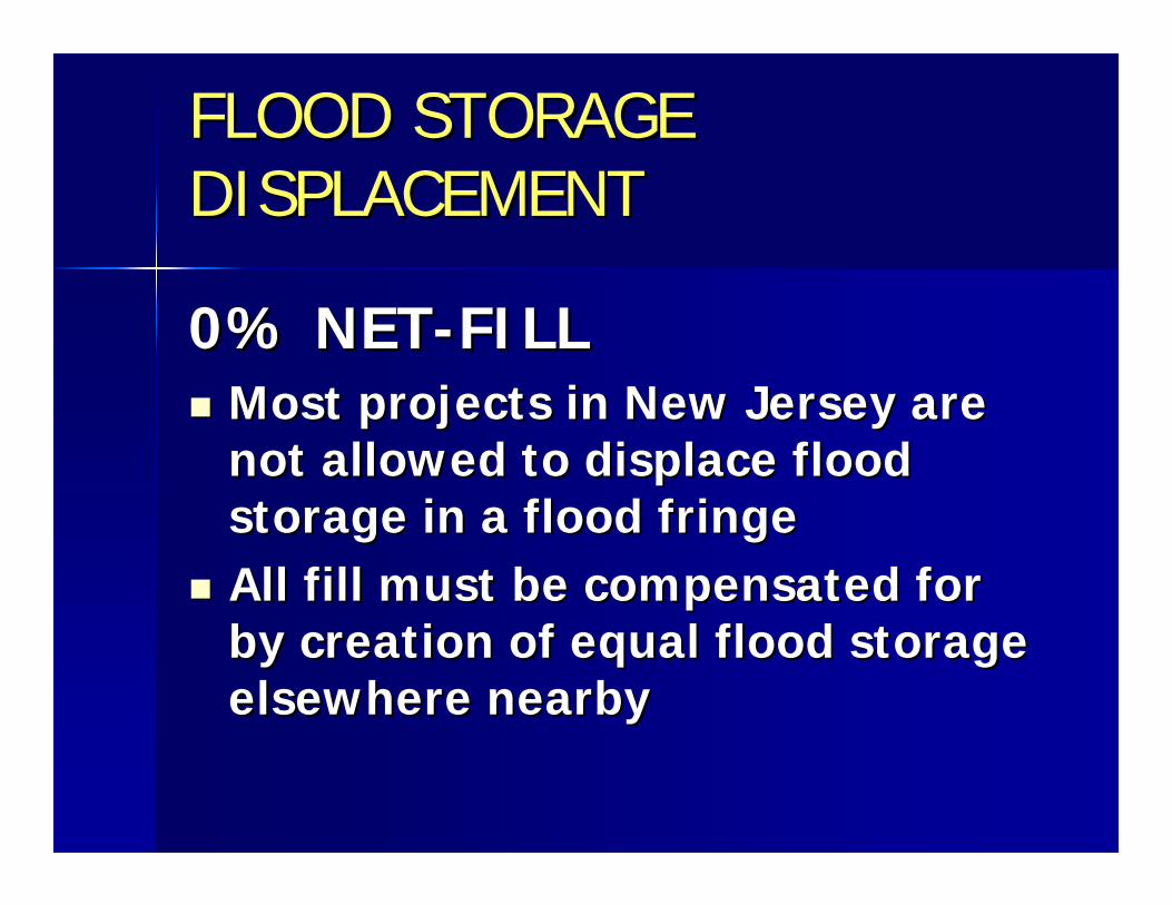
FLOOD STORAGE FLOOD STORAGE DISPLACEMENTDISPLACEMENT
0% NET0% NET--FILLFILLMost projects in New Jersey are Most projects in New Jersey are not allowed to displace flood not allowed to displace flood storage in a flood fringestorage in a flood fringeAll fill must be compensated for All fill must be compensated for by creation of equal flood storage by creation of equal flood storage elsewhere nearbyelsewhere nearby

FLOOD STORAGE FLOOD STORAGE DISPLACEMENTDISPLACEMENT
0% NET0% NET--FILL APPLIES TO: FILL APPLIES TO:
The space between the flood The space between the flood hazard area design flood and the hazard area design flood and the 1010--year flood ANDyear flood AND
The space between the 10The space between the 10--year year flood and the groundflood and the ground


Requirements for buildingsRequirements for buildings

Requirements for buildingsRequirements for buildings

Requirements for buildingsRequirements for buildings

Requirements for buildingsRequirements for buildings

Requirements for buildingsRequirements for buildings


Riparian Zone
• Measures 50, 150 or 300 ft from a regulated water (previously 25 or 50 ft)


Any Questions?
• For more information contact:Vince Mazzei, PENJDEP Division of Land Use RegulationPO Box 439Trenton, NJ 08625
Phone: (609) 292-9870Email: [email protected]: www.nj.gov/dep/landuse